Embed Size (px)
Citation preview
DISASTER MITIGATION AND MANAGEMENT FOR ANDHRA PRADESH, INDIA: AN APPRAISAL
Lakshmi Tejaswi and Ramancharla Pradeep Kumar
Earthquake Engineering Research CentreInternational Institute of Information Technology
Gachibowli, Hyderabad 500 032, [email protected]
ABSTRACT
Every year in the country innumerable number of life and property is getting lost in the disasters. Pre-disaster planning i.e., mitigation and preparedness can have a good impact on minimizing the post-disaster response i.e., emergency, rescue and rehabilitation. This also reduces tragedy and suffering to a great extent. Andhra Pradesh being 4th largest state in India by area of 2,75,608 km² and 5th largest in population with over 100 million and a density of 277 persons/km2 is spread over 23 districts. Although it lies in the central part of peninsular Indian shield it has prone to many disasters which caused large number of casualties and innumerable property loss. This paper discusses the disasters like cyclone, floods, drought, earthquakes, tsunami, fire.. with statistics relevant to each disaster. Finally, we recommend the effecient strategies for disaster risk mitigation.
INTRODUCTION
A disaster is the tragedy of a natural or man-made hazard (a hazard is a situation which poses a level of threat to life, health, property, or environment) that negatively affects the society or the environment. A natural disaster is a consequence when a natural hazard (e.g., volcanic eruption or earthquake) affects humans. Human vulnerability, caused by the lack of appropriate emergency management, leads to financial, environmental, or human impact. Some of the natural disasters are cyclones, floods, drought, earthquakes, Tsunami, land slides. Disasters caused by human action, negligence, error, or involving the failure of a system are called man-made disasters. Technological disasters are the results of failure of technology, such as engineering failures, transport disasters, or environmental disasters. Sociological disasters have a strong human motive, such as criminal acts, stampedes, riots and war. Some of the man made disasters are fire accidents, road accidents, rail and air accidents, bomb blast, health hazards, building collapse, stampede. This paper primarily focuses on multiple disaster situation of Andhra Pradesh. Necessity for such a kind of study is described in the next session.
REGIONAL PRESPECTIVE OF DISASTER
Andhra Pradesh (AP) being 4th largest state in India by area of 2,75,608 km² and 5th largest in population with over 100 million and a density of 277 persons/km2 is spread over 23 districts. Although it lies in the central part of peninsular Indian shield it has prone to many disasters which caused large

number of casualties and innumerable property loss. The state has a coast line of 1030 kms and 2482 villages are along the coast line having the population of 3,15,70,722. The estimated loss during the cyclones is in crores (See Table 1). Nine out of 23 districts in AP suffer from severe drought frequently. These districts have a population of about 30 million and they account for about 70% of state-wide crop production loss due to drought. Though AP is in penunsular india it has experienced considerable earthquakes of magnitudes greater than 5.0. the other major concern for the state is the long coast line along the indian ocean has very active faults. Many fire accidents are occuring in the state resulting in loss of life and property also. The tsunami occured on 26th december 2004 has effected 9 districts along the coast line. One of the important man made disaster are road accidents. From the available stastical data we can observe that accidents are increasing every year. Some of the man made disasters like bomb blasts, building collapse are frequently occuring in the state. Though so many types of disasters are occuring we still lack planning in many areas of specific action. One of these areas is the reduction of vulnerability of communities at risk from the threats of nature as well as ill-conceived development. Disasters are becoming more complex, where a range of multiple factors in the social, cultural and natural spheres are increasing the risks associated with disasters. Table 1 briefly gives the details of disasters and the loss at that event.
CYCLONES AND FLOODS
Cyclones are intense low pressure areas, from the centre of which pressure increases outwards. The amount of the pressure drop in the centre and the rate at which it increases outwards gives the intensity of the cyclones and the strength of winds. These are very strong winds circulating around it in anti-clockwise direction in the Northern Hemisphere and in clockwise direction in the Southern Hemisphere.
Andhra Pradesh has a long coastline stretching approximately 1,030Kms and equally long history of cyclones of varying intensity over the past 100 years. The total number of villages perched along the coastline is 2482. Of these, 500 are within 5 kms swathe extending inside from the coast, 601 are within 5-10km and 1381 villages are between 10-20 km. Coastal Andhra Pradesh covers an area of 92,906 sqkms with a total population of 3.15 crore. The land on
either side of the Godavari and the Krishna rivers consists of extensive, flat delta plains levelled between 4-6 feet above mean sea level. These areas are most vulnerable to storm surges. The coastal districts are primarily agricultural; Guntur, Krishna, East Godavari and West Godavari have highly productive network of irrigation canals founded on the Krishna and Godavari rivers. These four districts, along with Srikakulam, also face the brunt of floods during the monsoons. The coastline ranging from Srikakulam in the north and Nellore in the south is affected by at least one cyclone every year. The entire state suffers the consequences of cyclones and floods, because each district except Vizianagaram, West Godavari and Guntur, has one or more faces with over 100 km of very vulnerable seacoast. The area immediately close to the coast is relatively less populated, less accessible due to poor communication. The people living in the belt of 20 kms from the coast generally comprise fisher folk and weaker sections. Majority of them live in thatched houses which are vulnerable to the wind pressures of cyclonic gale which exceed 100 kms per hour.
The major impact of cyclones can be broadly categorized as below:
1. Loss of lives, injuries and other health consequences such as epidemics, and post traumatic stress disorders.
2. Loss of habitat. 3. Loss of cattle and damage to crops and agricultural fields. 4. Damage to public utilities. 5. Disturbance and damage to the ecosystem.
Table 2 gives the details of cyclones that have occured for the past 4 decades .The loss of life in the years 1976-1980,1981-1985 and 1986-1990 is more. The loss of live stock is more in the years 1986-1990. The damage in crop is more in the years 1986-1990. Damage to houses is more in years 1986-1990 and 2006-2008. Property loss is more in the years 2006-2008. Most of the lives are lost during a cyclone on account of floods and the devastating storm surge that often accompany cyclones. In case of severe cyclonic storms with storm surges, more than 90% of the fatalities occur due to drowning, either during the incoming water phase or during the out surges. In severe cyclonic storms without storm surges, the deaths are more or less evenly divided between drowning and the collapse of buildings. The most common health problems include water borne diseases such as diarrhea, dysentery, typhoid, viral hepatitis, respiratory diseases such as pneumonia and whooping cough, measles, gastroenteritis, cholera, conjunctivitis and fever.
AP State Government Cyclone Related Initiatives
Following the destruction caused by many cyclones and repeated floods during last few decades, the Government of Andhra Pradesh (GoAP), India, started the ‘Cyclone Hazard Mitigation Project’. The overall objective of the project was to provide a system that minimises impacts due to cyclone natural disasters, as well as enhances sustainable development of the coastal zone. To meet this objective, the project consisted of two major components: 1) the set-up of a real time early warning system and 2) the formulation of an Integrated Coastal ZoneManagement (ICZM) Programme. The early warning system focused on

the short-term andoperational measures to be taken, while the ICZM programme dealt with development of long-term strategies to reduce the vulnerability of the coastal area to cyclone hazards. For the ICZM programme, the objectives were to promote optimum utilisation of coastal resources, minimisation of impacts due to cyclone disasters and improvements in equitable quality of life levels while ensuring environmental protection and biodiversity conservation. The project was jointly funded by a World Bank loan and by the Government of Andhra Pradesh. The project was conducted by the consortium of organizations.
DROUGHT
Drought is defined in many ways, such as “a period of dry weather”, “a condition when precipitation is insufficient to meet established human needs”, “comparison of normal precipitation months and years”, “a prolonged dry weather causing hydrologic imbalance”, “a time-space duration distribution of percent of normal precipitation” etc.
Drought sets off a vicious cycle of socio-economic impacts beginning with crop yield failure, unemployment, erosion of assets, decrease in income, worsening of living conditions, poor nutrition and, subsequently, decreased risk absorptive capacity; thus, increasing vulnerability of the poor to another drought and other shocks. The mitigation of the impacts of drought has been a key area of focus of the Government of India (GOI) since 1950s, as evident through programs such as the Drought Prone Areas Programme, Desert Development Programme, National Watershed Management Programmer for Rain fed Areas, National Calamity Contingency Fund, and the National Agricultural Crop Insurance Scheme. However, the human and social costs of droughts remain devastating.
Andhra Pradesh is one of the states in India which has historically been most severely affected by drought. The failure of monsoons has had a disastrous affect on the states’ sizable agriculture sector and a large share of the population dependent on agriculture for livelihood. This study focuses on the eight (out of total 23) districts in AP, which are particularly vulnerable to drought: Anantapur, Chittoor, Cuddapah and Kurnool in Rayalaseema region: Rangareddi, Mahbubnagar and Nalgonda in Teleangana region and Prakasam in coastal Andhra. Together, these districts are home to about 30 million people and account for about 70% of stat-wide crop production loss due to drought. They also include some of the poorest areas and communities in the state. Due to the grossly deficient rainfall received in the catchment areas of irrigation sources, the water levels in the major and medium reservoirs and minor irrigation sources got severely depleted there by adversely affecting the supply of drinking water as well as vital irrigation needed for wet and irrigated dry crops. Groundwater utilization for domestic and irrigation purposes has been increased, due to its dependable supply even during droughts, the number of wells increased from 8.0 lakhs during 1975 to 26.0 lakhs by 2002. Commensurate increase is also registered in the area irrigated through groundwater from 8.0 lakh hectares to 26.0 lakh hectares during the same period. During the year 2002-03 (both Kharif and Rabi) total cropped area sown was 103.46 lakh ha. As against 116.45 lakh ha. Of normal area and the

decline was 11%. This was due to inadequate rainfall received during the crop sowing period i.e., in the month of July, 2002 and also non receipt of water in major reservoirs. The total production of food grains was 105.59 lakh MTs in 2002-03 as against a normal of 140.34 lakh MT showing a decline of 24.76%.
The demographic structure of Andhra Pradesh exhibits that a massive 73% of the total population lives in rural areas. The State has a predominantly agrarian economy with about 65% of the population depending upon agriculture, directly or indirectly, as a source of livelihood. The widespread drought in the year 2002 seriously affected the rural economy because of the enormous loss of agricultural production. As a result nearly 2/3rd of the total Agricultural labour force of 1.38 crores suffered from loss of employment of varying degrees. Due to drought 38,735 habitations suffered from drinking water scarcity due to drying up of spot sources as well as insufficient water storage in drinking water storage tanks fed either by rain water or by canal system. Owing to drought conditions, fodder production was depleted resulting in fodder scarcity. Such condition led to increase in the demand for the supply of fodder with accompanied hike in prices. Added to these factors the fodder had to be transported from surplus areas to the deficit areas and the transportation cost being added made fodder very costly.
The Government of Andhra Pradesh (Go AP) attaches high priority to uplifting these areas, as demonstrated by the creation of a dedicated Department for Rain-Shadow Areas Development. While the government continues to explore possibilities to increase areas under the surface water command and/or further develop groundwater resources, there are serious technical and economic constraints to increasing the volume of irrigation water for much of the area within these districts. Thus, there is a wide recognition in AP of the need to complement those efforts with an adaptation process of gradual shift to agricultural and other economic practices that are more sustainable under this resource constraint.
AP Government drought related initiatives:
A large number of drought-related initiatives have been on-going in AP with support by Government of India (GOI), Government of Andhra Pradesh (GoAP), and several donors. Examples of major programs include irrigation schemes by the Irrigation Department, the Calamity Relief Funds, and the Food for Work Programme by the Revenue Department and the Department of Agriculture. Other important initiatives include the crop seed program of the Department of Agriculture and ground water monitoring undertaken by the Groundwater

Department. In 2004, GoAP created a new Department for Rain-Shadow Areas Development to support the economic and social development in the most drought affected communities. There has been considerable experience in drought management at the community level through watersheds programs, sponsored by GoI or/and GoAP, such as the Drought Prone Area Programme (DPAP), Hariyali Watershed Development Programme, Indira Prabha and “Neeru meeru”, as well as the Joint Forest Management/Community Forestry Programme. In April 2002, the Water, Land and Tree Act promoting water conservation and tree cover was enacted by the AP Legislative Assembly.
Drought related issues have been addressed, to varying degree, by donor- funded rural development programs such as the DFID funded Rural Livelihood Program and the World Bank funded Rural District Poverty Initiatives Project (DPIP) and Poverty Reduction Project. The Hydrology Project helped to organize and maintain the database relevant to water resource and drought management.
The Department of Planning, with the technical help of CRIDA, has also developed, as part of preparing a drought management plan, a real-time decision support system to forecast, and warn the farmers about, the likely upcoming drought and suggest actions such as cropping patterns, to mitigate these impacts. Research institutions, such as ICRISAT and the Agricultural University, have been conducting extensive research on drought resistant crops, appropriate agricultural strategies in drought prone regions and the socio-economic impact of drought in select rural communities.
EARTHQUAKE
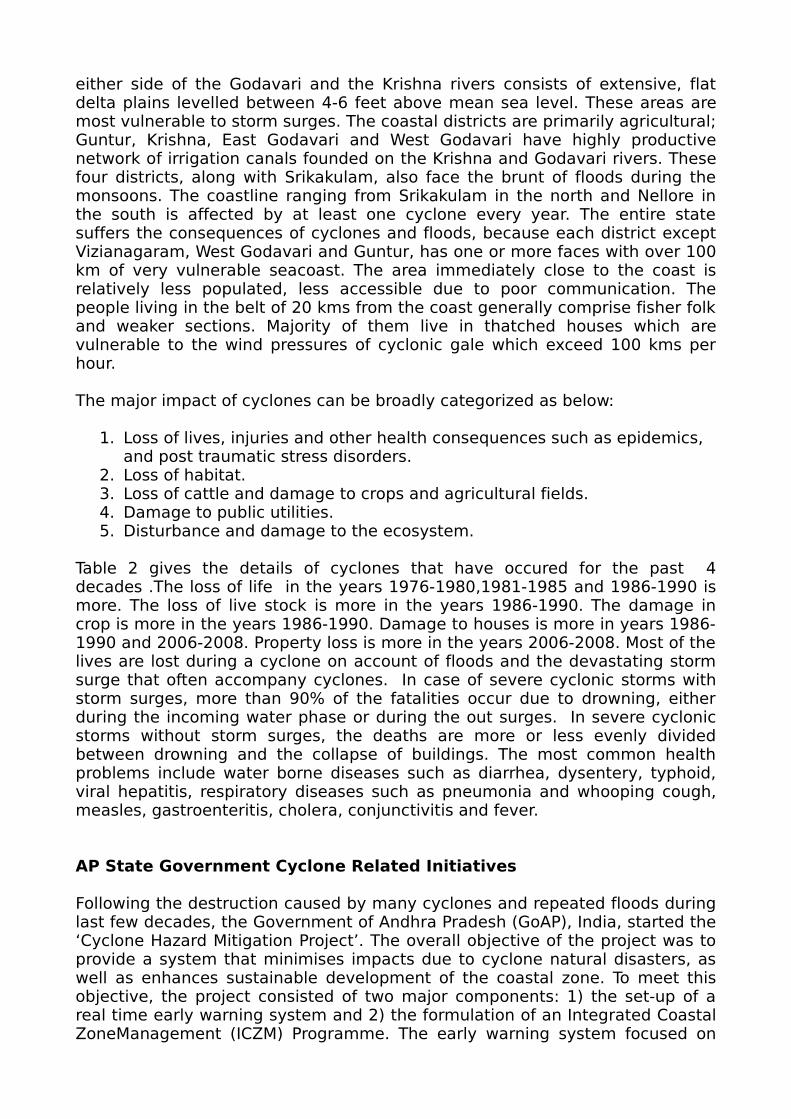
Andhra Pradesh, is located in central part of Peninsular Indian Shield. Though Peninsular Region considered to be stable has been experiencing major damaging earthquakes for the last few decades. As the Indian plate hitting against the mass of the Eurasian plate, which is situated in the north, inter plate movement occurring in weak planes along existing fault in peninsular region lead to earthquakes. According to seismic zonation of India given in IS 1893-2002 (Criteria for earthquake resistant design of structure), 34% of Andhra Pradesh (AP) falls in zone III which is having the possibility of earthquakes up to intensity VII (MSK) or more. The recent Latur Earthquake of 1993 and Jabalpur earthquake of 1997 have proven that the faults in peninsular region are active and can cause earthquakes. Active zones in the state are the Eastern Ghat belt and Godavari Valley. From table 3 recorded seismic history of Andhra Pradesh shows that the state has experienced earthquake of magnitude up to 5.7 on the Richter scale i.e., Vizianagaram (M5.5 1917), Ongole (M5.4, 1967) and Badrachalam (M5.7 1969). Totally 80 earthquakes have occured from 1800 to 1999, 43 of them are of magnitude less than 4, and 28 of them are less than 5 and only 9 of them are greater than 5 magnitude.Though not much of damage occurred due to these events,the earthquake in Killari (M6.3 1993) brought to the forefront the possibility of high risk to urban areas of Andhra Pradesh, where building construction activity is growing at phenomenal rate. And also according to IS 1893-2002 the state is in the proximity of zone III areas of Maharashtra, Orissa, Tamilnadu and Karnataka apart from being near to Andaman & Nicobar Islands which fall in zone V. Major urban centers of the state with mushrooming apartments and commercial complexes are Hyderabad

(Zone II) with population over 7.5 million, Visakhapatnam (zone II) with population of over 2.0 million and Vijayawada (zone III) with population over 1.8 million. Other important towns which fall in zone III are Tirupati, Nellore and Cuddapah. Earthquakes in Andhra Pradesh are being monitored through five seismic stations at Vishakhapatnam Hyderabad, Nagarjunasagar, Srisailam and Sriramsagar.
Since most of the area of Andhra Pradesh is Zone II and Zone III state government is not taken any special linitiatives so far. However, due to rapid growth in urban infrastructure, such as high rise buildings there is a serious need to consider earthquake forces which design and construction of buildings.
Figure 1: seismo tectonic map of Andhra pradesh
Figure 1.1: seismic zonation map of Andhra pradesh
TSUNAMI
The other major concern for Andhra Pradesh is its long coast line along Indian Ocean (Bay of Bengal) which has very active faults. The recent Tsunami which hit south Indian coastal areas and southeast Asia caused due to earthquake of magnitude 9.3 in Indonesia (26 December 2004) and the following earthquake in Andaman and Nicobar Islands brings out the interface activity of Indian plate and Burma plate.
Tsunamis are popularly called tidal waves but they actually have nothing to do with the tides. It is known that the earthquake occurs at deeper depths in subduction zone, while they occur at relatively shallow depth at mid-span ridge regions. The earthquake of 26th December 2004 occurred off northwest of Sumatra is not an unusual earthquake from the plate tectonics point of view. It has occurred in the vicinity of seismically active zone, close to sunda trench in the water depths of about 1200m. The earthquake epicenter is located relatively at shallow depth, about 10 km below the ocean floor. The highest magnitude 9.1 on richer scale, of the earthquake and its shallow epicenter has triggered tsunami (also called seismic sea wave) in the northeast Indian Ocean. These were travelled in Open Ocean of the Bay of Bengal and subduction transformed into a train of catastrophic oscillations on the sea surface close to coastal zones of srilanka and east coast of India.
State government evacuated about 9,000 persons to the safer places and provided food packets and medical teams have been deputed to tackle health situation in affected villages. 105 people were killed and 30 have missed after tidal waves wreaked havoc along the 1000 km coastline of andhrapradesh. The most effected districts are Krishna and praksham recording 35 deaths. Other effected districts are Guntur, Nellore, west Godavari, east Godavari and Vishakhapatnam. Significant tidal surge was experienced in Krishna, Guntur, prakasham and Nellore districts. The tidal waves penetrated between 0.5 to 2 kms, into the main land and the height of the tidal waves was upto 5m. About 361 villages were affected and in that 301 are seriously affected.
The Ministry of Earth Sciences (MoES) has set up tsunami warning system at

the Indian national center for ocean information services (INCOIS) at jeedimetla in collaboration with the department of science and technology, the department of space and the council of scientific and industrial research (CSIR). The center receives real-time seismic data from the national seismic network of the Indian meteorological department (IMD) and international seismic networks. The system detects all earthquakes of magnitude more than 6 on Richter scale in the Indian Ocean in 13 minutes of their occurrence which can help the 400 million people living in India’s coastal region to save themselves.
LANDSIDES
Landslides are simply defined as the mass movement of rock, debris or earth down a slope and have come to include a broad range of motions whereby falling, sliding and flowing under the influence of gravity dislodges earth material. They often take place in conjunction with earthquakes, floods and volcanoes. At times, prolonged rainfall causing heavy block the flow or river for quite some time. The formation of river blocks can cause havoc to the settlements downstream on its bursting. Landslides can be caused by poor ground conditions, geomorphic phenomena, and natural physical forces and quite often due to heavy spells of rainfall coupled with impeded drainage.
The two regions most vulnerable to landslides are the Himalayas and the Western Ghats. The Himalayas mountain belt comprise of tectonically unstable younger geological formations subjected to severe seismic activity. The Western Ghats and nilgiris are geologically stable but have uplifted plateau margins influenced by neo- tectonic activity. Compared to Western Ghats region, the slides in the Himalayas region are huge and massive and in most cases the overburden along with the underlying litho logy is displaced during sliding particularly due to the seismic factor. Andhrapradesh is not vulnerable to landslides how ever there places like vijayawada and vizag where human settlements are increasing in hilly areas which are prone to landslides.
FIRE
There were several fire accidents in the state every year. A state, process, or instance of combustion in which fuel or other material is ignited and combined with oxygen, giving off light, heat, and flame This causes destruction of a building, town, forest etc… A major fire accident occurred in the singerani colony in saidabad claimed four lives and thousand homeless. The fire resulted from an expulsion of a gas cylinder in one of the hut. Fire destroyed 4 coaches

of gouthami express train. 50 were seriously injured and more than 30 members are dead in this accident. In Andhra Pradesh the forest area to geographical area is about 23.2% with dense forest occupying 23,048 sq.kms. Open forest 19,859 sq.kms and mangrove vegetation of about 383 sq.kms. Most dominant forests are dry deciduous and moist deciduous forests. District wise estimates of fire counts suggest that adilabad, cuddaph, Kurnool, Prakasam and mehabubnagar had relatively highest number of fires compared to other places.
From Table 6 we can observe that more number of fire accidents has occured in houses, and outdoor storage. Approximately half of all residential fire accidents are the result of cooking accidents, smoking fire accidents, accidents caused by children playing with fire or intentional fires (arson). Other fire accidents are caused by defective products and electrical or water heater induced fire accidents. The factors that cause over current protection devices to fail to operate, the role of extension cords misused as permanent extensions of basic wiring as the apparent dominant factor in fires involving cord and plug, the problem of loose connections between receptacle and wiring which appears to be the leading failure mode for receptacle fires. Next electric installition, factories or industries, shops or offices. Mechanical or design defects are the number one cause these fire accidents. Next comes careless smoking, oven stores, spontaneous combustion, arson etc…..
Teaching people basic facts about fire safety can reduce fire accidents resulting in death or injury. However, no matter how many precautions are taken to prevent fire accidents they will occasionally happen and it is best to be fully prepared. This preparation for a fire accident should include the planning of escape routes and making family members (especially children) aware of what to do in the event of a fire accident or emergency. Espicially in the current culture of multi storied appartments, awareness of fire safety norms is a must. These buildings are more vurnarable to fire accidents due to usage of material for interiors and false ceiling.
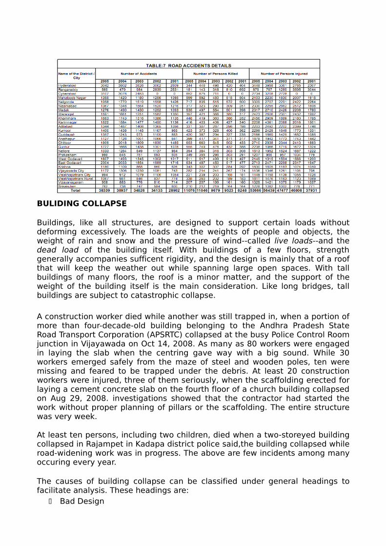
ROAD ACCIDENTS
In recent years, the number of vehicles has increased dramatically. This causes a high traffic density and makes new security features a crucial point in order to keep the traffic safe. Road traffic crashes are an important cause of death and disability. Reliable and accurate data are necessary to plan strategies to reduce death and disability due to road traffic crashes. We assessed the utility of the available data on deaths due to road traffic crashes for road crash

surveillance for major metropolitan cities. The majority of those who died due to the crashes were males. Seventy percent of those killed were between 16 and 49 years of age. Pedestrians and riders of two wheelers were the most vulnerable. Collision with a vehicle caused 86.4% of all crashes and 60% of the victims died before reaching a hospital. The available was not comprehensive enough to provide a thorough basis for planning intervention strategies to reduce fatalities due to road crashes.
From Table 7 we can notice that the total numbers of road accident cases were 28902 during the year 2001 which increased to 34133 in the year 2002, in the 2003 is 34826 and in the year 2004 increased 38937 to 38339 in the year 2005. The total numbers of injured persons were very high in 2004. The main key causes of the death include drunken-driving, speeding, driving without fastening seat belts and helmets, lack of road maintenance and lack of traffic enforcement. Despite the gap sin reporting of fatalities in road traffic rashes in these data sources, they provide insights into the magnitude and nature of deaths resulting from such crashes in Hyderabad. The available data have limitations and there is a need for strengthening the road traffic rash surveillance system to have reliable, accurate and adequate data on road traffic Crashes and the resulting fatalities and injuries. These could then form the basis for planning effective intervention strategies to improve road safety.
BOMB BLASTS
Andhra Pradesh is one of the few southern states affected by terrorism, although of a far different kind and on a much smaller scale. The terrorism in Andhra Pradesh stems from the People's War Group (PWG), popularly known as Naxalites. The PWG has been operating in India for over two decades with most of its operations in the Telangana region in Andhra Pradesh. There were some sporadic incidents by this group during 2004 bomb blast occurred at Alipiri road at the foothills of Tirumala when the Chief Minister's N Chandrababu Naidu convoy was proceeding to the temple. The incident occurred at around 4:20 PM just after crossing the Alipiri toll gate on the Ghat Road. The blast sound was heard upto about 2 kms. The bullet proof car in which he is going was damaged and overtuned hitting a big rock. Two more landmines detected and defused by the Police after the incident showed that this is an act of the Naxals and that this is carefully planned in advance.
State capital Hyderabad continues to be on the edge after twin blasts occured on august 25 2007 at least 43 people killed and more than 70 others injured as two bombs rock a crowded outdoor auditorium and a popular eatery in the southern city of Hyderabad. These blasts occured at 8:10pm in the night. Another incident occured on may 18 2007 at least 10 killed and more than a dozen injured in blast at 17th century Mecca mosque in Hyderabad. Though not many till now however the thought of such kind of incidents is also increasing.
BULIDING COLLAPSE
Buildings, like all structures, are designed to support certain loads without deforming excessively. The loads are the weights of people and objects, the weight of rain and snow and the pressure of wind--called live loads--and the dead load of the building itself. With buildings of a few floors, strength generally accompanies sufficent rigidity, and the design is mainly that of a roof that will keep the weather out while spanning large open spaces. With tall buildings of many floors, the roof is a minor matter, and the support of the weight of the building itself is the main consideration. Like long bridges, tall buildings are subject to catastrophic collapse.
A construction worker died while another was still trapped in, when a portion of more than four-decade-old building belonging to the Andhra Pradesh State Road Transport Corporation (APSRTC) collapsed at the busy Police Control Room junction in Vijayawada on Oct 14, 2008. As many as 80 workers were engaged in laying the slab when the centring gave way with a big sound. While 30 workers emerged safely from the maze of steel and wooden poles, ten were missing and feared to be trapped under the debris. At least 20 construction workers were injured, three of them seriously, when the scaffolding erected for laying a cement concrete slab on the fourth floor of a church building collapsed on Aug 29, 2008. investigations showed that the contractor had started the work without proper planning of pillars or the scaffolding. The entire structure was very week.
At least ten persons, including two children, died when a two-storeyed building collapsed in Rajampet in Kadapa district police said,the building collapsed while road-widening work was in progress. The above are few incidents among many occuring every year.
The causes of building collapse can be classified under general headings to facilitate analysis. These headings are:
Bad Design
Faulty Construction Foundation Failure Extraordinary Loads Unexpected Failure Modes Combination of Causes
CONCERNS AND ROADS AHEAD
To build a safer and disaster resilient India The National Disaster Management Authority (NDMA), has been started by the central government. The setting up of the NDMA and the creation of an enabling environment for institutional mechanisms at the State and District levels is mandated by the Disaster Management Act, 2005. The Disaster Management Act has mandated the constitution of a Specialist Response Force to a threatening disaster situation or a disaster. This Force will function under the National Disaster Management Authority which has been vested with its control, direction and general superintendence. This will be a multi-disciplinary, multi-skilled, high-tech force for all types of disasters capable of insertion by air, sea and land. All the eight battalions are to be equipped and trained for all natural disasters including four battalions in combating nuclear, biological and chemical disasters. NDMA conducts awareness programes and work shops regularly for combating disasters. However from the point of view of AP state following initiatives are necessary.
INITATIVES NECESSARY:
1. Co-ordinated capacity building plan.
2. High school education.
3. Life safety learning center.
CO-ORDINATED CAPACITY BULIDING PLAN:
All natural and man made disasters cause loss of life property. This can be avoided easily by just making awareness in the people by conducting workshops and by including in the syllibus. Now a days the fastest means of spreading is through the internet. So by conducting e-classes and providing the necessary information in the concern websites we can give awareness to the people to same extent. State government can take the responsibility of planning and coordinating the activity of public awareness through its organizations like MCR-HRD, AMR-APARD, SDMA etc.
HIGH SCHOOL EDUCATION:
Disaster management as a part of the syllabus in school subjects invariably aims at providing children with knowledge, attitudes and skills so that they are equipped to contribute meaningfully towards the betterment and solve the problems of environment and also protect oneself. At present only a brief

explaination of disasters is a part of syllubus like what are the disasters, how does it occur, Factors causing, effects etc... but it does not described about the preventive measures, guide lines and first aid tips after the occurance of the disaster. So the Disaster Management Department has requested the Director of School Education to include Disaster Management as a subject in classes VII to X in a phased manner from the 2010-11 academic year. The course would cover nature and types of disasters, need for their management, challenges and precautions needed to be taken to mitigate the affects and related aspects. Education and communication in disaster management plays a pivotal role in creating awareness, mobilizing people also helps in capacity building by transferring knowledge, skills and technique to the people.
LIFE SAFETY LEARNING CENTER
There is a necessity to have life safety learning centre. Safety is the state of being safe. It is the condition of being protected against physical, social, spiritual, financial, political, emotional, occupational, psychological, educational or other types or consequences of failure, damage, error, accidents, harm.This Life Safety Learning Center is dedicated to teaching basic reflexes that can save our life, and help us to save others. This is the state-of –the act center in an area to teach disaster safety awareness.
CONCLUSIONS
Andhra Pradesh being 4th largest state in India by area and 5th largest in population is spread over 23 districts. Although it lies in the central part of peninsular Indian shield it has prone to many disasters which caused large number of casualties and innumerable property loss. In this paper, we have examined the predominant natural disasters in Andhra Pradesh along with statistics for each disaster like cyclone, floods, drought, earthquakes, tsunami, fire.. Where the state government is strong and where it falling short in efforts is also emphasized. Finally, we recommend the effecient strategies for disaster risk mitigation.
References
Sankar Kumar Nath, Debasis Roy and Kiran Kumar Singh Thingbaijam: Disaster mitigation and management for West Bengal, India – An appraisal, Current Science Vol 94, No. 7, 2008.
_________ Vulnerability Atlas of India, Building Materials and Technology Promotion Council, Ministry of Urban Development, Government of India 1997.
Metri, M.A: Disaster mitigation framework for India using quality circle approach. Disaster Prevention Manage: International Journal 1994, 15, 621-635.
Arya, A.S., Karanth, A and Agarwal, A: Hazard, disasters and your community-A primer for parliamentarians. National Disaster Management Division, Ministry of Home Affairs, Government of India, 2005.
Dube, S.K., Chittibabu, P., Sinha, P.C., Rao, A.D. And Murty, T.S.: Numerical modeling of storm surge in the head of Bay of Bengal using location specific model. Natural Hazard, 2004, 31, 437-453.
__________ Landslide Hazard Zonation Atlas of India, Building Materials and Technology Promotion Council, New Delhi, 2004.
__________ IS 1893-2002 (Part I), Indian Standard Criteria for earthquake resistant design of structures, Part I- General provisions and buildings, Bureau of Indian Standards, New Delhi 2002.
__________ Drought: A Handbook for Management of Drought. Revenue (Relief) Department, 1981 & 1995.
__________ Note on Ground Water Scenario in Andhra Pradesh. Groundwater Department, 2003.


![Untitled-1 [] · Nagarjuna Sagar Dam õ3NãgerjunasagaóSite Jammar . ANDHRA AUTHORITY . ANDHRA AUTHORITY . ANDHRA AUTHORITY . ANDHRA AUTHORITY . ANDHRA AUTHORITY . ANDHRA AUTHORITY](https://img.pdfslide.us/doc/110x75/5fa86894420206628339e79d/untitled-1-nagarjuna-sagar-dam-3ngerjunasagasite-jammar-andhra-authority.jpg)