Embed Size (px)
Citation preview
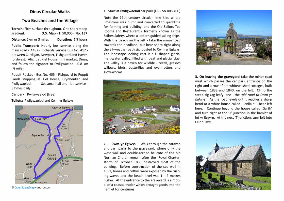
Dinas Circular Walks
Two Beaches and the Village
Terrain: Firm surface throughout. One short steep gradient. O.S. Map - 1: 50,000 - No. 157
Distance: 5km or 3 miles Duration: 1¾ hours
Public Transport: Hourly bus service along the main road - A487 - Richards Service Bus No. 412 - between Cardigan, Newport, Fishguard and Haver-fordwest. Alight at Kiel House mini market, Dinas, and follow the signpost to Pwllgwaelod - 0.8 km (½ mile).
Poppit Rocket - Bus No. 405 - Fishguard to Poppit Sands stopping at Kiel House, Brynhenllan and Pwllgwaelod. Seasonal hail and ride service - 3 times daily.
Car park: Pwllgwaelod (free)
Toilets: Pwllgwaelod and Cwm yr Eglwys
© OpenStreetMap contributors
1. Start at Pwllgwaelod car park (GR - SN 005 400)
Note the 19th century circular lime kiln, where limestone was burnt and converted to quicklime for farming and building, and the Old Sailors Tea Rooms and Restaurant - formerly known as the Sailors Safety, where a lantern guided sailing ships. With the beach on the left - take the minor road towards the headland, but bear sharp right along the all-weather path signposted to Cwm yr Eglwys. The landscape looking east is a U-shaped glacial melt-water valley, filled with peat and glacial clay. The valley is a haven for wildlife - reeds, grasses willows, birds, butterflies and even otters and glow-worms.
2. Cwm yr Eglwys - Walk through the caravan and car parks to the graveyard, where only the west wall and double-arched bellcote of the old Norman Church remain after the ’Royal Charter’ storm of October 1859 destroyed most of the building. Before construction of the sea wall in 1882, bones and coffins were exposed by the rush-ing waves and the beach level was 1 - 2 metres higher. At the entrance to the graveyard is a mod-el of a coastal trader which brought goods into the hamlet for centuries.
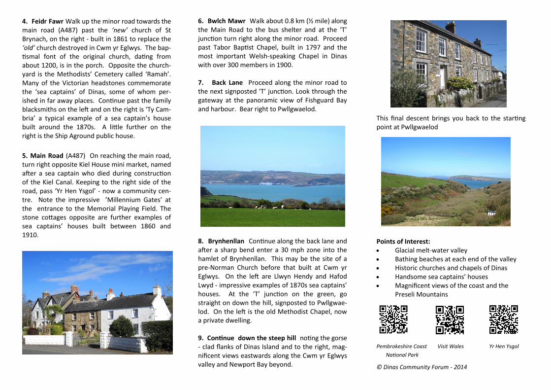
3. On leaving the graveyard take the minor road west which passes the car park entrance on the right and a row of old whitewashed cottages, built between 1838 and 1840, on the left. Climb the steep zig-zag leafy lane - the ‘old road to Cwm yr Eglwys’. As the road levels out it reaches a sharp bend at a white house called ‘Penllain’ - bear left here. Continue beyond the house called ’Garth’ and turn right at the ’T’ junction in the hamlet of Iet yr Esgyrn. At the next ‘T’junction, turn left into Feidr Fawr.
4. Feidr Fawr Walk up the minor road towards the main road (A487) past the ‘new’ church of St Brynach, on the right - built in 1861 to replace the ‘old’ church destroyed in Cwm yr Eglwys. The bap-tismal font of the original church, dating from about 1200, is in the porch. Opposite the church-yard is the Methodists’ Cemetery called ‘Ramah’. Many of the Victorian headstones commemorate the ‘sea captains’ of Dinas, some of whom per-ished in far away places. Continue past the family blacksmiths on the left and on the right is ‘Ty Cam-bria’ a typical example of a sea captain’s house built around the 1870s. A little further on the right is the Ship Aground public house.
5. Main Road (A487) On reaching the main road, turn right opposite Kiel House mini market, named after a sea captain who died during construction of the Kiel Canal. Keeping to the right side of the road, pass ‘Yr Hen Ysgol’ - now a community cen-tre. Note the impressive ’Millennium Gates’ at the entrance to the Memorial Playing Field. The stone cottages opposite are further examples of sea captains’ houses built between 1860 and 1910.
6. Bwlch Mawr Walk about 0.8 km (½ mile) along the Main Road to the bus shelter and at the ‘T’ junction turn right along the minor road. Proceed past Tabor Baptist Chapel, built in 1797 and the most important Welsh-speaking Chapel in Dinas with over 300 members in 1900. 7. Back Lane Proceed along the minor road to the next signposted ‘T’ junction. Look through the gateway at the panoramic view of Fishguard Bay and harbour. Bear right to Pwllgwaelod.
8. Brynhenllan Continue along the back lane and after a sharp bend enter a 30 mph zone into the hamlet of Brynhenllan. This may be the site of a pre-Norman Church before that built at Cwm yr Eglwys. On the left are Llwyn Hendy and Hafod Lwyd - impressive examples of 1870s sea captains’ houses. At the ‘T’ junction on the green, go straight on down the hill, signposted to Pwllgwae-lod. On the left is the old Methodist Chapel, now a private dwelling. 9. Continue down the steep hill noting the gorse- clad flanks of Dinas Island and to the right, mag-nificent views eastwards along the Cwm yr Eglwys valley and Newport Bay beyond.
This final descent brings you back to the starting point at Pwllgwaelod
Points of Interest: Glacial melt-water valley Bathing beaches at each end of the valley Historic churches and chapels of Dinas Handsome sea captains’ houses Magnificent views of the coast and the
Preseli Mountains
Pembrokeshire Coast Visit Wales Yr Hen Ysgol
National Park
© Dinas Community Forum - 2014