Embed Size (px)
Citation preview

Science of the Total Environment 556 (2016) 98–115
Contents lists available at ScienceDirect
Science of the Total Environment
j ourna l homepage: www.e lsev ie r .com/ locate /sc i totenv
Review
A review of atmospheric and land surface processes with emphasis onflood generation in the Southern Himalayan rivers
A.P. Dimri a,⁎, R.J. Thayyen b, K. Kibler c, A. Stanton d, S.K. Jain b, D. Tullos d, V.P. Singh e
a School of Environmental Sciences, Jawaharlal Nehru University, New Delhi, Indiab National Institute of Hydrology, Roorkee, Uttarakhand, Indiac University of Central Florida, Orlando, FL, USAd Water Resources Engineering, Oregon State University, Corvallis, OR, USAe Department of Biological and Agricultural Engineering, and Zachry Department of Civil Engineering, Texas A & M University, College Station, TX, USA
H I G H L I G H T S
• Floods in the southern rim of the Indian Himalayas are a major cause of loss of life, property, crops, infrastructure, etc.• In the recent decade extreme precipitation events have led to numerous flash floods in and around the Himalayan region. Sporadic case-based studies have triedto explain the mechanisms causing the floods.
• However, in some of the cases, the causative mechanisms have been elusive.• The present study provides an overview of mechanisms that lead to floods in and around the southern rim of the Indian Himalayas.
⁎ Corresponding author.
http://dx.doi.org/10.1016/j.scitotenv.2016.02.2060048-9697/© 2016 Elsevier B.V. All rights reserved.
a b s t r a c t
a r t i c l e i n f oArticle history:Received 9 January 2016Received in revised form 29 February 2016Accepted 29 February 2016Available online xxxx
Editor: D. Barcelo
Floods in the southern rim of the Indian Himalayas are amajor cause of loss of life, property, crops, infrastructure,etc. They have long term socio-economic impacts on the habitat living along/across the Himalayas. In the recentdecade extremeprecipitation events have led to numerousflash floods in and around theHimalayan region. Spo-radic case-based studies have tried to explain themechanisms causing the floods. However, in some of the cases,the causativemechanisms have been elusive. Various types of flood events have been debated at different spatialand temporal scales. The present study provides anoverviewofmechanisms that lead to floods in and around thesouthern rim of the Indian Himalayas. Atmospheric processes, landuse interaction, and glacier-related outbreaksare considered in the overview.
© 2016 Elsevier B.V. All rights reserved.
Keywords:HimalayasFloodGlacial lake outburstCloudburstLake dam outburstPrecipitationContents
1. Introduction . . . . . . . . . . . . . . . . . . . . . . . . . . . . . . . . . . . . . . . . . . . . . . . . . . . . . . . . . . . . . . . 992. Predominant atmospheric processes in Himalayan flood generation . . . . . . . . . . . . . . . . . . . . . . . . . . . . . . . . . . . . . 100
2.1. Overview of precipitation mechanisms in the Himalayas . . . . . . . . . . . . . . . . . . . . . . . . . . . . . . . . . . . . . . . 1002.2. Orographic forcing . . . . . . . . . . . . . . . . . . . . . . . . . . . . . . . . . . . . . . . . . . . . . . . . . . . . . . . . 1012.3. Convection – Orography dynamics . . . . . . . . . . . . . . . . . . . . . . . . . . . . . . . . . . . . . . . . . . . . . . . . . 1012.4. Large scale atmospheric flow conditions . . . . . . . . . . . . . . . . . . . . . . . . . . . . . . . . . . . . . . . . . . . . . . 103
3. Predominant land surface processes in Himalayan flood generation . . . . . . . . . . . . . . . . . . . . . . . . . . . . . . . . . . . . . 1043.1. Floods of atmospheric origin . . . . . . . . . . . . . . . . . . . . . . . . . . . . . . . . . . . . . . . . . . . . . . . . . . . . 104
3.1.1. Floods from large scale monsoon flow and topography controls . . . . . . . . . . . . . . . . . . . . . . . . . . . . . . . . 1043.1.2. Cloudburst floods . . . . . . . . . . . . . . . . . . . . . . . . . . . . . . . . . . . . . . . . . . . . . . . . . . . . 107
99A.P. Dimri et al. / Science of the Total Environment 556 (2016) 98–115
3.2. Floods of geologic origin: Landslide Dam Outburst Flood (LDOF) . . . . . . . . . . . . . . . . . . . . . . . . . . . . . . . . . . . 1083.2.1. River avulsion . . . . . . . . . . . . . . . . . . . . . . . . . . . . . . . . . . . . . . . . . . . . . . . . . . . . . . 109
3.3. Floods of cryospheric origin . . . . . . . . . . . . . . . . . . . . . . . . . . . . . . . . . . . . . . . . . . . . . . . . . . . . 1093.3.1. Glacial Lake Outburst Floods (GLOF) . . . . . . . . . . . . . . . . . . . . . . . . . . . . . . . . . . . . . . . . . . . . 1093.3.2. Glacial surge dam burst floods . . . . . . . . . . . . . . . . . . . . . . . . . . . . . . . . . . . . . . . . . . . . . . 110
3.4. Floods of hybrid origin . . . . . . . . . . . . . . . . . . . . . . . . . . . . . . . . . . . . . . . . . . . . . . . . . . . . . . 1103.4.1. Earth bursts . . . . . . . . . . . . . . . . . . . . . . . . . . . . . . . . . . . . . . . . . . . . . . . . . . . . . . . 110
4. Challenges and pathways to monitoring, predicting, and preparing for Himalayan floods. . . . . . . . . . . . . . . . . . . . . . . . . . . . 1115. Conclusions . . . . . . . . . . . . . . . . . . . . . . . . . . . . . . . . . . . . . . . . . . . . . . . . . . . . . . . . . . . . . . 113Acknowledgments . . . . . . . . . . . . . . . . . . . . . . . . . . . . . . . . . . . . . . . . . . . . . . . . . . . . . . . . . . . . . . 113References . . . . . . . . . . . . . . . . . . . . . . . . . . . . . . . . . . . . . . . . . . . . . . . . . . . . . . . . . . . . . . . . . 113
1. Introduction
Five major flood events in the Himalayan region from Pakistan toAssam in the past 10 years have occurred, highlighting the increasingprevalence of floods, inadequacy of infrastructure to combat floods, in-complete understanding of flood forecasting mechanisms, and the lackof preparedness in the region. Managing the Himalayan floods is a chal-lenging task, since the floods result from a combination of atmosphericand land surface processes. The 2010 July–August flood in Pakistan isconsidered to be theworst ever flood in the region caused by themeso-scale convective systems (Houze et al., 2011; Webster et al., 2011; Lauand Kim, 2012). This was followed by the Ladakh flood in August2010, which was caused by multiple cloudbursts in a span of threedays generated by the passing low pressure system (Rasmussen andHouze, 2012; Kumar et al., 2014; Thayyen et al., 2013). In 2012, theBrahmaputra flood was also generated by torrential rains over steepmountain slopes. In June 2013, the Kedarnath floods were caused byhigh intensity torrential rains coupled with Chorabari lake outburst(Dobhal et al., 2013). The Kashmir flood in September 2014 was causedby an unusual convergence of monsoon and westerly winds, whereasthe 2015 Zanskar flood was caused by a Landslide Lake Outburst(LLOF) (http://www.nrsc.gov.in/Phutkal.html). Apart from thesemajor flood events, many local floods were recorded across theHimalayas in the recent past as listed in Table 1. These recent floodevents highlight the need for a better framework for flood hazard miti-gation and disaster risk reduction in the region.
Geographically and geomorphologically, the Himalayas have aunique positioning, located along the Karakorum in the west to Assamin the east (Fig. 1a), blocking the monsoon and trade winds from the
Table 1Flood events reported during the recent past in the southern Himalayas.
Number corresponding to Fig. 1 Flood event D
Sutlej and Paree Chu Ju5 Nepal, Kosi River Au2 Myanmar M1 Pakistan, Indus River La
Pakistan, Indus River 20Ladakh AuZanskar, Ladakh 20Pokhara, Nepal MUttarakhand (Kedarnath) JuKashmir SeAssam, India Brahmaputra River 20Assi Ganga, India 20Rudraprayag, India 20Ukhimath, India 20Chenab, India 19
3 Bangladesh, Brahmaputra, Ganges, Meghna Rivers 194 Bangladesh, Surma, Kushiyara Rivers 19
tropics in summer and from extratropics in winter. Within theHimalayas, climate and hydrology vary at the regional to sub-regionalscale. The climate of western Himalayas is mainly driven by winter-timeweather (Dimri et al., 2015; Yadav et al., 2013), the climate of cen-tral Himalayas is driven by summer and winter monsoon (Shresthaet al., 1999), and the climate of eastern Himalayas is dominated by sum-mermonsoon (Jhajharia and Singh, 2011). The lifting ofmonsoonmois-ture along the steep southern slopes of the Himalayas is a major driverof floods in the region (Fig.1b). The principal non-monsoon flood re-gime of the Himalayas lies in the north-west of the monsoon regime,where major floods are also caused by glaciers and landslide damming.The high altitude glacier regimes are also the potential zones of non-monsoon floods, such as Glacial Lake Outburst Floods (GLOF). Hence,floods in the region have multiple geneses, offering a formidable chal-lenge to flood management.
Our understanding of atmospheric and land surface processes thatdictate flood characteristics in the Himalayan region have many gaps.This can be attributed to the complex geography and topographic inter-actions with large scale atmospheric flows and data gap/sharing issues.Conditions and physical processes that produce floods in the Himalayanregion can be highly complex, comprising multiple geneses that ofteninvolve coupled and dynamic atmospheric and land surface processes(Barros et al., 2004; Dimri and Niyogi, 2012; Bookhagen and Burbank,2006). Feedbacks between atmospheric, topographical, and geomor-phological attributes may result in highly variable patterns and out-comes of water and sediment distribution in high altitude areas,including foothill and plain regions. Incomplete understanding ofthese processes often hinder effective flood management practices, es-pecially flood forecasting.
ate Dominant forcings
n 2005 Landslide lake outburstg 2008 Breach in the Kosi embankmentay 2008 Tropical cyclone - Nargis??te Jul and early Aug 2010 European blocking and tropical-extratropical interaction12g 2010 Cloudburst15 Landslide Dam Outburstsay 2012 Landslide + glacier melt + ???n 2013 Westerly-ISM monsoon + lake outburstp 2014 Torrential Rain???12 Torrential rain05 Cloudburst06 Cloudburst08 Cloudburst96/1997 Monsoon flood88, 1998, 2004, 2010 Monsoon flood98, 2004, 2007, 2010 Flash flood

Fig. 1. (a) Recent flood events in Himalayan rivers. Numbers correspond to events in Table 1. (b) Glacio-hydrological regime of the Himalayas, trans-Himalayan region.
100 A.P. Dimri et al. / Science of the Total Environment 556 (2016) 98–115
The objectives of this paper therefore are to: 1) review the dominantatmospheric and land surface processes that contribute to flood gener-ation in the Himalayan region, drawing upon the reported flood events;and 2) discuss challenges and pathways to overcome adversities relatedto predicting, monitoring, and preparing for disastrous flood events.
2. Predominant atmospheric processes in Himalayan floodgeneration
2.1. Overview of precipitation mechanisms in the Himalayas
The Indian SummerMonsoon (ISM) provides a major part of annualprecipitation for the Indian sub-continent during summer (June, July,August, and September: JJAS). ISM is an intriguing synoptic-scale phe-nomenon controlled by varying drivers (Annamalai et al., 2007;KrishnaKumar et al., 1999; KrishnaKumar et al., 2006; Turner and
Slingo, 2011; Saha et al., 2012). The Tibetan High plays a significantrole in defining the strength of ISM (Yasunari et al., 1991; Wu andQian, 2003). This high pressure region blocks the northward propaga-tion of the monsoonal flow. Many studies have defined varying dura-tions of dominant monsoon spells or intraseasonal modes at 10–20 days and 30–60 days time scales for ISM (Hartmann andMichelsen, 1989; Goswami and Ajaya Mohan, 2001; Hoyos andWebster, 2007). Monsoons usually advance into the eastern Himalayanregion by thefirst week of June, steadily progresseswestward and covermost of the Himalayas by July 15. The influx of moisture to the easternHimalayas is sourced from the Bay of Bengal, while the moisture intothe western Himalayas is appended by the Arabian Sea as well. Duringthe intermittent lull in the monsoon activity over the core monsoon re-gion known as monsoon break period, the monsoon activities along thefoothill of the Himalayas is intensified (Maharana and Dimri, 2015). Inthis case also, the Himalayan topography plays a dominant role in
101A.P. Dimri et al. / Science of the Total Environment 556 (2016) 98–115
defining the advancement of quasi-intertropical convergence zone(ITCZ) associated with ISM.
During the post-monsoon months of October and November (ON),the northeast monsoons (NEM) dominate over the Indian subcontinentand provide precipitation over the southeastern coast of the Indian pen-insula. During NEM, the summer to winter circulation changes gradu-ally, reversing wind patterns from southwest to northeast (Kripalaniand Kumar, 2004; Kumar et al., 2007; Yadav et al., 2007). However,these winds have little influence over most of the Himalayas. In winter(December, January, February: DJF), the Indian winter monsoons(IWM) dominate and bring through western disturbances embeddedwithin large-scale subtropical westerlies and precipitate in the form ofsnow over mountainous regions (Dimri et al., 2015). The interannualand intraseasonal variability associated with IWM has been a subjectof various studies (Laat and Lelieveld, 2002; Dimri, 2013a, 2013b;Yadav et al., 2013). During DJF the spatial distribution of precipitationover central and western Indian Himalayas is strongly influenced bythe interplay of western disturbances with the orographic barrier ofthe Himalayas (Dimri, 2004; Dimri and Niyogi, 2012).
Extreme rainfall associated with flashfloods occurring over theHimalayas is an outcomeof various complex, non-linear interactive pro-cesses. At times, the interactive orographic forcing invigorates flashfloods in tandem with atmospheric flows. Adhikari et al. (2010) haveprovided a Global Flood Inventory (GFI) which suggests that themajor-ity of flood events (64%) are associated with short duration heavy rains,followed by events due to torrential rains (11%) during the monsoonperiod. These latter heavy rain events are particularly associated withlocalized causes, such as cloudbursts, lake bursts, landslides, and oro-graphic forcings, etc. These events are distinctly different from thelarge scale monsoonal flow. The explicit differences in floods associatedwith large and localized flows are discussed in what follows.
2.2. Orographic forcing
Orographic interaction with large scale atmospheric flow and local-ized events determines the amplitude of rainfall over the Himalayan re-gion. At times this higher amplitude rainfall is one of the leading causesof flood initiation. Examples of orographic control of the mountainsaiding heavy rainfall are available for various mountain ranges acrossthe world. Over the Andes basin, the interaction of Andean mountainfront increases the moisture flux to rise along it (Bookhagen andStrecker, 2008; Romatschke and Houze, 2011). Such pronounced inter-action of Andean mountain and the South American low level jet, asso-ciated with the South American monsoon, enhances precipitation(Boers et al., 2014). Based on a composite analysis of geopotentialheight andwindfields, Boers et al. (2014) showed northward propagat-ing frontal systems and the associated anomalies to be the driver of ex-treme rainfall. In the United States, Colorado suffered from severeflooding in September 2013 due to the orographic interaction of Colo-rado Front Range with North American monsoon (Kim et al., 2014).Later, an unusual near-stationary low-pressure system led to a strongplume tropical moisture influx from the Pacific Ocean near Mexico to-wards the Colorado Front Range.
In the case of the Indian Himalayas, steep topography and land useheterogeneity plays a crucial interactive role in defining the weatherand associated precipitationmechanisms. The latitudinal and longitudi-nal cross sectional distribution of the topography along and across theHimalayas highlights how the two-step topography determines theorographic forcing (Fig. 2a). Topographic variations along latitudinaland longitudinal cross sections induce different precipitation formingmechanisms leading to the associated precipitation amplitude. The cor-responding latitudinal and longitudinal cross-sectional topographyacross the western Himalayas at 30°N, 35°N, 40°N, 70°E, 75°E, and80°E is shown in Fig. 2a(1–3) and Fig. 2a(4–6), respectively, representsstrong topographic gradients across the east – west and north – southdirections. Such a distribution of topography also influences the
regional precipitation. The winter (DJF) precipitation investigated inmany experimental studies illustrates that in general precipitationpeaks at and around ~4000 m and then decays even if topography in-creases (Fig. 2b) (Dimri and Niyogi, 2012). This suggests that in generalprecipitation is limited up to ~4000 m elevation in the Himalayan re-gion. Associated physical processes limiting the precipitation aremainlydue to the shedding of mass of saturated water vapor on the upslopeside.
For analyzing the role of topography and/or orographic forcings, thelatitudinal and longitudinal cross-sectional distributions of mean sea-sonal winter (DJF) precipitation simulated under two sets of modelingexperiments as control (CONT) and subgrid (SUB) and the correspond-ing observed (CRU and APHRODITE) precipitation are depicted inFig. 2b. To project the interactive role of topography, these distributionsare also presented with the cross sectional topographies from modelsimulation (CONT and SUB) and observations (GTOPO30 10min). Inter-active and topographic feedback or dependence of precipitation on thetopography is evident in the spatial variability of precipitation amountacross the Himalayas. In the cross sectional distribution of topography,model simulations have elevations similar to the observations. The cor-responding precipitation distributionmaxima andminima along the to-pographic elevation in the model field and observations are seen.Beyond ~4000m elevation, reduced precipitation is seen in both the ex-periments and the observations. The temperature decrease along themountain upslope with elevation increase and the resistance to the up-slope flow results in cloud and precipitation formation. This rise of airsheds the condensed moisture along the upslope (Yasunari, 1976;Singh et al., 1995). This precipitation mechanism under the orographicinfluence leads to complex interactions. In the case of model, higherprecipitation at high elevation points and less precipitation at lowvalleypoints than the corresponding observations are seen. In addition,model-simulated precipitation peaks are seen as in the correspondingobservations with certain lead/lag in precipitation maxima at a fewplaces. These differences in the values of SUB and CONT model fieldsare due to land surface and topography interactions as seen in the SUBexperiment which uses finer topography than that in the CONT experi-ment (Dimri and Niyogi, 2012).The longitudinal cross-sectional topog-raphy is more variable than the latitudinal topography, particularlyover thewesternHimalayas. Such aspectswarrant further studies to un-derstand the associated precipitation mechanisms and the interactiveinfluence thereof.
2.3. Convection – Orography dynamics
Cloudbursts in and around the foothills of the Himalayas are typicalconvectively initiated orographically locked phenomena that subse-quently lead to flashfloods (Thayyen et al., 2013; Rasmussen andHouze, 2012; Kumar et al., 2014; Shrestha et al., 2015). Many localflood events recorded across the Himalayas in the recent past weremostly generated by the cloudburst events. Localized events overAsiganga (Gupta et al., 2013), Rudraprayag, Ukhimath (Shrestha et al.,2015; Chevuturi et al., 2015), and Leh (Thayyen et al., 2013) are someof the examples from the recent decade. In the case of the Leh (Ladakh)flood (4–6 August 2010), a cloudburst was the dominant atmosphericphenomenon, leading to flash flooding and subsequent debris flow(Thayyen et al., 2013; Rasmussen and Houze, 2011; Kumar et al.,2014; Hobley et al., 2012). On5August 2010, a cloudburst had produceda lethal flash flood in the Leh town situated in the high arid Indus valleyin northwest India. The rare penetration of monsoon into an otherwisenon-monsoon area makes it difficult to predict and even more complexto understand it. During this particular time of ISM, the 500 hPa windsover the Leh region are normally westerly. However, preceding03 days of the Leh flood, the 500 hPa geopotential height had shownan easterly jet, which remained persistent for those days. This quasi-stationary jet had led the mesoscale convective systems to move to-wards and over the Leh region. Simultaneously, there was a mid-

Fig. 2. (a) Map of western Himalayan latitudinal cross sectional topography (∗1e2 m) corresponding to the CONT experiment, SUB experiment, and GTOP30 10 min topography, at(1) 30°N, (2) 35°N, and (3) 40°N, respectively. Similarly longitudinal cross-sectional topography at (4) 70°E, (5) 75°E, and (6) 80°E, respectively. (b) 1980–2001 averaged winter (DJF)precipitation (mm d−1) (on left hand axis) and topography (m) (on right hand axis) along a latitudinal cross-section at (1) 30°N, (2) 40°N, and (3) 45°N and a longitudinal crosssection at (4) 70°E, (5) 75°E, and (6) 80°E. CONT-Pr and CONT-Topo correspond to control precipitation and topography, respectively. Similarly SUB-Pr and SUB-Topo correspond tosubgrid experiment. CRU-Pr corresponds to CRU precipitation. APH-Pr corresponds to APHRODITE precipitation (for details please refer Dimri and Niyogi, 2012).
102 A.P. Dimri et al. / Science of the Total Environment 556 (2016) 98–115
103A.P. Dimri et al. / Science of the Total Environment 556 (2016) 98–115
tropospheric transient vortex providing a strong barotropic shear(Krishanmurti et al., 1981) associated with ISM situated over northwestIndia. This vertical shear of the vortex was instrumental in bringing ad-ditional moisture over the Leh region (Rasmussen and Houze, 2012).Kumar et al. (2014) hypothesized that mesoscale convective systemsassociated with cloudburst events were steered towards the Leh regionby the 500 hPa wind, and low level moist air from the Arabian Sea andBay of Bengal rose up to the Himalayan barrier. The corresponding rain-fall intensity reconstructed from the flood hydrographs showed a veryhigh intensity rainfall up to 320 ± 35% mm constrained over a1.6 km2 area for 8.8 min and 209 ± 35% mm rainfall over 0.842 km2
for 11.9 min (Thayyen et al., 2013).Another such event occurred on 13 September 2012 over the
Ukhimath, Uttarakhand, in the central Himalayas. The Ukhimath regionis situated on the protruding foothills of the central Himalayas valleyfloors having an opening towards southwest on both sides. Shresthaet al. (2015) showed the development of an easterly low-level windalong the Gangetic Plain caused by a low pressure system over the cen-tral Gangetic plain. This situation led to the convergence of moistureover the north-western part of India, hence an increase of potential in-stability of the air mass along the valley recesses, which was cappedby an inversion located above the ridgeline and strengthening of thenorth-westerly flow above the ridges. This supported the lifting of po-tentially unstable air over the protruding ridge of the foothills of theHimalayas and triggered a shallow convection that, on passing throughadjacent topographic folds, initiated a deep convection.
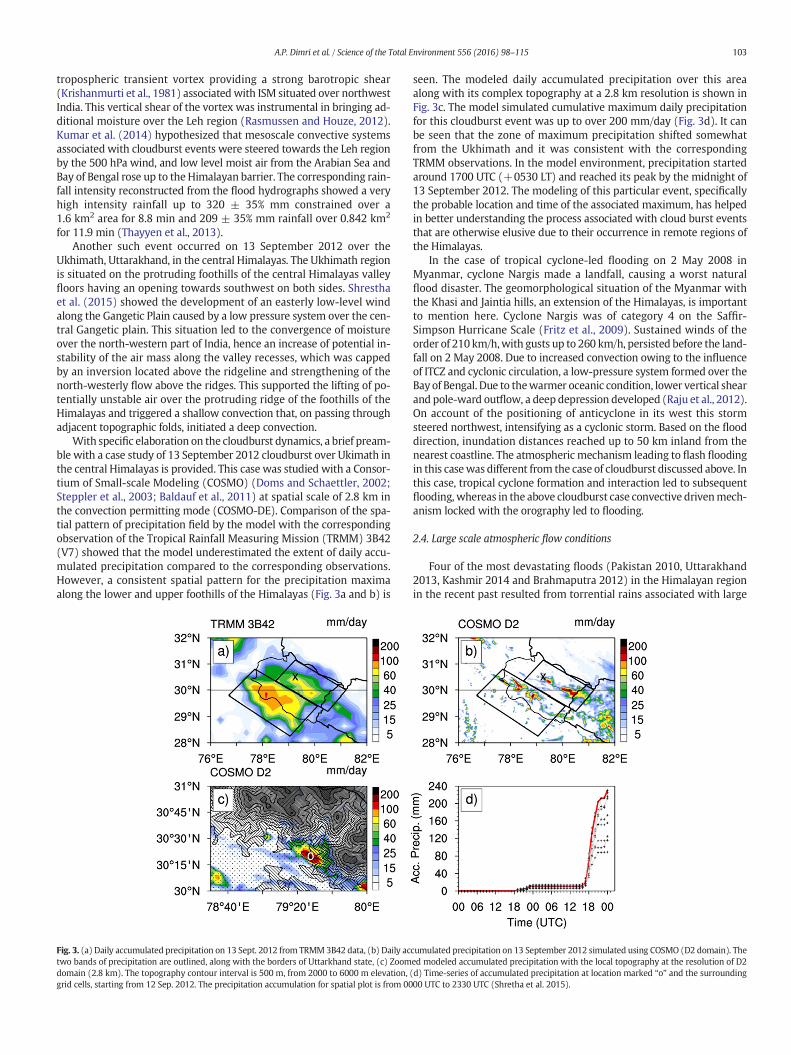
With specific elaboration on the cloudburst dynamics, a brief pream-ble with a case study of 13 September 2012 cloudburst over Ukimath inthe central Himalayas is provided. This case was studied with a Consor-tium of Small-scale Modeling (COSMO) (Doms and Schaettler, 2002;Steppler et al., 2003; Baldauf et al., 2011) at spatial scale of 2.8 km inthe convection permitting mode (COSMO-DE). Comparison of the spa-tial pattern of precipitation field by the model with the correspondingobservation of the Tropical Rainfall Measuring Mission (TRMM) 3B42(V7) showed that the model underestimated the extent of daily accu-mulated precipitation compared to the corresponding observations.However, a consistent spatial pattern for the precipitation maximaalong the lower and upper foothills of the Himalayas (Fig. 3a and b) is
Fig. 3. (a) Daily accumulated precipitation on 13 Sept. 2012 from TRMM3B42 data, (b) Daily actwo bands of precipitation are outlined, along with the borders of Uttarkhand state, (c) Zoomdomain (2.8 km). The topography contour interval is 500 m, from 2000 to 6000 m elevation, (grid cells, starting from 12 Sep. 2012. The precipitation accumulation for spatial plot is from 00
seen. The modeled daily accumulated precipitation over this areaalong with its complex topography at a 2.8 km resolution is shown inFig. 3c. The model simulated cumulative maximum daily precipitationfor this cloudburst event was up to over 200 mm/day (Fig. 3d). It canbe seen that the zone of maximum precipitation shifted somewhatfrom the Ukhimath and it was consistent with the correspondingTRMM observations. In the model environment, precipitation startedaround 1700 UTC (+0530 LT) and reached its peak by the midnight of13 September 2012. The modeling of this particular event, specificallythe probable location and time of the associated maximum, has helpedin better understanding the process associated with cloud burst eventsthat are otherwise elusive due to their occurrence in remote regions ofthe Himalayas.
In the case of tropical cyclone-led flooding on 2 May 2008 inMyanmar, cyclone Nargis made a landfall, causing a worst naturalflood disaster. The geomorphological situation of the Myanmar withthe Khasi and Jaintia hills, an extension of the Himalayas, is importantto mention here. Cyclone Nargis was of category 4 on the Saffir-Simpson Hurricane Scale (Fritz et al., 2009). Sustained winds of theorder of 210 km/h,with gusts up to 260 km/h, persisted before the land-fall on 2 May 2008. Due to increased convection owing to the influenceof ITCZ and cyclonic circulation, a low-pressure system formed over theBay of Bengal. Due to thewarmer oceanic condition, lower vertical shearand pole-ward outflow, a deep depression developed (Raju et al., 2012).On account of the positioning of anticyclone in its west this stormsteered northwest, intensifying as a cyclonic storm. Based on the flooddirection, inundation distances reached up to 50 km inland from thenearest coastline. The atmospheric mechanism leading to flash floodingin this casewas different from the case of cloudburst discussed above. Inthis case, tropical cyclone formation and interaction led to subsequentflooding, whereas in the above cloudburst case convective drivenmech-anism locked with the orography led to flooding.
2.4. Large scale atmospheric flow conditions
Four of the most devastating floods (Pakistan 2010, Uttarakhand2013, Kashmir 2014 and Brahmaputra 2012) in the Himalayan regionin the recent past resulted from torrential rains associated with large
cumulated precipitation on 13 September 2012 simulated using COSMO (D2 domain). Theed modeled accumulated precipitation with the local topography at the resolution of D2d) Time-series of accumulated precipitation at location marked “o” and the surrounding00 UTC to 2330 UTC (Shretha et al. 2015).
104 A.P. Dimri et al. / Science of the Total Environment 556 (2016) 98–115
scale atmospheric flows, where monsoons played a major role. The oc-currence of the 2010 Pakistan flood was due to the interaction oftropical-extratropical flows linked with the European blocking(Webster et al., 2011; Houze et al., 2011; Lau and Kim, 2012). ThisJuly–August 2010 flood was the worst over the Pakistan region. On 28July 2010 the mid-tropospheric 500 hPa height deviated from its mon-soonal normal conditions (Houze et al., 2011). This anomalous condi-tion brought in dry air into the western Himalayan foothills from theAfghan plateau. In tandem with such a situation, a low pressure mon-soon system over the Bay of Bengal brought in very humid deep layerof moisture wind leading to a major rain storm. Hong et al. (2011)have shown the role of large-scale circulation perspective in strongtropical-extratropical interaction due to the coupling of monsoonsurges and extratropical wave activity downstream of the Europeanblocking. The teleconnection of Russian Heat wave and Pakistan floodis important (Lau and Kim, 2012), generating anomalous southwesterlyflows along the foothills of theHimalayas in associationwith northwardpropagation of the monsoonal intraseasonal oscillation brought inabundantmoisture transport from the Bay of Bengal. Such exceptionallyhuge deluge can possibly be predicted using an Ensemble PredictionSystem.
In another case, a large scale atmospheric flow in the central Hima-layan region caused one of the most devastating extreme rainfall andflood events over upper Ganga basin of Uttarakhand during 16–17June 2013. The monsoonal low pressure system, providing increasedlow level convergence and abundant moisture, interacted with themid-level westerlies and generated a strong upper level divergence.Such interaction led to a faster northward progression of the monsoonITCZ to cover the entire Indian sub-continent and yielded heavy rainfallover the region (Joseph et al., 2014; Chevuturi et al., 2015). The largescale wind and geopotential height variation at low, mid and upper tro-pospheric levels is shown in Fig. 4. The figure depicts curved south-westerly flow associated with the ISM at 850 hPa. This is a cross-equatorial flow termed as low level jet (LLJ) (Blanford, 1884; Josephand Raman, 1966; Findlater, 1969) and has a direct relation with mon-soonal rainfall over peninsular India (Joseph and Sijikumar, 2004) TheLLJ is responsible for the moisture transport which is required for sus-taining the storm (Figure not presented, refer Chevuturi et al., 2015).Moisture incursion over the Indian sub-continent during 15–16 June2013 is fromArabian Sea and Bay of Bengal. On 17 June 2013 there is ad-ditional moisture flow from Arabian Sea, which is also reported(Ranalkar et al., 2015). The monsoon depression in the figurestrengthens as it moves northwards in the successive time periods. Inthe upper-troposphere, a trough is seen in the subtropical westerly jet(STWJ), which extends till the north-western India. This is the westerndisturbance (WD) travelling in the STWJ and its axis shows a slight east-ward movement in the different time steps. It is seen as the confluenceof the two systems:monsoon trough of ISM andWD in the STWJ occurson 17 June 2013. Considering the two systems are present in the lowerand upper parts of troposphere respectively, this merging could haveextended right from lower to upper-troposphere. At 500 hPa, a troughwith a deeper extent than the WD is observed. This trough is showingthe merged low pressure zones of both monsoon trough and WDtrough. This trough is the cause of the transient cloud system, formedalong the same axis centered over Uttarakhand. The corresponding ob-servations (MERRA dataset) of large scale wind and geopotential heightshow similar results (figure not presented, refer Chevuturi et al., 2015).Singh et al. (2015) illustrated the active phase of Madden Julian Oscilla-tion (MJO) that led to the faster northward propagation of themonsoonITCZ. In the case of the Jammu and Kashmir floods of 2014 and 2015, asouthward extension of western disturbances (Dimri et al., 2015) andits merging with the monsoon core was the major cause for the torren-tial precipitation leading to one of most severe floods in the region.
Some general characteristics of orographic rainstorms have beenelaborated byHouze et al. (2011). Rainstorms over themountains resultwhen air is lifted over the terrain. In an unstable environment, a
downdraft occurs in a rainy region.When sequences of such convectiveup and down drafts occur, the precipitating cloud system takes on theform of mesoscale convective system (Houze et al., 2011). During thisprocess, some convective cells disintegrate, while new ones emerge.The older dying storms group together to form regions of stratiformrains. On the upslope side of the Himalayas, mountains can sustain me-soscale convective systems, as the airflowover the rising terrain triggersnew intense convective cells, thus sustainingmesoscale convective sys-tems for longer periods and the orographic upward air motionmay sus-tain and broaden the stratiform region of the mesoscale convectivesystems. Such conditions are suggested to be themechanismof extremerainfall in the easternHimalayas (Houze et al., 2007) and is suggested asthe mechanism behind the 2010 Pakistan flood as well. Further studiesin this direction will improve our understanding of extreme rainfallacross the Himalayas.
3. Predominant land surface processes in Himalayan floodgeneration
The Himalayan terrain and processes shaping the land surfacestrongly influence and are, in turn, influenced by flood generation andpropagation. Bymonitoring atmospheric moisture, routing surface run-off, and controlling the supply of sediment/debris, the landscape of theHimalayas and its influence on allocyclic and autocyclic response is afirst-order control tofluvial processes, includingflooding. Given the var-ied flood-generating mechanisms related to the Himalayan topographyand patterns of geologic uplift and weathering, we present three broadcategories for the origin of Himalayan floods: (1) atmospheric origin,(2) floods of cryospheric origin, and (3) floods of geologic/geomorphicorigin. Because flood events are often a product of interaction acrossthese categories, we also discuss hybrid floods generated by combinedeffects (Fig. 5).
3.1. Floods of atmospheric origin
3.1.1. Floods from large scale monsoon flow and topography controlsA large swath of the Himalayas comes under the monsoon flood
zone, extending from Kashmir in the west to the eastern frontiers ofthe Himalayas (Fig. 1). Annual floods driven by monsoon rainfall are anearly universal signature of the Himalayan rivers. River channels areshaped by annual peak flows that may be of the orders of magnitudegreater than the mean annual flows (Kale, 2003). One of the major fac-tors controlling rainfall intensity across the Himalayas is the mountaintopography (Nandargi and Dhar, 2011; Bookhagen and Burbank,2010). Moisture is pushed up by the mountain barrier and this upwardtrajectory is regulated by the mountain slopes. Hence, precipitation oc-currence along the major parts of the Himalayan arc is concentrated indistinct orographic bands (Bookhagen and Burbank, 2010). One ofthese bands is along the lower ranges of the Shiwaliks. Major extremeone-day rainfall is mainly reported from an altitude b1000 m abovesea level along the foothill zone (Nandargi and Dhar, 2011). The centralHimalayas are characterized by a two-step topography, where two dis-tinct relief zones of themountains, represented by the lesser Himalayasand the greater Himalayas, aiding the orographic lifting of the monsoonmoisture and resultant higher rainfall 10's of kilometers offset to thoserelief zones (Fig. 6). On the other hand, western Himalayas are mainlycharacterized by a one-step topography, in which only one majormountain relief facilitates the orographic lift and the correspondinghigher rainfall. Precipitation observed by the TRMM reveals higher an-nual rainfall along this dominant mountain relief (Bookhagen andBurbank, 2006; Bookhagen, 2010; Bookhagen and Burbank, 2010).
In the monsoon flood zone (Fig.1) inputs of summer monsoon pre-cipitation dominates the annual water budget, with snowmelt as a sec-ondary contribution (Bookhagen and Burbank, 2010). Thus, most of thegeomorphic draining by the eastern and central Himalayan rivers occursduring the summer monsoon flood season, while more than 80% of the

Fig. 4.Wind circulation (m/s; vector) at 850 hPa, geopotential height (×102 m; contour) and wind speed (shaded) at 27 km horizontal model resolution for 16 June 2013 (1200UTC) for(a) 850 hPa (wind speed N10m/s shaded), (b) 500 hPa (wind speed N10m/s shaded) and (c) 200 hPa (wind speed N25m/s shaded). (d–f) for 17 June 2013 (0000UTC) and (g–i) 17 June2013 (1200UTC). Green plus sign depicts Kedarnath.
105A.P. Dimri et al. / Science of the Total Environment 556 (2016) 98–115
annual rainfall across the central Himalayas and Ganges Plain occursduring the monsoon season (Bookhagen, 2010) and b50% of annualrainfall occurs during the monsoon season in the western Himalayas.Additionally, in contrast to the eastern and central Himalayas, a largeproportion of runoff from the western Himalayan rivers is comprisedof snowmelt, which is beyond the scope of this study. Bookhagen andBurbank (2010) estimated snowmelt contributions of 66% and 57% inthe Indus and Sutlej basins, respectively, while reporting that waterbudgets in the central and eastern Himalayas comprise b20% snowmelt.Reflecting the varied water phases across the western Himalayas, thereare often two associated discharge peaks that occur during the summermonsoon, a less intense earlier peak attributed to combined snowmeltand rainfall and a more intense later peak primarily due to monsoonrainfall (Pal et al., 2013). In addition to the elevation gradients in themean annual rainfall across the Himalayan orography, the percentageof rainfall that occurs during the monsoon season is regionally variable.Bookhagen and Burbank (2010) reported gradients of monsoon precip-itation, wheremonsoon rainfall decreases, movingwest from the Bay ofBengal.
In the central Himalayan region, annual rainfall amount is concen-trated below 500m above sea level, whereas in thewestern and eastern
regions this elevation zone extends from 500 to 4000m above sea level.Overall, the highest annual rainfall occurs in the eastern region. Floodseverity at the foothill zone is also possibly linked with the rainfall dis-tribution regulated by the mountain topography. This east to west de-crease in the rainfall amount is also reflected in the peak flooddischarge. However, peak erosional processes, which trigger landslides,rockfalls, debris flows, and other mass movements, occur deep withinthe orographic interior frequently triggered by rainfall (Wulf et al.,2010).
In this discussion on floods, particularly related to the large-scale at-mospheric flow, a case study of the recent Uttarakhand flood of 2013 isdiscussed. Fig. 7a–d shows different vertical distributions related vari-ables whose physical and dynamical processes associated with theflood storm are discussed here. On day 1, 16 June 2013, an increasinglow level relative humidity is seen from 0600 UTC to 1800 UTC, whichin mid to upper-troposphere increases after 16 June 2013 1200UTC(Fig. 7a). An increase in the associated vertical wind is also seen(Fig. 7a). The higher low level moisture is due to themoisture incursionfrom the Arabian Sea (figure not represented) along with the low leveljet in themonsoonal south-westerly flow. It is seen that the monsoonalconvergence zone moved faster northwards in this particular year. This

Fig. 5. Various types of flood generating mechanism in the Himalayan region.
106 A.P. Dimri et al. / Science of the Total Environment 556 (2016) 98–115
increasedmoisture reached the Uttarakhand region, in association withthe increased vertical wind that led the low level moisture to rise up-slope mountains and rise up to mid and upper-tropospheric levels.The sudden rise of moisture in the water vapor form was forced to gothrough variousmicrophysical processes, thus forming different hydro-meteors, viz., cloudwater, cloud ice, rainwater, snow and graupel(Pruppacher and Klett, 2010). The signature of these hydrometeor con-centrations and the corresponding mixing ratios and the hydrometeordependent reflectivity signifies the formation of clouds over the region(Fig. 7b). During the storm, two time slices are very distinctly seen
Fig. 6.Monsoon over Himalaya is driven by the orographic processes andmountain topographythe mountain aiding higher precipitation 10 of kilometre offset to the relief. Regions with oneThese higher precipitation zone are the potent source areas of Himalayan flood. (Source: Book
with increased reflectivity: 16 June 2013 1200UTC and 16 June 20131800UTC onwards. Though there was continuous rainfall reportedthroughout the time period, however, during these two distinct timeperiods due to increased hydrometeor formation first and secondheavy precipitation episodes occurred one before (16 June 2013) andsecond during (17 June 2013). These two episodes brought in the cas-cading effect for the Uttarakhand disaster. Further investigation withthe corresponding vorticity and divergence (Fig. 7c) showed a lowlevel positive vorticity on 16 June 2013 that led to the development ofinstability in the region due to themonsoon trough of ISM. The positive
controls the precipitation distribution. Two step topography describes two distinct relief ofstep topography have only one major relief and corresponding higher precipitation zones.hagen and Burbank, 2010).
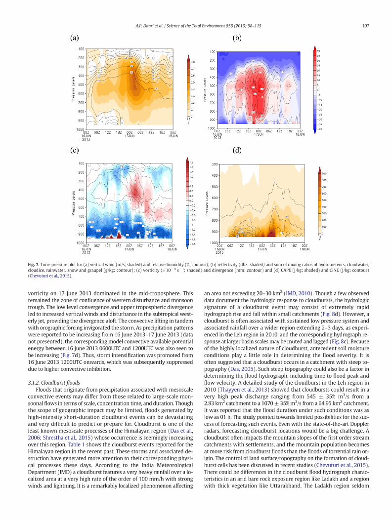
Fig. 7. Time-pressure plot for (a) vertical wind (m/s; shaded) and relative humidity (%; contour); (b) reflectivity (dbz; shaded) and sum of mixing ratios of hydrometeors: cloudwater,cloudice, rainwater, snow and graupel (g/kg; contour); (c) vorticity (×10−4 s−1; shaded) and divergence (mm; contour) and (d) CAPE (J/kg; shaded) and CINE (J/kg; contour)(Chevuturi et al., 2015).
107A.P. Dimri et al. / Science of the Total Environment 556 (2016) 98–115
vorticity on 17 June 2013 dominated in the mid-troposphere. Thisremained the zone of confluence of western disturbance and monsoontrough. The low level convergence and upper tropospheric divergenceled to increased vertical winds and disturbance in the subtropical west-erly jet, providing the divergence aloft. The convective lifting in tandemwith orographic forcing invigorated the storm. As precipitation patternswere reported to be increasing from 16 June 2013–17 June 2013 (datanot presented), the correspondingmodel convective available potentialenergy between 16 June 2013 0600UTC and 1200UTC was also seen tobe increasing (Fig. 7d). Thus, storm intensification was promoted from16 June 2013 1200UTC onwards, which was subsequently suppresseddue to higher convective inhibition.
3.1.2. Cloudburst floodsFloods that originate from precipitation associated with mesoscale
convective events may differ from those related to large-scale mon-soonal flows in terms of scale, concentration time, and duration. Thoughthe scope of geographic impact may be limited, floods generated byhigh-intensity short-duration cloudburst events can be devastatingand very difficult to predict or prepare for. Cloudburst is one of theleast known mesoscale processes of the Himalayan region (Das et al.,2006; Shrestha et al., 2015) whose occurrence is seemingly increasingover this region. Table 1 shows the cloudburst events reported for theHimalayan region in the recent past. These storms and associated de-struction have generated more attention to their corresponding physi-cal processes these days. According to the India MeteorologicalDepartment (IMD) a cloudburst features a very heavy rainfall over a lo-calized area at a very high rate of the order of 100 mm/h with strongwinds and lightning. It is a remarkably localized phenomenon affecting
an area not exceeding 20–30 km2 (IMD, 2010). Though a few observeddata document the hydrologic response to cloudbursts, the hydrologicsignature of a cloudburst event may consist of extremely rapidhydrograph rise and fall within small catchments (Fig. 8d). However, acloudburst is often associated with sustained low pressure system andassociated rainfall over a wider region extending 2–3 days, as experi-enced in the Leh region in 2010, and the corresponding hydrograph re-sponse at larger basin scalesmay bemuted and lagged (Fig. 8c). Becauseof the highly localized nature of cloudburst, antecedent soil moistureconditions play a little role in determining the flood severity. It isoften suggested that a cloudburst occurs in a catchment with steep to-pography (Das, 2005). Such steep topography could also be a factor indetermining the flood hydrograph, including time to flood peak andflow velocity. A detailed study of the cloudburst in the Leh region in2010 (Thayyen et al., 2013) showed that cloudbursts could result in avery high peak discharge ranging from 545 ± 35% m3/s from a2.83 km2 catchment to a 1070± 35%m3/s from a 64.95 km2 catchment.It was reported that the flood duration under such conditions was aslow as 01 h. The study pointed towards limited possibilities for the suc-cess of forecasting such events. Even with the state-of-the-art Dopplerradars, forecasting cloudburst locations would be a big challenge. Acloudburst often impacts the mountain slopes of the first order streamcatchments with settlements, and the mountain population becomesatmore risk from cloudburst floods than the floods of torrential rain or-igin. The control of land surface/topography on the formation of cloud-burst cells has been discussed in recent studies (Chevuturi et al., 2015).There could be differences in the cloudburst flood hydrograph charac-teristics in an arid bare rock exposure region like Ladakh and a regionwith thick vegetation like Uttarakhand. The Ladakh region seldom

Fig. 8. The varied hydrograph signatures of Himalayan floods. (a, b) torrential rain flooding in Chenab, India; cloudburst floods in upper Indus basin, (c) at Aichi, Leh (observed) and (d) inSabu River and tributaries (simulated),monsoonflood (e, f) in Brahmaputra (Bahadurabad, Bangladesh) andGanga (Farraka, Bangladesh) rivers during recordflood years, and (g, h) GLOFfloods, Dhauliganga River, India (simulated as a singular outburst flood event and as a hybrid event with a 100-year rainfall).
108 A.P. Dimri et al. / Science of the Total Environment 556 (2016) 98–115
experiences antecedent precipitation but the rest of the Himalayasunder the monsoon regime have hardly any soil moisture deficiencyduring the cloudburst period. Manifestations of these factors in theflood hydrograph characteristics are least known land surface controlson the cloudburst floods. Repeated occurrences of cloudbursts on a par-ticular catchment clearly point towards the control of the mountainslopes on the cloudburst formation (Thayyen et al., 2013). Hence, the di-saster risk reduction option in response to the cloudburst floods is lim-ited to the settlement management. It is noticed that most of thecausalities in such cases occur over settlements in the paleoflood/drychannels (Thayyen et al., 2013).
3.2. Floods of geologic origin: Landslide Dam Outburst Flood (LDOF)
Geologic and geomorphic processes associated with steep land-scapes of the Himalayan region, which is tectonically highly active,
could facilitate massive floods due to the occurrence of landslides intothe river leading to river blockage. These types of floods are known asLandslide Dam Outburst Floods (LDOF) or Landslide Lake OutburstFloods (LLOF). Some of the worst floods in the region are caused byLDOF. River Indus experienced such a flood in 1841 known as the“Great Indus Flood”. As detailed inMason (1929), the landslidewas trig-gered by an earthquake in December 1840 or January 1841 on the westside of the Lechar spur of Nanga Parbat. By the beginning of June 1841the water probably reached the top of the earthen dam, forming a64 km long and 300 m deep lake. According to Mason (1929), the lakeemptied in 24 h, devastating hundreds of villages and killing thousandsof people. At Attok, more than one thousand kilometers downstream,the flood was about 92 ft high, whereas normal high flood level is42 ft (Falconer, 1841).
The Upper Ganga basin under the monsoon regime is more prone tolandslides and quite a few LDOF's have been reported from two major

109A.P. Dimri et al. / Science of the Total Environment 556 (2016) 98–115
Himalayan tributaries of Bhagirathi and Alaknanada. The earliest reportof the LDOF in the upper Ganga basin dates back to 26 August 1894(Holland, 1984; Rana et al., 2013). A landslide lake of approximately270 m high and 3 km wide at the base was formed over BirahiGanga River, which is a tributary of Alaknanada River, on 6 September1893. It is reported that this flood was managed by diverting the pe-destrian routes and removing 08 suspension bridges on lower reaches.The Alaknanada valley again experienced another major flood after76 years in July 1970. It is believed to be initiated by a cloudburst be-tween Joshimath and Chamoli (Rana et al., 2013). The 1970 flood re-sulted from the failure of a persistent lake formed in the 1893landslide at Gohana. The 1970 flood washed away 30 buses and 13bridges downstream, besides destroying roadside settlements. TheBhagirathi River and its tributary Kanoldiya stream were blocked bya massive slide called Dabrani landslide on 6 August 1978, formingtwo lakes (Dimri and Pandey, 2014). The bursting of these naturaldams later caused an immense loss of life and property. Though notmuch mechanism associated with these historical flood events, how-ever, a brief discussion is provided due to the nature of theirdevastation.
Another recent and well-documented LDOF is the Pareechu land-slide dam in Tibet on 25 June 2005. The lake was created by a landslidethat occurred on 08 July 2004 (Gupta and Shah, 2008). Generally, theareas of Tibet bordering India do not receive heavy rainfall and the land-scape is completely barren. Hence, the trigger for this landslide is notvery clear. Most recently, the Phutkal River in Zanskar got blocked bya heavy landslide that occurred on 15 January 2015 in a comparablearid topography (www.greaterkashmir.com). The location of the land-slide lake was about 90 km interior of the road head and monitoringand managing this lake was a challenge. The National Remote SensingCentre (NRSC), India, has carried out routine monitoring of this lake(www.nrsc.org). The lake had busted on 07May 2015, affecting around40 villages. These two LDOFs in the cold-arid region suggest a need forbetter understanding of the trigger of landslides in such areas. Therole of permafrost thaw and snow melt water seepage in triggeringlandslides in such areas needs to be studied. The floods in the SetiRiver in Nepal had been suggested to be triggered by a rock slope failureat an altitude of 6700 m at Annapurna-IV which travelled through thesouthwest slope up to the river confluence (Bhandary et al., 2012).The LDOFs occurred in monsoon and non-monsoon flood zones of theHimalayas indicating diverse landslide triggering mechanisms. Hence,a better understanding of factors triggering the mass movement in theHimalayas, especially under the climate change scenario, is needed formanaging these floods.
The control of sediment supplies to rivers draining the Himalayas ishighly influential to drainage network dynamics and channel morphol-ogy. Dominant autocyclic processes include both changes to channelmorphology through flood cycles and stochastic land-forming events,such as gravity-driven mass wasting and dam break floods. Addition-ally, allocyclic events, notably related to seismicity, influence the peri-odic sediment supply. Though the channel responses and thegeomorphic effects vary spatially, the most pronounced geomorphic ef-fects of monsoon floods are over the Indian Himalayan region (Kale,2003). There are numerous instances of flood-induced dynamic changesin the channel dimensions, position and pattern. As Himalayan riversoften carry vast quantities of sediment and debris (Kale, 2003), flowsladen with material can be highly destructive and may require specialpreparedness measures for risk reduction. Additionally, generation ofdebris-laden flows entails different processes and conditions thanthose driving floods of atmospheric origin. Thus, forecasting suchflows may require different approaches to monitor and model thanthose commonly applied to riverine flooding. Along the continuumspanning end members of pure water flows and those containing littlewater, such as landslides, researchers and managers classify flows ofvariable proportions of water and other materials (Postma, 1986;Hungr et al., 2001).
3.2.1. River avulsionForeland basins of the Himalayan rivers often take the brunt of
floods generated by high mountains. River avulsion is one such phe-nomenon which could increase the disaster potential of a flood. Avul-sion occurs when an aggrading river leaves its channel to pursue alower-elevation course, thus producing a sudden flood scenario in theotherwise safe low lying areas away from the normal river course. Avul-sion is often triggered at the flood stage (Jones and Schumm, 1999) andflood damages that occurwhen a river rapidly changes its course can besevere. Many Himalayan rivers have long histories of channels shiftingthrough avulsion, especially in the alluvial foothill and plains' reaches.Heavy sediment loads from actively weathering high-altitude zonesare carried by high-gradient, powerful mountain rivers to depositwhere valleys widen and channel slopes diminish. In these alluvialreaches, active aggradation associatedwith such deposition creates haz-ardous conditions for avulsion-related flooding. Due to the high fre-quency of such events relative to other regions, some Himalayanrivers are considered to be ‘hyperavulsive’ (Jain and Sinha, 2004).
The alluvial reaches of Kosi River, which has many timestransitioned between channels in a wide alluvial fan, is a well-knownexample of avulsion phenomenon (Wells and Dorr, 1987). Most re-cently, following heavy monsoon rains in 2008, the Kosi River brokethrough man-made embankments to flow out of its channel (Sinha,2009). It started flowing through an old channel 120 km to the east, in-undating cropland and towns and villages with 1.2 million inhabitants,mostly in Bihar province of India. Over 30 million people were affectedby this one avulsion related flood event. In this case, heavy monsoonprecipitation triggered avulsion in the Kosi channel, yet the influenceof river engineering works also contributed to the avulsion (Sinhaet al., 2008; Sinha, 2009). As the origins of this event included interac-tions of atmospheric, hydrologic, and geomorphic variables and waslikely influenced by human engineering of the river channel, traditionalmethods of flood forecasting would have been unlikely to predict suchan occurrence. Paleochannels formerly occupied by aggrading riversmay be particularly hazardous.
3.3. Floods of cryospheric origin
3.3.1. Glacial Lake Outburst Floods (GLOF)Non-monsoon floods in the Himalayas are mainly of cryospheric or-
igin and spread across the trans-Himalayan region where monsoonpenetration is least and at the higher altitude glacial regimes 3500 mabove sea level in themonsoon zone (Fig.1). Floods of cryospheric originin the Himalayas mainly occur due to Glacial Lake Outburst Flood(GLOF), glacial surge dam outburst flood and snow avalanche dam out-bursts. The GLOF is themajor flood generatingmechanism of this genre.A glacial lake is defined as water mass existing in a sufficient amountand extending with a free surface in, under, beside, and/or in front of aglacier and originating from glacier activities and/or retreating pro-cesses of a glacier. Retreating glaciers in the Himalayan region have fa-cilitated the formation of proglacial glacial lakes in the region. Inrecent years accumulation of water in these lakes has been increasingrapidly in the Himalayas (Ives et al., 2010). The glacial lakes are classi-fied into Erosion (Valley trough and Cirque), Ice Blocked, MoraineDammed (Lateral Moraine and End Moraine Dammed lakes), andSupraglacial lakes (Campbell and Pradesh, 2005). Inventory of glaciallakes in the Himalayan countries has revealed the existence of a largenumber of glacial lakes in the region. In the case of GLOF, the probabilityof occurrencemainly depends on the expansion rate of the glacial lakes,as well as the probability of ice/rocks falling into the lake (Richardsonand Reynolds, 2000). The stability of damming moraines (Clague andEvans, 2000) and the failure of damming moraine (Fujita et al., 2013)are essential for the release of glacial lake water.
A GLOF is createdwhen thewater dammed by a glacier or amoraineis released suddenly. Some of the glacial lakes are unstable and most ofthemare potentially susceptible to suddendischarge of large volumes of

110 A.P. Dimri et al. / Science of the Total Environment 556 (2016) 98–115
water and debris which cause floods downstream. These floods pose se-vere geomorphological hazards and can wreak havoc on all manmadestructures located along their path. Much of the damage created duringthe GLOF events is associated with large amounts of debris that accom-pany the floodwaters. The lakes at risk are invariably situated in remoteand often inaccessible areas. When they burst, the devastation to localcommunities could be tremendous. Due to extreme hazard potential,it is necessary to take into account GLOF, while planning, designingand constructing any infrastructure, especially water resources projects,bridges and culverts as they are located on the path of flood wave andwould be the prime target for catastrophe.
It is observed that the number of GLOFs has increased in theHimalayas through the last century (Richardson and Reynolds, 2000).Previous studies have shown already that the risk of lake developmentis highest where the glaciers have a low slope angle and a low flow ve-locity or are stagnant (Quincey et al., 2007; Reynolds, 2000). Whetherglacial lakes become dangerous depends largely on their elevation rela-tive to the natural spillway over the surrounding moraine (Benn et al.,2000; Sakai et al., 2000). Triggering events for an outburst can be mo-raine failures by the melting of ice cored moraine or increased waterpressure, or a rock or snow avalanche slumping into the lake causingan overflow (Buchroithner et al., 1982; Ives et al., 2010; Vuichard andZimmermann, 1987).
Factors contributing to the hazard/risk of moraine-dammed glaciallake include (a) large lake volume; (b) narrow and high moraine dam;(c) stagnant glacier ice within the dam; and (d) limited freeboard be-tween the lake level and the crest of moraine ridge. Potential outburstflood triggers include avalanche displacement waves from (a) calvingglaciers; (b) hanging glaciers; (c) rock falls; (d) settlement and/or pip-ing within the dam; (e) melting ice-core; and (f) catastrophic glacialdrainage into the lake. In the Himalayas GLOF events are reportedfrom Nepal, Bhutan (ICIMOD, 2011) and Ladakh Himalayas (Thayyenet al., 2010). Though these flood events are reported but still neededto have amore comprehensive understanding of the associated intricateprocesses.
3.3.2. Glacial surge dam burst floodsSurging glaciers flow at exceptional rates during limited durations
ranging from a fewmonths to a few years resulting in sudden advancesin the front (Meier and Post, 1969; Hewitt, 1969). The surging of glaciersis not a regular phenomenon to be associated with all the glaciers sys-tems in the Himalayas or elsewhere. It is limited to certain mountainranges or areas. Hewitt (1969) suggested that around 90% of world'ssurging glaciers lie in the Alaska-Yukon and Karakorum region. There-fore, in the Himalayan region, manifestations of the surging glaciersare so far limited to the Karakorum region. Some of the exceptional gla-cier advances have been reported to be from the Karakorum regionranging from around 3.2 km in 08 days for Yengutz Har glacier in Hisparvalley (Hayden, 1907) to 12 km in 02 months for Kutiah glacier in Stakvalley (Desio, 1954). Apart from these, Hassanabad, Aktash, KichikKumdan and Chong Kumdan are some of the well-known surging gla-ciers in the Karakorum region. Surging glaciers lead to catastrophewhen they advance across the major headwater streams blocking anddamming the river. Hewitt (1982) enumerated the occurrence of thirtyfive destructive outburst floods in the Karakorum region in the past twohundred years. He also states that thirty glaciers are known to have ad-vanced across major headwater streams during this period. Most au-thentic records of the glacier surge dam outburst floods dating back tothe 18th century come from the headwaters of Shyok River, as it servedas a route to central Asia from India. At this location three surging gla-ciers, Chong Kumdan, Kichik Kumdan and Aktash, are responsible forthe surge dam burst floods. Mason (1929) presented a detailed analysisof the historical records on the snout position of these glaciers andfloods that originated from the river blockade by these glaciers. Accord-ing to Mason (1929) there were a number of such floods spanningthrough 1780, 1835, 1839, 1842, 1873, 1903, 1926 and 1929. The 1929
flood was the most devastating of this kind that has occurred in this re-gion. The state of the Kumdan dam in 1928 (Ludlow, 1929) and its sub-sequent burst in 1929 is well documented (Mason, 1930). It has beenreported that the Kumdan Lakewas 16 km long, 120m deep and storedaround 1.5x10⁹ m3 of water blocked by 2.4 km ice barrier. After thebreach, the lake water was evacuated in 48 h with an estimated peakdischarge of 22,650 m3/s (Hewitt, 1982). This flood resulted in a hugedevastation in the Shyok valley and Indus up to 1194 km downstream(Attock) of its origin.
Glacial surges are not random events but cyclic phenomena, proba-bly driven by the frozen and unfrozen conditions of the glacier bed(Murray et al., 2000; Fowler et al., 2001). Hence, surge dam outburstfloods are a perennial threat for the regions inflicted by the glaciersurge phenomena. However, proper monitoring of these areas can re-duce the disaster potential of such lake outbursts considerably, assurge initiation, lake formation and its eventual failure give ampletime for a calibrated response.
3.4. Floods of hybrid origin
Flood events in the Himalayas often are the product of multiple in-teractive geneses. Floods in the hybrid category are produced by rainor snow events, rain over glacial/periglacial lakes, earthquake-inducedGLOF or LDOF, or earth burst - a phenomenon of sudden outflow ofwater from the earth usually along the mountain slope which is accu-mulated over days of continuous rain over the region during the mon-soon and is a relatively unknown phenomenon.
One of themost devastating recent examples of a hybrid flood is theJune 2013 flood of the upper Ganga basin, including Kedarnath area ofUttarakhand. During the Kedarnath floods, the entire upper Gangabasin from Haridwar to Kedarnath experienced floods during 15–17June 2013. These floodswere one of theworst in this region, causing se-vere loss of life and property-killing around 6000 people and damaginginnumerable roads and bridges and adversely affecting 30 odd hydro-power plants (Allen et al., 2015). Widespread rains across the state ofUttarakhand and nearby plains caused by an anomalous advancementof ITCZ associated with ISM that led to high-intensity torrential rains.This extreme precipitation was caused by pulsed extension of themon-soon troughwith interim support from an existing unusualwestern dis-turbance, whichwas the key driver of accelerated northward advance ofthe ISM convergence zone (Chevuturi and Dimri, 2015). The rainfall, re-corded during 14–18 June 2013 period, averaged over a wide swath ofthe region, was 364 mm (Durga Rao et al., 2014). The highest recordingstation in the area above Kedarnath at 3820 m above sea level recorded325 mm rainfall in 24 h interspersed between 15 and 16 June 2013(Dobhal et al., 2013). The widespread sustained rainfall caused floodsin the downstream reaches of the Alaknanada and Bhagirathi Rivers.The Kedarnath temple, one of the most revered Hindu pilgrim sites at3800 m above sea level, was hit by the floods first on 16 June 2013 eve-ning caused by the torrential rain falling over the extensive snow cover(Dobhal et al., 2013). This rain on snow event fed huge quantities ofwater into the periglacial Chorabari Lake situated at 3960 m above sealevel near the Chorabari glacier which resulted into the bursting ofthis lake during the early morning hours of 17 June 2013, killing scoresof pilgrims and devastating the Kedarnath temple and downstreamareas. One of the factors that worsened this extreme event was the an-tecedent precipitation/snow melt which ensured the slope saturationbefore the actual event (Allen et al., 2015; Durga Rao et al., 2014). Thisevent has demonstrated extreme possibilities of hybrid Himalayanfloods and their disaster potential.
3.4.1. Earth burstsWater is the principal mediumof flow and the geomorphic evidence
is extremely close to the cloudburst. Hence this phenomenon is usually(mis)interpreted as a cloudburst or as debris flow in the Himalayan re-gion. The genesis of such events are often revealed by the villagers living
111A.P. Dimri et al. / Science of the Total Environment 556 (2016) 98–115
close to the earth burst zones who are witnesses to the water burstingout of the earth. One of the known events of earth burst occurred inthe Hinval catchment in the middle Himalayas of Uttarakhand on 15Aug 2014. The event, earlier thought to be a cloudburst flood, turnedinto an earth burst event after surveying the people living close to thesite. Such events are common along the Western Ghats of Kerala andthere are some studies detailing these phenomena (Kuriakose et al.,2006). However, the occurrence of such events is not common in themonsoon dominated regions of the Himalayas. This indicates that thelack of understanding of the various earth flood generatingmechanismsis limiting the scope of effective flood management in the Himalayas.
4. Challenges and pathways to monitoring, predicting, and prepar-ing for Himalayan floods
The varied nature of flood hazards in Himalayan Rivers necessitatesamulti-faceted andmulti-scaled action towards preparedness. The pro-cesses and phenomena need to be monitored, predicted, and dissemi-nated. These actions need to transcend traditional disciplinaryboundaries, requiring unified and collaborative efforts across variouslevels of government and administration between scientists, decisionmakers, and civil society. The relevant scales of Himalayan hazardstrend towards global extremes, for instance, in terms of precipitation in-tensities, frequencies of active tectonics, flood discharges, sedimentyields, land areas inundated, and number and vulnerability of peoplesaffected. Despite the high impact of Himalayan flood hazards, geo-graphic and topographic constraints impede robust monitoring. In thecase of transboundary rivers, lack of robust mechanisms for monitoringand sharing of hydro-meteorological data between the nations hamperaffirmative actions.
The remote, rugged, and high-altitude source areas ofmanyflood di-sasters (GLOF, LDOF, cloudbursts) confer limited access for ground-based data collection and thus have traditionally been some of themost poorly monitored places on the Earth. In-situ precipitation andriver gauging stations are limited across the rugged terrains of theHimalayas, especially along the steep ridges of valleys where intenseconvection is likely to occur (Thayyen et al., 2013). Over recent decades,satellite observations and coupled hydro-meteorologicalmodeling haveimproved characterization of flood hazards and understanding of inter-active precipitation and topographic mechanisms over the Himalayas.An extensive inventory of benign and potentially dangerous glaciallakes across the Himalayas is synthesized based on satellite information(ICIMOD, 2010). Furthermore, a better understanding of the meteoro-logical and atmospheric mechanisms generating extreme monsoonalprecipitation events causing floods is provided (Barros et al., 2004;Barros and Lang, 2003; Das et al., 2006; Houze, 2012). In addition,there are a number of landslide hazard assessment tools which useremotely-sensed data to predict potential LDOF (Pardeshi et al., 2013).
Despite the promise of remotely-sensed data andmodeled forecasts,without observed data to anchor predictions, such tools may be limitedin their application. Without robust ground-based data upon whichremotely-sensed data or hydrological models may be calibrated or val-idated, uncertainty associated with remote rainfall observation and hy-drological prediction will be high. Flood modeling and managementapplications are severely limited by the coarse spatial and temporal res-olution of remotely-sensed datasets. Only a few gridded remotely-senseddatasets (e.g. TRMM3B41RT) have sub-daily, 3-hourly, temporalcoverage, and most are limited to a 0.25 × 0.25° spatial coverage. Theseproducts are spatially and temporally resampled from finer resolvedsatellite data. Using hydrologic reanalysis in the Ladakh region,Thayyen et al. (2013) estimated a storm depth of 320 (±35%) mmwhich took place in 8.8 min in a small catchment (0.842–1.601 km2)of the Ladakh region. Harris et al. (2007) revealed the limitations ofreal time gridded satellite rainfall products in dynamic 1-dimensionalflood modeling of small catchments due to its course grid size. Further-more, numerical weather prediction models are unable to capture the
precise location of highly convective cloudburst events (Das et al.,2006). In addition, the spatial resolution of topographic data acrossthe Himalayas is limited to 30 × 30 m further limiting the applicationof 2-dimensional flood modeling.
Ground-based precipitation radar in the Himalayas is constraineddue to the steep terrain, and precipitation radar from space holds prom-ise to overcome this obstacle formaking regional-scale precipitation ob-servations. However, the uncertainties of precipitation radarobservations are dissimilar across the orography (Duan et al., 2015;Wilson and Schreiber, 2015). Furthermore, precipitation radar observa-tions are not available in real time. The sub-grid spatial distribution ofprecipitation is wider for gridded precipitation observations and ispoorly defined. These sub-grid uncertainties are dependent on the at-mospheric and land surface processes. Detailed analyses, which includeground-basedprecipitation observations to identify sub-grid spatial andtemporal characteristics of rainfall across the orography, would be fruit-ful for the development of uncertainty estimates. There have been a lim-ited number of short-term basin scale studies across the Himalayas inwhich a dense number of precipitation stations were deployed (Barroset al., 2000).
Many Himalayan rivers are transboundary watercourses and floodhazards often cross national boundaries and affectmore than one coun-try. Hence, cooperation regarding water-related disaster risk reductionand communication of hydrometeorological conditions between ripar-ian river basins must be a shared priority. As of now, minimum ad-vanced warning of hazardous conditions at upstream is beingprovided for hazard mitigation efforts in the downstream countries.However, formally-agreed procedures for sharing detailed ground andsatellite based hydrometeorological data in real time are likely to gener-ate the most impactful and just outcomes with regard to advanced pre-paredness. When river basin riparians lack procedures for directexchange of observed hydrometeorological data, forecasters may facegreat uncertainty in the ‘geopolitically ungauged’ catchment areas out-side their administration. Programs intended to enhance basin wide co-operation, including data sharing, in Himalayan river basins, such as theHindu Kush-Himalayan Hydrologic Cycle Observing System (HKH-HYCOS) are notable pathways to remove geopolitical barriers to floodrisk reduction.
Basin scale flood source area zonation has a great value for disasterrisk reduction efforts, including flood forecasting. Among the majortypes of Himalayan floods listed earlier, cloudbursts, GLOF, glaciersurge dam outburst flood, debris flows, and earth bursts are bound toimpact the first order streams of the Himalayan slopes (Fig. 9). Design-ingDisaster Risk Reduction (DRR) strategies to deal with such floods arethemajor challenges due to very limited lead time and unknown sourceareas, especially for cloudbursts and debris flow including earth bursts.Potentially dangerous glacial lakes can be identified, but extremelyshort lead time in a GLOF situation (Fig 7g and h) and challenges asso-ciated with regular monitoring of such high altitude lakes make fore-casting a big challenge. The middle reach of the Himalayan trunkchannel is among the safest areas as far as the flood is concerned, as itflows through deep gorges most of the time (Fig. 9) away fromhuman settlement. The downstream floods mainly generated from thetorrential rains over a large area of the mountain can be forecasted ef-fectively, as it provides a significant lead time (Fig. 8a and b).
The topographic control over the orographically uplifted monsoonrains provide another opportunity to constrain the monitoring effortsalong the two highest precipitation zones assisted by the two-step to-pography. In a study carried out in the Chenab basin, this important as-pect is demonstrated. Chenab basin comes under the one steptopography regime where monsoonal precipitation occurs along thefirst orographic barrier in the basin. Rainfall is monitored in the Chenabbasin at 21 stations and there are 09 discharge stations in the basin.Studies have shown that the source areas of all the major floods in theChenab basin is restricted to lower 7269 km2 area (Fig. 10). It is ob-served that the floods are actually gaining strength while passing

Fig. 9. Flood impact zones in the upper Ganga basin. Recent cloudburst/lake burst often impact the first or second order streams in themountain slopes, mainly impacting the settlementalong the valley floor. Floods from torrential rains impact the foothill zones. The trunk river in the mountain reach often flow through deep gorges posing limited risk.
Fig. 10. Floods in the Chenab basin is generated from one step topography. (a) Hydrograph of somemajor floods in the Chenab river at Akhnoor (b) generated from the lowermost zoneconstitutes Shivaliks mountain acting the first orographic barrier for monsoonwinds blowing from the south-west. (c) distribution of seven rainfall measuring stations in this lower zoneand location of representative station of Paoni.
112 A.P. Dimri et al. / Science of the Total Environment 556 (2016) 98–115
113A.P. Dimri et al. / Science of the Total Environment 556 (2016) 98–115
through the last three discharge stations (Fig. 10a and b). Seven raingauge stations in this constrained area are found to be representingthe extreme torrential rainfall responsible for the floods and the studieseven narrowed down to one station representing the regional extremesof the rainfall (Fig. 10c). This suggests that the spatial data generation,research and mapping of flood source zones can be very useful for fore-casting and managing the monsoon floods from torrential rains in theregion. Disaster potential of floods generated by the torrential rainsover the mountains extends to the foothill zones further downstream(Fig. 9) (Ref. Koshi flood, Brahmaputra floods). Floods in the Brahmapu-tra River bring in huge devastation in Assam and Bangladesh furtherdownstream and has been generated by torrential rains over steepmountain slopes and surrounding areas.
Catastrophic flooding in the downstream reaches of BrahmaputraRiver was caused by the simultaneous peaking of floods in the Gangesand Brahmaputra Rivers (Fig. 8e and f), providing the best example ofcomplexities associated with the downstream flooding in the big basinswith significant mountain area. Due to higher transit time, these floodscan be effectively forecasted, if robust forecasting systems are in placeandminimize the flood risk with effective intervention by the local gov-ernance. Understanding of the seasonal distribution of floods across theHimalayan arc is also important for effective flood management by theadministration. In the western part, floods from cloudbursts are ex-pected in the month of July and August and the GLOF's probability ishigh during August and September months. In the Kashmir regionmost of the major floods in the River Jhelum have occurred in themonth of May and September. Of late, more cloudbursts events are re-ported from the Kashmir region as well as experienced during the Julyand August 2015. In the central and eastern Himalayas, flood manage-ment effort can be focused during the monsoon months of June, Julyand August.
5. Conclusions
Himalayan floods are generated from various atmospheric,cryospheric and geologic processes and are highly influenced by the to-pography. Floods in the Himalayas have varying genesis and scale,linked to atmospheric, cryospheric and geological processes. Most fre-quent flood events in the Himalayas are associated with monsoon pre-cipitation, either from torrential rains or from local convective events.Associated precipitation mechanisms and manifestations of these tworainfall types are entirely different from each other. The Himalayan arcorography plays a very dominant role in defining the associated dynam-ics of precipitation mechanism. Steering of atmospheric flow due to thevariable topography and heterogeneous land use determines the scaleand quantum of the precipitation. Hence, the Himalayan arc geomor-phology is one of the key parameters determining the flood type and se-verity. A composite understanding is required for flood managementbut is lacking in the region.
Since a large population lives in the foreland basins of theHimalayas,socio-economic impacts of the large Himalayan floods are huge. Hima-layan floods often lead to the loss of life, property, livelihood, healthand epidemic and leave deep scars in the social and economic fabric.While forecasting capability of extreme events associated with large-scale monsoon flow is increased in tandem with the advancements inthe weather satellite technology, ground based flow monitoring, floodforecasting remains as the area of huge concern in the Himalayas. Fur-ther, lack of understanding of the cloudburst processes, tracking andmonitoring facilities and capabilities remain a huge challenge. It is ob-served that the cloudbursts are only recorded or reported when theycause damages to life and property and occur in the vicinity of a popu-lated area. Hence, it is impossible to assess whether such incidents areincreasing in the recent past due to changing climate. This seriously im-pacts our understanding of the causative factors of such extreme local-ized events. Hence concerted efforts to assimilate these disciplines are
imperative for developing a robust flood management system for theHimalayan region.
Acknowledgments
Authors acknowledge the funding from Indo-US Science and Tech-nology Forum (IUSSTF) to organize “Indo-US Bilateral Workshop onModeling and Managing Flood Risks in Mountain Areas” during 17–19Feb. 2015 Folsom, Sacramento, CA, USA. The paper is part of the out-come of workshop deliberations.
References
Adhikari, P., Hong, Y., Duglus, K.R., Kirshbaum, D.B., Gourley, J., Adler, R., Brakenridge, G.R.,2010. A digitized global flood inventory (1998–2008): Compilation and preliminaryresults. Nat. Hazards 55, 405–422.
Allen, S.K., Rastner, P., Arora, M., Huggel, C., Stoffel, M., 2015. Lake outburst and debrisflow disaster at Kedarnath, June 2013: hydrometeorological triggering and topo-graphic predisposition. Landslides 1–13.
Annamalai, H., Hamilton, K., Sperber, K.R., 2007. The south Asian summer monsoon andits relationship with ENSO in IPCC AR4 simulations. J. Climate 20, 1071–1092.
Baldauf, M., Seifert, A., Forstner, J., Majewski, D., Raschendorfer, M., et al., 2011. Opera-tional convective scale numerical weather prediction with the COSMO model: de-scription and sensitivitites. Mon. Weather Rev. 139, 3887–3905.
Barros, A.P., Lang, T.J., 2003. Monitoring the monsoons in the Himalayas: observations inCentral Nepal, June 2001. Mon. Weather Rev. 131, 1408–1427.
Barros, A.P., Kim, G., Williams, E., Nesbitt, S.W., 2004. Probing orographic controls in theHimalayas during monsoon using satellite imagery. Nat. Hazards Earth Syst. Sci. 4,9–51.
Barros, A.P., Joshi, M., Putkonen, J., Burbank, D.W., 2000. A study of 1999 monsoon rainfallin a mountainous region in central Nepal using TRMM products and rain gauge ob-servations. Geophys. Res. Lett. 27, 3683–3686.
Benn, D.I., Wiseman, S., Warren, C.R., 2000. Rapid growth of a supraglacial lake,Ngozumpa glacier, Khumu Himal, Napal. Int. Assoc. Hydrolo. Sci. 264, 177–185.
Bhandary, N. P., R. K. Dahal, and M. Okamura (2012). Preliminary understanding of theSeti River Debris-Flood in Pokhara, Nepal on May 5th 2012. A report based on aquick field visit program. ISSMGE Bulletin, 6(4), 8–18.
Blanford, H.F., 1884. On the connexion of the Himalaya snowfall with dry winds and sea-sons of drought in India. Proc. R. Soc. Lond. 37, 3–22.
Boers, N., Bookhagen, B., Barbosa, H.M.J., Marwan, N., Kurths, J., Marengo, J.A., 2014. Pre-diction of extreme floods in the eastern central Andeas based on a complex networkapproach. Nat. Commun. 5, 5199. http://dx.doi.org/10.1038/ncomms6199.
Bookhagen, B., 2010. Appearance of extreme monsoonal rainfall events and their impacton erosion in the Himalaya. Geomat. Nat. Haz. Risk 1 (1), 37–50.
Bookhagen, B., Burbank, D.W., 2010. Toward a complete Himalayan hydrological budget:spatiotemporal distribution of snowmelt and rainfall and their impact on river dis-charge. J. Geophys. Res.: Earth Surface (2003−2012) 115 (F3).
Bookhagen, B., Burbank, D.W., 2006. Topography, relief, and TRMM-derived rainfall vari-ations along the Himalaya. Geophys. Res. Lett. 33 (8).
Bookhagen, B., Strecker, M.R., 2008. Orographic barriers, high resolution TRMM rainfall,and relief variations along the eastern Andes. Geophys. Res. Lett. 35, 1–6.
Buchroithner, M.F., Jentsch, G., Waniverhaus, B., 1982. Monitoring of recent glaciologicalevents in the Khumbu Area (Himalaya, Nepal) by digital processing of Landsat MSSdata. Rock Mech. 15 (4), 181–197.
Campbell, J.G., Pradesh, H., 2005. Inventory of Glaciers, Glacial Lakes and the Identificationof Potential Glacial Lake Outburst Floods (GLOFs) Affected by Global Warming in theMountains of India, Pakistan and China/Tibet Autonomous Region. International Cen-tre for Integrated Mountain Development, GP O. Box, 3226.
Chevuturi, A., and A. P. Dimri (2015). Investigation of Uttarakhand (India) Disaster - 2013Using Weather Research and Forecasting Model. Nat. Hazards (in revision).
Chevuturi, A., Dimri, A.P., Das, S., Kumar, A., Niyogi, D., 2015. Numerical simulation of anintense precipitation event over Rudraprayag in the Central Himalayas during 13–14September 2012. J. Earth Sys. Sci. (accepted).
Clague, J.J., Evans, S.G., 2000. A review of catastrophic drainage of moraine-dammed lakesin British Columbia. Quat. Sci. Rev. 19 (17), 1763–1783.
Das, S., 2005. Mountain weather forecasting using MM5 modeling system. Curr. Sci. 88(6), 899–905.
Das, S., Ashrit, R., Moncrieff, M.W., 2006. Simulation of a Himalayan cloudburst event.J. Earth Sys. Sci. 15 (3), 299–313.
Desio, A., 1954. An exceptional advance in the Karakoram-Ladakh region. J. Glaciol. 2,383–385.
Dimri, A.P., 2004. Impact of horizontal model resolution and orography on the simulationof a western disturbance and its associated precipitation. Meteorol. Appl. 11 (2),115–127.
Dimri, A.P., 2013a. Interannual variability of Indian Winter Monsoon over the WesternHimalaya. Glob. Planet. Chang. 106, 39–50.
Dimri, A.P., 2013b. Intraseasonal oscillation associated with Indian Winter Monsoon.J. Geophys. Res.-Atmos. 118 (3), 1189–1198.
Dimri, A.P., Niyogi, D., 2012. Regional climatemodel application at subgrid scale on Indianwinter monsoon over the western Himalayas. Int. J. Climatol. http://dx.doi.org/10.1002/joc3584.

114 A.P. Dimri et al. / Science of the Total Environment 556 (2016) 98–115
Dimri, A.P., Niyogi, D., Barros, A.P., Ridley, J., Mohanty, U.C., Yasunari, T., Sikka, D.R., 2015.Western disturbance: a review. Rev. Geophys. 53. http://dx.doi.org/10.1002/2014RG000460.
Dimri, V.P., Pandey, A.K., 2014. Centre for Himalayan Study in Uttarakhand. Curr. Sci. 107(10), 1647.
Dobhal, D.P., Gupta, A.K., Mehta, M., Khandelwal, D.D., 2013. Kedarnath disaster: facts andplausible causes. Curr. Sci. 105 (2), 171–174.
Doms, G., Schaettler, U., 2002. The nonhydrostatic limited area model LM-Part 1: dynam-ics and numerics. Scientific Documentation. Deutscher-Wetterdienst, Ofenbach,Germany, p. 140 (Online at http://www.cosmo-model.org).
Duan, Y., Wilson, A.M., Barros, A.P., 2015. Scoping a field experiment: error diagnostics ofTRMM precipitation radar estimates in complex terrain as a basis for IPHEx2014.Hydrol. Earth Syst. Sci. 19, 1501–1520.
Durga Rao, K.H.V., Venkateshwar Rao, V., Dadhwal, V.K., Diwakar, P.G., 2014. Kedarnathflash floods: a hydrological and hydraulic simulation study. Curr. Sci. 106 (4), 598–603.
Falconer, H., 1841. Letter to the Secretary of the Asiatic Society, on the recent cataclysm ofthe Indus. J. Asiat. Soc. Bengal 10 (1841), 615–620.
Findlater, J., 1969. Inter-hemispheric transport of air in the lower troposphere over thewestern Indian Ocean. Quart. J. Royal Meteorol. Soc. 95, 400–403.
Fowler, A.C., Murray, T., Ng, F.S.L., 2001. Thermally controlled glacier surging. J. Glaciol. 47(159), 527–538.
Fritz, H.M., Blount, C.D., Thwin, S., Thu, M.K., Chan, N., 2009. Cyclone Nargis storm surge inMyanmar. Nat. Geosci. 2, 448–449.
Fujita, K., A. Sakai, S. Takenaka, T. Nuimura, A. B. Surazakov, T. Sawagaki, and T.Yamanokuchi, T. (2013). Potential flood volume of Himalayan glacial lakes. Nat. Haz-ards Earth Syst. Sci., 13(7), 1827–1839.
Goswami, B.N., Ajaya Mohan, R.S., 2001. Intraseasonal oscillations and interannual vari-ability of the Indian summer monsoon. J. Clim. 14 (6), 1180–1198.
Gupta, V., Shah, M.P., 2008. Impact of the trans-Himalayan landslide lake outburst flood(LLOF) in the Satluj catchment, Himachal Pradesh, India. Nat. Hazards 45 (3),379–390.
Gupta, V., Dobhal, D.P., Vaideswaran, S.C., 2013. August 2012 cloudburst and subsequentflash flood in the Asi Ganga, a tributary of the Bhagirathi river, Garhwal Himalaya,India. Curr. Sci. 105 (2), 249–253.
Harris, A., Rahman, S., Hossain, F., Yarborough, L., Bagtzoglou, A.C., Easson, G., 2007.Satellite-based flood modeling using TRMM-based rainfall products. Sensors 7,3416–3427.
Hartmann, D.L., Michelsen, M.L., 1989. Intraseasonal periodicities in Indian rainfall.J. Atmos. Sci. 46, 2838–2862.
Hayden, H.H., 1907. Notes on certain glaciers in Kashmir, Lahaul and Kumaon. Records, GS35, 123–148.
Hewitt, K., 1969. Glacier surges in the KarakoramHimalaya (central Asia). Can. J. Earth Sci.6 (4), 1009–1018.
Hewitt, K., 1982. Natural dams and outburst floods of the KarakoramHimalaya. Hydrolog-ical Aspects of Alpine and High Mountain Areas (Proceedings of the Exeter Sympo-sium, July 1982). IAHS, pp. 259–269.
Hobley, D.E., Sinclair, H.D., Mudd, S.M., 2012. Reconstruction of a major storm event fromits geomorphic signature: the Ladakh floods, 6 August 2010. Geology 40 (6),483–486.
Holland, T.H., 1984. Report on the Gohna Landslip, Garhwal, Selections from the Recordsof the Government of India in the PublicWorks Department: CCCXXIV(324), Office ofthe Superintendent of Government. Printing, Calcutta.
Hong, C.C., Hsu, H.H., Lin, N.H., Chiu, H., 2011. Roles of European blocking and tropicalextratropical interaction in the 2010 Pakistan flooding. Geophys. Res. Lett. 38,L13806. http://dx.doi.org/10.1029/2011GL047583.
Houze Jr, R. A., (2012). Orographic effects on precipitating clouds. Rev. Geophys., 50,RG1001, 47 pp., doi:http://dx.doi.org/10.1029/2011RG000365.
Houze Jr., R.A., Wilton, D.C., Smull, B.F., 2007. Monsoon convection in the Himalayan re-gion as seen by the TRMM precipitation radar. Quart. J. Roy. Meteor. Soc. 133,1389–1411.
Houze Jr., R.A., Rassmussen, K.L., Medina, S., Brodzik, S.R., Romastshke, U., 2011.Anomolous atmospheric events leading to the summer 2010 floods in Pakistan.Bull. Of Amer. Meteoro. Soc, Mar, pp. 291–298.
Hoyos, C.D., Webster, P.J., 2007. The role of intraseasonal variability in the nature of Asianmonsoon precipitation. J. Clim. 20, 4402–4424.
Hungr, O., Evans, S.G., Bovis, M.J., Hutchinson, J.N., 2001. A review of the classification oflandslides of the flow type. Environ. Eng. Geosci. 7 (3), 221–238.
India Meteorological Department (IMD), 2010. Cloud Burst Over Leh (Jammu and Kash-mir). Ministry of Earth Sciences, p. 4 (Available online at www.imd.gov.in/doc/cloud-burst-over-leh.pdf).
International Centre for Integrated Mountain Development, Kathmandu, (ICIMOD),2011K. Glacial Lakes and Glacial Lake Outburst Floods in Nepal. Kathmandu, p. 99.
International Centre for Integrated Mountain Development, Kathmandu, (ICIMOD),2010K. Formation of Glacial Lakes in the Hindu Kush-Himalayas and GLOF Risk As-sessment. p. 58.
Ives, J.D., Shrestha, R., Mool, P., 2010. Formation of Glacial Lakes in the Hindu Kush-Himalayas and GLOF Risk Assessment. ICIMOD, Kathmandu, pp. 10–11.
Jain, V., Sinha, R., 2004. Fluvial dynamics of an anabranching river system in Himalayanforeland basin, Baghmati river, north Bihar plains, India. Geomorphology 60 (1),147–170.
Jhajharia, D., Singh, V.P., 2011. Trends in temperature, diurnal temperature range andsunshine duration in Northeast India. Int. J. Climatol. 31 (9), 1353–1367.
Jones, L.S., Schumm, S.A., 1999. Causes of avulsion: an overview. Fluvial Sedimentology VI.Vol. 28, pp. 171–178.
Joseph, P.V., Raman, P.L., 1966. Existence of low level westerly jet stream over peninsularIndia during July. Indian J. Meteorol. Hydrol. Geophys. 17, 407–410.
Joseph, P.V., Sijikumar, S., 2004. Intra seasonal variability of the low level jet stream of theAsian summer monsoon. J. Clim. 17, 1449–1458.
Joseph, S., A. K. Sahai, S. Sharmila, S. Abhilash, N. Borah, R. Chattopadhyay, P. A. Pillai, M.Rajeevan and A. Kumar (2014). North Indian heavy rainfall event during June 2013:diagnostics and extended range prediction. Clim. Dyn., doihttp://dx.doi.org/10.1007/s00382-014-2291-5.
Kale, V.S., 2003. The spatio-temporal aspects of monsoon floods in India: implications forflood hazard management. Disaster Management. University Press, Hyderabad,pp. 22–47.
Kim, Y.J., Marshall, W., Pal, I., 2014. Assessment of infrastructure devastated by extremefloods: a case study from Colorado, USA. Civ. Eng. 167 (CE4), 186–191.
Kripalani, R.H., Kumar, P., 2004. Northeast monsoon rainfall variability over south penin-sular India vis-à-vis Indian Ocean dipole mode. Int. J. Climatol. 24, 1267–1282.
Krishanmurti, T.N., Ardanuy, P., Ramanathan, Y., Pasch, R., 1981. On the onset of the sum-mer monsoon. Mon. Weather Rev. 109, 344–363.
KrishnaKumar, K., Rajagopalan, B., Cane, M.A., 1999. On the weakening relationship be-tween the Indian monsoon and ENSO. Science 284 (5423), 2156–2159.
KrishnaKumar, K., Rajagopalan, B., Hoerling, M., Bates, G., Cane, M., 2006. Unravelingthe mystery of Indian monsoon failure during El Niño. Science 314 (5796),115–119.
Kumar, A., Houze Jr., R.A., Rassmussen, K.L., Lidard, C.P., 2014. Simulation of flash floodingstorm at the steep edge of the Himalayas. J. Hydrometeorol. 15, 212–228.
Kumar, P., Rupakumar, K., Rajeevan, M., Sahai, A.K., 2007. On the recent strengthening ofthe relationship between ENSO and northeastmonsoon rainfall over South Asia. Clim.Dyn. 28, 649–660 L02706, doi: 10.1029/2005GL024803.
Kuriakose, S.L., Lele, N.V., Joshi, P.K., 2006. Fractional vegetation cover estimation fromMODIS NDVI data – a comparison of methods and application in dynamic numericalmodelling for debris flow (Urul Pottal) initiation prediction. Indian Geographical So-ciety Conference Publication, International Conference on Natural Hazards and Disas-ters – Local to Global Perspectives, November 25th to 27th, Anantapur, India. SriKrishnadevaraya University, Anantapur and The Indian Geographical Society Univer-sity of Madras, Chennai, India (ISSN No. 0973-5062).
Laat, A.T.J., Lelieveld, J., 2002. Interannual variability of the Indian winter monsoon circu-lation and consequences for pollution levels. J. Geophys. Res. 107 (D24), 4739. http://dx.doi.org/10.1029/2001JD001483.
Lau, W.K.M., Kim, K.M., 2012. The 2010 Pakistan flood and Russian heat wave:teleconnection of hydrometeorological extremes. J. Hydrometeorol. 13, 392–403.
Ludlow, F., 1929. The Shyok Dam in 1928. Himalayan J. 1.Maharana, P., Dimri, A.P., 2015. Study of intraseasonal variability of Indian summer mon-
soon using a regional climate model. Clim. Dyn. 2015. http://dx.doi.org/10.1007/s00382-015-2631-0.
Mason, K., 1929. Indus floods and Shyok glaciers. Himalayan J. 1, 10–29.Mason, K., 1930. The Shyok flood: a commentary. Himalayan J. 2, 40–47.Meier, M.F., Post, A., 1969. What are glacier surges? Can. J. Earth Sci. 6 (4), 807–817.Murray, T., Stuart, G.W., Miller, P.J., Woodward, J., Smith, A.M., Porter, P.R., Jiskoot, H.,
2000. Glacier surge propagation by thermal evolution at the bed. J. Geophys. Res.105 (B6), 13491–13507.
Nandargi, S., Dhar, O.N., 2011. Extreme rainfall events over the Himalayas between 1871and 2007. Hydrol. Sci. J. 56 (6), 930–945.
Pal, I., Lall, U., Robertson, A.W., Cane, M.A., Bansal, R., 2013. Predictability of Western Hi-malayan river flow: melt seasonal inflow into Bhakra Reservoir in northern India.Hydrol. Earth Syst. Sci. 17 (6), 2131–2146.
Pardeshi, S.D., Autade, Sumant E., Pardeshi, Suchitra S., 2013. Landslide hazard assess-ment: recent trends and techniques. Springer Plus 2 (523). http://dx.doi.org/10.1186/2193-1801-2-523.
Postma, G., 1986. Classification for sediment gravity-flow deposits based on flow condi-tions during sedimentation. Geology 14 (4), 291–294.
Pruppacher, H.R., Klett, J.D., 2010. Microphysics of clouds and precipitation. Atmos.Oceanographic Sci. Lib. 18. http://dx.doi.org/10.1007/978-0-306-48100-0.
Quincey, D.J., Richardson, S.D., Luckman, A., Lucas, R.M., Reynolds, J.M., Hambrey, M.J.,Glasser, N.F., 2007. Early recognition of glacial lake hazards in the Himalaya using re-mote sensing datasets. Glob. Planet. Chang. 56 (1), 137–152.
Raju, P.V.S., Potty, J.R., Mohanty, U.C., 2012. Simulation of severe tropical cyclone Nargisover the Bay of Bengal using RIMES operational system. Pure Appl. Geophys. 169,1909–1920.
Rana, N., Singh, S., Sundriyal, Y.P., Juyal, N., 2013. Recent and past floods in the Alaknandavalley: causes and consequences. Curr. Sci. 105 (9), 1209–1212.
Ranalkar, M.R., Chaudhari, H.S., Hazra, A., Sawaisarje, G.K., Pokhrel, S., 2015. Dynamicalfeatures of incessant heavy rainfall event of June 2013 over Uttarakhand. India. Nat.Hazards 1-23.
Rasmussen, K.L., Houze Jr., R.A., 2011. Orogenic convection in South America as seen bythe TRMM satellite. Mon. Weather Rev. 139, 2399–2420.
Rasmussen, K.L., Houze Jr., R.A., 2012. A flashflooding storm at the steep edge of high ter-rain: disaster in the Himalayas. Bull. Am. Meteorol. Soc. 93 (11), 1713–1724.
Reynolds, J.M., 2000. On the formation of supraglacial lakes on debriscovered glaciers.IAHS Publ. 264, 153–161 (debris-covered glaciers).
Richardson, S.D., Reynolds, J.M., 2000. An overview of glacial hazards in the Himalayas.Quat. Int. 65, 31–47.
Romatschke, U., Houze Jr., R.A., 2011. Characetristic of precipitating convective systems inthe southasian monsoon. J. Hydrometeorol. 12 (1), 3–26.
Saha, S.K., Halder, S., Rao, A.S., Goswami, B.N., 2012. Modulation of ISOs by land-atmo-sphere feedback and contribution to the interannual variability of Indian SummerMonsoon. J. Geophys. Res. 117, D13101. http://dx.doi.org/10.1029/2011JD017291.
Sakai, A., Chikita, K., Yamada, T., 2000. Expansion of a moraine-dammed glacial lake,Tsho Rolpa, in Rolwaling Himal, Nepal Himalaya. Limnol. Oceanogr. 45 (6),1401–1408.

115A.P. Dimri et al. / Science of the Total Environment 556 (2016) 98–115
Shrestha, Arun B., Wake, Cameron P., Mayewski, Paul A., Dibb, Jack E., 1999. Maximumtemperature trends in the Himalaya and its vicinity: an analysis based on tempera-ture records from Nepal for the period 1971–94. J. Clim. 12 (9), 2775–2786.
Shrestha, P., Dimri, A.P., Schomburg, A., Simmer, C., 2015. Improved understanding of anextreme rainfall event at the Himalayan foothills-a case study using COSMO. Tellus67 http://dx.doi.org/10.3402/Tellusa.v67.26031.
Singh, P., Ramasastri, K.S., Kumar, N., 1995. Topographical influence on precipitation dis-tribution in different ranges of Western Himalayas. Nord. Hydrol. 26, 259–284.
Singh, R., Singh, D., Gokani, S.A., Buchunde, P.S., Singh, R.P., Singh, A.K., 2015. Climate, to-pographical and meterological investigation of the 16–17 Jun 2 2013 Kedarnath(India) disaster causes. Nat. Haz. and Ear. Sys. Sci. Diss. 3, 941–953.
Sinha, R., 2009. The great avulsion of Kosi on 18 August 2008. Curr. Sci. 97 (3), 429–433.Sinha, R., Bapalu, G.V., Singh, L.K., Rath, B., 2008. Flood risk analysis in the Kosi river basin,
north Bihar using multi-parametric approach of Analytical Hierarchy Process (AHP).Indian Journal of Remote Sensing 36, 293–307.
Steppler, J., Doms, G., Chattler, U.S., Bitzer, H., Grassmann, A., Damrath, U., Gregoric, G.,2003. Meso-gamma scale forecasts using the nonhydrostatic model LM. Meteorog.Atmos. Phys. 82, 75–96.
Thayyen, R.J., Dimri, A.P., Kumar, P., Agnihotri, G., 2013. Study of cloudburst and flashfloods around Leh, India during August 4–6, 2010. Nat. Hazards 65 (3), 2175–2204.http://dx.doi.org/10.1007/s11069–012-0464-2.
Thayyen, R.J., Goel, M.K., Kumar, N., 2010. Estimation of aerial and volumetric changes forselected glaciers in Jammu & Kashmir. Project Report. National Institute of Hydrology,WHRC, Jammu, p. 92.
Turner, G., Slingo, J.M., 2011. Using idealized snow forcing to test teleconnectionswith theIndian summer monsoon in the Hadley Centre GCM. Clim. Dyn. 36, 1717–1735.
Vuichard, D., Zimmermann, M., 1987. The 1985 catastrophic drainage of a moraine-dammed lake, Khumbu Himal, Nepal – cause and consequences. Mt. Res. Dev. 7,91–110.
Webster, P.J., Toma, V.E., Kim, H.M., 2011. Were the 2010 Pakistan flood predictable?Geophys. Res. Lett. 38, L04806. http://dx.doi.org/10.1029/2010GL046346.
Wells, N.A., Dorr, J.A., 1987. Shifting of Kosi river, Northern India. Geology 15, 204–207.Wilson, J.W., Schreiber, W.E., 2015. Initiation of convective storms at radar-observed
boundary-layer convergence lines. Mon. Weather Rev. 114, 2516–2536.Wu, T.W., Qian, Z.A., 2003. The relation between the Tibetan winter snow and the Asian
summer monsoon and rainfall: an observational investigation. J. Clim. 16 (12),2038–2051.
Wulf, H., Bookhagen, B., Scherler, D., 2010. Seasonal precipitation gradients and their im-pact on fluvial sediment flux in the northwest Himalaya. Geomorphology 118 (1–2),13–21.
Yadav, R.K., Ramu, D.A., Dimri, A.P., 2013. On the relationship between ENSO patterns andwinter precipitation over North and Central India. Glob. Planet. Chang. 107, 50–58.http://dx.doi.org/10.1016/j.gloplacha.2013.04.006.
Yadav, R.K., Rupa Kumar, K., Rajeevan, M., 2007. Role of Indian Ocean sea surface temper-atures in modulating northwest Indian winter precipitation variability. Theor. Appl.Climatol. 87, 73–83. http://dx.doi.org/10.1007/s00704005-0221-5.
Yasunari, T., 1976. Seasonal weather variations in Khumbu Himal. Seppyo 38, 74–83.Yasunari, T., Kitoh, A., Tokioka, T., 1991. Local and remote responses to excessive snow
mass over Eurasia appearing in the northern spring and summer climate. J. Meteor.Soc. Japan 69, 473–487.


![Welcome [tullosprimary.aberdeen.sch.uk] · Tullos School Handbook . 1 . Welcome . Tullos School . Girdleness Road . ABERDEEN . AB11 8FJ . Tel: 01224 876621 . Email: tullosprimary@aberdeencity.gov.uk](https://img.pdfslide.us/doc/110x75/5fa47de28818c41c2e34b7cd/welcome-tullos-school-handbook-1-welcome-tullos-school-girdleness-road.jpg)


![8 30 Aha Kibler Albert 91 [Corrected]](https://img.pdfslide.us/doc/110x75/577cdd2e1a28ab9e78ac66bf/8-30-aha-kibler-albert-91-corrected.jpg)