Embed Size (px)
Citation preview
Little
2
20
12
2
2
95
89
91
30
89
89
91
30
93
30
30
30
93
95
2693
26
93
93
91
26
20
26
91
2026
95
26
26
2020
20
20
20
95
93
9593
95
95
93
93
95
95
95
12
12
95
95
12
95
95
95
95
95
20
U T A H
C A N A D A
W
Y
O
M
I
N
G
N E V A D A
W
A
S
H
I
N
G
T
O
N
O
R
E
G
O
N
M O
N T A N A
O
R
E
G
O
N
M O
N T A
N A
Co
nt
in
en
ta
l
Di
vi
de
C o n t i n e n t a l D i v i d e
8
3
8
63
6
3
5
4
3
1
11
36
36
38
34
51
34
3777
34
81
27
25
24
74
25
78
46
39
78
24
78
51
39
67
33
75
31
46
78
45
19
21
55
75
19
33
44
32
55
44
16
55
33
33
52
72
52
33
33
21
52
28
22
22
75
2255
21
71
87
28
29
55
28
14
13
13
62
64
64
99
60
5897
4153
41
54
41
57
200
9
Nez PerceNationalHistorical
Park
HagermanFossil Beds
NationalMonument
Ye
llow
sto
ne
Na
t i on
al
P
ar k
Bruneau Dunes
State Park
HE
LL
S
CA
NY
ON
Craters
HE
LL
S
CA
NY
ON
of the
Moon
National
Monument
84
15
86 84
84
86
15
84
15
84
84
15
15
90
90
BOISE Arco
Parma
Pierce
PriestRiver
Mackay
Emmett
Wallace
Nordman
Bayview
Leadore
Challis
Stanley
Riggins
Council
Cascade
Elk City
Shoshone
Homedale
St Maries
Worley
Elk River
Montpelier
MaladCity
Headquarters
BonnersFerry
Oakley
Rigby
Salmon
Hailey
Rupert
Jerome
Burley
McCall
Weiser
Kellogg
Orofino
Ketchum
Preston
Gooding
Sandpoint
Idaho City
St Anthony
SodaSprings
Payette
MountainHome
Nampa
Moscow
Rexburg
Lewiston
Caldwell
Blackfoot
Pocatello
TwinFalls
Idaho Falls
Coeurd'Alene
Troy
Mullan
Plummer
Lapwai
SwanValley
MoyieSprings
Weippe
Nezperce
Cottonwood
Middleton
Crouch
Ashton
Dubois
IslandPark
Fairfield
Kuna
Post Falls
SpiritLake
Hope
ClarkFork
Athol
RathdrumHauser
Tensed
Pinehurst Osburn
Ponderay Kootenai
HaydenLake
Dalton Gardens
Hayden
Harrison
Parkline
Onaway
Bovill
Ferdinand
WhiteBird
Donnelly
HorseshoeBend
Melba
Murphy
GrandView
Castleford
Richfield
Dietrich
Minidoka
AtomicCity
Potlatch
Genesee
Deary
Kendrick
Juliaetta
Peck
Craigmont
Kamiah
Kooskia
Stites
Grangeville
Culdesac
Reubens
Fruitland
NewPlymouth
Wilder Greenleaf
Marsing
Star
Notus
Glenns Ferry Bliss
Hagerman
Wendell
BuhlFiler
Kimberly Hansen
Eden
Hollister
Hazelton
Malta
Paul
Acequia
Albion
Declo
Oxford
Clifton
Dayton
FranklinWeston
Downey
Paris
Bloomington
St Charles
Georgetown
Grace
Bancroft
LavaHot
SpringsMcCammon
Arimo
Michaud
AmericanFalls
Aberdeen
Chubbuck
Iona
Ucon
Ririe
Menan
LewisvilleRoberts
Victor
Lowell
Driggs
Tetonia
Parker
WarmRiver
Newdale
Teton
SugarCity
Hamer
Mud Lake
Spencer
Cambridge
Midvale
NewMeadows
Winchester
Shelley
Basalt
Firth
Rockland
Inkom
Oldtown
Dover
Moore
Drummond
Placerville
Eagle
Meridian
Carey
Bellevue
Heyburn
SunValley
Irwin
Clayton
Atlanta
SilverCity
Dixie
Fort
H
all
I
ndia
n
R
eser
vatio
n
Duck Valley Indian Reservation
Nez Perce Indian Reservation
Coeur
d'A
lene
Indi
an R
eser
vatio
n
Fort
Hal
l
In
dian
Res
erva
tion
9248
9151
10773
7438
5147
10047
7560
9385
8743
12662
8938
8110
5968
10339
9803
6682
5383
7464
9323
5227
7323
12009
8263
3497
7384
8084
6677
5968
5730
8126
7715
6694
8748
12197
9131
4042
8093
11019
6559
11153
9016
9909
6369
8282
8995
9857
11085
7301
8403
10422
5119
5531
3240
8124
5475
6208
3236
9274
5651
3789
9658
10273
7421
6870
5748
10082
9957
5227
6759
7901
4983
7433
9322
8356
8464
6402
9778
9575
8841
10012
4091
8817
7791
8844
7260
10810
9592
11393
8700
9167
7582
9280
10465
8534
9881
11508
10095
10651
4688
7814
5038
5896
4026
5235
10300
7414
4140
10751
5324
8652
83569451
8086
5226
8793
6618
4808
8374
5353
6399
7072
6836
6823
7672
6995
4725
11815
3553
7801
Bald Mtn
Bald Mtn
BaldyMtn
BennettMtn
Big GrassyButte
Big Pk
BigSouthernButte
BlackPine Pk
BlueBunch
Mtn
BorahPk
BuffaloHump
BurgdorfSummit
BussardMtn
Cache Pk
CaribouMtn
CascadePk
CedarButte
CedarCreek Pk
Boehls Butte
HyndmanPk
CenterMtn
ChristmasMtn
CliffMtn
ColdMtn
ContinentalMtn
CorralHill
CottonwoodButte
CouncilMtn
CuddyMtn
DanskinPk
DeepCreek
Pk
Diamond Pk
Draney Pk
DryPoint
Elk Mtn
FlatironMtn
Fog Mtn
Galena Pk
GarnsMtn
GoldstoneMtn
GrandmotherMtn
GravePk
GreyhoundMtn
Mt Greylock
GrouseCreekMtn
HawleyMtn
HaydenPk
HeartMtn
HoodooMtn
HullimanPk
InitialPoint
Jackson Pk
JuniperButte
Katka Pk
KunaButte
LakeMtn
LemonadePk
LockmanButte
LonePine
Pk
PittsburgLanding
Mackay Pk
MagruderMtn
MallardPk
McChordButte
Mt McGuire
Meade Pk
MenanButtes
MoccasinPk
Monumental Pk
MoscowMtn
NapoleonHill
NorthLoon Mtn
OldBaldyPk
OregonButte
PacksaddleMtn
Palisades Pk
ParisPk
PatrickButte
PorphyryPk
QuartzMtn
Ranger Pk
RattlesnakePk
RedButte
RomanNose
SaddleMtn
Sal Mtn
ScottPk
ScoutMtn
SedgwickPk
ShaferButte
SheDevil
SheephornPk
Signal Pk
SleepingDeerMtn
SmileyMtn
SmokyDome
Snowyside Pk
SouthMtn
SouthwestButte
SpadesMtn
SquawButte
Sugarloaf
TableButte
TargheePk
TaylorMtn
TeakeanButte
ThompsonPk
ThreePoint Mtn
ThunderboltMtn
TimberedDomeTrinity
Mtn
TripodPk
Trout Pk
VanceMtn
WarmRiverButte
WestDennis
WhitehawkMtn
Wilson Pk
YandellMtn
Targhee Pass
Raynolds Pass
Monida Pass
Lemhi Pass
BannockPass
Lost TrailPass
LoloPass
Lookout Pass
Castle Pk
SouthMountain
BannockPk
1908-01
1912-01
1920-01
1923-01
1923-02
1923-03
1926-031926-04
1926-05
1926-06
1926-07
1926-08
1926-09
1926-14
1927-01
1928-01
1928-021928-03 1928-04
1928-06
1928-09
1930-01 1930-02
1930-04
1931-01
1931-02
1931-03
1931-04
1931-06
1931-071931-08
1935-011935-02
1937-01
1938-01
1940-01
1950-01
1950-021950-03
1950-04
1950-05
1951-01
1952-01
1953-01
1953-02
1953-031953-04
1955-01
1955-04
1955-05
1955-06
1955-07
1955-08
1956-01
1956-02
1956-04
1956-06
1960-01
1963-02
1966-01
1969-01
1972-01
1972-02
1972-03
1973-01
1973-03
1973-04
1974-01
1974-02
1974-03
1974-04
1975-011975-02
1976-01
1976-02
1976-03
1977-01
1977-021977-03
1977-04
1977-05
1977-06
1977-07
1977-08
1977-09
1978-02
1978-03
1978-04
1978-06
1978-071978-08
1978-09
1978-10
1978-11
1979-01
1979-02
1979-03
1980-02
1980-03
1980-04
1980-05
1980-07
1981-01
1981-02
1981-03
1981-04
1981-05
1981-06
1981-08
1981-10
1982-01
1982-02
1982-03
1983-01
1983-03
1983-05
1983-06
1984-01
1984-02
1984-03
1984-04
1985-01
1985-02
1985-03
1985-04
1985-05
1985-06
1985-07
1986-01
1988-011988-02
1988-03
1903-01
1907-011926-01
1926-02
1926-10
1926-11
1926-121926-13
1927-021927-03
1928-05
1928-071928-08
1929-01
1929-02
1929-03
1930-031931-05
1949-01
1952-02
1953-05
1955-02
1955-03
1956-03
1956-05
1958-01
1963-011963-03
1965-01
1973-02
1978-011978-05
1980-01
1980-06
1981-07
1981-09
1983-02
1983-04
1987-01
IGS no.COMPLETION
DATEOPERATOR WELL NAME
TOTAL DEPTH
IGS no.COMPLETION
DATEOPERATOR WELL NAME
TOTAL DEPTH
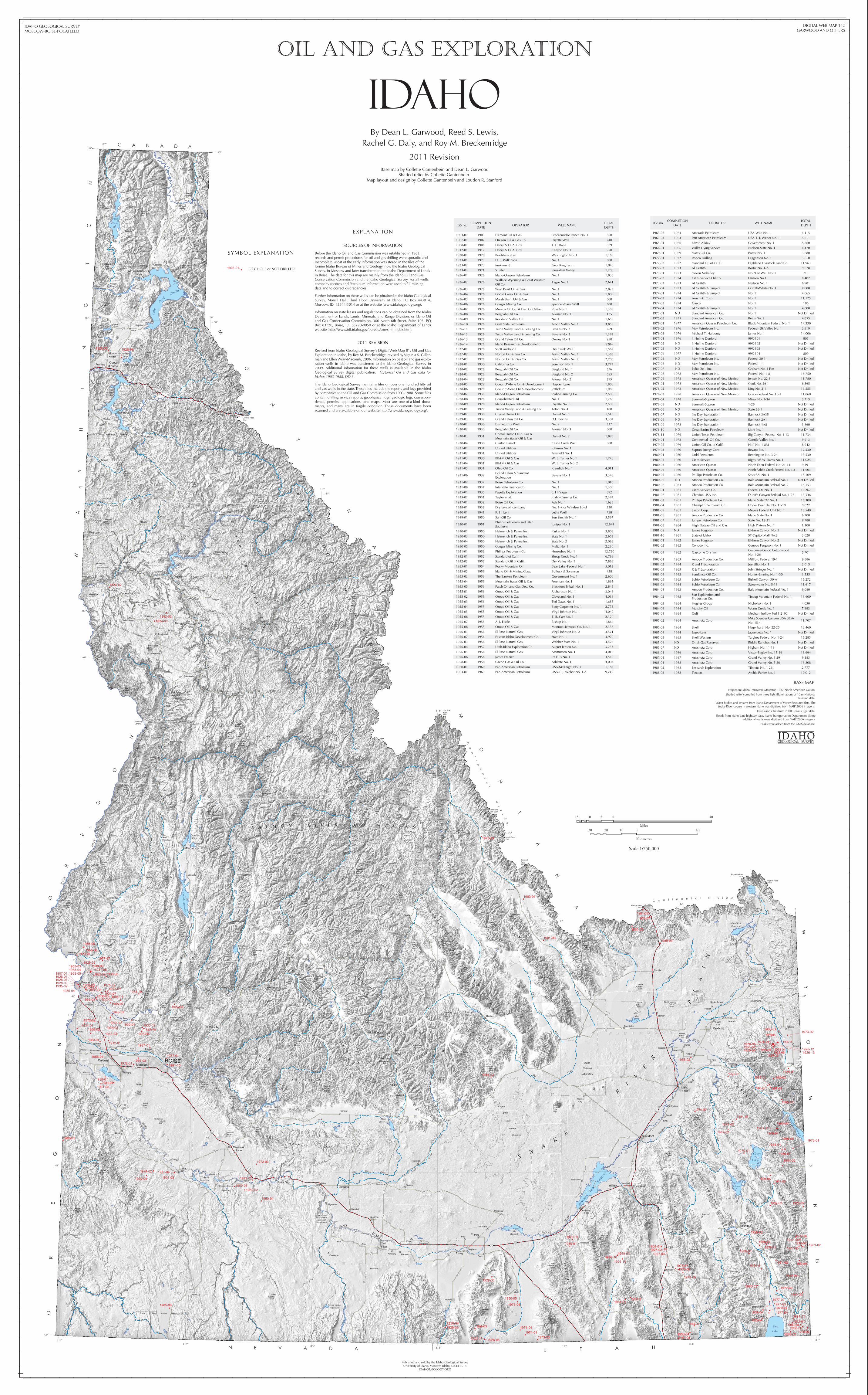
1903-01 1903 Fremont Oil & Gas Breckenridge Ranch No. 1 660
1907-01 1907 Oregon Oil & Gas Co. Payette Well 740
1908-01 1908 Henry & O. A. Cox T. C. Bane 879
1912-01 1912 Henry & O. A. Cox Canyon No. 1 950
1920-01 1920 Bradshaw et al. Washington No. 3 1,165
1923-01 1923 H. E. Wilkinson No. 1 500
1923-02 1923 (unknown) Geo. King Farm 1,040
1923-03 1921 S. Silen Jerusalem Valley 1,200
1926-01 1926 Idaho-Oregon Petroleum No. 1 1,830
1926-02 1926Wallace Wyoming & Great Western Oil Co.
Tygee No. 1 2,641
1926-03 1926 West Pearl Oil & Gas No. 1 2,823
1926-04 1926 Goose Creek Oil & Gas No. 1 1,800
1926-05 1926 Marsh Basin Oil & Gas No. 1 600
1926-06 1926 Cougar Mining Co. Spencer-Oasis Well 500
1926-07 1926 Monida Oil Co. & Fred G. Ostland Rose No. 1 1,385
1926-08 1926 Bergdahl Oil Co. Aikman No. 1 175
1926-09 1927 Rockland Valley Oil No. 1 1,650
1926-10 1926 Gem State Petroleum Arbon Valley No. 1 3,855
1926-11 1926 Teton Valley Land & Leasing Co. Bevans No. 2 269
1926-12 1926 Teton Valley Land & Leasing Co. Bevans No. 3 1,392
1926-13 1926 Grand Teton Oil Co. Dewey No. 1 950
1926-14 1926 Idaho Research & Development 220+
1927-01 1928 Scott Anderson Dry Creek Well 1,562
1927-02 1927 Norton Oil & Gas Co. Arimo Valley No. 1 1,383
1927-03 1928 Norton Oil & Gas Co. Arimo Valley No. 2 2,700
1928-01 1930 California Co. Sorenson No. 1 3,774
1928-02 1928 Bergdahl Oil Co. Berglund No. 1 576
1928-03 1928 Bergdahl Oil Co. Berglund No. 2 693
1928-04 1928 Bergdahl Oil Co. Aikman No. 2 295
1928-05 1929 Coeur D'Alene Oil & Development Hayden Lake 1,980
1928-06 1928 Coeur d'Alene Oil & Development Rathdrum 1,980
1928-07 1930 Idaho-Oregon Petroleum Idaho Canning Co. 2,500
1928-08 1928 Consolidated Oil No. 1 1,260
1928-09 1928 Idaho-Oregon Petroleum Payette No. 8 2,500
1929-01 1929 Tieton Valley Land & Leasing Co. Teton No. 4 100
1929-02 1930 Crystal Dome Oil Daniel No. 1 1,516
1929-03 1932 Grand Teton Oil Co. D.L. Bevins 3,304
1930-01 1930 Emmett City Well No. 2 337
1930-02 1930 Bergdahl Oil Co. Aikman No. 3 600
1930-03 1931Crystal Dome Oil & Gas & Mountain States Oil & Gas
Daniel No. 2 1,895
1930-04 1930 Clinton Basset Castle Creek Well 500
1931-01 1931 United Utilities Johnson No. 1
1931-02 1931 United Utilities Armfield No. 1
1931-03 1930 BB&M Oil & Gas W. L. Turner No.1 1,746
1931-04 1931 BB&M Oil & Gas W. L. Turner No. 2
1931-05 1931 Ohio Oil Co. Kramlich No. 1 4,011
1931-06 1932Grand Teton & Standard Exploration
Bevans No. 1 3,340
1931-07 1937 Boise Petroleum Co. No. 1 1,010
1931-08 1937 Interstate Finance Co. No. 1 1,300
1935-01 1935 Payette Exploration E. H. Yager 892
1935-02 1931 Taylor et al. Idaho Canning Co. 2,397
1937-01 1939 Boise Oil Co. Ada No. 1 1,625
1938-01 1938 Dry lake oil company No. 1-X or Windsor Loyd 250
1940-01 1941 R. H. Lent Letha Well 758
1949-01 1950 Sun Oil Co. Sun Sinclair No. 1 5,597
1950-01 1951Philips Petroleum and Utah Southern
Juniper No. 1 12,844
1950-02 1950 Helmerich & Payne Inc. Parker No. 1 3,808
1950-03 1950 Helmerich & Payne Inc. State No. 1 2,653
1950-04 1950 Helmerich & Payne Inc. State No. 2 2,068
1950-05 1950 Cougar Mining Co. Malta No. 1 2,230
1951-01 1953 Phillips Petroleum Co. Horseshoe No. 1 12,720
1952-01 1952 Standard of Calif. Sheep Creek No. 1 6,768
1952-02 1952 Standard Oil of Calif. Dry Valley No. 1 7,868
1953-01 1954 Rocky Mountain Oil Bear Lake -Federal No. 1 5,013
1953-02 1953 Idaho Oil & Mining Corp. Bullock & Sorenson 458
1953-03 1953 The Bankers Petroleum Government No. 1 2,600
1953-04 1953 Mountain States Oil & Gas Freeman No. 1 1,865
1953-05 1953 Patch Oil and Gas Dev. Co. Blackfoot Tribal No. 1 2,845
1955-01 1956 Oroco Oil & Gas Richardson No. 1 3,048
1955-02 1955 Oroco Oil & Gas Cleveland No. 1 4,038
1955-03 1956 Oroco Oil & Gas Ted Daws No. 1 1,685
1955-04 1955 Oroco Oil & Gas Betty Carpenter No. 1 2,775
1955-05 1955 Oroco Oil & Gas Virgil Johnson No. 1 4,040
1955-06 1955 Oroco Oil & Gas T. B. Carr No. 1 2,320
1955-07 1955 A. J. Eisele Bishop No. 1 1,864
1955-08 1955 Oroco Oil & Gas Monroe Livestock Co. No. 1 2,338
1956-01 1956 El Paso Natural Gas Virgil Johnson No. 2 3,521
1956-02 1956 Eastern Idaho Development Co. State No. 1 3,920
1956-03 1956 El Paso Natural Gas Webber-State No. 1 4,528
1956-04 1957 Utah-Idaho Exploration Co. August Jensen No. 1 5,233
1956-05 1956 El Paso Natural Gas Assmussen No. 1 4,017
1956-06 1956 James Frazier Ira Ellis No. 1 3,540
1958-01 1958 Cache Gas & Oil Co. Ashlette No. 1 3,003
1960-01 1960 Pan American Petroleum USA-McKnight No. 1 1,182
1963-01 1963 Pan American Petroleum USA-T. J. Weber No. 1-A 9,719
1963-02 1963 Amerada Petroleum USA-Wild No. 1 4,115
1963-03 1963 Pan American Petroleum USA-T. J. Weber No. 1 5,611
1965-01 1966 Edwin Allday Government No. 1 5,760
1966-01 1966 Willet Flying Service Nielson-State No. 1 4,470
1969-01 1969 States Oil Co. Porter No. 1 3,680
1972-01 1972 Roden Drilling Higgenson No. 1 3,610
1972-02 1972 Standard Oil of Calif. Highland Livestock Land Co. 11,963
1972-03 1973 Al Griffith Bostic No. 1-A 9,678
1973-01 1973 Steven Mahafley No. 9 or Well No. 1 715
1973-02 1974 Cities Service Oil Co. Hansen No.1 8,402
1973-03 1973 Al Griffith Neilson No. 1 6,981
1973-04 1973 Al Griffith & Simplot Griffith-White No. 1 7,000
1974-01 1974 Al Griffith & Simplot No. 1 4,065
1974-02 1974 Anschutz Corp. No. 1 11,125
1974-03 1974 Gasco No. 1 106
1974-04 1974 Al Griffith & Simplot No. 1 4,000
1975-01 ND Standard American Co. No. 1
1975-02 1975 Standard American Co. Reins No. 2 4,855
1976-01 1977 American Quasar Petroleum Co. Black Mountain Federal No. 1 14,330
1976-02 1976 May Petroleum Inc. Federal-Elk Valley No. 1 3,919
1976-03 1976 Michael T. Halbouty James No. 1 14,006
1977-01 1976 J. Hulme Dunford 99X-101 805
1977-02 ND J. Hulme Dunford 99X-102
1977-03 ND J. Hulme Dunford 99X-103
1977-04 1977 J. Hulme Dunford 99X-104 809
1977-05 ND May Petroleum Inc. Federal 30-1
1977-06 ND May Petroleum Inc. Federal 1-1
1977-07 ND Echo Dell, Inc. Graham No. 1 Fee
1977-08 1978 May Petroleum Inc. Federal No. 1-8 16,750
1977-09 1978 American Quasar of New Mexico Jensen No. 22-1 11,780
1978-01 1978 American Quasar of New Mexico Cook No. 26-1 6,565
1978-02 1978 American Quasar of New Mexico King No. 2-1 13,555
1978-03 1978 American Quasar of New Mexico Grace-Federal No. 10-1 11,860
1978-04 1978 Sunmark-Supron Miner No. 1-34 3,715
1978-05 ND Sunmark-Supron 1-28
1978-06 ND American Quasar of New Mexico State 26-1
1978-07 ND Nu Day Exploration Bannock 3A35
1978-08 ND Nu Day Exploration Bannock 2A1
1978-09 1978 Nu Day Exploration Bannock 1A8 1,860
1978-10 ND Great Basins Petroleum Little No. 1
1978-11 1979 Union Texas Petroleum Big Canyon-Federal No. 1-13 11,734
1979-01 1978 Continental Oil Co. Gentile Valley No. 1 9,913
1979-02 1979 Union Oil Co. of Calif. Hoff No. 1-8M 8,942
1979-03 1980 Supron Energy Corp. Bevans No. 1 12,530
1980-01 1980 Ladd Petroleum Bennington No. 3-24 13,530
1980-02 1980 Cities Service Rigby "A"-Williams No. 1 11,025
1980-03 1980 American Quasar North Eden-Federal No. 21-11 9,391
1980-04 1980 American Quasar North Rabbit Creek-Federal No. 6-21 11,603
1980-05 1980 Phillips Petroleum Co. Stoor "A" No. 1 15,109
1980-06 ND Amoco Production Co. Bald Mountain Federal No. 1
1980-07 1983 Amoco Production Co. Bald Mountain Federal No. 2 14,153
1981-01 1981 Cities Service Co. Federal DI No. 1 10,262
1981-02 1981 Chevron USA Inc. Dunn's Canyon Federal No. 1-22 13,546
1981-03 1981 Phillips Petroleum Co. Idaho State "A" No. 1 16,300
1981-04 1981 Champlin Petroleum Co. Upper Deer Flat No. 11-19 9,022
1981-05 1981 Exxon Corp. Meyers Federal Unit No. 1 18,540
1981-06 1981 Amoco Production Co. Idaho State No. 1 6,700
1981-07 1981 Juniper Petroleum Co. State No. 12-31 9,780
1981-08 1984 High Plateau Oil and Gas High Plateau No. 1 1,100
1981-09 ND James Forgotson Elkhorn Canyon No. 1
1981-10 1981 State of Idaho ST Capitol Mall No.2 3,028
1982-01 1982 James Forgotson Elkhorn Canyon No. 2
1982-02 1982 Conoco Inc. Conoco Ferguson No. 1
1982-03 1982 Gascome Oils Inc.Gascome-Gasco CottonwoodNo. 1-26
5,701
1983-01 1983 Amoco Production Co. Millford Federal 19-1 9,886
1983-02 1984 R and T Exploration Joe Elliot No. 1 2,015
1983-03 1983 R & T Exploration John Stringer No. 1
1983-04 1983 Sundance Oil Co. Hunter-Linning No. 1-30 3,555
1983-05 1983 Sohio Petroleum Co. Bishoff Canyon 30-A 15,272
1983-06 1984 Sohio Petroleum Co. Sweetwater No. 5-13 11,617
1984-01 1983 Amoco Production Co. Bald Mountain Federal No. 1 9,080
1984-02 1985Sun Exploration andProduction Co.
Tincup Mountain Federal No. 1 16,600
1984-03 1984 Hughes Group Nicholson No. 1 4,030
1984-04 1984 Murphy Oil Worm Creek No. 1 7,493
1985-01 1984 Gulf Mecham hollow Fed 1-2-1C
1985-02 1984 Anschutz CorpMike Spencer Canyon USA 0356 No. 15-4
11,707
1985-03 1984 Shell Hagenbarth No. 22-25 13,460
1985-04 1984 Jagee-Letts Jagee-Letts No. 1
1985-05 1985 Shell Western Targhee Federal No. 1-24 15,285
1985-06 ND Oil & Gas Reserves Riddle Ranches No. 1 Not Drilled
Not Drilled
Not Drilled
Not Drilled
Not Drilled
Not Drilled
Not Drilled
Not Drilled
Not Drilled
Not Drilled
Not Drilled
Not Drilled
Not Drilled
Not Drilled
Not Drilled
Not Drilled
Not Drilled
Not Drilled
Not Drilled
1985-07 ND Anschutz Corp Higham No. 11-19 Not Drilled
1986-01 1986 Anschutz Corp Victor-Bagley No. 15-16 13,694
1987-01 1987 Anschutz Corp Grand Valley No. 5-29 9,183
1988-01 1988 Anschutz Corp Grand Valley No. 5-20 16,208
1988-02 1988 Ensearch Exploration Tibbetts No. 1-26 2,777
1988-03 1988 Texaco Archie Parker No. 1 10,012
Miles
400515 10
Kilometers
0 401030 20
Scale 1:750,000
oil and gas exploration
IDAHOBy Dean L. Garwood, Reed S. Lewis,
Rachel G. Daly, and Roy M. Breckenridge
Base map by Collette Gantenbein and Dean L. GarwoodShaded relief by Collette Gantenbein
Map layout and design by Collette Gantenbein and Loudon R. Stanford
2011 Revision
SYMBOL EXPLANATION
1903-01 DRY HOLE or NOT DRILLED
EXPLANATION
SOURCES OF INFORMATION
Before the Idaho Oil and Gas Commission was established in 1963, records and permit procedures for oil and gas drilling were sporadic and incomplete. Most of the early information was stored in the files of the former Idaho Bureau of Mines and Geology, now the Idaho Geological Survey, in Moscow and later transferred to the Idaho Department of Lands in Boise. The data for this map are mainly from the Idaho Oil and Gas Conservation Commission and the Idaho Geological Survey. For all wells, company records and Petroleum Information were used to fill missing data and to correct discrepancies.
Further information on these wells can be obtained at the Idaho Geological Survey, Morrill Hall, Third Floor, University of Idaho, PO Box 443014, Moscow, ID. 83844-3014 or at the website (www.idahogeology.org).
Information on state leases and regulations can be obtained from the Idaho Department of Lands, Lands, Minerals, and Range Division, or Idaho Oil and Gas Conservation Commission, 300 North 6th Street, Suite 103, PO Box 83720, Boise, ID. 83720-0050 or at the Idaho Department of Lands website (http://www.idl.idaho.gov/bureau/smr/smr_index.htm).
2011 REVISION
Revised from Idaho Geological Survey's Digital Web Map 81, Oil and Gas Exploration in Idaho, by Roy M. Breckenridge, revised by Virginia S. Giller-man and Ellen Wray-Macomb, 2006. Information on past oil and gas explo-ration wells in Idaho was transferred to the Idaho Geological Survey in 2009. Additional information for these wells is available in the Idaho Geological Survey digital publication: Historical Oil and Gas data for Idaho: 1903-1988, DD-3.
The Idaho Geological Survey maintains files on over one hundred fifty oil and gas wells in the state. These files include the reports and logs provided by companies to the Oil and Gas Commission from 1903-1988. Some files contain drilling service reports, geophysical logs, geologic logs, correspon-dence, permits, applications, and maps. Most are one-of-a-kind docu-ments, and many are in fragile condition. These documents have been scanned and are available on our website http://www.idahogeology.org/.
BASE MAP
Projection: Idaho Transverse Mercator, 1927 North American Datum.
Shaded relief compiled from three light illuminations of 10 m National Elevation data.
Water bodies and streams from Idaho Department of Water Resource data. The Snake River course in western Idaho was digitized from NAIP 2006 imagery.
Towns and cities from 2000 Census Tiger data.
Roads from Idaho state highway data, Idaho Transportation Department. Some additional roads were digitized from NAIP 2006 imagery.
Peaks were added from the GNIS database.
IDAHOGEOLOGICAL SURVEY
Published and sold by the Idaho Geological SurveyUniversity of Idaho, Moscow, Idaho 83844-3014
IDAHOGEOLOGY.ORG
DIGITAL WEB MAP 142GARWOOD AND OTHERS
IDAHO GEOLOGICAL SURVEYMOSCOW-BOISE-POCATELLO