Embed Size (px)
DESCRIPTION
Digital Watershed:. A Nationwide Web Application Tool for Effective Watershed Management. Institute of Water Research Michigan State University. Introduction. - PowerPoint PPT Presentation
Citation preview

Digital Watershed:
Institute of Water ResearchMichigan State University
A Nationwide Web Application Tool for Effective Watershed Management

The digital watershed website is designed to provide both a centralized information repository and an online computing center for watersheds in the United States. This site is based on the comprehensive database of 8-digit watersheds for the whole continent of the United States, which is included in the EPA BASINS system.
Introduction

Nationwide Watershed Coverage Multiple Forms of Access Comprehensive Datasets Scaling Function Online Environmental Modeling Erosion and Deposition Modeling Online
Overview

Nationwide Watershed Coverage

Multiple Forms of Access
• Address entry• Map entry

Comprehensive Datasets(EPA BASINS Database)
• 8 Digit HUC• Regulated facilities• River network• DEM• State soil• …

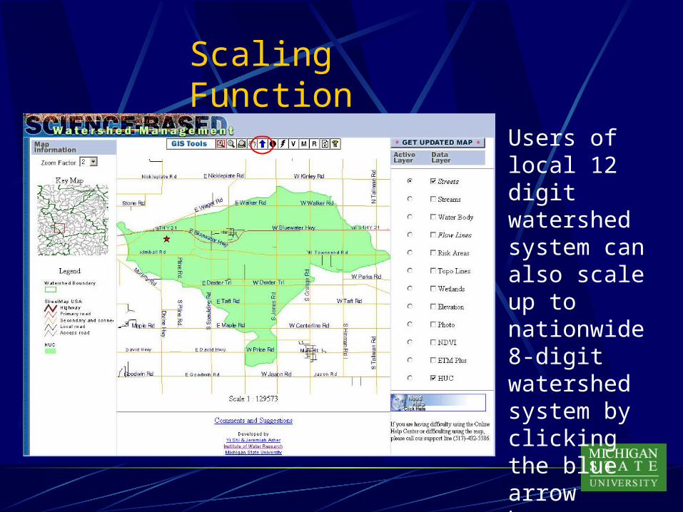
Our environment has different patterns at different scales. These patterns are shaped by a variety of processes at different scales. Therefore, the scale is a very important factor in understanding our environment. In Digital Watershed, we provide scaling function to allow users scale up and down between national level 8 digit and 12 digit local level watersheds. It also provides the seamless linkage between national watershed portal and distributed local level watershed systems. In other words, the local level systems can be anywhere on the web and their locations are transparent to end users.
Scaling Function

Scaling Function
The scaling function is provided by the blue arrow button. It allows users to scale down to local 12 digit watershed system.
Scaling Function
Users of local 12 digit watershed system can also scale up to nationwide 8-digit watershed system by clicking the blue arrow button.

With the advances in distributed computing technologies, online real time or quasi-real time environmental modeling has become a possibility. We believe that the online environmental modeling will become an essential part of our national watershed computing infrastructure.In Digital Watershed, we developed an online erosion and deposition modeling function as a demo for online environmental modeling to show the concept.
Online Environmental Modeling

Erosion and Deposition Modeling Online(A Demo for Online Environmental Modeling)
Users can conduct soil erosion and deposition modeling online by clicking the ‘M’ button.
Protecting our resources, protecting our future,one watershed at a time.
http://www.iwr.msu.edu/dw
Or Contact Jon Bartholic517-353-3742