Embed Size (px)
Citation preview

TS04E - Laser Scanners, 4988 Reginaldo Macedônio da Silva, Maurício Roberto Veronez, Francisco Manuel Wohnrath Tognoli, Larissa Jacobi and Débora Lamberty Digital Outcrop Model at Geological Analysis and Interpretation: Case Study Based on Data from Terrestrial Laser Scanner 3D FIG Working Week 2011 Bridging the Gap between Cultures Marrakech, Morocco, 18-22 May 2011
1/10
Digital Outcrop Model at Geological Analysis and Interpretation: Case Study Based on Data from Terrestrial Laser Scanner 3D
Reginaldo Macedônio da SILVA, Maurício Roberto VERONEZ, Francisco Manuel
Wohnrath TOGNOLI, Larissa JACOBI and Débora LAMBERTY, Brazil
Key words: LIDAR; Geological Interpretation; Digital Outcrop Models SUMMARY The analysis, description and interpretation of outcrops are mainly based on field activities, from which they make observations, descriptions and sketches in books and field photographs of outcrops. The traditional method of data collection in field generates a large amount of analog data to be processed and integrated for the subsequent interpretation. This study used the technique LIDAR (Light Detection and Ranging) for the acquisition of geological data from outcrop Morro Papaléo, located in the municipality of Mariana Pimentel, Rio Grande do Sul, Brazil where rocks of the Rio Bonito Formation, Permian of Paraná Basin outcrop. Data acquisition was made from a Terrestrial Laser Scanner (TLS), equipment that obtains three-dimensional coordinates of points on a surface by emitting and receiving laser pulses to an integrated receiver GPS. Initially, they were implanted with GPS geodetic points tracked for the transport of point coordinates installation of TLS. The resolution used to acquire the point cloud has a range from 1 mm to 3 cm between the points, according to the distance from the equipment in relation to the outcrop. The cloud has acquired the outcrop 151,395,728 points. In the later stage, were made to align the imaged scenes, georeferencing and triangulation points, which resulted in the Digital Outcrop Model (DOM). DOM enables to visualize geological elements with precision, including determining the direction of plans and measuring ranges of interest. It was possible to identify geological elements, such as layers, sedimentary structures, grain size less than gravel, fractures and faults, and the geometry of some bodies. It can be inferred rock types, depending on the texture and color resolution of the image. The interpretations obtained from the DOM has been validated in the field, in order to establish criteria for recognition of geological features from the georeferenced image analysis, which confirmed its usefulness as a technique for analysis and interpretation of outcrops complementary to conventional fieldwork . The ongoing research is focused on the integration between the DOMs and subsurface data (seismic, the borehole and well logs) as a way of refining geological models, especially models of analogous reservoirs.
TS04E - Laser Scanners, 4988 Reginaldo Macedônio da Silva, Maurício Roberto Veronez, Francisco Manuel Wohnrath Tognoli, Larissa Jacobi and Débora Lamberty Digital Outcrop Model at Geological Analysis and Interpretation: Case Study Based on Data from Terrestrial Laser Scanner 3D FIG Working Week 2011 Bridging the Gap between Cultures Marrakech, Morocco, 18-22 May 2011
2/10
Digital Outcrop Model at Geological Analysis and Interpretation: Case Study Based on Data from Terrestrial Laser Scanner 3D
Reginaldo Macedônio da SILVA, Maurício Roberto VERONEZ, Francisco Manuel
Wohnrath TOGNOLI, Larissa JACOBI and Débora LAMBERTY, Brazil 1. INTRODUCTION
Digital Outcrop Model (DOM) using the Terrestrial Laser Scanner has been growing
worldwide in recent years. In Brazil, there are few studies that discuss the benefits and the use of this tool, as well as the methods needed to work with this kind of technology.
Specifically at DOM, research utilizing the LIDAR (Light Detection and Ranging) technique is still incipient and require improvement, especially in regard to the processing, interpretation and integration with other data types.
According to Teixeira and Christofoletti (1997) modeling consists of a structured methodology for building models, and is based on standard techniques, generally complex. As for the model generated can be defined as being a simplified representation of a physical entity, a structure, a process or a phenomenon, to allow the analysis of their behavior in specific situations.
From the standpoint of geological modeling, we use structured methodologies for analyzing data and thus develop representative models that allow to visualize, analyze and interpret geological structures.
The geotechnologies usually available, such as total station, GPS and digital photographs, are tools that can be used to compare the improvements and progress that the Terrestrial Laser Scanner can offer in the fieldwork and subsequent interpretive analysis. Its use in geology has yielded good results (Pringle et al., 2004, 2006; Belliana et al., 2005, Wilson et al., 2009, Rotevatn et al. 2009; Fabuel-Perez et al., 2009), which motivates future studies on the subject.
In accordance with Barchik et al. (2007), the tool Terrestrial Laser Scanner is capable of capturing hundreds of millions of points with three-dimensional coordinates. According to Gonçales (2007), the equipment emits laser pulses with the aid of a scanning mirror. This pulse hits the object and part of that energy back into the system. Therefore, knowing the speed of the laser beam, the speed of light, and the time between transmission and reception of the laser pulse can measure the distance between sensor and object.
Within this context, analyze and create new procedures and methods for DOM with the use of remote sensing techniques is of paramount importance both for a better utilization of equipment and to improve the quality of interpretations.
TS04E - Laser Scanners, 4988 Reginaldo Macedônio da Silva, Maurício Roberto Veronez, Francisco Manuel Wohnrath Tognoli, Larissa Jacobi and Débora Lamberty Digital Outcrop Model at Geological Analysis and Interpretation: Case Study Based on Data from Terrestrial Laser Scanner 3D FIG Working Week 2011 Bridging the Gap between Cultures Marrakech, Morocco, 18-22 May 2011
3/10
2. GOALS
The main objective of this study was to establish some important guidelines for Digital Outcrop Model (DOM), from initial data collection and processing steps to interpret the geological features imaged. 3. MATERIALS AND METHODS 3.1 Materials
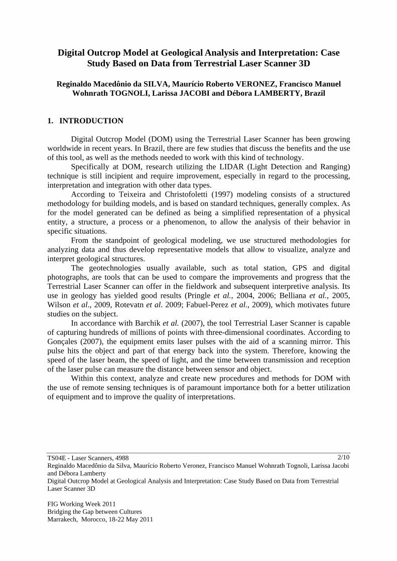
For the development of the work, it was used as study material one outcrop of the Rio Bonito Formation (Lower Permian of Paraná Basin) located in the city of Mariana Pimentel, Rio Grande do Sul, Brazil, between the geodetic coordinates in Datum WGS-84 (Latitude 300 18’ 10” South, Longitude 510 28’ 20” West and Latitude 300 18’ 40” South, Longitude 510 38’ 20” West) called Morro Papaléo (Figure 1).
Fig. 1 – Location of the outcrop (Morro Papaléo) in the Mariana Pimentel City
The outcop Morro Papaléo corresponds to an exposed section in large part by the activities of a former opencast mine created for exploitation of kaolin in the Mariana Pimentel City. As this is a small rise, the denudation of that hill to the exploration of clay allowed the three-dimensional exposure, primary from the middle-upper section. The basal portion of the outcrop section can be examined through existing ravines around the base of the hill (Iannuzzi et al., 2006). Thus this outcrop is perfect for the realization of scanning and use of the GPR (Ground Penetrating Radar) technique by accessibility to the sides and top of the outcrop.
M A RIA NAP IM EN TEL
R S
N
M orroPa p a le o

TS04E - Laser Scanners, 4988 Reginaldo Macedônio da Silva, Maurício Roberto Veronez, Francisco Manuel Wohnrath Tognoli, Larissa Jacobi and Débora Lamberty Digital Outcrop Model at Geological Analysis and Interpretation: Case Study Based on Data from Terrestrial Laser Scanner 3D FIG Working Week 2011 Bridging the Gap between Cultures Marrakech, Morocco, 18-22 May 2011
4/10
Fig. 2 - Photographs of the outcrop Morro Papaléo (Rio Bonito Formation - Paraná Basin).
The following equipment and software were also used for realize this work:
- Terrestrial Laser Scanner - ILRIS from Optech, Canadian Manufacturing (Figure 3 A);
- a pair of GPS-RTK (Real Time Kinematic) 900 LEICA Model (Figure 3 B);
Fig. 3 - (A) Terrestrial 3D Laser Scanner - ILRIS, (B) GPS-RTK (Real Time Kinematic) - 900 LEICA Model.
- Polyworks, Cloud Point and Parser – softwares for processing of points came from Terrestrial Laser Scanner 3D;
- Leica Geo Office - software for processing of GPS data; 3.2 Methods

TS04E - Laser Scanners, 4988 Reginaldo Macedônio da Silva, Maurício Roberto Veronez, Francisco Manuel Wohnrath Tognoli, Larissa Jacobi and Débora Lamberty Digital Outcrop Model at Geological Analysis and Interpretation: Case Study Based on Data from Terrestrial Laser Scanner 3D FIG Working Week 2011 Bridging the Gap between Cultures Marrakech, Morocco, 18-22 May 2011
5/10
3.2.1 Fieldwork - GNSS / GPS - Tracking Geodetic Marco
To collect field data with GNSS / GPS was needed as a first step to acquire the coordinate-based, and deployed it to a geodesic that was tracked for 4 hours with GPS dual frequency (L1, L2).
For coordinate transport were used as control points of the seasons RBMC (Rede Brasileira de Monitoramento Contínuo - Brazilian Network for Continuous Monitoring) of the IBGE (Instituto Brasileiro de Geografia e Estatística - Brazilian Institute of Geography and Statistics) from the cities of Santa Maria (SMAR) and Porto Alegre (POAL). 3.2.2 Fieldwork - Scanning the outcrop with the use of Terrestrial Laser Scanner 3D
For scanning the outcrop Morro Papaléo (Rio Bonito Formation, Paraná Basin) it has
required the installation of geodesic GNSS / GPS-RTK (Real-Time Kinematic) in both the control points. This technology allows for real time correction with radio frequency.
Importantly, the fieldwork should be guaranteed a minimum 10% overlap between shots scanned, so that there a proper junction of the scenes so as to minimize the effects caused by shadows during scanning (Bellian et al. 2005).
The coordinates obtained during scanning of the outcrop were used for the georeferencing of the point cloud generated with the Laser Scanner.
During the fieldwork was necessary to install the Laser Scanner in two strategic points for the scanning of the entire face of the outcrop. This procedure lasted approximately eight hours and took place in one day.
It was adopted as a parameter for the scanning of an outcrop spacing ranging from 1 to 5 mm between the dots, creating a cloud with a total of 151,395,728 points.
For the DOM generated and represents the outcrop, it is necessary that at the time of scanning the lighting conditions are good: a few clouds, sun shining directly on the outcrop, low amounts of aerosols, as these conditions ensure a better quality photograph, which will influence its junction with the cloud of points. If the picture gets a little dark, it can be improved before the association with the cloud of points, manipulating their properties (brightness, contrast, intensity), thereby increasing the visual quality of three-dimensional model. 3.2.3 Data processing of Terrestrial 3D Laser Scanner
The information collected in the field with Terrestrial Laser Scanner has been downloaded using the software Parser while processing the point cloud was performed using the software PolyWorks in four steps:
- Cleaning - in this procedure were eliminated from the cloud, the points on vegetation / waste or other obstructions that may interfere with the interpretation and modeling of outcrop (Figure 4);
- Alignment - this procedure were performed alignments of scanned scenes to merge into a single file;

TS04E - Laser Scanners, 4988 Reginaldo Macedônio da Silva, Maurício Roberto Veronez, Francisco Manuel Wohnrath Tognoli, Larissa Jacobi and Débora Lamberty Digital Outcrop Model at Geological Analysis and Interpretation: Case Study Based on Data from Terrestrial Laser Scanner 3D FIG Working Week 2011 Bridging the Gap between Cultures Marrakech, Morocco, 18-22 May 2011
6/10
- Geocoding - this step was performed during the alignment procedure, where it ran the georeferencing of the point cloud, using the data obtained in the field with GNSS / GPS-RTK;
- Triangulation - this step was the point of triangulation to generate the 3D modeling from point cloud.
Fig. 4 – The processing of point cloud in the PolyWorks
4. RESULTS AND DISCUSSIONS
Based on the point cloud and / or also on the triangulated model, it was possible to obtain measurements such as height, length and thickness of strata (Figure 5).
Fig. 5 – Measuring the height of strata after the triangulation of the outcrop
TS04E - Laser Scanners, 4988 Reginaldo Macedônio da Silva, Maurício Roberto Veronez, Francisco Manuel Wohnrath Tognoli, Larissa Jacobi and Débora Lamberty Digital Outcrop Model at Geological Analysis and Interpretation: Case Study Based on Data from Terrestrial Laser Scanner 3D FIG Working Week 2011 Bridging the Gap between Cultures Marrakech, Morocco, 18-22 May 2011
7/10
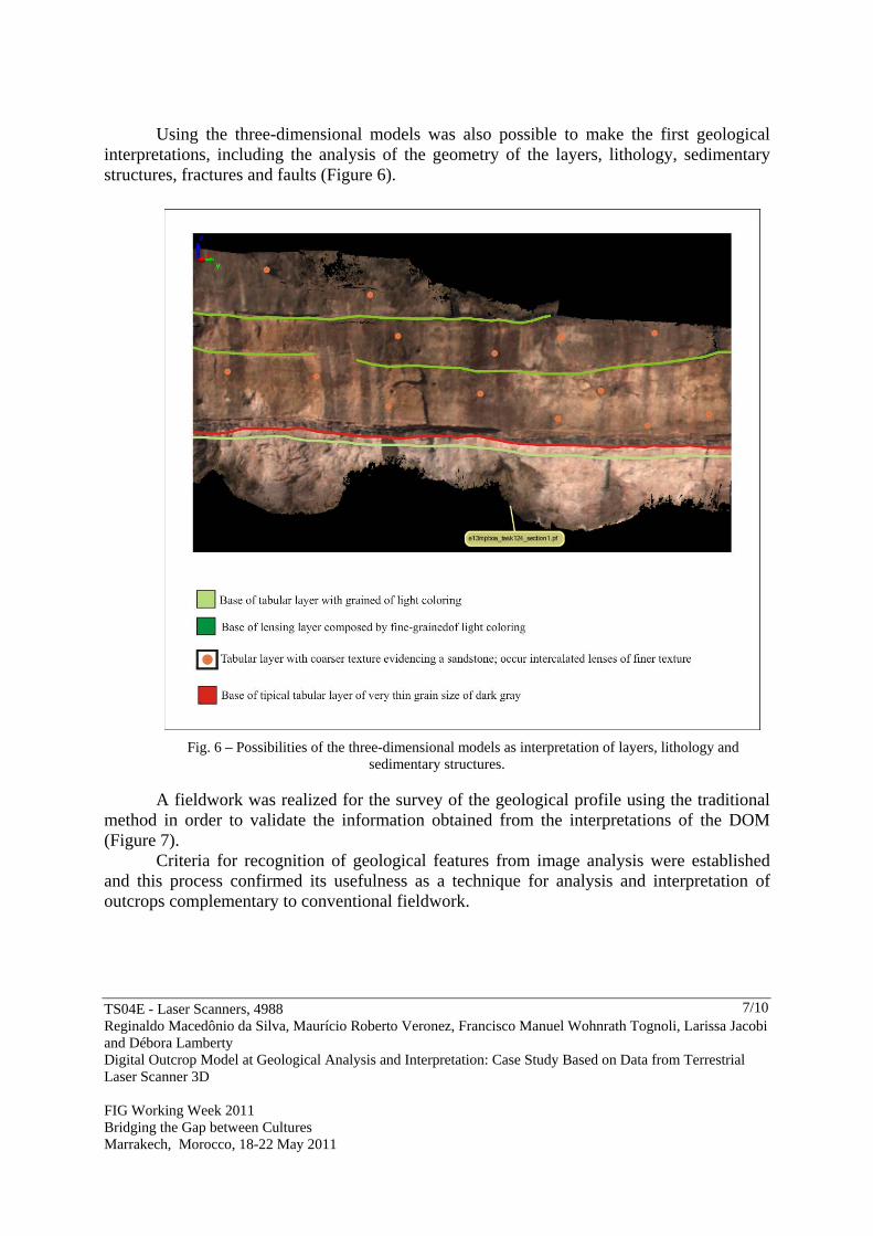
Using the three-dimensional models was also possible to make the first geological
interpretations, including the analysis of the geometry of the layers, lithology, sedimentary structures, fractures and faults (Figure 6).
Fig. 6 – Possibilities of the three-dimensional models as interpretation of layers, lithology and sedimentary structures.
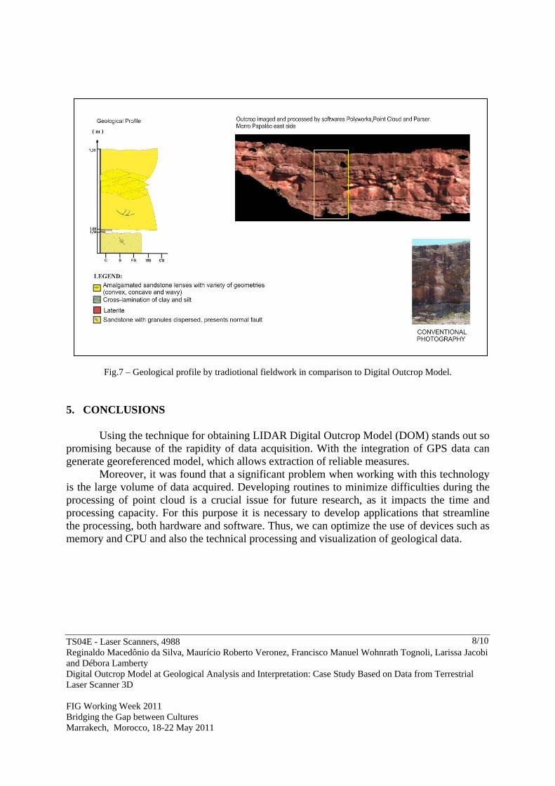
A fieldwork was realized for the survey of the geological profile using the traditional
method in order to validate the information obtained from the interpretations of the DOM (Figure 7).
Criteria for recognition of geological features from image analysis were established and this process confirmed its usefulness as a technique for analysis and interpretation of outcrops complementary to conventional fieldwork.
TS04E - Laser Scanners, 4988 Reginaldo Macedônio da Silva, Maurício Roberto Veronez, Francisco Manuel Wohnrath Tognoli, Larissa Jacobi and Débora Lamberty Digital Outcrop Model at Geological Analysis and Interpretation: Case Study Based on Data from Terrestrial Laser Scanner 3D FIG Working Week 2011 Bridging the Gap between Cultures Marrakech, Morocco, 18-22 May 2011
8/10
Fig.7 – Geological profile by tradiotional fieldwork in comparison to Digital Outcrop Model.
5. CONCLUSIONS
Using the technique for obtaining LIDAR Digital Outcrop Model (DOM) stands out so promising because of the rapidity of data acquisition. With the integration of GPS data can generate georeferenced model, which allows extraction of reliable measures.
Moreover, it was found that a significant problem when working with this technology is the large volume of data acquired. Developing routines to minimize difficulties during the processing of point cloud is a crucial issue for future research, as it impacts the time and processing capacity. For this purpose it is necessary to develop applications that streamline the processing, both hardware and software. Thus, we can optimize the use of devices such as memory and CPU and also the technical processing and visualization of geological data.

TS04E - Laser Scanners, 4988 Reginaldo Macedônio da Silva, Maurício Roberto Veronez, Francisco Manuel Wohnrath Tognoli, Larissa Jacobi and Débora Lamberty Digital Outcrop Model at Geological Analysis and Interpretation: Case Study Based on Data from Terrestrial Laser Scanner 3D FIG Working Week 2011 Bridging the Gap between Cultures Marrakech, Morocco, 18-22 May 2011
9/10
REFERENCES BARCHIK, E.; MOSER, I.; SANTOS, D. S. dos; MARTINS, B. D. 2007. Aplicação do Scanner Terrestre ILRIS – 3D no Ramo da Mineração. Anais. XIII Simpósio Brasileiro de Sensoriamento Remoto, Florianópolis, Brasil, 21-26 abril 2007, INPE, p. 3631-363. BELLIAN, J.A.; KERANS, C.; JENNETTE, D.C. Digital outcrop models: applications of terrestrial scanning lidar technology in stratigraphic modeling. Journal of Sedimentary Research, n. 75, p.166–176. 2005. BUCKLEY, S. J.; HOWELL, J. A.; ENGE, H.D; KURZ, T.H. Terrestrial Laser Scanning in Geology: Data Acquisition Processing and Accuracy Considerations. Journal of the Geological Society, London; 2008, v. 165; ISSUE: 3, p. 625-638. DOI: 10.1144/0016-76492007-100. FABUEL-PEREZ, I. HODGETTS, D.; REDFERN, J. 2009. A new approach for outcrop characterization and geostatistical analysis of a low-sinuosity fluvial-dominated succession using digital outcrop models: Upper Triassic Oukaimeden Sandstone Formation, central High Atlas, Morocco. AAPG Bulletin, 93:795-827. GONÇALES, R. 2007. Dispositivo de Varredura Laser 3D Terrestre e suas Aplicações na Engenharia, com Ênfase em Túneis. Dissertação de Mestrado, Universidade de São Paulo. São Paulo, 103 p. IANNUZZI, R.; SCHERER, C. M. dos S.; SOUZA, P. A.; HOLZ, M.; CARAVACA, G.; RODRIGUES, K. A.; TYBUSCH, G. P.; SOUZA, J. M. de; SMANIOTTO, L. P.; FICHER, T. V.; SILVEIRA, A. S. da; LYKAWKA, R.; BOARDMAN, R.; BARBOZA, E. G. 2006. Afloramento Morro do Papaléo, Mariana Pimentel, RS Registro ímpar da sucessão sedimentar e florística pós-glacial do Paleozóico da Bacia do Paraná. Sítios Geológicos e Paleontológicos do Brasil. (http://www.unb.br/ig/sigep/sitio101/sitio101.pdf.). OPTECH. Disponível em: http://www.optech.ca. Acesso em: 30 de setembro. 2009. PRINGLE, J.K.; GARDINER, A.; Westerman, R. 2004. Virtual geological outcrops-fieldwork and analysis made less exhaustive? Geology Today, 20:67-72. PRINGLE, J.K.; HOWELL, J.A.; HODGETTS, D.; WESTERMAN, A.R.; HODGSON, D.M. 2006. Virtual outcrop models of petroleum reservoir analogues: a review of the current state-of-the-art. First Break, 24: 33-42.

TS04E - Laser Scanners, 4988 Reginaldo Macedônio da Silva, Maurício Roberto Veronez, Francisco Manuel Wohnrath Tognoli, Larissa Jacobi and Débora Lamberty Digital Outcrop Model at Geological Analysis and Interpretation: Case Study Based on Data from Terrestrial Laser Scanner 3D FIG Working Week 2011 Bridging the Gap between Cultures Marrakech, Morocco, 18-22 May 2011
10/10
ROTEVATN, A.; BUCKLEY, S.J.; HOWELL, J.A.; FOSSEN, H. 2009. Overlapping faults and their effect on fluid flow in different reservoir types: A LIDAR-based outcrop modeling and flow simulation study. AAPG Bulletin, 93:407-427. TEIXEIRA, A. L. and CHRISTOFOLETTI, A. 1997. Sistemas de Informação Geográfica (Dicionário Ilustrado). Editora Hucitec, 244p. TEIXEIRA, W. L. E. 2008. Aquisição e construção de modelos estáticos análogos a reservatórios petrolíferos com tecnologia LIDAR e GEORADAR. Dissertação de Mestrado, Universidade Federal do Rio Grande do Norte. Natal, 99p. WILSON, P.; HODGETTS, D.; RARITY, F.; GAWTHORPE, R. L.; SHARP, I. 2009. Structural geology and 4D evolution of a half-graben: New digital outcrop modelling techniques applied to the Nukhul half-graben, Suez rift, Egypt. Journal of Structural Geology 31 (2009) 328–345 BIOGRAPHICAL NOTES The main author is surveyor engineer has been working in the topography and introduction to GIS disciplines since 2004 in the Universidade Feevale for the course of architecture and urbanism. He has a book of the Introduction to GIS in the Universidade Feevale. He is a Doctor of Science Student in Geology in the Univesidade do Vale do Rio dos Sinos (UNISINOS). CONTACTS Doctor of Science Student – Reginaldo Macedônio da Silva PPGEO – Programa de Pós-Graduação em Geologia UNISINOS – Universidade do Vale do Rio dos Sinos Av. Unisinos, 950 - B. Cristo Rei / CEP 93.022-000 SÃO LEOPOLDO BRAZIL Tel. +55 (51) 3591 1122 – r 1727 Email: [email protected] Web site: http://www.unisinos.br