Embed Size (px)
Citation preview
DIGITAL KILLED THE LABELLING STAR: APPROACHING THE TERRITORY-
MUSEUM WITH MOBILE TECHNOLOGY
HEATHER SUSAN HOBMA
Bachelor of Arts, University of Lethbridge, 2009
A thesis
Submitted to the School of Graduate Studies
of the University of Lethbridge
in partial fulfillment of the
Requirements for the Degree
MASTER OF ARTS
English
University of Lethbridge
LETHBRIDGE, ALBERTA, CANADA
© Heather Hobma, 2014
ii
Abstract
Visitors to historical locations in the United Kingdom step into what is, in
essence, a virtual world of history and cultural heritage. Whether they realise this or
not—and whether their experience at these sites is enriched by the recognition of the
connections to other related objects and sites in the region—is determined in large part by
the quality and coherence of the interpretative information available to them. This thesis
focuses on how this interpretation is currently carried out at three sites, Hoddom,
Ruthwell, and Bewcastle, and the possibilities for improvement based on the application
of different media and technologies.
iii
Table of Contents
Abstract ............................................................................................................................... ii
Table of Contents ............................................................................................................... iii
List of Figures and Graphs ................................................................................................. vi
Introduction ......................................................................................................................... 1
Chapter One: Museums and Technology ............................................................................ 9
History of the Museum ................................................................................................... 9
The History of Cultural Heritage .................................................................................. 16
The Visitor Experience and Mobile Technology .......................................................... 20
Technology in Museums: Some Examples ............................................................... 23
Chapter Two: Dumfries and Galloway as Territory-Museum .......................................... 32
The Historical Region ................................................................................................... 32
A De Facto Territory-Museum ................................................................................. 35
A Museological Reading of Ruthwell, Hoddom, and Bewcastle ................................. 43
Hoddom ..................................................................................................................... 44
Ruthwell .................................................................................................................... 50
Bewcastle .................................................................................................................. 61
Chapter Three: Digital Interpretation ................................................................................ 70
An Interpretive Strategy for Implementing a Digital Tour of Cultural Heritage Sites . 71
Digital Interpretation Plan for the Site of Ruthwell ...................................................... 71
iv
An Interpretation Plan using QR Codes .................................................................... 73
An Interpretation Plan using NFC Tags .................................................................... 75
An Interpretation Plan using Pattern Recognition .................................................... 79
Summary ................................................................................................................... 98
Chapter Four: Implementation and Larger Problems ..................................................... 101
A Technological Option for a Digital Tour ................................................................ 101
Experimentation with AR Applications for a Feasibility Study ................................. 103
Discussion ............................................................................................................... 108
Wikipedia and Sustainability .................................................................................. 109
The Visitor Survey as Part of the Feasibility Study .................................................... 111
Visitor Satisfaction .................................................................................................. 112
Results ..................................................................................................................... 127
Analysis ................................................................................................................... 129
Conclusion ...................................................................................................................... 131
Implications ................................................................................................................. 131
Further Research ......................................................................................................... 133
Technology ............................................................................................................. 133
User Interaction ....................................................................................................... 135
Sustainability ........................................................................................................... 138
Summary ..................................................................................................................... 139
v
Bibliography ................................................................................................................... 141
Appendix A ..................................................................................................................... 150
Sample of the visitor survey presented at Ruthwell, summer-winter 2013-14 ........... 150
Appendix B ..................................................................................................................... 151
A Transcription of the Hoddom Plaque ...................................................................... 151
vi
List of Figures and Graphs
Figure 1: Sign on the Ruthwell churchyard gate left by Historic Scotland. Photograph by
the author. 4
Figure 2: Map showing some important historical locations around Dumfries &
Galloway. Courtesy of Visit Scotland: http://www.visitscotland.com/en-ca/destinations-
maps/full-screen-map?region=dumfries 33
Figure 3: Aerial view of Hoddom looking north west. Photograph courtesy of Canmore
Mapping and RCAHMS. See http://canmore.rcahms.gov.uk 44
Figure 4: Plaque inside the Hoddom graveyard. Photograph by the author. 46
Figure 5: Hoddom, looking east. Photograph by the author. 48
Figure 6: The left image is an aerial view of the 1991 dig site, and (roughly) represents
the section in the black square on the right image, which is an aerial view of the Hoddom
graveyard. Both photographs courtesy of Canmore Mapping and RCAHMS. See
http://canmore.rcahms.gov.uk. 49
Figure 7: The front door to the Ruthwell kirk, just inside the churchyard gate, looking
south west. Photograph by the author. 50
Figure 8: Ruthwell kirk from the road, looking north. Historic Scotland site sign directs
visitors to the parking lot. Photograph by the author. 51
Figure 9: The old manse at Ruthwell, as seen from the visitor parking lot of the site.
Photograph by the author. 51
Figure 10: Murray's Quire. Photograph by the author. 52
Figure 11: The “Ruthwell Connection” sign, looking south west. Photograph by the
author. 54
vii
Figure 12: Front cover and forward of the visitor pamphlet available for sale in the
church. Photograph by the author. 55
Figure 13: Ruthwell interpretive paddles. Photograph by the author. 56
Figure 14: The piece of lintel fixed to the inside of the Ruthwell pit. Photograph by the
author. 57
Figure 15: The broken interior that is presented to visitors. Photograph by the author. 58
Figure 16: The carved side that faces away from visitors. Photograph by the author. 58
Figure 17: A confusing comparison between the original location of the cross and the
location of the plaque at the base of the tree stump. Right photograph by the author. Left
image is a vintage photograph courtesy of RCAHMS http://canmore.rcahms.gov.uk/en/de
59
Figure 18: Bewcastle Cross (centre background), looking east. Photograph by the author.
61
Figure 19: Close-up of the sundial on the south face of the Bewcastle Cross. Photograph
by the author. 62
Figure 20: Bewcastle Castle, looking east. Photograph by the author. 63
Figure 21: St. Cuthbert's Church, the Bewcastle Cross, and the Bewcastle interpretive
centre, looking east. Photograph by the author. 64
Figure 22: The Bewcastle Exhibition Centre. The order of the images here follows a
clockwise path around the room. Photographs by the author. 65
Figure 23: Image of the poster board of the Bewcastle Cross inside the Bewcastle
interpretive centre. Photograph by the author. 66
viii
Figure 24: Close-up image of "The Long Bar" image on the poster. Photograph by the
author. 67
Figure 25: View from the door of the visitors' centre, looking north. Photograph by the
author. 68
Figure 26: By scanning this QR code, you will be taken to the website
www.everythingruthwell.org 73
Figure 27: Example of AR in the Streetmuseum application by the London Museum.
Image courtesy of Zhang (2010). http://petapixel.com/2010/05/24/museum-of-london-
releases-augmented-reality-app-for-historical-photos. 79
Figure 28: Map of the Ruthwell site drawn by the author. 85
Figure 29: The Ruthwell Connections sign on the fence of the Ruthwell churchyard.
Photograph by the author. 86
Figure 30: This image is Aurasma enabled, meaning, it can be scanned using the
Aurasma application on your smartphone or tablet and will pull up the Aura associated
with it. Photograph by the author. 87
Figure 31: The Ruthwell connections sing overlaid with an Aura as seen in Aurasma on
an iPad. Photograph by the author. 88
Figure 32: A custom Google map with stops of interest and directions displayed in the
Aurasma application after the image is tapped. Photograph by the author. 88
Figure 33: The Christ and Magdalene panel on the Ruthwell Cross. Aurasma enabled.
Photograph by the author. 89
Figure 34: The painted plaster cast overlaid on the Christ and Magdalene panel displayed
on an iPad inside the Aurasma application. Photograph by the author. 90
ix
Figure 35: The Wikipedia entry on the Ruthwell Cross displayed inside the Aurasma
application after the image was tapped. Photograph by the author. 91
Figure 36: Murray's Quire looking south. Aurasma enabled. Photograph by the author. 91
Figure 37: Overlay for Murray's Quire displaying the role it played in the Aurasma app
on an iPad. Photograph by the author. 92
Figure 38: Image of the Ruthwell apse. Aurasma enabled. Photo by the author. 93
Figure 39: The apse plans overlaid on the apse displayed in the Aurasma application on
an iPad. Photograph by the author. 94
Figure 40: The garden marker indicating where the Ruthwell Cross stood between 1823-
1887. Aurasma enabled. Photograph by the author. 95
Figure 41: The Aura of the Ruthwell Cross in the garden dispalyed in the Aurasma
application on an iPad. Photograph by the author. 95
Figure 42: A photograph of the old manse looking north east. Aurasma enabled.
Photograph by the author. 96
Figure 43: McKeller’s painting of Burns at Ruthwell overlaid on the Ruthwell manse.
Displayed on an iPad inside the Aurasma application. Photograph by the author. 97
Figure 44: The Ruthwell kirk from the B724 looking north. Aurasma enabled. 98
Figure 45: Image of the Ruthwell kirk prior to the 1906 renovations overlaid on the
present day image of the kirk in the Aurasma application on an iPad. Photograph by the
author. 98
Figure 46: Members of VCP covering the skylight in order to scan the cross. Notice the
sunlight cast on the actual cross-head. Photograph by the author. 103
x
Figure 47: The trigger image printed on a piece of paper and taped to a wall.
Alternatively, the application also worked when used on a PowerPoint slide projected on
a screen. Aurasma enabled. Photograph by the author. 105
Figure 48: Screen capture taken of the Aurasma application overlay image on an iPad.
Photograph by the author. 106
Figure 49: Gravestone in the Canmore Historic Cemetery. Used as a target image.
Photograph by the author. 107
Figure 50: Image taken at the Canmore Museum. Used as an overlay image for the grave
marker in Figure 48. Photograph by the author. 108
Figure 51: Graph showing the places of residences of visitors to Ruthwell. 113
Figure 52: Graph portraying the amount of time visitors spent on-site at Ruthwell. 114
Figure 53: Age groups of visitors to Ruthwell. 115
Figure 54: Graph portraying the number of visitors with Ruthwell with mobile devices.
116
Figure 55: Graph showing the brands of smartphones and tablets carried by visitors to
Ruthwell. 117
Figure 56: Graph portraying visitors over the age of 65 with a mobile device. 118
Figure 57: Graph portraying visitors to Ruthwell with mobile devices broken down by
location of residence. 119
Figure 58: Penetration rate of smartphones by country (values in percentage of
population). Information and statistics from Our Mobile Planet by Google. 120
Figure 59: Graph portraying the specific reason for visiting Ruthwell. 121
xi
Figure 60: Graph portraying reasons for visiting Ruthwell when not specific to the cross.
121
Figure 61: Graph portraying reasons for visiting Ruthwell. 122
Figure 62: Graph portraying when visitors planned to see other sites while in the region.
123
Figure 63: Graph portraying other sites visitors had planned to visit while in the area. 124
Figure 64: Graph portraying visitors who researched Ruthwell before visiting. 124
Figure 65: Graph portraying types of research done before visting Ruthwell. 125
Figure 66: Graph portraying various ways visitors learned of the Ruthwell site. 126
Figure 67: Graph portraying the specific alternatives for how visitors learned of the
Ruthwell site. 127
xii
They took the credit for your second symphony,
Rewritten by machine and new technology.
And now I understand the problems you can see.
–The Buggles, “Video Killed the Radio Star”
Oh let the sun beat down up on my face, stars to fill my dream.
I am a traveller of both time and space, to be where I have been.
To sit with elders of the gentle race, this world has seldom seen;
They talk of days for which they sit and wait and all will be revealed.
–Led Zeppelin, “Kashmir”
1
Introduction
In Simon Thurley’s book, Men from the Ministry, the author’s primary aim is to
highlight the collective efforts of the men of the government (the architects,
archaeologists, and historians) to conserve, restore, research, and present to the public the
historical objects, artefacts, and places that make up Britain’s national history (2013, 2).
In his discussion of the men of the government who were responsible for the
creation of the national organisations for the conservation of historic monuments,
buildings, and places, Thurley briefly discusses the history of the evolution of cultural
heritage site preservation and interpretation. He describes the major role the expansion of
the railway system across the English landscape had on the increase of tourist visits to
rural sites (2013, 12) and how this increase in tourism brought the risk of destruction to
these delicate areas. This destruction demanded intervention, which was provided at first
by the local landowners (2013, 15). Eventually the government was organised enough to
step in and intervene in an official capacity, creating lists of scheduled (protected)
monuments, buildings, and places that became the cultural heritage sites we can visit
today. In the preservation of these monuments, buildings, and locations, we see an
authoritative shift from the indoor environments of the traditional museum (the static,
four walled buildings that remove objects and artefacts from their intended context in
order to place them under glass cases) to the field and countryside and back into the
environments and context these objects and artefacts were originally meant to be
experienced. This movement is largely influenced by technological innovations of the
day, encouraged primarily by the expansion of the railway lines (Thurley 2013, 12-14;
see also Sellars 1997; Runte 1997; Marsh and Hodgins 1998), shifting visitor interest
2
from the urban and city institutions to the countryside and rural heritage sites. These
protected collections are now in the care of the three devolved, contemporary bodies –
English Heritage, Cadw (in Wales), and Historic Scotland (Thurley 2013, 2).
This thesis is about the same divergent set of interests discussed in Thurley’s
book, but where Thurley argues that it was the Government that was the most successful
in operating cultural heritage sites (despite the landowners’ best efforts; 2013, 16), I
argue the opposite, especially when it comes to unstaffed locations. We see historically
that it was primarily the landowners (as amateur historians, whether they chose the role
or not) who became the curators, opening the doors to visitors, providing interpretive
information to tourists, and caring for the historical sites for the benefit of the society as a
whole. While on my own trip to Ruthwell and the Dumfries and Galloway area in April
of 2012, I saw that it is true that heritage interpretation is still handled best by the local
communities.
While there, I visited three related Anglo-Saxon heritage sites: the Ruthwell
church in Dumfries and Galloway, which is the site of the Ruthwell Cross, an eighth
century Anglo-Saxon stone cross; Hoddom, also in Dumfries and Galloway, which is the
location of a large Anglo-Saxon monastery (now gone) that saw its peak in the eighth
century; and the Bewcastle Cross in Cumbria, England, which is also an eighth century
Anglo-Saxon stone cross related closely to the Ruthwell Cross. These sites were
specifically chosen because of their close proximity to one other but also because of their
historical connections to each other. Although all three sites are under the care of
governmental heritage conservation agencies (Ruthwell and Hoddom by Historic
Scotland and Bewcastle by English Heritage), the best material is provided by the local
3
(and largely amateur) communities, acting as the curators of the (officially) unstaffed
sites. In contrast, the official materials (provided by the conservation agencies and
overseen by the bureaucrats1) are scarce and in some cases (specifically at Hoddom) are
even incorrect. It is in this dichotomy in the history of heritage preservation in the UK
that we see an ongoing conflict between the professionals and the amateurs to this day, a
political tension that I saw still exists while visiting the area, and in part largely stems
from the question of ownership. Although this question is not directly addressed in this
thesis, it is inherent at the sites discussed in this paper and worth mentioning here, even
briefly.
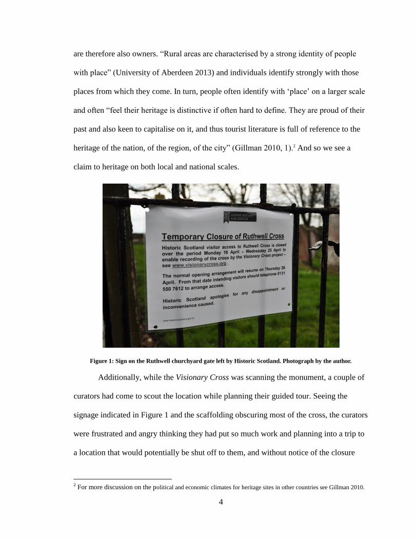
The tension I witnessed while visiting the Ruthwell site was primarily due to a
dispute over who had the right to close the church while the Visionary Cross Project
members were taking 3D scans of the Ruthwell Cross (the primary reason for the visit).
Members of Historic Scotland had come to the church to prepare the cross for the
erection of scaffolding and, while there, closed the site to the public by putting up signs
that included a phone number to the Historic Scotland office if access was required (see
Figure 1). Once they were gone however, the locals (those who maintain and care for the
curch on a daily basis) removed the signs and made arrangements with the Visionary
Cross members to allow visitors into the church while scanning continued. This dispute
exemplifies the tensions between the official conservation agencies, in this case Historic
Scotland, who are the “technical” owners of a historic site, and the local communities,
those who maintain, care for, make access to, and live directly with the historic sites, and
1 It is important to distinguish here what I mean by “professional.” When I refer to the professional works I
primarily mean the government bodies. Although I later stress the importance of allowing input to
interpretive material from all avenues (such as amateur and scholarly), I do not speak specifically of the
current scholarly contribution at these rural sites since it does not necessarily directly influence the on-site
interpretation plans themselves.
4
are therefore also owners. “Rural areas are characterised by a strong identity of people
with place” (University of Aberdeen 2013) and individuals identify strongly with those
places from which they come. In turn, people often identify with ‘place’ on a larger scale
and often “feel their heritage is distinctive if often hard to define. They are proud of their
past and also keen to capitalise on it, and thus tourist literature is full of reference to the
heritage of the nation, of the region, of the city” (Gillman 2010, 1).2 And so we see a
claim to heritage on both local and national scales.
Figure 1: Sign on the Ruthwell churchyard gate left by Historic Scotland. Photograph by the author.
Additionally, while the Visionary Cross was scanning the monument, a couple of
curators had come to scout the location while planning their guided tour. Seeing the
signage indicated in Figure 1 and the scaffolding obscuring most of the cross, the curators
were frustrated and angry thinking they had put so much work and planning into a trip to
a location that would potentially be shut off to them, and without notice of the closure
2 For more discussion on the political and economic climates for heritage sites in other countries see Gillman 2010.
5
from Historic Scotland. The members of the team (and the gentleman who had removed
the “Closed” signs) assured them they would have access and that the site and cross
would be open for their tour group (the scanning was finished, and subsequently the
scaffolding was gone, by the time the tour was scheduled to come through the area). The
curators were understandably angry about the situation, and their reaction highlights
another layer of tension between the curatorial/museological voices of authority and the
bureaucratic voices of authority.
The Ruthwell Cross, which has been defined as the “most important Anglo-Saxon
sculpture in Scotland” (Foster et al. 2006, 33) and is heralded by the local parish as “our
amazing cross” (Moule qtd. in Ruthwell Kirk n.d.), is viewed as both a heritage object
owned by the nation as well as a cultural object that, to some extent, defines the local
community. My point here is to not place validity on one group over the other, but to
recognise that the input from both parties is important (including the scholars and
academics who study the Ruthwell Cross and other Anglo-Saxon monuments, as a third,
more distanced party involved). The bureaucratic professionals have claimed ownership
in order to guarantee preservation of cultural artefacts and to fund conservation efforts.
But the local communities (the amateur curators) define themselves by the heritage and
artefacts they live with and are surrounded by. It is due to their pride, enthusiasm, and
desire to share these objects with visitors that the small, unstaffed (at least officially),
rural locations are cared for and made available to the general public.
Chapter one of this thesis looks at the historical development of the museum (in
line with what is discussed in Thurley’s book), the different types of museums, and the
definitions of each. It also looks at the differences between urban institutions and the
6
more rural and remote sites. It looks at how modern museums have been developed by
and benefitted from technological innovations throughout their history and how they are
currently experimenting successfully at an institutional level with mobile interpretation. It
also looks at how technological developments have taken people out of the urban and
placed them into the rural, and how contemporary technology is now directing people
back into the urban environment.
While chapter one looks at the history of cultural heritage tourism and
interpretation and its relationship with mobile technology, chapter two looks at the
Dumfries and Galloway peninsula in Scotland in particular and how it can be understood
as a territory-museum and how current interpretative efforts do and do not work in
bringing out this aspect of the region. It looks in detail at the three aforementioned
Anglo-Saxon sites in the region and how the local communities do a better job than the
professionals in the quality and comprehensiveness of their interpretation. In particular,
the amateur curators do a much better job in establishing the context for the sites they
interpret. We will see how the communities deal with the information locally and operate
out of enthusiasm, pride, and respect for their histories. In contrast, the professionals (the
bureaucrats) work on a more global scale, connecting rural sites in smaller regions to
urban landscapes hours away. The first two chapters, when taken together, demonstrate
how the current interpretive plan fails to exploit the full potential of the peninsula.
Chapter three looks at how contemporary mobile technology could be used to
improve the interpretive plan of the peninsula, and visitor experiences on a whole,
focussing on the interpretation of the Ruthwell Cross and kirk. Ruthwell was chosen
because it is a nice middle ground between the most complete interpretive plan at
7
Bewcastle and the least complete interpretive plan at Hoddom. Chapter three presents a
demonstration of a virtual tour of the Ruthwell site and how it could be constructed in a
way that would take advantage of the site's current strengths (including local engagement
and a commitment to a comprehensive, in situ interpretation) but builds on them by
taking advantage of the possibilities of contemporary and short-horizon mobile
technology.
And finally, chapter four looks at the difficulties and technological issues with
current mobile technology and how this can influence the implementation of a mobile
tour at a rural, folk-run, cultural heritage site through experimentation with augmented
reality applications (which is defined in more depth later in this thesis). It also looks at
some potential difficulties with Ruthwell’s unique visitor demographic in an introduction
of a digital tour and some possible solutions for addressing these issues.
Keeping the inherent conflict between the professionals and local communities in
mind, this thesis essentially looks at how mobile technology is being used successfully by
urban museums to improve visitor experience and edification and looks at how these
examples of mobile use can be employed to improve on heritage interpretation and visitor
experiences in rural territory-museums. However, it also looks at the distinctions between
urban museums and rural cultural heritage sites, how the two function in different ways
even as they both hope to achieve similar goals, and how the technology would need to
be modified to specifically work in a rural setting with no staff, no stable environment,
and with technology that is still young. In order to achieve these goals, this thesis
approaches three basic but important point when handling visitor interpretation in
territory-museums: 1. Cultural heritage sites are driven by technology; 2. Rural cultural
8
heritage sites have been best served by amateurs; 3. Mobile technology can (and should)
be looked at as a way of bridging the gap between the professionals and amateurs.
9
Chapter One: Museums and Technology
This chapter discusses the history of museums, museum studies, cultural heritage
sites, and the development of the discipline of site interpretation by discussing the theory
and literature of museums, both past and present. It also looks at the differences between
urban and rural sites, the interpretive strategies for the different kinds of museums, and
how these strategies and theories can be applied to the rural, folk-run, cultural heritage
sites. It then discusses the affect that historical technological innovations have always had
on the museum institution. We will see how mobile technology and cultural heritage
sites, at least in the United Kingdom, have an almost symbiotic relationship. We will then
turn to contemporary museums and how they are experimenting successfully at an
institutional level with mobile interpretation.
History of the Museum
According to the International Council of Museums (ICOM), a museum is “a non-
profit, permanent institution in the service of society and its development, open to the
public, which acquires, conserves, researches, communicates and exhibits the tangible
and intangible heritage of humanity and its environment for the purposes of education,
study and enjoyment” (International Council of Museums 2012). This definition is
accepted by the international community and was last revised in 2007 at the General
Conference in Vienna, Austria (International Council of Museums 2012). The definition
of a museum is constantly evolving, and often changes to reflect the attitudes, values, and
environments of the current times, primarily evolving to suit the interests and desires of
the museum’s visitors. In other words, the museum, at its most basic, is a building that
houses artefacts and objects of cultural and historical significance with the intention of
10
preserving, conserving, and interpreting them for the education and enjoyment of the
general public.
The original concept of the museum evolved from the curio-cabinets and princely
art collections of the eighteenth century that were opened to the public, primarily after the
French Revolution, as a way of distributing the upper class’s possessions (Duncan and
Wallach 1980, 449; see also Bennett 1995). In order for the collections to become
property of the public the presentation needed to change; specifically, the way visitors
experienced and perceived them (Duncan and Wallach 1980, 449). The collections were
no longer a privilege of the elite, but were on display for the enjoyment of the general
public, and the visitor was no longer a passive observer in awe of the prince’s collection,
but “a citizen and therefore a shareholder in the state” (Duncan and Wallach 1980, 455).
This change in the “way of viewing” a collection, and the building itself that housed the
collection, is what became known as the Universal Survey Museum (which as we shall
see is a type of Legislative museum) and is the traditionally accepted image of a museum.
The Universal Survey Museum is epitomised in museums such as the Louvre, the
National Galleries in London and Washington, and the Metropolitan Museum of New
York (Duncan and Wallach 1980, 452). But ever since publicly open museums became
popularly accepted in the eighteenth century, the definition of a museum has been in flux,
mainly in response to changing times. Hooper-Greenhill argues that “Museums have
always had to modify how they worked, and what they did, according to the context, the
plays of power, and the social, economic, and political imperatives that surrounded them”
(1992, 1). This argument is reflected in current museum practices. But despite the many
changes museums have had to go through, they have always maintained the fundamental
11
role as “storehouses of knowledge” (Hooper-Greenhill 1992, 4). In this role, a museum
can be anything: an art gallery, science centre, cultural heritage centre or interpretation
centre, even a theme park, as long as it employs knowledge preservation and presentation
that allows visitors to experience the institution’s collection of objects and artefacts.
There are problems surrounding the musealisation of these significant artefacts
and objects. The “Museum Effect” stipulates that the very act of removing an object from
its original context and placing it on display within the walls of the museum, surrounded
by glass cabinets, lighted, carefully labelled, is what gives the object its importance
(Atkins 2009, n.p.; Casey 2003, 2; see also Bennett 1995; Alpers 2001; Malraux 1967;
Kirshenblatt-Gimblett 1998). The curators of museums act as authorities on the objects
and artefacts they care for, but in turn, they are given the authority to act as caretaker and
interpreter by the general public (Cain 2008, 143). From this role, the curators choose
how visitors are directed around the museums and determine how visitors will “read” the
objects and interpret them. In many cases, the visitor becomes an observer and a witness
to the historical recreation being presented by the curator and the exhibit. How the
objects are displayed, and thereby interpreted, and how the visitor relates to these objects,
are all dependant on the museum’s institutional goals.
Museum practice has transitioned through many stages since its earliest days.
Casey identifies two major typologies of museum practice. Traditionally, the “Legislating
museum” was popular in the early nineteenth century and was essentially “a container for
collections of objects” (2009, 4). It aimed to “create a venue for display not debate” and
displayed objects without contextualising the information (Casey 2009, 5). The visitors
were therefore dependant entirely on their own interpretation of what they were seeing,
12
with no guidance whatsoever from the museum’s curator. The “Legislative Museum”
then grew into the “Interpreting Museum” with the idea that the museum is responsible
for the edification of the visitors. The Interpreting Museum is a contemporary style of
museum and presents a “metaphorical shift” from
the authoritative ‘temple’ to the contextualized ‘forum’ that contains multiple
voices and presentations. Through label text, docent tours, and multimedia tools,
the museum provides a framework for how objects should be viewed and
understood. (Casey 2009, 6)
The visitor is then told what to see and how to read an object or artefact, and must trust
the museum for the information he or she is being given. In both cases, the museum is the
voice of authority and the visitor is the passive observer taking in the information from
the outside, a position that has been criticised in recent history (see Cain 2008; Alpers
2001; Whitelaw 2000).
In response to this criticism, there has been a shift towards constructivist learning
in the museum. Constructivism addresses the idea that museum visitors represent a wide
range of individuals who each have his or her own way of learning. A Constructivist
Museum is one that allows visitors to “draw their own conclusions about the meaning of
the exhibition” (Hein 2008, 1-6). Hein states that by “considering both the
epistemological bases for our organisation of exhibitions and the psychological basis for
our theory of learning, we can develop museums that respond to the dispositions of our
visitors and maximise the potential for learning” (2008, 6).
These museum practices can, and have been, extended into interpretation centres
and cultural heritage sites. Indeed, the two types of museological settings are not
mutually exclusive, although there are many differences between them. Similar issues are
present at cultural heritage sites, and similar visitor interpretation strategies can be
13
employed at each to solve these problems. The HICIRA Project developed the 2005
Hicira Handbook for Heritage Interpretation Centres as a comprehensive guide to the
management of interpretation centres. HICIRA is an international European project
aimed at helping to facilitate the creation and management of interpretation centres,
especially in rural Europe, and is internationally recognised. The Handbook describes
four main types of interpretation settings (2005, 29-33):
Museums are specialised settings for presenting items of historical cultural
interest, exhibited in accordance with a museum’s museological and
museographical project, working within a museum’s mission statement. They
acquire (meaning, the object and/or artefact of interest is removed from its
original setting), conserve, preserve, communicate, and exhibit, for the purpose of
study. They tend to supply formal reading and interpretation to visitors.
Heritage in situ is the opposite of a museum. Heritage in situ contextualises
heritage artefacts that include archaeological and paleontological remains,
monuments, historic buildings (such as churches, castles, etc.), and other
unmovable features (such as walls, crossroads, etc.). These types of sites present
heritage in its own context, usually with supplementary interpretive material (such
as plaques). There are three main forms of presentation for heritage in situ sites:
o Basic. The site is open for visitors, with or without interpretive sign
postings.
o Supplementary permanent exhibition. An exhibition is installed to explain
and provide examples of research, restoration, or any other work that has
been done on the site.
14
o Musealisation. This takes a museological approach that employs the use of
an interpretation centre.
Interpretation centres are found in the same natural and cultural heritage sites as
those considered Heritage in situ, but the presentation strategy focuses on
scenographic exhibition. The aim is for the visitor to explore and interact with
heritage. This version differs from museums because interpretation centres do not
collect, conserve, or necessarily study objects, but rather they attempt to enable
visitors to gain a better appreciation of the site’s natural and cultural values by
providing the necessary information, within the context of the original site. These
centres work to educate and raise awareness from the heritage site where they are
located. The centres often include other services, such as tourist information
services, tours with guides, bars and/or restaurants, etc.
Territory Museums are relatively new models of interpretation centres, and
therefore not many currently exist. The territory-museum is not located in a
physically delimited single-use compound, but instead shares in the daily life of
the area and its inhabitants. The term “territory-museum” is used to designate an
area in which its coherence stems from historical and geographical links. It aims
to enhance the welfare of the local community.
In this context, the Handbook defines “Interpretation” as:
a working method which facilitates presentation and social use of heritage and
serves to provide a reading and options for its active use by means of many
presentation and animation resources. Interpretation is based on cultural and/or
natural evidence, either material or immaterial, found in a given location, and
seeks to promote these features in their original context. To this end, the aim is
always in situ recovery and the greatest possible contextualisation of heritage
15
resources. The idea of the object as having value in itself in isolation from its
function and setting, is rejected. (2005, 15)3
The important thing here is the idea that an object, in and of itself, as having value “in
isolation from its function and setting” has been rejected in favour of an understanding of
the object in its historical and geographic context, which is presented as the ideal. This is
what differentiates interpretation centres and cultural heritage sites from traditional
(Legislative) museums (although it is important to note that the “Interpreting Museum”
discussed earlier does attempt to rectify this issue within the museum walls). An object or
artefact that is treated as Heritage in situ through the addition of an interpretation centre,
or as part of a territory-museum derives its importance and value from the evidence of its
original function and context: it is the environment the object or artefact inhabits and its
purpose for being created that gives it value and significance in a greater historical whole.
In this model, the “Museum Effect” is being countered through in situ recovery.
André Malraux’s concept of the musée imaginaire or “museum without walls”
can also be applied to the territory-museum setting. Although Malraux’s concept dealt
with the proliferation of art to the public without the confines of a traditional museum
setting (1967), the theory behind such a concept is easily applied to the tangible reality of
a territory-museum, which is best realised and connected through the means of mobile
technology.4
3 The idea that cultural objects and artefacts should be seen and interpreted in their original setting is still hotly debated,
especially in war-torn areas of the world, partly due to political and economic reasons that will not be discussed in this
paper. For further discussion on these issues see Gillman 2010. 4 In an email to me on April 24, 2014, James Graham made an interesting observation about territory-museums: “The
Territory Museum—consisting of interconnected elements that form a larger “site”—can be understood as functioning
very much like hypermedia. The user and site administrator create or define pathways of physical, intellectual and
historical connectedness, which is greater than the sum of its parts.”
16
The History of Cultural Heritage
An interest in cultural heritage, and even cultural heritage preservation, at least as
we know it as it is today, blossomed among the general public in the mid-nineteenth
century. Museological practices had been observed since the princely curiosity cabinets,
and a solid foundation of artefact interpretation had already been mostly established.
What was different in the perspective of cultural heritage sites was the context of the
artefacts and object. They were not being removed from their original setting, but being
interpreted in situ; certainly because, in many cases, the objects were far too large to
move (e.g. Stonehenge):
Morales (2001) highlights the growing interest in the subject [of heritage
interpretation] over recent years, which he attributes to a number of factors: the
rise of environmental education; improvements in protected nature areas; a
concern with and awareness of the need to present cultural and natural heritage,
and the increasingly widespread interest in cultural and nature tourism. To all
these factors, we could also add the rising interest and demand among the public,
which increasingly seeks locations combining heritage with education and leisure.
(qtd. in Izquierdo et al. 2005, 15-16)
The interest in cultural heritage sites seems to have gained traction around the
same time in North America and the UK, showing that, to some extent at least, this
interest in cultural heritage and the interpretation of such a history is not an isolated
phenomenon. According to the Hicira Handbook, this interest began with the
establishment of the first National Parks in the United States, primarily due to an increase
in publicity for the parks around 1873 (when Yellowstone was established) and growing
in strength as the rail systems were established (Izquierdo et al. 2005, 15). Thurley argues
the interest in cultural heritage began much earlier in England due to a variety of factors
(2013, 5-17); however, interest in cultural heritage and natural sites in Canada, the US,
and the UK did not develop in isolation. The factors Thurley attributes to the growing
17
interest in heritage sites include the rise in the number of fictional books placed in
historic locations (specifically, Sir Walter Scott’s historical novels, the first of which was
published in 1814) and travel books published in the mid-nineteenth century (such as
William and Mary Howitt’s guidebook to ruined Abbeys, the first of its kind, published
in 1862) (2013, 6, 8-13, 19), the establishment of archaeology as a discipline (2013, 36-
37), and industrialisation and the development of the railway system, which made travel
to remote locations easier, at least for the elite. Rail transport became even more popular
with the Great Exhibition in 1851, since many more people travelled to London by rail
than ever before (2013, 12-14). This development of the railway system directly
influenced the development of the national parks in Canada and the US, and the
development of the railway systems in Canada and the US were influenced by
industrialisation in the UK (see Sellars 1997; Runte 1997). The history of the railway
system is convoluted in both Canada and the US and will not be discussed in any detail in
this paper, however it was primarily due to the westward movement of the rail systems in
both countries that created an interest in and brought people to the natural parks. And, in
turn, the railways exploited visitor interest in these sites through the promotion of tourism
as a way to help fund the railway lines.
England was the first to develop a rail system (in the 1830s), with its biggest
growth in the 1840s when it expanded to the smaller towns and villages in the English
countryside (Thurley 2013, 12-14). In 1840, Canada saw the establishment of a number
of railways in the eastern provinces, yet it was not until the 1880s that the longest railway
in Canada was built, which connected the Post-Confederation provinces with British
Columbia and the Pacific coast (Reichwein 1998, 160; see also Marsh and Hodgins 1998;
18
Sellars 1997; Runte 1997; Runte 2011). This is the system that really brought tourism to
the unsettled areas of Western Canada. And as a result, a different type of entertainment
was created.
The national parks and cultural heritage sites may seem different at first glance
(the national parks being devoted to the natural world while cultural heritage sites
focused on human history), but the two are not mutually exclusive. As mentioned earlier,
a museum can be anything that preserves and interprets its collection for the benefit of the
general public. This is the same for the national parks, which preserve and interpret the
natural world for the general public, and cultural and heritage sites (such as those in rural
England), which are preserved and interpreted for the general public. The driving force of
interest in the natural parks and cultural heritage sites were trains and promotional
tourism. In turn, the increased interest in the national parks and cultural heritage sites
drove the expansion of the railways and roads to make access to these areas more
accessible. In short, it seems that technology (specifically, the state of the art technology
of the day) and museological practices developed a somewhat symbiotic relationship.
Although the actual practice of heritage interpretation grew from the
establishment of the national parks in the course of the nineteenth century, it was really
not until 1957 when Tilden published Interpreting Our Heritage that the actual
foundations of the discipline were established (Izquierdo et al. 2005, 15). Although the
act of interpretation had really existed since the early days of the museum, Tilden is often
credited as the “founding father” of interpretation (Craig 2007, intro to Interpreting Our
Heritage, loc 349 and 350 of 3209). This was due mainly to his interest in the natural
heritage of the national parks. Interpreting Our Heritage was the first publication
19
interested in cultural and natural publication as a discipline (Craig 2007, Loc 102 of
3209). Until Tilden published his book in 1957, the discipline of cultural and natural
interpretation was largely the work of amateurs.
According to Tilden, “interpretive effort, whether written or oral or projected by
means of mechanical devices, if based upon these six principles, will be correctly direct.
There will inevitably be differences in excellence arising from varied techniques and
from the personality of the interpreter” (2007, Loc 585 of 3209). The six guiding
principles for interpretation, as defined by Tilden (2007, Loc 585-86 of 3209), are:
1. Any interpretation that does not somehow relate what is being displayed or
described to something within the personality or experience of the visitor will be
sterile.
2. Information, as such, is not interpretation. Interpretation is revelation based upon
information. But they are entirely different things. However, all interpretation
includes information.
3. Interpretation is an art, which combines many arts, whether the materials
presented are scientific, historical, or architectural. Any art is in some degree
teachable.
4. The chief aim of interpretation is not instruction, but provocation.
5. Interpretation should aim to present a whole rather than a part and must address
itself to the whole man rather than any phrase.
6. Interpretation addressed to children (say, up to the age of twelve) should not be a
dilution of the presentations to adults but should follow a fundamentally different
approach. To be at its best it will require a separate program.
These six principles are still relevant and being used by managers of cultural heritage
interpretation centres today (see Izquierdo et al. 2005, 17).
Despite the numerous changes museums have had to go through in order to adapt,
the fact that these six principles are still relevant supports the idea that interpretive
strategies generally do not change from site to site or even from year to year. We will see
that the real innovation comes from the medium of interpretation rather than the strategy
of interpretation. In other words, principle four, “the chief aim of interpretation is not
20
instruction, but provocation,” is the driving factor for interpretation. How the general
population is provoked is what changes from site to site and from year to year. This
provocation and medium of interpretation is generally found through the changing forms
of technology in museums and interpretation sites. As we saw earlier with the
establishment of the rail systems in England, Canada, and the US as being in part
responsible for the increase in tourism to natural and cultural heritage sites, technology is
the driving force behind interest in these sites, which encourages the improvement and
preservation of historic sites for the enjoyment of the general public. The railways
exemplified the “ever increasing mobility” of the nineteenth century (Farman 2013, 3),
which was the century that also saw the rise of personal mobile media.5 Farman describes
these changes in personal media as being a transformation of social space (2013, 3; see
also Bandelli 2010 for other ways visitors embody virtual and physical spaces). This
transformation is being exploited by the museological industry and, in fact, always has.
This relationship is portrayed in the method in which museums disseminate information
to the public, which is discussed in greater detail in the next section. Again, we will see a
relationship between technology and museums, only on a smaller scale and within the
museum walls.
The Visitor Experience and Mobile Technology
Although museums value the tactile and the authentic, it seems clear that
museums also value the benefits of technology. Contemporary museums are using
technology in order to “accomplish a number of institutional goals that extend and
5 Farman uses the pocket watch as an example of personal mobile media in Mobile Interface Theory (2013, 3).
21
interpret the material collections” (Hazan 2007, 134). As early as 1952, museums
welcomed the use of hand-held technology within its walls:
From its origin as an analog radio tour at the Stedelijk Museum, through its use by
over three million North Americans as a Sony Walkman-style taped tour of the
eight-stop “Treasures of Tutankhamun” exhibitions in the late 1970s, to its
incorporation as a direct-access – also known as random access – digital guide to
the Louvre’s permanent collection in 1993, to its subsequent adoption by virtually
every major museum by the end of the twentieth century, and to its establishment
at the forefront of in-gallery interpretation innovation, handheld technology is
today an established companion of the modern museum. (Tallon 2000, xiv)
These technologies are improving and building on the information, creating new ways of
popularising and distributing museum content. With mobile technology developing the
way it is, visitor interaction with the exhibits is changing; mobile technology is allowing
the museological world to enter into a new era of knowledge dissemination and
edification.
Museums, as well as cultural and natural heritage sites, are intended to be “open
doors” of knowledge, available to the general public as well as experts and scholars. They
are designed to create experiences and interactions:
Even if it were possible to disentangle objects from information and from the
classificatory process embedded in the museum enterprise, it could still be argued
that museum objects never stand alone. The physical things in museums and
galleries continue to comprise one element in a composite, but rather than being
part of an object-information package they exist without an object-subject
interaction. This is the interaction between inanimate, physical thing and
conscious person, and constitutes the moments in which a material thing is
perceived and sensorially experienced. It is only through this interaction that the
thing becomes properly manifest to the viewer – in effect, it is only through the
object-subject engagement that the material artefact or specimen becomes real at
all. (Dudley 2010, 5)
Knowing how audiences react, interact, internalise, perceive, and communicate makes all
the difference in how a museum portrays an object. This idea is not only in compliance
with the idea of a “Constructivist museum,” but also with new(er) ideas on how people
22
interact with space and place through the use of mobile technology. Farman, who builds
his theory of mobile interfaces around Edward Casey’s idea of implacement,6 states that,
in our current cultural shift from static to dynamic computing technologies, “it is less
about the devices and more about the activity” (2013, 1).7 Barrett argues that
interpretation done while in a museum is something that should be undertaken by the
visitor and not provided for them by the curator (2008, 76). Hooper-Greenhill argues that
“the process of meaning making is the process of making sense of experience, of
explaining or interpreting the world to ourselves and others. In museum, meaning is
constructed from objects, and from the sites themselves” (qtd in Walker 2008, 110). This
emphasises that knowledge cannot stand alone, that visitors require something to interact
with in order to have a meaningful experience. It seems possible that new digital and
mobile technology will increase these types of meaningful interactions as visitors shift
once again from passive observers (reading tags on artefacts or listening to audio-guides)
to active participants as they navigate and embody the space they are in using mobile
technology.
Museums are successfully using mobile technology for visitor experience and
artefact interpretation and the educative ability of museums of any kind is enhanced by
the use of this technology. Interactivity is a desirable trait of the modern museum since its
aim is to creatively engage the modern user. This idea is related to Hooper-Greenhill’s
idea of the “post-museum” which is: “a site of mutuality, where knowledge is
constructed, rather than transmitted, through the account of multiple subjectivities and
6 Implacement is the interaction of the human body with and its environment as part of a “lived
experience,” which Casey states is “an ongoing cultural process with an experimental edge” (1993, 31). 7 Farman also quotes Intel’s 2000 announcement: “Computing, not computers, will characterize the next era
of the computer age” (2013, 1), which, it seems, is certainly true now.
23
identities. In the post-museum the curator’s voice is one voice among many others that
are incorporated to create a constructive polyphony of views, experiences and values”
(Arvanitis, 252).
Technology in Museums: Some Examples
In their article “Enhancing Visitor Interaction and Learning with Mobile
Technologies” John Falk and Lynn Dierking explore the research done in order to
understand visitors’ “museum meaning-making” and how this understanding can benefit
the development of mobile media for use in the museum (2008, 19). The outcome of the
research proves that the experiences had by museum-goers are extremely complex and
differ from person to person (Falk and Dierking 2008, 27). This seems painfully obvious
in hindsight; however the research does offer “insights into why and in what ways digital
media tools have the potential to enhance the meaning made of and from these
experiences” (Falk and Dierking 2008, 27). The authors go on to argue, in conjunction
with a Constructivist point of view on learning, that digital technologies have the
capability to influence visitor learning and:
When designed well, can have the potential to positively impact visitor meaning
making by (1) enabling visitors to customize their experiences to meet their
personal needs and interests; (2) extending the experience beyond the temporal
and physical boundaries of the museum visit; and (3) layering multisensory
elements within the experience, thereby enriching the quality of the physical
context. (Falk and Dierking 2008, 27-28)
These technologies can take the shape of fixed electronic kiosks that are part of the
permanent exhibition that are used during a museum visit, or any number of hand-held
guides that can be permanent or temporary in the shape of personal digital assistants
(PDA), the visitors’ own iPods or mobile phones (Filippini-Fantoni and Bowen 2008,
79). These devices can be used to display text, video, and/or sound and can be used on
24
the visitors’ own terms without “interfering in the aesthetics of the galleries” (Filippini-
Fantoni and Bowen 2008, 79). In addition to these uses inside the museum, smartphone
applications can be downloaded as native applications (that is, applications that run off
the hard drive of the phone) and be used outside the museum, essentially creating a
“museum without walls” (Arvanitis 2005, 251; see also Battro 2010).
Because many museums are now taking advantage of how common it is that
nearly every visitor will have some sort of mobile device with them (see Tallon 2008,
xiii; also CHIN 2012a; Smithsonian Institution n.d.a.), museums are extending their walls
beyond their physical ones and moving the museum exhibits into the "real world" through
the use of smart-phone applications. These applications provide users with a new way of
experiencing history and art and “have been developed to accomplish a number of
institutional goals that extend and interpret the material collections” (Hazan 2007).
Properly implemented, these technologies improve and build on visitor experiences and
create new ways of popularising and distributing museum content.
Each institution classified as a museum has different intentions and different
visitors with different needs. Uses of such technologies also differ from museum to
museum. Many of the examples of new media technology in museums are found in
Canadian museums, which are displayed enthusiastically in the “Techwatch” article on
the website for the Canadian Heritage Information Network (CHIN 2012a). Some
applications, such as the iPod and iPad apps offered by the Musée Bagotville and the Art
Gallery of Ontario, offer simple, free, downloadable applications that display
information like opening hours, activities, ticket prices, planned exhibitions, and news
(CHIN 2012c). Other applications, such as ones offered by the Royal Ontario Museum
25
(ROM) and the Canadian Museum of History8 go a bit further and offer interactive floor
plans of the galleries, guided audio tours, and even treasure hunts, in addition to the usual
information (CHIN 2012c).
The most significant shift we see in the use of technology and ways individuals
interact with an environment is through augmented reality (AR) applications. AR
applications use a smartphone or tablet’s built-in camera to superimpose virtual objects
upon the real world.9 Therefore, “AR supplements reality, rather than completely replaces
it. Ideally, it would appear to the user that the virtual and real objects coexisted in the
same space” (Azuma 1997; see also Farman 2013; Bandelli 2010). Many AR applications
(such as Auramsa and Layar) operate through pattern recognition, which uses the natural
texture and form of a physical object as the equivalent of a “Quick Response” (QR) code
as a trigger that, when scanned, pulls up previously embedded information or actions.10
Although museums have used a number of different mobile technologies already
(beginning, of course, with radios tours in the Stedelijk Museum in the 1950’s) there is a
significant increase in the use of AR applications by museums. As early as 2011, the
British Museum ran a series of experiments with AR and its potential use for education in
the museum and its affect on the visitor experience. Shelley Mannion, the museum’s
Digital Learning Programmes Manager, wrote an article about the series of experiments
and the findings during the process (n.d.). In it, she lists the four main classifications of
interactions AR technology is used for:
8 At the time the application was launched, the Canadian Museum of History was still the Canadian
Museum of Civilisation/Musée de la Civilisation. 9 AR is most often viewed through a hand-held device, like a smartphone or tablet, but can also be
displayed through a head-mounted display (see Azuma 1997) or eyeglasses (like Google Glass).
Additionally, iOptik is working on bionic contact lenses that, when used with specially made eyeglasses,
are AR-capable (Statt 2014). 10
QR codes are two-dimensional matrices that can embed complicated information, such as URLs,
photographs, or videos (Simon 2011).
26
1. Outdoor guides and explorers
2. Interpretive mediation.
3. New media art and sculpture.
4. Virtual exhibitions.
Mannion states that, the more experimentation being done with AR in the museum, the
more blurred the lines between categories became, and these varied uses of the
technology are what create meaningful and engaging experiences for visitors. Most
importantly, she states that “AR may have been overhyped to begin with, but we are
entering a more serious phase during which its usefulness will become evident” (n.d.).11
Similarly, Farman states that AR is a key technology that allows for the organisation and
display of spatial data, which is highly significant to how locative media handles the
convergence of material and virtual spaces (2013, 39). Farman and Mannion both state
that AR technology is in its infancy, but this focus on AR shows that there is a great deal
of expectation in the improvement and usability of the technology.
As recently as two years ago, the Canadian Heritage website boasted that “QR
codes are one of the mobile technologies that are the hottest in the museum community
right now” and offered a number of examples of them being used in museums around the
world, such as the Powerhouse Museum in Australia and the Derby Museum and Art
Gallery in the UK (CHIN 2012b). However the popularity of QR codes, especially in
museums, has started to wane as more complicated technology, the software
(smartphones applications) and hardware (smartphones and tablets), has started to
improve (personal correspondence with James Graham February 2014). Indeed, many
museums have begun employing the use of AR applications and other multimedia
11
It is clear that the British Museum has taken these findings, and Mannion’s statements, seriously as they
recently (December 2013) launched a new AR app called “A Gift for Athena” (Davis, 2013), the first in a
series of apps funded by the museum’s Discovery Centre and Samsung.
27
technologies useable on personal smartphones or tablets (Mannion n.d.). As we see
marketing strategies of major corporations incorporating the use of AR technology12 and
Google launching Google Glass (http://www.google.com/glass/start/) as an every day,
wearable browser, it is clear that major funds and research are going into this technology
(see Farber 2013).
An early experiment with locational museum experiences is highlighted in the
conference paper “Museums Outside Walls: Mobile phones and the museum in the
everyday.” The author argues that museums are not currently (in 2005 at least) utilising
mobile technology to its fullest extent and that the “museum without walls” should
extend beyond the museological experience and into the real world. Arvanitis argues that
mobile media not only allows museums “to create exceptional ‘museum moments’ in the
everyday, but attempt to disclose the largely inaccessible everyday knowledge, that
usually goes unnoticed” (Arvanitis 2005, 253). To discover the possibilities that mobile
technology can extend the museum experience, Arvanitis invited ten university students
in Thessaloniki, Greece, to use their camera phones and mobile messaging service
(MMS) to explore three archaeological monuments as part of the city’s urban landscape
(Arvanitis 2005, 253). Camera phones were chosen because of their popularity among the
Greek population, their ease of use, and their personal portability (Arvanitis 2005, 253).
By participating in this study, the Greek students acknowledged the ancient surroundings
of their everyday lives that usually go unobserved. The practice of using camera phones
to discover the “everyday moments of archaeological monuments” extended the
museums walls, opening up the possibility for museum-quality experiences beyond the
12
For examples of the commercial use of AR technology, see Nissan’s use of Layar
(http://static.layar.com/website/cases/casestudy-nissan.pdf) or Office Depot’s use of Aurasma
(http://www.aurasma.com/news/aurasma-webcast-retail-is-evolving-office-depot-is-innovating/).
28
contextual walls the museum. Although the students did express some limitations with
the technology (a ‘sense of intrusion’ on the user’s behalf, poor image quality, and texts
limited to 70 characters) further use and experimentation is needed to “contribute towards
the understanding of the potential as well as the drawbacks of mobile media to connect
museums and people through the context of everyday life” (Arvanitis 2005, 253).
Working within the same scope (“museum without walls”), we see more
museums along with the British Museum developing AR applications that take visitors
from within the institution and out to the streets. Many museums are developing AR
applications that are locational and as such, have no requirement for pattern recognition.
Locational AR applications use a phone’s internal GPS and camera to juxtapose the
museum’s archival collections (like photographs) to show how areas of the cities looked
in the past. But because they rely on a phone’s GPS they cannot work indoors (Mannion
n.d.), or really in any area where the GPS information is unreliable, such as in remote
locations where cellular service is sketchy at best.
A Canadian example of this is the application called MTL Urban Museum
(offered by the McCord Museum). This application, which is downloadable as a native
app on a personal smartphone, allows users to superimpose up to 150 historic images
from the Notman Photographic Archives over present-day views of various Montreal
locations (CHIN 2012c). The application uses the phone’s internal GPS to track the
user’s movements by using “pinned” photographs in conjunction with physical locational
markers around the city to help visitors orient themselves so the photos overlay the real-
world locations appropriately (Martineau 2012).
29
Similarly in the UK, the Museum of London offers an application called
StreetMuseum. The native AR application is designed to guide users around the city of
London to a number of specific spots where they can view a historical photograph
superimposed over its modern-day location. The photographs are geotagged13 to a
specific location, so they are only functional in those exact spots. The application leads
users to these various locations using the map or the phone’s GPS. Once there, users are
prompted to click on the “3D view” button, the application recognises the location based
on the geotagged spot and the user’s GPS location and overlays the historical image with
the “live video feed of the real world,” giving a brief glimpse into the past (Zhang 2010;
Museum of London n.d.).
Another example of AR technology, but one that uses pattern recognition, was an
application developed by the ROM as part of their temporary “Ultimate Dinos”
exhibition (Royal Ontario Museum n.d. [now closed]). This was a two-part process, both
parts relying on pattern recognition technology. The first was an ad campaign with
posters set up around the city. The posters were bordered by a black box, which was
actually the target image for the AR application. When scanned, a three-dimensional
dinosaur head was called up, and the animated head popped out of the box, roaring
(Mairin 2012). The actual exhibit, which was actually not a “true AR” experience,
featured three specific kiosks of dinosaur skeletons (Mairin 2012). These displays were
not designed to be used to visitors’ personal mobile devices, but instead, iPad 3s were
installed on swivelling mounts aimed at the skeletons. By using installed iPads instead of
relying on visitors’ own devices, the museum and application developers had full control
13
A geographical identification added to the metadata of an image (Wikipedia n.d.).
30
over the display. In this case, instead of pattern recognition, the iPad’s internal compass
and gyroscope was used to tell the iPad where the dinosaur animation should be
displayed. “Looking through” the iPad, visitors were shown how the dinosaur would have
looked like with skin and, when touched, the limbs would move and pop-up bubbles were
displayed to show information about the species (Mairin 2012; Royal Ontario Museum
n.d.). To make it seem like visitors were viewing the dinosaurs in the environment of the
museum, images of the background taken from the exact vantage point of the installed
iPads were stitched together and the three-dimensional dinosaur image was placed on top
of it (Mairin 2012). In essence, this application is a complicated, three-dimensional image
designed to be “AR-like.”
Museums also use AR technology to create exciting, immersive, and entertaining
experiences for their visitors. For example, the Smithsonian Institution in Washington
D.C. has developed a number of Alternate Reality Games (ARG) meant to be played over
a period of a few weeks, which utilise a number of different media technologies, such as
AR. The latest ARG, “Capture the Pheon,” was introduced in September of 2010
(Smithsonian American Art Museum 2010), but is no longer playable. It was designed to
highlight the Smithsonian American Art Museum’s collection and was aimed primarily at
ages 11-14. It engaged the teens in the art collection by having them complete missions
that revolved around a story. The off-site version was played through Twitter and
Facebook while the on-site version was played by making an appointment with a museum
employee and completing a multimedia scavenger hunt. At its core, “Capture the Pheon”
was very much like a museum-based, multi-media game of “Capture the Flag.”
31
As we can see, museums have not shied away from the use of mobile technology,
inside or outside the physical walls. Although the examples above are interesting, and
although the shift from item tags to QR codes to AR applications may not seem
revolutionary in terms of the technology, what is most revolutionary here is in how
visitors engage with the information, how they experience the exhibitions, how they
perceive the objects, artefacts, and locations, and how (as Farman would put it) visitors
embody the space. Indeed, “while AR interfaces may not do anything revolutionary in
regards to historicizing a place... the major shift here is the implication of the user in the
act of defining the site” (Farman 2013, 44).
In this chapter, we looked at the history of museums, cultural heritage sites, and
some differences between these different institution types and how they handle visitor
experiences and interpretation. We also saw how contemporary museums are
experimenting successfully with new forms of mobile technology and we saw how this
method of interpretation changes a visitor’s experience in a significant way (how they
embody the space) while not necessarily changing the strategy of interpretation.
In the next chapter, we will look at the Dumfries and Galloway peninsula in
Scotland and how it can be understood as a territory-museum, the methods of
interpretation at a selection of small cultural heritage sites in the region and how they
function within the definitions set in chapter one, the implications of the methods of
preservation at each site, how each site reflects those who work to preserve and interpret
them (i.e. folk vs. professional interpretations), how cultural heritage sites and
interpretation have been handled historically, and what this means in the greater context.
32
Chapter Two: Dumfries and Galloway as Territory-Museum
In chapter one, we looked at how modern museums have been developed by and
benefitted from technological innovations throughout their history and, currently, are
experimenting successfully at an institutional level with mobile interpretation. We also
looked at the different types of museums and noted some of the differences that
distinguish urban institutions from more rural and remote sites.
In this chapter, we will look at how the Dumfries and Galloway peninsula can be
understood as a territory-museum, how current interpretive efforts function within the
definition of this museum type, how each site reflects those who work to preserve and
interpret them (i.e. folk vs. professional interpretations), how cultural heritage sites and
interpretation have been handled historically, and what this means in the greater context.
We then do a close reading of three separate but related cultural heritage sites in the
region (Hoddom, Ruthwell, and Bewcastle) to see how interpretation is handled at each,
as each site represents a different level of involvement.
The Historical Region
The Dumfries and Galloway peninsula is a historic region in the south west area
of Scotland and is bordered to the west by the Irish Sea and to the south by the Solway
Firth and the county of Cumbria in England. The peninsula can be considered a de facto
territory museum under the HICIRA definition discussed in chapter one.
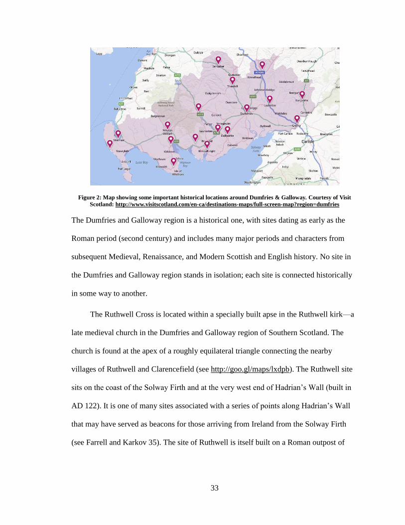
33
Figure 2: Map showing some important historical locations around Dumfries & Galloway. Courtesy of Visit
Scotland: http://www.visitscotland.com/en-ca/destinations-maps/full-screen-map?region=dumfries
The Dumfries and Galloway region is a historical one, with sites dating as early as the
Roman period (second century) and includes many major periods and characters from
subsequent Medieval, Renaissance, and Modern Scottish and English history. No site in
the Dumfries and Galloway region stands in isolation; each site is connected historically
in some way to another.
The Ruthwell Cross is located within a specially built apse in the Ruthwell kirk—a
late medieval church in the Dumfries and Galloway region of Southern Scotland. The
church is found at the apex of a roughly equilateral triangle connecting the nearby
villages of Ruthwell and Clarencefield (see http://goo.gl/maps/lxdpb). The Ruthwell site
sits on the coast of the Solway Firth and at the very west end of Hadrian’s Wall (built in
AD 122). It is one of many sites associated with a series of points along Hadrian’s Wall
that may have served as beacons for those arriving from Ireland from the Solway Firth
(see Farrell and Karkov 35). The site of Ruthwell is itself built on a Roman outpost of
34
Hadrian’s Wall (as is common of many other Anglo-Saxon sites in the area), and in this
case, is dedicated mainly to iron working (Crowe 1987, 46).
The nearby Roman site of Birrens was a fort and garrison originally built in timber
in AD 79. It was rebuilt in stone in AD 122, or soon after, but most of the visible fort and
outer buildings actually date from AD 142 (Lowe 2006, 122). It is this supply of carved
Roman stones that would be harvested by the Anglo-Saxon monastery builders of the
Hoddom complex in the seventh century (Lowe 2006, 122).
The site at Hoddom, which will be discussed in more detail later (albeit,
museologically as opposed to historically), was the site of an Anglo-Saxon monastery. In
its early days it was relatively unimportant, but it reached its peak in the eighth and early
ninth centuries, becoming a central monastery to the surrounding areas (Lowe 2006, 191).
The more significant buildings at Hoddom were built in part using stones harvested from
Birrens (Lowe 2006, 191).
The Bewcastle Cross (which will also be discussed in more detail in conjunction
with Hoddom and Ruthwell) is a late eighth century Northumbrian cross located in the
churchyard of St. Cuthbert’s church in Cumbria, near Carlisle, England. The Bewcastle
Cross bears a number of similarities to the Ruthwell Cross, including date of
manufacture. In addition to the cross, the site of Bewcastle contains a number of
historical layers: The site itself is located within the ruins of a Roman fort that was built
in AD 122 as an outlaying fort for Hadrian’s Wall (Farrell and Karkov 1992, 45; Crowe
1987, 47); within the ruins of the fort but outside the churchyard, are the ruins of the
fourteenth century castle Bewcastle; the current church, St. Cuthbert’s, was the last
35
iteration of churches that occupied that space, and was re-built in AD 1792; the site also
shares space with a modern-day working farm.
In addition to these cultural heritage sites, nearby places of historical interest
include the later medieval castle at Caerlaverock (also built on the ruins of a Roman fort),
the historic city of Dumfries, which is connected closely with both Robert the Bruce, who
began his ascent to the Scottish throne there, and the poet Robert Burns, who lived the
last five years of his life in the city and is buried in St. Michael's churchyard, 14 the town
of Lockerbie that is well known due to the bombing of Pan Am flight 103, which landed
in the town in 1988, and the town of Gretna Green, a popular wedding destination.
Many of these sites are under the official care of Historic Scotland, including
Ruthwell and Hoddom, or English Heritage, as in the case of Bewcastle. However, as we
will see, many English and Scottish cultural heritage sites have been best served by
amateurs, past and present.
A De Facto Territory-Museum
Returning for a moment to the HICIRA typology for museums and interpretation
centres, a territory-museum is “not located in a physically delimited single-use
compound, but instead shares in the daily life of the area and its inhabitants. The term
‘territory-museum’ is used to designate an area in which its coherence stems from
historical and geographical links. It aims to enhance the welfare of the local community”
(2005, 15). The important elements of what constitutes a “territory-museum” are actually
quite simple and relatively vague, meaning that an area does not need to be “officially
14
Burns himself has a connection to Ruthwell: he visited the Ruthwell manse shortly before his death—an
event documented in a well-known painting by Duncan McKellar (BBC-Your paintings); the friend Burns
was visiting at Ruthwell, Agnes Craig, was the wife of Henry Duncan, who led the reconstruction efforts
that resulted in the Cross's installation in its current location (Dinwiddie 1999, 32-36, 51).
36
designated” as a territory-museum in order to function as one; indeed, the concept of the
“territory-museum” has always existed, but it is only recently that it has been given a
name. However, in order for a space to be successful in its operation as a territory-
museum there needs to be recognition of the area’s historical significance and an attempt
to provide visitors with the necessary interpretive tools (see HICIRA 2005, 32). This
approach emphasises Tilden’s fifth guiding principle of interpretation: “Interpretation
should aim to present a whole rather than a part and must address itself to the whole man
rather than any phrase” (2007, Loc 586 of 3209). In this context, the region of Dumfries
and Galloway can be approached as a de facto territory museum when explored as a
cohesive whole. The “tools” are successfully supplied by Visit Scotland, the official
national tourism organisation (see http://www.visitscotland.com/en-ca/), as a selection of
“touring trails” that includes the Galloway Touring Route (which starts in Gretna Green),
the Burns Heritage Trail (which focuses on Burns landmarks), and the Solway Coast
Heritage Trail (which runs along the coast of the Solway Firth and through locations such
as Gretna Green and Dumfries and includes locations from a variety of different historical
periods).
These touring routes serve as a way for visitors to explore the region as an
interconnected whole and in turn unite all the cultural heritage sites with a common
element: the historical interest of the region. This fits with the scope designated by
HICIRA, which stipulates that the heritage ensemble “facilitates perception of the
territory as a cultural product, an open, inhabited museum, in continuous transformation.
The visitor can gain a first-hand view of the territory, selecting the aspects which are of
most personal interest” (2005, 33). This still functions within the HICIRA definition of
37
interpretation in that it recognises that an object has great or greater value when not taken
“in isolation from its function and setting.” The primary purpose for the trails is to
recognise that the environment the object or artefact inhabits is valuable and significant in
a greater historical whole (2005, 15).
These touring trails have both a physical and digital component. Tourists can look
up itineraries online before visiting the area—or on their mobile devices while on the
road—or by following heritage markers along the regional roads. Essentially, the
territory-museum has always existed, but it is through the use of digital technology that
the space as a whole is accessed.15 However, despite this idea that the area is (and always
has been) a territory-museum, the officials involved in its maintenance do not view it as
such. This is primarily a museological problem: the area is not viewed as a connected
whole or as a series of interrelated sites, but rather as a series of popular or entertaining
stops within the region. The Visit Scotland website does a relatively good job at
describing each site it lists on its itinerary, but that is all it does; it provides a brief history
of only a few stops along the trail. It provides the minimum of information and it actually
misses listing some historically important sites, ones that could easily be missed while
physically driving the routes.
In the late seventeenth century, travel to remote cultural heritage sites was made
by carriage, foot, or boat, and were generally seen as “nice days out” for the English elite
(Thurley 2013, 11-12). By the early eighteenth century, antiquarianism (the precursor to
the careful archaeology we have to today) and interest in studying the past had started to
gain popularity. A trend was created when the upper class had started to gain an
15
Again, see Farman (2013) for the theory of embodied space and implacement as a way of giving context
to digital information.
38
appreciation for the particular aesthetic of the ruins found scattered over the English
countryside and an “appreciation of landscape and the picturesque encouraged people to
see medieval ruins as beautiful and evocative” (Thurley 2013, 6). Landscape art began to
rise in popularity and the desire for the pleasing aesthetic of ruined abbeys and medieval
monuments was incorporated into parks and fake ruins and were castles built when there
were none. The late eighteenth century saw a revival of the Gothic style of country homes
on a cosmetic level, placing an increased value on medieval architecture.
However, it wasn’t until the nineteenth century and the development of the
railway systems that a boost in tourism was seen, with people venturing away from their
homes and their created landscapes and parks to the countryside and rural cultural
heritage sites (as discussed in the previous chapter; Thurley 2013, 12). With the influx of
visitors to these delicate areas, there was a need for intervention by official parties to
prevent damage. In England, the need for preservation of historic sites and monuments
was introduced in the 1740s, when antiquarians voiced outrage against landowners
defacing ancient monuments on their property, such as Stonehenge (Thurley 2013, 36).
But the movement did not really begin to take traction until the late nineteenth century
with the development of archaeology as a discipline and the notice of the destruction of
historically significant artefacts: industrial development and the extension of land meant
megaliths and monuments were being “repurposed” for roads and turnpikes (Thurley
2013, 36). Although the Society of Antiquaries had existed since 1707 (Thurley 2013, 6),
they were primarily concerned with Medieval and Renaissance art and architecture and
had little or nothing to do with prehistoric, Roman, or Anglo-Saxon heritage in the UK
(Thurley 2013, 37). The organisation of a protection act for these earlier artefacts was
39
thanks mainly to a man named John Lubbock. In 1870, Lubbock was elected as MP for
Maidstone, a position he planned to use to aid in the preservation of Danish
archaeological sites (Thurley 2013, 37). However, Lubbock received a number of
requests to aid in the preservation of several historically important English landmarks,
and so changed his focus to the legal preservation of prehistoric British monuments
(Thurley 2013, 38). In 1871, Lubbock proposed a bill to establish a National Monuments
Commission that would acquire the rights to of a number of archaeological sites and
would intervene if one of them looked to be in danger of mutilation or damage (however
owners were given the right to appeal against the purchase of the monument) (Thurley
2013, 38). Lubbock’s bill was largely opposed and, consequently, voting was consistently
delayed.16 After nine years, and earning the satirical nickname “The Monumentally
Ancient Act,” the Office of Works intervened and Lubbock’s bill was abandoned
(Thurley 2013, 40).
These interventions lead directly to the creation of the Ancient Monuments Act of
1882,17
proposed by George Lefevre, First Commissioner of Works. The new bill “was a
permissive measure that allowed an owner to place his monument under the protection of
the State, which would then take care of it on their behalf... Anyone convicted of
damaging a monument was to be fined £5” (Thurley 2013, 41; see also O’Neill 2005; Ó
Carragáin 2005). The Act had included a list of sixty four monuments for scheduling.
Scheduling, as defined by English Heritage is “shorthand for the process through which
16
For an account of the reasons see Thurley 2013.
17 This is the very act that eventually protected the Ruthwell Cross when it was added to the list of
protected monuments in 1882. This inclusion eventually led to the addition of the apse to the Ruthwell Kirk
in 1887, which was specially constructed to protect the Cross from the elements. Until the Ancient
Monuments Act of 1882 passed, the Ruthwell Cross stood in the garden since it was still considered an
“Idolatrous monument” under “Act anent the demolishing of Idolatrous Monuments” that passed in 1642.
The Act had not yet been rescinded by the General Assembly in 1823, and so Rev. Duncan felt it was
unsafe re-erecting it inside the Kirk itself; see Dinwiddie1999; O’Neill 2005; Ó Carragáin 2005.
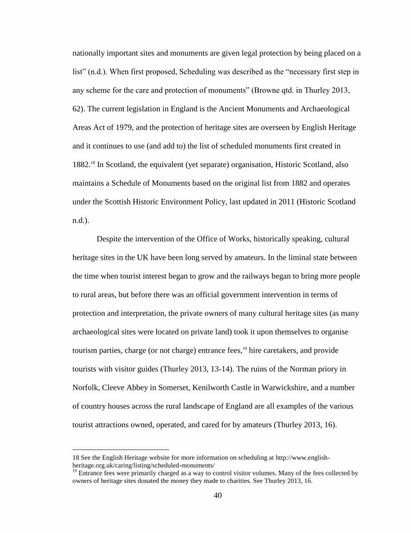
40
nationally important sites and monuments are given legal protection by being placed on a
list” (n.d.). When first proposed, Scheduling was described as the “necessary first step in
any scheme for the care and protection of monuments” (Browne qtd. in Thurley 2013,
62). The current legislation in England is the Ancient Monuments and Archaeological
Areas Act of 1979, and the protection of heritage sites are overseen by English Heritage
and it continues to use (and add to) the list of scheduled monuments first created in
1882.18 In Scotland, the equivalent (yet separate) organisation, Historic Scotland, also
maintains a Schedule of Monuments based on the original list from 1882 and operates
under the Scottish Historic Environment Policy, last updated in 2011 (Historic Scotland
n.d.).
Despite the intervention of the Office of Works, historically speaking, cultural
heritage sites in the UK have been long served by amateurs. In the liminal state between
the time when tourist interest began to grow and the railways began to bring more people
to rural areas, but before there was an official government intervention in terms of
protection and interpretation, the private owners of many cultural heritage sites (as many
archaeological sites were located on private land) took it upon themselves to organise
tourism parties, charge (or not charge) entrance fees,19 hire caretakers, and provide
tourists with visitor guides (Thurley 2013, 13-14). The ruins of the Norman priory in
Norfolk, Cleeve Abbey in Somerset, Kenilworth Castle in Warwickshire, and a number
of country houses across the rural landscape of England are all examples of the various
tourist attractions owned, operated, and cared for by amateurs (Thurley 2013, 16).
18 See the English Heritage website for more information on scheduling at http://www.english-
heritage.org.uk/caring/listing/scheduled-monuments/ 19
Entrance fees were primarily charged as a way to control visitor volumes. Many of the fees collected by
owners of heritage sites donated the money they made to charities. See Thurley 2013, 16.
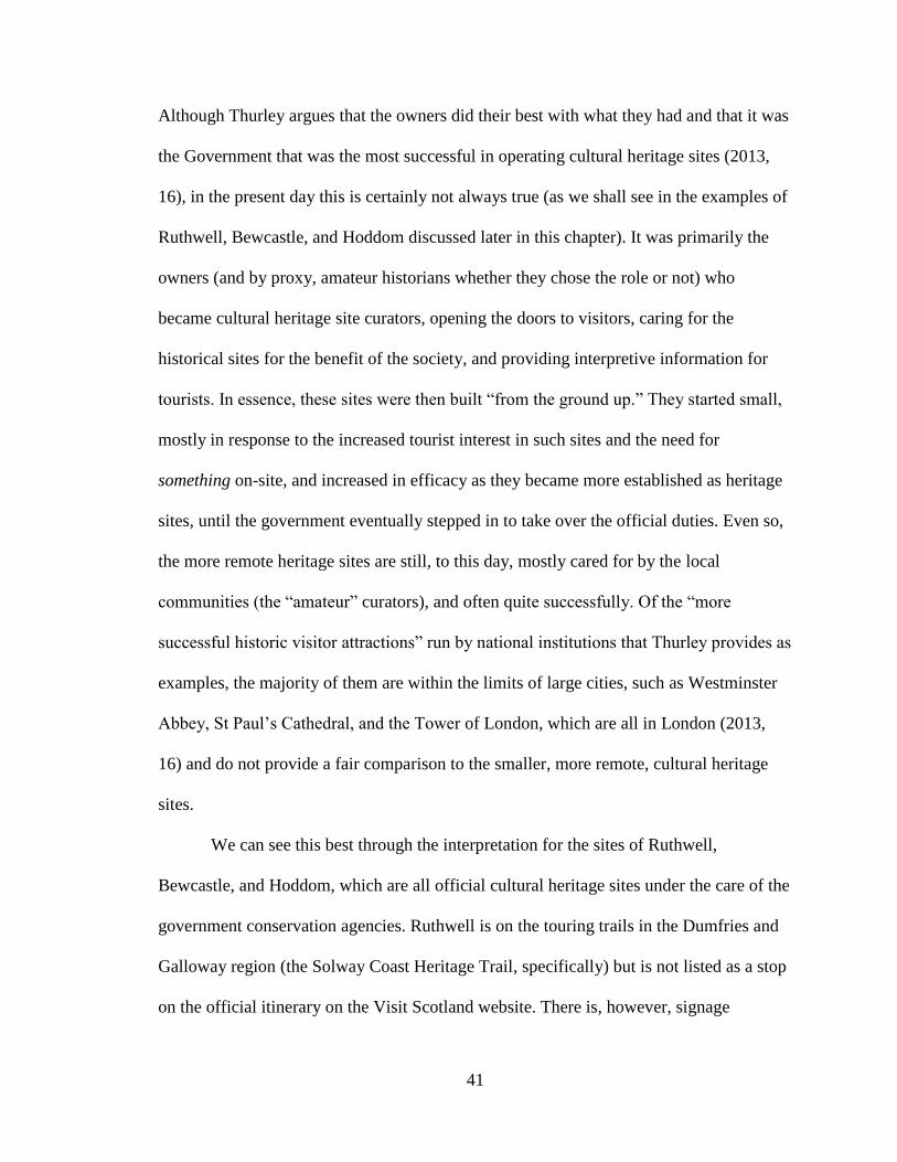
41
Although Thurley argues that the owners did their best with what they had and that it was
the Government that was the most successful in operating cultural heritage sites (2013,
16), in the present day this is certainly not always true (as we shall see in the examples of
Ruthwell, Bewcastle, and Hoddom discussed later in this chapter). It was primarily the
owners (and by proxy, amateur historians whether they chose the role or not) who
became cultural heritage site curators, opening the doors to visitors, caring for the
historical sites for the benefit of the society, and providing interpretive information for
tourists. In essence, these sites were then built “from the ground up.” They started small,
mostly in response to the increased tourist interest in such sites and the need for
something on-site, and increased in efficacy as they became more established as heritage
sites, until the government eventually stepped in to take over the official duties. Even so,
the more remote heritage sites are still, to this day, mostly cared for by the local
communities (the “amateur” curators), and often quite successfully. Of the “more
successful historic visitor attractions” run by national institutions that Thurley provides as
examples, the majority of them are within the limits of large cities, such as Westminster
Abbey, St Paul’s Cathedral, and the Tower of London, which are all in London (2013,
16) and do not provide a fair comparison to the smaller, more remote, cultural heritage
sites.
We can see this best through the interpretation for the sites of Ruthwell,
Bewcastle, and Hoddom, which are all official cultural heritage sites under the care of the
government conservation agencies. Ruthwell is on the touring trails in the Dumfries and
Galloway region (the Solway Coast Heritage Trail, specifically) but is not listed as a stop
on the official itinerary on the Visit Scotland website. There is, however, signage
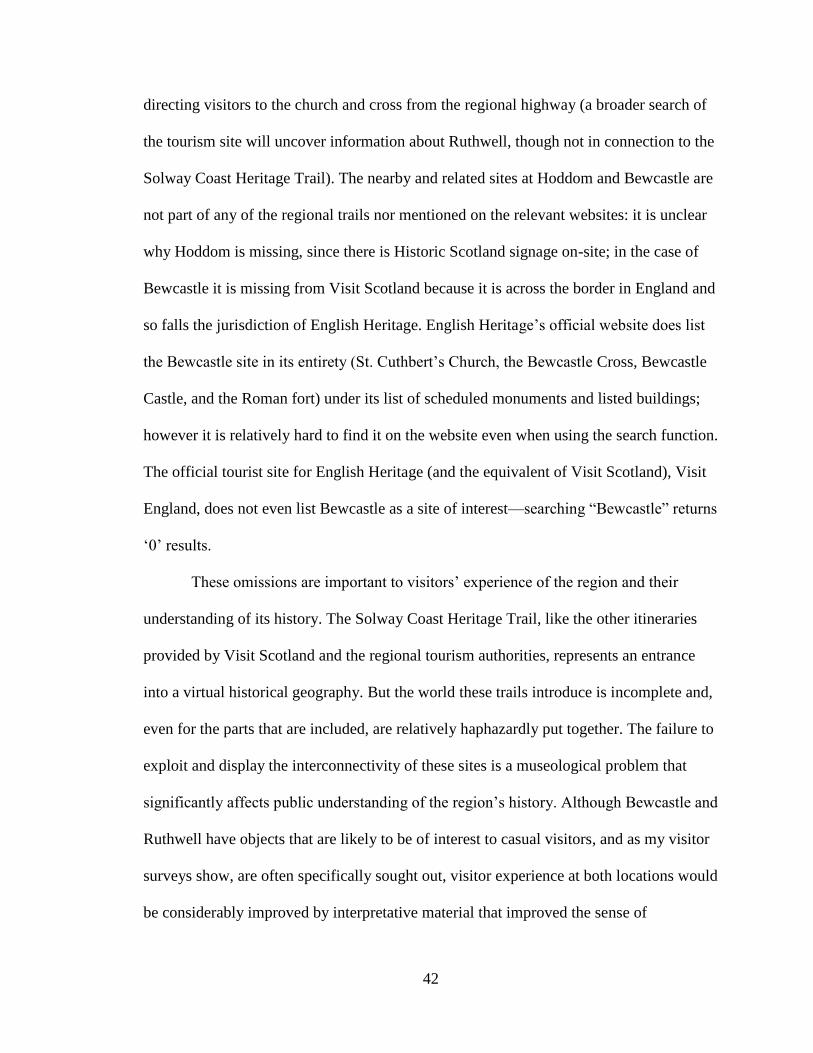
42
directing visitors to the church and cross from the regional highway (a broader search of
the tourism site will uncover information about Ruthwell, though not in connection to the
Solway Coast Heritage Trail). The nearby and related sites at Hoddom and Bewcastle are
not part of any of the regional trails nor mentioned on the relevant websites: it is unclear
why Hoddom is missing, since there is Historic Scotland signage on-site; in the case of
Bewcastle it is missing from Visit Scotland because it is across the border in England and
so falls the jurisdiction of English Heritage. English Heritage’s official website does list
the Bewcastle site in its entirety (St. Cuthbert’s Church, the Bewcastle Cross, Bewcastle
Castle, and the Roman fort) under its list of scheduled monuments and listed buildings;
however it is relatively hard to find it on the website even when using the search function.
The official tourist site for English Heritage (and the equivalent of Visit Scotland), Visit
England, does not even list Bewcastle as a site of interest—searching “Bewcastle” returns
‘0’ results.
These omissions are important to visitors’ experience of the region and their
understanding of its history. The Solway Coast Heritage Trail, like the other itineraries
provided by Visit Scotland and the regional tourism authorities, represents an entrance
into a virtual historical geography. But the world these trails introduce is incomplete and,
even for the parts that are included, are relatively haphazardly put together. The failure to
exploit and display the interconnectivity of these sites is a museological problem that
significantly affects public understanding of the region’s history. Although Bewcastle and
Ruthwell have objects that are likely to be of interest to casual visitors, and as my visitor
surveys show, are often specifically sought out, visitor experience at both locations would
be considerably improved by interpretative material that improved the sense of
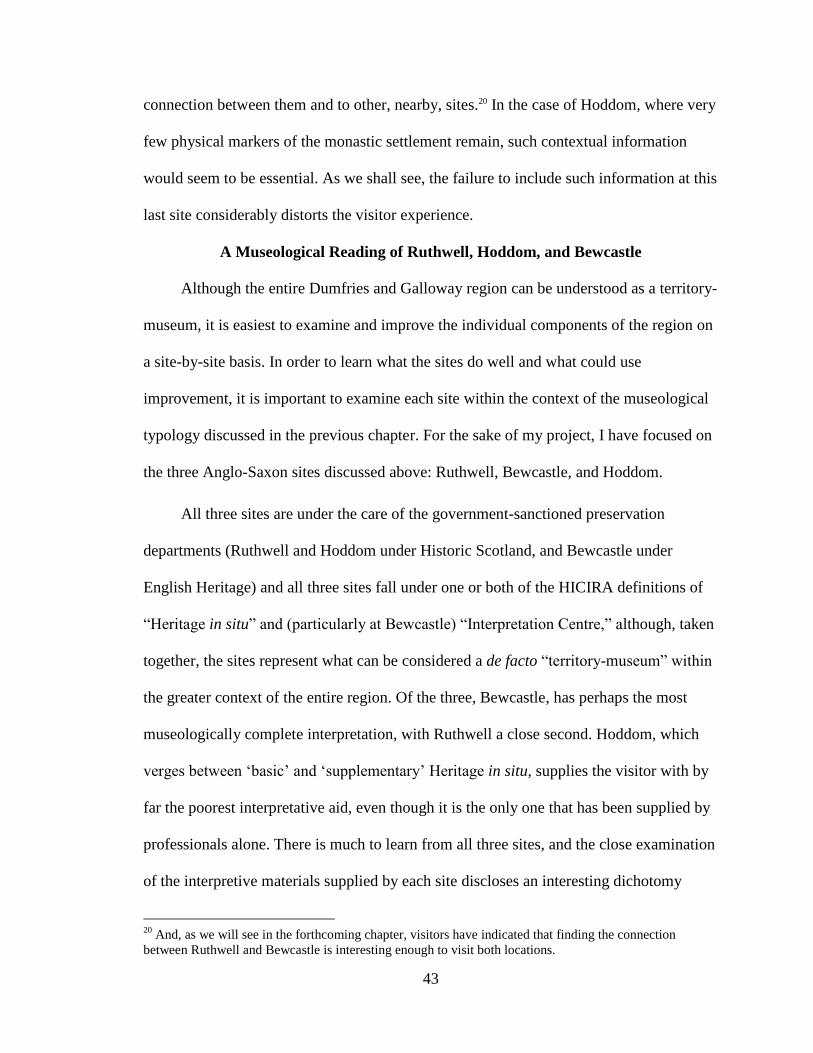
43
connection between them and to other, nearby, sites.20 In the case of Hoddom, where very
few physical markers of the monastic settlement remain, such contextual information
would seem to be essential. As we shall see, the failure to include such information at this
last site considerably distorts the visitor experience.
A Museological Reading of Ruthwell, Hoddom, and Bewcastle
Although the entire Dumfries and Galloway region can be understood as a territory-
museum, it is easiest to examine and improve the individual components of the region on
a site-by-site basis. In order to learn what the sites do well and what could use
improvement, it is important to examine each site within the context of the museological
typology discussed in the previous chapter. For the sake of my project, I have focused on
the three Anglo-Saxon sites discussed above: Ruthwell, Bewcastle, and Hoddom.
All three sites are under the care of the government-sanctioned preservation
departments (Ruthwell and Hoddom under Historic Scotland, and Bewcastle under
English Heritage) and all three sites fall under one or both of the HICIRA definitions of
“Heritage in situ” and (particularly at Bewcastle) “Interpretation Centre,” although, taken
together, the sites represent what can be considered a de facto “territory-museum” within
the greater context of the entire region. Of the three, Bewcastle, has perhaps the most
museologically complete interpretation, with Ruthwell a close second. Hoddom, which
verges between ‘basic’ and ‘supplementary’ Heritage in situ, supplies the visitor with by
far the poorest interpretative aid, even though it is the only one that has been supplied by
professionals alone. There is much to learn from all three sites, and the close examination
of the interpretive materials supplied by each site discloses an interesting dichotomy
20
And, as we will see in the forthcoming chapter, visitors have indicated that finding the connection
between Ruthwell and Bewcastle is interesting enough to visit both locations.
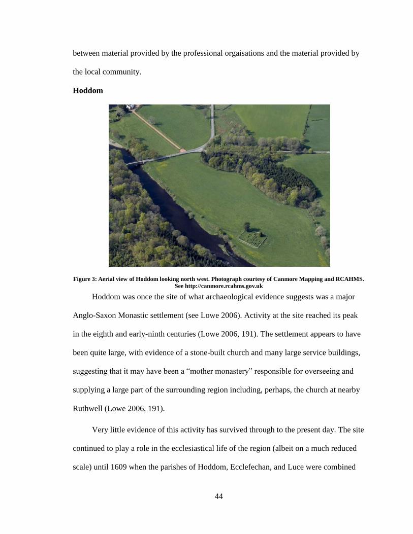
44
between material provided by the professional orgaisations and the material provided by
the local community.
Hoddom
Figure 3: Aerial view of Hoddom looking north west. Photograph courtesy of Canmore Mapping and RCAHMS.
See http://canmore.rcahms.gov.uk
Hoddom was once the site of what archaeological evidence suggests was a major
Anglo-Saxon Monastic settlement (see Lowe 2006). Activity at the site reached its peak
in the eighth and early-ninth centuries (Lowe 2006, 191). The settlement appears to have
been quite large, with evidence of a stone-built church and many large service buildings,
suggesting that it may have been a “mother monastery” responsible for overseeing and
supplying a large part of the surrounding region including, perhaps, the church at nearby
Ruthwell (Lowe 2006, 191).
Very little evidence of this activity has survived through to the present day. The site
continued to play a role in the ecclesiastical life of the region (albeit on a much reduced
scale) until 1609 when the parishes of Hoddom, Ecclefechan, and Luce were combined
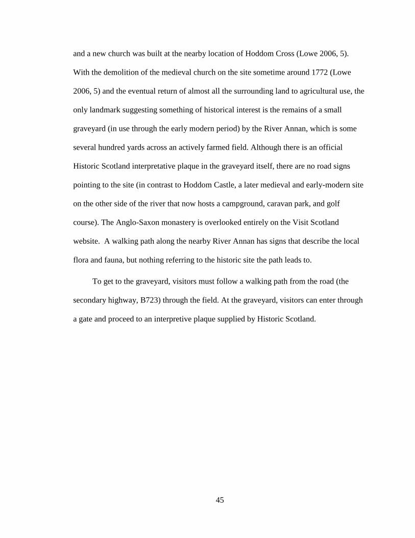
45
and a new church was built at the nearby location of Hoddom Cross (Lowe 2006, 5).
With the demolition of the medieval church on the site sometime around 1772 (Lowe
2006, 5) and the eventual return of almost all the surrounding land to agricultural use, the
only landmark suggesting something of historical interest is the remains of a small
graveyard (in use through the early modern period) by the River Annan, which is some
several hundred yards across an actively farmed field. Although there is an official
Historic Scotland interpretative plaque in the graveyard itself, there are no road signs
pointing to the site (in contrast to Hoddom Castle, a later medieval and early-modern site
on the other side of the river that now hosts a campground, caravan park, and golf
course). The Anglo-Saxon monastery is overlooked entirely on the Visit Scotland
website. A walking path along the nearby River Annan has signs that describe the local
flora and fauna, but nothing referring to the historic site the path leads to.
To get to the graveyard, visitors must follow a walking path from the road (the
secondary highway, B723) through the field. At the graveyard, visitors can enter through
a gate and proceed to an interpretive plaque supplied by Historic Scotland.
46
Figure 4: Plaque inside the Hoddom graveyard. Photograph by the author.21
As Figure 4 illustrates, the plaque focuses primarily on the (perhaps spurious; see Lowe
2006, 2) association between Hoddom and St. Kentigern (Mungo), the Patron Saint of
Glasgow, who is said to have built a church on the site and lived at Hoddom as Bishop
until he was exiled to the Kingdom of Rheged in the seventh century. The plaque mainly
discusses his work in Glasgow, where, as it notes, he was the “founder of a monastery.”
The final paragraph provides suggestions for further information and visits to related
sites, “if you are interested in the history of St. Kentigern/Mungo”: i.e. the website for
Historic Glasgow, Culross Abbey near Edinburgh (160 kilometers to the north) and
Glasgow Cathedral (130 kilometers north by north west).
The rest of the plaque discusses the graveyard the visitor is standing in, the many
finds of Anglo-Saxon stone fragments that have turned up over the years (including
“numerous carved Anglian [Nothumbrian] stone crosses” much like the nearby, still-
standing, but unmentioned, Ruthwell and Bewcastle crosses), and a description of the
21
See Appendix B for a transcription of the plaque.
47
ecclesiastical connection to the Glaswegian diocese. There is a brief description of “the
monastery,” but this reference, since it follows immediately after a mention of the
monastery St. Kentigern founded in Glasgow, does not refer to any landmarks in the area,
and is not differentiated from the monastery in Glasgow, is easily (and almost certainly)
misunderstood by many visitors as a reference to the Glaswegian institution rather than
the Anglo-Saxon one whose former location they are visiting.
In other words, the problem with this plaque is that it misdirects. It downplays the
details, history, and local connections of the once important, but now obscure site,
visitors are actually looking at in order to concentrate on the better-known, but partially
fanciful, connections to the area's largest city. It directs visitors virtually and physically to
more tenuously connected locations far outside the site's actual geographic and historic
context while ignoring the potential to enrich the visitor experience by explaining the
connection to local sites and artefacts as close as a ten minute drive away—including
both a standing example of the type of crosses they note are often ploughed up in the
surrounding field and the Roman site at Birrens from which the building material used in
Hoddom's construction were taken. While Hoddom has been the focus of several recent
digs (in 1915, 1952, and 1991), nothing is mentioned of the results of this archaeological
work (although the plaque is undated, the reference to the www.historicglasgow.com
website, which was first indexed in March of 2004, suggests it long post-dates the major
1991 dig described in Lowe 2006). And perhaps more problematically, a number of the
few details it does discuss of the actual site are wrong: its discussion of the post-
medieval history of the Hoddom church, for example, appears to mistakenly conflate
Hoddom and the nearby Hoddom Cross. The church that the plaque describes as having
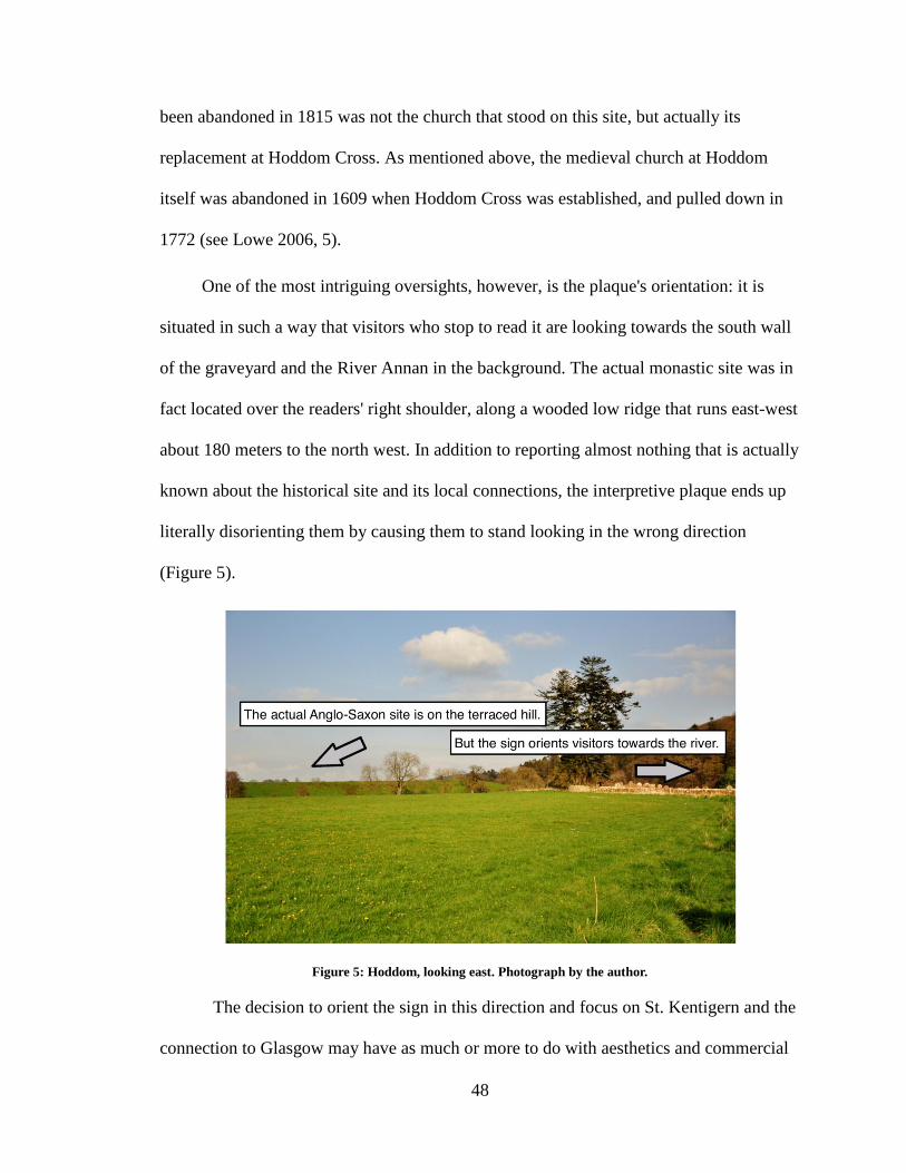
48
been abandoned in 1815 was not the church that stood on this site, but actually its
replacement at Hoddom Cross. As mentioned above, the medieval church at Hoddom
itself was abandoned in 1609 when Hoddom Cross was established, and pulled down in
1772 (see Lowe 2006, 5).
One of the most intriguing oversights, however, is the plaque's orientation: it is
situated in such a way that visitors who stop to read it are looking towards the south wall
of the graveyard and the River Annan in the background. The actual monastic site was in
fact located over the readers' right shoulder, along a wooded low ridge that runs east-west
about 180 meters to the north west. In addition to reporting almost nothing that is actually
known about the historical site and its local connections, the interpretive plaque ends up
literally disorienting them by causing them to stand looking in the wrong direction
(Figure 5).
Figure 5: Hoddom, looking east. Photograph by the author.
The decision to orient the sign in this direction and focus on St. Kentigern and the
connection to Glasgow may have as much or more to do with aesthetics and commercial
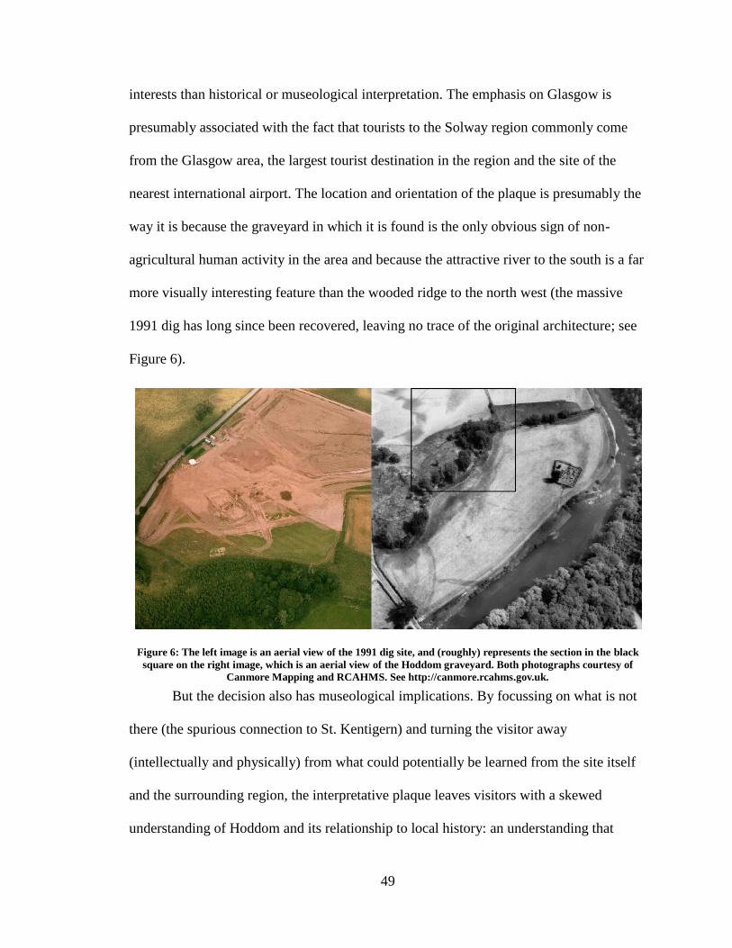
49
interests than historical or museological interpretation. The emphasis on Glasgow is
presumably associated with the fact that tourists to the Solway region commonly come
from the Glasgow area, the largest tourist destination in the region and the site of the
nearest international airport. The location and orientation of the plaque is presumably the
way it is because the graveyard in which it is found is the only obvious sign of non-
agricultural human activity in the area and because the attractive river to the south is a far
more visually interesting feature than the wooded ridge to the north west (the massive
1991 dig has long since been recovered, leaving no trace of the original architecture; see
Figure 6).
Figure 6: The left image is an aerial view of the 1991 dig site, and (roughly) represents the section in the black
square on the right image, which is an aerial view of the Hoddom graveyard. Both photographs courtesy of
Canmore Mapping and RCAHMS. See http://canmore.rcahms.gov.uk.
But the decision also has museological implications. By focussing on what is not
there (the spurious connection to St. Kentigern) and turning the visitor away
(intellectually and physically) from what could potentially be learned from the site itself
and the surrounding region, the interpretative plaque leaves visitors with a skewed
understanding of Hoddom and its relationship to local history: an understanding that
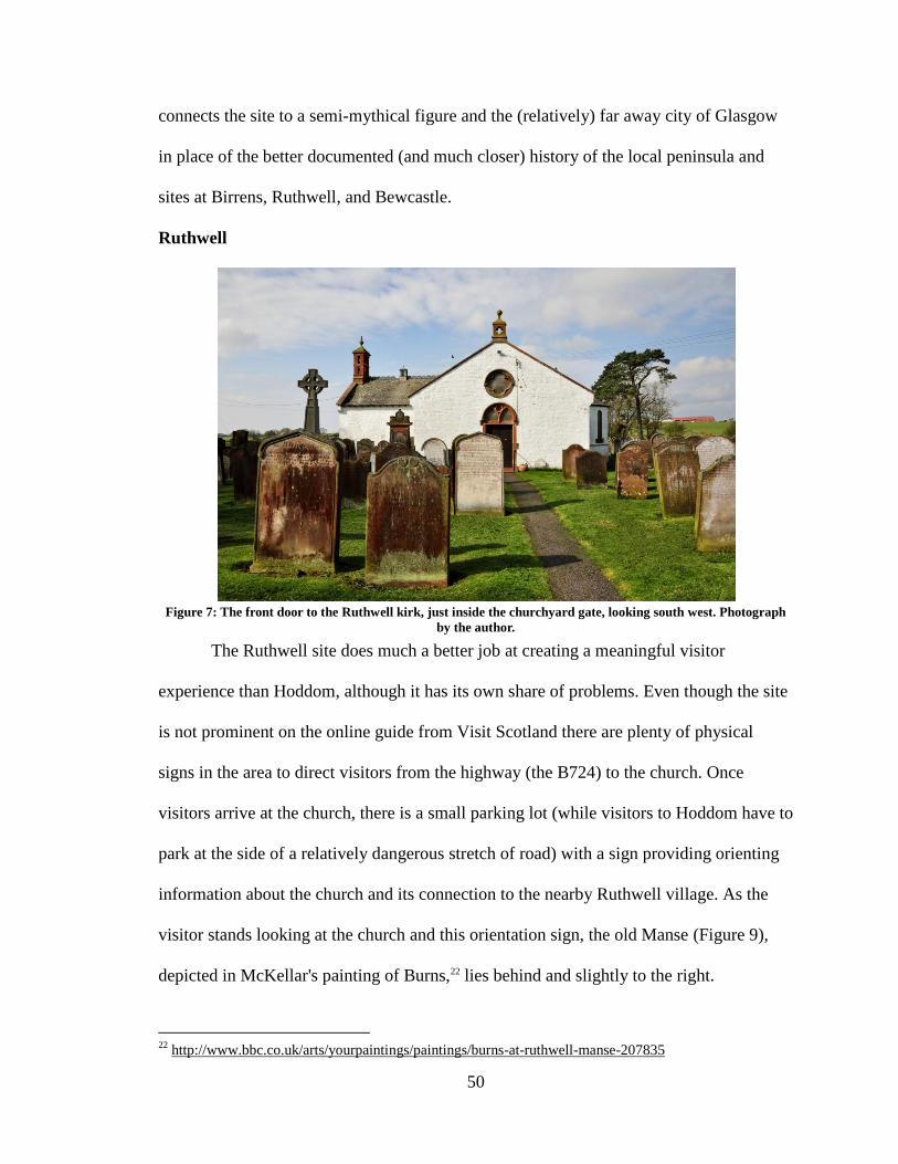
50
connects the site to a semi-mythical figure and the (relatively) far away city of Glasgow
in place of the better documented (and much closer) history of the local peninsula and
sites at Birrens, Ruthwell, and Bewcastle.
Ruthwell
Figure 7: The front door to the Ruthwell kirk, just inside the churchyard gate, looking south west. Photograph
by the author.
The Ruthwell site does much a better job at creating a meaningful visitor
experience than Hoddom, although it has its own share of problems. Even though the site
is not prominent on the online guide from Visit Scotland there are plenty of physical
signs in the area to direct visitors from the highway (the B724) to the church. Once
visitors arrive at the church, there is a small parking lot (while visitors to Hoddom have to
park at the side of a relatively dangerous stretch of road) with a sign providing orienting
information about the church and its connection to the nearby Ruthwell village. As the
visitor stands looking at the church and this orientation sign, the old Manse (Figure 9),
depicted in McKellar's painting of Burns,22 lies behind and slightly to the right.
22
http://www.bbc.co.uk/arts/yourpaintings/paintings/burns-at-ruthwell-manse-207835
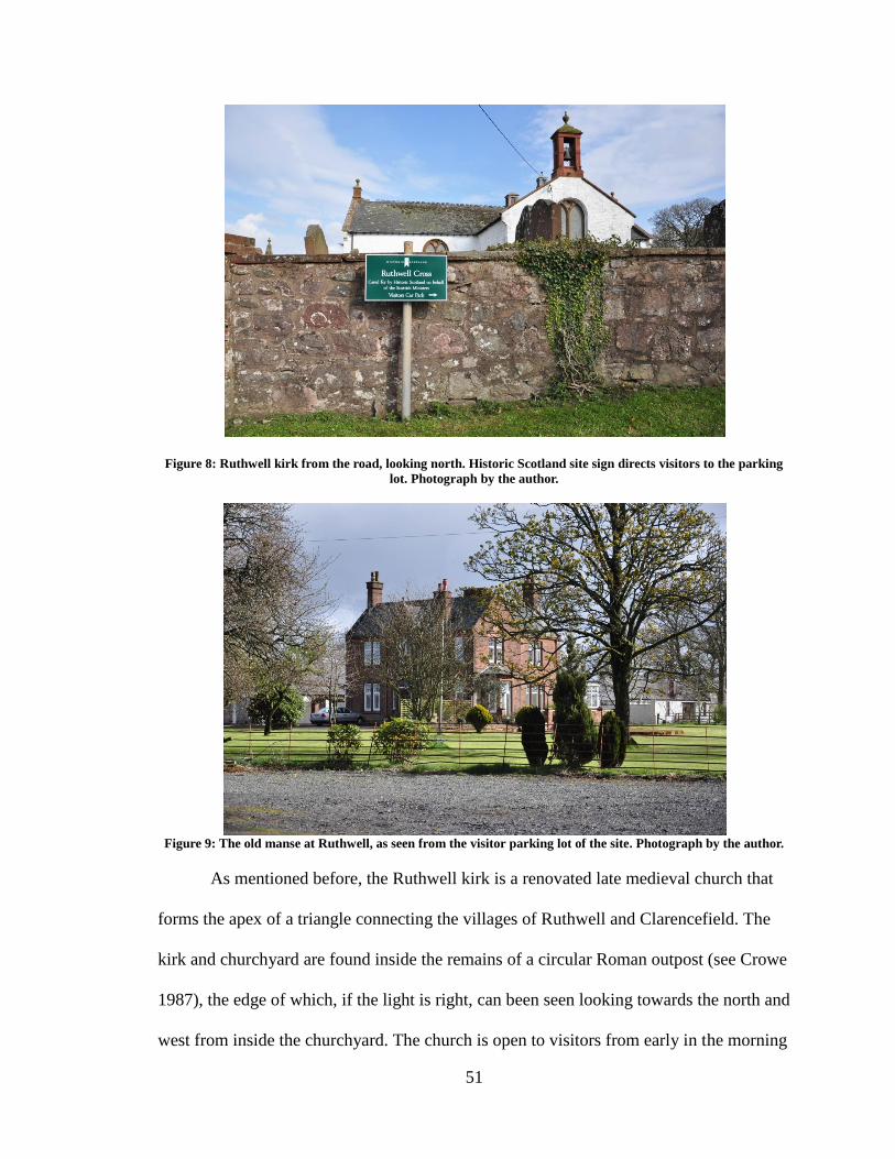
51
Figure 8: Ruthwell kirk from the road, looking north. Historic Scotland site sign directs visitors to the parking
lot. Photograph by the author.
Figure 9: The old manse at Ruthwell, as seen from the visitor parking lot of the site. Photograph by the author.
As mentioned before, the Ruthwell kirk is a renovated late medieval church that
forms the apex of a triangle connecting the villages of Ruthwell and Clarencefield. The
kirk and churchyard are found inside the remains of a circular Roman outpost (see Crowe
1987), the edge of which, if the light is right, can been seen looking towards the north and
west from inside the churchyard. The church is open to visitors from early in the morning
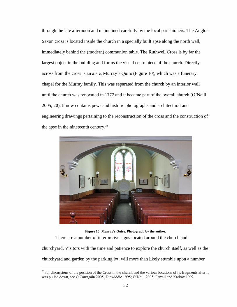
52
through the late afternoon and maintained carefully by the local parishioners. The Anglo-
Saxon cross is located inside the church in a specially built apse along the north wall,
immediately behind the (modern) communion table. The Ruthwell Cross is by far the
largest object in the building and forms the visual centrepiece of the church. Directly
across from the cross is an aisle, Murray’s Quire (Figure 10), which was a funerary
chapel for the Murray family. This was separated from the church by an interior wall
until the church was renovated in 1772 and it became part of the overall church (O’Neill
2005, 20). It now contains pews and historic photographs and architectural and
engineering drawings pertaining to the reconstruction of the cross and the construction of
the apse in the nineteenth century.23
Figure 10: Murray's Quire. Photograph by the author.
There are a number of interpretive signs located around the church and
churchyard. Visitors with the time and patience to explore the church itself, as well as the
churchyard and garden by the parking lot, will more than likely stumble upon a number
23
for discussions of the position of the Cross in the church and the various locations of its fragments after it
was pulled down, see Ó Carragáin 2005; Dinwiddie 1995; O’Neill 2005; Farrell and Karkov 1992
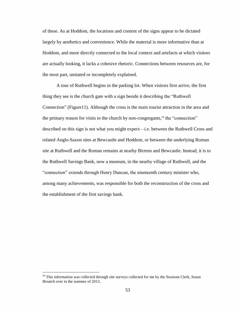
53
of these. As at Hoddom, the locations and content of the signs appear to be dictated
largely by aesthetics and convenience. While the material is more informative than at
Hoddom, and more directly connected to the local context and artefacts at which visitors
are actually looking, it lacks a cohesive rhetoric. Connections between resources are, for
the most part, unstated or incompletely explained.
A tour of Ruthwell begins in the parking lot. When visitors first arrive, the first
thing they see is the church gate with a sign beside it describing the “Ruthwell
Connection” (Figure11). Although the cross is the main tourist attraction in the area and
the primary reason for visits to the church by non-congregants,24 the “connection”
described on this sign is not what you might expect—i.e. between the Ruthwell Cross and
related Anglo-Saxon sites at Bewcastle and Hoddom, or between the underlying Roman
site at Ruthwell and the Roman remains at nearby Birrens and Bewcastle. Instead, it is to
the Ruthwell Savings Bank, now a museum, in the nearby village of Ruthwell, and the
“connection” extends through Henry Duncan, the nineteenth century minister who,
among many achievements, was responsible for both the reconstruction of the cross and
the establishment of the first savings bank.
24
This information was collected through site surveys collected for me by the Sessions Clerk, Susan
Broatch over in the summer of 2013.
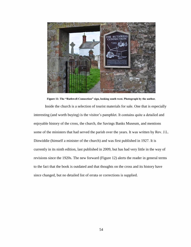
54
Figure 11: The “Ruthwell Connection” sign, looking south west. Photograph by the author.
Inside the church is a selection of tourist materials for sale. One that is especially
interesting (and worth buying) is the visitor’s pamphlet. It contains quite a detailed and
enjoyable history of the cross, the church, the Savings Banks Museum, and mentions
some of the ministers that had served the parish over the years. It was written by Rev. J.L.
Dinwiddie (himself a minister of the church) and was first published in 1927. It is
currently in its ninth edition, last published in 2009, but has had very little in the way of
revisions since the 1920s. The new forward (Figure 12) alerts the reader in general terms
to the fact that the book is outdated and that thoughts on the cross and its history have
since changed, but no detailed list of errata or corrections is supplied.
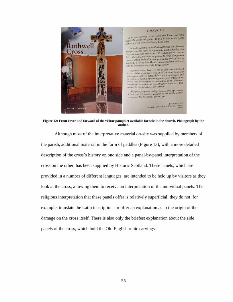
55
Figure 12: Front cover and forward of the visitor pamphlet available for sale in the church. Photograph by the
author.
Although most of the interpretative material on-site was supplied by members of
the parish, additional material in the form of paddles (Figure 13), with a more detailed
description of the cross’s history on one side and a panel-by-panel interpretation of the
cross on the other, has been supplied by Historic Scotland. These panels, which are
provided in a number of different languages, are intended to be held up by visitors as they
look at the cross, allowing them to receive an interpretation of the individual panels. The
religious interpretation that these panels offer is relatively superficial: they do not, for
example, translate the Latin inscriptions or offer an explanation as to the origin of the
damage on the cross itself. There is also only the briefest explanation about the side
panels of the cross, which hold the Old English runic carvings.
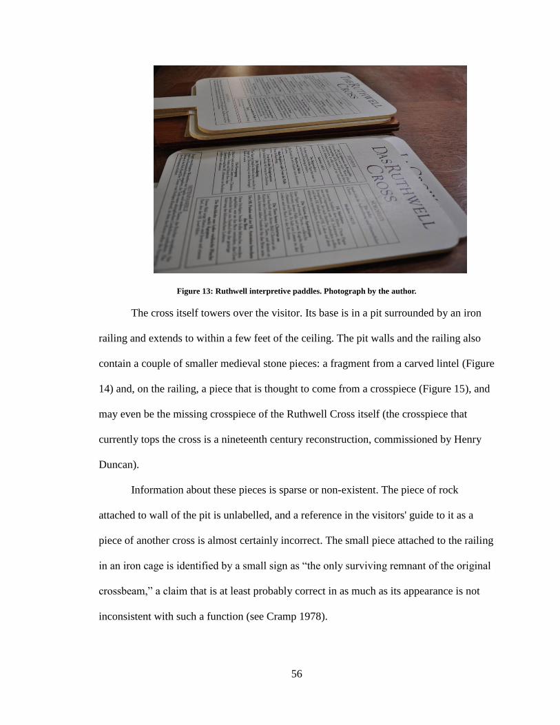
56
Figure 13: Ruthwell interpretive paddles. Photograph by the author.
The cross itself towers over the visitor. Its base is in a pit surrounded by an iron
railing and extends to within a few feet of the ceiling. The pit walls and the railing also
contain a couple of smaller medieval stone pieces: a fragment from a carved lintel (Figure
14) and, on the railing, a piece that is thought to come from a crosspiece (Figure 15), and
may even be the missing crosspiece of the Ruthwell Cross itself (the crosspiece that
currently tops the cross is a nineteenth century reconstruction, commissioned by Henry
Duncan).
Information about these pieces is sparse or non-existent. The piece of rock
attached to wall of the pit is unlabelled, and a reference in the visitors' guide to it as a
piece of another cross is almost certainly incorrect. The small piece attached to the railing
in an iron cage is identified by a small sign as “the only surviving remnant of the original
crossbeam,” a claim that is at least probably correct in as much as its appearance is not
inconsistent with such a function (see Cramp 1978).
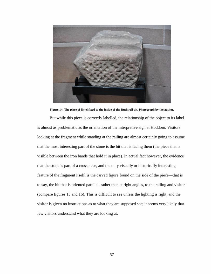
57
Figure 14: The piece of lintel fixed to the inside of the Ruthwell pit. Photograph by the author.
But while this piece is correctly labelled, the relationship of the object to its label
is almost as problematic as the orientation of the interpretive sign at Hoddom. Visitors
looking at the fragment while standing at the railing are almost certainly going to assume
that the most interesting part of the stone is the bit that is facing them (the piece that is
visible between the iron bands that hold it in place). In actual fact however, the evidence
that the stone is part of a crosspiece, and the only visually or historically interesting
feature of the fragment itself, is the carved figure found on the side of the piece—that is
to say, the bit that is oriented parallel, rather than at right angles, to the railing and visitor
(compare figures 15 and 16). This is difficult to see unless the lighting is right, and the
visitor is given no instructions as to what they are supposed see; it seems very likely that
few visitors understand what they are looking at.
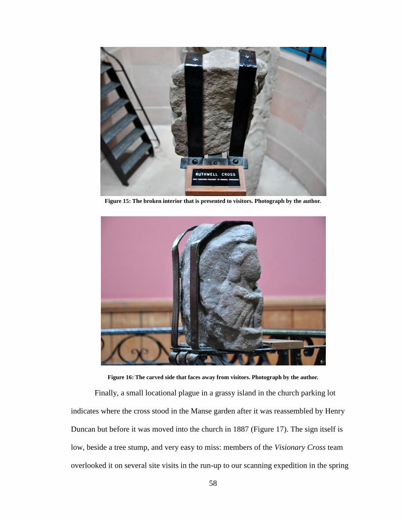
58
Figure 15: The broken interior that is presented to visitors. Photograph by the author.
Figure 16: The carved side that faces away from visitors. Photograph by the author.
Finally, a small locational plague in a grassy island in the church parking lot
indicates where the cross stood in the Manse garden after it was reassembled by Henry
Duncan but before it was moved into the church in 1887 (Figure 17). The sign itself is
low, beside a tree stump, and very easy to miss: members of the Visionary Cross team
overlooked it on several site visits in the run-up to our scanning expedition in the spring
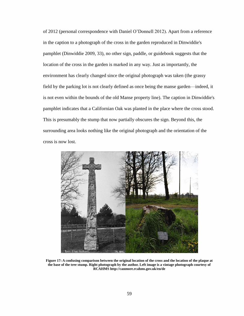
59
of 2012 (personal correspondence with Daniel O’Donnell 2012). Apart from a reference
in the caption to a photograph of the cross in the garden reproduced in Dinwiddie's
pamphlet (Dinwiddie 2009, 33), no other sign, paddle, or guidebook suggests that the
location of the cross in the garden is marked in any way. Just as importantly, the
environment has clearly changed since the original photograph was taken (the grassy
field by the parking lot is not clearly defined as once being the manse garden—indeed, it
is not even within the bounds of the old Manse property line). The caption in Dinwiddie's
pamphlet indicates that a Californian Oak was planted in the place where the cross stood.
This is presumably the stump that now partially obscures the sign. Beyond this, the
surrounding area looks nothing like the original photograph and the orientation of the
cross is now lost.
Figure 17: A confusing comparison between the original location of the cross and the location of the plaque at
the base of the tree stump. Right photograph by the author. Left image is a vintage photograph courtesy of
RCAHMS http://canmore.rcahms.gov.uk/en/de
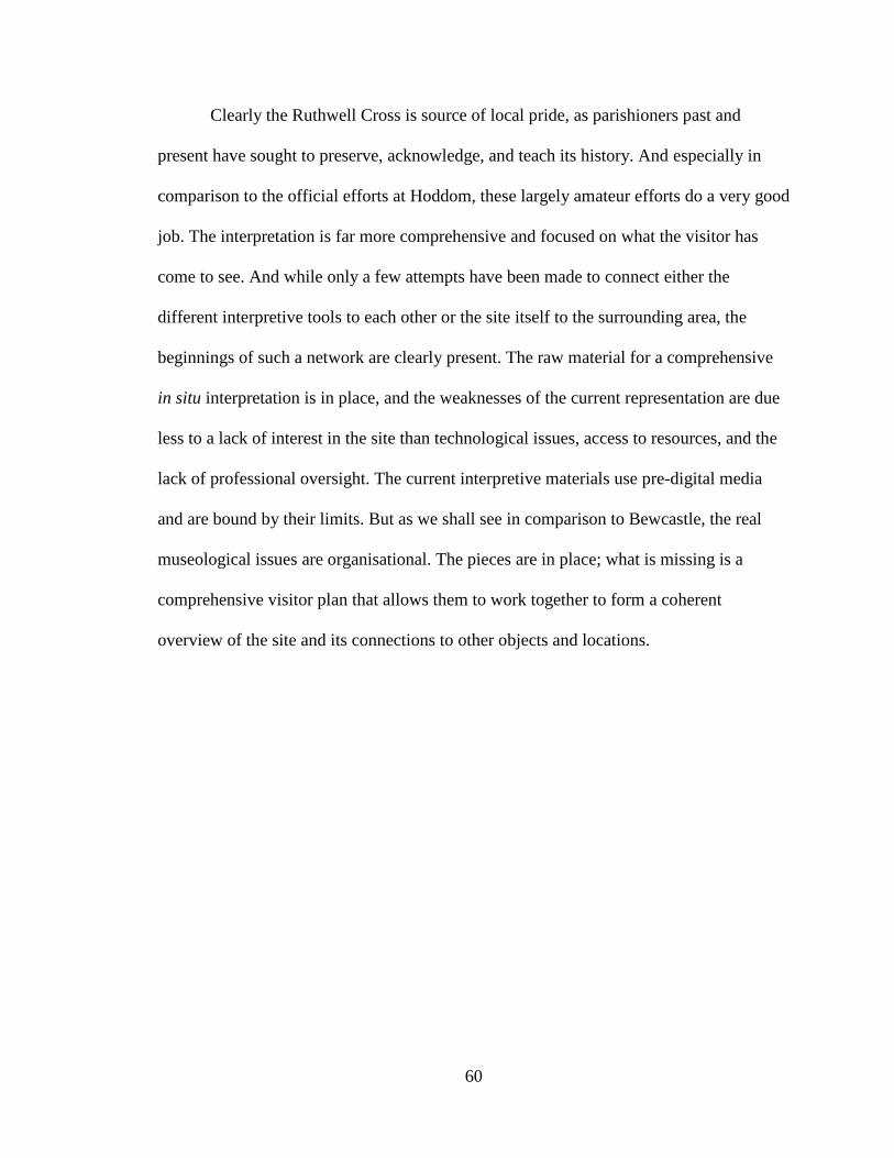
60
Clearly the Ruthwell Cross is source of local pride, as parishioners past and
present have sought to preserve, acknowledge, and teach its history. And especially in
comparison to the official efforts at Hoddom, these largely amateur efforts do a very good
job. The interpretation is far more comprehensive and focused on what the visitor has
come to see. And while only a few attempts have been made to connect either the
different interpretive tools to each other or the site itself to the surrounding area, the
beginnings of such a network are clearly present. The raw material for a comprehensive
in situ interpretation is in place, and the weaknesses of the current representation are due
less to a lack of interest in the site than technological issues, access to resources, and the
lack of professional oversight. The current interpretive materials use pre-digital media
and are bound by their limits. But as we shall see in comparison to Bewcastle, the real
museological issues are organisational. The pieces are in place; what is missing is a
comprehensive visitor plan that allows them to work together to form a coherent
overview of the site and its connections to other objects and locations.
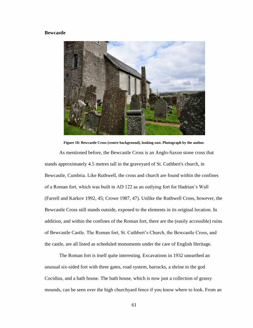
61
Bewcastle
Figure 18: Bewcastle Cross (centre background), looking east. Photograph by the author.
As mentioned before, the Bewcastle Cross is an Anglo-Saxon stone cross that
stands approximately 4.5 metres tall in the graveyard of St. Cuthbert's church, in
Bewcastle, Cumbria. Like Ruthwell, the cross and church are found within the confines
of a Roman fort, which was built in AD 122 as an outlying fort for Hadrian’s Wall
(Farrell and Karkov 1992, 45; Crowe 1987, 47). Unlike the Ruthwell Cross, however, the
Bewcastle Cross still stands outside, exposed to the elements in its original location. In
addition, and within the confines of the Roman fort, there are the (easily accessible) ruins
of Bewcastle Castle. The Roman fort, St. Cuthbert’s Church, the Bewcastle Cross, and
the castle, are all listed as scheduled monuments under the care of English Heritage.
The Roman fort is itself quite interesting. Excavations in 1932 unearthed an
unusual six-sided fort with three gates, road system, barracks, a shrine to the god
Cocidius, and a bath house. The bath house, which is now just a collection of grassy
mounds, can be seen over the high churchyard fence if you know where to look. From an
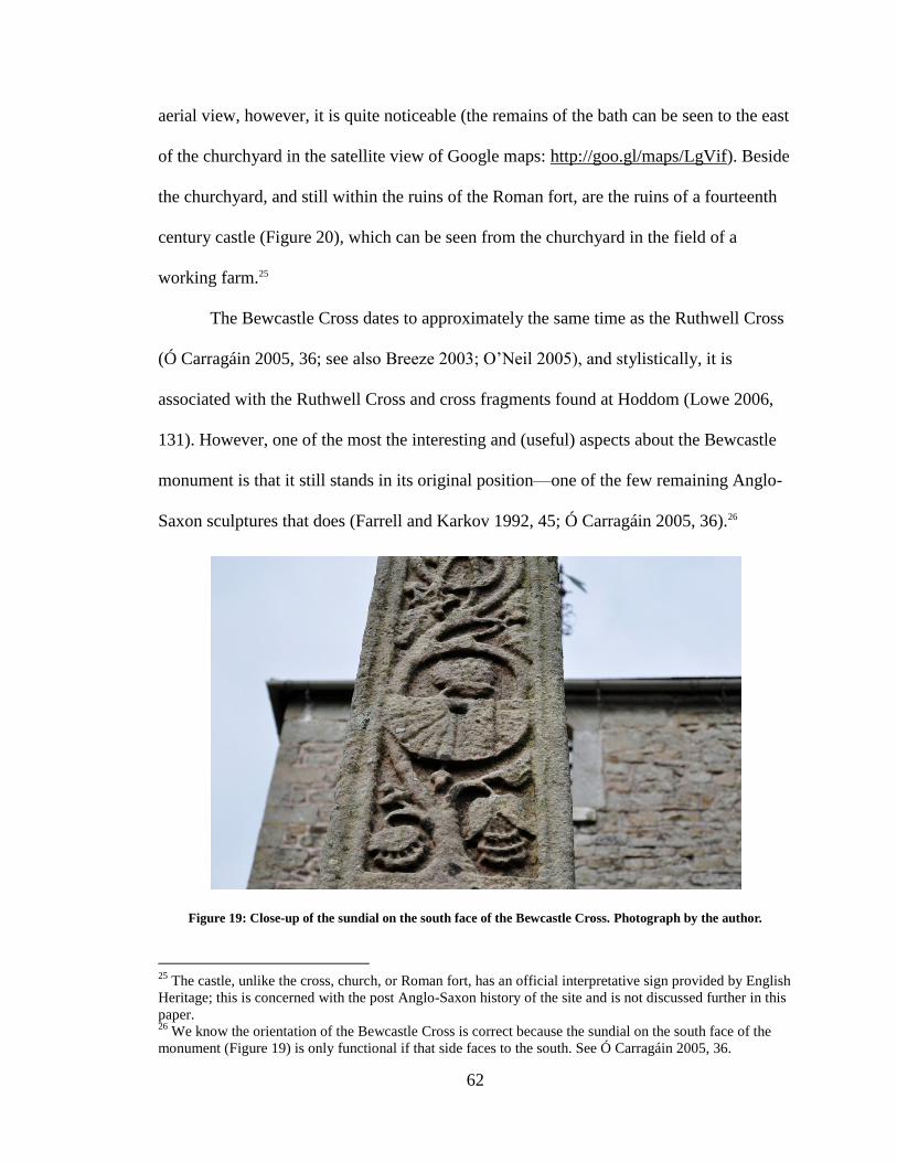
62
aerial view, however, it is quite noticeable (the remains of the bath can be seen to the east
of the churchyard in the satellite view of Google maps: http://goo.gl/maps/LgVif). Beside
the churchyard, and still within the ruins of the Roman fort, are the ruins of a fourteenth
century castle (Figure 20), which can be seen from the churchyard in the field of a
working farm.25
The Bewcastle Cross dates to approximately the same time as the Ruthwell Cross
(Ó Carragáin 2005, 36; see also Breeze 2003; O’Neil 2005), and stylistically, it is
associated with the Ruthwell Cross and cross fragments found at Hoddom (Lowe 2006,
131). However, one of the most the interesting and (useful) aspects about the Bewcastle
monument is that it still stands in its original position—one of the few remaining Anglo-
Saxon sculptures that does (Farrell and Karkov 1992, 45; Ó Carragáin 2005, 36).26
Figure 19: Close-up of the sundial on the south face of the Bewcastle Cross. Photograph by the author.
25
The castle, unlike the cross, church, or Roman fort, has an official interpretative sign provided by English
Heritage; this is concerned with the post Anglo-Saxon history of the site and is not discussed further in this
paper. 26
We know the orientation of the Bewcastle Cross is correct because the sundial on the south face of the
monument (Figure 19) is only functional if that side faces to the south. See Ó Carragáin 2005, 36.
63
Figure 20: Bewcastle Castle, looking east. Photograph by the author.
The Bewcastle Cross, even missing its top-piece,27 is one of the first things you
see when you enter the churchyard, although it appears quite small next to the church.28
The current church, which was rebuilt in 1792 (Visit Cumbria 2014), is open to visitors
and a selection of tourist items is available for sale just inside the porch in a fashion
similar to Ruthwell. The real innovation however, is the 1980s interpretive exhibit built
inside a repurposed shed or storeroom attached to the old rectory to the south of the
church. Although not officially organised by English Heritage, this exhibit means that
Bewcastle is the only site of the three that technically has a “visitor interpretation centre.”
27
The cross piece has been missing since at least 1607. In Conversion of the Heptarchy: Seven Lectures,
Browne mentions a note found by Gough in William Camden’s personal copy of Britannia (1607) that
read: “I received this morning a ston from my Lord Arundel, sent him from my Lord William. It was the
head of a cross at Bucastle” (1896, 190). Browne clarifies that “Lord William was Lord William Howard,
and that Lord Arundel was the first Baron of Wardour (1896, 190). Browne also briefly states that the cross
piece was blown from its socket in a gale wind and that it had “letters across that Camden could not read”
and that Camden’s “drawing of them shews us that they were runes” (1896, 190). 28
The earliest recording of a church on the site is from 1277, but the current church was rebuilt in 1792
(http://www.bewcastle.com/church.htm).
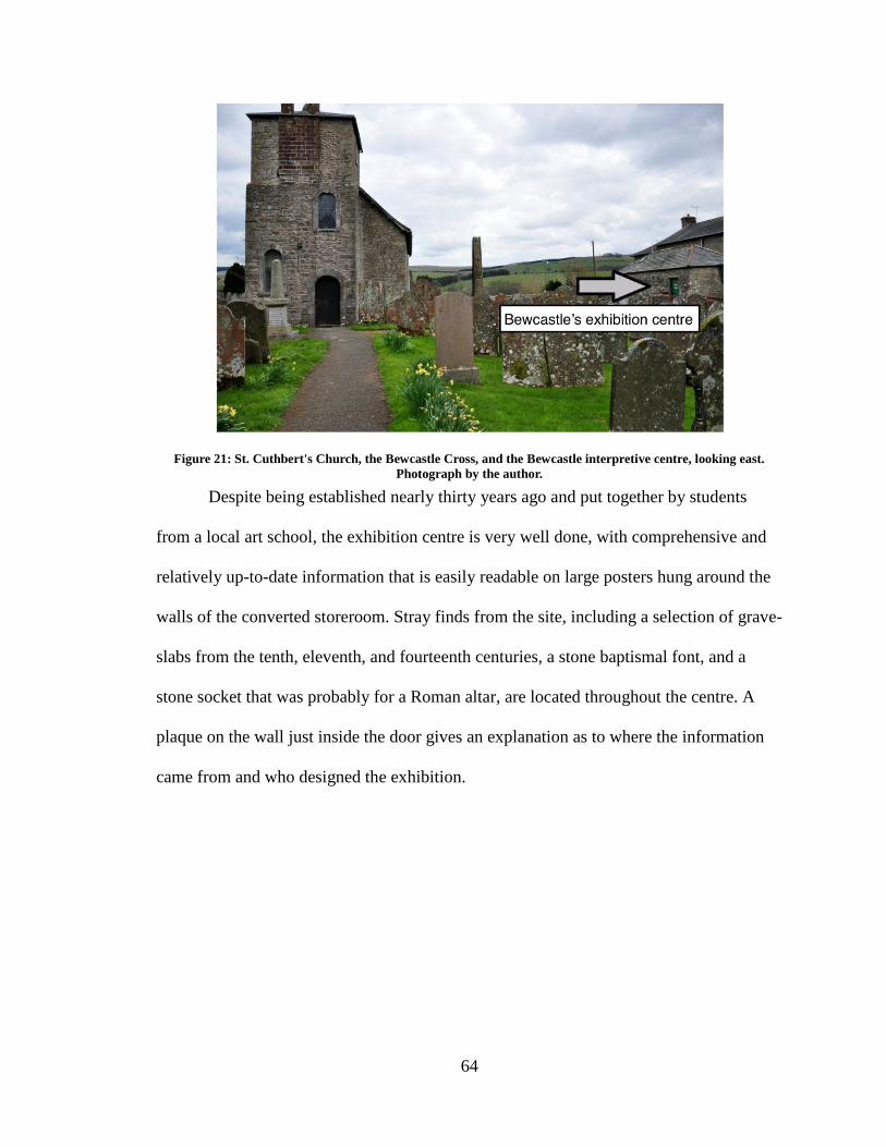
64
Figure 21: St. Cuthbert's Church, the Bewcastle Cross, and the Bewcastle interpretive centre, looking east.
Photograph by the author.
Despite being established nearly thirty years ago and put together by students
from a local art school, the exhibition centre is very well done, with comprehensive and
relatively up-to-date information that is easily readable on large posters hung around the
walls of the converted storeroom. Stray finds from the site, including a selection of grave-
slabs from the tenth, eleventh, and fourteenth centuries, a stone baptismal font, and a
stone socket that was probably for a Roman altar, are located throughout the centre. A
plaque on the wall just inside the door gives an explanation as to where the information
came from and who designed the exhibition.
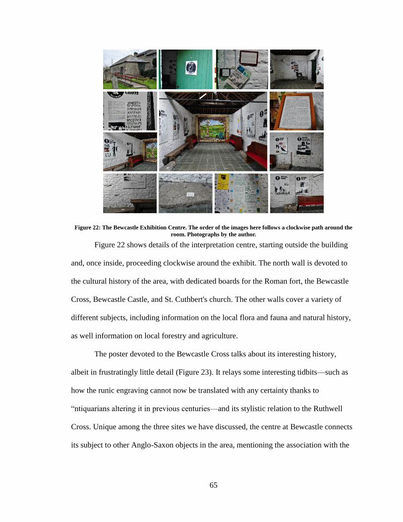
65
Figure 22: The Bewcastle Exhibition Centre. The order of the images here follows a clockwise path around the
room. Photographs by the author.
Figure 22 shows details of the interpretation centre, starting outside the building
and, once inside, proceeding clockwise around the exhibit. The north wall is devoted to
the cultural history of the area, with dedicated boards for the Roman fort, the Bewcastle
Cross, Bewcastle Castle, and St. Cuthbert's church. The other walls cover a variety of
different subjects, including information on the local flora and fauna and natural history,
as well information on local forestry and agriculture.
The poster devoted to the Bewcastle Cross talks about its interesting history,
albeit in frustratingly little detail (Figure 23). It relays some interesting tidbits—such as
how the runic engraving cannot now be translated with any certainty thanks to
“ntiquarians altering it in previous centuries—and its stylistic relation to the Ruthwell
Cross. Unique among the three sites we have discussed, the centre at Bewcastle connects
its subject to other Anglo-Saxon objects in the area, mentioning the association with the
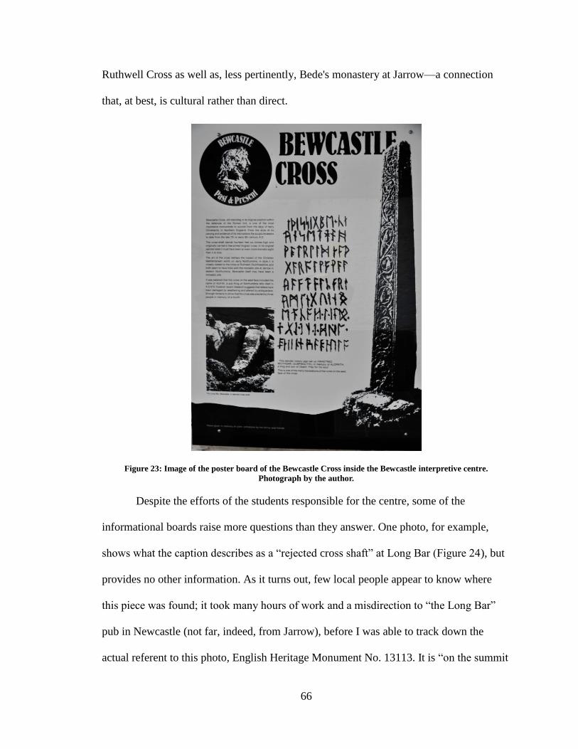
66
Ruthwell Cross as well as, less pertinently, Bede's monastery at Jarrow—a connection
that, at best, is cultural rather than direct.
Figure 23: Image of the poster board of the Bewcastle Cross inside the Bewcastle interpretive centre.
Photograph by the author.
Despite the efforts of the students responsible for the centre, some of the
informational boards raise more questions than they answer. One photo, for example,
shows what the caption describes as a “rejected cross shaft” at Long Bar (Figure 24), but
provides no other information. As it turns out, few local people appear to know where
this piece was found; it took many hours of work and a misdirection to “the Long Bar”
pub in Newcastle (not far, indeed, from Jarrow), before I was able to track down the
actual referent to this photo, English Heritage Monument No. 13113. It is “on the summit
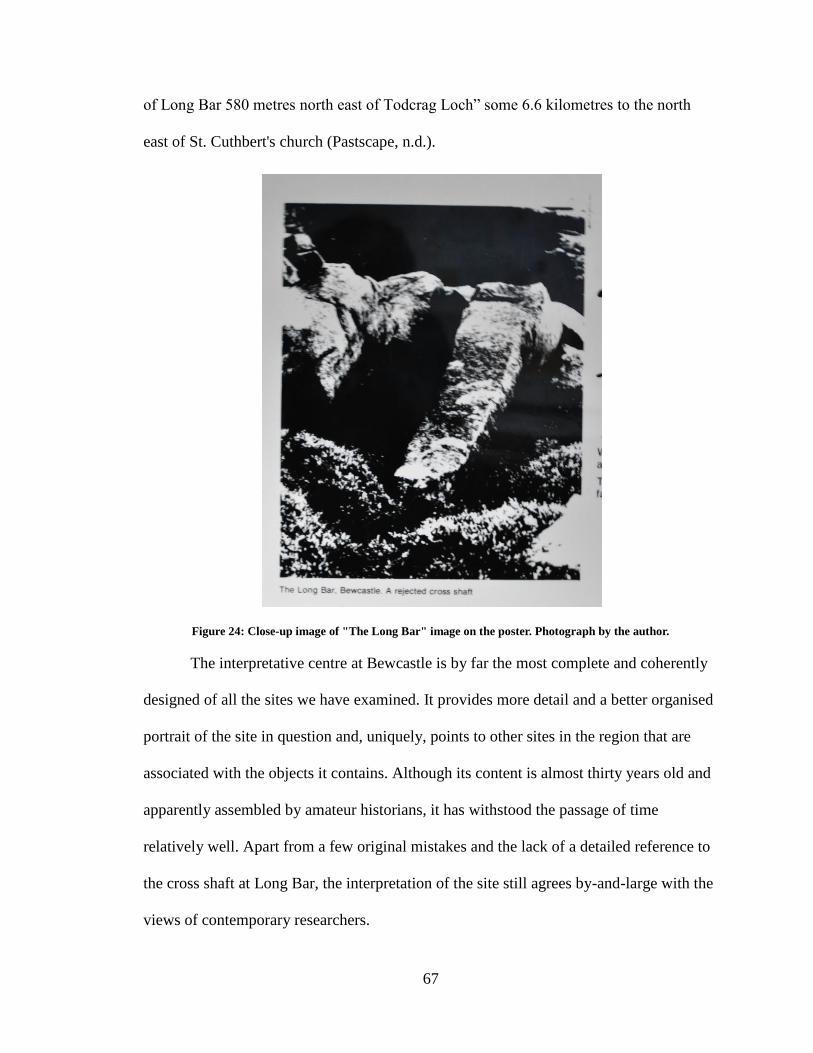
67
of Long Bar 580 metres north east of Todcrag Loch” some 6.6 kilometres to the north
east of St. Cuthbert's church (Pastscape, n.d.).
Figure 24: Close-up image of "The Long Bar" image on the poster. Photograph by the author.
The interpretative centre at Bewcastle is by far the most complete and coherently
designed of all the sites we have examined. It provides more detail and a better organised
portrait of the site in question and, uniquely, points to other sites in the region that are
associated with the objects it contains. Although its content is almost thirty years old and
apparently assembled by amateur historians, it has withstood the passage of time
relatively well. Apart from a few original mistakes and the lack of a detailed reference to
the cross shaft at Long Bar, the interpretation of the site still agrees by-and-large with the
views of contemporary researchers.
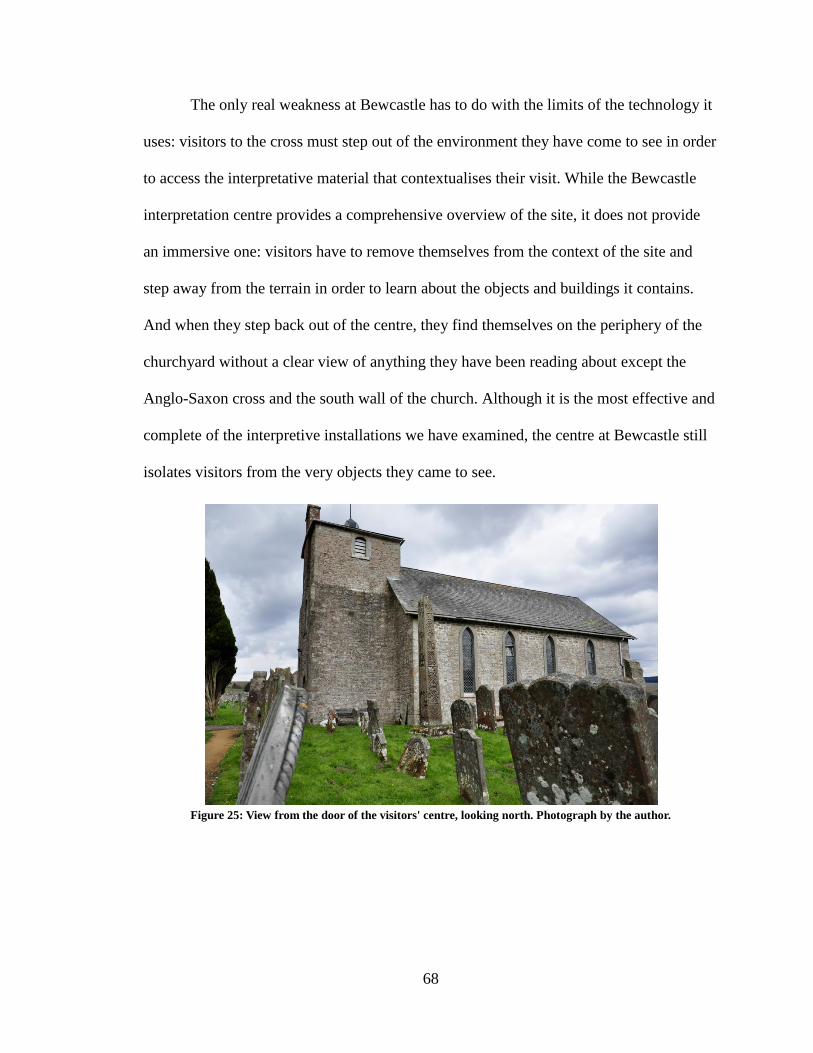
68
The only real weakness at Bewcastle has to do with the limits of the technology it
uses: visitors to the cross must step out of the environment they have come to see in order
to access the interpretative material that contextualises their visit. While the Bewcastle
interpretation centre provides a comprehensive overview of the site, it does not provide
an immersive one: visitors have to remove themselves from the context of the site and
step away from the terrain in order to learn about the objects and buildings it contains.
And when they step back out of the centre, they find themselves on the periphery of the
churchyard without a clear view of anything they have been reading about except the
Anglo-Saxon cross and the south wall of the church. Although it is the most effective and
complete of the interpretive installations we have examined, the centre at Bewcastle still
isolates visitors from the very objects they came to see.
Figure 25: View from the door of the visitors' centre, looking north. Photograph by the author.
69
These omissions are important to visitors’ experience of the region and their
understanding of its history. The Solway Coast Heritage Trail, like the other itineraries
provided by Visit Scotland and the regional tourism authorities, represents an entrance
into a virtual historical geography. But the world these trails introduce is incomplete and,
even for the parts that are included, are relatively unevenly put together. The failure to
exploit and display the interconnectivity of these sites is a museological problem that
significantly affects public understanding of the region’s history. Although Bewcastle and
Ruthwell have objects that are likely to be of intrinsic interest to casual visitors, visitor
experience at both locations would be considerably improved by interpretative material
that shows the sense of connection between them and to other, nearby sites.29 In the case
of Hoddom, where very few physical markers of the monastic settlement remain, such
contextual information would seem to be essential. The failure to include such
information at this last site considerably distorts the visitor experience.
In the next chapter, we will see how the potential of contemporary technology
could improve on the current materials at folk heritage sites by making them updatable as
well as creating a cohesive interpretive plan. It discusses the current forms of technology
and their potential uses in rural, folk-run cultural heritage sites. It then demonstrates how
a digital tour using AR technology and pattern recognition would look if employed at the
site of Ruthwell by overlaying the successful pieces of Ruthwell’s in situ material with
the successful presentation of Bewcastle’s interpretation centre.
29
And, as we will see in the forthcoming chapter, visitors have indicated that finding the connection
between Ruthwell and Bewcastle as interesting enough to visit both locations.
70
Chapter Three: Digital Interpretation
In chapter one, we looked at how modern museums have been developed by and
benefitted from technological innovations throughout their history and, currently, are
experimenting successfully at an institutional level with mobile interpretation. We also
looked at the different types of museums and noted some of the differences that
distinguish urban institutions from more rural and remote sites.
In chapter two, we looked at how the Dumfries and Galloway peninsula can be
understood as a territory-museum and how current interpretative efforts do and do not
work in bringing out this aspect of the region. We looked in detail at three related Anglo-
Saxon sites in the region and discovered that local amateurs have, on the whole, done a
far better job than the professionals in the quality and comprehensiveness of their
interpretation. In particular, the amateurs do a much better job than the professionals in
establishing the context for the sites they interpret. In Bewcastle, the 1980s interpretation
centre both comprehensively explains the different aspects of its own location and ties
this location to at least some of the surrounding, related, locations. In Ruthwell, the strata
of (primarily amateur) signage and documentation provides both a wealth of information
about the cross and church but also some sense of the (at times unexpected) connections
between the Anglo-Saxon cross and other aspects of the region's history and
personalities.
Taken together, however, the two chapters also demonstrate the extent to which
the current interpretation on the Peninsula fails to exploit its full potential. The official
archaeological and tourist websites do not integrate well with the existing on-site
interpretative material, even when this material is officially supplied. The amateur
71
interpretive efforts, while generally of higher quality and broader interest, are limited by
the nature of the physical media they employ: visitors to Bewcastle must leave the site in
order to learn about it; and while Ruthwell has better signage in situ, this signage both
lacks an overall plan, can be difficult to follow, and, as we shall see, is subject to scarcity.
This chapter looks at how contemporary mobile technology could be used to
improve upon the visitor experience on the peninsula, focussing on the interpretation of
the Ruthwell Cross and kirk. It demonstrates a virtual tour of the site and how it could be
constructed in a way that would take advantage of the site's current interpretative
strengths (including local engagement and a commitment to a comprehensive, in situ
interpretation) but builds on them by taking advantage of the possibilities of
contemporary and short-horizon mobile technology.
An Interpretive Strategy for Implementing a Digital Tour of Cultural Heritage Sites
In order for a digital interpretation programme to be successful at a rural cultural
heritage site, it needs to address three specific points: 1. It needs to be discoverable; 2. It
needs to recognise the greater context 9that it is part of a larger region and therefore part
of a territory-museum); 3. And, it needs to recognise that the local community can do a
better job at interpretation than the professionals, and consequently it requires
opportunities for local as well as scholarly input.
Digital Interpretation Plan for the Site of Ruthwell
One way of improving on the current Ruthwell interpretation programme is an
AR tour that would function through individual visitors’ personal mobile devices. An
example of how this would work is detailed in this chapter.
72
Although the ideal would be to have a unified virtual Anglo-Saxon network that
spans the region, the best strategy is to start small and move outwards. From the site
readings in the previous chapter, it is clear that the local communities have done an
excellent job at preserving and disseminating the history of the local region to their
visitors (at Ruthwell and Bewcastle, specifically). We have seen how the local passion,
interest, and enthusiasm in the history of the area is a source of local pride. The residents
want visitors to come and they want visitors to value their experiences and share what
they have learned. The interpretive material at Hoddom provided by Historic Scotland is
an example of how the professionals think globally and not locally, and as a consequence
do a poorer job at site interpretation. The strengths of the amateur interpretation and the
weaknesses of the national is a good reason to start small and eventually build to the
national level.
However, as mentioned before, although the raw material for a comprehensive
interpretive programme is in place, the main weaknesses in the current representation of
information are due mainly to a lack of professional oversight, a limited access to
resources, and limitations of physical media, and as a result, the current interpretive
material is bound by those mediums. However, what else is clear is that the overall
interpretive material at the site, although well done and focused on the object visitors
came to see, is lacking an overall cohesive rhetoric: the issues, aside from those
mentioned above, are organisational. An updated, digital interpretive plan can remedy
these organisational issues by allowing all the unconnected pieces on-site to work
together to form a coherent overview of the site and its connections to neighbouring
objects and locations in Dumfries and Galloway.
73
A digital interpretive tour using AR and pattern recognition technology would not
only improve on-site visitor experience and engagement, it would also address three main
points: 1. Discoverability; 2. Connection to the region and territory-museum; 3.
Allowance for local as well as scholarly input.
There are two main options for implementation of a digital tour at Ruthwell. One
is by using tags or codes linked to an external, mobile compatible website. The second is
by using pattern recognition to display the information directly on a visitor’s smartphone.
An Interpretation Plan using QR Codes
Figure 26: By scanning this QR code, you will be taken to the website www.everythingruthwell.org
QR codes have been around since 1994 and were developed by the automotive
industry in Japan, but only started to experience widespread use in North America in the
2000’s (Strout 2013), including inside the museum walls (Simon 2011). There are a
number of online articles and blog posts on the success (or lack thereof) of QR code use
in a variety of contexts (see Simon 2011; Wheeler 2011; Strout 2013; Anderson 2013). In
the museum world specifically, there is a definite rift between those who believe in using
QR codes and those who do not.30 Despite the Canadian Heritage website boasting that
“QR codes are one of the mobile technologies that are the hottest in the museum
30
Wheeler (2011) strongly advocates for the use of QR codes while Simon (2011) urges caution and careful
strategy when employing the use of QR codes. However, the Smithsonian Web and Media Strategy (n.d.)
on “Using QR Codes” suggests moving from QR to pattern recognition.
74
community right now” (CHIN 2012b), QR code popularity is beginning to decline just as
we are seeing a rise in AR technology in the museum environment (e.g. “Ultimate
Dinos,” “StreetMuseum,” “Capture the Pheon”). However, despite this, QR codes are still
“usable” in that the technology still exists, is free and downloadable, and QR code
readers are still available for every mobile platform. And so, if not “ideal,” QR codes are
still a solution for the implementation of a digital strategy at a site like Ruthwell.
Strategically placed QR codes could link to a dedicated website connected to
those of Visit Scotland, Historic Scotland, and the Ruthwell kirk while still allowing for
the input of scholars and the local community. Pointing a device at these codes pulls up
information about the relevant objects that is part of the larger website. A set of
individual QR codes can thus be used for each of panel of the cross, allowing visitors to
call up information about each panel individually—a method similar to that employed by
the current paddles but that allows easier updating.
One glaring downside is the actual physical addition of QR codes to a building
that is still a functioning church. QR codes are not exactly an attractive addition and as
such disrupt the natural aesthetic of any environment. This could be partially solved by
placing the QR codes on movable pillars, sticks, or podiums that could be removed
during a service or only placed out when the church is open to visitors. This option
requires an infrastructure (the addition of such sticks or podiums) and consequently
becomes bulky. There is also a chance for error (unless the codes are clearly marked) as a
QR code could be placed in the wrong location. For locations outside the church building,
the QR codes would have to be made permanent and protected in some way as to make
75
them immune to the weather but still readable (anything with a glare, like glass or plastic,
makes it difficult to scan a code successfully).
In addition to the technical issues, QR codes must be value-added to the current
interpretive material: they must offer more than a digitised version of the current material
on-site to be worthwhile for the time and energy it takes to download a reader and scan
the code. Furthermore, the proper context for the QR code needs to be presented to the
visitor—visitors need to know why they should scan the code and what they get out of
doing so. As one author states: “QR codes without context are appealing to two
audiences: museum geeks and technology geeks” (Simon 2011). What we want to do is
appeal to everyone.
An Interpretation Plan using NFC Tags
If the major concern with QR codes is the aesthetic appearance of them, an
alternative to using QR codes are near field communication (NFC) tags, which function
similarly to QR codes but are more visually inconspicuous. NFC is a “wireless
technology that allows for the transfer of data between two NFC enabled devices, such as
smartphones” (Rapid NFC n.d.a). For example, the technology that allows for the transfer
of data between two smartphones when “bumped” is due to NFC microchips in those
smartphones. NFC tags are small, unpowered microchips with aerials that can store
simple data that can be transferred to NFC enabled devices when such devices are within
ten centimeters of the tag (see Rapid NFC n.d.a; Casabona 2013; Chandler 2012). NFC
tags are programmable with simple data such as text, numbers, URLs, contact
information, and simple applications (Rapid NFC n.d.b.; see also Casabona 2013;
Chandler 2012). They are most popular for advertising and making payments (the “tap-
76
to-pay” options on many credit cards use NFC technology, as does Google Wallet and the
PayPal app, among others; see Casabona 2013; Rapid NFC n.d.a). NFC tags are small
and cheap enough that they can be used in items such as wristbands, posters, and business
cards, are easily programmable by anyone with an NFC enabled smartphone and a
suitable application, and are rewritable and fully lockable, meaning the data can be
changed until the tag is locked so no one else can overwrite it (however, once a tag is
“locked” it is not reprogrammable; see Rapid NFC n.d.a.; Rapid NFC n.d.b.; Casabona
2013; Chandler 2012). They do not require a power source of their own because they
draw from the power of the device reading them (so no batteries) nor do they require a
specially designed application to read them (like a QR code reader). Many smartphones
currently on the market are fitted with NFC technology, which is important to note,
because NFC technology requires NFC enabled phones in order to be read or written. In
order to write to an NFC tag, the enabled phone needs a specialised application that is
capable of writing data to the tag (Rapid NFC n.d.a.; Rapid NFC n.d.b.; Casabona 2013).
Although the tags themselves cost, the writers are generally free.
In the case of Ruthwell, anywhere a QR code would be positioned could be
replaced by the less intrusive NFC tag. The NFC tags could be programmed to direct
visitors to the same specially designed website the QR codes would direct them, and be
placed around the church and churchyard in the same manner as the QR codes. An
additional pro is the ability to code NFC tags with small amounts of text; the tags could
actually be programmed with the artefact description itself to be transferred directly to the
phone “tapped,” essentially bypassing the need for an internet connection (a clear benefit
over the functionality of QR codes). However, the comprehensiveness of the text would
77
depend on the amount of data the NFC tag can hold (they are available in difference
sizes).
Additionally, because of their small size NFC tags would not require as heavy an
infrastructure as QR codes would—they can even be ordered as stickers and placed
anywhere. What's more, and as mentioned before, NFC tags are compatible with NFC
enabled phones and as such do not require the need for a downloadable application (like a
QR code reader) in order to read them. Visitors to the site with these smartphones would
only need to hold their phones within ten centimeters of the tag in order to participate in
an NFC tour.
However there are some cons with these tags. If they were used to store and
transfer simple text to a user’s phone it would mean less of an equal opportunity for
scholars and the local community to include their input in the interpretive material
because the information would need to be planned and curated ahead of time. Because it
is not possible to place a sticker right on the Ruthwell Cross itself, they would still
require some sort of an infrastructure, like a plaque or a poster. Additionally, if the tag is
locked, it would need to be replaced with a new tag if the data stored on it ever changed.
The cost is not all that much and so is not a huge factor, but it does mean that the tags are
not updatable from anywhere, which is the primary benefit of QR codes.
The biggest concern with NFC tags is device compatibility. Although many
smartphones are equipped with NFC technology and are compatible with NFC tags, many
users may not be aware of this aspect of their devices since it is not a feature that is often
advertised (Nosowitz 2013). And even though many phones are NFC enabled (primarily
78
Windows and Android phones), not all are31—my own phone, a Samsung Galaxy Infuse
(Android), is not NFC enabled (albeit, it is over two years old). Additionally, Apple has
decided not to include NFC technology in its phones or tablets despite the fact that
Windows and Android are (Nosowitz 2013; see also Casabona).32 As one author puts it,
“Apple also, as the company with the most promotional power in the entire industry, has
the ability to singlehandedly change things. If Apple had included NFC in the iPhone 5S,
and really pushed it, who knows what could change?” (Nosowitz 2013). It is hard at this
point in time to know what the future is for NFC tags; because they are popular among
retailers and advertisers they will remain a viable technology, but because Apple has
decided not to include them in their devices, they are not available to all platform users.
Looking at the pros and cons of NFC tags in comparison to QR codes, they do not
seem like a feasible replacement for QR codes. However, there is no reason they could
not be used in conjunction with QR codes, and may even make a digital tour using QR
codes more robust and accessible. Indeed, it is generally felt that “QR Codes and NFC
tags sit alongside each other and both have their advantages and disadvantages” (Rapid
NFC n.d.b.). An NFC tag could be included in any medium the QR code is printed on—
for instance, an NFC tag could be inside a poster on which a QR code is printed—making
the tour more accessible to a larger audience than a tour involving only one or the other
would be.
This tour would need to (again) be value-added to the current interpretive tour and
it would require more careful updating than the current material does. The QR codes and
the NFC tags would need to be maintained simultaneously to make sure one would not
31
You can find a detailed list of NFC enabled smartphones and tablets at Wikipedia:
http://en.wikipedia.org/wiki/List_of_NFC-enabled_mobile_devices; see also Rapid NFC n.d.c. 32
See Figure 55 for a graph on the types of smartphones and tablets visitors to Ruthwell carry.
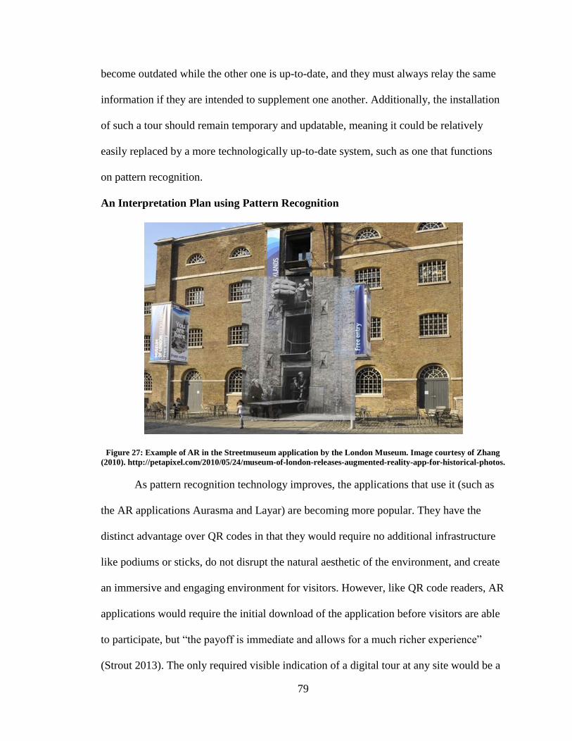
79
become outdated while the other one is up-to-date, and they must always relay the same
information if they are intended to supplement one another. Additionally, the installation
of such a tour should remain temporary and updatable, meaning it could be relatively
easily replaced by a more technologically up-to-date system, such as one that functions
on pattern recognition.
An Interpretation Plan using Pattern Recognition
Figure 27: Example of AR in the Streetmuseum application by the London Museum. Image courtesy of Zhang
(2010). http://petapixel.com/2010/05/24/museum-of-london-releases-augmented-reality-app-for-historical-photos.
As pattern recognition technology improves, the applications that use it (such as
the AR applications Aurasma and Layar) are becoming more popular. They have the
distinct advantage over QR codes in that they would require no additional infrastructure
like podiums or sticks, do not disrupt the natural aesthetic of the environment, and create
an immersive and engaging environment for visitors. However, like QR code readers, AR
applications would require the initial download of the application before visitors are able
to participate, but “the payoff is immediate and allows for a much richer experience”
(Strout 2013). The only required visible indication of a digital tour at any site would be a
80
poster or sign alerting visitors that a digital tour exists with a guide on how to get started.
This information can also be made available as a (reusable) brochure or pamphlet.
The primary benefit for AR technology that utilises pattern recognition is the
immersive environment it creates. Visitors are free to explore and navigate the area for
themselves and are not tied to any specific room. For example, visitors could view each
distinctly carved panel on the Ruthwell Cross in the suggested order, out of order, or view
the cross as a whole. They could move out to the churchyard and surrounding
environment, such as around the building of the church, the graveyard, or the street. One
way of exploring a tour such as this could begin inside the church, expanding outward
from the cross, to the inside structure of the church, then out to the churchyard, and then
finally to include any off-site points of interest, such as the Roman enclosure and the old
Ruthwell manse. Visitors have the freedom to explore the entirety of the site if they so
choose, free to move around without constraint, or they could focus entirely on the cross
itself and ignore any of the other points. The site would become a user-controlled,
immersive environment, introducing visitors to the historical layers of the site (Roman,
medieval, and modern), drawing them into the history. This mobility that results from
pattern recognition and AR applications is also a major benefit when compared to the less
mobile QR codes and NFC tags. Although QR codes and NFC tags can be placed nearly
anywhere, there are certainly locations where they are less convenient or are relatively
useless (like highways; see Anderson 2013 for more examples).
As we have seen, many museums have begun employing the use of AR
applications or other multimedia technology (Mannion n.d.; see again “Ultimate Dinos,”
“StreetMuseum,” “Capture the Pheon”). Additionally, there is also an increase in the use

81
of AR applications in the advertising strategies of major corporations and Google’s
Google Glass is becoming more popular.33 Looking at the versatile use of AR and pattern
recognition by different types of industries, it is clear that major funds and research are
going into this technology (see Farber 2013).34 As the focus turns away from QR codes
and to pattern recognition and AR, it makes sense to dedicate resources to implementing
an AR focused interpretive tour instead of a tour based on tags or codes. Essentially, there
is no sense in investing in a technology that will be defunct in five years or so. Therefore,
if a tour were to be implemented at Ruthwell, it should focus resources on one that uses
pattern recognition, or is at least one that is updatable for future technology that utilises
pattern recognition.
Discoverability, connection to the regional territory-museum, and allowance for
local and scholarly input can all be done through the use of the above technologies. The
first and, to a lesser extent, the second points can easily be solved by linking a dedicated
site about the Ruthwell Cross and kirk to the official websites for Visit Scotland and
Historic Scotland. By highlighting the interpretive programme at Ruthwell through these
official spaces, it not only makes the physical site more discoverable physically (visitors
are directed on how to get the location), but by notifying visitors of a digital interpretative
tour that requires a personal smartphone or tablet makes the site discoverable
intellectually as well. The current page for the Ruthwell Cross and kirk on the Visit
Scotland site would also need to be updated to reflect their connections to the greater
33
See Google Glass http://www.google.com/glass/start/. Also, see how Nissan uses Layar
(http://static.layar.com/website/cases/casestudy-nissan.pdf), or how Office Depot uses Aurasma
(http://www.aurasma.com/news/aurasma-webcast-retail-is-evolving-office-depot-is-innovating/), for
commercial uses of AR applications. 34
We are also seeing the decline of advertisers using QR codes at this time. See Strout 2013 and Anderson
2013.
82
region. Most of all, Visit Scotland needs to include Ruthwell as a stop in its online
itinerary, not only on the physical route. Similarly, the inclusion of Ruthwell as a “point
of interest” heritage site on the Historic Scotland website is imperative for directing
visitors to the area and alerting them of a digital interpretive tour in order to give them the
opportunity to participate in such a tour. Within this context, connecting the sites in the
Ruthwell area (the cross, church, and village) with nearby related sites online would
encourage visitors to take advantage of their opportunities to visit these sites while in the
area, not just discover them by chance (or perhaps not at all).
In addition to the heritage site being included on the Visit Scotland and Historic
Scotland websites in greater detail than it is now, the church’s own website
(http://www.ruthwellkirk.org.uk/), which already highlights the local and historical
importance of the Ruthwell Cross, could also advertise any new interpretive programme.
While essentially achieving the same results as the Visit Scotland or Historic Scotland
sites in terms of directing visitors to the physical location and encouraging them to bring
mobile technology along, linking to the church’s official website also allows for the
potential of including local knowledge and input in the overall interpretive tour; a digital
tour could also link to individual pages on the church’s website where the information is
collected and managed by those who manage the site.
It is also extremely important to allow for scholarly input as well as local input.
As we saw from the site reading at Ruthwell, one of the major weaknesses for the current
interpretation programme is that the existing material is outdated. Scholarship ages, and
in order for the information to stay up-to-date it will need to be updated by those
interested in, and with access to, the current research. Scholarship can be updated by
83
giving professional scholars and academics access to where the information is held, be it
on the church’s website, or the dedicated space for the site on the Visit Scotland or
Historic Scotland websites, or a dedicated web-space to the cross and church,
independent of, but linked to the previously mentioned websites.
An effective mobile tour should take the interpretive in situ pieces already at
Ruthwell (with the ability to expand on it) and overlay them with the successful cohesion
of the Bewcastle interpretation centre. It would take the presentation method from
Bewcastle (the posters) and display them in context of the entire site: visitors will be able
to receive the information for what they are currently looking at without being removed
from the direct environment. The primary improvement here would be the method of
tying the interpretive material to the environment itself. A digital tour such as this is not
meant to focus on the technology and the novelty of the new technology, but should
simply be designed as a robust and effective dissemination of knowledge to an interested
visitor base. Again, the point is not to change the strategy of interpretation but merely to
improve on the medium of interpretation by making it more cohesive, robust, sustainable,
and of course (as Tilden would put it), provoke interest. The most effective way of
achieving this is through the implementation of a tour using pattern recognition and AR
technology.
We will see in chapter four that the visitors to Ruthwell are interested in the cross
and church and spend a fair amount of time on-site; however, they are not heavy
technology users. Although more than half the visitors in most demographics (the
exception being visitors from England) have some technology with them on their visit,
experience suggests that they will not use this technology unless given a good reason to
84
do so.35 Because of these factors, visitors need a good reason to participate in a digital
tour, which would require additional steps to the current interpretive material (such as
downloading an AR application and possibly subscribing to a channel where the tour is
hosted).
To begin strategising the overall interpretive plan, I created the map in Figure 28,
which displays an aerial view of the Ruthwell site.36 The physical copy of the map is
customisable by using moveable cell phone icons to indicate where points of interest are.
The cell phone icons can be placed to indicate where there are currently marked points of
interest (e.g. the Ruthwell Cross, the marker in the garden, and the “Ruthwell
Connections” sign), or indicate where points of interest are not currently marked but may
be discoverable through other means, such as online research (e.g. the old manse, the
Roman enclosure), or indicate where there should be a marked point of interest but there
is none (e.g. a specific reference to the connection with the nearby sites of Bewcastle and
Hoddom).
35
This is seen in the visitor survey cards collected at Ruthwell in 2012. Although the survey was available
online as well, no visitor to Ruthwell chose to fill out the digital copy—in large part because it simply
repeated what was already available on-site in a physical medium 36
This map is hand-drawn and is based largely on the archaeological drawings by Chris Crowe (1987), the
ordnance survey map of the Ruthwell area from Canmore mapping, and two aerial photographs of the
Ruthwell site - licence obtained from RCHMS.
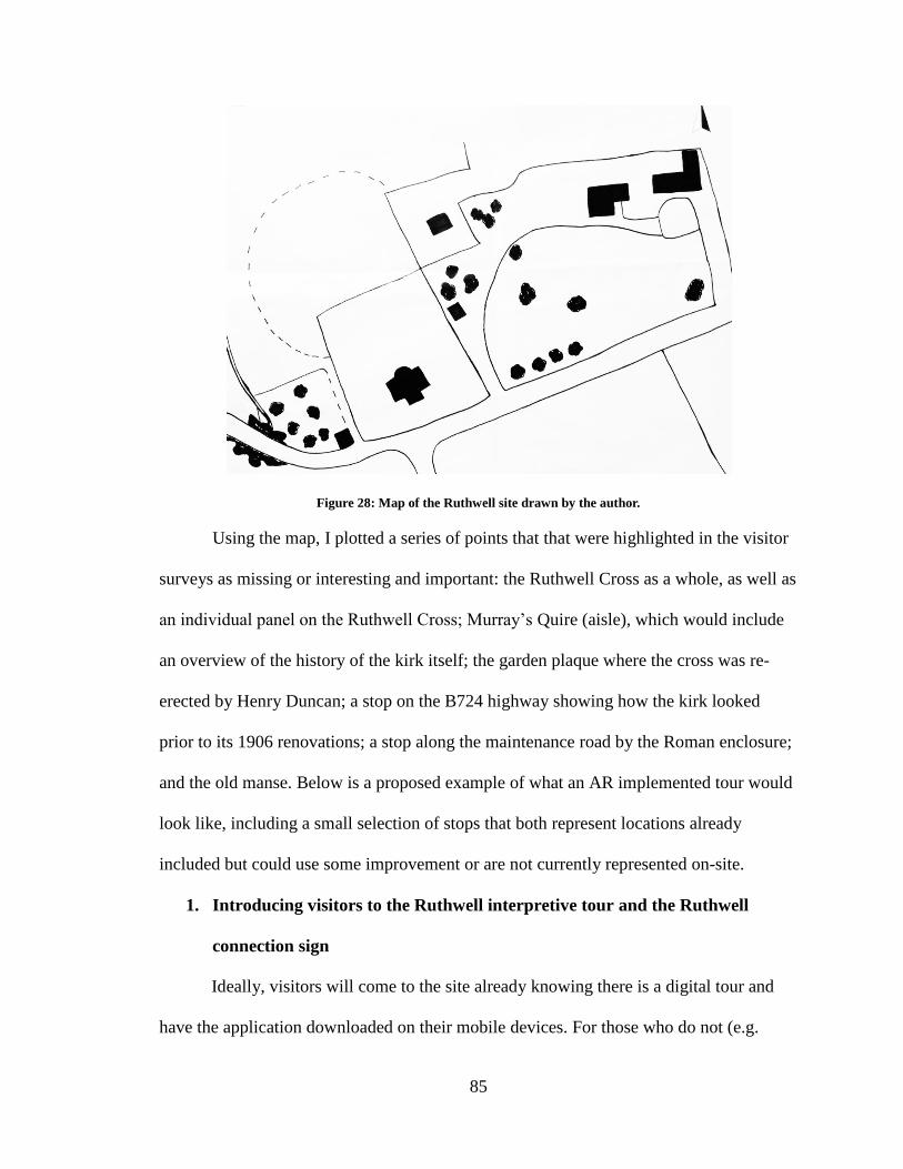
85
Figure 28: Map of the Ruthwell site drawn by the author.
Using the map, I plotted a series of points that that were highlighted in the visitor
surveys as missing or interesting and important: the Ruthwell Cross as a whole, as well as
an individual panel on the Ruthwell Cross; Murray’s Quire (aisle), which would include
an overview of the history of the kirk itself; the garden plaque where the cross was re-
erected by Henry Duncan; a stop on the B724 highway showing how the kirk looked
prior to its 1906 renovations; a stop along the maintenance road by the Roman enclosure;
and the old manse. Below is a proposed example of what an AR implemented tour would
look like, including a small selection of stops that both represent locations already
included but could use some improvement or are not currently represented on-site.
1. Introducing visitors to the Ruthwell interpretive tour and the Ruthwell
connection sign
Ideally, visitors will come to the site already knowing there is a digital tour and
have the application downloaded on their mobile devices. For those who do not (e.g.
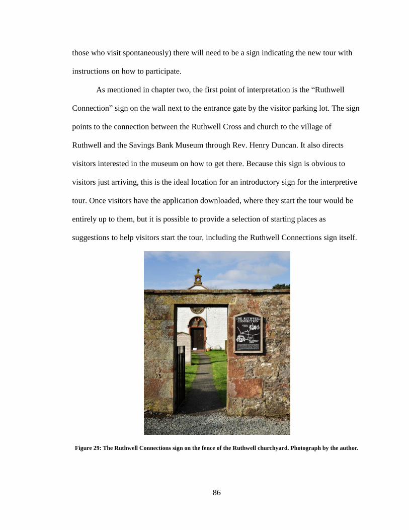
86
those who visit spontaneously) there will need to be a sign indicating the new tour with
instructions on how to participate.
As mentioned in chapter two, the first point of interpretation is the “Ruthwell
Connection” sign on the wall next to the entrance gate by the visitor parking lot. The sign
points to the connection between the Ruthwell Cross and church to the village of
Ruthwell and the Savings Bank Museum through Rev. Henry Duncan. It also directs
visitors interested in the museum on how to get there. Because this sign is obvious to
visitors just arriving, this is the ideal location for an introductory sign for the interpretive
tour. Once visitors have the application downloaded, where they start the tour would be
entirely up to them, but it is possible to provide a selection of starting places as
suggestions to help visitors start the tour, including the Ruthwell Connections sign itself.
Figure 29: The Ruthwell Connections sign on the fence of the Ruthwell churchyard. Photograph by the author.
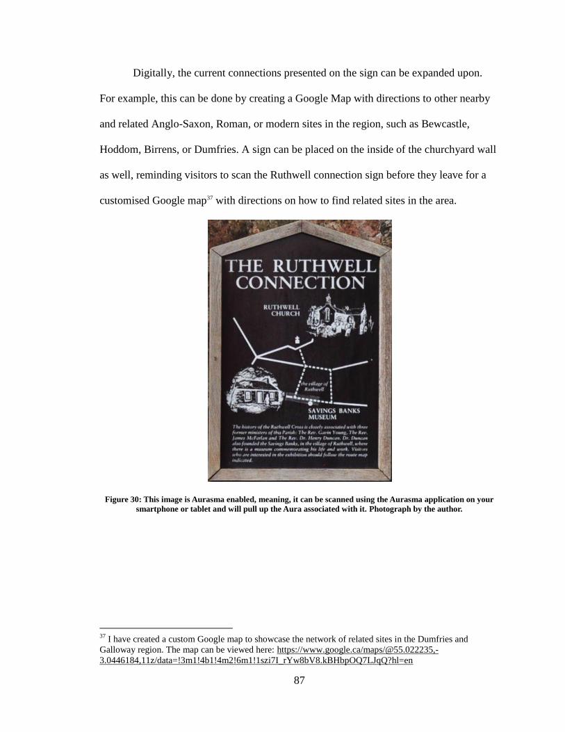
87
Digitally, the current connections presented on the sign can be expanded upon.
For example, this can be done by creating a Google Map with directions to other nearby
and related Anglo-Saxon, Roman, or modern sites in the region, such as Bewcastle,
Hoddom, Birrens, or Dumfries. A sign can be placed on the inside of the churchyard wall
as well, reminding visitors to scan the Ruthwell connection sign before they leave for a
customised Google map37 with directions on how to find related sites in the area.
Figure 30: This image is Aurasma enabled, meaning, it can be scanned using the Aurasma application on your
smartphone or tablet and will pull up the Aura associated with it. Photograph by the author.
37
I have created a custom Google map to showcase the network of related sites in the Dumfries and
Galloway region. The map can be viewed here: https://www.google.ca/maps/@55.022235,-
3.0446184,11z/data=!3m1!4b1!4m2!6m1!1szi7I_rYw8bV8.kBHbpOQ7LJqQ?hl=en
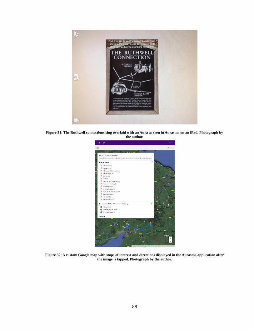
88
Figure 31: The Ruthwell connections sing overlaid with an Aura as seen in Aurasma on an iPad. Photograph by
the author.
Figure 32: A custom Google map with stops of interest and directions displayed in the Aurasma application after
the image is tapped. Photograph by the author.
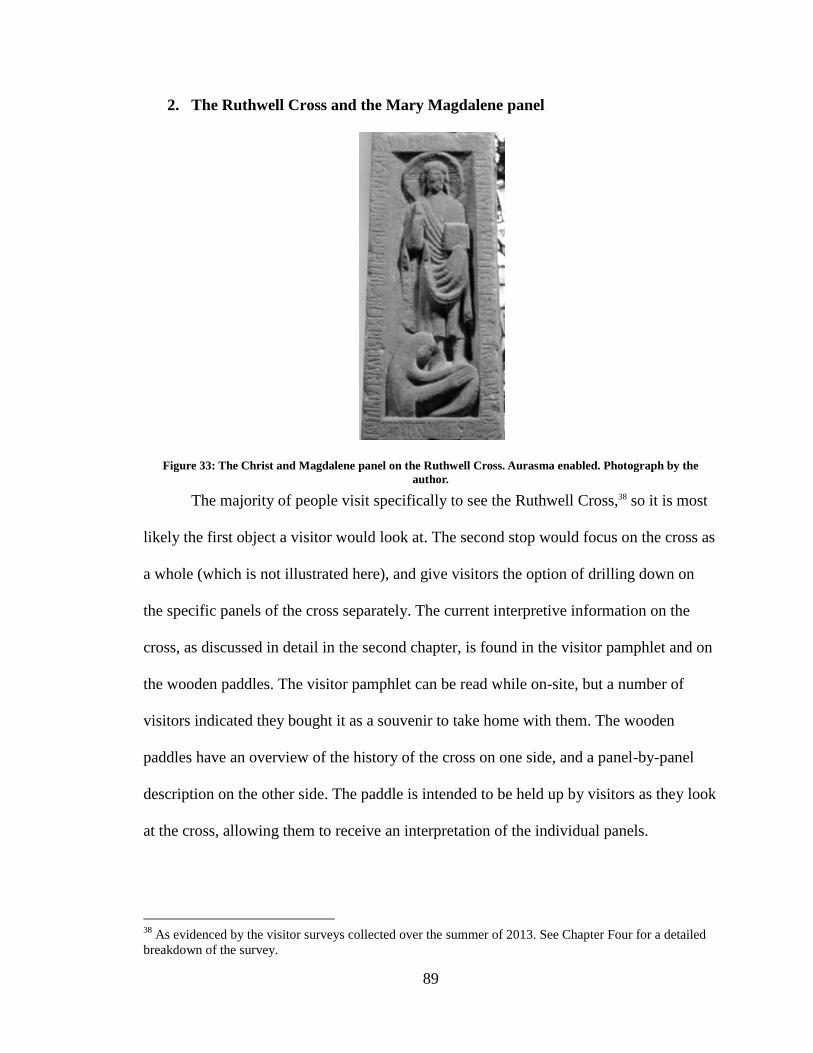
89
2. The Ruthwell Cross and the Mary Magdalene panel
Figure 33: The Christ and Magdalene panel on the Ruthwell Cross. Aurasma enabled. Photograph by the
author.
The majority of people visit specifically to see the Ruthwell Cross,38 so it is most
likely the first object a visitor would look at. The second stop would focus on the cross as
a whole (which is not illustrated here), and give visitors the option of drilling down on
the specific panels of the cross separately. The current interpretive information on the
cross, as discussed in detail in the second chapter, is found in the visitor pamphlet and on
the wooden paddles. The visitor pamphlet can be read while on-site, but a number of
visitors indicated they bought it as a souvenir to take home with them. The wooden
paddles have an overview of the history of the cross on one side, and a panel-by-panel
description on the other side. The paddle is intended to be held up by visitors as they look
at the cross, allowing them to receive an interpretation of the individual panels.
38
As evidenced by the visitor surveys collected over the summer of 2013. See Chapter Four for a detailed
breakdown of the survey.
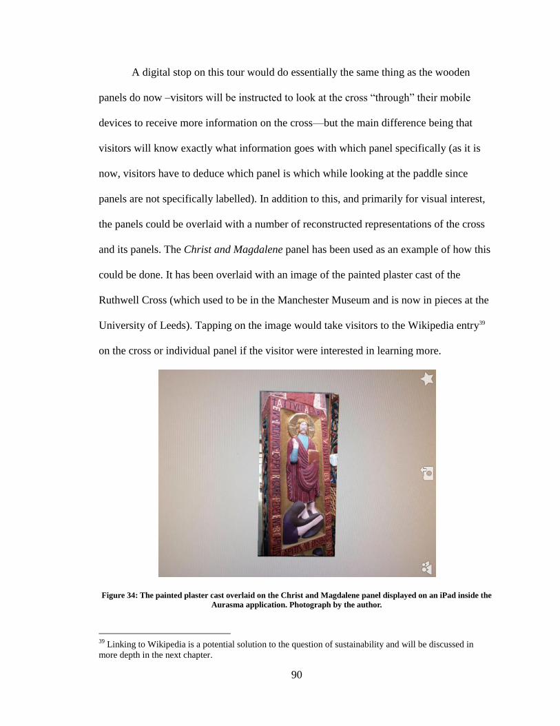
90
A digital stop on this tour would do essentially the same thing as the wooden
panels do now –visitors will be instructed to look at the cross “through” their mobile
devices to receive more information on the cross—but the main difference being that
visitors will know exactly what information goes with which panel specifically (as it is
now, visitors have to deduce which panel is which while looking at the paddle since
panels are not specifically labelled). In addition to this, and primarily for visual interest,
the panels could be overlaid with a number of reconstructed representations of the cross
and its panels. The Christ and Magdalene panel has been used as an example of how this
could be done. It has been overlaid with an image of the painted plaster cast of the
Ruthwell Cross (which used to be in the Manchester Museum and is now in pieces at the
University of Leeds). Tapping on the image would take visitors to the Wikipedia entry39
on the cross or individual panel if the visitor were interested in learning more.
Figure 34: The painted plaster cast overlaid on the Christ and Magdalene panel displayed on an iPad inside the
Aurasma application. Photograph by the author.
39
Linking to Wikipedia is a potential solution to the question of sustainability and will be discussed in
more depth in the next chapter.
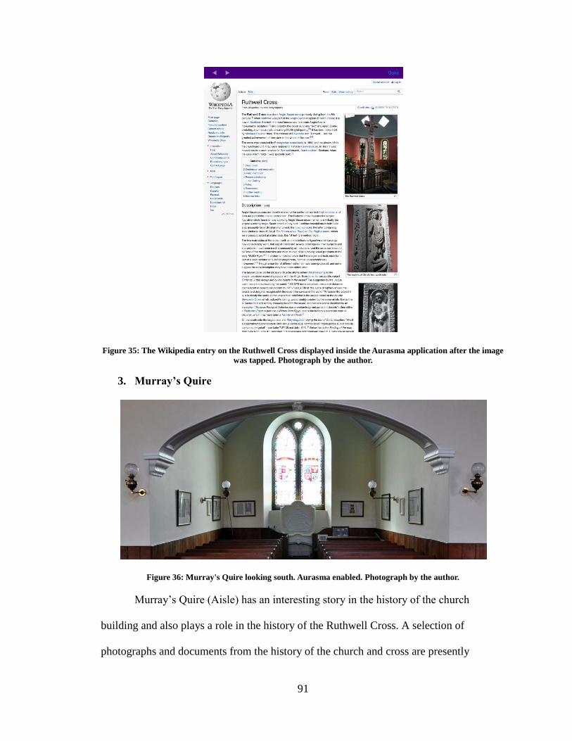
91
Figure 35: The Wikipedia entry on the Ruthwell Cross displayed inside the Aurasma application after the image
was tapped. Photograph by the author.
3. Murray’s Quire
Figure 36: Murray's Quire looking south. Aurasma enabled. Photograph by the author.
Murray’s Quire (Aisle) has an interesting story in the history of the church
building and also plays a role in the history of the Ruthwell Cross. A selection of
photographs and documents from the history of the church and cross are presently
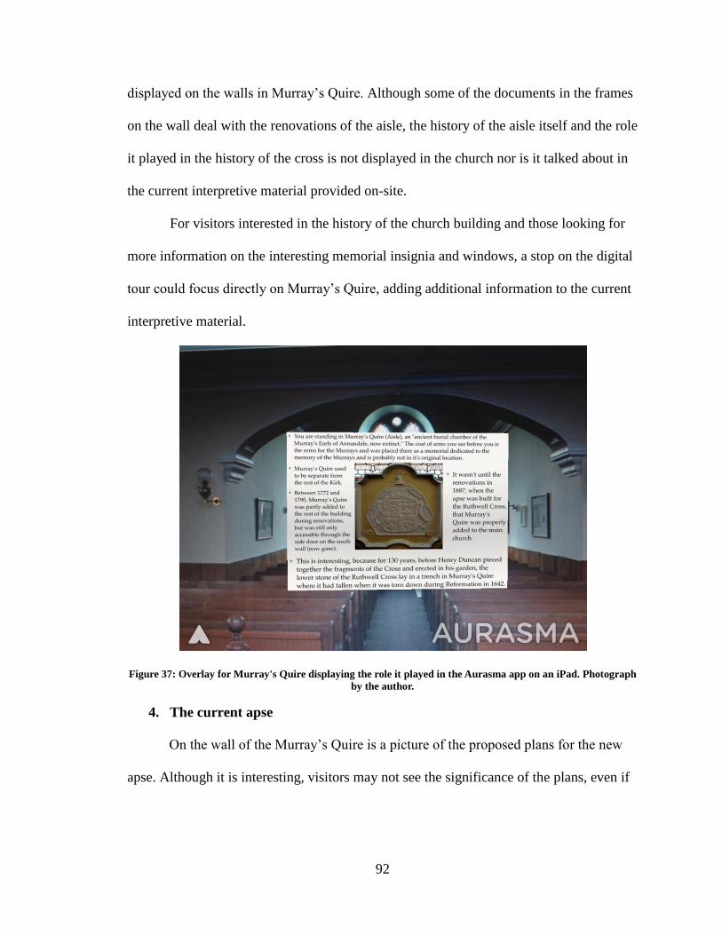
92
displayed on the walls in Murray’s Quire. Although some of the documents in the frames
on the wall deal with the renovations of the aisle, the history of the aisle itself and the role
it played in the history of the cross is not displayed in the church nor is it talked about in
the current interpretive material provided on-site.
For visitors interested in the history of the church building and those looking for
more information on the interesting memorial insignia and windows, a stop on the digital
tour could focus directly on Murray’s Quire, adding additional information to the current
interpretive material.
Figure 37: Overlay for Murray's Quire displaying the role it played in the Aurasma app on an iPad. Photograph
by the author.
4. The current apse
On the wall of the Murray’s Quire is a picture of the proposed plans for the new
apse. Although it is interesting, visitors may not see the significance of the plans, even if
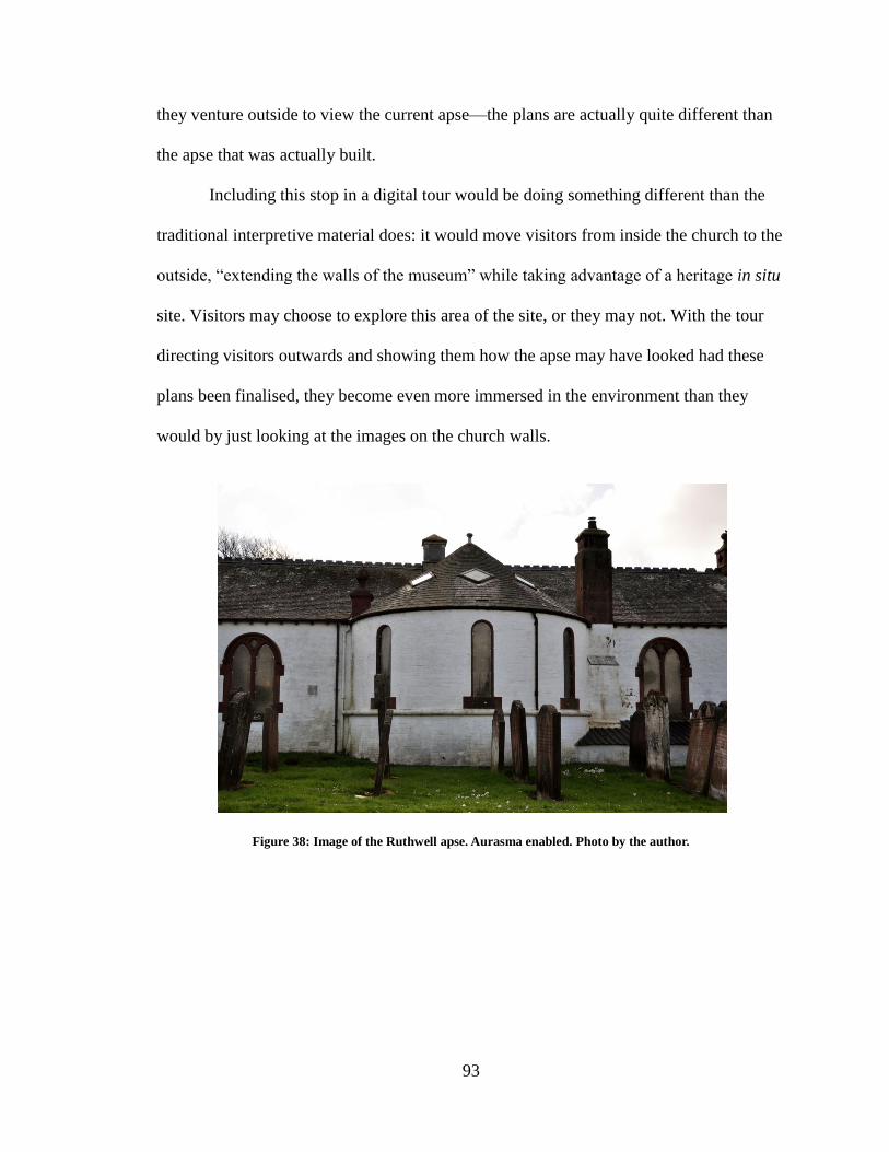
93
they venture outside to view the current apse—the plans are actually quite different than
the apse that was actually built.
Including this stop in a digital tour would be doing something different than the
traditional interpretive material does: it would move visitors from inside the church to the
outside, “extending the walls of the museum” while taking advantage of a heritage in situ
site. Visitors may choose to explore this area of the site, or they may not. With the tour
directing visitors outwards and showing them how the apse may have looked had these
plans been finalised, they become even more immersed in the environment than they
would by just looking at the images on the church walls.
Figure 38: Image of the Ruthwell apse. Aurasma enabled. Photo by the author.
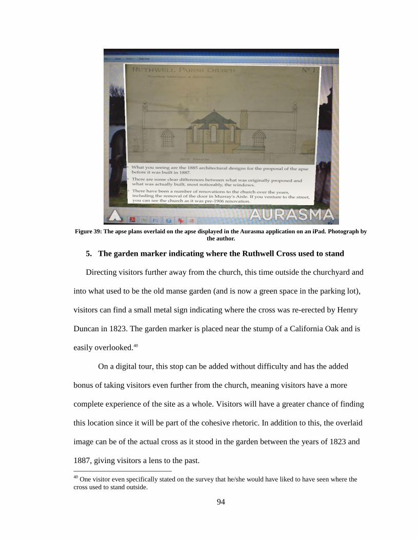
94
Figure 39: The apse plans overlaid on the apse displayed in the Aurasma application on an iPad. Photograph by
the author.
5. The garden marker indicating where the Ruthwell Cross used to stand
Directing visitors further away from the church, this time outside the churchyard and
into what used to be the old manse garden (and is now a green space in the parking lot),
visitors can find a small metal sign indicating where the cross was re-erected by Henry
Duncan in 1823. The garden marker is placed near the stump of a California Oak and is
easily overlooked.40
On a digital tour, this stop can be added without difficulty and has the added
bonus of taking visitors even further from the church, meaning visitors have a more
complete experience of the site as a whole. Visitors will have a greater chance of finding
this location since it will be part of the cohesive rhetoric. In addition to this, the overlaid
image can be of the actual cross as it stood in the garden between the years of 1823 and
1887, giving visitors a lens to the past.
40
One visitor even specifically stated on the survey that he/she would have liked to have seen where the
cross used to stand outside.
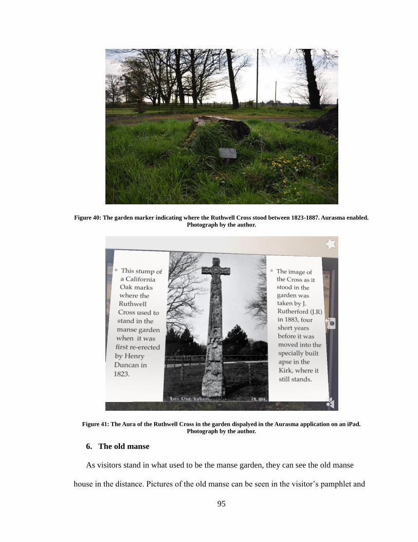
95
Figure 40: The garden marker indicating where the Ruthwell Cross stood between 1823-1887. Aurasma enabled.
Photograph by the author.
Figure 41: The Aura of the Ruthwell Cross in the garden dispalyed in the Aurasma application on an iPad.
Photograph by the author.
6. The old manse
As visitors stand in what used to be the manse garden, they can see the old manse
house in the distance. Pictures of the old manse can be seen in the visitor’s pamphlet and
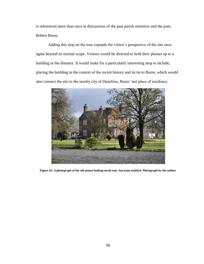
96
is referenced more than once in discussions of the past parish ministers and the poet,
Robert Burns.
Adding this stop on the tour expands the visitor’s perspective of the site once
again beyond its normal scope. Visitors would be directed to hold their phones up to a
building in the distance. It would make for a particularly interesting stop to include,
placing the building in the context of the recent history and its tie to Burns, which would
also connect the site to the nearby city of Dumfries, Burns’ last place of residence.
Figure 42: A photograph of the old manse looking north east. Aurasma enabled. Photograph by the author.
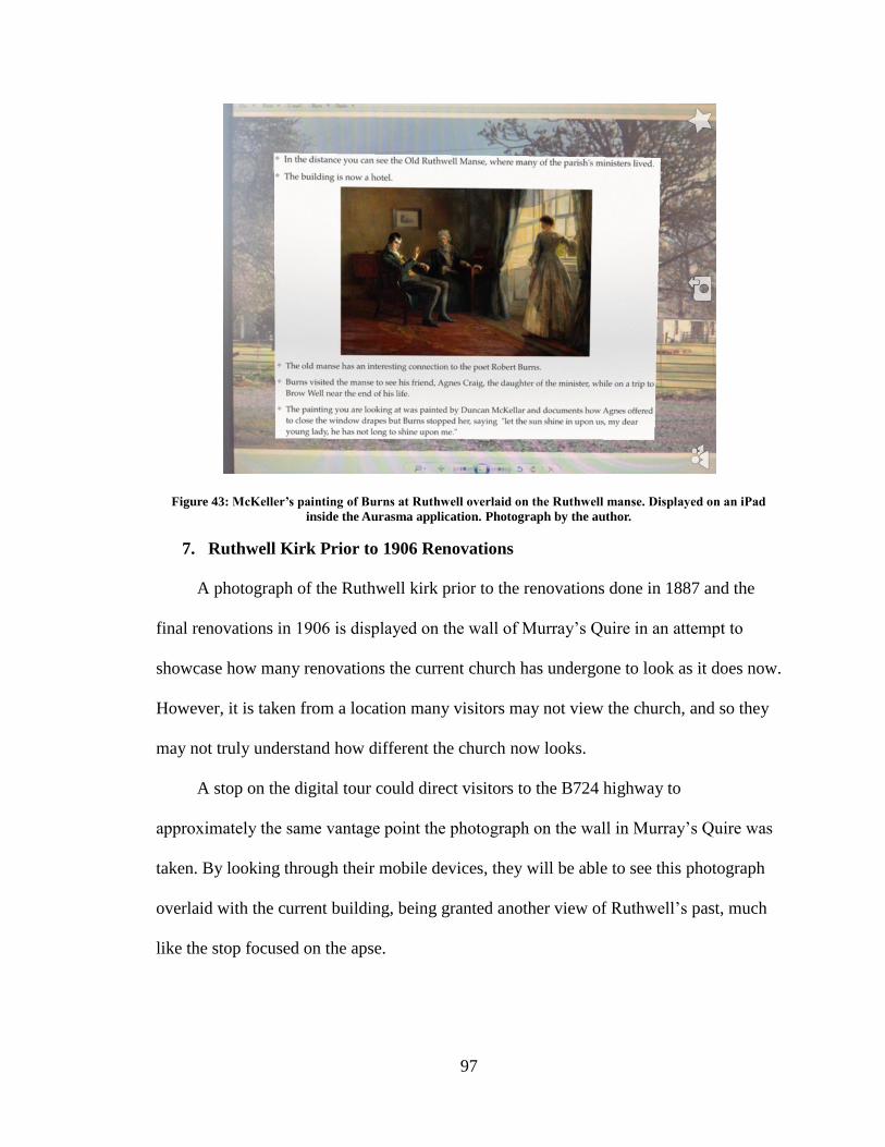
97
Figure 43: McKeller’s painting of Burns at Ruthwell overlaid on the Ruthwell manse. Displayed on an iPad
inside the Aurasma application. Photograph by the author.
7. Ruthwell Kirk Prior to 1906 Renovations
A photograph of the Ruthwell kirk prior to the renovations done in 1887 and the
final renovations in 1906 is displayed on the wall of Murray’s Quire in an attempt to
showcase how many renovations the current church has undergone to look as it does now.
However, it is taken from a location many visitors may not view the church, and so they
may not truly understand how different the church now looks.
A stop on the digital tour could direct visitors to the B724 highway to
approximately the same vantage point the photograph on the wall in Murray’s Quire was
taken. By looking through their mobile devices, they will be able to see this photograph
overlaid with the current building, being granted another view of Ruthwell’s past, much
like the stop focused on the apse.
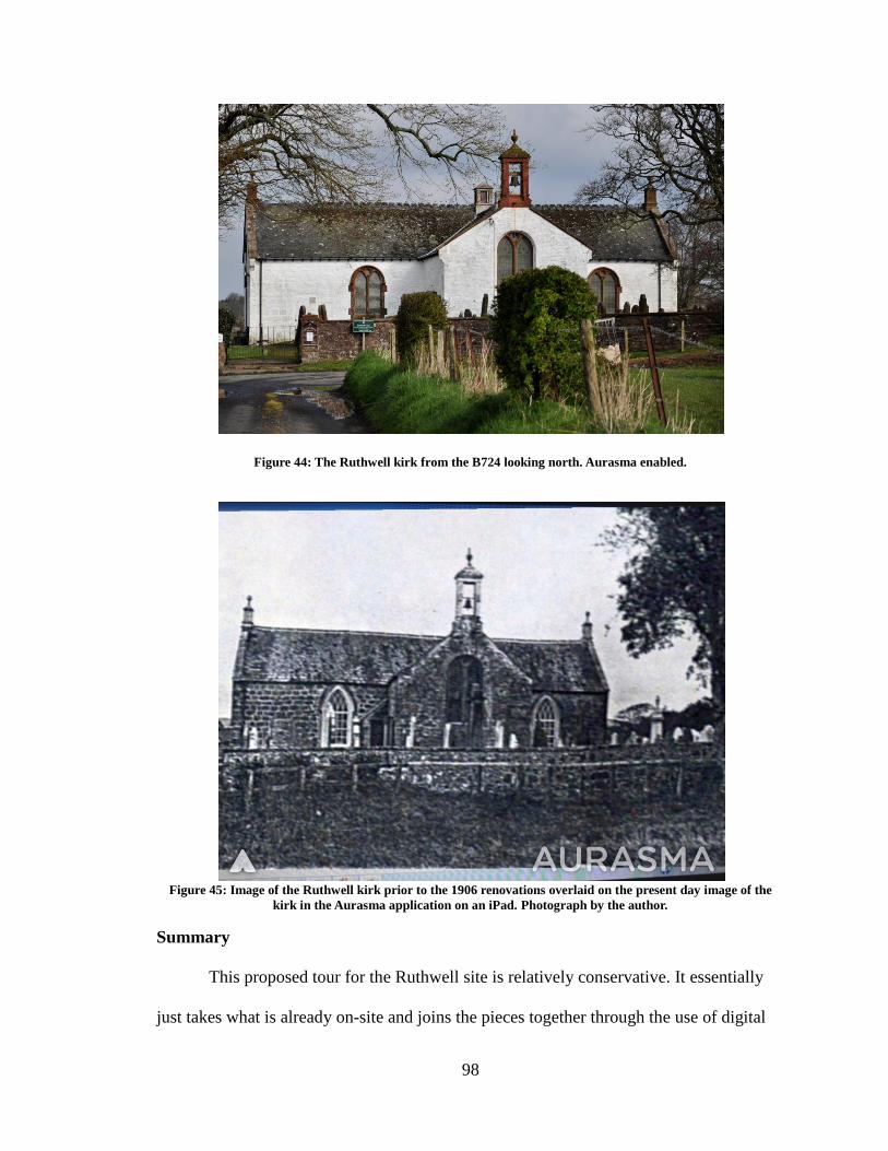
98
Figure 44: The Ruthwell kirk from the B724 looking north. Aurasma enabled.
Figure 45: Image of the Ruthwell kirk prior to the 1906 renovations overlaid on the present day image of the
kirk in the Aurasma application on an iPad. Photograph by the author.
Summary
This proposed tour for the Ruthwell site is relatively conservative. It essentially
just takes what is already on-site and joins the pieces together through the use of digital
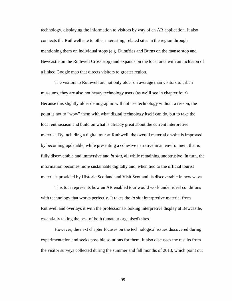
99
technology, displaying the information to visitors by way of an AR application. It also
connects the Ruthwell site to other interesting, related sites in the region through
mentioning them on individual stops (e.g. Dumfries and Burns on the manse stop and
Bewcastle on the Ruthwell Cross stop) and expands on the local area with an inclusion of
a linked Google map that directs visitors to greater region.
The visitors to Ruthwell are not only older on average than visitors to urban
museums, they are also not heavy technology users (as we’ll see in chapter four).
Because this slightly older demographic will not use technology without a reason, the
point is not to “wow” them with what digital technology itself can do, but to take the
local enthusiasm and build on what is already great about the current interpretive
material. By including a digital tour at Ruthwell, the overall material on-site is improved
by becoming updatable, while presenting a cohesive narrative in an environment that is
fully discoverable and immersive and in situ, all while remaining unobtrusive. In turn, the
information becomes more sustainable digitally and, when tied to the official tourist
materials provided by Historic Scotland and Visit Scotland, is discoverable in new ways.
This tour represents how an AR enabled tour would work under ideal conditions
with technology that works perfectly. It takes the in situ interpretive material from
Ruthwell and overlays it with the professional-looking interpretive display at Bewcastle,
essentially taking the best of both (amateur organised) sites.
However, the next chapter focuses on the technological issues discovered during
experimentation and seeks possible solutions for them. It also discusses the results from
the visitor surveys collected during the summer and fall months of 2013, which point out
100
Ruthwell’s specific visitor-base and how this unique group of people may affect future
digital installations on-site.
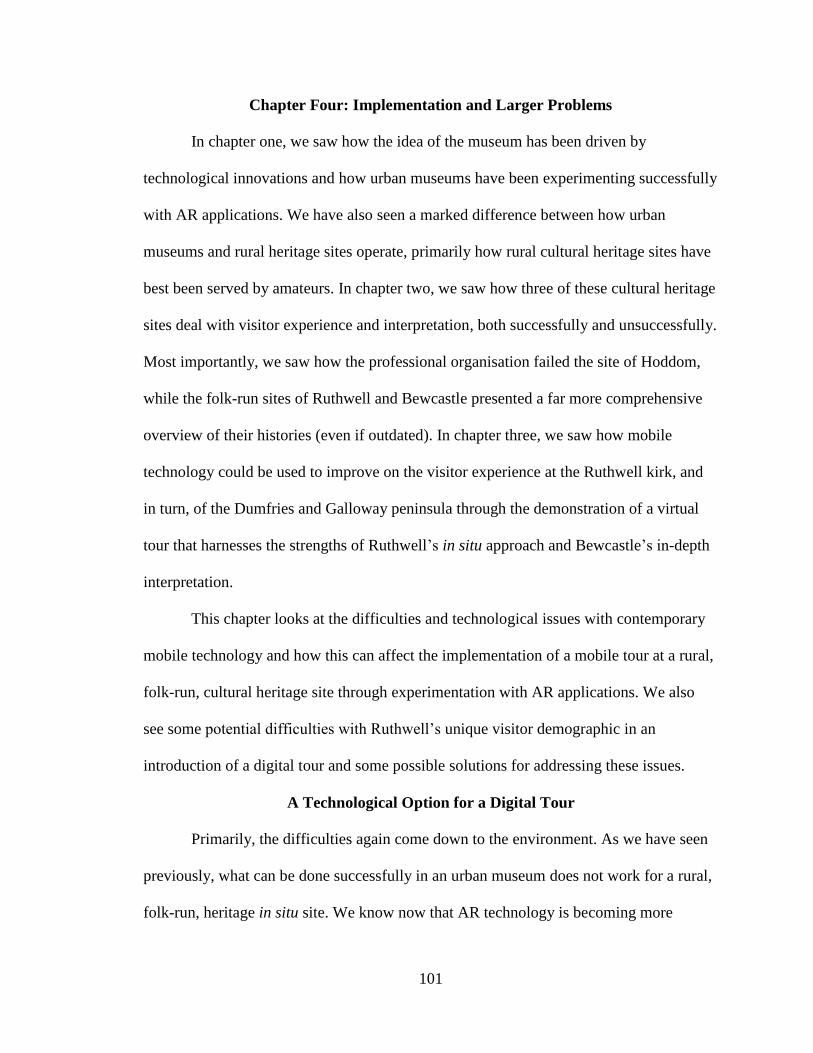
101
Chapter Four: Implementation and Larger Problems
In chapter one, we saw how the idea of the museum has been driven by
technological innovations and how urban museums have been experimenting successfully
with AR applications. We have also seen a marked difference between how urban
museums and rural heritage sites operate, primarily how rural cultural heritage sites have
best been served by amateurs. In chapter two, we saw how three of these cultural heritage
sites deal with visitor experience and interpretation, both successfully and unsuccessfully.
Most importantly, we saw how the professional organisation failed the site of Hoddom,
while the folk-run sites of Ruthwell and Bewcastle presented a far more comprehensive
overview of their histories (even if outdated). In chapter three, we saw how mobile
technology could be used to improve on the visitor experience at the Ruthwell kirk, and
in turn, of the Dumfries and Galloway peninsula through the demonstration of a virtual
tour that harnesses the strengths of Ruthwell’s in situ approach and Bewcastle’s in-depth
interpretation.
This chapter looks at the difficulties and technological issues with contemporary
mobile technology and how this can affect the implementation of a mobile tour at a rural,
folk-run, cultural heritage site through experimentation with AR applications. We also
see some potential difficulties with Ruthwell’s unique visitor demographic in an
introduction of a digital tour and some possible solutions for addressing these issues.
A Technological Option for a Digital Tour
Primarily, the difficulties again come down to the environment. As we have seen
previously, what can be done successfully in an urban museum does not work for a rural,
folk-run, heritage in situ site. We know now that AR technology is becoming more
102
popular and that corporations are turning to it for their marketing strategies. In turn,
museums such as the Smithsonian Institute, the British Museum, and the Museum of
London offer a variety of AR-based applications in order to improve on visitor
engagement and experience. However, a scavenger hunt-like game like “Capture the
Pheon” offered by the Smithsonian Institute is not appropriate for a sacred space such as
Ruthwell, and locational AR applications (which feature geotagged images and are
designed to function based on a user’s physical location in the world) rely on GPS
positioning and cannot work indoors (see Mannion n.d.). AR applications reliant on tags
or codes, such as the 3D exhibit at the ROM (“Ultimate Dinos”), while not ideal, are
possible at a site like Ruthwell, aside from the obvious disadvantages discussed in the
previous chapter. An AR application dependant entirely on pattern recognition, like the
newest application offered by the British Museum called “A Gift for Athena” (Goula,
2013), is ideal, but the technology behind pattern recognition is not robust or reliable
enough to function properly in an outdoor environment or an environment with changing
light and angles. However successful they are in a controlled indoor environment where
lighting is static and angles can be controlled, like at the British Museum, they ultimately
fail once tested in an environment where the light is constantly changing, like outdoors,
or in the apse of the Ruthwell church with its skylights.41
41
During the 3D scanning of the Ruthwell Cross in April of 2012, the Visionary Cross Project team
experienced the difficult lighting directly. While scanning, Callieri and Dellepiane (Visual Computing Lab,
see http://vcg.isti.cnr.it) had to cover the skylights with cloth in order to get a proper image.
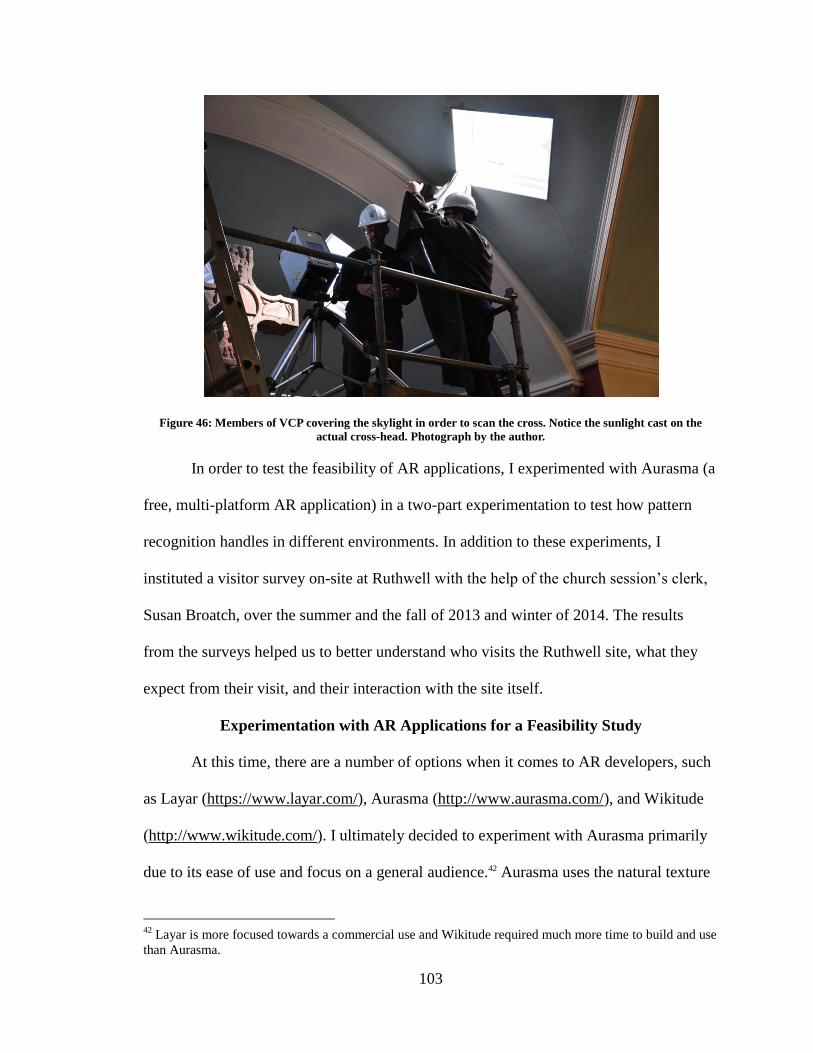
103
Figure 46: Members of VCP covering the skylight in order to scan the cross. Notice the sunlight cast on the
actual cross-head. Photograph by the author.
In order to test the feasibility of AR applications, I experimented with Aurasma (a
free, multi-platform AR application) in a two-part experimentation to test how pattern
recognition handles in different environments. In addition to these experiments, I
instituted a visitor survey on-site at Ruthwell with the help of the church session’s clerk,
Susan Broatch, over the summer and the fall of 2013 and winter of 2014. The results
from the surveys helped us to better understand who visits the Ruthwell site, what they
expect from their visit, and their interaction with the site itself.
Experimentation with AR Applications for a Feasibility Study
At this time, there are a number of options when it comes to AR developers, such
as Layar (https://www.layar.com/), Aurasma (http://www.aurasma.com/), and Wikitude
(http://www.wikitude.com/). I ultimately decided to experiment with Aurasma primarily
due to its ease of use and focus on a general audience.42 Aurasma uses the natural texture
42
Layar is more focused towards a commercial use and Wikitude required much more time to build and use
than Aurasma.
104
and form of a physical object as a trigger that, when scanned, pulls up previously
embedded information or actions. The technology functions by using pattern recognition,
meaning that any unique pattern can be used as a target image, including maps,
photographs, and specific buildings, etc. (see Mannion n.d.). Designers can use Aurasma
Studio to develop complex sets of such embedded information (known as “Auras”),
which are then assigned to “channels” that registered users can subscribe to. Once users
subscribe to a channel, they can search for specific Auras or are proactively notified when
a pre-set Aura is nearby. An added feature of the software allows users themselves to add
simple Auras to their environment—making it theoretically possible, for example, for
visitors to a site to “attach” notes or other material to surfaces that interest them.
To test the ease and function of the Aurasma application, I experimented with it in
two steps: 1. Using a series of still photographs, I experimented with how Aurasma’s
Auras handled still overlays, videos, and URLs in a static, unchanging environment; 2. I
experimented with Aurasma on my mobile phone in the dynamic, changing environment
of Canmore, Alberta’s historic cemetery. The reason behind the two separate experiments
was to test the reliability of the application in different environments to see how it
handled. Essentially, if Aurasma functioned as expected indoors as well as outdoors, it
should work in the Ruthwell kirk and on the individual panels of the Ruthwell Cross,
making it the perfect medium for a new interpretive programme at Ruthwell. The two
primary experiments are detailed below.
Experiment 1
The first experiment was a series of AR examples I had prepared for a class on the
digital humanities I was a teaching assistant for in the fall semester of 2012. I used the
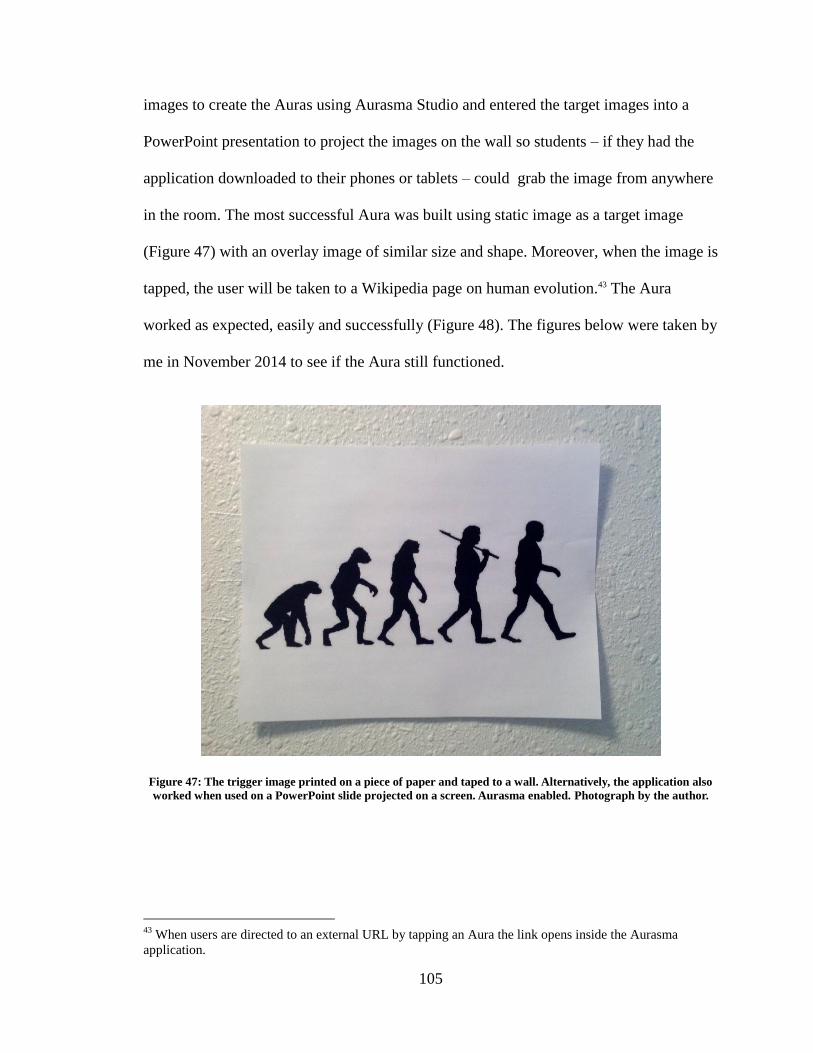
105
images to create the Auras using Aurasma Studio and entered the target images into a
PowerPoint presentation to project the images on the wall so students – if they had the
application downloaded to their phones or tablets – could grab the image from anywhere
in the room. The most successful Aura was built using static image as a target image
(Figure 47) with an overlay image of similar size and shape. Moreover, when the image is
tapped, the user will be taken to a Wikipedia page on human evolution.43 The Aura
worked as expected, easily and successfully (Figure 48). The figures below were taken by
me in November 2014 to see if the Aura still functioned.
Figure 47: The trigger image printed on a piece of paper and taped to a wall. Alternatively, the application also
worked when used on a PowerPoint slide projected on a screen. Aurasma enabled. Photograph by the author.
43
When users are directed to an external URL by tapping an Aura the link opens inside the Aurasma
application.
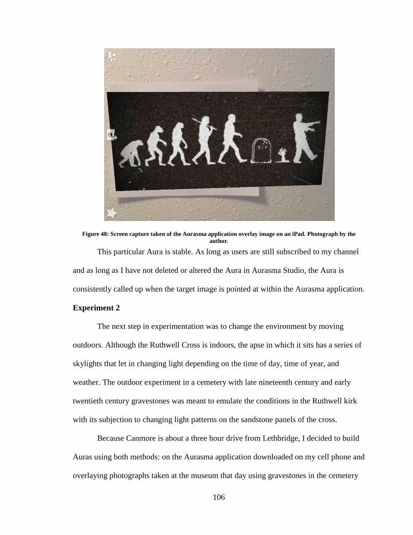
106
Figure 48: Screen capture taken of the Aurasma application overlay image on an iPad. Photograph by the
author.
This particular Aura is stable. As long as users are still subscribed to my channel
and as long as I have not deleted or altered the Aura in Aurasma Studio, the Aura is
consistently called up when the target image is pointed at within the Aurasma application.
Experiment 2
The next step in experimentation was to change the environment by moving
outdoors. Although the Ruthwell Cross is indoors, the apse in which it sits has a series of
skylights that let in changing light depending on the time of day, time of year, and
weather. The outdoor experiment in a cemetery with late nineteenth century and early
twentieth century gravestones was meant to emulate the conditions in the Ruthwell kirk
with its subjection to changing light patterns on the sandstone panels of the cross.
Because Canmore is about a three hour drive from Lethbridge, I decided to build
Auras using both methods: on the Aurasma application downloaded on my cell phone and
overlaying photographs taken at the museum that day using gravestones in the cemetery
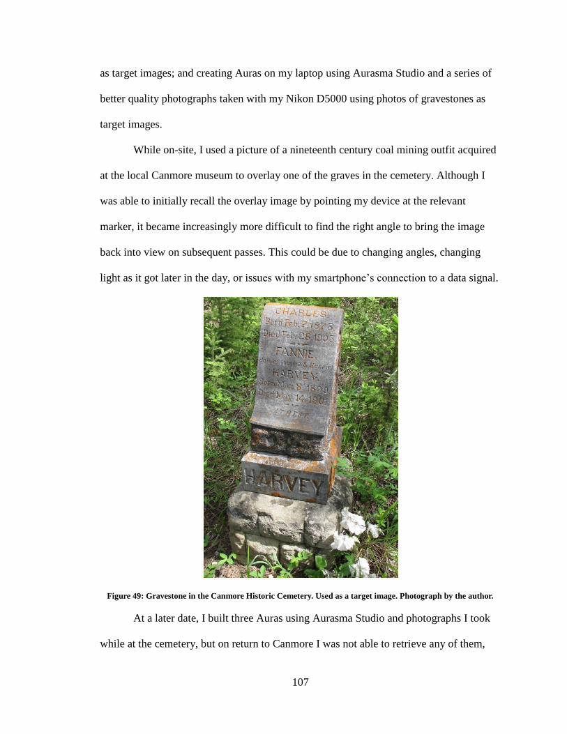
107
as target images; and creating Auras on my laptop using Aurasma Studio and a series of
better quality photographs taken with my Nikon D5000 using photos of gravestones as
target images.
While on-site, I used a picture of a nineteenth century coal mining outfit acquired
at the local Canmore museum to overlay one of the graves in the cemetery. Although I
was able to initially recall the overlay image by pointing my device at the relevant
marker, it became increasingly more difficult to find the right angle to bring the image
back into view on subsequent passes. This could be due to changing angles, changing
light as it got later in the day, or issues with my smartphone’s connection to a data signal.
Figure 49: Gravestone in the Canmore Historic Cemetery. Used as a target image. Photograph by the author.
At a later date, I built three Auras using Aurasma Studio and photographs I took
while at the cemetery, but on return to Canmore I was not able to retrieve any of them,
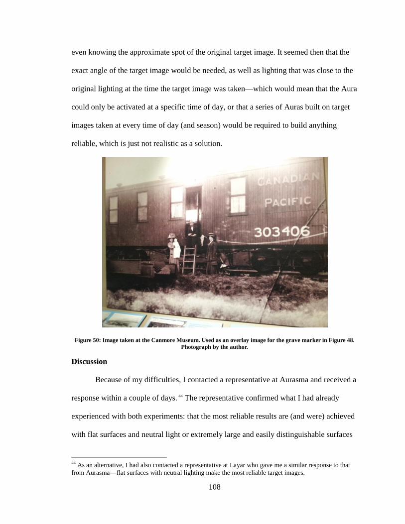
108
even knowing the approximate spot of the original target image. It seemed then that the
exact angle of the target image would be needed, as well as lighting that was close to the
original lighting at the time the target image was taken—which would mean that the Aura
could only be activated at a specific time of day, or that a series of Auras built on target
images taken at every time of day (and season) would be required to build anything
reliable, which is just not realistic as a solution.
Figure 50: Image taken at the Canmore Museum. Used as an overlay image for the grave marker in Figure 48.
Photograph by the author.
Discussion
Because of my difficulties, I contacted a representative at Aurasma and received a
response within a couple of days. 44 The representative confirmed what I had already
experienced with both experiments: that the most reliable results are (and were) achieved
with flat surfaces and neutral light or extremely large and easily distinguishable surfaces
44
As an alternative, I had also contacted a representative at Layar who gave me a similar response to that
from Aurasma—flat surfaces with neutral lighting make the most reliable target images.
109
without reflection.45 These conditions are difficult enough to achieve in relatively sunny
and dry Southern Alberta—but next to impossible to find at a cultural heritage site in
south east Scotland. As my experiments with the Canmore gravestones demonstrated
moreover, the requirement that physical objects be large and highly distinctive in shape
suggests that the individual cross panels would be too similar to each other to serve as
reliable triggers for interpretative Auras, despite their greatly differentiated details.
These experiments and conversation with the developers of Aurasma and Layar
show that current AR applications and pattern recognition are not reliable or robust
enough to support a digitised interpretive tour at Ruthwell at the present time. However,
the successful first experiment and the initial success with the first half of the second
experiment shows that this kind of tour will be more realistic as the technology improves
and becomes more popular.
Wikipedia and Sustainability
I had mentioned quite briefly in the previous chapter about using Wikipedia for
sustainability. Sustainability has been a pertinent question from the beginning, and it
seems that Wikipedia is a reasonable (and possibly popular) solution. Essentially,
information collected for a digital tour can be linked to Wikipedia entries, and as such,
ensures the information is always there, is updatable, and is accurate. Links to Wikipedia
will not corrupt or become stale since they are automatically re-directed if the article
moves or if articles are merged. Because Wikipedia is accessible by anyone, the article
can be continually updated ensuring the information found there is recent. One major
45
Such as the Eiffel tower, for example.
110
concern is the reliability of information found on Wikipedia,46 which stems from its open
access (and is the primary reason for the hesitance by professionals in using it in the first
place). New pages have to be checked and approved by Wikipedia’s administration, and
may be flagged or even taken down if incorrect. Although small changes and updates to a
site can be done immediately, this issue can be solved by asking volunteers to
occasionally check the page to protect from vandalism.47 If there is a particular user (or IP
address) making inappropriate changes, a request can be placed to block that individual
from making any more changes to the page.
Just as companies and museums turn to AR and pattern recognition, more
professionals are turning their attention toward Wikipedia as a solution for their projects
(Jisc 2013). For example, the Museum of Modern Art in New York (MoMA) has
discussed the possibility of linking their artist biographies to Wikipedia entries (Hobma
2013). The recent digital humanities project, “The Social Edition of the Devonshire
Manuscript,” is specifically published in Wikibooks with the aim “to explore new
dissemination venues that bring the best of academic scholarly practice, including peer
review, to the online spaces and tools that currently house and enable the circulation of
public knowledge” (Crompton n.d.).
I had experimented with creating a Wikipedia entry on the Christ and Magdalene
panel while building the examples spots along the proposed tour in chapter three to see
what it would take to link to an article in Wikipedia directly. I intended to create it as a
46
Wikimedia, the charity that runs Wikipedia, is working with museums, academics, libraries, and other
institutions to improve Wikimedia projects (Wikipedia, Wikibooks, etc.) to benefit everyone (Jisc 2013).
Wikipedia also offers a selection of academic career positions for the same reason – improving the overall
content of Wikimedia projects. 47
An alternative solution would be to make the article semi-protected, meaning it would require a user to
have a Wikipedia account in order to make changes to the page.
111
child article for the Ruthwell Cross article (meaning it is a smaller, linked article in
relation to a longer, more complete article), yet it was rejected based on formatting and
context. The recommendations for changes looked fairly straightforward if not a bit time
consuming, so I am in the process of making the changes to meet their stylistic requests.
There is evidence that a submission like this would be accepted by the Wikipedia
administration, but it needs to be organised and coordinated. On a larger scale, this page
and project would greatly benefit from the use of crowd sourcing. I recently led a tutorial
session for the University of Lethbridge Women’s Scholars Wiki-edit-a-thon during
International Women’s Week.48 It is possible to organise a similar event with the
intention on overhauling the Ruthwell Cross article and including subpages dedicated to
the individual cross panels, the interesting locations around the site, and including links
to the related sites of interest in the Dumfries and Galloway territory-museum. This
would require significant planning and coordination, but would be an interesting way of
harnessing the enthusiasm of the local community in conjunction with the academic
knowledge of Ruthwell scholars, giving both groups a place to contribute.
The Visitor Survey as Part of the Feasibility Study
The survey was based on a variety of visitor surveys taken at other museums
(such as the ROM in Toronto, Ontario and the Smithsonian Institute in Washington,
DC).49 It began with general visitor questions and then asked more specific questions
pertaining to the site and the visitors’ expectations.50 The survey was offered in English,
French, and German. Visitors had the option of filling out the provided paper copy or
48
The workshop information can be found here: http://www.uleth.ca/notice/display.html?b=302&s=20569 49
Recommendations on what to include in the survey were offered by Daniel O’Donnell and Susan
Broatch. 50
A copy of the survey can be found in Appendix A.
112
scanning the QR code on the survey to fill out an electronic version. The survey questions
included place of residence, age, reason for the visit, satisfaction with the visit, research
done prior to the visit, whether travelling with a smartphone or tablet (and what type),
additional cultural heritage sites on the visitor’s agenda, whether the visitor used any
interpretive material provided by the church, and whether the visitor would like to see
any improvements to the current programme. 108 hardcopies of the visitor surveys were
completed and mailed to me by Susan Broatch over the course of ten months (April to
February); no electronic versions were completed.
The tour discussed in chapter three really represents an incremental and
conservative change from the current interpretive material due to the data collected from
the visitor surveys, which are discussed below.
Visitor Satisfaction
Every single individual indicated that they were satisfied with their visit to
Ruthwell. In addition to satisfaction, visitors were asked what they would have liked to
have seen or learned that they did not during their visit. Very few had any suggestions or
comments in this regard; however, those who did had interesting requests. Several people
noted that the guide book (offered for £5 with proceeds going to the church) was missing
or was sold out, and as such asked for alternative methods of information (one asked for a
postcard with the inscription translations). In one case, the directional indicators for the
sides of the cross were problematic (north face, south face, for example) since the sun
was not out and they could not tell direction inside the church. A number of visitors had
asked for more information on the history of the location (such as the church itself, the
medieval history of the site, and the connection of Ruthwell to other stone crosses, such
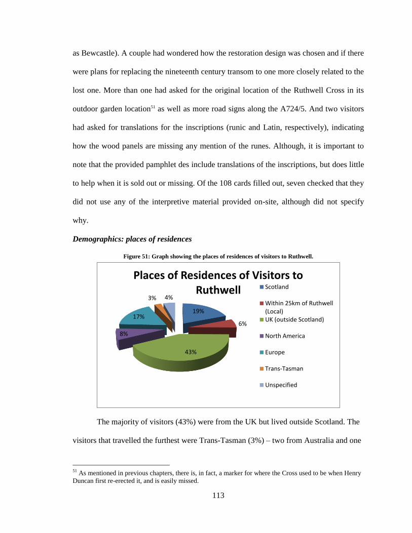
113
as Bewcastle). A couple had wondered how the restoration design was chosen and if there
were plans for replacing the nineteenth century transom to one more closely related to the
lost one. More than one had asked for the original location of the Ruthwell Cross in its
outdoor garden location51 as well as more road signs along the A724/5. And two visitors
had asked for translations for the inscriptions (runic and Latin, respectively), indicating
how the wood panels are missing any mention of the runes. Although, it is important to
note that the provided pamphlet des include translations of the inscriptions, but does little
to help when it is sold out or missing. Of the 108 cards filled out, seven checked that they
did not use any of the interpretive material provided on-site, although did not specify
why.
Demographics: places of residences
Figure 51: Graph showing the places of residences of visitors to Ruthwell.
The majority of visitors (43%) were from the UK but lived outside Scotland. The
visitors that travelled the furthest were Trans-Tasman (3%) – two from Australia and one
51
As mentioned in previous chapters, there is, in fact, a marker for where the Cross used to be when Henry
Duncan first re-erected it, and is easily missed.
19%
6%
43%
8%
17%
3% 4%
Places of Residences of Visitors to Ruthwell Scotland
Within 25km of Ruthwell (Local) UK (outside Scotland)
North America
Europe
Trans-Tasman
Unspecified
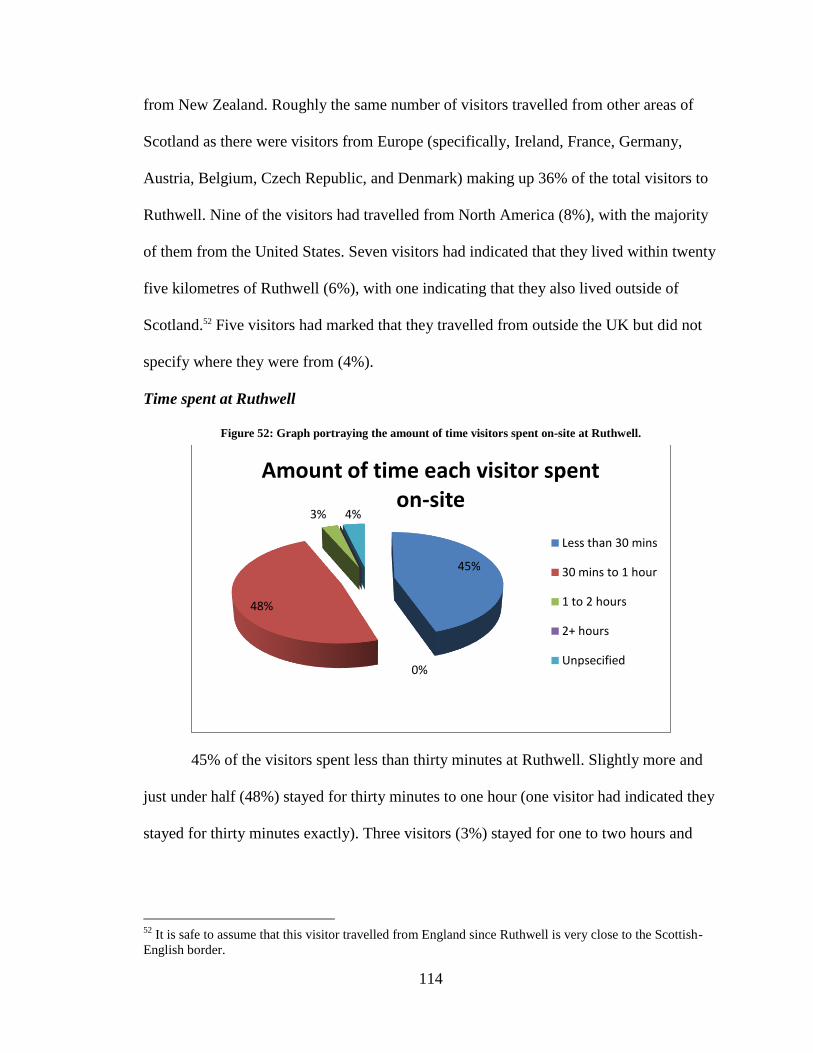
114
from New Zealand. Roughly the same number of visitors travelled from other areas of
Scotland as there were visitors from Europe (specifically, Ireland, France, Germany,
Austria, Belgium, Czech Republic, and Denmark) making up 36% of the total visitors to
Ruthwell. Nine of the visitors had travelled from North America (8%), with the majority
of them from the United States. Seven visitors had indicated that they lived within twenty
five kilometres of Ruthwell (6%), with one indicating that they also lived outside of
Scotland.52 Five visitors had marked that they travelled from outside the UK but did not
specify where they were from (4%).
Time spent at Ruthwell
Figure 52: Graph portraying the amount of time visitors spent on-site at Ruthwell.
45% of the visitors spent less than thirty minutes at Ruthwell. Slightly more and
just under half (48%) stayed for thirty minutes to one hour (one visitor had indicated they
stayed for thirty minutes exactly). Three visitors (3%) stayed for one to two hours and
52
It is safe to assume that this visitor travelled from England since Ruthwell is very close to the Scottish-
English border.
45%
48%
3%
0%
4%
Amount of time each visitor spent on-site
Less than 30 mins
30 mins to 1 hour
1 to 2 hours
2+ hours
Unpsecified
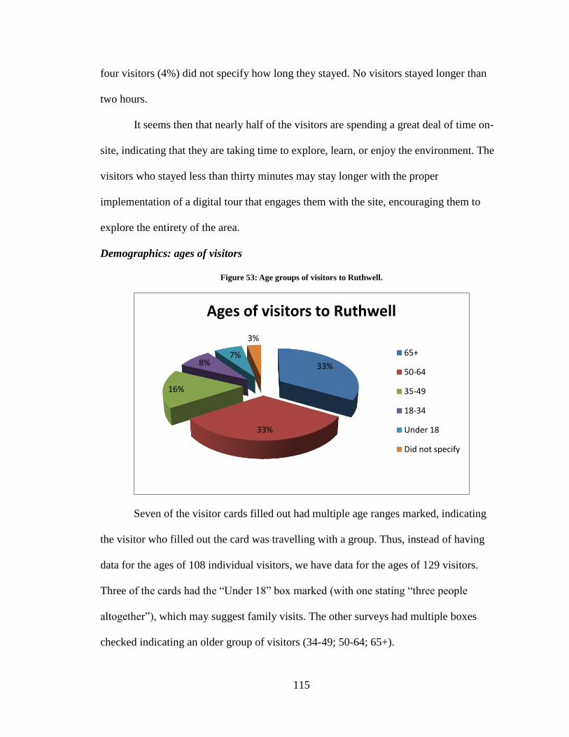
115
four visitors (4%) did not specify how long they stayed. No visitors stayed longer than
two hours.
It seems then that nearly half of the visitors are spending a great deal of time on-
site, indicating that they are taking time to explore, learn, or enjoy the environment. The
visitors who stayed less than thirty minutes may stay longer with the proper
implementation of a digital tour that engages them with the site, encouraging them to
explore the entirety of the area.
Demographics: ages of visitors
Figure 53: Age groups of visitors to Ruthwell.
Seven of the visitor cards filled out had multiple age ranges marked, indicating
the visitor who filled out the card was travelling with a group. Thus, instead of having
data for the ages of 108 individual visitors, we have data for the ages of 129 visitors.
Three of the cards had the “Under 18” box marked (with one stating “three people
altogether”), which may suggest family visits. The other surveys had multiple boxes
checked indicating an older group of visitors (34-49; 50-64; 65+).
33%
33%
16%
8% 7%
3%
Ages of visitors to Ruthwell
65+
50-64
35-49
18-34
Under 18
Did not specify
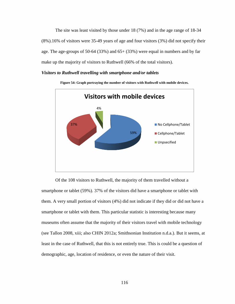
116
The site was least visited by those under 18 (7%) and in the age range of 18-34
(8%).16% of visitors were 35-49 years of age and four visitors (3%) did not specify their
age. The age-groups of 50-64 (33%) and 65+ (33%) were equal in numbers and by far
make up the majority of visitors to Ruthwell (66% of the total visitors).
Visitors to Ruthwell travelling with smartphone and/or tablets
Figure 54: Graph portraying the number of visitors with Ruthwell with mobile devices.
Of the 108 visitors to Ruthwell, the majority of them travelled without a
smartphone or tablet (59%). 37% of the visitors did have a smartphone or tablet with
them. A very small portion of visitors (4%) did not indicate if they did or did not have a
smartphone or tablet with them. This particular statistic is interesting because many
museums often assume that the majority of their visitors travel with mobile technology
(see Tallon 2008, xiii; also CHIN 2012a; Smithsonian Institution n.d.a.). But it seems, at
least in the case of Ruthwell, that this is not entirely true. This is could be a question of
demographic, age, location of residence, or even the nature of their visit.
59%
37%
4%
Visitors with mobile devices
No Cellphone/Tablet
Cellphone/Tablet
Unpsecified
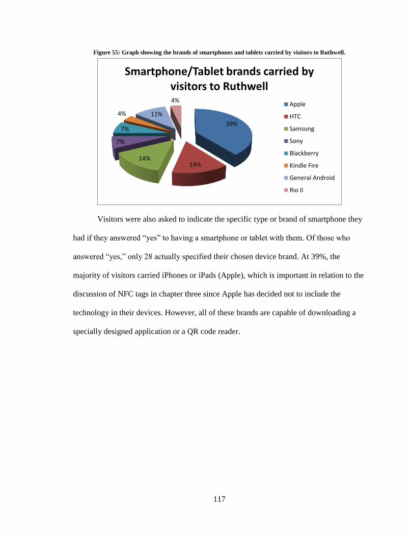
117
Figure 55: Graph showing the brands of smartphones and tablets carried by visitors to Ruthwell.
Visitors were also asked to indicate the specific type or brand of smartphone they
had if they answered “yes” to having a smartphone or tablet with them. Of those who
answered “yes,” only 28 actually specified their chosen device brand. At 39%, the
majority of visitors carried iPhones or iPads (Apple), which is important in relation to the
discussion of NFC tags in chapter three since Apple has decided not to include the
technology in their devices. However, all of these brands are capable of downloading a
specially designed application or a QR code reader.
39%
14% 14%
7%
7%
4% 11%
4%
Smartphone/Tablet brands carried by visitors to Ruthwell
Apple
HTC
Samsung
Sony
Blackberry
Kindle Fire
General Android
Rio II
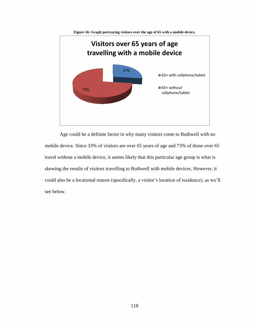
118
Figure 56: Graph portraying visitors over the age of 65 with a mobile device.
Age could be a definite factor in why many visitors come to Ruthwell with no
mobile device. Since 33% of visitors are over 65 years of age and 73% of those over 65
travel without a mobile device, it seems likely that this particular age group is what is
skewing the results of visitors travelling to Ruthwell with mobile devices. However, it
could also be a locational reason (specifically, a visitor’s location of residence), as we’ll
see below.
27%
73%
Visitors over 65 years of age travelling with a mobile device
65+ with cellphone/tablet
65+ without cellphone/tablet
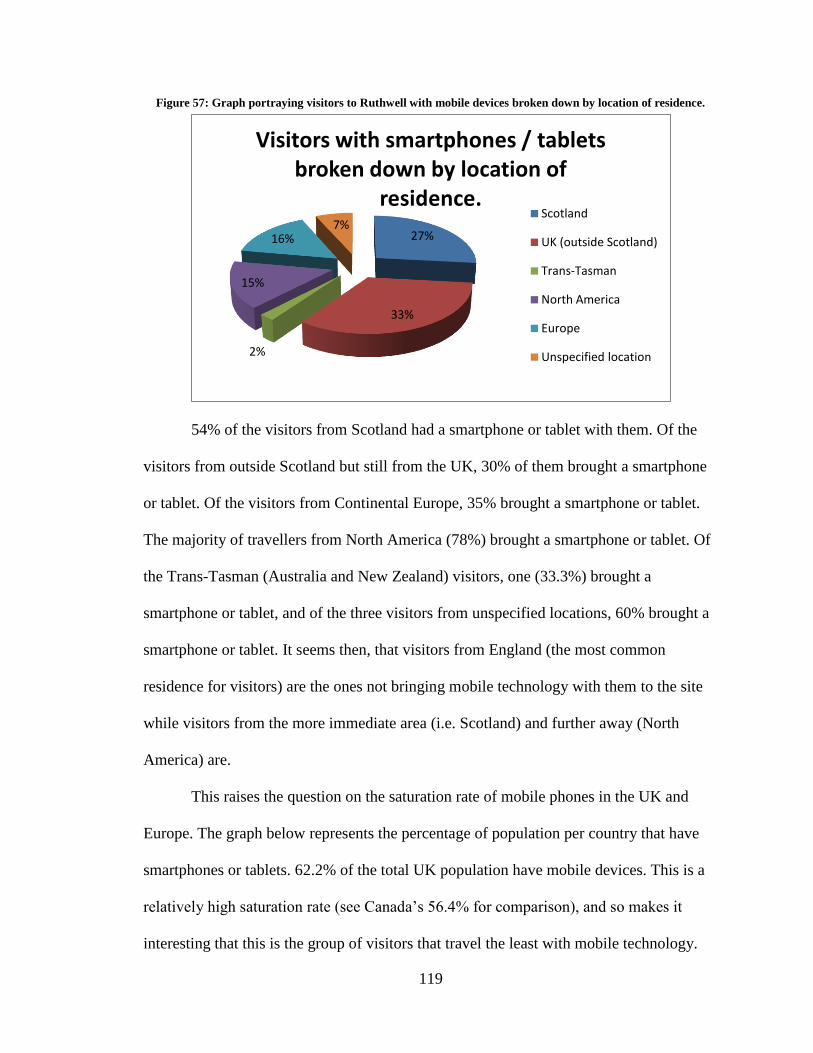
119
Figure 57: Graph portraying visitors to Ruthwell with mobile devices broken down by location of residence.
54% of the visitors from Scotland had a smartphone or tablet with them. Of the
visitors from outside Scotland but still from the UK, 30% of them brought a smartphone
or tablet. Of the visitors from Continental Europe, 35% brought a smartphone or tablet.
The majority of travellers from North America (78%) brought a smartphone or tablet. Of
the Trans-Tasman (Australia and New Zealand) visitors, one (33.3%) brought a
smartphone or tablet, and of the three visitors from unspecified locations, 60% brought a
smartphone or tablet. It seems then, that visitors from England (the most common
residence for visitors) are the ones not bringing mobile technology with them to the site
while visitors from the more immediate area (i.e. Scotland) and further away (North
America) are.
This raises the question on the saturation rate of mobile phones in the UK and
Europe. The graph below represents the percentage of population per country that have
smartphones or tablets. 62.2% of the total UK population have mobile devices. This is a
relatively high saturation rate (see Canada’s 56.4% for comparison), and so makes it
interesting that this is the group of visitors that travel the least with mobile technology.
27%
33%
2%
15%
16% 7%
Visitors with smartphones / tablets broken down by location of
residence. Scotland
UK (outside Scotland)
Trans-Tasman
North America
Europe
Unspecified location
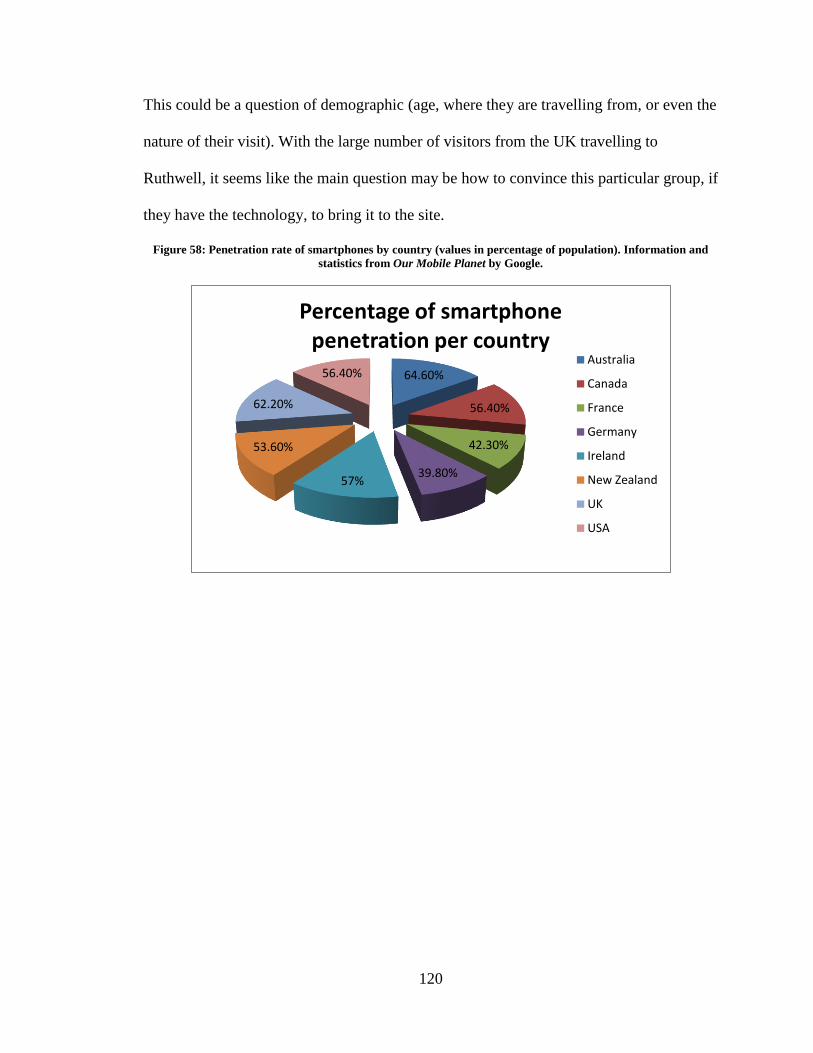
120
This could be a question of demographic (age, where they are travelling from, or even the
nature of their visit). With the large number of visitors from the UK travelling to
Ruthwell, it seems like the main question may be how to convince this particular group, if
they have the technology, to bring it to the site.
Figure 58: Penetration rate of smartphones by country (values in percentage of population). Information and
statistics from Our Mobile Planet by Google.
64.60%
56.40%
42.30%
39.80% 57%
53.60%
62.20%
56.40%
Percentage of smartphone penetration per country
Australia
Canada
France
Germany
Ireland
New Zealand
UK
USA
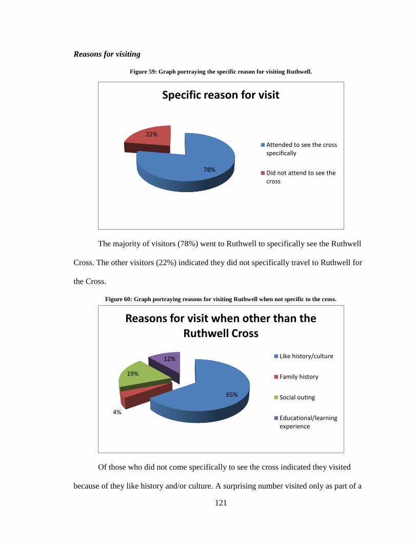
121
Reasons for visiting
Figure 59: Graph portraying the specific reason for visiting Ruthwell.
The majority of visitors (78%) went to Ruthwell to specifically see the Ruthwell
Cross. The other visitors (22%) indicated they did not specifically travel to Ruthwell for
the Cross.
Figure 60: Graph portraying reasons for visiting Ruthwell when not specific to the cross.
Of those who did not come specifically to see the cross indicated they visited
because of they like history and/or culture. A surprising number visited only as part of a
78%
22%
Specific reason for visit
Attended to see the cross specifically
Did not attend to see the cross
65%
4%
19%
12%
Reasons for visit when other than the Ruthwell Cross
Like history/culture
Family history
Social outing
Educational/learning experience
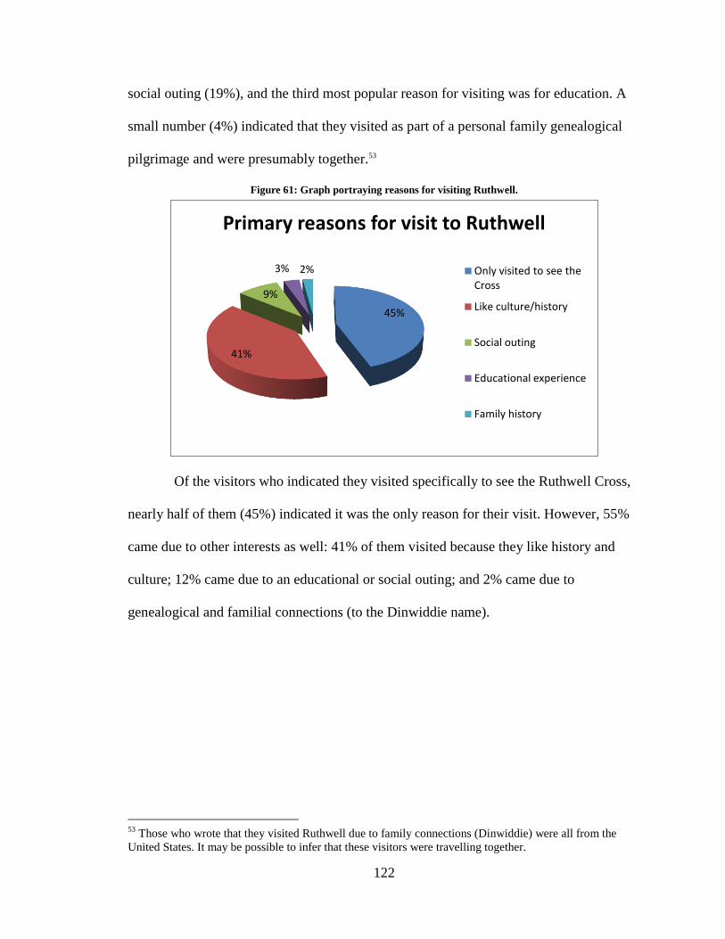
122
social outing (19%), and the third most popular reason for visiting was for education. A
small number (4%) indicated that they visited as part of a personal family genealogical
pilgrimage and were presumably together.53
Figure 61: Graph portraying reasons for visiting Ruthwell.
Of the visitors who indicated they visited specifically to see the Ruthwell Cross,
nearly half of them (45%) indicated it was the only reason for their visit. However, 55%
came due to other interests as well: 41% of them visited because they like history and
culture; 12% came due to an educational or social outing; and 2% came due to
genealogical and familial connections (to the Dinwiddie name).
53
Those who wrote that they visited Ruthwell due to family connections (Dinwiddie) were all from the
United States. It may be possible to infer that these visitors were travelling together.
45%
41%
9%
3% 2%
Primary reasons for visit to Ruthwell
Only visited to see the Cross
Like culture/history
Social outing
Educational experience
Family history
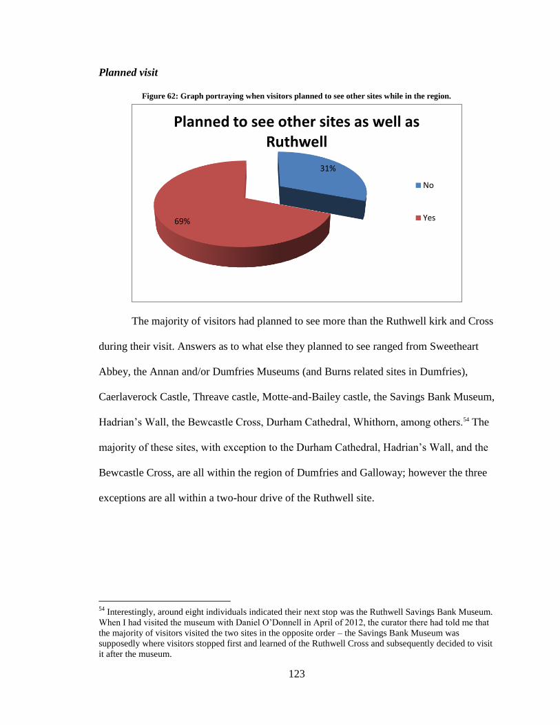
123
Planned visit
Figure 62: Graph portraying when visitors planned to see other sites while in the region.
The majority of visitors had planned to see more than the Ruthwell kirk and Cross
during their visit. Answers as to what else they planned to see ranged from Sweetheart
Abbey, the Annan and/or Dumfries Museums (and Burns related sites in Dumfries),
Caerlaverock Castle, Threave castle, Motte-and-Bailey castle, the Savings Bank Museum,
Hadrian’s Wall, the Bewcastle Cross, Durham Cathedral, Whithorn, among others.54 The
majority of these sites, with exception to the Durham Cathedral, Hadrian’s Wall, and the
Bewcastle Cross, are all within the region of Dumfries and Galloway; however the three
exceptions are all within a two-hour drive of the Ruthwell site.
54
Interestingly, around eight individuals indicated their next stop was the Ruthwell Savings Bank Museum.
When I had visited the museum with Daniel O’Donnell in April of 2012, the curator there had told me that
the majority of visitors visited the two sites in the opposite order – the Savings Bank Museum was
supposedly where visitors stopped first and learned of the Ruthwell Cross and subsequently decided to visit
it after the museum.
31%
69%
Planned to see other sites as well as Ruthwell
No
Yes
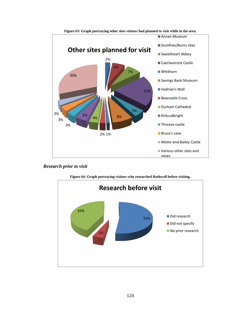
124
Figure 63: Graph portraying other sites visitors had planned to visit while in the area.
Research prior to visit
Figure 64: Graph portraying visitors who researched Ruthwell before visiting.
2%
6% 7%
21%
5%
8%
1% 2%
4% 5%
3%
3%
3%
30%
Other sites planned for visit
Annan Museum
Dumfries/Burns sites
Sweetheart Abbey
Caerlaverock Castle
Whithorn
Savings Bank Museum
Hadrian's Wall
Bewcastle Cross
Durham Cathedral
Kirkcudbright
Threave castle
Bruce's cave
Motte-and-Bailey Castle
Various other sites and views
52%
5%
43%
Research before visit
Did research
Did not specify
No prior research
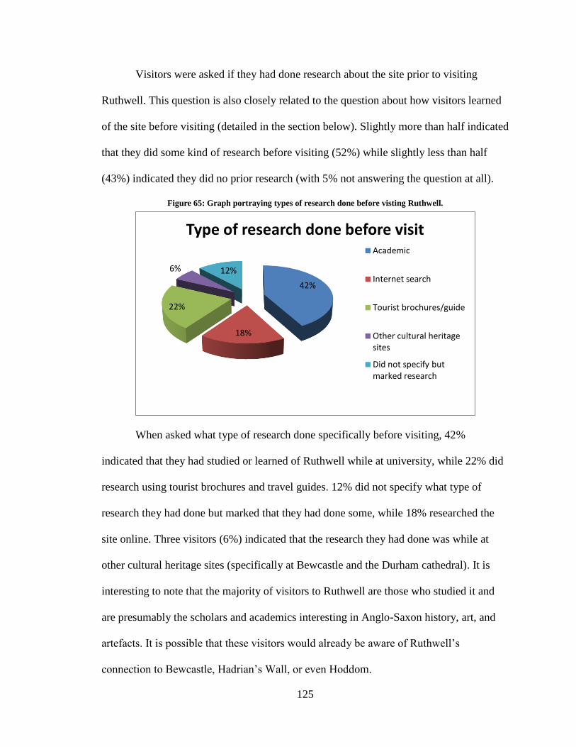
125
Visitors were asked if they had done research about the site prior to visiting
Ruthwell. This question is also closely related to the question about how visitors learned
of the site before visiting (detailed in the section below). Slightly more than half indicated
that they did some kind of research before visiting (52%) while slightly less than half
(43%) indicated they did no prior research (with 5% not answering the question at all).
Figure 65: Graph portraying types of research done before visting Ruthwell.
When asked what type of research done specifically before visiting, 42%
indicated that they had studied or learned of Ruthwell while at university, while 22% did
research using tourist brochures and travel guides. 12% did not specify what type of
research they had done but marked that they had done some, while 18% researched the
site online. Three visitors (6%) indicated that the research they had done was while at
other cultural heritage sites (specifically at Bewcastle and the Durham cathedral). It is
interesting to note that the majority of visitors to Ruthwell are those who studied it and
are presumably the scholars and academics interesting in Anglo-Saxon history, art, and
artefacts. It is possible that these visitors would already be aware of Ruthwell’s
connection to Bewcastle, Hadrian’s Wall, or even Hoddom.
42%
18%
22%
6% 12%
Type of research done before visit Academic
Internet search
Tourist brochures/guide
Other cultural heritage sites
Did not specify but marked research
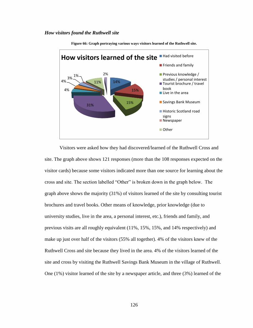
126
How visitors found the Ruthwell site
Figure 66: Graph portraying various ways visitors learned of the Ruthwell site.
Visitors were asked how they had discovered/learned of the Ruthwell Cross and
site. The graph above shows 121 responses (more than the 108 responses expected on the
visitor cards) because some visitors indicated more than one source for learning about the
cross and site. The section labelled “Other” is broken down in the graph below. The
graph above shows the majority (31%) of visitors learned of the site by consulting tourist
brochures and travel books. Other means of knowledge, prior knowledge (due to
university studies, live in the area, a personal interest, etc.), friends and family, and
previous visits are all roughly equivalent (11%, 15%, 15%, and 14% respectively) and
make up just over half of the visitors (55% all together). 4% of the visitors knew of the
Ruthwell Cross and site because they lived in the area. 4% of the visitors learned of the
site and cross by visiting the Ruthwell Savings Bank Museum in the village of Ruthwell.
One (1%) visitor learned of the site by a newspaper article, and three (3%) learned of the
14%
15%
15% 31%
4%
4% 3%
1%
11%
2%
How visitors learned of the site Had visited before
Friends and family
Previous knowledge / studies / personal interest Tourist brochure / travel book Live in the area
Savings Bank Museum
Historic Scotland road signs Newspaper
Other
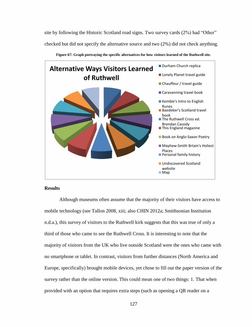
127
site by following the Historic Scotland road signs. Two survey cards (2%) had “Other”
checked but did not specify the alternative source and two (2%) did not check anything.
Figure 67: Graph portraying the specific alternatives for how visitors learned of the Ruthwell site.
Results
Although museums often assume that the majority of their visitors have access to
mobile technology (see Tallon 2008, xiii; also CHIN 2012a; Smithsonian Institution
n.d.a.), this survey of visitors to the Ruthwell kirk suggests that this was true of only a
third of those who came to see the Ruthwell Cross. It is interesting to note that the
majority of visitors from the UK who live outside Scotland were the ones who came with
no smartphone or tablet. In contrast, visitors from further distances (North America and
Europe, specifically) brought mobile devices, yet chose to fill out the paper version of the
survey rather than the online version. This could mean one of two things: 1. That when
provided with an option that requires extra steps (such as opening a QR reader on a
Alternative Ways Visitors Learned of Ruthwell
Durham Church replica
Lonely Planet travel guide
Chauffeur / travel guide
Caravanning travel book
Kemble's Intro to English Runes Baedeker's Scotland travel book The Ruthwell Cross ed. Brendan Cassidy This England magazine
Book on Anglo-Saxon Poetry
Mayhew-Smith Brtain's Holiest Places Personal family history
Undiscovered Scotland website Map
128
mobile phone and then following the URL linked), visitors will always choose the easier
option when the digital selection offers no added benefit; 2. There was no available wi-fi
on the premises, there was little to no data service while in the church, and/or they did not
want to use roaming minutes or data, which tends to be expensive in foreign countries.
Despite nearly half the visitors claiming they did no research prior to visiting the
site, the majority of visitors did come with a prior knowledge of the cross. This
discrepancy in the data may suggest that visitors filling out the surveys differentiate
between “research” and “planning a visit.” Regardless of what visitors consider research,
a clear majority of those who came planned their visit in advance and did not come as a
result of a chance sighting of a road-side sign. Although every visitor to Ruthwell was
satisfied with his or her visit, there were a number dissatisfied with the interpretive
material provided (with one specifically stating it needed to be updated). In some cases,
the guide book was missing, no postcards were available for sale, and for some reason the
visitor missed the other material provided on-site (such as the wooden panels).
Additionally, the majority of the visitors indicated they had planned to visit a number of
other sites in the local peninsula, meaning that visitors to the area are indeed exploring
the region as whole. A digital interpretation plan would provide a more comprehensive
and stable interpretation tour to supplement the current programme as well as provide
visitors with the information when the guide book is sold out, and connect the other sites
on their planned visit to the one they are currently exploring, provided visitors have some
type of mobile device with them.
This suggests that the types of visitors that visit Ruthwell are a group that needs to
be convinced (even more so than others) to bring and use technology: they are an older
129
demographic and, while more than half the visitors from Scotland and outside the UK
came with an electronic device, none took advantage of an opportunity presented to them
as part of a visitor survey to use the device to complete the survey online using a QR
code. The fact that far less than half the visitors came with an electronic device suggests
that this demographic needs to know more about the value of a virtual tour before they
visit the site. A properly designed and discoverable website could encourage visitors to
bring mobile technology with them as a means of enhancing their visit as well as a way to
stay engaged with the site (and perhaps even contribute to the maintenance of any crowd
sourced online resources) even after they left.
Analysis
As pattern recognition and other AR technologies improve and become robust
enough to allow implementation at remote heritage sites such as Hoddom, Ruthwell, and
Bewcastle, this kind of virtual interpretation will allow heritage professionals and
amateur enthusiasts to improve the visitor experience at individual sites and allow for a
better interaction between the contemporary physical environment and the virtual
territory-museum to which these sites also belong and from which they gain meaning.
However, it is clear from the visitor surveys that there is a major issue with the
implementation of a digital tour: nearly two thirds of the visitors to Ruthwell came
without some form of mobile technology. Nevertheless, we also see that visitors do come
to Ruthwell wanting to study the cross, the church, and the area as a whole. This
demonstrates that there is a receptive audience. Interestingly, it appears that it is the
visitors from the England who come without mobile technology; visitors from Europe
and North America tend to bring a smartphone or tablet with them. This could indicate
130
that those travelling from relatively nearby know the area as not being necessarily
mobile-friendly and so do not feel any need to travel with a smartphone or tablet.55 Not
only that, but the survey cards collected in the fall indicated that bird watching was the
main reason for visiting the area. This could mean that the reason for these specific visits,
to observe nature in its environment, did not lend the carrying of an electronic, possibly
invasive, device. However, perhaps if a digital interpretation plan for Ruthwell were
discoverable on the internet (through Visit Scotland, Historic Scotland, or the church
websites), visitors would come prepared with a mobile device. It could also simply be a
demographic explanation: the majority of visitors to Ruthwell fall between the ages of
50-64 (35%),56 as opposed to the British Museum’s, which fall between 16-34 (43%;
British Museum n.d.) and simply may not be heavy technology users. Visitors from North
America and Europe do travel with mobile devices and yet do not seem to be using them
on-site. As I mentioned earlier, this could be due to high roaming charges and no access
to wi-fi. If internet was supplied in the church it seems reasonable to assume visitors
would take advantage of the access and participate in a digital programme. Of course,
also mentioned earlier, the digital programme would have to be value-added to the
current programme and expand on the visitor experience, not just replace the current
programme with a digital one, in order to encourage visitors to take the extra time and
effort to use their devices.
55
On a global scale, the UK is ranked at ninth place with a smartphone penetration at 62.2% of the
population. 56
As a close second, 28% of visitors to Ruthwell are over the age of 65.
131
Conclusion
Implications
The jump from analogue interpretive models (plaques and signs), to audio guides
and guide books, and finally to QR codes was not a large one. The jump then from QR to
AR and pattern recognition technology may seem like the same thing, but the
implications for how AR technology affects the museum experience are actually quite
significant. The use of this technology changes the way we view the museum and it
changes the way we interact with cultural artefacts; mainly “we give context to the
information we interact with” (Farman 2013, 42). “In other words” as Farman states,
“accessing information on Wikipedia while at your desk is quite a different experience
from accessing the exact same information from a site-specific interaction with a mobile
device” (2013, 42). Individuals travel to heritage interpretation sites to see objects,
buildings, and artefacts in situ, to experience them tangibly and within the context in
which they were meant to be experienced. However, without proper interpretive materials
available to them on-site, their experiences can change drastically, as seen with the
erroneous material found at Hoddom.
Digital material has the added bonus of being updatable from anywhere, making it
easier to keep the information concurrent with contemporary scholarship while allowing
for input from the local communities, becoming discoverable to a wider visitor base, and
creating a more fully immersive environment, open for exploration and complete
engagement, on- and off-site. In addition to these aspects of digital technology, it can also
“bridge the gap” between the professionals and amateurs, potentially curing the continual
conflict we have seen; they both benefit from the expertise of the other. As demonstrated
132
in this thesis, rural cultural heritage sites have been best served by amateurs, as with the
cases of Ruthwell and Bewcastle that, while lacking an overall cohesive interpretive plan,
are cared for by enthusiastic and proud communities who want to share their histories
with visitors (and visitors who want to enjoy these locations). On the other hand, the
professionally implemented materials, such as those provided at Hoddom, can be
factually and museologically problematic, lacking connections to the local area. My main
goal here was to demonstrate how we could take what is implicit in the amateur
interpretive materials, harness the enthusiasm and excitement portrayed by the local
communities, and improve upon them by simply adding a consistent narrative and a
cohesive interpretive plan through the implementation of a digital mobile tour. Because
the local communities do better work (even if the professional materials “look better”), it
is a good idea to start small and build upwards, not only in terms of resources, but also in
terms of rhetoric.
In fact, the case at Hoddom is a good example of why working from “the top
down” would not be a good idea: the professionals were alone responsible for providing
the interpretive aid, but as we saw in chapter two, this material is museologically and
intellectually problematic—not only does it turn the visitor away from what is historically
interesting at Hoddom, it also gives incorrect information of the Hoddom church, and
connects the site to a possibly mythological figure and a city two hours away from the
local region. The professionals are trying to relate to the site on a global level, assuming
the interesting bits (and presumably the bits the visitors will find most interesting) are the
connection to the closest major city, when really the most interesting bits are its
connections to the local region and the area that makes up the territory-museum. Utilising
133
the mobility and personal nature of AR applications to combine the pieces of a territory-
museum together changes the way visitors navigate, experience, and embody the space.
This embodiment is quite different than the way visitors currently navigate and
experience the region, since many of the connections to the immediate region are
underrepresented and easily missed.
Further Research
Technology
While we have not yet been able to build an application that allows us to fully
implement a digital tour at Ruthwell, the day when it is possible to introduce such
applications at all three of the sites discussed in this paper is not too far off. As examples
of successful applications under more controlled and urban environments have been
demonstrated (e.g. “A Gift for Athena,” “Ultimate Dinos,” “StreetMuseum”, “Capture the
Pheon”), these approaches bring with them a need for new approaches to the rhetoric of
cultural heritage interpretation. While the implementation of such, often game-inspired,
rhetoric in active religious sites, such as the churches at Bewcastle and Ruthwell, would
require some modification (the very common “scavenger hunt” model currently used to
structure such applications in more secular contexts, for example, may prove disruptive in
an active church), it seems clear that the educational potential of an interpretive site can
be enhanced by the interactivity and interconnectivity such applications provide.
A successful introduction of AR technology would be an effective way of both
enhancing the visitor experience at these sites and connecting them to the larger virtual
historical network to which they belong. Hoddom, Ruthwell, and Bewcastle are already
part of an immersive virtual world: the minute a visitor chooses to explore a site, with or
134
without access to supplementary material or a mobile device, they are willingly stepping
into an alternate (historical) world that is (mentally at least) superimposed on the
contemporary landscape. Developing an approach that allows us to capture this reality in
practice as well as theory would considerably improve the visitor experience at all three
sites.
This of course raises the question of the future of the technology. The technology
will continue to improve as time moves forward. AR technology specifically is certainly
improving and has improved drastically in the two a half years I have been working on
this project. There are many who believe AR is “the next big thing” as we see major
corporations (Google and Google Glass, for example) invest in the future of AR:
Mobile analyst Tomi Ahonen expects AR to be adopted by a billion users by 2020.
Intel is betting that AR will be big. The chip maker is investing $100 million over
the next 2 to 3 years to fund companies developing "perceptual computing"
software and apps, focusing on next-generation, natural user interfaces such as
touch, gesture, voice, emotion sensing, biometrics, and image recognition. (Farber
2013)
As these uses challenge the reliability of pattern recognition and AR, the technology will
have to improve to continue to be useful, or it will face becoming obsolete.
An Alternative to Pattern Recognition
One other alternative to pattern recognition and AR technology I do not fully
explore in this thesis is the option of a native application that can be downloaded before
visiting the site and that contains all the interpretive information hard-coded in the
application itself, making it accessible off-line (so an available internet connection and
cell service is less of a concern). It would not be as “flashy” as an AR application, but it
have the added benefit of being simple to download, access, and use, is available on- and
off-site, and potentially would not require the installation of a wi-fi router in the church.
135
It would essentially act as a digital format for the guide pamphlet already available on-
site, but would be updatable and current, would potentially be free or available for a low,
on-time fee, and (once downloaded) the user’s device would automatically update (or
indicate there was an update if the user’s phone requires a manual update) when the
phone or tablet was connected to the internet.
The reason it is not presented as a fully viable option for the site of Ruthwell is
primarily due to the financial requirement of such an application. In order for an
application like this to be worthwhile, it would need to be properly designed and
programmed by someone with the skills and resources, which means it may be necessary
to hire a team capable of creating an application that would not only do the site justice by
taking into account its unique needs, but would also give scholars and the local
community the option of contributing to the information, all in an attractive package.
Unfortunately, Ruthwell is not the British Museum and as such relies mostly on
volunteers for care and maintenance of the site. Currently, pattern recognition
applications like Aurasma are free to create with and free to download, making it a viable
option financially for sites like Ruthwell, but with the added benefit of being on the
cutting edge of current technology.
User Interaction
In the particular case of Ruthwell, we saw from the visitor surveys that the age of
visitors is older on average (in the age ranges of 50-64, 65+) than other, more urban,
museums. These visitors also do not carry mobile devices as much as those to other
institutions (see the British Museum n.d; user survey analysis in chapter four). This could
136
be because of the nature of the visit, the older demographic, or simply because visitors to
Ruthwell are not anticipating a digital aspect to their visit.
The results from the visitor survey may argue against the implementation of a
digital tour at sites like Ruthwell. However, as discussed in chapter four, we could
convince people to bring a mobile device with them by making the Ruthwell kirk and
cross site more discoverable online and more noticeable on-site. Because of the older
visitor base however, the added effort to such an interpretive plan would also need to be
value-added and the visitors may need to be persuaded to participate. Furthermore, those
with smartphones or tablets did not fill out the digital version of the survey, so it may
even be that users who do bring smartphones need a good reason to take them out. If this
is the case, it may also “help to assuage the concerns of visitors (and local inhabitants) of
the perceived incursion of new technologies” to Ruthwell, as James Graham highlighted
in an email to me on April 24, 2014, to emphasise how the Ruthwell Cross was the “new
communication technology” of its time (Dinwiddie 2008, 9).57 The reformation was also
both stimulated by technological innovation, such as the Gutenberg Press (which helped
spread the ideas of Protestant Reformers to a larger audience; see Childress 2007, 155),
but also sought to restrict the way in which technology could be used, an idea that is
exemplified in the tearing down of monuments that had been used as teaching aids, such
as the Ruthwell Cross.
The main question then, assuming the technology holds up and visitors bring
mobile devices to the site, is how to train them to use it, especially at sites that are
unstaffed. If the visitors are a bit older, navigating a digital tour will not be intuitive for
them. I mentioned earlier the “scavenger hunt-like” aspects of certain museum AR
57
This is also mentioned on the Historic Scotland interpretive paddles on-site.
137
applications (such as “A Gift for Athena” or “Capture the Pheon”), which guide visitors
around the museum exhibits as part of an ARG and has them collect items (digitally) or
solve puzzles on their tablets. ARGs in museums are designed for visitor enjoyment,
engagement, and education, and institutions use them to get visitors interested in
particular exhibitions or to focus visitor attention on certain aspects of that exhibit.
Because AR applications are designed to supplements the “real world” and ARGs are
meant to engage visitors in a fictional world, ARGs often implement the use of AR
technology. This approach, although often entertaining and trains participants
successfully on how to use the app, is not a perfect solution to a sacred space like
Ruthwell, or even an outdoor environment with very little in the way of interesting visual
markers, such as Hoddom. But they could lead to a solution on how Ruthwell’s unique
visitor base could interact with the site and learn how to use the technology. This
approach would require a modified version of ARG rhetoric, one that is not built around a
scavenger hunt or other type of game, but one that still pulls visitors into interacting with
the site by exploring it respectfully.
Because Hoddom, Ruthwell, and Bewcastle are already part of an immersive
virtual world, and since the regional territory-museum of Dumfries and Galloway really
is a virtual world layered in history, visitors are stepping into an alternate historical world
that is superimposed on the contemporary landscape. The implementation of mobile
technology would just supplement what is there already by laying a cohesive digital map
on top of it, giving visitors direction and information along the way. A modified ARG
rhetoric could easily be used to guide visitors around these landscapes. This solution
would require further research and study however, as it would need to work directly with
138
the chosen technology (such as the specific AR application) and be built directly into the
tour so that it functions well within the environment.
Sustainability
This leads us into the final pertinent question of stability and sustainability. This
is a question of preservation and conservation but within the digital medium. I have
already briefly discussed in chapter four how Wikipedia is a potential solution for
sustainability, but this is a question that requires more research be fully solved. We see
some museums, such as MoMA in New York, linking to Wikipedia for certain
information (in this case, author biographies; see Hobma 2013) and an increase in the use
of Wikimedia projects for Digital Humanities projects, such as the “The Social Edition of
the Devonshire Manuscript.” However, museums are still struggling with the question of
storage and sustainability in an increasingly digital world (see Young 2012; Beel et al.
2013; Henriksen, Seuskens, and Wijers 2013).
The CURIOS Project (University of Aberdeen 2011) is working on the
sustainability of digital archives as a way of supporting interest and local heritage at rural
heritage sites while giving the local communities access to contribute to the information.
The project is looking at the semantic web and linked data technology “to build a general,
flexible and ‘future proof’ software platform that could help such projects to come into
existence and be sustainable over time” (University of Aberdeen 2011). Looking towards
this project and the successes and struggles the team members have had with the question
of access and sustainability may be one way to find a solution to the question of
sustainability at sites like Ruthwell, Bewcastle, and Hoddom.
139
Sustainability is an interesting, and imposing, problem. However, because of the
open access to Wikipedia, this may indeed be the most (at least fiscally) realistic option
for sustainability, with the option of moving towards a more controllable system, such as
the specially built one approached by CURIOS.
Summary
The primary focus of this thesis is to look at the visitor experience and
interpretation plans at rural cultural heritage sites in the UK. In doing so, it discovered
three basic but significant points: 1. Cultural heritage sites are driven by technology. 2.
Rural cultural heritage sites have been best served by amateurs. 3. Mobile technology can
(and should) be looked at as a way of bridging the gaps between the professionals and
amateurs.
Knowing that AR and pattern recognition technology will continue to improve, it
seems that these technologies are the ideal solutions to help improve folk-run, cultural
heritage sites, which function as both individual sites and part of a larger territory-
museum in the region. Not only will AR applications and pattern recognition improve on
the dissemination of information, visitor experience, and updatability, but by shifting
towards a mobile interface it connects one site to another on the same system, essentially
building the network for a regional territory-museum. Every region, with its cultural
heritage sites and interpretation of history, functions as a territory-museum, with or
without official designation. Pattern recognition and AR applications can do the same
thing on a site-level basis, especially for a site like Ruthwell, which has superb visitor
interpretation material but lacks a coherent narrative. A mobile interface can take all the
loose bits and connect them together.
140
This thesis, at its most basic, takes what is implicit in the amateur efforts at
cultural heritage sites and suggests a way to improve on the current material through the
use of contemporary technology. It places rural cultural heritage sites within the
definition of the museum and looks to the history of the symbiotic relationship with
technology the museum has always had as a solution. Looking at the theory and practice
behind cultural interpretation, this thesis attempts to overlay the current in situ
information found at folk-run, rural heritage sites with mobile theory and interpretive
materials found at more organised official sites, and it aims to harness the enthusiasm,
passion, and pride of the local communities, and combine it with a more coherent
interpretation plan.
141
Bibliography
Aerial View of Hoddom. 2007. Photograph. From Canmore Mapping/RCAHMS.
http://canmore.rcahms.gov.uk.
Alpers, Svetlana. 2001. “The Museum as a Way of Seeing.” In Exhibiting Cultures the
Poetics and Politics of Museum Display. Washington: Smithsonian Inst. Press.
25-32.
Anderson, Brittany. 2013. “QR Codes: A technology without a user base?” In
Information Space. Syracuse University. Accessed February 25, 2014.
https://infospace.ischool.syr.edu/2013/05/01/are-qr-codes-on-the-verge-of-death/
Arvanitis, Konstantinos. 2005. “Museums Outside Walls: Mobile Phones and the
Museum in the Everyday.” IADIS International Conference Mobile Learning.
251–255. Leicester, UK: University of Leicester.
Aurasma. N.d. Aurasma Partner Guidelines: A comprehensive guide to Aurasma.
http://www-cdn.aurasma.com/wp-content/uploads/Aurasma-Partner-
Guidelines.pdf.
Avery, Ted. 2011. “Augmented Reality App—Pickering Museum Village.” Ted Avery.
Portfolio. Accessed 21 September 2013. http://tedavery.ca/portfolio/augmented-
reality-app-%E2%80%93-pickering-museum-village/
Azuma, Ronald T. 1997. “A Survey of Augmented Reality.” Presence: Teleoperators
and Virtual Environments 6 (4): 355-385.
Bandelli, Andrea. 2010. “Virtual Spaces and Museums.” Museums in a Digital Age, ed
Ross Parry, 148-152. New York: Routledge.
Barrett, Terry. 2008. “Interactive Touring in Art Museums: Constructing Meanings and
Creating Communities of Understanding.” Visual Arts Research 34.2 (67): 76–84.
Battro, Antonio M. 2010. “From Malraux’s Imaginary Museum to the Virtual Museum.”
Museums in a Digital Age, ed. Ross Parry, 136-147. New York: Routledge.
BBC. 2013. “Burns at Ruthwell Manse.” BBC - Your Paintings. Accessed September 21
2013. http://www.bbc.co.uk/arts/yourpaintings/paintings/burns-at-ruthwell-
manse-207835.
Bennett, Tony. 1995. The Birth of the Museum. London: Routledge.
Bodard, Gabriel. 2010. Digital research in the study of classical antiquity. Burlington,
VT: Ashgate.
142
Breeze, A. 2003. “The Date of the Ruthwell Cross Inscription.” ANQ 16 (2): 3.
British Museum. N.d. “A Year of Success: 260 years in the making.” The British
Museum. Accessed January 15, 2014.
http://www.britishmuseum.org/about_us/news_and_press/press_releases/2013/a_y
ear_of_success.aspx
Brockman, William S, and Digital Library Federation. 2001. Scholarly work in the
humanities and the evolving information environment. Washington, D.C.: Digital
Library Federation, Council on Library and Information Resources.
Cain, Victoria. 2008. “Exhibitionary Complexity: Reconsidering Museums’ Cultural
Authority.” American Quarterly, 1143-1151.
Casabona, Joe. 2013. “What are NFC Tags and how do you use them?”
Android.Appstorm, January 28. Accessed April 25, 2014.
http://android.appstorm.net/how-to/hardware/what-are-nfc-tags-and-how-do-you-
use-them/
Casey, Edward C. 1993. Getting Back into Place: toward a renewed understanding of the
place-world. Bloomington: Indiana UP.
Chandler, Nathan. 2012. "What’s an NFC tag?" HowStuffWorks.com. Accessed April 24,
2014. http://electronics.howstuffworks.com/nfc-tag.htm
Childress, Diana. 2008. Johannes Gutenberg and the Printing Press. Minneapolis:
Twenty-First Century Books.
CHIN. 2012a. “Techwatch.” Canadian Heritage Information Network. Accessed April
25, 2012. www.rcip-chin.gc.ca
CHIN. 2012b. “Tip Sheets | Constructing Meaning and Online Museum User
Experience.” Canadian Heritage Information Network. Accessed April 25, 2012.
www.rcip-chin.gc.ca
CHIN. 2012c. “Mobile in Museums | News | Canadian Heritage Information Network.”
Canadian Heritage Information Network. Accessed April 25. www.rcip-
chin.gc.ca
Collingwood, W. G. 1916. “The Ruthwell Cross in its Relation to other Monuments of the
Early Christian Age.” The Ruthwell Cross, 34-52. Trans Dumfriesshire and
Galloway Natural History and Antiquarian Society.
Connor, Patrick, W. 2007. “The Ruthwell Monument Runic Poem in a Tenth-Century
Context.” Review of English Studies 59 (238): 25-51.
143
Cook, Albert S. 2011. “Notes on the Ruthwell Cross.” PMLA 17.3 (1902): 367-390.
Craig, R. Bruce. 2007. Introduction to Interpreting Our Heritage, by Freeman Tilden.
Loc 106-453 of 3209. Chapel Hill: University of North Carolina Press. Kindle e-
book.
Cramp, Rosemary. 1978. “The Evangelist Symbols and their Parallels in Anglo-Saxon
Sculpture.” Bede and Anglo Saxon England 46, edited by Robert T. Farrell, 118-
130. Oxford: British Archaeological Reports.
Crompton, Constance. N.d. “The Devonshire Manuscript: a social edition.” Accessed
January 20, 2014. Constance Crompton.
http://constancecrompton.com/?projects=the-devonshire-manuscript-a-social-
edition
Crowe, Chris. 1987. “Excavations at Ruthwell, Dumfries, 1980 and 1984.” Transactions
of the Dumfriesshire and Galloway Natural History and Antiquarian Society, 40-
47. 3rd
ed. Dumfries and Galloway: The Dumfriesshire and Galloway Natural
History and Antiquarian Society.
Din, Herminia, and Phyllis Hecht. 2007. The Digital Museum: a think guide. Washington,
DC: American Association of Museums.
Dinwiddie, J. L. 2008. The Ruthwell Cross and the Ruthwell Savings Bank Museum. 9th
ed. Dumfries: Solway Offset Services.
Dudley, Sandra H. 2010. Museum Materialities: Objects, Engagements, Interpretations.
London; New York: Routledge.
Duncan, Carol and Alan Wallach. 1980. “The Universal Survey Museum.” Art History 5
(4): 448-469.
English Heritage. 2007. “Monument No. 13113.” PastScapes. Accessed April 2012.
http://www.pastscape.org.uk/hob.aspx?hob_id=13113
Falk, John H. and Lynn D. Dierking. 2008. “Enhancing Visitor Interaction and Learning
with Mobile Technologies.” In Digital Technologies and the Museum Experience,
edited by Loïc Tallon and Kevin Walker, 19-33. Lanham, Md.: AltaMira Press.
Farber, Dan. 2013. “The next big thing in tech: Augmented reality.” Cnet, June 7.
http://news.cnet.com/8301-11386_3-57588128-76/the-next-big-thing-in-tech-
augmented-reality/.
Farman, Jason. 2012. Mobile Interface Theory: Embodied Space and Locative Media.
New York: Routledge. Print.
144
Farrell, David and Catherine Karkov. 1992. “The Construction, Deconstruction, and
Reconstruction of the Ruthwell Cross, Some Caveats.” The Ruthwell Cross:
Papers from the Colloquium Sponsored by the Index of Christian Art, edited by
Brendan Cassidy, 35-47. Princeton, NJ: Princeton UP.
Filippini-Fantoni, Sylvia and Jonathan P. Bowen. 2008. “Mobile Multimedia.” In Digital
Technologies and the Museum Experience, edited by Loïc Tallon and Kevin
Walker, 79-96. Lanham, Md.: AltaMira Press.
Forbes, M. D. and Bruce Dickins. 1914. “The Inscriptions of the Ruthwell and Bewcastle
Crosses and the Bridekirk Font.” The Burlington Magazine for Connoisseurs.
25:133. April. 24-29.
Foster, Sally, Nick Bridgland, Emma Carver, Marion Fry, Doreen Grove, Chris
Tabraham, Peter Yoeman, and Richard Welander. 2006. Early Medieval Carved
Stones in Historic Scotland’s Care. 6 March. Historic Scotland.
Fox, Zoe. 2013. “The Fifteen Countries with the Highest Smartphone Penetration.”
Mashable, August 27. Accessed March 2, 2014.
http://mashable.com/2013/08/27/global-smartphone-penetration/
Gammon, Ben and Alexandra Burch. 2008. “Designing Mobile Digital Experiences.” In
Digital Technologies and the Museum Experience, edited by Loïc Tallon and
Kevin Walker, 35-60. Lanham, Md.: AltaMira Press.
Gillman, Derek. 2010. The Idea of Cultural Heritage. Cambridge, Mass: Cambridge UP.
Goula, Jennifer. 2013. “Augmented Reality Technology Adopted by the British
Museum.” Mobile Commerse News, December 3. Accessed February 25, 2014.
http://www.qrcodepress.com/augmented-reality-technology-adopted-british-
museum/8524484/
Hazan, Susan. 2007. “A Crisis of Authority: New Lamps for Old.” In Theorizing Digital
Cultural Heritage: A Critical Discourse, edited by Fiona Cameron and Sarah
Kenderdine, 133-147. Cambridge, Mass.: MIT Press.
Hein, George. 1995. “The Constructivist Museum.” Journal for Education in Museums
16: 21-23.
Hein, Hilde S. 2000. The Museum in Transition: a Philosophical Perspective.
Washington, D.C.: Smithsonian Institution Press.
Hewison, James King. 1914. The runic roods of Ruthwell and Bewcastle, with a short
history of the cross and crucifix in Scotland. Glasgow: J. Smith.
Hilmo, Maidie. 2003. Medieval images, icons, and illustrated English literary texts: from
145
the Ruthwell cross to the Ellesmere Chaucer. Aldershot: Ashgate.
Hobma, Heather, ed. 2013. “Wikipedia and Museums.” Storify.
http://storify.com/HeatherHobma/wikipedia-and-museums
Hooper-Greenhill, Eilean. 2000. “Changing Values in the Art Museum: Rethinking
Communication and Learning.” International Journal of Heritage Studies 6 (1):
9–31.
Hooper-Greenhill, Eilean. 1992. Museums and the Shaping of Knowledge. New York:
Routledge.
Howlett, David R. 2008. “A Corrected Form of the Reconstructed Ruthwell Crucifixion
Poem.” Studia Neophilologica: A Journal of Germanic and Romance Languages
and Literature 80 (2): 255-257.
International Council of Museums. 2012. “Museum Definition.” Accessed April 5, 2012.
International Council of Museums. http://icom.museum/the-vision/museum-
definition/
Izquierdo Tugas, P., J. Juan Tresserras, and J.C. Matamala Mellin. 2005. The Hicira
Handbook. Barcelona: Diputació Barcelona.
Jisc. 2013. “Bridging the Gap Between Academia and Wikipedia.” Jisc, June 27.
Accessed March 5, 2014. http://www.jisc.ac.uk/news/bridging-the-gap-between-
academia-and-wikipedia-27-jun-2013
Kendall, Calvin B. 2006. “The Ruthwell Cross and the Dream of the Rood.” The Place of
the Cross in Anglo-Saxon England, edited by Catherine E Karkov, Sarah Larratt
Keefer and Karen Louise Jolly, 129-144. Woodbridge: Boydell Press.
Kirshenblatt-Gimblett, Barbara. 1998. Destination Culture: Tourism, Museums, and
Heritage. Berkeley: U of California P.
Ledingham, Simon. N.d. Aerial View of Bewcastle. Photograph. From Visitcumbria.com.
Lowe, Christopher. 2006. Excavations at Hoddom, Dumfriesshire. Edinburgh: Society of
Antiquaries of Scotland.
Lydens, Lois, Yasuji Saito, and Tohru Inoue. 2007. “Digital Technology at the National
Science Museum of Japan.” The Journal of Museum Education 32.1 (Spring): 7–
16.
Mairin. 2012. “How to Augment Your Reality with AR.” edgital, October 12. Accessed
March 5, 2014. http://www.edgital.org/2012/10/12/how-to-augment-your-reality-
with-ar-part-1-of-2-on-augmented-reality/
146
Malraux, André. 1967. Museum Without Walls. Garden City: Doubleday.
Mannion, Shelley. N.d. “British Museum – Augmented Reality: Beyond the Hype.”
Museum ID. Accessed February 25, 2014. http://www.museum-id.com/idea-
detail.asp?id=336
Marsh, John S., and Bruce W. Hodgins. 1998. Changing Parks: The History, Future and
Cultural Context of Parks and Heritage Landscapes. Toronto: Natural
Heritage/Natural History Inc.
Martineau, Nadia. 2012. “McCord Museum Wins the Gold Multimédi’art Interactive
Award for its MTL Urban Museum Applicaition.” McCord Museum, October 22.
http://www.mccord-museum.qc.ca/pdf/PR/PR_Premier_prix_MUM_EN.pdf
Murray, J.E.D. 1883. Runic Cross Ruthwell. JR 1883. Digital image of photograph on
glass. From Royal Commission of the Ancient and Historic Monuments of
Scotland, http://canmore.rcahms.gov.uk/en/details/1115768/
Museum of London. N.d. “Street Museum.” Museum of London. Accessed September 2,
2012. http://www.museumoflondon.org.uk/Resources/app/you-are-here-
app/home.html
Nosowitch, Dan. 2013. “Why Doesn’t the iPhone 5S Have NFC?” Popular Science,
September 23. Accessed April 24, 2014.
http://www.popsci.com/gadgets/article/2013-09/why-doesnt-iphone-5s-have-nfc
O’Donnell, Daniel Paul. 2005. Caedmon’s Hymn: A multimedia study, edition and
archive. Woodbridge: D.S. Brewer.
Ó Carragáin, Éamonn. 2005. Ritual and the Rood: Liturgical Images and the Old English
Poems of the Dream of the Rood Tradition. Toronto: U of Toronto P.
O’Gorman, Marcel. 2006. E-crit: digital medie, critical theory and the humanities.
Toronto: U of Toronto P.
O’Neill, Pamela. 2005. “A Pillar Curiously Engraven with Some Inscription Upon It” :
What Is the Ruthwell Cross? Oxford: Archaeopress.
Orton, Fred. 1998. “Rethinking the Ruthwell Monument: Fragments and Critique;
Tradition and History; Tongues and Sockets.” Art History 21.1 (March): 65-106.
Orton, Fred. 2004. “Northumbrian Identity in the Eighth Century: The Ruthwell and
Bewcastle Monuments; Style, Classification, Class, and the Form.” Journal of
Medieval and Early Modern Studies 34 (1): 95-145.
147
Page, R.I. 2006. An Introduction to English Runes. 2nd ed. Woodbridge, UK: Boydell
Press.
Palmer, Carole L., and Laura J. Neumann. 2002. “The Information Work of
Interdisciplinary Humanities Scholars: Exploration and Translation.” The Library
Quarterly 72 (1): 85-117.
Parry, Ross, ed. 2010. Museums in a Digital Age. New York: Routledge.
RapidNFC. N.d.a. “NFC Tags Explained.” Kimtag. Accessed April 24, 2014.
http://kimtag.com/s/nfc_tags
RapidNFC. N.d.b. “Encoding NFC Tags.” RapidNFC. Accessed April 24, 2014.
http://rapidnfc.com/encoding_nfc_tags
RapidNFC. n.d.c. “NFC Enabled Phones and Tablets.” Rapid NFC. Accessed April 24,
2014. http://rapidnfc.com/nfc_enabled_phones
Royal Ontario Museum. N.d. [Now closed]. “Ultimate Dinos.” Royal Ontario Museum.
Accessed April 25, 2012. http://www.rom.on.ca/en/exhibitions-
galleries/exhibitions/past-exhibitions/ultimate-dinos/about-ultimate-dinos
Runte, Alfred. 1997. National Parks: The American Experience. 4th ed. Plymouth, UK:
Roberts Rinehart Publishers.
Runte, Alfred. 2011. Trains of Discovery: Railroads and the Legacy of Our National
Parks. Plymouth, UK: Roberts Rinehart Publishers.
Ruthwell Kirk. N.d. “Ruthwell Cross.” Ruthwell Kirk: Cummertrees, Mouswald and
Ruthwell Church of Scotland. Accessed April 25, 2012.
http://www.ruthwellkirk.org.uk/
Sellars, Richard W. 1997. Preserving Nature in the National Parks: A History. New
Haven, CT: Yale UP.
Silberman. N. 2005. “Beyond Theme Parks and Digitized Data: What Can Cultural
Heritage Technologies Contribute to the Public Understanding of the Past?” In
From the selected worked of Neil. A. Silberman, 9-12. Amherst, MA: U of
Massachusetts.
Simon, Nina. 2011. “QR Codes and Visitor Motivation: Tell Them What They’ll Get
with That Shiny Gadget.” In Museum 2.0 (blog), August 2. Accessed April 2,
2012.
http://museumtwo.blogspot.ca/2011/08/qr-codes-and-visitor-motivation-tell.html
Smith, Neil. 2006. “Digitising Documents for Public Access.” In Digital Heritage:
Applying Digital Imaging to Cultural Heritage, edited by Lindsay MacDonald, 3-
148
33. Boston: Elsevier.
Smithsonian American Art Museum. 2010. “Capture the Pheon.” Smithsonian American
Art Museum. Accessed April 22, 2012.
http://newsdesk.si.edu/releases/smithsonian-american-art-museum-offers-largest-
mission-based-game-ever-designed-through-its
Smithsonian Institute. N.d.a. “Introduction to the Smithsonian Institution’s Mobile
Strategy.” Smithsonian Webstrategy. Accessed April 22, 2012. http://smithsonian-
webstrategy.wikispaces.com/
Smithsonian Institute. N.d.b. “Using QR Codes.” Smithsonian Institute Web and Media
Strategy Wiki. Accessed April 22, 2012. http://smithsonian-
webstrategy.wikispaces.com/Using+QR+Codes
Statt, Nick. 2014. “Augmented-reality contact lenses to be human-ready at CES.” CNET,
January 3. Accessed April 20, 2014. http://www.cnet.com/news/augmented-
reality-contact-lenses-to-be-human-ready-at-ces/
Strout, Aaron. 2013. “The Death of the QR Code.” In Marketing Land, April 4. Accessed
April 20, 2014. http://marketingland.com/the-death-of-the-qr-code-37902.
Swanton, M.J. 1970. The Dream of the Rood. Manchester: Manchester UP.
Tallon, Loïc. 2008. Introduction to Digital Technologies and the Museum Experience,
edited by Loïc Tallon and Kevin Walker, xiii-xxv. Lanham, Md.: AltaMira Press.
Thurley, Simon. 2013. Men from the Ministry: how Britain saved its history. New Haven:
Yale University Press.
Traub, Charles H., and Jonathan Lipkin. 1998. “If We Are Digital: Crossing the
Boundaries.” Leonardo 31 (5): 363-366.
University of Aberdeen. 2011. “CURIOS | Cultural Repositories & Information
Systems.” Accessed February 10, 2014. http://curiosproject.abdn.ac.uk/
Visit Cumbria. 2014. “Bewcastle.” Visit Cumbria. Accessed 20 September 2013.
http://www.visitcumbria.com/car/bewcastle-st-cuthberts-church/
Walker, Kevin. 2008. “Structuring Visitor Experience.” In Digital Technologies and the
Museum Experience, edited by Loïc Tallon and Kevin Walker, 109-124. Lanham,
Md.: AltaMira Press.
Wheeler, Judd. 2011. “QR Codes in Museums.” In The Mobilists (blog), August 30.
Accessed April 25, 2012. http://www.themobilists.com/2011/08/30/qr-codes-in-
museums/
149
Whitelaw, Ann. 2000. “‘Whiffs of Balsam, Pine, and Spruce’: Art Museums and the
Production of a Canadian Aesthetic.” Capital Culture: a Reader on Modernist
Legacies, State Institutions, and the Value(s) of Art, edited by Jody Berland and
Shelley Hornstein, 122-137. Montreal: McGill-Queen’s Press.
Wikipedia. N.d. “Geotagging.” Wikipedia. Accessed September 25, 2013.
https://en.wikipedia.org/wiki/Geotagging.
Young, Hilary. 2013. “How can museums preserve our digital heritage?” Wired, July 16.
Accessed February 25, 2014. http://www.wired.co.uk/news/archive/2012-
07/16/how-can-museums-preserve-our-digital-heritage
Zhang, Michael. 2010. “Museum of London Releases Augmented Reality App for
Historical Photos.” Petapixel, May 24. Accessed September 25, 2013.
http://petapixel.com/2010/05/24/museum-of-london-releases-augmented-reality-
app-for-historical-photos/.
Zorich, Diane M. 2008. A Survey of Digital Humanities Centers in the United States.
Washington, D.C.: Council on Library and Information Resources.
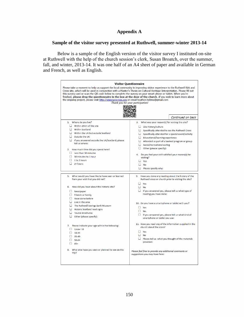
150
Appendix A
Sample of the visitor survey presented at Ruthwell, summer-winter 2013-14
Below is a sample of the English version of the visitor survey I instituted on-site
at Ruthwell with the help of the church session’s clerk, Susan Broatch, over the summer,
fall, and winter, 2013-14. It was one half of an A4 sheet of paper and available in German
and French, as well as English.
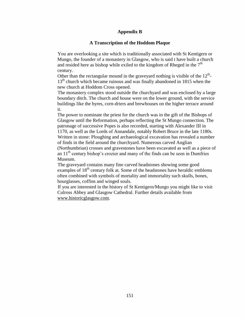
151
Appendix B
A Transcription of the Hoddom Plaque
You are overlooking a site which is traditionally associated with St Kentigern or
Mungo, the founder of a monastery in Glasgow, who is said t have built a church
and resided here as bishop while exiled to the kingdom of Rheged in the 7th
century.
Other than the rectangular mound in the graveyard nothing is visible of the 12th
-
13th
church which became ruinous and was finally abandoned in 1815 when the
new church at Hoddom Cross opened.
The monastery complex stood outside the churchyard and was enclosed by a large
boundary ditch. The church and house were on the lower ground, with the service
buildings like the byres, corn-driers and brewhouses on the higher terrace around
it.
The power to nominate the priest for the church was in the gift of the Bishops of
Glasgow until the Reformation, perhaps reflecting the St Mungo connection. The
patronage of successive Popes is also recorded, starting with Alexander III in
1170, as well as the Lords of Annandale, notably Robert Bruce in the late 1180s.
Written in stone: Ploughing and archaeological excavation has revealed a number
of finds in the field around the churchyard. Numerous carved Anglian
(Northumbrian) crosses and gravestones have been excavated as well as a piece of
an 11th
century bishop’s crozier and many of the finds can be seen in Dumfries
Museum.
The graveyard contains many fine carved headstones showing some good
examples of 18th
century folk at. Some of the headstones have heraldic emblems
often combined with symbols of mortality and immortality such skulls, bones,
hourglasses, coffins and winged souls.
If you are interested in the history of St Kentigern/Mungo you might like to visit
Culross Abbey and Glasgow Cathedral. Further details available from
www.historicglasgow.com.

![Chapter 8. Criteria Querieselearning.kocw.net/KOCW/document/2016/hanbat/kimyoungchan/9.pdf · [java] Track: "Video Killed the Radio Star" (The Buggles) 00:03:49, from VHS Videocassette](https://img.pdfslide.us/doc/110x75/5eaac2dd4b613b277b6ace63/chapter-8-criteria-java-track-video-killed-the-radio-star-the-buggles.jpg)