Embed Size (px)
Citation preview

Expedition 379T Preliminary Report
Page 1 of 109
Expedition 379T Preliminary Report
Digging Deeper with the JR100: Extending high
resolution paleoclimate records from the Chilean
Margin to the Eemian
20 July–18 August 2019
Samantha Bova, Yair Rosenthal, Laurel Childress,
and
Expedition 379T Scientists

Expedition 379T
Preliminary Report
Page 2 of 109
Table of Contents
Expedition Participants ........................................................................................................................ 5
Abstract ...................................................................................................................................................... 6
Introduction.............................................................................................................................................. 7
Oceanographic Setting...................................................................................................................................... 9
Motivation for coring the Chilean Margin .............................................................................................. 10 Investigating (sub)millennial-scale climate variability along the Chilean Margin and its relation to equatorial Pacific and Northern Hemisphere climate ........................................................................................................ 11 Evaluating the sensitivity of the Patagonia icefields to regional and global climate change ........................... 13 Assessing the density structure of the southeast Pacific during the LGM................................................................. 15
Specific scientific objectives ........................................................................................................................ 16
Specific outreach and education objectives .......................................................................................... 16
J1001 Site Summary ............................................................................................................................. 17
Background and Objectives ......................................................................................................................... 17
Operations ......................................................................................................................................................... 19 Hole J1001A ............................................................................................................................................................................................. 19 Hole J1001B ............................................................................................................................................................................................. 20 Hole J1001C ............................................................................................................................................................................................. 20 Hole J1001D ............................................................................................................................................................................................. 21 Hole J1001E ............................................................................................................................................................................................. 21
Principal results .............................................................................................................................................. 22
J1002 Site Summary ............................................................................................................................. 27
Background and Objectives ......................................................................................................................... 27
Operations ......................................................................................................................................................... 28 Hole J1002A ............................................................................................................................................................................................. 28 Hole J1002B ............................................................................................................................................................................................. 29 Hole J1002C ............................................................................................................................................................................................. 29
Principal results .............................................................................................................................................. 30
J1003 Site Summary ............................................................................................................................. 35
Background and Objectives ......................................................................................................................... 35
Operations ......................................................................................................................................................... 36 Hole J1003A ............................................................................................................................................................................................. 36 Hole J1003B ............................................................................................................................................................................................. 37
Principal results .............................................................................................................................................. 38
J1004 Site Summary ............................................................................................................................. 42
Background and Objectives ......................................................................................................................... 42
Operations ......................................................................................................................................................... 43 Hole J1004A ............................................................................................................................................................................................. 43 Hole J1004B ............................................................................................................................................................................................. 44 Hole J1004C ............................................................................................................................................................................................. 45

Expedition 379T
Preliminary Report
Page 3 of 109
Principal results .............................................................................................................................................. 45
J1005 Site Summary ............................................................................................................................. 49
Background and Objectives ......................................................................................................................... 49
Operations ......................................................................................................................................................... 50 Hole J1005A ............................................................................................................................................................................................. 51 Hole J1005B ............................................................................................................................................................................................. 51 Hole J1005C ............................................................................................................................................................................................. 52
Principal results .............................................................................................................................................. 52
J1006 Site Summary ............................................................................................................................. 57
Background and Objectives ......................................................................................................................... 57
Operations ......................................................................................................................................................... 58 Hole J1006A ............................................................................................................................................................................................. 58 Hole J1006B ............................................................................................................................................................................................. 59 Hole J1006C ............................................................................................................................................................................................. 59
Principal results .............................................................................................................................................. 60
J1007 Site Summary ............................................................................................................................. 64
Background and Objectives ......................................................................................................................... 64
Operations ......................................................................................................................................................... 65 Hole J1007A ............................................................................................................................................................................................. 65 Hole J1007B ............................................................................................................................................................................................. 66 Hole J1007C ............................................................................................................................................................................................. 66
Principal results .............................................................................................................................................. 67
J1008 Site Summary ............................................................................................................................. 71
Background and Objectives ......................................................................................................................... 71
Operations ......................................................................................................................................................... 72 Hole J1008A ............................................................................................................................................................................................. 72 Hole J1008B ............................................................................................................................................................................................. 73 Hole J1008C ............................................................................................................................................................................................. 73
Principal results .............................................................................................................................................. 73
Tables and Figures ............................................................................................................................... 79
References ............................................................................................................................................... 99

Expedition 379T
Preliminary Report
Page 4 of 109
Table of Figures: Figure F1. Map of sites cored during Expediton 379T/JR100. _______________________________________________________ 80 Figure F2. Water mass cross section with coring locations. _________________________________________________________ 81 Figure F3. Summary of coring operations and temporal resolution of Expedition 379T/JR100 core sites. ________ 82 Figure F4. Location map of Sites J1001, J1002, J1003, and J1004. ___________________________________________________ 83 Figure F5. Summary of Site J1001 results. ____________________________________________________________________________ 84 Figure F6. Age-depth plot for Site J1001. _____________________________________________________________________________ 85 Figure F7. Summary of Site J1002 results. ____________________________________________________________________________ 86 Figure F8. Summary of J1003 results. _________________________________________________________________________________ 87 Figure F9. Seismic Line near site J1003 showing prominent bottom seismic reflector. _____________________________ 88 Figure F10. Summary of J1004 results. _______________________________________________________________________________ 89 Figure F11. Location map of Sites J1005 and J1006. _________________________________________________________________ 90 Figure F12. Digital parasound data used to target sites J1005 and J1006. _________________________________________ 91 Figure F13. Summary of J1005 results. _______________________________________________________________________________ 92 Figure F14. Summary of J1006 results. _______________________________________________________________________________ 93 Figure F15. Location map of Sites J1007 and J1008. _________________________________________________________________ 94 Figure F16. Summary of J1007 results. _______________________________________________________________________________ 95 Figure F17. Summary of J1008 results. _______________________________________________________________________________ 96 Figure F18. Age-depth plot for Site J1008. ____________________________________________________________________________ 97 Figure F19. Headspace methane concentrations at all eight sites cored during Expedition 379T. ________________ 98

Expedition 379T
Preliminary Report
Page 5 of 109
Expedition Participants Co-chiefs:
• Samantha Bova (postdoc, Rutgers, USA; [email protected]) • Yair Rosenthal (professor, Rutgers, USA; [email protected])
Expedition Project Manager: • Laurel Childress (JRSO/TAMU, USA; [email protected]) • Emily Estes (JRSO/TAMU, USA; [email protected])
Sedimentologists: • Ivano Aiello (professor, Moss Landing Marine Labs, USA; [email protected]) • Hailey Riechelson (graduate student, Rutgers, USA; [email protected]) • Chen Li (graduate student, Tongji U., China; [email protected]) • Mark Yu (graduate student, Rutgers, USA; [email protected]) • Julia Hagemann (graduate student, AWI, Germany; [email protected]) • Beryl DeLong (graduate student, UCSC, USA; [email protected]) • Sarah McGrath (graduate student, Brown, USA; [email protected]) • Vincent Clementi (graduate student, Rutgers, USA; [email protected]) • Alejandro Avila (Lab Technician, U. of Concepcion, Chile; [email protected]) • Yusuke Yokoyama (U. of Tokyo, Japan; [email protected]) • Steve Goldstein (professor, LDEO, USA; [email protected])
Stratigraphic Correlation: • Jim Wright (professor, Rutgers, USA; [email protected]) • Chris Charles (professor, UCSD-SIO, USA; [email protected])
Physical Properties: • Jonathan Lambert (graduate student, LDEO, USA; [email protected]) • Xiaojing Du (graduate student, U. of Michigan, USA; [email protected]) • Anya Hess (graduate student, Rutgers, USA; [email protected]) • Shawn Taylor (graduate student, SUNY Binghamton, USA; [email protected])
Inorganic geochemists: • Anson Cheung (graduate student, Brown, USA; [email protected]) • Adam Sproson (postdoc, U. of Tokyo, Japan; [email protected]) • Yael Kiro (professor, Weizmann Institute, IL; [email protected] or
[email protected]) • Laura Haynes (postdoc, Rutgers, USA, [email protected])
Organic geochemists: • William Longo (postdoc, WHOI, USA; [email protected]) • Becky Robinson (professor, URI, USA; [email protected])
Micropaleontologists: • Diatoms: Isabel Dove (graduate student, URI; [email protected]) • Nannofossils: John Sarao (graduate student, TAMU, USA; [email protected]) • Foraminifers: Minda Monteagudo (graduate student, Georgia Tech, USA;
[email protected]), Nil Irvali (postdoc, U. of Bergen, Norway; [email protected]) Paleomagnetics:
• Rob Hatfield (professor, UFl, USA; [email protected]) • Cristina Garcia Lasanta (Research Scientist, Western Washington Univ., USA;
[email protected]) Apprentice marine techs:
• Anna Golub (undergraduate student, Lafayette, USA; [email protected]) • William Biggs (undergraduate student, Rutgers, USA; [email protected])
Chilean Observer: • Ursula Fuentes (SHOA, Chile; [email protected])

Expedition 379T
Preliminary Report
Page 6 of 109
Abstract Expedition 379T of the D/V JOIDES Resolution was the first in the new NSF funded JR100
program, intended to provide the US paleoceanographic community a new way for recovering
long sediment records (up to 100 meters below seafloor) outside of the IODP program. As such,
it bridges between the conventional coring capability on UNOLS ships and the deep sea drilling
program. The primary objective of the expedition was to investigate links between
oceanographic changes at the northern margin of the Antarctic Circumpolar Current and climate
variability on the South American continent over the past few glacial-interglacial cycles, with a
special emphasis on obtaining high-resolution records of the Eemian interval and the last two
glacial terminations. Given very high sedimentation rates along the Chilean margins, the new
cores will enable reconstruction of surface and intermediate water variability at centennial-to-
millennial resolution, which will extend available records from previous coring expeditions
(ODP Expedition 202), thus permitting comparison of Southern Hemisphere records of the
Holocene and last interglacial (LIG- Eemian), terminations I and II, and the MIS 5e-5d glacial
inception.
Eight sites were cored during Expedition 379T, recovering a total of 2232 m of sediment
cores in 670–3055 m water depth with an average recovery of 101.8% during 14.62 days of on-
site operations (Table T1). Despite delayed departure at Punta Arenas and several bad weather
days that prevented us from coring some of the planned sites, we have achieved almost all the
expedition objectives. The eight sites extend over a wide latitudinal distance (46-36°S) covering
the modern transition from the Antarctic subpolar to the subtropical zones (Figure F1) as well as
spanning water depths intersecting the Antarctic Intermediate Water (AAIW), Pacific Deep
Water (PDW) and Circumpolar deep water (CPDW) water masses (Figure F2). Six of the sites
are located on the Chilean margins at intermediate water depths (670-1534 mbsl) and the other

Expedition 379T
Preliminary Report
Page 7 of 109
two sites are situated in deep water off the shelf (2032 and 3055 mbsl). Three holes were APC
cored in all but one site (J1003 has only two holes) allowing for compositing complete splices
for paleoceanographic reconstructions (Figure F3). Shipboard analyses of the sediment cores
included determining properties including magnetic susceptibility (MS), gamma ray attenuation
(GRA), natural gamma radiation (NGR), visual description and imaging, paleomagnetic
measurements, and micropaleontology (foraminifers, nannofossil and diatoms). Low-resolution
(1 per core) interstitial water samples were collected for shipboard elemental analysis at each
site. In addition, high-resolution interstitial water samples (1 per section) were collected at each
site for further shore-based isotopic and elemental investigations totaling 472 IW samples.
Of the 30 science-party members we had 15 graduate students and 7 postdocs, assisted by 6
senior scientists. All members of the science-party were trained in and carried out the shipboard
analyses, and contributed to the interpretations and report writing. We adopted the report format
used on IODP expeditions to ensure future users of the cores have all the necessary information
to interpret the wealth of data collected onboard; we recommend that this be done on future
JR100 expeditions. Finally, two undergraduate students were trained by the technical staff, and
two Chilean observers both fully participated in the shipboard analyses. It is our opinion that the
educational component is another important strength of the JR100 program.
Introduction The southeast Pacific is a complex and climatically important region. It is home to the largest
temperate ice masses in the SH, the Northern and Southern Patagonia Icefields (NPI, SPI), which
contribute a disproportionate amount to modern sea level rise relative to other mountain glaciers
(Rignot et al., 2003; Glasser et al., 2011). Icefield loss is expected to continue into the future;
global climate model simulations with double CO2 predict a 2 to 4°C increase in regional air

Expedition 379T
Preliminary Report
Page 8 of 109
temperatures by 2030-2050 and a decrease in precipitation (Carrasco et al., 2002; Vera et al.,
2006; Cabre et al., 2010). The climate impacts of future ice loss from the Patagonia icefield
remain uncertain, but will likely lead to significant variations in this region of the SH (Glasser et
al., 2016), with potential implications to ocean circulation and the global climate.
Surface ocean conditions in the southeast Pacific exert primary control on southern South
American climate and impact many other parts of the globe via oceanic and atmospheric
teleconnections. Strong latitudinal gradients in sea surface temperature (SST) and sea surface
salinity (SSS) (Figure F1) impact the strength and position of the Southern Westerly Winds
(SWWs), which are linked to key modes of variability such as the Southern Annular Mode
(SAM) and the El Niño Southern Oscillation (ENSO) (e.g. Hall and Visbek, 2002). SWWs
variability driven by these mode changes or by large-scale shifts in global climate background
state have far-reaching consequences for many climate modulators, including the strength of the
Atlantic Meridional Overturning Circulation (AMOC) (Toggwelier and Samuels 1993; 1995,
Russell et al., 2006a; 2006b; Sijp and England 2009), Southern Ocean stratification affecting the
deep ocean carbon storage and hence atmospheric pCO2 (e.g. Toggweiler et al., 2006, Anderson
et al., 2009), pole-to-equator heat transport and interior ocean heat storage (Kalansky et al., 2015,
Roemmich et al., 2015; Rosenthal et al., 2013, 2017) and nutrient supply to the equatorial
regions (e.g. Hayes et al., 2011). The SWWs are also largely responsible for precipitation
patterns on the western side of the Andes; north-south precipitation gradients are severe in
southern South America transitioning from a semi-arid, winter-rain climate in central Chile to
persistent hyper-humid conditions in the fjord region of southern Chile (Garreaud, 2007).
Rainfall and meltwater fluxes along the southern Chilean Margin may impact the temperature
and salinity of key subsurface water masses Subantarctic Mode Water (SAMW) and Antarctic
Expedition 379T
Preliminary Report
Page 9 of 109
Intermediate Water (AAIW) form from surface waters in the southeast Pacific and are
responsible for ventilating the low latitude thermocline (Bostock et al., 2010; 2013). Change in
their buoyancy via surface temperature and salinity variations in their formation zones will
therefore lead to changes to the strength of upper ocean vertical stratification across vast areas of
the global ocean (Bova et al., 2015; 2018 Schmidtko and Johnson, 2012; Graham et al., 2011). In
turn, these changes can alter the ability of the ocean to sequester heat and carbon in the
subsurface and thus to mitigate future climate change (Bova et al., 2015, Kalansky et al., 2015;
Rosenthal et al., 2013, 2017, Schmidtko and Johnson, 2012; Umling and Thunnell, 2017).
Periods of apparent high variability in these water masses detected in the eastern equatorial
Pacific (EEP) during the Holocene have been attributed to strong eddy activity (Bova et al.,
2016), but could also be explained by large influxes of freshwater to the surface ocean in the
water mass source regions.
Extending over a large latitudinal gradient, the Chilean Margin is an ideal location to study
variations in regional climate, expressed by changes in sea surface temperature and salinity as
related to shifts in the position of the SWWs and its effects on regional precipitation and glacial
stability (Figure F1). Additionally, the water depths of the cores collected during the expedition
intersect the main water masses (Figure F2), which will allow us to assess the links between
surface processes and changes in intermediate and deep water circulation and their extratropical
effects.
Oceanographic Setting
Sediment cores were collected along the Chilean Margin near the northern boundary of the
Antarctic Circumpolar Current (ACC). The ACC is a key oceanographic feature that connects
the ocean basins of the southern hemisphere and plays an important role in regional and global

Expedition 379T
Preliminary Report
Page 10 of 109
climate. The ACC migrates seasonally, moving between ~50°S in summer and ~40-45°S in
winter, following the N-S migration of the Southern Westerly Winds. At present, the ACC
bifurcates at ~46°S sending Subantarctic surface water north via the Peru-Chile Current and
south via the Cape Horn Current, which continues through the Drake Passage. This circulation
sets up a series of sea surface fronts along the Chilean Margin characterized by strong latitudinal
gradients in sea surface temperature (SST) and sea surface salinity (SSS), including the Polar,
Subantarctic, and Subtropical Fronts located at 58°, 56°, and 35°S, respectively. The eight sites
collected during the expedition are located between ~46 and 36°S and span the region between
the ACC and the Subtropical Front (Figure F1).
Beneath the surface waters, the southeast Pacific is characterized by interweaving layers of
northern and southern sourced waters characterized by relatively low and high oxygen levels,
respectively. Just beneath the surface layer, the Gunther Undercurrent (GUC) flows poleward
between ~100 and 400 m water, carrying low oxygen equatorial sourced water poleward. From
400 to 1200 m water depth, Antarctic Intermediate Water (AAIW) carries well-oxygenated
Subantarctic surface waters equatorward. Beneath AAIW, we find another northern sourced low-
oxygen water mass, Pacific Deep Water (PDW) and finally Circumpolar Deep Water occurs
below ~2500 m water depth. The eight sites collected during the expedition intersect three of
these water masses: AAIW, PDW, and CPDW (Figure F2).
Motivation for coring the Chilean Margin
Paleoceanographic records from previous coring cruises to the Chilean Margin have uniquely
contributed to our understanding of SH climate because they provide exceptional time resolution,
not captured at most SH locations. However, the records from these cores are limited; while the
exceptionally high sedimentation rates along the Chilean Margin provide excellent temporal

Expedition 379T
Preliminary Report
Page 11 of 109
resolution, this comes at the expense of record length and foraminifer abundances. The JR100
provided the unique opportunity to capitalize on these “limitations”. By coring multiple 100 m-
long holes with the JOIDES Resolution at each location we obtained records ranging from ~15 to
800 ka, while maximizing foraminiferal abundances to enable stable isotope and trace metal
studies so far not possible with single hole piston coring in this region. Sites targeted during the
expedition lie between 36 and 46°S near the northern margin of the ACC and SWWs belt, mostly
south of those collected during ODP Leg 202 and north of those collected on IODP Leg 383.
These sites will allow us to address the following research themes.
Investigating (sub)millennial-scale climate variability along the Chilean Margin and its relation to equatorial Pacific and Northern Hemisphere climate
One of the primary findings from ODP Leg 202 is the clear Antarctic timing in sea surface
conditions along the Chilean Margin over the last 70 ky (Lamy et al., 2004; Kaiser et al., 2005;
2008; Caniupan et al., 2011). High sedimentation rates combined with excellent age control
enabled millennial- and even centennial-scale direct comparisons to high latitude ice core
records. Prior to ODP Leg 202, SH climate was considered an important global climate
modulator on orbital timescales but millennial-scale climate variability was attributed almost
exclusively to Northern Hemisphere (NH) ice sheet instabilities (e.g. Clark et al., 1999) and the
associated impacts on the AMOC (Ganopolski and Rahmstorf, 2001; Clark et al., 2002;
McManus et al., 2004). Results from Chilean Margin sediment core archives changed this view
by providing some of the first and best evidence for millennial-scale climate change originating
from the south.
Sediment cores from the southeast Pacific also demonstrate a close coupling between surface
waters and subsurface mode / intermediate waters on millennial to centennial timescales. Euler

Expedition 379T
Preliminary Report
Page 12 of 109
and Ninnemann (2010) find that SSTs at 41°S covary with temperatures at 851 m, within the
heart of AAIW, over the past 1300 yr. The magnitude of the observed subsurface variability,
though smaller than at the surface, suggests southeast Pacific surface anomalies can be
transferred into the subsurface far faster than previously anticipated. Oxygenation and preformed
nutrient content of these water masses are also highly sensitive to Subantarctic surface ocean
conditions and Antarctic climate (Martinez et al., 2006; Robinson et al., 2007; Muratli et al.,
2010b; De Pol-Holz et al., 2007). Finally, Robinson et al. (2007) found that denitrification rates
in the southeast Pacific are in phase with Antarctic temperatures based on bulk sediment 15N
records. This finding is supported by a subsequent study using redox sensitive metal
concentrations at intermediate depths (Muratli et al., 2010b).
Oceanographic conditions along the Chilean Margin are not only sensitive to Southern
Ocean climate variability but also effectively communicate these climate anomalies through
ocean tunneling and/or via their impact on atmospheric circulation (Liu and Alexander, 2007). A
clear correspondence to Antarctic climate can be seen in Eastern Equatorial Pacific (EEP) Mg/Ca
sea surface temperature estimates over at least the last 275 ky (Pena et al., 2008; Lea et al.,
2006). Thermocline and intermediate depth temperature estimates are in phase with Antarctic
temperature change (Bova et al., unpublished; 2015; Moffa-Sanchez et al. 2019), with the
earliest and largest increases occurring at 1000 m depth before propagating up towards the
surface ocean (Bova et al., 2015). Furthermore, thermocline carbon isotopes in the EEP
(Shackleton and Pisias, 1985; Spero and Lea, 2002; Pena et al., 2008) and equatorial Atlantic
(Curry and Crowley, 1987) exhibit strong isotopic minima during Antarctic warm events of the
last ~300 ky that can be directly correlated to surface records from the Subantarctic Pacific
(Ninnemann and Charles, 1997). The most likely conduit for transporting high latitude change

Expedition 379T
Preliminary Report
Page 13 of 109
into the EEP are Southern Ocean mode and intermediate waters, which form from surface waters
in the southeast Pacific, just south of our proposed coring region and propagate northward.
Change in their buoyancy via surface temperature and salinity variations along the Chilean
Margin will therefore lead to changes to the strength of upper ocean vertical stratification that
may feedback to local tropical dynamics (i.e. ENSO) on orbital and perhaps shorter timescales in
intriguing ways (Pena et al., 2008).
Although we have excellent sub-millennial-scale records of the surface ocean in the southeast
Pacific during the Holocene and last deglaciation (i.e. Lamy et al., 2001; 2002; 2004; 2010; Siani
et al., 2010; Muralti et al., 2010a; Caniupan et al., 2011; Mohtadi et al., 2008; Robinson et al.,
2009; Kim et al., 2002; Euler and Ninnemann, 2010; Collins et al., 2019), many important
questions cannot be addressed with this material because the records are short and limited by
foraminiferal abundances (Hebbeln et al., 2001; Mix et al., 2002; 2003; Kissel et al., 2007).
High-resolution records of subsurface waters are particularly limited due to low benthic
foraminifer abundances. It is therefore difficult to assess the role of the oceanic tunneling system
in driving change in the equatorial Pacific even during the last deglaciation, let alone termination
II and the MIS 5e to 5d transition. An outstanding question remains as to whether meltwater
input from the Patagonia Icefields during deglaciations impacts the buoyancy of SAMW and
AAIW. High resolution records from the EEP are available but we lack surface and subsurface
records from the southeast Pacific at adequate resolution for comparison (e.g. Pena et al., 2008).
Evaluating the sensitivity of the Patagonia icefields to regional and global climate change
Previous work on land (Lowell et al., 1995; Denton et al., 1999; Moreno et al., 2001; 2015;
Shakun et al., 2015; Bendle et al, 2019), in the fjord systems (Bertrand et al., 2012a; 2012b), and
using marine sediment records document chronologically well-constrained PIS meltwater events

Expedition 379T
Preliminary Report
Page 14 of 109
during the last deglaciation and Holocene. Most importantly, they show that conditions over
Patagonia during the last deglaciation and Holocene are in phase with offshore SSTs and thus
Antarctic climate (Kim et al., 2002; Lamy et al., 2001; 2004; 2010; Pisias et al., 2006; Kaiser et
al., 2005; 2007; 2008). This is shown most vividly by comparing marine SST records with
records of vegetative change and weathering intensity on land. Pollen records indicate systematic
latitudinal shifts in the zones of cool, mesic rainforests and warm, xeric vegetation in response to
north-south movement of offshore frontal systems and associated shifts in the SWWs (Heusser et
al., 2006; Kaiser et al., 2008). Grain size, clay mineralogy, and sediment geochemistry analyses
of margin sediments indicate large changes in provenance and weathering intensity on the
continent in phase with Antarctic ice core temperature records. These sedimentological changes
are likely related to rainfall (aka the intensity and position of the SWWs) and/or fluctuations in
the size and extent of the PIS (Lamy et al., 1998; 2001; 2002; 2004; 2010; Kaiser et al., 2007;
Muratli et al., 2010a; Siani et al., 2010; Chase et al., 2014). Finally, foraminifer trace metal ratios
are also sensitive to freshwater discharge; Rosenthal reconstructed the sea surface conditions
during the last millennium from a high-resolution core MD07-3094, recovered at the same
location as J1004, using Mg/Ca in N. incompta as a temperature proxy and Ba/Ca and Nd/Ca as
proxies of riverine discharge to the coastal zone (Rosenthal – unpublished data). The records
show a strong covariance between the hydrologic proxies (Ba/Ca and Nd/Ca), Mg/Ca-derived
SST and the reconstruction of terrestrial temperature in southern Chile (PAGES 2k, 2013) all
exhibiting a different pattern from the NH temperature reconstruction (Mann et al., 2008). This
suggests high-sensitivity of the Patagonia glaciers to the regional climate conditions, although at
this point we cannot rule out that changes in rainfall are the cause. Furthermore, although the
Holocene is presently our only example for interglacial conditions along the Chilean Margin,

Expedition 379T
Preliminary Report
Page 15 of 109
many studies find it is unique among past interglacials possibly due to anthropogenic affects (e.g.
Ruddiman, 2003).
Assessing the density structure of the southeast Pacific during the LGM
It has been three decades since the potential role of the polar ocean in controlling
atmospheric CO2 and thus global climate has been highlighted using simple model studies (Knox
and and McElroy, 1984; Sarmiento and Toggweiler, 1984; Siegenthaler and Wenk, 1984), but
the mechanisms behind it are still debated. Paleoceanographic records show strong synchroneity
in climate variability in the EEP and in Antarctica and the Southern Ocean suggesting that the
region plays a key role in both glacial inception and decay processes (e.g. Knorr and Lohmann,
2003; Anderson et al., 2009; Shakun et la., 2012; Adkins et al., 2013; Ferrari et al., 2014).
However, this coupling cannot be explained solely by the radiative effect of CO2 because
Southern Ocean and EEP SST lead the change in atmospheric CO2 during glacial inception (e.g.
MIS 5e-5d) and terminations (e.g. Terminations I and II). Nevertheless, it has been suggested
that cooling of Antarctic surface water might have contributed to establishing glacial climates by
regulating the carbon uptake and storage capabilities of the deep ocean (Adkins et al., 2013;
Ferrari et al., 2014). Pore water [Cl-] and 18O combined with benthic foraminifer 18O data from
the South Atlantic imply a stark change in deep water temperature and salinity properties that
indicate Antarctic Bottom Water (AABW) was volumetrically expanded, colder, saltier and more
isolated during the LGM relative to today (Adkins et al., 2002). Whether driven by equatorward
movement of the permanent sea ice edge as suggested by Ferrari et al., (2014) or the temperature
of upwelled deep water around the coast of Antarctica (Adkins et al., 2013), this configuration
would act to draw down CO2 from the atmosphere and cool climate globally. However, it
remains to be determined if the LGM stratification documented in the South Atlantic was also a

Expedition 379T
Preliminary Report
Page 16 of 109
feature of the South Pacific, reflecting a fundamentally different mode of deep ocean circulation
than today, and what processes caused the reversal to interglacial circulation and the termination
of glacial conditions.
Specific scientific objectives
The objectives of the JR100-Expedition 379T include the following:
• Evaluate the sensitivity of the Patagonia icefield to regional and global climate change
under different climate background conditions. For example, Holocene vs. Eemian
climate records will highlight the icefield sensitivity to differences in orbital
configuration and possible anthropogenic effects in the late Holocene.
• Reconstruct the evolution of sea surface temperature and salinity along the Chilean
Margin and the impact of SWW variations and Patagonia icefield melt on regional
surface ocean conditions
• Examine the impact of Southeast Pacific surface ocean temperature and salinity change
on Southern Ocean intermediate water structure and dynamics.
• Document variations in intermediate and deep-water temperatures, heat content, and
carbonate chemistry over the late Pleistocene glacial interglacial cycles
• Assess the links between southeast Pacific and equatorial Pacific climate change on
millennial and orbital time scales and their relation to Northern Hemisphere records.
• Determine the density structure of the southeast Pacific Ocean during the LGM relative
to the south Atlantic.
Specific outreach and education objectives
The objectives of the JR100 expedition include the following:
• Provide early career participants seagoing experience and training in making and
interpreting standard shipboard analyses

Expedition 379T
Preliminary Report
Page 17 of 109
J1001 Site Summary
Background and Objectives
Site J1001 (proposed site CM-12) is located on the abyssal plane ~130 km offshore the coast
of Chile at 46° 24.3180’S, 77° 19.4499’W and 3067 mbsl (Figure F4). The site is located on a
seismic reflection profile collected during MR16-9 Leg 2 off of the Taitao Peninsula. A 17.53 m
piston core, collected at the site location in 2017, is dominantly composed of dark olive grey to
grey silt- and diatom-bearing clay with some thin silt and sandy layers (Murata et al., 2017). The
upper and lower three meters of the core contain greater abundances of biogenic material, most
likely deposited during interglacial periods, likely the Holocene and last interglacial Marine
Isotope State 5, respectively, implying sedimentation rates of ~15 cm/ky. The seismic record
exhibits well-developed stratification down to at least 100 mbsf.
Site J1001 is located in a tectonically complex region west of the Peru-Chile Trench on
oceanic crust. The trench east of J1001, at 46°S, is intersected by the Chile Rise, an active
spreading center of the Nazca and Antarctic Plates. This intersection, known as the Chile Triple
Junction, is an example of an actively spreading mid-ocean ridge being subducted under
continental lithosphere. Onshore, the Southern Volcanic Zone of the Andes spanning 33 to 46°S,
contains at least 60 active volcanoes, including three giant caldera systems (Stern, 2010).
Numerous historical eruptions have been documented, including recent eruptions in 2010, 2011,
and 2015. The geology on land can be split into two units: the Coastal Range and the Andean
Cordillera. The Coastal Range lies within ~150 km of the coast and is composed of metamorphic
basement, ophiolite, and plutonic rocks with some sedimentary and volcanic units. The Andean
Cordillera lies further inland and is composed predominantly of granites, in many cases overlain

Expedition 379T
Preliminary Report
Page 18 of 109
by volcanic material. The Cordillera lies at altitudes higher than ~3000 km and is covered by
glaciers within the Southern and Northern Patagonia icefield regions.
The climatology and oceanography of southern Chile is strongly influenced by the
seasonal migration of the Southern Westerly Winds and the Southern Polar Front, which move
between ~50°S in summer and 40-45°S in winter. Precipitation in the region is on the order of
3000 mm on the western side of the Andes (Fujiyoshi et al., 1987) and is almost entirely
controlled by the Southern Westerly Winds (Garreaud et al., 2013). Thus, the band of maximum
precipitation also migrates north and south with the seasonal cycle. The oceanography of the
region is dominated by the northernmost extent of the Antarctic Circumpolar Current, which
bifurcates at 45°S and carries Subantarctic surface water into the Cape Horn Current flowing to
the south and the Peru-Chile Current (aka Humboldt Current) flowing to the north. In the
subsurface, Antarctic Intermediate Water flows northward at depths of ~500-1000 m. At 3067
mbsl, the sediment is bathed by Circumpolar Deep Water.
Site J1001 is our southern-most and deepest site, providing the potential to reconstruct
climate variability in the southeast Pacific and Patagonia over multiple glacial-interglacial
cycles. The relatively modest sedimentation rates at Site J1001 of about 12-15 cm/ky means that
this record is temporally the longest record collected during the JR100 expedition. This site will
enable us to reconstruct changes in sea surface conditions and shifts in the sub-Antarctic polar
front zone as well as variations in CPDW physiochemical properties. We expect the site is
sensitive to changes in weathering and erosion in Patagonia and will provide a record of
Patagonia icefield activity over the past ~ 0.8 Myr.

Expedition 379T
Preliminary Report
Page 19 of 109
Operations
Hole locations, water depths, and the number of cores recovered are listed in (Table T1). All
times are local ship time (UTC -03 h) unless otherwise noted. Site J1001 (proposed Site CM-12)
was the first site occupied during Expedition 379T. The plan for Site J1001 was to advanced
piston corer (APC) triple core to ~100 mbsf while using stratigraphic correlation to construct a
complete splice for a 100% record over the 100 m interval. Temperature measurements with the
advanced piston corer temperature tool (APCT-3) were scheduled to be completed on the first
hole.
Hole J1001A
After a 664 nmi transit from Punta Arenas, Chile, averaging 10.5 knots, the ship arrived at
Site J1001 at 1020 h (UTC -03 h) on 28 July 2019. The thrusters were lowered and secured, and
the dynamic positioning system was engaged. At 1106 h the drill floor was cleared for
operations, beginning Hole J1001A. We did not deploy an acoustic positioning beacon, but
prepared one for immediate deployment if required.
The APC bottom-hole assembly (BHA) was made up and deployed. When the BHA reached
650.0 meters below rigfloor (mbrf), operations were halted when vessel motion made operations
on the drill floor too dangerous for personnel and equipment. After a 2.75 h wait, the motions
were sufficiently reduced to resume operations. The drill string was run to 3040.9 mbrf and all
tubulars were strapped (measured) and drifted for an inside diameter check. The top drive was
picked up, and a wiper “pig” was pumped through the drill string. The calculated precision depth
recorder (PDR) depth for the site was 3066.4 mbrf. Based on the PDR, 3061.0 mbrf was selected
as the shoot depth for the first core. A non-magnetic core barrel was run to bottom and the first
attempt at spudding Site J1001 resulted in a water core. The bit was lowered 5 m to 3066.0 mbrf

Expedition 379T
Preliminary Report
Page 20 of 109
and another attempt was made to secure a mudline core. Hole J1001A was spudded at 0420 h on
29 July 2019. Unfortunately, this attempt resulted in 9.66 m of core recovered with no evidence
of a mudline thus, Hole J1001A was terminated.
Hole J1001B
After moving the vessel 20 m east, the drill pipe was spaced out to 3063.5 mbrf and Hole
J1001B was spudded at 0545 h on 29 July. Non-magnetic core barrels were used for all cores
and temperature measurements were taken with the APCT-3 on Cores J1001B-4H, 6H, 8H and
10H with mixed results due to high vessel heave. Coring continued through Core J1001B-10H to
a depth of 91.2 meters below seafloor (mbsf) when the coring line parted. The coring line was
pulled back to the surface and became lodged in the oil saver above the top drive. The coring line
was cut, the damaged piece of wire was removed, and after 7.5 h Core J1001B-10H was
recovered. Hole J1001B was terminated at 100.7 mbsf with Core J1001B-11H, recovering a total
of 101.25 m of sediment (101%). Hole J1001B ended at 0300 h on 30 July 2019 after clearing
the seafloor and the vessel was offset 20 m south to begin Hole J1001C.
Hole J1001C
The drill string was spaced out to 3062.0 mbrf and the first attempt to spud Hole J1001C
resulted in an empty core barrel. The bit was lowered 1 m to 3063.0 mbrf and another attempt
was made to secure a mudline core. Hole J1001C was spudded at 0515 h on 30 July 2019. The
mudline core recovered 4.56 m of sediment and sea floor was calculated to be 3068.0 mbrf. Non-
magnetic core barrels were used for APC coring and coring continued through Core J1001C-12H
to a depth of 102.5 mbsf. The bit was tripped back and cleared the seafloor at 1615 h ending
Hole J1001C. There was one drilled interval of 3.0 m from 23.5-26.5 mbsf for stratigraphic
correlation purposes, resulting in 99.5 m of cored sediments and recovery of 102.61 m of

Expedition 379T
Preliminary Report
Page 21 of 109
sediment (103%). Hole J1001C ended at 1615 h on 30 July, the vessel was offset 20 m to the
west.
Hole J1001D
At Hole J1001D the drill pipe was spaced out to 3064.5 mbrf in an attempt to recover at least
7.5 m of core for stratigraphic correlation of the splice. Hole J1001D was spudded at 1715 h on
30 July, however the mudline core recovered was only 6.13 m and Hole J1001D was abandoned
after failing to recover a mudline core >7.5 m long.
Hole J1001E
After clearing the seafloor from Hole J1001D at 1715 h on 30 July, the vessel was
repositioned 20 m west for the start of Hole J1001E. The shoot depth was adjusted to 3065.5
mbrf and Hole J1001E began with a mudline core with 9.48 m recovered. Non-magnetic core
barrels were used for APC coring and coring continued to final depth of 90.9 mbsf. There were
two drilled intervals for correlation of the splice. The first interval drilled was from 18.9 mbsf to
20.90 mbsf. The second drilled interval was from 77.9 mbsf to 81.4 mbsf, again for correlation
of the splice. In Hole J1001E 87.76 m of sediment were recovered through 85.4 m of cored
interval (103%). At 1200 h on 31 July the drill floor was secured ending Hole J1001E and Site
J1001.
A total of 33 cores were recorded for Site J1001. Only the APC coring system was used, with
a 102.1% recovery over the 301.2 m cored. The five holes at Site J1001 consumed 3.04 days of
expedition time. Of that time, 2.75 hours were lost due to weather related vessel motion and ~7.5
h were lost when the core wire failed.

Expedition 379T
Preliminary Report
Page 22 of 109
Principal results
All depth references in meters in this section refer to the CSF-A depth scale.
The sediment cored at Site J1001 is assigned to a single lithologic unit composed of ~103 m
of middle Pleistocene to recent ash-rich clay with varying amounts of calcareous nannofossils,
diatoms, and silt-sized siliciclastics (Figure F5). A ~20 cm brown ash layer is present at ~8 m
CSF-A. In general, sediments containing larger amounts of biogenic particles are observed in the
upper ~75 m of Site J1001, whereas biogenic particles are less abundant in the lower ~25 m (i.e.,
from ~75 – 100 m) where clay and silt-sized siliciclastics dominate. Nannofossils comprise most
of the observed biogenic particles, while foraminifer tests and diatom frustules are generally
present but sparse. Several of the cores collected at Site J1001 exhibit moderate to severe drilling
disturbance, mainly concentrated in the top sections of the cores.
Planktonic foraminifers, benthic foraminifers, and calcareous nannofossils are present and
generally exhibit excellent preservation throughout the succession at Site J1001. Planktonic
foraminifers are generally more abundant than benthic forms; planktonic/benthic ratios range
from 83:17 to 99:1, except for one sample at ~75 m where benthic foraminifera become more
abundant than planktonics (36:64). The age model for Site J1001 is largely based on calcareous
nannofossil biostratigraphy (Figure F6). At ~54 m, a distinct acme event of Gephyrocapsa sp.
small was noted, corresponding to ~200 ka. The first appearance datum (FAD) of E. huxleyi was
observed at ~63 m and corresponds to the base the NN21 nannofossil biozone. The last
appearance datum (LAD) of Pseudoemiliania lacunosa was identified at ~73.5 m and
corresponds to the top of the NN19 nannofossil biozone. Reticulofenestra asanoi (LAD) was
observed in multiple spot samples between ~92 and 99 m suggesting an age of approximately
875 ka. No older age diagnostic nannofossils were observed through the base of Hole J1001B.
Expedition 379T
Preliminary Report
Page 23 of 109
Diatoms exhibit good to moderate preservation and the flora is dominated by Chaetoceros spp.
vegetative valves and resting spores, which are indicative of productivity associated with
upwelling. Relative abundance of Fragilariopsis kerguelensis, a species associated with the
Antarctic Circumpolar Current (ACC), increases in Samples J1001B-3H-CC, -5H-CC, and
J1001C-9H-2A, possibly indicating northward shifts of the ACC during glacial periods. In
general, planktonic foraminiferal assemblages of these samples were characterized by subpolar
to transitional fauna, such as N. incompta, T. quinqueloba, G. bulloides, G. glutinata and G.
inflata, with the rare occurrence of (usually ≤ 5%) subtropical-tropical species, e.g., Globorotalia
hirsuta, Globorotalia crassaformis and Globorotalia truncatulinoides indicating temperate
conditions. The benthic foraminiferal assemblage is dominated mainly by Cibicidoides
wuellerstorfi, Cibicidoides sp., Melonis pumpiloides, Oridorsalis umbonatus, Pullenia bulloides,
Uvigerina peregrina and Uvigerina sp.
Paleomagnetic investigations on the recovered materials from Site J1001 involved the
measurement of the natural remanent magnetization (NRM) of APC archive-half cores from
Holes J1001A, J1001B, J1001C, J1001D and J1001E before and after alternating field (AF)
demagnetization. The drill string overprint is relatively soft and is effectively removed after AF
demagnetization in a 5–15 mT field. In addition, two discrete samples per core were generally
taken in Sections 3 and 6 (one in Core 379T-J1001B-1H) from Hole J1001B (21 samples) to
more fully characterize the NRM demagnetization behavior and to investigate the rock magnetic
properties of the sediment, including anisotropy of magnetic susceptibility (AMS). Inclination
and declination measured on discrete samples are generally in excellent agreement with those
measured on the archive-half sections. SRM- and discrete-measured inclination plot around the
expected values of -65° for the site latitude assuming the geocentric axial dipole (GAD) field

Expedition 379T
Preliminary Report
Page 24 of 109
model (e.g. Opdyke and Channel, 1996 and references therein). NRM demagnetization behavior
and rock magnetism results are consistent with [titano]magnetite being the primary magnetic
remanence-carrying mineral in sediments deposited at Site J1001. Such conditions are optimal
for the preservation of a paleogeomagnetic signal and for the reconstruction of reliable and
robust paleomagnetic records (e.g. Stoner and St-Onge, 2007).
Inclination values shift from largely negative values to positive values between 90.85 to 91.5
m CSF-A in Hole J1001B and 92.3 to 92.9 m CSF-A in Hole J1001C. This shift is interpreted as
the Matuyama/Brunhes polarity reversal (0.781 Ma) (GPTS; Cande and Kent, 1995). At 29.5 m
CSF-A in Hole J1001B and 29.2 m CSF-A in Hole J1001C a large inclination anomaly
accompanied by large shifts in declination and low NRM intensity values is observed (Figures
J1001-F-F3 and J1001-F-F4). The remarkable repeatability of this inclination, declination, and
intensity anomaly across Holes J1001B and J1001C (Figure J1001-F-F6) and the lack of
evidence that lithologic change or drilling disturbance could be responsible for driving this
variability leads us to conclude that this anomaly reflects an excursion of the geomagnetic field.
This anomaly could be the Iceland Basin excursion (194 ka; Channell et al., 2009), or the Pringle
Falls excursion (211 ka; Channell et al., 2009). Combining this stratigraphic point with the
nannofossils biohorizon ages suggest > 10 cm/ky sedimentation rates in the upper ~ 75 meters of
the core decreasing to < 10 cm/ky in the deeper part of the core (Figure F6).
The physical property data collected for Site J1001 includes gamma ray attenuation (GRA)
bulk density, magnetic susceptibility (MS), and natural gamma ray (NGR) counts collected on
whole-round cores and additional measurements on split cores and discrete samples including P-
wave velocity; porosity; thermal conductivity; and bulk, dry, and grain densities. The physical
properties of Site J1001 indicate high frequency variability (decimeter scale) in MS, NGR, and

Expedition 379T
Preliminary Report
Page 25 of 109
bulk density, but do not display obvious long-term trends. Thermal conductivity decreases with
depth, but variability increases, possibly due to small-scale fluctuations between terrigenous,
biogenic, and ash layers in the core, contributing to a heterogeneous lithology. Formation
temperature measurements made with the advanced piston corer temperature tool (APCT-3)
indicate a strong geothermal gradient of 163°C/km for the upper ~100 m CSF-A, consistent with
the young age of the underlying crust.
Despite the unfavorable sea state at the start of Site J1001 operations, a complete
stratigraphic section was recovered from the mudline in Core 379T-J1001D-1H to the base of
Core 379T-J1001C-12H at 107.04 m CCSF-A. Sequences from all holes were composited in
near-real-time using magnetic susceptibility data from the Whole-Round Multisensor Logger
measured at 2.5 cm resolution. Correlation was challenging due to substantial core disturbance,
particularly at the top of Hole 379T-J1001B, resulting from large swell (~ 5 m). In a couple of
instances, guaranteeing complete stratigraphic coverage required the drilling operations to
advance without coring (Table T1; Figure F3). Final compositing in preparation for splice
construction used a combination of magnetic susceptibility data from the WRMSL, NGR (10 cm
resolution), and RGB channels (1–2 cm resolution). The relative depth offset of each core was
determined by the optimized correlation of these 3 variables, with the top of Hole J1001D
serving as the anchor (0 m CCSF). Once the composite depth scale was created, selected
sequences from Holes J1001C and J1001E, with minor contributions from Hole J1001B, were
spliced together to create a complete and representative stratigraphic section. Inspection of the
spliced magnetic susceptibility, RGB, and NGR records demonstrates that the splice-tie
boundaries do not create gaps or repeated intervals within the spliced section. Confidence in the
splice ties is high because of the rich structure of the magnetic susceptibility records.

Expedition 379T
Preliminary Report
Page 26 of 109
We collected 59 interstitial water samples from Hole J1001B (one per section) and mudline
water samples from all holes. We measured routine shipboard analyses on one sample per core
and each mudline sample, totaling 16 samples. The rest of the samples were collected for high-
resolution isotope and chlorinity measurements. Routine shipboard analyses included chloride
(by titration and ion chromatography; IC), alkalinity (by titration), major and minor elements (by
Inductively Coupled Plasma-Optical Emission Spectroscopy; ICP-OES), major cations and
anions (by IC), and ammonium and phosphate (by UV/vis spectrophotometry). Chemical
gradients at this site reflect the influence of microbially mediated oxidation of organic matter,
authigenic mineralization reactions, water-rock interaction related to clay alteration, and
diffusive processes on interstitial water composition.
Methane concentrations were very low (~4 ppmV in Core 1 to 19 ppmV at the base of the
Hole; Figure F19). The presence of methane and the absence of higher molecular weight
hydrocarbon gases indicate that the methane is of biogenic origin.
Calcium carbonate (CaCO3) contents are relatively low, < 15 %, in the upper ~60 m CCSF.
Several intervals with >30 % CaCO3 occur between 56 and 103 m CCSF, but they are
interspersed with sediments containing near zero %CaCO3. The more carbonate bearing
intervals occur in low magnetic susceptibility sediments where RGB color shifts toward high
green and blue, indicating significant lithologic variations, potentially driven by changes in
dilution of biogenic materials by siliciclastic sediment or in surface productivity.

Expedition 379T
Preliminary Report
Page 27 of 109
J1002 Site Summary
Background and Objectives
Site J1002 (proposed Site CM-5) is located at 46° 4.2964’S, 75° 41.2300’W offshore of the
Taitao Peninsula to the east of the Chile Triple Junction on a bench in the continental slope at
1534 m water depth (Figure F4). Acoustic records obtained aboard the R/V Marion Dufresne and
R/V Mirai MR16-09_2 cruise (Frank Lamy – personal communication) demonstrate well-
developed stratification down to 70 mbsf. At present the core is located at the northern extent of
the Antarctic Circumpolar Current (ACC) and thus sensitive to meridional shifts in the location
of the polar fronts. Surface water at this site is influenced by the meltwater flow from the
Patagonia ice sheet as reflected in the relative freshening of the surface at this location (Figure
F1). At depth, the site is situated within the nutrient-rich, northern sourced Pacific deep-water
mass (PDW), characterized by relatively low oxygen content compared with the overlying
Antarctic intermediate water (AAIW) (Figure F2). A 18.9 m piston core collected by the R/V
Marion Dufresne at this site suggests it will provide well-resolved records of glacial erosion from
the NPI as well as PDW temperature and salinity (Kissel & Leau, 2007). The upper 6 m of the
core is composed of olive black to greyish olive diatom and silt-bearing clay. The bottom 12.9 m
of sediment is greyish olive to grey silty clay with numerous silt/sand layers. These silt/sand
layers are unlikely to be turbidite layers (Siani et al., 2010).
At this site, sedimentation was much higher at the end of the last glacial period (>3 m/ky)
relative to the deglaciation and Holocene (0.6 m/ky) reflecting an increase in terrigenous supply
due to (1) closer proximity of the site to land during sea level low stand and (2) enhanced
physical weathering due to the presence of permanent glaciers. Ice-rafted debris is expected
below ~8 m. Site J1002 allows us to investigate variations in the Northern Patagonia ice sheet
Expedition 379T
Preliminary Report
Page 28 of 109
during the last glacial period and Holocene using sedimentological and geochemical proxies. The
core depth intersects PDW and we expect benthic foraminifera will record changes in PDW
water mass properties over this time period.
Operations
Hole locations, water depths, and the number of cores recovered are listed in Table T1. All
times are local ship time (UTC -04 h) unless otherwise noted. Site J1002 (proposed Site CM-05)
was the second site occupied during Expedition 379T (Figure F3). The plan for Site J1002 was to
advanced piston corer (APC) triple core to ~100 mbsf while using stratigraphic correlation to
construct a complete splice for a 100% record over the 100 m interval. Temperature
measurements with the advanced piston corer temperature tool (APCT-3) were scheduled to be
completed on the first hole.
Hole J1002A
After the 71 nautical mile transit from Site J1001 averaging 10.4 knots, the vessel arrived at
Site J1002 at 1830 h (UTC -03h) on 31 July 2019. The thrusters were lowered and secured, the
dynamic positioning system was engaged and at 1908 h, the drill floor was cleared for
operations, beginning Hole J1002A. We did not deploy an acoustic positioning beacon, but
prepared one for immediate deployment if required.
The APC bottom-hole assembly (BHA) was made up and run to 135.62 m. While we waited
on weather two 30’ knobbies were picked up and place on top of the BHA. After 13.5 h, the
weather had subsided sufficiently where the remainder of the drill string could be run. The
calculated precision depth recorder (PDR) depth for the site was 1543.4 mbrf. Based on the PDR,
1538.5 mbrf was selected as the shoot depth for the first core. A non-magnetic core barrel was

Expedition 379T
Preliminary Report
Page 29 of 109
run to bottom and the mudline core (J1002A-1H) recovered 2.15 meters of sediment. The
seafloor was estimated to be 1545.9 mbrf (1534.9 mbsl). Non-magnetic core barrels were used
for all cores and temperature measurements were taken on Cores J1002A-5H, 7H, 9H and 11H
with good results, despite the high vessel heave. Coring continued through Core J1002A-12H to
a depth of 106.6 mbsf. From the 106.6 m cored in Hole J1002A, we recovered 110.95 m of core
(104%). Hole J1002A ended at 0315 h on 2 August 2019 and the vessel was offset 20 m east.
Hole J1002B
The drill pipe was spaced out to 1543.5 mbrf and Hole J1002B was spudded at 0405 h on 2
August. The mudline core (J1002B-1H) recovered 8.89 m of sediment and sea floor was
calculated to be 1544.1 mbrf. Non-magnetic core barrels were used for APC coring. Coring
continued through Core J1002B-7H to a depth of 65.9 mbsf. A routine inspection of the coring
line revealed several broken strands in the wire. Coring was halted and a routine slip and cut of
the coring line was performed, resulting in 1.5 h of productive time lost. After removing 150 m
of coring line and re-terminating the wire rope socket, coring resumed. Coring terminated with
Core J1002B-11H at a final depth of 103.9 mbsf. The bit was tripped back and cleared the
seafloor at 1445 h ending Hole J1002B. From the 103.90 m cored in Hole J1002B, we recovered
110.77 m of core (107%).
Hole J1002C
The vessel was repositioned 20 m south for the start of Hole J1002C. The drill pipe was
spaced out to 1541.0 mbrf and Hole J1002C was spudded at 1550 h on 2 August 2019. The
mudline core (J1002C-1H) recovered 6.9 m of sediment and sea floor was calculated to be
1543.6 mbrf. Non-magnetic core barrels were used for APC coring and coring continued through
Core J1002C-11H to a depth of 101.9 mbsf. During the latter part of Hole J1002C we

Expedition 379T
Preliminary Report
Page 30 of 109
experienced increasing heave and vessel motion (pitch and roll). The bit was tripped back and
cleared the drill floor at 0930 h on 3 August 2019, ending Hole J1002C and Site J1002. From the
101.90 m cored in Hole J1002C, we recovered 108.59 m of core (106%).
A total of 34 cores were recorded for the Site J1002. Only the APC coring system was used,
with 105.6% recovery over the 312.4 m cored. The three holes at Site J1002 consumed 2.64 days
of expedition time. Of that time, 13.5 hours were lost because of weather related vessel motion
and 1.5 h were lost when the core wire had to be slipped and cut (proactively repaired).
Principal results
All depth references in meters in this section refer to the CSF-A depth scale.
The sediment cored at Site J1002 is assigned to a single lithologic unit composed of ~110.89
m of Pleistocene silty clay with sulfide precipitates interspersed throughout and regular thin
layers of silty sand (Figure F7). The dominance of siliciclastics at the site reflects its location
close to the South American continent. Volcanogenic particles are observed, but are usually less
than 7% of the sediment due to the high influx of siliciclastic sediment. Microfossils are present,
mainly in the upper two cores and in a short interval at ~85 m. Within these intervals, the
sediment color is greener than the more common non-biogenic, gray siliciclastics. Among the
biogenic particles, diatoms dominate, but foraminifera, nannofossils, and sponge spicules are
also present in trace amounts. Below ~45 m, clay and silt-sized siliciclastics dominate, except
between 79 – 86 m where the lithology changes to pure clay with occasional nannofossils but no
sulfides. Prominent disturbances occur throughout the core randomly and include slight to heavy
gas expansion, voids, and some up-arching. Bioturbation is slight, with burrows, some of which

Expedition 379T
Preliminary Report
Page 31 of 109
are pyritized. Mineral clasts, which may be ice-rafted debris (IRD), occur in Samples J1002A-
3H-CC and -4H-CC (61% and 58%, respectively),
Planktonic foraminifers, benthic foraminifers, calcareous nannofossils, and siliceous
microfossils are present and show varying levels of preservation from very good to moderate.
Planktonic foraminifers are generally abundant and well preserved. A total of 14 planktonic
species identified. The most abundant planktonic foraminifer species in Hole J1002A were polar
Neogloboquadrina pachyderma (s), subpolar Neogloboquadrina incompta and Turborotalita
quinqueloba, and transitional species such as Globigerina bulloides, Globigerinita glutinata, and
Globorotalia inflata. Calcareous nannofossils are well preserved through Hole J1002A with
abundances ranging from rare to abundant (Figure J1002-E-F1). Biostratigraphic control on Hole
J1002A was limited due to the presence of Emiliania huxleyi throughout the entire sampled
section, denoting an age younger than the E. huxleyi first appearance datum of 0.29 ka. Diatoms
are most abundant in the uppermost section of the core, corresponding to the olive-green,
diatom-rich silty clay interval (see J1002-D-Core Description). The diatom assemblage is
dominated by Chaetoceros subgenus Hyalochaete resting spores and vegetative valves,
indicative of upwelling conditions. Thalassiosira eccentrica and other species of the
Thalassiosira genus are also present. Diatom abundances drop to trace amounts throughout most
of the grey, silty clay interval of the core, but occasionally have moderate abundances. Unlike
Site J1001, warm water species are observed at Site J1002. Fragilariopsis kerguelensis, a species
associated with the Antarctic Circumpolar Current (ACC), is present in trace amounts,
suggesting intermittent influence of the ACC to a lesser degree than that seen at Site J1001. 37
taxa of benthic foraminifera were identified. High abundances of infaunal species in almost all

Expedition 379T
Preliminary Report
Page 32 of 109
core-catcher samples suggest high organic flux and low bottom water oxygen levels through
Hole J1002A.
Paleomagnetic investigations on the recovered materials from Site J1002 involved the
measurement of the natural remanent magnetization (NRM) of APC archive-half cores from
Holes J1002A, J1002B, and J1002C before and after alternating field (AF) demagnetization. In
addition, we generally took two discrete samples per core in Sections 3 and 5 (only one was
taken in Core 379T-J1002A-1H) from Hole J1002A in order to more fully characterize the
magnetic properties of the sediment, including anisotropy of magnetic susceptibility (AMS). In
general, the NRM demagnetization behavior of the discrete samples are in agreement with the
results from rock magnetism and point to a low coercive ferromagnetic mineral (e.g. magnetite
or titanomagnetite) being the main carrier of the NRM in the majority of sediments recovered at
Site J1002. Both SRM- and discrete-measured inclination fall around the values expected for the
site latitude (around -64°) assuming the geocentric axial dipole (GAD) field model (e.g. Opdyke
and Channel, 1996 and references therein). Thus, the majority of the paleomagnetic data appear
stable enough to support magnetostratigraphic investigations but the intervals of low MS and
NRM intensity should be interpreted with caution. Over shorter timescales both inclination and
declination vary over a few tens of degrees suggesting that a paleosecular variation (PSV) record
is preserved in the sediments deposited at Site J1002. We identify three paleomagnetic anomalies
that are consistent across multiple holes and interpret these as excursions of the geomagnetic
field. The deepest of these, E2, has similarities in form and timing to a PSV feature in ODP Site
1233 associated with the Laschamp excursion. Sedimentation rates at Site J1002 appear to be
higher than those recorded at ODP Site 1233, suggesting that the PSV record over the
radiocarbon era may be better resolved at J1002.

Expedition 379T
Preliminary Report
Page 33 of 109
The physical property data collected for Site J1002 includes gamma ray attenuation (GRA)
bulk density, magnetic susceptibility (MS), and natural gamma ray counts (NGR) collected on
whole-round cores and additional measurements on split cores and discrete samples including P-
wave velocity; porosity; thermal conductivity; and bulk, dry, and grain densities. Due to high gas
content, cracks and voids are very common in all the three holes at Site J1002 (except for Cores
J1002B-1H and 2H), causing anomalously low values of GRA, MS, and NGR. Nevertheless, the
MS record shows real (not caused by cracks or voids), high-frequency and high-amplitude
variability (decimeter-scale) throughout the record except for a low MS interval observed in all
holes from ~80 to ~90 m CSF-A. The downhole NGR record also shows decimeter-scale
variability, but varies inversely with MS (Figure F7). Formation temperature measurements
made with the advanced piston corer temperature tool (APCT-3) indicate a strong geothermal
gradient of 116°C/km for the upper ~100 m CSF-A, consistent with the young age of the
underlying crust.
Tie points were established initially with Whole-Round Multisensor Logger magnetic
susceptibility data, and these tie points were sufficiently robust to establish that a complete
section was recovered. Subsequent scanning of the split cores indicated that it was possible to
use the RGB green to blue ratio to refine the initial correlations, given the rich structure and
evident reproducibility of the color signal among holes. The relative depth offset of each core
was then assessed with NGR (10 cm resolution) and other products such as paleomagnetic
inclination to provide additional cross-checks on the stratigraphic ties. The variable within-core
expansion of sequences implies that single depth offsets will result in inevitable misalignment of
features that are clearly correlative among holes. This variable expansion does not appear to be
systematic with depth, and, therefore, the tie points were chosen carefully to maximize lengths of

Expedition 379T
Preliminary Report
Page 34 of 109
cores in a spliced composite. Once the composite depth scale was created, selected sequences
from all holes (Holes J1002A, J1002B and J1002C) were spliced together to create a complete
section. The splice is continuous from 0 to ~129.53 m CCSF-A, but with a precision of ~20 cm
owing to the differential expansion of individual cores.
We collected 66 interstitial water samples from Hole J1002A, 10 interstitial water samples
from Hole J1002C, one mudline water sample for each hole, and surface seawater. We carried
out routine shipboard analyses on one sample per core from J1002A, one sample from cores 1
and 2 of J1002C and each mudline sample, totaling 16 samples. Routine shipboard analyses
included chloride (by titration and ion chromatography; IC), alkalinity (by titration), major and
minor elements (by Inductively Coupled Plasma-Optical Emission Spectroscopy; ICP-OES),
major cations and anions (by IC), and ammonium and phosphate (by UV/vis spectrophotometry).
Chemical gradients at this site reflect the influence of microbially mediated oxidation of organic
matter, authigenic mineralization reactions, and diffusive processes on pore water fluid
composition. The observed chloride maxima at 13.67 m CCSF likely reflects the presence and
subsequent diffusion of more saline Last Glacial Maximum seawater throughout the profile,
indicating that porewaters from this site may be useful for determining LGM seawater properties.
However, the lower concentrations deeper in the hole, coupled to the decrease of several major
elements with depth such as Sr, Mg, and Na, may be caused by melting of gas hydrates, clay
mineral dehydration (Kastner., 1995), or mixing with terrestrial meteoric melt water that
penetrated to the continental shelf during the last glacial (Post et al., 2013).
Maximum methane concentrations (~46,000 ppmV) occur at 8.61 m CSF-A (Figure F19).
Ethane is present in low concentrations (~10 ppmV) and covaried with methane from 83.92 m

Expedition 379T
Preliminary Report
Page 35 of 109
CCSF to the bottom of the hole. The high concentrations of methane relative to other gases from
11.44 to 83.92 m CCSF suggest a biogenic source.
Calcium carbonate contents vary between 0 and 8% downhole, with an average value of 2%.
Carbonate contents are slightly elevated, 5 to 8%, in the upper ~5 m of each Hole.
J1003 Site Summary
Background and Objectives
Site J1003 (proposed site CM-9) is located at 45° 28.5008’S, 75° 33.5020’W offshore of the
Taitao Peninsula to the east of the Chile Triple Junction on the edge of the continental shelf at
670 m water depth (Figure F4). The site is located along the seismic line 743 of RC2901 near
CMP 1950 (http://www-udc.ig.utexas.edu/sdc/cruise.php?cruiseIn=rc2901). The site is landward
(east) of the ridge axis and the forearc basin, and situated on the accreted strata overlying the
South American Plate in proximity to the Guamblin Fracture zone. A strong seismic reflector,
seen at 1.1 sec sub-bottom below the core site, can be traced seaward and is interpreted to mark
the continental basement in this region. A bottom-simulating reflector (BSR) can be seen in the
seismic reflection data at Site J1003 at ~0.1-0.2 sec (Figure F9), presumably resulting from the
presence of a zone of frozen gas hydrate in the shallow sub-bottom. High-resolution down hole
sampling of interstitial waters completed here will offer information on the geochemical
processes at this site.
At present the site is located at the northern extent of the Antarctic Circumpolar Current
(ACC) and thus sensitive to shifts in the location of the polar fronts. Like at site J1002, surface
water at site J1003 is influenced by the meltwater flow from the Patagonia ice sheet as reflected
in the relative freshening of the surface at this location (Figure F1). The site was recovered from

Expedition 379T
Preliminary Report
Page 36 of 109
670 m water depth and is therefore situated within the core of oxygen-rich Antarctic intermediate
water (AAIW). No previous coring was done at this site.
Operations
Hole locations, water depths, and the number of cores recovered are listed in Table T1. All
times are local ship time (UTC -04 h) unless otherwise noted. Site J1003 (proposed Site CM-09)
was the third site occupied during Expedition 379T. The plan for Site J1003 was to advanced
piston corer (APC) triple core to ~100 mbsf while using stratigraphic correlation to construct a
complete splice for a 100% record over the 100 m interval. Temperature measurements with the
advanced piston corer temperature tool (APCT-3) were scheduled to be completed on the first
hole.
Hole J1003A
After departing Site J1002 in rough weather, the 41 nautical mile transit to Site J1003
required 6.5 h in cruise mode (average 6.5 knots) and another 5 h in dynamic positioning mode.
In order to reduce the excessive rolling a course change was made, putting the vessel to the
northwest of the site. The vessel arrived at Site J1003 at 2100 h on 3 August 2019. We arrived
with the thrusters already lowered and the dynamic positioning system engaged. The vessel
stabilized over the initial position at 2100 h and began to wait on weather (WOW). After a 19.5 h
WOW, the drill floor was cleared to begin operations on Site J1003 at 1630 h on 4 August. We
did not deploy an acoustic positioning beacon, but prepared one for immediate deployment if
required.
The APC bottom-hole assembly (BHA) was made up and run to 135.62 m and the drill string
was run to 648.6 mbrf. The calculated precision depth recorder (PDR) depth for the site was
Expedition 379T
Preliminary Report
Page 37 of 109
680.4 mbrf. Based on the PDR, 675.0 mbrf was selected as the shoot depth for the first core. A
non-magnetic core barrel was run to bottom and the mudline core (J1003A-1H) was spudded at
2150 h on 4 August, recovering 3.6 meters of sediment. The seafloor was estimated to be 680.9
mbrf (669.8 mbsl). Non-magnetic core barrels were used for all cores and temperature
measurements were taken on Cores J1003A-5H, 7H, 9H with good results, despite the high
vessel heave. Coring concluded on Core J1003A-9H at a depth of 79.6 mbsf. We terminated
Hole J1003A based on the quality of the samples. The last core (J1003A-9H) had to be pumped
out of the core barrel. From the 79.6 m cored in Hole J1003A, we recovered 79.58 m of core
(100%). Hole J1003A ended at 0800 h on 5 August 2019 and the vessel was offset 20 m east.
Hole J1003B
The drill pipe was spaced out to 678.0 mbrf, however, a routine inspection of the coring line
found broken wire strands just above the rope socket so the coring line was slipped, cut, re-
terminated and reinstalled. Hole J1003B was spudded at 1000 h on 5 August. The mudline core
(J1003B-1H) recovered 5.69 m of sediment and sea floor was calculated to be 681.9 mbrf (670.8
mbsl). Non-magnetic core barrels were used for APC coring. Coring continued through Core
J1003B-6H to a depth of 53.1 mbsf, terminating before the planned 100 m to ensure quality core
recovery. The bit was tripped back and cleared the rigfloor at 1845 h ending Hole J1003B and
Site J1003. From the 53.1 m cored in Hole J1003B, we recovered 54.16 m of core (102%).
A total of 15 cores were recorded for the Site J1003. Only the APC coring system was used,
with 100.8% recovery over the 132.7 m cored. The two holes at Site J1003 consumed 1.91 days
of expedition time. Of that time, 19.5 hours were lost because of weather related vessel motion
and ~1 h was lost when the core wire had to be slipped and cut (proactively repaired).

Expedition 379T
Preliminary Report
Page 38 of 109
Principal results
All depth references in meters in this section refer to the CSF-A depth scale.
The sediment cored at Site J1003 is assigned to a single lithologic unit composed of ~80 m of
clay minerals mixed with coarser siliciclastic grains (mainly silt size), with minor biogenic
components (primarily calcareous nannofossils and secondarily diatoms) and volcaniclastic (ash)
particles (Figure F8). The dominance of hemipelagic sediments over pelagic sediments is
reflective of the close proximity to the South American continent. Situated on the edge of the
continental shelf, this site receives cross-shelf transport of fluvial and glacial sediments. A
prominent sand bed (about 1.5 m thick) is observed at ~40 m CSF-A. The texture and
mineralogy of the ~1.5 m thick sand layer (Cores J1003A-5H and J1003B-5H) is characterized
by sub-angular, moderately sorted grains of amphiboles, plagioclase, and biotite, indicating
limited physical and chemical weathering of the (granitoid) protoliths. In addition, secondary
precipitates occur in the form of sulfides throughout Hole J1003A and in the form of carbonate
concretions. Bioturbation, indicated by burrows and an absence of clear sedimentary layering, is
moderate to heavy throughout most of the cores. Drilling disturbances, mainly in the form of
cracks, up-arches, gas expansion, and soupy intervals, are common.
Planktonic foraminifers, benthic foraminifers, calcareous nannofossils, and siliceous
microfossils are present and show varying levels of preservation. Calcareous nannofossils are
common to abundance and their preservation ranged from poor to good with minor to significant
dissolution around the outer rim of the coccoliths. Biostratigraphic control on Hole J1003A was
difficult due to poor preservation and the presence of reworked Pliocene/Miocene nannofossils
throughout the entire set of core catchers observed in Hole A. Diatom assemblages at Site J1003
are characterized by high relative abundances of species indicative of upwelling. Their

Expedition 379T
Preliminary Report
Page 39 of 109
abundances range from trace to common throughout Site J1003 and preservation in terms of
dissolution ranges from good to moderate and fragmentation is consistently moderate. Planktonic
foraminifers are generally abundant in all core catcher samples from Hole J1003A. Preservation
is variable through Hole J1003A, and ranges from good to poor. Pyrite concretions are present in
almost all core catcher samples from Hole J1003A, and pyrite and pyritized foraminifera are
dominantly found in Samples J1003A-1H-CC and -7H-CC. The most abundant species in Hole
J1003A are polar Neogloboquadrina pachyderma (s), subpolar Neogloboquadrina incompta and
Turborotalita quinqueloba, and transitional species such as Globigerina bulloides, Globigerinita
glutinata, and Globorotalia inflata.
Paleomagnetic investigations on the recovered materials from Site J1003 involved the
measurement of the natural remanent magnetization (NRM) of APC archive-half cores from
Holes J1003A and J1003B before and after alternating field (AF) demagnetization. The drill
string overprint is magnetically soft and is effectively removed after AF demagnetization in a 5–
15 mT field. In addition, we generally took two discrete samples per core in Sections 3 and 6
(only one was taken in Core 379T-J1003A-1H) from Hole J1003A (17 samples) to more fully
characterize the NRM demagnetization behavior and to investigate the rock magnetic properties
of the sediment, including anisotropy of magnetic susceptibility (AMS). Inclination and
declination measured on discrete samples are generally in good agreement with those measured
on the archive-half sections. SRM- and discrete-measured inclination in the upper ~25-35 m
CSF-A generally plot around the expected values of -64° for the site latitude assuming the
geocentric axial dipole (GAD) field model (e.g. Opdyke and Channel, 1996 and references
therein). Below ~35 m CSF-A, inclination is more variable and generally shallower than that
predicted by a GAD, which potentially suggests that sediment diagenesis, compaction and/or
Expedition 379T
Preliminary Report
Page 40 of 109
disturbance affects the record at depth. Nevertheless, magnetic lineation orientations are
promising and may illustrate the evolution of depositional or even the early tectonic processes at
the Site.
Sediments in Hole J1003B (terminated at 53.1 CSF-A) and in the upper ~65 m CSF-A of
Hole J1003A possess negative values of inclination suggesting deposition within a normal
polarity chron. Assuming that this period relates to the most recent normal polarity interval, the
Bruhnes chron, then these sediments were deposited within the last ~781 kyrs through
correlation to the Geomagnetic polarity Timescale (GPTS) (Cande and Kent, 1995; Ogg et al.,
2012) of the Geologic Timescale (Hilgen et al., 2012). In Section 379T-J1003A-8H-5A,
inclination shifts from negative to largely positive values and is accompanied by a corresponding
~180° shift in declination. Positive inclination values are then maintained to the bottom of the
Hole. These reversed polarity intervals suggest that the sediments involved were deposited
during a reversed polarity configuration, likely during the Matuyama chron.
The physical property data collected for Site J1003 includes gamma ray attenuation (GRA)
bulk density, magnetic susceptibility (MS), and natural gamma ray counts (NGR) collected on
whole-round cores and additional measurements on split cores and discrete samples including P-
wave velocity; porosity; thermal conductivity; and bulk, dry, and grain densities. Due to high gas
content, cracks and voids are very common in both holes at Site J1003, causing anomalously low
values of GRA, MS, and NGR. Nevertheless, the MS and NGR records show real (not caused by
cracks or voids), high-frequency (decimeter-scale) variability, that are reproducible between
holes. Intervals (about 2–10 meters long) with persistent low MS values occur in both Hole A
and Hole B, which likely reflect diagenetic impacts of strongly reducing sediments. Abnormally
high MS values (around 1100 10-5 SI) were observed in the bottom of Section J1003A-5H (~40–

Expedition 379T
Preliminary Report
Page 41 of 109
41 m CSF-A) that are associated with a sand layer (Figure F8). Formation temperature
measurements made with the advanced piston corer temperature tool (APCT-3) indicate a
geothermal gradient of 53°C/km for the upper ~100 m CSF-A.
Sequences from both holes were composited in near-real-time using magnetic susceptibility
data from the WRMSL measured at 2.5 cm resolution to guide the coring by optimizing the core
stagger between Holes J1003A and J1003B. Tie points were then established with Whole-Round
Multisensor Logger (WRMSL) magnetic susceptibility and natural gamma radiation (NGR) data.
These tie points were sufficiently robust to indicate that a complete stratigraphic section was
recovered down to a depth of ~56 m CCSF-A. Subsequent scanning of the split cores suggested
that it was possible to use red-green-blue color space (RGB) green to blue ratio to further refine
some of the initial correlations. However, we have not defined a splice at this site because
identifiable features often displayed large differences in thickness and signature between Holes
J1003A and J1003B.
We collected 38 interstitial water samples from Hole J1003A, and one mudline water sample
from both Holes J1003A and J1003B. We carried out routine shipboard analyses on one sample
per core from J1002A, one sample from cores 1 and 2 of J1002C and each mudline sample,
totaling 16 samples. Routine shipboard analyses included chloride (by titration and ion
chromatography; IC), alkalinity (by titration), major and minor elements (by Inductively
Coupled Plasma-Optical Emission Spectroscopy; ICP-OES), major cations and anions (by IC),
and ammonium and phosphate (by UV/vis spectrophotometry). Chemical gradients at this site
reflect the influence of microbially mediated oxidation of organic matter, authigenic
mineralization reactions, and diffusive processes on porewater fluid composition. The decrease
of several major elements with depth such as Sr, Mg, Na and Cl is probably caused by dilution,

Expedition 379T
Preliminary Report
Page 42 of 109
which may be the result of melting of gas hydrates (Mix et al. 2003) or mixing with terrestrial
meteoric melt water that penetrated to the continental shelf during the last glacial (Post et al.,
2013).
Hydrocarbon monitoring shows that the maximum methane concentration (48,440 ppmV)
was found at 20.22 m CSF-A (Figure F19). Ethane was found in low concentrations (up to 17
ppmV) and covaried with methane throughout the hole. The high concentrations of methane
relative to other gases suggest a biogenic source.
J1004 Site Summary
Background and Objectives
Site J1004 (proposed site CM-4) is located at 44° 0.0300’S, 75° 9.0650’W within a
small-scale sediment drift 60 km offshore of the Aysén Region of Chile at 1125 m water depth
(Figure F4). The site lies northeast of the Chile Triple Junction on accreted strata overlying the
South American Plate east of the ridge axis and forearc basin. The acoustic record for Site J1004
shows well-developed stratification down to at least 55 mbsf. Two cores (3.3 and 17.25 m)
collected at this location by the R/V MARION DUFRESNE contain dominantly terrigenous
material with limited marine biogenic components, including diatoms, sponge spicules,
foraminifera, and occasional shell fragments (Kissel & Leau, 2007). Sedimentation rates are ~3
m/ky. Interstitial waters were sampled down-hole at high resolution (1 per section) and will offer
information on the geochemical processes at this site.
Site J1004 is located north of the Antarctic Circumpolar Current and, like the previous three
sites, will be sensitive to latitudinal shifts in the location of the polar front. Today the site is
located just north of the ACC bifurcation point in the path of the Peru-Chile Current (PCC); the

Expedition 379T
Preliminary Report
Page 43 of 109
ACC bifurcates at ~45°S sending Subantarctic surface water both north and south along the coast
of S. America via the PCC and the Cape Horn Current, respectively. Preliminary data from this
site suggest it is highly sensitive to meltwater events from the Patagonia Icefield. At 1125 m
water depth, the Site sits at the boundary between AAIW and PDW and will be sensitive to
changes in water mass geometry during the Holocene and late deglaciation.
Operations
Hole locations, water depths, and the number of cores recovered are listed in Table T1. All
times are local ship time (UTC -04 h) unless otherwise noted. Site J1004 (proposed Site CM-04)
was the fourth site occupied during Expedition 379T. The plan for Site J1004 was to advanced
piston corer (APC) triple core to ~100 mbsf while using stratigraphic correlation to construct a
complete splice for a 100% record over the 100 m interval. Temperature measurements with the
advanced piston corer temperature tool (APCT-3) were scheduled to be completed on the first
hole.
Hole J1004A
After the 82 nautical mile transit from Site J1003, averaging 10.1 knots, the vessel arrived at
Site J1004 at 0324 h on 6 August 2019. The thrusters were lowered and secured, the dynamic
positioning system was engaged, and at 0330 h the drill floor was cleared for operations,
beginning Hole J1004A. We did not deploy an acoustic positioning beacon, but prepared one for
immediate deployment if required.
The APC bottom-hole assembly (BHA) was made up and run to 135.62 m and the drill string
was run to 1109.4 mbrf. The calculated precision depth recorder (PDR) depth for the site was
1135.2 mbrf. Based on the PDR, 1130.0 mbrf was selected as the shoot depth for the first core. A

Expedition 379T
Preliminary Report
Page 44 of 109
non-magnetic core barrel was run to bottom and the mudline core (J1004A-1H) recovered 3.28
meters of sediment. The seafloor was estimated to be 1136.3 mbrf (1125.2 mbsl). Non-magnetic
core barrels were used for all cores and temperature measurements were taken on Cores J1004A-
5H and 7H with good results. At ~58.4 mbsf (Core J1004A-7H) the APC core barrel encountered
a layer (underdetermined thickness) of gravel. After pulling back the APCT-3 temperature shoe
filled with gravel, the hole was drilled out to 60.2 mbsf and another core was attempted. The next
core barrel (J1004-8H) rebounded off the gravel formation and recovered 0.65 m of gravel. The
driller advanced 9.5 m and attempted one more core with the same results (0.43 m gravel
recovered) and coring in Hole J1004 was terminated. From the 70.1 m cored in Hole J1004A, we
recovered 60.94 m of core (87%). Hole J1004A ended at 1821 h on 6 August 2019 and the vessel
was offset 20 m east.
Hole J1004B
The drill pipe was spaced out to 1132.5 mbrf and Hole J1004B was spudded at 1855 h on 6
August. The mudline core (J1004B-1H) recovered 6.80 m of sediment and the sea floor was
calculated to be 1135.3 mbrf (1124.2 mbsl). Non-magnetic core barrels were used for APC
coring. Coring continued through Core J1004B-7H to a depth of 58.0 mbsf. The final core
(J1004B-7H) was shot from 54.2 mbsf and was a partial stroke. Gravel was again encountered
stopping the coring at 58.0 mbsf. A single temperature measurement was taken on Core J1004B-
6H to complete our temperature data set. The bit was tripped back and cleared the seafloor at
0000 h on 7 August ending Hole J1004B. From the 58.0 m cored in Hole J1004B, we recovered
55.35 m of core (95%).
Expedition 379T
Preliminary Report
Page 45 of 109
Hole J1004C
The vessel was repositioned 20 m east for the start of Hole J1004C. The drill pipe was spaced
out to 1135.1 mbrf and Hole J1004C was spudded at 0050 h on 7 August. The mudline core
(J1004C-1H) recovered 9.4 m of sediment and sea floor was calculated to be 1135.1 mbrf
(1124.0 mbsl). Non-magnetic core barrels were used for APC coring and coring continued
through Core J1004C-6H to a depth of 56.9 mbsf. The bit was tripped back and cleared the drill
floor at 0954 h on 7 August 2019, ending Hole J1004C and Site J1004. From the 56.9 m cored in
Hole J1004C, we recovered 56.70 m of core (99%).
A total of 22 cores were recorded for the Site J1004. Only the APC coring system was used,
with 93.4% recovery over the 185.0 m cored. The three holes at Site J1004 consumed 1.27 days
of expedition time.
Principal results
All depth references in meters in this section refer to the CSF-A depth scale.
The sediment cored at Site J1004 is assigned to two lithologic units. Unit I (upper ~58 m) is
composed of nannofossil-bearing diatom rich clay and ash-bearing clay and silty clay (Figure
F10). All of the holes show a gradual color transition from olive gray to dark gray, reflecting
lithological shifts from diatom-rich clay to silty clay. Numerous sandy layers are observed; some
of the sandy layers have erosive bases and some appear graded, possibly indicating mass gravity
flows, such as turbidites. The thicker (>10 cm) poorly sorted felsic sandy layers contain easily
weathered primary minerals (e.g., quartz, feldspar, and opaque minerals), which suggests rapid
deposition, of which one possible process could be glacial outflow. Unit II was assigned to
sediment below ~58 m composed of large (5-10 cm-sized) gravel clasts. The dominance of
siliciclastics at this site reflects the proximal location of the site to the South American continent.

Expedition 379T
Preliminary Report
Page 46 of 109
Slight coring disturbances are found throughout, due to cracks caused by gas expansion.
Bioturbation is slight to moderate with some burrows.
Calcareous nannofossils, siliceous microfossils, planktonic foraminifers, and benthic
foraminifers are present and show varying levels of preservation. Calcareous nannofossils were
well preserved and ranged from common to abundant. The presence of Emiliania huxleyi in all
samples down to J1004A-7H-CC suggests that the age of this site is younger than the first
appearance of E. huxleyi at 290 ka. Samples from Site J1004 are characterized by high
abundance of siliceous microfossils. Diatom preservation is good in terms of both fragmentation
and dissolution in the upper ~34 m in Hole J1004A and moderate below. The diatom flora is
consistent throughout the site and is dominated by Chaetoceros subgenus Hyalochaete resting
spores and vegetative valves, indicating upwelling conditions. Additionally, the Antarctic
Circumpolar Current-associated species Fragilariopsis kerguelensis is present in trace to rare
abundances throughout the site. Benthic species such as Cocconeis spp., Delphineis sp., and
Paralia sulcata occur in few to trace abundances throughout the site, indicating sediment
redeposition, although they do not accompany any significant changes in lithology. Planktonic
and benthic foraminifers are present in all core catcher samples from Hole J1004A. The
planktonic:benthic foraminifer ratio (%) ranges from 88:12 to 59:41. Preservation is very good
for both planktonic and benthic foraminifers over the upper ~42 m in Hole J1004A, but drops to
poor at the base of the Hole. The most abundant planktonic species in Hole J1004A were polar
Neogloboquadrina pachyderma (s), subpolar Neogloboquadrina incompta and Turborotalita
quinqueloba, and transitional species Globigerina bulloides and Globigerinita glutinata—
indicating temperate/transitional conditions. The benthic foraminiferal assemblage in Hole
J1004A is dominated mostly by Bulimina mexicana, Cibicidoides sp., Fursenkoina bradyi,

Expedition 379T
Preliminary Report
Page 47 of 109
Globocassudulina subglobosa, Globobulimina affinis, Globobulimina sp., Melonis sp.,
Uvigerina peregrina and Uvigerina sp. Finally, lithic grains, which may be ice-rafted in origin,
dominate Samples 7H-CC (97%) and 8H-CC (~50%) suggesting glacial-like conditions.
Paleomagnetic investigations on the recovered materials from Site J1004 involved the
measurement of the natural remanent magnetization (NRM) of APC archive-half cores from
Holes J1004A, J1004B, and J1004C before and after alternating field (AF) demagnetization. The
drill string overprint was effectively removed after AF demagnetization in a 15 mT field. In
addition, we generally took two discrete samples per core in Sections 3 and 6 (only one was
taken in Core 379T-J1004A-1H) from Hole J1004A (13 samples) to more fully characterize the
NRM demagnetization behavior and to investigate the rock magnetic properties of the sediment,
including anisotropy of magnetic susceptibility (AMS). Inclination and declination measured on
discrete samples are generally in good agreement with those measured on the archive-half
sections. Inclination data average around the value predicted by a GAD field (-64°) for normal
polarity suggesting that the sediment record recovered at Site J1004 was deposited during the
Brunhes Chron and is younger than 780 ka. Over shorter timescales both inclination and
declination vary over a few tens of degrees. These variations are generally consistent between all
three holes suggesting that a paleosecular variation (PSV) record is preserved in the sediments
deposited at Site J1004, which may be used to facilitate chronostratigraphy through correlation to
independently dated records e.g. ODP Site 1233 (Lund et al., 2006). Fabric orientations in J1004
do not show similar orientation among different sections, and the changes do not follow a
noticeable consistent pattern downhole.
The physical property data collected for Site J1004 includes gamma ray attenuation (GRA)
bulk density, magnetic susceptibility (MS), and natural gamma ray counts (NGR) collected on

Expedition 379T
Preliminary Report
Page 48 of 109
whole-round cores and additional measurements on split cores and discrete samples including P-
wave velocity; porosity; thermal conductivity; and bulk, dry, and grain densities. High MS
values mostly coincide with peaks in GRA bulk density. Concurrent highs in MS and GRA
values are likely associated with the appearance of sand layers. NGR shows no noticeable trend
with depth, but downhole decimeter-scale variability is observed. Formation temperature
measurements made with the advanced piston corer temperature tool (APCT-3) indicate a
geothermal gradient of 31°C/km for the upper ~60 m CSF-A.
The extremely high sedimentation rates and numerous high magnetic susceptibility spikes
made the WRMSL data difficult to impossible to use for correlation purposes. However,
stratigraphic correlation using the high-resolution split core scans (e.g., RGB green to blue ratio)
was generally robust for the upper 58 m CSF-A (Figure J1004-I-F1). Incomplete recovery and
disturbance in the sediments of Cores J1004A-8H and -9H led to the decision not to extend
Holes J1004B and J1004C below ~58 meters CSF-A. Thus, the composited sections extend
through Core J1004A-7H with Cores J1004A-8H and 9H appended. The splice is likely to be
continuous from 0 to ~66 m CCSF-A, and the ties made with one variable (e.g. color) typically
produce similar results to those made with another variable, with a precision of a few
centimeters.
We collected 37 interstitial water samples from Hole J1004A and one mudline water sample
from Holes J1004A and J1004B. We measured the routine shipboard analyses on one sample per
core and each mudline sample, totaling 9 samples. Routine shipboard analyses included chloride
(by titration and ion chromatography; IC), alkalinity (by titration), major and minor elements (by
Inductively Coupled Plasma-Optical Emission Spectroscopy; ICP-OES), major cations and
anions (by IC), and ammonium and phosphate (by UV/vis spectrophotometry). The elevated

Expedition 379T
Preliminary Report
Page 49 of 109
values of the various products of organic matter degradation indicate that very high levels of
organic matter oxidation are dominating the interstitial water chemistry at Site J1004. Interstitial
water alkalinity shows a maximum value of 122 mM at 32.1 m CCSF, which is much higher than
the alkalinity maxima observed at nearby Sites J1002, J1003 and ODP Site 1233 (this report,
Mix et al. 2003).
Hydrocarbon monitoring shows that the maximum methane concentration (41,598 ppm) was
found at 10.17 m CSF-A (Figure F19). Concentrations decrease with a local minimum of 6,859
ppmV at 41.77 m CCSF. The high methane values relative to those from other sites such as
J1003 indicate that relatively more methanogenesis is occurring at this site.
Calcium carbonate contents vary between 3.7 and 8% downhole with an average of 6.4%.
CaCO3 content decreases steadily down hole. The lower values occur as magnetic susceptibility
increases, in association with increasing siliciclastic inputs.
J1005 Site Summary
Background and Objectives
Site J1005 (proposed site CM-3A) is located at 41° 4.5800’S, 74° 26.7000’W on a bench
in the upper continental slope 38 km offshore at 807 m water depth (Figure F11). The site is
offset ~10 km to the southeast of ODP site 1233, which was cored during ODP Leg 202 to 116.3
mbsf and yielded a high-resolution climate record of the past ~70 ky (Kaiser et al., 2010). The
main objective in re-coring this site was to recover the last interglacial (LIG) sediments. Given
the very high sedimentation rates at Site 1233 (about 1-3 m/ky; Lamy et al., 2004) and the
restriction of 100 meters coring depth of the JR100 program, we have targeted nearby sites with
expected lower sedimentation rates. Parasound and 3.5 kHz depth recorder data acquired along a

Expedition 379T
Preliminary Report
Page 50 of 109
N-S strike line from Site 1233 suggest that sediment packages are thinner upslope (Figure F12).
Projected lower sedimentation rates at the upper part of the record would possibly enable
recovery of sediment going further back in time, relative to ODP Site 1233. Sediments at ODP
Site 1233 are primarily composed of homogeneous fine-grained terrigenous material with minor
amounts of well-preserved biogenic components (Mix et al., 2003). Interstitial waters were
sampled down-hole at high resolution (1 per section) and will offer information on the
geochemical processes at this site.
Sediments collected at site J1005 should record latitudinal variations in the boundary
between the ACC and the subtropical gyre. Today the site is in the path of the Peru-Chile Current
(PCC; aka Humboldt Current), which brings sub-Antarctic surface water north along the coast of
Chile. The regional precipitation is controlled by the shifts of the southern westerly wind belt,
which is reflected in the terrigenous inputs to the Chilean shelf. The site should also record
meltwater events from the Patagonia Icefield (e.g. Lamy et al., 2004). At 807 m water depth, the
Site sits in the heart of AAIW (Figure F2) and will be sensitive to changes in its properties over
the last glacial-interglacial cycle.
Operations
Hole locations, water depths, and the number of cores recovered are listed in Table T1. All
times are local ship time (UTC -04 h) unless otherwise noted. Site J1005 (proposed Site CM-
03A) was the fifth site occupied during Expedition 379T. The plan for Site J1005 was to
advanced piston corer (APC) triple core to ~100 mbsf while using stratigraphic correlation to
construct a complete splice for a 100% record over the 100 m interval. Temperature
measurements with the advanced piston corer temperature tool (APCT-3) were scheduled to be
completed on the first hole.

Expedition 379T
Preliminary Report
Page 51 of 109
Hole J1005A
During the 224 nautical mile transit from Site J1004 (averaging 11.8 knots) the vessel
dropped off the two Chilean pilots (Pilot 1 and Pilot 2) at the Ancud pilot station at 0040 h on 8
August 2019. The vessel arrived at Site J1005 at 0506 h on 8 August 2019. The thrusters were
lowered and secured, the dynamic positioning system was engaged, and at 0533 h the drill floor
was cleared for operations, beginning Hole J1005A. We did not deploy an acoustic positioning
beacon, but prepared one for immediate deployment if required.
The APC bottom-hole assembly (BHA) was made up and run to 135.62 m and the drill string
was run to 794.2 mbrf. The calculated precision depth recorder (PDR) depth for the site was
819.4 mbrf. Based on the PDR, 815.0 mbrf was selected as the shoot depth for the first core. A
non-magnetic core barrel was run to bottom and the mudline core (J1005A-1H) recovered 6.92
meters of sediment. The seafloor was estimated to be 817.6 mbrf (806.5 mbsl). Non-magnetic
core barrels were used for all cores and temperature measurements were taken on Cores J1005A-
5H, 7H, and 9H with good results. Coring continued through Core J1005A-11H to a depth of
101.9 mbsf. From the 101.9 m cored in Hole J1005A, we recovered 108.54 m of core (106.5%).
Hole J1005A ended at 1847 h on 8 August 2019 and the vessel was offset 20 m east.
Hole J1005B
The drill pipe was spaced out to 811.0 mbrf and Hole J1005B was spudded at 1930 h on 8
August. The mudline core (J1005B-1H) recovered 2.52 m of sediment and the seafloor was
calculated to be 818.0 mbrf (806.9 mbsl). Non-magnetic core barrels were used for APC coring.
Coring continued through Core J1005B-12H to a depth of 107.0 mbsf. Core J1005B-12H was
categorized as a slow bleed and was most likely a partial stroke, explaining the poor (51%)
recovery on the final core of Hole J1005B. The bit was tripped back and cleared the seafloor at

Expedition 379T
Preliminary Report
Page 52 of 109
0329 h on 9 August ending Hole J1005B. From the 107.0 m cored in Hole J1005B, we recovered
108.9 m of core (102%).
Hole J1005C
The vessel was repositioned 20 m south for the start of Hole J1005C. The drill pipe was
spaced out to 817.0 mbrf and Hole J1005C was spudded at 0410 h on 9 August. The mudline
core (J1005C-1H) recovered 8.22 m of sediment and sea floor was calculated to be 818.3 mbrf
(807.2 mbsl). Non-magnetic core barrels were used for APC coring and coring continued
through Core J1005C-11H to a depth of 103.2 mbsf. The bit was tripped back to three pipe
stands above the seafloor (85.5 m) to prepare for the dynamic positioning move to Site J1006.
The drill floor was secured at 1209 h on 9 August 2019, ending Hole J1005C and Site J1005.
From the 103.2 m cored in Hole J1005C, we recovered 111.7 m of core (108%).
A total of 34 cores were recorded for the Site J1005. Only the APC coring system was used,
with 105.5% recovery over the 312.1 m cored. The three holes at Site J1005 consumed 1.28 days
of expedition time.
Principal results
All depth references in meters in this section refer to the CSF-A depth scale.
The sediment cored at Site J1005 is assigned to a single lithologic unit composed of ~108.87
m of Pleistocene clay mixed with varying amounts of biogenic tests, volcanic ash, and some
intervals dominated by authigenic carbonate precipitates (Figure F13). Biogenic constituents
vary in abundance and consist primarily of nannofossils, but diatoms, along with sponge
spicules, foraminifers, and shell fragments, are also observed regularly. In addition, two whole
bivalves, identified as marine mollusks belonging to the Lucinidae family of seawater clams,

Expedition 379T
Preliminary Report
Page 53 of 109
indicative of cold seep environments where hydrogen sulfide, methane, and/or other
hydrocarbon-rich fluid seepage occur. The sediments contain various types of authigenic
precipitates including carbonates, both in the form of carbonate concretions and micron-sized
particles scattered in the sediment. Sulfide minerals, including pyrite minerals, appear as discrete
dark spots or as finely dispersed particles and cause a distinct dark-color mottling in the
otherwise homogeneous greenish gray to dark-gray sediments. Rare, cm-scale layers of silty
clay, sand, and volcanic ash occur. The ash layers are generally a few cm thick and some are
traceable between holes. Except for rare sedimentary structures, including sand layers that may
represent hybrid mass-gravity flows and tephra layers, the lithology at Site J1005 is relatively
homogenous, suggesting moderate bioturbation throughout the site.
Calcareous nannofossils, siliceous microfossils, planktonic foraminifers, and benthic
foraminifers are present and show varying levels of preservation. Calcareous nannofossils range
from barren to abundance in Site J1005 and their preservation is good over the upper ~54 m
CSF-A and moderate to poor below. Age constraints are difficult to assign due to the poor
preservation, but appears to be within the total range of E. huxleyi in the NN21 nannofossil
biozone (< 290 ka). Diatom microfossil abundance is consistently high at Site J1005, with all
samples containing abundances of few or common. Preservation is good in terms of dissolution
and fragmentation throughout most of Hole J1005A, with only Sample 11H-CC displaying
moderate dissolution and Samples 9H-CC through 11H-CC displaying moderate fragmentation.
Similar to previous sites, the diatom flora at Site J1005 is dominated by Chaetoceros subg.
Hyalochaete resting spores and vegetative valves, which are indicative of upwelling.
Coscinodiscus radiatus and Nitzschia marina, which are associated with warm waters, and
Coscinodiscus marginatus, and Rhizosolenia hebetata, which are associated with cold waters,

Expedition 379T
Preliminary Report
Page 54 of 109
occasionally occur in trace amounts. Planktonic and benthic foraminifers are present in all core
catcher samples from Hole J1005A. In general, planktonic foraminifers were more abundant than
benthics, ranging from 85:15 to 17:83. The benthic foraminiferal assemblage in Hole J1005 is
characterized mostly by Cassidulina teretis, Cibicidoides sp., Ehrenbergina sp., Epistomella sp.,
Globobulimina affinis, Melonis sp., Melonis affinis, Nonionella turgida, Uvigerina peregrina and
Uvigerina sp., which were present in almost all core catcher samples.
Paleomagnetic investigations on the recovered materials from Site J1005 involved the
measurement of the natural remanent magnetization (NRM) of APC archive-half cores from
Holes J1005A, J1005B, and J1005C before and after alternating field (AF) demagnetization. The
drill string overprint is magnetically soft and is effectively removed after AF demagnetization in
a 5–15 mT field. In addition, we generally took two discrete samples per core in Sections 3 and 6
from Hole J1005A (22 samples) to more fully characterize the NRM demagnetization behavior
and to investigate the rock magnetic properties of the sediment, including anisotropy of magnetic
susceptibility (AMS). Fabric orientations in J1005 share a similar orientation downhole and may
be related to processes capable of regularizing the orientation of magnetic fabric (e.g. ocean
currents). Inclination and declination measured on discrete samples are generally in good
agreement with those measured on the archive-half sections. Inclination data average around the
value predicted by a GAD field (-60°) but over shorter timescales both inclination and
declination vary over a few tens of degrees suggesting that a PSV record is preserved in the
sediments deposited at Site J1005. Several inclination and declination anomalies are present in
the records from Holes J1005A, J1005B, and J1005C, but just two horizons have anomalies that
are expressed in both inclination and declination and occur across all three holes. These intervals
occur at ~10 m CSF-A, Event 1 (E1), and ~100 m, Event 2 (E2). We can tentatively associate E1

Expedition 379T
Preliminary Report
Page 55 of 109
with the Laschamp excursion (~41 ka) identified as excursion 3β in ODP Site 1233 (Lund et al.,
2006). However, inclination values at ODP Site 1233 have a predominantly positive expression
during the 3β excursion (Lund et al., 2006), not the steeply negative expression as seen in the
sediments deposited at Site J1005. Unlike E1 we cannot be certain that the directional anomalies
associated with E2 are geomagnetic in origin.
The physical property data collected for Site J1005 includes gamma ray attenuation (GRA)
bulk density, magnetic susceptibility (MS), and natural gamma ray counts (NGR) collected on
whole-round cores and additional measurements on split cores and discrete samples including P-
wave velocity; porosity; thermal conductivity; and bulk, dry, and grain densities. The amplitude
of MS variability increases downhole, with a particularly noticeable amplification between ~65
and 90 m CSF-A in each hole (Figure F13). Recurring periods of low (<100 x 10-5 SI Instrument
Units) and relatively invariable MS, which are potentially associated with sedimentary
diagenesis, are also observed. NGR displays a slight increasing trend downhole at Site J1005.
Formation temperature measurements made with the advanced piston corer temperature tool
(APCT-3) indicate a geothermal gradient of 57°C/km for the upper ~100 m CSF-A.
Sequences from both holes were composited in near-real-time using magnetic susceptibility
data from the WRMSL measured at 2.5 cm resolution to guide the coring by optimizing the core
stagger between holes. Final compositing was accomplished using a combination of magnetic
susceptibility measurements from the Whole-Round Multisensor Logger (WRMSL) and the ratio
of Green/Blue channels from the Section Half Imaging Logger (SHIL). The splice is likely to be
continuous from 0 to ~118 m core composite depth below seafloor (CCSF), and the ties made
with one variable (e.g. magnetic susceptibility) typically produce similar results to those made
with another variable, with a precision of a few centimeters.
Expedition 379T
Preliminary Report
Page 56 of 109
We collected 65 interstitial water samples from Hole J1005A, and one mudline water sample
from both Holes J1005A and J1005B. We measured the routine shipboard analyses on one
sample per core from J1005A and from each mudline sample, totaling 13 samples. The rest of
the samples were collected for high-resolution isotope and chlorinity measurements. Routine
shipboard analyses included chloride (by titration and ion chromatography; IC), alkalinity (by
titration), major and minor elements (by Inductively Coupled Plasma-Optical Emission
Spectroscopy; ICP-OES), major cations and anions (by IC), and ammonium and phosphate (by
UV/vis spectrophotometry). Chemical gradients at this site reflect the influence of microbially
mediated oxidation of organic matter, authigenic mineralization reactions, water-rock interaction
processes and diffusive processes on porewater fluid composition.
A methane headspace sample was collected from each core. The maximum methane
concentration (60,313 ppmV) was found at 23.41 m CSF-A (Figure F19). Concentrations
decrease with a local minimum of 6,238 ppmV at 69.55 m CSF-A. The high concentrations of
methane relative to other gases suggest a biogenic source.
Calcium carbonate content of the hemipelagic sediments varies between 0.5 and 9.6 %
downhole, with an average value of 4.3 %. The overall low concentrations are likely due to
dilution of the mostly biogenic carbonate by siliciclastic sediments. Carbonate contents of
discrete precipitates measured from 27.39 m and 115.25 m CCSF were high, at 58.2 and 45.1
wt%, respectively. The carbonate-rich precipitates occur in low magnetic susceptibility intervals
consistent with authigenic carbonate precipitation associated with anaerobic methane oxidation.

Expedition 379T
Preliminary Report
Page 57 of 109
J1006 Site Summary
Background and Objectives
Site J1006 (proposed site CM-3B) is located at 41°1.5600’S, 74° 26.7000’W on a bench in
the upper continental slope 38 km offshore at 824 m water depth (Figure F11). The site is offset
~5 km to the southeast of ODP site 1233, which was cored during ODP Leg 202 to 116.3 mbsf,
yielding a high-resolution climate record of the past ~70 Kyr (Kaiser et al., 2010). Parasound and
PDR depth recorder data acquired on approach suggest that sediment packages are thinner
upslope (Figure F12). Projected lower sedimentation rates may enable recovery of sediment
going further back in time, relative to ODP Site 1233, with the goal of reaching Marine Isotope
Stage 5e. Relative to Site J1005, we expect the uppermost sediment packages are thicker, but still
accumulate more slowly than those collected at ODP Site 1233. Sediments at ODP Site 1233 are
primarily composed of homogeneous fine-grained terrigenous material with minor amounts of
well-preserved biogenic components (Mix et al., 2003). Sedimentation rates at ODP Site 1233
range from 1-3 m/ky (Lamy et al., 2004). Interstitial waters were sampled down-hole at high
resolution (1 per section) and will offer information on the geochemical processes at this site.
Sediments collected at site J1006 should record latitudinal variations in the position of the
ACC and the SWWs. Today the site is in the path of the Peru-Chile Current (PCC), which brings
Subantarctic surface water north along the coast of Chile. The site should also record meltwater
events from the Patagonia Icefield (e.g. Lamy et al., 2004). At 824 m water depth, the Site sits in
the heart of AAIW (Figure F2) and will be sensitive to changes in its properties over the last
glacial-interglacial cycle.

Expedition 379T
Preliminary Report
Page 58 of 109
Operations
Hole locations, water depths, and the number of cores recovered are listed in Table J1006-C-
T1. All times are local ship time (UTC -04 h) unless otherwise noted. Site J1006 (proposed Site
CM-03B) was the sixth site occupied during Expedition 379T. The plan for Site J1006 was to
advanced piston corer (APC) triple core to ~100 mbsf while using stratigraphic correlation to
construct a complete splice for a 100% record over the 100 m interval. Temperature
measurements with the advanced piston corer temperature tool (APCT-3) were scheduled to be
completed on the first hole.
Hole J1006A
The 3 nautical mile transit from Site J1006 was made using the dynamic positioning (DP)
system while the drill string remained suspended from the vessel at 723.5 mbrf. The vessel
arrived at Site J1006 at 1506 h on 9 August 2019 and the drill floor was cleared for operations,
beginning Hole J1006A. We did not deploy an acoustic positioning beacon, but prepared one for
immediate deployment if required.
With the drill string already suspended, the bit was lowered to 794.2 mbrf. The calculated
precision depth recorder (PDR) depth for the site was 833.4 mbrf. Based on the PDR, 828.5 mbrf
was selected as the shoot depth for the first core. A non-magnetic core barrel was run to bottom
to spud Hole J1006A. Unfortunately, the first attempt came back without any sediment. The
shoot depth was lowered by 5 m to 833.5 mbrf and Hole J1006A was finally spudded at 1734 h.
The mudline core (J1006A-1H) recovered 8.64 meters of sediment and the seafloor was
estimated to be 834.4 mbrf (823.3 mbsl). Non-magnetic core barrels were used for all cores and
temperature measurements were taken on Cores J1006A-5H, 7H, and 9H with good results.
Coring continued through Core J1006A-11H to a depth of 103.6 mbsf. From the 103.6 m cored
Expedition 379T
Preliminary Report
Page 59 of 109
in Hole J1006A, we recovered 105.62 m of core (106.6%). Hole J1006A ended at 0250 h on 10
August 2019 and the vessel was offset 20 m east.
Hole J1006B
The drill pipe was spaced out to 830.5 mbrf and Hole J1006B was spudded at 0410 h on 10
August. The mudline core (J1006B-1H) recovered 4.41 m of sediment and the sea floor was
calculated to be 835.6 mbrf (824.5 mbsl). Non-magnetic core barrels were used for APC coring.
Coring continued through Core J1006B-12H to a depth of 108.9 mbsf. The bit was tripped back
and cleared the seafloor at 1330 h on 10 August ending Hole J1006B. From the 108.9 m cored in
Hole J1006B, we recovered 109.1 m of core (100.2%).
Hole J1006C
The vessel was repositioned 20 m south for the start of Hole J1006C. The drill pipe was
spaced out to 832.5 mbrf and Hole J1006C was spudded at 1420 h on 10 August. The mudline
core (J1006C-1H) recovered 5.42 m of sediment and sea floor was calculated to be 836.6 mbrf
(825.5 mbsl). Non-magnetic core barrels were used for APC coring and coring continued
through Core J1006C-12H to a depth of 108.9 mbsf. There was a deliberate short core (8.5 m) on
Core J1006C-6H to help improve the splice. There were some problems with biogenic gas
expansion while curating core on the catwalk. The bit was tripped back and the drill floor was
secured at 0415 h on 11 August 2019, ending Hole J1006C and Site J1006. From the 108.9 m
cored in Hole J1006C, we recovered 106.23 m of core (97.5%).
A total of 35 cores were recorded for the Site J1006. Only the APC coring system was used,
with 99.6% recovery over the 321.4 m cored. The three holes at Site J1006 consumed 1.55 days
of expedition time.

Expedition 379T
Preliminary Report
Page 60 of 109
Principal results
All depth references in meters in this section refer to the CSF-A depth scale.
The sediment cored at Site J1006 is assigned to a single lithologic unit composed of 109.12
m of Pleistocene clay mixed with various amounts of biogenic tests, silt, and volcanic ash
(Figure F14). Biogenic constituents vary in abundance and consist of roughly equal portions of
nannofossils and diatoms, with foraminifers and small shell fragments frequently present. The
sediment also contains authigenic precipitates, with the two main mineralogies being carbonate
and sulfide. Slight to severe drilling disturbances occur throughout, most commonly in the form
of cracks caused by gas expansion.
Calcareous nannofossils, siliceous microfossils, planktonic foraminifers, and benthic
foraminifers are present and show very good to good preservation. The calcareous nannofossils
ranged from common to abundant. The presence of Emiliania huxleyi down to 11H-CC suggests
an age no older than 290 ka based on the FAD of E. huxleyi, placing the entire sampled section
within the nannofossil biozone NN21. Diatom microfossils are present throughout the hole, but
abundance is generally greater in younger sediments and decreases downcore. Preservation is
good in terms of dissolution and fragmentation throughout most of Hole J1006A. Chaetoceros
subgenus Hyalochaete resting spores and vegetative valves, along with other upwelling-related
species Delphineis spp. and Thalassionema nitzschioides dominate the assemblage. A total of 15
taxa of planktonic foraminiera were identified in Hole J1006A. The most abundant species in
Hole J1006A were polar Neogloboquadrina pachyderma (s), subpolar Neogloboquadrina
incompta and Turborotalita quinqueloba, and transitional species Globigerina bulloides,
Globigerinita glutinata and Globorotalia inflata —indicating subpolar to transitional conditions.
Planktonic foraminifers are generally more abundant than benthic forms; planktonic/benthic

Expedition 379T
Preliminary Report
Page 61 of 109
ratios range from 87:13 to 54:46. Benthic foraminifer preservation ranged from very good to
good in Hole J1006A, although pyritized foraminifers were occasionally present. Despite the
presence of epifaunal, oxic indicator species (e.g., C. wuellerstorfi, Cibicidoides spp., Pyrgo
spp., Quinqueloculina spp., Triloculina sp. and Triloculina tricarinata) throughout Hole J1006A,
the majority of the assemblage constitutes infaunal species that are characteristic of low oxygen
environments and high organic matter flux.
Paleomagnetic investigations on the recovered materials from Site J1006 involved the
measurement of the natural remanent magnetization (NRM) of APC archive-half cores from
Holes J1006, J1006, and J1006 before and after alternating field (AF) demagnetization. The drill
string overprint is magnetically soft and is effectively removed after AF demagnetization in a 5–
15 mT field. In addition to the superconducting rock magnetometer (SRM) measured half core
sections, two discrete samples were taken per core, generally from Sections 3 and 6 from Hole
J1006A (22 samples in total) to provide a more detailed characterization of the paleomagnetic
behavior and the rock magnetic properties of the sediment, including anisotropy of magnetic
susceptibility (AMS). Inclination and declination measured on discrete samples are generally in
good agreement with those measured on the archive-half sections. Magnetic inclination data
average around the value predicted by a GAD field (-60°) but over shorter timescales both
inclination and declination vary over a few tens of degrees, suggesting that a PSV record is
preserved in the sediments deposited at Site J1006. The three holes at this site can be clearly
correlated using the secular variation in inclination and declination particularly when viewed on
the CCSF-A depth scale suggesting a robust PSV record can be derived from this site. Three
anomalies have both inclination and declination expressions and occur over multiple holes. The
shallowest of these events, named E1, occurs at ~22 m CSF-A in Holes J1006A and J1006C,
Expedition 379T
Preliminary Report
Page 62 of 109
above a prominent marker in MS that occurs at ~42-43 m CSF-A in all three holes. If we
correlate this marker to ODP (Oceanic Drilling Program) Site 1233 where it occurs at 89 meters
composite depth (mcd) then we can tentatively associate E1 with the Laschamp excursion (~41
ka), identified as excursion 3β in ODP Site 1233 (Lund et al., 2006).
The physical property data collected for Site J1006 includes gamma ray attenuation (GRA)
bulk density, magnetic susceptibility (MS), and natural gamma ray counts (NGR) collected on
whole-round cores and additional measurements on split cores and discrete samples including P-
wave velocity; porosity; thermal conductivity; and bulk, dry, and grain densities. High frequency
variability in the MS data is apparent in all Site J1006 holes and the amplitude increases
downhole (Figure F14). Recurring periods of low (<100 Instrument Units) and invariable MS,
which are potentially associated with sedimentary diagenesis, are observed. NGR counts show a
slight increasing trend and amplified variability downhole at Site J1006. Formation temperature
measurements made with the advanced piston corer temperature tool (APCT-3) indicate a
geothermal gradient of 76°C/km for the upper ~100 m CSF-A.
Sequences from both holes were composited in near-real-time using magnetic susceptibility
data from the WRMSL measured at 2.5 cm resolution to guide the coring by optimizing the core
stagger between holes. Final compositing was accomplished using a combination of magnetic
susceptibility measurements from the Whole-Round Multisensor Logger (WRMSL) and the ratio
of Green/Blue channels from the Section Half Imaging Logger. In general, the large amplitude
signals in magnetic susceptibility resulted in relatively robust stratigraphic ties that could be
verified and refined with the color data, despite the complication imposed by extreme stretching
of some cores near the middle of the stratigraphic section.

Expedition 379T
Preliminary Report
Page 63 of 109
We collected 68 interstitial water samples from Hole J1006A, and one mudline water sample
from Holes J1006A, J1006B, and J1006C. We measured the routine shipboard analyses on one
sample per core from J1006A, and from each mudline sample, totaling 15 samples. The rest of
the samples were collected for high-resolution isotope and chlorinity measurements. Routine
shipboard analyses included chloride (by titration and ion chromatography; IC), alkalinity (by
titration), major and minor elements (by Inductively Coupled Plasma-Optical Emission
Spectroscopy; ICP-OES), major cations and anions (by IC), and ammonium and phosphate (by
UV/vis spectrophotometry). Chemical gradients at this site reflect the influence of microbially
mediated oxidation of organic matter, authigenic mineralization reactions, water-rock interaction
processes, dilution, and diffusive processes on porewater fluid composition.
A methane headspace sample was collected from each core. The maximum methane
concentration (57,369 ppmV) was found at 15.6 m CSF-A (Figure F19). Concentrations decrease
to a local minimum of 6,207 ppmV at 62.9 m CSF-A and remain low to the base of the hole. The
high concentrations of methane relative to other gases suggest a biogenic source.
The calcium carbonate contents of the hemipelagic sediments at J1006 vary between 0.9 and
5.9 wt% downhole, with an average value of 4.0 wt%. Discrete precipitates, sampled from 51.2
and 79.1 m CCSF, contain 21.7 and 50.0 wt% carbonate, respectively. This suggests that the
precipitates reflect authigenic carbonate formation, perhaps related to the anaerobic oxidation of
methane.

Expedition 379T
Preliminary Report
Page 64 of 109
J1007 Site Summary
Background and Objectives
Site J1007 (proposed site CM-7), located at 36° 32.5400’S, 73° 39.9900’W, lies 60 km
offshore, shoreward of the Peru-Chile Trench, on continental crust at 786 m water depth (Figure
F15). Two sediment cores, GeoB 7162-6 and GeoB 7165-1, were recovered at this location in
2001 during the SO-156 cruise (Hebbeln and cruise participants, 2001). Sediment core
GeoB7165-1 is composed of strongly bioturbated dark olive green, hemipelagic, low carbonate,
mud in the upper ~3m, reddish gray muddy clay from 3 to 6 m, and olive green clayey mud to
the base of the core at 7.5 m. Age control was determined based on AMS 14C dates and by
comparing planktonic 18O data to the record from nearby site ODP 1233 (Mohtadi et al., 2008).
The core may be missing part of the late Holocene and terminates at ~22 ka (Mohtadi et al.,
2008). Estimated sedimentation rates are ~40 cm/ky during the LGM, ~75 cm/ky during the
deglaciation, and ~35 cm/ky during the Holocene.
Sediments collected at Site J1007 will possibly provide records of surface and intermediate
water variability over the last ~300 ky. At 36°S, the site is located south of the main upwelling
region along the coast of Peru and Northern Chile but upwelling does occur seasonally, primarily
during austral spring and summer driving high primary production, ~20 g C m-2 d-2 (e.g. Daneri
et al., 2000). Nutrients are also supplied to the study area via the Itata and Biobío rivers, which
carry weathering products and fresh water from the Andes and Coastal Ranges out into the open
ocean. In the shallow subsurface, the Peru-Chile Undercurrent brings low oxygen water sourced
from the oxygen minimum zone to the north. This site extends our transect of cores to the north
enabling comparative studies with cores collected further south to assess N-S penetration of
water masses in the eastern Pacific, including Subantarctic surface waters, low oxygen

Expedition 379T
Preliminary Report
Page 65 of 109
Equatorial Subsurface Water, and AAIW (Figure F1, F2). Furthermore, as Site J1007 lies in the
heart of AAIW, we can unambiguously tie its porewater signature to the water mass.
Operations
Hole locations, water depths, and the number of cores recovered are listed in Table T1. All
times are local ship time (UTC -04 h) unless otherwise noted. Site J1007 (proposed Site CM-07)
was the seventh site occupied during Expedition 379T. The plan for Site J1007 was to advanced
piston corer (APC) triple core to ~100 mbsf while using stratigraphic correlation to construct a
complete splice for a 100% record over the 100 m interval. Temperature measurements with the
advanced piston corer temperature tool (APCT-3) were scheduled to be completed on the first
hole.
Hole J1007A
During the 273 nautical mile transit from Site J1007 the vessel averaged 11.3 knots. We
arrived at Site J1007 at 0441 h on 12 August 2019. The thrusters were lowered and secured, the
dynamic positioning system was engaged, and at 0510 h the drill floor was cleared for
operations, beginning Hole J1007A. We did not deploy an acoustic positioning beacon, but
prepared one for immediate deployment if required.
The APC bottom-hole assembly (BHA) was made up and run to 135.62 m and the drill string
was run. The calculated precision depth recorder (PDR) depth for the site was 799.4 mbrf. Based
on the PDR and estimated tides, 795.5 mbrf was selected as the shoot depth for the first core. A
non-magnetic core barrel was run to bottom and the mudline core (J1007A-1H) recovered 6.80
meters of sediment. The seafloor was estimated to be 798.2 mbrf (787.1 mbsl). Non-magnetic
core barrels were used for all cores and temperature measurements were taken on Cores J1007A-

Expedition 379T
Preliminary Report
Page 66 of 109
5H, 7H, and 9H with good results. Coring continued through Core J1007A-11H to a depth of
101.8 mbsf. From the 101.8 m cored in Hole J1007A, we recovered 103.77 m of core (102%).
Hole J1007A ended at 1700 h on 12 August 2019 and the vessel was offset 20 m east.
Hole J1007B
Hole J1007B was spudded at 1820 h on 12 August. The mudline core (J1007B-1H)
recovered 4.37 m of sediment and the sea floor was calculated to be 797.6 mbrf (786.5 mbsl).
Non-magnetic core barrels were used for APC coring. Coring continued through Core J1007B-
12H to a depth of 108.9 mbsf. The bit was tripped back and cleared the seafloor at 0100 h on 13
August ending Hole J1007B. From the 108.9 m cored in Hole J1007B, we recovered 105.03 m of
core (96.4%).
Hole J1007C
The vessel was repositioned 20 m south for the start of Hole J1007C. The drill pipe was
spaced out to 797.0 mbrf and Hole J1007C was spudded at 0200 h on 13 August. The mudline
core (J1007C-1H) recovered >9.5 m of sediment and sea floor was calculated to be 797.0 mbrf
(785.9 mbsl). Non-magnetic core barrels were used for APC coring and coring continued
through Core J1007C-11H to a depth of 95.1 mbsf. The bit was tripped back and the drill floor
was secured at 1230 h on 13 August 2019, ending Hole J1007C and Site J1007. From the 95.1 m
cored in Hole J1007C, we recovered 95.86 m of core (100.8%).
A total of 34 cores were recorded for the Site J1007. Only the APC coring system was used,
with 99.6% recovery over the 305.8 m cored. The three holes at Site J1007 consumed 1.30 days
of expedition time.

Expedition 379T
Preliminary Report
Page 67 of 109
Principal results
All depth references in meters in this section refer to the CSF-A depth scale.
The sediment cored at Site J1007 is assigned to a single lithologic unit composed of 108.9 m
of Pleistocene silty clay and clay mixed with various amounts of biogenic tests, volcanic ash, and
authigenic precipitates (Figure F16). Biogenic constituents vary in abundance and mostly consist
of nannofossils and diatoms, though sponge spicules, bivalve shell fragments, and foraminifers
are also observed throughout the site. The sediments contain carbonate precipitates in the form of
concretions and micron-sized particles scattered in the sediment. Sulfide minerals, including
pyrite appearing as discrete dark spots or as finely dispersed particles, cause a distinct dark-color
mottling in sediments. Slight to severe drilling disturbances occur throughout, mostly in the form
of cracks caused by gas expansion.
Calcareous nannofossils, siliceous microfossils, planktonic foraminifers, and benthic
foraminifers are present and show moderate to good preservation. The calcareous nannofossils
ranged from few to abundant. Emiliania huxleyi is observed throughout the sampled section,
suggesting this site is no older than the first appearance datum of 290 ka. There is frequent
Pliocene/Miocene reworking observed at this site, including intermediate to large
Reticulofenestra spp., Coccolithus miopelagicus, Cyclicargolithus floridanus, Dictyococcites
bisectus, and Discoaster deflandrei. Diatom microfossils are common throughout Site J1007 and
their preservation ranges from moderate to good in terms of dissolution and fragmentation. The
diatom flora is characterized by an upwelling-related assemblage composed mainly of
Chaetoceros subgenus Hyalochaete (resting spores and vegetative valves) and secondarily of
Delphineis spp., Pseudonitzschia spp., and Thalassionema nitzschioides. Planktonic foraminifers
were more abundant than benthic foraminifers in almost all core catcher samples in Hole

Expedition 379T
Preliminary Report
Page 68 of 109
J1007A; with the planktonic:benthic ratio ranging from 74:26 to 30:70. A total of 14 planktonic
taxa were identified in Hole J1007A. The most abundant species in Hole J1007A were polar
Neogloboquadrina pachyderma (s), subpolar Neogloboquadrina incompta and Turborotalita
quinqueloba, and transitional species Globigerina bulloides, Globigerinita glutinata and
Globorotalia inflata —indicating subpolar to transitional conditions. The benthic foraminiferal
assemblage in Hole J1007A is characterized mostly by Bulimina mexicana, Cibicidoides sp.,
Ehrenbergina sp., Epistominella sp., Fursenkoina bradyi, Globobulimina affinis, Melonis affinis,
Nonionella turgida, Oridorsalis umbonatus, Uvigerina peregrina and Uvigerina sp., which were
present in almost all core catcher samples.
Paleomagnetic investigations on the recovered materials from Site J1007 involved the
measurement of the natural remanent magnetization (NRM) of APC archive-half cores from
Holes J1007A, J1007B, and J1007C before and after alternating field (AF) demagnetization. The
drill string overprint is magnetically soft and is effectively removed after AF demagnetization in
a 15 mT field. In addition to the superconducting rock magnetometer (SRM) measured half core
sections, two discrete samples were taken per core, generally from Sections 3 and 6 from Hole
J1007A (22 samples in total) to provide a more detailed characterization of the paleomagnetic
behavior and the rock magnetic properties of the sediment, including anisotropy of magnetic
susceptibility (AMS). Inclination and declination measured on discrete samples are generally in
good agreement with those measured on the archive-half sections. Magnetic inclination data
average around the value predicted by a GAD field (-56°) suggesting that the sediment was
deposited during a period of normal polarity during the Brunhes chron and is < 780 ka in age.
Over shorter timescales both inclination and declination vary over a few tens of degrees,
suggesting that a paleosecular variation (PSV) record is preserved in the sediments deposited at

Expedition 379T
Preliminary Report
Page 69 of 109
Site J1007. Three anomalies (E1, E2, E3) in both inclination and declination occur over multiple
holes. The shallowest of these events, E1, occurs around 22 m CSF-A in all three holes whereas
E2 occurs in just Holes J1007A and J1007C. E3 occurs in Holes J1007B and J1007C at around
87 m CSF-A but, unlike E1 and E2, it coincides with an interval of very low values of WRMSL
MS. Based on evidence from changes in sediment composition coupled with rock magnetic
evidence we suggest the ferromagnetic mineral assemblage across the E3 anomaly may have
been affected by diagenesis, and thus sedimentological or geochemical factors are more likely
responsible for the E3 anomaly rather than geomagnetic variability. However, E1 and E2 could
reflect excursions of the geomagnetic field recorded in the sediments deposited at Site J1007.
The physical property data collected for Site J1007 includes gamma ray attenuation (GRA)
bulk density, magnetic susceptibility (MS), and natural gamma ray counts (NGR) collected on
whole-round cores and additional measurements on split cores and discrete samples including P-
wave velocity; porosity; thermal conductivity; and bulk, dry, and grain densities. The MS
signature is characterized by high-frequency (decimeter-scale), high-amplitude variability
interrupted by intervals of low MS (<100 x 10-5 SI) (Figure F16), in which authigenic alteration
was observed. NGR counts show a slight increasing trend downhole at Site J1007. Formation
temperature measurements made with the advanced piston corer temperature tool (APCT-3)
indicate a geothermal gradient of 37°C/km for the upper ~100 m CSF-A.
Sequences from the three holes were composited in near-real-time using magnetic
susceptibility data from the WRMSL measured at 2.5 cm resolution to guide the coring by
optimizing the core stagger between holes. Final compositing was accomplished using a
combination of magnetic susceptibility measurements from the Whole-Round Multisensor
Logger (WRMSL) and the ratio of Green/Blue channels from the Section Half Imaging Logger.
Expedition 379T
Preliminary Report
Page 70 of 109
In general, the large amplitude signals in magnetic susceptibility resulted in relatively robust
stratigraphic ties that could be verified and refined with the color data, despite the complication
imposed by extreme stretching of some cores near the middle of the stratigraphic section.
We collected 66 interstitial water samples from Hole J1007A, and one mudline water sample
from Holes J1007A and J1007B. We measured the routine shipboard analyses on one sample per
core from J1007A, and from each mudline sample, totaling 13 samples. The rest of the samples
were collected for high-resolution isotope and chlorinity measurements. Routine shipboard
analyses included chloride (by titration and ion chromatography; IC), alkalinity (by titration),
major and minor elements (by Inductively Coupled Plasma-Optical Emission Spectroscopy; ICP-
OES), major cations and anions (by IC), and ammonium and phosphate (by UV/vis
spectrophotometry). Chemical gradients at this site reflect the influence of microbially mediated
oxidation of organic matter, authigenic mineralization reactions, water-rock interaction
processes, and diffusive processes on porewater fluid composition.
A methane headspace sample was collected from each core. The maximum methane
concentration (95,606 ppmV) was found at 14.0 m CSF-A (Figure F19). Methane concentrations
then decrease sharply until 31.4 m CSF-A and then gradually increase towards the bottom of the
hole (~6,150 ppmV). The high concentrations of methane relative to other gases suggest a
biogenic source.
The calcium carbonate contents of the hemipelagic sediments at J1007 vary between 1 and 4
wt% downhole, with an average value of 2.6 wt%. Carbonate contents are slightly elevated
around or within low magnetic susceptibility intervals e.g. around 5, 50, 70, and 95 m CCSF.
This suggests that CaCO3 enrichment at these depths reflects authigenic carbonate precipitation.

Expedition 379T
Preliminary Report
Page 71 of 109
J1008 Site Summary
Background and Objectives
Site J1008 (proposed site CM-8), located at 36° 27.1906’S, 73° 54.4651’W, lies ~80 km
offshore, shoreward of the Peru-Chile Trench, on continental crust at 2032 m water depth (Figure
F15). A 663 cm sediment core was recovered here in 2001 by the R/V Sonne, GeoB 7167-6
(Hebbeln and cruise participants, 2001). Sediments here are composed of strongly bioturbated clayey
mud. Foraminifers are widespread and abundant in some intervals. Clay content increases downcore
transitioning to muddy clay at 577 cm. The high terrigenous content of the sediment core likely
reflects its proximity to the outflow of the Biobío River. Parasound data indicate well stratified
sediment down to at least ~60 mbsf.
Sediments collected at Site J1008 will provide records of surface and Pacific Deep Water
variability over the last ~600 ky. At 36°S, the site is located south of the main upwelling region
along the coast of Peru and Northern Chile but upwelling does occur seasonally, primarily during
austral spring and summer driving high primary production, ~20 g C m-2 d-2 (e.g. Daneri et al.,
2000). Nutrients are also supplied to the study area via the Itata and Biobío rivers, which carry
weathering products and fresh water from the Andes and Coastal Ranges out into the open ocean.
In the shallow subsurface (70 and 400 m), the Gunter Undercurrent brings low oxygen water
sourced from the oxygen minimum zone located to the north. Nitrogen isotopes, foraminifer
I/Ca, and redox sensitive metals may be used at this location to track changes in the strength of
the OMZ. This site is our northernmost site and will therefore enable comparative studies with
cores collected further south to assess N-S penetration of water masses in the eastern Pacific,
including sub-Antarctic surface waters, low oxygen Equatorial Subsurface Water carried by the
GUC, and PDW (Figure F2).

Expedition 379T
Preliminary Report
Page 72 of 109
Operations
Hole locations, water depths, and the number of cores recovered are listed in Table T1. All
times are local ship time (UTC -04 h) unless otherwise noted. Site J1008 (proposed Site CM-08)
was the eighth site occupied during Expedition 379T. The plan for Site J1008 was to advanced
piston corer (APC) triple core to ~100 mbsf while using stratigraphic correlation to construct a
complete splice for a 100% record over the 100 m interval. Temperature measurements with the
advanced piston corer temperature tool (APCT-3) were scheduled to be completed on the first
hole.
Hole J1008A
During the 13 nautical mile transit from Site J1007 the vessel averaged 8.1 knots. We arrived
at Site J1008 at 1418 h on 13 August 2019. The thrusters were lowered and secured, the dynamic
positioning system was engaged, and at 1433 h the drill floor was cleared for operations,
beginning Hole J1008A. We did not deploy an acoustic positioning beacon, but prepared one for
immediate deployment if required.
The APC bottom-hole assembly (BHA) was made up and run to 135.62 m and the drill string
was run to 2039.0 mbrf. The calculated precision depth recorder (PDR) depth for the site was
2043.9 mbrf. Based on the PDR, 2039.0 mbrf was selected as the shoot depth for the first core. A
non-magnetic core barrel was run to bottom and the mudline core (J1008A-1H) recovered 4.04
meters of sediment. The seafloor was estimated to be 2044.5 mbrf (2033.4 mbsl). Non-magnetic
core barrels were used for all cores and coring continued through Core J1008A-11H to a depth of
99.0 mbsf. From the 99.0 m cored in Hole J1008A, we recovered 104.90 m of core (106%). Hole
J1008A ended at 0530 h on 14 August 2019 and the vessel was offset 20 m east.

Expedition 379T
Preliminary Report
Page 73 of 109
Hole J1008B
Hole J1008B was spudded at 0625 h on 14 August. The mudline core (J1008B-1H)
recovered 9.42 m of sediment and the sea floor was calculated to be 2043.1 mbrf (2031.9 mbsl).
Non-magnetic core barrels were used for APC coring. Coring continued through Core J1008B-
12H to a depth of 104.4 mbsf. The bit was tripped back and cleared the seafloor at 1415 h on 14
August ending Hole J1008B. From the 104.4 m cored in Hole J1008B, we recovered 109.91 m of
core (105%).
Hole J1008C
The vessel was repositioned 20 m south for the start of Hole J1008C. The drill pipe was
spaced out to 2041.0 mbrf and Hole J1008C was spudded at 1525 h on 14 August. The mudline
core (J1008C-1H) recovered 6.96 m of sediment and the seafloor was calculated to be 2043.6
mbrf (2032.3 mbsl). Non-magnetic core barrels were used for APC coring and temperature
measurements were taken on Cores J1008C-5H, 7H, and 10H with good results. Coring
continued through Core J1008C-12H to a depth of 109.4 mbsf. There was one short advance on
Core J1008C-9H of 7.5 m to assist in correlation. The bit was tripped back and the drill floor was
secured at 0630 h on 15 August 2019, ending Hole J1008C and Site J1008. From the 109.4 m
cored in Hole J1008C, we recovered 117.84 m of core (108%).
A total of 34 cores were recorded for the Site J1008. Only the APC coring system was used,
with 106% recovery over the 312.8 m cored. The three holes at Site J1008 consumed 1.67 days
of expedition time.
Principal results
All depth references in meters in this section refer to the CSF-A depth scale.

Expedition 379T
Preliminary Report
Page 74 of 109
The sediment cored at Site J1008 is assigned to a single lithologic unit composed of 109.9 m
of Pleistocene nannofossil-rich clay mixed with varying amounts of biogenic tests and coarser
siliciclastics (Figure F17). Biogenic constituents vary in abundance and mostly consist of
nannofossils and diatoms, though sponge spicules, bivalve shell fragments, and foraminifers are
also observed throughout the site. Minor constituents include intermittent thin (cm-scale) silty,
sandy-silt, and vitric ash-bearing intervals scattered throughout. The silty or sandy silt layers
always contain volcanogenic material, often volcanoclastic (reworked, rounded and partially
altered) ash and lava pieces, and they also nearly always contain significant fractions of
pyroclastic ash (tephra, i.e. first cycle, angular and vitric). In addition, the section contains tephra
layers, ~3-6 cm in thickness. Three of these tephra layers can be traced across all three holes and
serve as potential time-marker layers.
Calcareous nannofossils, planktonic foraminifers, and benthic foraminifers are present and
show good to very good preservation. Siliceous microfossils exhibit moderate to good
preservation. The calcareous nannofossils ranged from few to dominant. The last downhole
occurrence of Emiliania huxleyi is observed within the sample at 49.7 m CSF-A. The first
downhole occurrence of Pseudoemiliania lacunosa, which marks the top of nannofossil biozone
NN19 and corresponds to an age of 400 ka, is observed at 64.4 m CSF-A and persists to the base
of the hole (Figure F18). There is a minor amount of Pliocene/Miocene reworking observed at
this site, noted by the presence of intermediate to large Reticulofenestra spp., Dictyococcites
bisecta, and Discoaster variabilis. Diatom microfossils are common throughout Site J1008 with
good preservation in terms of dissolution and moderate preservation in terms of fragmentation.
The diatom flora is characterized by an upwelling-related assemblage composed mainly of
Chaetoceros subgenus Hyalochaete (resting spores and vegetative valves) and secondarily of
Expedition 379T
Preliminary Report
Page 75 of 109
Delphineis spp., Pseudonitzschia spp., and Thalassionema nitzschioides. Planktonic foraminifers
were more abundant than benthic foraminifers in almost all core catcher samples in Hole
J1008A, with the planktonic:benthic ratio ranging from 82:18 to 59:41. A total of 15 planktonic
taxa were identified in Hole J1008A. The most abundant species in Hole J1008A were polar
Neogloboquadrina pachyderma (s), subpolar Neogloboquadrina incompta, and transitional
species Globigerina bulloides, Globigerinita glutinata and Globorotalia inflata —indicating
subpolar to transitional conditions. The benthic foraminiferal assemblage in Hole J1007A is
characterized mostly by Bulimina mexicana, Cibicidoides sp., Fursenkoina bradyi,
Globobulimina affinis, Oridorsalis umbonatus, Uvigerina peregrina and Uvigerina sp.
Paleomagnetic investigations on the recovered materials from Site J1008 involved the
measurement of the natural remanent magnetization (NRM) of APC archive-half cores from
Holes J1008A, J1008B, and J1008C before and after alternating field (AF) demagnetization. The
drill string overprint is magnetically soft and is effectively removed after AF demagnetization in
a 5-15 mT field. In addition to the superconducting rock magnetometer (SRM) measured half
core sections, two discrete samples were taken per core, generally from Sections 3 and 6 from
Hole J1008A (21 samples in total) to provide a more detailed characterization of the
paleomagnetic behavior and the rock magnetic properties of the sediment, including anisotropy
of magnetic susceptibility (AMS). Inclination and declination measured on discrete samples are
generally in good agreement with those measured on the archive-half sections. Magnetic
inclination data average around the value predicted by a GAD field (-56°) suggesting that the
sediment was deposited during a period of normal polarity during the Brunhes chron and is <
780 ka in age. Over shorter timescales both inclination and declination vary over a few tens of
degrees, suggesting that a paleosecular variation (PSV) record is preserved in the sediments
Expedition 379T
Preliminary Report
Page 76 of 109
deposited at Site J1008. Several inclination and/or declination anomalies are present throughout
the records of Holes J1008A, J1008B, and J1008C, but only one anomaly, occurring at ~14.5 m
CSFA-A has inclination and declination expressions that can be correlated across holes. Lower
NRM intensity values during a period of relatively constant MS suggests that the observed
variability does not coincide with decreases in magnetic mineral concentration that could be
related to changes in lithology or sediment geochemistry. Following this initial evaluation, we
suggest the anomaly could reflect an excursion of the geomagnetic field recorded in the
sediments deposited at Site J1008. However, with no independent chronology or stratigraphic
markers currently available for Site J1008 it is unclear which geomagnetic excursions this
horizon might be associated with.
The physical property data collected for Site J1008 includes gamma ray attenuation (GRA)
bulk density, magnetic susceptibility (MS), and natural gamma ray counts (NGR) collected on
whole-round cores and additional measurements on split cores and discrete samples including P-
wave velocity; porosity; thermal conductivity; and bulk, dry, and grain densities. The MS
signature is characterized by decimeter-scale variability interrupted by intervals of low MS
(<100 x 10-5 SI), in which authigenic alteration was observed. NGR counts show a slight
decreasing trend downhole at Site J1008 and decimeter-scale variability. Formation temperature
measurements made with the advanced piston corer temperature tool (APCT-3) indicate a
geothermal gradient of 37°C/km for the upper ~100 m CSF-A.
Sequences from the three holes were composited in near-real-time using magnetic
susceptibility data from the WRMSL measured at 2.5 cm resolution to guide the coring by
optimizing the core stagger between holes. Final compositing was accomplished using a
combination of magnetic susceptibility measurements from the Whole-Round Multisensor

Expedition 379T
Preliminary Report
Page 77 of 109
Logger (WRMSL) and the ratio of Green/Blue channels from the Section Half Imaging Logger.
In general, the large amplitude signals in magnetic susceptibility resulted in relatively robust
stratigraphic ties that could be verified and refined with the color data, despite the complication
imposed by extreme stretching of some cores near the middle of the stratigraphic section.
We collected 45 interstitial water samples from Hole J1008B, 24 interstitial water samples
from Hole J1008C, and one mudline water sample from Holes J1008A, J1008B, and J1008C. We
measured the routine shipboard analyses on one sample per core from J1008A, and from each
mudline sample, totaling 13 samples. The rest of the samples were collected for high-resolution
isotope and chlorinity measurements. Routine shipboard analyses included chloride (by titration
and ion chromatography; IC), alkalinity (by titration), major and minor elements (by Inductively
Coupled Plasma-Optical Emission Spectroscopy; ICP-OES), major cations and anions (by IC),
and ammonium and phosphate (by UV/vis spectrophotometry). Chemical gradients at this site
reflect the influence of microbially mediated oxidation of organic matter, authigenic
mineralization reactions, water-rock interaction processes, and diffusive processes on porewater
fluid composition.
A methane headspace sample was collected from each core. The maximum methane
concentration (145,151 ppmV) was found at 58.7 m CSF-A (Figure F19). Methane
concentrations then decrease towards the bottom of the hole (8,120 ppmV). The high
concentrations of methane relative to other gases suggest a biogenic source. Low concentrations
(<1 ppmV) of Ethene were detected below 58.7 m CSF-A. C1:C2 values generally decrease
downhole from ~ 50,000 towards 11, 000 at the base. This trend is interrupted by a large spike,
to >180,000 at 58.7 m CSF-A, corresponding to the methane peak.

Expedition 379T
Preliminary Report
Page 78 of 109
The calcium carbonate contents of the hemipelagic sediments at J1008 vary between 1 and
16.4 wt% downhole, with an average value of 4.2 wt%. Generally, carbonate content is low,
below 7 wt% and it is largely biogenic, with lesser amounts of inorganic carbonate. A distinctly
higher value, of the 16.4 wt% at 84.5 m CCSF, comes from a foraminiferal-bearing nannofossil
ooze. The increase in biogenic carbonate around this horizon may reflect either enhanced surface
ocean productivity or improved carbonate preservation in the seafloor.

Expedition 379T
Preliminary Report
Page 79 of 109
Tables and Figures
Table T1. Expedition 379T hole summary. DSF=drilling depth below seafloor. APC=advanced
piston corer
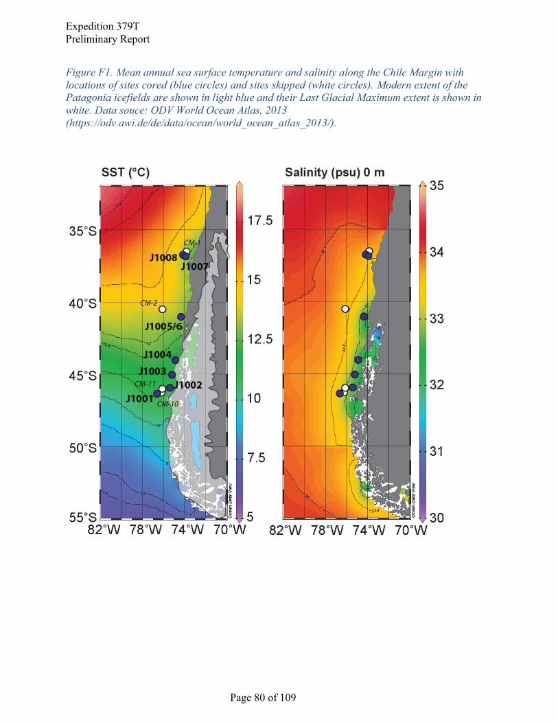
Expedition 379T
Preliminary Report
Page 80 of 109
Figure F1. Mean annual sea surface temperature and salinity along the Chile Margin with
locations of sites cored (blue circles) and sites skipped (white circles). Modern extent of the
Patagonia icefields are shown in light blue and their Last Glacial Maximum extent is shown in
white. Data souce: ODV World Ocean Atlas, 2013
(https://odv.awi.de/de/data/ocean/world_ocean_atlas_2013/).

Expedition 379T
Preliminary Report
Page 81 of 109
Figure F2. Dissolved oxygen content along WOCE line P19 showing the main water masses in
the southeast Pacific with locations of sites cored (blue circles) and sites skipped (white circles).

Expedition 379T
Preliminary Report
Page 82 of 109
Figure F3. Summary of coring operations and temporal resolution of Expedition 379T/JR100
core sites.

Expedition 379T
Preliminary Report
Page 83 of 109
Figure F4. South central Chilean Margin offshore of the Taitao Peninsula showing the location
of Sites J1001, J1002, J1003, and J1004 (blue circles) as well as two proposed sites that were
not cored during the Expedition (white circles).
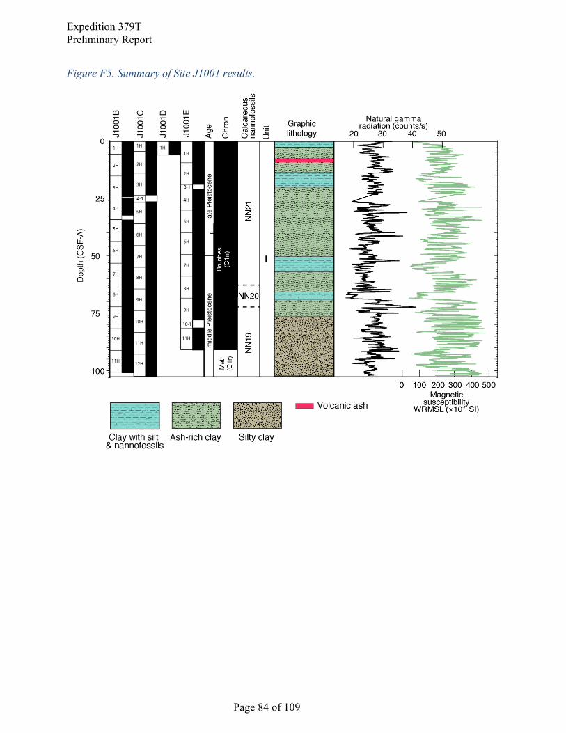
Expedition 379T
Preliminary Report
Page 84 of 109
Figure F5. Summary of Site J1001 results.

Expedition 379T
Preliminary Report
Page 85 of 109
Figure F6. Age-depth plot for calcareous nannofossil biohorizons and the Brunhes-Matuyama
paleomagnetic datum, Site J1001. Average sedimentation rates are estimated at ~15 cm/ky
during the last ~400 ky and <10 cm/ky to ~850 ky.
0 20 40 60 80 100
020
040
060
080
010
00
nann
ofos
sil
Pal
eom
agne
tics
m CSF-A
Age
(Ka)
20
cm/ky
0 10
ash
E

Expedition 379T
Preliminary Report
Page 86 of 109
Figure F7. Summary of Site J1002 results.

Expedition 379T
Preliminary Report
Page 87 of 109
Figure F8. Summary of J1003 results.

Expedition 379T
Preliminary Report
Page 88 of 109
Figure F9. Seismic Line 745 shown with line drawing interpretation showing the Nazca Plate
subducting under the S. American plate. A prominent bottom seismic reflector can also be
observed at~0.1-0.2 sec below the seafloor.

Expedition 379T
Preliminary Report
Page 89 of 109
Figure F10. Summary of J1004 results.
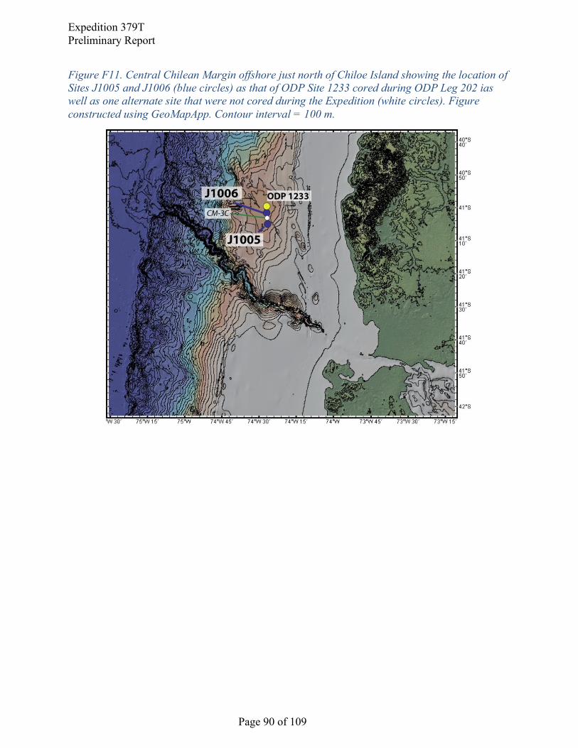
Expedition 379T
Preliminary Report
Page 90 of 109
Figure F11. Central Chilean Margin offshore just north of Chiloe Island showing the location of
Sites J1005 and J1006 (blue circles) as that of ODP Site 1233 cored during ODP Leg 202 ias
well as one alternate site that were not cored during the Expedition (white circles). Figure
constructed using GeoMapApp. Contour interval = 100 m.

Expedition 379T
Preliminary Report
Page 91 of 109
Figure F12. (A.) Digital parasound data used to target ODP Site 1233, cored during Leg 202,
and JR100/Exp. 379T sites J1005 and J1006. Site J1005 and J1006 were offset from ODP Site
1233 to target lower sedimentation rates. (B.) Analog 3.5-kHz profile collected during the
approach to Site 1233 on Leg 202. Visible reflectors are traced between the Parasound and 3.5
kHz profiles.

Expedition 379T
Preliminary Report
Page 92 of 109
Figure F13. Summary of J1005 results.

Expedition 379T
Preliminary Report
Page 93 of 109
Figure F14. Summary of J1006 results.

Expedition 379T
Preliminary Report
Page 94 of 109
Figure F15. Region offshore of the Arauco Peninsula showing the locations of Sites J1007 and
J1008 (blue circles) and planned site CM-1 that was not cored during the expedition.

Expedition 379T
Preliminary Report
Page 95 of 109
Figure F16. Summary of J1007 results.
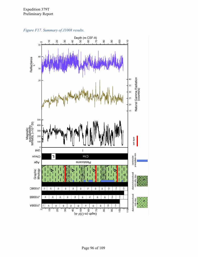
Expedition 379T
Preliminary Report
Page 96 of 109
Figure F17. Summary of J1008 results.
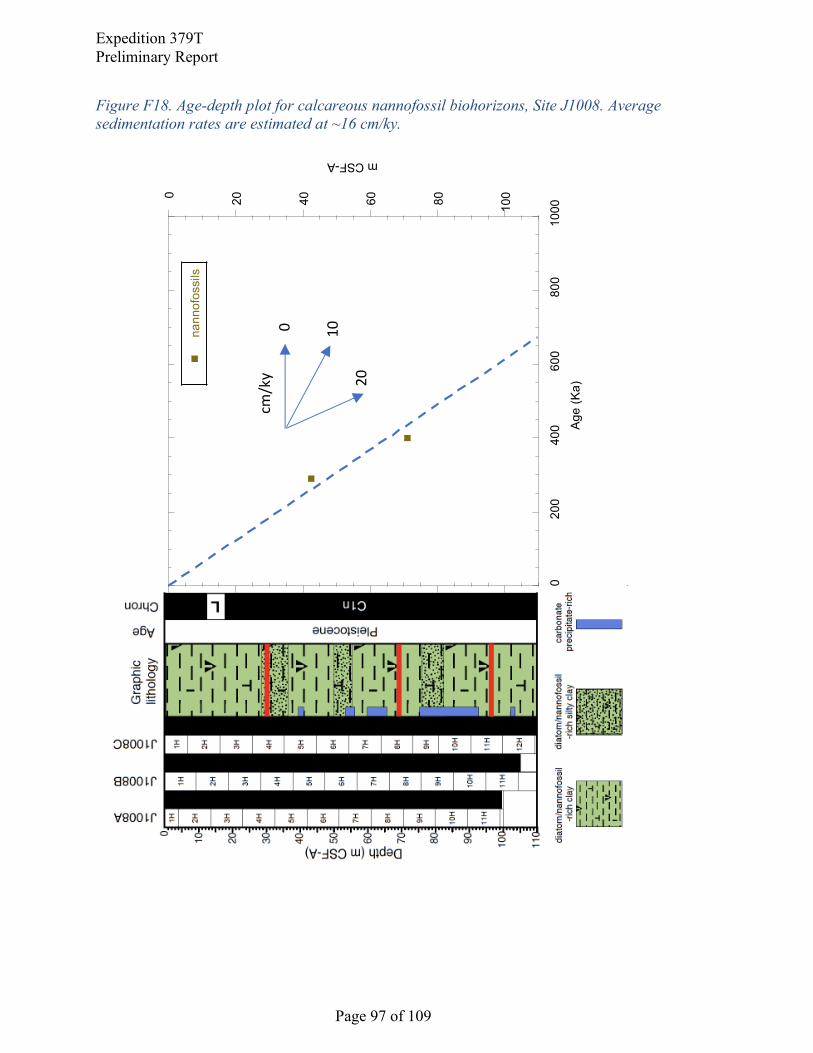
Expedition 379T
Preliminary Report
Page 97 of 109
Figure F18. Age-depth plot for calcareous nannofossil biohorizons, Site J1008. Average
sedimentation rates are estimated at ~16 cm/ky.
0 20 40 60 80 100
020
040
060
080
010
00
nann
ofos
sils
m CSF-A
Age
(Ka)20
cm/ky
0 10

Expedition 379T
Preliminary Report
Page 98 of 109
Figure F19. Headspace methane concentrations at all eight sites cored during Expedition 379T.

Expedition 379T
Preliminary Report
Page 99 of 109
References
Adkins, J.F., 2013. The role of deep ocean circulation in setting glacial climates.
Paleoceanography 28, 539-561.
Adkins, J.F., McIntyre, K., Schrag, D.P., 2002. The salinity, temperature, and 18O of the glacial
deep ocean. Science 298, 1769-1773.
Anderson, R.F., Ali, S., Bradtmiller, L.I., Nielsen, S.H.H., Fleisher, M.Q., Anderson, B.E.,
Burckle, L.H., 2009. Wind-Driven Upwelling in the Southern Ocean and the Deglacial
Rise in Atmospheric CO2. Science 323, 1443-1448.
Bendle, J. M., Palmer, A. P., Thorndycraft, V. R., and Matthews, I. P., 2019. Phased Patagonian
Ice Sheet response to Southern Hemisphere atmospheric and oceanic warming between
18 and 17 ka. Scientific Reports, 9:4133. https://doi.org/10.1038/s41598-019-39750-w.
Bertrand, S., Hughen, K.A., Lamy, F., Stuut, J.B.W., Torrejon, F., Lange, C.B., 2012a.
Precipitation as the main driver of Neoglacial fluctuations of Gualas glacier, Northern
Patagonian Icefield. Clim Past 8, 519-534.
Bertrand, S., Hughen, K.A., Sepulveda, J., Pantoja, S., 2012b. Geochemistry of surface
sediments from the fjords of Northern Chilean Patagonia (44-47° S): Spatial variability
and implications for paleoclimate reconstructions. Geochim Cosmochim Ac 76, 125-146.
Bostock, H.C., Opdyke, B.N., Williams, M.J.M., 2010. Characterising the intermediate depth
waters of the Pacific Ocean using 13C and other geochemical tracers. Deep-Sea Res Pt I
57, 847-859.
Bostock, H.C., Sutton, P.J., Williams, M.J.M., Opdyke, B.N., 2013. Reviewing the circulation
and mixing of Antarctic Intermediate Water in the South Pacific using evidence from
geochemical tracers and Argo float trajectories. Deep-Sea Res Pt I 73, 84-98.
Bova, S.C., Herbert, T., Rosenthal, Y., Kalansky, J., Altabet, M., Chazen, C., Mojarro, A., Zech,
J., 2015. Links between eastern equatorial Pacific stratification and atmospheric CO2 rise
during the last deglaciation. Paleoceanography 30, 1407-1424.

Expedition 379T
Preliminary Report
Page 100 of 109
Bova, S.C., Herbert, T.D., Fox-Kemper, B., 2016. Rapid variations in deep ocean temperature
detected in the Holocene. Geophys Res Lett 43, 12190-12198.
Bova, S.C., Herbert, T.D., Altabet, M.A., 2018. Ventilation of Northern and Southern Sources of
Aged Carbon in the Eastern Equatorial Pacific During the Younger Dryas Rise in
Atmospheric CO2. Paleoceanography and Paleoclimatology 33, 1151-1168. https://
doi/full/10.1029/2018PA003386.
Cabre, M.F., Solman, S.A., Nunez, M.N., 2010. Creating regional climate change scenarios over
southern South America for the 2020's and 2050's using the pattern scaling technique:
validity and limitations. Climatic Change 98, 449-469.
Cande, S. C., and Kent, D. V., 1995. Revised calibration of the geomagnetic polarity timescale
for the Late Cretaceous and Cenozoic. Journal of Geophysical Research: Solid Earth,
100(B4):6093–6095. https://doi.org/10.1029/94JB03098
Caniupan, M., Lamy, F., Lange, C.B., Kaiser, J., Arz, H., Kilian, R., Urrea, O.B., Aracena, C.,
Hebbeln, D., Kissel, C., Laj, C., Mollenhauer, G., Tiedemann, R., 2011. Millennial-scale
sea surface temperature and Patagonian Ice Sheet changes off southernmost Chile (53°S)
over the past similar to 60 kyr. Paleoceanography 26, PA3221.
Carrasco, J.F., Casassa, G., Rivera, A., 2002. Meteorological and climatological aspects of the
southern Patagonia icefield, in: Casassa, G. (Ed.), The Patagonian Icefields: A Unique
Natural Laboratory for Envrionmental and Climate Change Studies. Kluwer
Academic/Plenum Publishers.
Channell, J. E. T., Xuan, C., and Hodell, D. A., 2009. Stacking paleointensity and oxygen
isotope data for the last 1.5 Myr (PISO-1500). Earth and Planetary Science Letters, 283,
14-23.
Chase, Z., McManus, J., Mix, A.C., Muratli, J., 2014. Southern-ocean and glaciogenic nutrients
control diatom export production on the Chile margin. Quaternary Sci Rev 99, 135-145.

Expedition 379T
Preliminary Report
Page 101 of 109
Clark, P.U., Alley, R.B., Pollard, D., 1999. Northern hemisphere ice-sheet influences on global
climate change. Science’s Compass Review 286, 1104-1111.
Clark, P.U., Pisias, N.G., Stocker, T.F., Weaver, A.J., 2002. The role of the thermohaline
circulation in abrupt climate change. Nature 415, 863-869.
Collins, J. A., Lamy, F., Kaiser, J., Ruggieri, N., Henkel, S., De Pol‐Holz, R., Garreaud, R., and
Arz, H. W. (2019). Centennial‐Scale SE Pacific Sea Surface Temperature Variability
Over the Past 2,300 Years. Paleoceanography and Paleoclimatology, 34(3), 336-352.
Curry, W.B., Crowley, T.J., 1987. The 13C of equatorial Atlantic surface waters: implications
for ice age pCO2 levels. Paleoceanography 2, 489-517.
Daneri, G. Dellarossa, V., Quiñones, R., Jacob, B., Montero, P., and Ulloa, O., 2000. Primary
production and community respiration in the Humboldt current system off Chile and
associated oceanic areas. Mar Ecol Prog Ser 197, 41-49.
Denton, G.H., Heusser, C.J., Lowell, T.V., Moreno, P.I., Andersen, B.G., Heusser, L.E.,
Schluchter, C., Marchant, D.R., 1999. Interhemispheric linkage of paleoclimate during
the last glaciation. Geografiska Annaler: Series A, Physical Geography, 81, 107-153.
De Pol-Holz, R., Ulloa, O., Lamy, F., Dezileau, L., Sabatier, P., Hebbeln, D., 2007. Late
Quaternary variability of sedimentary nitrogen isotopes in the eastern South Pacific
Ocean. Paleoceanography 22, PA2207.
Euler, C., Ninnemann, U.S., 2010. Climate and Antarctic Intermediate Water coupling during the
late Holocene. Geology 38, 647-650.
Ferrari, R., Jansen, M.F., Adkins, J.F., Burke, A., Stewart, A.L., Thompson, A.F., 2014.
Antarctic sea ice control on ocean circulation in present and glacial climates. P Natl Acad
Sci USA 111, 8753-8758.
Fujiyoshi, Y., Kondo, H., Inoue, J., Yamada, T., 1987. Characteristics of precipitation and
vertical structure of air temperature in Northern Patagonia. Bull. Glacial Res. 4, 15-24.
Expedition 379T
Preliminary Report
Page 102 of 109
Ganopolski, A., Rahmstorf, S., 2001. Rapid changes of glacial climate simulated in a coupled
climate model. Nature 409, 153-158.
Garreaud, R.D., 2007. Precipitation and circulation covariability in the extratropics. J Climate
20, 4789-4797.
Garreaud, R., Lopez, P., Minvielle, M., Rojas, M. 2013. Large-scale control on the Patagonian
Climate. Jrnl. of Climate. 26, 215-230.
Glasser, N.F., Harrison, S., Jansson, K.N., Anderson, K., Cowley, A., 2011. Global sea-level
contribution from the Patagonian Icefields since the Little Ice Age maximum. Nat Geosci
4, 303-307.
Glasser, N.F., Jansson, K.N., Duller, G.A.T., Singarayer, J., Holloway, M., Harrison, S., 2016.
Glacial lake drainage in Patagonia (13-8 kyr) and response of the adjacent Pacific Ocean.
Sci Rep 6, 21064.
Graham, J.A., Stevens, D.P., Heywood, K.J., Wang, Z.M., 2011. North Atlantic climate
responses to perturbations in Antarctic Intermediate Water. Clim Dynam 37, 297-311.
Hall, A., Visbeck, M., 2002. Synchronous variability in the southern hemisphere atmosphere, sea
ice, and ocean resulting from the annular mode. J Climate 15, 3043-3057.
Hayes, C.T., Anderson, R.F., Fleisher, M.Q., 2011. Opal accumulation rates in the equatorial
Pacific and mechanisms of deglaciation. Paleoceanography 26, PA1207.
Hebbeln, D. and cruise participants, 2001. PUCK, Report and Preliminary Results of R/V
SONNE cruise SO 156, Valparaiso (Chile) – Talcahuano (Chile), March 29 – May 14,
2001, Berichte, Fachbereich Geowissenschaften, Universitat Bremen, No. 182, 195
pages, Bremen.
Heusser, L., Heusser, C., Mix, A., McManus, J., 2006. Chilean and Southeast Pacific
paleoclimate variations during the last glacial cycle: directly correlated pollen and 18O
records from ODP Site 1234. Quaternary Sci Rev 25, 3404-3415.

Expedition 379T
Preliminary Report
Page 103 of 109
Hilgen, F. J., Lourens, L.J., and Van Dam, J.A., 2012. The Neogene period. With contributions
by A.G. Beu, A.F. Boyes, R.A. Cooper, W. Krijgsman, J.G. Ogg, W.E. Piller, and D.S.
Wilson. In: Gradstein, F.M., Ogg, J.G., Schmitz, M.D., and Ogg, G.M. (Eds.), The
Geologic Time Scale: Oxford, United Kingdom (Elsevier), 923–978.
https://doi.org/10.1016/B978-0-444-59425-9.00029-9
Kaiser, J., Lamy, F., Arz, H.W., Hebbeln, D., 2007. Dynamics of the millennial-scale sea surface
temperature and Patagonian Ice Sheet fluctuations in southern Chile during the last 70kyr
(ODP Site 1233). Quatern Int 161, 77-89.
Kaiser, J., Lamy, F., Hebbeln, D., 2005. A 70-kyr sea surface temperature record off southern
Chile (Ocean Drilling Program Site 1233). Paleoceanography 20, PA4009.
Kaiser, J., Schefuss, E., Lamy, F., Mohtadi, M., Hebbeln, D., 2008. Glacial to Holocene changes
in sea surface temperature and coastal vegetation in north central Chile: high versus low
latitude forcing. Quaternary Sci Rev 27, 2064-2075.
Kalansky, J., Rosenthal, Y., Herbert, T., Bova, S., Altabet, M., 2015. Southern Ocean
contributions to the Eastern Equatorial Pacific heat content during the Holocene. Earth
Planet Sc Lett 424, 158-167.
Kastner, M., Kvenvolden, K.A., Whiticar, M.J., Camerlenghi, A. and Lorenson, T.D., 1995. 10.
Relation between pore fluid chemistry and gas hydrates associated with bottom-
simulating reflectors at the Cascadia margin, Sites 889 and 892. 1995. Proceedings of the
Ocean Drilling Program, Scientific Results, 146(Pt 1), 175-187.
Kim, J.H., Schneider, R.R., Hebbeln, D., Muller, P.J., Wefer, G., 2002. Last deglacial sea-
surface temperature evolution in the Southeast Pacific compared to climate changes on
the South American continent. Quaternary Sci Rev 21, 2085-2097.
Kissel, C., Leau, H., and Shipboard Participants, 2007. MD159-PACHIDERME IMAGES XV
Cruise Report, Punta Arenas (Chile) – Punta Arenas (Chile), Feb. 2 – Feb. 28, 2007.
Knorr, G., Lohmann, G., 2003. Southern Ocean origin for the resumption of Atlantic
thermohaline circulation during deglaciation. Nature 424, 532-536.

Expedition 379T
Preliminary Report
Page 104 of 109
Knox, F., Mcelroy, M.B., 1984. Changes in Atmospheric CO2 - Influence of the Marine Biota at
High-Latitude. J Geophys Res-Atmos 89, 4629-4637.
Lamy, F., Anderson, R., Cortese, G., Esper, O., Gohl, K., Arz, H., Hall, I., Hillenbrand, C.,
Hubscher, C., Lange, C., Lembke-Jene, L., Ninnemann, U., Pahnke, K., Polonia, A.,
Stoner, J., Nurnberg, D., Martinez-Garcia, A., Tiedemann, R., Uenzelmann-Nebe, G., and
Winckler, G, 2016. Plio-Pleistocene Dynamics of the Pacific Antarctic Circumpolar
Current, IODP Proposal Cover Sheet.
Lamy, F., Arz, H.W., Kilianc, R., Lange, C.B., Lembke-Jene, L., Wengler, M., Kaiser, J., Baeza-
Urrea, O., Hall, I.R., Harada, N., Tiedemann, R., 2015. Glacial reduction and millennial-
scale variations in Drake Passage throughflow. P Natl Acad Sci USA 112, 13496-13501.
Lamy, F., Hebbeln, D., Rohl, U., Wefer, G., 2001. Holocene rainfall variability in southern
Chile: a marine record of latitudinal shifts of the Southern Westerlies. Earth Planet Sc
Lett 185, 369-382.
Lamy, F., Hebbeln, D., Wefer, G., 1998. Late quaternary precessional cycles of terrigenous
sediment input off the Norte Chico, Chile (27.5°S) and palaeoclimatic implications.
Palaeogeogr Palaeocl 141, 233-251.
Lamy, F., Kaiser, J., Ninnemann, U., Hebbeln, D., Arz, H.W., Stoner, J., 2004. Antarctic timing
of surface water changes off Chile and Patagonian ice sheet response. Science 304, 1959-
1962.
Lamy, F., Kilian, R., Arz, H.W., Francois, J.P., Kaiser, J., Prange, M., Steinke, T., 2010.
Holocene changes in the position and intensity of the southern westerly wind belt. Nat
Geosci 3, 695-699.
Lamy, F., Ruhlemann, C., Hebbeln, D., Wefer, G., 2002. High- and low-latitude climate control
on the position of the southern Peru-Chile Current during the Holocene.
Paleoceanography 17(2), PA0727.

Expedition 379T
Preliminary Report
Page 105 of 109
Lea, D.W., Pak, D.K., Belanger, C.L., Spero, H.J., Hall, M.A., Shackleton, N.J., 2006.
Paleoclimate history of Galapagos surface waters over the last 135,000 yr. Quaternary Sci
Rev 25, 1152-1167.
Liu, Z.Y., Alexander, M., 2007. Atmospheric bridge, oceanic tunnel, and global climatic
teleconnections. Rev Geophys 45, RG2005.
Lowell, T.V., Heusser, C.J., Andersen, B.G., Moreno, P.I., Hauser, A., Heusser, L.E., Schluchter,
C., Marchant, D.R., Denton, G.H., 1995. Interhemispheric Correlation of Late
Pleistocene Glacial Events. Science 269, 1541-1549.
Lund, S.P., Stoner, J.S., and Lamy, F. 2006. Late Quaternary paleomagnetic secular variation
and chronostratigraphy from ODP Sites 1233 and 1234. In Tiedemann, R., Mix, A.C.,
Richter, C., and Ruddiman, W.F. (Eds.), Proc. ODP, Sci. Results, 202: College Station,
TX (Ocean Drilling Program), 1-22.
Mann, M.E., Zhang, Z.H., Hughes, M.K., Bradley, R.S., Miller, S.K., Rutherford, S., Ni, F.B.,
2008. Proxy-based reconstructions of hemispheric and global surface temperature
variations over the past two millennia. P Natl Acad Sci USA 105, 13252-13257.
Martinez, P., Lamy, F., Robinson, R.R., Pichevin, L., Billy, I., 2006. Atypical delta(15)N
variations at the southern boundary of the East Pacific oxygen minimum zone over the
last 50 ka. Quaternary Sci Rev 25, 3017-3028.
McManus, J.F., Francois, R., Gherardi, J.M., Keigwin, L.D., Brown-Leger, S., 2004. Collapse
and rapid resumption of Atlantic meridional circulation linked to deglacial climate
changes. Nature 428, 834-837.
Mix, A.C., Tiedemann, Blum, P. and Shipboard Scientific Party, 2002. Ocean Drilling Program
Leg 202 Preliminary Report, Southeast Pacific Paleoceanographic Transects, March 29 –
May 30, 2002.
Mix, A.C. and Cruise Participants, 2003. Proceedings of the Ocean Drilling Program, Initial
Reports. Volume 202.

Expedition 379T
Preliminary Report
Page 106 of 109
Moffa‐Sanchez, P., Rosenthal, Y., Babila, T. L., Mohtadi, M., & Zhang, X. (2019). Temperature
evolution of the Indo‐Pacific Warm Pool over the Holocene and the last
deglaciation. Paleoceanography and Paleoclimatology.
Mohtadi, M., Rossel, P., Lange, C.B., Pantoja, S., Boning, P., Repeta, D.J., Grunwald, M., Lamy,
F., Hebbeln, D., Brumsack, H.J., 2008. Deglacial pattern of circulation and marine
productivity in the upwelling region off central-south Chile. Earth Planet Sc Lett 272,
221-230.
Moreno, P.I., Jacobson, G.L., Lowell, T.V., Denton, G.H., 2001. Interhemispheric climate links
revealed by a late-glacial cooling episode in southern Chile. Nature 409, 804-808.
Moreno, P.I, Denton, G. H., Moreno, H., Lowell, T.V., Putnam, A. E., and Kaplan, M. R., 2015.
Radiocarbon chronology of the last glacial maximum and its termination in northwest
Patagonia. Quaternary Sci Rev 122, 233-249.
Murata, Harada, Abe, Uchida, 2017. Mirai Cruise Report, MR16-09: Trans South Pacific
Project., JAMSTEC.
Muratli, J.M., Chase, Z., McManus, J., Mix, A., 2010a. Ice-sheet control of continental erosion
in central and southern Chile (36°-41°S) over the last 30,000 years. Quaternary Sci Rev
29, 3230-3239.
Muratli, J.M., Chase, Z., Mix, A.C., McManus, J., 2010b. Increased glacial-age ventilation of the
Chilean margin by Antarctic Intermediate Water. Nat Geosci 3, 23-26.
Ninnemann, U.S., Charles, C.D., 1997. Regional differences in Quaternary Subantarctic nutrient
cycling: Link to intermediate and deep water ventilation. Paleoceanography 12, 560-567.
Ogg, J. G., 2012. Geomagnetic Polarity Time Scale. In: Gradstein, F.M., Ogg, J.G., Schmitz,
M.D., and Ogg, G.M. (Eds.), The Geologic Time Scale: Oxford, United Kingdom
(Elsevier), 85-114. https://doi.org/10.1016/B978-0-444-59425-9.00029-9
Opdyke, M. D., Channel, J. E. T., 1996. Magnetic Stratigraphy Vol 64. Academic Press, London,
346pp.

Expedition 379T
Preliminary Report
Page 107 of 109
PAGES 2k Consortium, 2013. Continental-scale temperature variability during the past two
millennia. Nat Geosci 6, 339-346.
Pena, L.D., Cacho, I., Ferretti, P., Hall, M.A., 2008. El Niño-Southern Oscillation-like variability
during glacial terminations and interlatitudinal teleconnections. Paleoceanography 23,
PA3101.
Pisias, N.G., Heusser, L., Heusser, C., Hostetler, S.W., Mix, A.C., Weber, M., 2006. Radiolaria
and pollen records from 0 to 50 ka at ODP Site 1233: continental and marine climate
records from the Southeast Pacific. Quaternary Sci Rev 25, 455-473.
Post, V.E.A., Groen, J., Kooi, H., Person, M., Ge, S., Edmunds, W.M, 2013, Offshore fresh
Groundwater reserves as a global phenomenon, Nature, 504, 71-78
Rignot, E., Rivera, A., Casassa, G., 2003. Contribution of the Patagonia Icefields of South
America to sea level rise. Science 302, 434-437.
Robinson, R.S., Martinez, P., Pena, L.D., Cacho, I., 2009. Nitrogen isotopic evidence for
deglacial changes in nutrient supply in the eastern equatorial Pacific. Paleoceanography
24, PA4213.
Robinson, R.S., Mix, A., Martinez, P., 2007. Southern Ocean control on the extent of
denitrification in the southeast Pacific over the last 70 ka. Quaternary Sci Rev 26, 201-
212.
Roemmich, D., Church, J., Gilson, J., Monselesan, D., Sutton, P., Wijffels, S., 2015. Unabated
planetary warming and its ocean structure since 2006. Nat Clim Change 5, 240-245.
Rosenthal, Y., Kalansky, J., Morley, A., Linsley, B., 2017. A paleo-perspective on ocean heat
content: Lessons from the Holocene and Common Era. Quaternary Sci Rev 155, 1-12.
Rosenthal, Y., Linsley, B.K., Oppo, D.W., 2013. Pacific Ocean Heat Content During the Past
10,000 Years. Science 342, 617-621.
Expedition 379T
Preliminary Report
Page 108 of 109
Ruddiman, W.F., 2003. The anthropogenic greenhouse era began thousands of years ago.
Climatic Change 61, 261-293.
Russell, J.L., Dixon, K.W., Gnanadesikan, A., Stouffer, R.J., Toggweiler, J.R., 2006a. The
Southern Hemisphere westerlies in a warming world: Propping open the door to the deep
ocean. J Climate 19, 6382-6390.
Russell, J.L., Stouffer, R.J., Dixon, K.W., 2006b. Intercomparison of the Southern Ocean
circulations in IPCC coupled model control simulations. J Climate 19, 4560-4575.
Sarmiento, J.L., Toggweiler, J.R., 1984. A New Model for the Role of the Oceans in
Determining Atmospheric Pco2. Nature 308, 621-624.
Schmidtko, S., Johnson, G.C., 2012. Multidecadal Warming and Shoaling of Antarctic
Intermediate Water. J Climate 25, 207-221.
Shackleton, N.J., Pisias, N.G., 1985. Atmospheric carbon dioxide, orbital forcing, and climate,
The Carbon Cycle and Atmospheric CO2: Natural Variations Archean to Present, pp.
303-317.
Shakun, J.D., Clark, P.U., He, F., Lifton, N.A., Liu, Z.Y., Otto-Bliesner, B.L., 2015. Regional
and global forcing of glacier retreat during the last deglaciation. Nat Commun 6, 8059.
Shakun, J.D., Clark, P.U., He, F., Marcott, S.A., Mix, A.C., Liu, Z.Y., Otto-Bliesner, B.,
Schmittner, A., Bard, E., 2012. Global warming preceded by increasing carbon dioxide
concentrations during the last deglaciation. Nature 484, 49-54.
Siani, G., Colin, C., Michel, E., Carel, M., Richter, T., Kissel, C., Dewilde, F., 2010. Late Glacial
to Holocene terrigenous sediment record in the Northern Patagonian margin:
Paleoclimate implications. Palaeogeogr Palaeocl 297, 26-36.
Siegenthaler, U., Wenk, T., 1984. Rapid Atmospheric Co2 Variations and Ocean Circulation.
Nature 308, 624-626.
Sijp, W. P., & England, M. H. (2009). Southern Hemisphere westerly wind control over the ocean's
thermohaline circulation. Journal of Climate, 22(5), 1277-1286.

Expedition 379T
Preliminary Report
Page 109 of 109
Spero, H.J., Lea, D.W., 2002. The cause of carbon isotope minimum events on glacial
terminations. Geochim Cosmochim Ac 66, A731-A731.
Stern, C. 2010, Active Andean volcanism: its geologic and tectonic setting. Revista Geológica de
Chile 31 (2): 161-206. [doi:http://dx.doi.org/10.5027/andgeoV31n2-a01]
Stoner, J. S., and St-Onge, G., 2007. Magnetic stratigraphy in paleooceanography: reversal,
excursion, paleointensity and secular variation. In Hillaire-Marcel, C., and de Vernal, A.
(Eds.), Developments in Marine Geology (Volume 1): Proxies in Late Cenozoic
Paleoceanography. R. Stein (Series Ed.): Amsterdam (Elsevier B.V.), 99–138.
https://doi.org/10.1016/S1572-5480(07)01008-1
Toggweiler, J.R., Russell, J.L., Carson, S.R., 2006. Midlatitude westerlies, atmospheric CO2, and
climate change during the ice ages. Paleoceanography 21, PA2005.
Toggweiler, J.R., Samuels, B., 1993. Is the magnitude of the deep outflow from the Atlantic
Ocean actually governed by Southern Hemisphere winds?, The Global Carbon Cycle.
NATO ASI (Series I: Global Environmental Change). Springer, Berlin, Heidelberg.
Toggweiler, J.R., Samuels, B., 1995. Effect of Drake Passage on the Global Thermohaline
Circulation. Deep-Sea Res Pt I 42, 477-500.
Umling, N. E., & Thunell, R. C. (2017). Synchronous deglacial thermocline and deep-water
ventilation in the eastern equatorial Pacific. Nature communications, 8, 14203.
Vera, C., Silvestri, G., Liebmann, B., Gonzalez, P., 2006. Climate change scenarios for seasonal
precipitation in South America from IPCC-AR4 models. Geophys Res Lett 33, L13707.