Embed Size (px)
Citation preview

Differences in the Indonesian Seaway in a coupled climatemodel and their relevance to Pliocene climate and El Nino1
2
3
4
Markus Jochum, Baylor Fox-Kemper, Peter Molnar and Christine Shields5
6
submitted to Paleoceanography, 8/21/087
8
9
Corresponding author’s address:10
National Center for Atmospheric Research11
PO Box 300012
Boulder, CO, 8030713
1-303-497174314
16
17
1
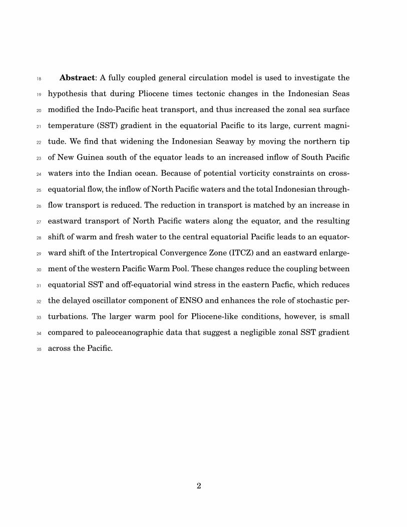
Abstract: A fully coupled general circulation model is used to investigate the18
hypothesis that during Pliocene times tectonic changes in the Indonesian Seas19
modified the Indo-Pacific heat transport, and thus increased the zonal sea surface20
temperature (SST) gradient in the equatorial Pacific to its large, current magni-21
tude. We find that widening the Indonesian Seaway by moving the northern tip22
of New Guinea south of the equator leads to an increased inflow of South Pacific23
waters into the Indian ocean. Because of potential vorticity constraints on cross-24
equatorial flow, the inflow of North Pacific waters and the total Indonesian through-25
flow transport is reduced. The reduction in transport is matched by an increase in26
eastward transport of North Pacific waters along the equator, and the resulting27
shift of warm and fresh water to the central equatorial Pacific leads to an equator-28
ward shift of the Intertropical Convergence Zone (ITCZ) and an eastward enlarge-29
ment of the western Pacific Warm Pool. These changes reduce the coupling between30
equatorial SST and off-equatorial wind stress in the eastern Pacfic, which reduces31
the delayed oscillator component of ENSO and enhances the role of stochastic per-32
turbations. The larger warm pool for Pliocene-like conditions, however, is small33
compared to paleoceanographic data that suggest a negligible zonal SST gradient34
across the Pacific.35
2

1 Introduction36
Because nearly all water that enters the Pacific Ocean from the Southern Ocean37
passes out of the Pacific Basin between islands of Indonesia, variability in the cur-38
rents that pass through the Indonesian Sea and link the Pacific and Indian Oceans39
are often assigned a major role modern climate [e.g., Gordon 1996; Hirst and God-40
frey 1993; Schneider 1998]. Moreover, because this region has been evolving rapidly41
over the past tens of millions of years, an evolving Indonesian Seaway has long of-42
fered a target for attributing cause, via its effect on the Indonesian Throughflow43
(ITF), to changing global climates on geological time scales [e.g., Kennet et al. 1985;44
Srinivasan and Sinha 1998; Cane and Molnar 2001]. It follows that attributions of45
global climate change to an evolving Indonesian Seaway require an understanding46
of current processes that govern its throughflow.47
Problematic to both modern and paleoclimate is the fact that these currents48
are governed by some of oceanography’s least quantified and understood processes.49
Observations are made difficult by the myriad of islands and the large temporal50
variability from intraseasonal to interannual timescales [e.g., Sprintall et al. 2003].51
Theories about the ITF are difficult to develop because the weak Coriolis effect re-52
quires a balance, necessarily uncertain and difficult to quantify, between pressure53
gradients, wind stress, and viscous drag. Nevertheless, the currently dominating54
theory that explains the ITF as the result of mass continuity and Sverdrup balance55
[’Island Rule’, Godfrey 1989] and direct observations of transport both arrive at a56
transport estimate for the ITF between 5 and 15 Sverdrup [Sv, Godfrey 1996; Hau-57
tala et al. 2001]. This agreement is reassuring, but the fact that most of the ITF58
water originates from the North Pacific and not from the South Pacific as required59
3

by the Island Rule leaves some doubt [Nof 1996]. The theoretical and observational60
uncertainty surrounding the ITF makes the application of numerical tools a natu-61
ral but possibly misleading step. Still, if nothing else, numerical studies highlight62
the importance of basin geometry [Morey et al. 1999; Rodgers et al. 2000], topogra-63
phy, and dissipation [Wajsowicz 1993ab].64
Thus, although a considerable amount of time and effort has been spent to quan-65
tify and understand the ITF, large uncertainties still remain. For that reason, the66
present work takes a step back and asks what particular aspects of the ITF might67
be relevant for climate. For example, it is not obvious how important the ITF mass68
transport is for climate. Even the heat carried by the ITF may only have a minor69
effect on climate [e.g., Vranes et al. 2002], because much of the ITF water is colder70
than 27◦C, and not only originates but also returns to the surface outside the Indo-71
Pacific warmpool. Rather than asking what determines strength and composition72
of the ITF, we ask what aspect of the ITF most affects climate, and specifically73
precipitation and its variability. There are, of course, many different sensitivity74
studies one could conceive of, but a reasonable starting point is the hypothesis that75
sometime during Pliocene times [approximately 3 million years ago, 3 Ma, see Fe-76
dorov et al. 2006 for a review] the ITF changed its source waters, which triggered77
northern hemisphere glaciation [Cane and Molnar 2001]. They speculate that the78
emergence of Halmahera and the northward movement of New Guinea blocked the79
New Guinea Coastal Current, which today supplies only a small amount of South80
Pacific water to the ITF, and allowed North Pacific water brought by the Mindanao81
Current to comprise the majority of the ITF. This, according to their hypothesis,82
drastically affected the inter-basin heat exchange, and led to a larger zonal SST83
gradient, and a cooling of the higher latitudes.84
4

Although neither Pliocene tectonic movement nor the development of northern85
hemisphere glaciation is disputed, their connection remains speculative; it could be86
that these two events happened coincidently during the Pliocene Epoch. Haywood87
et al. [2007] provide an extensive discussion of the uncertainties in tropical Pacific88
paleo-data, and list possible causes for the onset of northern hemisphere glaciation.89
Based on numerical evidence they then conclude that it is unlikely that changes90
to the atmospheric trace gas concentration alone could trigger the glaciation. The91
present study should be viewed as a companion case to Haywood et al. [2007] in92
that it investigates one more possible mechanism by which the tropical oceans93
could trigger climate change.94
The first part of Cane and Molnar’s hypothesis, the ITF - SST gradient con-95
nection, has support from forced ocean model (OGCM) studies [Hirst and Godfrey96
1993; Morey et al. 1999; Rodgers et al. 2000] and the second part, the connection be-97
tween SST gradient, ENSO and high-latitude cooling, can be examined with a cou-98
pled climate model (GCM) in a straightforward manner. Furthermore, the hypoth-99
esis and the aforementioned OGCM studies suggest a large response to changes in100
the Indonesian passages.101
This study describes possible differences in climate due to differences in posi-102
tions of Indonesian islands and adjacent ocean floor topography. The next section103
describes the GCM and the experiment, the third section discusses the differences104
in the ITF, and section four shows how ITF differences lead to differences in ENSO105
properties. A summary and discussion concludes the present mansucript.106
5

2 Description of Model and Experiment107
The numerical experiment is performed using the National Center for Atmospheric108
Research (NCAR) Community Climate System Model version 3 (CCSM3), which109
consists of the fully coupled atmosphere, ocean, land and sea ice models; a detailed110
description can be found in Collins et al. [2006].111
The ocean model has a zonal resolution that varies from 340 km at the equa-112
tor to 40 km around Greenland, and a meridional resolution that varies from 70113
km at the equator to 40 km around Greenland and 350 km in the North Pacific.114
This spatially varying resolution is achieved by placing the north pole of the grid115
over Greenland, and reflects the different relevant length scales of the 2 processes116
that are deemed most important to maintain a stable global climate: deep convec-117
tion around Greenland and in the Arctic, and oceanic heat uptake at the equator.118
In the vertical there are 25 depth levels; the uppermost layer has a thickness of119
8 m, the deepest layer has a thickness of 500 m. The atmospheric model (Com-120
munity Atmosphere Model, CAM3) uses T31 spectral truncation in the horizontal121
(about 3.75◦ resolution) with 26 vertical levels. The sea ice model shares the same122
horizontal grid as the ocean model and the land model is on the same horizontal123
grid as CAM3. This setup (called T31x3) has been developed specifically for long124
paleo-climate integrations and its performance is described in detail by Yeager et al.125
[2006]. The most significant difference between the present model setup (CONT)126
and the one described in Yeager et al. [2006] is the new convection scheme, which127
leads to significant improvements in the simulation of ENSO [Neale et al. 2008].128
While the coarse resolution allows long integration times, it limits the ability129
to represent the narrow passages in the Indonesian Seas. In particular the main130
6

passages, Makassar, Ombai and Timour Strait, are replaced by a one grid-point131
throughflow between Borneo and New Guinea (Figure 1, note that because of the132
staggered grid 2 tracer grid points make one active velocity grid point). Thus, the133
present study cannot claim to quantify the impact of a single island like Halmahera134
or Sulawesi, on climate. Rather, it seeks to identify the physical processes that are135
affected by island topography and are climate relevant. For the sake of argument136
we will use the name Makassar Strait for the one grid point (or two grid points in137
the sensitivity run) that connects the Pacific and Indian ocean between Borneo and138
New Guinea.139
For the present study, we carried out five runs: 3 forced OGCM simulations, and140
2 coupled T31x3 simulations; all are initialized with horizontally averaged Levitus141
et al. [1998] temperature and salinity fields. The forced integrations use a recently142
compiled climatology of seasonally varying surface fluxes [Large and Yeager 2008]143
as upper boundary condition, and the resulting subtropical and tropical circulation144
is shown in Figure 2. All forced OGCM runs, a control (CONTF) and two sensi-145
tivity runs (PLIOF, PLIOFvisc), are integrated for 250 years. PLIOFvisc is iden-146
tical to PLIOF, but horizontal friction along all western boundaries is increased147
by a factor of 10 [Large et al. 2001]. It takes approximately 100 years to equili-148
brate the ITF transport, so that the coupled simulations are both integrated for149
200 years. The presented results are based on the means of year 200 for the forced150
runs, and the means of years 160 to 200 for the coupled runs. The only difference151
between CONT(F) and PLIO(F) (here, and in what follows, the forms ”CONT(F)”152
and ”PLIO(F)” are short for ”CONT and CONTF” and for ”PLIO and PLIOF”) is153
the island geometry in the Indonesian Sea. The removal of the northwestern tip of154
New Guinea approximates conditions in early Pliocene time, 3-5 Ma: the island of155
7

Halmahera has emerged approximately 1000 m since 5 Ma and New Guinea has156
moved northward approximately 200 km since 3 Ma [e.g., Hall 2002, Figure 1]. It157
should be noted, though, that Pliocene time island geometry is highly uncertain.158
The present modifications are inspired by the work of Rodgers et al. [2000] and159
Cane and Molnar [2001], which suggests that the ocean is very sensitive to this160
particular aspect of the island geometry. Thus, our calculations are an attempt161
to examine how differences in island geometry that affect the ITF might lead to162
differences in climate that resemble differences between Pliocene and present-day163
climates.164
The difference in thermocline temperature between CONTF and PLIOF is rela-165
tively small, but consistent with the results from Rodgers et al. [2000]: a warming166
of the Pacific and a cooling of the Indian ocean thermocline (Figure 2). These sub-167
surface differences in the forced runs are also present in the coupled runs (not168
shown) where they translate into SST differences of less than 0.5◦C (section 4) and169
a slightly more equatorward position of the Pacific ITCZ in PLIO (Figure 3). The170
causes behind these differences are discussed in the next 2 sections.171
3 The Indonesian Throughflow172
Virtually all large-scale flows in the ocean have large Reynolds and small Rossby173
numbers, so viscous and inertial effects are negligible. The dominant dynamics174
neglecting these effects (Ekman transport, geostrophy, and the Sverdrup balance)175
apply nearly everywhere and specify the depth-integrated flow given only a single176
no-normal flow boundary condition. However, in a closed basin two boundary con-177
ditions are required: no-normal flow through both the eastern and western bound-178
8

aries. Veronis [1973] shows that a reasonable model with two boundaries can be179
formed by assuming that viscous and inertial effects are confined within a western180
boundary current. This current can be arbitrarily thin, but it always transports181
enough mass to close the circulation. Godfrey’s Island Rule [Godfrey 1989] takes182
advantage of this situation by only considering closed contours of depth integrated183
flow that avoid western boundary currents. This allows a calculation of the flow184
around an island based only on wind stress - independent of the details of viscous185
and inertial effects.186
The island rule has been successfully employed around Australia to determine187
the ITF transport Godfrey [1989], the flow around Hawaii [Qiu et al. 1997; Firing188
et al. 1999], and even around entire continents to estimate transport through the189
Bering Strait [De Boer and Nof ]. The Island Rule transports for the ITF here are190
based on the line integral of the annual mean wind stress around the western191
and southern coast of Australia, along the latitude of Tasmania to South America,192
along the western coast of South America to the latitude of the northern tip of New193
Guinea, to New Guinea, and along the eastern coast of New Guinea and northern194
coast of Australia [like in Godfrey 1996].195
The time to spin up the ITF transport is approximately 100 years (Figure 4),196
consistent with the expectations from the Island Rule [travel time of Rossby waves197
between Tasmania and South America; Godfrey, 1993]. The ITF transports, too, are198
roughly consistent with the Island Rule (Table 1). Note that the larger transports199
in the coupled runs are due to a westerly wind bias in the southern midlatitudes,200
a well documented but still not resolved bias in CCSM [Boville 1991], which forces201
more water into the Pacific basin and hence requires a larger ITF transport. The202
9

Island rule predicts larger transports in PLIO(F) than in CONT(F): Because of the203
more southerly northern edge of New Guinea in PLIO(F), the Island Rule trans-204
ports are based on the stronger Trade winds at this latitude. It is a key result that205
the actual transports in PLIO(F) are smaller than those in CONT(F), although206
the Island Rule predicts a larger transport. From this we conclude that the ITF207
transport is well approximated by the Island Rule, but that the disagreements of208
up to 30 % indicate that additional, secondary processes also effect the flow. These209
secondary effects are larger in PLIO(F) than in CONT(F).210
In principle the ITF transport could be modified by Pacific upwelling [Stommel211
and Aarons 1961; Gordon 1986], topography [Wajsowicz, 1993a], viscosity [Waj-212
sowicz, 1993a], and advection of momentum or vorticity [nonlinearities, Inoue and213
Welsh 1993]. Note that, together with the curvature of the flow, viscosity deter-214
mines the dissipation of momentum and vorticity. Thus, larger viscosity leads to215
reduced nonlinearities, whereas increased nonlinearities are not necessarily the216
result of reduced viscosity. Because the mean atmospheric forcing did not change in217
the forced runs, and only by little in the coupled runs, one can rule out the contrib-218
tion of upwelling. Also, by design, topography and viscosity were held constant in219
all runs, which leaves nonlinearities to explain the differences between CONT(F)220
and PLIO(F). In CONTF, 7.7 Sv of North Pacific water join the ITF through the221
model’s Makassar Strait, and 1.1 Sv of South Pacific water enter through the Tor-222
res Strait between Australia and New Guinea (Figure 5, left). The total transport is223
consistent with observations [e.g.; Hautala et al. 2001], and the Torres Strait trans-224
port is only poorly constrained by observations [A. Gordon, pers. communication,225
2008]. The Torres Strait is shallow and Wyrtki [1961] estimates its transport to be226
less than 1 Sv. The value in CONTF is larger than that, but not large enough to jus-227
10

tify drastic measures like closing the Torres Strait in the simulations. In PLIOF, in228
spite of a wider Makassar Strait, the North Pacific inflow is reduced from 7.7 to 6.4229
Sv, and the Torres Strait transport is increased from 1.1 to 1.6 Sv (Figure 5, right).230
The differences are the same in structure but larger in magnitude for the coupled231
runs: 12.1 Sv through Makassar and 3.0 Sv through Torres in CONT, versus 8.4232
Sv and 4.5 Sv in PLIO (Figure 6). It appears that by reducing the northernmost233
extent of New Guinea, part of the North Pacific water that in CONT(F) is destined234
for the Indian Ocean is forced to retroflect across the equator and remain in the235
Pacific. This increases the total and relative contribution of South Pacific water to236
the ITF (Table 1). The latter is consistent with the studies by Morey et al. [1999]237
and Rodgers et al. [2000], although the path of the South Pacific water is different238
in their studies.239
Theory relating to the topic of cross-equatorial flow emphasizes that conser-240
vation of potential vorticity severely constrains inviscid flow across the equator241
[Killworth 1991; Edwards and Pedlosky 1998]. Applied to the present case this im-242
plies that dissipation of potential vorticity is necessary to allow a non-trivial ITF243
transport of North Pacific water, and in the absence of dissipation the application244
of the Island Rule should be limited to islands confined to a single hemisphere. To245
demonstrate the importance of dissipation, PLIOF is repeated with horizontal fric-246
tion along western boundaries increased by a factor of 10 (PLIOFvisc). The Makas-247
sar Strait transport increases from 6.4 to 7.2 Sv and the Torres Strait transport248
decreases from 1.6 to 1.2 Sv. Thus, increasing viscosity increases the ITF and espe-249
cially the Makassar Strait transport. Of course, changing the size of New Guinea250
does not affect the value of viscosity along the western boundary, but it does affect251
the dissipation, the product of viscosity and the curvature (or second derivative) of252
11

velocity. In CONT(F) the Makassar Strait is treated using only one active velocity253
grid point, with the adjacent gridpoints being set to zero by the no-slip boundary254
conditions. The Makassar Strait in PLIO(F) is wider, thereby reducing the total255
dissipation and forcing more water to retroflect and stay in the Pacific. Note that256
the return flow of the ITF is under the same potential vorticity constraint: the257
New Guinea Coastal Current does not cross the equator and joins the ITF directly258
but retroflects to feed the eastward flowing Equatorial Undercurrent. This water259
can cross into the northern hemisphere only in the diabatic Ekman layer where260
potential vorticity is dissipated [see also Godfrey et al. 1993]. This is analogous261
to the tropical Atlantic where the northward flowing North Brazil Current has to262
retroflect into the Atlantic Equatorial Undercurrent to adjust its potential vortic-263
ity. In the Atlantic, however, some southern hemisphere water is trapped in ed-264
dies, which travel northwest along the coast. This eddy transport is possible in the265
Atlantic because of the weakness or absence of a low-latitude western boundary266
current there [Jochum and Malanotte-Rizzoli 2003].267
We are aware of only two OGCM studies that considered a land-sea geometry268
in the Indonesian region similar to that of PLIOF, and both also found a reduc-269
tion in the total ITF transport, albeit by only 4% [Morey et al., 1999; Rodgers et270
al., 2000]. These reductions are smaller than the 9% and 15% that we found for271
PLIOF and for the coupled run PLIO, but similar to the 5% reduction in the sen-272
sitivity study PLIOFvisc. It is noteworthy that, assuming identical wind fields and273
the validity of the Island Rule, the more southerly latitude of New Guinea appro-274
priate for Pliocene time calls for a larger ITF transport. This increase is predicted275
because the northernmost edge of New Guinea is shifted from the equator, where276
Trade winds are weak, to a more southern latitude, where they are stronger. Thus,277
12

the Island Rule, previous OGCM studies, and the current simulations all suggest278
that widening the Indonesian passages near the equator leads to increased non-279
linearity and reduced ITF transport. The amount of reduction will depend on the280
details of island geometry, topography and the strength of the diabatic processes281
acting on the Mindanao Current. In an OGCM the nonlinearity will depend on vis-282
cosity, diffusion, and boundary conditions, the numerical values of which are only283
poorly constrained by theory or observations [Jochum et al. 2008]. With the caveat284
that the presently modeled differences in the ITF are sensitive to resolution and285
parameterized dissipation, the next section discusses their climate impact.286
4 Climate response287
The differences in circulation that are caused by modifications in Indonesian island288
geometry lead to small differences in mean temperature (Figure 2), precipitation289
and surface winds (Figure 3), but clear differences in ENSO properties (Figure 7).290
The frequency peak of NINO3 SST (SST anomaly averaged between 150◦W-90◦W291
and 5◦S-5◦N) is shifted from 2.4 years in CONT to 3.3 years in PLIO, and its stan-292
dard deviation is reduced by more than 10% from 0.74◦C to 0.65◦C. Moreover, com-293
pared to CONT, ENSO in PLIO has more energy at periods longer than 5 years. The294
causes of the differences in ENSO properties are discussed in the present section.295
The western warm pool is buttressed against the Indonesian islands, which are296
surrounded by some of the worlds warmest and freshest surface waters (Figure297
8). These waters are advected eastward by the retroflected part of the Mindanao298
Current as part of the northern Pacific tropical gyre. A stronger retroflection makes299
stronger eastward flow in the western Pacific and weaker westward flow in the east300
13

(Figure 8, bottom), which extends the western Warm Pool eastward and reduces the301
extent of the cold tongue in the eastern equatorial Pacific (Figure 9). This warming302
leads to an increase in rainfall and surface wind convergence on the equator. Thus,303
3.7 Sv of warm and fresh Mindanao Current waters, which join the ITF in CONT,304
instead enter the western equatorial Pacific, where they lead to a southward shift305
in the ITCZ (Figure 9). This fresher and warmer water leads to increased upper306
ocean stratification in the western Pacific (not shown), and can reduce entrainment307
of subsurface water [Lukas and Lindstroem 1991; Yeager et al. 2006].308
How does this more equatorially centered position of the ITCZ in PLIO affect309
ENSO? There are numerous dynamical regimes proposed to explain ENSO be-310
haviour [see Wang and Picault 2004 for an overview], but on the most fundamental311
level the question is whether ENSO is a series of events or a delayed oscillator. In312
the ’series of events’ regime, the tropical Pacific is in equilibrium, and it takes313
strong stochastic forcing to trigger an El Nino event. In the ’delayed oscillator’314
regime, equatorially trapped Kelvin waves travel eastward across the tropical Pa-315
cific Ocean, and reflect into westward propagating Rossby waves. Being reinforced316
by atmospheric feedbacks, these 2 oceanic planetary waves grow into successive El317
Nino and La Nina events. In general, the delayed oscillator leads to a more regular318
ENSO, which inconsistent with present-day observations [Kessler 2002], but could319
feasibly have been a natural mode in the past [e.g., Garcia-Herrara et al. 2008].320
Neale et al. [2008] showed that when implemented into the high resolution ver-321
sion of CCSM, their modifications to the convection scheme transform ENSO from322
a delayed oscillator into a series of independent events, with little memory of pre-323
vious events. Their modifications achieve this by reducing the spuriously strong324
14

off-equatorial ocean-atmosphere coupling in the central and eastern Pacific of the325
model, and by creating westerly windbursts of realistic strength in the western326
Pacific. The former weakens the deterministic nature of the delayed oscillator, the327
latter adds stochastic forcing, and the two together make ENSO more irregular and328
less frequent. Compared to CONT, ENSO in PLIO becomes more irregular, weaker,329
and less frequent. Thus, to explain the shifted spectrum in PLIO, the westerly330
windbursts or the off-equatorial coupling must have become weaker. Inspection of331
the model fields show that, because of the coarse resolution in the present GCM,332
westerly windburst activity is almost non-existent in either run (not shown), but333
the off-equatorial coupling in the eastern and central Pacific, between 5◦N and334
10◦N and between 10◦S and 20◦S (Figure 10), is weaker in PLIO than in CONT.335
Thus, the more equatorial position of the ITCZ in PLIO affects the response of336
the Trade winds to an El Nino event, which reduces the strength of off-equatorial337
Rossby waves (not shown). As an integral part of the delayed oscillator, these338
weaker Rossby waves reduce the role of that mechanism in starting and ending339
El Nino events, making ENSO more irregular and weaker.340
5 Summary and Discussion341
A fully coupled general circulation model is used to investigate the hypothesis342
that in Pliocene time tectonic changes in the Indonesian Seas led to a different343
Indo-Pacific heat transport, and an increased zonal SST gradient in the equatorial344
Pacific. A more open Indonesian Seaway with the northern edge of New Guinea345
200 km south of its current position, as it was in Pliocene time, does lead to a346
greater flow of South Pacific waters into the Indian ocean, which is consistent with347
15

previous, forced ocean model studies. Because of potential vorticity constraints to348
cross-equatorial flow, ITF transport during Pliocene time may have been smaller349
than today. The resulting greater flow of warm and fresh North Pacific water to the350
central equatorial Pacific leads to an equatorward shift of the ITCZ. This reduces351
the coupling between equatorial SST and off-equatorial wind stress, thereby weak-352
ening the delayed oscillator regime and thus creating a weaker and less regular353
ENSO.354
Cane and Molnar [2001] suggested that the northward movement of New355
Guinea would have blocked relatively warm water in the Pacific south of the equa-356
tor, so that ITF would have come largely from the cooler water from the Pacific357
north of the equator. OGCM runs by Rodgers et al. [2000], indeed, showed that358
with a distribution of islands in Indonesia mimicking those today, water entering359
the Indian Ocean would be approximately 2◦C cooler than if the northern part360
of New Guinea were removed, and a direct passage from the Pacific to the In-361
dian Ocean were opened south of the equator. Rodgers et al. [2000] also calculated362
that with present-day winds and an island geometry appropriate for 3-5 Ma, the363
temperature at a depth of about 100 m in the central equatorial Pacific would be364
about 0.5◦C cooler than for present- day conditions. Based on this Cane and Mol-365
nar [2001] speculate that the narrowing of the Indonesian Seaway blocked warm366
water in the Pacific south of the equator to form, or strengthen, the Western Pacific367
Warm Pool. This in turn strengthened the Walker Circulation, and transformed368
equatorial Pacific climate from one resembling that during El Nino events, with369
weak zonal SST gradients, to the present state with a strong SST gradient. They370
speculate further that, like present-day teleconnections during El Nino events, a371
warm eastern Pacific would have maintained a warm North America and would372
16

have prevented ice sheets, or ice ages.373
The present results show subtle tendencies in the direction that Cane and374
Molnar [2001] suggested, but they offer little support for the mechanisms that375
they used to argue for a weaker zonal temperature gradient across the Pacific in376
Pliocene time. A more open seaway leads to an SST in the central Pacific that377
is slightly warmer (0.2-0.3◦C) than for CONT, and hence to a slightly more east-378
erly extent of the Warm Pool. This effect, however, is miniscule compared to the379
3-4◦C difference between Pliocene and present-day SSTs in the eastern equato-380
rial Pacific [e.g., Wara et al. 2005; Lawrence et al. 2006]. The explanation for the381
warmer central equatorial Pacific associated with the more open seaway, however,382
is very different from what Cane and Molnar imagined. Indeed, with the north-383
ern edge of New Guinea at 2◦S, compared to its present-day equatorial position,384
less water from north of the equator is calculated to pass through Indonesia into385
the Indian Ocean. Moreover, although its inertia carries this North Pacific water386
across the equator, it turns back northward (conserving potential vorticity) and387
then retroflects eastward to join the North Equatorial Countercurrent and con-388
tinue to the central Pacific. This surface water is relatively warm, and thus, with a389
more open seaway than today, warm water not from south of the equator, but from390
north of it, creates the mildly warmer central Pacific. The main climate impact of391
different distributions of islands in the Indonesian region that we find is a differ-392
ence in ENSO. As shown in Figure 7, the average ENSO period is longer for a more393
open Indonesian Seaway, and the amplitude is smaller.394
The present results depend on numerical details of the interaction between395
western boundary currents and topography, and they depend on the dominant396
17

ENSO regime. This leads to two obvious questions: How dissipative are the In-397
donesian islands now and during Pliocene times? How much of the sensitivity of398
ENSO to ITF depends on the dominating ENSO regime? It may never be possible399
to answer the first question, for even with increased horizontal and vertical reso-400
lution answers to fundamental questions about boundary conditions and viscosity401
remain challenges at the forefront of physical oceanography [e.g., Pedlosky 1996;402
Fox-Kemper and Pedlosky 2004ab]. However, one could attempt to arrive at an up-403
per bound for the possible climate response to changes in the ITF. Both Hirst and404
Godfrey [1993] and Lee et al. [2002] compared two global OGCM simulations, one405
with, and one without ITF. Their results suggest that the response to ITF changes406
are strongest below the thermocline and may have only little bearing on tropical407
SST or precipitation. In their calculations, the largest impact of the ITF blocking is408
seen in the Agulhas Current, the western boundary current of the southern Indian409
Ocean [Lutjeharms 2006]. Thus, it is possible that the ITF affects global climate410
not directly through the tropical atmosphere, but indirectly through the Agulhas411
Current and the mid-latitude atmosphere [Gordon 1986]. Testing this hypothesis412
would require a thousand year long integration of a coupled climate model that413
represents the Agulhas Current realistically. This is not impossible, but with the414
current computing resources is beyond the means of most. Schneider [1998] also415
investigates the effect of blocking the ITF, albeit in a coupled GCM, but integrated416
for only 10 years after closing the ITF, so that mid- and high-latitude responses417
could not be investigated. For the equatorial Pacific, however, his results should be418
meaningful. He finds a maximum warming of less than 1◦C in the central Pacific,419
a result consistent with the present results given that PLIO only has a partial re-420
duction of ITF transport. The rainfall response, too, is about three times as strong421
18

as the response in PLIO, with a maximum of 3 mm/day increase at the western422
Pacific equator. Song et al. [2007] also close the ITF in a fully coupled GCM, but423
integrate for several centuries. Their changes to mean SST and precipitation are,424
like Schneider’s, consistent with ours.425
Regarding the ENSO regime, it is fairly straightforward to repeat the current426
experiment with the new high resolution version of CCSM whose ENSO is more427
realistic and already in the ’series of events’ regime. However, even for today it is428
difficult to determine which regime dominates ENSO, and there is no information429
about ENSO variability during Pliocene times. Thus, a reasonable conclusion for430
this study is that details of the ITF can influence tropical variability, but they431
seem unlikely to affect the mean global climate directly. It is still possible that432
over centuries the ITF will affect climate through a modification of the northward433
heat transport, but for the time being it may be wise to develop hypotheses that434
are easier to test and that requires less computing power.435
436
Acknowledgements: This research was funded by NSF through NCAR, and437
by the University of Colorado/Boulder. Richard Neale is thanked for help with the438
atmospheric model and its analysis.439
440
441
442
19

References443
Boville, B. A., 1991. Sensitivity of simulated climate to model resolution. J. Clim.444
4, 469–485.445
Cane, M. A., Molnar, P., 2001. Closing of the Indonesian seaway as a precursor to446
East African Aridification around 3-4 million years ago. Nature 411, 157–162.447
Collins, W. D., coauthors, 2006. The Community Climate System Model: CCSM3.448
J. Clim. 19, 2122–2143.449
De Boer, A. M., Nof, D., 2004. The exhaust valve of the north atlantic. Journal of450
Climate 17, 417–422.451
Edwards, C., Pedlosky, J., 1998. Dynamics of nonlinear cross-equatorial flow. Part452
I: potential vorticity transformation. J.Phys.Oceanogr. 28, 2382–2406.453
Fedorov, A. V., coauthors, 2006. The Pliocene paradox. Science 312, 1485–1490.454
Firing, E., Qiu, B., Miao, W., 1999. Time-dependent island rule and its application455
to the time-varying north hawaiian ridge current. Journal of Physical Oceanog-456
raphy 29, 2671–2688.457
Fox-Kemper, B., Pedlosky, J., 2004a. Wind-driven barotropic gyre I: Circulation con-458
trol by eddy vorticity fluxes to an enhanced removal region. J. Mar. Res. 62, 169–459
193.460
Fox-Kemper, B., Pedlosky, J., 2004b. Wind-driven barotropic gyre II: Effects of ed-461
dies and low interior viscosity. J. Mar. Res. 62, 478–483.462
20

Garcia-Herrera, R., coauthors, 2008. A chronology of El Nino events from primary463
documentary sources in northern Peru. J. Clim. 21, 1948–1962.464
Godfrey, J. S., 1989. A Sverdrup model of the depth-integrated flow for the World465
Ocean allowing for island circulations. Geophysical and Astrophysical Fluid Dy-466
namics 45, 89–112.467
Godfrey, J. S., 1996. The effect of Indian ocean throughflow on ocean circulation468
and heat exchange with the atmosphere. A review. J. Geophys. Res. 101, 12217–469
12237.470
Gordon, A., 1986. Interocean exchange of thermocline water. J.Geophy.Res. 91,471
5037–5046.472
Hall, R., 2002. Cenozoic geological and plate tectonic evolution of SE Asia and473
the SW Pacific: computer-based recontructions, model and animations. J. Asian474
Earth Sci. 30, 353–431.475
Hautala, S. L., Sprintall, J., Potemra, J. T., Chong, J. C., Pandoe, W., Bray, N.,476
Ilahude, A. G., 2001. Velocity structure and transport of the Indonesian through-477
flow in the major straits restricting flow into the Indian Ocean. J. Geophys. Res.478
106, 19,527–19,546.479
Haywood, A. M., Valdes, P. J., Peck, V. L., 2007. A permanent El Nino - like state480
during the Pliocene? Paleoceanography 22, PA1213, doi:10.1029/2006PA001323.481
Hirst, A. C., Godfrey, J. S., 1993. The role of Indonesian throughflow in a global482
GCM. J. Phys. Oceanogr. 23, 1057–1086.483
21

Inoue, M., Welsh, S. E., 1993. Modeling seasonal variability in the wind-driven484
upper-layer circulation in the Indo-Pacific region. J. Phys. Oceanogr. 23, 1411–485
1436.486
Jochum, M., Danabasoglu, G., Holland, M., Kwon, Y.-O., Large, W., 2008. Ocean487
viscosity and climate. J. Geophys. Res. 113, C06017, doi:10.1029/2007JC004515.488
Jochum, M., Malanotte-Rizzoli, P., 2003. On the generation of North Brazil Current489
Rings. J.Mar.Res. 61/2, 147–162.490
Kennett, J. P., Keller, G., Srinivasan, M. S., 1985. Miocene planktonic foraminiferal491
biogeography and paleooceanography development of the Indo-Pacific region.492
The Miocene Ocean, Geol. Soc. Amer. Mem. 163, 197–236.493
Kessler, W., 2002. Is ENSO a cycle or a series of events? Geophys. Res. Let. 29,494
23,2125.495
Killworth, P., 1991. Cross-equatorial geostrophic adjustment. J.Phys.Oceanogr. 21,496
1581–1601.497
Large, W. G., Danabasoglu, G., McWilliams, J. C., Gent, P., Bryan, F. O., 2001.498
Equatorial circulation of a global ocean climate model with anisotropic horizontal499
viscosity. J. Phys. Oceanogr. 31, 518–536.500
Large, W. G., Yeager, S., 2008. The Global Climatology of an Interannually Varying501
Air-Sea Flux Dataset. Clim. Dyn., accepted .502
Lawrence, K. T., Liu, Z. H., Herbert, T. D., 2006. Evolution of the eastern tropical503
Pacific through Plio-Pleistocene glaciation. Science 312, 79–83.504
22

Lee, T., Fukumori, I., Menemenlis, D., Xing, Z., Fu, L.-L., 2002. Effects of the In-505
donesian Throughflow on the Pacific and Indian Oceans. J. Phys. Oceanogr. 32,506
1404–1429.507
Levitus, S., coauthors, 1998. World Ocean Database 1998. NOAA Atlas NESDIS508
18, 346 pp.509
Lukas, R., Lindstroem, E., 1991. The mixed layer of the western equatorial Pacific510
ocean. J. Geophys. Res. 96, 3343–3357.511
Lutjeharms, J. R. E., 2006. The Agulhas Current. Springer, 329pp.512
Morey, S. L., Shriver, J. F., O’Brien, J. J., 1999. The effects of Halmahera of the513
Indonesian throughflow. J. Geophys. Res. 104, 23281–23296.514
Neale, R., Richter, J., Jochum, M., 2008. From a delayed oscillator to a series of515
events: the impact of convection parameterization on ENSO. J. Clim., in press .516
Nof, D., 1996. What controls the origin of the Indonesian throughflow? J. Geophys.517
Res. 101, 12301–12314.518
Pedlosky, J., 1996. Ocean Circulation Theory. Springer.519
Qiu, B., Koh, D., Lumpkin, C., Flament, P., 1997. Existence and formation mecha-520
nism of the north hawaiian ridge current. Journal of Physical Oceanography 27,521
431–444.522
Rodgers, K. B., Latif, M., Legutke, S., 2000. Sensitivity of equatorial Pacific and In-523
dian ocean watermasses to the position of the Indonesian throughflow. Geophys.524
Res. Lett. 27, 2941–2944.525
23

Schneider, N., 1998. The Indonesian Throughflow and the global climate system. J.526
Clim. 11, 676–688.527
Song, Q., Vecchi, G. A., Rosati, A. J., 2007. The role of Indonesian throughflow in528
the Indo-Pacific climate variability in the GFDL coupled climate model. J. Clim.529
20, 2434–2450.530
Sprintall, J., Potemra, J. T., Hautala, S. L., Bray, N. A., Pandoe, W. W., 2003. Tem-531
perature and salinity variability in the exit passages of the Indonesian Through-532
flow. Deep-Sea Res. II 50, 2183–2204.533
Srinivasan, M. S., Sinha, D. K., 1998. Early Pliocene closing of the Indonesian534
Seaway: evidence from north-east Indian Ocean and Tropical Pacific deep sea535
cores. J. Asian Earth Sci. 16, 29–44.536
Stommel, H., Arons, A., 1960. On the abyssal circulation of the world ocean. I.537
Stationary planetary flow patterns on a sphere. Deep-Sea Res. 6, 140–154.538
Veronis, G., 1973. Model of World Ocean Circulation: 1. Wind-driven, two-layer. J.539
Mar. Res 31, 228–289.540
Vranes, K., Gordon, A. L., Ffield, A., 2002. The heat transport of the ITF and im-541
plications for the Indian Ocean heat budget. Deep-Sea Res. II 49, 1391–1410.542
Wajsowicz, R. C., 1993a. The circulation of the depth-integrated flow around an543
island with application to the Indonesian Throughflow. Journal of Physical544
Oceanography 23, 1470–1484.545
Wajsowicz, R. C., 1993b. A simple model of the Indonesian Throughflow and its546
composition. Journal of Physical Oceanography 23, 2683–2703.547
24

Wang, C., Picault, J., 2004. Understanding ENSO. in: Ocean-Atmosphere Interac-548
tion and Climate Variability, Geophys. Monogr. Ser., edited by Wang, Xie and549
Carton 147, 21–48.550
Wara, M. W., Ravelo, A. C., Delaney, M. L., 2005. Permanent El Nino-like conditions551
during the Pliocene warm period. Science 309, 758–761.552
Wyrtki, K., 1961. Physical oceanography of the southeast Asian waters. NAGA Re-553
port 2, Scripps Institute of Oceanography.554
Yeager, S. G., Shields, C. A., Large, W. G., Hack, J. J., 2006. The low-resolution555
CCSM3. J. Clim. 19, 2545–2566.556
25

Table 1: ITF transports (in Sv) from CCSM3 and from Godfrey’s Island Rule.
Transports Island Rule Model ITF source: north/south PacifcCONTF 11.8 8.8 7.7/1.1PLIOF 13.2 8.0 6.4/1.6CONT 17.1 15.1 12.1/3.0PLIO 18.1 12.9 8.4/4.5
557
26

Figure 1: Sea surface salinity from CONTF, which, apart from highlighting the558
large horizontal salinity gradients in this area, illustrates the ocean grid, and the559
real (black lines) and model (white rectangles) land surface. In PLIO(F) the north-560
ernmost part of New Guinea has been converted from land into ocean cells (marked561
’removed’).562
Figure 2: Temperature difference at 150 m depth between PLIOF and CONTF563
(PLIOF - CONTF). The contourlines (interval 5 Sv) illustrate the circulation by564
showing the barotropic streamfunction for CONTF.565
Figure 3: Precipitation difference between PLIO and CONT (color, in mm/day),566
and relative difference in surface windspeed (contour interval: 2%). For clarity only567
differences over sea are shown. The red color in the central and western tropical568
Pacific indicates that the ITCZ is shifted equatorwards, which weakens the winds569
south of the ITCZ and strengthens them to the north of it.570
Figure 4: Timeseries of ITF transport, solid:CONTF, dashed:PLIOF, dash-571
dotted: CONT, broken: PLIO.572
Figure 5: Barotropic Streamlines for CONTF (left) and PLIOF (right). Contour573
interval is 1 Sv; real land is shown in black and the ocean model landmask is shown574
in white. Note the retroflection of the Mindanao Current as it crosses the equator575
in PLIOF.576
Figure 6: Same as Figure 5 but for CONT (left) and PLIO (right).577
Figure 7: Statistical analysis for NINO3 SST anomalies of the years 101-200578
for CONT (top) and PLIO (bottom). The boxes on the left show the variance per579
frequency band, the middle boxes show the autocorrelation, and the boxes on the580
27

right side show the seasonal distribution of the variance. The solid lines across the581
power spectra mark the variance for a AR(1) process (noise with memory), and the582
parts of the spectra that are above the uppermost dashed lines are significant at583
the 99% level.584
Figure 8: Mean surface salinity and velocity in the western tropical Pacific re-585
gion of CONT (top). Mean surface temperature of CONT and difference in surface586
velocity between PLIO and CONT (bottom). Surface is here defined as upper 50 m.587
Note that the velocity changes happen in a region of a large east-west buoyancy588
gradient in temperature as well as in salinity.589
Figure 9: Differences between PLIO and CONT in SST (shades), precipitation590
(contour interval: 0.2 mm/day), and surface wind stress.591
Figure 10: Correlation between NINO3 SST anomalies and zonal wind stress592
anomalies lagging 3 months for CONT (top) and PLIO (bottom). Note the weaken-593
ing of the coupling in the eastern equatorial Pacific, a key region for the delayed594
oscillator [Neale et al. 2008].595
28

Figure 1: Sea surface salinity from CONTF, which, apart from highlighting thelarge horizontal salinity gradients in this area, illustrates the ocean grid, and thereal (black lines) and model (white rectangles) land surface. In PLIO(F) the north-ernmost part of New Guinea has been converted from land into ocean cells (marked’removed’).
29

Figure 2: Temperature difference at 150 m depth between PLIOF and CONTF(PLIOF - CONTF). The contourlines (interval 5 Sv) illustrate the circulation byshowing the barotropic streamfunction for CONTF.
30

Figure 3: Precipitation difference between PLIO and CONT (color, in mm/day), andrelative difference in surface windspeed (contour interval: 2%). For clarity onlydifferences over sea are shown. The red color in the central and western tropicalPacific indicates that the ITCZ is shifted equatorwards, which weakens the windssouth of the ITCZ and strengthens them to the north of it.
31

Figure 4: Timeseries of ITF transport, solid:CONTF, dashed:PLIOF, dash-dotted:CONT, broken: PLIO.
32

Figure 5: Barotropic Streamlines for CONTF (left) and PLIOF (right). Contour in-terval is 1 Sv; real land is shown in black and the ocean model landmask is shownin white. Note the retroflection of the Mindanao Current as it crosses the equatorin PLIOF.
33

Figure 6: Same as Figure 5 but for CONT (left) and PLIO (right).
34

Figure 7: Statistical analysis for NINO3 SST anomalies of the years 101-200 forCONT (top) and PLIO (bottom). The boxes on the left show the variance per fre-quency band, the middle boxes show the autocorrelation, and the boxes on the rightside show the seasonal distribution of the variance. The solid lines across the powerspectra mark the variance for a AR(1) process (noise with memory), and the partsof the spectra that are above the uppermost dashed lines are significant at the 99%level.
35

Figure 8: Mean surface salinity and velocity in the western tropical Pacific region ofCONT (top). Mean surface temperature of CONT and difference in surface velocitybetween PLIO and CONT (bottom). Surface is here defined as upper 50 m. Notethat the velocity changes happen in a region of a large east-west buoyancy gradientin temperature as well as in salinity.
36

��
Figure 9: Differences between PLIO and CONT in SST (shades), precipitation (con-tour interval: 0.2 mm/day), and surface wind stress.
37

Figure 10: Correlation between NINO3 SST anomalies and zonal wind stressanomalies lagging 3 months for CONT (top) and PLIO (bottom). Note the weak-ening of the coupling in the eastern equatorial Pacific, a key region for the delayedoscillator [Neale et al. 2008].
38