Embed Size (px)
Citation preview
DHANALAKSHMI COLLEGE OF ENGINEERING
DEPARTMENT OF CIVIL ENGINEERING
COURSE TITLE : WATER RESOURCES AND IRRIGATION ENGINEERING
COURSE CODE : CE 6703 NAME OF STAFF : S.Janakasudha
2 MARK QUESTIONS AND ANSWERS
UNIT-I - WATER RESOURCES
1. Write short notes on Global water resources survey?
The world total water resources potential are estimated to be 1.37X10⁸ million ha-m. Of
these global water resources about 97.2% is salt water, mainly in oceans and only 2.8% is
available as fresh water at any time on planet earth
2. Mention about the ground water potential of the planet earth?
Saline Water = 97.2%
Fresh Water = 2.8%
Out of these 2.8% ,about 2.2% is available as surface water and 0.6% as ground water.
Even out of this 2.2% of surface water, 2.15% fresh water available in glaciers and icecaps
and only of the order of 0.001% is available in lakes and reservoirs, 0.0001% in streams; the
remaining in other forms 0.001% as water vapor in atmosphere. Out of 0.6% of stored ground
water, only about 0.3% can be economically extracted with the present drilling technology,
the remaining being unavailable as it is situated below a depth of 800 m.
3. Write short notes on India’s water resources potential?
India’s with a geographical area of nearly 3.3 million square kilometers experiences
extremes of climate. Normal annual rainfall varies from 100 mm in Western Rajasthan to
over 1100 mm at Cherabunji at Megalaya. Variability of rainfall from season to season is also
very high. The average annual rainfall over the country is of the order of 1170 mm. The
average flow in the river systems of the country has been estimated to be 1880 km³, but over
90% of the annual runoff in peninsular rivers and over 80% of the annual runoff in
Himalayan rivers occur during the four monsoon months of June to September.
4. What are the steps involved in water resources planning?
( i) Statement of purpose
(ii) Evaluation of alternatives
(iii) Systematic consideration of project
(iv) Selection of project.
5. What are all the investigations in project planning?
(i) Explanatory Studies
(ii) Feasibility studies
(iii) Final studies
6. What are all the essential data’s necessary for water resources planning?
(i) Hydrological and climate data to ascertain rainfall, surface and ground water
availabilities.
( ii) Geological data to determine the type of foundation available for locating dam site.
( iii) Topographical data to collect information of land use, land slopes, valleys, ridges, etc.
7. What are all the steps involved in project formulation?
(i) Defining boundary conditions
(ii) Defining project alternatives
( iii) Timing of alternatives
8. What are all the drawbacks in project planning?
(i) Unsound preliminary report
( ii) Inappropriate design criteria
(iii) Time lag in the construction and use of the project
(iv) Neglecting economic analysis of the project
(v) Failure to consider all alternatives
(vi) Non-Consideration of the next best alternative
9. Differentiate b/w single and multipurpose reservoir.
A single purpose reservoir is for a single purpose. e.g conservation or flood control.
They are constructed to store water during the period of high flow for use during periods of
drought when the demand is more due to depletion of natural water storage.
A multipurpose reservoir is a man-made lake which is managed for multiple purposes like
water supply, flood control ,soil erosion, environmental ,management ,Hydroelectric power
generation, navigation, recreation and Irrigation.
10.What are the different types of single purpose reservoirs?
Depending upon the arrangement for releasing stored water,single purpose flood control
reservoir may be further sub-classified as
(i) Retarding reservoir
(ii) Detention reservoirs.
11.Differentiate b/w Levees and Flood walls.
The main purpose of artificial levees is to prevent flooding of the adjoining countryside and
to slow natural course changes in a waterway to provide reliable shipping lanes for maritime
commerce over time; they also confine the flow of the river, resulting in higher and
faster water flow. Levees can be mainly found along the sea, where dunes are not strong
enough, along rivers for protection against high-floods, along lakes or along polders.
A flood wall (or floodwall) is a primarily vertical artificial barrier designed to temporarily
contain the waters of a river or other waterway which may rise to unusual levels during
seasonal or extreme weather events. Flood walls are mainly used on locations where space is
scarce, such as cities or where building levees or dikes (dykes) would interfere with other
interests, such as existing buildings, historical architecture or commercial use of
embankments.
12.What are the preferable combinations for a multipurpose reservoir? The preferred combinations are:
(i) Irrigation and power
(ii) Irrigation, power and navigation
(iii) Irrigation, power and water supply
(iv) Recreation, fisheries and wild life
(v) Flood control and water supply
(vi) Power and water supply
(vii) Flood control, irrigation, power and water supply
13.List out the various zones of storage in a reservoir.
Reservoir storage is divided into four zones, or pools. These include, from top to bottom,
the flood-control zone, conservation zone, buffer zone and inactive zone.
The conservation and buffer pools, together, constitute the reservoir's active storage.
WEAP will ensure that the flood-control zone is always kept vacant, i.e., the volume of
water in the reservoir cannot exceed the top of the conservation pool.
14. Write short notes on reservoir sedimentation.
Sediment load carried by a flow will drop out if the transport capacity of flow is
diminished. In general, the capacity of a given flow decreases with a reduction of its velocity.
As a river enters the reservoir, the cross-sectional area of flow is increased, the average
velocity is decreased and sediment load starts dropping out. The order in which different
sediment sizes settle down and the location of deposits depends on three physical
phenomena—cessation of drag force on particles rolling along the stream bed (bedload);
reduction in turbulence level which determines the capacity of flow to maintain sediment
suspension and, development of density currents.
15. Enlist few major river basins of India.
i) Indus
ii) Ganga
iii) Brahmaputra
iv) Brahman
v) Mahanadhi
vi) Godavari
vii) Krishna
viii) Pennar
ix) Cauvery
x) Tapti
xi) Narmadha
xii) Mahi
xiii) Sabarmati
xiv) Subernareke
16. What are the steps involved in water project planning?
i) Systematic consideration of project
ii) Selection of project.
17. What are all the investigations in project planning?
i) Explanatory Studies
ii) Feasibility studies
iii) Final studies
18. What are all the essential data’s necessary for water resources planning?
i) Hydrological and climate data to ascertain rainfall, surface and ground water availabilities.
ii) Geological data to determine the type of foundation available for locating dam site.
iii) Topographical data to collect information of land use, land slopes, valleys, ridges, etc.
19. What are all the steps involved in project formulation?
i) Defining boundary conditions
ii) Defining project alternatives
iii) Timing of alternatives
20. What are all the drawbacks in project planning?
i) Unsound preliminary report
ii) Inappropriate design criteria
iii) Time lag in the construction and use of the project
iv) Neglecting economic analysis of the project
v) Failure to consider all alternatives
vi) Non-Consideration of the next best alternative
UNIT - II WATER RESOURCES MANAGEMENT
1. How the precipitation can be measured?
It can be measured by the rain gauge. The rain gauge may be
i) Recording type rain gauge
ii) Non-Recording type rain gauge.
2. What are the demerits of Non-recording type rain gauge?
It does not give information regarding Beginning of the rainfall, End of the rain, Intensity
of rainfall
3. Enlist the three types of recording type rain gauge.
i) Tipping bucket
ii) Weighing bucket
iii) Floating bucket
4. Write short notes on rain gauge density.
It is the number of rain gauge is to erected in an given area.
Rain gauge density = No of rain gauges / Area
5. What is the use of Double mass curve?
It is used to check the consistency of the rainfall record. In double mass curve a graph is draw
between the cumulative values of average rainfall of base stations as the abscissa against the
corresponding cumulative value of rainfall of the stations under let as ordinate.
6. What is the use of frequency analysis?
It is used to find the probability of occurrence of extreme rainfall. The probability of
occurrence of rainfall whose magnitude is equal to or greater than specified magnitude is
given by :
T = N+1/m
Where, T = return period
m = rank
n = no of years of rainfall record
7. Enumerate the methods used to estimate the amount of evaporation from a water
surface?
i) Evaporimeters
ii) Analytical methods
iii) Empirical formulae
8. Write short notes on Evaporimeters
i) Class A evaporation pan
ii) ISI Standard pan
iii) Colarodo sunken pan
iv) US geological survey floating pan.
9. Define pan co efficient.
Pan co efficient = lake evaporation/pan evaporation
10. Enlist the instruments used to measure transpiration.
i) Lysimeter
ii) Field plots
11. Define infiltrometers and mention its type.
Infiltrometers are the devices used to measure infiltration.
There are two kinds of infiltero meter. They are
i) Flooding type infiltrometer
ii) Rainfall simulator
12. What are the consumptive uses of water?
The following are the consumptive uses of water :
(i) Irrigation
(ii) Domestic use like cooking,washing etc.
(iii) Drinking
13.What are the non-consumptive uses of water ?
(i) Fishing
(ii) Navigation
(iii) Recreation
14. What are the two common measures of water use ?
(i) Withdrawal
(ii) Consumption
15.What is withdrawal ?
Withdrawal is process of taking water from a surface or ground water source and conveying
it to a place for a particular type of use.
16. What is meant by consumptive use of water ?
Consumption takes place when water is removed from available supplies by
evaporation or transpiration ,manufacturing and agriculture or for food preparation
and drinking.This is called consumptive use.
17.What is water budget ?
Water budget for a specified water system whether ground water,surface water ,or the
complete water system within a geographic area, is a summation of inputs and outputs
to the system.
18. What is master plan ?
It is an integrated plan of development of all activities related to water such as irrigation,
domestic use, industries, energy etc.
19.What is the aim of Master plan ?
a) to generate Wealth.
.
b) to generate Employment.
c) Optimise the resource to maximise wealth and employment.
20. What are the aspects that a master plan should incorporate ?
(a) Total potential or scope for development of the
activity in question.
(b) Scope of Management of the activity in question.
(c) Status of development / management.
(d) Gaps, shortcomings experienced in above.
21. What is a river basin ?
The total land area that contributes water to a river is called a Watershed, also called
differently as the Catchment, River basin, Drainage Basin, or simply a Basin.
22.When is inter-basin water transfer required ?
It is possible that the water availability in a basin (Watershed) is not sufficient to meet the
maximum demands within the basin. This would require Inter-basin water transfer.
23.Write short notes on Peninsular river development.
This component is divided into four major parts:
(i) Interlinking of Mahanadi-Godavari-Krishna-Cauvery rivers and building storages at
potential sites in these basins.
(ii) Interlinking of west flowing rivers, north of Mumbai and south of Tapi.
(iii) Interlinking of Ken-Chambal rivers.
(iv) Diversion of other west flowing rivers.
24.What is a donor basin ?
A Donor basin is the basin, which is supplying the water to the downstream basin.
25. What is a recipient basin ?
A Recipient basin is the basin, which is receiving the water from the Donor basin.
26. What are the possible implications of inter - basin water transfer ?
Since a large scale water transfer would be required, it is necessary to check whether
there shall be any of the following:
• River bed level rise or fall due to possible silt deposition or removal.
• Ground water rise or fall due to possible excess or deficit water seepage
• Ecological imbalance due to possible disturbance of flora and fauna habitat.
• Desertification due to prevention of natural flooding (i.e. by diversion of flood water).
27.List the methods of estimation of consumptive use.
To measure or estimate the consumptive use, there are three main methods:
(i) Direct Methods/Field Methods
(ii) Empirical Methods
(iii) Pan evaporation method
28.List the direct methods for estimation of consumptive use.
In this method field observations are made and physical model is used for this
purpose. This includes :
(i) Vapour Transfer Method/Soil Moisture Studies
(ii) Field Plot Method
(iii) Tanks and Lysimeter
(iv) Integration Method/Summation Method
(v) Irrigation Method
(vi) Inflow Outflow Method
29. Write short notes on vapour transfer method.
In this method of estimation of water consumptive use, soil moisture measurements are
taken before and after each irrigation. The quantity of water extracted per day from
soil is computed for each period.This method is suitable in those areas where soil is
fairly uniform and ground water is deep enough so that it does not affect the
fluctuations in the soil moisture within the root zone of the soil.
30. Write short notes on field plot method.
We select a representative plot of area and the accuracy depends upon the representativeness
of plot (cropping intensity, exposure etc). It replicates the conditions of an actual sample field
(field plot). Less seepage should be there.
UNIT -IV CANAL IRRIGATION
1. What are Impounding structures ?
Impounding structure" means a man-made structure, whether a dam across a watercourse or other
structure outside a watercourse, used or to be used to retain or store water or other materials.
The term "impounding structure" shall not include: (a) dams licensed by the State
Corporation Commission that are subject to a safety inspection program; (b) dams owned or
licensed by the United States government; (c) dams operated primarily for agricultural
purposes which are less than twenty-five feet in height or which create a maximum
impoundment capacity smaller than 100 acre-feet; (d) obstructions in a canal used to raise or
lower water.
2. What is a gravity dam ?
A gravity dam is a solid structure, made of concrete or masonry, constructed across a river to
create a reservoir on its upstream . The section of the gravity dam is approximately triangular in
shape, with its apex at its top and maximum width at bottom.
3. What are the forces acting on a gravity dam ?
(i) Weight of the Dam
(ii) Water Pressure
(iii) Uplift Pressure
(iv) Seismic Force
(v) Silt Pressure
(vi) Wave Pressure
(vii)Ice Pressure
(viii) Wind Pressure
4. Write short notes on
(i) Storage head works
(ii) Diversion head works
(i) Storage head works: when a dam is constructed across a river valley to form a storage
reservoir, it is known as storage head works. The water is supplied to the canal form this reservoir
through the canal head regulator. Again this reservoirs serves the multipurpose functions such as
hydro-electric power generation, flood control, fishery, etc..,
(ii) Diversion head works: when a weir or barrage is constructed across a perennial river to raise
the water level and to divert the water to the canal then it is known as a diversion head works.
The flow of water in the canal is controlled by canal head generator.
5.What are the points to be remembered while selecting the site for diversion head
works?
The following points should be remembered while selecting the site for diversion head works:
a. At the site, the river should be straight and narrow.
b. The river banks should be well defined
c. The valuable land should not be submerged when the weir or barrage is constructed
d. The elevation of the site should be much higher that the area to be irrigated
6. What is a weir?
Normally, the water level of any perennial river is such that it cannot be diverted to the irrigation
canal. That level of the canal may be higher than the existing water level of the river. In such a
case, weir is constructed across the river to raise the water level from H1 to H2. Then, the water
can be easily diverted to the canal. The surplus water passes over the crest of the weir.
7.What is a divide wall ?
The divide wall is a long wall constructed at right angles to the weir or barrage, it may be
constructed with stone masonry or cement concrete. On the upstream side, the wall is
extended just to cover the canal head regulator and on the downstream side it is extended up
to the launching apron.
8.What is a canal head regulator?
A structure which is constructed at the head of the canal to regulate flow of water is known as
canal head regulator. It consist of a numbers of piers which divide the total width of the canal
into a number of spans which are known as bays.
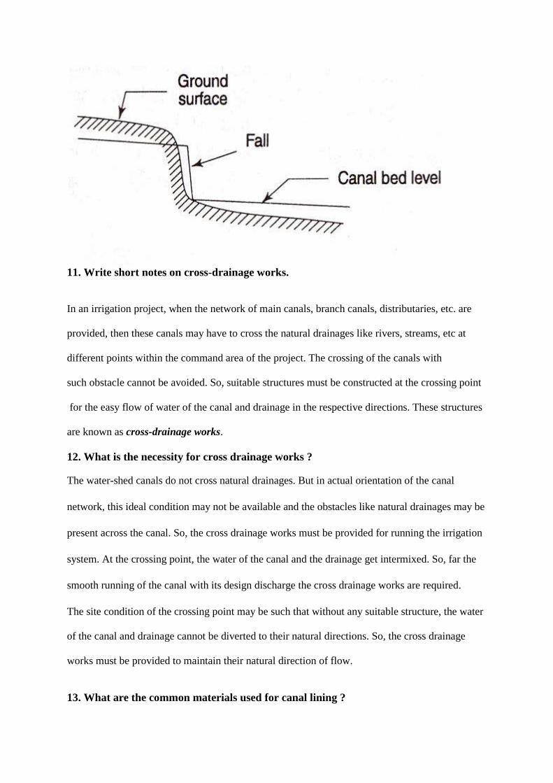
9. What are canal falls?
Generally, the slope of the natural ground surface is not uniform throughout the alignment.
Sometimes, the ground surface may be steep and sometimes it ma be very irregular with abrupt
change of grade. In such cases, a vertical drop is provided to step down the canal bed and then it
is continued with permissible slope until another step down is necessary. This is done to avoid
unnecessary huge earth work in filling. Such vertical drops are known as canal falls or simply
falls.
10. What is the necessity for canal falls?
When the slope of the ground suddenly changes to steeper slope, the permissible bed slope cannot
be maintained. It requires excessive earthwork in filling to maintain the slope. In such a case falls
are provided to avoid excessive earth work in filling.
11. Write short notes on cross-drainage works.
In an irrigation project, when the network of main canals, branch canals, distributaries, etc. are
provided, then these canals may have to cross the natural drainages like rivers, streams, etc at
different points within the command area of the project. The crossing of the canals with
such obstacle cannot be avoided. So, suitable structures must be constructed at the crossing point
for the easy flow of water of the canal and drainage in the respective directions. These structures
are known as cross-drainage works.
12. What is the necessity for cross drainage works ?
The water-shed canals do not cross natural drainages. But in actual orientation of the canal
network, this ideal condition may not be available and the obstacles like natural drainages may be
present across the canal. So, the cross drainage works must be provided for running the irrigation
system. At the crossing point, the water of the canal and the drainage get intermixed. So, far the
smooth running of the canal with its design discharge the cross drainage works are required.
The site condition of the crossing point may be such that without any suitable structure, the water
of the canal and drainage cannot be diverted to their natural directions. So, the cross drainage
works must be provided to maintain their natural direction of flow.
13. What are the common materials used for canal lining ?
The commonly used materials for canal lining are :
(i) Concrete
(ii) Rock masonry
(iii) Brick masonry
(iv) Bentonite-earth mixtures
(v) Natural clays of low permeability
(vi) Different mixtures of rubble, plastic, and asphaltic materials.
14.Write short notes on concrete lining.
Concrete lining is probably the best type of lining. Cement concrete lining made from selected
aggregate gives very satisfactory service. Despite the fact that they are frequently high in their
initial cost, their long life and minimum maintenance make them economical.
15.Write short notes on
(i) Bricks and Tiles lining
(ii) Stone lining
(i) Bricks are installed in layers of two with about 1.25 cm of 1 : 3 cement mortar sandwiched in
between. Good quality bricks should be used. Brick tiles can be plastered to increase the carrying
capacity of canal with same section and help in increasing the life span of the lining.
(ii) Stone lining of canals, if economically feasible, is useful for preventing erosion and where the
ground water level is above the bed of the canal and there is a possibility of occurrence of
damaging back pressures. The stones used for boulder linings should be hard, durable, and
capable of sustaining weathering and water action.
16. What are the drawbacks of Kennedy's theory ?
Drawbacks of Kennedy’s Theory are:
(i) The theory is limited to average regime channel only.
(ii) The design of channel is based on the trial and error method.
(iii)The value of m was fixed arbitrarily.
(iv)Silt charge and silt grade are not considered.
(v) There is no equation for determining the bed slope and it depends on Kutter’s equation only.
17.What are the drawbacks of Lacey's theory ?
Drawbacks of Lacey’s Theory are:
(i) The concept of true regime is theoretical and con not be achieved practically.
(ii) The various equations are derived by considering the silt factor f which is not at all constant.
(iii) The concentration of silt is not taken into account.
(iv)Silt grade and silt charge is not taken into account.
(v)The equations are empirical and based on the available data from a particular type of channel.
So, it may not be true for a different type of channel.
18. Compare Kennedy's and Lacey's theories.
KENNEDY'S THEORY
LACEY'S THEORY
1. It states that the silt carried by the flowing
water is kept in suspension by the vertical
component of eddies which are generated from
the bed of the channel.
It states that the silt carried by the flowing
water is kept in suspension by the vertical
component of eddies which are generated from
the entire wetted perimeter of the channel.
2. In this theory, a factor known as critical
velocity ratio ‘m’ is introduced to make the
equation applicable to different channels with
different silt grades.
In this theory, a factor known as silt factor ‘f’ is
introduced to make the equation applicable to
different channels with different silt grades.
19.Write short notes on Soil -Cement linings.
These linings are constructed using cement (15 to 20 per cent by volume) and sandy soil (not
containing more than about 35 per cent of silt and clay particles). Cement and sandy soil can
be mixed in place and compacted at the optimum moisture content. This method of
construction is termed the dry-mixed soil-cement method.
20. What are the factors to be considered before selecting the type of material for
lining?
(i) Economy
(ii) Structural stability
(iii)Resistance to erosion
(iv) Durability
21. What is a permanent canal?
A permanent canal has a continuous source of water supply. Such canals are also known as
perennial canals.
22.What is an inundation canal ?
This type of canal draws its supplies from a river only during the high stages of the river.
Such canals do not have any head works for diversion of river water to the canal, but are
provided with a canal head regulator.
23.Briefly explain the points to be considered for canal alignment.
(i) An irrigation canal should be aligned in such a way that maximum area is irrigated with
least length of canal.
(ii) Cross drainage works should be avoided as far as possible, such that the cost is reduced.
(iii) The off taking point of the canal from the source should be on a ridge, such that the
canal must run as a ridge canal and irrigate lands on both sides.
(iv) Sharp curves in canals must be avoided.
24. Briefly explain the problem in the design of unlined canals in alluvial soils.
When water from the catchment or drainage basin enters the river it carries huge amounts of
silt or sediments along with it. The sediment is carried either in suspension or dragged along
the rivers bed. A portion of this silt or sediment also entire the canals. These sediments can
cause a problem in the design of unlined canals in alluvial soils.
25. What are the measures to be taken for improving the duty of irrigation system ?
(i) The channel should not be in sandy soil and be as near the area to be irrigated as possible
so that the seepage losses are minimum.Wherever justified,the channel may be lined.
(ii) The channel should run with full supply dischargeas per the scheduled program so that
the farmers can draw the required amount of water in shorter durationand avoid the
tendency of unnecessary over -irrigation.
26. What is a Barrage ?
When the water level on the upstream side of the weir is required to be raised to different levels at
different times, then the barrage is constructed. Practically a barrage is on arrangements are
adjustable gates or shutters at different tiers over the weir. The water level can be adjusted at H1,
H2, etc. by operating the adjustable gates.
27.What are the functions of a divide wall ?
a. To form a still water pocket in front of the canal head so that the suspended silt can be settled
down which than later be cleaned through the scouring sluice from time to time.
b. It control the eddy current or cross current in front of the canal head
c. It provides a straight approach in front of the canal head
d. It resists the overturning effect on the weir or barrage caused by the pressure of the
impounding water.
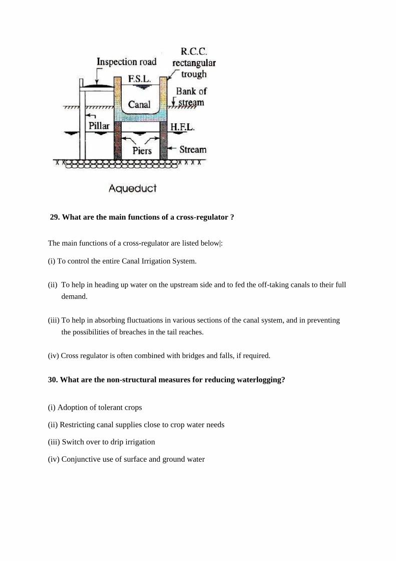
28. What is an aqueduct ?
The hydraulic structure in which irrigation canal is passing over the drainage is known as
aqueduct. This structure is suitable when bed of canal is above the highest flood level of drainage.
In this case, the drainage water passes clearly below the canal.
29. What are the main functions of a cross-regulator ?
The main functions of a cross-regulator are listed below|:
(i) To control the entire Canal Irrigation System.
(ii) To help in heading up water on the upstream side and to fed the off-taking canals to their full
demand.
(iii) To help in absorbing fluctuations in various sections of the canal system, and in preventing
the possibilities of breaches in the tail reaches.
(iv) Cross regulator is often combined with bridges and falls, if required.
30. What are the non-structural measures for reducing waterlogging?
(i) Adoption of tolerant crops
(ii) Restricting canal supplies close to crop water needs
(iii) Switch over to drip irrigation
(iv) Conjunctive use of surface and ground water
UNIT V - IRRIGATION METHODS AND MANAGEMENT
1. Write a short note on Lift irrigation
In lift irrigation water is lifted from a river or a canal to the bank to irrigate the land which are not
commanded by gravity flow. Lift irrigation is being increasingly practiced in India.
2. What is Lift area?
Lift area is defined as the area the level of which is too high to permit irrigation by gravity flow
from the source, but which can be irrigated by lifting water to the necessary level by means of
pump.
3. Write a short note on Tank irrigation.
A tank act as an irrigation storage system which is developed by constructing a small bund of
earth or stones built across a stream. Tank irrigation is more suitable in the peninsular plateau
area such as Andhra Pradesh (Including Telangana) and Tamil Nadu. According to reports,
Tamil Nadu has the second largest area which is over 23 per cent of tank irrigated area of
India and about one-fifth of the total irrigated area of the state.
4.What are the drawbacks of tank irrigation?
The drawbacks of tank irrigation are :
(i) Major problem with tanks water storage is that tanks dry up during the dry season and fail
to provide irrigation when it is needed the most.
(ii) Tanks cover large areas of cultivable land.
(iii) Lifting of water from tanks and carrying it to the fields is a tiring and expensive effort which
discourages the use of tanks as a source of irrigation.
5. Write a short note on well irrigation.
A well is a hole dug in the ground to get the subsoil water. Normal well is about 3-5 metres deep
but deeper wells up-to 15 metres are also dug. This system of irrigation has been used in India
from ancient time. Various methods are used to lift the ground water from the well for irrigation,
drinking, bathing and for other purposes. Well irrigation is more popular in those regions where
ground water is in ample and where there are few canals.
6. What is a tube well ?
Tube well is a deeper well (generally over 15 metres deep) from which water is lifted with
the help of a pumping set operated by an electric motor, a diesel engine or solar power.
7.What are the disadvantages of well and Tube-well irrigation ?
(i) With these methods, only limited area can be irrigated.
(ii) Normally, a well can irrigate 1 to 8 hectares of land. The well may dry up and may be
rendered ineffective for irrigation if excessive water is taken out.
(iii) In the drought situation, the ground water level falls and enough water is not available in
the well when it is needed the most. Tube wells can draw a lot of groundwater from its
neighbouring areas and make the ground dry and not suitable for agriculture.
(iv) Well and tube well irrigation is not possible in areas of salty groundwater.
8. Write a short note on surface irrigation.
In this technique water flows and spreads over the surface of the land. Varied quantities of
water are allowed on the fields at different times. Therefore, flow of water under surface
irrigation comes under wobbly flow. Consequently, it is very difficult to understand the
hydraulics of surface irrigation.
9. What is micro-irrigation?
Micro irrigation is defined as the frequent application of small quantities of water directly
above and below the soil surface; usually as discrete drops, continuous drops or tiny streams
through emitters placed along a water delivery line.
10. Write a short note on irrigation scheduling.
Irrigation scheduling is the use of water management strategies to prevent over application of
water while minimizing yield loss due to water shortage or drought stress.
11. What is participatory irrigation management ?
Participatory Irrigation Management (PIM) refers to a management approach that embraces
the involvement of the people who directly use the irrigation water i.e farmers.
12. What are the objectives of participatory irrigation management ?
The objectives of PIM are :
i) To create a sense of ownership of water resources and the irrigation system among the users, so
as to promote economy in water use and preservation of the system.
ii) To improve service deliveries through better operation and maintenance.
iii) To achieve optimum utilization of available resources through sophisticated deliveries,
precisely as per crop needs.
iv) To achieve equity in water distribution.
13. What are the main functions of Pani Panchayat ?
The main functions of Pani Panchayat are :
To prepare cropping programme considering the soil and agro climatic condition with due
regards to crop diversification.
To prepare a plan for the maintenance of irrigation system in the area of its operation at the end
of each crop season and carryout the maintenance works with the funds of the Pani Panchayats
from time to time.
To regulate the use of water among the various pipe outlets under its area of its operation
according to the warabandi schedule of the system.
To promote economy in the use of water allocated.
14. What are the sub-systems present in any irrigation system?
(i) The water supply sub-system which may include diversion from rivers or surface ponds or
pumped flow of ground water.
(ii) The water delivery subsystem which will include canals,branches and hydraulic structures
on these.
(iii) The water use subsystems,which can be one of the four main types,namely
a) Surface irrigation
b) Subsurface irrigation
c) Sprinkler irrigation
d) Trickle irrigation
(iv) The water removal system i.e,the drainage system.
15. List the various irrigation methods.
Irrigation water can be applied to croplands using one of the irrigation methods listed below:
(i) Surface irrigation which includes the following:
Uncontrolled flooding method
Border strip method
Check method
Basin method
Furrow method
(ii) Sub-surface irrigation
(iii) Sprinkler irrigation
(iv) Trickle irrigation
16. How is the most suitable irrigation method selected ?
Choice of the irrigation method depends on the following factors:
(i) Size,shape and slope of the field
(ii) Soil characteristics
(iii) Nature and availability of the water supply subsystem
(iv) Types of crops being grown.
(v) Initial development costs and availability of funds

(vi) Preferences and past experience of the farmer
17.Write a short note on furrow method of irrigation
An alternative to flooding the entire land surface is to construct small channels along the
primary direction of the movement of water and letting the water flow through these channels
which are termed 'furrows'. Furrows are small channels having a continuous and almost
uniform slope in the direction of irrigation.Furrows are used to irrigate crops planted in rows.
18. What are the disadvantages of furrow irrigation ?
(i) Possibility of increased salinity between furrows
(ii) Loss of water at the downstream end unless end dikes are used
(iii) The necessity of one extra tillage work viz.,furrow construction
(iv) Possibility of increased erosion.
18. What are the conditions favoring sub-surface irrigation ?
The conditions favoring sub-surface irrigation are :
i) Impervious sub-soil at a depth of 2 m or more
(ii) A very permeable sub-soil
(iii) A permeable loam or sandy loam surface soil
(iv) Moderate ground slopes
19. Write short note on sprinkler irrigation
Sprinkling is a method of applying water to the soil surface in the form of a spray which is
somewhat similar to rain. In this method,water is sprayed to the air and allowed to fall to the
soil surface in a uniform patternat a rate less than the infiltration rate of the soil.
20.What are the conditions favoring sprinkler irrigation ?
The following conditions are favourable for sprinkler irrigation :
(i) Very pervious soils that do not permit good distribution of water by surface methods.
(ii) Lands which have steep slopes and easily erodible soils.
(iii) Irrigation channels which are too small to distribute water efficiently by surface
irrigation.
21.What are the merits of irrigation?
Some of the advantages of irrigation are as follows :
Increase of food production.
Modify soil or climate environment – leaching.
Lessen risk of catastrophic damage caused by drought.
Increase income & national cash flow.
Increase labor employment.
Increase standard of living.
Increase value of land.
National security thus self sufficiency.
Improve communication and navigation facilities.
Domestic and industrial water supply.
Improve ground water storage.
Generation of hydro-electric power.
22.What are the demerits of irrigation?
The following are the disadvantages of irrigation :
Water logging.
Salinity and alkalinity of land.
Ill aeration of soil.
Pollution of underground water.
Results in colder and damper climate causing outbreak of diseases like malaria.
23. Explain the term water distribution.
Water distribution is the process of bringing water to consumers. It takes a number of forms
around the world from pressurized municipal water that delivers water directly into homes to
traveling tanker trunks that distribute water to community access points. Distribution of water
resources is usually overseen by a government agency, although private utilities may also be
involved.
24. Write short note on quality of irrigation water
Irrigation water must not have direct or indirect undesirable effects on health of
humans,animals and plants. The irrigation water must not damage the soil and not endanger
the quality of surface and ground waters with which it comes into contact.Attention is given
to the physical,chemical and biological characteristics of water.
25. What do you meant by water user association (WUA)?
It is a self-managing group of farmers working together to operate and maintain their
irrigation and drainage network, to ensure fair and equitable water distribution, and to
increase crop yield.
26. What are the problems of irrigation management without participatory
management?
Inadequate water availability at the lowest.
Poor condition / maintenance of the system.
Lack of measuring devices and control structures.
Inadequate allocation fro operation and maintenance.
Lack of incentives fro saving water.
Poor drainage.
27. Define long – term stability.
The long – term stability is defined as “environmental stability” and “durability” and
refers to the prevention or minimizing of adverse physical changes such as waterlogging,
leaching of nutrients form soils, salinity, erosion, silting, the ‘mining’ of ground water, and
infestations with weeds.
28. What is meant by Productivity?
Productivity is defined as the ratio of output and input. The output can be water
delivered, area irrigated, yield, or income, and the input can be water in the root zone, at the
farm gate at the outlet or at upstream points in the system including the point of diversion or
storage. Improved water supply influences the adoption of high – yielding agricultural
practices by farmers, which justify the productivity criterion of performance.
29. Write the methods used for controlling water logging?
The following measures may be taken to control water logging :
Prevention of percolation from canals.
Prevention of percolation from reservoirs.
Control of intensity of irrigation.
Economical use of water.
30. Define on-farm water management.
It can be defined as manipulation of water within the borders of an individual farm, a
farming plot or field. Example: in canal irrigation system, OFWM starts at the farm gate and
ends at the disposal point of the drainage water to a public watercourse, open drain or sink.
UNIT – 3
IRRIGATION ENGINEERING
1) Define irrigation
Irrigation is defined as the science of artificial application of water to the land in
accordance with the crop requirements.
2) What are the necessity of irrigation ?
(i)Inadequate rainfall
(ii)Increasing yield of crops
(iii)Growing perennial crops
(iv)Uneven distribution of rainfall.
3) What are the advantages of irrigation?
Increase in food production
Optimum benefits
General prosperity
Afforestation
4) What are the disadvantages of irrigation?
(i) Over irrigation may lead to water logging
(ii) It may reduce crop yield
(iii) It is expensive and complex.
5) What are the types of irrigation?
(i)Surface irrigation
(ii)sub-surface irrigation.
6) what are the techniques of water distribution in the farms?
Free flooding
Border flooding
Check flooding
Basin flooding, furrow irrigation method, drip irrigation method.
7) What are the types of sprinkler system?
(i) Permanent system
(ii) Semi-permanent system
(iii) Portable system
8)What are the advantages of sprinkler irrigation?
Land levelling is not required
Fertilisers can be uniformly applied
It is less labour oriented
9) What are the limitations of sprinkler irrigation?
Initial cost of the system is very high
It requires larger electrical power
High wind may distort sprinkler pattern
10) What is arid region?
The area where irrigation is must for agriculture is called arid region.
11) What is semi-arid region?
The area in which inferior crops can be grown without irrigation
12) What is crop period?
The time period that elapses from the instant of its sowing to the instant of its harvesting is
called crop period.
13) What is base period?
The time between the first watering of a crop at the time of its sowing to its last watering
before harvesting is called the base period
14) What is rotation period?
The time interval between two such consecutive watering is called frequency irrigation.
15) Define duty of water?
It is the relationship between the volume of water and the area of crops it matures is called
duty of water.
16) Define delta of a crop
Each crop requires a certain amount of water after a certain fixed interval of time, through its
period of growth is called delta of a crop
17) What are the factors on which duty depends?
Type of crop
Climate and seasons
Useful rainfall
Type of soil
Efficiency of cultivation method
18) What are kharif crops?
The kharif crops are rice,bajra,jawar,maize,cotton,tobacco, groundnut,etc.
19) What are rabi crops?
Rabi crops are wheat,barley,gram,linseed,mustard,potatoes,etc
20) Define irrigation efficiency.
It is the efficiency of water output to the water input,and is usually expressed as
percentage.
21) What is called effective rainfall?
Precipitation falling during the growing period of a crop that is available to meet the
evapo-transpiration nee