Embed Size (px)
Citation preview
District at a Glance
Population (2013 est) 2,515,169Male 1307064 (52%)Female 1208105 (48%)
Rural 2,164,878 (86%)Urban 350,291 (14%)Tehsils 3UC 59Revenue Villages 828Area (Sq km) 11,922Registered Voters 1,029,536Literacy Rate (10+) 2011 43%
Departmental Focal Points (area code 064) No Name of the Offices Office Residence Fax
District Coordination Officer (Iftikhar Ali Shah)
9260340-343-349 9260351
Commissioner DG Khan Div
9260467, 9260468 9260469
SP 9260111TMO DG Khan 9260553 9260358TMO Taunsa 2602858 2602263TMO Tribal Area 9260329 9260311PCO Officer DG Khan (Javed Ahmed)
0301-6971991
PCO Officer Tribal Area (Hassan Khalid)
0301-6971991
DHS, EDO (H) 9260218 9260219DHO 9260221MS DHQ 9260224THQ Taunsa 2602970Irrigation 0800-11-333EDO Education 9260044
Administrative Division
Administrative Unit
Number of Number of MouzasKanungoCircles/
Supervisory Tapas
Patwar Circles/ Tapas
Total Rural Urban Partly Urban Forest Un-
populated
D.G Khan District 36 249 828 724 5 20 6 73D.G Khan Tehsil 18 136 296 232 5 13 2 44Taunsa Tehsil 9 61 197 166 0 7 4 20DE-EX AREA 9 52 335 326 0 0 0 9
Source: Punjab Mouza Statistics 2008
Road Network InfrastructureDistrict Route LengthBhakkar to Layyah Karor-Bhakkar Road 150 kmMuzzafargarh to Layyah Kot Addu- Layyah Road 110 kmJhan to Layyah Rodu Sultan Road 135 km
Source: Google Maps
Entry-Exit Points1 Behal 5 Mianwali-Muzaffargarh Rd2 Fateh Pur 6 Pahar Pur3 Nawan Kot-Atthara Hazari Rd 74 Chaubara Rd 8
Political ScenarioConstituency Name Party Address Contact NumberNA-171 Sardar Muhammad Amjad
Farooq Khan Khosa PMLN Kot Qaisarani, Tehsil Taunsa,
District Dera Ghazi Khan. 06510-522222, 0641-468357 (Res), 0300-6786176
NA-172 Hafiz Abdul Kareem PMLN House No.30-A Khayaban Sarwar DG Khan
0321-6785555
NA-173 Sardar Awais Ahmad Khan Leghari
PMLN Bmp Post Pahar Fort MunrooP.O Khas Teh, & Distt. Dera Ghazi Khan
0333-5221111
PP-240 Sardar Meer Badshah Khan Qaisraani
PMLN Kot Qaisarani, Tehsil Taunsa, District Dera Ghazi Khan.
06510-522222, 0641-468357 (Res), 0300-6786176
PP-241 Khawaja Muhammad Nizam ul Mehmood
PPPP Taunsa Sharif, Mohallah Khawjgan, Distt: Dera Ghazi Khan
064-2602501, 0300-8632787
PP-242 Javed Akhtar IND - 0641-680383 (Res), 0641-680007 (Off), 0333-4364530
PP-243 Sardar Zulfiqar Ali Khan Khosa
PMLN 540-DHA, Lahore Cantt and Khosa House, Block.17, District Dera Ghazi Khan and also 16-B, Aikman Road, GOR-I
0333-6466666, 0333-4342902, 99204864
PP-244 Syed Abdul Aleem IND House No.10, Block No. 5, Dera Ghazi Khan
0641-470430 (Res), 0641-468555 (Off), 0300-6781700, 0333-4237501
PP-245 Sardar Muhammad Jamal Khan Laghari
IND - -
PP-246 Mehmood Qadir Khan IND - -
Health Infrastructure
Type No BedsHospitals 4 455Dispensaries 14 0Rural Health Centers 3 60Basic Health Units 42 84TB Clinics 0 0Sub-Health Centers 15 0Mother and Child Health Centers 2 0Total 80 599
Source: PHSRP and Google Earth
Educational InfrastructureLevel Enrolment School Facilities Teachers
Boys Girls Total Boys Girls Total Male Female TotalPrimary 75,315 52,585 127,900 736 529 1,265 1,582 1202 2,784Middle 24,237 22,453 46,690 87 125 212 933 1052 1,985Matric 32,567 22,191 54,758 54 39 93 1097 748 1,845
Higher Secondary 318 628 946 5 4 9 53 66 119Inter & Degree Colleges 4,403 4,440 8,843 5 7 12 139 62 201Grand Total 136,840 102,297 239,137 887 704 1,591 3,804 3,130 6,934
Source: Punjab Development Stats 2011 Employment Statistics
GENDER
QUANTIFICATION
SERVICE
AGRICULTURE
TRADE
INDUSTRY
PERSONALBUSINESS
OVERSEASEMPLOYMENT
LABOUR
MALE MOSTLY 1 298 1 1 5 1 61SOME 336 110 251 34 246 159 332NONE 81 10 166 383 167 258 25
FEMALE MOSTLY 1 159 82SOME 158 161 29 8 108 15 242NONE 259 98 389 410 310 403 94
Losses and Damages of Floods 2010, 2012 and 2013
Population (2013) Tehsils UC Area (Km2) Crop Area (Km2) Mouzas Deaths InjuriesLivestock affected House affected Partially damaged Destroyed
Total 2,515,169 3 59 12,318 N/A 491 2010 Affected1 263,501 3 51 725 100 141 4 43 1,500,000 61,982 47,659 14,323
2012 Affected2 616,623 N/A N/A 1,449 195 103 0 0 0 4,475 2,934 1,5412013 Affected3 160,074 2 3 N/A N/A N/A N/A N/A N/A N/A N/A N/A
1 Relief and Crisis Management Department, Board of Revenue, Punjab as of 26-09-20102 PDMA Punjab as of 09-10-20123 Pakistan Red Crescent Society as of 4th August
This Mini-District Profile [MDP] is the result of a close collaboration between iMMAP and ALHASAN Systems. We thank all those organizations who have made their emergency situation assessments public, in order to strengthen and enhance the overall response efforts. Should you have any questions or would like to share additional information for updating these MDPs, please contact us at [email protected] or 051 835 0754.
MINI DISTRICT PROFILE FOR RAPID NEEDS ASSESSMENTFLASH FLOOD 2013: DERA GHAZI KHAN, PUNJABAugust 9th, 2013
1
Rajanpur - Reference Map
Tehsil and UC PopulationTehsil UC Urban/Rural 2013 Pop DG Khan Aali Wala Rural 36,469
Bahadur Garh Rural 43,583Basti Fauja Rural 46,553Basti Malana Rural 51,290Chhabri Rural 36,042Choti Zerine Rural 47,488Churatta Rural 44,490D.G.Khan -2 Urban 42,947D.G.Khan -3 Urban 42,708D.G.Khan -4 Urban 42,537D.G.Khan -5 Urban 42,038D.G.Khan -6 Urban 40,217D.G.Khan -7 Urban 41,931D.G.Khan-1 Urban 42,366Darkhast Jamal Khan Rural 44,875Dchoti Bala Rural 51,142Drahma Rural 47,736Gadai Rural 43,482Ghaus Abad Rural 50,713Haji Ghazi Rural 38,386Jakhar Imam Shah Rural 40,561Jhoke Uttra Rural 47,542Kala Rural 45,956Khakhi Rural 45,167Kot Chutta Rural 42,700Kot Haibat Rural 42,094Kot Mubarak Rural 42,385Mamoori Rural 46,000Mana Ahmadani Rural 46,963Mutafariq Chahan Rural 47,077Nawan Rural 43,036Notak Rural 50,413Paigah Rural 51,624Pir Adil Rural 47,348Ramin Rural 47,125Saina Rural 40,600Sakhi Sarwar Rural 42,153Shadan Lund Rural 39,107Shah Sadar Din Rural 47,021Wadore Rural 37,433Yaroo Rural 42,525
Sub Total 1,811,823Taunsa Fateh Khan Rural 42,216
Hero Sharqi Rural 36,653Jaluwali Rural 37,171Kot Qaisrani Rural 36,825Lakhani Rural 37,738Makwal Kalan Rural 41,927Mangrotha Rural 40,536Morejhangi Rural 40,782Nari Shumali Rural 39,643Sokar Rural 41,595Taunsa Urban 57,309Tibbi Aisrani Rural 36,317Vehoa Rural 39,563
Sub Total 528,274Tribal Area Barthi Rural 40,012
Faziz Katchh Rural 28,243Mubaraki Rural 32,554Tuman Leghari Rural 36,271Tuman Qaisarani Rural 37,993
Sub Total 175,072
Coordination and Support ServicesName Contact Name Contact Name Contact Name Contact Name Contact
SDPO City Circle 064-9260103
SDPO Saddar Circle
064-9260104 SDPO Kot Chhutta Circle
064-2843509
SDPO Kot Chhutta Circle
064-2843509
SDPO Taunsa Circle
064-2601115
City 064-9260139 Kot Mubarak 064-2846015,064-2033622 Kot Chhutta 064-
2843507 Kot Chhutta 064-2843507 Taunsa 064-
2602914
Saddar 064-9260140 Kala NIL Choti 064-2566020 Choti 064-
2566020 Vehova 064-2524216
B-Division 064-9260138 Shah Saddar Din NIL D J Khan NIL D J Khan NIL Retra 064-
2523216Civil Lines 064-9260141 Drahma 064-2689270 Jhoke Utra NIL Jhoke Utra NIL
Sakhi Sarwar 064-2642262
List of NGOsName Phone1 Phone2 Email1 Fax1 AddressAl-Asar Development organization 0092-642-465683 0092-333-6464683 [email protected] NULL Block “S”, Infront of City Police Station
Al-Mustafa Development Organization 0092-333-6484813 NULL [email protected] NULLHouse No. 07, Main Street Shahzada Sultan Town
ASRA Development Organization 0092-333-6482011 0092-334-6759383 [email protected] NULLSarwar Colony, Bhatti Market (ShakoorAbad) Near Pul Dat
Association for Gender Awareness and Human Empowerment 0092-42-35291211 0092-42-35957916
[email protected], [email protected]
0092-42-35291211
House No.3, Block-A, Lalazar Colony, Phase II, Raiwind Road
Community Support Concern 0092-42-35123623 0092-42-35120410 [email protected]
Building # 319 Block 4 Sector D1 Green Town Lahore
Doaba Foundation 0092-61-6213256 NULL [email protected]
H. No.1, Street No.2, Behind Toyota Showroom, Shalimar Colony, Bosan Road
National Rural Support Program 0092-51-28223190092-51-2822324 , 0092-51-2822792 [email protected]
0092-51-2822779
House No. 46, Aga Khan Road, Sector F-6/4
Qatar Charity 0092-51-2212240 0092-51-2212241 [email protected]
House No. 31 Street No. 111, Sector G-11/3
Sungi Welfare Society058740-42853 , 05823452853
058720-32362 ,058740-42760 [email protected] NULL Chamyati Dhirkot, Tehsil Dhirkot
Youth Front Pakistan 0092-64-2471767 NULL [email protected] Jinnah Complex-231, Shakir town
Situation Update
As of 4th August 2013; Pakistan Red Crescent Society: On 02.08.2013, District Government declared the warning of flood in all the Tehsils of District D.G. Khan. Due to heavy rains in the Tribal Areas of District D.G. Khan hill torrents in (i) Kaura (ii) Vehove (iii) Sanghar (iv) Vadoor (v) Sakhi Sarwa and Taunsa Sharif. Hill Torrents of Tehsil Taunsa Sharif struck some villages of Tehsil Taunsa Sharif & Tehsil D.G. Khan. In Tehsil Taunsa Sharif, most affected Union Council is U/C Fateh Khan and two other U/Cs named (i) More Jhangi and (ii) Nari Shumali. In Tehsil D.G. Khan most affected Union Council is U/C Vadoor. District Government did not take any action about any kind of relief. PRCS Punjab trained Volunteers are ready for response and are on standby.
2MINI DISTRICT PROFILE FOR RAPID NEEDS ASSESSMENTFLASH FLOOD 2013: DERA GHAZI KHAN, PUNJABAugust 9th, 2013
This Mini-District Profile [MDP] is the result of a close collaboration between iMMAP and ALHASAN Systems. We thank all those organizations who have made their emergency situation assessments public, in order to strengthen and enhance the overall response efforts. Should you have any questions or would like to share additional information for updating these MDPs, please contact us at [email protected] or 051 835 0754.
3
This Mini-District Profile [MDP] is the result of a close collaboration between iMMAP and ALHASAN Systems. We thank all those organizations who have made their emergency situation assessments public, in order to strengthen and enhance the overall response efforts. Should you have any questions or would like to share additional information for updating these MDPs, please contact us at [email protected] or 051 835 0754.
Punjab
Balochistan
Sindh
Fata
Gilgit Baltistan
Khyber PakhtunkhwaAJK
ICTIndian Occupied Kashmir
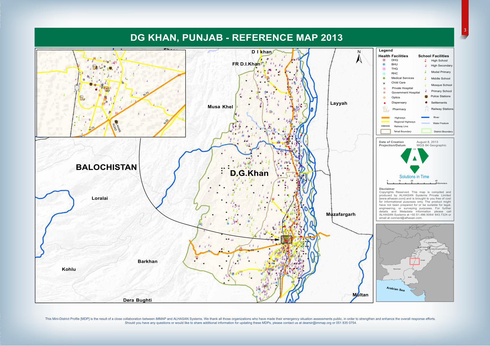
DG KHAN, PUNJAB - REFERENCE MAP 2013
DisclaimerCopyrights Reserved. This map is compiled andproduced by ALHASAN Systems Private Limited[www.alhasan.com] and is brought to you free of costfor informational purposes only. The product mighthave not been prepared for or be suitable for legal,engineering, or surveying purposes. For furtherdetails and Metadata information please callALHASAN Systems at +92.51.486.5064/ 843.7324 oremail at [email protected].
Date of Creation August 8, 2013Projection/Datum WGS 84 Geographic
N-70
N -55
Barkhan
Dera Bughti
Killa Saifullah
Kohlu
Loralai
Musa Khel
Sheerani
Zhob
FR D.I.Khan
D I khan
Layyah
Multan
Muzafargarh
0 20 4010Kilometers
LegendSchool Facilities± High School
High Secondary
Model Primary
Middle School
Mosque School
5
5
5
5
5
Primary School5
BALOCHISTAN
Arabian Sea
Health Facilities
"' THQ
"' RHC
GF Medical Services
Ó÷ Child Care
Private HospitalGovernment Hospital
BHU"' DHQ
'
D.G KHAN
ROADN-70
N-70
N-55
Õ
®v
"F% Optics
GF Dispensary
Pharmacy
Highways
Regional Highways
Railway Line
ca Police Stations
Railway Stations
Settlements
Water Feature
River
District BoundaryTehsil Boundary
D.G.Khan
Musa
Layyah
D. G.Khan
Multan
Bhakkar
Muzaffargarh
De-ExcludedArea (Tribal
Area)
DeraGhaziKhan
Taunsa
10
44
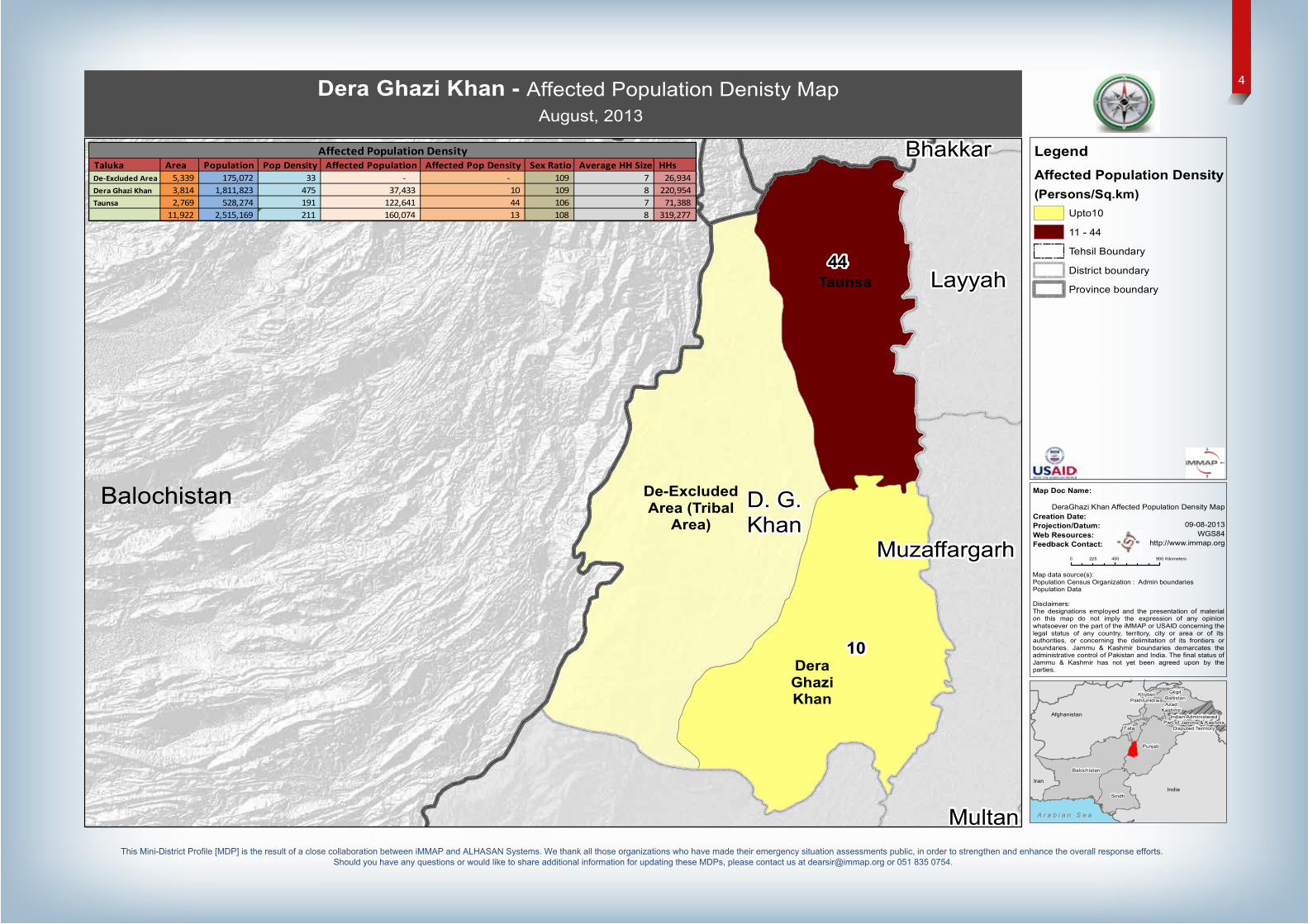
DeraGhazi Khan Affected Population Density Map
09-08-2013WGS84
http://www.immap.org
LegendAffected Population Density(Persons/Sq.km)
Upto10
11 - 44
Tehsil Boundary
District boundary
Province boundary
Dera Ghazi Khan - Affected Population Denisty Map
August, 2013
Balochistan
AzadKashmir
Balochistan
Indian AdministeredPart of Jammu & Kashmir
Disputed TerritoryFata
GilgitBaltistan
KhyberPakhtunkhwa
Punjab
Sindh
Map Doc Name:
Creation Date:Projection/Datum:Web Resources:Feedback Contact:
A r a b i a n S e aA r a b i a n S e a
Iran
Afghanistan
India
0 450 900225 Kilometers
Map data source(s):Population Census Organization : Admin boundariesPopulation Data
Disclaimers:The designations employed and the presentation of materialon this map do not imply the expression of any opinionwhatsoever on the part of the iMMAP or USAID concerning thelegal status of any country, territory, city or area or of itsauthorities, or concerning the delimitation of its frontiers orboundaries. Jammu & Kashmir boundaries demarcates theadministrative control of Pakistan and India. The final status ofJammu & Kashmir has not yet been agreed upon by theparties.
Taluka Area Population Pop Density Affected Population Affected Pop Density Sex Ratio Average HH Size HHsDe-Excluded Area 5,339 175,072 33 - - 109 7 26,934 Dera Ghazi Khan 3,814 1,811,823 475 37,433 10 109 8 220,954 Taunsa 2,769 528,274 191 122,641 44 106 7 71,388
11,922 2,515,169 211 160,074 13 108 8 319,277
Affected Population Density
4
This Mini-District Profile [MDP] is the result of a close collaboration between iMMAP and ALHASAN Systems. We thank all those organizations who have made their emergency situation assessments public, in order to strengthen and enhance the overall response efforts. Should you have any questions or would like to share additional information for updating these MDPs, please contact us at [email protected] or 051 835 0754.
89:D89:D89:D!.(89:D
89:D
89:D
89:D
89:D89:D89:D89:D
!.(
89:D
89:D
89:D
89:D
"'
89:D
!.(
89:D89:D
89:D
89:D
89:D89:D89:D89:D89:D89:D89:D89:D!.(89:D
!.(
"'89:D
89:D
89:D
89:D89:D89:D"'89:D 89:D89:D
"'
"'
"'
"'
"'
"'
"'
"'
"' "'
"'"'
"'
"'
"'
"'
"'
"'
"'
"' "'
"'
"'
"'
"'
"'
"'"'"'
"'
"'
"'
"'
"'
"'
"'
"'
"'
"'
"'
"'
"'
"'
"'
"'
"'"'
"'
"'
"'
"'
"'
"'
"'"'"'
"'
!.(
!.(
!.(
!.(
!.(
!.(
!.(
!.(
!.(
!.(
!.(
!.(
!.(
!.(
!.(
!.(
89:D89:D89:D89:D89:D
89:D
89:D89:D89:D89:D89:D89:D89:D89:D89:D
89:D89:D89:D89:D
89:D89:D89:D89:D89:D
89:D
89:D
89:D
!.(
89:D89:D89:D89:D89:D89:D89:D89:D89:D
"'
89:D89:D89:D89:D
"'
89:D
D. G.Khan
Bhakkar
Muzaffargarh
Multan
Lodhran
Layyah
De-ExcludedArea (Tribal
Area) DeraGhaziKhan
Taunsa
CivilhospitalHospital
Colonyhospital
Govt.hospital
Huzaifahospital
Ehsanhospital
Bhu jhoke uttra
Bhu piraadil
Bhu kala
Bhu batebait wala
Bhusamina
Bhukhanpur
Bhu kotmubarak
Bhu bakhar wah
Bhu lohar wala
Bhumanaahmedani
Bhu ghous abadBhu
mamooriBhu chotibala Rhc
choti zareen
Rhc kot chutta
Rhc shahsadar din
Rhcshadan
lund
Rhcbarthi
Bhujhoke bodo
Bhu kotqaisarani
Bhulakhani
Bhulitra
Bhu narishumali
Bhusokar
Bhutriman
Bhunutkani
Bhu more jhangi
Bhu sanjarsadanBhu kot mahoi
Bhudouna
Rhc tibbiqaisrani
Rhcvehvova
Bhudumbar
Bhu rakhimunh
Bhu fazlakatchh
BhulakhaBhu
roonghanBhu khararbuzdar
Bhubirotmandwani
Dispensary
Civil hospitalsakhi sarwar
Dr.aalamsher khanchanar clinic
Hasnainfarooq
clinic
Charityclinic
& maternity home
Dr.hafiz ishfaq ahmadkhan jogiani clinic
Al rehman zachabachacentre
Gulzar maternity home
Qurashi zachabachacentre
Hoorul shifamedical
Veterinaryhospital
Rhc
Saminaclinic
Basic healthunit
yaroo
District - DGKhan Health Facilities Map
07-08-2013WGS84
http://www.immap.org
LegendHealth Facilities
"' Basic Health Unit
"' District Health Unit
!.( Government Hospital
89:D Private Hospital
"' Rural Health Unit
"' Tehsil Health Unit
Tehsil Boundary
District boundary
Province boundary
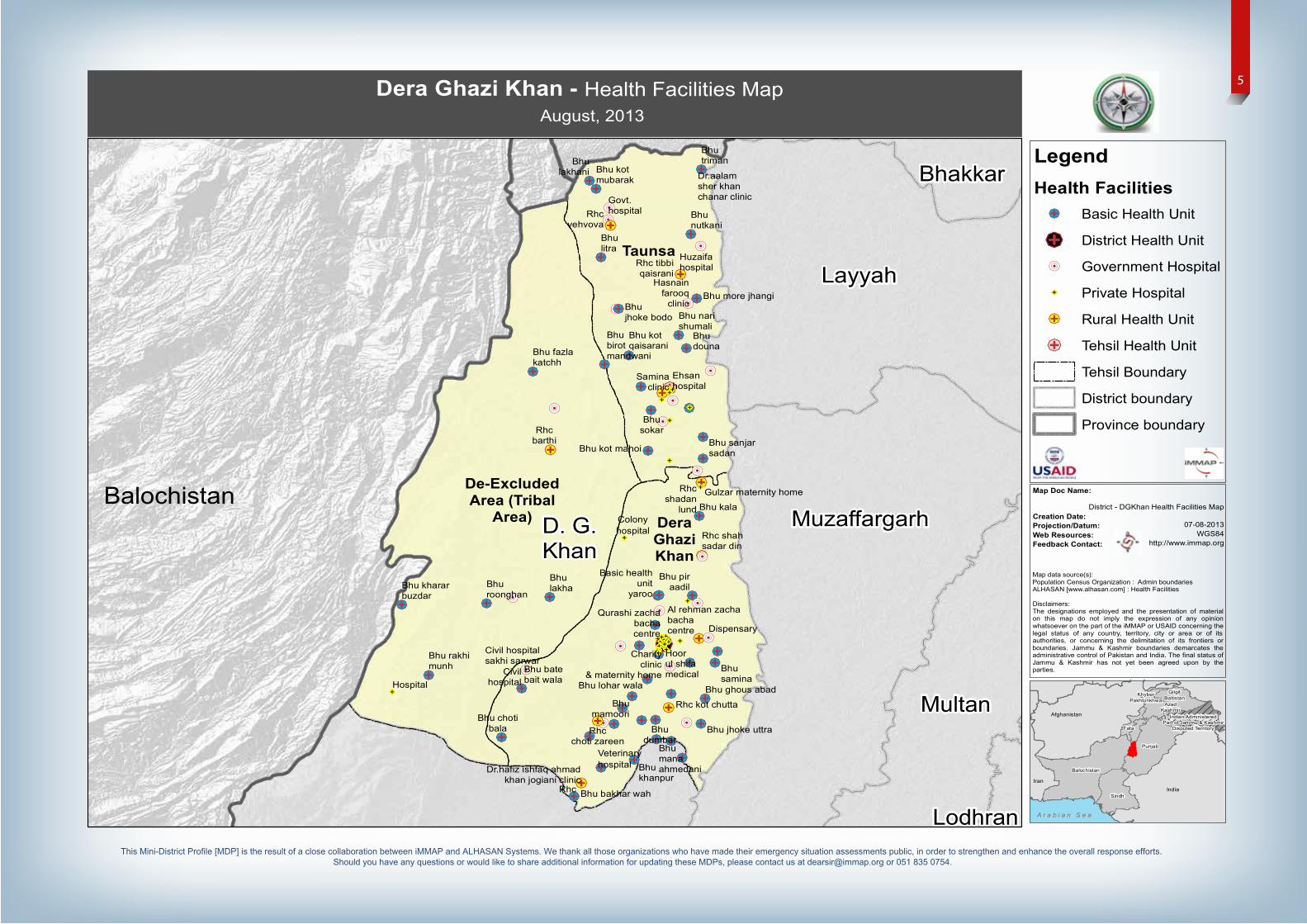
Dera Ghazi Khan - Health Facilities Map
August, 2013
Balochistan
AzadKashmir
Balochistan
Indian AdministeredPart of Jammu & Kashmir
Disputed TerritoryFata
GilgitBaltistan
KhyberPakhtunkhwa
Punjab
Sindh
Map Doc Name:
Creation Date:Projection/Datum:Web Resources:Feedback Contact:
A r a b i a n S e aA r a b i a n S e a
Iran
Afghanistan
India
Map data source(s):Population Census Organization : Admin boundariesALHASAN [www.alhasan.com] : Health Facilities
Disclaimers:The designations employed and the presentation of materialon this map do not imply the expression of any opinionwhatsoever on the part of the iMMAP or USAID concerning thelegal status of any country, territory, city or area or of itsauthorities, or concerning the delimitation of its frontiers orboundaries. Jammu & Kashmir boundaries demarcates theadministrative control of Pakistan and India. The final status ofJammu & Kashmir has not yet been agreed upon by theparties.
5
This Mini-District Profile [MDP] is the result of a close collaboration between iMMAP and ALHASAN Systems. We thank all those organizations who have made their emergency situation assessments public, in order to strengthen and enhance the overall response efforts. Should you have any questions or would like to share additional information for updating these MDPs, please contact us at [email protected] or 051 835 0754.
D. G.Khan
Layyah
MuzaffargarhMultan
Bhakkar
De-excludedArea
DeraGhaziKhan
Taunsa
Ali Wala
Ali Wala
BahadarGarh
Barthi
Barthi
BastiFauja
BastiMalana
ChabriChabri
Chorota
ChotiBala
ChotiBala
ChotiZareen
D.j.kGharbi
Drahma
Drahma
FazilaKach
FazilaKach
Gadai
Ghousabad
Hairosharqi
JakarImamShah
Jallowali
JhokUtra
Kala
Khakhi
KotChhutta
KotHaibat
KotMubarak
KotMubarak
KotMubarak
KotQaisarani
Lakhani
Mahmori
MakwalKalan
MakwalKalan
ManaAhmadani
Mangrotha
Mubarki
MutfariqChahan
NarriShumali
Nautak
Nautak
Nawan
Nawan
Paigan
Pir Adil
Pir AdilPir Adil
Pir Adil
RanmanRanman
SakhiSarwar
ShadanLund
ShahSadar
Din
Smena
Sokar
TibiQaisarani
TumanLeghari
TumanQaisrani
Unknown_2
Veho Wa
Wadoor
Yaru
40782
39643
42216
DGKhan Hazard Analysis Map
07-08-2013WGS84
http://www.immap.org
LegendAffected Population
Upto 37,500
37,501 - 41,000
41,001 - 45,000
Settlements at Risk
Roads
Railway
Stream
River
UC boundary
Tehsil boundary
District boundary
Province boundary
Dera Ghazi Khan - Hazard Analysis Map
August, 2013
Balochistan
AzadKashmir
Balochistan
Indian AdministeredPart of Jammu & Kashmir
Disputed TerritoryFata
GilgitBaltistan
KhyberPakhtunkhwa
Punjab
Sindh
Map Doc Name:
Creation Date:Projection/Datum:Web Resources:Feedback Contact:
A r a b i a n S e aA r a b i a n S e a
Iran
Afghanistan
India
0 500 1,000250 Kilometers
Map data source(s):Population Census Organization : Admin boundariesRoad River : WFP - World Food Program,River Stream : ESRI & DIVAAffected UC : Jinnah Welfare SocietySettlements : NGA - National Geospatial Agency
Disclaimers:The designations employed and the presentation of material on this mapdo not imply the expression of any opinion whatsoever on the part of theiMMAP or USAID concerning the legal status of any country, territory, cityor area or of its authorities, or concerning the delimitation of its frontiersor boundaries. Jammu & Kashmir boundaries demarcates theadministrative control of Pakistan and India. The final status of Jammu &Kashmir has not yet been agreed upon by the parties.
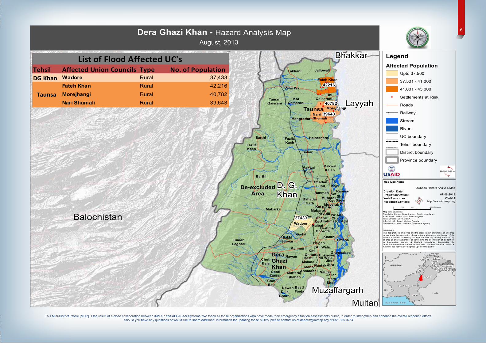
Tehsil Affected Union Councils Type No. of PopulationDG Khan Wadore Rural 37,433
Fateh Khan Rural 42,216
Morejhangi Rural 40,782
Nari Shumali Rural 39,643
List of Flood Affected UC's
Taunsa
37433
Fateh Khan
Morejhangi
6
This Mini-District Profile [MDP] is the result of a close collaboration between iMMAP and ALHASAN Systems. We thank all those organizations who have made their emergency situation assessments public, in order to strengthen and enhance the overall response efforts. Should you have any questions or would like to share additional information for updating these MDPs, please contact us at [email protected] or 051 835 0754.