Embed Size (px)
Citation preview
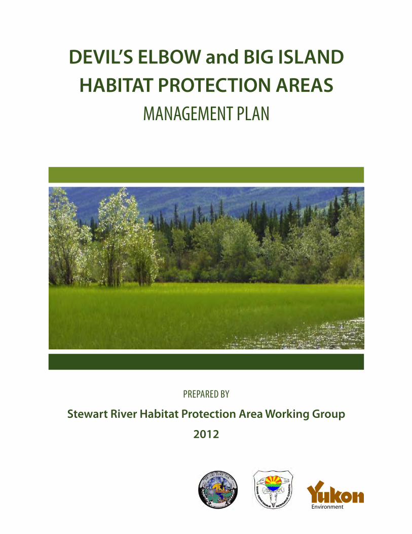
DEVIL’S ELBOW and BIG ISLAND HABITAT PROTECTION AREAS
MANAGEMENT PLAN
PREPARED BY
Stewart River Habitat Protection Area Working Group
2012
Environment
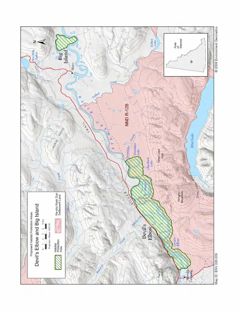
Location of land parcels that comprise the Devil’s Elbow and Big Island Habitat Protection Areas.
TABLE OF CONTENTSINTRODUCTION . . . . . . . . . . . . . . . . . . . . . . . . . . . . . . . . . . . . . . . . . . . . . . . . . . . . . . . . . 1
BACKGROUND . . . . . . . . . . . . . . . . . . . . . . . . . . . . . . . . . . . . . . . . . . . . . . . . . . . . . . . . . . 2
RESOURCE DESCRIPTIONS AND MANAGEMENT RECOMMENDATIONSWildlife . . . . . . . . . . . . . . . . . . . . . . . . . . . . . . . . . . . . . . . . . . . . . . . . . . . . . . . . . . . . . . . . . . . . . 5
Moose . . . . . . . . . . . . . . . . . . . . . . . . . . . . . . . . . . . . . . . . . . . . . . . . . . . . . . . . . . . . . . . . . . . 5Bears . . . . . . . . . . . . . . . . . . . . . . . . . . . . . . . . . . . . . . . . . . . . . . . . . . . . . . . . . . . . . . . . . . . . . 7Fish . . . . . . . . . . . . . . . . . . . . . . . . . . . . . . . . . . . . . . . . . . . . . . . . . . . . . . . . . . . . . . . . . . . . . . 8Waterfowl . . . . . . . . . . . . . . . . . . . . . . . . . . . . . . . . . . . . . . . . . . . . . . . . . . . . . . . . . . . . . . . . 9Trapping . . . . . . . . . . . . . . . . . . . . . . . . . . . . . . . . . . . . . . . . . . . . . . . . . . . . . . . . . . . . . . . . 10
Access . . . . . . . . . . . . . . . . . . . . . . . . . . . . . . . . . . . . . . . . . . . . . . . . . . . . . . . . . . . . . . . . . . . . . 11Off road vehicles . . . . . . . . . . . . . . . . . . . . . . . . . . . . . . . . . . . . . . . . . . . . . . . . . . . . . . . . . 11Roads and trails . . . . . . . . . . . . . . . . . . . . . . . . . . . . . . . . . . . . . . . . . . . . . . . . . . . . . . . . . . 12Visitor use . . . . . . . . . . . . . . . . . . . . . . . . . . . . . . . . . . . . . . . . . . . . . . . . . . . . . . . . . . . . . . .14
Agricultural dispositions and grazing leases . . . . . . . . . . . . . . . . . . . . . . . . . . . . . . . . . . . 15Buildings . . . . . . . . . . . . . . . . . . . . . . . . . . . . . . . . . . . . . . . . . . . . . . . . . . . . . . . . . . . . . . . . . . . 16Forest resources and woodcutting . . . . . . . . . . . . . . . . . . . . . . . . . . . . . . . . . . . . . . . . . . . . 17Heritage resources . . . . . . . . . . . . . . . . . . . . . . . . . . . . . . . . . . . . . . . . . . . . . . . . . . . . . . . . . . 19Mineral development . . . . . . . . . . . . . . . . . . . . . . . . . . . . . . . . . . . . . . . . . . . . . . . . . . . . . . . .20Oil and gas resources . . . . . . . . . . . . . . . . . . . . . . . . . . . . . . . . . . . . . . . . . . . . . . . . . . . . . . . .22Research and monitoring . . . . . . . . . . . . . . . . . . . . . . . . . . . . . . . . . . . . . . . . . . . . . . . . . . . .23
SUMMARY OF RECOMMENDATIONS AND IMPLEMENTATION . . . . . . . . . . . . 24
APPENDIX 1: TERMS OF REFERENCE . . . . . . . . . . . . . . . . . . . . . . . . . . . . . . . . . . . . 25
For more information, contact:
Habitat Protection Department of Environment, Government of Yukon (867) 667-5803
First Nation of Na-Cho Nyäk Dun Lands (867) 996-2265

1Approved Devil’s Elbow and Big Island Habitat Protection Areas Management Plan
INTRODUCTION
The Devil’s Elbow and Big Island areas along the Stewart River near Mayo have long been known as being important for moose calving. During calving season, cow moose and their calves are very sensitive to human disturbance. The concept of protecting these areas was first initiated in June of 2003 by the
Mayo District Renewable Resources Council (MDRRC) through a proposal forwarded to the Yukon Minister of Environment. The proposal requested that these areas be designated as Habitat Protection Areas (HPAs) under the Yukon Wildlife Act. This proposal was supported by the First Nation of Na-Cho Nyäk Dun (FNNND). The Yukon Government reviewed the proposal and agreed that it met the criteria for establishing Habitat Protection Areas (HPAs).
In 2005, the Yukon Government informed the First Nation of Na-Cho Nyäk Dun and the Mayo District Renewable Resources Council that they were prepared to work together on a management planning process for the areas. The purpose of the process was to prepare a recommended Habitat Protection Areas management plan for approval by the Yukon Government and the First Nation of the Na-Cho Nyäk Dun. The management plan would provide guidelines for the long-term management of fish and wildlife, and their habitats, while allowing for traditional uses of these areas by Northern Tutchone people and the general public. A planning team was established to conduct the management planning process. It consisted of members of the Yukon Government, the First Nation of Na-Cho Nyäk Dun and the Mayo District Renewable Resources Council.
We would like to acknowledge the work of Dawna Hope and Richard Mahoney from the First Nation of Na-Cho Nyäk Dun, Jimmy Johnny and Frank Patterson from the Mayo District Renewable Resources Council, and Bob Kuiper and Mark O’Donohue from the Yukon Government.
FNNND: First Nation of Na-Cho Nyäk Dun
HPA: Habitat Protection Area
HPAs: Habitat Protection Areas
MDRRC: Mayo District Renewable Resources Council
2 Approved Devil’s Elbow and Big Island Habitat Protection Areas Management Plan
THE HABITAT PROTECTION AREAS PROPOSALResidents of the Mayo area considered the identification and protection of important wildlife habitats to be the two top wildlife-related priorities in a door-to-door survey conducted by the Mayo District Renewable Resources Council in 2001. To address these concerns, the MDRRC, First Nation of Na-Cho Nyäk Dun, and the Yukon Government’s Fish and Wildlife Branch made a number of habitat-related commitments in 2002-2007 Community-based Fish and Wildlife Management Plan for the Na-Cho Nyäk Dun Traditional Territory.
One of these commitments was to propose two important moose calving areas as Habitat Protection Areas (HPAs) under Yukon’s Wildlife Act. The nomination formed the basis for initiating the management planning process for the proposed Devil’s Elbow and Big Island Habitat Protection Areas.
DESCRIPTION OF AREASThe proposed HPAs consist of two distinct land parcels on the Stewart River: Devil’s Elbow and Big Island.
The Devil’s Elbow parcel (locally referred to as 17 mile) is 75.1 km2 in size, containing 46.9 km2 of crown land and 28.2 km2 of Category B First Nation of Na-Cho Nyäk Dun settlement land (portion of block R-12B). It is situated on the Stewart River about 20 km downstream of Mayo and just upstream from Stewart Crossing. Its boundary extends from Tresidder Lake to near the community of Stewart Crossing, north to the Silver Trail Highway and along a 500-m-wide corridor to the south following the Stewart River.
The Big Island parcel is 7.6 km2 in size and about 5 km upstream of Mayo. Big Island is bounded by the Stewart River mainstream and a small side channel of the river.
Each parcel represents lowland habitat along the Stewart River which is heavily used by moose and many other species of wildlife. An administrative plan delineating the area was completed in 2011.
ECOLOGICAL IMPORTANCE OF THE STEWART RIVER HPAS The FNNND and the MDRRC conducted traditional and local knowledge interviews in the late 1990s about habitat use by moose in the Mayo region. Devil’s Elbow and Big Island were the two areas they felt were most important and vulnerable to disturbance. These areas contain expanses of mature forest, several oxbow lakes and numerous ponds, wetlands and side channels associated with the Stewart River. During the late winter, moose concentrate in these areas, especially during years of high snowfall accumulation. There was unanimous opinion among local people that these areas are also used by moose for calving and should be protected from disturbance, especially during May and June. Stretches such as these along the Stewart River represent ideal habitat for moose calving based on technical knowledge as well.
Cow moose with calves are less tolerant of disturbances than other moose. They typically extensively use habitats with denser vegetation along water bodies for travel and resting. Calving areas are also thought to be chosen because of the lack of disturbance from predators. Other factors that make these areas important for moose calving include the abundance of escape cover from predators, proximity to water and high quality forage.
On a regional level, the Devil’s Elbow and Big Island areas are considered to be two of the main moose calving sites in the lower Stewart River valley between Fraser Falls and the McQuesten River confluence. Densities of moose in the lower Stewart River valley are above the Yukon average, and the Devil’s Elbow and Big Island areas are likely key in the maintenance
BACKGROUND

3
BACKGROUND
Approved Devil’s Elbow and Big Island Habitat Protection Areas Management Plan
of high moose densities in the region. This in turn provides a traditional food base for residents of Mayo and Stewart Crossing.
The HPAs are also significant for birds, particularly waterfowl and shorebirds. The wetland expanses and the numerous ponds, connector streams and oxbows in these HPAs provide important nesting habitat for ducks. During a waterfowl survey of the Devil’s Island area in 2005, a total of 13 species of ducks were identified; American Widgeon, Green-winged teal, and Bufflehead were the species most commonly observed. The study concluded that the area was important to dabbling waterfowl species to a greater extent than that observed in other Yukon wetland complexes, including those within the region. Other important wildlife values based on local and traditional knowledge, as well as other technical surveys, include:
• breeding area for gulls, terns and shorebirds;
• swans, geese, ducks and cranes;
• Bald Eagles, kingfishers and Pacific Loons;
• habitat for black and grizzly bears;
• habitat for beaver, muskrat; otters and other furbearers;
• rearing and spawning habitat for freshwater fish (13 species);
• rearing habitat for anadromous fish.
EXISTING LAND USECurrently, there are two titled properties and two site specific FNNND land selections in the Devil’s Elbow parcel of the HPAs. The provisions of this plan do not apply to these land parcels. Some of these properties have residences which are not occupied year round. For example, a seasonally active fish camp is located near Devil’s Elbow on the Stewart River. In addition, there are numerous trails of varying condition throughout the HPAs.
There are limited existing land uses in these areas. There has been some local interest in these areas to harvest wood and a single forest harvest permit was issued in the HPAs in 2006. People have historically used the U-Slough area to graze horses and some light grazing continues to occur. One large group of quartz claims is located northwest of the Devil’s Elbow parcel with a small overlap in the HPAs boundary. Within recent times, there have been no placer activities in the HPAs. An active gravel pit is located above the Devil’s Elbow site and adjacent to the Silver Trail Highway.
PLANNING PROCESSThe Wildlife Act provides the Yukon Government with the mandate and authority to create Habitat Protection Areas. Specifically, Section 187(1) of the act allows for the designation of a Habitat Protection Area where Cabinet is of the opinion it is necessary to do so because of the sensitivity to disturbance, the likelihood of disturbance, and the importance of the area as habitat for any species, population or type of wildlife.
With the acceptance of the initial proposal to nominate the areas as HPAs, a Terms of Reference was drafted to guide the management planning process for the areas (Appendix 1). A planning team, comprised of a secretariat and six members, two nominated by Government of Yukon, two nominated by the First Nation of Na-Cho Nyäk Dun and two nominated by the Mayo District Renewable Resources Council, was assembled.
Included in the process was the requirement for consultation with First Nations and non-First Nations people in the Mayo area as well as the wider Yukon public. This was accomplished by completing a community-based management planning workshop in Mayo on December 8, 2005 to seek the public’s views on various resource use activities within the HPAs. Comments from this workshop with respect to activities that should be allowed in the HPAs were recorded for inclusion into the draft plan.

4
BACKGROUND
Approved Devil’s Elbow and Big Island Habitat Protection Areas Management Plan
Several meetings were also held with affected local residents. Research was undertaken on the agricultural, grazing and mineral potential of the areas, existing land tenure and forestry. A number of technical investigations that included waterfowl and fish inventories were also completed.
The results of this consultation and research were considered in preparation of this draft management plan. The public was given the opportunity to review the draft plan in workshops held in Mayo on April 24 and May 29, 2008; a brochure summarising the plan’s recommendations was placed in all Mayo-area mailboxes. Advertisements were also placed in newspapers to alert all Yukon residents about the draft plan. Presentations about the plan were made by the planning team to the Village of Mayo Council and to chief and council of the FNNND. The planning team finalised the recommended plan in June and July, 2008, after considering comments received in the public consultation and from affected governments.
MANAGEMENT OBJECTIVESThe management objectives for the Devil’s Elbow and Big Island HPAs as set out in the Terms of Reference (Appendix 1) are as follows:
• to conserve important wildlife and wildlife habitat in the areas for the benefit of Yukon residents;
• to protect the areas’ wildlife populations and their key habitats from activities which are likely to reduce the areas’ capability to support wildlife;
• to encourage public awareness and appreciation of the natural resources of the areas;
• to recognize traditional and current use of the areas by the First Nation of Na-Cho Nyäk Dun, residents of Mayo and the Yukon public;
• to allow for other land uses and activities which are compatible with the objectives of the areas; and,
• to respect all existing third party interests.
5Approved Devil’s Elbow and Big Island Habitat Protection Areas Management Plan
RESOURCE DESCRIPTIONS AND MANAGEMENT RECOMMENDATIONS
WILDLIFE
MOOSE Resource description
The areas associated with the HPAs are considered to be two of the main moose calving sites in the Stewart River valley between Fraser Falls and the McQuesten River. During the late winter, moose concentrate in these areas, especially during years of high snowfall. Calving occurs during May and June. The dense vegetation, proximity to water and high quality forage make the areas excellent habitat for moose calving, foraging, protection from predators, travel and resting.
Current use
The HPAs are key to maintaining the high densities of moose in the region, which provides a traditional food base for residents of Mayo and Stewart Crossing. The areas are used for hunting by both First Nation and licenced hunters. About 30 moose are harvested annually, mostly in the fall; almost all animals harvested are bulls. Hunters travel to and through the HPAs mostly by boat, but also sometimes on foot or using snowmobiles or ATVs. Moose are regularly monitored by aerial and ground-based surveys, and results indicate that the abundance and composition of the population remain healthy.
Management authority
Na-Cho Nyäk Dun people and other Northern Tutchone First Nations with a sharing agreement have the right to harvest for subsistence within the FNNND Traditional Territory, as outlined in Chapter 16 (Fish and Wildlife) of the FNNND Final Agreement. Subsistence harvesting by non-Northern Tutchone people without a sharing agreement is by prior consent of the FNNND. Hunting by residents and non-residents of the Yukon is monitored and managed by the Yukon Government, Department of Environment, and subject to the Laws of General Application.
MANAGEMENT ISSUE 1 Workshop participants in Mayo felt that a licenced hunting season for bull moose could continue in the HPAs provided that the moose population remains healthy. The FNNND has encouraged its hunters to refrain from hunting cow moose in the HPAs since the mid-1990s. A continued voluntary closure of cow and calf hunting by FNNND people is considered necessary to meet the objectives of this management plan.
Recommendations 1. The voluntary no-cow or calf moose harvesting policy should be continued by FNNND people and
all other First Nations people who hunt in the HPAs.
6
RESOURCE DESCRIPTIONS AND MANAGEMENT RECOMMENDATIONS
Approved Devil’s Elbow and Big Island Habitat Protection Areas Management Plan
2. The FNNND should plan an education campaign that encourages FNNND people to refrain from harvesting cow or calf moose in the HPAs.
3. The current quota agreement with the outfitter to voluntarily not hunt in the HPAs should continue, with the exception of bear hunting. (Future plan reviews should consider similar agreements.)
4. If a conservation issue is identified in the HPAs the appropriate authority should consult with the public to facilitate a resolution.
MANAGEMENT ISSUE 2 The FNNND recognizes a need for an increased commitment to awareness of the voluntary closure. Signage outlining the voluntary no-cow or calf moose harvesting should be posted to increase awareness of the management policy in the HPAs.
Recommendations 1. The old highway signage along the Silver Trail Highway should be removed and replaced with new
signage that reflects the sensitivity of the areas for moose and the voluntary no-cow or calf moose harvesting recommendation.
2. Additional signage should also be placed along the Stewart River to clearly delineate the Devil’s Elbow land parcel of the HPAs.

7
RESOURCE DESCRIPTIONS AND MANAGEMENT RECOMMENDATIONS
Approved Devil’s Elbow and Big Island Habitat Protection Areas Management Plan
BEARS
Resource description
There are numerous bear observations along the shorelines of the HPAs during the open water season and bears are thought to be relatively abundant. Both black and grizzly bears are known to use habitat in the HPAs.
Current use
Bears, especially black bears, are a traditional food and are very important for First Nations people. Bears are often hunted in the spring after they come out of their dens. Hunters usually look for tracks along rivers and lakes. Although the HPAs are not a principal destination for harvesting bears, both black and grizzly bears are occasionally hunted in the HPAs and along the Stewart River. The HPAs are not an established known destination for bear hunting by Yukon residents.
Management authority
Na-Cho Nyäk Dun people and other Northern Tutchone First Nations with a sharing agreement have the right to harvest for subsistence within the FNNND Traditional Territory. Subsistence harvesting by non-Northern Tutchone people without a sharing agreement is by prior consent of the FNNND. Hunting by residents and non-residents of the Yukon is monitored and managed by the Yukon Government, Department of Environment, and is subject to the Laws of General Application.
MANAGEMENT ISSUE 3Grizzly bears and, to a lesser extent, black bears are significant predators of moose calves and have the potential to affect the numbers of moose in the HPAs. Workshop participants in Mayo felt that a licenced hunting season for bears could continue in the HPAs provided that their populations remain healthy.
Recommendation1. If a conservation issue is identified in the HPAs, the appropriate authority should consult with the
public to facilitate a resolution.
8
RESOURCE DESCRIPTIONS AND MANAGEMENT RECOMMENDATIONS
Approved Devil’s Elbow and Big Island Habitat Protection Areas Management Plan
FISH
Resource description
At least 13 species of fish use the aquatic habitat in the HPAs. Common freshwater species include burbot, lake chub, longnose sucker, northern pike and lake whitefish. Inconnu and broad whitefish, prized as a food fish by local residents, are also known to be present. Anadromous chinook and chum salmon are seasonally abundant during spawning migrations up the Stewart River during late summer and fall. The diverse aquatic habitats in the HPAs associated with the several oxbows, wetlands and the river provide rearing and nursing areas for juvenile fish.
Current use
There is a long history of traditional use of salmon during spawning migrations in July and August, as evidenced by several drying racks of varying age and condition situated along the river. Freshwater fish such as northern pike and whitefish are also used for food in the domestic and subsistence fishery. While the HPAs are not a well known destination for recreational angling, the large sloughs in the areas do offer a unique angling experience. The light use of the areas by recreational anglers, and the past and present use of traditional salmon fish camps in the HPAs, are believed to be compatible with the objectives of this plan. Use of the HPAs for fishing is generally good after the moose calving season.
Management authority
Na-Cho Nyäk Dun people and other Northern Tutchone First Nations with a sharing agreement have the right to harvest for subsistence within the FNNND Traditional Territory as outlined in Chapter 16 (Fish and Wildlife) of the FNNND Final Agreement. Subsistence harvesting by non-Northern Tutchone people without a sharing agreement is by prior consent of the FNNND. Fish harvests by residents and non-residents of the Yukon are monitored and managed by the Yukon Government, Department of Environment, and are subject to the Laws of General Application.
MANAGEMENT ISSUE 4Current and future fishing patterns were generally not viewed as a concern by workshop participants.
Recommendation1. If a conservation issue is identified in the HPAs, the appropriate authority should consult with the
public to facilitate a resolution.
9
RESOURCE DESCRIPTIONS AND MANAGEMENT RECOMMENDATIONS
Approved Devil’s Elbow and Big Island Habitat Protection Areas Management Plan
WATERFOWL
Resource description
The wetland expanses and the numerous ponds, connector streams and oxbows in these HPAs provide important nesting habitat for ducks. A least 13 species of ducks have been identified, with American Widgeon, Green-winged teal and Bufflehead being the most common breeding waterfowl in the areas. The areas have a higher percentage of dabbling waterbird species than observed in most other Yukon wetland complexes.
Current use
Ducks are a traditional food and are very important for First Nations people. Although the HPAs are not a principle destination for harvesting waterfowl, ducks are occasionally harvested at traditional salmon fish camps or while hunting moose. The HPAs are not an established, known destination for waterfowl hunting by Yukon residents.
Management authority
Na-Cho Nyäk Dun people and other Northern Tutchone First Nations with a sharing agreement have the right to harvest for subsistence within the FNNND Traditional Territory. Subsistence harvesting by non-Northern Tutchone people without a sharing agreement is by prior consent of the FNNND. Hunting of waterfowl by residents and non-residents of the Yukon is monitored and managed by the Canadian Wildlife Service, and is subject to the Laws of General Application.
MANAGEMENT ISSUE 5Current and anticipated future hunting patterns were not viewed as a concern by the steering committee.
Recommendation1. If a conservation issue is identified in the HPAs, the appropriate authority should consult with the
public to facilitate a resolution.
10
RESOURCE DESCRIPTIONS AND MANAGEMENT RECOMMENDATIONS
Approved Devil’s Elbow and Big Island Habitat Protection Areas Management Plan
TRAPPING
Resource description
The wetland in the HPAs provides excellent wildlife habitat for numerous fur bearing species such as beaver, muskrat, marten, otter, mink, lynx and wolves.
Current use
Trapping has historically been an important resource-based activity in the region. The HPAs are enclosed in a trapping concession and the light use of the areas for trapping is believed to be compatible with the objectives of this plan. Trapping is generally conducted before the moose calving season.
Management authority
Trapping is currently monitored and managed by the Yukon Government through the Department of Environment, and is subject to the Laws of General Application. The trapline covering the HPAs is a Category 2 line, and the Yukon Government is responsible for allocating the line should it become vacant.
MANAGEMENT ISSUE 6The HPAs are situated in a licenced trapping concession. Public input from the planning workshop supported the continued use of the HPAs for trapping. Wolves are considered significant predators on moose and in high numbers could trigger a conservation issue in the HPAs. High beaver densities can disrupt fish migration and rearing habitat by damming creeks and flooding treed areas.
Recommendations1. The trapline concession holder should continue to have access to furbearers within the HPAs.
2. If a conservation issue is identified in the HPAs, the appropriate authority should consult with the public to develop a resolution.
11
RESOURCE DESCRIPTIONS AND MANAGEMENT RECOMMENDATIONS
Approved Devil’s Elbow and Big Island Habitat Protection Areas Management Plan
Access
OFF ROAD VEHICLESDescription
An off-road vehicle is considered to be any type of vehicle which is capable of driving off paved or gravel surfaces. It is generally characterized by having large tires with deep, open treads and a flexible suspension, or caterpillar tracks. Included are four-wheel-drive pickup trucks, all terrain vehicles (ATVs), amphibious vehicles, snowmobiles and motorcycles (dirt bikes).
Current use
ATVs and snowmachines are the most widely used off-road vehicles that access the HPAs. In the winter, the HPAs are readily accessible along the river by snowmachine. Most snowmachine use is in late winter when temperatures are warmer and the ice is at its thickest. Use of the HPAs by ATVs is generally quite light and limited by dense vegetation.
Management authority
Both the FNNND and the Yukon Government, Department of Energy, Mines and Resources, have the mandate to manage commercial or industrial access, especially the construction of new roads and trails, in their respective land parcels. This does not currently apply to recreational or casual use.
MANAGEMENT ISSUE 7ATVs and, to a lesser extent, snowmachines have been known to cause damage and disturbance to ground vegetation and wildlife in areas of high use. Workshop participants felt the use of these types of off-road vehicles could disturb pregnant moose in late winter, especially in March and April, just before the moose calving season. Generally, pregnant moose are more sensitive to disturbance, and deep snow can increase their vulnerability. Small motorized boats typically used for hunting and fishing are generally not a concern in the HPAs, although they can disturb waterfowl.
Recommendations1. During the summer, operators of motorized off-road vehicles should be encouraged to limit their
use to existing summer trails in the HPAs to minimize disturbance.
2. Periodic monitoring, where opportunities allow, by the Yukon Government and the FNNND should take place to assess the extent of damage and disturbance to ground vegetation in areas of high off-road vehicle use.
3. If monitoring shows extensive damage and disturbance of ground vegetation, the FNNND and the Yukon Government will explore options which may include regulation proposals to manage off-road vehicles in these HPAs.
4. There should be an increased commitment to education and awareness by both the Yukon Government and the FNNND of potential impacts that result from snowmachine use, especially in March and April, just before the moose calving season.
12
RESOURCE DESCRIPTIONS AND MANAGEMENT RECOMMENDATIONS
Approved Devil’s Elbow and Big Island Habitat Protection Areas Management Plan
ROADS AND TRAILSResource description
The Silver Trail Highway provides easy access to a number of undeveloped foot trails that enter the Devil’s Elbow HPA. In addition, small motorized vehicles gain access through several more established trails that originate along the Silver Trail Highway. Segments of an old wagon trail that once connected the communities of Mayo and Stewart Crossing are still present in the Devil’s Elbow HPA but are not widely used. Foot trails are also common along the banks of the Stewart River and at camping sites in both HPAs land parcels.
Current and future use
The general public and citizens of the FNNND regularly use existing access points to enter the HPAs. Summer access is largely by ATVs that use existing roads and trails, sometimes using exposed sandbars along the Stewart River. Winter access to the HPAs from Mayo is currently mostly from the river or by a well-known access route from the Silver Trail Highway to U-Slough. The old wagon trail south of the river is overgrown and is not currently used.
Management authority
The FNNND is the management authority on Category B settlement land as outlined in Chapter 5 (Tenure and Management of Settlement Lands) of the final agreement. The Yukon Government, Department of Energy, Mines and Resources, is the management authority for permitting the construction of any new road, trail or access on crown land. Trails less than 1.5 m wide generally do not require a land use permit. New roads, trails or access that require permitting are subject to an assessment through the Yukon Environmental and Socio-Economic Assessment Act which may include terms and conditions to address environmental issues.
MANAGEMENT ISSUE 8Additional road and trail development and ease of access were important issues during workshop discussions. The close proximity of the Devil’s Elbow area to the highway and ease of accessibility make it especially vulnerable to disturbance. The impact of existing access on wildlife and habitat is a potential concern. An even greater concern is a potential increase in trails or roads in the area, making it easier for people and predators to find or disturb moose. Studies have shown that human disturbance can result in temporary avoidance of an area. As well, off-road access by people and vehicles may disturb vegetation, and scare animals away from important feeding, calving or resting areas. Public sentiment expressed the need to discourage, and prohibit where possible, the establishment of new roads (including winter roads) and trails into and through the HPAs.
Recommendations1. No new permanent roads or trails should be authorized in the HPAs. This includes winter roads,
forest harvesting roads and ATV trails. FNNND and the Yukon Government will develop options for consideration which may include regulation proposals to manage off-road vehicles in the HPA.
2. Existing trails may be used and maintained only to the extent where permitting is not required.
3. To access forest harvest sites, only existing or temporary trails should be used.
13
RESOURCE DESCRIPTIONS AND MANAGEMENT RECOMMENDATIONS
Approved Devil’s Elbow and Big Island Habitat Protection Areas Management Plan
MANAGEMENT ISSUE 9There has been discussion in the community about expanding the Trans-Canada Trail network to include the old wagon trail from Mayo to Dawson. The old wagon trail south of the river to U-Slough is currently overgrown and, if opened up as part of the Trans-Canada Trail network, could result in increased traffic and disturbance to moose that congregate in the HPAs in late winter. The HPAs also contain many lowland areas that are saturated with water and unsuited for travel during the summer, which would potentially hamper the development of an all-season trail. It is believed that the trail would be initially constructed for winter use only, with the possibility of an all-season trail to be considered in the future.
Recommendations1. Should development of the Trans-Canada Trail in the Mayo region proceed, consideration should
be given to plan an alternate route that avoids the HPAs and the potential for disturbance to moose during the late winter.
2. The current trail through the Ethel Lake Gap that eventually connects with the Ethel Lake road should be considered as an alternate route for the Trans-Canada Trail.
14
RESOURCE DESCRIPTIONS AND MANAGEMENT RECOMMENDATIONS
Approved Devil’s Elbow and Big Island Habitat Protection Areas Management Plan
VISITOR USE
Resource description
The numerous wetlands, sloughs and ponds, while currently not popular Yukon destinations, do provide some recreational opportunities for both local and regional visitors. During the winter, snowmachines can easily access the HPAs. During the summer, small motorized and non-motorized boats can access the HPAs from the Stewart River. An interpretive hiking trail has been established at a vantage point just outside the boundaries of the HPAs.
Current use
Wildlife viewing, hiking and canoeing are believed to be activities that are compatible with the objectives of this management plan. Visitations during the summer are largely from people who travel the Silver Trail Highway and are attracted by the wildlife viewing signs and the recently constructed wildlife viewing platform.
Management authority
Wildlife viewing and interpretive trails in the HPAs are managed by the Yukon Government, Department of Environment through consultation with the FNNND and the Yukon Department of Highways and Public Works.
MANAGEMENT ISSUE 10There is a need to educate the general public about the ecological and cultural significance of the HPAs.
Recommendation1. Maintain current interpretive displays and encourage other displays when significant ecological and
cultural sites become known.
MANAGEMENT ISSUE 11The present vehicle pullout at the interpretive trail attracts traffic from the Silver Trail Highway but provides no services with respect to human waste and garbage.
Recommendation1. Outhouses and bear-proof garbage cans should be placed in the parking lot of the wildlife viewing
pullout near the Devil’s Elbow HPA, if it becomes necessary and where operational budgets allow. The parties will work together to explore options to install facilities and maintain them during the summer months. The Yukon Government will install and perform basic maintenance of an outhouse at the Devil’s Elbow viewing site throughout the summer season. FNNND will supply services to pump out the outhouse once per year as needed.
15
RESOURCE DESCRIPTIONS AND MANAGEMENT RECOMMENDATIONS
Approved Devil’s Elbow and Big Island Habitat Protection Areas Management Plan
AGRICULTURAL DISPOSITIONS AND GRAZING LEASESLand resource description
The proposed Devil’s Elbow HPA has potential for soil-based agriculture. Big Island has not been assessed. Soils and topography along the Stewart River provide some of the best available land in the area for agriculture use. The grazing potential inside the Devil’s Elbow HPA has never been quantified.
Current use
There are currently no active agriculture applications in the proposed HPAs.
Grazing activity has occurred in the area since the early 1960s. Some of the forest was cleared and seeded for this purpose, although the forage productivity of the area is thought to be low. In the late 1990s, an arrangement with the FNNND allowed a local resident to graze horses on their Category B land in the HPAs with the recommendation that no fencing be established that would cause wildlife concerns. There are several productive clearings near U-Slough that currently provide fodder for about 30 horses.
Management authority
Agriculture dispositions and grazing leases on all territorial lands are permitted through the Yukon Government, Department of Energy, Mines and Resources. The First Nation of Na-Cho Nyäk Dun is the permitting authority on Category B land, as outlined in Chapter 5 (Tenure and Management of Settlement Lands) of the FNNND Final Agreement.
MANAGEMENT ISSUE 12Agriculture developments will result in the clearing of large areas of forest. Removal of the forest canopy and associated disturbance has the potential to negatively impact moose calving in the HPAs.
Recommendation1. In order to protect forest cover and minimize wildlife disturbance, it is recommended that no
agriculture dispositions be permitted in the HPAs.
MANAGEMENT ISSUE 13It is believed that light grazing of horses in the HPAs will not disturb wildlife, especially moose. There is some concern, however, that grazing may affect nesting waterfowl and shorebirds. The current grazing agreements with the FNNND do not limit the number of horses that can be grazed. The grazing of other animals in the HPAs risks exposing wildlife to disease.
Recommendations1. Permission to graze livestock other than horses in the HPAs should not be allowed.
2. The practice of granting permission to graze horses on the FNNND settlement lands should continue on a year-to-year basis (no multi-year agreements) at the discretion of the FNNND.
16
RESOURCE DESCRIPTIONS AND MANAGEMENT RECOMMENDATIONS
Approved Devil’s Elbow and Big Island Habitat Protection Areas Management Plan
3. There should be no increase in the current grazing activity, and a maximum of 50 horses should use the HPAs annually.
4. Construction of fencing within the boundaries of the HPAs should not be allowed.
5. The impacts of grazing on the environment should be periodically monitored by the FNNND and the Yukon Department of Environment. This should include monitoring the impacts of grazing on nesting birds. To be effective, there should be a baseline survey to establish current grazing levels.
6. Permission to graze horses should not be renewed if there are signs of unacceptable impacts to vegetation and/or wildlife in the HPAs.
BUILDINGSResource description
The conservation of both the natural and cultural resources in the HPAs is a management priority based on comments from the planning workshop. The numerous sloughs and islands along the Stewart River are known as good places to camp. Areas in the HPAs have also been used as traditional gathering places to harvest game or to dry fish on racks. To get out of the weather, small temporary shelters or cabins were constructed at locations with good visibility, minimal bank erosion, low risk of flooding, and good access from the Stewart River.
Current use
Existing cabins in the HPAs are only used seasonally and do not pose a disturbance threat to the areas’ ecological integrity. Currently, the HPAs encompass two private land parcels and two site-specific entitlements, as well as several unpermitted cabins and public camp sites.
Management authority
Permitting on the FNNND settlement lands in the HPAs will continue to be regulated through the FNNND’s land permitting process. Permitting on non-settlement lands in the HPAs will be regulated through the Yukon Government, Department of Energy, Mines and Resources.
MANAGEMENT ISSUE 14Residential and commercial development in the HPAs has the potential to affect a number of natural and cultural features in the wetland, and potentially discourage use of the area by calving moose. In order to preserve the wetlands and to conserve fish and wildlife habitat, workshop participants felt that no additional rural residential, commercial or institutional dispositions should be allowed.
Recommendations1. Land dispositions that permit the construction of residential, commercial or institutional buildings
should not be allowed within the HPAs.
2. Allow only land dispositions in the HPAs for heritage and traditional uses, such as trapline cabins, wildlife viewing platforms and fish camps.
17
RESOURCE DESCRIPTIONS AND MANAGEMENT RECOMMENDATIONS
Approved Devil’s Elbow and Big Island Habitat Protection Areas Management Plan
FOREST RESOURCES AND WOODCUTTINGResource description
Locally, the most productive forest growing sites are in the riparian areas where the timber is the largest. Stands of high quality timber and fuelwood are limited and harvesting trees in the HPAs would be selective by default. These stands provide important cover for moose. No forest planning has been completed either inside or outside the boundaries of the HPAs.
Current use
Woodcutting for local traditional practices at fish camps and cabins has historically occurred in the HPAs. Current fuelwood harvests in the HPAs are low as there are better areas to harvest around Mayo that are designated solely for fuelwood purposes.
Management authority
Forest harvesting on all FNNND settlement lands by FNNND people and other First Nations will continue to be monitored and managed by the First Nation of Na-Cho Nyäk Dun as outlined in Chapter 17 (Forest Resources) of the Final Agreement. Forest harvesting on crown land in the HPAs by residents and non-residents of the Yukon will continue to be permitted, monitored and managed by the Yukon Government, Department of Energy, Mines and Resources. Yukon Government currently will accept spot applications for commercial permits under 1000 m3 in the region. All commercial permits, regardless of size, must obtain a permit and pay stumpage; for personal use, a permit is also required, but the first 25 m3 of timber will be free.
MANAGEMENT ISSUE 15It was believed by workshop participants that dry fuelwood harvesting would be compatible with the objectives of the plan. Workshop participants also felt the removal of small quantities of green trees for cabin logs was compatible in the HPAs, provided the activity did not disturb moose, used only existing trails and did not compromise the forest canopy.
Recommendations1. The harvesting of dry fuelwood up to 25 cords (roughly 91 m3) annually for personal use can
continue, provided the activity does not compromise the objectives of this management plan. Fuelwood harvest areas should be near available access roads or trails and directed away from the river. Refer to sections on off-road vehicles (p. 11) and roads and trails (p. 12) for more detailed recommendations.
2. A representative of the FNNND Lands Department and the Yukon Government Regional Biologist should meet once a year with the Natural Resource Officer in Mayo to discuss where to direct potential fuel cutting. A timber harvest plan should be developed.

18
RESOURCE DESCRIPTIONS AND MANAGEMENT RECOMMENDATIONS
Approved Devil’s Elbow and Big Island Habitat Protection Areas Management Plan
MANAGEMENT ISSUE 16Round wood harvesting in the HPAs could potentially result in the clearing of land that would diminish the habitat quality of these areas for moose calving. Removal of forest cover on a large scale would likely cause abandonment of the area until such time as it was reestablished. During periods when moose concentrate in the HPAs, especially in years of high snowfall, forest harvesting activities would be disruptive.
Recommendations1. The harvesting of round wood should be allowed provided the objectives of this management plan
are not compromised and each permit does not exceed 25 m3 (which is roughly what would be required to build a cabin). Refer to sections on off-road vehicles (p. 11) and roads and trails (p. 12) for more detailed recommendations on access management.
2. Logging should be permitted in winter, only when there is an adequate ground cover of snow to avoid surface disturbance and to protect underlying vegetation. A timber harvest plan should be developed.
3. Forest harvesting should use selective logging techniques to maintain adequate canopy closure.
4. No harvesting should take place when moose are concentrated in the HPAs.
5. Future reviews of the management plan should consider the cumulative impacts of forest harvesting over the long term.

19
RESOURCE DESCRIPTIONS AND MANAGEMENT RECOMMENDATIONS
Approved Devil’s Elbow and Big Island Habitat Protection Areas Management Plan
HERITAGE RESOURCESResource description
The Stewart River has been used by Northern Tutchone people for many generations for transportation and for sustenance. Although archaeological information is scarce in the HPAs, this does not mean that significant sites do not exist. In particular, the Devil’s Elbow HPA was an important location to procure wood, meat and fish.
Current heritage
There are locations in the HPAs that contain the remains of historical cabins, trails and fish drying racks from years of occupation by past inhabitants. Associated with these sites are potentially significant cultural artifacts. Heritage resources are generally described as the culture, property and characteristics of past times.
Management authority
Heritage resources are owned and managed under the terms specified in Chapter 13 of the FNNND Final Agreement and the Yukon Heritage Resources Act.
MANAGEMENT ISSUE 17Any new development in the HPAs has the potential to damage heritage sites.
Recommendations1. To protect known and undiscovered heritage sites, the usage of motorized vehicles should, where
possible, be restricted to existing trails in the HPAs.
2. To protect known and undiscovered heritage sites, an evaluation of heritage resources in the HPAs should be completed.
MANAGEMENT ISSUE 18Heritage sites and historical use in the HPAs are not well known or documented.
Recommendations1. It is recommended that an oral history survey of the past inhabitants who used the areas be
completed, to determine if there are heritage sites that need to be documented in the HPAs. If required, site visits to locate any heritage structures and artifacts should be undertaken to determine if they are abandoned or under private ownership.
2. Yukon Government and FNNND will work together to explore opportunities for FNNND elders, students and community members to participate in future studies.
20
RESOURCE DESCRIPTIONS AND MANAGEMENT RECOMMENDATIONS
Approved Devil’s Elbow and Big Island Habitat Protection Areas Management Plan
MINERAL DEVELOPMENTResource description
A mineral assessment for the areas was conducted in 2005. This assessment concluded that the regional mineral resource potential is moderate and that the potential for the discovery of hard rock mineral resources in the proposed HPAs is very unlikely. No significant mineral occurrences in the HPAs have been discovered to date.
There is potential for placer gold in the areas as point bar and abandoned channel (ox bow) type fine gold deposits, but there have been no placer activities in the HPAs within recent times.
Current use
There is one large group of quartz claims located immediately northwest of the Devil’s Elbow HPA. Some claims within this group have a small overlap within the HPAs’ boundary.
Management authority
The Yukon Government manages mineral exploration and development on territorial lands and Category B settlement lands, through the Quartz Mining Act and the Placer Mining Act. According to these acts, individuals 18 years of age or over may stake a mineral claim anywhere on vacant territorial lands. Once a claim is recorded, the claim holder has specific rights and obligations.
Mining activities on claims are regulated by the Quartz Mining Land Use Regulations and the Placer Mining Land Use Regulations. These regulations define four classes of activities. Class 1 activities are short-term exploration activities that may be done at anytime, anywhere on the claim. Class 1 activities do not require environmental assessments or permits, but they must comply with the operating conditions pursuant to the regulations. Class 2, 3 and 4 activities are longer term and more advanced exploration and development activities. They are subject to assessment through the Yukon Environmental and Socio-Economic Assessment Act, and they require permits that may include terms and conditions to address environmental issues.
The Yukon Government can also pass an Order-in-Council to prohibit entry on a specified parcel of land for the purpose of locating a claim or prospecting or mining for minerals on that land. This order prevents any mineral activity from taking place on the parcel. It is commonly known as a withdrawal order.
MANAGEMENT ISSUE 19At the Mayo consultation workshop, many members of the public stated that mining would be incompatible with the objectives of the HPAs and should not be allowed. People stated that mining would result in increased surface access, clearing of vegetation, ground disturbance, habitat disturbance, and increased human activities. If these activities occurred in moose habitat areas or during the time of year when moose congregate and calve there, it could disrupt calving activities and cause moose to avoid the areas.
A technical analysis of the mining acts and regulations by Yukon Government staff concluded that the current mining regulations do not have sufficient provisions to ensure that mining activities in the HPAs would be consistent with the HPAs’ management objectives, especially in regards to restricting additional access, clearings, corridors, human disturbance or potential residential use.
21
RESOURCE DESCRIPTIONS AND MANAGEMENT RECOMMENDATIONS
Approved Devil’s Elbow and Big Island Habitat Protection Areas Management Plan
This is especially of concern during calving season, and current mining regulations do not provide any means of restricting when Class 1 activities may take place.
The technical analysis also concluded that it would be virtually impossible to realistically envision advanced mineral exploration or a producing mine in the HPAs that would be consistent with the HPAs’ management objectives. The only option would be to prohibit all surface disturbances and require all minerals to be accessed from outside the HPAs. This would very likely eliminate any realistic option for advanced mineral exploration or production in the HPAs.
For these reasons, the analysis concluded that leaving the areas open for mineral staking would not be compatible with the objectives of the HPAs.
Recommendation1. Mineral resources in the HPAs should be withdrawn from disposition, subject to existing third party
interests. The Yukon Government should pass the necessary Order-in-Council that prohibits entry on the HPAs for the purpose of locating a claim, prospecting or mining for minerals on that land.
2. Existing rights associated with existing valid mineral claims in the HPAs should not be affected by this order.
22
RESOURCE DESCRIPTIONS AND MANAGEMENT RECOMMENDATIONS
Approved Devil’s Elbow and Big Island Habitat Protection Areas Management Plan
OIL AND GAS RESOURCESResource description
These areas are not within any known oil and gas basins. Given the current state of knowledge of the region’s geology, it is extremely unlikely that oil and gas resources will ever be found in the HPAs or anywhere close to it.
Current use
There are currently no oil and gas activities in the HPAs vicinity.
Management authority
Oil and gas resources are managed by the Yukon Government. The government only makes an area available for oil and gas exploration after it has asked for expressions of interest and consulted with First Nations and the public to identify concerns with respect to the areas being considered.
In the permitting process for oil and gas exploration and development, the Yukon Government has the authority to establish restrictions. This can include surface access restrictions to prevent the surface disturbance of an area, but still allow for access to subsurface oil and gas through techniques such as directional drilling. In this way, the surface of an area can be protected while still allowing for the development of sub-surface oil and gas resources.
MANAGEMENT ISSUE 20Many members of the public at the consultation workshop stated that oil and gas development should not be allowed in the HPAs. Since there are not any known oil and gas basins in the areas, it is almost impossible to envision that an oil and gas disposition would ever occur there. Even in the extremely unlikely event that it did, through the permitting process, the Yukon Government has the ability to restrict all surface access related to oil and gas development in an area but still retain the ability to access subsurface resources through directional drilling from adjacent areas.
Recommendation1. The Yukon Government should ensure that any oil and gas resource development in the HPAs be
done in such a manner that it does not disturb the wildlife, habitat, surface or hydrology of the HPAs.
2. All access to potential sub-surface oil and gas resources in the HPAs would need to be done through directional drilling from surface areas outside the HPAs.
23
RESOURCE DESCRIPTIONS AND MANAGEMENT RECOMMENDATIONS
Approved Devil’s Elbow and Big Island Habitat Protection Areas Management Plan
RESEARCH AND MONITORINGDescription
While the HPAs are recognized as important habitat for moose, it is also acknowledged that riparian habitat in the HPAs supports diverse groups of other plant and animal species. Riparian land often contains the highest regional diversity of living organisms, and plays a crucial role as a corridor for the movement of plants and animals. Even though riparian lands may occupy only a small percentage of the catchment landscape, they are vital to its long-term health and sustainable land management in the HPAs.
Current studies
Several technical surveys (moose, waterbirds and fish) and moose harvest surveys were completed during the preparation of the management plan. Regional moose harvest surveys are conducted annually by the Yukon Department of Environment and the First Nation of the Na-Cho Nyäk Dun. While these projects provide a baseline of information for some of the key species that use the areas, it is recognized that much more work is required to complete an adequate ecological characterization for long-term monitoring.
Management authority
The Yukon Department of Environment and the First Nation of Na-Cho Nyäk Dun, through consultation with the Mayo District Renewable Resources Council, monitor and manage fish and wildlife in the HPAs. Anadromous salmon species and fish habitat are managed and monitored by Fisheries and Oceans Canada. Waterfowl is managed and monitored by the Canadian Wildlife Service.
MANAGEMENT ISSUE 21The ecological relationships or community structure of the diverse groups of plants and animals in the HPAs is little understood and have been little documented.
Recommendations1. Current monitoring programs that have been initiated regionally by all management authorities
should continue with emphasis on periodic surveys of moose in the HPAs.
2. Additional baseline information should be gathered from traditional knowledge surveys and other sources of information on fish and wildlife and their habitat in the HPAs by the Yukon Department of Environment and the FNNND through consultation with MDRRC.
3. Information should be gathered on the monitoring of habitat condition and the need for habitat enhancement if required.
4. If a conservation issue is identified in the HPAs, the appropriate authority will consult with the public to develop a resolution.

24 Approved Devil’s Elbow and Big Island Habitat Protection Areas Management Plan
SUMMARY OF RECOMMENDATIONS AND IMPLEMENTATION
Recommended tasks and timelines are based on the approved management plan, input from the Steering Committee, and the parties.
Topic Concern Reference Recommendation Involved agency or agencies Implementation and actions
Management plan
Review Terms of reference
Review and amend the Management Plan.
DOE, FNNND, MDRRC and other agencies as appropriate
No later than 10 years after the initial management plan is approved
HPAs Boundaries p. 2 Complete an administrative plan (survey), to delineate the boundaries of the HPAs.
EMR, DOE 2010-2011
Education and awareness
Public education
p. 6 Replace road signage and install new river signage at Devil’s Elbow HPA.
DOE, FNNND, MDRRC and TC 2012-2014
Damage to vegetation
Habitat p. 11 Periodically monitor and assess the extent of damage and disturbance to ground vegetation in areas of high off-road vehicle use in the HPAs.
DOE and FNNND through consultation with MDRRC
As required and subject to availability of funding
Adjacent areas
Trails p. 13 Evaluate the Ethel Lake Gap trail for use as part of the Trans-Canada Trail.
DOE and FNNND through consultation with MDRRC and Trans-Canada Trail Yukon Director
As required
Visitor use Waste p. 14 Install outhouses and bear-proof garbage containers at the HPAs wildlife viewing platform during the summer months.
DOE, FNNND and HPW 2010-2011
Grazing Habitat p. 15 Periodically monitor HPAs for grazing impacts.
DOE and FNNND through consultation with MDRRC
As required and subject to availability of funding
Forestry Habitat p. 17 Monitor cumulative impacts of forest harvesting in the HPAs.
DOE and FNNND through consultation with MDRRC
As required
Forestry Habitat p. 17 Discuss where to direct potential fuel wood cutting in the HPAs.
DOE and FNNND through consultation with EMR
Annually
Information gaps
Heritage p. 19 Conduct an oral history survey to locate structures and artifacts in the HPAs.
FNNND and TC Ongoing as opportunities allow
Mineral development
Dispositions p. 20 Withdraw areas in the Devil’s Elbow and Big Island HPAs from mineral exploration and development.
EMR 2010
Fish and wildlife
Harvest p. 23 Continue to monitor fish and wildlife harvests in the HPAs.
DOE and FNNND through consultation with MDRRC
As required
Fish and wildlife
Population and habitat
p. 23 Continue to collect additional baseline information on fish and wildlife and their habitat in the HPAs.
DOE and FNNND through consultation with MDRRC
As required and subject to availability of funding
Moose Population p. 23 Continue periodic moose surveys in HPAs. DOE through consultation with FNNND and MDRRC
As required and subject to availability of funding
DOE – Yukon Department of Environment EMR – Yukon Department of Energy, Mines and Resources FNNND – First Nation of Na-Cho Nyäk Dun HPW – Yukon Department of Highways and Public Works HPAs –Habitat Protection Areas MDRRC – Mayo District Renewable Resource Council TC – Yukon Department of Tourism and Culture
25Approved Devil’s Elbow and Big Island Habitat Protection Areas Management Plan
1.0 PurposeThe purpose of this Terms of Reference is to identify the rationale for the establishment of two proposed Habitat Protection Areas (HPAs) in the Mayo area and describe the structure and process that will be used to undertake management planning for these areas.
2.0 Background and rationale In June 2003, the Mayo District Renewable Resources Council made a proposal to the Yukon Minister of Environment to designate two areas near Mayo as habitat protection areas under the Wildlife Act. These areas have been identified by the community as requiring special management because of their value as wildlife habitat, especially moose calving. The First Nation of Na-Cho Nyäk Dun has provided written support of the RRC proposal.
The Wildlife Act provides the Yukon Government with the mandate and authority to create Habitat Protection Areas. Specifically, Section 187 allows for the designation of an area as a Habitat Protection Area where Cabinet is of the opinion it is necessary to do so because of the sensitivity to disturbance, the likelihood of disturbance and the importance of the area as habitat for any species, population or type of wildlife.
The proposal from the MDRRC presented local and traditional information that cow moose are the most sensitive to disturbance during calving season. This view is supported by scientific research in other regions. The proposed HPA areas have a reasonable likelihood of disturbance because of the easy access from the Silver Trail; and past applications for agricultural and other land uses which could impact calving moose. A survey by the MDRRC of traditional and local knowledge identified these areas as being the most important moose calving locations in the Mayo/Stewart River region.
The Yukon Government reviewed this information and agreed that the proposal meets the criteria to be considered for HPA planning. Based on this review, in January of 2005, the Minister of Environment informed the Chief of Na-Cho Nyäk Dun that the Department will work together with the Mayo District Renewable Resources Council on a management planning and HPA process.
3.0 Boundaries The boundaries of the proposed areas are as set out on the attached map.
The Planning Team will limit its management plan recommendations to address matters arising from within these boundaries.
4.0 Planning team A Planning Team will be established to prepare a management plan for the areas. The Planning Team will be comprised of six members, two nominated by Government of Yukon, two nominated by the First Nation of Na-Cho Nyäk Dun and two nominated by the Mayo District Renewable Resources Council.
The Planning Team may choose and appoint one of the members as Chair. Alternatively, the Planning Team may recommend a Facilitator be appointed.
5.0 Management objectivesThe management objectives of the areas are as follows:
1. To conserve important wildlife and wildlife habitat in the area for the benefit of Yukon residents;
2. To protect the areas’ wildlife populations and their key habitats from activities which are likely to reduce the areas’ capability to support wildlife;
3. To encourage public awareness and appreciation of the natural resources of the areas;
4. To recognize traditional and current use of the areas by the First Nation of Na-Cho Nyak Dun, residents of Mayo and the Yukon public;
5. To allow for other land uses and activities which are compatible with the objectives of the areas; and,
6. To respect all existing third party interests.
6.0 Preparation of the management plan Regarding the process for management planning, the Planning Team shall:
• Prepare a proposed workplan, budget and schedule for the management planning process, for review and approval by the Parties;
APPENDIX 1: TERMS OF REFERENCEStewart River Habitat Protection Area Management Planning

26
APPENDIX 1: TERMS OF REFERENCE
Approved Devil’s Elbow and Big Island Habitat Protection Areas Management Plan
• Consider available traditional, local and scientific knowledge, and;
• Include a process for public consultation, which for greater clarity will include consultation with First Nations and non-First Nations people in the Mayo area.
The Management Plan will be guided by the management objectives. In preparing the Plan, the Planning Team shall consider and may address recommendations pertaining to:
• Fish and Wildlife management and protection;
• Habitat management and protection;
• The need for inventories of wildlife, habitats and other resources in the areas;
• First Nation and non First Nation wildlife harvesting in the areas;
• Traditional and current uses of the areas;
• Other potential land or resource uses in the areas;
• Existing third party interests;
• Measures to enhance public awareness and appreciation;
• Permitting or other methods of regulating activities and land uses in the areas in accordance with the management plans;
• Potential for land and resource withdrawals under the Yukon Quartz Mining Act, Yukon Placer Mining Act, Territorial Lands Act and Yukon Oil and Gas Act; and,
• An implementation plan.
7.0 Roles and responsibilitiesEach Party is responsible for covering their own costs related to participating in the planning process.
The Parties and the Council will make available all necessary information (excluding confidential material) to support the management planning process
Planning Team members will be responsible for:
• making best efforts to operate on a consensus basis;
• bringing forward the respective issues of their Party or the Council to the Planning Team;
• communicating and coordinating matters that arise from the Planning Team back to their respective Party or the Council;
The Planning Team Chair will be responsible for consulting with the Planning Team on communications requirements and will act as the contact for all media enquiries.
The Department of Environment will cover the administrative costs of up to two (2) public meetings. The Government of Yukon will cover all printing costs of the Approved Management Plan and its drafts.
8.0 Management plan approval and reviewThe Planning Team will make best efforts to recommend a management plan to the Government of Yukon and First Nation of Na-Cho Nyäk Dun by December 31, 2005.
Within 120 days of receipt of the management plan, the Government of Yukon and First Nation of Na-Cho Nyäk Dun will each decide whether to accept, vary or set aside the provisions of the management plan.
Where the provisions set out in the management plan are accepted by Government of Yukon and First Nation of Na-Cho Nyäk Dun, it will be the “Approved Management Plan”. Where the provisions are not accepted by the Government of Yukon or First Nation of Na-Cho Nyäk Dun, the Parties will attempt to reach agreement on disputed provisions.
9.0 Implementation and reviewIf an “Approved Management Plan” is agreed to by the Parties, each will manage their lands within these areas in accordance with the Plan.
The management plan will be reviewed by the Government of Yukon, First Nation of Na-Cho Nyäk Dun and Mayo District Renewable Resources Council no later than 10 years after an Approved Management Plan is agreed to by the Parties.
10.0 OtherNothing in this Terms of Reference shall be construed so as to abrogate or derogate from the protection provided for existing aboriginal or treaty rights of the aboriginal peoples of Canada by the recognition and affirmation of those rights in Section 35 of the Constitution Act, 1982.