Embed Size (px)
Citation preview
DEVELOPMENT PLAN FORTüNLE SAP AND CHAKDOMUK
PHASE 1
EXECUTIVE SUMMARY
PREPARt:D FOI~
THE MEKONG SECRETARIATBY
ORS TOM IN ASSOCIATION WITH B C E 0 M
OCTOBER 1993BCEOM
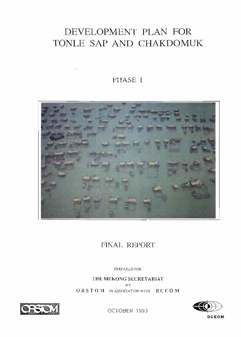
DEVELOPMENT PLAN
FOR TONLE SAP AND CHAKDOMUK
PHASE 1
EXECUTIVE SUMMARY
prepared for
The Mekong Secretariat
by
ORSTOM in association with BCEOM
October 1993
SCOPE Of THE STUDY
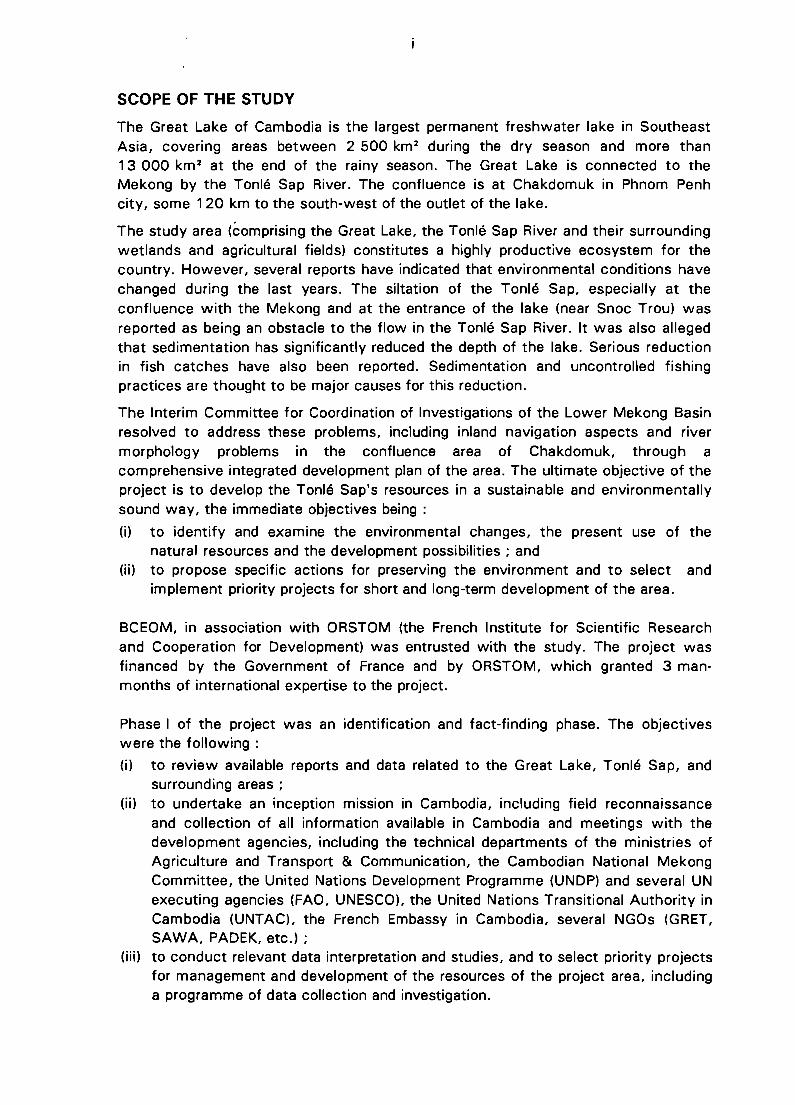
The Great Lake of Cambodia is the largest permanent freshwater lake in SoutheastAsia, covering areas between 2 500 km 2 during the dry season and more than13 000 km 2 at the end of the rainy season. The Great Lake is connected to theMekong by the Tonlé Sap River. The confluence is at Chakdomuk in Phnom Penhcity, some 120 km to the south-west of the outlet of the lake.
The study area (éomprising the Great Lake, the Tonlé Sap River and their surroundingwetlands and agricultural fields) constitutes a highly productive ecosystem for thecountry. However, several reports have indicated that environmental conditions havechanged during the last years. The siltation of the Tonlé Sap, especially at theconfluence with the Mekong and at the entrance of the lake (near Snoc Trou) wasreported as being an obstacle to the flow in the Tonlé Sap River. It was also allegedthat sedimentation has significantly reduced the depth of the lake. Serious reductionin fish catches have also been reported. Sedimentation and uncontrolled fishingpractices are thought to be major causes for this reduction.
The Interim Committee for Coordination of Investigations of the Lower Mekong Basinresolved to address these problems, including inland navigation aspects and rivermorphology problems in the confluence area of Chakdomuk, through acomprehensive integrated development plan of the area. The ultimate objective of theproject is to develop the Tonlé Sap's resources in a sustainable and environmentallysound way, the immediate objectives being :
(i) to identify and examine the environmental changes, the present use of thenatural resources and the development possibilities ; and
(ii) to propose specific actions for preserving the environment and to select andimplement priority projects for short and long-term development of the area.
BCEOM, in association with ORSTOM (the French Institute for Scientific Researchand Cooperation for Development) was entrusted with the study. The project wasfinanced by the Government of France and by ORSTOM, which granted 3 manmonths of international expertise to the project.
Phase 1 of the project was an identification and fact-finding phase. The objectiveswere the following :
(i) to review available reports and data related to the Great Lake, Tonlé Sap, andsurrounding areas ;
(ii) to undertake an inception mission in Cambodia, including field reconnaissanceand collection of ail information available in Cambodia and meetings with thedevelopment agencies, including the technical departments of the ministries ofAgriculture and Transport & Communication, the Cambodian National MekongCommittee, the United Nations Development Programme (UNDP) and several UNexecuting agencies (FAO, UNESCO), the United Nations Transitional Authority inCambodia (UNTAC), the French Embassy in Cambodia, several NGOs (GRET,SAWA, PADEK, etc.) ;
(iii) to conduct relevant data interpretation and studies, and to select priority projectsfor management and development of the resources of the project area, includinga programme of data collection and investigation.
ii
Eight experts, including two nationalJregional staff were assigned by BCEOM andORSTOM to provide expertise in the various fields of hydrology, river morphology andsedimentology, environment, aquatic biology, fishery, agriculture, socio-economy andnavigation. Ali staff carried out a joint inception mission in Cambodia from 10 to23 March 1993. An inception report of the mission was drafted and submitted to theMekong Committee on 26 March 1993. The draft final report was presented anddiscussed with the national authorities and the international and regionalorganisations concerned during a workshop held in Phnom Penh on 24 August 1993.The final version of this report was submitted in October 1993.
The Consultants wish to express their thanks to the Mekong Secretariat's officiais, tothe Cambodia National Mekong Committee who ensured coordination of the projectand generally to ail authorities who kindly extended their assistance to the team ofexperts and made the implementation of this study possible.
GENERAL CONCLUSIONS AND JUSTIFICATION OF AN INTEGRATEDDEVELOPMENT PLAN
Phase 1 of the Development Plan for Tonlé Sap and Chakdomuk provided the forumfor a preliminary assessment of existing conditions which has been carried out mainlyon the basis of a review of existing available data. "The Jack of quantitative andreliable data, especial/y during the past 15 years, is the more generaJ finding of eachsectoral assessment" (Inception Report p.22). This situation has severely restrictedthe certainty of the conclusions given in the sectoral assessments of the Report. Asan example, two crucial issues could not be solved :
- Does the sedimentation rate occur with its natural and normal magnitude or isthere any recent and on-going significant increase of this rate which could threatenthe sustainability of the physical and biological environment in the wetland area,and hamper its economic exploitation (fish, navigation, etc.) ? This question appliesespecially to the Great Lake, and to some extent to the Tonlé Sap river, where itappears that Mekong sediment deposit at both end of the stream (Snoc Trou andChakdomuk) has been a natural and long lasting process.
- Is the current pressure of the fisheries sustainable for the bio-ecologicalenvironment ? As discussed in the technical section on fisheries, a definite answerwould require accurate information on the actual level of the catches and thecomposition of the catches by size and specie. The socio-economical conditions inCambodia are changing at an unusual high rate which will undoubtedly urge thefishermen on higher fish production. Thus, recent data on catches and on fishmarketing conditions are absolutely necessary, but as it has been shown in theanalyses of fisheries and fish production (Section C), the available data are patchyand most of them have been collected several decades ago.
It is a long term objective for any country to access accurately the situation of itsrenewable resources (water, fish, forests, etc.,) and the conditions of theirexploitation. This implies the set up of efficient technical departments, having strongscientific back-up. Institutional building, training of staff, availability of fieldequipment and data processing facilities are the required components to achievesuch objectives. High priority should be given by the National Authorities to such
iii
programmes, even if the Nation's priorities have to be focused on more urgent andday-to-day issues. Regional institutions such as the Mekong Committee can play akey role in promoting such long term investigations and data collection.
Therefore, additional data collection, surveys and investigations are c1early one of theobjectives of the coming phase Il and should be undertaken as soon as possible.
- But as the indicative duration of phase Il is 2 years only, it is clear that mostresults and analysis of long term "strategic" data collection will not be availablebefore the end of phase II. Therefore during this phase, priority should be given tosmall scale surveys and data collection programmes, aiming at the verification ofthe tentative conclusions presented during phase 1of the project.
On the other hand, the implementation of a development plan of the area, which isa long term and a permanent process, will require long term data bases,permanently updated, to take into account the natural fluctuations and the socioeconomic trends. As such, the project must stress the needs for long term datacollection programmes in different sectors (water, fish, wild-life, land use,transport infrastructure, etc.), even if these activities are not carried out within theinstitutional and financial framework of the project.
It would however be unrealistic as weil as unacceptable for the Country to delay theformulation of a development plan of the area until ail above mentioned data andinformation have been collected and analysed. Currently a dynamic and mostlyinformai development process is taking place in the whole country, and especially inthe project area. The fringes of the Great Lake and of Tonlé Sap River are targetareas for the returning refugees and displaced persons. Most of them are believed tobe farmers and therefore pressure on agricultural land and possibly on forests willincrease. Some of the newcomers mayas weil undertake activities providing higherand more immediate income than agriculture such as fishing, fish processing, woodprocessing (charcoal, construction wood), wildlife poaching, etc. Under such specificconditions, even without ail desirable information on environmental characterisation,the basics of an environmentally sound development plan can be formulated andimplemented, on the basis of the few available data, general expertise and commonsense. It is expected also that aside from the required data collection programmespreviously mentioned, large quantities of information will be available in the very nearfuture, as several sectoral reviews are currently in progress, such as the review ofthe fishery sector by FAO; the review of the irrigation sector by UNDP, the review ofthe agricultural sector by FAO, etc. Information on population has already beencollected for the purpose of the May general elections.
The immediate tasks of the proposed Integrated Development Plan project willinclude:
- to centralise and analyse ail relevant information on the area ;- to advise the Government in the decisions concerning the development of the
area;- to set up an institutional framework which will be able to formulate a plan for an
integrated and sustainable development of the area. This will include the definitionof rules and of working procedures between the identified stakeholders (national,regional, international, bilateral). It has been proved in every country that inter-
iv
ministry collaboration can be a delicate process, which would require a specifieinstitutional forum to share the information and to come to a consensus when anydecision has to be made. The building of this ad-hoc institution is clearly anobjective on which the project should be focused in its initial step. The NationalMekong Committee could play a key role in the implementation of suchcoordinating process.
SECTORAL CONCLUSIONS AND RECOMMANDATIONS
Hydrology and sedimentology
The major recommendations of the hydrological and sedimentological assessmentwere the following :
(i) As a preliminary estimate, the catchment of Great Lake would contributes about1/3 of the total water flow volume entering the Great Lake. The sedimentationof the Great Lake and of the upstream and downstream sections of Tonlé SapRiver (at Snoc Trou and Chakdomuk) are major concerns reflected in the termsof reference of this study. There are no data currently available to support theassumption that the sedimentation rate of the lake is higher now than it was30 years ago. However; very significant changes in land use of the Great Lakedrainage basin have been reported (mining activities, logging, etc.). Theimportance of these issues and the different interpretations of the few availableinformation warrant the priority projects addressing the bathymetric survey andsedimentation assessment of the Great Lake. Hydrological stations shall beinstalled and an operational monitoring of liquid and solid discharge carried outon the major tributaries of the lake and/or at the outlets of the most disturbedwatersheds, at least for one or two monsoon seasons.
A minimum network of six hydrological and sediment monitoring stations isproposed. Core samples of the bottom of the lake shall be taken and analysedusing the more up-to-date techniques, to assess the long term siltation rate overseveral centuries (considered as being the "natural" process). This figure shall becompared with the rate of the last decade(s), given by the analysis of the upperpart of the cores and by the sediment delivery figures, given by the soliddischarge monitoring of the lake tributaries.
(ii) At the mean time, as the contribution of Mekong river would be around 2/3 ofthe total water supply of the Jake the Mekong flows in Phnom Penh and theupstream and downstream flows (water and sediment) of the Tonlé Sap Rivershall be monitored. The Mekong control station in Phnom Penh should bebacked-up by an upstream station; the best option being the rehabilitation of thestation of Kratié.
(iii) Interpretation of the water levels of Tonlé Sap River in Kompong Chhnang hasshown that the differences in the annual maximum levels of the lake range from1 to 2 m, which result in changes of several thousands of km 2 for flooded areaand of more than 1Ox1 09 m3 for water storage. If several years with low flowsfollow each other, which has happened several times in the recent past, theecological conditions are temporariJy modified, with subsequent effects on fishdevelopment and fishery catches. Therefore it is recommended to monitor the
v
water level of the Great Lake and to determine accurate curves relating floodedarea and water storage, which implies to undertake :
- a bathymetric and topographic survey of the lake, to be conducted on theoverall area, including the remaining water body at the end of the dry seasonand the flooded area in its largest possible extension,' and,
- the continuous recording of the lake water level, possibly at two differentsites.
(iv) The expertise did not identify any impact of existing dams or hydraulic controlstructures on the Great Lake water balance. This conclusion should however beconsidered as an initial and tentative estimation, to be improved throughcomprehensive and careful analysis of ail hydrological data collected on theMekong main stream and its main tributaries.
Fish and fisheries
(i) Any modification in the Mekong fJows and floods have consequences on theenvironment and resources of the study area. Similarly, ail modifications of theenvironment and resources in the Great Lake can have consequences in Mekongriver - mainly downstream of Phnom Penh -, but also upstream in the case ofmigratory fish. The role and importance of the inundated forests in relation toreproduction of fish have inspired many assumptions. These forests have beenused since ancient times by fishermen as sources of wood for cooking,construction, fish traps. In addition, the land clearing for agriculture has probablybeen particularly destructive during the last decades. Based on the availableevidence, this ecosystem deserves protection, appropriate management anddetaiJed study to determine its capacity for renewal and its role in relation to fishreproduction.
(ii) Assessment of the living resources is particularly difficult because of the scarcityand unreliability of the available data. A generally held viewpoint, supported byseveral expert opinions, is that there is currently an over-exploitation of the fishand a "general decline in yields". Our conclusion is much more moderate, firstlybecause there are no data to support such a viewpoint and secondly because thedata which do exist show a situation of relative stability, and the variations inyield can be attributed as much to natural causes as to the harmful effects ofman's activities. If the pressure on the living resources of the Great Lake hasprobably been relatively low during the last twenty years, because of stagnationof development, this situation is changing rapidly. Population growth, attractionof new markets and short term prospects are putting an increasing pressure onfish and other natural resources. The existing legislation aiming at the protectionof the renewable resources has to be improved, both in its relevance to thechanging conditions and to its application.
An overall project, which would integrate the research and development aspects,concerning the sustainable management of Great LakelTonlé Sap living resources isrecommended. The implementation of such a project, will require a more longerperiod than two years, and would therefore go beyond the scope of Phase Il. Assuch, the two proposed priority projects, identified in this study as Bio-ecologicalBasis for Fish Production and Response of Fishermen to Environmental and Socio-
vi
Economie Changes, shall be considered as first contributions to the overall project,aiming at the verification of the different hypotheses presented in the final mainreport.
Navigation
(i) The rehabilitation and extension of the port of Phnom Penh will be completed bythe end of 1995. Ships up to 4 000 DWT will then be able to access the portlocated on the bank of Tonlé Sap river, but continuous dredging of the accesschannel at Chakdomuk will be required. In the long term, with the proposed newport at Chrui Changvar on the Mekong river mainstream, the Chakdomuk passdredging may not be necessary. Therefore, there is a risk that the existingentrance channel of Tonlé Sap river may be blocked by sediment.
(ij) Tonlé Sap river is navigable from Phnom Penh to Kompong Chhnang ail yearround by boats up to 150 T, but navigation beyond Kompong Chhnang to theGreat Lake is hampered by the shallow pass at Snoc Trou. Important agriculturaland forestry resources, as weil as fish, could be transported more economicallyby waterways along the naturally favourable system provided by Tonlé Sap. Thisis particularly relevant to the poor road conditions during the rainy season, whenwaterborne transport becomes the only link for certain areas with the rest of thecountry. Navigation requires less maintenance and investment than highwaysand is a low-energy mode of transport, consuming from 50 to 75 % energy lessthan road transport, and therefore providing better protection of theenvironment. Boats for Tonlé Sap could be built locally with limited amounts ofimported equipment and materia!.
In-depth investigations and study of navigation development in Tonlé Sap aretherefore strongly recommended to determine optimum use of its natural resources inthis respect.
Agriculture
(i) Based on available c1imatic, rainfall and crop production data, irrigation isrequired for the development of agriculture even in the wet season, but the mostsuitable type of irrigation scheme for each specific area needs to be determined.Therefore, it is recommended to prepare a comprehensive development plan forirrigation in the study area, giving careful attention to any possible environmentalimpact. Agriculture development projects located outside the riparian areas ofthe lake and Tonlé Sap River, but in the same catchment area, needs to be takeninto consideration as weil, since they may have strong impact on theenvironment of the project area.
(ii) The studies for agricultural improvement of several irrigation projects in TonléSap basin, such as Battambang Multi-purpose Project and Stung Mongkol BoreyIrrigation Scheme, are presently on-going. In addition, the inventory of existingirrigation projects is included in the on-going Irrigation Rehabilitation Study ofMekong Secretariat. The results of these studies will be extremely relevant forthe planning of irrigation and agricultural development in the Tonlé Sap - GreatLake project area.
vii
(iii) A small scale irrigation pilot project (area of 100-400 ha) should beimplemented, aiming at the development of participatory management andcapacity strengthening of governmental technical staff and farmers. It isexpected that the present government policy of developing priva te ownership ofagricultural land will encourage the farmers to actively participate in suchprojects.
Environmental aspects
No evidence was found that the Great Lake is on the fringe of an environmentaldisaster. Existing speculations of high siltation rates, prevention of fish migration andfish reproduction as weil as over exploitation of the aquatic resources are not basedon hard data. Figures of current deforestation rates of the inundated forest could notbe found, but the process is taking place in some areas. The major environmentalimpacts are currently expected to be :
- sedimentation and pollution of the Battambang River and of the Great Lake due togem mining in the upper parts of the watershed ;
- possible impact of deforestation of the inundated forest on wildlife, fish andfisheries yields ;
- Possible impact - especially on aquatic life and fisheries - of domestic waste waterreleased from the urban areas (Phnom Penh, Siem Reap, Battambang, etc.).
To assess environmental impacts in the Great Lake, data has to be collected duringbase-line surveys and consecutive interpretation studies have to be carried out,especially in the fields of hydrology, sediment transport, water quality, fisheries, landuse and socio-economy. Environmental impact studies will be a worthwhile exercisefor the purpose of a regional development plan only when this base line data will beavailable.
PROPOSED PRIORITY PROJECTS
ln line with the conclusions given above, recommendations for further actlvltlesconsist of several coordinated actions to be undertaken as part of Phase Il of theDevelopment Plan for Tonlé Sap and Chakdomuk. The actions recommended to becarried out during Phase Il are presented in the form of lone-standing priority projects.For the sake of consistency and coordination of the proposed actions with otheractions being implemented, the setting-up of an institutional structure able toformulate the integrated and environmentally sound development plan isrecommended as a major priority project, thereby making a total number of sixrecommended priority projects as follows :
PROJECT No.1
viii
INTEGRATED DEVELOPMENT PLAN fOR THE GREAT LAKE,TONLE SAP AND CHAKDOMUK
This project is expected to ensure coordination and consistency to the whole Phase IlDevelopment Plan.
Development planning has to be considered as a dynamic process, with periodicalassessment of the results and updating of the objectives. The first step couldtherefore be based on existing information and on data supplemented by limitedadditional investigations and survey to be undertaken during the formulation of thePlan. Institutional strengthening and national capacity building should be initiated atthe same time as the formulation of the Plan.
The functions of the new institutional set up should include the following :
(il to coordinate and to synchronise the sectoral planning;
(ii) to advise the decision making in screening projects in order to avoid duplicationand to ensure that the projects will not pre-empt the long-term development ;
(iii) to build up a comprehensive data base on the project area and make theinformation accessible to line agencies and donor countries/organisations.
The main activities of the project will include :
(il During the first year
- additional investigations, survey and data collection,- collection and review of new information and data from on-going and planned
projects in the Tonlé Sap - Great Lake area ;- sectoral reassessments based on updated information and identification of the
potential and constraints of each sector (fishery, agriculture, navigation,tourism ... ) ;
- establishment of the new institution and training of core staff, especially onintegrated regional development planning ;
- analysis of the government policy, strategy and priorities.
(ii) During the second year
- preparation of scenarios of long-term development ;- formulation of a short-medium term development plan.
Duration : 2 years
Cost : US$ 700 000
PROJECT No.2: BATHYMETRY AND SEDIMENTOLOGY Of THE GREAT LAKE
The need for a bathymetric and topographic survey of the flooded area of the GreatLake and the Tonlé Sap was discussed and justified to address issues regardingwater management, environmental aspects and navigation purposes. Due to itsforeseeable high cost, this has to be considered as a major technical support projectfor the country. The expected outputs are :- bathymetry of the "dead storage" area of the Great Lake (dry season conditions!.
ix
- topography and/or bathymetry of the zone flooded during the monsoon season (upto the highest water levels - around 10 m asl).
The sedimentological study component comprises core sampling and suspendedsediment study. It has to be undertaken in close coordination with the hydrologicalmonitoring of the main tributaries of the lake and of the Tonlé Sap River.
Duration : 8 months
Costs- Topographie and bathymetric survey : US$ 1 000 000 (estimate)- Sedimentological study : US$ 170000
PROJECT No.3: HYDROLOGICAL MONITORING OF TONLE SAP BASIN
Since 1963 no comprehensive assessment has been carried out simultaneously onwater and sediment dynamics of the overall hydrological system of the Great Lakewatershed, Tonlé Sap River and Mekong. According to many findings, thecharacteristics of the lake have changed since, but with the lack of any recent data,it is quite impossible to find any solid element to support such findings, and anhydrological and sedimentological network has to be implemented in the area, as isusually the case in the monitoring of wide water bodies such as the Great Lake.
Duration : 3 years
Costs:- US$ 500 000, according to the specifications of the country-wide hydrological
rehabilitation project- US$ 400 000, for a scaled-down project
PROJECT No.4 : BIO-ECOLOGICAL BASIS FOR FISH PRODUCTION
The proposed approach of fish bioecology in the framework of Phase Il focuses onfish movements between the Mekong basin and the Great Lake with special attentionto the Chakdomuk area. This preliminary study of migrations will pave the way forother ecological aspects: reproduction and growth.
Species to be observed and surveyed should be focused on the current catches indifferent sites, such as selected days in Tonlé Sap River, fishing barriers at SnocTrou, fishing lots in the lake and around the confluence zone of Chakdomuk.
Duration : one year
Cost : US $ 200 000
PROJECT No.S: RESPONSE OF FISHERMEN TO ENVIRONMENTAL AND SOCIOECONOMIC CHANGES
Fishery in the studied area is a major activity with important socio-economic andenvironmental impacts. There are some indications of strong changes in fisheriesmanagement and marketing due to changes in the socio-economic context.
x
The main objectives of the project are :
- to appraise the effects of the current regulation of fisheries ;to estimate of the impact of fisheries on the living aquatic resources, in particularregarding the sustainable management of the fishery sector ;to identify catching and processing techniques which could endanger the resourceor the environment ;to review the present conditions of fish processing and marketing and its recentevolution;to estimate the prospective of cage culture development as an alternative to thefishery effort.
Duration : one year
Cost: US$ 150 000
PROJECT Na.6 NAVIGATION DEVELOPMENT IN TONLE SAP
The proposed approach under Phase Il comprises an economic and technicalassessment of inland navigation development from Phnom Penh to the Great Lakeand its tributaries. The main objectives of the project are:
- to identify the actual resources of Tonlé Sap system in respect of navigation;- to estimate investment and operating costs of navigation improvement in Tonlé
Sap system;- to work out the potential transport demand in terms of passengers and freight and
to assess technically and economically the viability of navigation development onTonlé Sap system;
- to evaluate navigation development relating to the development of touristicactivities in the area ;
- to review the dredging needs governed by international navigation in theChakdomuk area at various time scales and for various options of national portdevelopment plans.
Project activities and expected output will include :
- hydrographical survey of Tonlé Sap River by cross section soundings to producenavigation charts, especially for the difficult sections at Chakdomuk and SnocTrou;the study of dredging and other works required to open navigation channels in thelake (estimation of capital and maintenance dredging quantities, dredging methodsand costs) ;the technical and economical assessment of inland navigation conditions;a tourism development study related to boat cruises on Tonlé Sap River;a review of alternative plans of port development country-wide.
Duration : 6 months, not including time for surveys and mapping.
Cost : US$ 135 000, not including surveys and mapping works.
xi
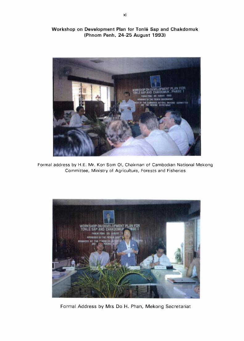
Workshop on Development Plan for Tonlé Sap and Chakdomuk(Phnom Penh, 24-25 August 1993)
Formai address by H.E. ML Kon Som 01, Chairman of Cambodian National MekongCommittee, Ministry of Agriculture, Forests and Fisheries
Formai Address by Mrs Do H. Phan, Mekong Secretariat
xiiI
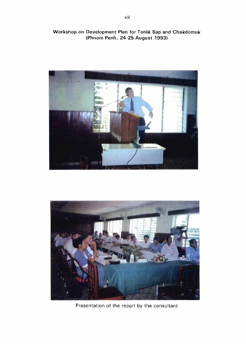
Workshop on Development Plan for Tonlé Sap and Chakdomuk(Phnom Penh, 24-25 August 1993)
Presentation of the report by the consultant
DEVELOPMENT PLAN FORTONLE SAP AND CHAKDOMUK
PI-IASE 1
FINAL REPORT
PREPARiD FOR
THE MEKONG SECRETARIATBY
ORS TOM IN ASSOCIATION WITH B C E 0 M
OCTÜBE.R 1993BCEOM
DEVELOPMENT PLAN FORTONLE SAP AND CHAKDOMUK
PHASE 1
FINAL REPORT
PREPARED FOR
THE MEKONG SECRETARIATBY
ORS TOM IN ASSOCIATION WITH B C E 0 M
OCTOBER 1993BCEOM
TABLE OF CONTENTS
A. INTRODUCTION A. 1
A.1 SCOPE A. 1A.2 OB..IECTIVES A. 3A.3 PRO..IECT AREA A. 3A.4 IMPLEMENTATION A. 3A.5 ACKNOWLEDGEMENTS A. 5
B. BACKGROUND B. 1
B.1 GENERAL FEATURES OF THE PRO..IECT AREA B. 1B.2 DEMOGRAPHIC ASPECTS B. 4B.3 REGIONAL PRODUCTION AND ECONOMICS B. 6
C. HYDROLOGY, SEDIMENTOLOGY and MORPHOLOGY C. 1
C.1 HYDROLOGICAL ASPECTS C. 1C.2 SEDIMENTOLOGY AND RIVER MORPHOLOGY C.12
D. FISH AND FISHERIES !). 1
0.1 BACKGROUND AND AVAILABLE DATA D. 10.2 BIO-ECOLOGICAL CONTEXT D. 6D.3 EXPLOITAllON OF RESOURCES 0.11
E. NAVIGATION, AGRICULTURE, IRRIGATION andENVIRONMENTAL ASPECTS E. 1
E.1 NAVIGATION E. 1E.2 AGRICULTURE AND IRRIGATION E.11E.3 ENVIRONMENTAL ASPECTS E.13
F. INSTITUTIONAL ASPECTS F. 1
F.1 NATIONAL CAMBODIAN INSTITUTIONS F. 1F.2 INTERNATIONAL AND REGIONAL ORGANIZATIONS F. 4
G. CONCLUSIONS G. 1
G.1 GENERAL CONCLUSIONS G. 1G.2 SCOPE FOR A :lEVELOPMENT PLAN FOR TONLE SAP/CHAKDOMLIK. G. 2G.3 HYDROLOGICAL AND MORPHOLOGICAL ASPECTS G. 5G.4 FISH AND FISHERIES G. 9G.5 NAVIGATION ASPECTS G.13G.G AGRICULTURE G. 14G.7 ENVIRONMENTAL ASPECTS G.14
H. RECOMMENDATIONS H. 1
H.1 DEVELOPMENT PLAN H. 1H.2 BATHYMETRY AND SEDIMENTOLOGY H. 1H.3 HYDROLOGICAL MONITORING OF TONLE SAP BASIN H. 1H.4 BIO-ECOLOGICAL BASIS FOR FISH PRODUCTION H. 2H.5 RESPONSE OF FISHERMEN TO ENVIRONMENTAL
AND SOCIO-ECONOMIC CHANGES H. 2H.6 NAVIGATION DEVELOPMENT IN TONLE SAP H. 2H.7 MISCELLANEOUS RECOMMENDATIONS H. 2
PRIORITY PROJECT SHEETS H. 4PRIORITY PROJECT No. 1 H. 5PRIORITY PROJECT No. 2 H. 8PRIORITY PROJECT No. 3 H. 12PRIORITY PROJECT No. 4 H.16PRIORITY PRO..IECT No. 5 H. 18PRIORITY PROJECT No. 6 H.20
ANNEXES
Bibliography
Il Project Sheet : MKG/R.920S0
III Hydrological data and information
IV On-going and Proposed Projects of Interim Mekong Committee
A.l
A. INTRODUCTION
A.1 SCOPE
The Great Lake is the largest permanent freshwater lake in Southeast Asia. The lakecovers an area varying between 2 500 km 2 during the dry season with an average depthof less than 2 metres, and more than 13 000 km 2 at the end of the rainy season with amaximum de;Jth of 8 to 10 metres. The Great Lake is connected to the Mekong by theTonie Sap River. The confluence is at Chakdomuk in Phnom Penh city, sorne 120 km tothe southwest of the outlet of the Lake.
The study area (comprising the Great Lake and its surrounding wetlands and ayriculturalfields, and the Tonie Sap River) constitutes a highly productive ecosystem. It has alwaysbeen the most important inland fishery resource, not only for the population living in thearea but for the whole country. Figure A.1 shows the location of the principal features ofthe study area in relation to the provinces and international boundaries of Cambodia.
Several reports in the 1960's indicated that physical conditions have rapidly changed.The siltation of the Tonlé Sap, especially at the confluence with the Mekong and at theentrance of the lake (near Snoc Trou) was reported as being an obstacle to the flow inthe Tonie Sap River. It was also alleged that sedimentation has significantly reduced thedepth of the lake.
Serious reduction in fish catches have been reported. Sedimentation and uncontrolledfishing practices are thought to be major causes for this reduction; this decline incatches led to a technical feasibility study of a barrage on the Tonlé Sap river in 1967.The location of the proposed dam is near the entrance of the Great Lake, about 3 kmnorth of Kompong Chhnang (Figure A.1).
The Interim Committee for Co-ordination of Investigations of the Lower Mekong Basin(The Interim Mekong Committee or IMC) resolved to address these problems, includinginland navigation aspects and river morphology problems in the confluence area ofChakdomuk, through a comprehensive integrated development pian of the area.
The project was launched with the invitation to bid N° CAM/167/TSAP "ConsultancyServices for the Development Plan for the Tonlé Sap and Cha kd omL:k, Phase 1". Thedeadline for the proposais was 25 February 1993.
»
'1'-11
MAP I.F .... AMS DIA1,1·.I;nlh
Il II.
r
f,t 16.!
Il
A.3
A.2 OBJECTIVES
According to the tJ1ekong Secretariats' Project summary sheet, and Terms of Reference,
the ultimate objective of the project is to develop the Tonlé Sap's resources in asustainable and environmentally sound way. The immediate objectives are:
1) To identify and examine the morphology changes, the present use of the natural
resources and the development possibilities ; and
2} To propose specifie actions for preserving the environment and to select priority
projects for short and long-term development of the area and to select andimplement priority projects.
A.3 PROJECT AREA
The Project Area is specified in the Mekong Secretariat's Project summary sheet andterms of refer':nce as follows :
"The project area covers the Great Lake, its surrounding area, the Tonlé Sapriver including the confluence with the Mekong at Chakdomuk".
However, a more accurate and detailed definition deserves to be discussed and finalizedin view of further implementation of the Development Plan for Tonlé Sap and
Chakdomuk.
ln scientific terms, as the study addresses such matters as hydrology, sedimentation,irrigation and navigation, the project area does spread over the entire catchment area ofthe Great Lake and Tonlé Sap river. This means that allliquid and solid discharges to theGreat Lake sho..Jld be taken into consideration, as far as it affects the project (see FigureC.1 ).
However it is understood that the actual area where proposed Phase \1 projects would beimplem:mted is restricted to lands likely to be flooded by the Great Lake, in addition t0
the Tonlé Sap river and the zone of confluence of Chakdomuk.
ln this connection, the proposed definition of the project area is the strip of territorystretching from Sisophon to Phnom Penh of which the boundaries are the layout of RN6
to the north and east and, the layout of RN5 to the west and south.
A.4 IMPLEMENTATION
BCEOM, in association with ORSTOM (the French Institute for Scientific Research and
Cooperation for Development) was entrusted with the study. The project was financedby the Government of France and by ORSTOM, which granted 3 man-months of
international expertise to the project. Experts were mobilised on 10 March 1993.
A.4
Phase 1 of the project was an identification and fact-finding phase. The objectives were
the following :
(i) to review available 'reports and data related to the Great Lake, Tonie Sap, and
surrounding areas;
(ii) to undertake an inception mission in Cambodia covering :
- field reconnaissance for observation of the natural conditions and collection ofail relevant data and information available in Cambodia ;
- meetings with the development agencies in Cambodia, including :
technical departments of the Ministries of Agriculture, Transport
Communication, and Post;the Cambodian National Mekong Committee ;the United Nations Development Programme (UNDP), and certain UNexecuting agenci~s (FAO, UNESCO) ;
the United Nations Transitional Authority in Cambodia (UNTAC) ;
the French Embassy in Cambodia ;NGO's (GRET, SAWA, PADEK, etc.).
(iii) to conduct relevant data interpretation and studies, and to draft an assessment
report, and
(iv) to select priority projects for management and development of the resources ofthe project area, including a programme of data collection and investigation.
Eight experts, including two nationallregional staff were assigned by BCEOM andORSTOM to provide expertise in the various fields of hydrology, river morphology and
sedimentology, environment, aquatic biology, fishery, agriculture, socioeconomy andnavigation.
For BCEOM :- Mr. J. Bouloc, river morphology- Mr. X. Dubosc, navigation
Mr. Kovit Thué'msangim, agriculture and irrigation, regional expert, (PRO-ENConsultant and Management Co,)
- Mr. R. Schouten, environmental aspects, (PRO-EN Consultant and Management Co.)
For ORSTOM:- Dr. J.R. Durand, fishery
- Dr. J.M. Fritsch, hydrology- Dr. Srinn Kim You, aquatic biology, regional expert
- Dr. J.Y. Weigel, socioeconomy
A.5
Ali staff carried out a joint inception mission in Cambodia from 10 March to 23 March
1993. An inception report of the mission was drafted and submitted to the Mekong
Committee on 26 March 1993.
The present draft final report (July 1993) will be discussed with the authorities and
organizations concerned in Cambodia in August 1993. The final version of this report
shall take into account their comments and shall be submitted in October 1993.
A.5 ACKNOWLEDGEMENTS
The Consultants wish to express their thanks to the Mekong Secretariat's officiaIs.
especially the Chief of the Water Resources and I-i)'dropower Unit. to the CambodiaNational Mekong Committee who ensured co-ordination of the project and generally to ail
authorities who kindly extended their assistance to the team of experts and made theimplementation of this study possible.
B - 1
B. BACKGROUND
B.1 GENERAL FEATURES OF THE PROJECT AREA
B.1.1 Mekong River Ba~in
Mekong River is among the ten largest rivers in the world in terms of annual volume offlow. On average it discharges more than 500 billion rn3 /year to South China Sea(SOOx10 9 m 3), where the total drainage area is nearly 79S 000 km 2
• The ri~arian
countries are China, Burma, Thailand, Vietnam, Lao PDR and Cambodia, of which thelatter two are almost entirely in the Mekong watershed.
The project area comprises Tonlé Sap River, the Great Lake and its surrounding floodplain areas. A wide alluvial plain, mostly occupied by open water during the floodingperiods, stretches upstream from Phnom Penh to the vicinity of Siem Reap and
Battambang in the northwest.
ln the central part of the plain, comprising the areas surrounding the Great Lake duringthe dry season and the riparian zones along the Tonlé Sap River, the altitudes vary from
1.S m to less than 10 m asl (the sea level reference in the re'gion being the mean sea
level in Ha Tien). Because the variations of water level of Mekong river between low andflood flows are in the same range (1-10 m as/), the whole region is flooded and is underthe hydraulic influence of Mekong river during several months each year.
R.1.2 Geological Aspects
The Greé.:·~ Lake plain is surrounded in the south by the Cardamoll mountains (PhnomKravanh) and the Elephant mountains. The highest points vary from 1 SOO m in the
eastern part of the range to 1 800 m in the western part, where the highest point ofCambodia is located (Phnom Aoral 1 813 m).
To the north of the plain, the Dangkrek mountains are Iimited by a steep escarpmentextending more than 300 km in a WSW-ENE direction, with altitudes between 500 and700 m. South of the Phnom Dangkrek range down to the Great Lake, the landscape is
composed of numerous hills with altitudes decreasing from 200 m near the range to40 m around the plain. In this area the valley bottoms are fiat and swampy and areoccupied by the Stung Sen and the Stung Tren rivers and their tributaries.
The original geological layers of the Cardamom mountains are shales and sandstones
which have locally undergone intense metamorphic and tectonic activity. Intrusive rocks(granite, ryolite) are particularly widespread in the region of Pamn, where intensive gemmining takes place. The Dangkrek mountains are of sedim€:1tary origin and composed of
siliceous sandstones.
[3·2
B.1 .3 Vegetative Caver
The vegetation has been described by Schmid (1956) who identified the following
vegetal associations:
a) Dense and semi-dense forests
These are most notably developed on the upper parts of the Great Lake watershed.According to Schmid. this forest had already been degraded into a secondary forest
fallow in the northern part of the Lake along Hiyhway RN6 at the time of his study.
b) Open forest
This one-storey tree cover is typical of South Indochina. The trees are small and widely
spaced. Though this forest has certainly been exploited by man for centuries. the open
forest should not be considered as a degraded dense forest but as a vegetation re/ated tupoor soil conditions in the lowlands. The open forest is widespread in the southern part
of the plain. stretching from the lake margins up to the hills making the transition to theCardamon range.
c) Inundated forest
The inundated forest covers a ring which is nearly 40 km wide in the western part of the
lake and 32 km in the eastern part (when the lake is at its lowest water level). The
nature of the forest varies from a continuous cover of big trees to an open cover of
shrubs. It is alleged that the impact of man's activities has been quite strong in these
areas. Carbonnel and Guiscafré (1963) pointed out that "everywhere, this (orest has
been degraded by Jogging".
d) "Veals"
These large bare areas. locally called "veal". are low herbaceous covers with ~ocal
concentrations of reeds. fi Ishes and small bamboos. The surface area of the veals was
estimated to be as much as 5.000 km 2 (Carbonnel and Guiscafré. 1963). The ecologicalzone of the veals extends between the inundated forests and the terra firma forests. The
water depth over the veals during tr.e flooding is generally less than 50 cm. Occurrenceof veals coincides with heavy clay soil::.. having very compact underlayers ::It depths of
20 to 50 cm beneath the surface.
Several assessments of the vegetative cover have been made since Schmid. the latestone being the Reconnaissance Land Use Map produced by the Remote Sensing and
Mapping Unit of the Mekong Secretariat in 1991 .
The ecology of the vegetation in the area is very complex due to the combination of
dîfferent soil conditions and flooding dynamics. and as a result of long lasting impacts of
man's activities. It cannot therefore be assumed that ail open forests. shrub areas or lowherbaceous zones result from the degradation of a natural and pre-existent c10sed and
dense vegetal cover.
B-3
8.1 .4 Climate
Because the project area is located between latitudes 12° N and 15° N, the major
climatic feature of the area is the seasonal fluctuation of the Inter-Tropical ConvergenceZone (ITCZ) associated with alternate seasonal chaclges in the direction of the trade
winds (from SE and from NE). However, in South and South-East Asia this globalphenomenon is ,!,odified by the massive continental areas of the northern parts of the
Asian continent, into a specifie large-scale meteorological process know as the monsoon.
- The so-called "winter monsoon" generally occurs during the perioJ end Novemberto end April. The general direction of the wind is from NE or N up to January.
From February to April the wing speed usually decreases and wind direction maybe from E or even from SE. Because the origin of the air mass is the dry and
cold Asian continent, the winter monsoon period corresponds to the dry season.
ln Potchentong (Phnom Penh airport) the long-term average rainfalls in January
and February are 5 and 6 mm respectively. December, March and April can beconsidered as dry months with averages of 39, 28 and 70 mm.
- The "summer monsoon", referred to generally <JS "the monsoon", commences in
May and continues through to Nov~mber. The air masses coming from theIndian Ocean are humid and highly unstable. Any vertical movements in the airmass, which may be caused by orographie effects, thermal ascending currentsor frontal contacts with another air mass, bring the vapour pressure to the
saturation point and heavy rains take place. The average monthly rainfalls inPotchentong are 255 mm in October and 230 mm in September. From May to
November the rainfall ex~eeds 140 mm every month, the long term annualrainfall for this station being around 1,340 mm.
The rainfall is highly influenced by the relief. The seaward slopes of the Elephant and theCardamon mountains, whose alignments are perpendicular to the south-westernmonsoon, receive more than 5 000 mm per year. CarbOllnel and Guiscafré (1963) have
quoted the figure of 6 360 mm as the maximum annual rainfall observed at Bokor(altitude 1 050 m) in Elephant mountain. The rainfall decreases sharply ta around 1000
'200 mm on the northern side of the mountain. Rainfall then increases again with valuesof 1 200-1 400 mm over the central area of the Great Lake and another strong increase
takes place when the air masses reach the Phnom Dangkrek range, where the rainfall is
estimated as being around 1 600 to 2 000 mm per year. As a consequence of thisrainfall heterogeneity, the hydrological regimes of the lake tributaries are very differentaccording to the location of their respective heaC;water areas.
The range of seasonal temperature variation is very narrow, a typical characteristic of
tropical regions. Whereas the annual average in Phnom Penh is 27.5 oC, the averagetemperatures of the hottest month (April) and of the coldest month (December) are
respectively 29.3°C and 25.6°C.
The maximum and minimum instantaneous temperatures observed in Phnom Penh wereslightly over 40 oC (in April) and over 13°C (in January). The diurnal variation is usually
lessthan 10°C.
B.2 DEMOGRAPHIC ASPECTS
During the Jast thirty years, two population census were heId in Cambodia, the first in1962 and the second in 1980. The most recent demographic study was undertaken byJ. Migozzi (1972).
Estimations of the population of Cambodia and of the Great Lake and Tonlé Sap areas
must therefore be made from projections based on the 1980 census figures and may bedifferent according to the method of estimation. An example of the fluctuations whichcan be found is c1early shown by the estimations of the population of Phnom Penh. TheMinistry of Planning (1992) gave a figure of 491 000 and the World Bank (1992) a
figure between 700 000 and 1 000 000 inhabitants.
Table B.1
Population by Province(Source: Ministryof Planning)
1986 1987 1988 1989 1990 1991
Kandal 776,000 798.000 820.000 844.000 867.000 892.000Siem Reap 548.000 563.000 563.000 579.000 595.000 612.000Kompong Chhnang 254.000 261.000 268.000 275.000 283.000 291.000Pursat 201.000 207.000 212,000 218.000 225.000 231.000Battambang 11) 825.000 844.000 888.000 913.000 939.000 965.000Kompong Thom 435.000 447.000 460.000 473.000 486.000 499.000Phnom Pènh City 428,000 440.000 452.000 465.000 478.000 491.000
1') ln 1988 five districts were removed from Battambang and three from Siem Reap to form the province ofBanteay Meanchey. For convenience the statistics given for Battambang province include those of thenew province.
Based on the Ministry of Planning's appraisal, the population of the provinces around the
Great Lake and Tonlé Sap river down to Phnom Penh would be around 4 100 000(see Table B.1), hé1lt of the total population of Cambodia estimated at 9 000 000 by theMinistry of Planning. From the same source the growth rate would be 2.8%.
Within this area, the population is very irregularly distributed and the densities varydepending on the subdivisions of the provinces. {Provinces are cal/ed khet which are
a-5
divided into srok and further subdivided into khum). According to the Ministry ofPlanning, the most populated srok around the Great Lake or the Tonlé Sap River, are
those of Bakan (Pursat Province), Maung Russei and Songke (Battambang Province), andKompong Tralach (Kompong Chhnang Province). Densities vary from 30/krr. 2 (Sampuoch
khum in Kompong Thom Province) up to 1 500/km 2 (Rokakong khum in Kandal
Province).
The importance of this irregularity of population density would need to he taken into
account in any future studies and planning. Seasonal migrations and the isolation ofsome communities (especially the fishermen floating villages) are also important.
UNICEF in 1989 provided the following estimates :
- life expectancy at birth :
- unadjusted birth rate:- unadjusted death rate :
50 years,
40/1000 (one of the highest in Asia), and16/1000 (two times more than the Asian average).
The infant mortality rate is one of the highest in the world. The population is very young
and women form 63% of the whole population, 35% of heads of households, and 70o/cof the whole rural labour force.
Certain social indicators, not yet available with any preCISion at regional level, show
worrying nutritional and sanitary conditions (World Bank, 1992). Only 12% of the wholepopulation have access to drinking water in rural areas, the rate of tuberculosis incidence
is considered to be the highest in the world, malnutrition affects 20% of the population
in the provinces, the overall school enrollment rate is assessed at 30% in the rural areas.
Despite the lack of field studies in this area, and in view of the isolation of the fishingand rural populations around the Great Lake or the Tonlé Sap river (Kompong Chhnang
and Kandal Provinces), it can be assumed thc:t the sanit~ry and schooling situations ofthe project area are probably the worst in the country.
As far back as 1925. Gruvel drew attention to the migrations of fishermen during the
north-east monsoon, shown by the convergence of boats from the rivers leading to theGreat Lake. At that time the migrations concerned Vietnamese, Chinese and Cambodian
fishermen. The result of this migration was l'i growth in activities linked to fisheries suchas the building of floating villages and of fish traps. Apart from the period 1975-1979
those migrations did not stop, but the Regional Office of the Department of Fisheries inSiem Reap has indicated that the present tendency is a change towards a moresedentary lifestyle.
Migrations presently occur from lJ.::tober to May (with a peak in March and April). Duringthis period the fishermen and their families settle in the area (fishery masters, unskilled
workers). These migrants contribute to the spread of fishery or aquaculture know-how.
B,.
- 0
There are, however, no data concerning the movements and the onglns of thesemigrants in the project area. Some figures prov:ded by the Regional Offices of the
Department of Fisheries are given below in Table B.2, although the unreliability of thefigures has been emphasised by this office.
Table B.2
Numbar of Fishermen and Families for Siem Reap Province(Source : Department of Fisheries)
FishermenFishermen familiesTotal
1985
4,2601,4055,605
1990
3,6701,1904,760
1992
3,9001,3005,200
Based on the fishing permits which are issued, it is possible to estimate the numbers of
industrial or artisanal fishermen, but not the numbers involved in family fishery (forwhich a permit is not required!. Estimates of numbers involved in family fishing aretherefore much less reliable. For Siem Reap Province the industrial, artisanal and family
fishermen have been estimated to be 420, 880 and 2600 (an average during the period
October 1992-May 1993). On a regional scale the number of industrial fishermen has
not changed in recent years, but the numbers of artisanal and family fishermen are
increasing.
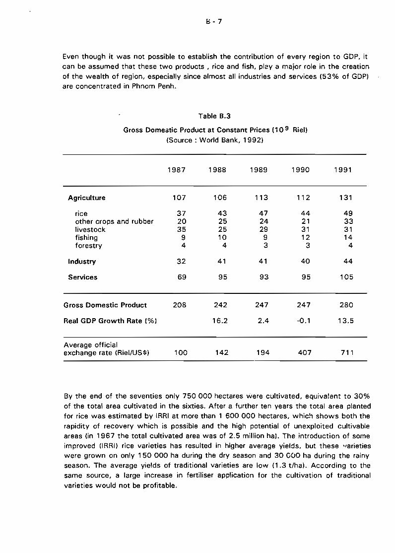
8.3 REGIONAL PRODUCTION AND ECONOMICS
The seven provinces considered during this study provided almost haIf of the nationalrice production: 950 000 out of 2 400 000 tons. Thus the role of these regions in thenational rice production economy is Vf.;ry important. Rice production represented 15% of
Gross Domestic Product in 1991 (Table 8.3) and as much as 47% of GDP of the
agricultural sector.
The role of other cultures (essentially corn and vegetables) is marginal compared withrice because they represented less than 10% of total cultivated area in 1991 (StatisticsOffice, Ministry of Agriculture!.
Fishery production represented 5% of GDP in 1991 and is very important at the regionallever where the production of 61 000 tons represents half of the national capture.
1:)-7
Even though it was not possible to establish the contribution of every region to GDP, itcan be assumed that these two products , rice and fish, plé!Y a major role in the creationof the wealth of region, especially since almost ail industries and services (53% of GDP)are concentrated in Phnom Penh.
Table 8.3
Gross Domestic Product at Constant Priees (10 9 Riel)(Source: World Bank, 1992)
1987 1988 1989 1990 1991
Agriculture 107 106 113 112 131
rice 37 43 47 44 49other crops and rubber 20 25 24 21 33Iivestock 35 25 29 31 31fishing 9 10 9 12 14forestry 4 4 3 3 4
Industry 32 41 41 40 44
Services 69 95 93 95 105
Gross Domestic Product
Real GDP Growth Rate (%)
Average officialexchange rate (RieI/US$)
208
100
242
16.2
142
247
2.4
194
247
-0.1
407
280
13.5
711
By the end of the seventies only 750000 hectares were cultivated, equivalent to 30%of the total area cultivated in the sixties. After a further ten years the total area plantedfor rice was estimated by IRRI at more than 1 600 000 hectares, which shows both the
rapidity of recovery which is possible and the high potential of unexploited cultivableareas (in 1967 the total cultivated area was of 2.5 million ha). The introduction of sorneimproved (lRRI) rice varieties has resulted in higher average yields, but these 'farietieswere grown on only 150 000 ha during the dry season and 30 COO ha during the rainyseason. The average yields of traditional varieties are low (1.3 t/ha). According to thesame source, a large increase in fertiliser application for the cultivation of traditional
varieties would not be profitable.
8-8
Table B.4 shows the importance, in terms of planted area, of rice cultivation comparedwith other cash crops.
Table B.4
Cash crops in Cambodia(Source: Ministry of Agriculture)
Crops 1989 (ha) 1990 (ha)
Rice (both seasons)MaizeCassavaSweat PotatoesVegetablesSoy beansMung beansPeanutsSesameSugar CaneJuteCottonTobaccoBlack pepper
1 61553047485
93361466725 18913 10127 176
503512 14765442 132
47323598
111
1 8900004450011 2607670
286401469025 150
6450941063301 540
93013 630
260
rhe study area provides almost half of the total rice production, and has recovered to alevel of production close to that which pertained at the end of the sixties (Table B.5).Also, because these provinces provide the major part of the national production of thedeepwater/floating rice whose yields have, according to IRRI, the highest capability for
increase, an important potential exists for increased regional producticn, mainly in theareas bordering the Great Lake in the provinces of Siem Reap, Kompong Thom,
Battambang and Pursat.
With regard to improvements of rainfed lowland rice and dry season rice, the approachshould focus firstly on varieties and secondly on the improvement of irrigation.
As the fishery sector has not received the same level of international assistance as ricecultivation during the last decade, there has not been a large effort with regard toresearch and development. Therefore, the estimates of the present and future captureand fisheries production are even more uncertain than those for rice production. a similarsituation is found for estimating the profitability of the fishery units, the organization ofthe different segments of the chain of production and marketing, and the process offormation of fish prices.
~-9
Table B.5
Area Planted for Rice and Rice Production{11 (1981-1991)
(Source: Statistics Office, Ministry of Agriculture)
Province Phnom Kandal Kompong Siem Battam- Pursat Kompong TotalPenh Thom Reap bang Chhnang
Area (103 ha)
1981 2 86 94 150 260 57 49 6981982 2 86 117 162 288 65 52 7721983 3 81 118 168 295 75 52 7921984 3 74 97 160 182 51 34 6011985 3 79 105 157 190 63 44 6411986 10 77 99 156 203 60 62 6671987 10 63 99 128 203 46 39 5881988 13 73 137 180 129 75 64 6711989 13 93 138 163 152 78 63 7001990 13 94 142 169 148 79 66 7111991 12 92 130 143 162 86 72 697
Production (103 t)
1981 3 125 71 141 246 43 54 6831982 4 163 112 168 342 80 61 9301983 6 154 126 162 276 97 63 8841984 6 108 73 156 144 35 41 5631985 4 142 91 159 231 74 57 7581986 13 140 109 159 270 69 74 8341987 16 142 116 131 264 53 47 7691988 19 124 166 220 181 96 85 8911989 21 178 161 212 209 101 88 9701990 21 190 162 194 197 93 89 9461991 20 177 155 172 228 100 95 947
(1 ) Variation in time of area and production within a single province may net be significant, because ûfchunges of the boundaries of sorne provinces, such as Phnom Penh and Battambang.
The following figures given by the Department of Fisheries give the estimates <>f fisheryproduction for the study area. In 1991, production in the study area represented 75% of
the production from national freshwater catches and cultures (Table B.6).
B - 10
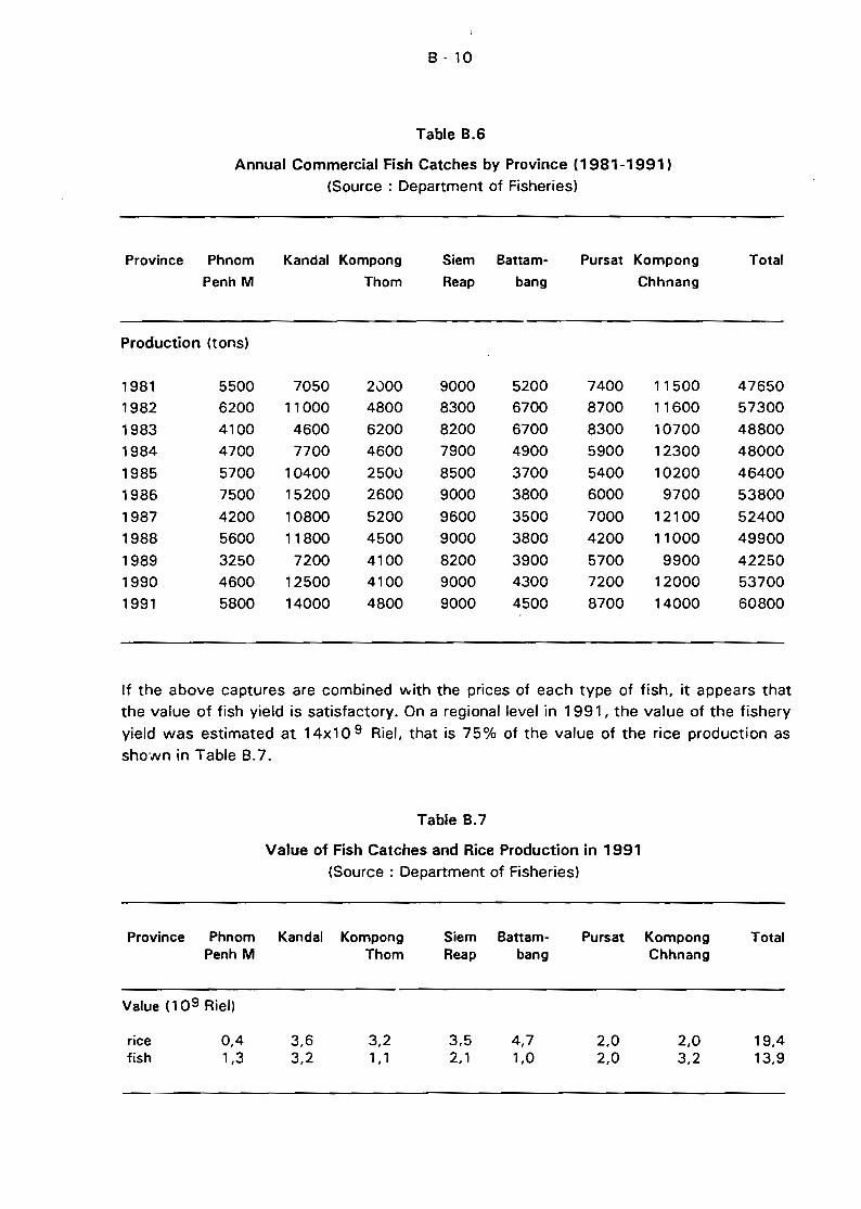
Table B.6
Annual Commercial Fish Catches by Province (1981-1991)
(Source: Department of Fisheries)
Province Phnom
Penh MKandal Kompong
Thom
Siem
Reap
Battam
bang
Pursat Kompong
Chhnang
Total
Production (tons)
1981 5500 7050 2000 9000 5200 7400 11500 47650
1982 6200 11000 4800 8300 6700 8700 11600 57300
1983 4100 4600 6200 8200 6700 8300 10700 48800
1984 4700 7700 4600 7900 4900 5900 12300 48000
1985 5700 10400 2500 8500 3700 5400 10200 46400
1986 7500 15200 2600 9000 3800 6000 9700 53800
1987 4200 10800 5200 9600 3500 7000 12100 52400
1988 5600 11800 4500 9000 3800 4200 11000 49900
1989 3250 7200 4100 8200 3900 5700 9900 42250
1990 4600 12500 4100 9000 4300 7200 12000 53700
1991 5800 14000 4800 9000 4500 8700 14000 60800
If the above captures are combined VIIith the priees of each type of fish, it appears that
the value of fish yield is satisfactory. On a regional level in 1991, the value of the fishery
yield was estimated at 14xl0 9 Riel, that is 75% of the value of the rice production as
shO"Nn in Table B.7.
Table B.7
Value of Fish Catches and Rice Production in 1991
(Source: Department of Fisheries)
Province Phnom Kandal Kompong Siem Battam- Pursat Kompong TotalPenh M Thom Reap bang Chhnang
Value (109 Riel)
rice 0,4 3,6 3,2 3,5 4,7 2,0 2,0 19,4fish 1,3 3,2 1,1 2,1 1,0 2,0 3,2 13,9
8 - 11
The above table shows that the relative importance of th~se two products varies fromone province to another. For example, Battambang is the major rice producer but thevalue of its fisheries production is relatively low. A similar situation occurs in theprovince of I(ompong Thom. The value of fish production is the highest in the provincesof Kompong Chhl1ang and Kandal. Fish captures for the municipality of Phnom Penh are
estimated at mOïe than 10 9 Riel. It can be concluded that efficient and effectivemanagement of the fisherv sector at regional level would result in important economicand socio-cultural benefits. This sector is especially important in relation to the revenuesraised for public services through taxation and auctioning of fishery plots. Revenues forthe freshwater fisheries alone were estimated to be 52x106 Riel in 1988 (Curtis, 1988).
C - 1
C HYDROLOGY, SEDIMENTOLOGY AND RIVER MORPHOLOGY
C.1 HYDROLOGICAL ASPECTS
C.1.1 Hydrological Dynamics of the Great Lake
The Great Lake of Cambodia cail be considered as a common water body, fed bv the
rivers of its own drainage basin and by direct rainfall on its water mirror. The overflow of
the lake runs through the Tonlé Sap River downstream to its confluence with Mekong
River in Phnom Penh. However, the most specifie hydrological feature occurs during the
Mekong flooding period when its waters flow back into the Tonlé Sap. The current of the
Tonlé Sap then changes direction and the Mekong inundates the Great ~ake. With the
ebbing of this flood, the water which was stored in the lake flows again to the sea,
through the Tonlé Sap, and then through the delta complex, where the Mekong itself and
the Bassac are the m~jor channels.
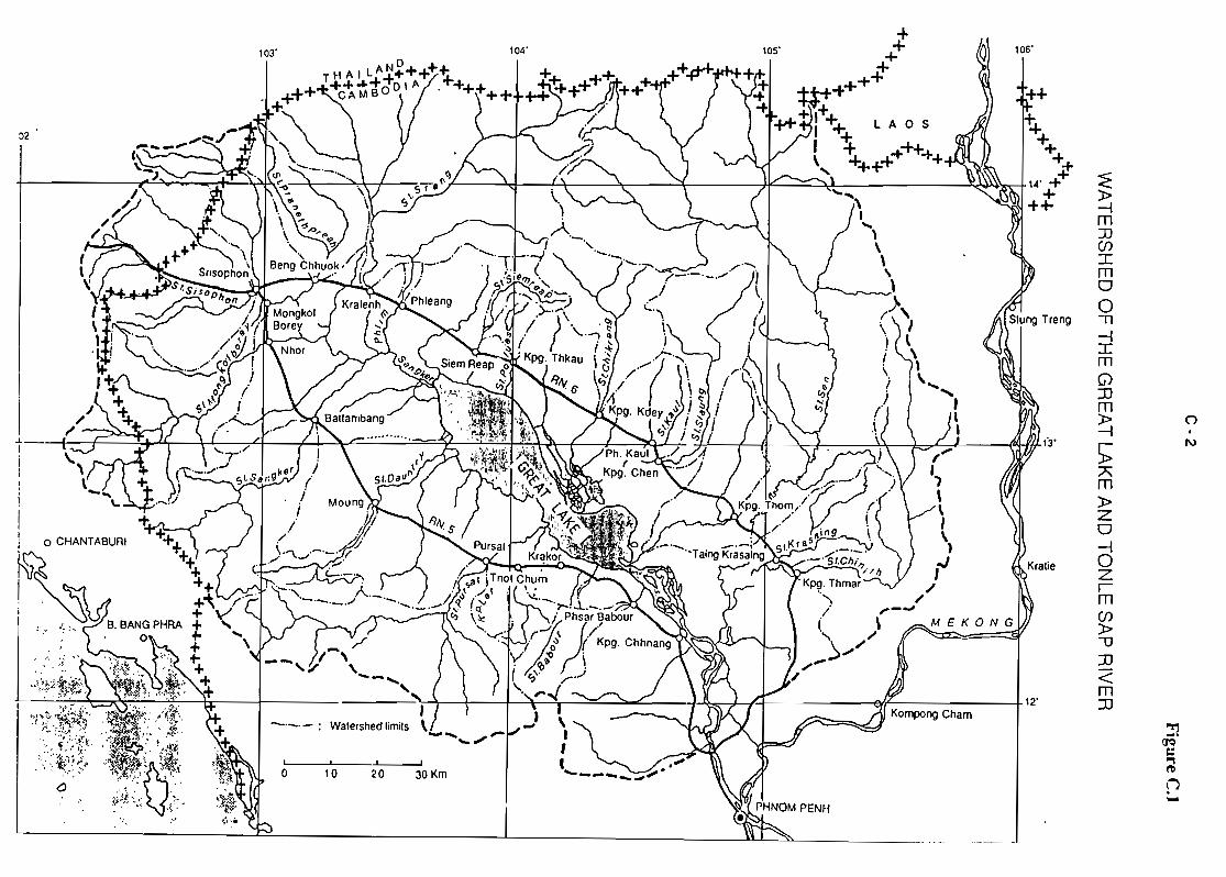
The watershed of the Great Lake and its connections with Mekong River and BassacRiver are shown in Figure C.1.
Because of the very fiat topography, any variation of the volume stored in the lakeresults in very large variations of the flooded surface. Accolding to Carbonnel and
Guiscafré (1963), the surface of the flooded area during the 1962-63 hydrological yearranged from 2 700 km 2 during the dry season, to nearly 16 000 km 2 at the maximumlevel of the flooding. The alignment of the two highways surrounding the lake (RN5 in
the SW and RN6 in the NE) corresponds to the limits of the open water of the lake at its
highest level. At this stage, the area of the drain~ge basin of the Great Lake is
67 600 km 2 •
Water levels are around 1 m as! or less during the dry season, and over 9 mas! when
the lake is full, the storage capac.ity then being 72* 109 m 3 . This figure, which was
given by Carbonnel and Guiscafré (1963), corresponds to a level of 9.36 m asl reached
from 11 to 14 October 1962. This storage figure was established using the waterbalance method (which is not very accurate), as no bathymetric and topographie surveys
have ever been carried out in the area. The renaining capacity of the lake during its low
periods is unknown. The same authors gave an estimated capacity of 1.3 * 109 m3 for
the lake at the end of the dry season (ail as! water levels are referenced to Ha Tien sealevel).
C.1.2 Available hydrological data
The Mekong Committee operates an extensive electronic data bank where most of the
hydroclimatological existing information is stored. In conjunction with this historicalseries. some other processed data can be found in technical reports or studies. Ali thedata of the recent past years are not yet stored in the electronic data bank.
A comprehensive assessment of the available numerical data available for this study is
presented in Annex 3.
()
1\)
~()'Qc:.,l'D
li
~
~m:::0(J)ImooIl~ImG):IJm»~
):;:;'\m»zo~oZrm(J)
»-0:IJ<m:IJ
106'lOS'104'
30 Km2010, • 1 1
o
-"'0_._: Walershed limils
103'
rp~ J< \ ( 4 (i"' c············---~ -"!,,'<:';;~,~ ( J ~l' "J).' 1 fi '" 1 . _\\ ')..ç;.c_, ~flfù'1 • \:' J {. ( ".,AI.~It~. '~h:~. \ jOh k!3IIIT /_
a
"/.....,\... r ~12'
- ..... , \, ~ r l ".."''''i~ i 'k) rr 9 ;nrnnMl,('h~rn" \ 11 .' ca \;=À'C"'" HOt, 'w. 1 • ,
1 ~ttJ', ~<'
··"::'-~ii.r;·.! f~ ·;,..~,i,..... : :{
':, "', ,~:<:.'(.t.".,,~o' :<.
~., . ~:;t ;:.,.v"': .:.,v~ ~...
02
C-3
C.1.3 Hydrological analysis of the system
a) Background and objectives of the present analysis
As described in section C.1, the Great Lake and its watershed area, the alternatedrainage and supply channel of the Tonlé Sap and the Mekong form a complex
hydrological organization which will be designated further with the generic term"system".
According to many technicians' findings and experts' advice, there has been a prolonged
degradation of the physical characteristics of the lake. In summary, an alarming trend inthe decrease of the water depth due to the siltation of the lake has been observed in thelast few decades, and this process would have accelerated recently. Decreases infisheries' yields and problems of navigation during the dry season are seen as impacts ofthis reduction of the lake's depth.
If these findings are confirmed, some modification or continuous trend in the hydrologicaland/or sedimentological behaviour of the system should exist. The sedimentological
expertise will be developed in the next chapter. The aim of the current hydrologicalreport is to find out any modification or trend in hydrological behaviour which could
sustain these alarming findings.
b) Water balance
The o':ljective of the calculation of the system's water balance is to assess the respectivecontributions of the Mekong and of the Great Lake drainage basin in the filling of thelake.
The hydrological d9ta of the lake watershed, the Tonlé Sap River, and of the Mekong are
simultaneously available for one single hydrological year, that of 1962-63. Carbonnel andGuiscafré derived the following water balance for that period (ail figures in 109 m 3 ):
(i) Inputs from the drainage basin of the lake
- lnflow from the rivers 24.3 (1)
- Net balance "rainfall on the lake" (+ 13.9)
minus "evaporation" (-1 004) .:.:'L? (2)
Total inputs from the lake drainage basin 28.0 (3)
(ii) Inputs from the Mekong through the Tonlé Sap
- inflow to the Tonlé Sap at Prek Kdam {going to the lake) .45.0 (4)
- Outflow from the Tonlé Sap at Prek Kdam (going to the sea) ??..:~ (5)
Net balance at Prek Kdam = (5)-(4) .••••••.••.•...•.•.••••.•.•.•.••..••..•••..••••• 27.9 (6)
C-4
(iii) Contribution of the Mekong overflow and of the part of the basin between the
outlet of the Jake and Phnom Penh
References {3} and {5} which were obtained by two separated methods, are nearly
the same. However, the inflow-outflow balance in Prek Kdam cannot be taken
as being the contribution of the Great Lake drainage basin, as reference (fl does
not take irito account sorne water entering the system which had not been
monitored during the increasing flow at Prek Kdam. There CIre two main sources
for such inputs:
(1) Water coming from the overflow of the Mekong upstream of Phnom Penh:
When the water level passes 8 m in Phnom Penh and 10 m in KompongCham, the Mekong overflows its right bank upstream of Phnom Penh and
inflow may enter the Jake by-passing the Tonlé Sap at Prek Kdam (however
it is controlled at this point during the ebbing period). According to
Carbonnel and Guiscafré study, the most important channel for collection
of this overflow is Prek Spean Tras. The prek starts from the Mekong at
Roka Kaong in a sharp curve of the Mekong between Kompong Cham andPhnom Penh (point X=501, Y=1310 on the 1/50000 map of Cambodia). The
greater part of the overflow is routed to the lake under a bridge located at
Kilometre 54 of highway RN6. At this location, the embanked road which
crosses the flooded plain in a S-N direction has an opening of 132 m
width, which allows the water to flow westward (bridge coordinates X =494,
Y=1319 on the 1/50 000 map). Discharges were monitored at this site during
the 1962-63 hydrological year. The water crossing the road at this point
flows to the Tonlé Sap, somewhere in the South-East of KompongChhnang, much further upstream of Prek Kdam. It h:.s to be mentioned
that the bridge at Km 54, as weil as severa! waterways from the Mekong
to the Tonlé Sap have been located on the maps. However, the name
"Spean Tras" could not be found on the different maps available for the
study (1/50 000 and 1/250 000).
During the 1962-63 period, the volume of the Mekong overflow whichcrossed the bridge control section was .4.0 * 10 9 m 3 {7}
Thus, when compared with the 45 * 10 9 m 3 which flowed to the Jake at
Prek Kdam site, the overflow gave an additional input of around 10%.
However modest, this contribution has very specific dynamics and as sucris worth consideration: at the end of the Mekong flood, the water in Prek
Spean Tras was still flowing in the direction of the lake for a two-week
period, w!1i:e the stream direction had already changed in Prek Kdam,
where the current was oriented to the sea.
RN6 highway was constructed in 1927 and Carbonnel and Guiscafré
stated that "before the road construction, the volume of the overflowsgoing to the lake was probably larger".
(8)
C-5
The impact of the road construction is most probably minor, but this facthas to be pointed out in a study aiming to compile every Iikely natural orman-made change in the system. Moreover, it is not impossible that somechanges are attributable to hydraulic works which were extensively carriedout in the country during the 70's. In any case, the current importance andthe. role played by the Mekong overflow will have to be assessed.
(2) Water coming from the part of the watershed between the outlet of the l(lkeand Prek Kdam.
- This area of 2 500 to 3 000 km 2 could bringan addition of 1 * 10 9 m 3
The estimation of the water supply to the lake area using the water balance methodwould be (5)-(4)-(7)-(8), or 23 * 10 9 m 3, which can be compared to the 28 * 10 9 m 3
given by the monitoring of the flow entering and leaving Prek Kdam. The monitoring inPrek Kdam overestimated the supplies from the lake drainage basin. Moreover, as the
final result comes from a difference, the method is not very accurate : if the inflolN andthe outflow had been monitored with an accuracy of 10% to 15% (which would nothave been bad, according the difficult hydraulics conditions of the site), then theaccuracy of the difference (contribution of the lake watershed area) would be estimatea
with an accuracy not better than 20% to 30%.
ln summary, for the year considered, the share of the water between the Mekong andthe Great Lake watershed area was as follows :
-Mekong
- Great Lake watershed area
49 x 10 9 m 3 or 62% of the total supply
28 x 109 m3 or 38% of the total supply
c) Hydrological variability of the system in time
The information of daily flow of the electronic data bank. also published in thehydrological year-books for the period 1963-70 have been used to estimate thehydrological variability of the s,ystem in time (Table C.1)
According to these figures:
Either, there is a very strang variation of the hydrological yield on the Great Lakewatershed area from year ta year, shawn by differences in runoff as great as450 mm in 1963-64 and 75 mm anly in 1967-68 (respectively 32.2 and4.5*10 9 m 3). However, the low values seem to be aberrant, and a carefulstudy of the rainfall on ail stations of the watershed may reveal these values asbeing outlying or inconsistent
Or, some changes have occurred in the calibration at Prek Kdam and starting
from 1967-68, discharges were not measured with the required accuracy.
C-6
From the available information, it is not possible to determine which hypothesis is the
correct one.
Table C.1
Water Balance of the Tonlé Sap at Prek Kdam - Unit =109 m 3
Source: Mekong Secretariat Year-books
Year Flow going Flow going to Balance
to the lake the Mekong(a) (b) (bHa)
1962-63 111 45.0 72.9 27.9
1963-64 43.4 75.6 32.2
1964-65 49.1 66.1 17.01965-66 48.3 67.8 19.5
1967-68 56.5 61.0 4.5
1968-69 42.9 53.8 10.9
1969-70 61.3 65.6 4.3
11) data taken trom Carbonnel and Guiscafré 's study
The historical records of the water levels in Kompong Chhnang are another valuable
source of information to assess the hydrological variability of the lake. This station hasbeen observed since 1924. The water lever in Kompong Chhnang can be taken as being
the level of lake with an acceptable approximation (around 10 to 20 cm). The quality of
the data is extremely poor. In sorne years thare are more ']aps than readings and sorne
readings are obviously aberrant. Moreover, we did not find the altitude of the datum of
the gauge in any document. Therefore, a first interpretation was made of the range of
the variations of water levels, rather than the true altitudes related with the lever of tne
sea in Ha Tien. For each year, maximum and minimum water levels were extracted from
the data base, the difference was calculated and the values were plotted as shown in
Figure C.2.
To minimize the effects of odd readings. the maximum WélS defined as the average levelof the five highest days and the minimum as the average level of the ten lowest days of
the year.
Considering the variations of the lowest annual values, three ciifferent periods can clearly
be identified :
- 1925-56, with minimum levels close to 3 m.
1957-61, with minimum levels close to 2 m.- from 1962, with minimum around 1 m.
Knowing that the water level in the lake at the end of the dry season is around
1.3 m asl, we conclude that the situation of the gauge was probably in accordance with
C-7
sea level topography during the last period. We assume that this was not the previously
the case and put forward the following hypothesis :
(il The shifting of the gauge was exactly 1 m during the 1957-61 period and2 m during the former 1925-56 period.
(ii) The shifting was the same for ail gauge staffs, from lowest to highest
levels.
Thus we have corrected the data, subtracting 2 m from the readings during the 192556 period and 1 m during the 1957 -61 period. The graph with the corrected data isshowr) on Figure C.3.
According to this data, the maximum level of the lake would usually have been between
9 and 10 m asl, but sometimes the maximum was no more than 8 m and could reach
nearly 11 m.
The distribution of the annual maximum levels for the 50 years with available data was
the following :
Over 10.00mOver 9.50 m :
Over 9.00 m :
Over 8.50 m :Over 8.00 m :
8% of time (max 10.73)
32% of time
52% of time
76% of time100% of time (min 8.01)
If the validity of these data is confirmed, it is c1ear that the high water of the lake mustbe very different from one year to the another. There have never been any bathymetric
or topographie surveys carried out on the lake area and '10 accurate relations betweendepths, volumes, and surfaces have been made available. However, using the monthly
water balance, Carbonnel and Guiscafré published a graph establishing an approximate
relationship between water depth, flooded area and stored capacity, which can be
extrapolated up to 10 m agI. The flooded areas and stored volumes are as follow(Table C.2) :
Table C.2
Flooded area and storage capacity of the Great Lake in relatiiJn with water level(Source: Carbonnel and Guiscafré, 1963)
Water level Flooded area Storage(m as!) (104 km 2 ) (10 9 m 3)
8 13.5 519 15.2 65
10 17.0 80
C-8
Taking 10 m asl water level as a reference, a drop in the level of filling of the lake equalto 1 m (9 mas!) leads to a reduction of nearly 2 000 km 2 in the flooded area and of
15 * 10 9 m 3 in storage. If the reduction is 2 m, these values are as high as 3 500 km 2
and 29 * 10 9 m 3, respectively. Such situations, which according to the historical data
are not unusual, will probably have very significant impacts on the ecology of the flooded
area (especially on the "inundated forest") and therefore on fish and fishery yields.
With data of such poor quality, attempts at identification of trends in water levels are
very risky :
(i) ln correcting the data, we assumed that the 1 m level in Kompong Chhnang was
a steady feature and thus no trend may appear on the graph for the low water
levels.
(ii) For the high water levels, the situation is less clear. However two periods of
recession can be identified (see Figure C.3):
- 1924-33, during which the lake shrank continuously (except for two years
1929 and 1930) and finally reached its lowest known high level (8.03 m in
1933).
- 1947-56 (except 1952)
There is no runoff data available for the Great Lake watershed during these periods, theonly reference being the Mekong flow. During these two periods, the flow was generally
less than average (see F~gure C.7), the phenomenon being especially visible between
1924 and 1933. The impact of the Mekong floods on the inflow of the lake will be
discussed in section (e).
d) Variability of the Mekong flow in time
The discharge of the Mekong in Phnom Penh (drainage area 663 000 km 2) has been
monitored for too short a period to carry out any trend analysis. The nearest station withseveral decades of relïable data is Paksé, where the watershed area is only
545 000 km 2• A double-mass curve analysis, as weil as correlations between iîùw in
Phn::>m Penh and Paksé during the joined observation period, showed that despite the
difference in drainage area, the regime was the same for the two stations and that there
was a fairly good correlation between the discharge in Paksé and in Phnom Penh (see
Annex 3).
Figure C.4 shows the variations of the annual discharge of the Mekong in Paksé for theperiod 1923-1989, as weil as the 5-year moving average and the long-term average forthe overé'1I period (10 122 m 3 s -,). The Mekong annual discharges show slgnificantvariations and these variations determine periods with stronger flow than the average,such as 1937-54, and other periods with reduced flow (1955-61), and most recently,
1985-89.
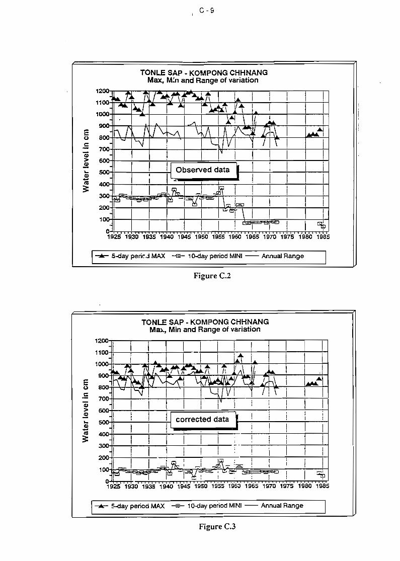
C-9
TONLE SAP - KOMPONG CHHNANGMax, M;n and Range of variation
1
1
1
2-- ... i\ j- Mt!- ~~ l... 11
1 1 1100'" /A~ , -\j \1 ,/\ 1
• AV.. :""1 ~ ~ ....Î~~-'t Il Â. 1
1 1 1 1000 ' l \ 1 1- 14 \ J... 1 1 1
· ./\--- ..·Î\r 1\ J"v~ \,iJ\ 1 A Y"O 1rh\ 1
Ai800 1\ I~I- '\j "- VI ... /1"\ 1700
I~
1 1 1 1600
1 Il Observed data1 1
1 11 111
500 1
1
11 L 1
1 i 1
1
400 1 1 1
I-,=- 1 I~~1 Jn 1
1
,1 1300 ....,! ! !
~ ~- I~ -t=gr= 1 \ r.::1 it:=J 1 t1
1
200 1 1 1
1 1 1 1 i 1~9" \ 11 1 1
1
1:= 1 1
1 1 1 ! 1
11
1 9b0 1 1
i -1 i !
1925 1~30 1935 1940 1945 1950 1955 1960 1965 1970 1975 1980 1985
....... 5-day perk,j MAX = 10-day period MINI - AnnuaJ Range
Figure C.l
TONLE SAP - KOMPONG CHHNANGMID.., Min and Range of variation
5OOr+.--~~----i-i corrected data
E80
.5CI)
>CI)
"-CI)-ca;:
~1 ! 1
1925 1930 1935 1940 1945 1950 1955 1960 1965 1970 1975 1980 1985
....... 5-day period MAX = 10-day period MINI - Annual Range
Figure C.3
c - 10
The question is to know if the reduction of flow during the most recent period can be
reJated with the construction of the dams which started during the late sixties. A list of
existing reservoirs and of theïr capacities is given in Annex 3. According to this
information, the overall storage capacity upstream of Phnom Penh is 8.8 *1 0 9 m 3 . This
value is Jess than 2 % of the average annual flow of the Mekong in Phnom Penh(~10*10 9 m 3, for an annual discharge of 13 000 m 3 s-1).
Howev&r, the effects of the barrages might be detectable during very dry years when the
water demand is high and the Mekong flow is reduced. If one considers the variations of
the flow in Vientiane, upstream of the reservoirs (Figure C.S), the departures from the
mean have the same magnitude and occurred at the same periods than in Paksé.Moreover, such reductions in flow already occurred in the past, prior to any dam
construction. The conclusion is that the ecosystem has a strong natural variability, a
feature which has to be taken into account when addressing the problem of hydrological
changes in the area.
e) Relationship between the Mekong fJoods and the filling of the lake
The discharges of the Mekong in Phnom Penh and of the Tonlé Sap in Prek Kdam are
simultaneously available during a pericd of 7 years during the sixties. This allows
examination of an existing relationship between the flow of the Mekong and the flow
entering the Tonlé Sap.
For each year where data was available, we selected the months during which Tonlé Sap
was flowing upstream on a:l days. On an annual basis, a regression was drawn between
the volume discharged by the Mekong River in Phnom Penh during these months and thevolume which entered the Tonlé Sap(1). Results are shown on Figure C.G).
(i) Despite an increasing dispersion, as floods become larger, it is c1ear that the
volume of water entering the Tonlé Sap and thereby the Great Lake shows a strongcorrelation with the magnitude of the Mekong floods.
(ii) Regulation of the Mekong floods will lead to a reduction of the supply of the Jake.
This would happen even if the regulation did not reduce the annual flow but only
causes a redistribution throughout the year, such as an increase of flow during dry
periods and a reduction of flood peaks.
(iii) The Tonlé Sap - Great Lake system is small compared to the Mekong : whereas thea:1nual flow of the Mekong during the selected months varies between 150 and
300 * 10 9 m 3 , the volume "lent" to the Tonlé Sap in the same period is of the
order of 35 to 65 * 10 9 m 3, or a little over 20% of the Mekong flood waters.
11): These volumes are an underestimation of the entering volumes for the considered year, asthe flows of the months during which the direction of the stream changed are not includedin the total.
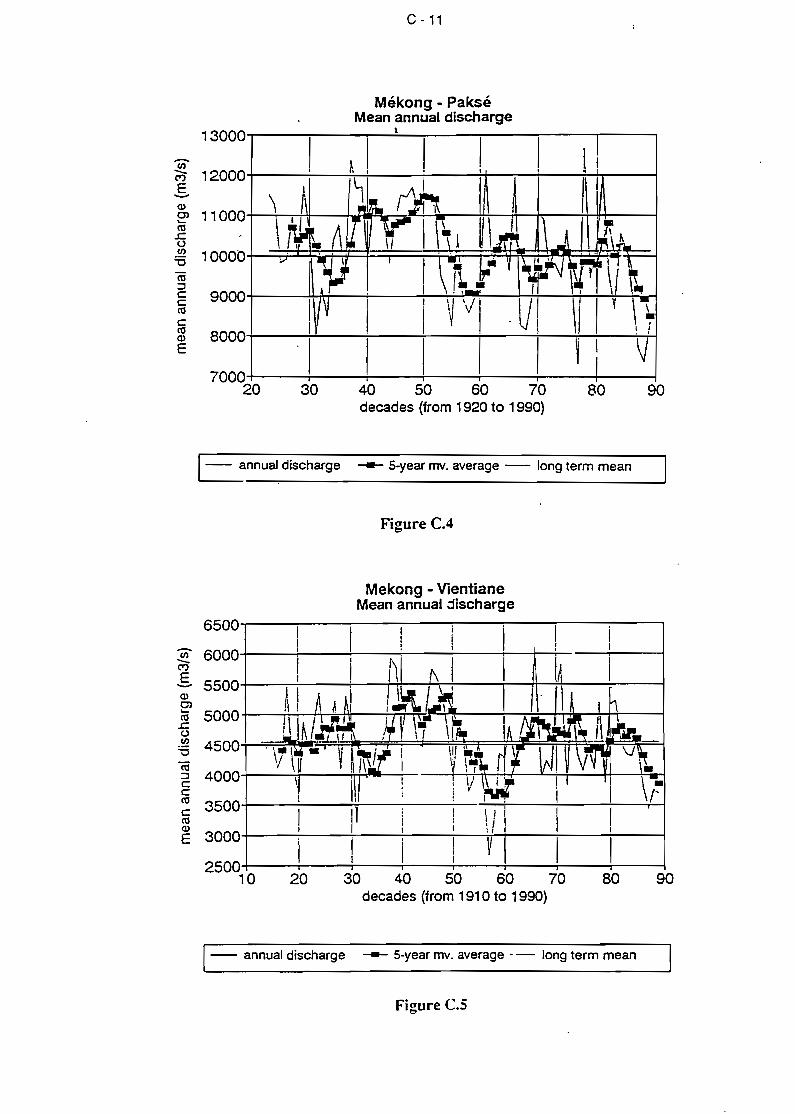
90
C - 11
Mékong - PakséMean annuai discharge
13000-r----:------:-...:.1--:-----:--.........---.--,
Ci)M" 12000+---.:..--.;:,....-;---:----i+--;--:---.....:-+T-----1E-
9000-t---!+-T'H----:-I---+--+i-~T-___:---t+-__++--+-"""ïi-_h.rl
SOOO-t----i-!------7,---i----+----+--"i+--i---t-i-i
17000-t----f-----+---+---r-----;----+-------j20 30 40 50 60 70
decades {tram 1920 to 1990)
- annuaJ discharge - 5-year rnv. average - long term mean
Figure C.4
Mekong - VientianeMean annual discharge
6500
Ci) 6000-C")
E 5500-Q)0).... 5000ca
.J::(.)
.~ 4500vëii
4000::::lCCca 3500ccaQ)
3000E
250010 20 30 40 50 60 70 SO 90
decades (tram 1910 to 1990)
- annual discharge - 5-year rnv. average - - long term mean
Figure C.s
C - 12
Because of the crucial role of the floods, the analysis previously carried out on annual
discharge of the Mekong in Paksé (see section C.1.3 (dl and Figures CA and C.5), was
repeated for the flooding period. The flooding period was identified as extending frol n1 June to 30 September, i.e. the oeriod having most frequent inflows to Tonlé Sap.
Results are shown in Figure C.7 (for each year, average discharge during the 4-month
period, moving average over a 5-year period, and long-term average over the overall
periodl. The following conclusions can be drawn from the results :
(il The floods have variations in their hydrological regimes similar to those of the
annual flow.
(iil The volume of the Mekong floods during 1962, which corresponds to the period of
the study carried out on the lake by Carbonnel and Guiscafré, is close to the
average. As far as the Mekong contribution is concerned, it can be assumed thatthe findings of this study apply to a normal situation. A comprehensive analysis of
the rainfall on the lake basin might give some information about the rank of the
contribution from the lake walershed.
(iii) The period 1947-56 which has been identified in Kompong Chhnang as having a
decreasing trend in the filling of the lake, corresponds on Figure C.7 to a similar
situation for the Mekong floods.
(ivl The recent period (1985-89) already identified as having a deficit in annual
discharge is also c1early marked on flood discharge.
C.2 SEDIMENTOLOGY AND RIVER MORPHOLOGY
Assessments were made of sediment transport and river morphology in the drainage
channels which constitute the river system known as Quatre-Bras (Chakdomuk). The
objective of this assessment was to determine ~he likely evolution of channel formingprocesses in the Quatre-Bras zone. Of major concern, therefore, were transport and
deposition of sediment emanating from flood flows.
C.2.1 Sediment Transport and Deposition
a) Importance of the phenomenon
As with ail major rivers in humid tropial regior,s of Asia, the Mekong river has a very high
rate of sediment transport, principally suspended sediment (more than 90% of total solid
transport) in its lower reaches. An understanding of the characteristics of thesesediments and their transport mechanisms (entrainment, deposition, re-entrainment) in
the complex Mekong-Tonlé Sap-Great Lake system is of vital importance, because thesephenomena have a direct impact on the biological environment of this system, and in
particular on fish.
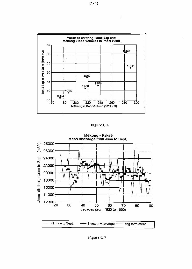
C -13
Volumes enterlng Tonlé Sap andMékong Flood Volumes ln Phom Penh.
1 1 11bs9
1,.
1 11
1 11
1 1 11
19•62
11
1
1
1967•1 1
1196J 19.j
1~~-.,
19.9 '-.-- 1 1
1 1135
160 180 200 220 240 260 280 300Mékong st Pnor.lh Penh (10-9 m3)
65
c=;-E 60C)«o:::. 55El'CIC
~ 50è:aic. 45caen'41
ë 40r=.
Figure C.6
Mékong - PakséMean discharge trom June to Sept.
- 28000ri)-Cf)
E 26000--0- 24000Q)Cf)
.9 22000Q)c::
20000::l-,Q)0) 18000....co.c::() 16000(J)
'5c:: 14000coQ)
:E 1200020 30 40 50 60 70
decades (fram 1920 ta 1990)80 90
- Q June ta Sept. --- 5-year mv. average - long term mean
Figure C.7
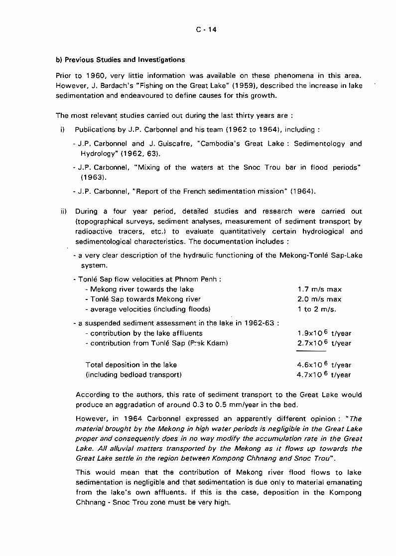
1.7 mis max2.0 mis max
1 to 2 mis.
C - 14
b) Previous Studies and Investigations
Prior to 1960, very little information was available on these phenomena in this area.
However, J. Bardach's "Fishing on the Great Lake" (1959), described the increase in lakesedimentation and endeavoured to define causes for this growth.
The most relevan~ studies carried out during the last thirty years are:
i) Publications by J.P. Carbonnel and his team (1962 to 1964), including :
- J.P. Carbonnel and J. Guiscafre, "Cambodia's Great Lake: Sedimentology andHydrology" (1962, 63).
- J.P. Carbonnel, "Mixing of the waters at the Snoc Trou bar in flood periods"(1963).
- J.P. Carbonnel, "Report of the French sedimentation mission" (1964).
ii) During a four year period, detailed studies and research were carried out
(topographical surveys, sediment a:1alyses, measurement of sediment transport by
radioactive tracers, etc.) to evaluate quantitatively certain hydrological and
sedimentological characteristics. The documentation includes :
- a very c1ear description of the hydraulic functioning of the Mekong-Tonlé Sap-Lake
system.
- Tonlé Sap flow velocities at Phnom Penh:
- Mekong river towards the lake- Tonlé Sap towards Mekong river- average velocities (including floods)
- a suspended sediment assessment in the lake in 1962-63 :
- contribution by the lake affluents- contribution from Tonlé Sap (P~~k Kdam)
Total deposition in the lake(including bedload transport)
1.9x10 6 t/year
2.7x10 6 t/year
4.6x10 6 t/year
4.7x1 0 6 t/year
According to the authors, this rate of sediment transport to the Great Lake would
produce an aggradatiun of around 0.3 to 0.5 mm/year in the bed.
However, in 1964 Carbonnel expressed an apparently different opinion: "The
material brought by the Mekong in high water periods is neg/igible in the Great Lake
proper and consequently does in no way modify the accumulation rate in the Great
Lake. Ail alluvial matters transported by the Mekong as il flows up towards theGreat Lake settle in the region between Kompong Chhnang and Snoc Trou".
This would mean that the contribution of Mekong river flood flows to lakesedimentation is negligible and that sedimentation is due only to material emanating
from the lake's own affluents. If this is the case, deposition in the KompongChhnang - Snoc Trou zone must be very high.
C - 1S
iii) .. The Lower Mekong Basin - Suspended sediment transport and sedimentation
problems", P.O. Harden and A. Sundborg, 1992. This is the most recent report onthe subject and it is based on thorough bibliographical research, sedimentologicalmeasures and statistical studies. It provides the following useful information:
- A summary of rare data collected during the period 1960-91.
- Some suspended sediment concentrations at Phnom Penh (Iess than 2 g/litre),
which is low compared with such rivers as Yellow River (44 g/l).
- An estimation of sediment transport and its evolution at several points, from
which the following figures are quoted (Table C.3) :
TABLE C.3
Transport Rates (10 6 t/year)
Location
PakséStung TrenKratiérivermouth
1961
115146
1961-65
126
1986-90
178
250200 to 300
These figures imply a degradation of the catchment area of the order of300 t/km 2 /year. The authors believe that the sediment charge of the lowerMekong is increasing, t-ut this remains to be confirmed.
- Recommendations to continue studies in this field.
iv) On the subject of lake sedimentation, M. Imre Csavas, FAO Fish Expert, expressedthe following opinion during an FAO mission in Phnom Penh in November 1990 :
- The intensivE:: deforestation around the Lake is the essential cause ofsedimentation.
- Deposition in .the bed of Great Lake is presently occurring at a rate of 4 cm/year
and, as the lake has an average depth of 40 cm in the dry season, it could ceaseto exist as a lake in the dry season in 10 years' time.
Some caution is necessary, however, in this regard. Considering that the averagesurface area of the lake is about 5 000 km 2
, then the available storage volume isabout 2x10 9 m 3. For a deposited sediment density of 1.4 t/m 3, this wouldrequire some 1 500 yea:-s of sedimentation at the rate proposed by Carbonnel(1.9x10 6 t/year). At the more pessimistic rate of 4.7x1 0 6 t/year the period
would be 600 years, which is very different from the 10 years suggested by M.Imre Csavas.
C - 16
c) Present knowledge of sediment phenomena
After an analysis of available existing documentation, several reconnaissance visits in the
zone and various interviews, we can state that :
i) There are some indications, based on very few, and insufficient, data, that
suspended sediment transport rates in the lower Mekong river are increasing
slightly..
ii) Except at its two extremities (Chakdomuk and Snoc Trou) it would appear that
Tonlé Sap river is not experiencing any marked change in sediment transport and
deposition rates.
- At Chakdomuk (Quatre Bras) heavy deposition of sediment occurs, as proven bythe annual dredging which is carried out, r'Jt only to maintain access to the port,
but also (according to the authorities) to assist fish migration. At this location
some 40 to 80,000 m3 /year is dredged. The morphological evolution of this
zone is described in the following chapter.
- Several cross sections were measured in the lower Tonlé Sap river in March
1993 at distances of 2, 7, 8, 10 and 30 km from Phnom Penh, corresponding to
some of the same sites measured in 1969. These sites comprise typical reaches
of the river (straight and winding). A comparison of these two series of cross
sections leads to the following remarks :
A small amount of aggradation l'las occurred at the P10 and P30 setions (about2 m in 24 years).
Sections P7 and P8 have barely changed.
Aggradation at section P2 has been abuut 3.5 m in the period 1969 to 1993.
Because of the dynamic nature of elevation changes in alluvial riverbeds it is hard
to draw any firm conclusions from these measurements apart from ~:'e fact that
bed aggradation at section P2 is significant. The large bed rise in this section,
near Quatre Bras, confirms that heavy sedimentation is occurring in this zone.
- At Snoc Trou there has been aggradation of the bed, and the causes appear to
be twofold :
The discharge of flood water coming from Mekong river creates a delta due to
the sharp reduction in velocity and turbulence.
The Stung Sen affluent, one of the most important contributing rivers in the
catchment of the Great Lake, discharges also at this location. Because Stung
Sen transports coarser sediments (sands) than those of the flood flows in
Tonlé Sap, the corresponding deposits are r,ot easily eroded by Tonlé Sap floodflows. It can c1early be seen from the maps and aerial photos that the inflow of
Stung Sen causes a diversion in the flow of Tonlé Sap towards the west. This
can be c1early seen in Figure C.S.
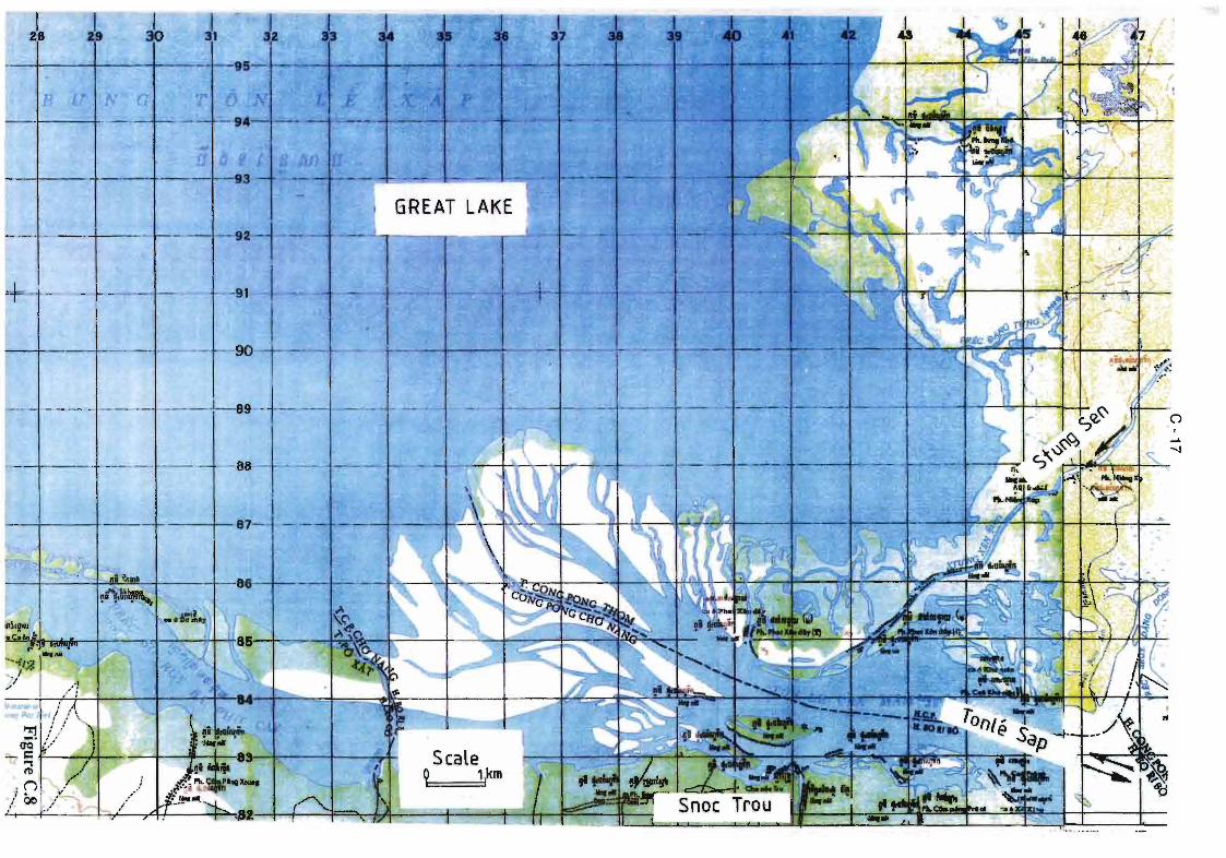
JI
-88
1.-+----+--87- - --+'---+---~r-
-- ' .... -.-.-.
C - 18
An in-depth study based on radioactive tracers was carried out on the StungSen by J.P. Carbonnel and is described in his 1962-63 report (seebibliography) .
Investigations should be continued at these two sites (Chakdomuk and SnocTrou) to determine the causes and rate of the sedimentation which can beobserved.
iii) Any lake which receives heavily sediment-charged waters will undergo anaggradation in its bed level, even if there are periods of outflow. The importantconsiderations are the rate of accumulation of sediments and the distribution ofthe sites of deposition.
It is the belief of this consultant that the deposition of sediments over the wholebed of the lake is relatively minor because there are very few changes which canbe observed between the 1965 maps of the dry season lake boundary andcorresponding aerial photographs taken in 1992.
The contributions to lake sedimentation due to the rivers in the catchment of thelake and due to flood flows in Tonlé Sap are not known, neither in absolute norrelative terms. The contribution from Mekong river would appear to be the mostimportant, especially since sorne of the Mekong flood waters enter via overlandflow (see discussion in Section C.1.3.
Local deforestation is generally given as the main cause of the increasedsedimentation rates. Whereas deforestation of the Mekong basin upstream fromPhnom Penh has increased the sediment concentration of the flood flows of thisriver, it has not yet been shown that deforestation within the direct catchmentof the Great Lake has had a marked effect on sediment transport rates in therivers discharging to the lake. The deforested zones are often only gently sloped,and the erosive action of rainfall would not be very significant.
There is no evidence that the situation has rapidly deteriorated in recent years.
ln conclusion, it should be noted that available data relating to sedimentary phenomenaare insufficient and that complementary investigations are absolutely necessary todetermine the actual situation.
C.2.2 Evolution of the Zone of Confluence of Chakdo"}uk (Quatre-Bras)
a) Basic Principles
This zone near the capital has been undergoing slow but constant morphological chan~esfor many decades. During floods, strong currents erode the not very resistant river bankson the outside of bends and, as the floods recede, sediments ars deposited to form pointbars on the opposite sides of the channel. The confluence of Mekong, Tonlé Sap andBassac rivers is slowly moving. downstream as a result of the erosion and depositionphenomena which are characteristic of alluvial rivers.
C - 19
Figure C.9 shows the changes which have been observed in the last thirty years.
bl Consequences
The following points are made:
- The Noréa point and the whole of the northern bank of the zone situated between
Mekong and Bassac rivers are eroding rapidly. For the last thirty years this bank hasbeen receding at a rate of 10 to 15 m per year {see photographl.
- Concurrently a point bar is progressively building on the opposite bank of Bassac river.ln this regard the backfilling of the bank for construction of the Cambodiana Hotel has
certainly contributed to increasing the erosion.
- As a result of the two preceding phenomena flows to Bassac river are being
diminished.
- This deformation of the entry to Bassac river increases the risks of erosion on the right
bar.~... near Monivong bridge.
- The rivermouth of Tonlé Sap is moving simultaneously downstream. The small
sediment island which appeared 8 to 10 years age will shortly be linked to the riverbank. However, because the growth of the point bar separating Tonlé Sap and Mekong
rivers is occurring at a slower rate than the erosion on the Noréa point, the surface areaof Quatre-Bras is increasing and, as a consequence, sediment deposition will be
facilitated. Dredging of the access channel to the port (Chakdomuk zone) will thereforeneed to be increased as a consequence.
It can be concluded that the natural evolution of this zone is unfavourable and that
current problems related to erosion and sedimentation will increase.
C.2.3 Expected influence of proposed dams
Ail dams along a river modify the hydrological regime and sediment transport of the riverto a greater or lesser extent. Several dams have already been proposed in the Mekong
river basin, either in the upper Mekong basin or on Tonlé Sap river.
Several major dam projects for harnessing the main stream the Mekong were proposedduring the 70's. Because of the very heavy impact on populations and environment, suchprojects are currently not likely to be achieved at short or medium term. As far as wehave been able to determine, the dams proposed in the upper reaches would be built on
tributaries and would therefore only intercept relatively small subcatchments of Mekongriver. Their influence on solid discharges of the river would barely be noticeable at PhnomPenh.
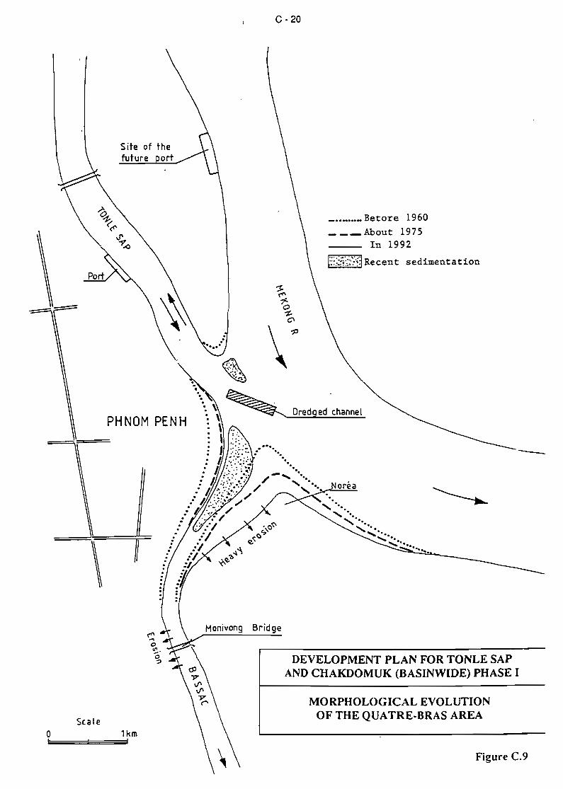
C - 20
oréa
Figure C.9
_ ••_•.•_Betore 1960___ About 1975
In 1992
r::}!·:·:·;·~:·~~Recent sedimentation
ed channel
MORPHOLOGICAL EVOLUTIONOFTHEQUATR~BRASAREA
DEVELOPMENT PLAN FOR TONLE SAPAND CHAKDOMUK (BASINWIOE) PHASE 1
Honivong Bridge
Il
PHNOM PENH
\
Scaleo 1km1::;'==;;;;;;1;;;;==='
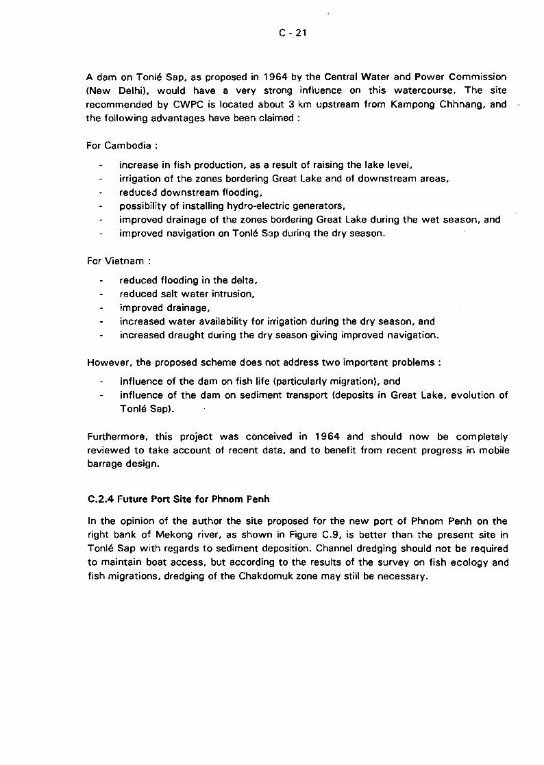
C - 21
A dam on Tonlé Sap, as proposed in 1964 by the Central Water and Power Commission(New Delhi), would have a very strong influence on this watercourse. The site
recommended by CWPC is located about 3 km upstream from Kampong Chhnang, andthe following advantages have been claimed :
For Cambodia :
increase in fish production, as a result of raising the lake level,irrigation of the zones bordering Great Lake and of downstream areas,
reduce.:1 downstream flooding,possibility of installing hydro-electric generators,improved drainage of the zones bordering Great Lake during the wet season, andimproved navigation on Tonlé Sap durinQ the dry season.
For Vietnam :
reduced flooding in the delta,reduced salt water intrusion,improved drainage,increased water availability for irrigation during the dry season, andincreased draught during the dry season giving improved navigation.
However, the proposed scheme does not address two important problems :
influence of the dam on fish life (particularly migration), andinfluence of the dam on sediment transport (deposits in Great Lake, evolution ofTonlé Sap).
Furthermore, this project was conceived in 1964 and should now be completelyreviewed to take account of recent data, and to benefit from recent progress in mobilebarrage design.
C.2.4 Future Port Site for Phnom Penh
ln the opinion of the author the site proposed for the new port of Phnom Penh on theright bank of Mekong river, as shown in Figure C.9, is better than the present site inTonlé Sap with regards to sediment deposition. Channel dredging should not be requiredto maintain boat access, but according to the results of the survey on fish ecology andfish migrations, dredging of the Chakdomuk zone may still be necessary.
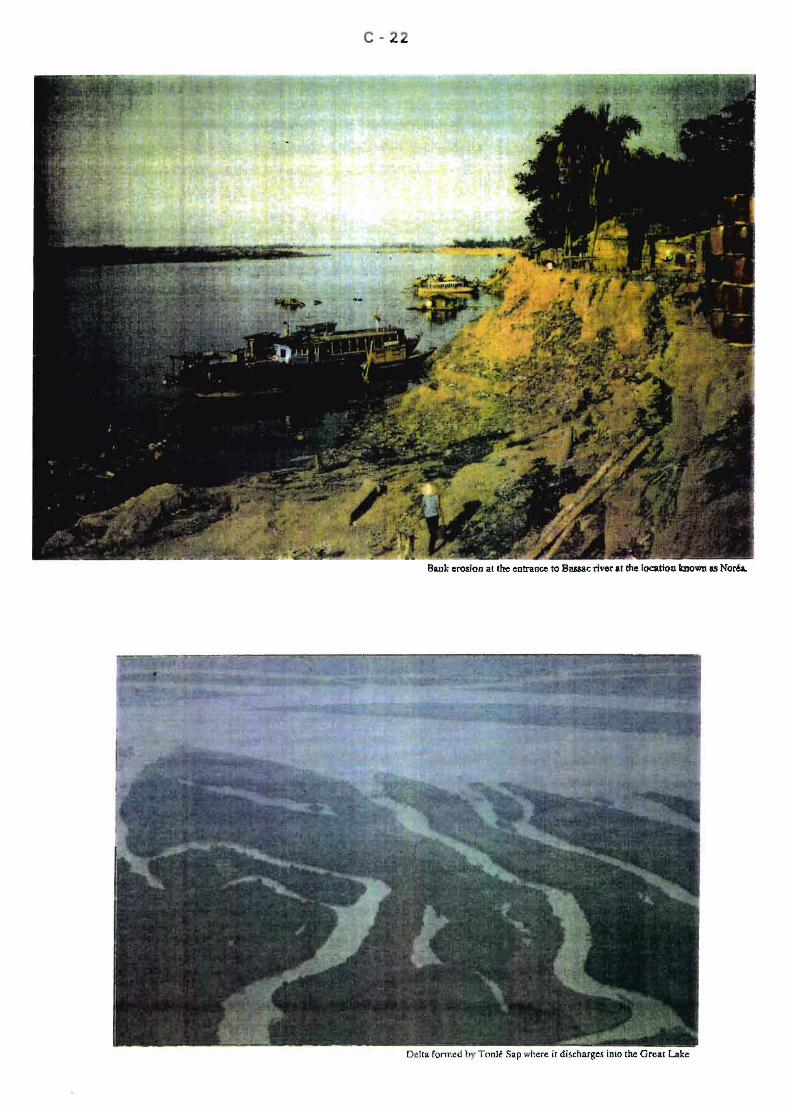
C - 22
Ba.ok erosion al the entrance 10 Bassac rivor al the location known as Noréa.
D - 1
D FISH AND FISHERIES
D.1 BACKGROUND AND AVAILABLE DATA
D.1 .1 Preliminary Remarks
Literature on Cambodia's aquatic resources makes frequent reference to the abundanceof its fish, to the inundated areas that cover up to a quarter of its territory and to theknowledge of fishermen involveL in the exploitation of these riches. Recentlv, attentionhas also been drawn to endangered species, degradation of the environment.deforestation and the adverse effects of fishing on wild life stocks.
These concerns were kept foremost in the assessments that were made of the current
situation during the brief site visits in March 1993, and in the literature review based onpublications provided by the Mekong Committee and documents held by the NationalMuseum of f\iatural History in Paris.
The present study has been mainly concerned with the Great Lake, its connectingchannel (Tonlé Sap) leading to Mekong river, and the zone of low land surrounding thelake t::> the limit of il'lundation during the flooding perioè:>. The Great Lake, however, isinseparable from the Mekong river basin system, and any consideration of physicalconditions (sediment flows, hydrological variability) or biological aspects (fish migrations)should address the entire system and not just the Great Lake subsystem.
ln support of the statement that the whole r.1ekong river basin/Great Lake drainage basin
should be considered in any analyses of the fish resources, it is worth noting that, whenthe lake is fi lied to its highest levels, it accounts for less than half of the 50 000 km 2
total flooded areas of Cambodia. A comparison of fish resources and their exploitation inthe lake with those in the remaining flooded areas should therefore also be made. It isparticularly necessary to take into account the links with the waters of the Mekongupstream and downstream of Phnom Penh to verify the hypothesis of its bioecologicalprocesses.
The hydro-c1imatic system comprising tha Great Lake and its connections with Mekongriver has already been described in Section C. Sorne features of the Mekong river basinare described below with reference to the four zones shown in Figure D.1 :
A : To the North, from Kratié to the Khone Falls, Mekong river is interrupted bynumerous rapids with noticeable deep holes (up to 40 m deep according toBlanc, 1960) and absence of inundation.
B: South of Kratié the profile of the river changes as it meets the plain.Inundations periodically affect this area whir:h links the Phnom Penh junction tothe upstream.
D-2
DEVELOPMENT PLAN FOR TONLE SAPAND CHAKDOMUK (BASINWIDE) PHASE 1
MAP OF CAMBO DIA SHOWING THE MAINAQUATIC ECOSYSTEMS: A,B,C,D
,---- --
LAOS
1l,-
11
""' ---</ ..... / 1
,- ...... ,,_/ 1r- '.... 1\ ,\ 1
) \___~~r- Fa Ils "
\\
\\\
11
1(
r111\\
1..... "" ,
/' -/
""",...""-
_Kompong Som
170v/)/
~//)s
,-- ~ Angkor, ,<>, ",0,
THAILAND
",.---,.,.., -.---".,--.,- .....--..,- ,---/
//
/'(
,,/r ..... '\J11\
" 0,
11
,,-- ..... /r ....~-_..--,
L...:..-'..:..:..:....:~~i;i;iioi.;.;iii 1 ~
\ , \1 C;;; \-f- - (\ ,, Cf!. \......... .....)
, , ",,--, ',J'... j VIETNAM1 \ ,
1=== -===- - --:zr - X
=-=---..!.-N+--'- _/-=---~~_\
Legend approximate limit of inundation during floods
_____ separation of zones
Figure D.I
0-3
C: From the south of Phnom Penh to the Vietnam border: a complex systemwhere the upper Mekong river merges with Tonlé Sap river and with theestuarial zone downstream in Vietnam.
o : Great Lake which is related via Tonlé Sap to both the upper and lower watersof the Mekong (B and C) at Chakdomuk (Quatre Bras confluence)(l) .
The present study has considered the living resources in two parts:
- ecosystems and biology, and- exploitation of fish resources.
0.1.2 AVAILABlE REPORTS AND DATA SOURCES
Basic data concerning fish populations, their environment and their exploitation is patchyand mostly very old. Table 0.1 shows some of the more relevant works known to beavailable and which were consulted. This does not represent an exhaustive survey. Theoutstanding works in terms of soundness and relevance are: Chevey and LePoulain (1940), Smith (1945), Fily and d'Aubenton (1965), Kottelat (1985), Departmentof Fisheries (1990), and Mekong Committee (1992).
It is important to distinguish between original research publications and some expertreports VJhich have simply quoted from older works. Both should be taken into account,but with appropriate care depending on the sources of data.
The first publications on the fisheries and fishes of Cambodia date back to the secondhalf of the 19th century. One can quote in particular Buchard (1880) among the firstinteresting descriptions and the work~ of Pavie (1904) for observations carried out from1882 tn 1885. It should be noted that it was Pavie who described "Pangasius (ex
PangasianodonJ gigas" and forewarned its likely extinction.
At the beginning of the 20th century numerous taxonomie descriptions appeared, andthey are practically the only scientific works in the ichthyological field. Two interestingworks are those of Petillot (1911) and Gruvel (1925).
The Oceanographie Institute of Nha Trang was the first permanent scientific institutionfor research. This period was marked by the pioneering works of Krempf (1925-1927)and above ail of Chevey (1925-1948) who made observations on growth marks,inundated forest, the first fish population descriptions as weil as numerous biological andsystematics notes. Chevey and Le Poulain's book is the reference on bioecologicalstudies of the Great Lake of Cambodia.
(1) The Chakdomuk area is of the utmost importance to the river/lake system and should be given specialconsideration in any analysis. It is the hydraullc junction. influenced by erosion and siltation, and it is thepassage for upstream and downstream migrating adult fish and for juveniles as flood waters recede.
Table D.1.
0-4
AcquisitiGn ,of knowledg€ concerning aquatic ecos)'stems in Cambodia
Legend : ( ) : expert opinion based on secondary data only
1850
1860
1930
Explorersand naturalists
Recognition of economicimportance
First allempLS at biological,flSheries and socio-economic analyses
Buchard, 1880
Pavie, 1904
Peùllol. 1911Gruvel, 1925
Chevey, 1933
1940 ---------> CHEVEY, LE POULAIN
SMITH,1945
Blache et Goossens, 1954
First description of the Great Lakeand iLS resources
Il1960
------->
Expen opinions
Study of the GreatLake and Tonlé Sap
Blan-: (1950), Bardach (1959)
(SOULIER, 1963)* BibliographyCAR80NNEL/GU~CAFR&I%3
FlLY 1d'AU8ENTON, 1965
Vietnamese works
KOlTELAT (taxonomy)
Second series of expert opinions:Barrage proposed on Tonlé Sap1970
11975 --------> (LagIer / University of Michigan, 1976)
11985 -------->
1i 936-88 ----->
11991-92 -----> Third scric~ of
1 expert opinions
(Schmid, 1964) (d'Aubenton, 1963)(Mékong Commiuce, 1962)
NGUYEN XUAN THAN etNGUYEN VAN HAO, 1991
(Edwards), (Grünewald), (FAO)...(MEKONG COMMITTEE, 1992)
19~3 (phase l, Mekong commiueel
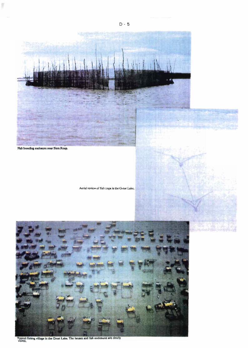
0-5
Flsh brceding enc!œure ncar Siem Rcap.
krial rcview of fish laps in the GreaI Ùlke.
TypicaJ fishing village ln the GreaI LaIte. The houses and fish encloswes are c1earlyvisible.

1)-6
Smith's book on the fishes of Siam was published in 1945. This book gave the firstcomprehensive view of fish fauna at a regional level, including the Mekong species. The
next notable works are those of Blache and Goossens (1954), Bardach (1959), andBlanc (1960). Blanc drew attention to the natural barrier to migration formed by theKhone Falls (see Figure D.1 , Zone A).
These works can be separated into those concerned mainly with the physicalenvironment (hydrology and sedimentation) and those treating mainiy biologicalproduction (fish and fisheries): Carbonnel and Guiscafré (1963), Fily andd'Aubenton (1965). Apart from recent Vietnamese works (see below), they constitute
the latest sCientific contributions to a broad view of the Great Lake.
At that time the Mekone Committee carried out studies on the consequences ofconstruction of a barrage on Tonlé Sap: Schmid (1964), d'Aubenton (1963), andMekong Committee (1962).
Due to political disturbances during the last twenty years, there has been Httle furtherpublication in this field. The publications of the University of Michigan (Lagier, 1976) arean example : the basin-wide programmes initiated by the Mekong Committee were onlypartialfy implemented in Vietnam and had to be cancelled in Cambodia. The Department
of Fisheries relaunched a research programme on limnology and fisheries and carried outan ambitious programme from 1986 to 1988, whose first results have recently beenpublished in Vietnamese (Nguyen Xan Tan and Nguyen Van Hao, 1991).
Recent works on taxonomy, such as those of Kottelat (1988) and Roberts andVidthayanon (1992), are important. There have been no updated scientific field studieson Cambodia and the Great Lake for the last thirty years (Table D.1). There are,however, some usefui national records (Fisheries Statist;cs, 1980-1991;Regulation, 1990) and some recent studies related te' an expected new economic boom:Grunewald (1990), FAO (1991), Edwards (1990), Nandeesha (1992), Durand (1992).
Finally mention 15 made of a study carried out in 1992 for the Mekong Committee andfinanced by Denmark (Mekong Committee, 1992). This work reviews ail of the availableIiterature on the subject, and is often referred to in this report.
0.2 BIO-ECOLOGICAL CONTEXT
The productivity of the fresh waters of Cambodia is acknowledged to be among thehighest in the world. High temperatures (the Great Lake lies at 13 0 N) ar.d periodical
flooding are responsible for the high produccivity. The role of the inundated forest shouldalso be noted. It contributes to the process in different ways: enhancement of theoverall productivity of the system, rapid development of micro-organism, phyto andzooplankton, shelters to juveniles anà/or specific adult fish species, reproduction zonesfor some fish species.
D-:
However, the bio-ecological importance of the inundated forest is difficult to
demonstrate and there is a need to c1arify thE: process of this very specifie ecosystem. It
is essential that, at some time, research studies be performed to quantify the role of the
inundated forest.
The identification of the characteristic fish species of Mekong river and of Cambodia, in
particular, was m~de as early as the 19th century (Sauvage, Tirant, Boulenger), and in
the early descriptions by Cuvier and Valenciennes. More recently Kottelat (1985) listed
215 species belonging to 127 different genus and 47 families. According to Kottelat,
400 nominal species have been described since Sauvage.
After Smith (1945), a large collection was implemented by d'Aubenton between 1960
and 1964 which paved the way to the evaluation of genus or groups of a relatively
limited size (d'Aubenton, 1965b; d'Aubenton and Blanc, 1965, 1966, 1967; Blanc and
Fourmanoir, 1965; Stauch, 1966; Stauch and d'Aubenton, 1965; de Soutter, 1975,
1977).
Meanwhile Kottelat completed the identification of fish in this collection, enabling the
inventory of 215 fish species in the Cambodian fish fauna and the establishment of a
comprehensive list of 131 khmer terms. Kottelat gives particulars on the overwhelming
abundance of "Cyprinidae", with 42 genus and 81 species and the "Si/uriformes" whichinclude 23 genus and 41 species for 8 families. In his taxonomie review Kottelatremarked the Jack of systematics on "Pangasius" , so muc~, as to write that of the
16 nominal species in the Cambodian waters only "P. larnaud," could be identified. Since
then, the family of "Pangasiidae" has been reviewed by Roberts andVidthayanon, (1992).
The distribution of species does not prove any particular endemism and the great
majority of the species appeôr elsewhe're in the Mekong, in ~outh of Vip.tnam, Laos and
in Thailand. There does not, therefore, seem to be a geographical barrier at the Khone
Falls as far as we know.
It is possible to c1assify the major species into three groups with a view to theirbiologica: and ecological features (Mekong Committee, 1992) :
a) A group of species which are mainly associated with the larger streams/main
river, but undertake spawning migrations between these and the flooded areas in
the wet season. This group is communly c1assified as "white fish". They are
mainly cyprinids (Cirrhinus aurautus, Hampala macrolepidota, Puntius altus,
Leptobarbus hoevenii, Osterchilus melanopleura, Labeo [MoruliusJ chrysophekaidon), Schilbeidae (Notopterus chitale .:;nd N.notopterus) ;
b) Species which are able to survive under more adverse and varied environmental
conditions (Iow oxygen levels, some acidity, some salinity) and which can
remain in the swamps and plains year round, commonly c1assified as "black
fish". This group includes members of the families Clariidae (Clarias batrachus),
0-8
Ophicephalidae (Channa micropeltes, C. striata), Bagridae (Mystus (MacronesJ
nemurus) and Anabantidae (Anabas testudineus, Trichogaster trichopterus);
c) Smaller, fast growing and prolific species (opportunists), which are able to utilize
the flood period for prolific reproduction and growth. The group consists mainly
of cyprinids (Thynnichthys thynnoides, Dangila siamensis, Cirrhinus jullient). Due
to their piology they can exhibit very high abundance in a distinct seasonal
pattern. The opportunists and small specimen of several species are collectively
called "trey changvéir".
The reproduction cycle functions predominantly by migrations, which are themselves
regulated by the hydrological cycle. Referring to the consequences of a barrage on Tonlé
Sap, d'Aubenton (1963) gave particulars of the main biotopes in Cambodia and on the
related migrations.
Two main migration types are commonly distinguished : the genetic migrations, related
to the reproduction of species, and the trophic migrations, related to the search for food.
Another typology makes a distinction between longitudinal and lateral migrations. The
first ones cover larger distances: the species involved are able to cover very large
distances (group a). The lateral migrations are concerned with relatively sedentary
species which pass from the river to flooded areas with no specific displacement at low
water : they can be trophic as weil as genetic (group b). The lateral migrations aregenerally catadromous : the fish follow the flood while the longitudinal migrations can be
either anadromous or catadromous.
At lowest water level, the total volume of residual waters of the Great Lake is about 2 to
3x10⁹ m 3 compared with a maximum volume at high water level about 20 to 30 times
higher. The shelter provided by Tonlé Sap is only about 10% of the volume of low
waters in the Great Lake. It is probable that the main shelter is provided by Mp.kong river.
considering the overcrowding which occurs in the residual waters of the Jake. This issubstantiated by d'Aubenton (1965a) : "at high waters the fish try to find their way to
the inundated zones. They travel in the direction of the rising waters, that is to say with
the stream. At receding waters the fish leave the inundated zones and shelter from the
stream in still waters (Great Lake, Beng, Tonlé Sap). They then descend as the watersrecede in accordance with the lunar cycles until tf<ey reach permanent waters (rivers,
tributaries, stung) where they move upstream" (2) •
ln conclusion it can be said that the migration patterns in the Great Lake and Tonlé Sap
system are weil documented, but that the quantitative and qualitative evolution to the
present time, particularly in recent years, is not known. The situation upstream anddownstream of Phnom Penh in Mekong river is less weil understood (Zones Band C in
(2) The opportunists species (see group c abovel migrates collectively as the waters of the Great Lakerecede in Tonlé Sap, and provide the major part of the day catches. Their behaviour in Mekong river is notyet fully understood.
D-9
Figure D.1). It is important that the exchanges between Mekong river and Tonlé Sap atQuatre Bras be studied in the near future.
There are 3 basic domains in bio-ecology : reproduction. feeding and growth.
- Fish reproduction. which is heavily dependent on the hydrological cycle and on
migrations. is the best understood of these fields (Chevey. 1939). There aresome fragmentary data in old publications fiS weil as in Roberts (1992) on the
Pangasiidae. or in recent Vietnamese works(3) . These works have adequatelyconfirmed the peak egg laying period which. in the lower Mekong. corresponds
to the flooding periods (see Figure 0.2).
- Feeding patterns and behaviour provide usefui information essential for the
analysis of fish populations and dynamics. The diet composition has only
partiallty been assessed. The same reference as for those cited for reproductionapply. The interrelations between the various species. competition for food and
role of the biotopes cannot be understood without a comprehension of sources
and utilisation of food. The evaluation of existing data would be a preliminary
step.
- The growth of the main species is only approximately known. Chevey's worksrevealed the existence of distinct growth marks on various fish species in the
Great Lake. but the large differences he quoted between the growth of fishes inthE: inlJndated forests and in the lakes. and between lakes and Tonlé Sap for
many Cyprinids species remains unconfirmed. Being able to determine the age ofa fish is essential for the management of stocks. and should be given high
priority. More precisely. the determination of age at first reproduction for theprincipal species should be undertaken as soon as new biology research
programmes are commenced.
(3) These works devoted to the diet composition and fish growth were not taken into conSIderation bec<lusethe translation was not available in time.
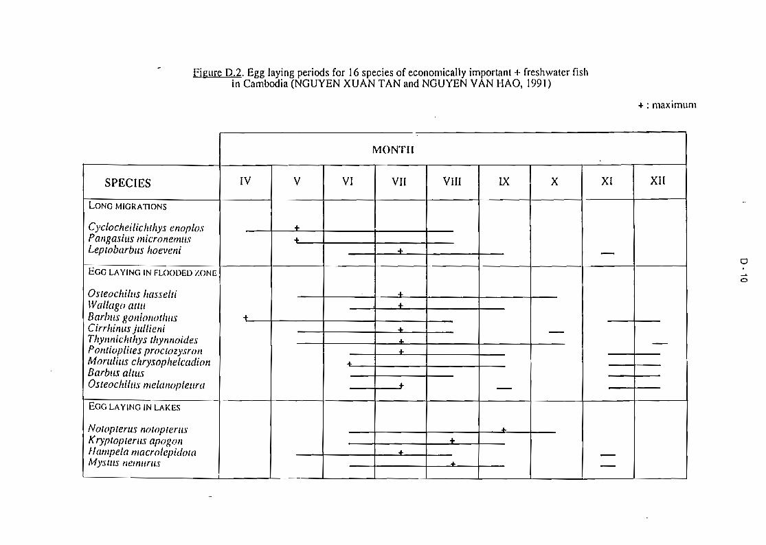
Figure 0.2. Egg laying periods for 16 species of economically imporlanl + freshwaler fishin Cambodia (NGUYEN XUAN TAN and NGUYEN VAN HAü, 1991)
+: maximum
MONTII
SPECIES IV V VI VII VIII lX X XI XII
LONG MIGRATIONS
CyclocheilicJahys enoplos ...Pallgasius micronemUJ ...Leptobarbus IlOeveni + -EGG LAYING IN FLOOl)El) ZONE
OsteochilllS hasselci "-
lVallago attll "-
Bar/ms gOlli01wtllllS of.
Cirrhinus jllllieni "- -Thynnichehys thynnoides .a. -Pontioplites proceozysroll "-
Morutius chrysophelcadionBarbm alwsOsteochilus melallopleura + -EGG LAYING IN LAKES
NotoptertlS notopeerus .&.
Kryptopterus apowm ...flampela macrolepùlow .&. -MysClls nemUTllS .&. -
o.....o
D • 11
0.3 EXPLOITATION OF RESOURCES
0.3.1 Introduction
ln the 19th century leases for fisheries were awarded by the drawing of lots. giving rise
to many conflicts (Petillot. 1911). The present system with its complicated rules and
centralised administration results from the 1884 Convention between France andCambodia and from the Royal Decree of 1908. This organization is described below.
followerl by a review of the available data and an analysis of the present level ofexploitation.
0.3.2 System of Exploitation
A large diversity exists in fishing gear and methods. each adapted to the environmental
conditions and to the species being sought according to the stages of the annual flooding
cycle. A recent work by the Depa~ment of Fisheries describes more than 70 differenttechniques and gears taken into account in the regu!ations. The range extends fromlines. dipping nets and harpoons used by families to the falling-stage traps and largefixed trawls including ail the gill nets. cast nets and draw nets. An interesting description
can be found in Fily and d'Aube:'lton (1966).
The Department of Fisheries defines three main fishery types: family (subsistence).small-scale (artisanal) and industrial. each one being characterized by fishing techniques
and gears.
For subsistence fishery. different gears are authorized ail year round, including fishtraps, bamboos. baskets, gill nets having less than 10 m in length, square-dippingnets less than 2 m wide. The artisanal or small-scale fishery includes larger fishing
gears which are privately owned. Industrial fishery corresponds to collective gear.
generally large-sized and of greater efficiency such as large draw nets, falling-stagetraps or days (working as large fixed trawls). Family fishery is private subsistence
fishery, whereas the two other types are professional and often include some kindof commercialisation of fish products, the distinction being mainly in the private or
individual as opposed to the collective nature of ownership. While family fisherymay be practiseJ ail year round with certain pre-defined gear and territorial
limitations, artisanal and industrial fisheries are heavily regulated.
- Artisanal and industrial fisheries are prohibited during four months (from 1 June to
30 September north of Quatre Bras and from 1 July to 30 October downstream ofthe confluence area). The whole of the territory which can be exploited for fishing
(banks of Mekong and Bassac river. areas surrounding the Great Lake, inundatedzones, etc.) is strictly divided into zones where fishing is prohibited and zones
divided into lots (FigurE" 0.3),
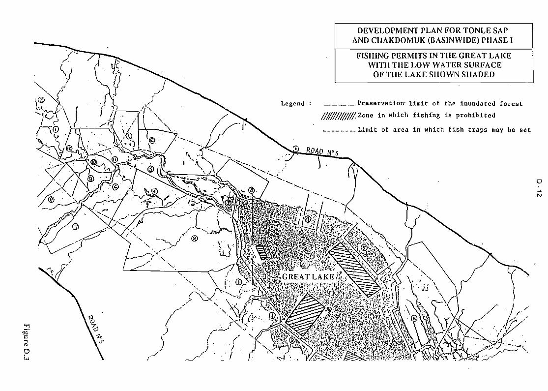
DEVELOPMENT PLAN FOR TONLE SAPAND CIlAKDOMUK (IlASINWIDE) PHASE 1
N
o
FISHING PERMITS IN THE GREAT LAKEWITH THE LOW WATER SURFACE
OFTIIE LAKE SHOWN SHADED
_0_0_0_ Preservatiorr limit of the inundated forest
!lW//I///// Zone in which fishfng is prohih ited
________ Limit of area in which Hah traps may he set
Legend
0-13
Each lot corresponds to a territory and is put up for auction every two years, theminimal value of the lot being fixed by the Oepartment of Fisheries according to the
fishing potential and to the catches of the previous year. Inside the lot the use offishing gears is reQulated by the Department of Fisheries which restricts also the
type of gear and their number, location and period of operation.
For each lot ~here is a record book in which the catches are recorded for each dayof exploitation and for each type of gear according to the major categories of fish.These official statistics are compiied and published each year by the Oepartment of
Fisheries. The Department of Fisherie5 also operates several lots as state fisheries,from which it would ~e hoped that some usefui statistics relating to commercial
fishing could be obtained.
Figure 0.3 shows the complexity of the regulation of exploitation, particularly in theGreat Lake which includes fishing lots, zones strictly Iimited to lobster pots and zoneswhere fishing is prohibited. In theory at least the organization is very elaborate, butadherence to its restrictions should be checked in the field, as should the accuracy of the
records of catches. Possibly as a result of political unrest, there are some lots which arenot being operated at pre!;ent (along Battambang and Stung Sangker rivers, for examplel.Quite apart from any considerations of differences between regulation and common
practice, it may be worthwhile to overhaul the whole regulatory system to improve its
effectiveness.
Fishing and related activities in the Great Lake and Tonlé Sap are determined by thehydrological cycle of rising and receding flood waters and the corresponding fishmigrations. Fily and d'Aubenton (19651 described the fishing calendar in the Great Lakeand Tonlé Sap as it relates to the water level (Figure 0.4). It is worth noting that in 1993
the overall orçdnisation is the same as it was 30 years ago, and there is quite a strongsimilarity with the scheme described by Chevey and Le Poulain in the thirties. This isvery marked for industrial fisheries : tile same distribution of lots and traps, comparable
size of days in Tonlé Sap, existence of low water draw nets and the disappearance of
the unprofitable high water draw nets. A doser examination would be required toestablish the situation with regard to the individual fishing gear.
The apparent stability of the organisation of fisheries does not mean that there havebeen no significant changes in the level of activity and in the relative importance held byeach type of fishing. In particular, there have been important technological innovations.
Aquaculture has not been studied in great depth to the present, but some general
observations can be found (Lafont et Savoeun, 1951; Tin, 1976, Mok, 1991). Morerecent reports indude those of Edwards, 1991; Nandeesha, 1991; Lazard et
Legendre, 1993).
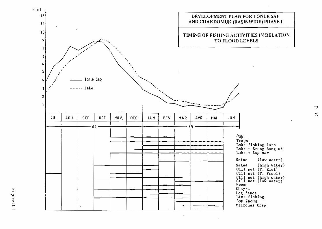
o
IVITIES IN RELATIONLEVELS
ayapske fishing lots
ake - Stung Sang Kéke + Lop na}'
ine (low water)ine (bigh water)11 net (T. Riel)11 net (T. Pruo1)Il net (high water)11 net (low water)amayrag fencene fishingp luongcrones trap
N FOR TONLE SAPSINWIDE) PHASE 1
DEVELOPMENT PLAAND CHAKDOMUK (BA
~
TIMING OF FISHING ACT"'...... TO FLOOD
'" '"'"
,'" ...
'" .. . _. -- _...
,,'" ,," \
'".- .- ,'"
\, \,. \,. \1 \
1 \\
1 \1 Tonie Sap
......1
,1 ' ....
1 .. .../ Lake ..., -- --. ... ... ...
".." ... ""'- ... - "-.. ,.......--- ...-- - -----'"-
JUI AOU SEP OCT NOV OH JAN FEV MAR AVR MAI JUN
62 63
D
- TrLaLLa
SeSeÇiGiGiGiNe. ChLoLiLoMa,
8
7
6
5
4
3
2
10
9
H(m)
12
11
0-15
Aquaculture has been practised in Cambodia for a long time without ever beingdeveloped to any large extent. This is essentially due to the prevalence of inland fisheries
which provide some 150 000 to 200 000 tons/year.
Though the aquaculture yields were negligible at the end of the seventies and in the earlyeighties, official statistics show a continuous growth in total production in recent years :
from 1 600 tons'in 1984 to 6-7000 tons in 1990-1991. The Department of Fisheries
aims to increase aquaculture production to 10 000 tons by 1995.
Fish culture in cages and pens accounts for 85% of the 12 000 tons produced during
the two years 1989 and 1990, of which about two-thirds were from cages. Thebreeding and raising of fish in ponds, introduced by fishermen from Vietnam, also exists.
Integrated rice production with fish culture and the use of fish ponds and temporarywater bodies for fish raising are also prevalent. In the beginning cages were only used to
keep fish alive prior to delivery to markets. Progressively the period of retention wasincreased, corresponding to the inclusion of younger fis" which are fed until they are
large enough to be sold. This phase may Jast up to one year and is now widely practisedin the Tonlé Sap and in the Great Lake.
There are from 10 to 15 species cultured in Cambodia. The list includes numerous
Cyprinidae, of which Cambodians seem to be very fond, as weil as Pang_as~id~e and suchspecies as Clarias batrachus or Channa (ex Ophiocephalus micropeltes). Imported speciessuch as carps and tilapias are also raised in cages.
Aquêculture in Cambodia remains largely dependent on capture fisheries. Breeding inhatcheries, despite recent improvements, is still far from meeting the needs and it may
be assumed that 90 to 95% of larvae and juveniles are captured directly from naturalwater bodies. Hatching techniques therefore Ileed to be developed. Feed is partiallyprovided by using small fisl1 captured in artisanal fisheries, which means that there isless available for traditional processed fish products (dried fish, prahoc, ... ). Consequently
the development of aquaculture will depend on finding other feed sources.
There is a general lack of facilities to carry out any aquaculture research. The ChhrangCham Res research station near Phnom Penh could be a suitable venue, as ~cme
production of indigenous species is already on-going there. It could also play a role intraining because of the existing facilities : laboratories, c1assrooms, hatcheries. However,
the station is currently inoperative because of the Jack of water, electricity supply andskillad staff.
ln conclusion, aquaculture will continue to expand, but should be the subject of astra1:cgic analysis. Its potential for meeting the needs of subsistence, national marketsand exportation should be developed, and it would be wise to concentrate on indigenous
species because of established taste preferences.
D - 16
Various NGO's have recently shown interest and have tentatively implemented somefield projects: such efforts should also be directed in a manner likely to provide the
greatest national benefit.
The implementation of a national aquaculture development scheme necessitates takingail the various factors into consideration, with a comprehensive approach ~nd multidisciplinary point 'of view.
D.3.3 Relevant Data
There exist reasonably extensive and detailed descriptions of the different fishingtechniques employed, and these could be used to help modify the regulations concerningpermissible types ~f gear, prohibited zones and fishing seasons. These descriptions,
including the outstanding descriptions of gears and techniques by Chevey and LePoulain (1940), Fily and d'Aubenton (1965) are still valid in relation to industrial andartisanal fishing. However, they do not provide sufficient accurate d~ta relating toproduction, neither at the national level, nor at the regional or local levels. Therefort::, it is
necessary to consider different methods and approaches to estimate fish production.
An initial estimate can be made from the number, the locûtions and the maincharacteristics of the various fishing gears used. Such information is relatively easy toobtain for collectively-owned gear (days, draw nets, traps) but is much harder to gatherinformation for individual fishing gear. It would be worthwhile to examine theinformation collected by Regional Fisheries Offices and examine if it would be possible tomake indirect estimates from the available data. The first level of estimate thereforedefines the fishinÇl potential, that is the capacity of a p:uticular type of fishing gear in agiven zone.
A second estimate can be done cy measuri••g the yields of each type of fishing gear.during fixed periods of time (for instance, a month) and for different locations. There arecomprehensive figures for industrial fisheries, bllt sampling and extrapolation would be
required for ail individual fishing gears of any size. If, at the same time, the main speciesare identified as weil, then it would be possible to obtain total and spatial-temporalestimates for the major locations : the Great Lake, the Tonlé Sap and the whole waterresources of Cambodia.
The fishing effort would represent a third quantitative estimation. The definition of a unitof effort (for instance a given surface of gill net during a given period of time) wouldenable definition of the fishing gear yield, would improve the accura~y of extrapolations
and would enable drawing up of cornparisons and preparation of fisheries yield models.Such data have nev~r been collected on the fresh waters of Cambodia.
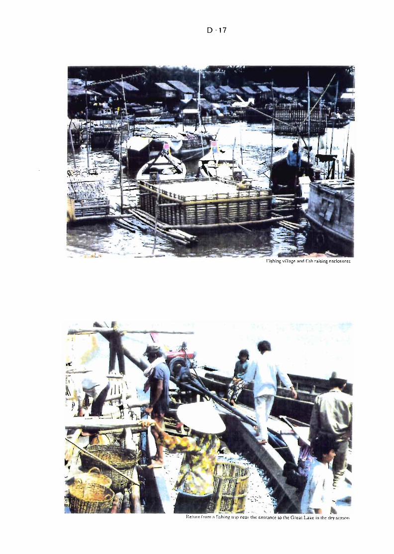
D ·17
Fi~hing village and fi~h raising enclosures
,Rel'"11 rrolll a rl"hlnr {/Ir> neor Iii" cnlranee 10 lhe Greai Lake in lhe dry s"asoo
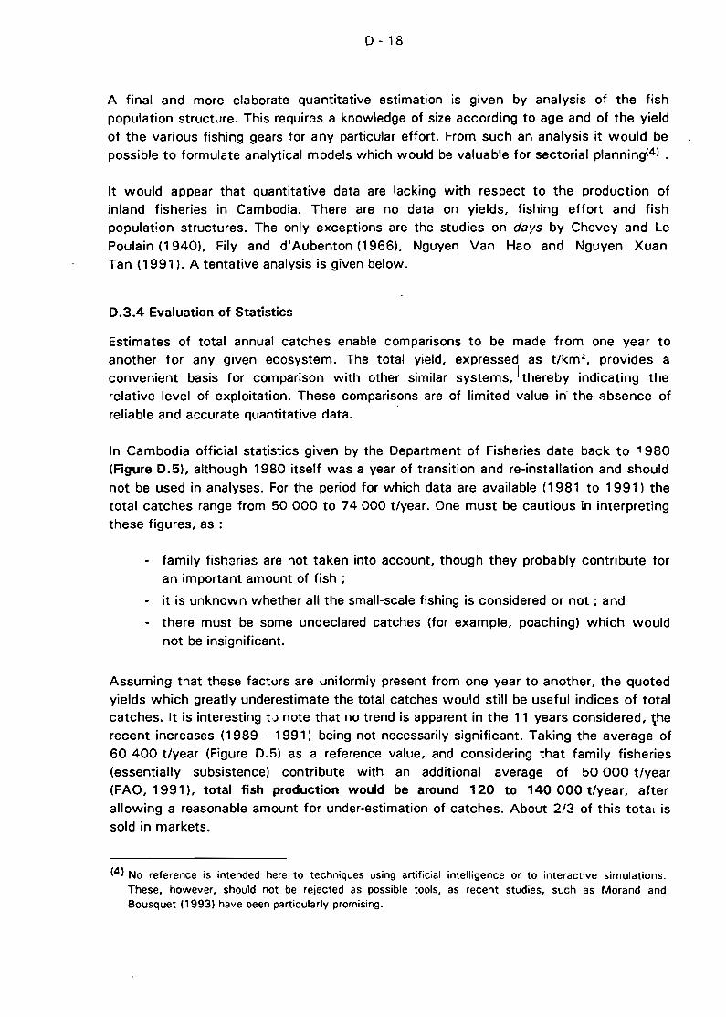
D - 18
A final and more elaborate quantitative estimation is given by analysis of the fishpopulation structure. This requircs a knowledge of size according to age and of the yield
of the various fishing gears for any particular effort. From such an analysis it would bepossible to formulate analytical models which would be valuable for sectorial planning(41 .
It would appear that quantitative data are lacking with respect to the production ofinland fisheries in Cambodia. There are no data on yields, fishing effort and fishpopulation structures. The only exceptions are the studies on days by Chevey and LePoulain (1940), Fily and d'Aubenton (1966), Nguyen Van Hao and Nguyen XuanTan (1991). A tentative analysis is given below.
0.3.4 Evaluation of Statistics
Estimates of total annual catches enable comparisons to be made from one year toanother for any given ecosystem. The total yield, expressed as t/km 2
, provides aconvenient basis for comparison with other similar systems, 1thereby indicating therelative level of exploitation. These comparisons are of Iimited value in the t:ibsence ofreliable and accurate quantitative data.
ln Cambodia official statistics given by the Department of Fisheries date back to , 980(Figure 0.5), although 1980 itself was a year of transition and re-installation and shouldnot be used in analyses. For the period for which data are available (1981 to 1991) thetotal catches range from 50 000 to 74000 t/year. One must be cautious in interpretingthese figures, as :
- family fishsrias are not taken into account, though they probably contribute foran important amount of fish ;
- it is unknown whether ail the small-scale fishing is considered or not ; and
- there must be some undeclared catches (for example, poaching) which would
not be insignificant.
Assuming that these factors are uniformiy present from one year to another, the quotedyields which greatly underestimate the total catches would still be usefui indices of totalcatches. It is interesting 0 note that no trend is apparent in the 11 years considered, \herecent increases (1989 - 1991) being not necessarily significant. Taking the average of60 400 t/year (Figure 0.5) as a reference value, and considering that family fisheries(essentially subsistence) contribute with an additional average of 50 000 t/year
(FAO, 1991), total fish production would be around 120 to 140000 t/year, after
allowing a reasonable amount for under-estimation of catches. About 2/3 of this total issold in markets.
(41 No reference is intended here to techniques using artificial intelligence or to interactive simulations.These. however. should not be rejected as possible tools, as recent studies, such as Morand andBousquet 119931 have been particularly promising.
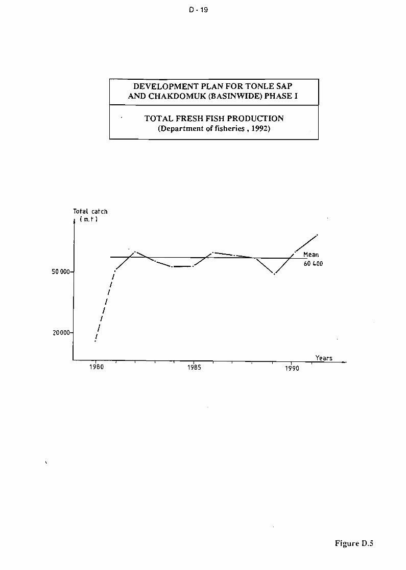
0-19
DEVELOPMENTPLANFORTONLESAPAND CHAKDOMUK (BASINWIDE) PHASE 1
TOTAL FRESH FISH PRODUCTION(Department of fisheries , 1992)
Total catch(m. t)
50000
20000
L........... /0---._/ '. 7"""""'-.--..
11
11
11
11
/'L' Mean
"""./ 60 400
Years1980 1985 1990
Figure 0.5
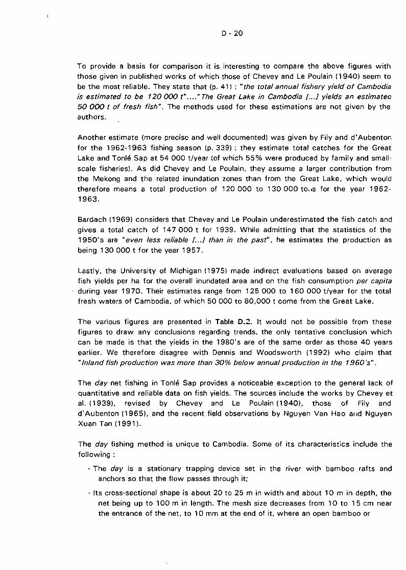
D - 20
To provide a basis for comparison it is interesting to compare the above figures with
those given in published works of which those of Chevey and Le Poulain (1940) seem tobe the most relia ble. They state that (p. 41) ; "the total annual fishery yield of Cambodiais estimated to be 120 000 t" .... " The Great Lake in Cambodia l... ] yields an estimateo
50 000 t of fresh fish". The methods used for these estimations are not given by theauthors.
Another estimate (more precise and weil documented) was givan by Fily and d'Aubenton
for the 1962-1963 fishing season (p. 339) : they estimate total catches for the Great
Lake and Tonlé Sap at 54000 t/year (of which 55% were produced by family and small
scale fisheries). As did Chevey and Le Poulain, they assume a larger contribution fromthe Mekong and the related inundation zones than from the Great Lake, which would
therefore means a total production of 120 000 to 130 000 tOdS for the year 19621963.
Bardach (1969) considers that Chevey and Le Poulain underestimated the fish catch and
gives a total catch of 147 000 t for 1939. While admitting that the statistics of the1950's are "even less reliable l...] than in the past", he estimates the production as
being 130000 t for the year 1957.
Lastly, the University of Michigan (1975) made indirect evaluations based on averagefish yields per ha for the overall inundated area and on the fish consumption per capitaduring year 1970. Their estimates range from 125 000 to 160 000 t/year for the totalfresh waters of Cambodia, of which 50000 to 80,000 t come from the Great Lake.
The various figures are presented in Table 0.2. It would not be possible from these
figures to draw any conclusions regarding trends, the only tentative conclusion whichcan be made is that the yields in the 1980's are of the same order as those 40 years
earlier. We therefore disagree with Dennis and Woodsworth (1992) who c1aim that"Inland fish production was more than 30% below annual production in the 1960's".
The day net fishing in Tonlé Sap provides a noticeable exception to the general lack of
quantitative and reliable data on fish yields. The sources include the works by Chevey etal. (1939), revised by Chevey and Le Poulain (1940), those of Fily and
d'Aubenton (1965), and the recent field observations by Nguyen Van Hao alld NguyenXuan Tan (1991).
The day fishing method is unique to Cambodia. Sorne of its characteristics include thefollowing ;
- The day is a stationary trapping device set in the river witl"l bamboo rafts andanchors 50 that the flow passes through it;
- Its cross-sectional shape is about 20 to 25 m in width and about 10 m in depth, the
net being up to 100 m in length. The mesh size decreases from 10 to 15 cm nearthe entrance of the net, to 10 mm at the end of it, where an open bamboo or
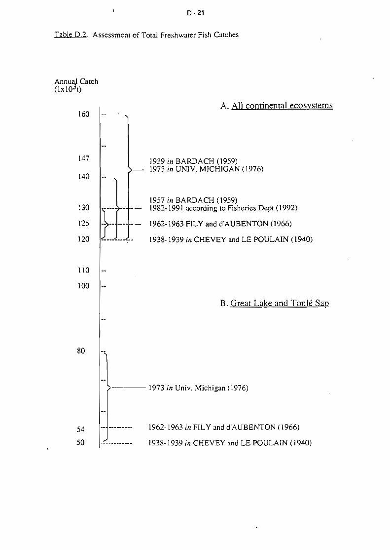
0·21
Table 0.2. Assessment of Total Freshwater Fish Catches
Annu~ Catch(1x 10 t)
A. AIl continenral ecosvstems160
147
140
~30
125
120
110
100
80
1939 in BARDACH (1959)1973 in UNIV. MICHIGAN (1976)
1957 in BARDACH (1959)1982-1991 according to Fisheries Dept (1992)
1962-1963 FILY and d'A UBENTON (1966)
1938-1939 in CHEVEY and LE POULAIN (1940)
B. Great Lake and Tonlé Sap
54
50
--1973 in Univ. Michigan (1976)
1962-1963 in FILY and d'AUBENTON (1966)
1938-1939 in CHEVEY and LE POULAIN ( 1940)

TABLE D.3; Yields of DAY in TONLE SAP averaged over four fis~ing seasons.
(according to NGUYEN XUAN TAN and NGUYEN VAN HAO, 1991)
The sites 1 to 22 are shown on Figure D.6.
[Site 2 3 4 5 6 7 8 9 10 11/12 13 14 15 17 18 19 22 m Total Catch/yi
1983-84 157 257 205 210 233 63 79 81 59 105 59 68 214 38 60 88 304 59 117 10090 0
NN
1985-86 250 345 352 344 390 122 157 157 116 206 110 133 420 74 118 176 600 114 209 18026
1986-87 71 101 99 98 109 62 78 79 56 104 55 68 213 38 59 83 299 57 86 7413
1987·88 187 240 270 261 296 98 124 127 86 171 90 110 350 63 96 128 488 94 164 14 142
INb. DAY 4 4 4 4 6 7 7 8 5 7 7 5 7 3 5 86
IAv.Yield/DAY 166 236 232 228 257 86 110 III 79 147 78 95 299 53 83 118 423 81131-__1_2_4_1_91
ITotal AV.Yield 665 943 927 912 1544 602 769 890 396 1027 544 473 299 53 583 118 1269 404
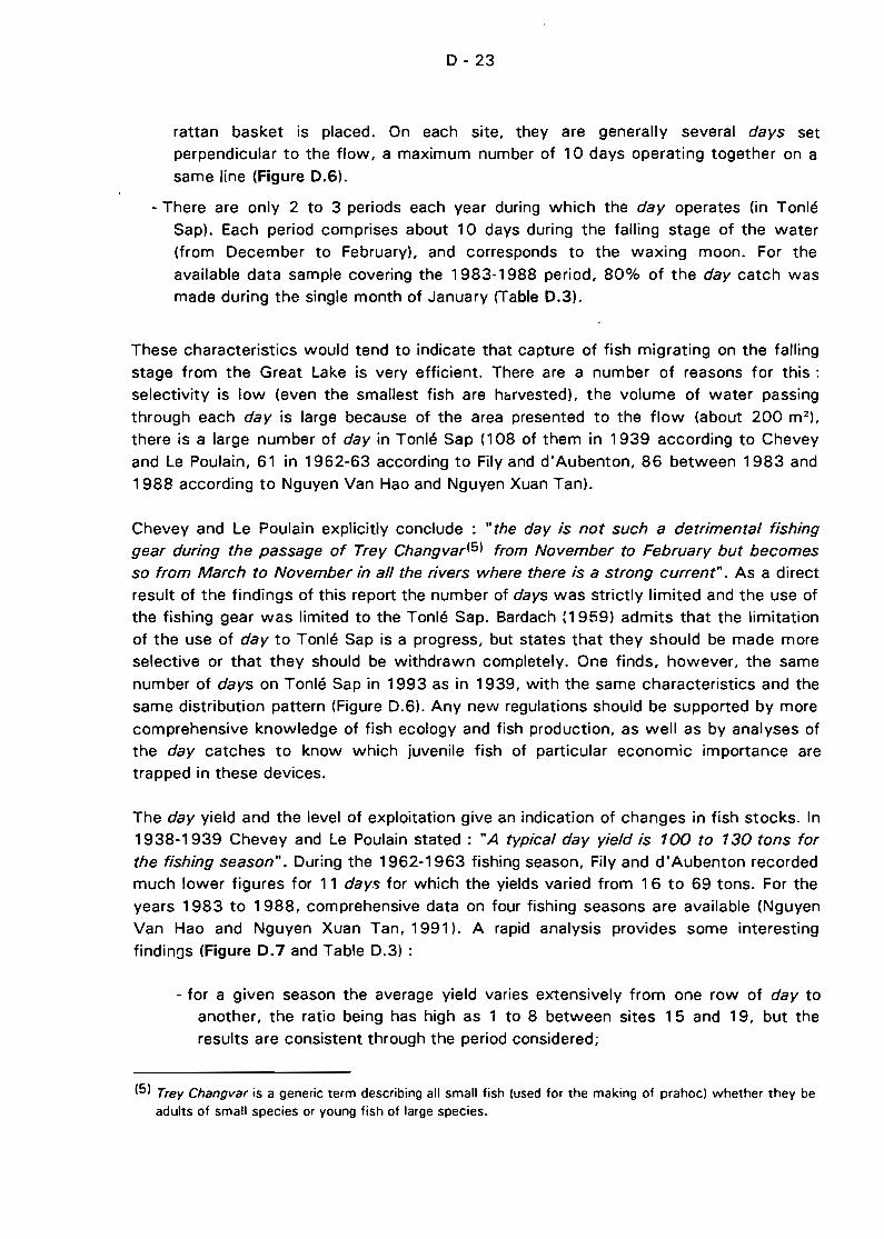
D - 23
rattan basket is placed. On each site, they are generally several days setperpendicular to the flow, a maximum number of 10 days operating together on asame line (Figure 0.6),
- There are only 2 to 3 periods each year during which the day operates (in TonléSap). Each period comprises about 10 days during the falling stage of the water(from December to February). and corresponds to the waxing moon. For theavailable data sample covering the 1983-1988 period, 80% of the day catch wasmade during the single month of January (Table 0.3),
These characteristics would tend to indicate that capture of fish migrating on the fallingstage from the Great Lake is very efficient. There are a number of reasons for this :selectivity is low (even the smallest fish are harvested). the volume of water passingthrough each day is large because of the area presented to the flow (about 200 m 2 ).
there is a large number of day in Tonlé Sap (108 of them in 1939 according to Cheveyand Le Poulain, 61 in 1962-63 according to Fily and d'Aubenton, 86 between 1983 and1988 according to Nguyen Van Hao and Nguyen Xuan Tan).
Chevey and Le Poulain explicitly conclude : "the day is not such a detrimental fishinggear during the passage of Trey Changvar(5) from November ta February but becomes
sa from March ta November in ail the rivers where there is a strong current". As a directresult of the findings of this report the number of days was strictly limited and the use ofthe fishing gear was Iimited to the Tonlé Sap. Bardach {1959l admits that the limitationof the use of day to Tonlé Sap is a progress, but states that they should be made moreselective or that they should be withdrawn completely. One finds, however, the samenumber of days on Tonlé Sap in 1993 as in 1939, with the same characteristics and thesame distribution pattern (Figure 0.6), Any new regulations should be supported by morecomprehensive knowledge of fish ecology and fish production, as weil as by analyses ofthe day catches to know which juvenile fish of particular economic importance aretrapped in these devices.
The day yield and the level of exploitation give an indication of changes in fish stocks. In1938-1939 Chevey and Le Poulain stated : "A typical day yield is 100 ta 130 tons for
the fishing season". During the 1962-1963 fishing season, Fily and d'Aubenton recordedmuch lower figures for 11 days for which the yields varied from 16 to 69 tons. For theyears 1983 to 1988, comprehensive data on four fishing seasons are available (NguyenVan Hao and Nguyen Xuan Tan, 1991). A rapid analysis provides sorne interestingfindinos (Figure 0.7 and Table D.3) :
- for a given season the average yield varies extensively from one row of day toanother, the ratio being has high as 1 to 8 between sites 15 and 19. but theresults are consistent through the period considered;
(5) Trey Changvar is a generic term describing ail small fish (used for the making of prahoc) whether they beadults of small species or young fish of large species.
D - 24
- interannual variability for a given site is very high : 100 tons for sites 2 to 5 for
1986-87 and more than 350 tons in 1985-86;
- total annual catches are high : from 7 400 t in 1986-87 to 18 000 t in 1985-86,with an average of 12 419 t harvested in a very short time;
- average d::lY yield also reflects interannual variability : a maximum of 209 t in
1985-86, a minimum of 86 t in 1986-87, the average being 144 t.
This average of 144 t is of the same order of magnitude as the yield given, by Chevey
and Le Poulain 40 to 50 years ago. Comparisons of this nature, however, should bemade with caution because of the many unknowns regarding the conditions of collectionof figures, the interannual variability of the small opportunist fish (see above) and so on.
ln any case there is no evidence of any diminution of stocks, even though the figures donot distinguish between different forms of exploitation of fresh water fish, nor between
adults of small species and juveniles of others. Neverthele:'5 the broad findings of thisstudy do not substantlate any biological over-exploitation.
0.3.5 Socio-Economic Aspects
a) Methodology of Fishery Management
The content of any fish management system depends on its objectives. These could be,for instance, highest profitability for ail fish production units or for only a féw of them,highest employment rate in the sector, exclusion of certain classes of fishermen, highest
taxation returns to the government, etc. No matter which objectives are set, aknowledge of the existing socio-economic context is a prereqL.isite.
To assess the socio-economic context, a suitable analytical frame is the chain ofproduction and marketinr followed by bio-economic modelling as the appropriatedecision-making too!. Study of the chain of production and marketing provides
knowledge of tha fishery activities, and particularly of modifications of the interrelationsbetween the various segments of the chain of production and marketing (from the
fisherman to the consumer), or new relé'ltions of dependency.
Before any biological or socio-economic analysis may be performed, the compilation of
data must be carried out. Existing data are, however, relevant to particular segmentsonly, and no complete data set exists covering ail of the fishery production units as weilas processing and marketing units. Firstly there is a large gap between data collection atany point in time and the dynamic nature of fishery activities. There are also differencescaused by such external agents as formai or informai taxdtions by the public service,which inspire fishermen to declare much lower catches than they achieve.
D - 25
o -3km! ri
QUATRE-BRAS
~ '\~ MEKONG
Bassac
LOCATION OF DAY ALONG TONLE SAP(Chevey and Le Poulain)
DEVELOPMENT PLAN FOR TONLE SAPAND CHAKDOMUK (BASINWIDE) PHASE 1
PHNOM-PENH
Sites of the Il daystudied by Fily andd'Aubenton
Figure D.6
0·26
500
t.OO
200
100
Ton+
Mean (e)
Variability of day catch along Tonlé Sap
1986-87(0)
üEVELO?MENT PLAN fOR TüNLE SAPAND CHAKDOMUK (BASINWIDE) PHASE 1
:t-
--+--/1 1985-86(+) ~
1987 -88(0
-+' •ar"'"--.-_-"
1 2 3 4 5 6 7 8 9 10 11/12 13 14 15 17 18 19 22
~ 8........ •CI) Day Site Number~ 6 (see Figure D.6)~
0..
~4.,g
2j \ !......0
0Z
i .
...-- 1500co.u---
U.u<Il
U
o-l<Il.u 50o
E-<
/
Mean of 4 sets of observations
Figu:-e O.ï
27
\ \ \1 _ Il ,1
0-28
To analyse the modifications or the restructuring concerning the various production ormarketing systems, after identification of these systems, we have to compare theirproductivity and the share of each system in the value added creation. Then thedescription of the formai or informai relationships between the various operators mightallow commanding positions ail along the chain of production and marketing to beconfirmed.
ln particular, the recent transformation of these production systems is linked to the newconditions regarding a significant accumulation of capital which allow larger investmentsinvolving in sorne cases a technical change and dramatic changes in the labour relations:
it is the history of this capital accumulation which would allow the appraisal of thisprocess of accumulation.
It should be kept in mind that the fishery sector is characterized by specifie technologicalprocess regarding the catches as weil as the fish processing cr marketing. Depending onthese processes, the operators will choose, for instance, the labour organization~ andfinancing modalities to reduce the risk and the uncertail1ty linked to the characteristics ofthe aquatic living resources.
Bio-economic modelling is a tool for decision-ma king. These models l"'1ight to be
considered as a complement of biological models. Evolving such a model means, first ofail, describing the various types of fishery units, their production system and the leveland distribution of the catches; if they are working on several stocks, pluri-specificmodels have to be used. Secondly, costs and priee functions might be introduced afterthe appraisal of the interrelatio:1s between the fishery efforts, the state of the stocks andthe fish landings. Finally, an appraisal of the profitability of each type of fishery unit onthe catches and the stocks must be carried out.
ln the case of the Great Lake and Tonlé Sap fisherie~. such a model could be used fordirect control (fishing permits) or indirectly (investment policy) to manage productionfactors; or to control the production itself directly (individual quotas) or indirectly(market).
b) Vitality of the I~formal Financing System
Excluding a financing operation implemented by the State Bank of Cambodia between1980 and 1987 for a total amount of 200x1 QG Riel, the financing of fishery activities isdone following the traditional channels. This informai financing system is mainly done bymerchants. The merchants involve the fishermen in continuous indebtedness (thegovernmental financing operation during the 1980's was an attempt to liberate thefishermen from their creditorsl. This traditional system is distinguished by the toughnessof financing conditions: high interest rates, obligatory selling (fish) or buying (nets, foodetc.).
0-29
Nevertheless, this is this type of financing system which allows the preservation or thedevelopment of the fishery sector. In granting Joans at short notice, requiring fewwarranties, this system gives a high degree of flexibility in money use according to needsand seasonal variations. These traditional financing channels facilitated, for example,
technological innovations such as the introduction of monofilament nets.
On the other hand, this system allows the merchants downstream in the marketing chainto develop a commanding position, which exp!ains the high margins. For instance , in
March 1993 for the same species and size, the price of a fresh fish doubled between thefishermen's village and the urban market (Siem Reap) and doubled again between this
market and the nearest Thaï market.
c) Alternative Sources of Financing
There are insufficient data regarding commercial activities to enable the drawing of any
conclusion regarding the current marketing of fish from the Great Lake and Tonlé Sapriver. Nevertheless some factors point to the efficiency of commercialisation procedures
and to signs of new sources of financing.
The marketing of fish caught in the Great Lake and Tonlé Sap is an old practice, aswitnessed by studies from the beginning of the century (Petillot, 1911; Gruvel, 1925).Fresh fish as weil as processed fish have been commercialized from early times on local,inter-regional and international bases (Vietnam and Thailand mainlyl.
There have been no radical changes in the techniques of commercialisation; but becauseof the development of road networks and the increase in demand due to populationgrowth and the attraction of the Thai market, some modifications of the marketingconditions have occurred. In particular the increase in demand is presumed to have led to
increases in fishing effort and aquaculture. The share of commercialized processed fish
has fallen for the benefit of fresh fish and the share of eRch processing method has
changed.
According to Chevey and Le POulain (1940), fish commercializing methods werecompletely different depending on whether they came from the Great Lake or Tonlé Sap.
From the Great Lake dried fish predominated because of remoteness of urban marketsand the navigational barrier for boat s presented by the shallow pass of Snoc Trou during
the low water stage. Unmotorized junks were used to bring the dried fish to Phnom Penhbecause they were able to cross the pass (15 days only were necessary to cross the
Great Lake and to reach Phnom Penh). The jur.ks drew no more than 60 cm at full loadand were able to cross the pass even if it entailed dragging the boats through the mud.
Fish harvested in the Mekong and Tonlé Sap rÎ\.'ers were traded mainly as fresh fish inPhnom Penh and Vietnam. Chevey and Le Poulain wrote that "the provinces of KompongChhnang, Kompong Cham, Prey Veng, Takeo and Kandal export the major part of their
production of fresh fish to the huge markets of Saigon, Phnom Penh and Tanchau, and
D - 30
to the secondary markets located along the Bassac or Mekong rivers such as Chau-Docor Can Tho".
According to the people we interviewed in March 1993, most of the fish catches of theGreat Lake as weil as the fish harvested and traded upstream the Tonlé Sap river(Kompong Chhnang Province), is c1eared via Siem Reap or Battambang to be marketed in
Thailand. The Thai demand has thus modified the orientation of commercial flows andgiven impetus to the marketing of fresh fish. According to the Office of the Departmentof Fisheries in Siem Reap, the mean priee for first grade fish from the Lake is2 500 Riel/kg in the main Phnom Penh market compared with 5 000 Riel/kg in Chonburimarket (Thailandl. According to the same source, the quantity of fish marketed in SiemReap and traded in Phnom Penh is less than the quantity traded in Thailand, although it is
presently impossible to get precise figures for this trade.
The exports of Cambodian fish to ThaiJand have a long history (Petillot, 1911), but wereessentially concerned with processed fish, kh/an-trey (oi/) and prahoc (paste). In response
to the Sino-Thai investments in transport, there are changes in the traditionalcomposition and orientation of the flows : generally speaking, and with a view to the
difference of priees, traders are now able to obtain better priees for fish products. Thisnew orientation of flows is detrimental to traditional flows (which used to be destinedfor Indonesia, according to Chevey and Le Poulain, 1940) and to Hong Kong, Singaporeand Vietnam which receive smaller shares of the market.
d) Diversity of Fish Processing
During the last fifty years there have been significant changes in the processingmethods. In spite of internai diversity and adaptation to natural constraints (fishcharacteristics, use of heat source and of locally available materials), these processesremain characterized by a low efficiency and a misuse of raw material (Iosses fromprocessing), even though the development of cage aquaculture consumes sorne share ofthe processing wastes that were previously lost.
Department of Fisheries data on fish processing describe the main processing types,although the compilers of the data point out the inaccuracy of the statistics. Theprocesses include making of fish oil and fish sauce, drying and the making of fish pastewhich together use the largest quantities of fresh f;sh, and the smoking of fish which is
minor compared with the other processing techniques.
It is worth mentioning that the processing coefficient of fresh fish into oil is assumed tobe 0.15 (Marcelet, 1940), that the making of oil is predominantly located along thebanks of Tonlé Sap river (the most appropriate fish are the Cyprinidae harvested in day),and that the species providing the highest potential for the oil making areAmb/yrhynchichthys truncatus, A/bu/ichtys a/bu/oides, Cirrhinus ju/lieni, but thatPangasius spp. and Channa micrope/tes are also used. The process is distinguished bythe amount of unrecovered wastes and by a large loss of fats: up to half of the fats
0-31
contained in the raw material (Krempf, 1928). An improvement would be to process the
fish into paste and then into flour and oil.
The prahoc is a paste made from Pangasius spp., Channa stria ta, ,C/arias batrachus after
fermentation, salting and pounding (specially aimed at the Thai market). Ouring the
fermentation process a juice is obtained which is used as a sauce (tûk trey) which is
equivalent to the" Vietnamese nuoc mâm; this preparation may be obtained directly withno intermediate stage by fermentation of Cirrhinus micro/epis, etc. No particular localityis favoured for making prahoc and tûk trey. The processing coefficient from fresh fishinto prahoc is known to be 0.33 (Chevey and Le Poulain, 1940). As in the preparation of
fish oil, a large quantity of the residue is spoiled.
Orying of fish is extensive and requires large fish tray areas which are periodicallyinsufficient for the demand, bearing in mind the low efficiency of this drying technique.
The "white' fish (essentially Pangasius spp) and "black" fish (mainly Channa micrope/tes
and Channa stria ta) are mostly used. As the drying is a relatively swift technique (Iess
than two days after fermentation and saltingl. a transformation coefficient of 0.3 isassumed. Better use is made of the wastes in large fisheries than in smaller ones,
generally as feed for aquaculture or oil making (heads and viscus). As for otherprocessing methods sorne waste products could be used as fertilizer. Undercapacity of
drying areas could be overcome by the introduction of new drying techniques which aremore intensive and better adapted to local environmental and traditional socio-economic
conditions. This would relieve sorne of the pressure on forestry and vegetal products forthe building of fences or enclosures.
Smoking of fish represents about 1/3 of the dried fish, in equivalent fresh fish. Pangasius
spp, C/arias batrachus and Notopterus notopterus are mainly used. Smoking of fish isstill a small-scale, family activity. Because the head of the fish is not removed, the waste
is less important than for the making of prahoc and of dried fish. However, the very poorefficiency of the traditional ovens is responsible for a large loss of fuel, as for oil making.
Sorne technical improvements would have positive results with regard to reducingpressure on the use of forestry and vegetal products as fuel.
0.3.6 Exploitation and Overexploitation
Exploitation of a renewable resource enables a reasonable consumption of Iimited stockswithout detrimental effects to the renewal of species and to the harvesting of the naturalresource in coming years.
The process of production of a natural resource is intricate and diverse. Aquaticecosystems transform incidental solar energy through various trophic chair.s. Even
without any human intervention such complex systems have an intrinsic variability, more
or less linked to c1imatic variability. Hydrological changes from one year to another:
rainfall, flooding, inundation. In addition there is variability in the ecosystems associated
with changes in fish populations and in their capacity to adapt. This means that the
D·32
production of living resources is naturally variable. Experience shows that, beyond a
certain level of complexity of ecosystem and population level, there are compensatory
effects and that overall production is closely linked to changes in c1imate. In other words,
biological production of reproducing stocks may be characterized by a definable level in
any given environment.
The issue with "regards to the fish resources of the Great Lake lies therefore in theidentification of any human interventions which could have produced a degradation of
this complex environment.
Firstly it should be noted that any modification, whether qualitative or quantitative, of
the water supply of Mekong river via Tonlé Sap may have repercussions on the biological
production in the Great Lake. This would be the case, for example, if large hydroelectric
works were to modify the regime of the river. For the time being, it seems that the main
problem is deforestation of the upper Mekong river basin and the resultant increase insediment transport. Until a more detailed study is carried out the observations made
above in Section C indicate that this is not yet a serious problem.
The situation is quite different for the overall degradation of the environmental conditions
in the Gn="at Lake due to human interference. Two main types of alteration may be
identified : those which act directly on the physical environment and those which modify
the biological production.
The changes in the physical environment are essentially erosion and increased sediment
generation in the subcatchments of the lake as a result of deforestation. Increased
exploitation of forest products and clearing of land for agriculture are the maindetrimental activities. Another harmful activity is the mining in the region of Pamn, which
is the cause of large sediment deposition at the mouth of Stung Sangker. With reference
to the earlier discussions of sediment generation and transport in Section C, it wouldseem that sedimentation of the Great Lake has been low and stable for the past
30 years. It would therefore be unlikely that increased sedimentation could have altered
the productivity of the system.
It is more likely that any degradation in productivity is due to direct attacks on the
ecosystem. In this regard the inundated forest surrounding the Great Lake would appearto be the most vulnerable Iink in the production system. Clearing of the inundated forests
was mentioned as early as 1940 by Chevey and Le Poulain. This is a particularly urgent
issue and the recommendations made at that time to conserve the remaining forest are
equally pertinent now. It should be noted firstly that there is no link between acceleratedsedimentation (which in any case has not been demonstrated to be occurring) and
clearing of the inundated forest. These forests have been exploited by fishermen for agesto supply wood (which is still the case) and previously also to build samras (large brush
wood traps).
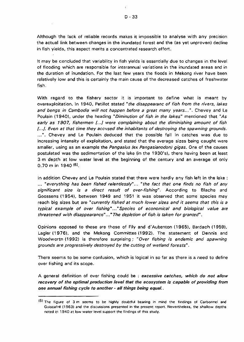
0-33
Although the lack of reliable records makes it impossible to analyse with any precIsion
the actual link between changes in the inundated forest and the (as yet unproven) decline
in fish yields, this aspect merits a concentrated research effort.
It may be concluded that variability in fish yields is essentially due to changes in the levelof flooding which are responsible for interannual variations in the inundated areas and inthe duration of inundation. For the last few years the floods in Mekong river have beenrelatively low and this is certainly the main cause of the decreased catches of freshwater
fish.
With regard to the fishery sector it is important to define what is meant byoverexploitation. In 1940, Petillot stated "the disappearanc of fish from the rivers, lakes
and bengs in Cambodia will not happen before a great many years... ". Chevey and LePoulain (1940), under the heading "Diminution of fish in the lakes" mentioned that "As
early as 1907, fishermen [ .. .] were complaining about the diminishing amount of fish[ .. .]. Even at that time they acc~/sed the inhabitants of destroying the spawning grounds.
... ". Chevey and Le Poulain deduced that the possible fall in catches was due to
increasing intensity of exploitation, and stated that the average sizes being caught were
smaller, using as an example the Pangasius (ex Pangasianodon) gigas. One of the causespostulated was the sedimel"'tation of the lake (in the 1930's), there having been at least
3 m depth at low water level at the beginning of the century and an average of only0.70 m in 1940 (61.
ln addition Chevey and Le Poulain stated that there were hardly any fish left in the lake :... "everything has been fished relentlessly..... "the fact that one finds no fish of anysignificant size is a direct result of over-fishing". According to Blache and
Goossens (1954), between 1949 and 1951 it was observed that some species mayreach big sizes but are "currently fished at much lower sizes and it seems that this is a
typical example of over fishing" .....Species of economical and biological value arethreatened with disappearance" ... " The depletion of fish is taken for granteeJ".
Opinions opposed to these are those of Fily and d'Aubenton (1965), Bardach (1959),
Lagier (1 976), and the Mekong Committee (1992). The statement of Dennis andWoodwortn (1992) is therefore surprising.: "Over fishing is endemic and spawninggrounds are progressively destroyed by the cutting of wetland forests" .
There seems to be some confusion, which is logical in so far as there is a need to defineover fishing and its scope.
A general definition of over fishing could be : excessive catches, which do not allow
recovery of the optimal production level that the ecosystem is capable of providing (romone annual fishing cycle to another - ail things being equal..
(61 The figure of 3 m seems to be highly doubtful bearing in mind the findings of Carbonnel andGuiscafré (19631 and the discussions presented in the present report. Nevertheless, the shallow depthsnoted i.fl 1940 at low water level support the findings of this study.
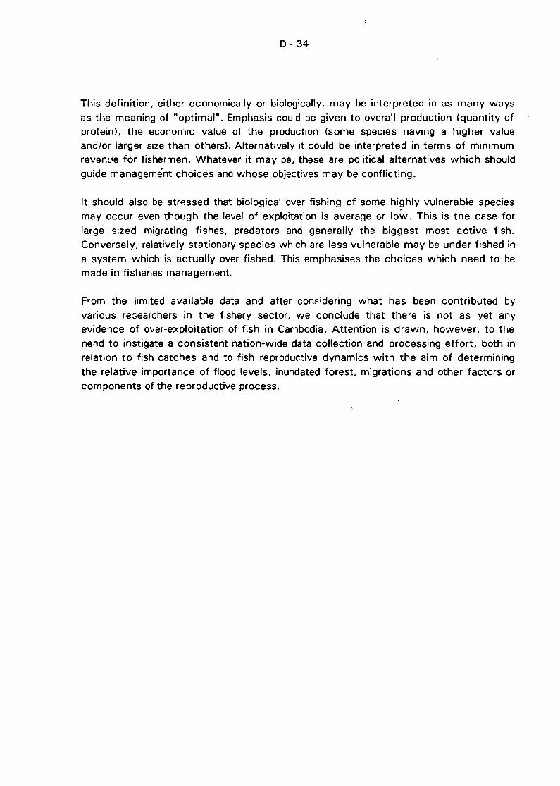
0-34
This definition, either economically or biologically, may be interpreted in as many ways
as the meaning of "optimal". Emphasis could be given to overall production (quantity ofprotein), the economic value of the production (some species having 'a higher valueand/or larger size than others). Alternatively it could be interpreted in terms of minimumreven:.'e for fishermen. Whatever it may be, these are political alternatives which should
guide managemént choices and whose objectives may be conflicting.
It should also be str~ssed that biological over fishing of some highly vulnerable speciesmay occur even though the level of exploitation is average cr low. This is the case for
large sized migrating fishes, predators and generally the biggest most active fish.Conversely, relatively stationary species which are less vulnerable may be under fished ina system which is actually over fished. This emphasises the choices which need to bemade in fisheries management.
From the limited available data and after com:idering what has been contributed by
various re::;earchers in the fishery sector, we conclude that there is not as yet anyevidence of over-exploitation of fish in Cambodia. Attention is drawn, however, to the
nend to instigate a consistent nation-wide data collection and processing effort, both inrelation to fish catches and to fish reprodur.~ive dynamics with the aim of determining
the relative importance of flood levels, inundated forest, migrations and other factors orcomponents of the reproductive process.
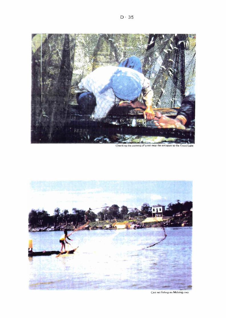
0- 35
Checking the con lents of a nel ncar the enlrance 10 the GrcalLake
Cast nel fishing on Mekong river
E - 1
E NAVIGATION, AGRICULTURE, IRRIGATION AND ENVIRONMENTAL ASPECTS
E.1 NAVIGATION
E.1 .1 Existing Situation !'If Navigation
a) General
Water transport plays an important role in domestic distribution of goods in Cambodia.
During most of the rainy season, when part of the territory is flooded, waterway:> are
almost the only means of communication. The Tonlé Sap river and Great Lake rank
among the most important waterways of Cambodia. Although the shallow pass of Snoc
Trou makes navigation unpracticable during the dry season, the sharC' of Tonlé Sap is
about 15 % of the total waterborne traffic of the country. The Tonlé Sap lake and river,
with its tributaries, provide natural transport routes from Phnom Penh to Battambang,Siem Reap, Kompong Thom, Pursat and Kompong Chhnang.
The project area encompasses various levels of navigation as follows :
(il International navigation from the South China Sea and Southern Vietnam, ending
up ~cross the Chakdomuk area at Phnom Penh port il"l the mouth of the Tonlé
Sap river.
(ii) Industrial riverborne transport on the Tonlé Sap river up to Kompong Chhnang.
(iii) Semi-industrial to craft-industrial navigation on the Great Lake and its tributaries.
b) Navigation Conditions
Sea-going vessels can steam ail the way from the South China sea in Vietnam along the
Mekong lIver and cali at Phnom Penh using the entrance channel of the Tonlé Sap river
located in the Chakdomuk area. Maintenance dredging is required and periodically
performed in this area to maintain the minimum water depth required for the passage of
sea-faring vessels.
ln the old days, the maximum available depth of water at Phnom Penh during the dryseason used to be 5.50 m. Ships with maximum draft of 5.10 m or about 3 000 DWT
could cali at Phnom Penh the year round. Towards thE' end of the low water period, the
maximum draft at Phnom Penh was reduced to about 4.60 m due to siltation in the
channel.
Nowadays, the water depth in the dry season is 4.90 m. Navigation is restricted to ships
of 2000 DWT of capacity or which draft does not exceed 4.50 m. The Cambodian
government has recently acquired new cutter suction dredgers of ample capacity to
reinstate the past situation.
E-2
During the high water stage (from May to November) ships of 4 000 DWT usually cali atPhnom Penh, entering the Tonlé Sap. Larger ships, up to 6 000 DWT can sail up to
Phnom Penh but have to moor at midstream buoys as the present structure of thewharves could not bear the impact cf this size of ships. The project of future port at
Chrui Changvar is desjgned for ships up to 5 000 DWT.
ln any case, international navigation in Phnom Penh is restricted by sand-bars building upat the entl ance of the Mekong river in Vietnam and by sharp bends reducing theallowable ship overall length on the Mekong in Cambodia downstream of Phnom Penh(see Figure E.1).
The maximum size of sea-faring vessels expected to ever cali at Phnom Penh is in the
range of 6000-7000 DWT depending on ship categories. However, the water depth of5.50 m in the channel of the Tonlé Sap is deemed sufficient in any case to meetinternational navigation requirements.
Upstream of Phnom Pe,h, the Tonlé Sap rive," is navigable the year round to KompongChhnang. Channel width is not less than 150 m and minimum depth is 2.80 m. Thedistance is 102 km. Barges of up to 1GO DWT can operate the year round.
Navigation upstream of Kompong Chhnang to the Great Lake is hampered by the shallowpass of Snoc Trou near the inlet of the river into the lake. The available depth at SnocTrou is limited to 0.80 m during low water stage thereby hampering navigation to theGreat Lake. Channel is 100 m wide and depth at high water stage is not less than2.00 m. Distance from Kompong Chhnang to the Great Lake mouth iS 53 km.
Navigation across and around the Great Lake is practicable. During the low water period,when the water depth is reduced to some 0.80 m, natural peripheral channels are knownby old pilots with sufficient water to be used by wooden launches the year round.Distance from the mouth of the Tonlé Sap river to the northern tip of the lake is 130 km.From the I<:ke, navigation can be extended up along lake's tributaries, in particular up theStung Sen connecting with the Tonlé Sap right in the Snoc Trou pass, up to KompongThom where channel is 85 m wide and depth is more than 2.0 m at high water stage.Distance to Kompong Thom is 47 km.
The depth in the Bassac river downstream of Chakdomuk is too shallow for any vesselsapart from small wooden boats catering to local traffic. No development is envisaged onthis arm as the Mekong mainstream provides a better alternative route to Vietnam andthe sea. There is no need to imorove the channel of the Bassac river at this point.
c) Types of Rivercraft
Very Iittle information on the composition of the Inland waterways fleet operating on the
Tonlé Sap could be obtained. From observations made during the field trips, most of the
rivercraft are small mixed cargo-passenger wooden launches hardly exceeding 20 T incapacity.
m
Ho Chi Minh City•
INTERNATIONAL NAVIGATION ROUTESTO CAMfiODIA
DEVELOPMENT PLAN FOR TONLE SAPAND CHAKDOMUI{ (fiA~INWIDE) PHASE 1
.N
E-4
Larger wooden junks of 100 to 200 T would operate during high water stage and on the
lower Tonlé Sap section, i.e. downstream of Kompong Chhnang. Modernization of the
fleet operating on inland waterways seems to be another preliminary requirement to
sound development of waterborne transport in the area. Construction and operating
costs of wooden boats are relatively high. Their efficiency needs improvement.
d) Aids to Navigation
Day and night navigation safety used to be ensured by a system of aids to navigation on
the main channel of the Mekong river and in the entrance channel of the Tonlé Sap.
Pilotage is compulsory for ail sea-faring vessels. In 1965, lighted beacons, leading lights,
steel lighted buoys and steel dumb buoys were installed by the local hydrographie
department with the help of the Mekong Committee and donor countries. Most of these
aids to navigation have now disappeared. The Mekong Committee has already specified
the navigation aids needs in the area of Chakdomuk, which can be found in ..Aids to
Navigation study" conducted in 1976. This study would probably need some up-dating
to take into account the morphological change of the area and the perspectives of
development of the port of Phnom Penh and Chrui Changvar.
As regards the Tonlé Sap lake and river upstream of Phnom Penh, very little information
is readily available on the status of existing aids to navigation. There are likely none on
this large natural reservoir which in high water stage expands to double its normal area
with depths of about 10 m, whereas its average depth in dry season is only 1 m.
ln normal time day and night navigation take place on the Great Lake and the Tonlé Sap
river. A hydrographie survey will be needed to detect the deepest channels which could
be beaconed. Navigation in the low water stage could be greatly improved by lighted
shore marks and lighted buoys meant to guide navigators across [."d around the waters
of the Great Lake. Depending on conclusions of detailed navigation study, channel
marking could be required to ensure good navigation condition and consequently lower
transport costs.
e) Navigation Charts
Basic hydr0graphic surveys of the Mekong river and tributaries have been achieved in theearly 1960's providing maps at a scale of 1/20 000. This was part of the action
programme under the Colombo Plan. Although a reliable survey carried out in 1969 onthe Tonlé Sap river WêlS made available to the Consultants during the field trip, up-dating
surveys have seldom been undertaken on the Tonlé Sap.
The Mekong Secretariat is now undergoing a programme called "Up-dating of the
Mekong Hydrographie Atlas" funded by the Government of Finland. To date, Cambodia
has not been covered under this programme. Moreover, the programme covers the
Mekong mainstream channel. It is not c1ear whether additional surveys could be included
in this programme to cover the Tonlé Sap waters. Furthermore, aerial photographiesurvey of the country has been completed recently with the assistance of Finland.
E - 5
A complete bathymetric survey of the Great Lake and Tonlé Sap river will be needed
under Phase Il of the Development Plan for Tonlé Sap and Chakdomuk as dealt with inconnection with Hydrological matters herein. This bathymetric survey will serve as a
basis for a navigation study and aids to the navigation study to be carried out during
Phase Il of the project.
f) Ports and Landing Facilities
The port of Phnom Penh, the Tonlé Sap river, lake and tributaries are lack port facilities.
The major port in terms of traffic is Kompong Chhnang which has no facilities. Cargo has
to be handled by ship's gear or gang-and-plank methods. Prek Kdam is to be mentioned
as the Tonlé Sap ferry crossing point.
Phnom Penh is located on the right bank of the Tonlé Sap river at short distance from its
mouth in the Chakdomuk area. Designed for ships of 4 000 DWT and 5 m draft, the port
has a present capacity of 450 000 T per year. Ships calling at Phnom Penh port have to
steam upstream the Mekong river for 332 km from its mouth of Cua Tieu into the South
China Sea in Vietnam. Wharves and berthing facilities are laid along the bank of the
Tonlé Sap river. The niain facilities are the following :
- Berths No 1 and No 2 : Two floating pontoons for ships of 2 000 DWT at high
water stage.
- Berth No 4 : One concrete wharf 83 m x 12 m for ships of 2 000 DWT,
- Berth No 5 : One concrete wharf 100 m x 12 m for ships up to 4 000 DWT
Due to the present state of disrepair of the wharves, the port of Phnom Penh cannot
operate at its nominal capacity. The Government of Japan r~s provided a grant for a
project of rehabilitation and extension of the port, expected to be completed by the end
of 1995. The port of Phnom Penh will then provide ample facilities to accommodate
ships up to 4000 DWT.
At a short distance downstream of the floating port can be found some passenger
terminais for river launch services and public port for domestic traffic by mixed cargo
passenger wooden boats. Proceeding further upstream along the Tonlé Sap, landing
places can be found for log barges waiting to be loaded on sea-faring vessels for export.
oil terminais where tankers up to 2 300 DWT can be accommodated and other facilities
associated with industries situated along the river, notably rice mills.
At Km 6 along the Tonlé Sap, upstre:::rl1 of Phnom Penh, some port facilities belonging to
the Ministry of Commerce include 200 m pier which used to bear railway extension for
direct transhipment from barge to rail. The port designed for river barges and small shipsless than 500 DWT is dedicated to rice and cereals. The port is provided with 21 sheds
of total capacity 50 000 T. Cereals from up-country are barged down to Km 6 port
E - 6
facilities where they are sorted and conditioned for export. In the old days ships over1 000 DWT could berth also at Km 6, for the handling of heavy loads.
g) Traffic and Commodities
Due to long periods of serious political disturbances and war, no reliable sources oftraffic data cano be found. No figures of traffic volume on the Tonlé Sap could be
obtained. From information gathered during fjeld trip, large quantities of dried fish arecarried on smail boats from villages of the lake area to Kompong Chhnang where they
are transferred to larger wooden junks and carried to Phnom Penh or to Vietnam.
The main commodities transported by waterways in the Tonlé Sap area are southbound :dried or salted fish, maize, rice/paddy, timber and firewood/charcoal, rottan, beans, fruitsand vegetables and, northbound : consumer goods, construction materials and petroleum
products.
Phnom Penh is the major centre of the country's economic activities. Most domestic
freight transits through Phnom Penh. As a result, Phnom Penh is the breakpoint for mostof import and export commodities.
Cargo traffic through Phnom Penh port reached its maximum in 1963, with 963 000 T.Subsequently, its traffic decreased gradually in favour of the new port of Sihanoukvilleopened in 1968. In recent years, traffic through the port of Phnom Penh recoveredpositive growth rates from 260 000 T in 1988 to around 400 000 T in 1991. In terms
of ship traffic there are currently about 300 calls of sea-faring vessels of not more than
2 000 DWT of capacity per year in Phnom Penh. Ail vessels use the channel acrossChakdomuk area. Forecast traffic is dealt with hereafter.
E.1.2 Perspectives of Navigation Development
Navigation conditions in the channels of Tonlé Sap and Chakdomuk are deemedfavourable. However navigation development will depend on magnitude of waterbornetransport demand. Sound assessment of transport demand and modal split in the projectarea is essential. During Phase 1 of this study only limited information on prospective
development of fisheries, forestry and agriculture in the project area could be found.
Forecasts of production, consumption and export would have to be worked out as partof Phase Il. As regards Chakdomuk, the navigation channel will have to meetcharacteristics reQuired by navigation of sea-faring vessels calling at Phnom Penh Port.
a) Hinterland of the Great Lake and Tonlé Sap River
The Tonlé Sap waterways system provides ideal communication routes between PhnomPenh and each of the six following provinces: Battambang, Siem Reap, Kompong Thom,Ddong Meanchey, Kompong Chhnang and Pouthisat.
E - 7
However, the road belt outlining the perimeter of the wet area of the lake competes with
the waterways system. Made of Road No 5 to the western part of the basin and Road
No 6 to the eastern part, the road belt links up with Phnom Penh. The railway line from.Battambang to Phnom Penh provides an additional competitive route.
Therefore, the hinterland of the Tonlé Sap system is outlined by the road/rail network
surrounding the area and c1early does not extend beyond this belt. Modal competition
within this perÎmeter further reduces demé'lnd for water-borne transport to a short range
from the lake's shore and its tributaries (see Figure E.2l.
Detailed modal split should be carefully studied for each main commodity, as weil as itsseasonal variations as part of the second phase of the project in order to assess with
sufficient accuracy the share of cargoes and passengers which WOLJid be conveyed by
boat against those to be conveyed by road and railways.
b) Tonlé Sap: Commodities, Passengers, Tourism
The major commodities and categories of traffic expected to develop in the future along
the waterways system of the Tonlé Sap are the following :
Timber : Forestry resources is one of the most important natural resources of
Cambodia. Large quantities of timber are extracted from the Tonlé Saparea, part of it being transported along the tributaries of the Great Lake and
further down the Tonlé Sap river to Phnom Penh.
Fish : The Tonlé Sap is weil known for being one of the richest fishing grounds in
the world. For many years, the annual catch from the Tonlé Sap has been
in the range of 50-60 000 tons of fish. Large quantities of dried fish are
transported to Phnom Penh by boat. Thailand and Vietnam count amo'1g
final destÎnation of fish export.
Rice : Battambang and Siem Reap are two top rice-producing provinces, sharingrespectively 13.9 % and 7.1 % (as of 1986) of the total domestic
production of the country. Cambodia used to be net exporter of rice in the
old days until the late 1960's. Added to the consumption of Phnom Penh,
large quantities of paddy and rice are tradition311y to be carried from the
north to Phnom Penh, but rail and road are usually favoured over
waterways for transportation of these commodities.
Tourism: Tourism is one of the government's aims În developing navigation on the
Tonlé Sap. The Tonlé Sap river and Great Lake will eventually provideattractive cruises to Siem Reap and the ruins of the famous Angkor Wat
complex. In this regard, future development of the port of Phnom Kromlocated at the mouth of the Siem Reap river and dredging of the river
mouth are to be considered.
1---~---------ï7'" ------~----- ..-~--.~~-.-
DEVELOPMENT PLAN FOR TONLE SAPAND CHAKDOMUK (BASINWIDE) PHASE 1
NAV'GATION: MAP OF TONLE SAP BASIN
m
E-9
Passengers : Transport of passengers on the Great Lake and tributaries caters
mostly to local inter-village traffic by small wooden launches. This traffic is
combined with individual cargoes. Demand for line passenger
transportation requires specific enquiries.
A balance in th~ distribution of transportation in this area, which is particularly rich in
export produets, is still diffieult to establish. A detailed eeonomic survey could determine
the nature, origin and destination of merehandise, as weil as the most promising routes
and means of transport within the Tonlp. Sap basin.
c) Phnom Penh Port: Chakdomuk
Traffic through the port of Phnom Penh will govern the traffic of sea-faring vessels in the
navigation channel of the zone of Chakdomuk. In this respect, the traffic growth will
heavily depend on future development options for the ports of Cambodia as follows :
(i) Respective roles of the ports of Phnom Penh and Sihanoukville in the handling of
import/export of Cambodia. The reeent economic appraisal carried out by the
Mekong Committee on the rehabilitation and extension of the port of Phnom
Penh give-:. foreeast share of traffie between the two ports. This study led to the
conclusion that each port would share a steady 50% of the traffie in the future.
According to the same study, the traffie through the port of Phnom Penh would
reach some 600 000 T in the 'year 2000 and remain almost steady beyond that.
Owing to the expected improvement of the port of Phnom Penh and its aceess
channel, the ships calling at Phnom Penh will become larger, up to 4000 DWT.
As a result, thp total number of ship calls is expected to remain in the range cf
300 to 400 calls per year.
(iil Project of reloeation of the port of Phnom Penh on the Chrui Changvar Peninsula
along the Mekong mainstream. Another projeet of port extension is envisaged on
the Mekong river in Chrui Changvar to replace the existing port facilities
squeez3d between the Tonlé Sap river and the urban area of Phnom Penh (see
Figure E.3l. The projeet port has 675 m of waterfront and six wharves. !t can
accommodate ships up to 5 000 DWT. Its capaeity will exeeed 1 million tons
per year. It is at short distance from Phnom Penh across the Chrui Changvar
bridge which first has to be re-construeted.
If built, the port of Chrui Changvar will ultimately replace the port of Phnom Penh,
diverting the traffie of sea-faring vessels from the Tonlé Sap to the Mekong mainstream.
There would possibly be no more requirements in terms of navigation in the Tonlé Sap
entrance, but for rivereraft with limited draft.
DEVELOPMENT PLAN fOR TONLE SAPAND CHAKDOMUK (IlASINWIDE) PHASE 1
THE ZONE Of CONfLUENCE Of CIIAKDOMUK(QUATRE BRAS)
Future Port of NCHRUICHANGVAR
~mAoZCD
CHAKDOMUK
~/~~~
m....o
E - 11
E.2 AGRICULTURE AND IRRIGATION
E.2.1 General
Agriculture is the dominant sector in the Cambodian economy; it accounts for nearly45% of the Gross Domestic Product and employs 85% of the labour force. Production
generally meets only subsistence requirements and the cultivated land areas, as weil asoverall crop production, are still weil below the levels of the 1960·s.
Rice accounts for more than 80% of the overall agricultural tonnage production, is the
main employer of people in Cambodia and it occupies most of the land area. However,the yield is very low by international standards. The total rice production is insufficient
for consumption requirement. Estimated deficit in 1992 is about 150 000 tons.
The control and use of water to irrigate rice and field crops has traditionally played animportan't role in cultivation. Water control and usao'3 for agriculture in Cambodia
includes:
- the simple movement of water from one paddy field to another,
the retaining of receding flood waters in the lowlands (wetlands) for dry seasonirrigation, and
- the construction of dikes, reservoirs, diversion weirs and canal systems for the
distribution of stored or diverted irrigation waters.
Due to the complex ways in which water is utilized and the various developments ofirrigation systems, many of which do not function effectively, the current status ofirrigation is not known.
Major studies and proj3cts are currently being implemented in Cambodia, dealing withirrigation and agricultural development which, in fact, overlap the Tonlé Sap Area.
The specifics of the study area, composed of the Tonlé Sap, the Great Lake and itssurrounding swamp forest and agric'Jltural fields are described hereafter.
E.2.2 Land Classification
From the field observation, the agricultural lands, excluding the inundated forest, may bec1assified as followed :
1) Island area : this area is a high land in the lake which may be cultivated duringDecember to June, from July to November the area is flooded.
2) Seasonal flood area : the area is situate'1 near and surrounding the lake. Deepwater (floating) rice is grown in this area.

E - 12
3) Rainfed lowland area : the area is located next to the seasonal flood area and
wet season rice is planted.
E.2.3 Present Agricultural Practice
From the observation, interviews and related reports, and based on the earlier c1assifiedareas, the present agricultural practice may be concluded as followed :
1) Some island areas are cultivated by dry ~eason crops, i.e. rice, corn, mung beanand vegetables. The cultivation period is between December and June.
2) Seasonal flood areas around the Great Lake are the major floating rice areas ofCambodia. Most deepwater rice crops are dry seeded in April-Way with seeds
germinating with the onset of the opening rains. The depth and duration offlooding depends on local rainfall as weil as the height of the Mekong Riverresulting from rainfall upstream. The areas remain flooded for between 3 and6 months up to October when the river height begins to recedt:;: It is also
reporteJ that dry season rice is planted in some areas with supplementaryirrigation.
3) For the rainfed lowland area, wet season rice is a major crop planted in the area.
The water regimes in which the rice grows is variable. Rice varieties are
matched to the expected maximum water depth. In shallow rainfed lowlandenvironments, early varieties are grown; in middle rainfed, medium duration
varieties; and lower rainfed, later maturing rices are planted. Other crops(vegetables, jutes and fruits) are also grown on some limited areas.
E.2.4 Government :-olicy and Preliminary Findings
According to relevant literature some existil1g irrigation systems/structures can be foundin the study area. The locations and functions of these systems/structures are not
suf~;ciently known. The requirec inventory, surveys and diagnosis p.xceed by far thepreliminary study of this Phase 1 of the Development Plan for Tonlé Sap and Chakdomuk.
The present land policy, released by the government in 1989, intends dividinge ailagricultural and residential land holdings among private indlviduals and providingepermanent titles. It is intended to provide farmers with land tenure for parcels of land
which were, in the past administered and aHocated through the farmers' organizationgroups termed Kram Samaki. According to the policy, each farmer will be allowed tohave, on a permanent bé:sis, a maximum of 5 hectares of agricultural land.
These changes to land ownership and owner management of that land have majorimplications on the direction of research in Cambodia. Farmers tend to take a pride in
their own land and are more Iikely to accept long-term programs for crop productionimprovement.
E - 13
For rural development purposes, small scale irrigation projects may provide immediate
agricultural improvement. It is suggested that an appropriate model for viable and
sustainabJe small scale irrigation development be formulated through pilot studies. Theconcept of the model is mainly aimed àt participatory planning and management as weil
as capability strengthening of local staff and farmers.
E.3 ENVIRONMENTAl ASPECTS
E.3.1 General
The Great Lake together with the Tonlé Sap River functions as an important water
reservoir and buffer to the Mekong and Bassac Rivers. It therefore plays a role in
diminishing the effects of flooding and salt water infiltration in the Mekong Delta.
As shown in Figure E.4 the flood plain of the Great Lake consists mainly of secondary
forest dominated by thickets (the so calied inundated forestl and grassland brushwood.
Paddy fields. where receding rice culture is practiced. are located at the fringes of the
flood plain.
The Great' Lake area is probably a spawning and nursery ground for migrating fish
species. which may be of importance to Mekong basinwide fish production.
Fisheries yields and aquaculture production at the Great Lake and the Tonlé Sap River
contribute to the Cambodian economy as hard currency earners and form an important
animal protein source to the Cambodian population.
The Great Lake and its surroundin~.:i are considered to be of global importance for
designation as a orotected natural area and is one of the sites of highest priority for
conservation in the Indo-Malayan Realm (McKinnon and McKir.non, 19861.
15% of the total Cambodian wet season rice is estimated to be produced within th~
project area. including the surroundings of the Tonlé Sap River.
The secondary forest (dominated by thicketsl. which is annually flooded. probably plays
a significant role in the Great Lake's function as a nursery for fish.
al land Use
Land Use around the Great Lake and part of the Tonlé Sap river is shown on the map
overleaf ,Figure E.41 and detailed in the following table in hectares.
LF 2end'-'
. ,L 1 PADD'i FIEL D~
748.S2! ha
Ul'lAND C:1l0P~,
'; ~ 1~ ha
1_1 SECONuARY FOR ES1
858 ha
r:J UNAFFECTED AREAS
46,298 ha
o SECOt-lDAR't' FOREST DOMINA rED B"t rHICKETS ANt-IUALL y FLOODED
549,9'22 h.
TonIe Sap Landuse
(HWL = 10 m)
B.a.sed on the interp-etation of uod.sal -1' M images taken in 1989
Source. Mekoog s.~retarial. Remole Sell,Sing and Mapping Unit
• BAMBOO rHICKET SII~I~EPTIBLEFLOOD/Nt;
2,679 ha
r-: SWAMPY VEGETAT/fJ/,
24,44' ha
~ G RASSLAND BR USH ~I(l.)[l SLJSCEPTIBLE ru FLOODI/'lG
284.7LJ ha
WATER
270,607 hl.
E - 14
DEVELOPME~TPLANFORTONLESAP
AND CHAKDOMl K (BASIl\iWIDEl PHASE 1
TÜ rLE SAP L :":D SE
Figure E. 4
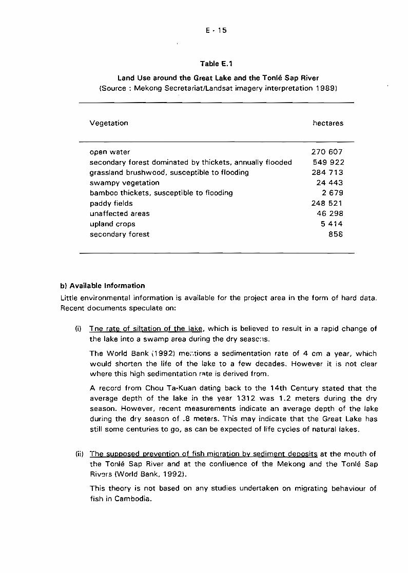
E - 15
Table E.1
Land Use around the Great Lake and the Tonlé Sap River
(Source: Mekong Secretariat/Landsat imagery interpretation 1989)
Vegetation
open water
secondary forest dominated by thickets, annually flooded
grass/and brushwood, susceptible to flooding
swampy vegetation
bamboo thickets, susceptible to flooding
paddy fields
unaffected areas
upland crops
secondary forest
hectares
270 607
549 922284 713
24443
2679
248 521
46298
5414
858
b) Available Information
Little environmental information is available for the project area in the form of hard data.
Recent documents speculate on:
(il Tne rate of siltation of the lake, which is believed to result in a rapid change of
the lake into a swamp area during the dry seaSC;IS.
The World Bank ,1992) me;-.tions a sedimentation rate of 4 cm a year, which
would shorten the Iife of the lake to a few decades. However it is not clearwhere this high sedimentation r~te is derived from.
A record from Chou Ta-Kuan dating back to the 14th Century stated that the
average depth of the lake in the year 1312 was 1.2 meters during the dry
season. However, recent measurements indicate an average depth of the lake
during the dry season of .8 meters. This may indicate that the Great Lake has
still some centuries to go, as can be expected of life cycles of natural lakes.
(ii) The supposed prevention of fish migration by sediment deposits at the mouth of
the Tonlé Sap River and at the confluence of the Mekong and the Tonlé SapRivers (World Bank, 1992).
This theory is not based on any studies undertaken on migrating behaviour of
fish in Cambodia.
E - 16
(iiil The rate of on-going deforestation of the swamp forest around the Great Lake
due to anticip3ted encroachment, Jogging, firewood use, charcoal production and
wood use in fisheries and fish culture.
The Department of Forestry (1991 l states' that during the period 1965 - 1389 a
24 % decrease of the inundated forest area took place in Cambodia, largely in
the vicinity of the Great Lake. It is doubtful if the 1965 study can be compared
with the land use classification of 1989 based on satellite images.
Based on /ittle information, unreliable data and worst case scenarios, as mentionedabove, proposais have been made for dredging projects at Chakdomuk and the entrance
of the Great Lake. Aiso a moratorium on export of ail natural resources, including fish isproposed, while the Great Lake is said to be silted up within a few decades.
E.3.2 Integrated Water Management and Development Plan
Any management and development plan of the Great Lake and the Tonlé Sap River area
will be greatly dependant not only on the water quantity and the water quality of its
tributaries, but even more on the water quantity and the water quality of the Mp.kongRiver at Chakdomuk.
The tributaries of the Great Lake and the Tonlé Sap River continuously influence the
water qua lity in the project area to some degree, but the water qua lity of the Great Lake
may be mostly determined by the Mekong River, during the 4-5 months inflow period
each year.
The water level of the Great Lake is also dependent on the water flow from its tributaries
and on the water level of the Mekong River for the whole year round.
A management and development plan for the Great Lake and the Tonlé Sap area should
include not only the use of water and related resources in the project area, but also the
use of water a~d related resources in the watershed of the Mekong River and the
watershed of the Great Lake.
Developments ir. the project area will not be sustainable. without antlclpating future
developments in the Great Lake watershed and in the Mekong River watershed.
Developments in the Great Lake area can also have impacts on the use of water
resources in the Mekong River watershed. Therefore an integrated water managementplan is proposed which should address the following environmental concerns.
E - 17
E.3.3 Expected Environmental Impacts
a) Impacts of the whole Mekong Basin Development on the Project Area
(i) Barrages and dams
Dams and barrages. especially mainstream dams, will have an influence on the
flow of the Mekong River. Both hydropower dams and irrigation schemes will
result in reduced flooding. However only large reservoirs or great numbers of
medium-size dams may significantly affect the flood magnitude in the Great
Lake. In the case of hydropower dams. the release of water during dry season is
more than in natural conditions. This would have a positive impact on water
level of the lake where the recession of the water in the dry season is governed
by the water level at Phnom Penh. On the contrary. irrigation dams which divert
water during the dry season would worsen the natural flowing condition.
Impacts on fisheries production and impacts on the swamp forest and floodplain
around the lake are expected. Any flow intervention or flow diversion at the
Mekong River upstream of Chakdomuk should be evaluated carefully for possible
impacts on the project area.
(ii) Domestic and industrial waste water disposai
Disposai of untreated domestic waste water from urban centres add to health
risks, increase of biological oxygen demand and increase of suspended solids.
Especially the disposai of raw sewage at Phnom Penh forms a threat to the
Mekong and Tonlé Sap River.
With the expected industrial actlvltles near Phnom Penh in the near future. a
legal frame work should be put in place to regulate industrial waSl:e water
treatment and disposaI.
(iii) Forestry and deforestation
Deforestation is linked with increased sediment load and increase of seasonal
flow fluctuations. Water depth and water exchange of the Great Lake can bedependant of forestry mailagement in the Mekong watershed.
(iv) Flood protection
Flood protection in the Mekong delta may result in a rise of the level of the
Mekong River (Mekong Secretariat. 1992). Effects of flood protection
downstream of Chakdomuk on the water level and the water exchange in the
project area should be evaluated.
(v) Fisheries
Fisheries management in the Mekong watershed will influence the fish
production of migrating species in the Great Lake.
E - 1H
(vi) Port development and navigation
With the construction of a new port in Phnom Penh and the expected increase of
water transport. the risks of accidentaI pollution. such as oil spills. can be
anticipated to increase.
b) Impacts of thé Tonlé Sap Basin Development ante the Project Area
(i) Barrages and dams
Several irrigation schemes are planned at the tributaries of the Great Lake and
the Tonlé Sap River. Possible conflicts in use of the water may arise (watersupply to the main towns in the watershed. waste water disposai. fisheries.
aquaculture and irrigation). Aiso irrigation will result in intensification of
agriculture with probable use of fertilizers. herbicides and pesticides. which may
end up in the Jake.
Dams may block the movement of migratory fish.
(ii) Domestic and industrial waste water disposaI
Disposai of untreated domestic waste water into the tributaries should be
avoided. Treatment and disposai of waste water from food and fish processing
as weil as jute manufacturing needs to be evaluated.
(iii) Forestry and deforestation
As deforestation can lead to high sediment load and increased flow fluctuations
in the tributaries. hopefully the enforced export ban on timber will diminishdeforestation and resulting negative effects to the project area.
(ivl Gem mining
Gem mining upstream of the Battambang River leads to a high sediment load inthe river. with possible effects to water supply• fisheries. aquaculture andwildlife.
(v) Fisheries
Fisheries management in the tributaries a'nd fisheries managemünt in the GreatLake and Tonlé Sap River are probably interdependent.
cl Impacts within the Project Area
(i) Aquaculture
Existing fish culture is completely dependent on fisheries. no hatcheries and/ornurseries are producing fingerlings and the fish feed consist of small catch fish.
fish processing waste or cooked rice bran. With the establishment of hatcheries
E - 19
and nurseries and with the development of a semi-moist fish feed pellet, fish
culture in the project area is expected to boom.
When no regional management plan exists aquaculture booms generally result intemporary problems with fish diseases, oxygen depletion and organic pollution,
together with bankruptcies of the smaller fish culture enterprises.
(ii) Agriculture and irrigation
Plans for irrigation and intensification of agriculture need evaluation to determine
possible conflicts in use of the water and effects on water resources.
(iii) Forestry and deforestation
Deforestation of the swamp forest is said to be considerable, but estimations of
the deforested area are not based on hard data.
Forestry management probably influences fisheries production and determineswild life conservation.
(iv) Wild life reserves
Cambodia has under consideration the establishment of a protected area of 100000 hectares of swamp forest in Siem Reap, Battambang and Pursat Provinces
to support both resident and migratory birds and lessen threats to endangeredspecies such as the giant ibis and the Siamese crocodile (Mok Mareth, 1993).
Co'nflicts of interest may arise between the protection of fish eating species andexisting fisheries and aquaculture practices. Socio-economic as weil as
environmental impacts of tourism may be expected, when the wild life reservesare established.
(v) Water transport
The low water level of the Great Lake during the dry season has lead to dredgingproposais, to enable water transport during ail seasons. Boat design should be
considered as an option to enable water transport during a!1 seasons, to avoid
impacts and costs of dredging.
(vi) Gas and oil exploration
A number of concession blocks for oil and gas exploration cover portions of thewet season Jake area. Provisions for protection of the wetlands ecosystems
should be incorporated in both explanatory and development proposais to ensurethat adequate protection is provided. (Dennis and Woodsworth, 1992).
(vii) Tourism
When security can be guaranteed for tourists in the Siem Reap area, many
visitors to Anchor Wat are expected, resulting in an extra demand in watersupply and in an increase of the quantity of domestic waste water. Domestic
waste water treatment may be necessary.
E - 20
An environmental zoning and management plan will soon be proposed for the
Siem Reap area by UNESCO.
(viii) Barrage or dam
As long as no fundamental understanding of the hydrological and biological
processes in the Great Lake has been reached, the idea of constructing a barrage
or dam 'in the Tonlé Sap River to raise the water level of the Great Lake in the
dry season should not be supported.
(ix) Infrastructure
Road building to improve transport in the project area and to improve access tothe lake should not reduce the flood plain area or reduce fish breeding and/or
feeding grounds (Mekong Secretariat, 1992).
(x) Life cycle of the Great Lake
If the ·Iake will turn into a swamp area due to siltation, fisheries yield and
aquaculture production will be restricted to seasonal activities.
d) Impacts of the Tonlé Sap Development Projects on the Mekong Basin
(i) Fisheries
Fisheries management at the project area will influence fisheries of migratory
species downstream as weil as upstream of Chakdomuk.
(H) Aquaculture
Uncontrolled fish culture may lead to introduction of foreign species and fish
diseases as weil as degradation of the water quality.
(iii) Siltation of the Great Lake
If the current high siltation rate is confirmed, the storage capacity of the laj(e
will be reduced, which can affect flood protection and salt water intrusion in the
Mekong delta. Aiso fish migration to the Mekong basin may be restricted.
(iv) Barrage or dam
A barrage or dam planned to increase the water level in the lake during the dry
season may also affect salt water intrusion in the Mekong delta and restrict fishmigration to the Mekong basin.
(v) Wild Iife protection
The wetlands within the project area can play a regional role as a refuge area for
migratory birds.
F- l
F INSTITUTIONAL ASPECTS
F.1 NATIONAL CAMBODIAN INSTITUTIONS
The following sections (F.1.1 and F.1.2) describe the institutional
framework in Cambodia as it was at the time of the visit of the consultant
team in March 1993. With the occurrence of the elections and the
constitution of the Provisional National Government of Cambodia , the
situation has been extensively modified. Sor.,e information on the current
governmental temporary structure are given in section F.1.3.
The governmental ministries which will be directly involved in carrying out the Tonlé Sap
Project or which will be concerned by its coordination or planning stages are Ministry of
Agriculture and Ministry of Transp~rt, Communications and Post.
F.1.1 Ministry of Agriculture
The areas of involvement for ,the Ministry of Agriculture (MOA) are very wide. It is
responsible for every state controlled development action, including civil works, in the
domains of water, land, crops and livestock management. The MOA is also responsiblefor the survey and monitoring of the overall physical and biological environment and the
management planning and protection of ail renewable resources (water, fish, forests,wildlife. It is for this reason that the MOA is the interlocutor as far as the environmental
issues in general, and the dynamics and use of the aquatic or forest resources in
particular, are concerned.
The present organization chart comprises five Vice-Ministries two of which concern the
Project directly: the Vice-Ministry in charge of training and general coordination ofresearch and the Vice-Ministry of Fishery and Forestry.
Thus, the MOA exercises authority over the whole range of activities concerning
research and training. Training is carried out by the Institute of Agricultural Techniquesof Chamcar Daung (w:'ich should become the University of Agronomic Sciences) for the
education of engirieers, teachers and research staff, and by the Secondary School ofPrek Leap for medium-Ievel technicians. The current situation is quite critical because the
Soviet teachers responsible for training in Cambodia left the country in December 1990.
As a consequence there is a need to assess the level of people who were trained prior to
1990 (essentially in Russian language). and to make up for the extreme deficit of
teachers in the four agronomic faculties, including fishery.
The MOA includes an Environmental Steering Committee (ESC) which is chaired by the
Vice-Minister and which has representatives of ail departments of this ministry. The ESC
is presently preparing a national environmental institutional framework.
F-2
a) Department of Hydrology
This department within the MOA has a large complement of staff (725 persons in total),
of whom 59 are engineers and 131 are medium-Ievel technicians. The Department ofHydrology comprises eight sections or offices, of which five can be considered as
technical sections. There are large discrepancies in the sizes of the sections and their
respective <;taff quotas. For instance, the section of hydrometeorology has three
engineers only, which is not sufficient to operate the surveys required on a country-wide
basis.
Only three of the engineers have been trained outside the country (in Vietnam, Soviet
Union and Laosl. The remainder obtained their training from the Soviet-Khmer Technical
University or in Chamkar Daung Agricultural University. For the medium-Ievel staff, the
range of technical skills is expected to be broad, some havlng benefited from on-the-jobtraining while being involved in assistance projects; others have a general college or high
school background with Iittle hydrology-oriented technical knowledge. The Department ofHydrol'lgy is giving high priority to the training of its staff, including language training.
Some support in terms of expert assistance, equipment and training is expected to be
given scon to the Department of Hydrology through a Mekong Committee Project (see
belowl.
b) The Department of Fishery and Forestry
This department is in the process of being reorganized. With regard to fisheries it is in
charge of ail activities linked to exploitation (definition of plots and sale by auction,
establishment and supervision of the implementation of regulations, collecting and
processing fishery statisticsl; it trains directly four groups of state fisheries distributedamong Kompong Thom, Kompong Chhnang, Kandal and South Mekong; and ;t is in
charge of fishery and fish culture research.
The research laboratories are presently inoperable because the hydro-biological research
station in Phnom Penh and the oceanographie research station in Kompong Som were
completely destroyed in the 1970's. There remains only the fish culture station of ChanCham Res, but it is almest inactive. The Cambodian government wants to rebuild a
research institute near Phnom renh. If this project is realised the institute could be
conceived to regroup ail the aquatic environments and ail the aquatic resources. The
establishment and functioning of this station should be given the highest priority.
The Department of Fisheries manages the inundated forest around the Great Lake,
including the aspects of law and enforcement. The department is developing proposais
relating to the wetland and inundated forests conservation within the frame of a WildlifeProtection Office created in 1992.
F-3
F.1 .2 Ministry of Transport, Communication, and Post
The existing institutional framework of navigation and river transport is under theMinistry of Transport, Communication and Post. It includes the River Transport Companyfor operational aspects and the River and Construction Enterprises which undertakes
river works : dredging, navigation aids and port facilities. Ports other than Phnom Penhare administereçj by provincial administrations.
F.1.3 The Provisional National Government
The Provisional Government includes 27 different ministries, of which the following mayhave strong links with the development of the Tonlé Sap and Great Lake area.
- Ministry of Planning- Minister of Agriculture, Forestry and Fishery
- Ministry of Rural Development- Ministry of Envirrmment
- Ministry of Transport- Ministry of Energy and Mines
- Ministry of Public Works- Ministry of Industry
- Ministry of Tourism- Ministry of Commerce
- Ministry of EducationMinistry of Higher and Technical Education
- Ministry of Social Welfare and Labour
It is highly foreseeable that this institutional structure will not be exactly renewed in thedefinitive National Government. Particularly, the number of Ministries should be less than
now <around 20), which should make the coordination for technical matter within each
sector easier.
However, it is expected that there will be more ministries and departments in the final
National Government than in March 1993 and that a new assessment of the institutionalsituation will be required in a few months. As an example of the consequence of the reorganization, the tasks carried out by a single department of a former Ministry would be
split into 7 different ministries. This is the case of the water sector, which was totally in
charge of the Department of Hydrology and whose future structure is given inTable F.1 (1) :
Whatever the future governmental structure will be, the formulation and theimplementation of an integrated development plan will require the direct participation ofseveral line ministries and the involvement of most of them at information, discussion
and advisory levels. Therefore the institutional framework for d project aiming at the
11) Information provided by Mr. Nick Mandeville, QOA, Hydrology Programme Adviser, during the discussionof the Oraft Report.
F-4
formulation of a Development Plan for the Tonlé Sap region, the links and the working
procedures of the project staff with the technical departments of the different ministries
remains major and preliminary objectives for achieving such a project. These aspects will
be adressed in chapters Gand H.
Table F.1
Future Structure of the Water Sector
(as envisaged 13-08-1993)
MINISTRY IN CHARGE
AGRICULTURE, FORESTRY AND FISHERY
ENVIRONMENT
PUBLIC WORKS
RURAL DEVELOPMENT
TRANSPORT
INDUSTRY
ENERGY AND MINES
Task
Irrigation
Water ManagementWater pollution
Hydroclimatological dataClimatologyLarge damsFlood controlDredging
Drinking WaterRural sanitationWater reservoirsIrrigation systemsMicro-hydropower systems
Meteorofogy forecastingNa\"igation
Urban water supply
Large hydropower schemes
F.2 INTERNATIONAL AND REGIONAL ORGANIZATIONS
F.?.1 Interim Mekong Committee
The Interim Mekong Committee UMC) is the abbreviation for the Interim Committee for
Coordination of Investigation of the Lower Mekong Basin, the only region31 body
addressing water-related development issues with regard to the four riparian countries of
the Lower Mekong Basin. The IMC plays an important role in the planning, coordination.
F - 5
implementation and monitoring of bilateral assistance in the region. It also acts as the
centrâl repository of data and information concerning water-related resources of the
whole area.
Every year the IMC publishes a work-plan glvlng a summary of on-going and future
projects. A list of projects relevant to the integrated develot:ment of the Great Lake,
Tonlé Sap and Chakdomuk areas is given in Annex 4.
a) Assistance in Hydrology
As far as hydrology is concerned the most important project is undoubtedly
MKG/R.91 038/Rev.1, Rehabilitation and Development of the Hydro-Meteorological
Network in Cambodia. This is a 3-year project with a total cost of US$ 757 000, of
which US $ 289 000 is for measurement and monitoring equipment and transport
facilities. The project will provide a full-time field hydrologist assigned to the Department
of Hydrology to ensure the effective implementation of the programme. Among other
activities the programme will install 15 staff gauges and 8 float recorders for stream
gauging measurements, and collect sediment and water quality samrles with a frequency
allowing the assessment of sediment transport in Tonlé Sap and in the tributaries of the
Great Lake.
The Tonlé Sap Development Project area will benefit from
8 hydrological/sedimentological stations on the Great Lake tributaries, two recordingstations for lake water level changes, the rehabilitation of the gauge in Kompong
Chhnang and an intensive monitoring programme in Prek Kdam.
If carried out according to the specifications of the project document, this project wouldrequire only minor modifications to fit the needs of the current Tonlé Sap project. Some
points which will have a bearing on the implemc.ltation of future phases of the present
project are discuss~d below :
(il The 3-year period for installation of ail stations may be too long for the purpose
of the Tonlé Sap Projer;t. Thus the Hydro-Meteorological Rehabilitation and
Development Project should be either strengthened to enable installation of the
monitoring equipment in a shorter time, or the Tonlé Sap and Great Lake
monitoring sites should be given first priority for installation.
(ii) The project is designed as a comprehensive operational hydrology programme,
emphasizing infrastructure rehabilitation, data collection, and field hydrologists'
training. This is c1early the first priority for the country. However, there is little
provision in the project for data interpretation and studies specifically targeting
the Tonlé-Sap, Great Lake and Mekong dynarllics. It is foreseeable that the day
to-day impiementation of this ambitious project will require the full-timeinvolvement of the hydrologist, who would not be available for carrying out
studies specific to Tonlé Sap, Great Lake and Mekong river interactions.
F-6
The Tonlé Sap Project should therefore include a data interpretation and analysis
component to be carried out in close collaboration with the country-wide
hydrological project.
(iii) The timing of commencement of the Project is doubtful. BecéJuse this is
the key project for hydrofogy and monitoring of sediment transport, a more
definitiv~ schedule should be drawn up.
Another important project being prepared by the Interim Mekong Committee is the
proposed MKG/R.91039/Rev.2 Mekong Geographie Information System - Cambodian
Component. This project will provide useful data for the future monitoring of land use
changes associated with a study of watershed condition and sediment generation. The
monitoring of changes in land use with time (deforestation in the upper watershed,
extension of mining areas, land use changes in the agricultural zones surrounding the
Great Lake, changes of vegetation features and type of vegetation cover in the inundated
areas) should be undertaken with updating on a regular yearly hasis. Associated with this
is the need to measure and monitor the sediment transport into the lake by its
tributaries.
The issue of topographical levelling and bathymetric surveys of the Great Lake area is
not included in any project of the Mekong Committee. This aspect should be specifically
addressed within the current Tonlé Sap project as soon as possible.
b) Assistance in Fishery Management
Several 1MC projects are planned in the fishery sector. These are :
- Assessment and Management of the Freshwater Fisheries of Cambodia
(MKG/R.91050) to be funded by Denmark for an amount of US$ 1 888 000 andto be implemented over a period of 36 months,
- Management of Regional Fisheries Resourees (MKG/R.92063) with a projected
budget of US$ 270000 and an implementation schedule of 24 months, and
- Investigation of Commereially Important Fish Species with a projecteJ budget of
US$ 400 000 and an implementation period of 30 months.
Ali of these projects emphasize training of staff and the strengthening of the concerned
agencies.
c) Assistance in Navigation Aspects
- IMC has a proposed project titled Long-term Development of Inland Navigation inCambodia (MKG/R.92057) but it does not yet have funding.
Other on-going studies which are not directly carried out under the um~rella of the IMCalso address navigation in a general way, but not in sufficient detail for the needs
identified in the present study. On-going projects include :
- The jointly funded UNDP-ADB Transport Rehabilitation Study, and another
implementation project in the transport sector funded by ADB.
The Phnom Penh Port Rehabilitation and Extension Projeet funded by JICA.
F· 7
The navigation aspects of Tonlé Sap should be addressed by a specific study becausenone of the on-going projects consider these in detai!.
F.2.2 United Nations
The contribution of the United Nations to Cambodia has been especially outstanding withthe deployment of UNTAC and ail connected activities.
The United Nations Development Programme (UNDP) implements numerous development
projects focused on the enhancement of institutional capacity in the country with specialregard to environmental and renewable resources management. To achieve this
objective, several initiatives have been started (Dennis and Woodsworth, 1992),
including :
(il The Cambodian Environmental Advisory Team (CEAT) is a team of advisersworking with UNTAC, UNDP, the SNC Secretariat, the Ministries of Planning,
Agriculture, Industry and Finance, and with a National Investment andEnvironment Board yet to be created. The brief of CEAT is to screen ail majorinvestments and development aid proposais for potentially adverseenvironmental impacts and for development sustainability.
(ii) The Cambodian Environment Fund which could be used for environmental
rehabilitation projects including reforestation, erosion control and water
management works. The CEF will also be used to provide long-term support forenvironmental protection and management of protected areas. In the first two
years CEF will emphasize training and employment of returned refugees,demobilised soldiers and local inhabitants in labour-intensive environmentalrestoration and surveys. Such projects would be designated by the CEAT andproposed for funding through the UN coordination process.
If this process is implemented, it will be an unprecedented effort in thecoordination of development projects in the country, and the current
Development Plan for Tonlé Sap and Chakdomuk will benefi~ from being carriedout in such a context.
UNESCO is currently carryin~ out the Zoning and Environmental Management Plan forAngkor which can be considered as a pilot project for further integrated studies of theGreat Lake surrounding areas. Even though the site conditions are very particular, it isexpected that some findings and experience gained from this project will be of help for aproject addressing the overall riparian areas of the Great Lake.
FAO has current projects in Cambodia, inc1uding :
- Improvement of Floodplain Fishery Resources in the Mekong and Bassac Rivers,
with a projected budget of US$ 1 670000 and an implementation schedule of
5 years,
F-8
- Multi-Sectaral Develapment Plan far the Great Lake (fisheries campanent), with
a projected budget of US$ 100000 and éln implementation schedule of
20 months, and
- RehabilitaÛan af the Inundated Forests af the Great Lake far a Multi-Purpase Use(fisheries campanent) , with a projected budget of US$ 825 000 and an
implem~ntation schedule of 5 years.
Generally speaking the value of these projects lies in the integration of fishery aspesis
into other sociological and developmental activities, including agriculture and utilisation
of vegetal cover. Unfortunately the FAO projects have been conceived in the light of
catastrophic predictions relating to fish resources and the environment. The present
project has not found evidence within the body of available data to support such
negative assessments of the current situation. although ~he need for extreme vigilance
has been highlighted.
F.2.3 Non-Governmental Organizations
The NGOs play a key role in Cambodia because, for many years, they have been the only
channel for providing international assistance to the country. Currently the inputs of thenon-governmental sector are widespread in every domain related to the environment,
development and day-to-day Iife of the people. Some of the staff of NGOs have gained
an in-depth knowledge of the country (in the environmental, sociological, economical and
institutional sectors). Their contributions to the project will be helpful in its design stage
as weil as in the implementation phase.
The importance of the assistance provided by NGOs is illustrated by the hydrology and
water resources sectors. The contribution from the NGO donors is US$ 15 to 20 millionsince 1979, the current annual inputs being between US$ 2.5 and 3 million during
recent years. In 1990 direct assistance from the NGOs to the Central Hydrology
Department in Phnom Penh was provided by :
- AFFHC (Australian Freedom for Hunger Campaign)
- CIDSE (Coopération Internationale pour la Solidarité et le Développement)
- OSB (Overseas Service Bureau)- OXFAM UK and Ireland
At the same time assistance has been provided at the provincial level for site-specific
actions by :
- ACR (Australian Catholic Relief)
- ADRA (Adventist Development and Relief Agency)
- CIDSE (Coopération Internationale pour la Solidarité et le Développement)- MCC (Mennonite Central Committee)
- WCC (World Council of Churches)

·-....-
;:-9
Currently PADEK (Partnership for Development in Kampucheal. GRET (Groupe deRecherche et d'Echanges Technologiques) and SAWA (Stichting Adviesgroep
Waterbeheer) are involved in small-scale development projects in the water sector.
Generally the NGO staff are highly committed to their duties, but the organisations havelong-term funding problems. The assistance, which has to be given on an "ad-hoc" basis,should be included in long-term projects aiming at enhancement of the Department ofHydrology, including institutional strengthening, supply of equipment and staff training.
CEAT might bring such coordination and long-term perspective for the NGO workprogr3mmes.
G - ,
G. CONCLUSIONS
G.1 GENERAL CONCLUSIONS
Phase 1 of the Development Plan for Tonlé Sap and Chakdomuk provided the forum for apreliminary asse:;sment of existing conditions which has been carried out mainly on the
basis of a review of existing available data. "The lack of quantitative and reliable data,especia/ly during the past 15 years, is the more general finding of each sectoral
assessment" (Inception Report p.22). This situation has severely restricted the certainty
of the conclusions given in the sectoral assessments of the Report. As an example. two
crucial issues could not be solved
- Does the sedimentation rate occur with its natural and normal magnitude or isthere any recent and on-going significant increase of this rate which couldthreaten the sustainability of the physical and biological environment in thewédand area, and hamper its economic exploitation (fish, navigation, etc.) ? This
question applies especially to the Great Lake, and to some extent to the TonléSap river, where it appears that Mekong sediment deposit at both end of the
stream (Snoc Trou and Chakdomuk) is a natural process.
- Is the current pressure of the fisheries sustainable for the bio-ecological
environment? As discussed in the technical section on fisheries, a definiteanswer would ~9ql!ire accurate information on the actual level of the catches(partially known), composition of the catches by size and specie (unknown). The
socio-economical conditions in Cambodia are changing at an unusual rate which
will undoubtedly urge the fishermen on higher fish production. Thus, recent dataon catches and on fish marketing conditions are absolutely necessary, but as it
has Deen shown in the analyses of fisheries and fish production (Section CL theavailable data are patchy and most of them have been collected several decades
ago. Almost without exception, experts who have prepared reports andexpressed opinions on the bio-ecological environment in the last 30 years havedone so on the basis of very few field observations, using instead second orthird hand information sources.
Inadequacy of data is especially constrammg when the system to be analysed is
dynamic, has strong variability with time (at annual, interannual and pluriannual levels)and its components are interactive. The links between the annual magnitude of the
Mekong flood and the variations of the catch of fish are an example of such variability intime. The effects can be highly significant if an under average (or an over average) flood
pattern is 0bserved during several consecutive years. In a similar way, human activitiescan have short term influences (on migrations, for example) and long term influences(such as changes in the demand for fish due to regional development and populationgrowth). To manage such an ecosystem in an environmentally sound way, it is therefore
necessary to have long series of data concerning environmental changes, resources, theirexploitation and the communities involved in the exploitation. It is a long term objective
G-2
for any country to access accurately the situation of its renewable resources (water,fish, forests, etc,) and the conditions of their exploitation. This implies the set up of
efficient technical departments, naving strong scientific back-up. Institutional building,training of staff, availability of field equipment and data processing facilities are the
required components to achieve such objectives. High priority should be given by the
National Authorities to such programmes, even if the Nations's priorities have to be
focused on moré urgent and day-to-day issues. Regional institutions such as the Mekong
Committee can play a key role in promoting such long term investigations and data
collection.
It must be stressed that usually, the collection of data without clear objectives(identification of the problem to be addressed and of the questions to be answered) is
usually not a very effective process. Such multi-purpose data collection programmes led
to patchy data bases which remained untouched without any analysise for too long a
period. As it is only when data interpretation starts that the lacks in data collection will
be discovered, any data collet::tion programme should include studies and analyses of the
data carried out at the time of the collection. 50, an appropriate feed-back can be
provided to the data collection activities.
G.2 SCOPE OF A DEVELOPMENT PLAN FOR TONLE SAP AND CHAKDOMUK
Therefore, additional data collection, surveys and investigations should be undertaken as
soon as possible and are clearly one of the objectives of the coming phase Il.
However, as the indicative duration of phase Il is 2 years only, it is clear that the results
and interpretation of long term "strategic" data collection will not be available before theend of Phase II. Therefore du,'ing this phase priority should be given to data collection
and surveys of additional and representative data aiming at the verification of thetentative conclusions presented during phase 1of the project.
On the other hand, tr.e implementation of a development plan of the area, which is a
long term and a permanent process, will require long term data bases, permanently
updated to take into account the natural fluctuations and the socio-economic trends. As
such, the project must stress the needs for long term data collection programmes indifferent sectors (water, fish, wild-life, land use, transport infrastructure, etc.), even jf
these activities are not carried out in the institutional framework of the project.
However it would be unrealistic as weil as unacceptable for the Country to delay theprocess of the formulation of a development plan of the area until ail above mentioned
data and information have been collected and analysed. The justification of such astatement includes the following reasons :
(i) A dynamic and mostly informaI development takes place in the whole country,
and especially in the project area. The fringes of the Great Lake and of Tonlé Sap
River are target areas for the returning refugees and displaced persons. Most of
G-3
them are believed to be farmers and therefore pressure on agricultural land andpossibly on forests will increase. Some of the newcomers mayas weil undertake
activities providing Immediate and higher incorne than agriculture such as fishing,
fish processing, wood processing (charcoal, construction wood), wild life
poaching, etc. Under such specific conditions, even without ail desirable
information on environmental characterization, the basics of an environmentally
sound dévelopment plan can be formulated and implemented, based on available
data and common sense.
(ii) Aside from the required data previously mentioned, (collection of which are
activities of some of the priority projects recommended by this study). a large
quantity of information will be availa'Jle in the near future, as several sectoral
reviews are currently in progress, such as :
- Review of the fishery sector by FAO (the draft report is already available)
- Review of the irrigation sector by UNDP (will be available during the course of
1994)
- Review of the agricultural sector by FAO «will be available during the course
of 1994)- information on population has alrt:lady been collected for the purpose of the
May general elections
Compared with the present situation (September 1993). the initial step of the
development plan of the area (which is the formulation OT the plan) which should
start in the first months of 1994, will therefore benefit from a significant amount
of new information in tile fields of rural development, if not in those directly
related with the environment.
(iii) The concept of an integrated development plan implies the participation, at
various degrees of involvement, of a great number of national and non-national
institutions.
ln the present case, the first line of national stakeholders will comprises the
following ministries :
- Planning
Finance
Agriculture (water sector, crops, fish, forest)
Environment
TransportEnergy and Mines,
Public Works
Tourism
To a lesser extent, some others ministries will be concerned for the formulation
as weil as for the implementation of the plan, such as Commerce, Education,
Industry, Heaith, Social Welfare and Labour, Veterans, etc.
G-4
Others regional and international organisations will be concerned as weil, with the
Mekong Committee having a key role to play. As discussed in the different
technical sections of the report, the environmental conditions 0f Great Lake and
Tonlé Sap river and therefore the development of their riparian areas depends
largely on the conditions prevailing in the upstream parts of the Mekong
watershed. The development of the area may also have some downstream
effects. The implication of the only existing regional and basinwide organisation is
therefore essential, a~ least to provide the project with the required data and
information.
The immediate tasks of the project will include :
- To centralize and analyse ail relevant information on the area. This will allow the
Project to advise ail institutions acting in the area (national and non-national), for
a better coordination and synchronization of their activities, avoiding duplication
of efforts and implementation of development projects w: .ich could threaten the
environment and the long term sustainable development. The data base of the
project will be a useful tool for national ministries, international and bilateraldeveloping agencies, national and international research community, donor
community.
to advise the Government in the day-to-day decisions concerning the
development of the area
- to set up an institutional framework which will be able to formulate a plan for an
integrated and sustainable developmer.! of the area. This will include the
definition of rules and of working procedures between the above identifiedstakeholders. It has been proved in every country that inter-ministry
collaborations may be a delicate process, which would require a specifie
institutional forum to share the information and to come to a consensus when
any decision has to be made. The building of ad-hoc institution is c1early anobjective on which the project should be focussed in its initial step.
The scouring near the abutment of Monivong bridge has been identified as an urgent
issue. However, the studies and works required for solving the problem were notconsidered as being a component of the Development Plan of Tonlé Sap and
Chakdomuk. The protection works to the Monivong bridge remains therefore as a lonestanding project, already in the pipe-line of Mekong Work Programme, which will benefit
from high priority from this institution.
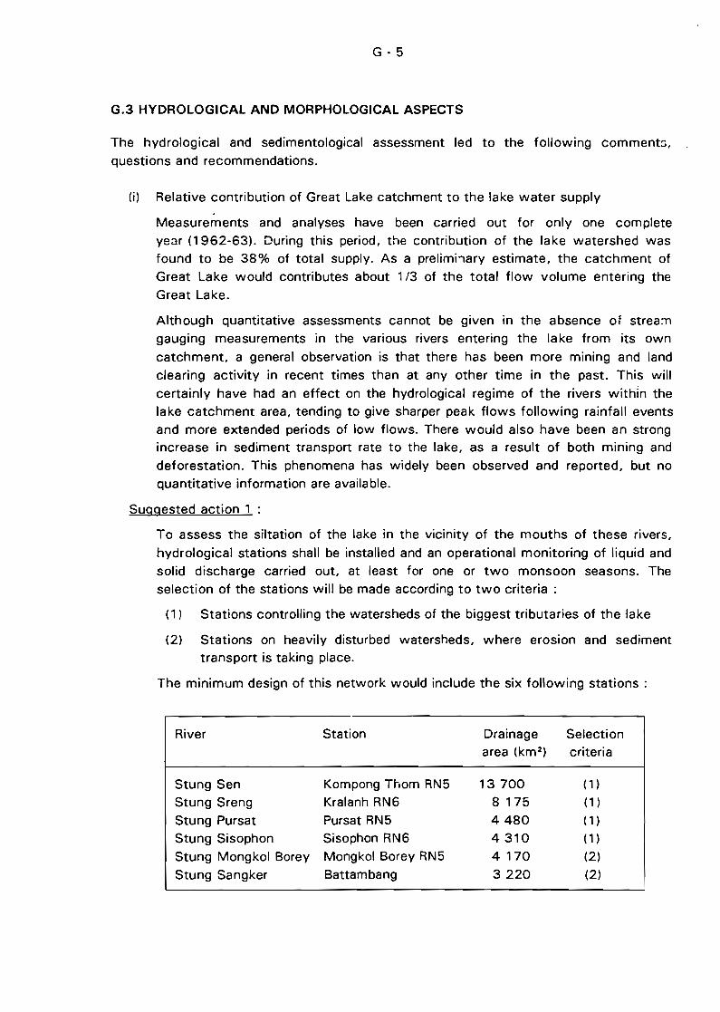
G-5
G.3 HYDROLOGICAL AND MORPHOLOGICAL ASPECTS
The hydrological and sedimentological assessment led to the following comment:>,
questions and recommendations.
(i) Relative contribution of Great Lake catchment to the Jake water supply.
Measurements and analyses have been carried out for only one complete
ye~Jr (1962-63). During this period, the contribution of the lake watershed wasfound to be 38% of total supply. As a prelimhary estimate, the catchment of
Great Lake would contributes about 1/3 of the total flow volume entering the
Great Lake.
Although quantitative assessments cannot be given in the absence of strea:T1
gauging measurements in the various rivers entering the lake from its own
catchment, a general observation is that there has been more mining and land
clearing activity in recent times than at any other time in the pasto This will
certainly have had an effect on the hydrological regime of the rivers withln thelake catchment area, tending to give sharper peak flows following rainfall events
and more extended periods of Jow flows. There would also have been an strongincrease in sediment transport rate to the lake, as a result of both mining and
deforestation. This phenomena has widely been observed and reported, but no
quantitative information are available.
Suqgested action 1 :
To assess the siltation of the lake in the vicinity of the mouths of these rivers,
hydrological stations shall be installed and an operational monitoring of liquid andsolid discharge carried out, at least for one or two monsoon seasons. The
selection of the stations will be made according to two criteria:
(1) Stations controlling the watersheds of the biggest tributaries of the Jake
(2) Stations on heavily disturbed watersheds, where erosion and sediment
transport is taking place.
The minimum design of this network would include the six following stations:
River Station Drainage Selectionarea (km 2 ) criteria
Stung Sen Kompong Thom RN5 13700 (1)
Stung Sreng Kralanh RN6 8 175 (1 )
Stung Pursat Pursat RN5 4480 (1)
Stung Sisophon Sisophon RN6 4310 (1)
Stung Mongkol Borey Mongkol Borey RN5 4 170 (2)
Stung Sangker Battambang 3220 (2)
G-G
(ii) Contribution of Mekong river to the lake water balance
The share of Mekong river was a little over 2/3 of the total water supply during
the single year for which data were available, corresponding to an entry of
45x109 m3 . According to the short historicai series of daily discharge of Tonlé
Sap in Prek Kdam, the inflow ranged from 43x1 dl m3 to 61 x1 dl m3 according to
the magnltude and the duration of the Mekong flood for each respective year.
Suggested action 2 :
The dominating influence of the Mekong to the supply of the lak'3 implies that the
flow moving upstream and downstream of the Tonlé Sap shall be monitored in an
operational way, i.e. with the best accuracy and continuously for a long period.
The control station shall be re-calibrated with frequent and accurate gauging
measurements (several measurements per week) carried out using modern
gauging techniques and equipment, during at least one hydrological cycle. The
objectives of this new hydrological calibration of the section will be :
- To evaluate the volume flowing in and out of Prek Kdam.
- ln addition, to verify indirectly jf some sedimentation has actually taken place
in the Tonlé Sap River between the outlet of the lake and Prek Kdam. The
new calibration will be compared with that used during the sixties. Any
significant departure from the former curves will be an indication that some
change occurred in the hydraulic conditions of the Tonlé Sap River.
Since 1992 a new gauge has been installed for the monitoring of the Mekong
water level in Phnom Penh at Chrui Chanvgar island. The corresponding cross
section of the Mekong has to be calibrated. This control station of the Mekongdischarge in Phnom Pen~ should be backed up by an upstream station inCambodia, the best option being to rehabilitate the station of Kratié.
The activities suggested in this recommendation are related to the hydrological
basin wide monitoring of the Mekong and is closely linked \/l/ith action 5.
(iii) Water supply to the Lake by overflowing of the Mekong
Part of the Mekong floodwaters flows directly to the lake due to overtopping of
its right bank between Kompong Cham and Phnom Penh. The voiume of thisoverflow was measured during one year only (1962) and its contribution was
found to represent 10% of the total supply of Mekong river to the lake. Howevermodest, this contribution may have a significant effect as it takes place late in the
season when Tonlé Sap at Prek Kdam is already flowing downstream to Mekongriver. This part of the lake supply is very sensitive to civil works and may have
been modified by the construction of roads and hydraulic works undertaken
during the 70's.
Suggested action 3 :
The contribution of the water supplied by overflowing has to be checked.
Hydrological monitoring of the flow crossing the bridge at Kilometre 54 of
G-7
highway RN6 has to be carried out during at least one rainy season to make sure
that this supply still exists and to evaluate its volume.
(iv) Variability in water level and supply to the Great Lake
Interpretation of the available recorded water levels in Kompong Chhnang showthat the eifferences in the annual maximum levels of the lake at its final fiIIing
stage range from 1 to 2 m. Because of the very fiat topographical conditions of
the area, such variations result in changes in lake surface area of several
thousands of km 2 and storage variations of more than 1Ox1 cft m3. If several
years with low flows follow each other. which has happened several times in the
recent pasto the ecological conditions are temporarily modified with the
anticipated effects on fish development and fishery catches. Such climatic
variations will continue to occur. either in the lake catchment or in the Mekong
river basin.
Suggested action 4 :
The water level of the Great Lake must be monitored and accurate curves relating
flooded area and stored water with water levels must be determined. which
implies:
A bathymetrie and topographie survey of the Jake,
to be conducted on the overall area. including the remaining water body at the
end of the dry season and the flooded area in its largest possible extension.
The survey shall be carried out using modern positioning systems. Thetopography and bathymetry must be linked up with a large number of
topographic benchmarks ail around the lake. The grid of the bathymetric survey
will have to be very dense in the sites where sedifTl'3ntation is supposed to be
active (at the outlet of the lake near Snoc Trou and in the northwestern partwhere rivers carrying silt ftow into the lake). This document will be a tasic
reference. which has never been established up to now. for the assessment of
the sedimentation of the lake in the future. It will be cr llcial for the
establishment of the water balance. for ecological characterization. and for
planning of any navigation development. This geodesic document will be the
reference of the situation at the end of this century to be given to futuregenerations.
The eontinuous reeording of the lake water level
As breakdown of chart recorders and data loggers are routine events. tlle levels
should be measured at two different sites. one near the inlet of the lake
(somewhere between S'lOC Trou and Krakor) and the other at the northern end.
possibly near Siem Reap. The recorders will be installed on scaffolding towers
slJnk into the lake bottom. As far as possible. the sites should remain in sight of
a topographical benchmark located on firm land, to easily ensure checking of the
datum level of the gauges during the dry season. as the towers may sink into
G-8
the muddy bottom of the lake. With the availability of the depth-volume curve, it
will be possible to monitor the water balance of the lake.
Suggested action 4 is urgent and crucial. Without this information, the definitionof any development plan of the area will indefinitly remain a topic for controversy
and unproductive discussion.
(v) Impact of existing dams and hydraulic control structures
The expertise did not identify any impact of existing dams or hydraulic control
structures on the Great Lake water balance. The 1985·1989 period was actually
one of generally low flows at Phnom Penh {on an annual discharge basis as weil
as on a flood season basis). However, this feature was also observed in the upper
part of Mekong river, ~;Jstream of any known large-scale water-harnessing
structures or recently constructed hydraulic controls.
This conclusion should however be considered as an initial and tentative
estimation which should be improved through comprehensive and careful analysis
of ail hydrological data collected on the Mekong and its tributaries.
Suggested action 5 :
Ali operational activities in the hydrological monitoring of the Mekong and its
tributaries carried out under the coordination of the Mekong Committee,
especially the project MKG/R.91038 "Rehabilitation and Development of the
Hydro-Meteorological network in Cambodia" shaH be supported and strengthenedas ail information gathered in this context is of definite interest for the
understanding of the Tonlé Sap hydrological behaviour. The recurrent activities of
electronic data encodinQ, processing, and control shaH be s:.Jpported with the
same lever of priority. In addition, hydrological interpretation and synthesis of this
information must be developed. Special interest shall be given ta Project
MKG/R.900029 .. Water Balance of the Lower Mekong Basin", which outputs on a
basin-wide scale will be of great help to understand the comparatively local
phenomena of the Great Lake and to access, as much a:; possible, the range of itsexpected hydrological variability.
The monitoring and the assessment of the low-flow levels and discharges of theMekong in Phnom Penh shaH be carried out carefully, as there are actually two
possible processes for the Mekong to modify the water balance of the lake :
- a reduction of the floods, already discussed, and
- a reduction of low flows or an occurrence of low flow earlier in the season,
which would hasten the start of the draining of the lake, with ail the
foreseeable consequences on ecol(\gy, fisheries and navigation. In this
range, hydropower ciams are of less concern as they usually release higher
discharge thl3n the natural one during low-flow periods. Contrarily,irrigation schemes provide genuine uptake of water which is returned to
the atmosphere in the form of evaporation, essentiaHy during the dryseason, and thus their impact can be very significant.
G-9
(vi) Capability of the Department of Hydrolcgy to monitor the situation
Several reviews of the Department of Hydrology have been conducted recently,the most comprehensive being the "Appraisa/ af Management Systems and
Resaurces. Department af Hydra/agy - Cambadia" supervised by AFFHC/CIDSE,
Phnom P~nh, December 1990. It was concluded that in its present stage, the
Department needs equipment to carry out the surveys, to store, process and
analyze the data, and qualified and trained staff to use the equipment. A
comprehensive assistance programme providing equipment and training is
required to make the Department fully operational. A country-wide project for the
rehabilitation of the hydrological network (MKG/R.91 038) is included in the 1993
Mekong Work Programme and will be initiated as soon as funding is provided.
Sorne local rehabilitation work has already been undertaken near Phnom Penhunder the co-ordination of the Mekong Secretariat
It must be pointed out that the re-organisation of the department will be a longlasting process, with huge training needs as the department has 725 ski lied
workers, including 59 engineers and 139 staff with a medium-Ievel background.
However, the activities specifically targeted on the development of the Tonlé Sap
and Great Lake area, are weil identified and of a smaller scale. Thus it seems that
to subordinate ail the recommended hydrological activities to a previous and
comprehensive rehabilitation of the overall Department of Hydrology might be a
ambitious, costly and prolonged programme. Especially, if the nation-wide project
is not going to start very soon, it might be more realistic to set up inside the
Department a specific team for the Tonlé Sap area. This unit will have a limited
number of staff, who will be responsible for the surveys and the studies, and willbenefit of every needed assistance, including the supply of equipment and
training. This design would allow a more efficient mobilization of the staff, better
control of the funding, and more efficiency in the accomplic;hment of their duties.
The "Tonlé Sap Team n should include the field and office technicians working in
the other domains of the environment (fishery, forestry, etc.). The team could
share the measuring devices, the transportation facilities (cars, boats, motorbikes,etc.) and the data processing equipment.
G.4 FISH AND FISHERIES
(i) The Great LakelTonlé Sap river is dependent on the floods of the Mekong river.
Any modifications in the floods have repe~cussions on the environment and
resources of the study area, and three major influences were identified :
- flood volumes which are essentially a function of climate;
- water quality (sediment content, in particular) which is a function of climateand also of environmental (iegradation due to human activities (for
example, deforestation in the upper catchments); and
the level of exploitation of fish resources in Mekong river upstream and
downstream of Phnom Penh (zones 8 and C in Figure D.1). Determination
G - iO
of the changes and interrelationships affecting the water, sediment content
and fish stocks is of the hlghest priority.
Similarly, ail modifications of the environment and resources in the Great Lake can
have consequences in Mekong river, mainly downstream of Phnom Penh but also
upstream in the case of migratory fish.
(ii) Although the project area for Phase 1 was not the whole catchment area of theGreat Lake and Mekong river, the Great LakelTonlé Sap system is strongly
dependent on outputs from the whole drainage basin: Iiquid and solid discharge
which evolve as a function of erosion and human activities (deforestation,
mining); chemical and organic pollution (mining, agriculture). In this respect
attention needs to be given to quantitative and qualitative surveillance of runoff.
(iii) The role and importance of the inundated forests in relation to reproduction of
fish and generation of sediment, neither of which are currently weil understood,
have nevertheless inspired many affirmations. These forests have been used since
ancient times by fishermen as sources of wood for cooking, construction, fishtraps, and samras. The land clearing for agriculture in the 1970-80s has probably
been particularly destructive. However, due to the fiat topography of the area, the
clearing of the inundated forests cannot be blamed for any increase of sediment
supply to the Great Lake
Based on the available evidence, this ecosystem deserves protection, appropriate
management and detailed study to determine its capacity for renewal and its rolein relation to fish reproduction. These objectives will be partially covered by the
FAO project "Rehabilitation of inundated forests of the Great Lake for a multipurpose use" (fisheries component).
(iv) Sedimentation of the Great Lake and of the upstream and downstream limits of
Tonlé Sap (Snoc Trou and Chakdomuk) were major concerns reflected in the
Terms of Reference for this study. The builing-up of an island of sediment in the
vicinity of Quatre Bras and interference with navigation caused by reduction in the
draft of the lake compared with the situation of 20 or 50 years ago, led to
hypotheses of accelerated erosion in the catchme.,ts affecting the Great Lake.Some writers have even expressed the opinion that the lake will soon cease to
exist in the dry season.
An assessment of this pessimistic scenario was presented (Section Cl, which led
to more reasonable hypotheses. There are no data available at present to supportthe assumption that the rate of sedimentation of the lake is hlgher now tha'1 it
was 30 years ago. However, even though the condition of the lake at low water
is not appreciably different from the descriptions giver. in that period, there are
signs that changes are occurring, in the Great Lake watershed as weil as in the
Mekong drainage basin.
G - 11
Our tentative conclusions are somewhat different from those given recently by
other authors. However, the importance of these issues and the different
interpretations of the few available information warrant the priority projects
adressing the bathymetric survey and and sedimentation assessment of the Great
Lake.
(v) Assessment of the living resources is particularly difficult because of the scarcity
and unreliability of the available data. A generafly hald viewpoint, supported by
severa' expert opinions made by FAO, is that there is over-exploitation of the fishand a "genera/ decline in yields". Our conclusion is much more moderate, firstly
because there are no data to support such a viewpoint and secondly because the
d::jta which do exist show a situation of relative stability. It is necessary to recall
two important elements in relation to living resources :
- It is actually possible that the potential production has decreased during
the last 10 or 20 years. This could be due to two major series of factors:
(il lower flood volumes and levels in Mekong river giving correspondingly
lower reproductive rates in the aquatic ecosystem, and/or (ii) environmental
degradation caused by man's activities (deforestation, erosion,construction of embankments and other agricultural development works).
The present level of exploitation should be assessed in terms of the
present reproductive potential of the aquatic ecosystem.
- Given that there has been an increased intensification of fishing effort.linked to technological innovations in fishing gear, the composition of the
catch has probably changed as a function of the vulnerability of the
species. It is probable that less large fish and less species of hlgh
economic value are caught, while at the same time the proportion of fish
of less value has increased. Depending on the priorities and a definition of
value, the present situation could be considered acceptable in terms oftotal yield even though there may or may not be a real decline in the value
of the catch. This does not necessarily mean over-fishing.
(vi) Although there was no specific mention in the Terms of Reference, we considered
the effects of the barrage proposed on Tonlé Sap (1964) by the "Cl ntral Water
and Power Commission" (New Delhi). According to the CWPC the preferred site
is 3 km upstream from Kompong Chhnang and the barrage would offer many
advantages, among which the most probable are:
- For Cambodia: increased fish production due to increased lake levels.
possibility of irrigation in the zone surrounding the lake and downstream of
the lake, reduction of ffooding downstream, improved navigation in Tonl6
Sap in the dry season;- For Vietnam: If weil managed, reduced salt-water intrusion during dry
season, improved drainage, increased water availability for irrigation in the
dry season, greater draft and improved navigation in the dry season.
G - 12
This whole argument should be reworked in the light of more recent data and up-to-date
methods for analysing the benefits and constraints of such complex multi-purpose dams.
ln relation to the production of fish in the lake, Schmid (1963) and d'Aubenton (1964)
analysed the consequences of such a dam on the inundated forest and the migration of
fish. The conclûsions are ambiguous : there would probably be a diminution of the area
of inundated forest and consequent disturbance of fish migration, even if the best
technical solutions are envisaged. Increased production of fish is not certain if the lake ispermanently maintained at a highe~ level, there being the negative effects of interference
in the seasonal flooding.
Although we were not explicitly asked to consider this aspect we feel that its
consequences could be important. At the very least, the proposed dam merits a new
study, possibly to be undertaken in the form of a workshop specifically dedicated to the
Tonlé Sap dam projer. t .
Our overall conclusions, arrived at in the most objective manner possible, tend towards a
less pessimistic view than those which have been expressed in recent reports. Thepresent condition ')f the environment and the fish resources is not (subject to verification
by more complete data) seriously degraded, and the apparent variations in yield can be
attributed as much to natural causes as to the harmful effects of man's activities. It
would appear also that the pressure on the Great Lake and its ecosystem has not beentoo heavy in terms of sustainable use of resources during recent years because of the
unusJal political and socio-economic situation of Cambodia.
This situation is changing rapidly. Population growth, attraction of new markets and
short term prospects are putting an increasing pressure on the natural resources. The
existing legislation aiming at the protection of the natural resources has to be improved,both in its relevance to the changing conditions and to its application.
An overall project which would integrate the research and development aspects
concerning the Great Lakerronlé Sap system is recommended. Such a multi-sector and
multi-disciplinary project would be beyond the scope of Phase Il of the study because it
would nf:ed to be implemented over a longest period. The identified priority projects
could be considered as first contributions towards the overall project, especially in
relation to the collection of new data and the verification of the various hypothesesdescribed in this report. The overall project should include a programme of monitoring
and the training of professional local staff.
This overall project should take into account the various on-going and planned projects in
the study area, implemented by a number of developing agencies (Interim Mekong
Committee, rAO, UNESCO, other United Nations agencies, NGOs and bilateral
assistance programmes) to avoid as much as possible any duplication of activities.
Overlapping appears as being already a problem, and there is also the risk that some high
G - 13
priority actions will be adressed by any project. A national development master plan is
necessary to ensure that priorities will be kept and that national objectives are clearly
defined. This comment is particularly relevant to the management of the living aquaticresources which is currently not coordinated in the most efficient way.
The first priority for Phase \1 is therefore defined as being the setting-up of a institutional
structure to OVeTsee further research programmes and development actions for the GreatLakerronlé Sap system.
G.5 NAVIGATION ASPECTS
(il The project of rehabilitation and ext::,nsion of the port of Phnom Penh funded bythe Government of Japan will be completed by the end of 1995. Ships up to
4 000 DWT will then be able to access the port located in the Tonlé Sap river,
but dredging of the access channel, across Chakdomuk will be required at a
minimum water depth of 5.50 m LLW.
ln the long term the proposed new port at Chrui Changvar in Mekong river
mainstream will serve sea-faring vessels, thereby allowing the existing entrancechannel to Tonlé Sap river .to become blocked by sediment in the absence of
frequent dredging. If the project is implemented, an approximate completion timefor this new port project is 7 to 9 years from now.
(iïl Tonlé Sap river is navigable from Phnom Penh to Kompong Chhnang ail year
round by boats up to 150 T, but navigation beyond Kompong Chhnang to the
Great Lake is hampered by the s~allow pass at Snoc Trou. At present only smallcraft carrying dried fish can conti'1ue beyond Tonlé Sap river during the low waterperiod. Further downstream, fish is collected by larger junks and forwarded to
Phnom Penh. The traffic of timber coming from Tonlé Sap tributaries is alsointerrupted during the dry season because of shallow draft at Snoc Trou.
Important agricultural anJ forestry resources as weil as fish could be transportedmore economically by waterways along the naturally favourable system provided
by Tonlé Sap. Dredging in the pass of Snoc Trou would be required to ensurecontinuous navigation by barges up to 200 T and over from the provinces to
Phnom Penh, which requires further investigation.
Waterborne transport is cheap and efficient, and contributes to the economicdevelopment of local populations. Navigation routes in Tonlé Sap could readilyprovide accessibility, without heavy investment, to most of the economically
important areas, especially those areas which are inaccessible because of poorroad conditions. During the rainy season waterborne transport is presently the
only Iink for certain areas with the rest of the country.
Navigation requires less maintenance and investment than highways and, during
the flood season, navigation on Tonlé Sap would relieve road infrastructure fromfurther degradation. Inland waterborne transport, like railways, is a low-energy
G - 14
mode of transport consuming from 50 to 75 % energy less than road transport,
and therefore providing better protection of the environment.
Both the capital and operating costs of waterborne transport are relatively
inexpensive in terms of foreign currency. Boats for Tonlé Sap could be buitt
locally with Iimited amounts of imported equipment and material, whereas road
transport r~quires import of trucks and spare parts. Operating costs of rivercraft
per t.km are also lower.
In-depth investigations and study of navigation development in Tonlé Sap are
therefore strongly recommended to determine optimum use of' its natural
resources in this respect.
G.G AGRICULTURE
(i) Based on available c1imatic, rainfall and cropping data, irrigation is needed for thedevelopment of agriculture even in the wet season. The command area of the
irrigation project and amount of irrigation water required depends on the variable
parameters concerned. Also, the most suitable type of irrigation scheme for each
specifie area needs to be determined. Therefore, it is recommended that adevelopment plan for irrigation in the study drea be prepared with carefu/
consideration of environmental impacts. Development in areas outside the study
area but located in the same catchment area needs to be taken into consideration
as weil, since it may have a major impact on development in the study area.
(ii) The studies for agricultural improvement of several irrigation projects in Tonlé Sap
basin, such as Battambang Multi-purpose Project and Stung Mongkol BoreyIrrigation Scheme, are presently on-going . In addition an inventory of existing
irrigation projects is included in the on-going Irrigation Rehabilitation Study ofMekong Secretariat. The results of these studies will be useful for planning of the
irrigation and agricu/tural development in the Tonlé Sap - Great Lake project area.
(iii) If rural development and subsistence farming are considered as high priorities, the
development programme should be country-wide and be started as soon aspossible. In the study area, a small scale irriga~ion pilot project (area of 100-400
ha) should be developed and appropriate development models should beformulated through the study of thi;; project. The concept of this pilot
development project should be aimed at participatory planning and managementas weil as capability strengthening of governmental technical staff and farmers. It
is expected that the present policy of the government of private ownership of
?gricultural land will encourage the farmers to actively participate in the project.
G.7 ENVIRONMENTAL ASPECTS
No evidence was found that the Great Lake is on the fringe of an environmentaldisaster. Existing speculations of high siltation rates. prevention of fish migration
G - 15
and fish reproduction as weil as over exploitation of the aquatic resources are not
based on hard data.
Current deforestation of the inundated forest could not be proved. but takes
probably place in sorne éHeas.
To assess environmental impacts in the Great Lake. data has to be collected
during base-Iine surveys and consecutive interpretation studies have to be carried
out. especially in the fields of h~/drology. water quality. fisheries. land-use and
socio-economy. Environmental impact studies will be a worthwhile exercise for
the purpose of a regional development plan only when this base line data will be
available.
The major environmental impacts are expected to be :
- Sedimentation and pollution in the Battambang River and the Great lake due
to gem mining in the upper parts of the watershed
- Possible impact - ec;pecially on aquatic life and fisheries - of dompstic waste
water released from t~e urban areas (Phnom Penh. Siem Reap.
Battambang. etc.)
- Possible impact of deforestation of the inundated forest on wild life and fish(and fisheries)
A project to establish baseline measurements relating to water quality. sediment
transport rates and hydro-c1imatological parameters is recommended to provide
the basis for monitoring of environmental degradation. These baseline data will
also be essential to the definition of a national master plan for thestudy area.
H - 1
H. RECOMMENDATIONS
ln line with the conclusions given above. recommendations for further activities consist
of several coordinated actions to be undertakefl as pêrt of Phase Il of the Development
Plan for Tonlé Sap and Chakdomuk.
The actions recommended to be carried out during Phase Il are presented in the form of
!one-standing priority projects. For the sake of consistency and coordin::ltion of the
proposed actions with other actions being implemented. the setting-up of an institutional
structure able to formulate the integrated and environmentally sound development plan is
recommended as a major priority project. thereby making a total number of six
recommended priority projects as follows :
H.1 INTEGRATED DEVELOPMENT PLAN FOR THE GREAT LAKE, TONLE SAP AND
CHAKDOMUK
As stated above and discussed in section G.2. this proposed sub-project is expected toensure co-ordination and consistency to the whole Phase Il Development Plan. For any
major development proposais. environmental impact assessments are recommended tobe made in prefeasibility, feasibility and implementation stages.
H.2 BATHYMETRY AND SEDIMENTOLOGY
The need for a bathymetric and topographic survey of the flooded area of the Great Lakeand the Tonlé Sap was discussed and justified to address issues regarding water
management, environmental aspects and navigation purposes (see G.3. suggested
action 4 and G.Sl. Due to its foreseeable high cost. this has to be considered as a major
technical support project for the cou'ltry.
The sedimentological sub-project comorises core sampling and suspended sediment~tlldy. It has to be undertaken in close coordination with the hydrological monitoring of
the main tributaries of the lake and of the Tonlé Sap itself.
H.3 HYDROLOGICAL MONITORING OF TONLE SAP BASIN
Thé needs for hydrological monitoring have been presented. amongst others. in sections
G.3 (water management and siltation assessmentl. G.5 (agriculturel and G.7(environmentl. When phase 1 began. an MS project for éI country-wide hydrological
monitoring (MKG/R.910381 should have started shortly afterwards. Thus. the design ofthe proposed hydrological project was identified as a component of the country-wide
project limited to the watershed of the Lake and Tonlé Sap.
HA BIO-ECOLOGICAL BASIS FOR FISH PRODUCTION
The proposed approach of fish bioecology in the framework of Phase Il focuses on
exchanges between the Mekong basin and the Great Lake. This preliminary study ofmigrations will pave the way for other ecological aspects: reproduction and growth.
H.S RESPONSE OF FISHERMEN TO ENVIRONMENTAL AND SOCIO-ECONOMIC
CHANGES
The justification of the project is to assess the behaviour of the fishermen communities inrelation to institutional regulations, technical innovations, and economic return, theobjective being the planning of a sustainable fishing effort.
H.6 NAVIGATION DEVELOPMENT IN TONLE SAP
The proposed approach under Phase Il comprises an e(;onomic and technical assessmentof inland navigation devefopment from Phnom Penh to the Great Lake and its tributaries.
The critical issue in this connection is year-round navigability of the pass (lf Snoc Trou
which is cJosely linked to the general issues to be addressed under the integrated studyon environment and resources proposed herein. Another focal point of the proposed
study is the navigation channel at the entrance of Tonlé Sap river at Chakdomuk.
H.7 MISCELLANEOUS RECOMMENDATIONS
H. 7.1 Agriculture
ln terms of agricultural development, it is recommended that appropriate small scaleirrigation development be implemented as a pilot project. The result of such study Vl/ould
be adopted in other areas of Cambodia as weil as in the study area. The main objectivewould be to assist in the improvement of living standards amongst smallholder farmers
in the areas surrounding the Great Lake by increasing agricultural production through aviable and sustair·able development of irrigation techniques. The terms of reference ofthe study would include the following requirements:
- to make a reconnaissan~e survey for site selection and conduct a Rapid RuralAppraisal in the proposed areas,
- to select the target areas and formulate r-n appropriate development model based onthe participatory planning and management of local staff and farmers,
- to prepare an implementation programme,
- to draw up a recommended approach for viable and sustainable irrigation agricultural
development in the area surrounding the Great Lake.
H-3
Since other on-going projects launched recently by the Interim Mekong Committee and
by the Asian Development Bank o'Jerlap with this sub-project, no specifie
agriculture/irrigation priority project is proposed in the framework of the Phase Il of the
Development Plan for Tonlé Sap and Chakdomuk.
H.7.2 land Use
Them are various land use data, aerial photographs, satellite images and G!S maps held
by the Mekong Secretariat but, due to a lack of manpower, no thorough compilation of
these data has been carried out. Other relevant data are available in the Asian Institute ofTechnology (AIT) in Bangkok, and at the Land Use Mapping Office (LUMO) in Phnom
Penh.
A priority project to provide institutional support to Mekong Secretariat for thecompilation of ail available land use data would be a worthwhile exercise, the
implications of such a compilation being vast in terms of development in Cambodia.
However, such a project has not been included here, because it is considered as being b~
of a general purpose nature and not specifically targeted to the needs of the Great Lake
and Tonlé Sap area.
H. 7.3 Water Quality Monitoring
The setting-up of a water quality monitoring network is recommended to ensure that
relevant and up-to-date data are collected, processed and compiled for management and
planning decisions. Sampling points should be located downstream of the main urbancentres, such as Phnom Fenh, Siem' Reap, Battambang, near the food and fish
processing facilities, and downstream of the jute manufacture in Battambang, to monitor
the impacts of waste water disposaI. The water quality monitoring may indicate
immediate needs for waste water treatment.
H.7.4 Aquaculture
Fish culture in the Great Lake depends on capture fisheries for fingerlings (stocking) and
feeding. The development of a pricn competitive fish feed and the construction of fishhatcheries and nurseries are previous conditions for an increase in the aquaculture
production. Aquaculture would not be restricted to a seasonal activity and dependant
only on capture fisheries.
H.7.5 Environmentallmpact
For any major development action, environmental impact assessments are recommended
to be undertaken in prefeasibility, feasibility and implementation stages.


H-S
PRIORITY PROJECT SHEETS

H-7
PRIORITY PRO..IECT NO. 1
INTEGRATED DEVELOPMENT PLAN FOR THE GREAT LAKE, TONLE SAP AND
CHAKDOMUK (PHASE Il)
OB..IECTIVES
To assist the Government of Cambodia in :
1) FormulatinJ sustainable integrated development and management plans for Tonlé
Sap and Chakdomuk areas.
2) Strengthening the institution and capacity building for the planning, development
and management of the project area.
JUSTIFICATION
1) With the increasing population pressure, the expected rapid economic upturn,
enhancement of food production from ail available land and water resources is
becoming an economic and social imperative.
2) Natural resources exploitation will occur at a much faster pace and on a large
scale, and sorne development options are antagonistic to each other.
3) Attention must also be given to the management, conservation and protection of
the environment for the sustainable exploitation of land and aquatic resources.
4) Without an integrated development and management plan, the natural beneficial
and productive function of the Great-Lake-Tonle Sap area could be endangered.
5) There are several on-going and planned activities in the project area which need to
be coordinated in order to avoid duplication and waste of resources and time.
6) There is still a Jack of institution framework/body for coordination of several
projects and for integrated regional development planning.
APPROACH
1) Development planning should be considered as a dynamic process which requires
the setting-up of an institution responsible for periodic updating.
2) The first plan should therefore be based on existing information and data
supplemented only by limited additional investigations and sur"ey to be
undertaken during the formulation of the plan.
3) The institution strengthening and capacity building should be initiated at the same
time thas the plan formulation and should be a step-wise approach.
4) The basic function of a new set up should include :
i) Coordination and synchronisation of sectoral planning.
H-a
ii) Advisory role to the decision making in screening projects in order to avoid
duplication and to ensure that the projects will not pre-empt the long-term
development.
iii) Comprehensive data base center accessible to line agencies and doner
countries/organisations.
5) The new set-up should not be another bureaucratie layer but should be under the
jurisdiction of existing government organisation (Ministry of Planning?, NationalMekong Committee ?).
6) The new set-up shoufd not be under a line mmlstry to ensure efficient
coordination. It should not take away functions and tasks of existing agencies in
order to he accepted.
MAIN ACTIVITIES
First year
1) Additional investigations, survey and data collection (see annex).
2) Collection of information on on-going and planned projects in the project area.
3) Establisroment of new institution and training of core staff mainly on integrated
regional development planning.
4) Heview and assessment of new information and data.
5) Sectoral reassessment based on updated information and identification of thepotential and constraints of each sector (Fishery, agriculture, navigation,
tourism...).
6) Analysis of the governement policy, strategy and priority.
Second year
7) Preparation of scenarios of long-term development perspective.
8) Formulation of short-medium development plan.
TIME FRAME: 2 years
FUNDS TO BE SECURED : US$ 700 000
H-9
PRIORITY PROJECT No.1 - ANNEX
Main Additional Investigation, Surveys and Data Collection
Those activities, stated on page H6, section 1, may include the following tasks :
1) Topograpl)ic survey of inundated area
2) Monitoring of water level in the Great Lake.
3) M0nitoring of water quality, sedimentation of the major tributaries as weil as
tributaries exposed to serious degradation (could be handled by the on-going
project of Mekong Secretariat)
4) Socio economic survey at provinci<:l level
5) Fish species sampling of current catches in selected locations
6) Survey of the type and volume of goods transports through the Tonie Sap river
7) Identify major obstruction on navigation channel
8) Land use and land suitability mapping (in cooperation with the on-going project of
the Mekong Secretariat)
These activities should be promoted and coordinated by the "Integrated Development
Plan for the Great Lake, Tonlé Sap and Chakdomuk", Project rather than direcly carriedout and supported by it. However, certain urgent, preliminary and Iimited investigations
and surveys could be directly undertaken by the project.
H-10
PRIORITY PROJECT No. 2
BATHYMETRY, TOPOGRAPHY AND SEDIMENTOLOGICAL STUDY OF THE
GREAT LAKE AREA
OBJECTIVES AND OUTPUTS
(1) To establish a bathymetrical and topographical map of the Great Lake, i.e
- Bathymetry of the "dead storage" area of the Great Lake (dry season conditions).
- Topography· and/or bathymetry of the zone f100ded during the monsoon season
(up to the highest water levels - around 10 m asl).
(2) To locate the areas of the lake where "recent" and "current" siltation is taking
place, and to access the rate of sedimentation olier time.
This is a sedimentological expertise based on the interpretation of core samples of
th~ Lake bottom, taken in several typical sites (Snoc Trou, Battambang area,
middle of the "small n Great Lake, middle of the "big" Great Lake, Stung Sen
mouth, etc...
JUSTIFICATION
The bathymetrical and topographical map of the Great Lake and the sedimentological
study are essential to achieve the following four objectives:
(1) To monitor the water balance of the Great Lake
Any water management project or environmental assessment requires knowledgeoi the quantity of water stored in the Jake and in the TonIe Sap River, and the
variations of these quantities with time. Such data ;s crucial, for instance, to
detect possible modifications of the Mekong supply flow (due to climatic change
or to the activity of Man~. The hydrological feasibility of a possible artificial
regulation of the Great Lake with a barrage will require water balance data of the
system in different conditions ("normal" year, dry year, wet year). The easier and
more accurate method to estimate the water balance of a lake is the utilization of
a water le\fel/storage relationship, which can only be derived from bathymetrical
and topographical surveys.
(2) To provide an environmental characterisation of the flooded area
ln the analysis carried out in the pari" C "Hydrology", it appeared that the
maximum extension of the flooded area could be significantly different from one
year to another, and that the occurrent::e of several years with low or high levels
following each other are common phenomena. These situations will have direct
H-11
impact on the vegetation of the flooded area (including the "flooded forest") andon fish ecology and fishery productivity.
The combination of a permanent monitoring of the lake level and the use of arelationship betwe~n the water level and extension of the flooded area will enable
the extension and the location of the flooded areas and the duration of flooding to
be assessed. This will be concrete information for environmental and ecological
characterization. Protected areas may be identified as areas which are flooded foran extended duration, and quite regularly every year, while potential areas fordevelopment could be identified as zones where flooding occurs only during.exceptional hydrological conditions or for a short duration. A bathymetrical and
topographical survey of the lake is required to establish such a relationship linkingwater level and flooded area extension.
(3) To access the siltation process in a definite manner
An indisputable way to access the siltation of the lake during a ~ertain period oftime is to compare changtls of the lake bottom from a former survey. Such a
basic and irreplaceable document is still not available and is urgently required forany long·term en Jironmental monitoring of the area. Moreover, a generalbathymetr:calltopographical map fitting the needs of objecti,oes (1), (2) and (4),
this component will require sorne additional and specific small-scale and more
accurate surveys in the sensitive areas (Snoc Trou, Northwest"of the lake, StungSen mouth, sorne cross-sections of the Tonie Sap River). For the monitoring of
the sedimentation in the central areas of the lake, very accurate bathymetry hasto be carried out along several cross-section~. The position of these cross
sections must be precisely known (using electronic positioning systems) in such away that future surveys can be carried out following exactly the same route.
This topographical information will be cross-checked with the "recent" and"current" siltation rates deterrdned by the core sample analysis. The "recent"
time-scale refers t~ the natural sedimentation rate which has occurred during thelast hundred years (a~\d which is the bottom line of the sedimentation rate of theLake) ; the "current" time-scale refers to the past few years (i.e. the last decade).The comparison of the sedimentation rate over the two periods will give an
estimation of the environmental degradation and of the importance of Manactivity in the current siltation process. The current siltation rate assessed
through sedimentological studies will be cross-checked with the sediment flow ofthe Jake tributaries which will be obtained from the hydrological and water qualitymonitoring of the major streams of the Great Lake watershed area (see"Operational hydrology programme: hydrological and sedimentological survey ofthe Great Lake Watershed and of the Tonlé Sap River".
(4) To help navigation and to set up a navigation extension plan
A bathymetrical map and the recording of the lake level will the maximum draught
for a specified route on a day-to-day basis. In the context of a navigation
H-12 '
development plan, such documents will identify on the relevancy of carrying outdredging in specific areas, will help to define ad hoc specifications for ship
construction, and to carry out other navigation-related work in the area (buildingof wharves, etc ... ).
OUTPUTS AND 'ACTIVITIES
The realization of the topographical and bathymetrical map is highly dependent on thelatest technological developments. Electronic positioning system, digital recording and
processing of the information, and automatic mapping are techniques which not onlymay reduce the cost of the survey but also make it more precise. As such, the task
should be considered as a sub-contract rather than a conventional assistance projéct.However the national technical departments could be entrusted with some of the small
scale and site-specific surveys, such as bathymetry of cross-sections of the Tonie SapRiver, or survey of some riparian areas of the lake where positioning can be achieved
with optical means.
Depending on the technology, the objectives can be achieved by a bathymetric survey ofthe lake at its highest level or to combine a bathymetric survey during the dry season(when water level is around 1 m asl) with a topographical survey of the remaining area(between 1 and 10 m asl). The topographical survey would probably include cross
checking field survey information with remote sensing data (aerial photographs, satelliteinformation, microwaves, etc ... ). Currently, the 1/50000 topo map presents the
situation of the lake at the end of the dry season, the position of the 10 m contour fine,and the altitude of a number of specific points between 1 and 10 m asl, which are notsufficient for the definicion of the water-Ievel/storage/flooded area relationships.
The activities reQuired for the sedimentological expertise will include :
Shallow drillings and core sampling of the bottom of the lake. The sampling
methodology and the drilling locations should be as possible the same as thosecarried out by Carbonnel in 1962. However, some techniques in core analysis and
interpretation have been improved since.
To access the "recent" and "current" sedimentation rates, laboratorv analysis ofthe core samples will be carried out in the following fields:
- Sediment mechanics and physicsVariation with depth of the core density and of water contents of the silts,
etc
- Isotopic analysisCarbon C14 and others
- Mineralogical analysisTo determine the watershed area where the sediment came from. As the
geology in the northern part of the Great Lake (the Phnom Dangkre\<) is Quitedifferent to the southern part (especially if we consider the intrusive rocks in
H-13
the region of Pamn), it should be possible to determine the area of origin ofthe sediment using the mineralogical patterns of the cores. To optimise this
"natural tracers" study, the same mineralogical characterisation shall be
carried out on some of the suspended sediment samples taken from the majortributaries of the lake, including the Mekong and the Tonlé Sap Rivers, duringthe "Hydrological and sedimentological survey of th~ Great Lake watershedand o'f the Tonie Sap river"
DURATION : 8 months
COSTS
(1) Topographie and bathymetric survey
To be executed by an organisstion specialized in these fields, on the basis of atender. Several different technological options are '":urrently available to achieve
the objective (airborne laser scanninp, airborne micro-wavcs altimetry, waterborne bathymetry using electronic positioning systems, etc.). In any case, the
cost estimate would not be less than US$ 1 000000.
caST ESTIMATE: US$ 1 000000
(2) Sedimentological study
Field work :
2 man-months of sedimentologistfield equipment
air ticket, local transport (vehicles and boats),per diem, allowances for local staff (8 man-months)
shipping of the core samples
Laboratory analysis and data interpretation :
3 man-months of sedimentologistlaboratory analysis (soit physics, mineralogy, isotopie ana!ysis)
re portlng costs
caST: US$ 170000
H-14
PRIORITY PROJECT No. 3
HYDROLOGICAL MONITORING Of TONLE SAP BASIN
JUSTIFICATION
The hydrological expertise in this report shows that the quantitative information on watprand sediment dynamics of the complex system of the Great Lake watershed, the Tonlé
Sap River. and the Mekong were measured once in 1962-63. Since this period no
comprehensive assessment has been carried out. However, according to many findingsand much advice, the characteristics of the lake have since changed. With the lack ofany data collection network in the area, it is quite impossible to find any solid element to
support such findings. An hydrological and sedimentoJogical network has to beimplemented in the area, as is usually the case in the monitoring of wide water bodies
such as the Great Lake.
ACTIVITIES
Within the hydrological section of this report. a list is given with a minimum number of
sites to be monitored. This breaks down as follows :
Water level. discharge and sediment flow measurements
6 stations on the lake tributaries (see recommendation 1) ;1 station on the Tonlé Sap (Pre Kdam) ;
1 station on the Mekong (Phnom Penh), with an upstream station providing backup, such as Kompong Cham or Kratié.
Water level and discharge measurem~nts
1 station for the assessment of the Mekong overflow (at RN6 PK 54)
Water level maasurements only
2 stations for the recording of the lake level ;
1 stntion on the Tonlé Sap River (rehabilitation of the gauge of KompongChhnang) ;
the gauges of the Tonlé Bassac and the Tonlé Sap in Phnom Penh, alreadyrehabilitated, will be part of this design.
Hydrological activities on this network will be the following :
(1) Field activities :
rehabilit<'ltion or installation of gauges, levelling of the gauges datum, installationof water level recorders ;
training of observers for gauge reading and maintenance, water level recordermaintenance and operation ;
H-15
gauging measurements with appropriate frequencies ;water sampling in the cross-sections for sediment concentration assessment with
appropriate frequencies. The analysis of the samples could either be directlycarried out by the project, or the samples could be forwarded to the laboratory ofthe water quality project in Phnom Penh.
(2) Office-baséd activities :
determination of the calibrations of the stations ;calculation of water and sediment flow ;encoding of ail data with appropriate software and merging with the existing database of the Mekong Committee.
(3) Training activities :
training of the technicians and professionals in field work and desk actlvltles(electronic data processing), study tours in hydrological organisations in theregion.
INPUTS
(1) Equipment
Hydrological measuring equipment such as water level recorders, current meters,sediment samplers, echo-sounder, winches, topographical and optical equipment,etc. ;transport facilities (pick-up cars and boat for the measurements) ;
data processing and encoding equipment (PC computers).
(2) Operating costs
Fuel, field allowances, car and boat maintenance, spares and expendables for themeasuring equipment and data processing equipment.
(3) Training costs
On-the-job training sessions, local group training, regional and internationaltraining for selected techl1icians and engineers.
(4) Staffing
As discussed in the report (see part F "Institutional aspects" chapter,"International and Regional organizations" section), a project document for acountry-wide programme on operational hydrology was drafted in 1991. (Ref.MKG/R.91038/rev.1, Rehabilitation and Development of the Hydro-~1eteorological
Network in Cambodia). In the project design and budget, special emphasis wasgiven to the supply of equipment, running ccsts, and training costs, according tothe local conditions. International expert contribution was reduced to 1 manmonth per year and the project was under the responsibility of a full-time riparian
hydrologist.
H-16
Thus, the design of the project led to relatively low costs when compared with the
project objectives. For an overall period of 3 years, the provisional budget was
US$ 757 000. Seing a country-wide project, part of the proposed network extends'outside of the current Great-Lake - Tonlé Sap project area. The number of monitoringstations concerning each project breaks up as follows :
Country-wide project Tonlé Sap project
Mekong main stream
Tonlé Sap River
Others
(Great Lake tributaries, others "Prek")
Total
DURATION
63
22
31
4
312
19
As for the country project, it is doubtful that ail stations may be installed during a single
dry season (Iow water levels are required for the installation). As such, a two-year period
would be a realistic schedule for the installation of ail equipment. Therefore, to obtain a
minimum of two years of data on each site, the project will last for 3 years, with highequipment and installation inputs during the first two years. The budget split would be
50% for year 1, 35% for year 2 and 15% for year 3.
COSTS
Following the same specifications for the Tonlé Sap network as those given for the
country-wide project (type of equipment, frequency of flow gauging measurements and
sediment sampling, training activities, etc.), an estimation of the cost of a hydrological
project limited to the needs of the" Integrated Development Plan of Great Lake and Tonlé
Sap" would be around US$ 500 000 (according to a 19/31 ïatio of the number of
stations monitored in each project).
If the country-wide project is not likely to start soon and to gi'Je sorne of the required
information within the next two years (i.e. during phase Il), a more modest hydrological
monitoring programme could be envisaged. Such a programme would concentrate only
on the 6 selected stations on the lake tributaries, on 2 stations on the Me!~ong (Phnom
Penh and Kratié as a back-up), and 3 level recording stations on the Great Lake and the
Tonlé Sap. The number of stations would therefore be reduced to 11 instead of 19.
However the cost will not be reduced in the same proportion, as sorne of the equipment
(pick-up vehicles, boats and heavy measuring equipment for working on the Mekong andTonlé Sap streams, etc.) will have to be supplied for both situations. The only significant
way to scale down the cost would be to concentrate the measurements on the laketributaries only, and on the recording of the water level of the Great Lake (no action on
H-17
Tonlé Sap and Mekong). However, it must be pointed out that to collect hydrologicaldata in the lake area without simultaneously having the corresponding information (i.e.water levels, discharges, and suspended sediment concentration) of the Mekong andTonlé Sap River would be a waste of effort and means, and such an alternative cannotbe recommended. In both cases, the training effort and the allowances for international,regional and national staff will have to be provided. According to a first estimation thecost reduction for the scaled down hydrological project will not be more than 20%, thecost estimate of such project would then be around US$ 400 000 for a 3-year period.
H-18
PRIORITY PROJECT No. 4
BIO-ECOLOGICAL BASIS FOR FISH PRODUCTION
OBJECTIVES
The ichtyological production is tightly governed by the functioning process of the system(flooding, inundated forests...) and by the bio-ecological characteristics of species.
The objective of the study is to identify the conditions of exchanges between the GreatLake and Mekong river via the Tonlé Sap as a basis for determining reproduction andgrowth mechanisms and the role 0; Tonlé Sap river in these mechanisms.
JUSTIFICATIONS
The available information and knowledge about bio-ecology of fish in the Mekong andGreat Lake system is outdated. There is a need for up-dating and further in depthstudying of the phenomenon, with special attention to the Chakdomuk area where basicdata are believed to be ::..vailable. Such data as the age at first reproduction for the
species of major economic importance are particularly needed.
OUTPUTS AND ACTIVITIES
Investigations to be conducted are the following :
(i) Study of main species found in the catches. Characteristics of migrations andenquiries of fisherman.
(ii) Study of reproduction process, observation on one-year cycle basis.
(iii) Demographie structures : repeated comprehensive measurements throughout aone-year cycle, ~ize and age survey.
The study area should be the Great Lake and Tonlé Sap river. Species to be observed and
surveyed should be focused on the current catches. In this connection, there will be afourfold observation :
selected days in Tonlé Sap river,fishing barrier at Snoc Trou (Government lot).fishing lot no13 : dams, hoops and nets,confluence zone of Chakdomuk : gill nets, cast nets and square nets
H-19
TIME FRAME
The study schedule will focus on the fishing period (from October to March). Two
months will be required for preliminary preparation (training of local technicians,
interviews, selection of samples) the total duration of the study will be 12 months.
INPUTS
The study will require 8 man-months of international experts in addition to 5 man-year of
national engineer/technician staff.
COSTS
Estimated cost including international and national staff allowances, transportation costs,
field allowances and procurement of equipment is US$ 200 000
H-20
PRIORITY PROJECT No. 5
RESPONSE OF FISHERMEN TO ENVIRONMENTAL AND SOCI0-ECONOMIC
CHANGES
JUSTIFICATION'
Fishery in the studied area is a major activity with important socio-economic and cultural
implications. The present exploitatiorl seems to be stable, even though there ar~ some
indications of internai modifications in the chain of production and marketing due to
changes in the socio-economic context. The fishermen's adaptability study should point
out the capabilities and the constraints of the fishermen's sJcieties regarding possible
changes in fisheries management.
OBJECTIVES
After the identification of the traditional and institutional regulations, the first objectivewould be to esth nate their effects on the living aquatic resources exploitation. In
particular to appraise the influence of this regulation systp.m regarding a sustainable
fishery development.
After the description of the recent technological innovations, the second objective might
be to point out their consequences on the effort, and catch per effort unit. Particularly toidentify the techniques which endanger the re~'Jurces or the environment (fish catches
and fish processing) or the traditional social organization.
After the review of the present fish valorization (processing and marketing) and of its
recent evolution, the third objective should be to grasp the consequences on the shortand medium term fishery units profitability, in comparison with a sustainable fishing
effort.
After having analysed the multi-functionality of the cage c1Jlture, the fourth objective will
be to estimate the deveJopment prospects as an alternative to the fishery effort increase.
OUTPUTS AND ACTIVITIES
After choosing a representative sampie of fishery units, this sample would be monitoredduring a yearly fishery cycle. The inquiry will concern :
the effort and catch per effort unit of the main fishery techniques (day, gill nets,
fishery lots). In particular a typology of gill nets should be developed.
the various technical process of cage culture including the calculation of the
transformation coefficient. The profitability, the conditions of employment, offinancing, of revenue distribution of cage culture.
H-21
the profitability, the conditions of employment, of financing, of revenue
distribution of the fishery units. The distribution of the production factors and the
multi-activity of the fishery units.
the profitability, the conditions of employment, of financing, of revenue
distribution according each fish processing.
the cost and benefit analysis of the first stage of marketing, the relations between
the fishermen and the fish traders.
the effects on the fishery effort of the traditional and institutional regulations.
These indicators would allow the formulation of a fishery unit typology, and to point out
the various strategies regarding the fishermen's adaptability.
TIME FRAME, INPUTS AND CaST ESTIMATE
The duration of this Project is one 'y3ar :
10 months for preparing up the methodology, sampling the fishery units,
computerizing the results, training of Cambodian counterparts and field inquiries(questionnaires and interviews).
2 months for writing the report including recommendations for the following
studies with the aim of evolving a sustainable fishery development plan.
The project will need 8 man-months of international experts: 4 man-months of a fisherybiologist expert and 4 man-months of a fishery socio-economist expert.
Total cost, including international and national staff salaries and allowances, field
expenses (inquirers, trar.3portation), data encoding and processing, miscellaneous is
estimFlted to be US$ 150 000.
H-22
PRIORITY PROJECT No. 6
NAVIGATION DEVELOPMENT IN TONLE SAP RIVER, THE GREAT LAKE AND
TRIBUTARIES
OBJECTIVES
Waterborne transport is a relatively low-cost, non-porlutant mode of transport. It can
contribute efficiently to the reconstruction efforts of the country especially during the
period in which damaged road and railways infrastructures are being re-installed.Navigation development in Tonlé Sap system is needed to make optimum use of its
naturally favourable natural condition.
JUSTIFICATION
(1) To identify the actual resources of Tonlé Sap system in respect of navigation.
(2) To estimate investment and operating costs of navigation improvement in TonléSap system.
(3) To work out the potentiaJ transport demand in terms of passengers and freight andto assess technically and economically the viability of navigation development on
Tonlé Sap system.
(4) To evaluate navigation development relating to the development of touristic
activities in the area.
(5) To review the dredging needs governed by international navigation in the
Chakdomuk area at various time ~cales and for various options of national port
deve~opmentplrtns.
OUTPUTS AND ACTIVITIES
(1) Remap by aerial photography the contours of Tonlé Sap river and the Great Lake.Using the new aerial maps, survey hydrographically Tonlé Sap river by cross
section soundings every 250 to 500 m to locate the navigable channel, to draw a
plan of aids to navigation, to lay down buoys and beacons and to produce
navigation charts. Conduct detailed hydrographie survey of the difficult passages(1 :25,000) especially at Chakdomuk and Snoc Trou (in conjunction with
hydrology-related activities).
(2) Study of dredging and other training works required to open navigation channels in
the lake, its tributaries, the shallow passes of Tonlé Sap river (Snoc Trou), inPhnom Penh berthing areas dedicated to inland navigation, at Km 6 berthing
facilities, and Chakdomuk area. Estimate capital and maintenance dredging
H-23
quantities, dredging methods and costs (in close relation with the main study onsedimentation and fisheriesl.
(3l Technical-economic assessment of inland navigation including (il Transportdemand forecast in the hinterland of Tonlé Sap system (iil Identification' of
navigation routes, distribution of the traffic of goods and passengers (iiil
Specificatjons of rivercraft adapted to navigation condition, commodities and
magnitude of cargo volumes to be transported. (ivl Boat construction method, useof local shipbuilding facilities, invesrment and operation cost estimates. (vl
Anticipated transport costs. (vi) Modal split between roads, railways and inlandwaterways at various time-scales and forecast traffic on the Tonlé Sap
waterways (vii) Investment programme, cost-benefit analysis and rate of return.
(4l Tourism development study related to boat cruises on Tonlé Sap river including (il
Survey of existing tourism orientated infrastructure (iil Marketing study (iiilInvestment and operation cost estimates for specifie rivercraft (ivl Economie and
financial evaluation.
(5l To review alternative plans of port development country-wide, wi(h their
respective time scales and compile relevant requirements with regards tonavigation, dredging and minimum available depth, across the Chakdomuk areaand in the Tonlé Sap river in Phnom Penh. The future role of Phnom Penh port ascompared to that of Sihanoukville and its possible relocation on the Chrui
Changvar Peninsula should not be part of the study. Such issues are being dealtwith under separate studies already înitiated by the Mekong Committee.
TIME FRAME, INPUTS AND CaST ES11MATE
The total time-frame for the study is 6 months, not includi:,g surveying and mâppingworks. The study itself will rf!quire 6 man-months of international experts (Transport
Economist, Navigation Expert, River Engineer, and Tourism Development Specialistl inaddition to local input of riparian engineers and specialists to undertake the necessary
surveys and data collection. The total cost of this component, not including survey andmapping works would be US$ 135 000.
Annex 1 - 1
ANNEX 1
BIBUOGRAPHY
AFFHC (1991) - Report on Irrigation. Rehabilitation Program : 1989-90. February 1991.
AFFHC/CIDSE (1990) - Appraisal of Management Systems and Resources - Department
of Hydrology.
Angladette A. (1966) - Etude des éventuelles répercussions agricoles résultant de
l'exploitation du barrage du Tonlé Sap. UNESCO - Cambodge - République du Viet
nam, mai 1966, 45 p.
Anonyme (1991) - Reconstruction and Development Program. Rehabilitation of the Great
Lake 1 Tonlé Sap Flood Plain Forest. Phnom Penh, 13 p.
d'Aubenton F. (1965b) - Notopterus blanci n. sp. nouvelle espèce de poisson Notop teridae du Haut Mékong cambodgien. Bull. Mus.Natn., Paris(2}37: 261-264.
d'Aubenton F. et Blanc M. (1965) - Etude systématique et biologique de Scomberomorussinensis (Lacépède, 1802), poisson des eaux douces du Cambodge. Bull. Mus.
Natn. Hist. Nat.,Paris(2}37: 233-243.
d'Aubenton F. et Blanc M. (1966) - Poissons tétraodontiformes du Cambodge. Bull.Mus.Natn. Hist. Nat., Paris (2}38: 554-561.
d'Aubenton F. et Blanc M. (1967) - E~ude systématique et biologique de Wallagonia attu(Bloch-Schneider). Siluridae des eaux douces cambodgiennes. Bull. Mus. Natn. Hist.Nat., Paris(2}39: 282-287.
d'Aubenton F. (1965a) - Compte-Rendu sommaire d'une mission ichtyologique au Cam
bodge (juin 1960 juillet 1964). Bull. Mus.Natn., Paris (2)37: 128-138.
d'Aubenton F. (1963) - Report on the operation of a barrage on the Tonie Sap. Interim
Mekong CommitteE:, 6 p.
Bangkok Post (1993) - Cambodia teeters on a knife edge.13-05-1993.
Bardach J. (1959) - Etude sur la pêche au Cambodge. Phnom Penh, USOM, 80 p.
BCEOM {1990} - Integrated transport study for the Mekong Delta. Code 5160.
BCEOM (1991) - Reconnaissance study on the role of the Mekong River in Sub-Regional
and Regional Transport Development.
BCEOM {1992} - Evaluation du Proj~t du port de Phnom Penh.
Benge M.D. (1991) - Cambodia : an environnmental and agricultural overview and sustainable dvelopment strategy. USAID, Washington OC, 19 p.
Annex 1 - 2
Blache J., Gossens J. (1954) - Monographie piscicole d'une zone de pêche au Cambodge. Cybium, 8.
Blanc M. et D'Aubenton F. (1965) - Sur la présence de Scleropages formosus (Müller etChlegel), poisson de la famille des Osteoglossidae, dans les eaux douces du Cambodge. Bull. Mus. Natn. Hist. Nat., Paris(2)37: 397-402.
Blanc M.(1960) - Mission hydrobiologique et océanologique au Cambodge (Février-Mars,
1959). Extr. Cahiers du Pacifique, 2:32,4 figs.
Blanc M .. D'Aubenton F. et Fourmanoir P. (1965) - A propos d'un Scombridae des eaux
douces cambodgiennes: Scomberomorus sinensis (Lacépède. 1802). Bull. Mus.
Natn. Hist. Nat.• Paris (2)37: 121-123.
Braatz S.et al (1992) - Conserving biologicaJ diversity: a strategy for protected area inthe Asia-Pacific region. World Bank. technical paper nO 193.
Braatz S. et al. (1992) - Conserving biological biodiversity : a strategy for protected area
in the Asia-Pacific region. World Bank Technical Paper No.193.
Buchard M. (1880) - Rapport du gouverneur sur la mission du Grand Lac confiée à M.Buchard. Enseigne de Vaisseau. Excursions et Reconnaissances: 243: 261-272.
Carbonnel J.P. (1963) - Mixing of the waters at Snoc Trou bar in flood periods. Mekong
Secretariat.
Carbonnel J.P. (1963) - Sedimentation rate of the Great Lake. Interim Mekong Committee, 8 p.
Carbonnel J.P. (1964) - Report of the French sedimentation mission. Mekong Secretariat.
Carbonnel J.P., Guiscafré J. (1963) - Grand Lac du Cambodge: sédimentologie et hy
drologie (1962-63), 390 p.
Carbonnel J.P. et Meybeck M. (1975) - Quality variations of the Mekong River at Phnom
Penh, Cambodia, and chemical tra:1spcrt in the Mekong basin. Journal of Hydrology, Vol. 27. 249-265.
Carmouze J.P., Durand J.R. et Lévêque C. (1983) - The lacustrine ecosystem during the"Normal Chad" period and the drying phase. In "Carmouze J.P., Durand J.R. et
Lévèque C.rse.edJ; Lake Chad: eeology and produetivity of a shallow tropical eeosystem". pp.527-569. Monographiae 8iologicae nO 53. Junk, The Hague.
Central Water & Power Commission of India (1964) - Tonlé Sap barrage project - Report
on designs and cost estimates, Part 1& II. 314 p.
Chevey P. (1930) - Sur un nouveau silure géant du Bassin du Mékong Pangasianodon gigas nov. sp. Bull. Soc.Zool. Fr.55: 536-542.
Chevey P. (1932a) - Poissons des campagnes du "De Lanessan" (1925-1929). Mem.
Inst.Océanogr. Indochine 19: 32 p.
Annex 1 • 3
Chevey P. (1930-1932) - Pêche au Grand Lac. Etude de la croissance des poissons par laméthode de la lecture des écailles, influence de la Forêt inondée. Rapport sur lefonctionnement de l'Institut océnographiQue de l'Indochine, a) année 1930-31, 18 0
note, pp. 15-18, b) année 1931-32, 21 0 note, pp. 8-9 et 12-13),
Chevey P. (1932) - Sur la nature de l'influence exercée par la forêt inondée du Grand Lacdu Cambodg"e sur la vitesse de croissance des poissons. Comptes rendus del'Académie des Sciences, Paris, t. 195, pp.11 08-1110).
Che\/ey P. (1933) - Chevey P.(1940 bis) - Sur la périodicité sexuelle des Poissons des
eaux douces du Cambodge. Comptes Rendus de l'Académie des Sciences, à Paris,t. 210, 1940, nO 11, pA1 5.
Chevey P. (1936) - Le Grand Lac du Cambodge. Les causes profondes de sa richesseichtyologique. Notes Inst. Océanogr. Indochine 29: 39-49.
Chevey P., Durand J. et Le Poulain F. (1939) - Etude des engins de pêche dits"day" surle Tonlé.Sap.C.R. Cons. Rech. Sci. Indoch., 63-83.
Chevey P. and Le Poulain f. (1940) - La pêche dans les eaux douces du Cambodge.
Trav. Inst. Oceanogr. Indochine.
Chou Ta-Kuan (1 31 2) - The customs of Cambodia. Translated and reprinted by the SiamSociety, Bangkok, 1992.
CMB (1992) - Project document on Irrigation Rehabilitation Study.
Cooperation Committee for Cambodia (1993) - Humanitarian assistance in Cambodia.283 p.
Csavas 1. (1990) - Report of the Mekong Secretariat Mission to Cambodia. Appendix 3d.
Delvert J. (1983) - Le Cambodge. P.U.F., Paris.
Dennis J.V. and Woodworth G. (1992) Report to the United Nations Conference on Environment and Development (UNCED) : environmental pr;orities and strategies forstrengthening capacity for sustainable development in Cambodia.
Département des Pêches (1990) - Règlementation des pêchl;s au Cambodge. Département des Pêct:les, Ministère de l'Agriculture du Cambodge, 216 p., 7 cartes, horstexte.
Département des Pêches (1992) - Rapport sur l'ensemble de la situation des pêcheries en1992. Projection pour 1993. Etat du Cambodge, Ministère de "Agriculture.
Department of Forestry (1990) - Tropical Forest Management. Present and future conditions in Cambodia.
Department of Forestry (1991) - Environmental protection in Cambodia.
Department of Forestry (1992) - Forest practice rules of the People's Republic of Kampuchea
Annex 1 - 4
Desoutter M. (1975) - Etude de quelques Bagridae (Siluriformes, Pisces) du Cambodge.De$cription d'une espèce nouvelle: Mystus aubentoni. Bull. Mus. Natn. His. Nat.,Paris(3)296: 442-462.
Desoutter M. (1977) - Revision de genre Hemipimelodus Bleeker, 1858 (Tachysuridae,
Siluriformes, Pisces).Cybium, (3)1977: 9-36.
Dom Savoeun (1982) - Notes sur "économie de la pêche au Cambodge. Service des
Pêches du Cambodge.
Durand J.R. (1992) - Mission au Cambodge.Mars 1992, ORSTOM, Paris, 21 p. mult.
Economist Intelligence Unit (1992) - Cambodia, outlook
Edwards P. (1991) - Trip report to Cambodia (16-30/06/1991) with recommandations tothe Government concerning the development of aquaculture. A.I.T., Bangkok, 63 p.
Eur-::::onsult (1992) - Report on Prek Thnot Multipurpose Project. January 1992.
EWI Engineers and Consultants (1992) - Draft Report on Stung Battambang Multi-Pur
pose Project and Stung Mongkol Borey (Bovel) Irrigation Scheme.September, 1992.
rAO (1991) - Cambodge: Evaluation de la situation agricole. OSRO 01/91/F, 165 p.
Fily M. and D'Aubenton F. (1966) - Cambodge (Grand Lac, Tonlé Sap). Technologies despêches, 19ô2-53. Phnom Penh, 273 p.
Fishery Data Collection (1980-1992) -. Fishery Department, Ministry of Agriculture,
1992.
Gourou P. (1953) - L'Asie. Hachette, Paris, 541 p.
Grunewald F. (1991) - Projet d'action pour l'environnement au Cambodge. GRET, 13 p.
Grunewald F. (1993) - Pêche, forêt et agriculture: dans un Cambodge à peine sorti de laguerre civile. Revue du Tiers Monde, t.XXXIV, nO 134, Avril-Juin 1993.
Gruvel A. (1925) - L'Indochine - Ses richesses marines et fluviales. Paris, Société
d'Editions géographiques maritimes et coloniales, 1925; 160 x 250, 319 p., 26pis. et 92 figs.).
Harden P.O., Sundborg A. (1992) - The Lower Mekong Basin. Suspended Sediment
Transport and Sedimentation problems. AB Hydroconsult, Uppsala, Sweden.
Interim Mekong Committee (1962) - Indian Mekong Tonlé Sap Investigations. Review ofcollateral investigations and studies essential for preparation of the comprehensive
project report. 11 p.
Interim Mekong Committee (1973) - Effects of dredging at Snoc Trou on the Great Lake.
22 p.
-
Annex 1 - 5
Interim Mekong Committee (1992) - Fisheries in the Lower Mekong Basin. Review of thefisheries sector in the Lower Mekong Basin. Summary (16 p.), Main Report (92 p.).
Annexes.
IRRI (1991) - Report on Rice production in Cambodia. IRRI Rice project, Phnom Penh,1991.
IRRI Annual Research Report (1991) -. IRRI Rice Project in Cambodia, June 1991.
Japan Development Institute/Engineering Consulting Firms Association Japan (1992) Report of the comprehensive study on reconstruction an development for mediumand long term development.
Kottelat M. (1985) - Freshwater fishes of Kampuchea. A provisory annoted check-list.Hydrobiologia, 121: 249-279.
Kottelat M. (1989) - Zoogeography of the fishes from Indochinese Inland Water with an
noted check-list.lnstitute of Taxonomie Zoology (Zoologisch Museum) of the University of Amsterdam (Bull. Zoo. Mus., vol. 12; nO 1, 54 p.
Krempf A. (1924-1930) - Faune ichtyologique du Grand Lac (Cambodge), pêche et biologie générale; ;a forêt inondée. Rapport sur le fonctionnement du Service Océanographique des Pêches de l'Indochine; a) année 1924-25, 2e note, pp. 11-12 ; b)année 1925-26, 5e note, pp. 14-18; c) année 1926-27,9° note, pp. 16-17; d)
année 1927-28, 11 ° note, pp. 23-25 ; e) année 1928-29, 13° note, pp. 27-30 ; f)année 1929-30,13° note, pp. 33-38 et 46.
Lafont R. et Savoeun (1952) - Sur la pisciculture au Cambodge. Proc. IndoPacific. Fish.
Coun. 3(2/3); pp.167-170.
Lafont R. et Savoeun D. (1951) - Notes sur la pisciculture au Cambodge. Cybium 6: 5461.
Lagier K.F. (1976) - Fisheries and Integrated Mekong River Basin Development. Executivevolume. Terminal report of the Mekong basin-wide fishery studies. Commitee forthe Coordination of Investigation of the Lower Mekong Basin. University of Michigan, USA.
Lazard et Legendre (1993) - Compte-Rendu de mission en Asie du Sud-Est (Aquaculturecontinentale). Janvier 1993, C.I.R.A.D.-ORSTOM: 44 p.mult.
Leng Tek Seng, Puckridge D.W. and Thongbai P. (1988) - Cultivation of deepwater andfloating rice in Kampuchea.
LYK.H. (1972) - Etude monographique du lot nO 15 au Kandal. Mém. Univ. Sc. Agr., Fac.Sc. Pisc., 100 p.
LYK.H. (1991) - Rapport de mission en France, Mali et Côte d'Ivoire. Département des
Pêches, Ministère de l'Agriculture du Cambodge, 10 p.
Anne" 1 - 6
Mekong Commitee (1992) - Fisheries in the Lower Mekong Basin. Review of the fisherysector in the Lower Mekong Basin.
Mekong Secretariat. Lower Mekong Hydrological Yearbooks.
Mekong Secretariat (1962) - Mission Indienne pour "étude du Tonlé Sap. Accroissement
de la production des pêcheries intérieures au Cambodge, grâce au barrage mobile
proposé sur le Tonlé Sap.
Mekong Secretariat (1964) - The future of fisheries in the Great Lake of Cambodia.
Mekong Secretariat (1967) - Report on the reconnaissance survey made in January 1967
to access the possibility of irrigating the area north of the Great Lake in Cambodia.
Mekong Secretariat (1973) - Effects on dredging at Snoctrou on the Great Lake.
Mekong Secretariat (1986) - Hydrologie and meteorologic data base - User Manual.
Mekong Secretariat (1991) - Reconnaissance land-use map of Cambodia
Mekong Secretariat (1991) - Project proposai on Repair and Reappraisal of the StungChinit Project. December 1991.
Mekong Secretariat (1992) - Fisheries in the lower Mekong Basin. Review of the fishery
sector in the lower Mekong Basin.
Mekong Secretariat (1992) - Proceedings of workshop on water quality monitoring net
work
Mekong Secretariat (1992) - Project proposai on Rolang Cherey Irrigated Agricultural De
velopment Project. November 1992.
Mekong Secretariat (1992) - Water Balance Study (phase 111). Investigation on dry seasoni lows. Main report + annexes.
Mekong Secretariat (1993) - Mekong Work Programme. Ongoing and proposed projects.
Mekong Secretariat (1993) - Mekong Work Programme.
Meybeck M. et Carbonnel J.P. (1975) - Chemical transport by the Mekong River. Nature,
Vol. 255, 134-136.
Migozzi J. (1972) - Cambodge, faits et problèmes de civilisation.Editions du CNRS. Paris.
Ministère de l'Agriculture (1991) - Bulletin de statistique agricole (1979-1990). Etat duCambodge, Août 1991.
Ministry of Planning (1992) - Population of the State of Cambodia.
Mok M. (1991) - Aquaculture in Cambodia. In "Report of the 3rd governing council of
the network of aquaculture centers in Asia Pacifie" (11-14/11/1991). Bangkok.
Mok M. 1993 (in print) - An Indochin~ tr4-state reserve: the view from Cambodia.
Annex 1 - 7
Morand P., Bousquet F. (1993 )(sous presse) - Modélisation de la ressource in"Quensière J. - La pêche dans le Delta Central du Niger. Approche pluridisciplinaire"
- ORSOM-Paris.
MS-OCTA (1967) - Report on the Reconnaissance Survey to Assess the Possibility of Ir
rigating the Area North of the Great Lake in Cambodia.
Nan Dee Sha M.C. (1991) - A report on aquaculture in Cambodia. Univ. of Agri. Sciences
Mangalore, CISDE/PADEK, 85 p.
Nguyen Xuan Tan et Nguyen Van Hao (1991) - Enquête sur la productivité piscicole des
eaux douces du Cambodge (1986-88). Service des Pêches Viet Nam, Hanoi, 126 p.
mult. Nguyen Van Hao et Nguyen Xuan Tan (1991 )- La situation actuelle de la
pêche au Cambodge. Service Pêches Viet Nam, Hanoi, 76 p. mult.
Pantulu V.R. (1986 a) - The Mekong river System. In "The Ecology of River Systems",
Davies B.R. and Walker K.F. Ed., Dordrecht, The Nederlands. p. 695-719.
Pantulu V.R. (1986 b) - The Mekong river System. In "The Ecology of River Systems",Davies B.R. and Walker K.F. Ed., Dordrecht, The Nederlands. p. 721-741.
Pevie A. (1904) - Poissons in Pavie (ed), Mission Pavi-;: en Indochine 1879-1895. Etudes
diverses. III. Recherches sur l'Histoire Naturelle de l'Indochine Orientale. Leroux,Paris, xxi + 549 pp., 26 pis.
Piper B.S., Gustard A., Green C.S. and Sridurongkatum P. (1991) - Water resources de
velopment and flow regimes of the Mekong river. In "Hydrology for the Water Management of Large River Basins". Proccedings of the Vienna Symposium, August1991, Pub. IAHS N°201, pA5-56.
S.A.W.A. (1989) - Report on Farmer Participatoru Management in Kampuchea. November 1989.
S.A.W.A. (1993) - Cambodia : Agriculture and Agricultural Education. Phnom Penh, January 1993.
Schmid M. (1 964) - Report on the o,eration of a barrage on the Tonie Sap. Interim Mekong Committee, 22 p.
Shiraishi (1970) - The migration of the fishes in the Mekong river in Regional Meeting ofInland Water Biologist in S.E. Asia, UNESCO, 1970, pp. 134-140.
Smith H.M. (1945) - The fresh water fishes of Siam, or Thailand. Bull. Dept. Fish. 188,622 p. Washington.
Soulier A. (1963) - Preliminary bibliography of fish and fisheries for Cambodia, Laos and
Vietnam. Indo·Pacific Fish. Coun. Occ. Paper 63/11, 80 p.
Stauch A. et D'Aubenton F. (1966) - Poissons pleuronectiformes du Cambodge. Cah.ORSTOM, Océanogr. 4: 137-158.
Annex 1 - 8
Stauch A. (1966) - Description d'une nouvelle espèce de Cynoglossidae capturée en eau
douce du Cambodge: Cynoglossus aubentoni n. sp.(Pisces, Teleostei, Heteroso
mata). Bull. Mus. Natn. Hist. Nat., Paris (2)38: 126-128.
Taki Y. (1974) - Fishes of the Lao Mekong basin. USAID mission to Laos, Agric. Div.,Vientane, 232 p.
Tin (1976) - Fish culture in cages in Cambodia.Working Document 28, Mekong Basin
wide Fishery Study, University of Michigan, USA.
Tyson R.Roberts et Chavalit Vidthayanon (1992) - Systematic Revision of the Asian Cat
fish Family Pangasidae, with Biological Observations and Descriptions of three New
Species. Proceedings of The Academy of Natural Sciences of Philadelphia 143: 97
144.
UNDP (1989) - Report on the Kampuchea Needs. Assessment Study. Executive Sum
mary.
UNDP (1990) - neport of the Cambodian infrastructure survey mission
UNDP (1991) - Economie and Demographic Statistical Assessment Mission to Cambodia.
Mars 1991.
UNDP (1992) - Comprehensive paper on Cambodia.
UNDP (1992) - Report of the Cambodian rural integration stategy mission.
UNICEF (1992) - Cambodia : the situation of children and W(lmen. Phnom Penh. 1989.
Welcomm~ R.L. (1985) - River fisheries. FAO fisheries technical paper 262. FAO, Rome.
Woodworth G. (1991) - Environment and Conservation in Cambodia: Programming op
portunities for the World Wide Fund for Nature. World Wide Fund for Nature:
Gland, Switzerland.
World Bank (1992) - Cambodia : Agenda for Rehabilitation and Recon~truction. The
World Bank, East Asia and Pacific Region, June 1992.
PROJECf ~HSET : MKG/R.92!l50
Objectives: The ultimate objective is to develop the Tonie Sap's resources in a sustainableand environmentally sound way. The immediate objectives are:
1. To identify and examine the r.!orphology changes, the present use of the naturalresources and the development possibilities; and
2. To propose specific actions for preserving the environment and to select priorityprojects for short and long-term development of the area and to select and implementpriority projects.
Justification: The project area covers the Great Lake, its surrounding area, the Tonie Sapriver including the confluence with the Mekong at Chakdomuk. The project area has highpotential for development, especially fisheries, agriculture and navigation. The system alsofunetions as a natural regulator of Mekong f10w which benefits downstream areas.
With the increasing population pressure, enhancement of food production from available landand water resources is becoming an economic and social imperative. The natural functionsand productivity of the system will be further endangered if its specific ecology andconstraints are not taken into accounL
The development of the area has to considèr two main issues:
(a)
(b)
Most of the previous reports indicate that the Great Lake and the Tonie Sap, particularlyat Chakdomuk, and the entrance of the Great Lake are exposed to serious siltation. Thisis partly due to natural phenomena and probably further aggravated by human activities.If no action is taken, the Great Lake would probably be reduced in volume considerablyand its bottom shape might be transformed into a number of separate small lakes duringthe dry season within a few decades.
The socioeconomic conditions which have been prevailing for the last 20 years (Iowpopulation pressure and limited funding capacity for f.conomic development) arechanging rapidly. Natural resources exploitat.ion will occur at a much quicker rate andon a larger scale, and sorne of the developmeflt options may be antagonistic to eachother.
There is a need to assess the present trend of the Tonie Sap/Great Lake system in order toprepare appropriate actions for management and development of its resources. The proposedprojed will gather ail eiements required for formulating appropriate development actions. Itwill also draw up an action plan for short and long-term development and management for theGreatLake-Tonle Sap resources as weil as a study of selected high priority projects.
Outputs and Activities:
The outputs will be: (1) Phase 1: a report assessing the natural conditions and recommendingpriority altétnatives in various sectors including a programme of investigations/studies; and,(ii) Phase Il: a report showing priority projects and an action plan for the ecologically-soundmanagement and development of the Tonie Sap/Great Lake resources. Another output is Lw')trained riparian engineers in water resources planning.
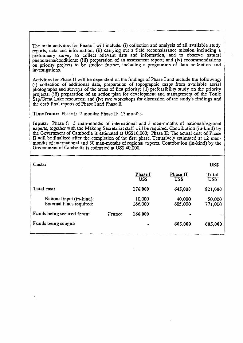
The main activities for Phase 1 will include: (i) collection and analysis of aIl available studyreports, data and infonnation; (ii) carrying out a field reconnaissance mission including apreliminary survey to colleet relevant data and information, and to observe naturalphenomena/conditions; (iii) preparation of an assessmem report; and (iv) recommendationson priority projects to be studied further, including a programme of data collection andinvestigations.
Activities for. Phase II will be dependent on the findings of Phase 1 and include the following:(i) collection of additional data, prepar:ltion of topographie maps from available aerialphotographs and surveys of the areas of first priority; (ii) prefeasibility study on the priorityprojects; (Hi) preparation of an action ·plan for development and management of the TonIeSap/Great Lake resources; and (iv) two workshops for discussion of the study's findings andthe draft final reports of Phase 1and Phase il.
Time fraII1e: Phase 1: 7 months; Phase il: 13 months.
Inputs: Phase 1: 5 man-months of international and 3 man-months of natioIiaVregionalexperts, together with the Mekong Secretariat staff will be required. Contribution (in-kind) bythe Government of Cambodia is estimated at US$10,OOO; Phase II: The actual cost of Phase
. II will be finalized after the completion of the first phase. Tentatively estimated at 12 manmonths of international and 30 man-months of regionaJ experts. Contribution (in-kind) by theGovernment of Cambodia is estimated at US$ 40,000.
US$
Phase II TotalUS$ US$
645,000 821,000
40,000 50,000605,000 771,000
Costs:
Total cost:
National input (in-kind):Extemal funds required:
Funds being secured from:
Funds being sought:
France
Phase 1US$
176,000
10,000166,000
166,000
605,000 605,000
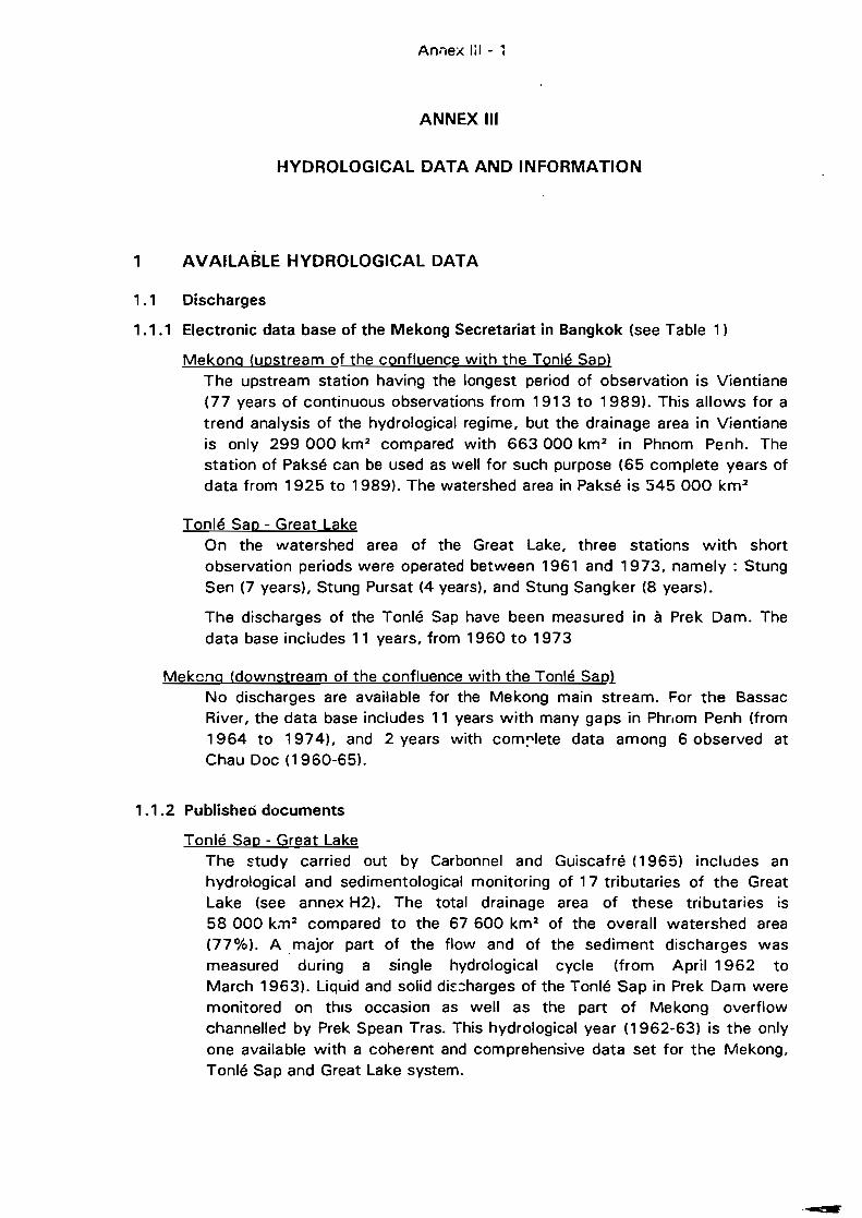
Anôlex Iii - 1
ANNEX III
HYDROLOGICAL DATA AND INFORMATION
1 AVAILABLE HYDROLOGICAL DATA
1.1 Discharges
1.1.1 Electronic data base of the Mekong Secretariat in Bangkok (see Table 1)
Mekonq (upstream of the confluence with the Tonlé Sap)The upstream station having the longest period of observation is Vientiane(77 years of continuous observations from 1913 to 1989). This allows for atrend analysis of the hydrological regime, but the drainage area in Vientianeis only 299 000 km 2 compared with 663000 km 2 in Phnom Penh. Thestation of Paksé can be used as weil for such purpose (65 complete years ofdata from 1925 to 1989). The watershed area in Paksé is 545 000 km 2
Tonlé Sap - Great LakeOn the watershed area of the Great Lake, three stations with shortobservation periods were operated between 1961 and 1973, namely : StungSen (7 years), Stung Pursat (4 years), and Stung Sangker (8 years).
The discharges of the Tonlé Sap have been measured in à Prek Dam. Thedata base includes 11 years, from 1960 to 1973
Mekcnq (downstream of the confluence with the Tonlé Sap}No discharges are availab/e for the Mekong main stream. For the BassacRiver, the data base includes 11 years with many gaps in Phrlom Penh (from1964 to 1974), and 2 years with com~lete data among 6 observed atChau Doc (1960-65).
1.1.2 Publisheo documents
Tonlé Sap - Great LakeThe ~tudy carried out by Carbonnel and Guiscafré (1965) includes anhydrological and sedimentological monitoring of 17 tributaries of the GreatLake (see annex H2). The total drainage area of these tributaries is58 000 k:n 2 compared to the 67 600 km 2 of the overall watershed area(77%). A. major part of the flow and of the sediment discharges wasmeasured during a single hydrological cycle (from April 1962 toMarch 1963). UqlJid and solid di~:::harges of the Tonlé Sap in Prek Dam weremonitored on thls occasion as weil as the part of Mekong overflowchannelleé by Prek Spean Tras. This hydrological year (1962-63) is the onlyone available with a coherent and comprehensive data set for the Mekong,Tonlé Sap and Great Lake system.
hnnex iil . 2
1.2 Water levels
Here we considered only those water levels which have not been convertedinto discharges (these have already been cited in section 1.1
1.2.1 Electronic data base of the Mekong Secretariat in Bangkok (see annex H3)
Mekong (upstream of the confluence with the Tonlé Sap)Mekong in .Phnom Penh: 5 complete years from 1983 to 1988
Tonlé Sap - Great LakeTonlé Sap in Kompong Chhnang. This station is located on the Tonlé Sap40 Km before the inlet (Snoc Trou). As there are no historical records of thelake level, the data of Kompong Chhnang is the best (and the only one)available approximation of the lake level. This approximation willoverestimate the water level of the lako during the Mekong filling phase andunderestimate it during the draining situation. The approximation shouldaround or less than 20 cm for each situation. The data applies to the perioda 1924-1971 period (i.e. 48 years, but only 33 are complete) and to theperiod from 1981 to 1988 (ail years having substantial gaps and 1987 ismissing).
Tonlé Sap in Prek Dam: data with gaps in 1987-88, data complete in 1989.
Mékong (downstream of the confluence with the Tonlé Sap)Bassac in Phnom Penh: 9 cpmplete years over 10, from 1980 to 1989Bassac in Chau Doc: 8 complete years over 11, from 1979 to 1989
The field hydrologists who are aware of the local conditions of the datacollection in the area hava advised using extreme care and suspicion in theanalysis of the water levels of the last decade, as the readings were restartedon gauges which have not been operated since the mid 70's and theappropriate topographical verification of the gauge levels with the datum hasnot necessarily been carried out.
1 .2.2 Non-edited documents
Such documents have been collected in Phnom Penh during the inception visitof the expeit.Mekong.
Stung Treng (1991, 1992)Kratié (1991 and 1992 up to September, 18)Kompong Cham (1992)Chrui Changvar (1992, since May). New gauge installed at the pumping
station site).
Stung Sen at Kompong Thom (1981-921
Tonlé Sap· Great LakeTonlé Sap in Prek Dam (1992)Phnom Penh Port (1992, starting July)
Ar:nex IIi - 3
BassacChakdomuk (1992)
This gives evidence of a modest restart of the hydrological activities during thetwo past years. However, the information is still incomplete (i.e. no dischargesare available).
1.3 Hydrological stations used for the calculation of the inflow to the Great Lakeduring year 1962-63 (Carbonnel and Guiscafré's study)
River Station Watershedarea (km 2 )
Stung Babaur Babaur RN5 869Stung Krakor Krakor RN5 138Stung Kompong Lar Thuot-Chum RN5 420Stung Pursat Pursat RN5 4480Stung Dauntry Maung RN5 835Stung Sangker Battambang 3220O-Nhor O-Nhor RN5 51Stung Mongkol Borey Mongkol Borey RN5 4 170Stung Sisophon Sisophon RN6 4310O-Phranet Preah Beng Chhouk RN6 1 670Stung Sreng Kralanh RN6 8 175Stung Phleang Phleang RN6 96Stung Roluos Kompong Thkau RN6 281Stung Chikreng Kompong Kdey RN6 1 920Stung Staung Kompong Chen RN6 1 895Stung Sen Kom pong Thom RN 6 13670Stung Chinit Kompong Thmar RN6 4 130
Tonlé Sap Prek Dam 85000Spean Tras PK54 RN6 n.s.
1.4 Rainfall
At this stage of the study, the rainfall informé'tion can be used to verifychanges or trends in the c\imate. The electronic data base of the MekongSecretariat includes rainfall data. Unfortunately the data for Cambodia refersonly to the 1960-74 period. There is also a paper file with data collected I"-efore1965. The oldest rainfall station is Pochentong airpo.t, which has beenoperational since 1911. 48 years of data are available between 1911 and 1964while 8 years are missing.
The monthly rainfall of Potchentong has been re-published by IRRI for the lastyears (1989-91) and collected during the inception mission in Phnom Penh.
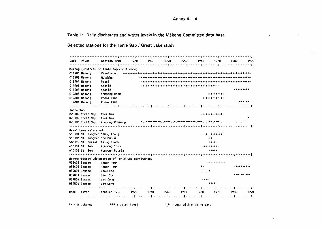
Annex III - 4
Table 1: Daily discharges and woter levels in the Mékong Committee data base
Selected stations for the Tonlé Sap 1Great Lake study
_._-_. __ ..._---------- .. -.--.(-_._ .. -_.(-_.- ..-.. (---------(---------(--_ ....-.(----_.---(---._-._-(-_._--_ .. (
Code river station 1910 1920 1930 1940 1950 1960 1970 1980 1990._----_.-------. __ .__ ._-----.(-.-------(---.-----(.--.-----(---------(--_. __ ._.(-_.-_.-.-(---------(--.------(Mékong (upstream of Tonlé Sap confluence)011901 Mékong Vientiane +++++++++++++++++++++++++++++++++++++++++f+++++++++++++++++++++++++++++++++++
013402 Mékong Mukdahan -.+++++++++++++++++++++++++++++++++++++++++++++++++++++++++++++++++013901 Mékong Paksé -.+++++++++++++++++++++++++++++++++++++++++++++++++++++++++++++++++014901 Mékong Kratié .++++-+++++++++++++++++++++++++++++++++++++++.-014901 Mékong Krat ié ...019803 Mékong Kompong Cham ++++++++++-019801 Mékong Phnom Penh -+++++++++++++-
9801 Mékong Phnom Penh ••• -••_.-_.--_. __ ._-_._ .. _._----_ .. (-----_._-(---_.-_.-(----_._--(._-_ ..-.. (----.----(._-------(----_._--(------_._(Tonlé Sap020102 Tonlé Sap Prek Dam -+++++++-++++.020102 Tonlé Sap Prek Dam _o.020103 Tonlé Sap Kompong Chhnang .-- ••••••••• -- ••••• -.- ••••••••••• -•••• --- •• -••• -. .---- •.-_._---_._---_._ .._----------(-._-.----(.- ... ----(--_.--_._(--.-----.(--_ .. ----(._._--_.-(_ .. _-- ... (--.---_._(
Great Lake watershed550101 St. Sangker Stung Treng +--+++++++.550103 St. Sangker Sre Punlu +++580102 St. Pursat Taing Luoch ++++-610101 St. Sen Kompong Thom .++-+++++-610102 St. Sen Kompong Put réa +++++-_ .. ----------- .. -._-.-------(----_.-.-( .. -_.-._-(--.---_._(-----._._(-------.-(.- .. -_ .. _(---------(---------(Mékong-Bassac (downstream of Tonlé Sap confluence)033401 Bassac Phnom Penh . - -. - -. - - --033401 Bassac Phnom Penh •• -•••••••••039801 Bassac Chau Doc -+- ••+039801 Bassac Chau rloc •••• -•• -•••039804 Bassa.. Van; ;:ong039804 Bassac V",m Cong ••••--_ .. _._.-._-.---_._-------_._(- ..... _--(_ .. _.-_.-(--._ .. _.-(-----.- .. ( ... -.--_.(.-- .. __ .. (---_ .. _--( .. _---- .. (
Code river stet ion 1910 1920 1930 1940 1950 1960 1970 1980 1990••• --.-.--.-- ••• -.---.-.-----(.--------(-- •• --- .. (-.--··-··(-·-------(·-·--·---(····--···(--·-·-·--(------·--1
"+ : Discharge Il.'' : Water level "_" : year with missing data
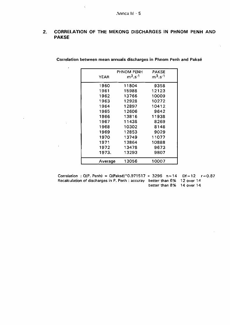
.\nnc::< III - 5
2. CORRELATION OF THE MEKONG DISCHARGES IN PHNOM PENH ANDPAKSE
Correlation between mean annuals discharges in Phnom Penh and Paksé
PHNOM PENH PAKSEYEAR m 3.s-1 m3.s-1
1960 11804 93581961 15988 121231962 13766 100091963 12928 102721964 12897 104121965 12606 96421966 13816 119381967 11438 82691968 10302 81481969 12853 90291970 13749 110771971 13864 108881972 13478 96731973. 13293 9807
,Average 13056 10007
Correlation : Q(P. Penh) = Q(Paksé)*O.971517 + 3296 n = 14Recalculation of discharges in P. Penh: accuray better than 6%
better than 8%
Df= 12 r=O.8712 over 1414 over 14
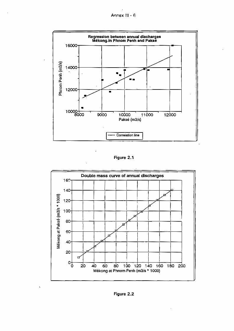
Annex III • F.
Regression between annual dlschargesMékong. ln Phnom Penh and Paksé
16000,....----.,...-----.,...------;-----~____,
1200010000 11000Paksé (m3/s)
9000
-~g 14000
! l..§ 12000+-------:::>--F----.....;----...:..--+-------+---l
~ . 1
10000+--..,....--+--..,....--+--.,...--+---.,...--.;.----1SOOO
1- Correlation line 1
Figure 2.1
Double mass curve of annual dlscharges160.,----:----:---.,---.,---,.---..--..--..--,.--.,
140+--+--+--+--;--+--+--+--+-~P---l
8~ 120+--+---f--+---f---!--+--+-~+--+-~
'"~ 100+---+---+--+---+---r---h.r-+--+--+-----j
g 1
~ SO+---r--i-----ir-----:----7-"1--+--+---+--~--i
~ 1ëii 60+---r---;----:-----:7'7---:---..--7--+---+----l
l 40+--...,.--+-""""""+--...:..--.;--~-7-1--i---+--~~ 1
20+--~,,--+--..;......-..;......-+--+---+-1--+---+----l1
1O+--+--~--;----;---"---+---r--+---+----l
o 40 60 SO 100 120 140 160 1SO 200Mékong at Phnom Penh (m3/s * 1000)
Figure 2.2
Anilex (II - 7
3. MAJOR DEVElOPMENT SCHEMES IN OPERATION ON THE lOWERMEKONG BASIN
Country Project Name Year of Installed Irrigation Active
Completion CapaCÎty Storage
KW ha 106 m3
Lao PDR Lower Se Done 1970 2500 run-off
Lao PDR Nam Dong 1971 1 250 negligible
Lao PDR Nam Ngum 1 1971 30000
Lao PDR Nam Ngum Il & III 1978 & 1987 120000 run-off
Thailand Nam Pung 1967 6 :i00 1.55
Thailand Nam Pong 1966 25000 53000 1 695
Thailand Lam Phra Plerng 1967 10500 145
Thailand Lam Pao 1968 54000 1 260
Thailand Lam Takong 1970 38000 290
Thailand Lam Dom Noi 1971 24000 24000 1 135
Thailand Nam Phrom 1972 40000
Thailand Nam Don 1973 32500 145
Thailand Huai Luang 1979 12800 113
Thailand Huai Mong 1986 8700 26
Thailand Huai Pa Thao 1992 4800 2400
Vietnam Huong My 1987 3800 pumping
Vietnam Drayling 1987&1993 12000 run-off
Vietnam Tarn Phuong 1989 5900 pumping
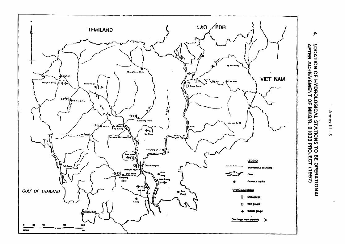
·A~nex
III•
g
4.
LO
CA
TIO
NO
fH
YD
RO
LO
GIC
AL
ST
AT
ION
ST
OB
EO
PE
RA
TIO
NA
lA
FT
ER
AC
HIE
VE
ME
NT
Of
MK
G/R
.9
10
38
PR
OJE
CT
(19
97
)
f+
91]i
ttl
1~
li~JJJ'
!~
-c
...1
.!
i-
~l
'~._y,J
tt.,
__,.............--->lI"",~"
".•"
,"--~C\..."",<';..1\""'-''/,.i'
(··Z''-7l
./.~
'tJ•.,....,;
Il..."
,•
C,,,.I
t
A~nex
III•
g
4.
LO
CA
TIO
NO
fH
YD
RO
LO
GIC
AL
ST
AT
ION
ST
OB
EO
PE
RA
TIO
NA
LA
FT
ER
AC
HIE
VE
ME
NT
Of
MK
G/R
.9
10
38
PR
OJE
CT
(19
97
)
IrJ
J~:~.h
~~~~
fJ
'"91J
!t
t1
1~
Il~JJJ'
~-
0+
l]~•
1
-.A
......
~~C\...""<'l..1....,.._.'/..i'
('·Z''-l
l./'
~'t
J'''-~~.rl
.,.
•c'
J.
']1!11
"-'::::=
...."If
c~~ ~.~
J'•
1
'"":\
l.
.tir'
~.
·rJ
{)1l1~).Jt\t.,)
-t'~
\'F
t:"':J)
......
-J
'..~'...r-
.....oS
"\~}
//l..~-~
J '..-.,
a-=::J
1\,...--,.--'"
~
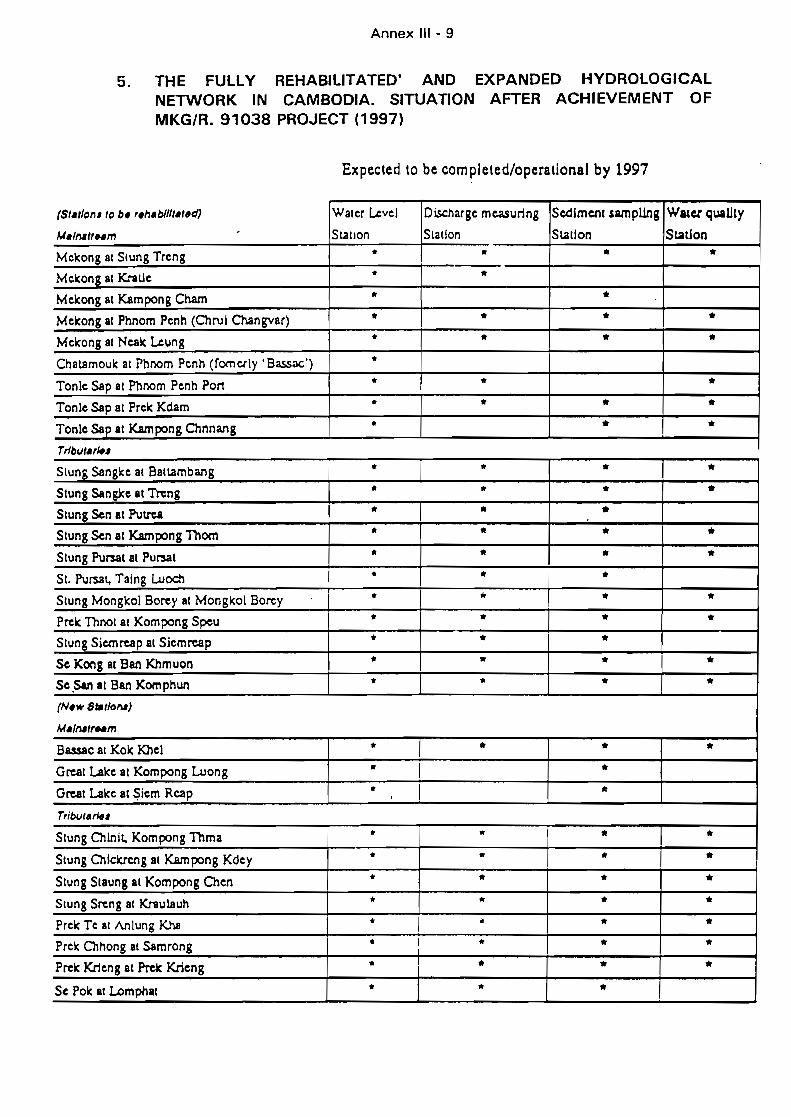
5.
Annex III - 9
THE FULLY REHABILITATEO' ANDNETWORK IN CAMBODIA. SITUATIONMKG/R. 91038 PROJECT (1997)
EXPANOEO HYDROLOGICALAFTER ACHIEVEMENT OF
Expected ta be completed/aperatianal by 1997
(S'.'/Ofl' 10 b. r.h.bllIt.'.d) Waler Level Dischargc measuring Sedlmenl sampUng Watel qua1Jty
M.lflIlfNm Stallon Slallon Station Station
Mekong at Stung Treng * • • *Mekong at Kralle * *Melcong al Kampong Cham • *Melcong al Phnom Penh (Chrul Changvar) * • * *Melcong al Neak Leung * * * *Cha18moulc al Phnom Penh (fomerly .Bassoc') 1 *Tonie Sap al Phnom Penh Pon * * *Tonie Sap al Prek Kdam * * * *Tonlc Sap al l<.ampong Chnnang * * *Trlbul.r~'
Slung Sangke at Battambang * • * *Stung SangXc at Tteng * * * *Slung Sen al Putrea * • *Stung Sen allûmpong Thom * * * *Slung ?urssl al Pursal * * * *SI. ?u~t, Taing Luoch * * *Stung Monglt:ol Borey al Mongkol Borey * • * *Prek Thnot al Kompong Speu * * * *Slung Siemreap al Siemreap * * *Sc Kong al Ban Khmuon * .. * *Sc.San al Ban Komphun * * * *(N.w Statlofll)
M./Mlr..m
Ba.ssac at Kok Khel * * * *GreaI Lalce al Kompong Luong • *GreaI Lalce al Siem Reap * li:,
Tribut."',
Slung Chlnit, Kompong Thma * 1 * * *Stung Chlclcrcng al K.ampong Kdey * * * *Slung Slaung al Kompong Chen * * * *Stung Sreng at KrsulJluh * • * *Prelc Te al Anlung Kha * JI * *Prelc Chhong at Samrong * 1 • * *Prelc Krieng al Prelc Krieng • * * *Sc Pole al Lomphal * • *
Annex IV - i
ANNEX 4 :
ON GOING AND PROPOSED PROJECTS OF THE MEKONG COMMITTEERElATED WITH THE DEVElOPMENT OF TONlE-SAP - CHAKDOMUK AREA
A FUNDED
A.1 Having significant part of the activities to be carried out on the Tonlé Sap Project area
MKG/R.91040 Aerial Photography for Resource Mapping (Cambodia)
MKG/R.910S7/Rev.1 Review and Assessment of Water Resources for Hydropower andIdentification of Priority Projects (Cambodia)
MKG/R.91072/Rev.2 Irrigation Rehabilitation Study in Cambodia
MKG/R.910S0 Assessment and Management of the Freshwater CaptureFisheries of Cambodia (phase 1)
MKG/R.90016/Rev.2 Water Resources Training Programme :Cambodian Component.(partly funded)
A.2 Projects with strong links with the Tonlé Sap Project, but major part of the activities andresults outside the project area. Nevertheless shall take into account the Tonlé SapProject findings and constraints
MKG/R.90042 Salinity Forecasting in the Mekong Delta
MKG/R.88011 Water Quality Monitoring Network ln the Lower Mekong Basin,Phase Il (Basinwide).
MKG/R.8604S/Rev.1 Control of Soil Erosion, Sedimentation, and Flash Flood Hazards(Basinwide)
MKG/R.90011 Integration of Environmental Components in Projects (Basinwide)
MKG/R.870S3/Rev.2 Master Plan for the Integrated Development of the Mekong Delta(Viet Nam)
MKG/R.890S6 Integrated Development of the Lower Mekong Basin (Basinwide)
MKG/R.89017 Low Pa Mong Multipurpose Project (E.asinwide)
MKG/R.91048
MKG/R.91066
MKG/R.89019 Assessment and Monitoring of the Mekong Basin Forest Coyer(Basinwide)
MKG/R.88009 Mekong Watershed Assessment and Management (Basinwide)
MKG/R.89021 Environmental Training Fund (Basinwide)
Annsx IV - 2
ANNEX 4 (continued) :
ON GOING AND PROPOSED PROJECTS OF THE MEKONG COMMITTEERELATED WITH THE DEVELOPMENT OF TONLE-SAP - CHAKDOMUK AREA
B SEEKING FUNDS
B.1 Having significant part of the activities to be carried out on the Tonlé Sap Project area
MKG/R.91038/Rev. t Rehabilitation and Development of the Hydro-MeteorologicalNetwork in Cambodia
MKG/R.91039/Rev.2 Mekong Geographie Information System. Cambodian Component
MKG/R.91068 Inventory and Management of the Cambodian Wetlands
MKG/R.91074 Feasibility Study to update the Stung Mongkol Borey IrrigationScheme, Phase 1 (Cambodia)
MKG/R.92072 Protection Works to the Monivong Bridge (Cambodia)
B.2 Projects with strong links with the Tonlé Sap Project, but major part of theactivities and results outside the project area. Nevertheless shall take into accountthe. Tonlé Sap Project findings and constraints
MKG/R.90029/Rev.1 Water Balance of the Lower Mekong Basin
MKG/R.91037 Imp'rovement of the Hydro-meteorological Network (Basinwide)
MKG/R.92044 Assessment of the Impact of Deforestation on Runoff (Basinwide)
MKG/R.92063 Management of Regional Fisheries Resources (Basinwide)
MKG/R.8800 1 Assessment of Impacts of Water Management on FisheryResources.