Embed Size (px)
Citation preview
Development of Site Specific Climate Scenarios for River and Sediment Discharge using Macrophysical Climate Models: An Example From Puerto Rico
1Paula E. Allen and Samantha W. Kaplan2
1Unites States Environmental Protection Agency, Office of Research and Development, Landscape Ecology Branch, 944 E Harmon Ave., Las Vegas, NV 89119, [email protected]
2Department of Geography and Geology, University of Wisconsin Stevens Point, Stevens Point, WI 62703Abstract
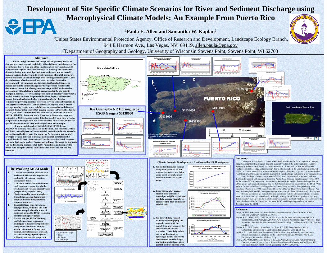
Climate change and land use change are the primary drivers of changes in ecosystem services globally. Global climate models suggest that in the future Puerto Rico and other small islands in the Caribbean will experience changes in rainfall seasonality. It is anticipated that water demands during low-rainfall periods may not be met, and an overall increase in river discharge due to greater amounts of rainfall during wet periods will cause increased damage from flooding and landslides. Land derived sources of sediment and nutrients carried to the marine environment by streams may also increase significantly. Changes in stream flow due to climate change may have profound effects on the downstream production of ecosystem services provided by the marine environment. Global climate models cannot predict the site specific changes in rainfall. However, site specific rainfall data is precisely what is needed in order to assess the potential localized impacts of increased stream flow and sediment discharge on reefs and other benthic communities providing essential ecosystem services to island populations. The Bryson Macrophysical Climate Model (MCM) was used to model average monthly temperature, rainfall and its seasonality, and river and sediment discharge for nine USGS gauging stations in Puerto Rico for the past 14,000 years. Temperature and rainfall was calibrated to NOAA HCDN 1961-1990 climate normal's. River and sediment discharge was calibrated to USGS gauging station data downloaded from their website. We provide an example from one of our modeled river basins, of how site specific climate scenarios may be developed from MCM output.
Hydrologic models such as SWAT, SEDMOD/RUSLE, or AnnAGNPS use daily rainfall data as model input. We chose the wettest and driest years (highest and lowest rainfall years) from the MCM results for the Guanajibo River near Hormigueros. As these data are monthly averages, we used the ratio of average daily rainfall to total monthly rainfall for the 30 year climate normal's to derive daily rainfall datasets for use in hydrologic models. Stream and sediment discharge for the basin was modeled using modern (1961-1990) rainfall data and compared to model runs using the derived rainfall data for today and wet and dry scenarios.
ReferencesBerger, A. 1978. Long term variations of caloric insolation resulting from the earth’s orbital
elements. Quaternary Research 9:139-167.Bryson, R.A., DeWall, K.M., 2007. An introduction to the Archaeoclimatology macrophysical
climate model. In: Bryson, R.A., DeWall, K.M. (Eds.), A Paleoclimatology Workbook: High Resolution, Site-Specific, Macrophysical Climate Modeling. The Mammoth Site, Hot Springs, SD, pp. 3–11.
Bryson, R.A., 2005. Archaeoclimatology. In: Oliver, J.E. (Ed.), Encyclopedia of WorldClimatology. Encyclopedia of Earth Series. Springer, New York, pp. 58–63.
Hopkins, E.J. 1985. Analysis of Astronomically-induced monthly and zonally averaged extra-atmospheric irradiance variations for the earth over the last 500,000 years. PhD thesis, University of Wisconsin – Madison, 919p.
Warne, A.G., Webb, R.M.T., and Larsen, M.C., 2005, Water, Sediment, and Nutrient Discharge Characteristics of Rivers in Puerto Rico, and their Potential Influence on Coral Reefs: U.S. Geological Survey Scientific Investigations Report 2005-5206, 58 p.
SummaryThe Bryson Macrophysical Climate Model provides site-specific, local response to changing
circulation regimes within a region. It is site specific by virtue of the fact it implicitly considers topography and other local factors via calibration to local climate stations. The MCM has been validated with paleoecology and archaeology data at sites throughout the world (Bryson & DeWall 2007). In contrast to the MCM, the resolution (1-2 degrees of lat/long) of general circulation models (GCM) make GCMs unsuitable for local questions of climate change particularly in mountainous areas.
Using the Bryson Macroclimate Model (MCM) we modeled rainfall, stream and sediment discharge for several USGS gauging stations in Puerto Rico. We used climate normal's (1961-1990) for the nearest NOAA cooperative climate station obtained from NOAA. Stream discharge data for USGS gauges and sediment discharge data for 4 of these stations were obtained from the USGS NWIS website. Stream and sediment discharge data for Puerto Rican basins that have previously been calculated (Warme et al. 2004) were obtained from the USGS Caribbean Water Science Center. We used the Guanajibo River NR Hormigueros gauge as an example of our climate scenario development.
Because our models are calibrated to local conditions, realistic site specific climate scenarios based on site histories can be developed . Although currently the MCM is not predictive, by using daily to monthly average ratios for rainfall normal's data can be used in hydrologic models that consider current land use and soils. Future work includes SWAT modeling using the climate scenarios developed using the MCM.
The Working MCM Model1. Uses measured solar radiation as it
varies with Milankovitch cycles and probability of volcanic eruptions (Volcanicity Index)
2. Calculates net surface radiation for each hemisphere using the albedo, irradiance and volcanic aerosol values (Berger 1978; Hopkins, 1985).
3. Derives monthly mean hemisphere temps from seasonal hemisphere temps and modern mean surface temps as a control.
4. Calculates large scale meridional temp gradients, combines this with modern synoptic data (locations of centers of action like ITCZ, etc.) using monthly hemisphere temps.
5. Creates site specific MCMs using multiple non-linear regression techniques to link modern positions of the synoptic features to monthly weather station data (temperature, rainfall, storm frequency, snowfall, etc) and stream gauge data (river, sediment, nutrient discharge etc.).
Volcanicity Index
0.00
0.50
1.00
1.50
2.00
2.50
3.00
-15000 -13000 -11000 -9000 -7000 -5000 -3000 -1000
14C Calibrated Years BP
Ind
ex
JET 120W
• North Pacific High• ITCZ• Jet Stream• Azores High
0
20
40
60
80
100
120
140
160
-16000 -14000 -12000 -10000 -8000 -6000 -4000 -2000 0
Calendar Years BP
Jan
uary
Pre
cipi
tati
on
mm
050100150200250300350400450500
Precipitation History
July Precip
itation mm
Jan Jul
29
29.2
29.4
29.6
29.8
30
30.2
30.4
-16000 -14000 -12000 -10000 -8000 -6000 -4000 -2000 0
Calendar Years BP
Janu
ary
Tem
p. D
egre
es C
31.4
31.6
31.8
32
32.2
32.4
32.6
32.8
33
Temperature History
July Tem
p. D
egrees C
Jan Jul
Rio Guanajibo NR HormiguerosUSGS Gauge # 50138000
0
10
20
30
40
50
60
70
80
-16000 -14000 -12000 -10000 -8000 -6000 -4000 -2000 0
C alend ar Y ears B P
An
nua
l Ave
rag
e D
isch
. m^3
/s
0
10
2 0
3 0
4 0
50
6 0
70
8 0
River Discharge History
Su
mm
er Ave. D
isch. m
^3/s
Annual Ave Jul-Aug Ave
50138000
0
20
40
60
80
100
120
140
160
180
-16000 -14000 -12000 -10000 -8000 -6000 -4000 -2000 0
Calendar Years BP
Ann
ual
Sto
rms
0
5
10
15
20
25
30
35
Storm History
Su
mm
er Storm
s
Annual Sum Jul-Aug Sum
Climate Scenario Development – Rio Guanajibo NR Hormigueros
50131990
50136400
MODELED ANNUAL MARCH OF PRECIPITATIONRIO GUANAJIBO NR HORMIGUEROS
0.0050.00
100.00150.00200.00250.00300.00350.00400.00
Jan Feb Mar Apr May Jun Jul Aug Sep Oct Nov Dec
MONTH
PR
EC
IPIT
ATI
ON
(m
m )
WET (5,800 BP) NORMALS DRY (10,000 BP) TODAY
Modeled Annual Rainfall for Climate Scenarios and Climate Normals (1961-1990)
1,950
2,000
2,050
2,100
2,150
2,200
2,250
2,300
2,350
2,400
DRY (-10000) NORMALS TODAY WET (-5800)
An
nu
al R
ain
fall
(mm
)
PUERTOPUERTOPUERTOPUERTO RICORICORICORICO
50136400
Reef Locations of Puerto Rico
Derived Daily Rainfall Estimates
0.00
2.00
4.00
6.00
8.00
10.00
12.00
14.00
0 50 100 150 200 250 300 350 400
Days of the Year
Rai
nfa
ll (m
m)
TODAY WET SCENARIO DRY SCENARIO
Rio Rosario NR Hormigueros
0
0.2
0.4
0.6
0.8
1
1.2
1.4
1.6
1.8
2
-16000 -14000 -12000 -10000 -8000 -6000 -4000 -2000 0
Calendar Years BP
Ann
ual
Ave
rage
Dis
ch.
m^3
/s
0
0.5
1
1.5
2
2.5
3
3.5
4
River Discharge History
Su
mm
er Ave. D
isch. m
^3/s
Annual Ave Jul-Aug Ave
Rio Rosario NR Hormigueros
0
10
20
30
40
50
60
70
80
90
100
-16000 -14000 -12000 -10000 -8000 -6000 -4000 -2000 0
Calendar Years BP
Jan
uar
y P
rec
ipit
atio
n m
m
0
50
100
150
200
250
300
350
400
450
500
Precipitation History
July P
recip
itation
mm
Jan Jul
Rio Rosario NR Hormigueros
0
0.5
1
1.5
2
2.5
-16000 -14000 -12000 -10000 -8000 -6000 -4000 -2000 0
Calendar Years BP
An
nual
Ave
rage
Dis
ch. m
^3/s
0
1
2
3
4
5
6
7
8
9
Sediment Discharge History
Sum
mer A
ve. Disch. m
^3/s
Annual Ave Jul-Aug Ave
Rio Guanajibo at HWY 119 at San German
0
2
4
6
8
10
12
14
16
-16000 -14000 -12000 -10000 -8000 -6000 -4000 -2000 0
Calendar Years BP
An
nual
Ave
rage
Dis
ch. m
^3/s
0
2
4
6
8
10
12
14
16
River Discharge History
Sum
mer A
ve. Disch
. m^3/s
Annual Ave Jul-Aug Ave
Rio Guanajibo at HWY 119 at San German
0
10
20
30
40
50
60
70
-16000 -14000 -12000 -10000 -8000 -6000 -4000 -2000 0
Calendar Years BP
Janu
ary
Pre
cip
itat
ion
mm
020040060080010001200140016001800
Precipitation History
July Precipitation
mm
Jan Jul
RIO FAJARDO NR FAJARDO
0
20
40
60
80
100
120
140
-16000 -14000 -12000 -10000 -8000 -6000 -4000 -2000 0
Calendar Years BP
Jan
uar
y P
reci
pit
atio
n
mm
0
50
100
150
200
250
300
Precipitation History
July P
recipitatio
n mm
Jan Jul
1. We modeled monthly rainfall using the Bryson MCM and selected the wettest and driest years based on total annual rainfall over the last 10,000 years.
2. Using the monthly average rainfall from the climate normal period (1961-1990) and the daily average normal's we calculated the daily to monthly rainfall ratio.
3. We derived daily rainfall estimates by multiplying the normal's ratios with the modeled monthly averages for the chosen wet and dry scenarios. These daily values can be used as input to hydrologic models in order to determine stream discharge and sediment discharge given present land use and soil type.
RIO FAJARDO NR FAJARDO
0
0.05
0.1
0.15
0.2
0.25
-16000 -14000 -12000 -10000 -8000 -6000 -4000 -2000 0
Calendar Years BP
Ann
ual A
vera
ge D
isch
. m
^3/
s
0
0.1
0.2
0.3
0.4
0.5
0.6
River Discharge History
Su
mm
er Ave. D
isch. m
^3/s
Annual Ave Jul-Aug Ave
RIO FAJARDO NR FAJARDO
0
0.5
1
1.5
2
2.5
3
-16000 -14000 -12000 -10000 -8000 -6000 -4000 -2000 0
Calendar Years BP
An
nual
Ave
rag
e D
isch
. K
g/s
0
1
2
3
4
5
6
7
Sediment Discharge
Sum
mer A
ve. Disch
. kg/s
Annual Ave Jul-Aug Ave
Rio Portugues NR Tibes
0.00
0.20
0.40
0.60
0.80
1.00
1.20
1.40
1.60
0-2000-4000-6000-8000-10000-12000-14000-16000
Calendar Years BP
An
nu
al A
ve
Dis
ch
arg
e (m
^3
/s
0.00
0.10
0.20
0.30
0.40
0.50
0.60
0.70
River Discharge
Su
mm
er D
isc
ha
rge
(m^
3/s)
Jul-Aug Ave Annual Ave
RIO PORTUGUES NR TIBES (TIBES)
0
5
10
15
20
25
30
-16000 -14000 -12000 -10000 -8000 -6000 -4000 -2000 0
Calendar Years BP
Jan
uar
y P
rec
ipit
atio
n m
m
0
1000
2000
3000
4000
5000
6000
Precipitation His tory
July P
recipitatio
n m
m
Jan Jul
50114900
RIO PORTUGUES NR TIBES (TIBES)
0
5
10
15
20
25
30
35
40
45
50
55
-16000 -14000 -12000 -10000 -8000 -6000 -4000 -2000 0
Calendar Years BP
An
nual
Ave
rage
Sed
imen
t Dis
ch.
Kg/
s
0
5
10
15
20
25
Sediment Discharge History
Sum
mer A
ve. Disch
. m^3/s
Annual Ave Jul-Aug Ave
A-D point to sediment plumes discharging from major rivers. Photo from Warne et al 2004