Embed Size (px)
Citation preview
DEVELOPMENT OF AN UNDERGROUND INJECTION WELL
GEOGRAPHIC INFORMATION SYSTEM FOR WYOMING
Jeffrey D. Hamerlinck Victor R. Hasfurther Scott Needham
Final Report 1993
WWRC-93-22
Wyoming Water Resources Center University of Wyoming
Laramie, Wyoming 82071
Prepared for:
Underground Injection Control Program Wyoming Department of Environmental Quality
Water Quality Division Herschler Building
Cheyenne, Wyoming 82002
December, 1993

Contents of this publication have been reviewed only for editorial and grammatical correctness, not for technical accuracy. The material presented herein resulted from research sponsored by the Wyoming Department of Environmental Quality, Water Quality Division, through the Wyoming Water Resources Center, however views presented reflect neither a consensus of opinion nor the views or policies of the Wyoming Department of Environmental Quality, the Wyoming Water Resources Center, or the University of Wyoming. Explicit findings and implicit interpretations of this document are the sole responsibility of the author(s).
ACKNOWLEDGEMENTS
This project was made possible by a USEPA Office of Drinking Water grant
administered by the Wyoming Department of Environmental Quality, Water Quality
Division (Contract ~33600033 1FS). The authors wish to recognize Robert Lucht,
Wyoming UIC Program Supervisor, for his technical assistance throughout the
duration of the project. Further appreciation is extended to WWRC GIS technicians
Laisan Serebryakov and Dave Wrazien for their assistance with database development
and cartographic production.
Questions or requests for additional information regarding this document should
be directed to Jeff Hamerlinck or Scott Needham, Wyoming Water Resources Center
GIS Lab, University of Wyoming, Laramie, Wyoming 82071.
ii
TABLE OF CONTENTS
ACKNOWLEDGEMENTS
Page
ii
TABLE OF CONTENTS iii
LIST OF TABLES V
CHAPTER I: INTRODUCTION 1
Purpose 1
Underground Injection Regulation 1
Scope 1
CHAPTER 11: FACILITY BACKGROUND DATA COLLECTION AND LOCATION DETERMINATION 5
Federal UIC Reporting System 5
Permit File Data 6
Data Accuracy 7
Location Mapping
CHAPTER III: FACILITY LOCATION INVESTIGATION
8
10
CHAPTER IV: INJECTION FACILITY DIGITIZATION AND MAPPING 11
Countywide Digitization TIGER-based Digital Basemaps
11 11
... ll1
TABLE OF CONTENTS (continued)
Address Geocoding Digitization Techniques
Large- Scale Plat Map Digi tiza tion
Database Design NEW-FURS Database MSDE Database Class1 Database
CHAPTER V: DATABASE SUMMARY
APPENDIX A:
APPENDIX B:
APPENDIX C:
APPENDIX D:
APPENDIX E:
APPENDIX F:
APPENDIX G:
12 13
13
14 14 15 15
17
CLASS V INJECTION WELL SUBCLASSES 21
FURS DATABASE FILE STRUCTURE 24
INJECTION FACILITY LOCATION INVESTIGATION PRIORITY LIST 27
MSDE DATABASE FILE STRUCTURE AND FIELD DEFINITIONS 33
CLASS1 DATABASE FILE STRUCTURE AND FIELD DEFINITIONS 41
INJECTION FACILITY COVERAGE NAMING CONVENTIONS AND FILE STRUCTURE 57
INJECTION FACILITY COVERAGE RECORDS 85
iv
LIST OF TABLES
Table
1 Injection Well Classes
2 Wyoming UIC Facilities
Page
3
6
V
CHAPTER I
INTRODUCTION
PURPOSE
In 1988, the Underground Injection Control (UIC) Branch of the U.S.
Environmental Protection Agency's (USEPA) Office of Drinking Water initiated a
five-year effort to develop a, " ... national, decentralized UIC information system,"
(USEPA 1990; USEPA 1991a). Recent "minimum data set" guidance documents
associated with the now established UIC Data Management System stipulated that all
UIC regulatory agencies work toward establishing and maintaining a spatially-
referenced digital database containing geographic coordinate location information for
all UIC facilities. prior to establishment of this mandate, location information for UIC
facilities in Wyoming was only available in hardcopy format, and, to a limited extent,
digital tabular files. In July 1992, the Wyoming Department of Environmental Quality
(DEQ) contracted with the Wyoming Water Resources Center (WWRC) at the
University of Wyoming to create an underground injection well geographic
information system (GIs) database for the Wyoming DEQ's Underground Injection
Control (UIC) Program. Dates of the contract were August 1, 1992 to June 30, 1993,
with project work carried out by the WWRC GIS Lab over a 12-month period,
September 1992 through August 1993. This document is the project's final report,
detailing the methods employed and results obtained from the development of the GIs.
UNDERGROUND INJECTION REGULATION
The practice of underground injection has increasingly become essential to
many of today's industries, including the petroleum and chemical industries, food and
product manufacturing companies, geothermal energy development and a wide variety
1
of local small specialty plants and retail establishments (Osborne 1991). Responding
to the realization that subsurface injection could contaminate groundwater, the Safe
Drinking Water Act (SDWA) of 1974 established a federal Underground Injection
Control (UIC) program for regulating the subsurface emplacement of fluids through
injection wells. The goal of the federal regulations is to prevent contamination of
Underground Sources of Drinking Water (USDW). A USDW is defined as an aquifer
or portion of an aquifer which:
A) supplies any Public Water System; or
B) contains a sufficient quantity of ground water to supply a Public Water System; and
1) currently supplies drinking water for human consumption; or
2) contains fewer than 10,OOO mg/l total dissolved solids, unless exempted by special provisions of the SDWA (Osborne 1991).
The United States Environmental Protection Agency (USEPA) has delegated
primary regulatory authority to those states that have demonstrated an ability to
implement UIC programs that meet USEPA requirements defined under Section 1422
or 1425 of the SDWA. In many states, primary UIC regulatory authority is shared
between two or more agencies. In states that have not received primacy, the
responsible regulatory agency is the USEPA (UIPC 1990a).
All primacy requirements for UIC program regulation have been met in
Wyoming. The state UIC program for Class I1 wells has been administered by the Oil
and Gas Conservation Commission in Casper since 1982; the state UIC program for
Class I, III, IV and V wells has been administered by the Water Quality Division of
the Department of Environmental Quality in Cheyenne since 1983 (Western Water
Consultants 1986).
As noted above and defined by USEPA UIC Program regulations, injection
facilities are divided into five distinct categories, based on common design and
operating technique. The principal factor originally used to define the classes is the
type of activity and the nature of associated injection fluids. A secondary factor used
2
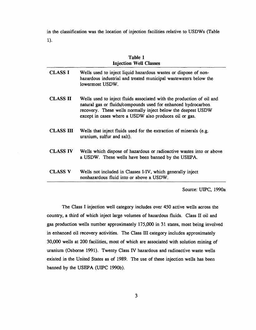
in the classification was the location of injection facilities relative to USDWs (Table
1).
Table 1 Injection Well Classes
CLASS I
CLASS I1
CLASS III
CLASS IV
CLASS V
Wells used to inject liquid hazardous wastes or dispose of non- hazardous industrial and treated municipal wastewaters below the lowermost USDW.
Wells used to inject fluids associated with the production of oil and natural gas or fluids/compounds used for enhanced hydrocarbon recovery. These wells normally inject below the deepest USDW except in cases where a USDW also produces oil or gas.
Wells that inject fluids used for the extraction of minerals (e.g. uranium, sulfur and salt).
Wells which dispose of hazardous or radioactive wastes into or above a USDW. These wells have been banned by the USEPA.
Wells not included in Classes I-IV, which generally inject nonhazardous fluid into or above a USDW.
Source: UIPC, 1990a
The Class I injection well category includes over 450 active wells across the
country, a third of which inject large volumes of hazardous fluids. Class I1 oil and
gas production wells number approximately 175,000 in 31 states, most being involved
in enhanced oil recovery activities. The Class III category includes approximately
30,000 wells at 200 facilities, most of which are associated with solution mining of
uranium (Osborne 1991). Twenty Class IV hazardous and radioactive waste wells
existed in the United States as of 1989. The use of these injection wells has been
banned by the USEPA (UIPC 199Ob).
3
The largest class of injection wells includes the Class V "shallow injection"
wells, with more than 300,000 facilities presently identified nationwide. This category
includes all injection wells which do not fall under Classes I - IV. Class V injection
practices recognized by the USEPA include 30 individual types of wells in seven
major categories, which range in complexity from simple cesspools that are barely
deeper than they are wide, to sophisticated geothermal reinjection wells that may be
thousands of feet deep. Not all Class V wells are used for disposal. "Examples of
Class V practices which are not disposal related include Aquifer Recharge, Fossil Fuel
Recovery and Mineral Recovery wells," (UIPC 199Ob, 10). Appendix A contains a
table describing each of the 30 subclasses of Class V wells, associated potential
contaminants and groundwater contamination potential.
SCOPE
The primary objective of this project was the development of a GIs-based
underground injection well database containing location information (including
latitude/longitude coordinates to the nearest whole second) for all permitted injection
wells regulated by the Wyoming DEQ's Water Quality Division. Three major tasks
were involved with the creation of the GIs:
1) 2) Facility Location Investigation; 3)
Facility Background Data Collection and Location Identification;
Digitization and Mapping of Injection Facilities.
Chapters Two through Four outline the methodology and/or products associated with
each of these tasks. A summary of the project and database development is detailed in
Chapter Five.
4
CHAPTER I1
FACILITY BACKGROUND DATA COLLECTION AND LOCATION DETERMINATION
FEDERAL UIC REPORTING SYSTEM
The first major task in the development of the GIS database was the collection
of background location data associated with each of the injection facilities permitted
by DEQ. Background data was collected for all injection wells identified in the
existing DEQ injection facility inventory.
dBase III+ database file called FURS (Federal UIC Reporting System). Established in
the early 1980s and designed to correspond to the USEPA’s injection well inventory
data sheet, the FURS database includes individual records for each of the injection
This inventory had been maintained in a
facilities located in the state. Forty-one tabular fields contain data associated with the
injection facilities, including information on: I facility permit numbers, names and locations; - owner and operator contacts;
well class, type and status; - township/range legal description;
associated monitor wells (Appendix B).
- -
As of September 1, 1992, DEQ’s FURS database contained records on 826 permitted
facilities, representing over 6,700 individual Class I, III and V injection wells (Table
2). To eliminate the possibility of overlooking permitted facilities which may have
been added to the FURS database during the development of the GIs, a decision was
made that the project would only be responsible for locating wells associated with the
826 facilities contained in the FURS database on September 1, 1992. Following
completion of the initial GIs database, DEQ personnel could update the established
5
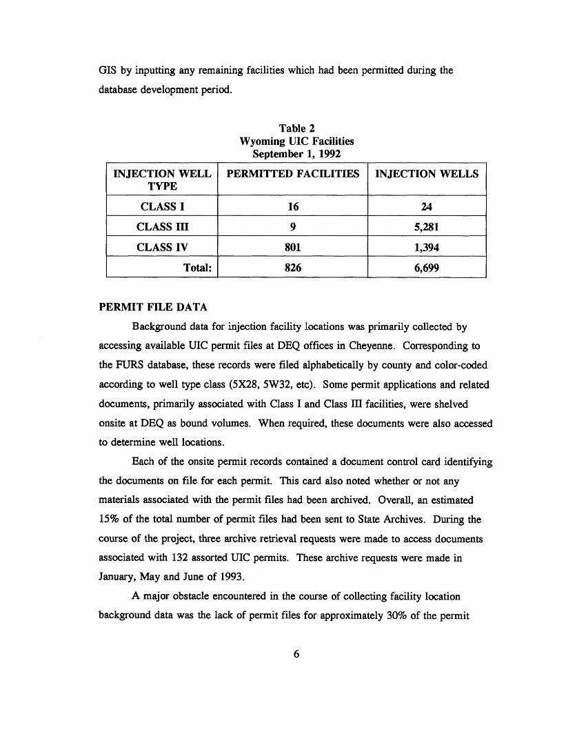
GIS by inputting any remaining facilities which had been permitted during the
database development period.
INJECTION WELL TYPE
CLASS I
Table 2 Wyoming UIC Facilities
September 1, 1992
PERMITTED FACILITIES INJECTION m L L S
16 24
CLASS IV Total:
1 CLASSIII 1 9 I 5,281 I 801 1,394
826 6,699
PERMIT FILE DATA
Background data for injection facility locations was primarily collected by
accessing available UIC permit files at DEQ offices in Cheyenne. Corresponding to
the FURS database, these records were filed alphabetically by county and color-coded
according to well type class (5x28, 5W32, etc). Some permit applications and related
documents, primarily associated with Class I and Class 111 facilities, were shelved
onsite at DEQ as bound volumes. When required, these documents were also accessed
to determine well locations.
Each of the onsite permit records contained a document control card identifying
the documents on file for each permit. This card also noted whether or not any
materials associated with the permit files had been archived. Overall, an estimated
15% of the total number of permit files had been sent to State Archives. During the
course of the project, three archive retrieval requests were made to access documents
associated with 132 assorted UIC permits. These archive requests were made in
January, May and June of 1993.
A major obstacle encountered in the course of collecting facility location
background data was the lack of permit files for approximately 30% of the permit
6
records contained in the FURS database. It was determined that the majority of these
facilities were Class 5x28 or Class 5W32 "shallow" injection wells (shop repair bay
floor drains and drainfield septic systems), with "WYS" permits. In discussing this
matter with DEQ staff, it was determined that these facilities had been inventoried and
added to the FURS database prior to 1986. At that time, Class V wells were
authorized by rule, with no permitting requirements or restrictions (Council and
Fryberger 1988). Consequently, the manner in which they were originally identified
was not known, and in most cases, no follow-up work had been undertaken. As a
result, the location information available for these facilities was limited to what could
be determined from records in the FURS database.
DATAACCURACY
The location data provided in the UIC permit files was generally found to be in
one or more of the following formats: permit application maps, township/range legal
descriptions, subdivision block/lot locations or street address. Precision of available
well location information varied considerably. When available, many permit maps
provided highly precise and accurate locations of injection facilities. Other maps
however, lacked geographic registration and/or an identifiable scale. Several
townshipJrange legal descriptions were encountered which failed to locate wells to the
nearest quarter-quarter section. Similarly, a large number of subdivision descriptions
were encountered which did not specify lot locations within a block. Given the
recommended locational accuracy goal of 25 meters established by the USEPA
Locational Accuracy Task Force (USEPA 1992b), these cases (which included many
of the "WYS" permits mentioned above), required a more extensive background data
search involving additional resources to locate the facilities in question (Chapter 3).
Collection of background data began in October 1993 on a county-by-county
basis and continued throughout the duration of the contract. Much of this work
coincided with the facility location investigation (Chapter 3). This investigation had to
be expanded as a result of the relatively limited amount of location data available for
the "WYS" permits described above.
7
LOCATION MAPPING
As collection of background data was completed, injection well locations
within each county were plotted on one of two types of standard paper basemaps.
With the exception of Campbell, Natrona and Teton Counties, all injection wells
located within a county were plotted on Bureau of Land Management (BLM) Editions
of U.S. Geological Survey (USGS) 1 : 100,000-scale topographic maps (30x60 Minute
Quadrangle Series). Fifty-Six 30x60 minute quadrangle maps provide coverage at this
scale for the entire state. Mapped features used as locational references included
Public Land Survey System linework, roads, surficial hydrography features and land
ownership delineations.
Provisions of the contract called for a more detailed mapping of wells in 20
square miles of specified areas with dense concentrations of UIC facilities. These
areas were chosen by DEQ’s UIC Program Supervisor and included five
township/range sections in the vicinity of Gillette, in Campbell County, and 14
sections surrounding Casper, in Natrona County, as well as one section in Teton
County. The basemaps used for plotting (and digitizing) well locations in these areas
included a collection of 1:6000-scale subdivision plat maps acquired from county
address books for Campbell and Natrona Counties. The majority of the injection wells
in these areas were repair shop floor drains (5x28s) or septic system drainfields
(5W32s) located in subdivisions adjacent to the cities’ corporate limits and sanitary
sewer networks. Monitor wells associated with the facilities in these areas were also
located and plotted on the plat maps. The section in Teton County for which more
detailed mapping was done contained a UIC facility with five 5W12 wastewater
treatment plant effluent disposal wells. This section was located northeast of the town
of Jackson. (Note: For each of the three counties -Campbell, Natrona and Teton,
injection wells located outside of the detailed mapping area were mapped using the
county-wide 1 : 100,OOO-scale method described above.)
For most permits, individual injection well locations were delineated and
mapped as distinct points on the basemaps for digitization as point features. Permits
for a number of facilities, however, contained a very large number of wells which

could not be accurately located within the permitted area due to insufficient data in these permit applications and files. For these cases, which primarily involved Class
111-U mineral extraction, Class 5x13 and 5x15 fossil fuel recovery and Class 5x26
aquifer remediation activities, permit area boundaries were transferred to the basemaps
and digitized as polygon features.
9
CHAPTER III
FACILITY LOCATION INVESTIGATION
Prior to the start of the project, DEQ staff determined that the location
information needed for geo-referencing wells in the GIS was available for
approximately 95% of the 6,700 injection sites in the state. Consequently, the second
major task for the project was to acquire accurate location information for a minimum
of 50 of the estimated 300 remaining wells for which adequate location information
was not available.
A DEQ-approved list of 127 permit facilities was generated from the FURS database. These permits were reselected based on the absence of data in the
LOCATION field in FURS. Within this list, priority was first given to locating 5x28
wells in Natrona County, followed by 5x28 wells in other parts of the state and
finally, wells in all counties classified as 5W31s and 5W32s.
Overall, well locations were obtained for 67 of the 127 permit facilities
targeted with insufficient information (Appendix C). The primary means of obtaining
this information was through requests made to city and county planners and engineers
across the state. Such requests were made in seven counties: Campbell, Park,
Sheridan, Sweetwater, Teton, Uinta and Washakie. Along with a list of the 127
"priority" permits, officials in these seven counties were also given a list of the
additional permits from their counties for which sufficient location information was
lacking. Provided with a list of facility names and street addresses and/or subdivision
block/lot descriptions, these county officials were able to locate and plot on county
plat maps, 90% of the remaining wells with missing or inadequate permit
documentation.
CHAPTER IV
INJECTION FACILITY DIGITIZATION AND MAPPING
The third major task involved in the development of the GIs was the digital
geo-referencing of the injection well point locations and permit area boundaries. A
combination of screen and tablet digitizing methods were utilized for transferring
injection well locations (plotted on the USGS and subdivision plat basemaps) to a
digital GIS format. Screen digitizing of well location point features was carried out
using a series of digital reference basemaps created in ARC/INFO GIs'*' from 1990
U.S. Bureau of the Census TIGERLine files (Bureau of the Census 1991). Tablet
digitizing was used to create line and polygon coverages from the 20 subdivision plat
maps described in Chapter Two. Injection facilities and monitor wells which had been
plotted on these maps were then digitized as point features in the GIs.
COUNTYWIDE DIGITIZATION
TIGER-based Digital Basemaps. Both TIGER3 files and 1: 100,000-scale
USGS Digital Line Graphs (DLG) were originally considered as sources for the digital
reference basemaps. In the end, however, the TIGER files were chosen over the
DLGs for a number of important reasons. While both data sets contain elements
which correspond closely to the transportation and surficial hydrography features
found on the USGS 1:100,000-scale maps, the TIGER files contain additional data
'ARC/INFO is a registered trademark of Environmental Systems Research Institute, Inc., Redlands, CA USA.
me use of brand names in this report is for identification purposes only and does not constitute endorsement by the Wyoming Water Resources Center ar the University of Wyoming.
3Topologically Integrated Geographic E n d i n g and Referencing System
11
which can be used in address matching procedures within the GIs. Furthermore,
while the formats of both data types allow for relatively easy software-specific
conversion (ESRI, Inc 1991b), the resulting TIGER-generated coverages are tiled by
county, a method favored for the purposes of this project over the 30’x30’
latitude/longitude extent of converted DLG coverages.
Some concern was raised regarding the consistency of the TIGER files’ spatial
accuracy, since these files were developed from a combination of Census Bureau
GBF/DIME files and original USGS 1:100,000-scale data sets. To compare the
accuracy of TIGER and DLG linework in Wyoming, ARC/INFO line coverages were
created from both datasets for three counties reflecting varying levels of transportation
network development (Albany, Laramie, Natrona). Visual comparisons indicated, that
in each county, the extent of linework was nearly identical for both coverages; the
TIGER-generated coverages maintained comparable spatial accuracy to the coverages
generated from the DLGs, confirming conclusions made by others that TIGER/Line
files are suitable for county-based regional scale projects (Ferber 1991). Finally, many
of the DLGs for the state contain linework which has not been updated in 20 years,
while the TIGER files have been enhanced to reflect recent expansion of urban or
built-up areas.
Address Geocoding. The 1990 Wyoming TIGER/Line files contain address
range information for only two of the state’s 23 counties, Natrona and Laramie.
Because of the large number of injection wells located around the city of Casper in
Natrona County, a decision was made to explore the viability of using address
geocoding techniques to locate these facilities. Address geowding routines in
ARC/INFO provide a means of building a database relationship between addresses and
coverage features. Addresses in an attribute data file are compared with coverages
which have address attributes for each feature. When a match is found, geographic
coordinates from the matched coverage feature are assigned to the attribute data file
address.
criteria.
Matches are determined by a scoring process based on user-defined matching
Address comparisons must meet the minimum specified score in order for a
12
match to be made. Provisions are also provided for evaluating and altering rejected
addresses to achieve a match (ESRI 1991a).
After converting the Base III+ FURS database to an INFO data file, reselected
addresses for facilities in Natrona County were compared with address ranges for arcs
in the TIGER-generated Natrona County basemap line coverage. Overall, 168 of the
313 injection site addresses found in Natrona County were georeferenced. However,
based on comparisons with available permit file maps and prior knowledge of UIC
Program staff at DEQ, it was determined that the interpolated locations generated by
the address matching routines would not meet the accuracy requirements for the
project. As a result, this geo-referencing technique was abandoned in Natrona County.
Ten out of 38 injection facilities in Lararnie County were also matched with
the address geocoding routines. Positional accuracy similar to that achieved in
Natrona County was observed during an individual field check of the address-matched
well locations. Based on this field verification, it was possible to accurately adjust the
positions of these ten wells on a basemap for digitization.
Digitization Techniques. As noted above, screen digitization techniques were
used for digitizing well locations plotted on the USGS 1:100,000-scale basemaps. For
each county, TIGER file road features in ARC/INFO line coverages were used as
references for screen digitizing well locations into point feature coverages in
ARC/INFO’s A.rcedit4 module. Tablet digitization was used in Arcedit to create
polygon feature coverages representing permit boundaries of those injection facilities
for which individual well locations could not be determined.
LARGE-SCALE PLAT MAP DIGITIZATION
Subdivision plat maps representing the 20 square miles of specified areas with
dense concentrations of injection facilities township/range sections were tablet
digitized in Arcedit at an input scale of 1:6OOo. Individual line and polygon coverages
created for each section included coverages for section lines, roads, lot lines and
4 A r d t is a trademark of Environmental Systems Research Institute, Inc., Redlands, CA USA.
13
subdivision boundaries. Individual injection well and monitor locations were also
digitized off the same basemaps as separate point feature coverages in the GIs.
DATABASE DESIGN
The structure of the GIS database is based on ARC/INFO's georelational vector
data structure; spatial data, representing the point and line geometry of well locations
and facility permit boundaries, is stored in an arc-node data structure, while attributes
describing the spatial features are stored in a relational structure. Related well point
feature attribute tables for each coverage include a unique well identification number
with associated latitudefiongitude coordinate values. The related attributes for polygon
features representing facility boundaries include a unique well identification number
field (WELLNUM) and Permit identification field (PERMIT), which serve to describe
all wells associated with the site.
Redundancy of attribute data in the GIS was minimized by establishing a series
of "one-to-one" and "many-to-one" relates between the point and polygon coverage
feature attribute tables and three related attribute database files. In a "one-to-one"
relate environment, each record in the feature attribute table has a unique relate item
value with one corresponding relate item value in the related table. In a "many-to-
one" relate, some records in the feature attribute table have the same values for the
relate item, however, in the related file there is only one unique Occurrence for each
related item or column value (ESRI 1991~).
NEW-FURS Database. No unique identifiers exist in the original FURS
database for individual wells represented by each of the permit records. Once
imported into the GIS database, FURS was used to create a new database file,
NEW-FURS, containing individual records and an additional well identification
number field, WELLNUM, for all 6,700 injection wells in the state. The 11-digit well
identification numbers were the same numbers used as feature identifiers in the point
and polygon coverage feature attribute tables. The well identifiers combine state and
county FIPS code numbers with a six-digit consecutive number for up to 999,999
14
wells in each county. In Wyoming all well identifiers begin with "56-" (the state FIPS
code for Wyoming), followed by a three-digit odd number representing the county
FIPS code and a six-digit sequential number for the individual wells in that county.
For example, the number "5600 1OOOO37" represents an injection well in Wyoming's
Albany County. Wells in Wyoming's Bighorn County would begin with the number
"56003000001" and so on. Using the unique well identifier as the relate item, "one-to-
one" relates were established between the coverage feature attribute tables and the
NEWJURS data file.
MSDE Database. In addition to NEW-FURS, a second related data file was
created called MSDE, containing well-by-well information on the USEPA's Minimum
Set of Data Elements for Groundwater Quality. The USEPA has defined these
elements as the basic data entities necessary to effectively use data from wells, springs
and other ground water locations across groundwater related programs. The Minimum
Set of Data Elements are considered one measure in developing comprehensive state
ground water protection programs (USEPA 1992a).
The MSDE data file created for the injection well GIS consists of 51 fields,
representing the 21 data elements defined by the USEPA (Appendix D). Each record
contains information for an individual injection well relative to its geographic location.
A WELLNUM field for unique well identification provides for the establishment of
"one-to-one" relates between coverage feature attribute tables and the MSDE data file.
Data in the original FURS database and NEW-FURS database can also be accessed
from the MSDE data file using a "many-to-one" relate, keyed on the PERMIT field in
each file. Structure of the MSDE database is also consistent with specifications
outlined by the USEPA's Facility Identification Data Standard and Locational Data
Policy (USEPA 1992b).
CLASS1 Database. The third related attribute file created for the project was
the CLASS1 database file. The CLASS1 file contains records for each of the 24
permitted Class I wells in the state. The 228 fields in this database were designed to
represent the State Minimum Data Set for Class 11 wells, as defined by the UIC Data
Management System (Appendix E). Therefore, the data structure of the CLASS1 file
15
was designed to match that of the Class 11 data set, as well as the USEPA UIC
Branch’s WATERS software.
WATERS is a PC-based database system designed for tracking Class 11
injection wells. It contains well-specific data similar in nature to that contained in the
FURS database for facility permitting, along with additional data associated with the
Class I1 minimum data set regarding operational characteris tics, inspections,
mechanical integrity tests, enforcement actions and compliance status (USEPA 1991b).
Recent enhancements to the system include well schematic display capabilities and a
GIs interface for querying and map display. While the current version of WATERS is
designed only for Class II wells, consideration is being given to expanding the system
to accommodate other well classes. In part, for this reason, Wyoming UIC program
staff elected to begin compiling information on Class I wells in the same format as
outlined by the Class 11 Minimum Set of Data Elements, necessitating the creation of
the CLASS1 attribute file.
As with the NEW-FURS and MSDE relate files, the CLASSl file also contains
fields for both PERMIT and WELLNUM fields to allow for the establishment of
relates between the CLASSl, MSDE, NEW-FURS and coverage PAT files. At this
time, only selected fields related to well location contain data. However, the structure
has been established for input of data into all of the remaining fields. Should
WATERS be adopted at some point by the DEQ, the data structure of the CLASS1
file will allow for easy exporting and/or importing of data with WATERS.
16
CHAPTER V
DATABASE SUMMARY
The completed GIS database contains over 300 coverages created to represent
the locations of 6700+ injection wells across the state. Overall, 468 individual
injection wells were located in 1:100,000-scale coverages in 21 of Wyoming's 23
counties. Several thousand wells were located as part of 43 permit boundary polygons
at the same 1: 100,OOO-scale for eight counties. An additional 268 injection wells and
an associated 155 groundwater quality monitoring wells were individually located for
twenty "priority" square-mile sections at a scale of 1:6OoO.
Appendix F contains information on each of the injection and monitor well
coverages created, including the naming convention standards employed, feature
attribute table file structures, and a description of each coverage's size and content,
editing tolerances, coordinate system and map projection. Geographic
(latitude/longitude) coordinates for the injection facility records contained in each of
the coverages is listed in Appendix G.
The development of an underground injection well GIS will greatly enhance
data management and analysis within Wyoming's UIC Program. In terms of data
management, the GIS has the ability to provide comprehensive well-by-well tracking
at the program implementation level. In addition to extensive map and report
generating capabilities, the GIS will be able to maintain a wide range of well-specific
data, including permitting history, well location, inspections and operational
characteristics. Potential analysis capabilities of the GIS include "Area of Review"
and "Zone of Endangered Influence" calculations (UICP 1990a; Engineering
Enterprises, Inc 1985), as well as the integration of the injection
with ongoing statewide ground-water sensitivity mapping efforts
well GIS database
(Hamerlinck, Wrazien

and Needham 1993). Other future potential developments associated with the injection
well GIS include increased use of address matching routines to locate well locations
(made possible with the greatly enhanced address range attribute data in the most
recent version of the Bureau of the Census’ TIGER/Line files), and the utilization of
global positioning systems (GPS) technology to more accurately locate existing and
new injection facilities. This technology will also be instrumental if the injection well
database is expanded or integrated with other databases which include other point
sources of groundwater contamination such as underground storage tanks. Finally, it
is recommended that future enhancements to the GIS also address the need for a user-
friendly, system interface, to ensure that the database is utilized to its fullest potential.
18
REFERENCES
Address Geocodinjq, ARC/INFO User's GUIDE 6.0. 1991a. Redlands, CA: Environmental Systems Research Institute.
An Introduction to the Underground Injection Control Program. 1990a. Oklahoma City, OK: Underground Injection Practices Council.
Bureau of the Census. 1991. TIGER/Line Census Files, 1990, Technical Documentation. Washington, DC: U.S. Department of Commerce.
Council, L.C. and J.S. Fryberger. 1988. "An Overview of Class V Injection Wells,'' in Proceedings. Underground Iniection Practices Council 1988 Winter Meeting. Charleston, SC, pp. 45-72.
Data Conversion, ARC/INFO User's Guide 6.0. 1991b. Redlands, CA: Environmental Systems Research Institute, Inc.
Guidance Document for the Area of Review Requirement. 1985. Norman, OK: Engineering Enterprises, Inc.
Ferber, D. 1991. "Tracking TIGER: The Use, Verification, and Updating of TIGER Data," in Proceedings, GISLIS '91, Atlanta, GA, pp. 230-239.
Hamerlinck, J.D.; D.R. Wrazien and S. Needham. 1993. "Underground Injection Well Database Development for Groundwater Vulnerability Assessment Applications," in Proceedings, GISLIS '93, Minneapolis, MN, pp. 270-281.
Iniection Wells: An Introduction to Their Use. Operation and Regulation. 1990b. Oklahoma City, OK: Underground Injection Practices Council.
Managing Tabular Data, ARC/INFO User's Guide 6.0. 199lc. Redlands, CA: Environmental Systems Research Institute, Inc.
Osborne, P.S. 1991. Program Overview: Underground Iniection Control - Region VIII. Denver, CO: United States Environmental Protection Agency.
19
U.S. Environmental Protection Agency. 1992a. Definitions for the Minimum Set of Data Elements for Ground Water Quality. Washington, DC: Office of Water.
. 1992b. Locational Data Policy Implementation Guidance - Guide to the Policy. Washington, DC: Office of Information Resources Management.
. 1991a. Release of WATERS Version 1.0, memorandum. Washington, DC: Office of Water.
. 1990. UIC Data Management System - State Minimum Data Set for Class 11 Wells; Guidance #68, memorandum. Washington, DC: Office of Water.
. 199lb. WATERS Users Guide, Version 1.0. Washington, DC: Office of Water.
Western Water Consultants, Inc. 1986. Assessment of Class V Injection Wells in the State of Wvorning. Cheyenne, WY: Wyoming Department of Environmental Qualitywater Quality Division.
20

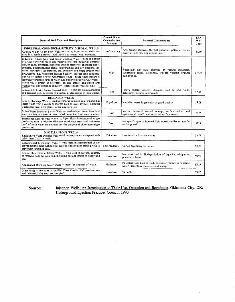
APPENDIX A CLASS V INJECTION WELL SUBCLASSES
21
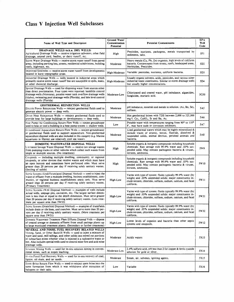
Class V Injection Well Subclasses
Name of Well Type and Description
DRAINAGE WELLS (a.k.a. DRY WELLS) Agricultural Drainage Wells - receive irrigation tailwaters, other field drainage, animal yard, feedlot, or dairy runoff, etc.
Ground Water Contamination
Potential
High
storm Water Drainage Wells - receive storm water runoff from paved areas, including parking lots, streets, residential subdivisions, building roofs, highways, etc. Improved Sinkholes - receive storm water runoff from developments located in karst topographic areas. Industrial Drainage Wells - wells located in industrial areas which primarily receive storm water runoff but are susceptible to spills, leaks, or other chemical discharge. Special Drainage Wells - used for disposing water from sources other than direct precipitation. Four types were reported: landslide control drainage wells (Montana), potable water tank overflow drainage wells (Idaho), swimming pool drainage wells (Florida), and lake level control drainage wells (Florida)
Moderate
High-Moderate
High-Moderate
GEOTHERMAL REINJECTION WELLS Eixtric Power Reinjection Wells - reinject geothermal fluids used t o generate electric power - deep wells. Dircct Heat Reinjection Wells - reinject geothermal fluids used t o provide heat for large buildings or developments - deep wells. Heaa! Pump/Air Conditioning Return Flow Wells - reinject groundwater used t o heat or cool a building in a heat pump system - shallow wells. Groundwater Aquaculture Return Flow Wells - reinject groundwater or geothermal fluids used t o support aquaculture. Non-geothermal aquaculture disposal wells are also included in this category (e.g. Marine aquariums in Hawaii use relatively cool sea water).
Moderate-Low
Moderate
Moderate
Moderate
p H imbalance, minerals and metals in solution. (As, Bo, Se). sulfates.
Hot geothermal brines with TDS between 2.000 to 325,000 mg/l. Co,, CaSO,, Sr and Ba, As. Potable water with temperatures ranging from 90° to 110' F., may have scale or corrosion inhibitors. Used geothermal waters which may be highly mineralized 6; include traces of arsenic, boron, fluoride, dissolved & suspended solids, animal detritus, perished animals and bacteria.
DOMESTIC WASTEWATER DISPOSAL WELLS Cnrreated Sewage Waste Disposal Wells - receive raw sewage wastes from pumping trucks or other vehicles which collect such wastes from single or multiple sources. (No treatment) Cesspools - including multiple dwelling, community, or regional cesspools, or other devices that receive wastes and which must have an open bottom and sometimes have perforated sides. Must serve greater than 20 persons per day if receiving solely sanitary wastes. (Settling of solids)
5AS
SA6
5A7
High
Soluble organic & inorganic compounds including household chemicals. Raw sewage with 99.9% water and .03To sus- pended solid. May contain pathogenic bacteria & viruses, nitrates, ammonia.
High 5w10
~~~ ~ ~ ~
S:pic Systems (Undifferentiated Disposal Method) - used to inject the waste or effluent from a multiple dwelling, business establishment, com- munity, or regional business establishment septic tank. Must serve greater than 20 persons per day if receiving solely sanitary wastes. (Primary Treatment) S:pric Systems (Well Disposal Method) - examples of wells include anual wells, seepage pits, cavitettes, etc. The largest surface dimen- sion is less than or equal t o the depth dimension. Must serve greater than 20 pesons per day if receiving solely sanitary wastes. (Less treat- ment per square area than 5W32) S-pric System (Drain field Disposal Method) - examples of drainfields include drain or tile lines, and trenches. Must serve more than 20 per- sons per day if receiving solely sanitary wastes. (More treatment per square area than "31) Domestic Wastewater Treatment Plant Effluent Disposal ii'ells - dispose of treated sewage or domestic effluent from small package plants u p LO laree municioal treatment Dlants. ISecondarv or further treatment)
High-Low
High-Low
High-Low
High-Low
Varies with type of system: fluids typically 99.9% water (by weight) and .03% suspended solids: major constituents in- clude nitrates, chlorides, sulfates, sodium, calcium, and fecal coliform.
Potential Contaminants
sw' '
EPA Well I Code
Varies with type of system: fluids typically 99.9% water (by weight) and .03% suspended solids: major constituents in- clude nitrates, chlorides, sulfates. sodium, calcium, and fecal coliform.
1 SFI Pesticides, nutrients, pathogens, metals transported by sediments, salts.
5w3'
Heavy metals (Cu, Pb, Zn) organics, high levels of coliform bacteria. Contaminants from streets, roofs, landscaped areas, Herbicides, Pesticides.
Variable: pesticides, nutrients, coliform bacteria.
Usually organic solvents. acids, pesticides, and various other industrial waste constituents. Similar to storm drainage wells but usually higher concentrations.
Chlorinated and treated water, pH imbalance, algaecides. fungicides, muriatic acid.
Varies with type of system: fluids typically 99.9% water (by weight) and .O3 070 suspended solids: major constituents in- clude nitrates, chlorides, sulfates, sodium, calcium, and fecal coiiform.
Lower levels of organics and bacteria than other septic systems and cesspools.
5w32
5W12
__ Soluble organic & inorganic compounds including household chemicals. Raw sewage with 99.9'70 water and .03oio sus- pended solid. May contain pathogenic bacteria & viruses, nitrates, ammonia.
sw9
hlI\ERAL AND FOSSIL F U E L RECOVERY RELATED WELLS \lining. Sand, or Other Backfill Wells - used to inject a mixture of uater and sand, mill tailings, and other solids into mined out portions of subsurface mines whether what is injected is a radioactive waste o r no:. Also includes special wells used t o control mine fires and acid mine drainage wells. Solution \lining Wells - used for in-situ solution mining in conven- tional mines, such as stopes leaching.
Moderate
Moderate-Low 2.4% sulfuric acid, pH less than 2 for copper & ferric cyanide solution for gold or silver.
Steam, air, solvents, igniting agents.
5x14
5x15 In-situ Fossil Fuel Recovery Wells - used for in-situ recovery of coal, lignite, oil shale, and tar sands. Sptnt-Brine Return Flow Wells - used to reinject spent brine into the same formation from which it was withdrawn after extraction of halogens or their salts.
Acidic waters
Moderate
LOW Variable 1 5x14
Ground Water Contamination
Potential
~~ _- ~
Varies: advanced treated sewage, surface urban and agricultural runoff, and imported surface waters.
EP.i Well 1 Code
_____ ~~~~ ~ ~~~
Low-level radioactive wastes.
Varies depending on project.
Vutrients used in Biodegradation of organics, oillgrease, ihenols, toluene.
Name o f Well Type and Description Potential Contaminants
INDUSYRlhL/COhtMERCIhL/UTILITY DISPOSAL WELLS Cooling Water Return Flow Wells - used to inject water which was used in a cooling Drocess. both oDen and closed loop Drocesses.
Anti-sealing additives, thermal pollution, potential for in- dustrial spills reaching ground water.
~-
Industrial Process Water and Water Disposal Wells - used to dispose of a wide variety of wastes and wastewaters from industrial. commer- cial. or utility processes. Industries include refineries, chemical plants. smelters, pharmaceutical plants, laundromats and drv cleaners, tan- neries. carwashes, laboratories. etc. Industry and waste stream must be specified (e.g. Petroleum Storage Facility-storage tank condensa- tion water; Electric Power Generation Plant-mixed waste stream of laboratory drainage, fireside water, and boiler blowdown; Car Wash- Mixed waste stream of detergent, oil and grease, and paved area washdown; Electroplating Industry-spent solvent wastes; etc.).
Automobile Service Station Disposal Well - repar bay drams connected to a disDosal well. Susoected of disoosal of dangerous or toxic wastes.
Potentially any fluid disposed by various industries, suspended solids, alkalinity, sulfate volatile organic compounds.
High
Heavy metals, solvents, cleaners, used oil and fluids, detergents. organic comoounds. High
~ _ _ _
RECHARGE WELLS Aquifer Recharge Wells - used to recharge depleted aquifers and may inject fluids from a variety of sources such as lakes, streams. domestic wastewater treatment Dlants, other aquifers, etc.
High-Low Variable: water is generally of good quality
~~ ~ ~
Saline Water Intrusion Barrier Wells - used to inject water into fresh water aquifers to prevent intrusion of salt water into fresh water aquifers. Subsidence Control Wells - used to inject fluids into a non-oil or gas producing zone to reduce or eliminate subsidence associated with over- draft of fresh water and not used for the purpose of oil or natural gas Droduction.
Low
No specific type of injected fluid noted. similar to aquifer recharge wells. Low
-~ ~~ ~~
MISCELLAN EOL'S WELLS Radioactive Waste Disposal Wells - ail radioactive waste disposal wells other than Class 1V wells.
Experimental Technology Wells - wells used in experimental or un- proven technologies such as pilot scale in-situ solution mining wells in previously unmined areas.
Aquifer Remediation Related Wells - wells used to prevent, control, Dr remediate aquifer pollution. including but not limited to Sueprfund sites.
Unknown
Low-Moderate 5x25
Unknown 5x26
Moderate ?otentially any kind or' h i d . particularly brackish or saline Nater, hazardous cnerncials and sewage. 5x29 Abandoned Drinking Water Wells - used for disposal of waste.
Unknown Other Wells - any other unspecified Class V wells: Well fypeipurpose 2nd iniecred fluids must be soecified. SX':
Source: Injection Wells: An Introduction to Their Use, Omration and Regulation. Oklahoma City, OK: Underground Injection Practices Council, 1990.

APPENDIX B FURS DATABASE FILE STRUCTURE
24
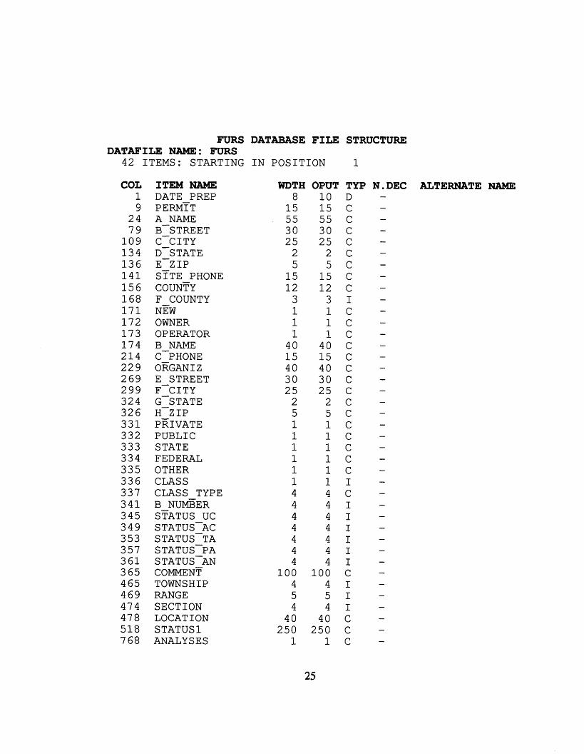
FURS
42 ITEMS: STARTING DATAFILE NAME: FURS
COL 1 9
24 7 9
1 0 9 1 3 4 1 3 6 1 4 1 1 5 6 1 6 8 1 7 1 172 1 7 3 1 7 4 214 2 2 9 269 2 9 9 324 326 3 3 1 332 333 334 335 3 3 6 337 3 4 1 345 3 4 9 353 357 3 6 1 3 65 465 469 474 478 518 768
ITEM NAME DATE PREP
A NAME PERMTT B-s TREE T C-CITY D-STATE
STTE PHONE E-Z IP
COUNTY F COUNTY NEW OWNER OPERATOR B NAME C-PHONE OTTGANI z F-CITY G-STATE H-z IP PRIVATE
E STREET
PUBLIC STATE FEDERAL OTHER CLASS CLASS TYPE B N U ~ E R STATUS uc STATUSAC STATUS-TA STATUSPA STATUSAN COMMENT TOWNSHIP RANGE SECTION LOCATION STATUS1 ANALY S E S
DATABASE FILE
IN POSITION
WDTH OPUT 8
1 5 55 30 25
2 5
1 5 1 2
3 1 1 1
40 1 5 40 30 25
2 5 1 1 1 1 1 1 4 4 4 4 4 4 4
1 0 0 4 5 4
40 250
1
1 0 1 5 55 30 25
2 5
1 5 1 2
3 1 1 1
40 1 5 40 3 0 25
2 5 1 1 1 1 1 1 4 4 4 4 4 4 4
1 0 0 4 5 4
40 250
1
25
STRUCTURE
1
TYP D C C C C C C C C I C C C C C C C C C C C C C C C I C I I I I I I C I I I C C C
N.DEC ALTERNATE NAME

7 6 9 WELLS 7 7 0 PARSE ADD -
1 1 c 38 38 C
26

APPENDIX C
INJECTION FACILITY LOCATION INVESTIGATION PRIORITY LIST
27
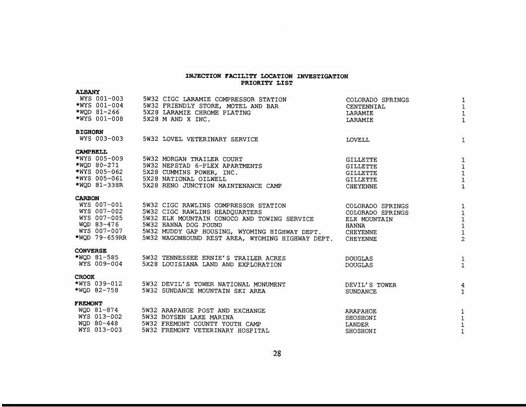
ALBANY WYS 001-003 "WYS 001-004 "WQD 81-266 "WYS 001-008
BIGHORN WYS 003-003
CAMPBELL "WYS 005-009 "WQD 80-271 "WYS 005-062 "WYS 005-061 "WQD 81-338R
CARBON WYS 007-001 WYS 007-002 WYS 007-005 WQD 83-476 WYS 007-007 "WQD 79-659RR
CONVERSE "WQD 81-585 WYS 009-004
CROOK "WYS 039-012 "WQD 82-758
FREMONT WQD 81-874 WYS 013-002 WQD 80-448 WYS 013-003
INJECTION FACILITY LOCATION INVESTIGATION PRIORITY LIST
5W32 CIGC LARAMIE COMPRESSOR STATION 5W32 FRIENDLY STORE, MOTEL AND BAR 5x28 LARAMIE CHROME PLATING 5x28 M AND X INC.
COLORADO SPRINGS CENTENNIAL LARAMIE LARAMIE
5W32 LOVEL VETERINARY SERVICE LOVELL
5W32 MORGAN TRAILER COURT 5W32 NEPSTAD 6-PLEX APARTMENTS 5x28 CUMMINS POWER, INC. 5x28 NATIONAL OILWELL 5x28 RENO JUNCTION MAINTENANCE CAMP
GILLETTE GI LLETTE GILLETTE GI LLETTE CHEYENNE
5W32 CIGC RAWLINS COMPRESSOR STATION COLORADO SPRINGS 5W32 CIGC RAWLINS HEADQUARTERS COLORADO SPRINGS 5W32 ELK MOUNTAIN CONOCO AND TOWING SERVICE ELK MOUNTAIN 5W32 HANNA DOG POUND HANNA
CHEYENNE 5W32 MUDDY GAP HOUSING, WYOMING HIGHWAY DEPT. 5W32 WAGONHOUND REST AREA, WYOMING HIGHWAY DEPT. CHEYENNE
5W32 TENNESSEE ERNIE'S TRAILER ACRES 5x28 LOUISIANA LAND AND EXPLORATION
5W32 DEVIL'S TOWER NATIONAL MONUMENT 5W32 SUNDANCE MOUNTAIN SKI AREA
5W32 ARAPAHOE POST AND EXCHANGE 5W32 BOYSEN LAKE MARINA 5W32 FREMONT COUNTY YOUTH CAMP 5W32 FREMONT VETERINARY HOSPITAL
DOUGLAS DOUGLAS
DEVIL'S TOWER SUNDANCE
ARAPAHOE SHOSHONI LANDER SHOSHONI
1
1 1
4 1
28
*WQD *WQD
WYS WYS WYS
*WQD
83-480 80-32 013-005 013-006 013-008 8 2 - 4 0 3 R
5W32 5W32 5W32 5W32 5x2 8 5x2 8
SOUTH P A S S M S T AREA, WYOMING HIGHWAY DEPT. UNIVERSITY OF M I S S O U R I F I E L D CAMP WIND R I V E R ANIMAL C L I N I C WIND R I V E R MOBILE HOME PARK H AND H B I C O SOUTH P A S S MAINTENANCE CAMP
GOSHEN *WQD 8 1 - 5 7 8 R R 5W32 HUNTLEY SCHOOL
*WYS 015-003 5W32 LINGLE REST AREA WYS 015-002 5W32 JAY EM CAMPGROUND
HOT SPRINGS *WQD 75-005 5W32 BLUE MESA TRAILER COURT
WQD 8 2 - 1 5 2 R 5W32 LUCERNE ELEMENTARY SCHOOL WQD 83-259 5x28 COPPER MOUNTAIN S A L E S
LARAMIE *WQD 77-389 5W32 BINGO TRUCK STOP *WQD 8 1 - 3 2 8 R *WQD 82-563 5W32 US 85 PORT OF ENTRY (TERRY ROAD)
5W32 1-80 PORT OF ENTRY (Cheyenne south)
LINCOLN
CHEYENNE LANDER LANDER LANDER RIVERTON CHEYENNE
HUNTLEY JAY EM CHEYENNE
KIRBY THERMOPOL I S THERMOPOLI S
CHEYENNE CHEYENNE CHEYENNE
WQD 8 1 - 6 7 2 R R 5W32 ALPINE JUNCTION PORT OF ENTRY CHEYENNE WYS 023-001 5W32 ASPEN CAMPGROUND A L P I N E
*WYS 023-005 5W32 UTAH POWER AND L I G H T KEMMERER WYS 023-006 5x28 CBS TRANSPORTATION AFTON WYS 023-008 5x28 LINCOLN COUNTY ROAD AND BRIDGE SHOP (AFTON) AFTON
NATRONA WQD WQD WQD
*WQD *WQD
WQD WYS WYS
*WQD *WQD
79-156 79-161 79-137 79-681 79-310 79-695 025-011 025-061 79-016 79-183
5W32 ALBERT URBIGKIT SUBSURFACE DISPOSAL 5W32 AMOCO P I P E L I N E COMPANY 5W32 ANDERSON CONSTRUCTION 5W32 B . MOORE MOBILE HOME SPACES 5W32 BUSS PLUMBING 5W32 CASPER BUILDING SYSTEMS I N C . 5W32 COUNTRY KITCHEN 5W32 DEROWITSEH TRAILER COURT 5W32 F I N N MCCARTHY SUBSURFACE DISPOSAL 5W32 GETTMAN TRAILER SYSTEM
CASPER CHICAGO CASPER CASPER CASPER CASPER CASPER CASPER CASPER CASPER
1 1 1
4 1 2
1 1 1
1 1 1 1 1 1 1 1 1 1
29
"WQD 79-014 "WQD 79-008 "WQD 79-162 "WYS 025-025
WQD 79-057 WQD 79-043 WQD 80-043
"WQD 80-635 WQD 80-002 WQD 79-009
"WQD 79-465 "WQD 79-309 "WQD 7 9 - 6 6 0 *WQD 79-247
WYS 0 2 5 - 0 6 5 "WQD 79-184
WYS 025-106 "WYS 025-069 "WYS 025-067 "WQD 80-240 *WQD 82-072 "WQD 79-248
WQD 79-009 WYS 025-077 WYS 0 2 5 - 0 2 2
"WQD 79-716
NIOBRARA WYS 027-002
PARK "WQD 81-942
WQD 8 0 - 3 4 4 R R "WYS 029-012
WYS 0 2 9 - 0 1 6 WYS 029-017
"WQD 77-442 "WYS 029-026 "WYS 029-028 "WYS 0 2 9 - 0 3 1
5W32 GRAYSON BUILDING CASPER 5W32 HANSEN BUILDING S P E C I A L T I E S CASPER 5W32 H I C K S EQUIPMENT COMPANY B U I L D I N G CASPER 5W32 HOOVER L U I Z LAND CASPER 5W32 J I M HOWARD SUBSURFACE D I S P O S A L CASPER 5W32 MARTIN CLARK SUBSURFACE D I S P O S A L CASPER 56532 MILLCHEM O F F I C E AND WAREHOUSE 5W32 NANIA DEVELOPMENT 5W32 NEWMILLER SUBDIVISION CASPER 5W32 P A C I F I C STEEL CASPER 5W32 PERCY MANNINGS RESTAURANT CASPER 5W32 P R I D E O I L F I E L D SERVICE CASPER 5W32 SOUTHWEST POWER TOOL CASPER 5W32 TANNER-FREIBERG CASPER 5W32 T R A I L E R COURT CASPER 5W32 TRUE D R I L L I N G COMPANY - TRUCK SHOP M I L L S 5x28 AMOCO O I L COMPANY - SECOND AND MCKINLEY CASPER 5x28 C I T Y O F CASPER HOGADON D R A I N F I E L D CASPER 5x28 COMPRESSION LEASING S E R V I C E S CASPER 5x28 DRILLCO BUILDING, ZERO ROAD CASPER 5x28 GREAT LAND DIRECTIONAL D R I L L I N G CASPER 5x28 NATRONA COUNTY WEED AND P E S T CONTROL D I S T R I C T CASPER 5x28 P A C I F I C STEEL CASPER 5x28 SCHLUMBERGER WELL SERVICE CASPER 5x28 VACANT FORMERLY HARPEL D R I L L I N G SHOP CASPER 5x28 WEST YELLOWSTONE B U S I N E S S PARK M I L L S
5W32 MULE CREEK JUNCTION TRUCK STOP LUSK
5W32 CODY MEAT PACKING CO 5W32 CROSSED SABRES RANCH, I N C . 5W32 P E T SET AND BLESSING VETERINARY C L I N I C 5W32 WAPATI VALLEY INN CAMP 5x28 B J S E R V I C E S - POWELL 5x28 CODY LUMBER, INC. 5x28 K AND K TREATER 5x28 MINER O I L F I E L D SERVICE 5x28 P A C I F I C POWER AND LIGHT, CODY D I S T R I C T O F F I C E
CODY W A P I T I CODY W A P I T I POWELL CODY CODY CODY CODY
1 1 1 1 1 1 1 1 1 1 1 1 1 1 1 1 1 1 1 1 1 1 1 1 1 0
1
30
"WQD 87-005 5x28 PAT O'HARA COMPANY CODY 1
SHERIDAN "WQD 81-872
SUBLETTE WYS 035-002 WYS 035-001 WYS 035-003 WYS 035-004
SWEETWATER "WQD 82-669
WYS 037-002 WYS 037-003 WYS 037-004 WYS 037-005
"WYS 037-010 "WYS 037-031 "WYS 037-006 *WYS 037-015 "WYS 037-008 "WYS 037-029
TETON *WQD 88-331 "WQD 89-499 *WQD 8 9 - 2 5 7 R "WQD 87-304 *WQD 87-304 "WYS 039-006 "WQD 88-218 *WQD 88-218
WQD 87-318 WYS 039-010 WQD 89-522
"WQD 90-421 WYS 039-023
"WQD 90-340
5W32 B I G GOOSE ANIMAL C L I N I C
5W31 OX YOKE ACRES MOBILE HOME PARK 5W32 HOBACK VILLAGE RESORT 5W32 OX YOKE ACRES MOBILE HOME PARK 5W32 TRIANGLE F LODGE
5W32 CHURCH AND DWIGHT 5W32 C I G C DESERT S P R I N G S COMPRESSOR STATION 5W32 C I G C TABLE ROCK PROCESSING PLANT 5W32 C I G C WAMSUTTER COMPRESSOR STATION 5W32 C I G C WAMSUTTER TRAILER PARK 5x28 DELTA E L E C T R I C I N C . 5x28 GEORGE SEARLE 5x28 GRANGER MAINTENANCE CAMP 5x2 8 K-MOTIVE 5x28 NOWCAM SERVICES POBOX 1086 5x28 WYOMING BEARING AND FABRICATION I N C .
5W32 GROS VENTRE R I V E R RANCH LODGE 5W32 JACKSON HOLE AIRPORT F I R E F I G H T I N G BUILDING 5W32 JENNY LAKE LODGE 5W32 MORAN JUNCTION SEEPAGE BED 5W32 M O W JUNCTION S E P T I C TANK 5W32 RED TOP MEADOWS RESIDENTIAL TREATMENT CENTER 5W32 STEAK PUB RESTAURANT 5W32 STEAK PUB mSTAURANT S E P T I C TANK 5W32 TETON P I N E S INTERIM WWTF EXPANSION 5W32 TETON VALLEY RANCH CAMP 5W32 T R A I L S END RANCH WWTP 5W32 V I S T A GRANDE WASTEWATER SYSTEM 5W32 YELLOWSTONE NATIONAL PARK 5x28 JACKSON HOLE AIRPORT RENTAL CARWASH
SHERIDAN
BOULDER BONDERONT BOULDER BONDERANT
GREEN R I V E R COLORADO SPRINGS COLORADO SPRINGS COLORADO SPRINGS COLORADO SPRINGS ROCK SPRINGS ROCK SPRINGS CHEYENNE GREEN R I V E R ROCK SPRINGS ROCK S P R I N G S
JACKSON JACKSON HOLE JACKSON MORAN MORAN JUNCTION WILSON JACKSON JACKSON JACKSON KELLY JACKSON JACKSON YELLOWSTONE JACKSON
1
20 1 1 1
1 1 1 1 1 2 1 1 1 1 1
1 1 1 1 1 1 1 1 1 1 1 1
11 1
31
UINTA WQD 79-489 5W32 NORTHERN NATURAL GAS CO. WQD 77-047RR 5W32 UINTA COUNTY YOUTH CAM€?
WASHAKIE WYS 043-004 5x28 GENE REICHERT TRUCKING WYS 043-012 5x28 WASHAKIE GARAGE WYS 043-014 5x28 WORLAND MUNICIPAL AIRPORT
WESTON WYS 045-002 5x28 DIXON BROTHERS
OMAHA EVANS TON
WORLAND WORLAND WORLAND
1 1
1 1 2
NEWCASTLE 0
* - Denotes injection facilities which were located as part of the location investigation activities (N=67).
32

APPENDIX D
MSDE DATABASE FILE STRUCTURE AND FIELD DEFINITIONS
33
MSDE DATABASE FILE STRUCTURE
DATAFILE NAME: MSDE 51 ITEMS: STARTING IN POSITION
COL 1
1 2 42 72 87 89 99
111 1 4 1 154 1 6 8 1 7 6 1 7 8 1 8 5 1 9 3 208 222 230 238 2 3 9 2 4 1 242 243 2 5 1 253 2 5 6 2 7 1 273 2 7 9 280 285 287 294 3 0 1 303 3 1 1 3 1 9 3 2 6
ITEM NAME WDTH OPUT TYP WELLNUM SOURCE S ADD S-CI TY S-STATE s-z IP S-PHONE - S CONTACT LAT LONG LL METHOD L L-D A T UM L L-s CAL E LLDATE ENTITY ACCURACY ERROR ALTITUDE ALT PT
A METHOD ALT-UN I T s A-DATUM A-DATE
CT-FIPS PERMIT ST FIPS
WELLUSE WELL TYPE LOG TYPE
D UNITS DEPTH D-TOP DBOT
SCN
S-DEPTH S-UNITS -
DT UNITS S DATE
11 3 0 30 1 5
2 1 0 12 30 13 1 4
8 2 7 8
15 1 4
8 8 1 2 1 1 8 2 3
1 5 2 6 1 5 2 7 7 2 8 8 7 1
11 30 30 1 5
2 1 0 1 2 30 13 1 4
8 2 7
1 0 1 5 1 4
8 8 1 2 1 1
1 0 2 3
1 5 2 6 1 5 2 7 7 2 8
1 0 7 1
34
I C C C C C C C N N C I I D C N N N C C C C D I I C I C C I C N N C I D N C
1
N.DEC ALTERNATE NAME -
- 5 5
5 5 1
- 1
327 334 341 342 350 357 3 62 363 370 376 381 384 385
S TIME W D E P T H W-UNITS W-DATE W-TIME PARAME T ER P CODE ACV ACV UNITS
AR - GUAL ACV-METHD
QAI FLD QAI-LAB
7 7 1 8 7 5 1 7 6 5 3 1 1
7 c 7 N 1 c 10 D 7 c 5 1 1 c 7 c 6 C 5 1 3 c 1 c 1 1
35
MSDE DATABASE FILE FIELD DESCRIPTORS
GENERAL
WELLNUM
SOURCE S ADD S-CITY - S STATE s-ZIP S-PHONE
DESCRIPTORS
Well Identification Number (SSCCC######) where r'S1' is the state FIPS code; "C" is the county FIPS code; and " # # # # # # " is a six digit assigned number.
Source Agency Source Address Source City
Source State Source 9-digit Zip Code Source Phone Number
s - TONTACT Source Contact
GEOGRAPHIC DESCRIPTORS LAT LONG LL METHOD -
LL DATUM -
Lat it ude Longitude Method used to Determine LAT & LONG. Input one of the Following:
SUR-GPS NAV-GPS SUR-C MAP
LORAN-C ADDMAT PHOTO -GM SPCSCONV TSRCONV UTMCONV PHOTORAW RMTSEN ZIP UNKNOWN
Reference
surveyed using differential-mode GPS. navigational-quality GPS. cadastral survey digital or manual interpolation from a map or photo. Loran-C navigation device. Address matching. Aerial photography. State Plane conversion. Township/Range conversion UTM conversion. Digital or manual raw photo extraction. Remote sensing. Zip code centroid. Method unknown.
Datum. Input one of the Following:
83 North American Datum of 1983 (NAD 83) 27 North American Datum of 1927 (NAD 27) 05 World Geodetic System of 1984 (WGS 84) 10 World Geodetic System of 1972 (WGS 72) 15 Old Hawaiian Datum 20 Puerto Rico Datum 25 St. Paul Island Datum 30 St. George Island Datum 35 St. Lawrence Island Datum 40 Guam 1963
36
45 Wake-Eniwetok 1960 50 Midway Astro 1961 55 American Samoa Datum 60 Johnson Island 1961 00 Reference Datum not Specified
LL SCALE Scale of Map ( "X" value in the ratio 1:X) LLDATE Date Long/Lat was determined (MM/DD/YY) ENTITY Textual description of the entity to which the
Long/Lat coordinates refer. ACCURACY Accuracy of Long/Lat Coordinates expressed as +/-.
Units remain consistent with LONG & LAT. ERROR Error of the Accuracy ( + / - ) . ALTITUDE Altitude above or below the National Reference
ALT - PT Measuring Point of Altitude. Enter one of the Datum
Following:
A Airline C Top of well casing K Kelly Bushing L Land or ground surface U Underground surf ace (e. g . caves)
ALT UNITS Units of Altitude Measure (F=feet or M=meters) A - METHOD Method used to Determine Altitude.
the Following: Enter one of
A Differential-mode GPS B Absolute-mode GPS C Surveyed from a benchmark D Digitally interpolated from a map or
E Manually interpolated from a map or photo. photo.
A DATUM National Reference Datum for Altitude Codes. A-DATE Date Altitude Determined (MM/DD/YY) S r FIPS State FIPS Code CT-FIPS - County FIPS Code
WELL DESCRIPTORS
PERMIT Permit Number
37
WELLUSE Principal Use of Well. Enter one of the Following:
1 2 3 4 5 6 7 8 9 10 11 12 13 14 15 16 17 18 19 20
Public Water Supply Well Community Supply Well Non-community Supply Well Industrial Supply Well Recharge We1 1 Irrigation Well RCRA Monitoring Well Superfund Monitoring Well Recovery Well Remediation Well Piezometer Well Class I Injection Well Class I1 Injection Well Class 111 Injection Well Class IV Injection Well Class V Injection Well Geophysical Well Geothermal Well Oil and Gas Well Unknown
WELL TYPE Type LOG TYPE Type -
of Well (e-g., 5x28, 5~32). of record-keeping log(s). Enter one of the
Following:
A C D E G M R T U V
Acoustic Caliper Driller's Electrical Geologist/Engineer Multiple Types of Logs Radioactive Temperature Unknown Video
DEPTH D UNITS D-TOP
Depth of Well at Completion. Units of Depth Measure (F=feet or M=meters). Depth below the measuring point to the top of the open section.
-
D BOT Depth below the measuring point to the bottom of the open section.
-
DI UNITS Units-D TOP and D BOT are measured (F=feet or M=meters) . - -
38
SAMPLE DESCRIPTORS
SCN S DATE S-DEPTH S-UNITS S-TIME -
W DEPTH W-UNITS W-DATE W-TIME PARAMETER P - CODE
ACV ACV UNITS ACV-METHD code) AR QUAL -
QAI - FLD
Sample Control Number Sample Date (MM/DD/YY) Sample Depth Sample Depth Units Sample Time ( # # # # Z Z Z ) where " # # # # " is the time based upon a 24-hour clock and 2 2 2 is the time zone. (e.g., 1635EST means 16:35 Eastern Standard Time). Depth to Water Units used to measure W DEPTH Date W DEPTH was taken -(MM/DD/YY) Time WDEPTH was taken. Same format as S - TIME. Constituent or Parameter Measured. Parameter code Source. Enter one of the Following:
S STORET parameter codes C CAS number 0 Other
Analytical Concentration/Value Analytical Concentration/Value Units Analytical Concentration/Value Method (US
Analytical Results Qualifier. Enter one Following:
ADL Above Detection Limits BDL Below Detection Limits BQK Below Quantitation Limits FPS Failed Preliminary Screening NSA Sample Not Suitable for Analysis PNQ Present But Not Quantified
t
EPA
3f the
Quality Assurance Indicator (Field Protocol Plan Code). Enter one of the Following:
A Resource Conservation and Recovery Act Field Program
B A detailed field sampling and preservation protocol plan that was developed by a certified laboratory or organization and approved by the responsible regulatory authority. Standard procedures and internal checks also exist.
C A detailed field sampling and preservation protocol plan that contains standard procedures and internal checks but has not
39
been approved by t h e responsible organiza t ion .
D No d e t a i l e d f i e l d sampling pro tocol e x i s t s .
U Unknown
QAI - LAB Q u a l i t y Assurance Ind ica to r (Laboratory) . E n t e r one of t h e Following:
1 The labora tory i s c e r t i f i e d by a s t a t e f o r a l l parameters reported o r has had a s t a t e o r EPA approved QA/QC eva lua t ion w i t h i n t h e l a s t two year w i t h a s a t i s f a c t o r y r a t i n g .
2 Work conducted by an EPA Contract Laboratory Program l a b .
3 Laboratory has a d e t a i l e d QA/QC p lan w i t h s tandard procedures and i n t e r n a l checks. Nei ther t h e s t a t e nor EPA has v e r i f i e d o r eva lua ted t h e procedures, b u t t h e o b j e c t i v e s of t h e plan have been repor ted a s being m e t .
4 Laboratory has a d e t a i l e d QA/QC p lan w i t h s tandard procedures and i n t e r n a l checks, however, n e i t h e r t h e s t a t e nor EPA has eva lua ted o r v e r i f i e d t h e procedures. No d e t a i l e d labora tory QA/QC p lan e x i s t s . 5
6 Unknown
40

APPENDIX E
CLASS1 DATABASE FILE STRUCTURE AND FIELD DEFINITIONS
41
CLASS1 DATABASE FILE STRUCTURE
DATAE'ILE NAME: CLASS1 228 ITEMS: STARTING
COL 1 12 20 22 24 27 47 77 78 79 104 119 120 130 131 143 173 174 176 177 207 209 217 230 244 246 248 250 252 254 258 2 62 263 266 268 298 328 358
ITEM NAME WELLNUM I NUP DATE REGION STATE COUNTY DISTRICT WELLID CLASS TYPECODE FIELDX PERMIT RULE AP 1 INDIAN FINDS FACID FEDERAL OWNERSHIP CFAC I L I TY SOURCE METHOD ERROR LAT LONG Q4 Q3 Q2 Ql SECTION TOWNSHIP RANGE WPA PWS LEGAL ONAME OORG OADDR OCITY
IN POSITION
WDTH OPUT 11 8 2 2 3 20 30 1 1 25 15 1 10 1 12 30 1 2 1 30 2 8 13 14 2 2 2 2 2 4 4 1 3 2 30 30 30 15
11 10 2 2 3 20 30 1 1 25 15 1 10 1 12 30 1 2 1
30 2 8 13 14 2 2 2 2 2 4 4 1 3 2 30 30 30 15
42
TYP I D I C I C C I C C C C I C C C C C C C C N N N C C C C I C C C I C C C C C
1
N.DEC ALTERNATE NAME
373 375 385 3 97 427 435 443 447 452 457 459 460 465 467 474 478 482 483 490 494 498 499 506 5 1 1 515 5 1 6 523 528 532 534 5 3 9 544 5 4 9 554 559 564 5 6 9 574 594 614 618 6 2 1 625 645 665 669 672 676 696 7 1 6 720
OSTATE OZIP OPHONE OCONTACT DATEWELL DATEIB SURFACE TDEPTH PLUGBACK TYPECON PACKER PACKERD ANNULUS S D I AME T ER SDEPTH SGRADE SCEMENTED IDIAMETER IDEPTH IGRADE ICEMENTED LSDIAMETER LSDEPTH LSGRADE LSCEMENTED TDIAMETER TUDEPTH TGRADE COME" LETE T AZONFROM AZONETO ACZONFRM AC ZONE TO BZONFROM BZONETO BCZONFRM BCZONETO IZLA GNA PA EPA FPA IZLB GNB PB EPB FPB CZLA CZGNA CZPA CZEPA
2 1 0 12 3 0
8 8 4 5 5 2 1 5 2 7 4 4 1 7 4 4 1 7 5 4 1 7 5 4 2 5 5 5 5 5 5 5 5
20 20
4 3 4
20 2 0
4 3 4
20 20
4 3
2 1 0 1 2 30 1 0 1 0
4 5 5 2 1 5 2 7 4 4 1 7 4 4 1 7 5 4 1 7 5 4 2 5 5 5 5 5 5 5 5
20 20
4 3 4
20 2 0
4 3 4
20 20
4 3
C C C C D D I I I C C I C N I C C N I C C N I C C N I C C I I I I I I I I C C I I I C C I I I C C I I
723 727 747 767 771 774 778 798 818 822 842 8 62 866 871 876 881 886 891 896 916 92 0 92 4 92 8 932 93 6 940 941 942 962 966 970 974 97 6 996 1000 1004 1008 1010 1018 1030 1031 1032 1035 1043 1051 1059 1067 1075 1083 1085 1093
CZFPA CZLB CZGNB CZPB CZEPB CZFPB OCZONEA GNZONEA TT ZONEA OCZONEB CNZONEB TT ZONEB AZONETOP AZONEBOT ANETFT BZONE TOP BZONEBOT BNETFT INAME ITOPDPTH IBASDP TH ITHICK TDS ITDS DTDS ACFR BCFR US D WNAME USDWDPTH USDWTHCK USDWTDS TDSMETHOD USDWNAMEZ USDWDTH2 USDWTHK2 USDWTDS2 TDSMETHD2 PTUPDATE APPNUM TYPEWELL WELLTYPE APWN APPDATE ISSUED EFFECTIVE TRDATE PNDATE PHDATE TERM EXPIRE DENIED
4 20 20 4 3 4
20 20 4 20 20 4 5 5 5 5 5 5 20 4 4 4 4 4 4 1 1
20 4 4 4 2 20 4 4 4 2 8 12 1 1 3 8 8 8 8 8 8 2 8 8
4 1 20 c 20 c 4 1 3 1 4 1
20 c 20 c 4 1
20 c 20 c 4 1 5 1 5 1 5 1 5 1 5 1 5 1 20 c 4 1 4 1 4 1 4 1 4 1 4 1 1 c 1 c
20 c 4 1 4 1 4 1 2 c 20 c 4 1 4 1 4 1 2 c
1 0 D 12 I 1 c 1 c 3 1 10 D 10 D 10 D 10 D 10 D 10 D 2 1 10 D 10 D
44
1101 1109 1117 1119 1123 1127 1129 1131 1133 1137 1141 1145 1149 1153 1157 1161 1165 1172 1180 1182 1190 1192 1195 1201 1202 1206 1214 1222 1228 1258 1288 1303 1305 1315 1327 1335 1343 1345 1347 1367 1369 1389 1390 1392 1393 1394 1402 1403 1411 1419 1427
WITHDRWN MOD I F I ED MODCODE IPRESS IRATE IPCODE FRCODE IVCODE AWAOR OWAOR DAWAOR DOWAOR CAWAOR COWAOR PAWAOR POWAOR RADIUS DATECA TYPECA DATECAC MITCODE TDCODE AMTCOV BCOVER NWBC DEMEXP DEMREV PLUGCOST GNAME GADDR GCITY GSTATE GZ IP GPHONE IODATE DATEINSP TYPEINSP CRTIME COMPLAINT ERTIME EMERGENCY VI OLAT I ON ACTION BPTCOMP BPRETES T DATEMIT RESULTMIT LAS TCAC T DATELTF DATELPT TYPELT
8 10 D 8 10 D 2 2 c 4 4 1 4 4 1 2 2 c 2 2 c 2 2 c 4 4 1 4 4 1 4 4 1 4 4 1 4 4 1 4 4 1 4 4 1 4 4 1 7 7 N 8 10 D 2 2 c 8 10 D 2 2 c 3 3 c 6 6 1 1 1 c 4 4 1 8 10 D 8 10 D 6 6 1
30 30 C 30 30 C 15 15 C 2 2 c 10 10 c 12 12 c 8 10 D 8 10 D 2 2 c 2 2 1 20 20 c 2 2 1 20 20 c 1 1 c 2 2 c 1 1 c 1 1 c 8 10 D 1 1 c 8 10 D 8 10 D 8 10 D 2 2 c
45

1429 1437 1445 1447 1455 1457 1459 1467 1475 1478 1481 1484 1488 1492 1496 1500 1504 1508 1514 1518 1520 1528 1529 1537 1538 1546 1548 1556 1558 1566 1574 1575 1583 1591 1599 1605 1613
DATE FMT F DATE FMTP TYPEFMT DATERA TYPERA OPSTATUS STATDATE ABANDATE IRMIN IRAVG IRMAX IPMIN I PAVG IPMAX APMIN APAVG APMAX VOLUME VOLUNIT FLTYPE ENUPDATE SNC LASTCR LCRE SULT DATOCRD TYPEVRFD DATENOTE TYPENOTE DATEEAT TYPEEAT CSWRITE DATECR DATERET DATEASSED ASSESSED DATECOLL COLLECTED
8 8 2 8 2 2 8 8 3 3 3 4 4 4 4 4 4 6 4 2 8 1 8 1 8 2 8 2 8 8 1 8 8 8 6 8 6
10 D 10 D 2 c 10 D 2 c 2 1 10 D 10 D 3 1 3 1 3 1 4 1 4 1 4 1 4 1 4 1 4 1 6 1 4 c 2 c 10 D 1 c 10 D 1 c 10 D 2 c 10 D 2 c 10 D 8 C 1 c 10 D 10 D 10 D 6 1 10 D 6 1
46
CLASS1 DATABASE FILE FIELD DESCRIPTORS
INVENTORY: Part 1: Identification Information
WELLNUM INUPDATE REGION STATE COUNTY D I S T R I C T WELLID CLASS TYPECODE FIELDX PERMIT RULE AP I INDIAN F I N D S FACID FEDERAL OWNERSHIP
CFAC I L I TY
W e l l I d e n t i f i c a t i o n Number Date Form Updated ( I n v e n t o r y ) R e g i o n (1 -1 0 ) S t a t e C o u n t y D i s t r i c t W e l l I d e n t i f i e r W e l l C l a s s W e l l T y p e F i e l d N a m e P e r m i t Number R u l e A u t h o r i z e d ? ( Y / N ) A P I Number I n d i a n T r i b e ? ( Y / N ) FINDS Number F a c i l i t y Iden t i f i e r Federal L a n d ? ( Y / N ) O w n e r s h i p (code) : P r i v a t e
F e d e r a l Other
C o m m e r c i a l F a c i l i t y ? ( Y / N )
INVENTORY: Part 2: Locational Information
SOURCE S o u r c e / A g e n c y METHOD Method of C o l l e c t i o n (code) :
C a d a s t r a l S u r v e y Automated A d d r e s s
Matching Map In t erpol a t i on Remote S e n s i n g Techniques Other
ERROR LAT LONG Q4 Q3 Q2 Q1 S ECT I ON TOWNSHIP RANGE WPA ( Y / W
E r r o r L a t i t u d e L o n g i t u d e Q u a r t e r , Q u a r t e r , Q u a r t e r , Q u a r t e r Q u a r t e r , Q u a r t e r , Q u a r t e r Qua r t e r , Quar t e r Q u a r t e r S e c t i o n T o w n s h i p R a n g e W e l l L o c a t e d i n Wellhead P r o t e c t i o n A r e a ?
47
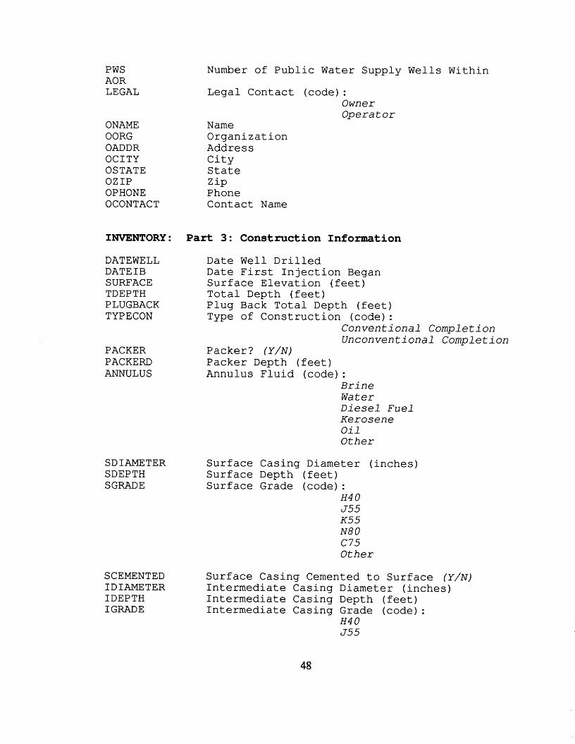
Number of Public Water Supply Wells Within PWS AOR LEGAL
ONAME OORG OADDR OCITY OSTATE OZIP OPHONE OCONTACT
Legal Contact (code) : Owner Operator
Name Organization Address City State Zip Phone Contact Name
INVENTORY: Part 3: Construction Information
PACKER PACKEFD ANNULUS
DATEWELL Date Well Drilled DATEIB Date First Injection Began SURFACE Surface Elevation (feet) TDEPTH Total Depth (feet) PLUGBACK Plug Back Total Depth (feet) TYPECON Type of Construction (code) :
Packer? ( Y / N ) Packer Depth (feet) Annulus Fluid (code) :
Conventional Compl e t i on Unconventional Completion
Brine Water Diesel F u e l Kerosene O i 1 Other
SDIAMETER SDEPTH SGRADE
SCEMENTED I D I AME TER IDEPTH IGRADE
Surface Casing Diameter (inches) Surface Depth (feet) Surface Grade (code) :
H 4 0 J55 K 5 5 N 8 0 c75 Other
Surface Casing Cemented to Surface ( Y / N ) Intermediate Casing Diameter (inches) Intermediate Casing Depth (feet) Intermediate Casing Grade (code):
H 4 0 J55
48
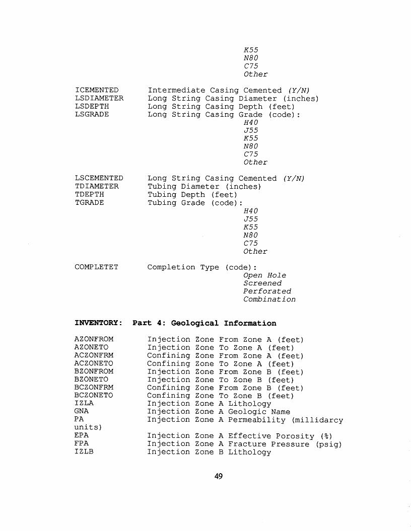
K 5 5 N 8 0 c75 Other
ICEMENTED Intermediate Casing Cemented ( Y / N ) LSDIAMETER Long String Casing Diameter (inches) LSDEPTH Long String Casing Depth (feet) LSGRADE Long String Casing Grade (code):
H 4 0 J55 K 5 5 N 8 0 c75 Other
LSCEMENTED Long String Casing Cemented ( Y / N ) TDIAMETER Tubing Diameter (inches) TDEPTH Tubing Depth (feet) TGRADE Tubing Grade (code) :
H 4 0 J55 K 5 5 N 8 0 c75 Other
COMPLETET Completion Type (code) : Open Hole Screened P e r f o r a t e d Combi n a t i on
INVENTORY: P a r t 4: Geological Information
AZONFROM AZONETO ACZONFRM ACZONETO B ZONFROM BZONETO BCZONFRM BC Z ONE TO IZLA GNA PA units) EPA FPA IZLB
Injection Injection Confining Confining Injection Injection Confining Confining Injection Injection Injection
Zone Zone Zone Zone Zone Zone Zone Zone Zone Zone Zone
From Zone A (feet) To Zone A (feet) From Zone A (feet) To Zone A (feet) From Zone B (feet) To Zone B (feet) From Zone B (feet) To Zone B (feet) A Lithology A Geologic Name A Permeability (millidarcy
Injection Zone A Effective Porosity ( % ) Injection Zone A Fracture Pressure (psig) Injection Zone B Lithology
49
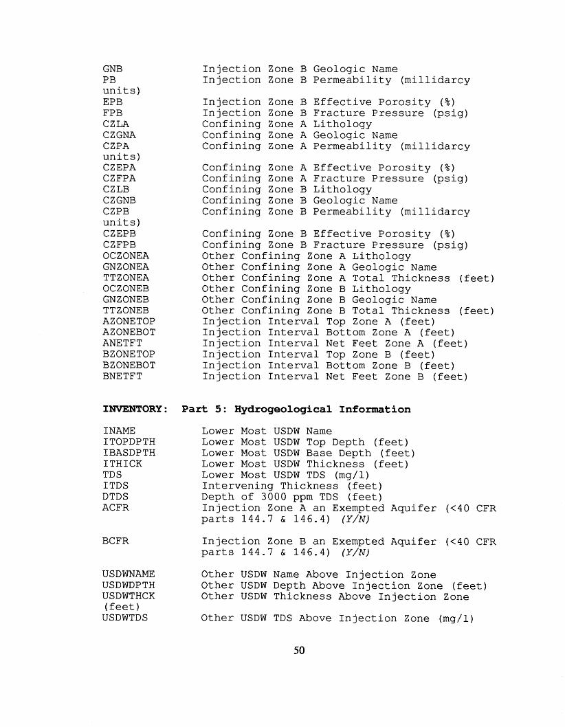
GNB PB u n i t s ) EPB FPB CZLA CZGNA CZPA u n i t s ) CZEPA CZFPA CZLB CZGNB CZPB u n i t s ) CZEPB CZFPB OCZONEA GNZONEA TT ZONEA OCZONEB GNZONEB TTZONEB AZONETOP AZONEBOT ANETFT BZONETOP BZONEBOT BNETFT
I n j e c t i o n Zone B Geologic N a m e I n j e c t i o n Zone B P e r m e a b i l i t y ( m i l l i d a r c y
I n j e c t i o n Zone B E f f e c t i v e P o r o s i t y ( % ) I n j e c t i o n Zone B F rac tu re Pressure (ps ig) Conf in ing Zone A L i tho logy Conf in ing Zone A Geologic N a m e Conf in ing Zone A P e r m e a b i l i t y ( m i l l i d a r c y
Conf in ing Zone A E f f e c t i v e P o r o s i t y ( % ) Conf in ing Zone A F r a c t u r e Pressure ( p s i g ) Conf in ing Zone B L i tho logy Conf in ing Zone B Geologic N a m e Conf in ing Zone B Permeabi l i ty ( m i l l i d a r c y
Confining Zone B E f f e c t i v e P o r o s i t y ( % ) Conf in ing Zone B Frac ture P r e s s u r e (ps ig) Othe r Conf in ing Zone A L i tho logy Other Conf in ing Zone A Geologic N a m e Other Conf in ing Zone A To ta l Thickness ( fee t ) Othe r Conf in ing Zone B L i tho logy Othe r Conf in ing Zone B Geologic N a m e Other Conf in ing Zone B Tota l Thickness ( feet) I n j e c t i o n I n t e r v a l Top Zone A ( fee t ) I n j e c t i o n I n t e r v a l B o t t o m Zone A ( f e e t ) I n j e c t i o n I n t e r v a l N e t Feet Zone A ( fee t ) I n j e c t i o n I n t e r v a l Top Zone B ( f e e t ) I n j e c t i o n I n t e r v a l B o t t o m Zone B ( fee t ) I n j e c t i o n I n t e r v a l N e t F e e t Zone B ( f e e t )
INVENTORY: Part 5: Hydrogeological Information
INAME ITOPDPTH IBASDPTH I T H I C K TDS ITDS DTDS ACFR
BCFR
L o w e r Most USDW N a m e L o w e r Most USDW Top Depth ( fee t ) Lower Most USDW Base Depth ( fee t ) L o w e r Most USDW Thickness ( fee t ) L o w e r Most USDW TDS (mg/l) I n t e r v e n i n g Thickness ( f e e t ) Depth of 3000 ppm TDS ( f e e t ) I n j e c t i o n Zone A an Exempted A q u i f e r (<40 CFR p a r t s 1 4 4 . 7 & 1 4 6 . 4 ) ( Y / N )
I n j e c t i o n Zone B an Exempted Aqu i fe r (<40 CFR pa r t s 1 4 4 . 7 & 1 4 6 . 4 ) ( Y / N )
USDWNAME Other USDW N a m e Above I n j e c t i o n Zone USDWDPTH Other USDW Depth Above I n j e c t i o n Zone ( feet) USDWTHCK Othe r USDW Thickness Above I n j e c t i o n Zone ( fee t ) USDWTDS Othe r USDW TDS Above I n j e c t i o n Zone (mg/l)
50
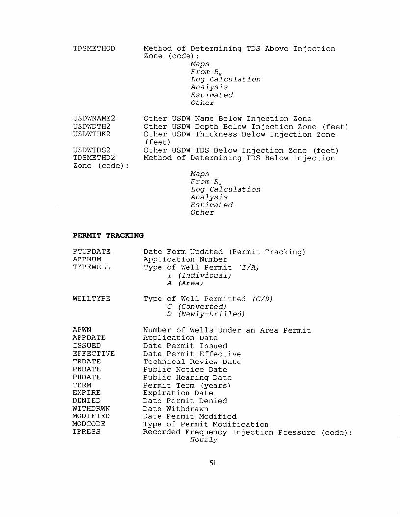
TDSMETHOD Method of Determining TDS Above I n j e c t i o n Zone (code) :
Maps F r o m R, Log C a l c u l a t i o n A n a l y s i s E s t i m a t e d Other
US D WNAME 2 Other USDW N a m e B e l o w I n j e c t i o n Zone USDWDTH2 Othe r USDW Depth B e l o w I n j e c t i o n Zone ( fee t ) USDWTHK2 Other USDW Thickness B e l o w I n j e c t i o n Zone
USDWTDSZ Other USDW TDS B e l o w I n j e c t i o n Zone ( fee t ) TDSMETHD2 Method of Determining TDS B e l o w I n j e c t i o n Zone (code) :
( f e e t )
Maps F r o m R, Log C a l c u l a t i o n An a l y s i s E s t i m a t e d Other
PERMIT TRACKING
P TUPDATE Date Form Updated ( P e r m i t T rack ing) APPNUM A p p l i c a t i o n Number TYPEWELL Type of W e l l P e r m i t ( I / A )
I ( I n d i v i d u a l ) A ( A r e a )
WELLTYPE
APWN APPDATE ISSUED EFFECTIVE TRDATE PNDATE PHDATE TERM EXPIRE D E N I E D WITHDRWN MOD I F I ED MODCODE IPRESS
Type of W e l l P e r m i t t e d ( C / D ) C (Converted) D ( N e w l y - D r i l l e d )
Number of Wells Under an Area P e r m i t Appl icat ion Date Date P e r m i t Issued Date P e r m i t E f f e c t i v e Techn ica l Review Date P u b l i c Notice Date P u b l i c Hearing Date P e r m i t T e r m ( y e a r s ) E x p i r a t i o n Date Date P e r m i t Denied Date Withdrawn Date P e r m i t Modified Type of P e r m i t Mod i f i ca t ion Recorded Frequency I n j e c t i o n P r e s s u r e (code) :
H o u r l y
51
D a i l y Weekly Monthly Other
IRATE IPCODE FRCODE
IVCODE
AWAOR OWAOR DAWAOR DOWAOR CAWAOR
COWAOR
PAWAOR
POWAOR
RADIUS DATECA TYPECA
DATECAC MITCODE
TDCODE
I n j e c t i o n Rate (gpm o r b b l s / d a y ) I n j e c t i o n P r e s s u r e ( p s i g ) Recorded Frequency Flow Rate ( c o d e ) :
H o u r l y D a i l y Weekly Mon t hl y Other
Recorded Frequency I n j e c t i o n Volume H o u r l y D a i l y Weekly Mon t h 1 y Other
Number of Abandoned W e l l s i n AOR Number of Other Wells i n AOR Number of Abandoned D e f e c t i v e W e l l s i n AOR Number of Other D e f e c t i v e Wells i n A o r Number of Abandoned Wells i n AOR Needing C o r r e c t i v e Act ion Number of Other Wells i n AOR Needing C o r r e c t i v e A c t i o n Number of Abandoned Wells P e n e t r a t i n g t h e I n j e c t i o n Zone i n AOR Number of Other Wells P e n e t r a t i n g t h e I n j e c t i o n Zone i n AOR R a d i u s of AOR (miles) Date of Correct ive Act ion Type of C o r r e c t i v e Act ion (code) :
C a s i n g/Cemen t Rep 1 u g g i n g P1 u ggi n g/Aban donmen t Other
Date of Corrective Act ion Complete Frequency of M I T T e s t s (code):
Ann ua 1 l y Semi -Annua l l y Every 5 Y e a r s Other
T r u s t Fund S u r e t y Bond -guaran tee payment
Type of Demonstration (code) :
52
AMTCOV BCOVER NWBC
DEMEXP DEMREV PLUGCOST GNAME GADDR GCITY GSTATE GZ IP GPHONE
Coverage
INSPECTION AND
IODATE DATEINSP TYPEINSP
CRTIME COMPLAINT ERTIME EMERGENCY V I OLAT I ON ACTION
S u r e t y Bond -guaran tee p l u g g i n g and abandonment Le t t e r o f C r e d i t F i n a n c i a l Test & C o r p o r a t e Guaran tee C o l l a t e r a l Other
Amount of Coverage ( $ ) Blanket Coverage ( Y / N ) Number of Blanket Wells Under Blanket
Demonstration Expiration Date Date Demonstration Last Reviewed Estimated Plugging Cost ( $ ) Guarantor Name Guarantor Address Guarantor City Guarantor State Guarantor Zip Code Guarantor Phone
OPERATION: Part 1: Inspections
Date Form Updated (Inspection and Operation) Date of Inspection Type of Inspection (code) :
Rout i ne /Per i o d i c P l u g g i n g Witnessed C o n s t r u c t i on M I T W i t nessed Pre-Operat i on Compl iance V e r i f i c a t i o n Complain t Response Emergency Response Other
Time Required for Complaint Response (days) Complaint Resolution Time Required for Emergency Response (days) Emergency Resolution Violat ion Di scovered/P resent ( Y / N ) Action Taken (code) :
Corrected on S i t e Operat or t o Correct (n on -vi o l a t i on) Fol low-up I n s p e c t i o n S c h e d u l e d Referred t o Enforcement Other
53
INSPECTION AND OPERATION: Part 2: Mechanical Integrity Testing
BTPCOMP BPRE TE S T DATEMIT RESULTMIT LAS T CAC T DATELTF DATELPT TYPELT
DATEFMTF DATEFMTP TYPEFMT
DATERA TYPERA
Both Parts Test Complete? (Y/N) MIT Retest? ( Y / N ) Date of Last MIT Last MIT Passed? (Y/N) Date of Last Corrective Action Date of Failed Leak Test Date of Passed Leak Test Type of Leak Test (code) :
Annulus Monitoring Casing/Tubing Pressure Monitoring Record Review Ada Test Other
Date of Failed Fluid Migration Test Date of Passed Fluid Migration Test Type of Fluid Migration Test (code) :
Cement Record Review Temperat ure/Noise Log Radioactive Tracer Other
Date of Remedial Action Type of Remedial Action (code) :
Casing/Tubing Tubing/Packer P1 ugging/Aban donmen t Shut -in Other
INSPECTION AND OPERATION: Part 3: Operating Data
OPSTATUS Operating Status (code) : Under Construction Active Temporarily Abandoned Permanently Abandoned (approved) Perminantly Abandoned (unapproved) Unknown Other
STATDATE ABANDATE IRMIN IRAVG IRMAX IPMIN
Date Status Effective Date Plugged and Abandoned Injection Rate Minimum (gpm or bbls/day) Injection Rate Average (gpm or bbls/day) Injection Rate Maximum (gpm or bbls/day) Injection Pressure Minimum (psig)
IPAVG IPMAX APMIN APAVG APMAX VOLUME VOLUNIT
FLTYPE
Injection Pressure Average (psig) Injection Pressure Maximum (psig) Annulus Pressure Minimum (psig) Annulus Pressure Average (psig) Annulus pressure Maximum (psig) Annual Volume of Injected Fluid Volume Measured in: ( g a l l (gallons) or bbls (barrels) Fluid Type (code):
S a l t W a t e r Fresh W a t e r Gas Other
ENE'ORCEMENT/COMPLIANCE TRACKING
ENUPDATE
SNC LASTCR LCRE SULT DATOCRD TY P EVRFD
DATENOTE TYPENOTE
DATEEAT TYPEEAT
Date Form Updated (Enforcement/Compliance Tracking) Yes/No? Date of Last Compliance Review Compliance Review Results ( P / F ) Date Violation Occured or Verified Type of Violation (code):
U n a u t h o r i z e d I n j e c t i o n Mechanical I n t e g r i t y P r e s s u r e a n d / o r R a t e P l u g g i n g and Abandonment V i o l a t i o n o f Formal O r d e r Fa1 s i f i c a t i on O p e r a t i o n and Main tance Other P e r m i t V i o l a t i o n C a s i n g and Cementing M o n i t o r i n g and R e p o r t i n g USD W Contaminated F i n a n c i a l R e s p o n s i b i l i t y Other
Date Owner/Operator Notified Type of Notification (code) :
L e t t er/Not i c e of V i o l a t i o n Phone C a l l F i e l d V i s i t Other
Date of Enforcement Action Taken Type of Enforcement Action Taken (code):
A d m i n s t r a t i v e O r d e r (Agency Ac t ion) :
- U n i l a t e r a l O r d e r -Consent O r d e r
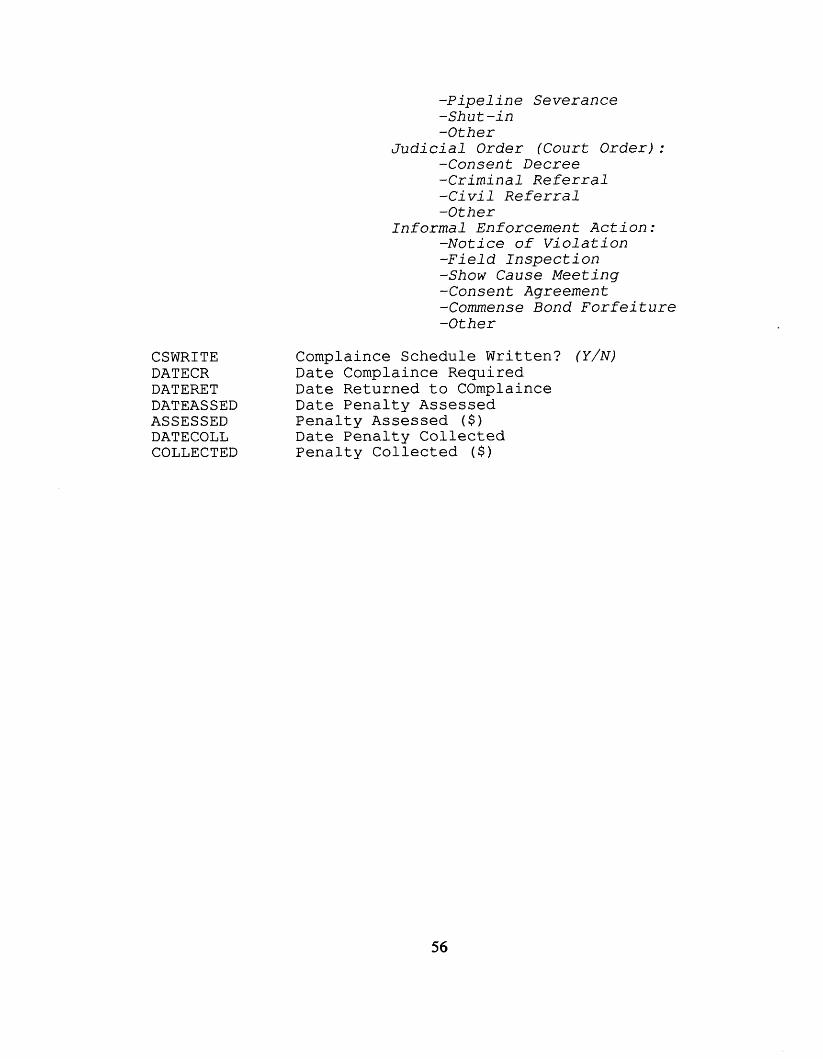
CSWRITE DATECR DATERE T DATEAS SED ASSESSED DATECOLL COLLECTED
Complaince
-Pipel ine Severance -Shut - in -Other
J u d i c i a l O r d e r (Court Order) : -Consent Decree -Criminal Re fe r ra l - C i v i l Re f e r ra l -Other
Informal Enforcement Ac t ion: -Notice of Viol a t i o n -Field Inspec t ion -Show Cause Meeting -Consent Agreement -Commense Bond F o r f e i t u r e -Other
Schedule Written? ( Y / N ) Date Complaince Required Date Returned to COmplaince Date Penalty Assessed Penalty Assessed ( $ ) Date Penalty Collected Penalty Collected ( $ )
56
APPENDIX F
INJECTION FACILITY COVERAGE NAMING CONVENTIONS AND FILE STRUCTURE
57
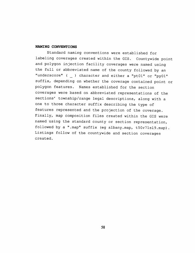
NAMING CONVENTIONS Standard naming conventions were established for
labeling coverages created within the GIs. and polygon injection facility coverages were named using the full or abbreviated name of the county followed by an "underscore" ( ) character and either a ''pt01" or llpyOlrl suffix, depending on whether the coverage contained point or polygon features. Names established for the section coverages were based on abbreviated representations of the sections' township/range legal descriptions, along with a one to three character suffix describing the type of features represented and the projection of the coverage. Finally, map composition files created within the G I S were named using the standard county or section representation, followed by a .map" suffix (eg albany.map, t50r71s19.map) . Listings follow of the countywide and section coverages created.
Countywide point
-
58
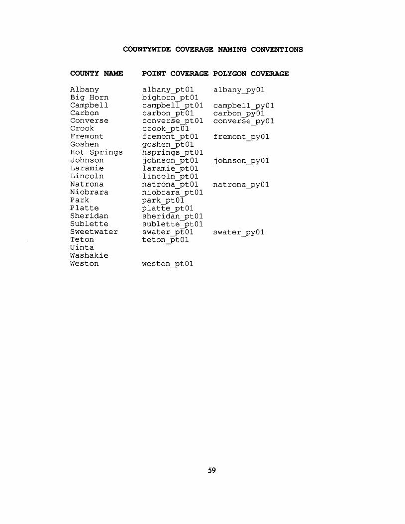
COUNTYWIDE COVERAGE NAMING CONVENTIONS
COUNTY NAME
Albany Big Horn Campbell Carbon Converse Crook Fremont Goshen Hot Springs Johnson Lar amie Lincoln Natrona Niobrara Park P l a t t e She r i dan S u b l e t t e Sweetwater Teton Uinta Washakie Weston
POINT COVERAGE POLYGON COVERAGE
albany ptOl albany - pyOl bighorn - ptOl campbell ptOl campbell pyOl carbon pFOl carbon pvOl converse - ptO1 converge - pyol crook ptOl fremont D t O I goshen FtOl hsprings p t iohnson x > t O
01 1
fremont - pyOl
johnson - pyOl
natrona ptOl natrona - pyOl n iob ra ra ptOl park p t 0 l p l a t t e ptO1 s h e r i d k ptOl suble t te -p t0 l swater pt01 t e t o n - FtOl
weston - ptOl
swater - pyOl
59
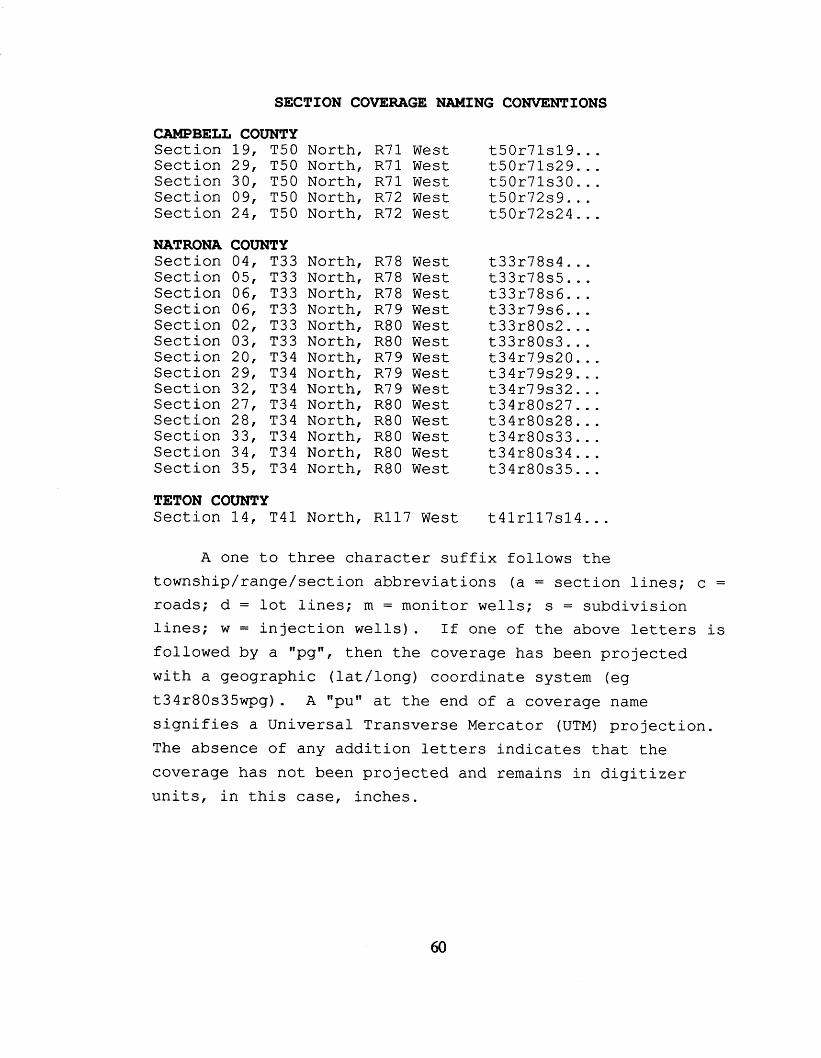
SECTION COVERAGE NAMING CONVENTIONS
CAMPBELL COUNTY S e c t i o n 1 9 , T50 North, S e c t i o n 29 , T50 North, S e c t i o n 30, T50 North, S e c t i o n 09, T50 North, S e c t i o n 2 4 , T50 North,
NATRONA COUNTY S e c t i o n 04 , S e c t i o n 05, S e c t i o n 06 , S e c t i o n 06, S e c t i o n 02 , S e c t i o n 03, S e c t i o n 20 , S e c t i o n 29 , S e c t i o n 32, S e c t i o n 27, S e c t i o n 28, S e c t i o n 33, S e c t i o n 34, S e c t i o n 35,
T33 North, T33 North, T33 North, T33 North, T33 North, T33 North, T34 North, T34 North, T 3 4 North, T34 North, T34 North, T34 North, T34 North, T34 North,
TETON COUNTY S e c t i o n 1 4 , T 4 1 North,
R 7 1 W e s t R 7 1 West R 7 1 West €372 West R72 West
R78 West R78 West R78 West R79 W e s t R80 West R80 West R 7 9 W e s t R79 West R7 9 W e s t R80 W e s t R80 W e s t R80 West R80 West R80 West
R 1 1 7 West
t50r71s19 ... t 50 r71s29 . . . t50r71s30 . . . t 50 r72s9 . . . t50r72s24 ...
t33r78s4 . . . t 3 3 r 7 8 s 5 . . . t 33 r78s6 . . . t 3 3 r 7 9 s 6 . . . t 33 r80s2 ... t 33 r80s3 . . . t 34 r79s20 . . . t 34 r79s29 . . . t 34 r79s32 . . . t34r80s27 ... t34r80s28 ... t34r80s33 . . . t34r80s34 ... t34r80s35 ...
t 4 1 r 1 1 7 s 1 4 ...
A one t o t h r e e c h a r a c t e r s u f f i x f o l l o w s t h e t o w n s h i p / r a n g e / s e c t i o n a b b r e v i a t i o n s (a = s e c t i o n l i n e s ; c =
roads ; d = l o t l i n e s ; m = moni tor w e l l s ; s = s u b d i v i s i o n l i n e s ; w = i n j e c t i o n w e l l s ) . I f one of t h e above le t ters i s f o l l o w e d by a "pg", t h e n t h e coverage h a s been p r o j e c t e d w i t h a geograph ic ( l a t / l o n g ) c o o r d i n a t e system (eg t34r80s35wpg) . A ''puff a t t h e end of a coverage name s i g n i f i e s a U n i v e r s a l T ransve r se Mercator (UTM) p r o j e c t i o n . The absence of any a d d i t i o n l e t te rs i n d i c a t e s t h a t t h e cove rage h a s not been projected and remains i n d i g i t i z e r u n i t s , i n t h i s case, i n c h e s .
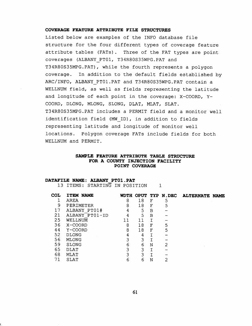
COVERAGE FEATURE ATTRIBUTE FIfiE STRUCTURES L i s t e d below a r e examples of t h e INFO database f i l e
s t r u c t u r e f o r t h e four d i f f e r e n t types of coverage f e a t u r e a t t r i b u t e t a b l e s (FATs). Three of t h e FAT types a r e po in t coverages (ALBANY - PTO1, T34R80S35WPG.PAT and T34R80S35MPGePAT), w h i l e t h e fou r th represents a polygon coverage. I n addi t ion t o the de fau l t f i e l d s e s t ab l i shed by ARC/INFO, ALBANY - PTOLPAT and T34R80S35WPG.PAT contain a WELLNUM f i e l d , a s w e l l as f ie lds represent ing the l a t i t u d e and longi tude of each poin t i n t h e coverage: X-COORD, Y- COORD, DLONG, MLONG, SLONG, DLAT, MLAT, SLAT. T34R8OS35MPG.PAT i n c l u d e s a PERMIT f i e l d and a monitor w e l l i d e n t i f i c a t i o n f i e l d (MW - ID), i n addi t ion t o f ie lds
represent ing l a t i t u d e and longitude of monitor w e l l
l oca t ions . Polygon coverage FATs include f ie lds f o r both WELLNUM and PERMIT.
SAMPLE FEATURE ATTRIBUTE TABLE STRUCTURE FOR A COUNTY INJECTION FACILITY
POINT COVERAGE
DATAFILE NAME: ALBANY PTOl .PAT 13
COL 1 9 17 21 25 36 44 52 56 59 65 68 7 1
ITEMS: STARTINE IN POSITION
ITEM NAME AREA PERIMETER ALBANY PTOl# ALBANY-PTOI-ID WELLNUM x-COORD Y-coom DLONG MLONG SLONG DLAT MLAT SLAT
WDTH OPUT 8 18 8 18 4 5 4 5 11 11 8 18 8 18 4 4 3 3 6 6 3 3 3 3 6 6
1
TYP F F B B I F F I I N I
N.DEC ALTERNATE 5 5 -
5 5
2 - - I
N 2
NAME
61
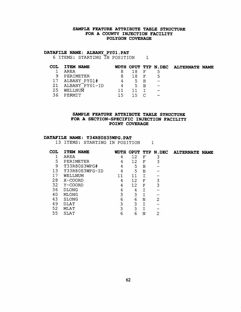
SAMPLE FEATURE ATTRIBUTE TABLE STRUCTURE FOR A COUNTY INJECTION FACILITY
POLYGON COVERAGE
DATAFILE NAME: ALBANY PY0l.PAT 6 ITEMS: STARTING TN POSITION 1
COL ITEM UAME WDTH OPUT TYP N.DEC ALTERNATE NAME 1 AREA 8 18 F 5 9 PERIMETER 8 18 F 5 17 ALBANY PYOl# 4 5 B - 21 ALBANY-PYOI-ID 4 5 B - 25 WELLNUM 11 11 I -
- 36 PERMIT 15 15 C
SAMPLE FEATURE ATTRIBUTE TABLE STRUCTURE FOR A SECTION-SPECIFIC INJECTION FACILITY
POINT COVERAGE
DATAFILE NAME: T34R8OS35WPG0PAT 13 ITEMS: STARTING IN POSITION 1
COL 1 5 9 13 17 28 3 2 36 40 43 49 52 55
ITEM NAME AREA PERIMETER T33R80S3WPG# T33R8OS3WPG-ID WELLNUM x-COORD Y-COORD DLONG MLONG SLONG DLAT MLAT SLAT
WDTH OPUT TYP N.DEC ALTERNATE NAME 4 12 F 3 4 12 F 3 4 5 B - 4 5 B - 11 11 I - 4 12 F 3 4 12 F 3 4 4 1 - 3 3 1 -
6 6 N 2 3 3 1 - 3 3 1 - 6 6 N 2
62
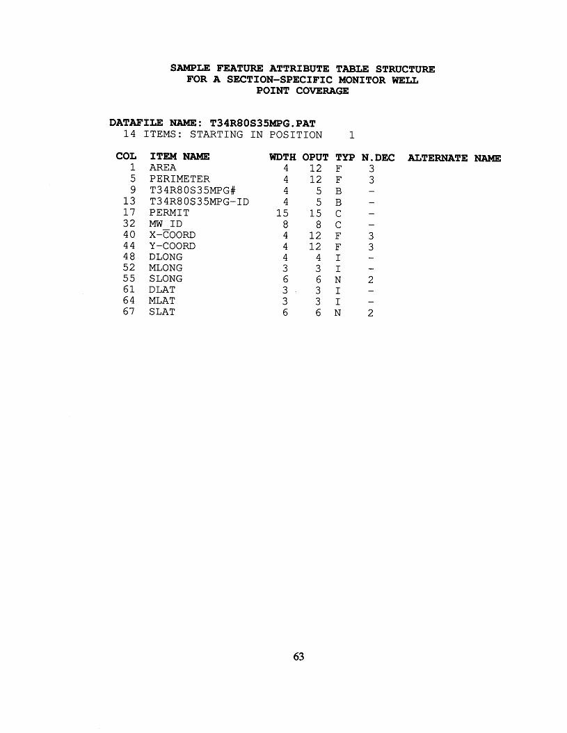
SAMPLE FEATURE ATTRIBUTE TABLE STRUCTURE FOR A SECTION-SPECIFIC MONITOR WELL
POINT COVERAGE
DATAETLE NAME : T34R80S35MPG. PAT 1 4 ITEMS: STARTING I N POSITION 1
COL 1 5 9
13 1 7 32 4 0 4 4 4 8 52 55 6 1 6 4 67
ITEM NAME AREA PERIMETER T 3 4R80S35MPG# T34R8OS35MF'G-ID PERMIT MW I D
Y-coom DLONG MLONG SLONG DLAT MLAT SLAT
x-COORD
WDTH OPUT TYP N.DEC ALTERNATE NAME 4 1 2 F 3 4 1 2 F 3 4 5 B - 4 5 B -
15 15 C - 8 8 C 4 1 2 F 3 4 1 2 F 3 4 4 1 - 3 3 1 - 6 6 N 2 3 3 1 - 3 3 1 - 6 6 N 2
-
63
COVERAGE DESCRIPTIONS T h i s s e c t i o n conta ins t h e output of an ARC/INFO
"DESCRIBE" command run f o r each of t h e poin t and polygon coverages c r e a t e d f o r t h e i n j e c t i o n w e l l g i s database. T h e
information repor ted provides a d e t a i l e d desc r ip t ion of t h e
f e a t u r e conten ts of t h e geographic da t a set , inc luding the
number of f e a t u r e s , coverage boundaries, coverage to l e rances , coordinate system p ro jec t ion , and topology s t a t u s .
64
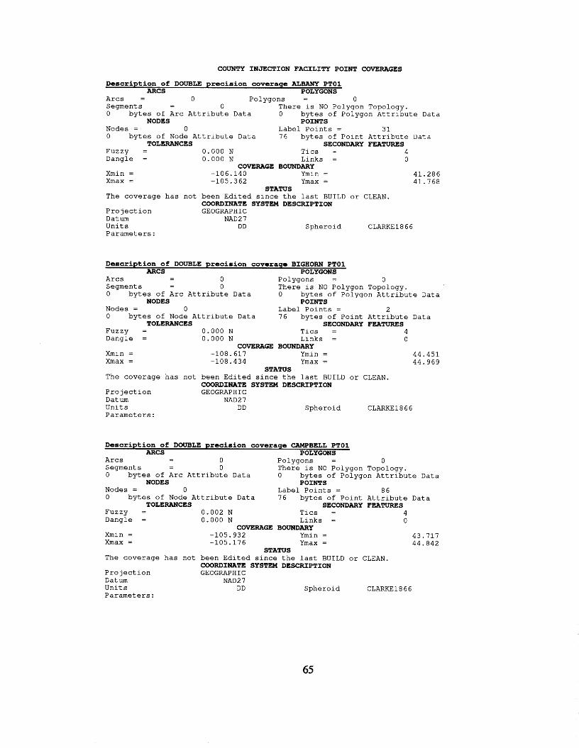
COUNTY INJECTION FACILITY POINT COVERAGES
Description of DOUBLE precision coverage ALaANy PTOl ARCS POLYGONS
A r c s = 0 Po lygons = 0 Segments - 0 T h e r e i s NO Po lygon Topology. - 0 b y t e s of A r c A t t r i b u t e Data 0 b y t e s of Po lygon A t t r i b u t e Data
Nodes = 0 Label P o i n t s = 3 1 0 b y t e s of Node A t t r i b u t e Data 76 b y t e s of P o i n t A t t r i b u t e Data
NODES POINTS
TOLERANCES SECONDARY FEATURES Fuzzy = 0 . 0 0 0 N T i c s = 4 Dang le = 0 . 0 0 0 N L i n k s = 0
COVERAGE BOUNDARY Xmin = -106.140 Ymin = 41.286 Xmax = -105.362 Ymax = 41.768
The coverage h a s n o t b e e n E d i t e d s i n c e t h e l a s t BUILD o r CLEAN.
P r o j e c t i o n GEOGRAPHIC D a t u m NAD2 7 U n i t s DD Sphe ro 1 d CLARKE1866 P a r a m e t e r s :
STATUS
COORDINATE SYSTEM DESCRIPTION
Description of DOUBLE precision coveraqe BIGHORN PTOl ARCS POLYGONS - - A r c s 0 Po lygons = 0
Segment s - 0 T h e r e i s NO Po lygon Topology. 0 b y t e s of A r c A t t r i b u t e Data 0 b y t e s of Po lygon A t t r i b u t e Data
Nodes = 0 L a b e l P o i n t s = 2 0 b y t e s of Node A t t r i b u t e Data 76 b y t e s of P o i n t A t t r i b u t e Da ta
FUZZY = 0.000 N T i c s = 4 Dang le = 0 . 0 0 0 N L i n k s = 0
Xmin = -108.617 Ymin = 4 4 , 4 5 1 Xmax = -108.434 Ymax = 44.969
The coverage h a s n o t b e e n E d i t e d s i n c e t h e l a s t B U I L D o r CLEAN.
P r o j e c t i o n GEOGRAPHIC Datum NAD27 U n i t s DD S p h e r o i d CLARKE1866 P a r a m e t e r s :
-
NODES POINTS
TOLERANCES SECONDARY FEATURES
COVERAGE BOUNDARY
STATUS
COORDINATE SYSTEM DESCRIPTION
Description of DOUBLE precision coverage CAMPBELL PTOl ARCS POLYGONS
- - A r c s 0 Po lygons = 0 Segments - 0 T h e r e i s NO Po lygon Topology. - 0 b y t e s of A r c A t t r i b u t e Data 0 b y t e s of Po lygon A t t r i b u t e Data
Nodes = 0 Label P o i n t s = 86 0 b y t e s of Node A t t r i b u t e Data 76 b y t e s of P o i n t A t t r i b u t e Data
NODES POINTS
TOLERANCES SECONDARY FEATURES FUZZY = 0 . 0 0 2 N T i c s = 4 Dang le = 0 . 0 0 0 N L i n k s = 0
COVERAGE BOUNDARY Xmin = -105.932 Ymin = 43.717 Xmax = -105.176 Ymax = 44.842
T h e coverage h a s n o t b e e n E d i t e d s i n c e t h e l a s t B U I L D o r CLEAN.
P r o j e c t i o n GEOGRAPHIC Datum NAD27 U n i t s D D S p h e r o i d CLARKE1 8 6 6 P a r a m e t e r s :
STATUS
COORDINATE SYSTEM DESCRIPTION
65
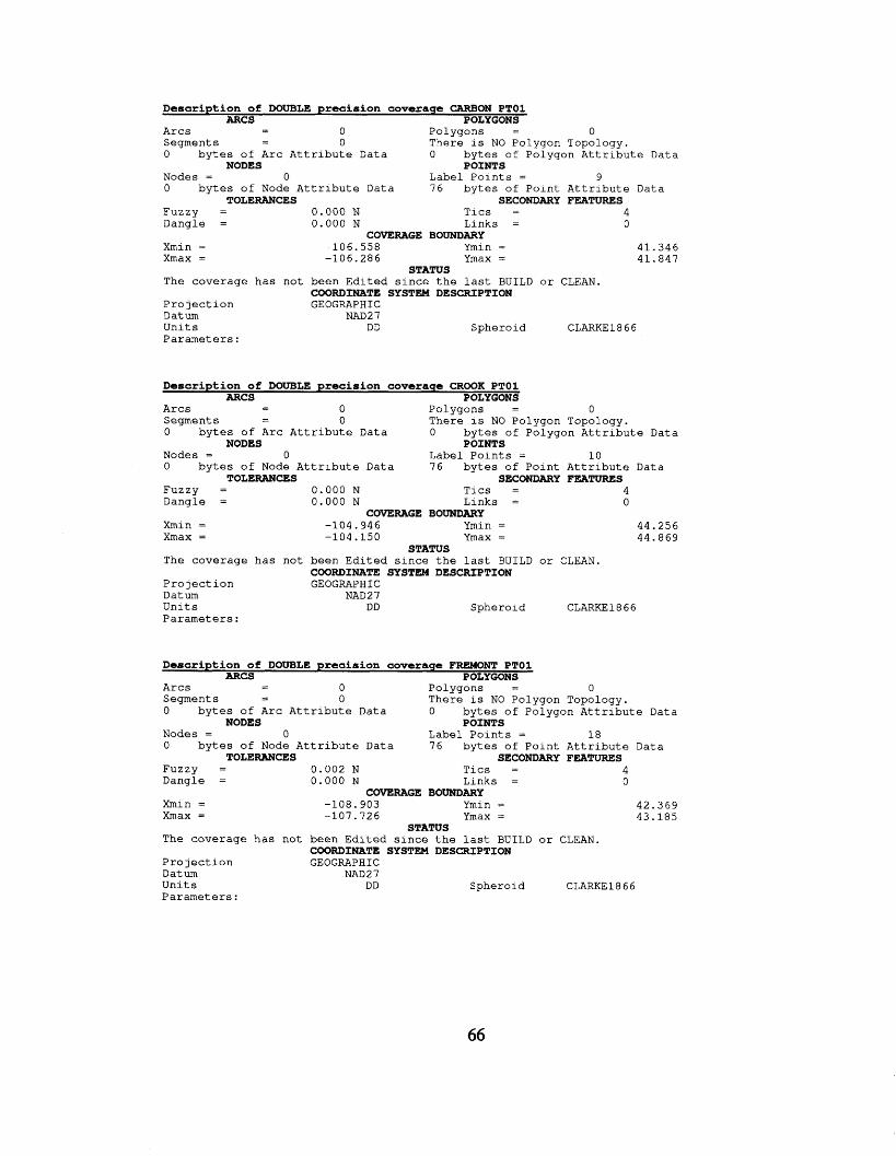
Description of DOUBLE precision coveraqc CARBON PTOI ARCS POLYGONS
- - A r c s 0 P o l y g o n s = 0 S e g m e n t s - 0 T h e r e i s NO P o l y g o n T o p o l o g y . - 0 b y t e s of A r c A t t r i b u t e Data 0 b y t e s of P o l y g o n A t t r i b u t e Data
Nodes = 0 L a b e l P o i n t s = 9 0 b y t e s of Node A t t r i b u t e Data 76 b y t e s of P o i n t A t t r i b u t e D a t a
NODES POINTS
TOLERANCES SECONDARY FEATURES F u z z y = 0.000 N T i c s = 4 D a n g l e = 0 . 0 0 0 N L i n k s = 0
COVERAGE BOUNDARY 41.346 Xmin = -106 .558 Ymin =
Xmax = -106 .286 Ymax = 41.847
The coverage h a s n o t b e e n E d i t e d s i n c e t h e l a s t BUILD o r CLEAN.
P r o j e c t i o n GEOGRAPHIC Datum NAD 2 7 U n i t s DD S p h e r o i d CLARKE1866 P a r a m e t e r s :
STATUS
COORDINATE SYSTEM DESCRIPTION
Description of DOUBLE precision coverage CROOK PTOl ARCS POLYGONS - - A r c s 0 P o l y g o n s = 0
S e g m e n t s - 0 T h e r e i s NO P o l y g o n Topology. 0 b y t e s of A r c A t t r i b u t e Data 0 b y t e s of P o l y g o n A t t r i b u t e Data
Nodes = 0 L a b e l P o i n t s = 1 0 0 b y t e s of Node A t t r i b u t e Data 76 b y t e s of P o i n t A t t r i b u t e Data
NODES POINTS
TOLERANCES SECONDARY FEATURES F u z z y = 0 . 0 0 0 N T i c s = 4 D a n g l e = 0 . 0 0 0 N L i n k s = 0
COVERAGE BOUNDARY Xmin = -104 .946 Ymin = 44.256 Xmax = -104.150 Ymax = 44.869
The coverage h a s n o t b e e n E d i t e d s i n c e t h e l a s t B U I L D o r CLEAN.
P r o j e c t i o n GEOGRAPHIC Datum NAD2 7 U n i t s DD S p h e r o i d CLARKE1866 P a r a m e t e r s :
STATUS
COORDINATE SYSTEM DESCRIPTION
Description of DOUBLE precision coverage FREMONT PTOl ARCS POLYGONS - - A r c s 0 P o l y g o n s = 0
S e g m e n t s - 0 T h e r e i s NO P o l y g o n Topology. 0 b y t e s of A r c A t t r i b u t e Data 0 b y t e s of P o l y g o n A t t r i b u t e Data
Nodes = 0 L a b e l P o i n t s = 1 8 0 b y t e s of Node A t t r i b u t e Data 76 b y t e s of P o i n t A t t r i b u t e Data
NODES POINTS
TOLERANCES SECONDARY FEATURES F u z z y = 0 . 0 0 2 N T i c s = 4 D a n g l e = 0 . 0 0 0 N L i n k s = 0
COVERAGE BOUNDARY Xmin = -108 .903 Ymin = 4 2 . 3 6 9 Xmax = -107.726 Ymax = 43.185
The coverage has n o t b e e n E d i t e d s i n c e t h e l a s t BUILD o r CLEAN.
P r o j e c t i o n GEOG-PHIC Datum NAD2 7 U n i t s DD S p h e r o i d CLARKE1866 P a r a m e t e r s :
STATUS
COORDINATE SYSTEM DESCRIPTION
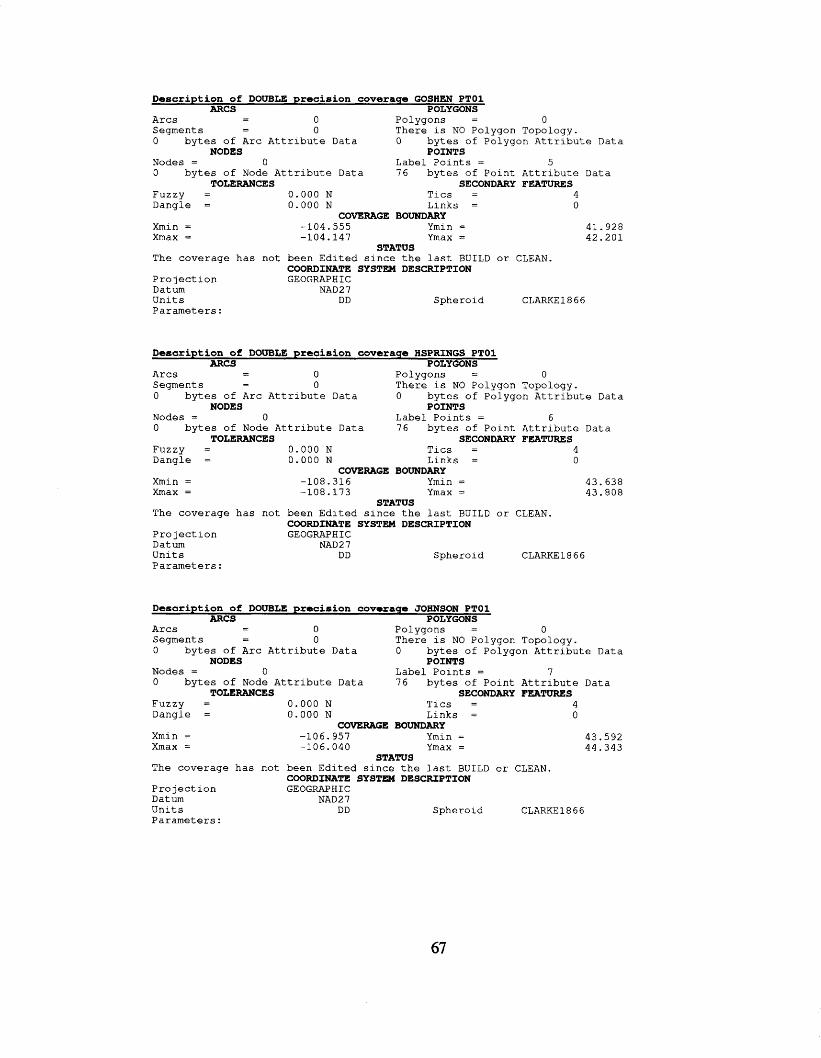
Description of DOUBLE precision coverage GOSHEN PTOl ARCS POLYGONS - - A r c s 0 P o l y g o n s = 0
S e g m e n t s - 0 T h e r e i s NO P o l y g o n T o p o l o g y . - 0 b y t e s of A r c A t t r i b u t e Data 0 b y t e s of P o l y g o n A t t r i b u t e Data
Nodes = 0 L a b e l P o i n t s = 5 0 b y t e s of Node A t t r i b u t e Data 7 6 b y t e s of P o i n t A t t r i b u t e Data
NODES POINTS
TOLERANCES SECONDARY FEATURES F u z z y = 0 . 0 0 0 N T l c s = 4 D a n g l e = 0 . 0 0 0 N L i n k s = 0
COVERAGE BOUNDARY X m i n = -104 .555 Ymin = 41.928 X m a x = -104 .147 Ymax = 4 2 . 2 0 1
The coverage has n o t b e e n E d i t e d s i n c e t h e l a s t BUILD o r CLEAN.
P r o 7 ect ion GEOGRAPHIC Datum NAD2 7 U n i t s DD S p h e r o i d CLARKE 18 6 6 P a r a m e t e r s :
STATUS
COORDINATE SYSTEM DESCRIPTION
Description of DOUBLE precision coverage HSPRINGS PTOl ARCS POLYGONS
- - A r c s 0 P o l y g o n s = 0 S e g m e n t s - 0 T h e r e is NO P o l y g o n T o p o l o g y . - 0 b y t e s of A r c A t t r i b u t e Data 0 b y t e s of P o l y g o n A t t r i b u t e Data
Nodes = 0 L a b e l P o i n t s = 6 0 b y t e s of Node A t t r i b u t e Data 76 b y t e s of P o i n t A t t r i b u t e Data
NODES POINTS
TOLERANCES SECONDARY FEATURES Fuzzy = 0 . 0 0 0 N T i c s = 4 D a n g l e = 0 . 0 0 0 N L i n k s = 0
COVERAGE BOUNDARY Xmin = -108 .316 Ymin = 4 3 . 6 3 8 Xmax = -108 .173 Ymax = 4 3 . 8 0 8
T h e coverage has n o t b e e n E d i t e d s i n c e t h e l a s t B U I L D o r CLEAN.
P r o j e c t i o n GEOGRAPHIC Datum NAD27 U n i t s DD S p h e r o i d P a r a m e t e r s :
STATUS
COORDINATE SYSTEM DESCRIPTION
CLARKE1 8 6 6
Description of DOUBLE precision coveraqe JOHNSON PTOl ARCS POLYGONS - - A r c s 0 P o l y g o n s = 0
S e g m e n t s - 0 T h e r e i s NO P o l y g o n T o p o l o g y . - 0 b y t e s of A r c A t t r i b u t e Data 0 b y t e s of P o l y g o n A t t r i b u t e Data
Nodes = 0 L a b e l P o i n t s = 7 0 by tes of Node A t t r i b u t e Data 7 6 b y t e s of P o i n t A t t r i b u t e Data
NODES POINTS
TOLERANCES SECONDARY FEATURES F u z z y = 0 . 0 0 0 N T i c s = 4 D a n g l e = 0.000 N L i n k s = 0
Xmin = -106.957 Ymin = 4 3 . 5 9 2 Xmax = -106 .040 Ymax = 4 4 . 3 4 3
T h e coverage has n o t b e e n E d i t e d s i n c e t h e l a s t BUILD o r CLEAN.
P r o j e c t i o n GEOGRAPHIC Datum NAD2 7 U n i t s DD S p h e r o i d CLARKE1866 P a r a m e t e r s :
COVERAGE BOUNDARY
STATUS
COORDINATE SYSTEM DESCRIPTION
67
Description of DOUBLE precision coverage LARAMIE PTOl ARCS POLYGONS
- - A r c s 0 P o l y g o n s = 0 Segment s - 0 T h e r e i s NO P o l y g o n Topology. - 0 b y t e s of A r c A t t r i b u t e Data 0 b y t e s of P o l y g o n A t t r i b u t e Data
Nodes = 0 L a b e l P o i n t s = 48 0 b y t e s of N o d e A t t r i b u t e Data 76 b y t e s of P o i n t A t t r i b u t e D a t a
NODES POINTS
TOLERANCES SECONDARY FEATURES F u z z y = 0 . 0 0 0 N T i c s = 4 D a n g l e = 0 . 0 0 0 N L i n k s = 0
COVERAGE BOUNDARY Xmin = -104.926 Ymin = 4 1 . 0 5 9 Xmax = -104.068 Ymax = 4 1 . 2 1 9
The coverage h a s n o t b e e n E d i t e d s i n c e t h e l a s t B U I L D o r CLEAN.
P r o j e c t i o n GEOGRAPHIC Datum NAD2 7 U n i t s DD S p h e r o i d CLARKE1866 P a r a m e t e r s :
STATUS
COORDINATE SYSTEM DESCRIPTION
Description of DOUBLE precision coveraqe LINCOLN PTOl ARCS POLYGONS
- - A r c s 0 P o l y g o n s = 0 S e g m e n t s - 0 T h e r e i s NO P o l y g o n Topology. - 0 b y t e s of A r c A t t r i b u t e Data 0 b y t e s of P o l y g o n A t t r i b u t e Data
Nodes = 0 Label P o i n t s = 1 2 0 b y t e s of Node A t t r i b u t e Data 76 b y t e s of P o i n t A t t r i b u t e Data
NODES POINTS
TOLERANCES SECONDARY FEATURES F U Z Z Y = 0.002 N T i c s = 4 D a n g l e = 0.000 N L i n k s = 0
Xmin = -111.009 Ymin = 41.586 Xmax = -110.563 Ymax = 4 3 . 0 3 1
The coverage h a s n o t b e e n E d i t e d s i n c e t h e l a s t BUILD o r CLEAN.
P r o j e c t i o n GEOGRAPHIC Datum NAD27 U n i t s DD S p h e r o i d CLARKE1866 P a r a m e t e r s :
COVERAGE BOUNDARY
STATUS
COORDINATE SYSTEM DESCRIPTION
Description of DOUBLE precision coverage NATRONA PTOl ARCS POLYGONS
- - A r c s 0 P o l y g o n s = 0 S e g m e n t s - 0 T h e r e i s NO P o l y g o n Topology. - 0 b y t e s of A r c A t t r i b u t e Data 0 b y t e s of P o l y g o n A t t r i b u t e Data
Nodes = 0 Label P o i n t s = 62 0 b y t e s of Node A t t r i b u t e Data 76 b y t e s of P o i n t A t t r i b u t e Data
NODES POINTS
TOLERANCES SECONDARY FEATURES F U Z Z Y = 0.002 N T i c s = 4 D a n g l e = 0.000 N L i n k s = 0
Xmin = -107 .501 Ymin = 42.557 Xmax = -106 .164 Ymax = 43.374
The coverage has n o t b e e n E d i t e d s i n c e t h e l a s t BUILD o r CLEAN.
P r o j e c t i o n GEOGRAPHIC Datum NAD2 7 U n i t s DD S p h e r o i d CLARKE1866 P a r a m e t e r s :
COVERAGE BOUNDARY
STATUS
COORDINATE SYSTEM DESCRIPTION
68
Description of DOUBLE precision coverage NIOBRARA PTOl ARCS POLYGONS - - A r c s 0 P o l y g o n s = 0
S e g m e n t s - 0 T h e r e i s NO P o l y g o n Topology. 0 b y t e s of A r c A t t r i b u t e Data 0 b y t e s of P o l y g o n A t t r i b u t e Data
Nodes = 0 L a b e l P o i n t s = 1 0 b y t e s of Node A t t r i b u t e Data 76 b y t e s of P o i n t A t t r i b u t e Data
F u z z y = 0 . 0 0 0 N Tics = 4 D a n g l e = 0 . 0 0 0 N L i n k s = 0
-
NODES POINTS
TOLERANCES SECONDARY FEATURES
COVERAGE BOUNDARY Xmin = -104.487 Ymin = 42.748 Xmax = -104- 487 Ymax = 4 2 . 7 4 8
The coverage h a s n o t b e e n E d i t e d s i n c e t h e l a s t B U I L D or CLEAN.
P r o j e c t i o n GEOGRAPHIC Datum NAD2 7 U n i t s DD S p h e r o i d CLARKE1866 P a r a m e t e r s :
STATUS
COORDINATE SYSTEM DESCRIPTION
Description of DOUBLE precision coverage PARK PTOl ARCS POLYGONS
- - A r c s 0 P o l y g o n s = 0 S e g m e n t s - 0 T h e r e i s NO P o l y g o n Topology. -
0 b y t e s of A r c A t t r i b u t e Data 0 b y t e s of P o l y g o n A t t r i b u t e Data
Nodes = 0 L a b e l P o i n t s = 5 0 0 b y t e s of Node A t t r i b u t e Data 76 b y t e s of P o i n t A t t r i b u t e Data
NODES POINTS
TOLERANCES SECONDARY FEATURES F u z z y = 0 . 0 0 2 N T i c s = 4 D a n g l e = 0 . 0 0 0 N L i n k s = 0
Xmin = -110 .692 Ymin = 44.457 Xmax = -108 .752 Ymax = 44. a87
COVERAGE BOUNDARY
STATUS The coverage h a s n o t b e e n E d i t e d s i n c e t h e l a s t BUILD o r CLEAN.
P r o j e c t i o n GEOGRAPHIC Datum NAD2 7 U n i t s DD S p h e r o i d CLARKE1866 P a r a m e t e r s :
COORDINATE SYSTEM DESCRIPTION
Description of DOUBLE precision coverage PLATTE PTOl ARCS POLYGONS - - A r c s 0 P o l y g o n s = 0
S e g m e n t s - 0 T h e r e i s NO P o l y g o n Topology. 0 b y t e s of A r c A t t r i b u t e Data 0 b y t e s of P o l y g o n A t t r i b u t e Data
Nodes = 0 L a b e l P o i n t s = 1 0 b y t e s of Node A t t r i b u t e Data 76 b y t e s of P o i n t A t t r i b u t e Data
F u z z y = 0 . 0 0 0 N T i c s = 4 D a n g l e = 0 . 0 0 0 N L i n k s = 0
-
NODES POINTS
TOLERANCES SECONDARY FEATURES
COVERAGE BOUNDARY Xmin = -104 .728 Ymin = 42.267 Xmax = -104 .728 Ymax = 42.267
The coverage h a s n o t b e e n E d i t e d s i n c e t h e l a s t BUILD o r CLEAN.
P r o j e c t i o n GEOGRAPHIC Datum NAD27 U n i t s D D S p h e r o i d CLARKE1866 P a r a m e t e r s :
STATUS
COORDINATE SYSTEM DESCRIPTION
Description of DOUBLE precision coverage SHERIDAN PTOl ARCS POLYGONS
- - A r c s 0 P o l y g o n s = 0 S e g m e n t s - 0 T h e r e i s NO P o l y g o n Topology. - 0 b y t e s of A r c A t t r i b u t e Data 0 b y t e s of P o l y g o n A t t r i b u t e Data
Nodes = 0 L a b e l Points = 13 0 b y t e s of Node A t t r i b u t e Data 76 b y t e s of P o i n t A t t r i b u t e D a t a
NODES POINTS
TOLERANCES SECONDARY FEATURES F u z z y = 0.002 N Tics = 4 D a n g l e = 0.000 N L i n k s = 0
COVERAGE BOUNDARY Xmin = -107 .234 Ymin = 4 4 . 7 7 1 Xmax = -106 .928 Ymax = 44.815
The coverage has n o t b e e n E d i t e d s i n c e t h e l a s t B U I L D o r CLEAN.
P r o j e c t i o n GEOGRAPHIC D a t u m NAD2 7 U n i t s DD S p h e r o i d CLARKE1866 P a r a m e t e r s :
STATUS
COORDINATE SYSTEM DESCRIPTION
Description of DOUBLE precision coverage SUBLETTE PTOl ARCS POLYGONS
- - A r c s 0 P o l y g o n s = 0 S e g m e n t s - 0 T h e r e i s NO P o l y g o n Topology. -
0 b y t e s of A r c A t t r i b u t e Data 0 b y t e s of P o l y g o n A t t r i b u t e Data
Nodes = 0 Label P o i n t s = 5 0 b y t e s of Node A t t r i b u t e Data 76 b y t e s of P o i n t A t t r i b u t e Data
NODES POINTS
TOLERANCES SECONDARY FEATURES F u z z y = 0 . 0 0 0 N T i c s = 4 D a n g l e = 0.000 N L i n k s = 0
CavERAGE BOUNDARY Xmin = -109.859 Ymin = 4 2 . 8 7 1
4 2 . 8 7 1 Xmax = -109.859 Ymax =
The coverage h a s n o t b e e n E d i t e d s i n c e t h e l a s t BUILD o r CLEAN.
P r o j e c t i o n GEOGRAPHIC Datum NAD27 U n i t s DD S p h e r o i d CLARKE1846 P a r a m e t e r s :
STATUS
COORDINATE SYSTEM DESCRIPTION
Description of DOUBLE precision coveraqe SWATER PTOl ARCS POLYGONS
- - A r c s 0 P o l y g o n s = 0 S e g m e n t s - 0 T h e r e i s NO P o l y g o n T o p o l o g y . - 0 b y t e s of A r c A t t r i b u t e Data 0 b y t e s of P o l y g o n A t t r i b u t e Data
Nodes = 0 L a b e l P o i n t s = 35 0 b y t e s of Node A t t r i b u t e Data 76 b y t e s of P o i n t A t t r i b u t e Data
F u z z y = 0 . 0 0 2 N Tics = 4 D a n g l e = 0 . 0 0 0 N L i n k s = 0
NODES POINTS
TOLERANCES SECONDARY FEATURES
COVERAGE BOUNDARY Xmin = -109 .981 Ymin = 41.545 Xmax = -107 .900 Ymax = 42.127
The coverage h a s n o t b e e n E d i t e d s i n c e t h e l a s t B U I L D or CLEAN.
P r o j e c t i o n GEOGRAPHIC Datum NAD 2 7 U n i t s DD S p h e r o i d CLARKE1866 P a r a m e t e r s :
STATUS
COORDINATE SYSTEM DESCRIPTION
70
Description of DOUBLE precision coverage TETON PTOl ARCS POLYGONS - - A r c s 0 P o l y g o n s = 0
S e g m e n t s - 0 T h e r e i s NO P o l y g o n Topology. - 0 b y t e s of Arc A t t r i b u t e Data 0 b y t e s of P o l y g o n A t t r i b u t e D a t a
Nodes = 0 L a b e l P o i n t s = 52 0 b y t e s of Node A t t r i b u t e Data 76 b y t e s of P o i n t A t t r i b u t e Data
NODES POINTS
TOLERANCES SECONDARY FEATURES F u z z y = 0 . 0 0 0 N T i c s = 4 D a n g l e = 0 . 0 0 0 N L i n k s = 0
COVERAGE BOUNDARY Xmin = -110.847 Ymin = 4 3 - 314 Xmax = -110.397 Ymax = 44.280
The coverage h a s n o t b e e n E d i t e d s i n c e t he l a s t B U I L D o r CLEAN.
P r o j e c t i o n GEOGRAPHIC Datum NAD2 7 U n i t s DD S p h e r o i d CLARKE 1 8 6 6 P a r a m e t e r s :
STATUS
COORDINATE SYSTEM DESCRIPTION
Description of DOUBLE precision coverage WESTON PTOl ARCS POLYGONS - - A r c s 0 P o l y g o n s = 0
S e g m e n t s - 0 T h e r e i s NO P o l y g o n Topology. - 0 b y t e s of A r c A t t r i b u t e Data 0 b y t e s of P o l y g o n A t t r i b u t e Data
Nodes = 0 L a b e l P o i n t s = 5 0 b y t e s of Node A t t r i b u t e Data 76 b y t e s of P o i n t A t t r i b u t e Data
NODES POINTS
TOLERANCES SECONDARY FEATURES F u z z y = 0 . 0 0 0 N T i c s = 4 D a n g l e = 0 . 0 0 0 N L i n k s = 0
COVERAGE BOUNDARY Xmin = -105 .048 Ymin = 43.967 Xmax = -104.397 Ymax = 44.092
The coverage h a s n o t b e e n E d i t e d s i n c e t h e l a s t BUILD or CLEAN.
P r o j e c t i o n GEOGRAPHIC Datum NAD27 U n i t s DD S p h e r o i d CLARKE1866 P a r a m e t e r s :
STATUS
COORDINATE SYSTEM DESCRIPTION
71
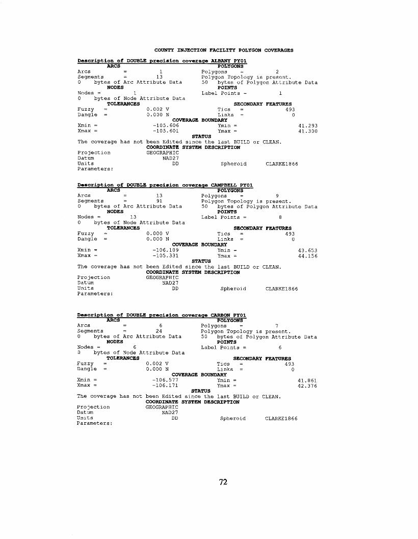
COUNTY INJECTION FACILITY POLYGON COVERAGES
Description of DOUBLE precision coverage ALBANY PYOl ARCS POLYGONS
- - A r c s 1 Po lygons = 2 Segments - 1 3 Po lygon Topology is p r e s e n t . 0 b y t e s of A r c A t t r i b u t e Da ta 50 b y t e s of Po lygon A t t r i b u t e Da ta
Nodes = 1 Label P o i n t s = 1 0 b y t e s o f Node A t t r i b u t e Data
-
NODES POINTS
TOLERANCES SECONDARY FEATURES Fuzzy = 0.002 v T i c s = 4 93 Dang le = 0 . 0 0 0 N L i n k s = 0
COVERAGE BOUNDARY Xmin = -105.606 Ymin = 41.293 Xmax = -105.601 Ymax = 41.300
T h e coverage has n o t b e e n E d i t e d s i n c e t h e l a s t BUILD o r CLEAN.
P r o j e c t i o n GEOGRAPHIC Datum NAD 2 7 U n i t s DD S p h e r o i d CLARKE1866 P a r a m e t e r s :
STATUS
COORDINATE SYSTEM DESCRIPTION
Description of DOUBLE precision coverage CAMPBELL PYOl ARCS POLYGONS
- - A r c s 13 Po lygons = 9 Segments - 9 1 Po lygon Topology i s p r e s e n t . - 0 b y t e s of A r c A t t r i b u t e Data 50 b y t e s of Po lygon A t t r i b u t e Data
Nodes = 1 3 Label P o i n t s = 8 0 b y t e s of Node A t t r i b u t e Data
NODES POINTS
TOLERANCES SECONDARY FEATURES Fuzzy = 0 . 0 0 0 v T i c s = 4 93 Dang le = 0 . 0 0 0 N L i n k s = 0
Xmin = -106 .109 Ymin = 43.653 Xmax = -105.331 Ymax = 44.156
The c o v e r a g e h a s n o t b e e n Edi ted s i n c e t h e l a s t BUILD o r CLEAN.
P r o j e c t i o n GEOGRAPHIC Datum NAD 2 7 U n i t s DD S p h e r o i d CLARKE1866 P a r a m e t e r s :
COVERAGE BOUNDARY
STATUS
COORDINATE SYSTEM DESCRIPTION
Description of DOUBLE precision coverage CARBON PYOl ARCS POLYGONS
- - A r c s 6 Po lygons = 7 Segments - 24 Po lygon Topology i s p r e s e n t . - 0 b y t e s of A r c A t t r i b u t e Data 5 0 b y t e s of Po lygon A t t r i b u t e Da ta
Nodes = 6 Label P o i n t s = 6 0 b y t e s of Node A t t r i b u t e Data
FUZZY = 0 . 0 0 2 v T i c s = 4 93 Dangle = 0.000 N L i n k s = 0
NODES POINTS
TOLERANCES SECONDARY FEATURES
COVERAGE BOUNDARY Xmin = -106.577 Ymin = 41.861 Xmax = -106 .171 Ymax = 42.376
The coverage has n o t b e e n E d i t e d s i n c e t h e l a s t BUILD o r CLEAN.
P r o j e c t i o n GEOGRAPHIC Datum NAD2 7 U n i t s DD S p h e r o i d CLARKE1866 P a r a m e t e r s :
STATUS
COORDINATE SYSTEM DESCRIPTION
72
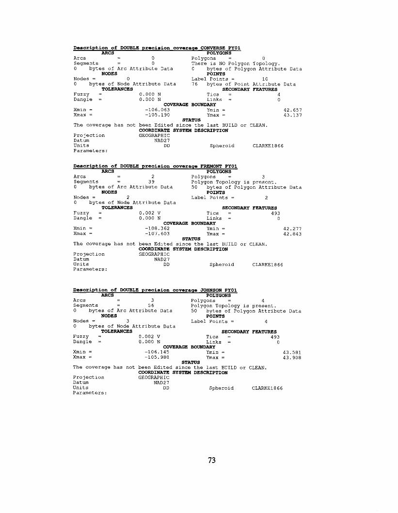
Description of DOUBLE precision coveraqe CONVERSE PYOl ARCS POLYGONS
- - A r c s 0 P o l y g o n s = 0 S e g m e n t s - 0 T h e r e i s NO P o l y g o n T o p o l o g y . - 0 b y t e s of A r c A t t r i b u t e Data 0 b y t e s of P o l y g o n A t t r i b u t e Data
Nodes = 0 L a b e l P o i n t s = 1 0 0 b y t e s of Node A t t r i b u t e Data 7 6 b y t e s of P o i n t A t t r i b u t e Data
F u z z y = 0 . 0 0 0 N T i c s = 4 D a n g l e = 0 . 0 0 0 N L i n k s = 0
NODES POINTS
TOLERANCES SECONDARY FEATURES
COVERAGE BOUNDARY Xmin = -106 .063 Ymin = 4 2 . 6 5 7 X m a x = -105 .190 Ymax = 4 3 . 1 3 7
T h e coverage has n o t b e e n E d i t e d s i n c e t h e l a s t BUILD o r CLEAN.
P r o j e c t i o n GEOGRAPHIC Datum NAD27 U n i t s DD S p h e r o i d CLARKE1866 P a r a m e t e r s :
STATUS
COORDINATE SYSTEM DESCRIPTION
Description of DOUBLE precision coverage FREMONT PYOl ARCS POLYGONS
- - A r c s 2 P o l y g o n s = 3 S e g m e n t s - 3 9 P o l y g o n T o p o l o g y i s p r e s e n t . 0 b y t e s of A r c A t t r i b u t e Data 5 0 b y t e s of P o l y g o n A t t r i b u t e Data
Nodes = 2 L a b e l P o i n t s = 2 0 b y t e s of Node A t t r i b u t e Data
F u z z y = 0 . 0 0 2 v T i c s = 4 93 D a n g l e = 0 . 0 0 0 N L i n k s = 0
NODES POINTS
TOLERANCES SECONDARY FEATURES
COVERAGE BOUNDARY Xmin = -108 .362 Ymin = 4 2 . 2 7 7 Xmax = - 1 0 7 - 6 0 3 Ymax = 4 2 . 8 4 3
T h e coverage has n o t b e e n E d i t e d s i n c e t h e l a s t B U I L D o r CLEAN.
P r o j e c t i o n GEOGRAPHIC Datum NAD2 7 U n i t s DD S p h e r o i d CLARKE1866 P a r a m e t e r s :
STATUS
COORDINATE SYSTEM DESCRIPTION
Description of DOUBLE precision coverage JOHNSON PYOl ARCS POLYGONS - - A r c s 3 P o l y g o n s = 4 - S e g m e n t s 5 6 P o l y g o n T o p o l o g y i s p r e s e n t .
0 b y t e s of A r c A t t r i b u t e Data 5 0 b y t e s of P o l y g o n A t t r i b u t e Data
Nodes = 3 L a b e l P o i n t s = 4 0 b y t e s of Node A t t r i b u t e Data
F u z z y = 0 . 0 0 2 v T l c s = 4 93 D a n g l e = 0.000 N L i n k s = 0
NODES POINTS
TOLERANCES SECONDARY FEATURES
COVERAGE BOUNDARY Xmin = -106 .145 Ymin = 4 3 . 5 8 1 X m a x = -105 .980 Ymax = 4 3 . 9 0 8
T h e coverage has n o t b e e n E d i t e d s i n c e t h e l a s t BUILD o r CLEAN.
P r o j e c t i o n GEOGRAPHIC Datum NAD2 7 U n i t s DD S p h e r o i d CLARKE1866 P a r a m e t e r s :
STATUS
COORDINATE SYSTEM DESCRIPTION
73
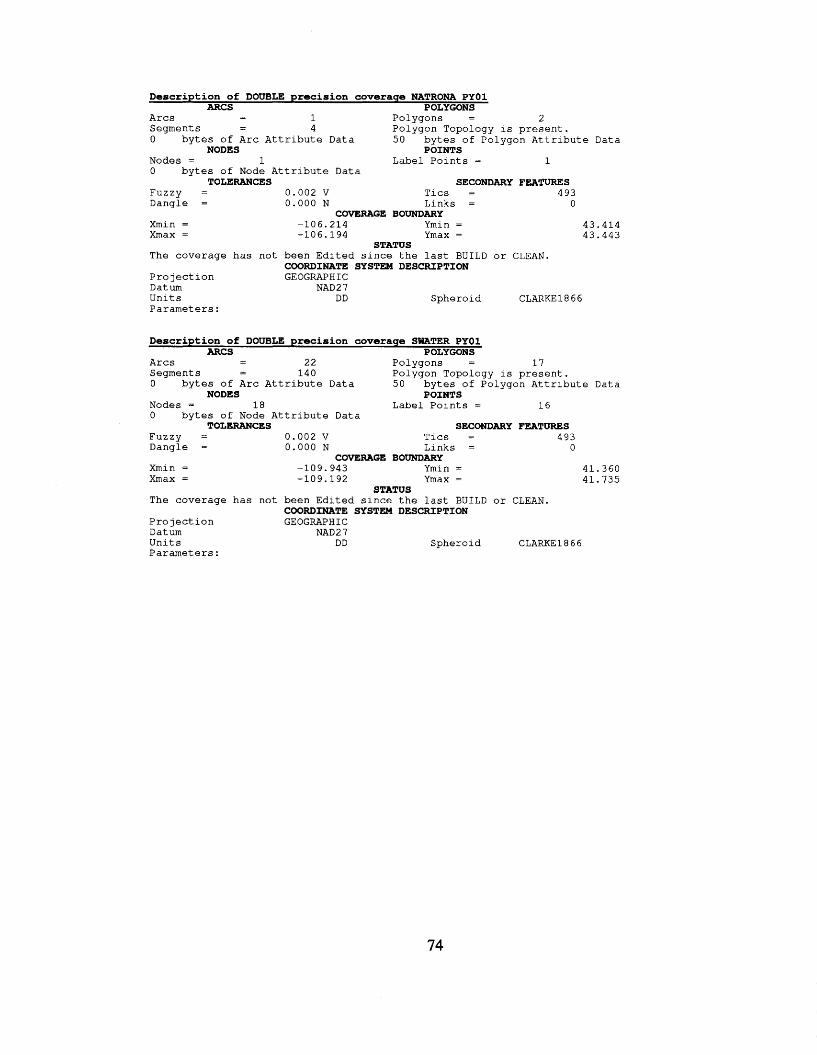
Description of DOUBLE precision coverage NATRONA PYOl ARCS POLYGONS
- - A r c s 1 P o l y g o n s = 2 S e g m e n t s - 4 P o l y g o n T o p o l o g y is p r e s e n t . - 0 b y t e s of A r c A t t r i b u t e Data 5 0 b y t e s of P o l y g o n A t t r i b u t e Data
Nodes = 1 Label P o i n t s = 1 0 b y t e s of Node A t t r i b u t e Data
NODES POINTS
TOLERANCES SECONDARY FE2iTURES F u z z y = 0.002 v T i c s = 4 93 D a n g l e = 0 . 0 0 0 N L i n k s = 0
Xmin = -106 .214 Ymin = 4 3 . 4 1 4 X m a x = -106 .194 Ymax = 4 3 . 4 4 3
The coverage has n o t b e e n E d i t e d s i n c e t h e l a s t B U I L D o r CLEAN.
P r o j e c t i o n GEOGRAPHIC Datum NAD2 7 U n i t s DD S p h e r o i d CLARKE1866 P a r a m e t e r s :
COVERAGE BOUNDARY
STATUS
COORDINATE SYSTEM DESCRIPTION
Description of DOUBLE precision coverage SWATER PYOl ARCS POLYGONS
- 1 7 A r c s 2 2 P o l y g o n s =
0 b y t e s of A r c A t t r i b u t e Data 5 0 b y t e s of P o l y g o n A t t r i b u t e Data
Nodes = 1 8 Label P o i n t s = 1 6 0 b y t e s of Node A t t r i b u t e Data
- - S egme n t s - 1 4 0 P o l y g o n T o p o l o g y i s p r e s e n t .
NODES POINTS
TOLERANCES SECONDARY FEATURES F u z z y = 0 . 0 0 2 v Tics = 4 9 3 D a n g l e = 0.000 N L i n k s = 0
COVERAGE BOUNDARY Xmin = -109 .943 Ymin = 4 1 . 3 6 0 Xmax = -109 .192 Ymax = 4 1 . 7 3 5
T h e coverage has n o t b e e n E d i t e d s i n c e t h e l a s t B U I L D o r CLEAN.
P r o j e c t i o n GEOGRAPH I C Datum NAD2 7 U n i t s DD S p h e r o i d CLARKE1866 P a r a m e t e r s :
STATUS
COORDINATE SYSTEM DESCRIPTION
74
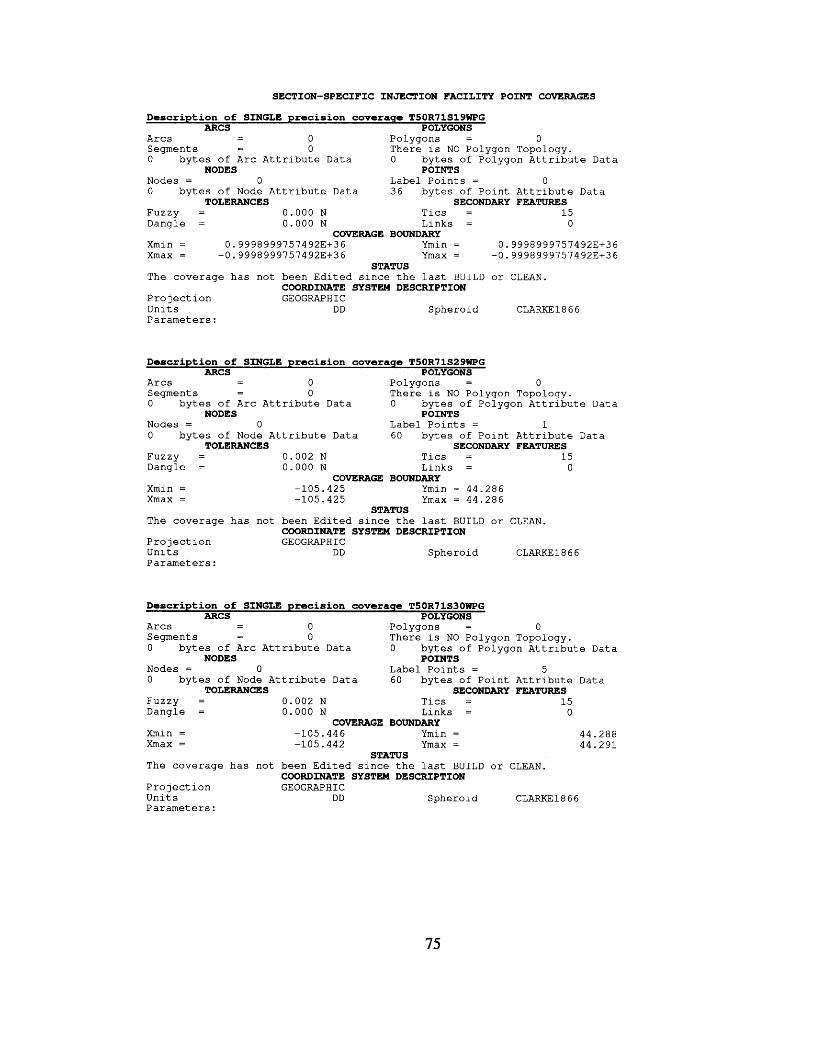
SECTION-SPECIFIC INJECTION FACILITY POINT COVERAGES
Dascription of SINGLE precision coveraqe T50R71S19WPG ARCS POLYGONS
- - A r c s 0 P o l y g o n s = 0 S e g m e n t s - 0 T h e r e i s NO P o l y g o n T o p o l o g y . - 0 b y t e s of A r c A t t r i b u t e Data 0 b y t e s of P o l y g o n A t t r i b u t e Data
Nodes = 0 L a b e l P o i n t s = 0 0 b y t e s of Node A t t r i b u t e Data 3 6 b y t e s of P o i n t A t t r i b u t e Data
F u z z y = 0 . 0 0 0 N T i c s = 15
NODES POINTS
TOLERANCES SECONDARY FEATURES
D a n g l e = 0 . 0 0 0 N L i n k s = 0 COVERAGE BOUNDARY
Xmin = 0 . 9 9 9 8 9 9 9 7 5 7 4 9 2 3 + 3 6 Ymin = 0 . 9 9 9 8 9997574 92E+3 6 Xmax = -0 .9998999757492E+36 Ymax = -0 .9998999757492E+36
STATUS The coverage has n o t b e e n E d i t e d s i n c e t h e l a s t B U I L D o r CLEAN.
P r o j e c t i o n GEOGRAPH I C U n i t s D D S p h e r o i d CLARKE 18 6 6 P a r a m e t e r s :
COORDINATE SYSTEM DESCRIPTION
Description of SINGLE precision coveraga T50R71S29WPG ARCS POLYGONS
- - A r c s 0 P o l y g o n s = 0 S e g m e n t s - 0 T h e r e i s NO P o l y g o n T o p o l o g y . 0 b y t e s of A r c A t t r i b u t e Data 0 b y t e s of P o l y g o n A t t r i b u t e Data
Nodes = 0 L a b e l P o i n t s = 1 0 b y t e s of Node A t t r i b u t e Data 60 b y t e s of P o i n t A t t r i b u t e Data
F u z z y = 0 . 0 0 2 N T i c s = 15
-
NODES POINTS
TOLERANCES SECONDARY FEATURES
D a n g l e = 0 . 0 0 0 N L i n k s = 0
Xmin = -105 .425 Ymin = 44.286 X m a x = -105 .425 Ymax = 4 4 . 2 8 6
T h e coverage has n o t b e e n E d i t e d s i n c e t h e l a s t BUILD o r CLEAN.
P r o j e c t i o n GEOGRAPHIC U n i t s DD S p h e r o i d CLARKE1866 P a r a m e t e r s :
COVERAGE BOUNDARY
STATUS
COORDINATE SYSTEM DESCRIPTION
Description of SINGLE precision coverage T50R71S30WPG ARCS POLYGONS
- - A r c s 0 P o l y g o n s = 0 S e g m e n t s - 0 T h e r e i s NO P o l y g o n T o p o l o g y . 0 b y t e s of A r c A t t r i b u t e Data 0 b y t e s of P o l y g o n A t t r i b u t e Data
Nodes = 0 L a b e l P o i n t s = 5 0 by tes of Node A t t r i b u t e Data 60 b y t e s of P o i n t A t t r i b u t e Data
F u z z y = 0 . 0 0 2 N T i c s = 15
-
NODES POINTS
TOLERANCES SECONDARY FEATURES
D a n g l e = 0.000 N L i n k s = 0 COVERAGE BOUNDARY
Xmin = -105 .446 Ymin = 4 4 . 2 8 8 Xmax = -105 .442 Ymax = 4 4 . 2 9 1
T h e coverage has n o t b e e n E d i t e d s i n c e t h e l a s t BUILD o r CLEAN.
P r o j e c t i o n GEOGRAPHIC U n i t s DD S p h e r o i d CLARKE1866 P a r a m e t e r s :
STATUS
COORDINATE SYSTEM DESCRIPTION
75
Description of SINGLE precision coverage T50R72S9WPG ARCS POLYGONS
- - A r c s 0 P o l y g o n s = 0 S e g m e n t s - 0 T h e r e i s NO P o l y g o n T o p o l o g y . 0 b y t e s of A r c A t t r i b u t e Data 0 b y t e s of P o l y g o n A t t r i b u t e D a t a
Nodes = 0 Label P o i n t s = 7 0 b y t e s of Node A t t r i b u t e Data 60 b y t e s of P o i n t A t t r i b u t e Data
F u z z y = 0 . 0 0 2 N T i c s = 15
-
NODES POINTS
TOLERANCES SECONDARY FEATURES
Dangle = 0.000 N L i n k s = 0 COVERAGE BOUNDARY
Xmin = -105 .528 Ymin = 4 4 . 3 2 1 X m a x = -105 .522 Ymax = 4 4 . 3 2 8
T h e coverage h a s n o t b e e n E d i t e d s i n c e t h e l a s t B U I L D o r CLEAN.
P r o j e c t i o n GEOGRAPHIC U n i t s DD S p h e r o i d CLARKE1866 P a r a m e t e r s :
STATUS
COORDINATE SYSTEM DESCRIPTION
Description of SINGLE precision coverage T50R72524WPG ARCS POLYGONS
- - A r c s 0 P o l y g o n s = 0 S e g m e n t s - 0 T h e r e i s NO P o l y g o n T o p o l o g y . - 0 b y t e s of A r c A t t r i b u t e Data 0 b y t e s of P o l y g o n A t t r i b u t e Data
Nodes = 0 L a b e l P o i n t s = 1 7 0 b y t e s of Node A t t r i b u t e Data 60 b y t e s of P o i n t A t t r i b u t e Data
F u z z y = 0 . 0 0 2 N T i c s = 1 5
NODES POINTS
TOLERANCES SECONDARY FEATURES
D a n g l e = 0 . 0 0 0 N L i n k s = 0 COVERAGE BOUNDARY
Xmin = -105 .468 Ymin = 4 4 . 2 9 0 X m a x = -105 .449 Ymax = 4 4 . 2 9 8
T h e coverage has n o t b e e n E d i t e d s i n c e t h e l a s t BUILD o r CLEAN.
P r o j e c t i o n GEOGRAP H I C U n i t s D D S p h e r o i d CLARKE1866 P a r a m e t e r s :
STATUS
COORDINATE SYSTEM DESCRIPTION
Description of SINGLE precision coveraqe T33R78S4WPG ARCS POLYGONS
- - A r c s 0 P o l y g o n s = 0 S e g m e n t s - 0 T h e r e i s NO P o l y g o n T o p o l o g y . 0 b y t e s of A r c A t t r i b u t e Data 0 b y t e s of P o l y g o n A t t r i b u t e Data
Nodes = 0 L a b e l P o i n t s = 0 0 b y t e s of Node A t t r i b u t e Data 3 6 b y t e s of P o i n t A t t r i b u t e Data
F U Z Z Y = 0 . 0 0 2 N T i c s = 3 3 D a n g l e = 0 . 0 0 0 N L i n k s = 0
NODES POINTS
TOLERANCES SECONDARY FEATURES
COVERAGE BOUNDARY Xmin = 0.9998999757492E+36 Ymin = 0.9998999757492E+36 X m a x = -0 .9998999757492E+36 Ymax = -0 .99989997574923+36
STATUS T h e coverage has n o t b e e n E d i t e d s i n c e t h e l a s t BUILD o r CLEAN.
P r o j e c t i o n GEOGRAPHIC U n i t s DD S p h e r o i d CLARKE1866 P a r a m e t e r s :
COORDINATE SYSTEM DESCRIPTION
76
Description of SINGLE precision coverage T33R78S5WPG ARCS POLYGONS
- - A r c s 0 P o l y g o n s = 0 S e g m e n t s - 0 T h e r e i s NO P o l y g o n Topology. 0 b y t e s of A r c A t t r i b u t e Data 0 b y t e s of P o l y g o n A t t r i b u t e Data
Nodes = 0 L a b e l P o i n t s = 3 0 b y t e s of Node A t t r i b u t e Data 60 b y t e s of P o i n t A t t r i b u t e Data
-
NODES POINTS
TOLERANCES F u z z y = D a n g l e =
Xmin = Xmax =
The coverage h a s n o t
P r o j e c t i o n U n i t s P a r a m e t e r s :
SECONDARY FEATURES 0 . 0 0 0 N T i c s = 3 3 0 .000 N L i n k s = 0
COVERAGE BOUNDARY -106 .235 Ymin = -106.225 Ymax =
STATUS b e e n E d i t e d s i n c e t h e l a s t B U I L D or CLEAN. COORDINATE SYSTEM DESCRIPTION GEOGRAPHIC
DD S p h e r o i d CLARKE1 8 6 6
42 .853 4 2 . 8 6 1
Description of SINGLE precision coverage T33R78S6WPG ARCS POLYGONS
- - A r c s 0 P o l y g o n s = 0 S e g m e n t s - 0 T h e r e i s NO P o l y g o n Topology. - 0 b y t e s of A r c A t t r i b u t e Data 0 b y t e s of P o l y g o n A t t r i b u t e Data
Nodes = 0 L a b e l P o i n t s = 31 0 b y t e s of Node A t t r i b u t e Data 60 b y t e s of P o i n t A t t r i b u t e Data
NODES POINTS
TOLERANCES SECONDARY FEATURES F u z z y = 0 . 0 0 0 N T i c s = 33 D a n g l e = 0 . 0 0 0 N L i n k s = 0
COVERAGE BOUNDARY Xmin = -106.262 Ymin = 42.855 Xmax = -106.245 Ymax = 4 2 . 8 6 4
The coverage has n o t b e e n E d i t e d s i n c e t h e l a s t BUILD or CLEAN.
P r o j e c t i o n GEOGRAPHIC U n i t s DD S p h e r o i d CLARKE1866 P a r a m e t e r s :
STATUS
COORDINATE SYSTEM DESCRIPTION
Description of SINGLE precision coverage T33R79S6WPG ARCS POLYGONS - - A r c s 0 P o l y g o n s = 0
S e g m e n t s - 0 T h e r e i s NO P o l y g o n Topology. -
0 b y t e s of A r c A t t r i b u t e Data 0 b y t e s of P o l y g o n A t t r i b u t e Data
Nodes = 0 Label P o i n t s = 1 4 0 b y t e s of Node A t t r i b u t e Data 60 b y t e s of P o i n t A t t r i b u t e Data
NODES POINTS
TOLERANCES SECONDARY FEATURES F U Z Z Y = 0 . 0 0 0 N T i c s = 33 D a n g l e = 0 . 0 0 0 N L i n k s = 0
COVERAGE BOUNDARY Xmin = -106 .369 Ymin = 42.854 Xmax = -106 .363 Ymax = 42.857
T h e coverage h a s n o t b e e n E d i t e d s i n c e t h e l a s t B U I L D o r CLEAN.
P r o j e c t i o n GEOGRAPHIC U n i t s DD S p h e r o i d CLARKE1866 P a r a m e t e r s :
STATUS
COORDINATE SYSTEM DESCRIPTION
77
Description of SINGLE precision coveraqe T33R80S2WPG ARCS POLYGONS
- - A r c s 0 Po lygons = 0 Segments - 0 T h e r e i s NO Po lygon Topology. - 0 b y t e s of A r c A t t r i b u t e Data 0 b y t e s of Po lygon A t t r i b u t e Data
Nodes = 0 Label P o i n t s = 3 0 b y t e s of Node A t t r i b u t e Data 60 b y t e s of P o i n t A t t r i b u t e Data
NODES POINTS
TOLERANCES SECONDARY FEATURES Fuzzy = 0 . 0 0 0 N T i c s = 33 Dang le = 0.000 N L i n k s = 0
COVERAGE BOUNDARY Xmin = -106.414 Ymin = 42.857
42.862 Xmax = -106.3 95 Ymax =
The c o v e r a g e has n o t b e e n E d i t e d s i n c e t h e l a s t BUILD o r CLEAN.
P r o j e c t i o n GEOGRAPHIC U n i t s DD S p h e r o i d CLARKE 18 6 6 P a r a m e t e r s :
STATUS
COORDINATE SYSTEM DESCRIPTION
Description of SINGLE precision coverage T33R80S3WPG ARCS POLYGONS
- - A r c s 0 Po lygons = 0 Segments - 0 T h e r e i s NO Po lygon Topology. 0 b y t e s of A r c A t t r i b u t e Data 0 b y t e s of Po lygon A t t r i b u t e Data
Nodes = 0 L a b e l P o i n t s = 9 0 b y t e s of Node A t t r i b u t e Data 60 b y t e s of P o i n t A t t r i b u t e Data
Fuzzy = 0.000 N T i c s = 33 Dang le = 0.000 N L i n k s = 0
-
NODES POINTS
TOLERANCES SECONDARY FEATURES
COVERAGE BOUNDARY 42.858 Xmin = -106.432 Ymin =
Xmax = -106.416 Ymax = 42.862
The coverage h a s n o t been E d i t e d s i n c e t h e l a s t BUILD o r CLEAN.
P r o j e c t i o n GEOGRAPHIC U n i t s DD S p h e r o i d CLARKE 18 6 6 P a r a m e t e r s :
STATUS
COORDINATE SYSTEM DESCRIPTION
Description of SINGLE precision coverage T34R79S20WPG ARCS POLYGONS
- - A r c s 0 P o l y g o n s = 0 Segments - 0 T h e r e i s NO Po lygon Topology. 0 b y t e s of A r c A t t r i b u t e Data 0 b y t e s of Po lygon A t t r i b u t e Data
Nodes = 0 Label P o i n t s = 20 0 b y t e s of Node A t t r i b u t e Data 60 b y t e s of P o i n t A t t r i b u t e Data
Fuzzy = 0 . 0 0 0 N T i c s = 33 Dang le = 0.000 N L i n k s = 0
-
NODES POINTS
TOLERANCES SECONDARY FEATURES
COVeRAGE BOUNDARY Xmin = -106.354 Ymin = 42.893 Xmax = -106.334 Ymax = 42.899
T h e coverage has n o t b e e n E d i t e d s i n c e t h e l a s t BUILD o r CLEAN.
P r o j e c t i o n GEOGRAPHIC U n i t s DD S p h e r o i d CLARKE1866 P a r a m e t e r s :
STATUS
COORDINATE SYSTEM DESCRIPTION
78
Description of SINGLE precision coverage T34R79S29WPG ARCS POLYGONS
- - A r c s 0 P o l y g o n s = 0 S e g m e n t s - 0 T h e r e is NO P o l y g o n Topology. - 0 b y t e s of A r c A t t r i b u t e Data 0 b y t e s of P o l y g o n A t t r i b u t e D a t a
Nodes = 0 Label P o i n t s = 8 0 b y t e s of Node A t t r i b u t e Data 60 b y t e s of P o i n t A t t r i b u t e Data
NODES POINTS
TOLERANCES SECONDARY FEATURES F u z z y = 0 . 0 0 0 N T i c s = 33 D a n g l e = 0 . 0 0 0 N L i n k s = 0
COVERAGE BOUNDARY 42.880 42 .892
k i n = -106.354 Ymin = Xmax = -106 .346 Ymax =
The coverage h a s n o t b e e n E d i t e d s i n c e t h e l a s t BUILD o r CLEAN.
P r o j e c t i o n GEOGRAPHIC U n i t s DD S p h e r o 1 d CLARKE1866 P a r a m e t e r s :
STATUS
COORDINATE SYSTEM DESCRIPTION
Description of SINGLE precision coverage T34R79S32WPG ARCS POLYGONS
- - A r c s 0 P o l y g o n s = 0 S e g m e n t s - 0 T h e r e i s NO P o l y g o n Topology. 0 b y t e s of A r c A t t r i b u t e Data 0 b y t e s of P o l y g o n A t t r i b u t e Data
Nodes = 0 L a b e l P o i n t s = 5 4 0 b y t e s of Node A t t r i b u t e Data 60 b y t e s of P o i n t A t t r i b u t e Data
F U Z Z Y = 0 . 0 0 0 N T i c s = 3 3 D a n g l e = 0 . 0 0 0 N L i n k s = 0
-
NODES POINTS
TOLERANCES SECONDARY FEATURES
COVERAGE BOUNDARY Xmin = -1 0 6 .355 Ymin = 42.867 Xmax = -106.345 Ymax = 42.877
The coverage h a s n o t b e e n E d i t e d s i n c e t h e l a s t BUILD o r CLEAN.
P r o j e c t i o n GEOGRAPHIC U n i t s DD S p h e r o i d CLARKE1866 P a r a m e t e r s :
STATUS
COORDINATE SYSTEM DESCRIPTION
Description of SINGLE precision coverage T34R80S27WPG ARCS POLYGONS
- - A r c s 0 P o l y g o n s = 0 Segment s - 0 T h e r e i s NO P o l y g o n Topology. 0 b y t e s of A r c A t t r i b u t e Data 0 b y t e s of P o l y g o n A t t r i b u t e Data
Nodes = 0 L a b e l P o i n t s = 1 9 0 b y t e s of Node A t t r i b u t e Data 60 b y t e s of P o i n t A t t r i b u t e Data
F u z z y = 0 . 0 0 0 N T i c s = 33 D a n g l e = 0 . 0 0 0 N L i n k s = 0
-
NODES POINTS
TOLERANCES SECONDARY FEATURES
COVERAGE BOUNDARY Xmin = -106.434 Ymin = 42.878 Xmax = -106.420 Ymax = 4 2 . 8 8 1
The coverage h a s n o t b e e n E d i t e d s i n c e t h e l a s t B U I L D o r CLEAN.
P r o j e c t i o n GEOGRAPHIC U n i t s DD S p h e r o i d CLARKE1866 P a r a m e t e r s :
STATUS
COORDINATE SYSTEM DESCRIPTION
79
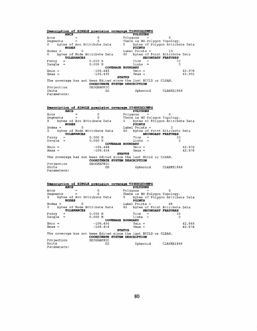
Description of SINGLE precision coveraqe T34R80S28WPG ARCS POLYGONS
- A r c s - 0 P o l y g o n s = 0 S egme n t s - 0 T h e r e i s NO P o l y g o n Topology. 0 b y t e s of A r c A t t r i b u t e Data 0 b y t e s of P o l y g o n A t t r i b u t e Data
Nodes = 0 Label P o i n t s = 1 9 0 b y t e s of Node A t t r i b u t e Data 60 b y t e s of P o i n t A t t r i b u t e Data
-
NODES POINTS
TOLERANCES SECONDARY FEATURES F u z z y = 0 . 0 0 0 N T i c s = 33 D a n g l e = 0 . 0 0 0 N L i n k s = 0
COVERAGE BOUNDARY 42.878 42 .891
Xmin = -1 06.445 Ymin = Xmax = -106.435 Ymax =
The c o v e r a g e has n o t b e e n E d i t e d s i n c e t h e l a s t BUILD o r CLEAN.
P r o j e c t i o n GEOGRAPHIC U n i t s DD S p h e r o i d CLARKE1866 P a r a m e t e r s :
STATUS
COORDINATE SYSTEM DESCRIPTION
Description of SINGLE precision coverage T34R80S33WPG ARCS POLYGONS
- - A r c s 0 P o l y g o n s = 0 Segment s - 0 T h e r e i s NO P o l y g o n Topology. - 0 b y t e s of A r c A t t r i b u t e Data 0 b y t e s of P o l y g o n A t t r i b u t e Data
Nodes = 0 Label P o i n t s = 3 0 b y t e s of Node A t t r i b u t e Data 60 b y t e s of P o i n t A t t r i b u t e Data
NODES POINTS
TOLERANCES SECONDARY FEATURES F u z z y = 0 .000 N T i c s = 33 D a n g l e = 0 . 0 0 0 N L i n k s = 0
COVERAGE BOUNDMY 42.872 Xmin = -106.448 Ymin =
Xmax = -106.434 Ymax = 42.878
The coverage h a s no t b e e n E d i t e d s i n c e t h e l a s t BUILD o r CLEAN.
P r o j e c t i o n GEOGRAPHIC U n i t s DD S p h e r o i d CLARKE1866 P a r a m e t e r s :
STATUS
COORDINATE SYSTEM DESCRIPTION
Description of SINGLE precision coveraqe T34R80534WPG ARCS POLYGONS
- - A r c s 0 P o l y g o n s = 0 S e g m e n t s - 0 T h e r e i s NO P o l y g o n Topology. - 0 b y t e s of A r c A t t r i b u t e Data 0 b y t e s of P o l y g o n A t t r i b u t e D a t a
Nodes = 0 L a b e l P o i n t s = 68 0 b y t e s of Node A t t r i b u t e Data 60 b y t e s of P o i n t A t t r i b u t e Data
NODES POINTS
TOLERANCES SECONDARY FEATURES F u z z y = 0 . 0 0 0 N T i c s = 33 D a n g l e = 0 . 0 0 0 N L i n k s = 0
Xmin = -106.434 Ymin = 42.864 Xmax = -106 .416 Ymax = 42.878
The coverage has n o t b e e n E d i t e d s ince t h e l a s t B U I L D or CLEAN.
P r o j e c t i o n GEOGRAPHIC U n i t s DD S p h e r o i d CLARKE1866 P a r a m e t e r s :
CCWERAGE BOUNDARY
STATUS
COORDINATE SYSTEM DESCRIPTION
80
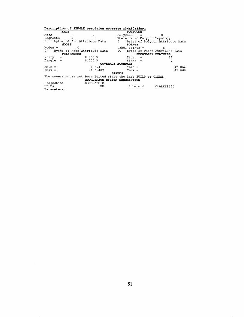
Description of SINGLE precision coverage T34R80S35WPG ARCS POLYGONS
- - A r c s 0 P o l y g o n s = 0 S e g m e n t s - 0 T h e r e i s NO P o l y g o n Topology. 0 b y t e s of A r c A t t r i b u t e Data 0 b y t e s of P o l y g o n A t t r i b u t e Data
Nodes = 0 Label P o i n t s = 5 0 b y t e s of Node A t t r i b u t e Data 60 b y t e s of P o i n t A t t r i b u t e Data
-
NODES POINTS
TOLERANCES SECONDARY FEATURES F U Z Z Y = 0 . 0 0 0 N T i c s = 33 D a n g l e = 0 . 0 0 0 N L i n k s = 0
Xmax = -106 .403 Ymax = 42.868
COVERAGE BOUNDARY Xmin = -106 .411 Ymin = 42.864
STATUS T h e coverage h a s n o t b e e n E d i t e d s i n c e t h e l a s t B U I L D o r CLEAN.
P r o j e c t i o n GEOGRAPHIC U n i t s DD S p h e r o i d CLARKE1866 P a r a m e t e r s :
COORDINATE SYSTEM DESCRIPTION
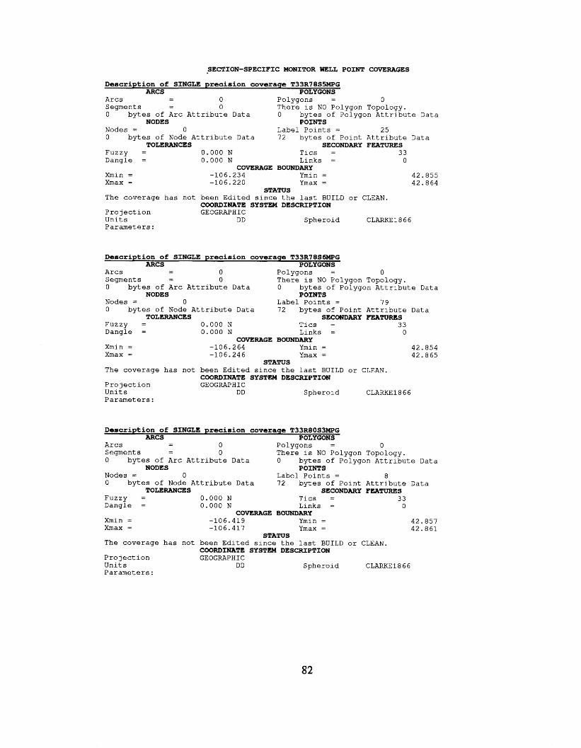
SECTION-SPECIFIC MONITOR WELL POINT COVERAGES
Description of SINGLE precision coverage T33R7855MPG ARCS POLYGONS
- - A r c s 0 P o l y g o n s = 0 S e g m e n t s - 0 T h e r e i s NO P o l y g o n T o p o l o g y . - 0 b y t e s of A r c A t t r i b u t e Data 0 b y t e s of P o l y g o n A t t r i b u t e Data
Nodes = 0 L a b e l P o i n t s = 25 0 b y t e s of Node A t t r i b u t e Data 72 by tes of P o i n t A t t r i b u t e Data
NODES POINTS
TOLERANCES SECONDARY FEATURES F u z z y = 0 . 0 0 0 N T i c s = 33
0 L i n k s = D a n g l e = 0 . 0 0 0 N
Xmin = -106 .234 Ymin = 42.855 X m a x = -106 .220 Ymax = 4 2 . 8 6 4
T h e coverage has n o t b e e n E d i t e d s i n c e t h e l a s t BUILD o r CLEAN.
P r o j e c t i o n GEOGRAPHIC U n i t s DD S phe ro i d CLARKE1866 P a r a m e t e r s :
COVERAGE BOUNDARY
STATUS
COORDINATE SYSTEM DESCRIPTION
Description of SINGLE precision coverage T33R78S6MPG ARCS POLYGONS
- - A r c s 0 P o l y g o n s = 0 S e g m e n t s - 0 T h e r e i s NO P o l y g o n T o p o l o g y . 0 b y t e s of A r c A t t r i b u t e Data 0 b y t e s of P o l y g o n A t t r i b u t e Data
Nodes = 0 Label P o i n t s = 7 9 0 b y t e s of Node A t t r i b u t e Data 72 b y t e s of P o i n t A t t r i b u t e Data
-
NODES POINTS
TOLERANCES SECONDARY FEATURES F u z z y = 0 . 0 0 0 N T i c s = 33 D a n g l e = 0 . 0 0 0 N L i n k s = 0
COVERAGE BOUNDARY Xmin = -106 .264 Ymin = 4 2 . 8 5 4 Xmax = -106 .246 Ymax = 42.865
T h e coverage has n o t b e e n E d i t e d s i n c e t h e l a s t BUILD o r CLEAN.
P r o j e c t i o n GEOGRAPHIC U n i t s DD S p h e r o i d CLARKE1866 P a r a m e t e r s :
STATUS
COORDINATE SYSTEM DESCRIPTION
Description of SINGLE precision covcraqe T33R80S3MPG ARCS POLYGONS - - A r c s 0 P o l y g o n s = 0
S e g m e n t s - 0 T h e r e i s NO P o l y g o n T o p o l o g y .
Nodes = 0 Label P o i n t s = a
F u z z y = 0 . 0 0 0 N T i c s = 33 Dangle = 0 . 0 0 0 N L i n k s = 0
- 0 by te s of A r c A t t r i b u t e Data 0 b y t e s of P o l y g o n A t t r i b u t e Data
NODES POINTS
0 b y t e s of Node A t t r i b u t e Data 72 b y t e s of P o i n t A t t r i b u t e Data TOLERANCES SECONDARY FEATURES
COVERAGE BOUNDARY Xmin = -106 .419 Ymin = 4 2 . 8 5 7
4 2 . 8 6 1 X m a x = -106 .417 Ymax =
T h e coverage has n o t b e e n E d i t e d s i n c e t he l a s t BUILD o r CLEAN.
P r o lect i o n U n i t s DD S p h e r o i d CLARKE1866 P a r a m e t e r s :
STATUS
COORDINATE SYSTEM DESCRIPTION GE OGRAPH I C
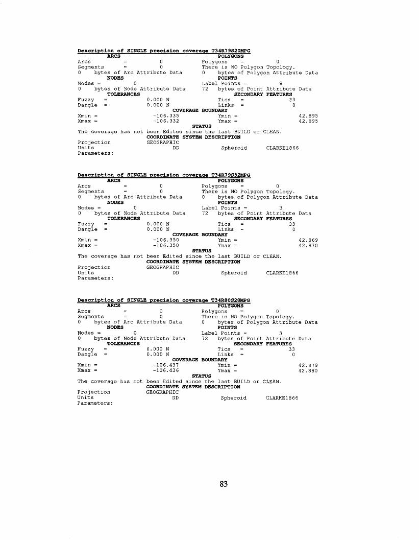
Description of SINGLE precision coverage T34R79S20MPG ARCS POLYGONS
- - A r c s 0 P o l y g o n s = 0 S e g m e n t s - 0 T h e r e i s NO P o l y g o n T o p o l o g y . - 0 b y t e s of A r c A t t r i b u t e Data 0 b y t e s of P o l y g o n A t t r i b u t e Data
Nodes = 0 L a b e l P o i n t s = 8 0 b y t e s of Node A t t r i b u t e Data 72 b y t e s of P o i n t A t t r i b u t e Data
NODES POINTS
TOLERANCES SECONDARY FEATURES F u z z y = 0 . 0 0 0 N T i c s = 33 D a n g l e = 0 . 0 0 0 N L i n k s = 0
COVERAGE BOUNDARY Xmin = -106 .335 Ymin = 4 2 . 8 9 5 X m a x = -106 .332 Ymax = 4 2 . 8 9 5
T h e coverage has n o t b e e n E d i t e d s i n c e t h e l a s t BUILD o r CLEAN.
P r o j e c t i o n GEOGRAPHIC U n i t s DD S p h e r o i d CLARKE1866 P a r a m e t e r s :
STATUS
COORDINATE SYSTEM DESCRIPTION
Description of SINGLE precision coverage T34R79S32MPG ARCS POLYGONS
- A r c s - 0 P o l y g o n s = a S e g m e n t s - 0 There i s NO P o l y g o n T o p o l o g y . - 0 b y t e s of A r c A t t r i b u t e Data 0 bytes of P o l y g o n A t t r i b u t e Data
Nodes = 0 L a b e l P o i n t s = 3 0 bytes of Node A t t r i b u t e Data 72 b y t e s of P o i n t A t t r i b u t e Data
NODES POINTS
TOLERANCES SECONDARY FEATURES F u z z y = 0 . 0 0 0 N T l c s = 33 D a n g l e = 0.000 N L i n k s = 0
COVERAGE BOUNDARY Xmin = -106 .350 Ymin = 4 2 . 8 6 9
4 2 . 8 7 0 X m a x = -106 .350 Ymax =
T h e coverage has n o t b e e n E d i t e d s i n c e t h e l a s t BUILD o r CLEAN.
P r o j e c t i o n GEOGRAPHIC U n i t s DD S p h e r o i d CLARKE1866 P a r a m e t e r s :
STATUS
COORDINATE SYSTEM DESCRIPTION
Description of SINGLE precision coverage T34R80528MPG ARCS POLYGONS
- - A r c s 0 P o l y g o n s = 0 S e g m e n t s - 0 T h e r e i s NO P o l y g o n T o p o l o g y . 0 b y t e s of A r c A t t r i b u t e Data 0 b y t e s of P o l y g o n A t t r i b u t e Data
Nodes = 0 L a b e l P o i n t s = 3 0 b y t e s of Node A t t r i b u t e Data 72 b y t e s of P o i n t A t t r i b u t e Data
F u z z y = 0 . 0 0 0 N T i c s = 3 3 D a n g l e = 0 . 0 0 0 N L i n k s = 0
-
NODES POINTS
TOLERANCES SECONDARY FEATURES
COVERAGE BOUNDARY Xmin = -106 .437 Ymin = 4 2 . 8 7 9 Xmax = -106 .436 Ymax = 4 2 . 8 8 0
T h e coverage has n o t b e e n E d i t e d s i n c e t h e l a s t BUILD o r CLEAN.
P r o j e c t i o n GEOGRAPHIC U n i t s DD S p h e r o i d CLARKE1866 P a r a m e t e r s :
STATUS
COORDINATE SYSTEM DESCRIPTION
83
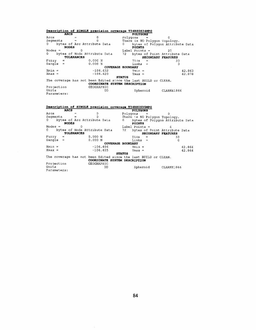
Description of SINGLE precision coveraqe T34R80S3-G ARCS P OLY CONS
- - A r c s 0 P o l y g o n s = 0 S e g m e n t s - 0 T h e r e i s NO P o l y g o n T o p o l o g y . -
0 by tes of A r c A t t r i b u t e Data 0 b y t e s of P o l y g o n A t t r i b u t e Data
Nodes = 0 L a b e l P o i n t s = 25 0 b y t e s of Node A t t r i b u t e Data 72 b y t e s of P o i n t A t t r i b u t e Data
NODES POINTS
TOLERANCES SECONDARY FEATURES F u z z y = 0 . 0 0 0 N T i c s = 33 D a n g l e = 0 . 0 0 0 N L i n k s = 0
COVERAGE BOUNDARY X m i n = -106 .432 Ymin = 4 2 . 8 6 3 X m a x = -106 .420 Y m a x = 4 2 . 8 7 8
The coverage has n o t b e e n E d i t e d s i n c e t h e l a s t BUILD o r CLEAN.
P r o j e c t i o n GEOGRAPHIC U n i t s DD S p h e r o i d CLARKE1866 P a r a m e t e r s :
STATUS
COORDINATE SYSTEM DESCRIPTION
Description of SINGLE precision coverage T34R80S35MPG ARCS POLYGONS - - A r c s 0 P o l y g o n s = 0
S e g m e n t s - 0 T h e r e i s NO P o l y g o n T o p o l o g y . 0 b y t e s of A r c A t t r i b u t e Data 0 b y t e s of P o l y g o n A t t r i b u t e Data
Nodes = 0 Label P o i n t s = 4 0 b y t e s of Node A t t r i b u t e Data 7 2 b y t e s of P o i n t A t t r i b u t e Data
F u z z y = 0 . 0 0 0 N T i c s = 3 3 D a n g l e = 0 . 0 0 0 N L i n k s = 0
-
NODES POINTS
TOLERANCES SECONDARY FEATURES
COVERAGE BOUNDARY Xmin = - 1 0 6 . 4 0 6 Ymin = 4 2 . 8 6 4 Xmax = - 1 0 6 . 4 0 5 Ymax = 42.864
T h e coverage has n o t b e e n E d i t e d s i n c e t h e l a s t BUILD o r CLEAN.
P r o j e c t i o n GEOGRAPHIC U n i t s DD S p h e r o i d CLARKE1866 P a r a m e t e r s :
STATUS
COORDINATE SYSTEM DESCRIPTION
84

APPENDIX G
INJECTION FACILITY COVERAGE RECORDS
85
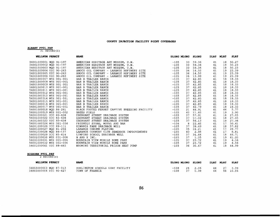
ALBANY PTO1.PAT 31 RECORD(S)
WELLNUM PERMIT
56001000001 WQD 91-197 56001000002 WQD 91-197 56001000003 WQD 91-197 56001000004 UIC 90-263 56001000005 UIC 90-263 56001000006 UIC 90-263 56001000007 WYS 001-001 56001000008 WYS 001-001 56001000009 WYS 001-001 56001000010 WYS 001-001 56001000011 WYS 001-001 56001000012 WYS 001-001 56001000013 WYS 001-001 56001000014 WYS 001-001 56001000015 WYS 001-001 56001000016 WYS 001-001 56001000017 WYS 001-001 56001000018 WQD 86-261 56001000019 WYS 001-002 56001000021 UIC 83-638 56001000022 UIC 83-638 56001000023 UIC 83-638 56001000024 WYS 001-004 56001000026 UIC 89-111 56001000027 WQD 81-266 56001000028 WQD 86-137 56001000029 UIC 85-616 56001000030 WYS 001-008 56001000031 WYS 001-006 56001000032 WYS 001-006 56001000041 UIC 88-465
BIGHORN PTO1.PAT 2 RECORD (S)
WELLNUM PERMIT
56003000003 WQD 87-013 56003000006 UIC 90-427
NAME
COUNTY INJECTION FACILITY POINT COVERAGES
DLONG MLONG SLONG
AMERICAN HERITAGE ART MUSEUM, U.W. AMERICAN HERITAGE ART MUSEUM, U.W. AMERICAN HERITAGE ART MUSEUM, U.W. AMOCO OIL COMPANY - LARAMIE REFINERY SITE AMOCO OIL COMPANY - LARAMIE REFINERY SITE AMOCO OIL COMPANY - LARAMIE REFINERY SITE BAR B TRAILER RANCH BAR B TRAILER RANCH BAR B TRAILER RANCH BAR B TRAILER RANCH BAR B TRAILER RANCH BAR B TRAILER RANCH BAR B TRAILER RANCH BAR B TRAILER RANCH BAR B TRAILER RANCH BAR B TRAILER RANCH BAR B TRAILER RANCH BLACK FOOTED FERRET CAPTIVE BREEDING FACILITY BREES FIELD EBERHART STREET DRAINAGE SYSTEM EBERHART STREET DRAINAGE SYSTEM EBERHART STREET DRAINAGE SYSTEM FRIENDLY STORE, MOTEL AND BAR KIWANIS PARK DRAINAGE WELL LARAMIE CHROME PLATING LARAMIE COUNTRY CLUB SEWERAGE IMPROVEMENTS LINFORD SCHOOL DRAINAGE WELL M AND X INC. MOUNTAIN VIEW MOBILE HOME PARK MOUNTAIN VIEW MOBILE HOME PARK WYOMING TERRITORIAL PRISON HEAT PUMP
NAME
BURLINGTON SCHOOLS CORE FACILITY TOWN OF FRANNIE
-105 -105 -105 -105 -105 -105 -105 -105 -105 -105 -105 -105 -105 -105 -105 -105 -105 -105 -105 -105 -105 -105 -106 -105 -105 -105 -105 -105 -105 -105 -105
33 59.36 33 59.36 33 59.36 36 14.50 36 14.50 36 13.99 37 42.85 37 42.85 37 42.85 37 42.85 37 42.85 37 42.85 37 42.85 37 42.85 37 42.85 37 42.85 37 42.79 21 44.91 40 11-60 37 57.91 37 57.02 37 56.13 8 22.40 37 38.49 35 24.21 40 2.95 37 34.66 37 1.35 37 23.72 37 23.72 36 30.67
DLONG MLONG SLONG
-108 26 2.06 -108 37 0.99
DLAT
41 41 41 41 41 41 41 41 41 41 41 41 41 41 41 41 41 41 41 41 41 41 41 41 41 41 41 41 41 41 41
DLAT
44
MIAT SLAT
18 50.27 18 50.23 18 50.23 19 19 23.39 23.39
19 23.39 18 18.33 18 18.33 18 18.33 18 18.33 18 18.33 18 18.33 18 18.33 18 18.33 18 18.33 18 18.33 18 18.33 46 5.77 19 3.90 18 27.05 18 27.45 18 27.94 17 50.41 18 57.82 17 28.77 17 8.81 18 46.71 19 41.20 19 4.56 19 4.56 18 44.99
MLAT SLAT
27 3.39 44 58 10.06
86
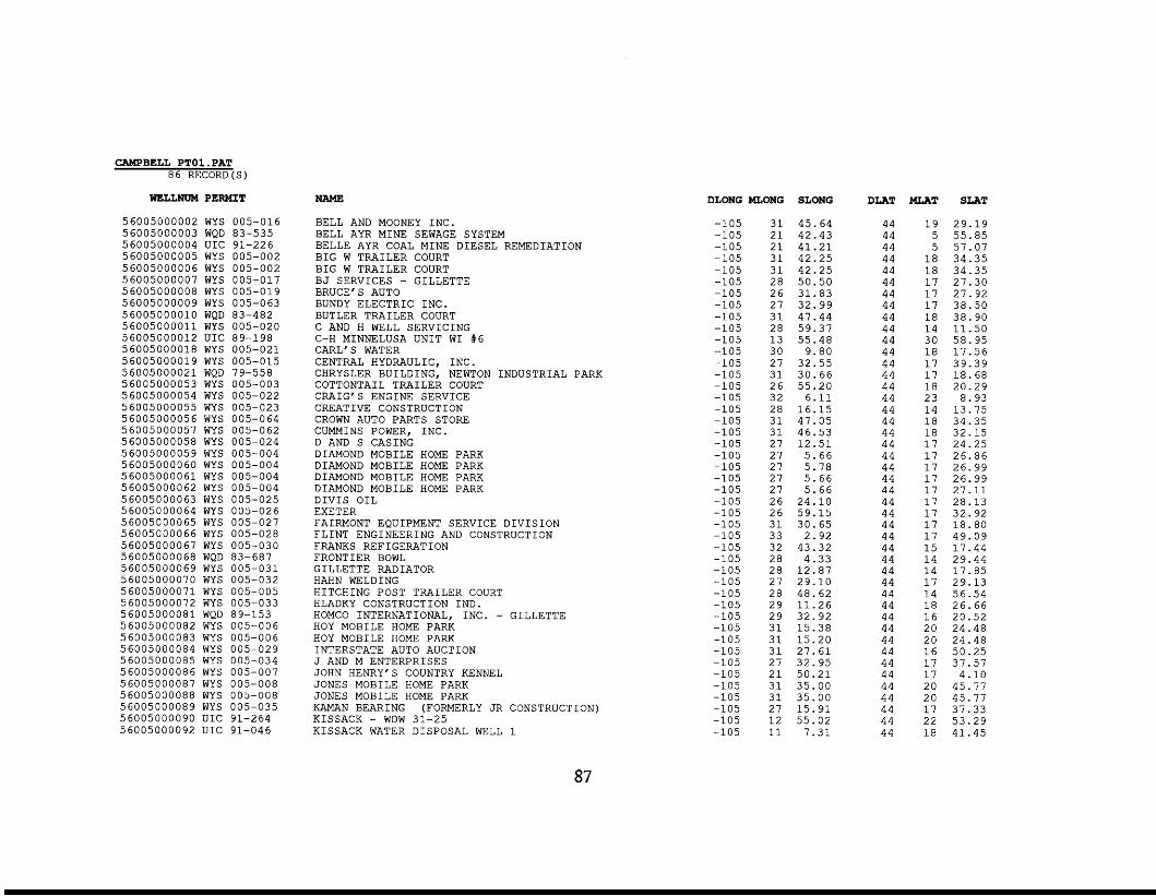
CAMPBELL PTOl .PAT 86 RECORD(S)
WELLNUM PERMIT
56005000002 WYS 005-016 56005000003 WQD 83-535 56005000004 UIC 91-226 56005000005 WYS 005-002 56005000006 WYS 005-002 56005000007 WYS 005-017 56005000008 WYS 005-019 56005000009 WYS 005-063 56005000010 WQD 83-482 5 6 0 0 5 0 0 0 0 1 1 WYS 005-020 56005000012 UIC 89-198 56005000018 WYS 005-021 56005000019 WYS 005-015 5 6 0 0 5 0 0 0 0 2 1 WQD 79-558 56005000053 WYS 005-003 56005000054 WYS 005-022 56005000055 WYS 005-023 56005000056 WYS 005-064 56005000057 WYS 005-062 56005000058 WYS 005-024 56005000059 WYS 005-004 56005000060 WYS 005-004 5 6 0 0 5 0 0 0 0 6 1 WYS 005-004 56005000062 WYS 005-004 56005000063 WYS 005-025 56005000064 WYS 005-026 56005000065 WYS 005-027 56005000066 WYS 005-028 56005000067 WYS 005-030 56005000068 WQD 83-687 56005000069 WYS 005-031 56005000070 WYS 005-032 5 6 0 0 5 0 0 0 0 7 1 WYS 005-005 56005000072 WYS 005-033 5 6 0 0 5 0 0 0 0 8 1 WQD 89-153 56005000082 WYS 005-006 56005000083 WYS 005-006 56005000084 WYS 005-029 56005000085 WYS 005-034 56005000086 WYS 005-007 56005000087 WYS 005-008 56005000088 WYS 005-008 56005000089 WYS 005-035 56005000090 UIC 91-264 56005000092 UIC 91-046
NAME
BELL AND MOONEY INC. BELL AYR MINE SEWAGE SYSTEM BELLE AYR COAL MINE DIESEL REMEDIATION BIG W TRAILER COURT BIG W TRAILER COURT BJ SERVICES - GILLETTE BRUCE'S AUTO BUNDY ELECTRIC INC. BUTLER TRAILER COURT C AND H WELL SERVICING C-H MINNELUSA UNIT WI #6 CARL' S WATER CENTRAL HYDRAULIC, INC. CHRYSLER BUILDING, NEWTON INDUSTRIAL PARK COTTONTAIL TRAILER COURT CRAIG'S ENGINE SERVICE CREATIVE CONSTRUCTION CROWN AUTO PARTS STORE CUMMINS POWER, INC. D AND S CASING DIAMOND MOBILE HOME PARK DIAMOND MOBILE HOME PARK DIAMOND MOBILE HOME PARK DIAMOND MOBILE HOME PARK DIVIS OIL EXETER FAIRMONT EQUIPMENT SERVICE DIVISION FLINT ENGINEERING AND CONSTRUCTION FRANKS REFIGERATION FRONTIER BOWL GILLETTE RADIATOR HAHN WELDING HITCHING POST TRAILER COURT HLADKY CONSTRUCTION IND. HOMCO INTERNATIONAL, INC. - GILLETTE HOY MOBILE HOME PARK HOY MOBILE HOME PARK INTERSTATE AUTO AUCTION J AND M ENTERPRISES JOHN HENRY' S COUNTRY KENNEL JONES MOBILE HOME PARK JONES MOBILE HOME PARK KAMAN BEARING (FORMERLY JR CONSTRUCTION)
KISSACK WATER DISPOSAL WELL 1 KISSACK - WDW 31-25
DLONG MLONG SLONG
-105 -105 -105 -105 -105 -105 -105 -105 -105 -105 -105 -105 -105 -105 -105 -105 -105 -105 -105 -105 -105 -105 -105 -105 -105 -105 -105 -105 -105 -105 -105 -105 -105 -105 -105 -105 -105 -105 -105 -105 -105 -105 -105 -105 -105
3 1 45 .64 2 1 42 .43 2 1 4 1 . 2 1 3 1 42.25 3 1 42 .25 2 8 50 .50 2 6 31 .83 27 3 2 . 9 9 3 1 47 .44 28 59 .37 1 3 55 .48 3 0 9 - 8 0 2 7 32 .55 3 1 3 0 . 6 6 2 6 55 .20 3 2 6 .11 2 8 16 .15 3 1 47 .05 3 1 46 .53 27 1 2 . 5 1 2 7 5 . 6 6 27 5.78 2 7 5 . 6 6 27 5 . 6 6 2 6 24 .10 2 6 59 .15 3 1 3 0 . 6 5 3 3 2 . 9 2 3 2 43 .32 2 8 4 .33 2 8 12 .87 27 2 9 . 1 0 28 48 .62 2 9 1 1 . 2 6 2 9 32 .92 3 1 15 .38 3 1 1 5 . 2 0 3 1 2 7 . 6 1 2 7 3 2 . 9 5 2 1 5 0 . 2 1 3 1 35 .00 3 1 35 .00 27 1 5 . 9 1 1 2 55.02 11 7 . 3 1
DLAT
44 44 44 44 44 44 44 44 44 44 44 44 44 44 44 44 44 44 44 44 44 44 44 44 44 44 44 44 44 44 44 44 44 44 44 44 44 44 44 44 44 44 44 44 44
MLAT SLAT
1 9 2 9 . 1 9 5 55 .85 5 57 .07
1 8 34 .35 1 8 34 .35 1 7 27.30 1 7 27.92 1 7 38 .50 1 8 38 .90 1 4 1 1 . 5 0 3 0 58 .95 1 8 1 7 . 5 6 1 7 39 .39 1 7 1 8 . 6 8 1 8 20 .29 2 3 8.93 1 4 1 3 . 7 5 1 8 34 .35 1 8 32 .15 1 7 24 .25 1 7 2 6 . 8 6 1 7 2 6 . 9 9 1 7 2 6 . 9 9 1 7 2 7 . 1 1 1 7 28 .13 1 7 32 .92 1 7 1 8 . 8 0 1 7 49.09 1 5 1 4 29 .44 1 7 . 4 4
1 4 1 7 . 8 5 1 7 29 .13 1 4 56 .54 1 8 2 6 . 6 6 1 6 20 .52 2 0 24 .48
1 6 50 .25 1 7 37 .57 1 7 4.10 2 0 45 .77 2 0 45 .77 1 7 37 .33 2 2 53 .29 1 8 41 .45
2 0 24 .48
a7
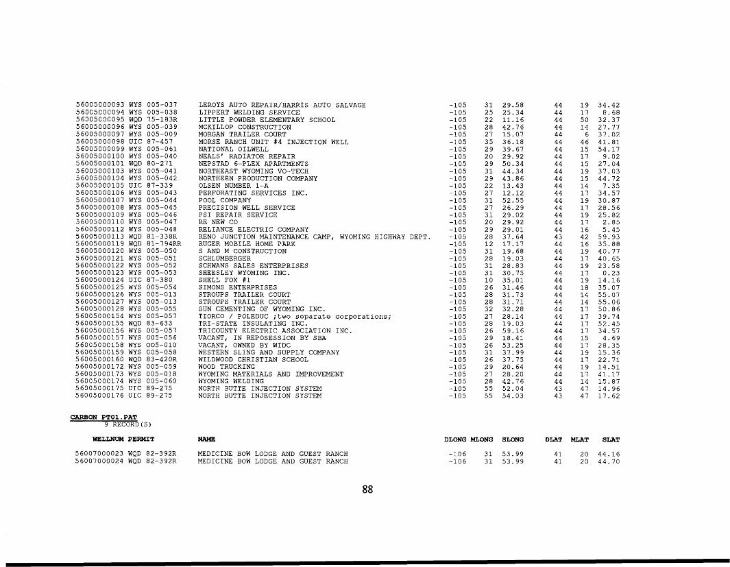
56005000093 WYS 005-037 56005000094 WYS 005-038 56005000095 WQD 75-183R 56005000096 WYS 005-039 56005000097 WYS 005-009 56005000098 UIC 87-457 56005000099 WYS 005-061 56005000100 WYS 005-040 56005000101 WQD 80-271 56005000103 WYS 005-041 56005000104 WYS 005-042 56005000105 UIC 87-339 56005000106 WYS 005-043 56005000107 WYS 005-044 56005000108 WYS 005-045 56005000109 WYS 005-046 56005000110 WYS 005-047 56005000112 WYS 005-048 56005000113 WQD 81-338R 56005000119 WQD 81-794RR 56005000120 WYS 005-050 56005000121 WYS 005-051 56005000122 WYS 005-052 56005000123 WYS 005-053 56005000124 UIC 87-380 56005000125 WYS 005-054 56005000126 WYS 005-013 56005000127 WYS 005-013 56005000128 WYS 005-055 56005000154 WYS 005-057 56005000155 WQD 83-633 56005000156 WYS 005-057 56005000157 WYS 005-056 56005000158 WYS 005-010 56005000159 WYS 005-058 56005000160 WQD 83-420R 56005000172 WYS 005-059 56005000173 WYS 005-018 56005000174 WYS 005-060 56005000175 UIC 89-275 56005000176 UIC 89-275
CARBON PTOl .PAT 9 RECORD (S)
WELLNUM PERMIT
56007000023 WQD 82-392R 56007000024 WQD 82-392R
LEROYS AUTO REPAIR/HARRIS AUTO SALVAGE LIPPERT WELDING SERVICE LITTLE POWDER ELEMENTARY SCHOOL MCKILLOP CONSTRUCTION MORGAN TRAILER COURT MORSE RANCH UNIT #4 INJECTION WELL NATIONAL OILWELL NEALS' RADIATOR REPAIR NEPSTAD 6-PLEX APARTMENTS NORTHEAST WYOMING VO-TECH
OLSEN NUMBER 1-A NORTHERN PRODUCTION COMPANY
PERFORATING SERVICES INC. POOL COMPANY PRECISION WELL SERVICE PSI REPAIR SERVICE RE NEW CO RELIANCE ELECTRIC COMPANY RENO JUNCTION MAINTENANCE CAMP, WYOMING HIGHWAY DEPT. RUGER MOBILE HOME PARK S AND M CONSTRUCTION SCHLUMBERGER SCHWANS SALES ENTERPRISES SHEESLEY WYOMING INC. SHELL FOX #1 SIMONS ENTERPRISES STROUPS TRAILER COURT STROUPS TRAILER COURT SUN CEMENTING OF WYOMING INC. TIORCO / POLEDUC ;two separate corporations;
TRICOUNTY ELECTRIC ASSOCIATION INC. VACANT, IN REPOSESSION BY SBA VACANT, OWNED BY WIDC WESTERN SLING AND SUPPLY COMPANY WILDWOOD CHRISTIAN SCHOOL WOOD TRUCKING WYOMING MATERIALS AND IMPROVEMENT WYOMING WELDING NORTH BUTTE INJECTION SYSTEM NORTH BUTTE INJECTION SYSTEM
TRI-STATE INSULATING INC.
NAME
MEDICINE BOW LODGE AND GUEST RANCH MEDICINE BOW LODGE AND GUEST RANCH
-105 -105 -105 -105 -105 -105 -105 -105 -105 -105 -105 -105 -105 -105 -105 -105 -105 -105 -105 -105 -105 -105 -105 -105 -105 -105 -105 -105 -105 -105 -105 -105 -105 -105 -105 -105 -105 -105 -105 -105 -105
31 29.58 25 22 25.34 11.16
28 42.76 27 15.07 35 36.18 29 39.67 20 29.92 29 50.34 31 44.34 29 43.86 22 13.43 27 12.12 31 52.55 27 26.29 31 29.02 20 29.92 29 29.01 28 37.64 12 17.17 31 19.68 28 19.03 31 28.83 31 30.75 10 35.01 26 31.46 28 31.73 28 31.71 32 32.28 27 28.14 28 19-03 26 59.16 29 18.41 26 53.25 31 37.99 26 37.75 29 20.64 27 28.20 28 42.76 55 52.04 55 54.03
44 19 34.42 44 17 8.68 44 50 32.37 44 14 27.77 44 6 37.02 44 46 41.81 44 15 54.17 44 17 9.02 44 15 27.04 44 19 37.03 44 15 44.72 44 14 7.35 44 17 34.57 44 19 30.87 44 17 28.56 44 19 25.82 44 17 2.85 44 16 5.45 43 42 59.93 44 16 35.88 44 19 40.77 44 17 40.65 44 19 23.58 44 17 0.23 44 19 14.16 44 18 35.07 44 14 55.07 44 14 55.06 44 17 50.86 44 17 39.74 44 17 52.45 44 17 34.57 44 15 4.69 44 17 28.35 44 19 15.36 44 17 22.71 44 19 14.51 44 17 41.17 44 14 15.87 43 47 14.96 43 47 17.62
DLONG MLONG SLONG DLAT MLAT SLAT
-106 31 53.99 41 20 44.16 -106 31 53.99 41 20 44.70
88
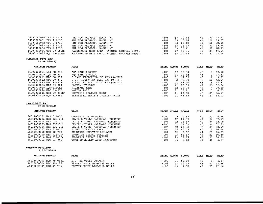
56007000030 TFN 2 1/38 56007000031 TFN 2 1/38 56007000032 TFN 2 1/38 56007000033 TFN 2 1/38 56007000034 TFN 2 1/38 56007000036 WQD 79-659RR 56007000037 WQD 79-659RR
CONVERSE PTO1.PAT 10 RECORD (
WELLNUM PERMIT
56009000001 LQD-RD #13
56009000021 UIC 88-352 56009000022 UIC 89-379 56009000025 UIC 88-353 56009000026 UIC 89-324 56009000028 LQD-218CA1 56009000044 UIC 89-030 56009000045 WQD 79-340RR 56009000049 WQD 81-585
56009000009 LQD RD #5
CROOK PTO1.PAT 10 RECORD (S)
WELLNUM PERMIT
56011000001 WYS 56011000003 WYS 5 6 0 11 00 0 0 0 4 WYS 5 60 11 0 0 0 0 0 5 WYS 56011000006 WYS 56011000007 WYS 5 6011000 0 08 WQD 56011000009 WYS 56011000010 WYS 56011000011 UIC
011-001 039-012 039-012 039-012 039-012 011-003 82-758 011-004 011-004 91-049
FREMONT PTO1.PAT 18 RECORD (S)
WELLNUM PERMIT
56013000003 WQD 79-055R 56013000004 UIC 89-285 56013000005 UIC 89-285
RM1 UCG PROJECT, HANNA, WY RM1 UCG PROJECT, HANNA, WY RM1 UCG PROJECT, HANNA, WY RM1 UCG PROJECT, HANNA, WY RM1 UCG PROJECT, HANNA, WY WAGONHOUND REST AREA, WYOMING HIGHWAY DEPT. WAGONHOUND REST AREA, WYOMING HIGHWAY DEPT.
NAME
' 0 ' SAND PROJECT "Q' SAND PROJECT E SAND INJECTION- 50 WYO PROJECT G.G. NICOLAYSEN COLE CR. F41-27G H SAND INJECTION- 50 WYO PROJECT HARVEY HEINBACH HIGHLAND MINE MORTON 1-20 NORTON' S TRAILER COURT TENNESSEE ERNIE'S TRAILER ACRES
NAME
COLONY WYOMING PLANT DEVIL'S TOWER NATIONAL MONUMENT DEVIL'S TOWER NATIONAL MONUMENT DEVIL'S TOWER NATIONAL MONUMENT DEVIL'S TOWER NATIONAL MONUMENT J AND J TRAILER PARK SUNDANCE MOUNTAIN SKI AREA SUNDANCE TEXACO STATION SUNDANCE TEXACO STATION TOWN OF HULETT ACID INJECTION
NAME
B.J. SERVICES COMPANY BEAVER CREEK DISPOSAL WELLS BEAVER CREEK DISPOSAL WELLS
-106 33 20.64 41 50 48.97 -106 33 6.64 41 50 49.07 -106 33 25.48 41 50 32.55 -106 33 22.45 41 50 29.94 -106 33 30.41 41 50 28.93 -106 17 10.36 41 37 57.64 -106 17 10.36 41 37 57.64
DLONG MLONG SLONG DLAT MLAT SLAT
-105 42 15.54 -105 41 14.42 -105 41 12.05
-105 41 43.20 -105 11 25.59 -105 32 38.29 -105 31 56.11 -105 11 24.98 -105 21 48.33
-106 3 48.39
DLONG MLONG
-104 9 -104 42 -104 42 -104 42 -104 42 -104 56 -104 22 -104 23 -104 23 -104 36
SLONG
0.93 21.87 21.87 21.83 21.83 45.42 2.02 54.17 54.17 6.13
43 3 47.58 2 57.63 43 8 9.22 43
42 58 43.64 8 12.63 43
42 39 32.24 43 4 28.80 43 5 0.63 42 39 25.51 42 47 36.02
DLAT MLAT SLAT
44 52 6.78 44 34 52.99 44 34 52.99 44 34 52.99 44 34 52.99 44 15 20.54 44 23 25.69 44 23 30.39 44 23 30.39 44 41 4.27
DLONG MLONG SLONG DLAT MLAT SLAT
-108 26 57.69 43 3 4.27 42 50 33.78
-108 19 7.08 42 50 22.16 -108 18 55.73
89
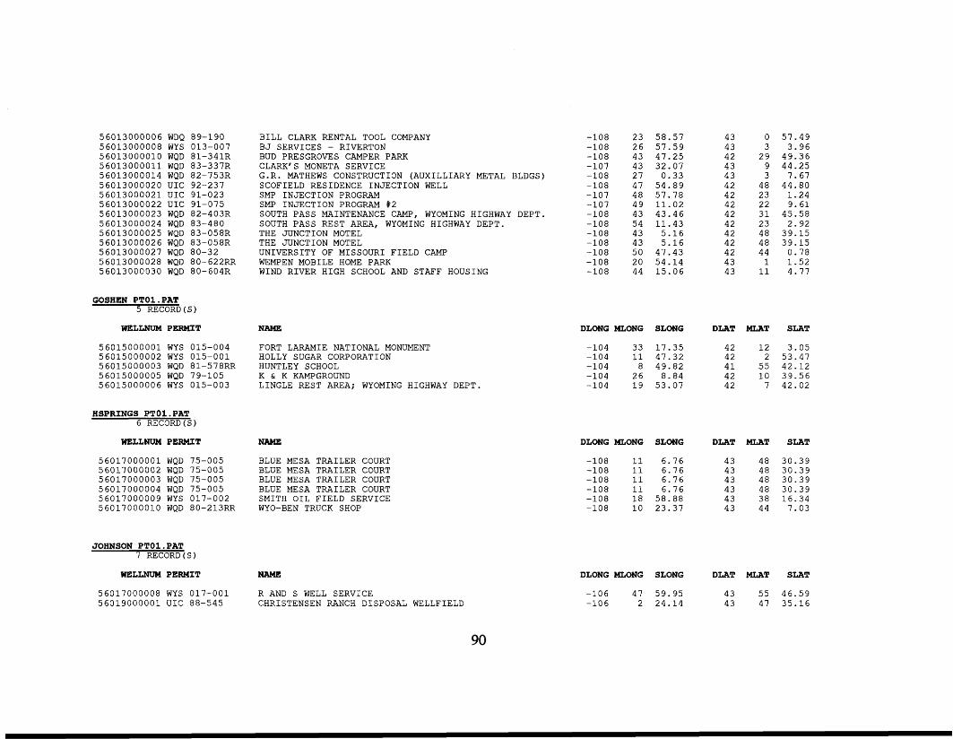
5 60 13 0 00 00 6 WDQ 56013000008 WYS 5 60 1300 00 10 WQD 5 60 130 000 11 WQD 5 60 13 0000 14 WQD 56013000020 UIC 56013000021 UIC 56013000022 UIC 5 60 13 0 0 0 023 WQD 5 60 130 0 0024 WQD 5 60 1300 0025 WQD 5 60 13 00002 6 WQD 5 60 13 00 0027 WQD 5 60 13 00 0 02 8 WQD 56013000030 WQD
89-190 013-007 81-341R 83-337R 8 2- 7 5 3R 92-237 91-023 91-075 82-403R 83-480 83-058R 83-058R 80-32 8 0- 62 2RR 80-604R
GOSHEN PTOl .PAT 5 RECORD
BILL CLARK RENTAL TOOL COMPANY BJ SERVICES - RIVERTON BUD PRESGROVES CAMPER PARK CLARK'S MONETA SERVICE G.R. MATHEWS CONSTRUCTION (AUXILLIARY METAL BLDGS) SCOFIELD RESIDENCE INJECTION WELL SMP INJECTION PROGRAM SMP INJECTION PROGRAM #2 SOUTH PASS MAINTENANCE CAMP, WYOMING HIGHWAY DEPT. SOUTH PASS REST AREA, WYOMING HIGHWAY DEPT. THE JUNCTION MOTEL THE JUNCTION MOTEL UNIVERSITY OF MISSOURI FIELD CAMP WEMPEN MOBILE HOME PARK WIND RIVER HIGH SCHOOL AND STAFF HOUSING
WELLNUM PERMIT NAME
56015000001 WYS 015-004 FORT LARAMIE NATIONAL MONUMENT 56015000002 WYS 015-001 HOLLY SUGAR CORPORATION 56015000003 WQD 81-578RR HUNTLEY SCHOOL 56015000005 WQD 79-105 K & K KAMPGROUND 56015000006 WYS 015-003 LINGLE REST AREA; WYOMING HIGHWAY DEPT.
HSPRINGS PTO1.PAT 6 RECORD (S)
WELLNUM PERMIT NAME
56017000001 WQD 75-005 BLUE MESA TRAILER COURT 56017000002 WQD 75-005 BLUE MESA TRAILER COURT 56017000003 WQD 75-005 BLUE MESA TRAILER COURT 56017000004 WQD 75-005 BLUE MESA TRAILER COURT 56017000009 WYS 017-002 SMITH OIL FIELD SERVICE 56017000010 WQD 80-213RR WYO-BEN TRUCK SHOP
JOHNSON PTO1.PAT 7 RECORD (S)
WELLNUM PERMIT NAME
56017000008 WYS 017-001 R AND S WELL SERVICE 56019000001 UIC 88-545 CHRISTENSEN RANCH DISPOSAL WELLFIELD
-108 -108 -108 -107 -108 -108 -107 -107 -108 -108 -108 -108 -108 -108 -108
23 58.57 26 57.59 43 47.25 43 32.07 27 0.33 47 54.89 48 57.78 49 11.02 43 43.46 54 11.43 43 5.16 43 5.16 50 47.43 20 54.14 44 15.06
43 0 57.49 43 3 3.96 42 29 49.36 43 9 44.25 43 3 7.67 42 48 44.80 42 23 1.24 42 22 9.61 42 31 45.58 42 23 2.92 42 48 39.15 42 48 39.15 42 44 0.78 43 1 1.52 43 11 4.77
DLONG MLONG SLONG DLAT MLAT SLAT
-104 33 17.35 42 12 3.05 -104 11 47.32 42 2 53.47 -104 8 49.82 41 55 42.12 -104 26 8.84 42 10 39.56 -104 19 53.07 42 7 42.02
DLONG MLONG SLONG DLAT MLAT SLAT
-108 11 6.76 43 48 30.39 43 48 30.39
-108 11 6.76 43 48 30.39 43 48 30.39
-108 18 58.88 43 38 16.34 -108 10 23.37 43 44 7.03
-108 11 6.76
-108 11 6.76
DLONG MLONG SLONG DLAT MLAT SLAT
-106 47 59.95 43 55 46.59 -106 2 24.14 43 47 35.16
90
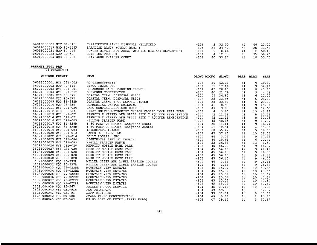
56019000002 UIC 88-545 56019000019 WQD 83-333R 56019000021 WQD 82-017 56019000023 LQD-RD #9 56019000024 WQD 80-221
LARAMIE PTO1.PAT 48 RECORD(S)
WELLNUM PERMIT
56021000001 WYS 021-002 56021000002 WQD 77-389 56021000003 WYS 021-001 56021000004 WYS 021-012 56021000005 UIC 90-375 56021000006 UIC 90-375 56021000009 WQD 81-382R 56021000010 WQD 78-530 56021000011 WYS 021-020 56021000012 UIC 88-257 56021000013 WYS 021-021 56021000014 WYS 021-021 56021000016 WYS 021-003 56021000017 WQD 81-328R 56021000018 WQD 81-328R 56021000019 WYS 021-004 56021000020 WYS 021-013 56021000022 WYS 021-014 56021000023 WYS 021-006 56021000025 WYS 021-009 56021000026 WYS 021-020 56021000027 WYS 021-020 56021000028 WYS 021-020 56021000029 WYS 021-020 56021000030 WYS 021-020 56021000031 WQD 80-337R 56021000032 WQD 80-337R 56021000033 WQD 79-022RR 56021000034 WQD 79-022RR 56021000035 WQD 79-022RR 56021000036 WQD 79-022RR 56021000037 WQD 79-022RR 56021000038 WQD 79-022RR 56021000039 WQD 85-567 56021000040 WYS 021-016 56021000041 WYS 021-017 56021000042 WQD 80-608 56021000045 WQD 82-563
CHRISTENSEN RANCH DISPOSAL WELLFIELD PARADISE RANCH (GUEST RANCH) POWDER RIVER REST AREA, WYOMING HIGHWAY DEPARTMENT RUTH ISL PROJECT SLAYBAUGH TRAILER COURT
NAME
AC Transformers BINGO TRUCK STOP BROADMOOR EAST BOARDING KENNEL CHEYENNE CONSTRUCTOR COASTAL CHEM, DISPOSAL WELLS COASTAL CHEM, DISPOSAL WELLS COASTAL CHEM, INC. SEPTIC SYSTEM COMMERCIAL OFFICE BUILDING DAFC CENTRAL SERVICES DRYWELL FIRST UNITED METHODIST CHURCH CLOSED LOOP HEAT PUMP FRANCIS E WARREN AFB SPILL SITE 7 AQUIFER REMEDIATION FRANCIS E WARREN AFB SPILL SITE 7 AQUIFER REMEDIATION HILLTOP TRAILER PARK 1-80 PORT OF ENTRY (Cheyenne East) 1-80 PORT OF ENTRY (Cheyenne south) INTERSTATE TEXACO JAMES E. SIMON INC. JOLLY ROGERS, INC. LIGHTHOUSE BAPTIST CHURCH MAGILL TRAILER RANCH MERRITT MOBILE HOME PARK MERRITT MOBILE HOME PARK MERRITT MOBILE HOME PARK MERRITT MOBILE HOME PARK MERRITT MOBILE HOME PARK MILLER UPPER AND LOWER TRAILER COURTS MILLER UPPER AND LOWER TRAILER COURTS MOUNTAIN VIEW ESTATES MOUNTAIN VIEW ESTATES MOUNTAIN VIEW ESTATES MOUNTAIN VIEW ESTATES MOUNTAIN VIEW ESTATES MOUNTAIN VIEW ESTATES PALMER'S AUTO SERVICE PDQ TRANSPORT SAPP BROTHERS SMALL TIMES CONSTRUCTION US 85 PORT OF ENTRY (TERRY ROAD)
2 32.50 -106 -106 57 24.42 -106 9 18.46 -106 4 12.75 -106 40 55.27
DLONG MLONG SLONG
-104 -104 -104 -104 -104 -104 -104 -104 -104 -104 -104 -104 -104 -104 -104 -104 -104 -104 -104 -104 -104 -104 -104 -104 -104 -104 -104 -104 -104 -104 -104 -104 -104 -104 -104 -104 -104 -104
39 43.33 21 17.11 45 28.15 40 21.79 55 34.85 55 33.93 55 33.93 46 0.90 49 9.83 4 3.90 52 11.31 52 11.31 45 48.53 38 11.11 51 12.51 50 55.22 45 37.46 44 3.08 46 15.68 52 36.55 45 56.00 45 56.15 45 56.15 45 56.15 45 56.15 46 3.36 46 3.36 45 15.07 45 15.07 45 15.07 45 15.07 45 15.07 45 15.07 45 37.46 49 59.06 39 31.64 49 9.83 47 39.16
43 48 23.22 44 20 33.48 44 12 50.40 43 35 30.24 44 18 33.70
DLAT
41 41 41 41 41 41 41 41 41 41 41 41 41 41 41 41 41 41 41 41 41 41 41 41 41 41 41 41 41 41 41 41 41 41 41 41 41 41
MLAT SLAT
9 30.82 9 34.46 8 43.80 9 4.52 6 23.02 6 23.02 6 23.02 9 45.86 8 14.65 10 42.88
8 52.28 8 52.28 9 37.27 9 36.24 4 55.31 5 59.08 10 38.03 9 17.59 6 22.41 13 8.62 9 46.27 9 46.41 9 46.55 9 46.41 9 46.55 9 26.35 9 26.35 10 47.65 10 47.65 10 47.67 10 47.67 10 47.67 10 47.69 10 38.03 7 52.07 9 30.69 8 14.65 3 30.67
91
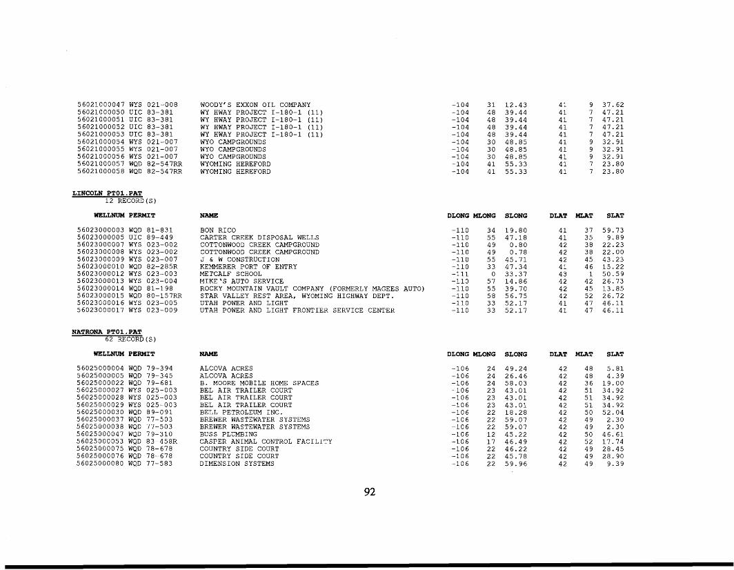
56021000047 WYS 56021000050 UIC 56021000051 UIC 56021000052 UIC 56021000053 UIC 5 602 10 0 0 054 WY S 56021000055 WYS 56021000056 WYS 56021000057 WQD 5 602 10 0 0 05 8 WQD
021-008 83-381 83-381 83-381 83-381 021-007 021-007 021-007 8 2 - 5 4 7RR 82-547RR
WOODY'S EXXON OIL COMPANY WY HWAY PROJECT 1-180-1 (11) WY HWAY PROJECT 1-180-1 (11) WY HWAY PROJECT 1-180-1 (11) WY HWAY PROJECT 1-180-1 (11) WYO CAMPGROUNDS WYO CAMPGROUNDS WYO CAMPGROUNDS WYOMING HEREFORD WYOMING HEREFORD
-104 31 12.43 -104 48 39.44 -104 48 39.44 -104 48 39.44 -104 48 39.44 -104 30 48.85 -104 30 48.85 -104 30 48.85 -104 41 55.33 -104 41 55.33
41 41 41 41 41 41 41 41 41 41
9 37.62 7 47.21 7 47.21 7 47.21 7 47.21 9 32.91 9 32.91 9 32.91 7 23.80 7 23.80
LINCOLN PTOl .PAT 12 RECORD(S)
WELLNUN PERMIT NAME DLONG MLONG SLONG DLAT MLAT SLAT
56023000003 WQD 81-831 56023000005 UIC 89-449 56023000007 WYS 023-002 56023000008 WYS 023-002 56023000009 WYS 023-007 56023000010 WQD 82-285R 56023000012 WYS 023-003 56023000013 WYS 023-004 56023000014 WQD 81-198 56023000015 WQD 80-157RR 56023000016 WYS 023-005 56023000017 WYS 023-009
BON RICO CARTER CREEK DISPOSAL WELLS COTTONWOOD CREEK CAMPGROUND COTTONWOOD CREEK CAMPGROUND J & W CONSTRUCTION KEMMERER PORT OF ENTRY METCALF SCHOOL MIKE'S AUTO SERVICE ROCKY MOUNTAIN VAULT COMPANY (FORMERLY MAGEES AUTO) STAR VALLEY REST AREA, WYOMING HIGHWAY DEPT. UTAH POWER AND LIGHT UTAH POWER AND LIGHT FRONTIER SERVICE CENTER
-110 34 -110 55 -110 49 -110 49 -110 55 -110 33 -111 0 -110 57 -110 55 -110 58 -110 33 -110 33
19.80 47.18 0.80 0.78
45.71 47.34 33 * 37 14.86 39.70 56.75 52.17 52.17
41 41 42 42 42 41 43 42 42 42 41 41
37 35 38 38 45 46
59.73 9.89 22.23 22.00 43.23 15.22 50.59 26.73 13.85 26.72 46.11 46.11
, 1
42 45 52 47 47
NATRONA PTO1.PAT 62 RECORD(S)
WELLNUM PERMIT NAME DLONG MLONG SLONG DLAT MLAT
48 48 36 51 51 51 50 49 49 50 52 49 49 49
SLAT
56025000004 WQD 79-394 56025000005 WQD 79-345 56025000022 WQD 79-681 56025000027 WYS 025-003 56025000028 WYS 025-003 56025000029 WYS 025-003 56025000030 WQD 89-091 56025000037 WQD 77-503 56025000038 WQD 77-503 56025000047 WQD 79-310 56025000053 WQD 83-458R 56025000075 WQD 78-678 56025000076 WQD 78-678 56025000080 WQD 77-583
ALCOVA ACRES ALCOVA ACRES B. MOORE MOBILE HOME SPACES BEL AIR TRAILER COURT BEL AIR TRAILER COURT BEL AIR TRAILER COURT BELL PETROLEUM INC. BREWER WASTEWATER SYSTEMS BREWER WASTEWATER SYSTEMS BUSS PLUMBING CASPER ANIMAL CONTROL FACILITY COUNTRY SIDE COURT COUNTRY SIDE COURT DIMENSION SYSTEMS
-106 24 -106 24 -106 24 -106 23 -106 23 -106 23 -106 22 -106 22 -106 22 -106 12 -106 17 -106 22 -106 22 -106 22
5.81 4.39 19.00 34.92 34.92 34.92 52.04 2.30 2.30 46.61 17.74 28.45 28.90 9.39
49.24 26.46 58.03 43.01 43.01 43.01 18.28 59.07 59.07 45.22 46.49 46.22 45.78 59.96
42 42 42 42 42 42 42 42 42 42 42 42 42 42
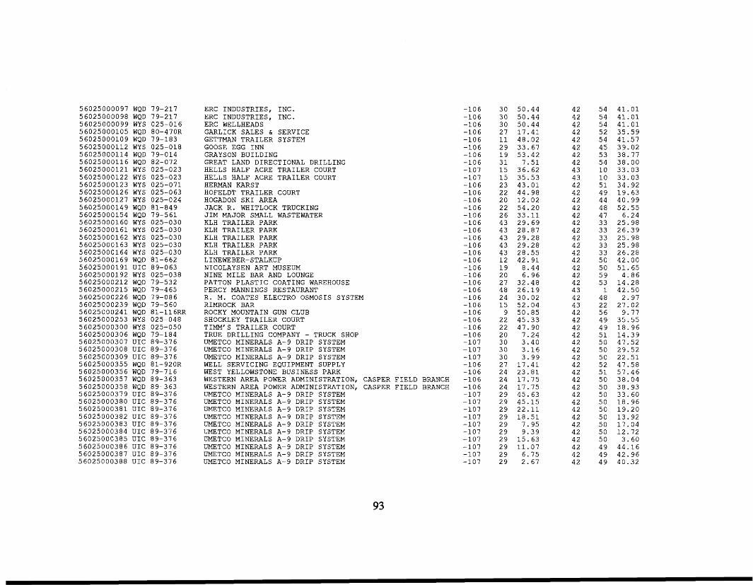
5 6 0 2 5 0 0 0 0 9 7 WQD 79-217 5 6 0 2 5 0 0 0 0 9 8 WQD 79-217 5 6 0 2 5 0 0 0 0 9 9 WYS 025-016 5 6 0 2 5 0 0 0 1 0 5 WQD 80-470R 5 6 0 2 5 0 0 0 1 0 9 WQD 79-183 5 6 0 2 5 0 0 0 1 1 2 WYS 025-018 5 6 0 2 5 0 0 0 1 1 4 WQD 79-014 5 6 0 2 5 0 0 0 1 1 6 WQD 82-072 5 6 0 2 5 0 0 0 1 2 1 WYS 025-023 5 6 0 2 5 0 0 0 1 2 2 WYS 025-023 5 6 0 2 5 0 0 0 1 2 3 WYS 025-071 5 6 0 2 5 0 0 0 1 2 6 WYS 025-063 5 6 0 2 5 0 0 0 1 2 7 WYS 025-024 5 6 0 2 5 0 0 0 1 4 9 WQD 81-849 5 6 0 2 5 0 0 0 1 5 4 WQD 79-561 5 6 0 2 5 0 0 0 1 6 0 WYS 025-030 5 6 0 2 5 0 0 0 1 6 1 WYS 025-030 5 6 0 2 5 0 0 0 1 6 2 WYS 025-030 5 6 0 2 5 0 0 0 1 6 3 WYS 025-030 5 6 0 2 5 0 0 0 1 6 4 WYS 025-030 5 6 0 2 5 0 0 0 1 6 9 WQD 81-662 5 6 0 2 5 0 0 0 1 9 1 UIC 89-063 5 6 0 2 5 0 0 0 1 9 2 WYS 025-038 5 6 0 2 5 0 0 0 2 1 2 WQD 79-532 5 6 0 2 5 0 0 0 2 1 5 WQD 79-465 5 6 0 2 5 0 0 0 2 2 6 WQD 79-086 5 6 0 2 5 0 0 0 2 3 9 WQD 79-560 5 6 0 2 5 0 0 0 2 4 1 WQD 81-116RR 5 6 0 2 5 0 0 0 2 5 3 WYS 025-048 5 6 0 2 5 0 0 0 3 0 0 WYS 025-050 5 6 0 2 5 0 0 0 3 0 6 WQD 79-184 5 6 0 2 5 0 0 0 3 0 7 UIC 89-376 5 6 0 2 5 0 0 0 3 0 8 UIC 89-376 5 6 0 2 5 0 0 0 3 0 9 UIC 89-376 5 6 0 2 5 0 0 0 3 5 5 WQD 81-920R 5 6 0 2 5 0 0 0 3 5 6 WQD 79-716 5 6 0 2 5 0 0 0 3 5 7 WQD 89-363 5 6 0 2 5 0 0 0 3 5 8 WQD 89-363 5 6 0 2 5 0 0 0 3 7 9 UIC 89-376 5 6 0 2 5 0 0 0 3 8 0 UIC 89-376 5 6 0 2 5 0 0 0 3 8 1 UIC 89-376 5 6 0 2 5 0 0 0 3 8 2 UIC 89-376 5 6 0 2 5 0 0 0 3 8 3 UIC 89-376 5 6 0 2 5 0 0 0 3 8 4 UIC 89-376 5 6 0 2 5 0 0 0 3 8 5 UIC 89-376 5 6 0 2 5 0 0 0 3 8 6 UIC 89-376 5 6 0 2 5 0 0 0 3 8 7 UIC 89-376 5 6 0 2 5 0 0 0 3 8 8 UIC 89-376
ERC INDUSTRIES, INC. ERC INDUSTRIES, INC. ERC WELLHEADS GARLICK SALES & SERVICE GETTMAN TRAILER SYSTEM GOOSE EGG INN GRAYSON BUILDING GREAT LAND DIRECTIONAL DRILLING HELLS HALF ACRE TRAILER COURT HELLS HALF ACRE TRAILER COURT HERMAN KARST HOFELDT TRAILER COURT HOGADON SKI AREA JACK R. WHITLOCK TRUCKING JIM MAJOR SMALL WASTEWATER KLH TRAILER PARK KLH TRAILER PARK KLH TRAILER PARK KLH TRAILER PARK KLH TRAILER PARK
NICOLAYSEN ART MUSEUM NINE MILE BAR AND LOUNGE PATTON PLASTIC COATING WAREHOUSE PERCY MANNINGS RESTAURANT R. M. COATES ELECTRO OSMOSIS SYSTEM RIMROCK BAR ROCKY MOUNTAIN GUN CLUB SHOCKLEY TRAILER COURT TIMM'S TRAILER COURT TRUE DRILLING COMPANY - TRUCK SHOP UMETCO MINERALS A-9 DRIP SYSTEM UMETCO MINERALS A-9 DRIP SYSTEM UMETCO MINERALS A-9 DRIP SYSTEM
LINEWEBER-STALKUP
WELL SERVICING EQUIPMENT SUPPLY WEST YELLOWSTONE BUSINESS PARK WESTERN AREA POWER ADMINISTRATION, CASPER FIELD BRANCH WESTERN AREA POWER ADMINISTRATION, CASPER FIELD BRANCH UMETCO MINERALS A-9 DRIP SYSTEM UMETCO MINERALS A-9 DRIP SYSTEM UMETCO MINERALS A-9 DRIP SYSTEM UMETCO MINERALS A-9 DRIP SYSTEM UMETCO MINERALS A-9 DRIP SYSTEM UMETCO MINERALS A-9 DRIP SYSTEM UMETCO MINERALS A-9 DRIP SYSTEM UMETCO MINERALS A-9 DRIP SYSTEM UMETCO MINERALS A-9 DRIP SYSTEM UMETCO MINERALS A-9 DRIP SYSTEM
-106 - 1 0 6 -106 -106 -106 -106 -106 -106 -107 -107 -106 -106 -106 -106 -106 -106 -106 -106 -106 -106 -106 -106 -106 -106 -106 -106 -106 -106 - 1 0 6 -106 -106 -107 -107 -107 -106 -106 -106 -106 -107 -107 -107 -107 -107 -107 -107 -107 -107 -107
3 0 5 0 . 4 4 3 0 5 0 . 4 4 3 0 5 0 . 4 4 2 7 1 7 . 4 1 11 4 8 . 0 2 2 9 3 3 . 6 7 1 9 5 3 . 4 2 31 7 . 5 1 1 5 3 6 . 6 2 15 35.53 2 3 4 3 . 0 1 2 2 4 4 . 9 8 2 0 1 2 . 0 2 2 2 5 4 . 2 0 2 6 33.11 4 3 2 9 . 6 9 4 3 2 8 . 8 7 4 3 2 9 . 2 8 4 3 2 9 . 2 8 4 3 2 8 . 5 5 1 2 4 2 . 9 1 1 9 8 . 4 4 20 6 . 9 6 2 7 3 2 . 4 8 4 8 2 6 . 1 9 24 3 0 . 0 2 15 5 2 . 0 4
9 5 0 . 8 5 2 2 4 5 . 3 3 2 2 4 7 . 9 0 2 0 7 . 2 4 3 0 3 . 4 0 3 0 3 . 1 6 3 0 3 . 9 9 2 7 1 7 . 4 1 24 2 3 . 8 1 24 1 7 . 7 5 2 4 1 7 . 7 5 2 9 4 5 . 6 3 2 9 4 5 . 1 5 2 9 2 2 . 1 1 2 9 1 8 . 5 1 2 9 7 . 9 5 2 9 9 . 3 9 2 9 1 5 . 6 3 2 9 1 1 . 0 7 2 9 6 . 7 5 2 9 2 . 6 7
4 2 5 4 4 1 . 0 1 42 5 4 4 1 . 0 1 42 5 4 4 1 . 0 1 4 2 5 2 3 5 . 5 9 4 2 5 4 4 1 . 5 7 4 2 4 5 3 9 . 0 2 4 2 53 3 8 . 7 7 4 2 5 4 3 8 . 0 0 4 3 1 0 3 3 . 0 3 4 3 1 0 3 3 . 0 3 4 2 5 1 3 4 . 9 2 4 2 4 9 1 9 . 6 3 4 2 44 4 0 . 9 9 4 2 4 8 5 2 . 5 5 42 4 7 6 . 2 4 4 2 33 2 5 . 9 8 4 2 33 2 6 . 3 9 42 33 2 5 . 9 8 4 2 33 2 5 . 9 8 4 2 33 2 6 . 2 8 4 2 5 0 42 .00 42 5 0 5 1 . 6 5 42 5 9 4 . 8 6 4 2 53 1 4 . 2 8
1 4 2 . 5 0 4 3 4 2 4 8 2 . 9 7 4 3 2 2 2 7 . 0 2 4 2 5 6 9 .77 42 4 9 3 5 . 5 5 4 2 4 9 1 8 . 9 6 42 51 1 4 . 3 9 42 5 0 4 7 . 5 2 4 2 50 2 9 . 5 2 4 2 5 0 2 2 . 5 1 4 2 5 2 4 7 . 5 8 4 2 51 5 7 . 4 6 4 2 5 0 3 8 . 0 4 42 5 0 3 8 . 9 3 4 2 5 0 3 3 . 6 0 4 2 5 0 1 8 . 9 6 4 2 5 0 1 9 . 2 0 42 5 0 1 3 . 9 2 4 2 5 0 1 7 . 0 4 4 2 5 0 1 2 . 7 2 42 5 0 3 . 6 0 4 2 4 9 4 4 - 1 6 4 2 4 9 4 2 . 9 6 4 2 4 9 4 0 . 3 2
93
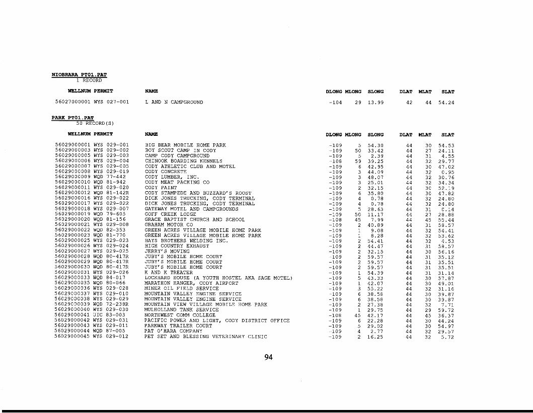
NIOBRARA PTOl . PAT 1 RECORD
WELLNUM PERMIT
5 6 0 2 7 0 0 0 0 0 1 WYS 027-001
PARK PTOl-PAT 5 0 RECORD(S)
WELLNUM PERMIT
5 6 0 2 9 0 0 0 0 0 1 WYS 029-001 5 6 0 2 9 0 0 0 0 0 3 WYS 029-002 5 6 0 2 9 0 0 0 0 0 5 WYS 029-003 5 6 0 2 9 0 0 0 0 0 6 WYS 029-004 5 6 0 2 9 0 0 0 0 0 7 WYS 029-005 5 6 0 2 9 0 0 0 0 0 8 WYS 029-019 5 6 0 2 9 0 0 0 0 0 9 WQD 77-442 5 6 0 2 9 0 0 0 0 1 0 WQD 81-942 5 6 0 2 9 0 0 0 0 1 1 WYS 029-020 5 6 0 2 9 0 0 0 0 1 2 WQD 81-142R 5 6 0 2 9 0 0 0 0 1 6 WYS 029-022 5 6 0 2 9 0 0 0 0 1 7 WYS 029-022 5 6 0 2 9 0 0 0 0 1 8 WYS 029-007 5 6 0 2 9 0 0 0 0 1 9 WQD 79-605 5 6 0 2 9 0 0 0 0 2 0 WQD 81-156 5 6 0 2 9 0 0 0 0 2 1 WYS 029-008 5 6 0 2 9 0 0 0 0 2 2 WQD 82-353 5 6 0 2 9 0 0 0 0 2 3 WQD 81-770 5 6 0 2 9 0 0 0 0 2 5 WYS 029-023 5 6 0 2 9 0 0 0 0 2 6 WYS 029-024 5 6 0 2 9 0 0 0 0 2 7 WYS 029-025 5 6 0 2 9 0 0 0 0 2 8 WQD 80-417R 5 6 0 2 9 0 0 0 0 2 9 WQD 80-417R 5 6 0 2 9 0 0 0 0 3 0 WQD 80-41712 5 6 0 2 9 0 0 0 0 3 1 WYS 029-026 5 6 0 2 9 0 0 0 0 3 3 WQD 84-017 5 6 0 2 9 0 0 0 0 3 5 WQD 80-066 5 6 0 2 9 0 0 0 0 3 6 WYS 029-028 5 6 0 2 9 0 0 0 0 3 7 WYS 029-010 5 6 0 2 9 0 0 0 0 3 8 WYS 029-029 5 6 0 2 9 0 0 0 0 3 9 WQD 72-238R 5 6 0 2 9 0 0 0 0 4 0 WYS 029-030 5 6 0 2 9 0 0 0 0 4 1 UIC 83-003 5 6 0 2 9 0 0 0 0 4 2 WYS 029-031 5 6 0 2 9 0 0 0 0 4 3 WYS 029-011 5 6 0 2 9 0 0 0 0 4 4 WQD 87-005 5 6 0 2 9 0 0 0 0 4 5 WYS 029-012
NAME
L AND N CAMPGROUND
NAME
BIG BEAR MOBILE HOME PARK BOY SCOUT CAMP IN CODY CAMP CODY CAMPGROUND CHINOOK BOARDING KENNELS CODY ATHLETIC CLUB AND MOTEL CODY CONCRETE CODY LUMBER, INC. CODY MEAT PACKING CO CODY PAINT CODY STAMPEDE AND BUZZARD'S ROOST DICK JONES TRUCKING, CODY TERMINAL DICK JONES TRUCKING, CODY TERMINAL GATEWAY MOTEL AND CAMPGROUNDS GOFF CREEK LODGE GRACE BAPTIST CHURCH AND SCHOOL GRAHAM MOTOR CO GREEN ACRES VILLAGE MOBILE HOME PARK GREEN ACRES VILLAGE MOBILE HOME PARK HAYS BROTHERS WELDING INC. HIGH COUNTRY EXHAUST JERRY'S MOVING JUBY'S MOBILE HOME COURT JUBY'S MOBILE HOME COURT JUBY'S MOBILE HOME COURT K AND K TREATER LOCKHARD HOUSE (A YOUTH HOSTEL AKA SAGE MOTEL) MARATHON HANGER, CODY AIRPORT MINER OIL FIELD SERVICE MOUNTAIN VALLEY ENGINE SERVICE MOUNTAIN VALLEY ENGINE SERVICE MOUNTAIN VIEW VILLAGE MOBILE HOME PARK MULHOLLAND TANK SERVICE NORTHWEST COMM COLLEGE PACIFIC POWER AND LIGHT, CODY DISTRICT OFFICE PARKWAY TRAILER COURT PAT O'HARA COMPANY PET SET AND BLESSING VETERINARY CLINIC
DLONG MLONG SLONG DLAT MLAT SLAT
-104 2 9 1 3 . 9 9 42 4 4 5 4 . 2 4
DLONG MLONG SLONG
-109 -109 -109 -108 -109 -109 -109 -109 - 1 0 9 - 1 0 9 - 1 0 9 - 1 0 9 - 1 0 9 - 1 0 9 -108 - 1 0 9 - 1 0 9 - 1 0 9 -109 -109 -109 -109 -109 - 1 0 9 - 1 0 9 - 1 0 9 - 1 0 9 -109 -109 - 1 0 9 - 1 0 9 -109 -108 -109 -109 -109 -109
5 5 4 . 3 0 5 0 3 3 . 4 2
5 2 . 3 9 5 9 3 9 . 2 5
6 4 2 . 9 5 3 4 4 . 0 9 3 4 8 . 0 7 3 2 5 . 0 1 2 3 2 . 1 5 6 3 5 . 8 0 4 0 . 7 8 4 0 . 7 8 5 2 8 . 6 3
5 0 1 1 . 1 7 4 5 7 . 9 9
2 4 0 . 8 9 1 9 - 0 8 1 8 . 2 8 2 5 4 . 4 1 2 4 4 . 4 7 2 3 2 . 1 5 2 5 9 . 5 7 2 5 9 . 5 7 2 5 9 . 5 7 1 5 4 . 3 9 5 4 3 . 3 3 1 4 2 . 0 7 3 5 5 . 2 2
6 3 8 . 5 8 2 2 7 . 3 8 1 2 9 . 7 5
4 5 4 2 . 1 7 6 2 2 . 2 8 5 2 9 . 0 2 4 2 . 7 7 2 1 6 . 2 5
6 3 8 . 5 8
DLAT
44 44 44 44 4 4 4 4 4 4 44 4 4 44 44 44 44 44 44 44 44 44 44 44 44 44 44 44 4 4 44 44 4 4 44 44 44 44 44 44 44 44 44
MLAT SLAT
3 0 5 4 . 5 3 2 7 2 4 . 1 1 31 4 . 5 5 3 2 2 9 . 7 7 30 4 7 . 0 2 3 2 0 . 9 5 3 2 3 0 . 7 6 3 2 3 4 . 3 4 3 0 5 2 . 1 9 3 0 4 7 . 8 2 3 2 2 4 . 8 0 3 2 2 4 . 8 0 31 0 . 1 4 2 7 2 8 . 8 8 4 5 5 5 . 4 4 31 5 8 . 5 7 3 2 5 4 . 4 1 3 2 5 3 . 6 2 3 2 4 . 5 3 31 5 8 . 5 7 3 0 5 6 . 1 6 31 3 5 . 1 2 31 35.51 31 35.51 31 3 1 . 1 4 3 0 5 7 . 8 7 3 0 4 9 . 0 1 3 2 3 1 . 1 6 3 0 3 9 . 8 7 3 0 3 9 . 8 7 3 2 7 . 7 1 2 9 5 9 . 7 2 4 5 3 6 . 3 7 3 0 4 4 . 2 4 3 0 5 4 . 9 7 3 2 2 9 . 5 7 3 2 5 . 7 2
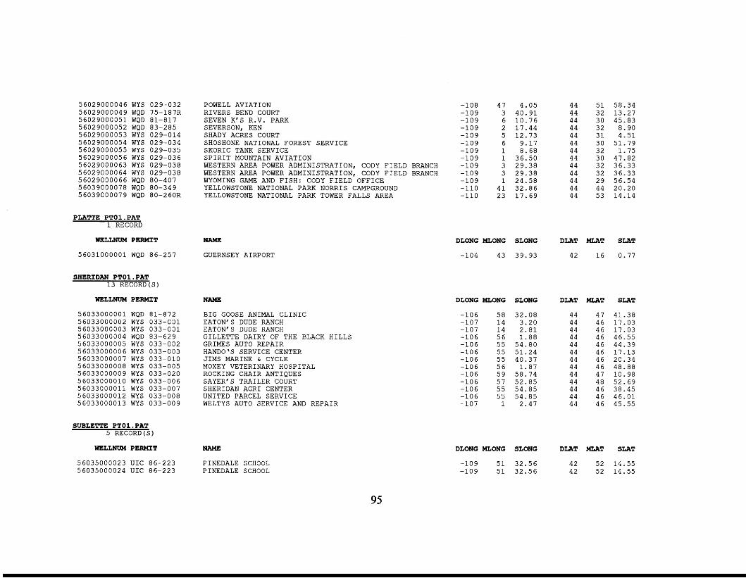
56029000046 WYS 5 602 90 0 0 0 4 9 WQD 5 6 0 2 9 0 0 0 0 5 1 WQD 5 602 90 0 0 05 2 WQD 56029000053 WYS 56029000054 WYS 56029000055 WYS 5 602 9000056 WYS 56029000063 WYS 5 60 2 90 0 0 0 64 WYS 5 60 2 90 0 0 0 6 6 WQD 5 60 3 90 0 0 0 7 8 WQD 5 603 900007 9 WQD
PLATTE PTOl . PAT 1 RECORD
029-032 75 -1 8 7R 81-817 83-285 029-014 029-034 029-035 029-036
029-038 80-407 80-349 80-260R
029-038
WELLNUM PERMIT
5 6 0 3 1 0 0 0 0 0 1 WQD 86-257
SHERIDAN PTO1.PAT 1 3 RECORD(S)
WELLNUM PERMIT
5 6 0 3 3 0 0 0 0 0 1 WQD 81-872 56033000002 WYS 0 3 3 - 0 0 1 56033000003 WYS 0 3 3 - 0 0 1 56033000004 WQD 83-629 56033000005 WYS 033-002 56033000006 WYS 033-003 56033000007 WYS 033-010 56033000008 WYS 033-005 56033000009 WYS 033-020 56033000010 WYS 033-006 5 6 0 3 3 0 0 0 0 1 1 WYS 033-007 56033000012 WYS 033-008 56033000013 WYS 033-009
SUBLETTE PTO1.PAT 5 RECORD(S)
WELLNUM PERMIT
56035000023 UIC 86-223 56035000024 UIC 86-223
POWELL AVIATION RIVERS BEND COURT SEVEN K'S R.V. PARK SEVERSON, KEN SHADY ACRES COURT SHOSHONE NATIONAL FOREST SERVICE SKORIC TANK SERVICE SPIRIT MOUNTAIN AVIATION WESTERN AREA POWER ADMINISTRATION, CODY FIELD BRANCH WESTERN AREA POWER ADMINISTRATION, CODY FIELD BRANCH WYOMING GAME AND FISH: CODY FIELD OFFICE YELLOWSTONE NATIONAL PARK NORRIS CAMPGROUND YELLOWSTONE NATIONAL PARK TOWER FALLS AREA
NAME
GUERNSEY AIRPORT
NAME
BIG GOOSE ANIMAL CLINIC EATON'S DUDE RANCH EATON'S DUDE RANCH GILLETTE DAIRY OF THE BLACK HILLS GRIMES AUTO REPAIR HANDO'S SERVICE CENTER JIMS MARINE & CYCLE MOXEY VETERINARY HOSPITAL ROCKING CHAIR ANTIQUES SAYER'S TRAILER COURT SHERIDAN AGRI CENTER UNITED PARCEL SERVICE WELTYS AUTO SERVICE AND REPAIR
NAME
P INEDALE SCHOOL P INEDALE SCHOOL
-108 47 4 .05 -109 3 4 0 . 9 1 -109 6 1 0 . 7 6 -109 2 1 7 . 4 4 -109 5 1 2 . 7 3 -109 6 9.17 -109 1 8 .68 -109 1 36 .50 - 1 0 9 3 29.38 -109 3 2 9 . 3 8 -109 1 2 4 . 5 8 -110 4 1 3 2 . 8 6 -110 2 3 1 7 . 6 9
44 5 1 58 .34 44 3 2 13 .27 44 3 0 45.83 44 3 2 8.90 44 3 1 4 . 5 1 44 3 0 51 .79 44 3 2 1 .75 44 3 0 47.82 44 3 2 36 .33 44 3 2 36 .33 44 2 9 56.54 44 44 20 .20 44 5 3 14 .14
DLONG MLONG SLONG DLAT MLAT SLAT
-104 43 39.93 42 1 6 0.77
DLONG MLONG SLONG
-106 5 8 32.08 -107 1 4 3.20 -107 1 4 2 . 8 1 -106 5 6 1 .88 -106 5 5 54 .80 -106 5 5 5 1 . 2 4 -106 5 5 40 .37 -106 5 6 1 . 8 7 -106 5 9 5 8 . 7 4 -106 5 7 5 2 . 8 5 -106 5 5 5 4 . 8 5 -106 55 5 4 . 8 5 -107 1 2 . 4 7
DLAT MLAT SLAT
44 47 41.38 44 4 6 17.03 44 46 1 7 . 0 3 44 46 46 .55 44 46 44 .39 44 46 17 .13 44 46 20.34
44 47 10.98 44 48 52 .69 44 4 6 38.45 44 46 4 6 . 0 1 44 46 45.55
44 46 4 8 - 8 8
DLONG MLONG SLONG DLAT MLAT SLAT
-109 5 1 3 2 . 5 6 4 2 5 2 14 .55 -109 5 1 3 2 . 5 6 4 2 5 2 14 .55
95
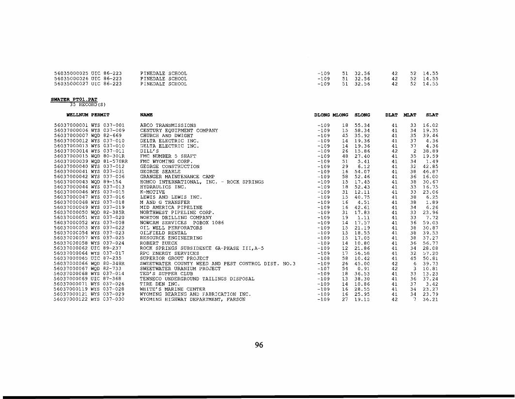
56035000025 UIC 86-223 56035000026 UIC 86-223 56035000027 UIC 86-223
SWATER PTO1.PAT 35 RECORD
WELLNUM PERMIT
56037000001 WYS 037-001 56037000006 WYS 037-009 56037000007 WQD 82-669 56037000012 WYS 037-010 56037000013 WYS 037-010 56037000014 WYS 037-011 56037000015 WQD 80-301R 56037000039 WQD 81-570RR 56037000040 WYS 037-012 56037000041 WYS 037-031 56037000042 WYS 037-006 56037000043 WQD 89-154 56037000044 WYS 037-013 56037000046 WYS 037-015 56037000047 WYS 037-016 56037000048 WYS 037-018 56037000049 WYS 037-019 56037000050 WQD 82-385R 56037000051 WYS 037-020 56037000052 WYS 037-008 56037000053 WYS 037-022 56037000054 WYS 037-023 56037000057 WYS 037-025 56037000058 WYS 037-024 56037000062 UIC 89-237 56037000064 WYS 037-017 56037000065 UIC 87-235 56037000066 WQD 80-348R 56037000067 WQD 82-733 56037000068 WYS 037-014 56037000069 UIC 87-368 56037000071 WYS 037-026 56037000119 WYS 037-028 56037000121 WYS 037-029 56037000122 WYS 037-030
P INEDALE SCHOOL P INEDALE SCHOOL PINEDALE SCHOOL
NAME
ABCO TRANSMISSIONS CENTURY EQUIPMENT COMPANY CHURCH AND DWIGHT DELTA ELECTRIC INC. DELTA ELECTRIC INC. DILL'S FMC NUMBER 5 SHAFT FMC WYOMING CORP. GEORGE CONSTRUCTION GEORGE SEARLE GRANGER MAINTENANCE CAMP HOMCO INTERNATIONAL, INC. - ROCK SPRINGS HYDRAULICS INC. K-MOTIVE LEWIS AND LEWIS INC. M AND G TRANSFER MID AMERICA PIPELINE NORTHWEST PIPELINE CORP. NORTON DRILLING COMPANY NOWCAM SERVICES POBOX 1086 OIL WELL PERFORATORS OILFIELD RENTAL RESOURCE ENGINEERING ROBERT ZUECK
W C ENERGY SERVICES SUPERIOR GROUT PROJECT SWEETWATER COUNTY WEED AND PEST CONTROL DIST. N0.3 SWEETWATER URANIUM PROJECT TED'S SUPPER CLUB TENNECO UNDERGROUND TAILINGS DISPOSAL TIRE DEN INC. WHITE' S MARINE CENTER WYOMING BEARING AND FABRICATION INC. WYOMING HIGHWAY DEPARTMENT, FARSON
ROCK SPRINGS SUBSIDENCE 6A-PHASE III,A-5
-109 51 32.56 -109 51 32.56 -109 51 32.56
DLONG MLONG SLONG
-109 -109 -109 -109 -109 -109 -109 -109 -109 -109 -109 -109 -109 -109 -109 -109 -109 -109 -109 -109 -109 -109 -109 -109 -109 -109 -108 -109 -107 -109 -109 -109 -109 -109 -109
18 55.34 15 58.34 45 35.92 14 19.36 14 19.36 26 15.86 48 27.40 51 5.41 29 6.12 16 54.07 58 52.46 15 17.45 18 52.43 31 12.11 15 40.75 16 4.51 16 42.61 31 17.83 19 1.11 14 17.57 15 21.19 15 18.55 15 17.05 14 10.80 12 21.86 17 56.58 58 10.42 26 45.00 54 0.91 18 36.53 13 38.30 14 10.86 16 28.55 16 25.95 27 19.15
42 52 14.55 42 52 14.55 42 52 14.55
DLAT
41 41 41 41 41 42 41 41 41 41 41 41 41 41 41 41 41 41 41 41 41 41 41 41 41 41 41 42 42 41 41 41 41 41 42
MLAT SLAT
33 16.02 34 19.35 35 39.46 37 4.36 37 4.36 2 38.89 35 19.59 34 1.49 32 42.85 38 46.87 36 16.00 38 30.67 33 16.75 33 23.06 38 6.25 38 1.89 34 6.26 33 23.96 33 7.72 36 59.03 38 30.87 38 39.53 38 37.27 36 56.77 34 28.08 32 57.20 45 50.81 6 39.73 3 10.81 33 13.23 36 37.24 37 3.42 34 23.27 34 23.79 7 36.21
96
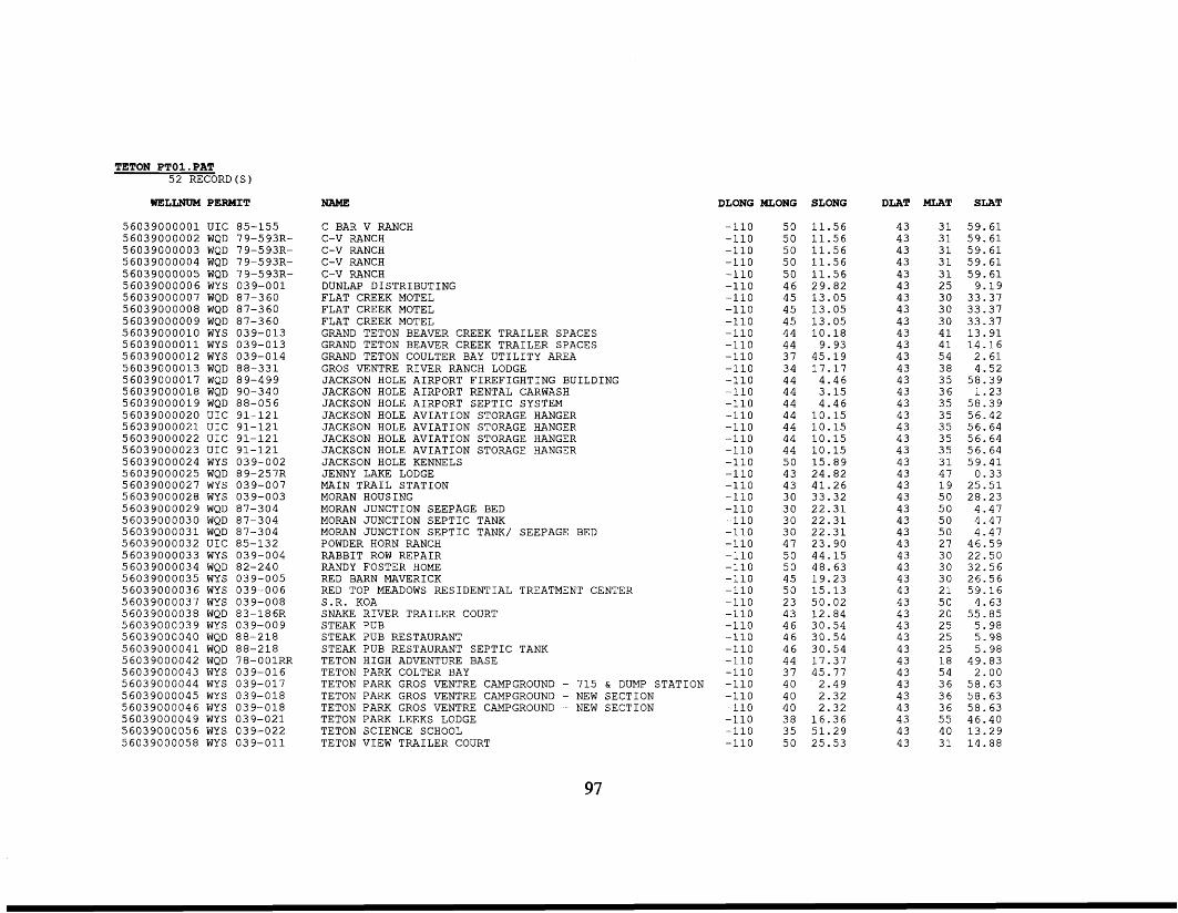
TETON PTO1.PAT 5 2 RECORD(S)
WELLNUM PERMIT
5 6 0 3 9 0 0 0 0 0 1 UIC 5 6 0 3 9 0 0 0 0 0 2 WQD 5 60 3 900 0 0 0 3 WQD 5 60 3 90 0 0 0 0 4 WQD 56039000005 WQD 5 603 900 0 0 0 6 WYS 5 603 900 000 7 WQD 56039000008 WQD 56039000009 WQD 5 603 9 0 0 0 0 1 0 WYS 5 6 0 3 9 0 0 0 0 1 1 WYS 5 603 900 00 1 2 WY S 5 603 900 00 1 3 WQD 56039000017 WQD 56039000018 WQD 5 6 0 3 9 0 0 0 0 1 9 WQD 56039000020 UIC 5 6 0 3 9 0 0 0 0 2 1 UIC 56039000022 UIC 56039000023 UIC 5 603 90 00024 WYS 5 603 90 0 00 25 WQD 56039000027 WYS 56039000028 WYS 56039000029 WQD 5 603 900 0 03 0 WQD 5 6 0 3 9 0 0 0 0 3 1 WQD 5 6 0 3 9 0 0 0 0 3 2 UIC 5 603 90 0003 3 WYS 5 603 9000 034 WQD 56039000035 WYS 5 603 900 003 6 WY S 56039000037 WYS 56039000038 WQD 5 603 900003 9 WYS 56039000040 WQD 5 603 900004 1 WQD 5 6 0 3 9 0 0 0 0 4 2 WQD 5 603 900 004 3 WY S 56039000044 WYS 56039000045 WYS 5 6 0 3 9 0 0 0 0 4 6 WYS 5 603 900 0 0 4 9 WYS 56039000056 WYS 56039000058 WYS
85-155 7 9-5 93R- 7 9-5 93R- 7 9-5 93R- 7 9-593R- 0 3 9 - 0 0 1 87 -360 87 -360 87 -360 039-013 039-013 039-014 8 8 - 3 3 1 8 9-4 99 90 -340 8 8 - 0 5 6 9 1 - 1 2 1 9 1 - 1 2 1 91 -121 9 1 - 1 2 1 039-002 89-257R 039-007 0 3 9-0 03 87-304 87 -304 87 -304 85 -132 039-004 82-240 039-005 039-006 039-008 83-186R 039-009 88 -218
7 8 - 0 0 1RR 0 3 9-0 1 6 039-017 039-018 0 3 9-0 1 8 0 3 9 - 0 2 1 039-022 0 3 9 - 0 1 1
88 -218
NAME
C BAR V RANCH C-V RANCH C-V RANCH C-V RANCH C-V RANCH DUNLAP DISTRIBUTING FLAT CREEK MOTEL FLAT CREEK MOTEL FLAT CREEK MOTEL GRAND TETON BEAVER CREEK TRAILER SPACES GRAND TETON BEAVER CREEK TRAILER SPACES GRAND TETON COULTER BAY UTILITY AREA GROS VENTRE RIVER RANCH LODGE JACKSON HOLE AIRPORT FIREFIGHTING BUILDING JACKSON HOLE AIRPORT RENTAL CARWASH JACKSON HOLE AIRPORT SEPTIC SYSTEM JACKSON HOLE AVIATION STORAGE HANGER JACKSON HOLE AVIATION STORAGE HANGER JACKSON HOLE AVIATION STORAGE HANGER JACKSON HOLE AVIATION STORAGE HANGER JACKSON HOLE KENNELS JENNY LAKE LODGE MAIN TRAIL STATION MORAN HOUSING MORAN JUNCTION SEEPAGE BED MORAN JUNCTION SEPTIC TANK MORAN JUNCTION SEPTIC TANK/ SEEPAGE BED POWDER HORN RANCH RABBIT ROW REPAIR RANDY FOSTER HOME RED BARN MAVERICK RED TOP MEADOWS RESIDENTIAL TREATMENT CENTER S.R. KOA SNAKE RIVER TRAILER COURT STEAK PUB STEAK PUB RESTAURANT STEAK PUB RESTAURANT SEPTIC TANK TETON HIGH ADVENTURE BASE TETON PARK COLTER BAY TETON PARK GROS VENTRE CAMPGROUND - 715 & DUMP STATION TETON PARK GROS VENTRE CAMPGROUND - NEW SECTION TETON PARK GROS VENTRE CAMPGROUND - NEW SECTION TETON PARK LEEKS LODGE TETON SCIENCE SCHOOL TETON VIEW TRAILER COURT
DLONG MLONG SLONG
-110 -110 -110 -110 -110 -110 -110 -110 -110 -110 -110 - 1 1 0 -110 -110 -110 -110 -110 -110 -110 -110 -110 - 1 1 0 -110 -110 -110 -110 -110 -110 -110 -110 -110 -110 -110 -110 -110 -110 -110 - 1 1 0 - 1 1 0 - 1 1 0 -110 -110 -110 -110 -110
5 0 11 .56 5 0 11 .56 5 0 1 1 . 5 6 5 0 1 1 . 5 6 5 0 1 1 . 5 6 4 6 2 9 . 8 2 4 5 1 3 . 0 5 4 5 1 3 . 0 5 4 5 1 3 . 0 5 44 10 .18 44 9.93 3 7 45.19 3 4 1 7 . 1 7 44 4.46 44 3 . 1 5 44 4.46 4 4 1 0 . 1 5 44 10 .15 44 1 0 . 1 5 44 1 0 . 1 5 5 0 1 5 . 8 9 4 3 24 .82 4 3 4 1 . 2 6 3 0 33 .32 3 0 2 2 . 3 1 3 0 2 2 . 3 1 3 0 2 2 . 3 1 47 23 .90 5 0 44 .15 5 0 48 .63 45 1 9 . 2 3 5 0 1 5 . 1 3 2 3 5 0 . 0 2 43 1 2 . 8 4 4 6 30 .54 4 6 30 .54 4 6 30.54 44 17 .37 3 7 45.77 40 2.49 40 2 .32 4 0 2 . 3 2 3 8 16 .36 3 5 51 .29 5 0 2 5 . 5 3
DLAT
43 43 43 43 43 43 43 43 43 43 43 43 43 43 43 43 43 43 43 43 43 43 43 43 43 43 43 43 43 43 43 43 43 43 43 43 43 43 43 43 43 43 43 43 43
M A T SLAT
3 1 5 9 . 6 1 3 1 5 9 . 6 1 3 1 5 9 . 6 1 3 1 5 9 . 6 1 3 1 5 9 . 6 1 2 5 9.19 3 0 3 3 . 3 7 3 0 33.37 3 0 33.37 4 1 1 3 . 9 1 4 1 1 4 . 1 6 5 4 2 . 6 1 38 4 .52 3 5 5 8 . 3 9 3 6 1 . 2 3 3 5 5 8 . 3 9 3 5 56 .42 3 5 56 .64 35 56.64 3 5 56 .64 3 1 5 9 . 4 1 47 0 .33 1 9 2 5 . 5 1 5 0 28 .23 5 0 4 . 4 7 5 0 4 .47 5 0 4 .47 27 46 .59 3 0 22 .50 3 0 3 2 . 5 6 3 0 26 .56 2 1 5 9 . 1 6 5 0 4 .63 20 55 .85 2 5 5 . 9 8 2 5 5.98 2 5 5 . 9 8 1 8 49 .83 5 4 2 . 0 0 3 6 58 .63 3 6 58 .63 3 6 58 .63 55 46 .40 40 1 3 . 2 9 3 1 1 4 . 8 8
97
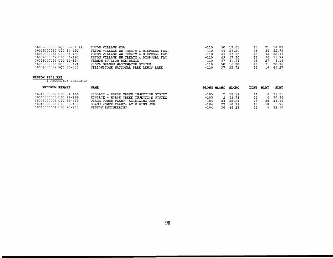
56039000059 WQD 79-347RR TETON VILLAGE KOA 56039000060 UIC 84-190 TETON VILLAGE WW TREATM & DISPOSAL FAC. 56039000061 UIC 84-190 TETON VILLAGE WW TREATM & DISPOSAL FAC. 56039000062 UIC 84-190 TETON VILLAGE WW TREATM & DISPOSAL FAC. 56039000064 UIC 85-154 VERNON STILSON RESIDENCE 56039000065 WQD 90-421 VISTA GRANDE WASTEWATER SYSTEM 56039000077 WQD 80-350 YELLOWSTONE NATIONAL PARK LEWIS LAKE
WESTON PTO1.PAT 5 RECORD (S ) SELECTED
WELLNUM PERMIT NAME
56045000002 UIC 91-166 KISSACK - HORSE CREEK INJECTION SYSTEM 56045000003 UIC 91-166 KISSACK - HORSE CREEK INJECTION SYSTEM 56045000004 UIC 89-439 OSAGE POWER PLANT- ACIDIZING JOB 56045000005 UIC 89-439 OSAGE POWER PLANT- ACIDIZING JOB 56045000007 UIC 90-245 WESTON ENGINEERING
-110 5 0 1 7 . 0 1 -110 4 9 57 .50 -110 4 9 57 .50 -110 4 9 5 7 . 5 0 -110 47 41 .77 -110 5 0 16 .28 -110 37 35 .72
43 3 1 1 4 . 8 8 43 3 4 5 5 . 7 9 43 34 5 5 . 7 9 43 3 4 5 5 . 7 9 43 27 6.18 43 3 1 20 .75 44 1 6 46.27
DLONG MLONG SLONG DLAT MLAT SLAT
-105 2 52 .12 44 4 3 9 . 2 1 -105 2 53 .73 44 4 30 .36 -104 24 35.24 43 5 8 33 .69
43 5 8 1 . 7 5 -104 23 5 0 . 2 9 -104 3 6 46 .23 44 5 32 .50
98
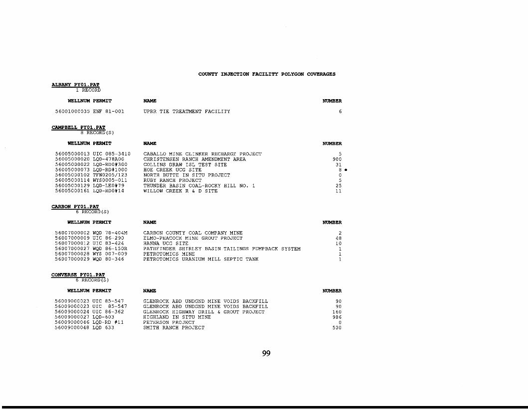
COUNTY INJECTION FACILITY POLYGON COVERAGES
ALBANY PYO1.PAT 1 RECORD
WELLNUM PERMIT
56001000035 ENF 81-001
CAMPBELL PYOl .PAT 8 RECORD(S)
WELLNUM PERMIT
56005000013 UIC 085-3410 56005000020 LQD-478A00 56005000022 LQD-RD0#300 56005000073 LQD-RD#lOOO 56005000102 TFN0205/123 56005000114 WYSOOO5-011 5 60 0500 0 12 9 LQD-LEO#7 9 56005000161 LQD-RDO#14
CARBON PYOl . PAT 6 RECORD(S)
WELLNUM PERMIT
56007000002 WQD 78-404M 56007000009 UIC 86-290 56007000012 UIC 83-424 56007000027 WQD 86-15OR 56007000028 WYS 007-009 56007000029 WQD 80-346
CONVERSE PYOl . PAT 6 RECORD(S)
WELLNUM PERMIT
56009000023 UIC 85-547 56009000023 UIC 85-547 56009000024 UIC 86-362 5 600 9000 02 7 LQD- 603 56009000046 LQD-RD #11 56009000048 LQD 633
NAME
UPRR TIE TREATMENT FACILITY
NAME
CABALLO MINE CLINKER RECHARGE PROJECT CHRISTENSEN RANCH AMENDMENT AREA COLLINS DRAW ISL TEST SITE HOE CREEK UCG SITE NORTH BUTTE IN SITU PROJECT RUBY RANCH PROJECT
WILLOW CREEK R & D SITE THUNDER BASIN COAL-ROCKY HILL NO. 1
NAME
CARBON COUNTY COAL COMPANY MINE
HANNA UCG SITE PATHFINDER SHIRLEY BASIN TAILINGS PUMPBACK SYSTEM PETROTOMICS MINE PETROTOMICS URANIUM MILL SEPTIC TANK
ELMO-PEACOCK MINE GROUT PROJECT
NAME
GLENROCK ABD UNDGND MINE VOIDS BACKFILL GLENROCK ABD UNDGND M I N E VOIDS BACKFILL GLENROCK HIGHWAY DRILL & GROUT PROJECT HIGHLAND IN SITU MINE PETERSON PROJECT SMITH RANCH PROJECT
NUMBER
6
NUMBER
5 900 31 8. 0 5 25 11
NUMBER
2 48 10 1 1 1
NUMBER
90 90 160 986 0
500
99
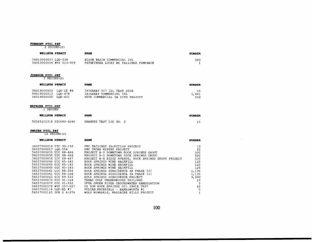
FREMONT PYO1.PAT 2 RECORD(S)
WELLNUM PERMIT NAME
56013000007 LQD-504 BISON BASIN COMMERCIAL ISL 56013000016 WYS 013-009 PATHFINDER LUCKY MC TAILINGS PUMPBACK
JOHNSON PYO1.PAT 3 RECORD(S)
WELLNUM PERMIT NAME
56019000003 LQD-LE #8 IRIGARAY 517 ISL TEST SITE 56019000013 LQD-478 IRIGARAY COMMERCIAL ISL 5 60 190 0 0 0 2 2 LQD- 63 1 RUTH COMMERCIAL IN SITU PROJECT
NATRONA PYO1.PAT 1 RECORD
WELLNUM PERMIT NAME
56025000318 UICO83-4280 URANERZ TEST LOC NO. 2
SWATER PYO1.PAT 16 RECORD(S)
WELLNUM PERMIT
56037000016 UIC 90-152 56037000017 LQD-554 56037000055 UIC 88-466 56037000055 UIC 88-466 56037000056 UIC 88-467 56037000060 UIC 85-183 56037000060 U I C 85-183 56037000060 UIC 85-183 56037000061 UIC 88-504 56037000061 UIC 88-504 56037000063 UIC 89-533 56037000070 UIC 91-144 56037000072 UIC 91-332 56037000074 WYS 037-027 56037000114 LQD-RD #7 56037000120 TFN 2 6/276
NAME
FMC TAILINGS INJECTION PROJECT FMC TRONA MINING PROJECT PROJECT A-3 DOWNTOWN ROCK SPRINGS GROUT PROJECT A-3 DOWNTOWN ROCK SPRINGS GROUT PROJECT A-4 RIDGE AVENUE, ROCK SPRINGS GROUT PROJECT ROCK SPRINGS MINE BACKFILL ROCK SPRINGS MINE BACKFILL ROCK SPRINGS MINE BACKFILL ROCK SPRINGS SUBSIDENCE 6A PHASE I11 ROCK SPRINGS SUBSIDENCE 6A PHASE I11 ROCK SPRINGS SUBSIDENCE PROJECT TEXAS GULF UNDERGROUND TAILINGS UPRR GREEN RIVER GROUNDWATER REMEDIATION US DOE ROCK SPRINGS OIL SHALE TEST
WOLD MINERALS, MASSACRE HILLS PROJECT VULCAN MATERIALS - HANESWORTH #1
NUMBER
500 1
NUMBER
10 1,841 532
NUMBER
10
NUMBER
10 22 500 500 500 125 125 125
1,100 1,100 9,999
10 2 40
5 1
100
SECTION INJECTION FACILITY POINT COVERAGES
T50R7 1S2 9WPG. PAT 1 RECORD SELECTED
WELLNUM PERMIT NAME DLONG MLONG SLONG DLAT MLAT SLAT
-105 2 5 28 .97 44 1 7 11 .30 56005000094 WYS 005-038 LIPPERT WELDING SERVICE
T50R71S30WPG.PAT 5 RECORD (S)
DLONG MLONG SLONG DLAT MLAT SLAT WELLNUM PERMIT NAME
56005000007 WYS 005-017 56005000008 WYS 005-019 56005000010 WQD 83-482 56005000063 WYS 005-025 56005000160 WQD 83-420R
BJ SERVICES - GILLETTE BRUCE'S AUTO BUTLER TRAILER COURT DIVIS OIL WILDWOOD CHRISTIAN SCHOOL
44 1 7 1 7 . 1 6 -105 2 6 31 .78 -105 2 6 38 .46 44 1 7 26 .34 -105 2 6 45 .02 44 1 7 26 .50
44 1 7 26 .13 -105 2 6 30.49 -105 2 6 40.43 44 1 7 2 0 . 7 1
T50R72S9WPG.PAT 7 RECORD (S)
WELLNUM PERMIT NAME DLONG MLONG SLONG DLAT MLAT SLAT
56005000002 WYS 005-016 56005000093 WYS 005-037 56005000103 WYS 005-041 56005000109 WYS 005-046 56005000120 WYS 005-050 56005000122 WYS 005-052 56005000159 WYS 005-058
BELL AND MOONEY INC. LEROYS AUTO REPAIR/HARRIS AUTO SALVAGE
PSI REPAIR SERVICE S AND M CONSTRUCTION SCHWANS SALES ENTERPRISES WESTERN SLING AND SUPPLY COMPANY
NORTHEAST WYOMING VO-TECH
-105 3 1 -105 3 1 -105 3 1 -105 3 1 -105 3 1 -105 3 1 -105 3 1
42 .39 2 8 . 6 9 40 .28 29.04 1 7 . 5 6 30 .77 38 .05
44 44 44 44 44 44 44
26 .53 32 .54 35.58 22 .70 40 .25 2 0 . 2 9 1 4 . 2 1
1 9 1 9 1 9 1 9 1 9 1 9 1 9
T50R72S24WPG.PAT 1 7 RECORD(S)
DLONG MLONG SLONG DLAT NLAT SLAT WELLNUM PERMIT NAME
56005000009 WYS 005-063 56005000058 WYS 005-024 56005000059 WYS 005-004 56005000060 WYS 005-004 5 6 0 0 5 0 0 0 0 6 1 WYS 005-004 56005000062 WYS 005-004 56005000064 WYS 005-026 56005000070 WYS 005-032 56005000085 WYS 005-034
BUNDY ELECTRIC INC. D AND S CASING DIAMOND MOBILE HOME PARK DIAMOND MOBILE HOME PARK DIAMOND MOBILE HOME PARK DIAMOND MOBILE HOME PARK EXETER HAHN WELD I NG J AND M ENTERPRISES
-105 27 -105 27 -105 27 -105 27 -105 27 -105 27 -105 2 6 -105 27 -105 2 7
3 0 . 2 0 1 2 . 1 6
4 . 4 1 4 . 4 1 4 . 4 1 4 . 4 1
59 .00 29.95 28 .64
44 44 44 44 44 44 44 44 44
1 7 1 7 1 7 1 7 1 7 1 7 1 7 1 7 1 7
37 .72 2 2 . 8 9 23 .34 23 .34 23 .34 23 .34 29 .77 26 .65 3 3 . 9 2
101
5 6005 0 0 0 0 8 9 WY S 5 600500010 6 WYS 56005000108 WYS 5 6 0 0 5 0 0 0 1 2 1 WYS 5 6005 00 0 1 5 4 WYS 5 6005000 1 5 5 WQD 5 6005 00015 6 WYS 5 60050 00 1 7 3 WYS
005-035 005-043 005-045 005-051 005-057 83-633 005-057 005-018
T33R78S5WPG.PAT 3 RECORD ( S )
WELLNUM PERMIT
56025000084 WYS 025-107 56025000132 WYS 025-021 5 6 0 2 5 0 0 0 3 1 6 WYS 025-028
T33R78S6WPG. PAT 3 1 RECORDS ( S )
WELLNUM PERMIT
5 6 0 2 5 0 0 0 0 7 2 UIC 91-213 56025000073 UIC 91-213 56025000167 WYS 025-032 56025000275 UIC 84-449 56025000276 UIC 84-449 56025000277 UIC 84-449 56025000278 UIC 84-449 56025000279 UIC 84-449 56025000280 UIC 84-449 5 6 0 2 5 0 0 0 2 8 1 UIC 84-449 56025000282 UIC 84-449 56025000283 UIC 84-449 56025000284 UIC 84-449 56025000285 UIC 84-449 56025000286 UIC 84-449 56025000287 UIC 84-449 56025000288 UIC 84-449 56025000289 UIC 84-449 56025000290 UIC 84-449 5 6 0 2 5 0 0 0 2 9 1 UIC 84-449 56025000292 UIC 84-449 56025000293 UIC 84-449 56025000294 UIC 84-449 56025000295 UIC 84-449 56025000372 UIC 84-449
KAMAN BEARING (FORMERLY JR CONSTRUCTION) PERFORATING SERVICES INC. PRECISION WELL SERVICE SCHLUMBERGER TIORCO / POLEDUC ; t w o separate corpora t ions ;
TRICOUNTY ELECTRIC ASSOCIATION INC. WYOMING MATERIALS AND IMPROVEMENT
TRI-STATE INSULATING INC.
NAME
DOW SCHLUMBERGER - CERCLA CLEANUP HTI SUPERIOR UNIVERSAL TRANSPORT
NAME
CONOCO CASPER STATION AQUIFER REMEDIATION CONOCO CASPER STATION AQUIFER REMEDIATION LATHROP FEED AND EQUIPMENT COMPANY TEXACO CASPER REFINERY TEXACO CASPER REFINERY TEXACO CASPER REFINERY TEXACO CASPER REFINERY TEXACO CASPER REFINERY TEXACO CASPER REFINERY TEXACO CASPER REFINERY TEXACO CASPER REFINERY TEXACO CASPER REFINERY TEXACO CASPER REFINERY TEXACO CASPER REFINERY TEXACO CASPER REFINERY TEXACO CASPER REFINERY TEXACO CASPER REFINERY TEXACO CASPER REFINERY TEXACO CASPER REFINERY TEXACO CASPER REFINERY TEXACO CASPER REFINERY TEXACO CASPER REFINERY TEXACO CASPER REFINERY TEXACO CASPER REFINERY TEXACO CASPER REFINERY
-105 -105 -105 -105 -105 -105 -105 -105
2 7 1 7 . 4 0 2 7 1 2 . 4 6 2 7 2 3 . 9 7 2 8 4 . 5 9 2 7 2 5 . 2 9 27 5 3 . 6 8 2 6 5 8 . 1 8 27 30 .17
44 1 7 34.70 44 1 7 29 .13 44 1 7 23 .55 44 1 7 45 .52 44 1 7 37 .83 44 1 7 52 .07 44 1 7 31 .42 44 1 7 36 .80
DLONG MLONG SLONG DLAT MLAT SLAT
-106 1 4 4.88 42 5 1 17 .82 -106 1 4 7 . 1 6 4 2 5 1 3 9 . 1 6 -106 1 3 30 .13 4 2 5 1 1 1 . 2 4
DLONG MLONG
-106 1 4 -106 1 4 -106 1 4 -106 1 5 -106 1 5 -106 1 5 -106 1 5 -106 1 5 -106 1 5 -106 1 5 -106 1 5 -106 1 5 -106 1 5 -106 1 5 -106 1 5 -106 1 5 -106 1 5 -106 15 -106 1 5 -106 1 5 -106 1 5 -106 1 5 -106 1 5 -106 1 5 -106 1 5
SLONG
53 .57 53 .57 42.17 44 .19 4 3 . 6 2 42 .98 41 .78 4 1 . 3 6 4 0 . 7 6 33 .84 34.17 34 .50 34 .47 34 .44 31 .83 3 1 . 4 5 3 1 . 0 6 2 9 . 6 9 29 .42 2 3 . 4 3 2 3 . 4 3 23 .46 1 6 . 5 3 16 .95 1 6 . 1 8
DLAT
4 2 42 42 4 2 42 42 42 42 42 42 42 42 42 4 2 4 2 4 2 4 2 4 2 42 42 42 42 4 2 4 2 42
MLAT
5 1 5 1 5 1 5 1 5 1 5 1 5 1 5 1 5 1 5 1 5 1 5 1 5 1 5 1 5 1 5 1 5 1 5 1 5 1 5 1 5 1 5 1 5 1 5 1 5 1
SLAT
1 7 . 0 8 17 .08 1 6 . 6 9 51 .09 5 1 . 1 1 51 .09 48 .42 47 .22 47 .28 48.17 47 .89 47.50 47 .04 46 .66 44 .17 44.17 4 4 . 1 7 4 5 . 5 6 45 .22 3 8 . 6 1 3 8 . 0 2 37.50 41 .39 41 .33 41 .80
102
56025000373 UIC 84-449 56025000374 UIC 84-449 56025000375 UIC 84-449 56025000376 UIC 84-449 56025000377 UIC 84-449 56025000378 UIC 84-449
T33R7 9S6WPG. PAT 1 4 RECORD ( S )
WELLNUM PERMIT
56025000039 WQD 77-257B 56025000065 WQD 79-419 56025000066 WQD 79-419 56025000096 WYS 025-054 56025000142 WQD 81-566 56025000256 WYS 025-079 56025000270 WQD 77-257A 56025000298 WQD 81-058 56025000328 WQD 79-015 56025000329 WQD 79-015 56025000330 WQD 79-015 56025000331 WYS 025-078 56025000345 WQD 77-258 56025000366 WQD 77-461
T33R80S2WPG. PAT 3 RECORD(S)
WELLNUM PERMIT
56025000108 WQD 78-531 56025000228 WQD 81-241 56025000251 WQD 78-674
T33R80S3WPG.PAT 9 RECORD ( S )
WELLNUM PERMIT
56025000020 WQD 81-430 56025000085 WYS 025-112 56025000086 WQD 80-240 56025000138 WQD 81-199 56025000178 WQD 79-255 56025000179 WQD 79-255
TEXACO CASPER REFINERY TEXACO CASPER REFINERY TEXACO CASPER REFINERY TEXACO CASPER REFINERY TEXACO CASPER REFINERY TEXACO CASPER REFINERY
-106 15 1 6 . 1 8 -106 1 5 1 6 . 0 4 -106 1 5 1 5 . 9 3 -106 15 1 5 . 6 3 -106 1 5 15 .27 -106 1 5 1 4 . 8 0
NAME DLONG MLONG SLONG
BURD COMMERCIAL SHOP AND OFFICE COBRE TIRE COMPANY COBRE TIRE COMPANY ENGINE POWER COMPANY INDUSTRIAL MAINTENANCE AND FABRICATING SJS INC. T AND T WELDING (FORMERLY BURD COMMERCIAL TIC, THE INDUSTRIAL COMPANY OF WYOMING VACANT - FORMERLY HALLIBURTON INDUSTRIES VACANT - FORMERLY HALLIBURTON INDUSTRIES VACANT - FORMERLY HALLIBURTON INDUSTRIES VACANT FORMERLY AMERICAN DRILLING COMPANY VACANT, FORMER BECKER LEASE BUILDING WYOMING CARBONICS, INC.
-106 -106 -106 -106 -106 -106
SHOP ) -106 -106 -106 -106 -106
(FORMER OWNER -106 -106 -106
22 2 . 1 8 2 1 47 .02 2 1 46 .96 2 1 51 .47 22 1 . 3 8 2 1 5 3 . 3 9 2 1 56 .05 2 1 5 0 . 1 5 22 0 . 5 6 2 2 0 . 6 1 2 2 0 . 6 1 2 1 5 1 . 6 0 2 1 5 5 . 4 5 2 2 7 .34
NAME DLONG MLONG SLONG
GETTER TRUCKING, FORMER OCCUPANT REDA DIVISION OF CAMCO INTERNATIONAL SECURITY DRILLING TOOLS
NAME
B AND B TOOL AND SUPPLY DRESSER ATLAS WIRELINE DRILLCO BUILDING, ZERO ROAD ICO PLATTE ROD AND PIPE COMPANY MGF DRILLING COMPANY MGF DRILLING COMPANY
-106 24 48 .78 -106 24 48 .65 -106 2 3 41 .27
42 5 1 4 1 . 5 0 42 5 1 4 1 . 1 5
42 51 41 .48 42 51 41 .55 42 5 1 4 1 . 5 5
42 51 4 0 . 8 5
DLAT MLAT SLAT
42 51 1 5 . 4 3 42 5 1 1 6 . 1 6 42 5 1 1 6 . 1 4 42 5 1 1 9 . 1 1 42 5 1 1 8 . 6 6 42 5 1 2 4 . 4 9 42 51 1 5 . 7 3 42 51 2 4 . 5 6 42 5 1 1 5 . 5 4 42 5 1 1 5 . 5 1 42 5 1 1 5 . 5 1 42 5 1 1 5 . 9 4 42 5 1 1 8 . 9 5 42 5 1 1 5 . 2 5
DLAT MLAT SLAT
42 5 1 4 4 . 7 6 42 51 3 2 . 3 2 42 5 1 2 6 . 6 8
DLONG MLONG SLONG DLAT MtAT SLAT
-106 24 5 7 . 3 3 42 5 1 3 0 . 8 5 -106 2 5 4 . 2 5 42 5 1 4 1 . 6 6 -106 2 5 5 3 . 6 9 42 5 1 4 3 . 9 8 -106 24 5 6 . 6 9 42 51 3 4 . 2 0 -106 2 5 4 . 4 7 42 5 1 2 7 . 2 7 -106 2 5 4 .58 42 5 1 2 7 . 2 7
103
56025000194 WQD 82-235 56025000195 WQD 81-844 56025000214 WQD 78-226
T3 4R7 9S2 OWPG. PAT 20 RECORD(S)
WELLNUM PERMIT
56025000032 WQD 79-723 5 6 0 2 5 0 0 0 0 3 3 WQD 79-723 56025000052 WQD 78-681RR 5 6 0 2 5 0 0 0 1 4 6 WQD 78-143R 56025000150 WQD 79-154 5 6 0 2 5 0 0 0 1 5 1 WQD 79-154 5 6 0 2 5 0 0 0 1 5 5 WQD 78-271 56025000187 WQD 80-635 56025000217 WQD 78-245 56025000218 WQD 78-245 5 6 0 2 5 0 0 0 2 1 9 WQD 78-245 56025000220 WQD 78-245 5 6 0 2 5 0 0 0 2 2 1 WQD 78-245 5 6 0 2 5 0 0 0 2 3 5 WQD 79-476 56025000238 WQD 80-177 56025000265 WQD 80-633R 56025000272 WQD 81-764 5 6 0 2 5 0 0 0 2 7 3 WQD 79-247 5 6 0 2 5 0 0 0 3 3 6 WQD 81-614 56025000342 WQD 81-614
T34R7 9S2 9WPG . PAT 8 RECORD(S)
WELLNUM PERMIT
56025000044 56025000067 5 6 0 2 5 0 0 0 1 0 3 5 60250001 11 56025000188 56025000196 56025000240 56025000244
WQD 81-475 WYS 025-092 WQD 80-625 WYS 025-062 WQD 81-928 WQD 7 9 - 1 4 1 WQD 81-313 WQD 79-234
NL SHAFFER - NL INDUSTRIES, INC. NL SPERRY SUN AND BAIROID DRILLING FLUID EQUIPMENT PEPSI-COLA BOTTLING COMPANY
NAME
BILL H. KUHN BILL H. KUHN CAROL COURT IRI INTERNATIONAL (FORMERLY INGERSOL RAND) JERRY HELLER COMPANY JERRY HELLER COMPANY JOHN JAPP AND ASSOCIATES NANIA DEVELOPMENT PLAINVIEW TRAILER COURT PLAINVIEW TRAILER COURT PLAINVIEW TRAILER COURT PLAINVIEW TRAILER COURT PLAINVIEW TRAILER COURT REED TRANSPORTATION REMANUFACTURING SERVICES, INC. SPIVA BACKHOE SERVICE T.F.I. INTERNATIONAL TANNER-FREIBERG VACANT FORMERLY COMMERCIAL SHOP AND OFFICE VACANT FORMERLY SCHERER BROTHERS CONSTRUCTION
NAME
BURRIS DRILLING CO. COLORADO BIOTECHNOLOGY COMPANY FRONTIER WELL SERVICE GLENN BENNETT MOBILE HOME PARK NATIONAL SUPPLY CO. - CASPER MACHINERY CENTER NORTH PARK TRANSPORTATION ROBERTS RATHOLE DRILLING SALT CREEK AUTO BODY
-106 2 5 4 . 3 6 -106 2 5 4 . 3 6 -106 2 5 4 . 3 9
4 2 5 1 4 0 . 1 1 4 2 51 4 0 . 1 1 4 2 51 44 .64
DLONG MLONG SLONG DLAT MLAT SLAT
-106 -106 -106 - 1 0 6 -106 -106 -106 - 1 0 6 -106 -106 -106 -106 -106 -106 -106 -106 -106 -106 -106 -106
2 0 5 7 . 3 3 2 0 5 7 . 4 1 2 1 1 6 . 0 9 2 0 3 . 2 2 2 0 3 9 . 6 7 2 0 3 9 . 5 9
2 1 1 1 . 8 9 2 0 4 9 . 1 7 2 0 4 9 . 3 4 2 0 4 9 . 3 4 2 0 4 9 . 3 4 20 4 9 . 3 1 2 1 2 . 0 0 2 0 3 8 . 8 7 2 1 2 . 2 5 2 0 5 7 . 6 0 2 0 4 1 . 6 5 2 0 53.13 2 0 5 2 . 4 7
20 35.58
4 2 53 3 8 . 4 2 4 2 5 3 3 8 . 3 6 4 2 53 55.53 4 2 53 4 2 . 6 2 4 2 53 4 9 . 0 2 4 2 53 4 8 . 9 6 4 2 5 3 5 3 . 9 5 42 53 4 5 . 8 5 4 2 53 5 6 . 8 7 4 2 53 5 6 . 8 1 4 2 53 5 6 . 8 1 4 2 5 3 5 6 . 8 1 4 2 53 5 6 . 7 1 4 2 53 4 4 . 9 8 4 2 5 3 3 5 . 9 2 4 2 53 5 1 . 0 2 4 2 53 4 5 . 0 2 4 2 53 5 4 . 8 4
4 2 53 3 8 . 4 4 4 2 53 4 4 . 8 6
DLONG MLONG SLONG DLAT MLAT SLAT
-106 2 0 5 5 . 4 1 -106 2 1 3 . 3 2 -106 2 1 5 . 2 1 - 1 0 6 2 0 5 7 . 6 6 -106 20 4 3 . 9 0 -106 2 1 1 4 . 3 9 -106 2 1 1 5 . 6 2 - 1 0 6 2 0 5 9 . 1 7
4 2 5 3 3 2 . 6 9 4 2 5 2 5 1 . 0 5 4 2 53 2 7 . 3 2 4 2 5 2 5 6 . 7 4 4 2 5 3 3 2 . 7 5 4 2 5 2 5 3 . 4 6 4 2 5 2 4 9 . 7 3 42 53 2 2 . 1 0
104
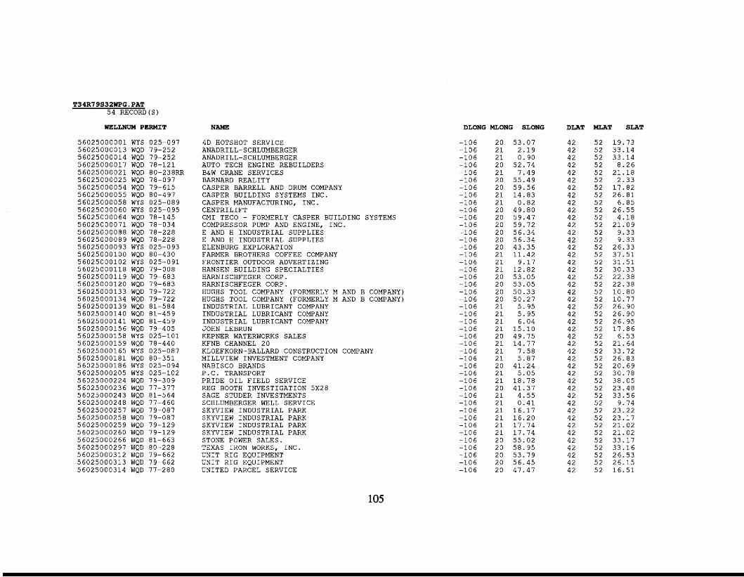
T34R7 9S32WPG. PAT 5 4 RECORD(S)
WELLNUM PERMIT
5 6 0 2 5 0 0 0 0 0 1 WYS 025-097 5 6 0 2 5 0 0 0 0 1 3 WQD 79-252 5 6 0 2 5 0 0 0 0 1 4 WQD 79-252 5 6 0 2 5 0 0 0 0 1 7 WQD 78-121 5 6 0 2 5 0 0 0 0 2 1 WQD 80-238RR 5 6 0 2 5 0 0 0 0 2 5 WQD 78-097 5 6 0 2 5 0 0 0 0 5 4 WQD 79-615 5 60 2 5 0 0 0 0 5 5 8 0-4 97 5 6 0 2 5 0 0 0 0 5 8 WYS 025-089 5 6 0 2 5 0 0 0 0 6 0 WYS 025-095 5 6 0 2 5 0 0 0 0 6 4 WQD 78-145 5 6 0 2 5 0 0 0 0 7 1 WQD 78-034 5 6 0 2 5 0 0 0 0 8 8 WQD 78-228 5 6 0 2 5 0 0 0 0 8 9 WQD 78-228 5 6 0 2 5 0 0 0 0 9 3 WYS 025-093 5 6 0 2 5 0 0 0 1 0 0 WQD 80-430 5 6 0 2 5 0 0 0 1 0 2 WYS 025-091 5 6 0 2 5 0 0 0 1 1 8 WQD 79-008 5 6 0 2 5 0 0 0 1 1 9 WQD 79-683 5 6 0 2 5 0 0 0 1 2 0 WQD 79-683 5 6 0 2 5 0 0 0 1 3 3 WQD 79-722 5 6 0 2 5 0 0 0 1 3 4 WQD 79-722 5 6 0 2 5 0 0 0 1 3 9 WQD 81-584 5 6 0 2 5 0 0 0 1 4 0 WQD 81-459 5 6 0 2 5 0 0 0 1 4 1 WQD 81-459 5 6 0 2 5 0 0 0 1 5 6 WQD 79-405 5 6 0 2 5 0 0 0 1 5 8 WYS 025-101 5 6 0 2 5 0 0 0 1 5 9 WQD 78-440 5 6 0 2 5 0 0 0 1 6 5 WYS 025-087 5 6 0 2 5 0 0 0 1 8 1 WQD 80-351 5 6 0 2 5 0 0 0 1 8 6 WYS 025-094 5 6 0 2 5 0 0 0 2 0 5 WYS 025-102 5 6 0 2 5 0 0 0 2 2 4 WQD 79-309 5 6 0 2 5 0 0 0 2 3 6 WQD 77-377 5 6 0 2 5 0 0 0 2 4 3 WQD 81-564 5 6 0 2 5 0 0 0 2 4 8 WQD 77-460 5 6 0 2 5 0 0 0 2 5 7 WQD 79-087 5 6 0 2 5 0 0 0 2 5 8 WQD 79-087 5 6 0 2 5 0 0 0 2 5 9 WQD 79-129 5 6 0 2 5 0 0 0 2 6 0 WQD 79-129 5 6 0 2 5 0 0 0 2 6 6 WQD 81-663 5 6 0 2 5 0 0 0 2 9 7 WQD 80-228 5 6 0 2 5 0 0 0 3 1 2 WQD 79-662 5 6 0 2 5 0 0 0 3 1 3 WQD 79-662 5 6 0 2 5 0 0 0 3 1 4 WQD 77-280
WQD
NAME
4D HOTSHOT SERVICE ANADRILL-SCHLUMBERGER ANADRILL-SCHLUMBERGER AUTO TECH ENGINE REBUILDERS B&W CRANE SERVICES BARNARD REALITY CASPER BARRELL AND DRUM COMPANY CASPER BUILDING SYSTEMS INC. CASPER MANUFACTURING, INC. CENTRILIFT CMI TECO - FORMERLY CASPER BUILDING SYSTEMS COMPRESSOR PUMP AND ENGINE, INC. E AND H INDUSTRIAL SUPPLIES E AND H INDUSTRIAL SUPPLIES ELENBURG EXPLORATION FARMER BROTHERS COFFEE COMPANY FRONTIER OUTDOOR ADVERTIZING HANSEN BUILDING SPECIALTIES HARNISCHFEGER CORP. HARNISCHFEGER CORP. HUGHS TOOL COMPANY (FORMERLY M AND B COMPANY) HUGHS TOOL COMPANY (FORMERLY M AND B COMPANY) INDUSTRIAL LUBRICANT COMPANY INDUSTRIAL LUBRICANT COMPANY INDUSTRIAL LUBRICANT COMPANY JOHN LEBRUN KEPNER WATERWORKS SALES KFNB CHANNEL 2 0
MILLVIEW INVESTMENT COMPANY NABISCO BRANDS P . C. TRANSPORT PRIDE OIL FIELD SERVICE REG BOOTH INVESTIGATION 5 x 2 8 SAGE STUDER INVESTMENTS SCHLUMBERGER WELL SERVICE SKYVIEW INDUSTRIAL PARK SKYVIEW INDUSTRIAL PARK SKYVIEW INDUSTRIAL PARK SKYVIEW INDUSTRIAL PARK STONE POWER SALES. TEXAS IRON WORKS, INC. UNIT RIG EQUIPMENT UNIT RIG EQUIPMENT UNITED PARCEL SERVICE
KLOEFKORN-BALLARD CONSTRUCTION COMPANY
DLONG MLONG SLONG
- 1 0 6 - 1 0 6 - 1 0 6 -106 - 1 0 6 - 1 0 6 - 1 0 6 - 1 0 6 - 1 0 6 - 1 0 6 - 1 0 6 - 1 0 6 - 1 0 6 -106 -106 - 1 0 6 -106 - 1 0 6 -106 - 1 0 6 -106 - 1 0 6 - 1 0 6 - 1 0 6 - 1 0 6 - 1 0 6 -106 - 1 0 6 -106 - 1 0 6 -106 -106 -106 -106 -106 -106 -106 -106 -106 -106 -106 -106 -106 -106 -106
2 0 5 3 . 0 7 2 1 2 . 1 9 2 1 0 . 9 0 2 0 5 2 . 7 4 2 1 7 . 4 9 2 0 5 5 . 4 9 2 0 5 9 . 5 6 2 1 1 4 . 8 3 2 1 0 . 8 2 2 0 4 9 . 8 0 2 0 5 9 . 4 7 2 0 5 9 . 7 2 2 0 5 6 . 3 4 2 0 5 6 . 3 4 2 0 4 3 . 3 5 2 1 1 1 . 4 2 2 1 9 . 1 7 2 1 1 2 . 8 2 2 0 5 3 . 0 5 2 0 5 3 . 0 5 2 0 5 0 . 3 3 2 0 5 0 . 2 7 2 1 5 . 9 5 2 1 5 . 9 5 2 1 6 .04 2 1 1 5 . 1 0 2 0 4 9 . 7 5 2 1 1 4 . 7 7 2 1 7 . 5 8 2 1 5 . 8 7 2 0 4 1 . 2 4 2 1 5 . 0 5 2 1 1 8 . 7 8 2 0 4 1 . 3 7 2 1 4 . 5 5 2 1 0 . 4 1 2 1 1 6 . 1 7 2 1 1 6 . 2 0 2 1 1 7 . 7 4 2 1 1 7 . 7 4 2 0 5 5 . 0 2 2 0 5 8 . 9 5 20 5 3 . 7 9 20 5 6 . 4 5 20 4 7 . 4 7
DLAT
4 2 4 2 4 2 4 2 4 2 4 2 4 2 4 2 4 2 4 2 4 2 4 2 4 2 4 2 4 2 4 2 4 2 4 2 4 2 4 2 4 2 4 2 4 2 4 2 4 2 4 2 4 2 4 2 4 2 4 2 4 2 4 2 4 2 4 2 4 2 4 2 4 2 4 2 4 2 4 2 42 4 2 42 4 2 42
MLAT SLAT
5 2 1 9 . 7 3 5 2 3 3 . 1 4 5 2 3 3 . 1 4 5 2 8 . 2 6 5 2 2 1 . 1 8 5 2 2 . 3 3 5 2 1 7 . 8 2 5 2 2 6 . 8 1 5 2 6 . 8 5 5 2 2 6 . 5 5 5 2 4 . 1 8 5 2 2 1 . 0 9 5 2 9 . 3 3 5 2 9 . 3 3 5 2 2 6 . 3 3 5 2 3 7 . 5 1 5 2 3 1 . 5 1 5 2 3 0 . 3 3 5 2 2 2 . 3 8 5 2 2 2 . 3 8 5 2 1 0 . 8 0 5 2 1 0 . 7 7 5 2 2 6 . 9 0 5 2 2 6 . 9 0 5 2 2 6 . 9 5 5 2 1 7 . 8 6 5 2 6 . 5 3 5 2 2 1 . 6 4 5 2 3 3 . 7 2 5 2 2 6 . 8 3 5 2 2 0 . 6 9 5 2 3 0 . 7 8 5 2 3 8 . 0 5 5 2 2 3 . 4 8 5 2 3 3 . 5 6 5 2 9 . 7 4 5 2 2 3 . 2 2 5 2 2 3 . 1 7 5 2 2 1 . 0 2 5 2 2 1 . 0 2 5 2 3 3 . 1 7 5 2 3 3 . 1 6 5 2 2 6 . 5 3 5 2 2 6 . 1 5 5 2 1 6 . 5 1
105
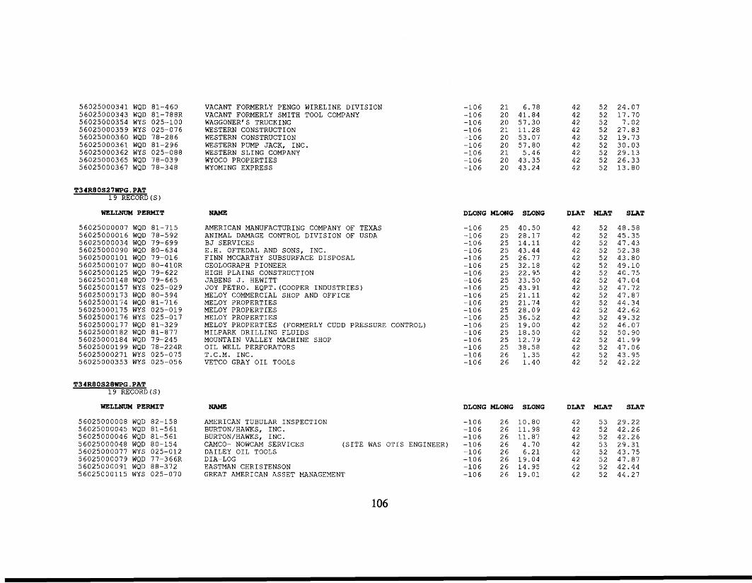
56025000341 56025000343 56025000354 56025000359 56025000360 56025000361 5 60250003 62 56025000365 56025000367
WQD 81-460 WQD 81-788R WYS 025-100 WYS 025-076 WQD 78-286 WQD 81-296 WYS 025-088 WQD 78-039 WQD 78-348
T34R80S27WPG.PAT 19 RECORD
WELLNUM PERMIT
56025000007 WQD 81-715 56025000016 WQD 78-592 56025000034 WQD 79-699 56025000090 WQD 80-634 56025000101 WQD 79-016 56025000107 WQD 80-410R 56025000125 WQD 79-622 56025000148 WQD 79-665 56025000157 WYS 025-029 56025000173 WQD 80-594 56025000174 WQD 81-716 56025000175 WYS 025-019 56025000176 WYS 025-017 56025000177 WQD 81-329 56025000182 WQD 81-877 56025000184 WQD 79-245 56025000199 WQD 78-224R 56025000271 WYS 025-075 56025000353 WYS 025-056
T34R80S28WPG.PAT 19 RECORD(S)
WELLNUM PERMIT
56025000008 WQD 82-158 56025000045 WQD 81-561 56025000046 WQD 81-561 56025000048 WQD 80-154 56025000077 WYS 025-012 56025000079 WQD 77-366R 56025000091 WQD 88-372 56025000115 WYS 025-070
VACANT FORMERLY PENGO WIRELINE DIVISION VACANT FORMERLY SMITH TOOL COMPANY WAGGONER' S TRUCKING WESTERN CONSTRUCTION WESTERN CONSTRUCTION WESTERN PUMP JACK, INC. WESTERN SLING COMPANY WYOCO PROPERTIES WYOMING EXPRESS
NAME
AMERICAN MANUFACTURING COMPANY OF TEXAS ANIMAL DAMAGE CONTROL DIVISION OF USDA BJ SERVICES E.H. OFTEDAL AND SONS, INC. FINN MCCARTHY SUBSURFACE DISPOSAL GEOLOGRAPH PIONEER HIGH PLAINS CONSTRUCTION JABENS J. HEWITT JOY PETRO. EQPT.(COOPER INDUSTRIES) MELOY COMMERCIAL SHOP AND OFFICE MELOY PROPERTIES MELOY PROPERTIES MELOY PROPERTIES MELOY PROPERTIES (FORMERLY CUDD PRESSURE CONTROL) MILPARK DRILLING FLUIDS MOUNTAIN VALLEY MACHINE SHOP OIL WELL PERFORATORS T.C.M. INC. VETCO GRAY OIL TOOLS
-106 21 6.78 -106 20 41.84 -106 20 57.30 -106 21 11.28 -106 20 53.07 -106 20 57.80 -106 21 5.46 -106 20 43.35 -106 20 43.24
DLONG MLONG SLONG
-106 25 40.50 -106 25 28.17 -106 25 14.11 -106 25 43.44 -106 25 26.77 -106 25 32.18 -106 25 22.95 -106 25 33.50 -106 25 43.91 -106 25 21.11 -106 25 21.74 -106 25 28.09 -106 25 36.52 -106 25 19.00 -106 25 18.50 -106 25 12.79 -106 25 38.58 -106 26 1.35 -106 26 1.40
NAME DLONG MLONG SLONG
AMERICAN TUBULAR INSPECTION BURTON/HAWKS, INC. BURTON/HAWKS, INC . CAMCO- NOWCAM SERVICES (SITE WAS DAILEY OIL TOOLS
EASTMAN CHRISTENSON GREAT AMERICAN ASSET MANAGEMENT
DIA-LOG
-106 26 10.80 -106 26 11.98 -106 26 11.87
OTIS ENGINEER) -106 26 4.70 -106 26 6.21 -106 26 19.04 -106 26 14.95 -106 26 19.01
42 52 24.07 42 52 17.70 42 52 7.02 42 52 27.83 42 52 19.73 42 52 30.03 42 52 29.13 42 52 26.33 42 52 13.80
DLAT
42 42 42 42 42 42 42 42 42 42 42 42 42 42 42 42 42 42 42
DLAT
42 42 42 42 42 42 42 42
MLAT SLAT
52 48.58 52 45.35 52 47.43 52 52.38 52 43.80 52 49.10 52 40.75 52 47.04 52 47.72 52 47.87 52 44.34 52 42.62 52 49.32 52 46.07 52 50.90 52 41.99 52 47.06 52 43.95 52 42.22
MLAT SLAT
53 29.22 52 42.26 52 42.26 53 29.31 52 43.75 52 47.87 52 42.44 52 44.27
106
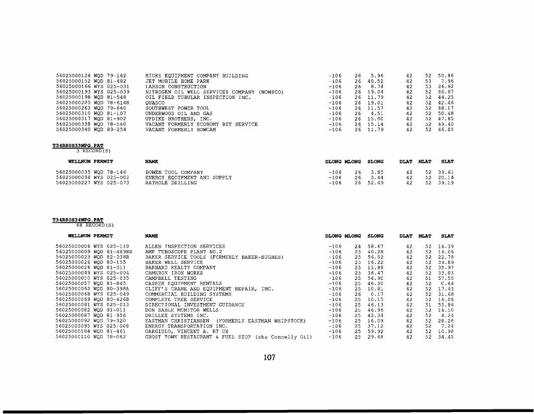
5 6025 0 0 0 1 2 4 WQD 56025000152 WQD 56025000166 WYS 56025000193 WYS 5 60250 0 0 1 9 8 WQD 5 602 50 0 0225 WQD 5 602 5 0 0 02 63 WQD 5 60250 003 1 0 WQD 5 6025 0 0 0 3 1 7 WQD 56025000338 WQD 5 6025 0 0 03 4 0 WQD
79-162 81 -482 0 2 5 - 0 3 1 025-039 8 1 - 5 4 8 7 8- 614R 79 -660 81 -107 81 -902 78 -560 89 -254
T34R80S33WPG.PAT 3 RECORD ( S )
WELLNUM PERMIT
56025000035 WQD 78-146 56025000094 WYS 025-002 56025000227 WYS 025-073
T34R80S34WPG.PAT 68 RECORD(S)
mLLNUM PERMIT
5 6 0 2 5 0 0 0 0 0 6 WYS 025-110 56025000009 WQD 81-489RR 56025000023 WQD 82-038R 56025000024 WQD 80-155 5 6 0 2 5 0 0 0 0 2 6 WQD 8 1 - 0 1 1 56025000049 WYS 025-004 56025000050 WYS 025-035 56025000057 WQD 81-845 56025000063 WQD 80-398A 56025000068 WYS 025-049 56025000069 WQD 80-626B 5 6 0 2 5 0 0 0 0 8 1 WYS 025-013 56025000082 WQD 9 1 - 0 1 1 56025000087 WQD 81-956 56025000092 WQD 7 9 - 3 2 0 56025000095 WYS 025-008 56025000104 WQD 8 1 - 4 6 1 56025000110 WQD 78-062
HICKS EQUIPMENT COMPANY BUILDING JET MOBILE HOME PARK LARSON CONSTRUCTION NITROGEN OIL WELL SERVICES COMPANY (NOWSCO) OIL FIELD TUBULAR INSPECTION INC. QUADCO SOUTHWEST POWER TOOL UNDERWOOD OIL AND GAS UPDIKE BROTHERS, INC. VACANT FORMERLY ECONOMY BIT SERVICE VACANT FORMERLY NOWCAM
NAME
BOWEN TOOL COMPANY ENERGY EQUIPMENT AND SUPPLY RATHOLE DRILLING
NAME
ALLEN INSPECTION SERVICES AMF TUBOSCOPE PLANT N0.2 BAKER SERVICE TOOLS (FORMERLY BAKER-HUGHES) BAKER WELL SERVICE BARNARD REALTY COMPANY CAMERON IRON WORKS CAMPBELL TESTING CASPER EQUIPMENT RENTALS CLIFF'S CRANE AND EQUIPMENT REPAIR, INC. COMMERCIAL BUILDING SYSTEMS COMPLETE TREE SERVICE DIRECTIONAL INVESTMENT GUIDANCE DON SABLE MONITOR WELLS DRILLEX SYSTEMS INC. EASTMAN CHRISTIANSEN (FORMERLY EASTMAN WHIPSTOCK) ENERGY TRANSPORTATION INC. GARGIULO, VINCENT A. ET UX GHOST TOWN RESTAURANT & FUEL STOP (aka Connelly O i l )
- 1 0 6 - 1 0 6 - 1 0 6 - 1 0 6 - 1 0 6 - 1 0 6 - 1 0 6 - 1 0 6 - 1 0 6 - 1 0 6 - 1 0 6
2 6 5 .96 2 6 40 .52 2 6 8.74 2 6 1 9 . 0 4 2 6 1 1 . 7 9 2 6 1 9 . 0 1 2 6 1 1 . 5 7 2 6 4 . 5 1 2 6 1 5 . 0 0 2 6 1 5 . 1 4 2 6 1 1 . 7 9
4 2 5 2 5 0 . 8 6 4 2 5 3 7 .96 4 2 5 3 26 .62 42 5 2 46 .07 42 5 2 44 .25 4 2 52 4 2 . 4 6 4 2 5 2 48 .17 42 5 2 50 .48 4 2 5 2 47 .85 42 5 2 49.40 4 2 5 2 46.05
DLONG MLONG SLONG DLAT MLAT SLAT
- 1 0 6 2 6 3.85 4 2 5 2 3 9 . 6 1 4 2 5 2 20.14
- 1 0 6 2 6 5 2 . 4 9 42 5 2 3 9 . 1 9 - 1 0 6 2 6 5 . 4 4
DLONG MLONG
- 1 0 6 2 4 - 1 0 6 25 -106 25 - 1 0 6 2 5 - 1 0 6 2 5 - 1 0 6 2 5 - 1 0 6 2 5 - 1 0 6 2 5 - 1 0 6 2 5 - 1 0 6 2 6 - 1 0 6 2 5 - 1 0 6 2 5 - 1 0 6 25 - 1 0 6 25 - 1 0 6 25 - 1 0 6 2 5 - 1 0 6 2 5 - 1 0 6 25
SLONG
5 8 . 6 7 40.28 5 6 . 0 2 1 6 . 2 2 1 1 . 8 8 3 6 . 4 7 5 4 . 9 0 4 6 . 3 0 1 0 . 8 1
0 .17 1 0 . 1 5 46 .13 4 6 . 9 6 42 .34 16 .09 3 7 . 1 2 5 9 . 9 2 29 .68
DLAT
4 2 4 2 4 2 4 2 4 2 4 2 42 4 2 42 42 4 2 4 2 4 2 4 2 4 2 4 2 4 2 42
MLAT
5 2 5 2 5 2 5 2 5 2 5 2 5 1 5 2 5 2 5 2 5 2 5 1 5 2 52 5 2 5 2 5 2 5 2
SLAT
1 6 . 3 9 1 6 . 0 6 22 .78 39 .89 35.97 33 .03 57 .55
0 .64 1 7 . 4 3 31 .68 1 6 . 0 6 5 5 . 8 6 1 6 . 5 0
4 . 2 4 2 8 . 2 6
7 .24 1 0 . 9 8 34 .45
107
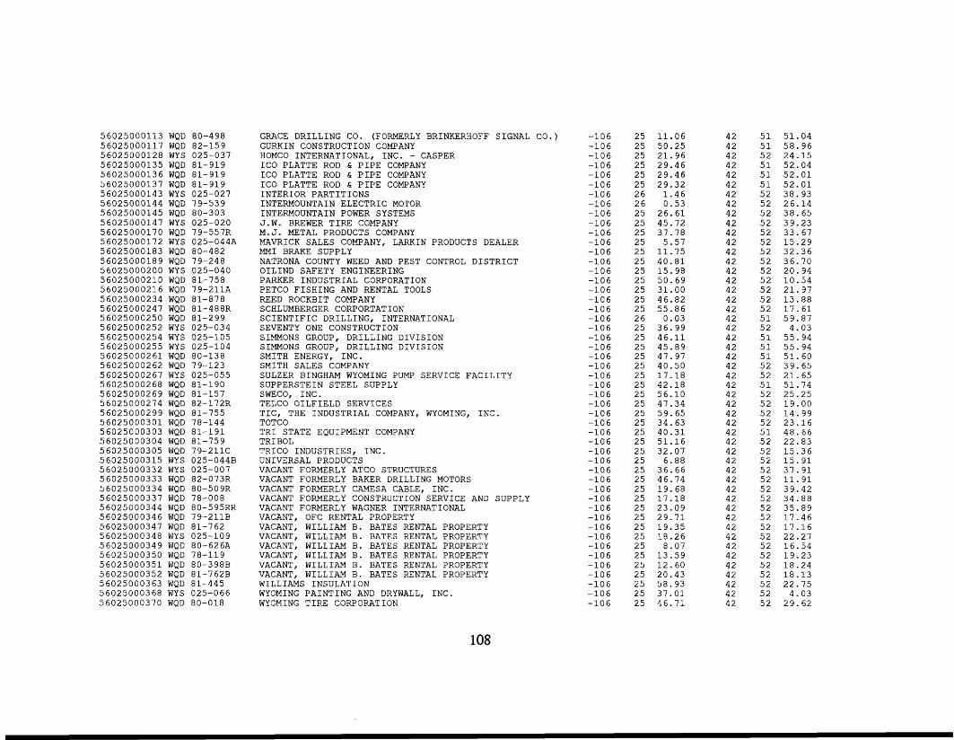
56025000113 WQD 80-498 56025000117 WQD 82-159 56025000128 WYS 025-037 56025000135 WQD 81-919 56025000136 WQD 81-919 56025000137 WQD 81-919 56025000143 WYS 025-027 56025000144 WQD 79-539 56025000145 WQD 80-303 56025000147 WYS 025-020 56025000170 WQD 79-557R 56025000172 WYS 025-044A 56025000183 WQD 80-482 56025000189 WQD 79-248 56025000200 WYS 025-040 56025000210 WQD 81-758 56025000216 WQD 79-2llA 56025000234 WQD 81-878 56025000247 WQD 81-488R 56025000250 WQD 81-299 56025000252 WYS 025-034 56025000254 WYS 025-105 56025000255 WYS 025-104 56025000261 WQD 80-138 56025000262 WQD 79-123 56025000267 WYS 025-055 56025000268 WQD 81-190 56025000269 WQD 81-157 56025000274 WQD 82-172R 56025000299 WQD 81-755 56025000301 WQD 78-144 56025000303 WQD 81-191 56025000304 WQD 81-759 56025000305 WQD 79-211C 56025000315 WYS 025-044B 56025000332 WYS 025-007 56025000333 WQD 82-073R 56025000334 WQD 80-509R 56025000337 WQD 78-008 56025000344 WQD 80-595RR 56025000346 WQD 79-211B 56025000347 WQD 81-762 56025000348 WYS 025-109 56025000349 WQD 80-626A 56025000350 WQD 78-119 56025000351 WQD 80-398B 56025000352 WQD 81-762B 56025000363 WQD 81-445 56025000368 WYS 025-066 56025000370 WQD 80-018
GRACE DRILLING CO. (FORMERLY BRINKERHOFF SIGNAL CO.) GURKIN CONSTRUCTION COMPANY
ICO PLATTE ROD & PIPE COMPANY ICO PLATTE ROD & PIPE COMPANY ICO PLATTE ROD & PIPE COMPANY INTERIOR PARTITIONS INTERMOUNTAIN ELECTRIC MOTOR INTERMOUNTAIN POWER SYSTEMS J . W . BREWER TIRE COMPANY M. J. METAL PRODUCTS COMPANY MAVRICK SALES COMPANY, LARKIN PRODUCTS DEALER MMI BRAKE SUPPLY NATRONA COUNTY WEED AND PEST CONTROL DISTRICT OILIND SAFETY ENGINEERING PARKER INDUSTRIAL CORPORATION PETCO FISHING AND RENTAL TOOLS REED ROCKBIT COMPANY SCHLUMBERGER CORPORTATION SCIENTIFIC DRILLING, INTERNATIONAL SEVENTY ONE CONSTRUCTION SIMMONS GROUP, DRILLING DIVISION SIMMONS GROUP, DRILLING DIVISION SMITH ENERGY, INC. SMITH SALES COMPANY SULZER BINGHAM WYOMING PUMP SERVICE FACILITY SUPPERSTEIN STEEL SUPPLY SWECO, INC. TELCO OILFIELD SERVICES TIC, THE INDUSTRIAL COMPANY, WYOMING, INC. TOTCO TRI STATE EQUIPMENT COMPANY TRIBOL TRICO INDUSTRIES, INC. UNIVERSAL PRODUCTS VACANT FORMERLY ATCO STRUCTURES VACANT FORMERLY BAKER DRILLING MOTORS VACANT FORMERLY CAMESA CABLE, INC. VACANT FORMERLY CONSTRUCTION SERVICE AND SUPPLY VACANT FORMERLY WAGNER INTERNATIONAL VACANT, OFC RENTAL PROPERTY VACANT, WILLIAM B. BATES RENTAL PROPERTY VACANT, WILLIAM B. BATES RENTAL PROPERTY VACANT, WILLIAM B. BATES RENTAL PROPERTY VACANT, WILLIAM B. BATES RENTAL PROPERTY VACANT, WILLIAM B. BATES RENTAL PROPERTY VACANT, WILLIAM B. BATES RENTAL PROPERTY WILLIAMS INSULATION WYOMING PAINTING AND DRYWALL, INC. WYOMING TIRE CORPORATION
HOMCO INTERNATIONAL, INC. - CASPER
-106 25 11.06 -106 25 50.25 -106 25 21.96 -106 25 29.46 -106 25 29.46 -106 25 29.32 -106 26 1.46 -106 26 0.53 -106 25 26.61 -106 25 45.72 -106 25 37.78 -106 25 5.57 -106 25 11.75 -106 25 40.81 -106 25 15.98 -106 25 50.69 -106 25 31.00 -106 25 46.82 -106 25 55.86 -106 26 0.03 -106 25 36.99 -106 25 46.11 -106 25 45.89 -106 25 47.97 -106 25 40.50 -106 25 17.18 -106 25 42.18 -106 25 56.10 -106 25 41.34 -106 25 59.65 -106 25 34.63 -106 25 40.31 -106 25 51.16 -106 25 32.07 -106 25 6.88 -106 25 36.66 -106 25 46.74 -106 25 19.68 -106 25 17.18 -106 25 23.09 -106 25 29.71 -106 25 19.35 -106 25 18.26 -106 25 8.07 -106 25 13.59 -106 25 12.60 -106 25 20.43 -106 25 58.93 -106 25 37.01 -106 25 46.71
42 51 51.04 42 51 58.96 42 52 24.15 42 51 52.04 42 51 52.01 42 51 52.01 42 52 38.93 42 52 26.14 42 52 38.65 42 52 39.23 42 52 33.67 42 52 15.29 42 52 32.36 42 52 36.70 42 52 20.94 42 52 10.54 42 52 21.97 42 52 13.88 42 52 17.61 42 51 59.87 42 52 4.03 42 51 55.94 42 51 55.94 42 51 51.60 42 52 39.65 42 52 21.65 42 51 51.74 42 52 25.25 42 52 19.00 42 52 14.99 42 52 23.16 42 51 48.66 42 52 22.83 42 52 15.36 42 52 15.91 42 52 37.91 42 52 11.91 42 52 39.42 42 52 34.88 42 52 35.89 42 52 17.46 42 52 17.16 42 52 22.27 42 52 16.54 42 52 19.23 42 52 18.24 42 52 18.13 42 52 22.75 42 52 4.03 42 52 29.62
108
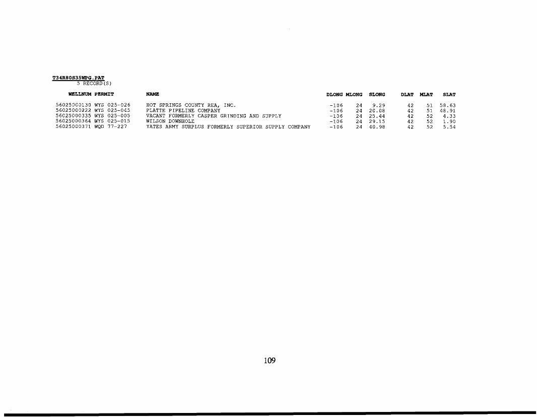
T34REOS35WPG.PAT 5 RECORD ( S )
WELLNUM PERMIT NAME DLONG MLONG SLONG DLAT MLAT SLAT
5 6 0 2 5 0 0 0 1 3 0 WYS 025-026 HOT SPRINGS COUNTY REA, INC. - 1 0 6 2 4 9 .29 4 2 5 1 5 8 . 6 3 5 6 0 2 5 0 0 0 2 2 2 WYS 025-045 PLATTE P I P E L I N E COMPANY - 1 0 6 2 4 20 .08 42 5 1 4 8 . 9 1 56025000335 WYS 025-005 VACANT FORMERLY CASPER GRINDING AND SUPPLY - 1 0 6 2 4 25 .44 4 2 5 2 4 .33 56025000364 WYS 025-015 WILSON DOWNHOLE -106 2 4 29.15 42 5 2 1 . 9 0 5 6 0 2 5 0 0 0 3 7 1 WQD 77-227 YATES ARMY SURPLUS FORMERLY SUPERIOR SUPPLY COMPANY -106 2 4 40 .98 42 5 2 5 .54
109
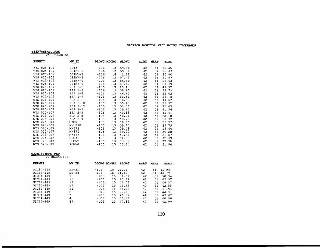
SECTION MONITOR WELL POINT COVERAGES
T33R78S5MPG. PAT 25 RECORD(S)
PERMIT MW-ID
WYS 025-107 WYS 025-107 WYS 025-107 WYS 025-107 WYS 025-107 WYS 025-107 WYS 025-107 WYS 025-107 WYS 025-107 WYS 025-107 WYS 025-107 WYS 025-107 WYS 025-107 WYS 025-107 WYS 025-107 WYS 025-107 WYS 025-107 WYS 025-107 WYS 025-107 WYS 025-107 WYS 025-107 WYS 025-107 WYS 025-107 WYS 025-107 WYS 025-107
T33R78S6MPG.PAT 79 RECORD(S)
DS15 DSIMW-1 DSIMW-2 DSIMW-3 DSIMW-4 DSIMW-6 EPA 1-1 EPA 1-2 EPA 1-6 EPA 1-7 EPA 2-1 EPA 2-10 EPA 2-15 EPA 2-2 EPA 2-3 EPA 2-8 EPA 2-9 MKMW 1 MW 878 MW872 MW874 MW877 OBG3 PCMW2 PCMW4
PERMIT MW-ID
UIC84-449 UIC84-44 9 UIC84-44 9 UIC84-449 UIC84-449 UIC84-449 UIC84-449 ULC84-449 UIC84-449 UIC84-44 9 UIC84-449
ss-21 ss-34 1 11 12 13 14 2 3 4 48
DLONG MLONG SLONG DLAT
-106 -106 -106 -106 -106 -106 -106 -106 -106 -106 -106 -106 -106 -106 -106 -106 -106 -106 -106 -106 -106 -106 -106 -106 -106
13 59.96 13 59.71 14 1.22 13 57.41 13 56.69 13 57.60 13 25.13 13 38.65 13 46.61 13 51.61 13 10.58 13 55.40 13 53.31 13 29.23 13 40.13 13 48.26 13 50.76 13 56.66 13 59.60 13 59.49 13 59.55 13 57.46 13 54.00 13 53.07 13 53.15
DLONG MLONG SLONG
-106 -106 -106 -106 -106 -106 -106 -106 -106 -106 -106
15 15 15 15 15 15 15 15 15 15 15
23.21 11.12 34.61 43.92 46.03 46.28 46.22 27.16 26.07 36.17 47.85
42 42 42 42 42 42 42 42 42 42 42 42 42 42 42 42 42 42 42 42 42 42 42 42 42
MLAT SLAT
51 18.45 51 21.47 51 20.00 51 21.07 51 22.63 51 23.79 51 49.57 51 32.79 51 26.02 51 26.18 51 44.57 51 25.32 51 25.43 51 41.34 51 45.41 51 25.10 51 25.32 51 23.77 51 23.79 51 19.44 51 20.58 51 21.57 51 32.39 51 23.70 51 21.84
DLAT MLAT SLAT
42 51 41.04 42 51 44.79 42 51 50.94 42 51 45.97 42 51 44.37 42 51 42.55 42 51 41.93 42 51 44.37 42 51 43.67 42 51 40.96 42 51 43.99
110
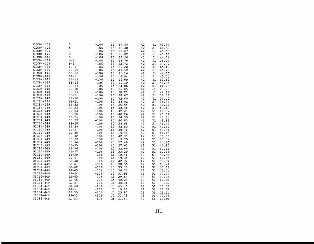
UIC84-449 UIC84-449 UIC84-449 UIC84-44 9 UIC84-44 9 UIC84-449 UIC84-44 9 UIC84-449 UIC84-44 9 UIC84-449 UIC84-449 UIC84-449 UIC84-44 9 UIC84-449 UIC84-449 UIC84-449 UIC84-449 UIC84-449 UIC84-44 9 UIC84-449 UIC84-449 UIC84-449 UIC84-449 UIC84-449 UIC84-449 UIC84-44 9 UIC84-44 9 UIC84-449 UIC84-449 UIC84-449 UIC84-449 UIC84-449 UIC84-44 9 UIC84-449 UIC84-449 UIC84-449 UIC84-449 UIC84-449 UIC84-449 UIC84-449 UIC84-449 UIC84-449 UIC84-449 UIC84-44 9 UIC84-449 UIC84-44 9 UIC84-449 UIC84-44 9 UIC84-449 UIC84-449
5 6 7 8 9 B- 1 B- 2 ss-1 ss-10 ss-10 ss-11 ss-12 SS-16 SS-17 SS-18 ss-19 ss-2 ss-20 ss-21 ss-22 SS-23 SS-24 SS-25 SS-2 6 SS-27 SS-28 SS-29 ss-3 SS-30 SS-32 ss-33 ss-34 ss-35 SS-36 ss-37 ss-39 ss-4 SS-40 SS-41 SS-42 ss-43 ss-44 ss-45 SS-4 6 ss-47 SS-48 ss-5 SS-50 SS-51 SS-52
-106 -106 -106 -106 -106 -106 -106 -106 -106 -106 -106 -106 -106 -106 -106 -106 -106 -106 -106 -106 -106 -106 -106 -106 -106 -106 -106 -106 -106 -106 -106 -106 -106 -106 -106 -106 -106 -106 -106 -106 -106 -106 -106 -106 -106 -106 -106 -106 -106 -106
15 37.55 15 42.38 15 13.07 15 15.82 15 33.26 15 23.76 15 23.73 15 29.20 15 47.52 15 25.16 15 8.84 15 46.09 15 11.10 15 14.86 15 25.05 15 28.21 15 38.07 15 32.00 15 38.92 15 50.65 15 43.45 15 42.41 15 40.26 15 34.39 15 46.03 15 39.88 15 32.00 15 38.78 15 19.45 15 42.35 15 13.76 15 27.49 15 27.63 15 32.66 15 33.29 15 10.41 15 19.34 15 42.82 15 38.56 15 33.78 15 36.23 15 33.98 15 29.64 15 40.26 15 30.84 15 45.76 15 19.89 15 29.97 15 33.78 15 31.50
42 51 45.52 42 51 48.69 42 51 45.63 42 51 45.66 42 51 44.76 42 51 38.24 42 51 37.87 42 51 45.49 42 51 44.28 42 51 44.05 42 51 45.04 42 51 53.69 42 51 43.35 42 51 41.28 42 51 43.53 42 51 44.87 42 51 53.48 42 51 34.40 42 51 36.51 42 51 39.71 42 51 43.46 42 51 49.57 42 51 45.07 42 51 44.61 42 51 48.13 42 51 41.55 42 51 43.31 42 51 53.54 42 51 41.43 42 51 36.85 42 51 45.82 42 51 47.80 42 51 47.25 42 51 50.92 42 51 50.56 42 51 44.68 42 51 47.13 42 51 50.67 42 51 45.99 42 51 44.49 42 51 48.71 42 51 47.41 42 51 42.18 42 51 47.30 42 51 38.95 42 51 36.65 42 51 47.08 42 51 42.51 42 51 40.79 42 51 48.50
111
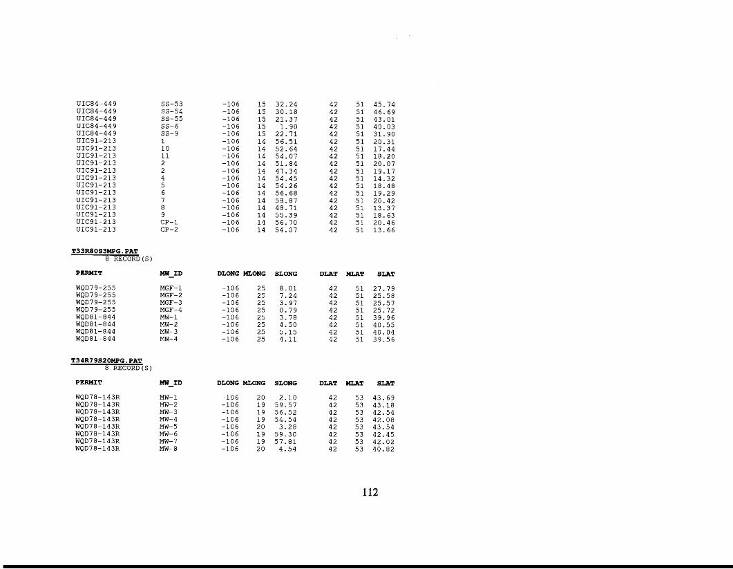
UIC84-449 UIC84-44 9 UIC84-449 UIC84-449 UIC84-44 9 UIC91-2 13 UIC91-213 UIC91-213 UIC91-213 UIC91-213 UIC91-213 UIC91-213 UIC91-213 UIC91-213 UIC91-213 UIC91-213 UIC91-213 UIC91-213
T33RSOS3MPG. PAT 8 RECORD
ss-53 ss-54 ss-55 SS-6 ss-9 1 10 11 2 2 4 5 6 7 8 9 CP-1 CP-2
PERMIT MW-ID
WQD7 9- 2 5 5 WQD79-255 WQD 7 9-2 55 WQD 7 9-2 5 5 WQD 8 1- 844 WQD8 1- 8 4 4 WQD8 1- 84 4 WQD8 1- 8 4 4
T34R7 9S20MPG. PAT 8 RECORD(
MGF- 1 MGF-2 MGF-3 MGF-4 MW- 1 MW-2 MW-3 MW- 4
PERMIT MW-ID
WQD78-143R WQD78-143R WQD78-143R WQD78-143R WQD78-143R WQD78-143R WQD78-143R WQD78-143R
MW- 1 MW-2 MW-3 MW-4 MW-5 MW- 6 MW- 7 MW- 8
-106 -106 -106 -106 -106 -106 -106 -106 -106 -106 -106 -106 -106 -106 -106 -106 -106 -106
15 32.24 15 30.18 15 21.37 15 1.90 15 22.71 14 56.51 14 52.64 14 54.07 14 51.84 14 47.34 14 54.45 14 54.26 14 56.68 14 58.87 14 48.71 14 55.39 14 56.70 14 54.07
DLONG MLONG
-106 25 -106 25 -106 25 -106 25 -106 25 -106 25 -106 25 -106 25
DLONG MLONG
-106 20 -106 19 -106 19 -106 19 -106 20 -106 19 -106 19 -106 20
SLONG
8.01 7.24 3.97 0.79 3.78 4.50 5.15 4.11
SLONG
2.10 59.57 56.52 54.54 3.28 59.30 57.81 4.54
42 51 45.74 42 51 46.69 42 51 43.01 42 51 40.03 42 51 31.90 42 51 20.31 42 51 17.44 42 51 18.20 42 51 20.07 42 51 19.17 42 51 14.32 42 51 18.48 42 51 19.29 42 51 20.42 42 51 13.37 42 51 18.63 42 51 20.46 42 51 13.66
DLAT
42 42 42 42 42 42 42 42
DLAT
42 42 42 42 42 42 42 42
MLAT
51 51 51 51 51 51 51 51
MLAT
53 53 53 53 53 53 53 53
SLAT
27.79 25.58 25.57 25.72 39.96 40.55 40.04 39.56
SLAT
43.69 43.18 42.54 42.08 43.54 42.45 42.02 40.82
112
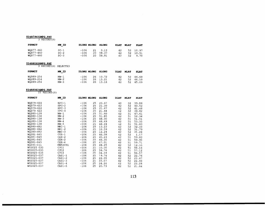
T34R79S32MPG.PAT 3 RECORD (S)
PERMIT MW-ID
WQD77-460 sc- 1 WQD7 7 -4 6 0 sc-2 WQD77-4 60 sc-3
T34RBOS28MPG.PAT 3 RECORD (S ) SELECTED
PERMIT MW-ID
WQD89-254 MW- 1 WQD8 9-25 4 MW- 2 WQD8 9-25 4 MW-3
T34R80S34MPG.PAT 25 RECORD(S)
PERMIT
WQD7 9- 62 2 WQD7 9- 622 WQD7 9-622 WQD 7 9- 62 2 WQD8 0-1 3 8 WQD8 0- 13 8 WQD8 0- 13 8 WQD8 0- 13 8 WQD8O-13 8 WQD8 0-4 8 2 WQD80-482 WQD 8 0-4 8 2 WQD 8 1 - 8 4 5 WQD8 1- 84 5 WQD8 1- 84 5 WQD81-845 WQD 91-0 11 WYSO25-035 WYSO25-035 WYSO25-035 WYSO25-037 WYSO25-037 WYSO25-037 WYSO25-037 WYSO25-037
MW-ID
HPC-1 HPC-2 HPC- 3 HPC-4 MW- 1 MW-2 MW-3 MW- 4 MW-5 MMI-1 MMI-2 MMI-3 CER- 1 CER-2 CER-2 CER- 4 MW52091 CTCl CTC2 CTC3 CAS1-1 CAS 1-2 CAS1-3 CAS1-4 CAS 1-5
DLONG MLONG SLONG DLAT MLAT SLAT
-106 21 0.13 42 52 10.97 -106 20 58.37 42 52 10.51 -106 20 58.81 42 52 9.70
DLONG MLONG SLONG DLAT MLAT SLAT
-106 26 10.72 42 52 46.69 -106 26 13.21 42 52 46.59 -106 26 13.16 42 52 45.09
DLONG MLONG SLONG
-106 -106 -106 -106 -106 -106 -106 -106 -106 -106 -106 -106 -106 -106 -106 -106 -106 -106 -106 -106 -106 -106 -106 -106 -106
25 23.67 25 21.30 25 21.47 25 21.44 25 51.60 25 51.85 25 48.30 25 44.49 25 44.24 25 13.23 25 10.59 25 12.24 25 46.08 25 45.23 25 46.30 25 47.01 25 48.25 25 55.00 25 56.76 25 54.59 25 19.74 25 22.05 25 25.07 25 24.24 25 20.73
DLAT
42 42 42 42 42 42 42 42 42 42 42 42 42 42 42 42 42 42 42 42 42 42 42 42 42
MLAT SLAT
52 39.86 52 40.52 52 41.48 52 39.82 51 47.61 51 52.34 51 51.51 51 53.35 51 51.63 52 32.33 52 31.79 52 31.24 52 1.17 51 59.83 51 59.95 51 59.71 52 12.55 51 58.14 51 57.12 51 56.57 52 22.76 52 23.67 52 22.93 52 23.28 52 21.64
113
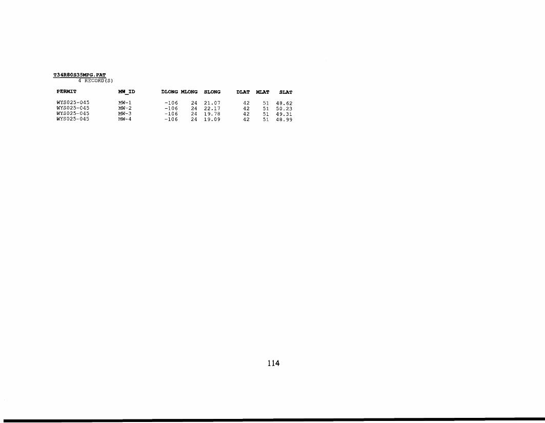
T34R80S35MPG.PAT 4 RECORD(S)
PERMIT MW-ID
WYSO25-045 MW- 1 WYSO25-045 MW-2 WYSO25-045 MW-3 WYSO25-045 MW- 4
DLONG MLONG SLONG
-106 24 21.07 -106 24 22.17 -106 24 19.78 -106 24 19.09
DLAT MLAT SLAT
42 51 48.62 42 51 50.23 42 51 49.31 42 51 48.99
114