Embed Size (px)
Citation preview

Development of a severe frontal rainband
- plans for the Testbed-course study
Jenni TeittinenFinnish Meteorological Institute
16 February 2007

A cold front moved over Finland on 26 August 2005
26 August 2005 12 UTC 27 August 2005 00 UTC

Two rainbands developed
12.30 UTC11.30 UTC
13.30 UTC 14.30 UTC
Pre-frontalSevere cold frontal

Nature caused emergency reports on 26 August
6 reported tornadoes

Lightning 26 August 2005CG IC
Motivation• Difficult to forecast – numerical models had high shear but no
CAPE
• How could we forecast these type quite common events?
• Difficult to nowcast – we would anticipate severe weather in the first rainband
• Can the Testbed-observations explain why severe weather occured in the second rainband?
• The frontal rainband had line echo wave patterns –often observed with nonsupercell tornadoes
• Can we observe the nonsupercell tornado development with radar reflectivity and Doppler velocity?
• Can we observe a tornado vortex with the Kumpula polarimetric radar (differential reflectivity ZDR and cross-colleration coefficient)?

Why severe weather occured in the second rainband?
• Testbed-observations
• Soundings
• Wind profiler (LAP-3000)
• Weather transmitters
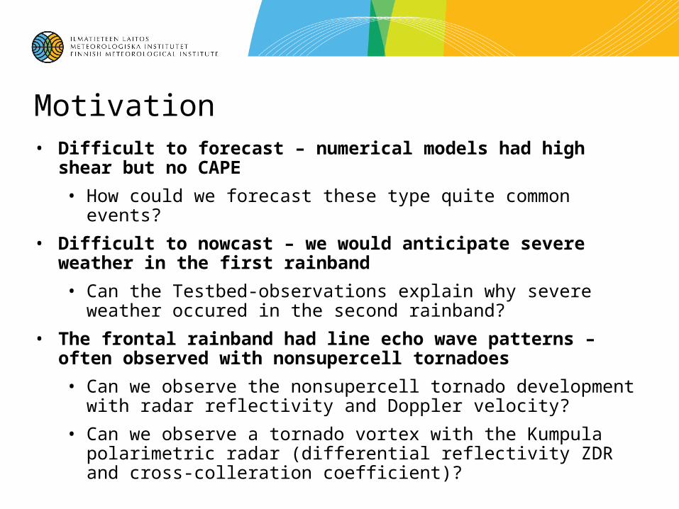
Can we observe the nonsupercell tornado development with radar reflectivity and Doppler velocity?
Can we observe a tornado vortex with the Kumpula polarimetric radar (differential reflectivity ZDR and cross-colleration coefficient)?
Lee and Wilhelmson 1997b
Ryzhkov et al. 2005
Testbed data: Kumpula, Vantaa and Ikaalinen radars