Embed Size (px)
Citation preview

Clemson UniversityTigerPrints
All Dissertations Dissertations
5-2009
Development of a Methodology for Evaluating andAnticipating Improvised Explosive Device ThreatActivity Using a Fault Tree Based ProcessBenjamin BennettClemson University, [email protected]
Follow this and additional works at: https://tigerprints.clemson.edu/all_dissertations
Part of the Civil Engineering Commons
This Dissertation is brought to you for free and open access by the Dissertations at TigerPrints. It has been accepted for inclusion in All Dissertations byan authorized administrator of TigerPrints. For more information, please contact [email protected].
Recommended CitationBennett, Benjamin, "Development of a Methodology for Evaluating and Anticipating Improvised Explosive Device Threat ActivityUsing a Fault Tree Based Process" (2009). All Dissertations. 353.https://tigerprints.clemson.edu/all_dissertations/353

Development of a Methodology for Evaluating and Anticipating Improvised Explosive Device Threat Activity Using a Fault Tree Based Process
_________________________________________________
A Dissertation Presented to
the Graduate School of Clemson University
_________________________________________________
In Partial Fulfillment of the Requirements for the Degree
Doctor of Philosophy Civil Engineering
_________________________________________________
by Benjamin A. Bennett
May 2009 _________________________________________________
Accepted by: Dr. Mashrur Chowdhury, Committee Chair
Dr. Lansford C. Bell Dr. Jennifer H. Ogle
Dr. Charles O. Skipper

ii
ABSTRACT
This document is a redacted version of the original dissertation titled
“Development of a Methodology for Evaluating and Anticipating Improvised Explosive
Device Threat Activity Using a Fault Tree Based Process.” To allow for publication,
information was removed which was considered sensitive in nature or which could be
used by those who employ the Improvised Explosive Device, to negate any advantage
gained by this research. The complete un-redacted dissertation is available (with proper
vetting) to those whishing to further develop the concepts outlined in this document.
Those interested in obtaining access to the complete document should contact the Joint
IED Defeat Organization (JIEDDO).
To date there is little published evidence to believe that a sufficient IED threat
prediction capability has been developed. Most of the countermeasures seen on the
battlefield today are reactive in nature designed to neutralize the effects of a device
before it causes injury to military and civilian personnel. These countermeasures have
meet with varying levels of success. An efficient threat prediction capability will
significantly increase the ability of military forces to eliminate the threat associated with
the IED. The lack of an accurate threat prediction capability is a possible result of not
having identified all of the variables or the variable relationships associated with IED
placement.
This research analyzes the variables associated with an IED incident and develops
an IED threat prediction process using the Fault Tree model. This dissertation also
explores the use of visualization software to determine their suitability in C-IED

iii
operations. Furthermore, the application of a Fault Tree based process as a decision
support tool for use by decision makers involved in C-IED operations is analyzed.
This research is conducted in three phases with the first phase dedicated to the
development of a Fault Tree diagram representing an IED incident. During this phase a
complete Fault Tree is constructed identifying, sequencing, and establishing relationships
between all variable associated with a successful IED attack against a military vehicle
operating on a road.
The second phase outlines the development of a complete process intended to
serve as an operational guide for those attempting to employ the concepts addressed. To
ensure a more precise understanding of the required procedures, a theoretical case study
was used to articulate and demonstrate the requisite activities.
Through this research, events were identified as required for an effective attack to
take place. Through the integration of the Fault Tree, probability information and
visualization assets a threat prediction capability is demonstrated.
The ability to predict IED activity will provide military personnel a distinct
advantage in defeating the IED threat and directly contribute to the increased safety of
military and civilian personnel living and operating in an IED environment.

iv
DEDICATION
This work is dedicated to Captain Mathew August, Captain Timothy McGovern,
First Lieutenant Josh Hurley, Staff Sergeant Stephen Seale, Sergeant Carleton Clark, and
Corporal Jos Zamora of the United States Army. These comrades, brothers, friends and
heroes made the ultimate sacrifice in defense of our nation. There is hope that this
research will help deny the enemies of our nation the ability to effectively employ the
Improvised Explosive Device.

v
ACKNOWLEDGEMENTS
I would first like to thank Dr. Mashrur Chowdhury for his tremendous support as
my committee chair. Dr. Chowdhury is an outstanding advisor and educator whose
willingness to support a non traditional student and this unique research endeavor is
testament to his professionalism. I am extremely grateful for his willingness to
participate in the numerous late night phone calls and weekend meetings required to see
this project through to completion. Furthermore, I would like to express my sincere
appreciation and gratitude to the other members of my committee; Dr. Lansford C. Bell,
Dr. Jennifer H. Ogle and Dr. Charles O. Skipper. Their assistance, outstanding guidance,
and superb mentorship was critical to the completion of this project and is very much
appreciated.
I would like to thank those who assisted in finding an acceptable solution to the
issues associated with publishing a sensitive document of this nature. Clemson, JIEDDO,
the Security Reviewers, and the other advisors with whom I work, were critical in
developing a way to contribute to the body of knowledge while protecting the military
benefit associated with this research.
I owe a debt of gratitude to those members of our military who I know, and with
whom I have served. I have had the honor of serving in many outstanding units and with
many amazing individuals. Those experiences and influences have been instrumental in
my professional growth and have provided a solid understanding of military operations.
This understanding is the foundation upon which this research was built.

vi
Much is owed to my family and friends. I am blessed with a tremendous and
solid support structure that has always been there for me without fail. Most significant
are my Mother and Father, two amazing individuals who have always provided
unconditional love and unbelievable opportunity. Through their example they have
instilled within me a confidence and a desire to seek out challenges as well as a drive to
see them through to completion. For there influence I am eternally grateful.
Most importantly I must say thank you to my wife Audrey. She is a tremendous
example of constant and unwavering love, support, kindness, and patience. Without her
support none of this would have been possible.

vii
TABLE OF CONTENTS
Page
TITLE PAGE …………………………………………….……………………………...i
ABSTRACT …….………………………………………………………………………ii
DEDICATION …………………………………………………………………………iii
ACKNOWLEDGEMENTS.....…………………………………………………………iv
LIST OF FIGURES ….…………………………………………………………………ix
CHAPTER
1. INTRODUCTION ….………………………………………………………………...1 Introduction ....……………………………………………………………………......1 Statement of the Problem …………………………………………………………….4 Purpose of the Study …………………………………………………………………7 Methodology of the Study …….……………………………………………………9 Hypotheses ....……………………………………………………………………….11 Assumptions and Limitations ….……………………………………………………13 Anticipated Benefits ………………………………………………………………...15 2. LITERATURE REVIEW ….………………………………………………………..17 Fault Tree….………………………………………………………………………...17 Classification and Regression Tree Analysis ……………….…………………........31 Simulation…….……………………………………………………………………..37 Geographic Information Systems ….………………………………………………..48 Insurgencies ……….………………………………………………………………...57 Improvised Explosive Devices ….…………………………………………………..66 3. RESEARCH METHODOLOGY …………………………………………………...76 Introduction …………………………………………………………………………76 Research Questions and Hypothesis….……………………………………………..76 Design of the Research …………….………………………………………………..79 Summary of Research Methodology ….…………………………………………….81 4. ANALYSIS OF RESEARCH AND FINDINGS ….………………………….........83 5. CONCLUSIONS AND RECOMMENDATIONS ….………………………………84

viii
Table of Contents (Continued)
Page
APPENDICES ………………………………………………..……………………….85
REFERENCES …....………………………………………………………………...…86

ix
LIST OF FIGURES
Figure Page
2.1 Basic Elements of Fault Tree...………………………………………………22
2.2 Sample Fault Tree……………………………………………………………24
2.3 Classification Tree for Identification of Flowers…….………………………34
2.4 Regression Tree for Admission to Medical School…….……………………36
2.5 Vector Model …...……………………………………………………………51
2.6 Raster Model…………………………………………………………………53
2.7 Vector vs. Raster Model ...…...………………………………………………53
2.8 Components of an IED ...….…………………………………………………69
2.9 IED Main Charge Constructed Out of Military Munitions ...………………..71
2.10 Diagram of EFP Operation ............................................................................. 72
2.11 Example Pressure Plate/Victim Operated Initiation System .….…………....75

1
CHAPTER 1: INTRODUCTION
Introduction
This document is a redacted version of the original dissertation titled
“Development of a Methodology for Evaluating and Anticipating Improvised Explosive
Device Threat Activity Using a Fault Tree Based Process.” To allow for publication,
information was removed which was considered sensitive in nature or which could be
used by those who employ the Improvised Explosive Device, to negate any advantage
gained by this research. The complete un-redacted dissertation is available (with proper
vetting) to those whishing to further develop the concepts outlined in this document.
Those interested in obtaining a copy of the complete document should contact the Joint
IED Defeat Organization (JIEDDO).
The Improvised Explosive Device (IED) continues to be one of the largest
casualty producing weapons used against coalition forces participating in combat
operations in the Afghanistan and Iraq Theater of Operations. As of 22 September 2007
there have been over 81,000 recorded IED incidents in Iraq causing the death of 1,952
American servicemen and women and the injury of 19,248 more (Atkins, 2007). These
deaths are a direct result of the enemy’s employment of the IED. IEDs capitalize on the
Coalition Forces reliance on, and use of, established highways, freeways, and other
vehicular transportation corridors. Terrorist and insurgent groups have employed the IED
with marked success and have been able to disrupt both non-military and military
operations with this effective weapon system. This dissertation focuses on limiting the

2
enemy’s ability to engage targets by developing a method to anticipate enemy activity
and predict where an IED will be placed.
The Department of Defense is actively and aggressively searching for ways to
defeat the IED. The United States Government is spending billions of dollars searching
for ways to defeat the insurgent’s weapon of choice (Levine, 2006). The military created
the Joint IED Task Force and gave them, along with other organizations, the mission of
developing new ways to defeat the IED (Levine, 2006). The military’s research and
development assets, industry, and academia are all actively engaged in developing ways
to mitigate the effects of this often simple and destructive weapon system.
Many of the new developments and countermeasures seen on today’s battlefield
are reactive in nature, designed to increase chances of survival when in proximity of an
IED. Many of these measures emphasis traditional force protection and survivability
principles focusing on allowing a soldier to survive the blast of an IED or preventing an
existing IED from detonating. Some of the improvements being fielded include equipping
vehicles with stronger armor as well as developing disposal vehicles which are designed
to locate suspicious objects and survive the blast should a device detonate. Electronic
jamming equipment is also in use designed to jam the detonating signal as vehicles
approach or cause premature detonation before a vehicle enters a kill zone (Vanden
Brook, 2007). These measures have all met with varying levels of success.
As is the case with armed conflict against a thinking enemy there is a constant
evolution of technology and tactics between opposing forces. Each side adapts and
evolves with the aim of gaining and maintaining an advantage over the opponent. This

3
evolution is evident in the Iraqi theater of operation. An illustration of this concept is
when the American Military develops stronger armor designed to survive a blast of an
IED, insurgent forces build more powerful IEDs designed to defeat the improved armor.
When the military develops a way to jam a specific detonating signal the insurgent forces
develop effective ways to detonate the device while avoiding the jammed frequency.
To prevent casualties and minimize the risks associated with this constant action-
reaction relationship and to help limit the ability of an enemy force to effectively employ
the IED, the international coalition of forces operating in Iraq require a method to
minimize the enemy’s ability to evolve. Specifically with the IED, this evolution can be
reduced by limiting the enemy’s ability to engage targets with the IED. This can be
accomplished by developing a threat prediction capability.
To date there has been no published evidence to suggest that any method, model
or tool has been developed to accurately and reliably anticipate threat activity or identify
locations of Improvised Explosive Devices. This is a possible result of not having
identified all of the variables associated with IED placement.
A failure based model like the Fault Tree can effectively be used to identify all
variables present during an incident and clarify their relationship to IED activity.
Information derived from the Fault Tree can then be integrated into visualization software
and used to identify areas which meet specified criteria. Anticipating location and threat
activity can be accomplished through the use of the Fault Tree and provide the
understanding of relationships between IED related variables. To date, there is no
evidence to suggest that this approach has been thoroughly explored.

4
This research project will identify and analyze specific variable relationships
related to an IED incident with the aim of effectively combining the principles of Fault
Tree modeling, Geographic Information Systems (GIS), simulation, and military doctrine
to present an effective process which can be used to understand and anticipate threat
activity. The primary intent is to develop a Fault Tree based process for anticipating IED
activity and locations. A secondary objective is to analyze the effectiveness of various
visualizations assets in Counter-IED (C-IED) related activities. The ability to predict
IED activity will provide military personnel a distinct advantage in defeating the IED
threat. Anticipation of enemy ambush locations will encourage the preemptive
neutralization of the device, denial of the location, and the elimination of personnel
attempting to place an IED. A prediction capability will allow Coalition Forces the
ability to deny the enemy their intended effects of the IED.
Statement of Problem
Coalition Soldiers, Sailors, Airman, and Marines have experienced significant
casualties as a result of the Improvised Explosive Device. IEDs have caused 68% of the
31,101 combat deaths and injuries sustained by the United States military in Iraq (Atkins,
2007). This does not include the many more thousand Iraq citizens whose lives have
also been devastated by the IED. From January 2007 to July of 2007 coalition forces
estimated that over 11,000 Iraqi civilians have been killed or wounded by the IED
(Atkins, 2007). The physical, psychological, political and financial effectiveness of this
weapon requires a reliable and effective method of mitigating the IEDs effect. To date

5
there is little published evidence to suggest that a reliable method of predicting and
determining IED locations has been developed.
The IED is often a simple device which is relatively cheap to construct, easy to
emplace, difficult to detect, and which can be employed with significant effectiveness
against many of the vehicles in the military inventory. By studying the recent evolution
of insurgency warfare it is easy to assume the IED will continue to be the weapon of
choice for the insurgent, guerilla, terrorist, or any other organization searching for a way
to offset the superior technological advantage of the American military. The Director of
National Intelligence, John Negroponte, testified before the United States Senate in
January of 2007 stating that the use of conventional explosives continues to be the most
probable terrorist attack scenario (Negroponte, 2007).
The most recent events between the American Military and Iraqi militants
combined with the recently well publicized 2006 conflict between the Hezbollah party of
the Lebanese Government and the Israel Army have given current and potential enemies
insight as to how to counter larger and more lethal conventional forces. Two experts of
guerrilla warfare, US Army Lieutenant General James Lovelace and Brigadier General
Joseph Votel, believe that “with relatively small amount of resources-access to common
electronic components and military ordinance and electronic and demolition skills-
insurgent terrorists can build devices that literally have the capability to destroy
prominent conventional warfare systems like the Abrams Tank and Bradley Fighting
Vehicle” (Lovelace, et al., 2004, pg.1). There is little doubt that future opponents have

6
taken notice of the effectiveness of this weapon and the world will continue to see the
employment of IEDs well beyond the limits of America’s War on Terror.
As armies develop new ways to counter the effects of the IED, the enemy
develops new ways to ensure its effectiveness. As demonstrated in the war in Iraq, when
armor and vehicles are made stronger and tougher, IEDs become bigger, more powerful
and are employed in ways which capitalize on observed vulnerabilities. There are at least
two documented cases were IEDs were successful in disabling the vehicle and killing the
occupants of a M1 Abrams Tank and M2 Bradley fighting vehicle, two of the most
heavily armored vehicles on today’s battlefield (Wilson, 2005), (United States
Department of Defense, 2006). “Defense planners should view IEDs like medical
professionals view the influenza virus, another “primitive”, adaptable, and lethal enemy.
As soon as vaccines have defeated a certain flu strain, the virus evolves” (Levine, 2006).
There is a visible evolution with the terrorist groups in Iraq and the Coalition. When the
U.S. develops a countermeasure, insurgents improve and adapt their IED to overcome the
advantage gained.
One way to decrease the number of soldiers who are injured by the IED is to
develop a way to identify probable IED locations before sending soldiers into harms way.
If a prediction tool can be developed which can identify and predict enemy IED locations
from a secure environment first response military personnel will have the advantage of
knowing where a possible device is located before entering the area. Furthermore, stand-
off disposal techniques can be employed which would allow for the neutralization of the

7
device from a safe distance. An accurate threat prediction capability has the potential to
significantly reduce the number of personnel exposed to the IED threat.
The ability to know where the enemy is going to attack is of extreme importance
to military commanders. The accurate prediction of the actions of an opposing force will
help enable its destruction. The ability to anticipate will provide the opportunity for a
force to focus resources and be pre-emptive in denying enemy terrain and neutralizing
personnel performing hostile actions.
Purpose of the Study
This research is intended to develop a framework which can eventually lead to the
anticipation of IED locations. If an individual or organization is going to truly understand
the employment of the IED, that organization must study an environment where IEDs are
routinely employed and examine every facet of their use. This in-depth analysis will
create a foundation and baseline which can then be further enhanced and applied to
different geographical areas, militant forces, and technical variations of the IED. This
research project will analyze current military operations being conducted in support of
OPERATION IRAQI FREEDOM with the hope of developing a framework and
methodology for identifying and analyzing variables associated with the IED
environment. Once the identification of variables is achieved a process will be developed
and a method presented which can be used to analyze IED attack information with the
intent of identifying locations where IED activity will take place.
It is important to understand that this research project is theoretical and general in
nature and will not be able to predict exactly where on a road in Iraq enemy forces might

8
place an IED. It is the intent of this research project to develop a general process which
can be used to assist decision makers in understanding and anticipating IED activity. The
situation in Iraq will be used to understand threat tactics and will contribute to the
development of an experimental data set which will be used to illustrate a process.
This research project encompasses three separate tasks. These tasks include an
identification of IED related variables and variable relationships, interfacing threat data
with the Fault Tree model and visualization assets, as well as development of a process
which can be used by decision makers involved with C-IED operations to understand
threat activity and identify threat locations.
Any student or practitioner of the profession of arms understands the necessity of
a complete understanding of all facets of the military operating environment. This
analysis must be in-depth and thorough. Any study of the IED without a complete
understanding of the environment and conditions of its employment would be short-
sighted and incomplete. One can not attempt to analyze the employment of a weapon
system unless there is a complete understanding of the who, what, when, where, how, and
why of its employment. The culmination of this analysis is the development of a basic
Fault Tree Model correctly describing the variables and variable interaction in the IED
environment. This is the first objective of this research initiative.
Once the Fault Tree is complete a process will be developed which can be used to
anticipate threat activity. The process developed is intended as guidance to decision
makers involved with C-IED operations. The process is intended to describe how to
implement the principles of the Fault Tree into an effective decision support tool. The

9
process includes the integration of threat data into the Fault Tree, employment of
visualization assets to help illustrate location information, and explanation of how these
concepts can be used to anticipate and predict threat activity and IED locations.
The IED is often referred to as a “roadside bomb” since the majority of attacks
take place against military convoys which use established transportation corridors.
Accordingly this dissertation focuses on convoy operations and the variables related to
the employment of IED on vehicular transportation corridors. Developing a methodology
for analyzing IED information will allow military personnel the ability to develop models
capable of identifying areas which meet specific IED criteria. The integration of the
Fault Tree model with threat data and visualization software will provide the military
with a method of more clearly understanding the IED environment.
Methodology of Study
This research project is conducted in two phases. These two phases are Phase 1:
Fault Tree Development and Phase 2: Implementation Guidance. The methodology and
intent of each phase is listed in detail below.
Phase 1: Fault Tree Development: An axiom of warfare is that a complete
understanding of the operating and threat environments is critical to military success.
This understanding must encompass every aspect of the operating environment. The
environment includes, but is not limited to, the training, tactics, equipment, logistics,
locations used by friendly and enemy forces, and their relationship to an IED incident.
The conditions in which the enemy chooses to fight should be understood in detail. This

10
detailed analysis provides a foundation from which all future activities are based and is
essential as the environmental influences are what dictate friendly and enemy behavior.
A Fault Tree Model will be used to identify and understand the variables which
are present during an IED attack. The U.S. Nuclear Regulatory Commission uses the
Fault Tree analysis as a systematic method for acquiring information about a system
failure (Fault Tree Handbook, 1981). Fault Tree analysis has been used in transportation
studies in the past to identify causal factors of highway crashes (Chowdhury, 1995).
Specifically, a Fault Tree failure model will be developed which will identify the
variables present for a failure to take place. In this case a failure is defined as an IED
attack against a military vehicle on a road network. From this failure model information
pertaining to the specifics of each attack can be analyzed, integrated, and compared to
threat and exposure data in order to anticipate threat activity.
The specifics of real-world IED attack information are classified and not available
for use in this study. As such a theoretical data set will be created to illustrate the
analysis process. The data set was created by identifying IED attack locations on a road
network in the city of Richmond Hill, Georgia. Richmond Hill was selected because it is
the residence of the author and as such provides the opportunity to illustrate data
collection requirements and techniques. The incident locations selected will be dissected
with relevant data extracted for integration with the Fault Tree model.
Phase 2: Implementation Guidance: Once the Fault Tree is complete and the
exposure information and threat data identified, a process will be developed to provide a
clear understanding of how to employ the Fault Tree as a decision support and threat

11
prediction tool to be used by those decision makers involved in C-IED operations.
Visualization assets will be employed as a method of translating threat data and Fault
Tree information into visually identifiable areas on the ground. Two visualization
software packages will be used in this study. The visualization packages are the
transportation simulation software package Paramics and the GIS package ArcInfo. The
visualization models are intended to provide clarity to the process and allow for easier
interpretation of location information.
Hypotheses
This research project developed three separate hypotheses relative to the use of
the Fault Tree Failure Model, the locations of Improvised Explosive Devices, and the use
of visualization assets in threat prediction. These hypotheses were created to help guide
research activities. These hypotheses are subjective in nature and cannot be proven or
disproved by a theoretical data set. Ultimate validation of the concepts presented can
only be accomplished through the integration of real IED data into the proposed process.
Without access to real-world data the hypothesis presented are validated by the
presentation and acceptance of logical information specific to the principles of the IED
threat, military operations, Fault Tree modeling, simulation and GIS programming. This
research project is presented for further development by those organizations with access
to real world IED data. The hypothesis described are intended as basic fundamentals
which can assist in the execution of future research intended to defeat the threat of IED
data.

12
The first hypothesis (the specific details of this hypothesis have been removed to
allow for publication) is associated with establishment of identifiable relationship exists
between specific events associated with a successful IED incident against a military
vehicle on a road. Through the establishment of these variables and relationships
information can be obtained which will allow for the identification of IED locations. H1o
represents the first null hypothesis where H1a represents the first alternative hypothesis.
IEDV represents IED variables and IEDL represents decision IED locations.
H1o: IEDV = IEDL
H1a: IEDV ≠ IEDL
The second hypothesis is that a Fault Tree based model can be used as a decision
support tool in C-IED operations and in the prediction of IED activity. Specifically,
employment of a Fault Tree based process can serve as an effective decision support tool
with multiple applications including anticipation and identification of IED activity and
locations. The null hypothesis for this question can be stated as a Fault Tree model
equals a beneficial IED decision support tool. The alternative hypothesis can be written
as a Fault Tree model does not equal a beneficial IED decision support tool. For this
hypothesis H1o represents the first null hypothesis where H1a represents the first
alternative hypothesis. FTM represents the Fault Tree Model and DST represents
decision support tool.
H1o: FTM = DST
H1a: FTM ≠ DST

13
The third hypothesis is presented to determine the effectiveness of various
visualization assets in the identification of IED locations and evaluate their utility in C-
IED operations. It is also intended to help guide research activities. It is believed that a
visualization tool can be integrated with the Fault Tree in an effective manner to provide
clear and understandable information relative to threat locations. Specifically when
required, visualization platforms can be us in conjunction with the Fault Tree to translate
information into a visually recognizable location. The null hypothesis for this question
can be stated as visualization assets can be integrated with a Fault Tree to visualize
anticipated IED locations. The alternative hypothesis can be written as visualization
assets can not be integrated with Fault Tree to visualize anticipated IED locations. For
this hypothesis H1o represents the first null hypothesis where H1a represents the first
alternative hypothesis. VFT represents the integration of visualization platforms and
Fault Tree and AIEDL represents anticipated IED locations.
H1o: VFT = AIEDL
H1a: VFT ≠ AIEDL
Assumptions and Limitations
Care has been taken to ensure that the threat analysis is complete and provides a
complete understanding of the operating environment. Due to the unique difficulty
associated with collecting data in a combat zone and the information security issues
associated with releasing sensitive military information several assumptions will be made
during the conduct of this research project. These assumptions are based largely on
careful analysis of unclassified literature pertaining to combat operations and tactical

14
theory as well as established principles of engineering. When required the author made
assumptions to guide the execution of this research. The assumptions are listed below.
• Assumption 1: The unclassified, open source information available is
sufficient to adequately understand the threat and environments associated
with the use of the improvised explosive device. From this information
and a general understanding of military operations, a sensible failure
diagram can be established. Only information released to the public will
be used in this study.
• Assumption 2: The methods described in this dissertation can be applied
to the overall study of the IED as they pertain to attacks on military
vehicles on established road networks.
The limitations associated with this research initiative are explained in detail
below.
• Limitation 1: This research project will not utilize any official, classified,
or sensitive information. All information and analysis conducted in this
report will be obtained from published, unclassified, open source
documents.
• Limitation 2: A theoretical data set (Richmond Hill, Ga) was created for
use in this research. The selected incident locations were based on
analysis and understanding of present day threat tactics, techniques, and
procedures. Validation for purposes of this dissertation will be derived
from a logic based analysis and understanding of Fault Tree modeling and

15
the IED environment. Ultimate validation of these concepts can only be
achieved through integration of real-world location information and IED
data.
• Limitation 3: This dissertation is focused on IEDs placed on roads to
attack military vehicles. This methodology is not designed to predict other
explosive based attacks such as car bombs and suicide bombers.
• Limitation 4: There will be causal factors identified that exceed the
capabilities of the visualization assets which would provide a stronger
prediction capability. It is the hope of the author that the information
pertained in this dissertation may eventually be incorporated and
integrated into more robust simulation models.
Anticipated Benefits
The overall hope of the author and the primary purpose of this project is that the
information obtained and the process described in this dissertation can be used to help
save the lives of the members of the American military who are forced to do battle with
the IED. It is believed that this research project will provide a new framework for
analysis, a fresh perspective, and relative information, which can be further developed by
individuals and organizations working to solve the threat associated with the IED. This
research is presented as a new approach to solving the IED threat. Preliminary research of
the topic indicates that no individuals or organization has attempted to correlate and
integrate IED locations utilizing the Fault Tree model and visualization assets focused on
the principles established in this dissertation. The endstate of this project is that new

16
information is developed which can positively contribute to the ongoing effort to protect
members of the military against the threats associated with the IED.

17
CHAPTER 2: LITERATURE REVIEW
Fault Tree
Introduction
The Fault Tree failure model is the primary method used in this dissertation for
identifying and analyzing variables associated with an IED attack. The Fault Tree
provides a systematic approach for acquiring information about a system and presents
information in a logical, structured, and easily understood format, which can be
manipulated to meet specific research requirements. The graphical manner in which
information is presented encourages ease of interpretation and clarity of understanding.
The Fault Tree is a proven method of identifying and analyzing events and has been used
in numerous studies to identify and evaluate causes of failure. The Fault Tree has been
used extensively in transportation research to identify variables associated with, and
causes of, vehicular accidents in a transportation system. This application closely
parallels the objectives of this IED study.
The following paragraphs discuss the history of the Fault Tree, the principles of
Fault Tree analysis, past applications of the Fault Tree model, and a discussion of why
the Fault Tree is best suited for identifying variables present during an IED attack.
History of the Fault Tree
The Fault Tree failure model was developed in 1961 by H.A. Watson of Bell
Laboratories. Bell Laboratories was assisting the Boeing Company and United States Air
Force with the development and analysis of the launch control system of the Minuteman
Missile system. The Boeing Company, an international aerospace company, was the main

18
contractor responsible for the development of the entire Minuteman Missile program
(Engel, 2003). Boeing quickly recognized the value of the Fault Tree as an analysis tool
and began to apply the Fault Tree to the entire Minuteman program. After witnessing the
effectiveness of the Fault Tree on the Minuteman, Boeing was quick to recognize the
numerous benefits which could be achieved by applying the Fault Tree to the aircraft
division of the Boeing organization. Boeing began using Fault Tree analysis in the
design and product development of their commercial aircraft. In 1965 Boeing, in
cooperation with the University of Washington, sponsored a joint System Safety
Conference in which several papers were presented on the Fault Tree (Ericson, 1999).
This conference led to worldwide interest in the Fault Tree and recognition of its
effectiveness as a prime method for identification and evaluation of variables associated
with failures of complex systems.
In 1966 Boeing developed a computer simulation program which was able to
analyze complex Fault Trees. The integration of computer technology to assist with the
analysis process was an important step in Fault Tree development. Computer assistance
allowed for a less time consuming and more error free evaluation of complex Fault Trees
(Ericson, 1999). Today there are numerous computer programs on the market which are
able to quickly interpret Fault Tree information.
In 1971 the nuclear power industry adopted the Fault Tree for use in the design
and development of nuclear power plants. The nuclear industry has made the Fault Tree
a part of their institutional culture resulting in significant contributions to the progression
and enhancement of Fault Tree analysis. The United States Nuclear Regulatory

19
Commission has developed the Fault Tree Handbook which is an excellent reference for
Fault Tree employment. In a paper on the history of the Fault Tree, Clifton A. Ericson, a
system safety and Fault Tree expert, states that Nuclear Power Industry has contributed
more to the development of Fault Tree theory and software codes than any other single
user group (Ericson, 1999).
Over the past 46 years the Fault Tree has been used extensively in industry. Here
are a list of major industries and technologies which utilize the Fault Tree (Ericson,
1999).
1. Aircraft – commercial, fighters, bombers, tankers, Unmanned Aerial Vehicles
(UAV), Airborne Warning Alert Control Systems (AWACS), helicopters
2. Power Systems – nuclear, solar, electric
3. Transit Systems – trains, Morgantown Personal Rapid Transit (MPRT)
4. Space – Apollo, space shuttle, satellites, launch vehicles, space station
5. Robotic Systems
6. Auto Systems
7. Missile Systems – Minuteman, SRAM, ALCM, Tomahawk
8. Oil Platforms
9. Torpedoes
10. Hydrofoils
In his 1999 paper Mr. Ericson cataloged over 775 technical articles and books on
the subject of Fault Trees. The prolific and continuing development of the Fault Tree
lends credibility to the assertion that the Fault Tree is an effective tool for safety analysis,

20
failure modeling, risk assessment, accident investigation, cause analysis, and system
reliability.
Principles of Fault Tree Analysis
The information contained in this section comes primarily from the U.S. Nuclear
Regulatory Commission (NRC) Fault Tree Handbook, a document which is used by the
NRC and others as the principle reference in Fault Tree analysis.
The Fault Tree is a “systematic method for acquiring information about a system”
(Fault Tree Handbook, 1981, pg. I-1). The Fault Tree is most effectively used to analyze
a system failure. System failures are more clearly defined and often easier to identify than
system successes. A clear understanding of what comprises a system is critical to
effective application of a Fault Tree analysis. The Fault Tree Handbook devotes five
pages in the beginning of the text to the definition and clear understanding of a “system”.
On page I-4 of the Fault Tree Handbook a “system” is defined as a “deterministic entity
comprising an interacting collection of discrete elements”.
The key terms are “deterministic” and “interacting collection of discrete
elements”. Deterministic means the system is identifiable. Interacting collection of
discrete elements suggests that the system is a collection of smaller entities or subsystems
that interact. It is the collective interaction of the parts which comprises the system.
There are two separate analytical approaches which can be applied to Fault Tree
analysis, the Inductive Approach and the Deductive Approach. The Inductive Approach
is used to understand the effect of one subsystem or component on the overall system. An
investigator applying an Inductive Approach manipulates one specific variable to

21
understand how this variable affects the overall system. The Inductive Approach can be
viewed as working forward in a failure analysis. For example, to determine what
happens to a vehicle when a tire loses air pressure during highway operation, an
investigator can deflate the tire and evaluate the behavior of the vehicle. The investigator
is analyzing the effect of losing air pressure on a tire (subsystem) and the overall
operation of the vehicle (system).
Conversely, a Deductive Approach works in reverse to determine the cause of a
failure. Accident investigators generally use a Deductive Approach. If a vehicle has
crashed on a highway the investigator can work backwards analyzing the individual
subsystems to see which or how the actions of the subsystem caused or contributed to the
overall failure. Investigators routinely use the Deductive Approach to determine how an
airplane crashed, a train departed the track, and a boat sank. This type analysis is also
often executed as a pre-emptive measure by a system manufacturer to identify how
different subsystems can cause system failure. “In summary, inductive methods are
applied to determine what system states (usually failed states) are possible; deductive
methods are applied to determine how a given system state (usually failed state) can
occur” (Fault Tree Handbook, 1981, pg. I-8).
The difference between a fault and a failure is also an important concept. A car
engine can be used as an example. The “system” is defined as the engine and everything
associated with its operation. Failure is defined as any condition which causes the engine
to stop running. If a malfunctioning fuel pump provides less fuel than is required for
optimum performance the engine may continue to run, although its performance is

22
degraded. The engine is operating at a less than optimal rate. The fuel pump did not fail
but is not performing correctly. The substandard operation of the fuel pump is referred to
as a fault. The fuel pump is not considered in a state of failure because it did not cause
the engine to stop running. The Fuel Pump is in a state of fault because it is not operating
correctly.
An advantage of the Fault Tree is the clear graphical depiction of information.
The “tree like” structure which results from depicting the interaction of the components is
where the Fault Tree earned its name. A brief description of the basic symbols of a Fault
Tree diagram are listed below in Figure 2.1 and are taken from page IV-3 of the Fault
Tree Handbook.
Figure 2.1 Basic Elements of Fault Tree (Fault Tree Handbook, 1981)
Basic Event : A basic initiating Fault requiring no further development.
Intermediate Event : A Fault event that occurs because of one or more antecedent causes acting through a logic gate.
Undeveloped Event : An event which is not further developed because of insufficient consequence or because information
“Or” Gate: Output Fault occurs if at least one of the input Faults occur.
“And” Gate : Output Fault occurs if all of the input Faults occur.

23
Once the Fault Tree has been constructed it can be evaluated and analyzed by
either a Qualitative or Quantitative method. A Qualitative analysis uses the principles of
Boolean Algebra (often referred to as the Algebra of Events) to determine a path to
overall failure and describes the interaction and contribution of elements in system
failure. A Qualitative analysis will define a systematic path which can lead to system
failure and will provide a description of the interaction of Fault Tree elements. The
combination of events that will lead to overall system failure is referred to as a Minimal
Cut Set. The Minimal Cut Set is defined as “the smallest combination of component
failures which, if they occur will cause the top event to occur” (Fault Tree Handbook,
1981, pg. VII-15).
The Quantitative approach provides the user with the ability to apply probability
information to the Fault Tree in order to gain a better understanding of the likelihood of
system failure. This empirical analysis is built from the bottom up identifying the
probability of individual component failure and through the application of the minimal
cut set can provide tangible information on the probability of system failure. The
Quantitative and Qualitative methods can be used individually or in combination, based
on the requirements of the study.
Figure 2.2 represents an example of a simple Fault Tree containing both
qualitative and quantitative information to help understand Fault Tree diagrams. In this
example the system is defined as a doctor, a patient, an infection or disease, and a test to
identify the infection or disease. Failure is labeled “Malpractice” and is where the doctor

24
subjects the patient to an incorrect treatment. The Probability (P) of each event is located
in the bottom of the icon.
Figure 2.2: Sample Fault Tree (Chowdhury, 2006)
The Fault Tree is constructed with a top down approach with the failure event
(malpractice) placed as the top level event. After careful analysis of how malpractice can
occur it is determined that either of two events could cause the failure. The two events
which can cause failure are failing to treat an infection or disease or treating a patient
when they are not infected with a infection or disease. Since either event can cause
failure an “Or” gate is used to separate the top level event from the intermediate event.
Below each intermediate event there is an “And” gate implying that both of third level,
basic events, must both occur for each of the intermediate events to occur. The third
level events are enclosed in a circle indicating a basic event. The basic events terminate
Malpractice P = .01
Fail to Treat Infection or Disease P = .001
Treat Needlessly P = .018
False Negative P = .01
Infected Patient P = .10
False Positive P = .02
Healthy Patient P = .90

25
their specific branch of the tree since by definition no further development is required.
The basic events under the Fail to Treat Infection or Disease are False Negative and
Infected Patient. A false negative means that the test indicates no infection or disease is
present when the patient is indeed infected or carrying the disease. The basic events
below the second intermediate event are False Positive and Healthy Person. A false
positive means the test indicates that the patient has the infection or disease when in
reality the patient has neither. Applying the principles of Boolean Algebra and the laws
of probability of the basic events up to the top level event, the probability of failure is
1.9%.
Real World Examples of Fault Tree Application
The Fault Tree has a multitude of applications and has been used extensively in
numerous segments of industry by differing types of professionals responsible different
for various aspects of system performance. The following list contains examples of why
an individual would select the Fault Tree as a research tool (Ericson, 1999).
1. Accident/incident analysis
2. Visual diagrams of cause-consequence events
3. Common cause analysis
4. Numerical requirement verification
5. Identification of safety critical components
6. Product certification
7. Product risk assessment
8. Design change evaluation

26
Two transportation research initiatives are detailed in the following paragraphs
which employed the Fault Tree. Although there are hundreds of examples how the Fault
Tree has been used in transportation research these two employ the Fault Tree in a
manner which relates to how the Fault Tree is applied in this dissertation. The two
research projects are titled “A Causal Analysis of Large Vehicle Accidents through Fault
Tree Analysis” and “Improvements of Highway Safety I: Identification of Causal Factors
through Fault Tree Modeling”
Study 1: A Causal Analysis of Large Vehicle Accidents Through Fault Tree
Analysis utilizes the Fault Tree to examine the relationships between a driver, a vehicle,
and the environment, during a large vehicle accident. The intent of the study was to
identify and determine, in a qualitative and quantitative manner, the level of contribution
of variables present in a large vehicle accident. By identifying the crash characteristics
and variables associated with the crashes, the authors are be able to make viable
recommendations which could help prevent future accidents (Joshua, 1992).
The authors provide background on the selected methodology by providing a brief
overview of five established accident theories. These accident theories are: “The Single
Event Theory, The Chain of Events Theory, The Determinant Variable Theory, The
Branched Event Theory, and The Multilinear Events Sequence Theory” ( Joshua, et al.,
1992, pg.174).
An explanation of each of these theories and the advantages and limitations of
each is discussed in adequate detail with the Determinant Variable Theory, The Branched
Events Theory, and The Multilinear Events Sequence Theory, appearing to most

27
influence the investigation of large vehicle crashes and the utilization of the Fault Tree
model.
The Determinate Variable Theory is based on the statistical and fact based
analysis of accident data which presents the belief that “accident proneness” can be
determined by examining all available accident data (Brenner, 1978). Additionally, there
are common factors in all accidents. The Fault Tree is well suited for use in identifying
the branched events discussed in The Branched Event Theory. This theory is based on
the belief that an accident is likely to occur if a path which allows an event to happen is
present.
The Multilinear Events Sequence Theory is a complex theory which tends to
suggest that accidents are part of a continuum of activities with an associated process
approach to understanding accidents. The Multilinear Events Sequence defines events
and states that events during an accident happen in parallel and in series and suggest the
use of a flow chart to describe the accident. This charting of the accident will help
identify, and place in order, the events which happened and allow for better
understanding of how they occurred and why they occurred (Brenner, 1975).
In attempting to identify causes of large vehicle accidents the researchers used the
Fault Tree to identify how accidents occur, the relationship between failures, and how
much protection is provided by the design of the vehicle (Joshua, 1992).
From the work of past accident research it was initially established that the major
factors which contribute to an accident can be related to the driver, the vehicle, or the
environment. As such, these three variables were each treated as subsystems and

28
evaluated. Each evaluation was then discussed in context to the overall objective which is
a large vehicle crash. The driver, vehicle, and environment stems were developed down
to basic events and were then evaluated in both a qualitative and quantitative manner.
The qualitative data was based on a logical analysis and from Virginia Department of
Transportation accident data from 1984-1986. The quantitative data came from the
accident data from1984-1986 which contained information on 2760 large vehicle
accidents.
Minimal cut sets were developed for each subsystem. The minimal cut set for
Driver Related Failure was broken down to 10 combinations of events which could result
in a crash. The minimum cut set with the highest probability is when a driver of normal
aptitude made an error in judgment and is unable to successfully execute an evasive
action. The minimum cut set for Vehicle Related Failure determined that failure of a
vehicle component is the cause of 73% of all vehicle related failures. Lastly, the
Environmental Related Failure determined that the minimal cut set has 14 combinations
that can relate to an environmental related crash (Joshua, et al., 1992).
Once the causes of large vehicle accidents were identified potential solutions were
identified and discussed. These countermeasures were broken down and titled
Preventative measures for Driver Related, Vehicle Related, and Environmental Related
Failures. The recommendations ranged from improving vehicle and road compatibility
with the specific characteristics of the driver population, driver education and
enforcement, improved vehicle reliability, enhanced ergonomic design, and better
highway design to improved driver training for inclement weather.

29
The advantage of the Fault Tree method over other accident investigation
methods is that the relationships between basic failures and the most harmful failure are
clearly established. “The Fault Tree method of analysis provides extremely useful insight
into the problem of vehicular accidents” (Joshua, et al.,1992, pg.186). The Fault Tree
analysis method also enables the researcher to identify most effective countermeasure
which can be employed to help prevent accident occurrence.
Study 2: Improvement of Highway Safety I: Identification of Causal
Factors through Fault Tree Modeling. This research initiative is part one of a two part
study which provides a framework for analyzing factors which directly relate to
automobile safety and which will help contribute to better design practices in multiple
areas including automotive and roadway design. It is the primary objective of phase 1
(Improvement of Highway Safety I) to provide a clear methodology and tool for
understanding and describing the interaction of human factors, vehicle factors,
environmental factors and understanding how each of these variables contribute to
accident occurrence (Kuzminski, et al., 1995).
The Fault Tree model was used to provide a framework for quantitatively and
qualitatively identifying variables which can lead to accident occurrence. The chief
qualitative advantage of using the Fault Tree is that it “describes fault occurrences and
the interactions which lead to an undesired situation as well as providing a structured
approach to studying failure” (Kuzminski, et al.,1995, pg.294).
The system boundaries for this model are defined as the driver-vehicle-roadway.
As with the previous study which identified causal factors associated with large vehicle

30
accidents, the three primary subsystems for this study were the driver, the vehicle, and
the environment.
The study goes into excellent detail defining each of the levels of subsystems. The
research states that the function of the driver is to provide steering, braking, and speed
inputs to the vehicle so it may operate in a steady state condition which is appropriate to
the operating environment. The analysis borrows from a previous study by James C. Fell
and further separates the driver subsystem into four additional subsystems. These four
driver subsystems are perception, comprehension, decision, and action.
The purpose of the vehicle is to move personnel and equipment in a safe manner
which is in compliance with the speed and directional inputs of the driver. The vehicle is
expected to operate in an appropriate harmonious state with the environment based on
conditions. The vehicle subsystem is further divided into five additional subsystems.
These additional subsystems are directional, speed governance, environment-driver
interface control, passenger compartment control and vehicle artificial information
provision system (Kuzminski, et al.,1995).
Once the system and subsystems are adequately defined a Fault Tree is
constructed. As earlier discussed a critical step is to define the failure, this is the top
event of the Fault Tree. “Vehicle Violation of Space Occupied by Another Object” is
the top level event. This is the definition used for an accident. Through careful
dissection of the different ways an accident can occur the researchers developed a
hierarchy of contributing events ( Kuzminski, et al.,1995). From this Fault Tree the
researchers were able to develop a detailed qualitative and quantitative understanding of

31
the variables associated with accident occurrence and suggested numerous driver,
vehicle, and environmental recommendations to improving safety.
Fault Tree Application in IED Analysis
The studies listed above are two of many transportation research projects which
have used the Fault Tree as a method for identifying causes of accident. The Fault Tree
is a flexible, versatile, and effective, model which has be used for 46 years in hundreds
studies and a variety of industries by professionals attempting to understand various
aspects of system operation.
The Fault Tree is equally effective in both qualitative and quantitative
applications and can be manipulated to meet specific research objectives. It is apparent
that the Fault Tree is an effective tool for providing a clear understanding what variables
are present during an event, how those variables interact and how variables contribute to
a specific event. These characteristics make the Fault Tree ideal for researching variables
associated with IED attacks.
Classification and Regression Tree Analysis
There are other types of tree structured models which can be useful in the analysis
and decision making process. The Classification Tree and the Regression Tree are
examples of two tree structure models which are routinely used in multiple fields of
engineering. Like the Fault Tree, these two models are effective in specific situations and
provide a technique for modeling the probability of an event and analyzing explanatory
and predictor variables (Loh, 2006). This section will provide a basic overview of the
Classification Tree and Regression Tree Analysis models, emphasizing practical

32
application rather than statistical theory. Additionally a comparison of these two
methods and the Fault Tree will be discussed as well as the possible application of
Classification and Regression Tree Analysis to IED research.
Classification and Regression Tree Analyses are also used to support the
understanding of relationships between variables and identify patterns contained in a
large data base and are methods which provide a statistical decision support tool capable
of describing the relationship between variables within a data set. Classification and
Regression Trees use tree-building algorithms to determine a set of logical if-then
conditions between variables that permit accurate prediction of classification of cases
(Lewicki, et al., 2007).
There are four common components found in a classification and decision
problem in which Classification Tree and Regression Tree analyses are used. These four
components are the categorical outcome or dependent variable, the predictor or
independent variable, the learning data set, and test or future data set (Lewis, 2000). The
dependent variable is a characteristic or outcome which the decision maker hopes to
predict. This prediction is based on the analysis of the related predictor or independent
variables associated with the classification or decision. The learning data set is a
collection of information which includes values from both the dependent and independent
variables and is representative of the situation to be classified. Lastly, the test or future
data set is the data which is analyzed for actual prediction, classification, or decision
purposes (Lewis, 2000).

33
The Classification Tree and Regression Tree are based on statistical relationship
theories and when constructed present a logical and easy to understand representation of
variable relationships. A tree is graphically depicted as a collection of nodes and
branches. The top node is referred to as the top node and termination node is called a
leaf. The process of partitioning the nodes begins at the root and proceeds in a recursive
manner (Qin, et al., 2005). This process eventually creates a well defined tree with its
leaves representing different groups of dependent variables corresponding to associated
and related predictor variables (Qin, et al., 2005). This is a very simplified description of
how a tree is constructed and intentionally does describe the statistical theory associated
with identifying the relationships between variables. Figure 2.3 and Figure 2.4 are
Classification and Regression Trees and illustrate how they are used as decision support
tools.
Figure 2.3 is a very simple Classification Tree. As the name implies it is often
used when the classification of an element is the desired endstate. In this example the
decision maker creates a Classification Tree based on petal width, to assist in identifying
the type of flower present. This Classification Tree is based on the analysis of the pedal
width to determine the type of plant present. If the petal width is less than 0.800 the
flower is identified as a Setosa. If the petal width is greater than 0.800 the decision
maker must continue down the tree and decide if the size of the petal is greater or less
than 1.750. If the petal width is less than 1.750 the flower is a Virginic. If the Petal is
greater 1.750 then the flower is a Versicol.

34
Figure 2.3: Classification Tree for Identification of Flowers (StatSoft, 2007)
Figure 2.4 is an example of a simple Regression Tree which is used as a decision
tool to decide or predict admission of a student to medical school. This case illustrates
the possible dual capability of a Regression Tree model as a prediction tool and as a
decision support tool. In this example 727 candidates are evaluated for admission
(n=727). The decision maker would enter the tree at the top root node and determine
Setosa N=150
<0.8000
>0.8000
<1.7500
>1.7500
Setosa N=50
Versicol N=100
Virginic N=54
Petal Width
Petal Width
Versicol N=48

35
whether the applicant has a Grade Point Average (GPA) greater than or less to 3.47. If
the applicant’s GPA is greater than 3.47 then the decision maker will follow the branch
down to the right and analyze the Medical College Admission Test (MCAT) Verbal
score. If the MCAT Verbal score is greater than 535 then the candidate should be
interviewed. If the MCAT Verbal is less than 535 the candidate should be rejected.
Conversely if the candidate has a GPA less than 3.47 then the MCAT verbal score is
again analyzed. If the verbal score is less than 555 then the candidate should be rejected.
If the score is greater than 555 then the MCAT Quantitative score should be analyzed.
This is continued until a decision to reject or interview is made. An applicant can also
use this tree to predict the probability of being accepted by analyzing the applicant’s GPA
and MCAT Verbal and Quantitative scores (Wilkinson,1992).
One of the primary differences between Classification and Regression Trees and
the Fault Tree is that that the Classification and Regression Trees are driven by the data
provided. The Classification and Regression Trees are useful when large amounts of
complex data are available in some sort of data base. Through the use of modern
computer software a complex data set can be sorted to identify statistically significant
relationships and depicting these relationships in the tree structure.

36
Figure 2.4: Regression Tree for Admission to Medical School (Wilkinson,
1992).
Data mining can be used with Regression trees. This process is common
vehicular safety studies. Most state departments of transportation maintain a large
accident data base containing thousands of data points from multiple years with
information specific to every accident. Examples of the information contained within this
data base would be, age of driver, driver history, sex of driver, number of passengers, age
of passengers, sex of passengers, type of vehicle, weather conditions, road surface, speed
of vehicle, and time of day. Data mining can be used to interpret the information,
identify relationships, and determine statistical probabilities. Information concerning the
relationship between age of driver, type of vehicle and probability of being involved in a

37
fatality can be determined through the use of data mining and a regression tree analysis.
“Data mining has become a very valuable data analytic process for detecting interesting
patterns and clusters in large data sets” (Hardin, et al., 2002, pg. 2).
As discussed earlier the Fault Tree is better suited for variable identification. It is
through the variable identification process that a relevant data base can be developed.
This dissertation focuses on the use of the Fault Tree to identify variables present in an
IED attack. At the present time there is a limited unclassified data base available for
analysis. This prevents the use of a regression analysis in IED attacks. Exploration of the
application of a regression based process should be more thoroughly explored once a
sufficient IED attack data base is established.
Simulation
Once the variables associated with an IED attack are determined a system of
presenting this information in a usable format is required. The format must allow our
military forces the capability of interpreting the information contained in the Fault Tree
and translating this information into identifiable points on the ground that meet the
criteria for an IED location. This transfer of data from an analytical analysis to useable
and actionable information will allow the military the ability to neutralize an IED
location and minimize the catastrophic effects of an IED explosion. In order to be
effective, and to guarantee use by the average soldier on the battlefield, the information
must be presented in a clear and easy to understand format. This simplicity is critical.
The battlefield is a complex environment which places enormous physical, mental, and

38
emotional stress on the soldier. Experience shows that if information is presented in an
overly complicated manner it simply will not be used.
This dissertation focuses on presenting a method of using the computer
simulation program Paramics to interface with the Fault Tree Analysis in a C-IED
application. Paramics is an extremely diverse and flexible transportation engineering and
simulation software package capable of performing a multitude of tasks. This dissertation
emphasizes the use of one specific application and discusses other capabilities of the
software. The following paragraphs outline the basic principles of simulation, the
capabilities of Paramics, and discuss a few research initiatives which use Paramics.
Additionally, an explanation is included as to why Paramics was selected as the method
of integrating the information contained in the Fault Tree into actionable information,
which can be used defeat the threat associated with the IED.
Simulation has proven to be a practical and cost effective method of replicating
and anticipating actions and behaviors within a system. Simulation is the “process of
designing a model of a real system and conducting experiments with this model for the
purpose either of understanding the behavior of the system or of evaluating various
strategies” (Ingalls, 2002, pg.7). At the most basic level simulation can be considered as
a form of Cognition. Cognition is the action or process of acquiring knowledge about an
entity (Sklenar, 2007). There are numerous ways to obtain information or acquire
knowledge about a system, however most methods can generally be broken down into
three general categories. The three general ways to gain information about a system are
(1) conducting a real world experiment, (2) analyzing available information, and (3)

39
running a simulation. The Fault Tree will answer the “how” questions of system failure
but is not able to clearly and independently answer the “when” and “where” questions of
system failure. This is where simulation can assist. Simulators are an economical and
feasible method of understanding and evaluating system operations and network behavior
for abstract and complex systems (Craig, 1996).
Simulation compliments the Fault Tree and will provide an interface illustrating
the information obtained in the Fault Tree Analysis. There are several principles used to
guide a simulation process. The investigator must determine what type of simulation is
best suited to achieving the desired endstate. The appropriateness of each method is
dependent on what information is to be extracted, the complexity of the system, and how
the time variable is to be represented.
There are three basic simulation techniques or strategies which may be employed
by the investigator to model the system behavior and obtain system information. These
strategies are (1) Discrete Event Simulation, (2) Continuous Simulation, and (3)
Combination Continuous and Discrete Event Simulation. The selection of the
appropriate technique is dependent on the system and the information desired. Each of
these approaches has several common elements. Different investigators might refer to
these elements with different terms but the fundamentals remain constant.
The components of a simulation are the Model, the System State, the Entity, and
the Activity. Models can be mathematical, logical, descriptive or a combination of each
of these forms (Banks, et al., 1986). The model is the object which is created to represent

40
the system to be studied. For this dissertation the model will be the road network and
operating environment.
The System State is “a collection of variables that contain all information
necessary to describe the system at any point in time” (Banks, et al., 1986, pg.17). The
System State contains all of the specific variable information required to represent the
system at any specified point in time.
The Entity represents the information which is to be extracted from the
simulation. The Entity is the knowledge the investigator wishes to obtain from the
simulation and represent or reproduce in the model. Entities can be simple or complex
depending on the system and may be comprised of several variables. An Entity could be
any subsystem such as a part or piece of machinery (Banks, et al.,1986). For this
dissertation the Entity would be the anticipated or predicted IED location.
The Activity often represents the time element and is associated with the time
variables of the simulation. The length of the activity may be “constant or random
(specified by a probability distribution), or represented as a function of present or past
system state” (Banks, et al., 1986, pg. 17). The application of this concept is addressing
the duration or period of time the simulated is going to represent. This concept can be
used to allow the military the ability to gain insight on when exactly IEDs are being
placed or how many IEDs could be anticipated in a 48 hour period. This application is
beyond the scope of this dissertation but with enough information is achievable.

41
Discrete Event and Continuous Simulation
One way to understand the difference between Discrete Event Simulation and
Continuous Simulation is how each type of simulation incorporates the time element in
regards to data output and analysis. In Discrete Event simulation the system state is
changed at a specific set of points often referred to as event times. The system state at
the discrete point or event time is represented as a snapshot of the system at a specific
period. Discrete Event simulations change or increase the time period the simulation is
attempting to replicate and updates the associated system state. As this occurs, the
simulation is providing information as it pertains to the specific point in time (Banks, et
al., 1986).
The information extracted from the simulation represents the behavior of the
system at a specific point in time. Discrete Event simulations are used to extract
information about a specific time period. Once the information pertaining to the
simulated time period is extracted, the simulation continues until information pertaining
to another specific point in time is desired. This definition is best represented with an
example.
A banker might use Discrete Event Simulation to understand the effect on
inflation and fluctuations in the stock market on the price of a specific type of house in a
specific area over a 30 year period. The banker could use a Discrete Event Simulation to
predict the price of the house at every five year period. The banker would build a model
representing inflation, fluctuations in the stock market, and market price information on a

42
house. The banker requires price information at the 5, 10, 15, 20, 25, and 30 year period.
The prices at these specific periods are snapshots.
Discrete Event simulation have a multitude of applications and are often seen in
areas of manufacturing, the service industry, business process evaluation, and risk
analysis (Ball, 1996).
Continuous Simulation represents time as “a continuous variable and expresses
system changes in terms of a set of differential equations representing the system state of
variables” (Seila,1995, pg.10). In a Continuous Simulation the information does not
represent a snapshot or frozen moment in time, instead it represents time as a continuing
and flowing illustration of system behavior. Integration of time equations are used to
replicate system behavior in a fluid manner. Continuous Simulation can be used to
understand how traffic interacts on a freeway during a high volume periods. The
investigator is not interested in freezing time or obtaining a “snap shot”, instead the
investigator is interested in observing the overall freeway flow. The investigator is
interested in the fluid interaction and movement of vehicles as they flow through the high
volume period. This application would require a continuous simulation. Continuous
Simulations are often mathematically complex, using detailed calculus based algorithms
to accurately integrate the time variable.
There are some simulation packages which are capable of combining the
principles of Discrete Element and Continuous Simulation to provide the investigator the
flexibility of creating one model and obtaining information about specific periods of time

43
and understanding the fluid behavior of the system. Paramics is an example of this type
of simulation package.
Paramics
Paramics is an extremely powerful transportation research tool which is capable
of performing a wide variety of transportation engineering and planning functions.
“Paramics is a suite of microscopic simulation modules providing a powerful, integrated
platform for modeling a complete range of real world traffic and transportation problems”
(Paramics-Online, 2007, pg. 1). Paramics is a stochastic, microsimulation package
developed in the Edinburugh Parallel Computing Center in Scotland and stands for
PARAllell Micro-Simulation (Fries, 2007).
There are three primary methods of representing vehicle movement in a traffic
simulation. These methods are Macroscopic simulation, Mesocopic simulation, and
Microscopic simulation. Macroscopic simulations deal with overall flow of all vehicles
across individual links of a road and do not address individual driver behavior (Klefstad,
et al., 2005). In Macroscopic simulations all vehicles are addressed as a single large
group. Mesoscopic simulations break vehicles down into platoons and represents smaller
groups of vehicles traveling on similar paths with some attention placed on vehicle
behavior (Klefstad, et al., 2005). Microscopic simulations represent networks, traffic
control elements, and movements of individual vehicles as individual components (Wai,
et al., 2004). In Microscopic simulation the individual behavior of each vehicle is
modeled independently. “Microscopic simulation models are superior for understanding

44
real traffic because driver personalities and likely behavior can be described and
propagated through the simulation” (Klefstad, 2005, pg. 1).
The main Paramics Project Package is comprised of three primary components,
these components are the Modeller, the Processor and the Analyzer (Quadstone Paramics,
2006). The Modeller is the primary network construction and visualization component
and is essentially the brain of the simulation package. The Modeller requires two key
pieces of information specific to the transportation environment for accurate operation.
These two pieces of information are geometric network data and traffic information
(Quadstone Paramics, 2006). The network data is everything associated with the road
layout and the physical environment to include the all geometric information, intersection
data, and lane markings. Traffic information is volume and travel demand data as well as
turning movement information and signal timing. Volume information includes all items
associated with the amount, types, and time of occupation of all vehicles which utilize the
network. The Modeller is capable of handling an immense amount of information
associated with an entire city’s traffic data.
The information specific to the road network can be loaded into the Modeller by a
variety of methods. One method is manually reproducing the network based on field
measurements. This method is very time consuming but does provide the user flexibility.
Paramics also has the ability to convert AutoCad or Microstation, (engineering design
packages) and multiple GIS products, to include imagery, directly into the system
(Paramics-Online, 2007). The ability of Paramics to use existing network files and
overhead imagery is very important because it saves valuable time and provides

45
flexiblity. This flexibility lends itself to military operations since imagery of a military
area of operations is usually obtainable.
The Processor is the brain of Paramics simulation. The processor executes the
simulation directives. Paramics is capable of conducting Discrete Element simulations,
Continuous Simulations, and a combination of both methods. Paramics simulations can
be manipulated to provide a wealth of information and simulate extensive and complex
operations at various levels of sensitivity (Paramics-Online, 2007).
The Analyzer is the component which interprets the simulation data and provides
the user with decision making information. “The Analyzer is the post-data-analysis tool
used for custom analysis and reporting of model statistics” (Paramics-Online, 2007,
pg.1). The Analyzer provides report templates and is capable of managing large amounts
of data. Additionally the Analyzer can be programmed to present information in a
specific format. The Analyzer interprets the information from the simulation model and
provides this information in a graphical representation of the simulation results.
A unique capability of Paramics is the ability to customize the simulation to
perform non-standard simulations. This is accomplished through the use of the
Application Programmer Interface (API). The API provides the investigator with a great
deal of flexibility by providing a method of conducting simulations which may be
considered outside the primary intent or scope of software designers. “Using the API the
user can override the core models used by the simulation engine such as car following
and lane changing rules” (Lee, et al., 2001, pg. 842). The API provides the investigator
the ability to transform the simulation platform into a tool which can be effectively used

46
to model new ideas, even if the simulation package was not originally designed for such
applications (Lee, et al., 2001). Using the API will allow Paramics to interface with the
Fault Tree.
Paramics is also capable of providing a two and three dimensional visual
representations of road networks using The Graphical User Interface (GUI) and can
graphically depict network information in multiple formats (Paramics-Online, 2007).
This capability is of considerable importance for military applications. With this
capability a soldier will be able to run a three dimensional drive through simulation of an
area and identify locations on a three dimensional model which meet IED placement
criteria.
Paramics Projects
Leftwich Consulting Engineers, Inc (LCE) executed a future year analysis for the
City of Miami, Florida. Leftwich built models of three districts of Miami. The districts
were the Brickewell area, the Downtown Core, and the Omni areas, and included all
roads east of I-95, north and south of 15th Road, west of Biscayne Bay, and south of
North 20th Street (Leftwich, 2004). The city was interested in comparing the effects of
converting two-way streets to one-way streets, depressing freeways to an at-grade tunnel
system, creating light rail lines, and building a tunnel under the Miami River. The firm
was tasked to conduct an operational analysis for the year 2025.
Before beginning this project Leftwich consultants conducted an extensive
comparison of the different micro-simulation packages. It was important to select a
program which was capable of conducting accurate simulations of complex networks and

47
process vast amounts of information. “Having examined a number of other software
products to handle the mammoth traffic microsimulation task, the Paramics modeling
suite was selected primarily for its ease of application, excellent 3D visualization
capabilities and scalability that allowed fast and accurate modeling” (Leftwich, 2004,
Paramics-Online).
The engineering company Edwards and Kelcey completed an analysis of a
construction upgrade. The project was a border inspection facility between Canada and
Massena, NY. Edwards and Kelcey were tasked to evaluate the most effective
construction plan in which various configurations, circulation directions, lane openings,
signal timings as well as management techniques were being considered. Edwards and
Kelcey were tasked to determine which plan would allow for the most efficient and
secure operation of the crossing point (Edwards, 2004).
The firm selected Paramics because of its ability to effectively customize vehicle
maneuvers associated with inspection points, the ability to integrate, evaluate, and
analyze traffic variables, the ease in which various designs could be assessed, and the
clarity of understanding associated with the graphical representation (Edwards, 2004).
Paramics has also been used in several incident management studies which
analyze the effectiveness of different incident response strategies. An example of two
incident response strategies in which Paramics were used are evaluation of Freeway
Service Patrols (FSP) as well as “Quick Clearance” legislation.
In these studies the investigators were looking for quantifiable data to assess the
effectiveness, in terms of incident durations, of various FSP strategies. These strategies

48
included dispatch procedures, use of different types of FSP vehicles, and headway
(Yongchang, et al., 2007). Paramics provided a clear understanding of the operational
impacts associated with legislation which require vehicles involved in minor traffic
accidents to move quickly from the main roadway (Hamlin, et al., 2007).
Paramics was selected for use in these incident response investigations because
real world field tests were considered impractical and microscopic traffic simulation
would create a realistic representation of actual conditions (Yongchang, et al., 2007).
“Paramics is a time-step, behavior based microscopic traffic simulation model, which can
incorporate detailed network and traffic control information to provide a realistic estimate
of traffic operation conditions” (Yongchang, et al., 2007, pg. 6). Additionally the ability
of Paramcis to create an API allows for the creation of unique research applications.”
The API allows users to customize many features of the underlying model and develop
their own modules to interface with Paramics” (Hamlin, et al., 2007, pg.6).
Paramics and IED Identifion
The information contained in this section has been removed to allow for open
publication.
Geographic Information Systems
Introduction
A Geographic Information System (GIS) provides a visualization capability
which can be used to translate analytical variable information into an actionable format
by identifying recognizable locations on the ground. In other words, GIS systems allow
the representation and analysis of information relative to locations on the earth’s surface.

49
Stated more formally, GIS is an organized collection of computer software, computer
hardware, geographic information, and specially trained geographic experts, which are
used to capture, store, update, manipulate, analyze and display all types of geographic
information. (Environmental Systems Research Institute, 1992).
GISs are extremely powerful tools which, like simulation, are capable of
integrating large amounts of complex data and are adaptable to a wide variety of
applications. This section will address the principles of GIS, the transportation safety and
military applications of GIS, as well as detail how GIS can be used in Counter-IED (C-
IED) operations.
Principles of GIS
The capability which distinguishes a GIS from other types of graphical programs
is the ability to analyze and process spatial information. This differentiates a GIS from
more dedicated programs such as Computer Assisted Cartographic (CAC) systems,
which are used simply to design and create maps, or Computer Assisted Drafting (CAD)
type programs used to create graphic images (DeMers, 1997). A GIS is comprised of
several components which provide the complete ability to store, update, manipulate,
analyze and display all forms of geographic information. On page nine of his book
Fundamentals of Geographic Information Systems, Michael DeMers states that a
standard GIS has four subsystems. The subsystems are as follows:
1. A data input subsystem that collects and preprocesses spatial data from
various sources. This subsystem is largely responsible for the transformation
of different types of spatial data.
50
2. A data storage and retrieval subsystem which organizes the spatial data in a
manner that allows retrieval, updating, and editing.
3. A data manipulation and analysis subsystem which performs tasks on the data,
aggregates and disaggregates, estimates parameters and constraints, and
performs modeling functions.
4. A reporting subsystem that displays all or part of the database in tabular,
graphic, or map form.
The data manipulation and analysis subsystem is what provides the critical and unique
capability of the GIS. The analysis subsystem allows the user to compare and contrast,
measure, and describe, information obtained in the database (DeMers, 1997).
A GIS is able to create a digital representation of geographic elements for
analysis. The digital representation of the geographic model is usually the foundation for
subsequent data manipulation and analysis. A GIS is able to depict real world
relationships through models involving geographical geometry, geographical attributes,
and relationships (Bernhardsen, 2002). There are two basic types of models used in GIS;
Vector Data Models and Raster Data Models. These categories describe how digital
information is created, interpreted, and stored by the GIS (Bernhardsen, 2002).
Vector Data Model
In the Vector Model GIS digitally represents data in the model and operates under
the principle that the real world can be portrayed into specific elements, each of which
contains an identifiable object with a specific geometry. The geometry is comprised of
points, lines or areas. “Points, lines, and areas, are mathematical figures used to describe

51
the position and extensions of geographical objects” (Bernhardsen, 2002, pg 55).
Coordinate systems such as “northing” and “easting”, are used to define the specific
point, line or area data in the geographical system. Figure 2.5 provides an illustration of
a vector data model.
Figure 2.5: Vector Model (Bernhardsen, 2002, pg. 56)
The point is the basic building block of the vector model. Points are considered
zero dimensional because they possess no extension and are represented by a pair of
coordinates. Lines are multiple points linked together and an area consists of a continuous
single line that closes on itself to create an enclosed space. In a vector model the
geographical data is mathematically defined by describing the information specific to
each point, line, or area in a database. This mathematical description and graphical
representation is accomplished by assigning a computer code to each point, line, or area.
The point, line and area are often referred to as the graphical primitive as they represent

52
the smallest unit of information (Delaney, 1999). The computer code describes and
categorizes each primitive for use in the GIS subsystems.
Raster Data Model
A Raster Data Model is the second method to digitally represent the information
in a GIS. A Raster Data Model divides the geographical information into cells. A raster
model applies a grid to a surface of the geographic entity and dissects the grid into basic
cells. The cell is the basic geographic entity or geographic primitive. The size and shape
of the cell is uniform throughout the model and is assigned a number code in the database
which describes the geographic information specific to the cell. The cell is usually
square in shape and contains one number or key code, which is the link to the specific
information or data for the individual cell. The size of the cell is dependant on the size of
the geographic model to be surveyed and the amount of detail desired from the model.
The smaller the cell, the greater the degree of digital accuracy and detail in the
model. Applying multiple layers of grid cells provides the user the ability to provide
more detailed information for use in analytical activities. Figure 2.6 is a simple display
of a Raster Model.

53
Figure 2.6: Raster Model (Bernhardsen, 2002, pg. 74)
Figure 2.7: Vector vs. Raster Model (Delaney, 1999, pg. 18)
Raster Models and Vector Models each have their advantages and disadvantages.
Raster Models are more compatible with computer technologies as most computer
monitors use raster type displays. Additionally, remotely sensed imagery, such as satellite
or aerial imagery, uses Raster theory and therefore is more easily integrated into
computer systems (Delaney 1999).

54
Conversely, Vector Models possesses a higher degree of spatial accuracy, as
information can be pinpointed to an individual location defined as a specific point with a
specific coordinate cell, and specific characteristic. (This is more discrete than the Raster
Model.) Most GIS have the ability to combine Raster and Vector models for use in GIS
subsystems.
Real World GIS Applications
GIS has been used extensively in the fields of transportation safety and in military
operations. Transportation safety programs regularly use GIS which provides users the
capability to geographically visualize accident data. Many Departments of
Transportation (DOT) have developed GIS based accident location and analysis systems
(Souleyrette, 1998). These GIS based systems allow for the integration, sharing, and
interpretation of accident and safety information. Through the establishment and
integration GIS database users have the ability to customize data requests and query and
analyze accident related information. These queries can be set up to identify accident
locations which meet specific characteristics. Search results are able to be displayed in
several formats to include tabular or graphic which provides for a more easily understood
interpretation of results and promotes the analysis of accident patterns and causal
relationships (Soulyrette, 1998).
The analysis capability of GIS for transportation safety applications is only
limited by the amount and accuracy of information contained in the accident database. In
order to fully identify patterns, understand relationships, and identify causal factors a
detailed and accurate accident database is essential. With GIS, users can create

55
visualization products such as maps displaying information contained in the accident data
base. The types of information often found in a transportation safety accident database
are provided in the bullets below (Khan, 1998).
• General Information: Year, Month, Day, Hour,
• Location: Street, Intersection, Location Coordinate, Milepost
• Driver and Passenger Information: Age, Sex, Seat Belt, Car Type,
Passenger Location, Injuries, Driver’s License Category, Past
Traffic Citations.
• Road Environment: Road Type, Road Category, Weather,
Lighting, Road Surface, Road Conditions, Volume of Traffic,
Vehicle Speeds
• Road Geometry: Horizontal Curve, Vertical Curve, Superelevation
• Vehicle Information: Vehicle Type, Vehicle Year, Mileage
A researcher can create GIS visualization products which are tailored to research
objectives based on queries specific to any individual or set of variables contained in the
database. The locations of these accidents can be displayed on a map. The maps provide
the ability for personnel identify locations which meet specific characteristics.
The military uses GIS products throughout the planning and execution phases of
most military operations. Understanding the terrain and the operational environments is a
key tenet of military doctrine. GISs provide this capability. Military personnel use GIS in
a multitude of applications such as cartography, terrain analysis and management,
battlefield management, and intelligence (Satyanarayana, 2002). GIS products are

56
critical to the military decision making process as they allow the military decision maker
the ability to visualize the operational environment.
The majority of military activities are terrain sensitive. Understanding the impacts
of terrain is critical to military success. Terrain has a direct impact on the operation,
effectiveness, and mobility of personnel, weapon systems, and equipment. Terrain
Characteristics such as elevation, soil type, density of vegetation, type of vegetation,
water conditions and land use all influence the effectiveness of military operations and
are critical elements of the military’s decision making process (Baijal, 2008). . History is
full of examples where a smaller force, possessing a clear knowledge of terrain, has
defeated a larger, better equipped force lacking this knowledge.
With an accurate and detailed database military planners can create terrain queries
which are specific to certain military operations and use GIS products as decision support
tools. An example of how GIS can support military operations can be found in the
identification and selection of vehicle mobility corridors (Baijal, 2008). For example, if a
military commander is attempting to locate the best location to cross a particular river a
GIS query can be created to identify all points where the river depths and currents will
permit vehicular crossing (eg, river depth less than five feet and river current less than
one mile per hour). Another example would be if a tank commander is attempting to
select the best route between two points, a GIS query can be established to identify all
routes between the two points where the road widths are a certain dimension, overpasses
are of a specific height, and bridges are structurally capable of supporting the weight of
vehicles involved (Baijal, 2008).

57
These examples show the versatility of GIS applications. In all cases the
effectiveness of the GIS product is very much dependent on the level of detail provided
in the database. A carefully created and well maintained database, with established
variables, is of critical importance to the decision maker. It is also directly related to, and
a critical element of, an effective GIS product.
GIS and C-IED Operations
The information contained in this section has been removed to allow for open
publication.
Insurgencies
In order to have a full understanding of why the IED is employed one must have a
appreciation of the operational environment in which it is used. It is therefore important
to understand the military and political nature of insurgent warfare - the history, nature,
and objectives involved. This includes the objectives of the enemy and why in Iraq today
the IED is a major asset of the Iraqi insurgent.
This section examines the characteristics of an insurgency and follows with a
brief analysis of three historical campaigns: (1) the 2nd Boer War in South Africa from
1899 to 1902, (2) the “Banana Wars” of Central and South America which took place in
the early 1900’s, and (3) The Algerian War of Independence, from1956 to 1962.
These military campaigns are selected as they provide historical relevance and
contain lessons which can be applied to ongoing operations in Iraq and Afghanistan. The
Boer war provides an example of an engagement where Great Britain was engaged in
military operations against an opponent which employed insurgent tactics. The Banana

58
Wars, which are relatively unknown to the majority of Americans, illustrate a time in
America’s history were our nation’s military had first hand exposure to fighting classic
insurgencies. The Algerian War of Independence provides a more recent example of an
Islamic based insurgency, when a relatively smaller force was capable of defeating the
significantly larger and stronger military of France, a major Western power.
In 2006 the United States Army and United States Marine Corps published a
manual on counterinsurgencies which states that “Insurgency and its tactics are as old as
warfare itself, and is defined as an organized movement aimed at the overthrow of a
constituted government through the use of subversion and armed conflict” (FM 3-24,
2006, pg. 1-1). This style of military operation is based on the philosophy that superior
political will, when correctly employed, can defeat an opponent with greater economic
and military power. Insurgencies employ all available political, social, economic, and
military resources with a goal of convincing the opponent’s political decision makers that
their goals are either too costly or unattainable for the perceived benefit (Hammes, 2006).
“Fourth Generation Warfare” is a term which is often used within military
channels to describe insurgency warfare. It is based on the accepted evolution of the way
military battles are fought. The first generation of modern war was manpower intensive
with large numbers of personnel often standing shoulder to shoulder in large formations
at close range. The intent was to dominate the opponent through the use of personnel
engaged in relatively close quarters combat and did not emphasize maneuver or advanced
weaponry. This style of warfare culminated with the Napoleonic Wars. The second
generation of warfare saw the domination of firepower. As seen in World War I, front

59
lines became relatively stationary with opponents emphasizing the use of firepower and
weapon systems to dominate the enemy. The third style of warfare used speed and
maneuver (as seen in World War II, DESERT STORM, and the early phase of
OPERATION IRAQI FREEDOM) forces gained the advantage by the use of swift
maneuver (Hammes, 2005).
Insurgencies often employ terrorist and guerrilla tactics to achieve specific objectives.
Although the terms “terrorism,” “guerilla warfare,” and “insurgency” are sometimes
interchangeably, there are differences worthy of discussion. “Most analysts define
terrorism as the threat or use of physical coercion against non-combatants to create fear in
order to achieve political objectives- Guerilla warfare, by contrast, consists of hit-and-run
attacks against police and military and the physical infrastructure that supports them”
(Taber, 2002, pg. ix). Insurgents often employ both of these styles of warfare.
Insurgents often have limited resources in comparison to the opponent and usually
refrain from engagements where the insurgent’s military resources could be quickly and
decisively defeated. Most insurgents are aware that a military campaign consisting of
deliberate, sustained, conventional military engagements, against a state sponsored and
technologically advance military superpower, would rapidly sacrifice the insurgents’
resources. The comparatively limited resources available to the insurgent are why
insurgents often employ guerrilla and terrorists tactics as this style of engagement limits
risk of a decisive defeat. One decisive defeat of the insurgent force has the potential to
cripple their ability to conduct sustained operations. History shows that sustained
operation are critical to accomplishment of insurgent objectives.

60
A key issue and primary objective of an insurgency is the desire to influence
political power. “Stated another way, an insurgency is an organized, protracted politico-
military struggle designed to weaken the control and legitimacy of an established
government, occupying power, or other political authority while increasing insurgent
control” (FM3-24, 2006, pg. 1-1). The insurgent seeks to influence the political process
and uses every available asset to include guerilla and terrorist tactics to accomplish this
goal.
In his book “War of the Flea” Robert Taber defines an insurgency as “ a conflict
between a government and an out group or opponent in which the latter uses both
political resources and violence to change, reformulate, or uphold the legitimacy of one
or more of four key aspect of politics- those aspects are (1) the integrity of the borders
and composition of the nation state, (2) the political system, (3) the authorities in power,
and (4) the policies that determine who gets what in society” (Taber, 2005, pg. viii).
The 2nd Boer War, 1899-1902
Great Britain has extensive experience with insurgency warfare. The British
Empire has been involved in insurgencies throughout the majority of their existence.
The Boer Wars are an example where a somewhat conventional military campaign
evolved into struggle between a conventional force and an opponent who employed
guerilla style tactics. The 2nd Boer War was fought in the present day country of South
Africa between the various nationalities within the British Empire, (England, Canada,
New Zealand, and Australia), and the Dutch-Afrikaner settlers of the region, commonly
referred to as the Boers.

61
Settlers of Dutch and German decent first settled along the Cape of South Africa
in 1652 (Weber, 2007). Britain took over the colony in 1814 and the Boers, refusing to
live under British rule, moved north to the highlands and set up an independent republic.
Throughout the 19th century the British and the Boers maintained a tense co-existence.
During the late 1800’s tension increased when the Boers began to suspect the British
were positioning themselves for ultimate control of the territory. In 1880 the British and
the Boers fought a short indecisive war with the goal of establishing supremacy of the
region. When it was determined that the region was rich in natural resources, specifically
diamonds and gold, tension again triggered armed conflict.
In 1899 the Boers attacked the British and initiated a four year military struggle
for control of the area. The Boer War can be described in three phases. The first phase
was from October to December 1899 when the Boers were able to capitalize on the
mobility associated with a strong mounted force and were able to defeat the mainly
dismounted British Infantry (Australian, 2007). The second phase covered the period
from December 1899 to September 1900. British forces mounted a deliberate counter-
offensive which resulted in the British gaining control of most of the major towns in
South Africa (Australian, 2007). The third phase began in September 1900 and ended in
May of 1902. This period of the conflict was basically a guerilla war fought between
British mounted troops and Boer irregulars.
Like most insurgency campaigns this period found the larger conventional British
forces deployed across the countryside attempting to disrupt Boer activities and enforce
British policy. Most engagements consisted of hit and run attacks by small groups of

62
Boers against larger conventional British forces (Australian, 2007). The British
experienced difficulty achieving a decisive militarily defeat of the Boers because they
lacked sufficient troops to adequately cover the countryside and therefore were not able
to efficiently disrupt Boer activity.
This difficulty is often witnessed when a conventional force is required to engage
in the guerilla style tactics witnessed in an insurgency. The British did possess military
control of the major population centers but struggled to pinpoint, engage, and eliminate
small bands of rebels. The Boers guerillas were difficult to identify, quick to assimilate
into the population, and engaged in small harassing engagements where condition usually
favored of the smaller force. Although the British eventually prevailed, with the
majority of the Boers accepting British occupation and rule, the Boer’s caused great
frustration for the British through the use of guerrilla style tactics.
Banana Wars
Some believe that the Vietnam War and America’s current involvement in Iraq
and Afghanistan are America’s only experience in insurgency warfare. In actuality, The
United States’ involvement in insurgency warfare is much more robust than Vietnam,
Iraq, and Afghanistan. In the early 1900’s The United States became involved in a thirty
year Caribbean campaign known as the Banana Wars. During this period America was
heavily involved in providing stability to a civilian population, creating a pro-American
political system, and defeating armed guerilla style combatants.
The Banana Wars define the period of American history following the Spanish
American War, beginning in roughly 1906 and ending in 1934. The foreign policy of the

63
United States became heavily engaged in the affairs of the Caribbean as well as South
and Central America. Specifically, the countries involved are current day Cuba,
Nicaragua, Mexico, Haiti, and Dominica Republic.
American involvement stemmed from several issues. These included the
financial interests of American entities in the region, security concerns associated with
the views of neighboring political leaders, and a strong belief (pre-dating WW-I) that the
United States had a right and duty to participate in the affairs in region. As a result
America became involved in a large, complex, and sustained, counterinsurgency
operation in the Caribbean, Central and South America (Langley, 2002).
The intricacies of individual campaigns during this thirty year war are
complicated and beyond scope of this dissertation. What is significant is that the
American military, specifically the United States Marine Corps, conducted a sustained
and complicated support and stability operation while simultaneously engaged in non-
traditional warfare.
Marines were forced to deal militarily and politically with multiple national and
regional organizations, each with diverse objectives, and often times with lethal force.
The intervention in civil wars, rebellions, or revolutions which leaders of the era usually
lump together under the description of “disorder and chaos” routinely turned out to last
longer and become more problematic than initially anticipated (Langley, 2002).
American military forces participating in the Banana Wars were attempting to
create and strengthen independent governments sympathetic to American interests while
providing stability and security to the general population. The United States Marine

64
Corps was the dominate military force engaged in this campaign. The Marine Corps was
forced to develop new doctrine focused on stabilizing and resolving extremely
complicated intertwined political and military situations. The lessons learned and
doctrine established during this period was placed in print in the US Marine Corps Small
Wars Manual published in 1940.
The Small Wars Manual was one of the American military’s first
counterinsurgency manuals and many of the principles identified remain true today. In
the Mission section on Page 2 of the Small Wars Manual it is stated that “In a major war,
the mission assigned to the armed forces is usually unequivocal- the defeat and
destruction of hostile forces. This is seldom true in small wars. More often than not, the
mission will be to establish and maintain law and order by supporting or replacing the
civil government in countries or areas in which the interests of the United States have
been placed in jeopardy, in order to insure the safety and security or our nationals, their
property and interests” (Small Wars Manual, 1940, pg. 2).
The Banana Wars illustrate that insurgent campaigns have the potential to become
lengthy military endeavors where a force is required to simultaneously execute a wide
variety of operations ranging from stability and support to direct combat. These
operations are often intended to defeat a force who wishes to de-stabilize a region,
undermine the legitimacy of a government or change a social or political structure.
The Algerian War of Independence, 1956-1962
In 1954 France experienced first hand a religious based Islamic insurgency.
This confrontation took place between a portion of the Islamic population in Algeria and

65
the ruling French government. A classic insurgency, this struggle is relevant for inclusion
because of some parallels with the Iraq insurgency. This struggle in Algeria ended with
the French military and government completely withdrawing from Algeria in 1962
(Riley, 2007).
The war of Algerian Independence began on November 1, 1954 when the
guerrilla forces of the National Liberation Front (NLF), an Islamic based organization,
initiated several coordinated attacks in multiple locations in Algeria. These attacks were
against the military installations, police posts, warehouses, communications facilities, and
public utilities (Armed, 2003). It was the stated messages of the NLF to “call on
Muslims in Algeria to join in a national struggle for the restoration of the Algerian state,
sovereign, democratic, and social, within the framework of the principles of Islam”
(Armed, pg 1, 2003). Algeria was a long standing colony of France dating as far back as
1830. Many French citizens considered Algeria an integral part of the French Republic.
France deployed as many as 500,000 troops to Algeria in an attempt to maintain
control, but in the end were unable to defeat the roughly 10,000 men of the NLF
(Connelly, 2004). As with the Banana Wars the French became consumed with
maintaining stability and order among the civilian population, maintaining a pro-French
political system of government, and defeating armed insurgents who participated in
guerilla and terrorist style attacks. The French, who were militarily superior, became
entangled in an intense and complicated military and political struggle. As often the case
in insurgent campaigns there was much indiscriminate brutality and blood shed which
would strongly influence the position of the civilian population. Although the NLF were

66
never able to control any part of Algeria or decisively defeat the French Army in any
military engagement they were able to accomplish their political objectives. The
effective use of all available political, social, and military resources enabled the NLF to
degrade French political and military will and convince French decision makers that their
goals are either too costly or unattainable for the perceived benefit. As a result, in April
of 1962 France withdrew from Algeria.
In summary a study of the IED must address the style of warfare associated with
its employment. The three historical provide lessons relevant to the conflict in Iraq from
which the modern IED problem has evolved. In each case, (2nd Boer War, Banana Wars,
and Algerian War) and others not discussed (e.g Vietnam), specialized tactics and
weapons emerged which demanded effective counter response.
Improvised Explosive Devices
The IED is the weapon of choice of the insurgent because it allows the insurgent
the ability to attack under its own terms. IEDs are relatively cheap, simple to construct,
and inflicted serious casualties on Coalition personnel in Iraq. This section provides an
overview of the fundamentals of IED construction and employment. It is not intended to
serve as a “how to” guide to IED construction nor is it intended to make the reader an
explosive expert. The information provides a basic understanding of the common types
and components of IEDs found on the battlefield in Iraq. All of the information in this
section was obtained from unclassified internet sources. (A great deal of information is
available on the internet providing information on how to construct an explosive device.)
Insurgents have learned that the internet is an effective information distribution source

67
which can be as a venue for distributing IED related information. This section will
provide a basic overview of the IED as well as categorical information used in this
dissertation for referencing types of IEDs and IED initiation systems commonly found in
Iraq. A brief discussion on how insurgent IED cells operate is provided. Additional
details specific to the IED device and explosive theory is also located in the Fault Tree
development section of this dissertation.
There are several definitions available for an IED. A 2005 congressional report
prepared by the Congressional Research Service defined an IED “as a low-technology
exploding mine, usually "homemade" that is typically hidden beside a roadway and set
off using a variety of trigger mechanisms. IEDs can utilize commercial, military, or
homemade explosives, and often the IED builder has had to construct the IED with the
materials at hand” (Wilson, 2005). The Australian Army and the Joint IED Defeat
Organization defines the IED as “a device placed or fabricated in an improvised manner
incorporating destructive, lethal, noxious, pyrotechnic, or incendiary chemicals and is
designed to destroy, incapacitate, harass, or distract. It may incorporate military stores but
is normally devised from nonmilitary components” (Australian Department of Defense,
2008 and JIEDO 2008). Common to both definitions is that the explosive device is a
“homemade” or “fabricated” device constructed from a variety of materials and is
intended to explode and cause some type of injury or destruction.
IEDs have four main components. These components are the power source, the
trigger or switch, the detonator, and the main charge (Australian Department of Defense,
2008).

68
• The Power Source: Usually a battery, the power source is what provides the initial
supply of energy to the IED used to initiate the explosion sequence.
• The Trigger: This is the mechanism which initiates the IED detonation. Triggers
are generally one of three types; the remote or radio controlled initiation system,
the command wire initiation system, or a victim operated initiation system.
• The Detonator: This is a device which usually contains a small amount of
explosives and which upon receiving an output from the trigger is used to initiate
the main explosive charge.
• The Main Charge: This is the main explosive component of the IED. The main
charge can usually be broken down into three categories depending on the
materials used for construction, and are: Military Munitions, Conventional
Explosives, and Homemade Explosives.

69
Figure 2.8: Components of an IED (Australian Department of Defense, 2008)
The IED Main Charge
As is the nature of the device, the main charges of IEDs found in Iraq have been
constructed out of a variety of materials and explosives. The main charge can be
generally classified into three categories and are done so within the body of this research.
The categories used are based on a description of the composition of the main charge.

70
Conventional military munitions describe a category where the main charge of the
IED is comprised of a military ordnance of some type. Military munition IEDs consist of
IEDs where the main explosive component consist of a conventional munition employed
in a modified method and functions in manner different from the original design or intent.
There are many cases where artillery rounds, land mines, and mortars have been modified
and used as the main charge of an IED. These types of IED are common in Iraq as a
result of the large military stores present in Iraq at the beginning of OPERATION IRAQI
FREEDOM. At that the beginning of OPERATION IRAQI FREEDOM there were
thousands of caches of military munitions throughout the country containing an estimated
650,000 to 1 million tons of explosives (Atkins, 2007).
The Conventional Explosives category of IED describes the use of conventional
explosives as the primary explosive component of the main charge. In this category the
explosive component is some type of commercially manufactured explosive. Examples
of commercially manufactured explosives are TNT, dynamite, black powder, plastic
explosives (C-4), or the explosive material extracted from a military munition. In 2006
investigators in Iraq noticed that bombmakers were using acetone to remove the
explosive materials from artillery rounds. This process allowed the explosive component
to be molded into more portable shapes and concealable containers which could be more
easily concealed and placed (Atkins, 2007).

71
Figure 2.9: IED Main Charge Constructed out of Military Munitions (U.S. Department of
Defense, 2005)
The main charge of an IED can also be constructed from homemade explosives.
These are derived from common commercial products and chemicals. Potassium chlorate,
peroxide, ammonium nitrate, aluminum powder and urea nitrate can all be used to create
a high explosive material.
When required, insurgents have been known to use homemade explosives
developed from the nitrate component found in fertilizer. The explosive is mixed in large
containers like children’s swimming pools and then dried on the rooftops of houses and
placed in large sacks (Atkins, 2007).
A unique type of IED found in Iraq is the Explosively Formed Projectile or (EFP).
Some experts define an EFP as an independent category however for the purpose of this
dissertation an EFP is considered a conventional explosive as based on the explosive

72
material commonly used in the main charge. An EFP is unique type of improvised device
which, when correctly constructed and employed, has the capability to penetrate some of
the armor found on military vehicles.
Often created from copper, an EFP is created by placing circular metal disc of
specific material and shape usually measuring between two inches to 11 inches in front of
a high explosive which is densely packed behind the metal disc. When the explosive is
detonated the explosive wave moving in excess of 8,000 meters per second transforms
the metal disc into a metal slug traveling at several thousand meters per second (Atkins,
2007). An eight inch diameter copper EFP was recorded to have thrown a seven pound
slug at six times the speed of sound, or over 2000 meters per second (Atkins, 2007). By
comparison, a .50 caliber bullet is one of the most lethal rifle projectiles used by the
military. A .50 caliber bullet weighs approximately two ounces and travels at a
maximum speed of 900 meters per second (Atkins, 2007). Figure 2.10 describes the
explosive sequence of an EFP.
Figure 2.10: Diagram of EFP Operation (Australian Department of Defense, 2008)

73
The IED Trigger
As discussed earlier the trigger is the component which actually detonates (or
initiates) the IED. The method used to trigger an IED is only limited by the imagination
and experience of the IED maker and the materials at hand. For the purposes of this
dissertation IED triggers are defined in three separate categories relating to how the
trigger is activated. The three categories are remote initiated, command wire initiated, or
victim operated triggers.
Remote initiation systems (also referred to as radio controlled initiation systems)
rely on radio waves to transmit a signal from the triggerman to the device. The trigger is
activated when the device receives a specific radio signal. An insurgent with a remote
transmitter can send a firing signal to a receiver located several hundred meters, or miles,
depending on the power of the transmitter. The receiver which is linked to an electronic
firing circuit causes the detonation of the device. Key fobs, cell phones, walkie-talkies,
remote controlled cars, wireless doorbell buzzers, and cordless phones have all been used
as remote initiation systems in Iraq (Atkins, 2007). The stand-off the triggerman can
achieve with a remote initiation system is dependant on a variety of variables to include
the power of the transmitter.
The Coalition has expended a great deal of effort to deny the use of remote
initiation systems in Iraq through the use of radio jammers and other technologies. This
effort continues today.
With Command Wire initiation systems the triggerman initiates the device by
sending the firing signal through some type of command wire. Command wire system

74
are usually copper but can be any a material that is capable of carrying an electric signal.
A typical command wire firing system would include an electric blasting cap connected
to the main charge of an IED. The electric blasting cap is connected to a copper wire
which traces back several hundred yards to the insurgents firing location. At the
appropriate time the insurgent initiates the system by attaching the copper wire to a
battery which sends an electric current to the electric blasting cap causing the main
charge to detonate.
Victim operated initiation systems describe an initiation system which is in some
manner activated by the intended victim of the device. This action can be stepping on a
pressure plate, tripping a trip wire, or activating a motion detector. Firgure 2.11 is a
picture of a pressure plate type initiation system. The pressure plate operates on the
principle that when the two metal plates are pressed together to make contact, as would
occur when run over by a vehicle tire, or stepped on by a soldier, the two metal plates
connect. This connection of the two metal plates completes an electronic firing circuit
which causes the IED to detonate. Victim operated initiation systems are placed in close
proximity of the main charge.
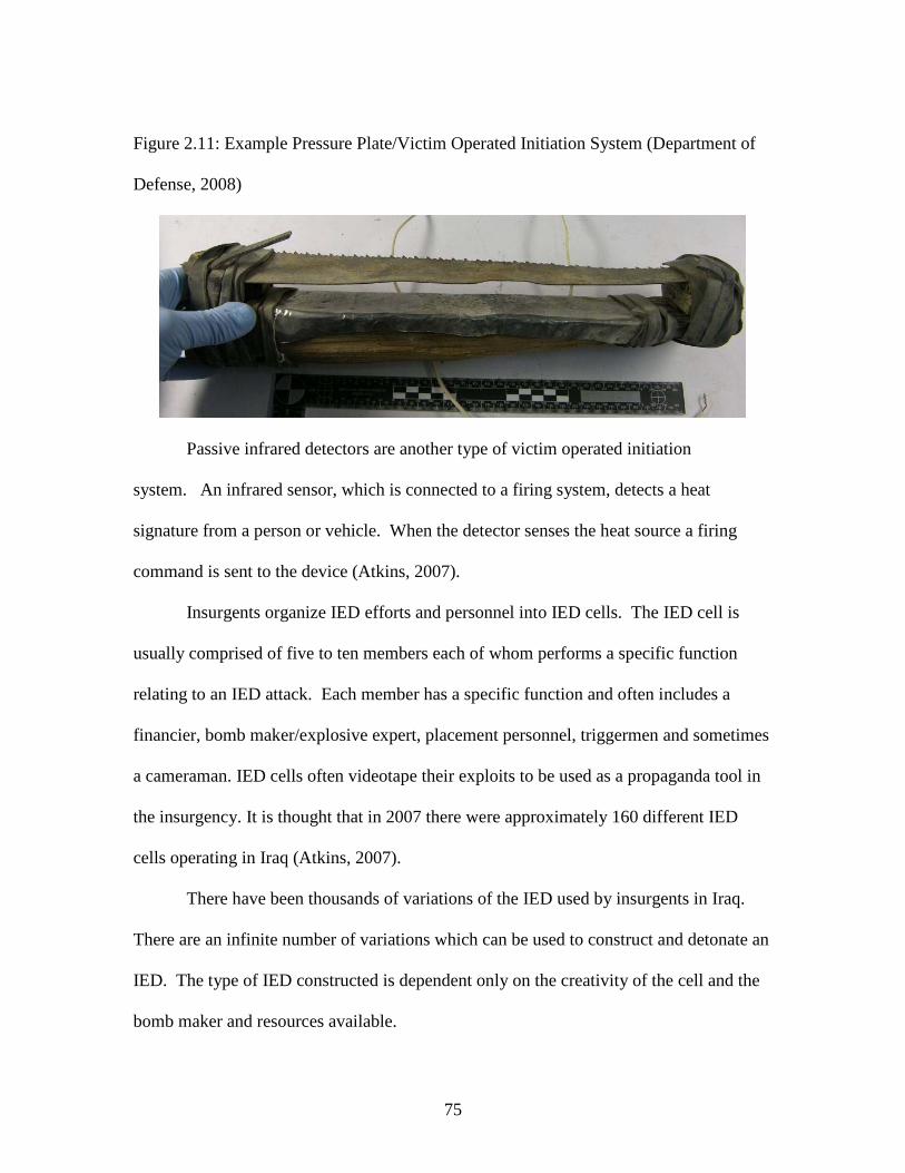
75
Figure 2.11: Example Pressure Plate/Victim Operated Initiation System (Department of
Defense, 2008)
Passive infrared detectors are another type of victim operated initiation
system. An infrared sensor, which is connected to a firing system, detects a heat
signature from a person or vehicle. When the detector senses the heat source a firing
command is sent to the device (Atkins, 2007).
Insurgents organize IED efforts and personnel into IED cells. The IED cell is
usually comprised of five to ten members each of whom performs a specific function
relating to an IED attack. Each member has a specific function and often includes a
financier, bomb maker/explosive expert, placement personnel, triggermen and sometimes
a cameraman. IED cells often videotape their exploits to be used as a propaganda tool in
the insurgency. It is thought that in 2007 there were approximately 160 different IED
cells operating in Iraq (Atkins, 2007).
There have been thousands of variations of the IED used by insurgents in Iraq.
There are an infinite number of variations which can be used to construct and detonate an
IED. The type of IED constructed is dependent only on the creativity of the cell and the
bomb maker and resources available.

76
CHAPTER 3: RESEARCH METHODOLOGY
Introduction
As described earlier the overall research project identifies and analyzes specific
variable relationships related to an IED incident with the aim of effectively combining
the principles of Fault Tree modeling, Geographic Information Systems (GIS),
simulation, and military doctrine to present a Fault Tree based process which can be used
to anticipate IED activity. The information learned will be consolidated into a multi-step
IED prediction process which can be applied to any threat force and region in the world.
This chapter explains the methodology as well as the anticipated end result of this
study. This study is conducted with intent of developing a framework which can
eventually lead to the anticipation of IED locations by development of a Fault Tree based
process for analyzing IED activity. The information included in this study is presented
for consideration and further development by those organizations interested in IED threat
prediction and which possess the data and resources to fully validate and utilize the
concepts contained in this study.
Research Questions and Hypotheses
This research will be presented in two phases relating to three specific objectives:
(1) identification of IED variables and variable relationships, (2) integrating threat data
with the a Fault Tree model and visualization assets, and (3) development of a process
which can be used by decision makers involved with C-IED operations to understand
threat activity and identify potential threat locations.

77
The Fault Tree Model is the foundation for this research and the model in which
all related activities are based. The Fault Tree will illustrate the interaction of identified
variables, provide a platform from which to integrate threat information and incorporate
visualization software, and is the baseline entity from which a decision support process is
developed. The information derived from this research is presented with suggested
implementation guidance intended to describe to those associated with C-IED operations
how to fully utilize and understand the real world application of the concepts and theories
addressed in this dissertation.
This research project will prove or disprove three separate hypotheses relative to
the use of the Fault Tree Failure Model, the locations of Improvised Explosive Devices,
and the use of visualization assets in threat prediction. These hypotheses are subjective
in nature.
The first hypothesis (the details of this hypothesis have been removed for
purposes of publication) is associated with establishment of identifiable variables and
variable relationships between specific events associated with a successful IED incident
against a military vehicle on a road. Through the establishment of these variables and
relationships information can be obtained which will allow for the identification of IED
locations. H1o represents the first null hypothesis where H1a represents the first
alternative hypothesis. IEDV represents IED variables and IEDL represents decision IED
locations.
H1o: IEDV = IEDL
H1a: IEDV ≠ IEDL

78
The second hypothesis is that a Fault Tree based model can be used as a decision
support tool in C-IED operations and in the prediction of IED activity. Specifically,
employment of a Fault Tree based process can serve as an effective decision support tool
with multiple applications including anticipation and identification of IED activity and
locations. The null hypothesis for this question can be stated as a Fault Tree model
equals a beneficial IED decision support tool. The alternative hypothesis can be written
as a Fault Tree model does not equal a beneficial IED decision support tool. For this
hypothesis H1o represents the first null hypothesis where H1a represents the first
alternative hypothesis. FTM represents the Fault Tree Model and DST represents
decision support tool.
H1o: FTM = DST
H1a: FTM ≠ DST
The third hypothesis is presented to determine the effectiveness of various
visualization assets in the identification of IED locations and evaluate their utility in C-
IED operations. It is also intended to help guide research activities. It is believed that a
visualization tool can be integrated with the Fault Tree in an effective manner to provide
clear and understandable information relative to threat locations. Specifically when
required, visualization platforms can be us in conjunction with the Fault Tree to translate
data into a visually recognizable location. The null hypothesis for this question can be
stated as visualization assets can be integrated with a Fault Tree to visualize anticipated
IED locations. The alternative hypothesis can be written as visualization assets can not
be integrated with Fault Tree to visualize anticipated IED locations. For this hypothesis

79
H1o represents the first null hypothesis where H1a represents the first alternative
hypothesis. VFT represents the integration of visualization platforms and Fault Tree and
AIEDL represents anticipated IED locations.
H1o: VFT = AIEDL
H1a: VFT ≠ AIEDL
Design of the Research
It is emphasized that this research is theoretical and general in nature using a
hypothetical data set as well as information collected through open source channels such
as the internet, journals, books, and articles. Due to the sensitive nature of IED incident
information real world data from Iraq and Afghanistan cannot be used. No classified or
official information is used.
Phase 1: Fault Tree Development: This phase provides the foundation of this
research and is dedicated to the detailed analysis and of the IED threat. This provides the
foundation from which all IED research is based and is essential to understanding IED
activity.
A Fault Tree Failure Model is used to identify and understand the variables and
the relationship between the variables which are present during an IED attack.
Specifically, a Fault Tree Failure Model will be developed which will identify the
variables present for a failure to take place. In this case a failure is defined as an IED
attack against a military vehicle on a road network. Information pertaining to the
specifics of each attack can be analyzed, integrated, and compared to threat data in order

80
to anticipate threat activity and can be effectively used as a decision support tool for
those involved in C-IED operations.
As discussed in the Literature Review section the Fault Tree will describe the
interaction (through the use of “and gates” / “or gates”) of variables present during a
failure. By understanding the components necessary for an IED incident to occur, Fault
Tree principles, and variable interaction it will be possible to create a Fault Tree that
illustrates a top down description of what events and components must be present for a
failure to occur. This will be developed as a logical framework constructed by focusing
on the question, in order for this event to take place, what must happen?
Once the basic Fault Tree is created, numerical probability information specific to
each variable can be integrated into the Fault Tree and the minimal cut set will be
determined. The minimal cut set will be determined through the principles of Boolean
Algebra and with the assistance of a computer program called Relex Architect. Relex
Architect aides in the graphical representation of a Fault Tree and the computation of
complex minimal cut sets. The minimal cut set will determine the overall probability of a
failure for specific criteria as well as illustrate which combination of variables has the
highest probability of contributing to an overall event.
Phase 2: Implementation Guidance: Once the Fault Tree is complete a process
will be developed to serve as employment guidance on how to use the Fault Tree as a
decision support and threat prediction tool. Phase 2 is described in two sections: Phase
2(A) Process Overview, describes a general process for using the Fault Tree model in C-
IED operations. Phase 2(B) Theoretical Case Study, utilizes a hypothetical scenario to

81
illustrate described process and integration of threat data with the Fault Tree and
visualization assets.
Since real-world IED attack information is not available a hypothetical data set is
presented to provide numerical information to illustrate the variable analysis process.
The data set is created by identifying several theoretical IED attack locations in the city
of Richmond Hill, Georgia. Richmond Hill was selected as it provides the author an
opportunity to test the feasibility of the proposed data collection techniques and
requirements.
Visualization assets are included to illustrate a method of translating threat data
and Fault Tree exposure information into visually identifiable areas. Two visualization
software packages are used in this study. The transportation simulation software package
Paramics and the GIS package ArcInfo. The visualization models are intended to provide
clarity to the process and allow for easier interpretation of location information.
Summary of Research Methodology
The two research phases of this dissertation are intended to illustrate a new way of
analyzing the IED threat by utilizing a Fault Tree Failure Model to understand the IED
environment, identify variables present during an IED incident, as well as the interaction
and relationship of identified variables. Once the variables have been identified, the
relationship established, a process is developed to describe how the proposed concepts
can be used as a decision support tool to anticipate IED activity and threat locations.
The proposed process is intended for consideration and use by those engaged
Counter-IED activity.

82
Due to the sensitive nature of real-world IED data only unclassified open source
data was used. This study is intended to provide a description and framework for
ultimate validation by those with the resources and information available to fully test the
suggested process. It is strongly believed that the theories described in this research
initiative are worthy of consideration and further development.

83
CHAPTER 4: ANALYSIS OF RESEARCH AND FINDINGS
The information contained in this chapter has been removed to allow for open
publication.

84
CHAPTER 5: CONCLUSIONS AND RECOMMENDATIONS
The information contained in this chapter has been removed to allow for open
publication.

85
APPENDICES
The information contained in this section has been removed to allow for open
publication.

86
REFERENCES
American Association of State Highway Officials. (2004).A Policy on Geometric Design of Highways and Streets. Washington D.C.: American Association of State Highway Officials,. Armed Conflict Events Data, (2003) Algerian War of Independence 1954-1962 Web Site:http://www.onwar.com/aced/data/alpha/algeria1945.htm Atkins, R. (2007). Left of Boom: The Struggle to Defeat Roadside Bombs. Washington. Washington Post. (A Five Part Story Ran in the Washington Post Sept-Oct) Australian Department of Defense. (2008). Improvised Explosive Device (IED) Fact Sheet. Retrieved from Official Australian Department of Defence Publications Website: http://www.defence.gov.au/publications/IED_Fact_Sheet Australian War Memorial (2007). Australia and The Boer War, 1899-1902. Web Site: http://www.awm.gov.au/atwar/boer.htm Ball, P. (1996). Introduction to Discrete Event Simulation. Proceedings from the 2nd DYCOMANS workshop on Management and Control, Algarve, Portugal. Retrieved April 7, 2007, from University of Strathclyde Department of Design Manufacture & Engineering Management Web Site: http://www.dmem.strath.ac.uk/~pball/simulation/simulate.html Baijal, R., Arora, M. K., & Ghosh, S.K., (2008) A GIS Assisted Knowledge-Based Approach for Military Operations. Geomatics Engineer Section, Department of Engineering, Indian Institute of Technology Roorkee. Retrieved: http://www.gisdevelopment.net/application/military/overview/militaryo0001pf.htm Banks, J., & Carson, J.S. (1986). Introduction to Discrete-Event Simulation. Proceedings of the 1986 Winter Simulation Conference, (pp. 17-23). Benner, L., (1978). Five Accident Theories and Their Implications for Research. (Paper Presented at the Joint International Meeting of the American Association for Automotive Medicine and the International Association for Accident and Traffic Medicine Ann Arbor MI 10 July 1978) [Online] Available: http://www.iprr.org/THEORY/Ann Arbor78.htm Bernhardsen, Tor. (2002). Geographic Information Systems: An Introduction. New York John Wiley & Sons

87
Brenner, L., (1975). Accident Investigations: Multilinear Events Sequencing Methods. Journal of Safety Research, 7 [Online], 1-9 Retrieved: http://members.cox.net/lbjr05/papersa/MES75.htm Chowdhury, M. (1995).Accident Analysis Using Fault Tree and Multi-Objective Analysis. A Report Prepared for the Federal Highway Administration. Chowdhury, M., (2006). Safety and Security in ITS. (Class Notes, Clemson University Fall 2006). Chowdhury, M., Garber, N., and Li,D., (2000). An Interactive Multiobjective Resource
Allocation Methodology for Highway Safety Improvements. ASCE Journal of Infrastructure Systems, Volume 6 Number 4, 134-144.
Connelly, M. (2004). A Diplomatic Revolution: Algeria’s Fight for Independence and the Origins of the Post-Cold War Era. Strategic Insights, Volume III, Issue 2 (February). Craig, D. C. (1996). Extensible Hierarchical Object-Oriented Logic Simulation with an Adaptable Graphical User Interface. Retrieved April 7, 2007, from Memorial University of Newfoundland, Department of Computer Science Web Site: http://www.cs.mun.ca/~donald/msc/thesis.html Delaney, Julie. (1999). Geographic Information Systems: An Introduction. Melbourne Aulstralia. DeMers, Michael N. (1997). Fundamentals of Geographic Information Systems. New York. John Wiley and Sons Inc. Edwards and Kelcey, Inc. (2007). Edwards and Kelcey Massena Border Crossing Operational Analysis. Retrieved April 7, 2007, from Paramics webpage Web Site: http://www.paramics-online.com/projects.php Contact information: ekcorp.com Engel, J, (2003). The Missile Plains: Frontline of America’s Cold War. (Historic Resource Study, Minuteman Missile National Historic Site, South Dakota) [Online], 1-90 Retrieved: http://www.nps.gov/archive/mimi/history/srs/hrs.htm Environmental Systems Research Institute. 1992. Understanding GIS: The Arc/Info Method. Redlands, CA: Environmental Systems Research Institute. Retrieved: http://www.ciesin.columbia.edu/docs/005-331/005-331.html Ericson II, C. (1999). Fault Tree Analysis-A History. (Proceedings of The 17th International Safety Conference) [Online], 1-9 Retrieved:http://www.fault-tree.net

88
FM 3-24 (MCWP 3-33.5) (2006). Counterinsurgency. Published by Headquarters Department of the Army and Headquarters Marine Corps Combat Development Command. Fries, R (2007). Evaluating the Impacts of Accelerated Incident Clearance Tools and Strategies by Harnessing the Power of Microscopic Traffic Simulation. Unpublished doctoral dissertation, Clemson University, South Carolina. Hamlin, C., Fries, R., Chowdhury, M., Yongchang, M., & Ozbay,K. (2007). Incident “Quick Clearance” Legislation: Will it Effectively Reduce Congestion? Transportation Research Board 2007 Annual Meeting Hammes, T. (2005). Insurgency: Modern Warfare Evolves into a Fourth Generation. Institute for National Strategic Studies, National Defense University. No. 214 January 2005. Hammes, T. (2006). The Sling and the Stone: On War in the 21st Century. Minnesota: Zenith Press. Hardin, M. J., Cornerly, M., Watkins, W. (2002). Traffic Safety Analysis: A Data Mining Approach Tuscaloosa Alabama, The University of Alabama, Department of Information Systems, Statistics and Management Science Web Site: http://neptune.galaxy.gmu.edu/interface/I03/I2003Proceedings/Conerly Michael/ConerlyMichael.paper.pdf Headquarters, Department of the Army.(1994). FM 34-130 Intelligence Preparation of the Battlefield. Washington, D.C.: Headquarters Department of the Army. Ingalls, R.G. (2002). Introduction to Simulation. Proceedings of the 2002 Winter Simulation Conference (ISBN: 0-7803-7615-3) (pp. 7-16). JIEDDO. (2008) Definition of IED obtained from the Joint IED Defeat Organization Website: https://www/jiedo.dod.mil/CIEDTECHNOLOGY/CIEDTECHHOME. ASPX. Joshua, S., & Garber, N. (1992). A Causal Analysis of Large Vehicle Accidents Through Fault Tree Analysis. Risk Analysis, 12 173-187 Khan, A.M., Al Kathairi, A.S., & Garib, A.M., (2008). A GIS Based Traffic Accident
Data Collection, Referencing and Analysis Framework for Abu Dhabi. Abu Dahbi, United Arab Emerits. Parsons Brickerhoff International Inc.

89
Klefstad, R., Zhang, Y., Lai, M., Jayakrishnan, R., & Lavanya, R. (2005). A Scalable, Synchronized, and Distributed Framework for Large- Scale Microscopic Traffic Simulation. Intelligent Transportations System Society (IEEE) (Paper Number: TB6.4). Web Site: https://its.papercept.net/conferences/scripts/abstract.pl?ConfID =15&Numer=296 Kuzminski, P., & Eisele, J.S. (1995). Improvement of Highway Safety I: Identification of Causal Factors Through fault-Tree Modeling. Risk Analysis,15 293-312 Langley, L. (2002). The Banana Wars: United States Intervention in the Caribbean, 1898-1934. Delaware: Scholarly Resources Inc. Lee, D., Chandrasekar, P., & Long, C.R.. (2001). Customized Simulation Modeling Using Paramics Application Programmer Interface. IEE Intelligent Transportation Sstems Conference Proceedings- Oakland (CA) August 25-29, 2001, (pp. 842-847). Leftwich Consulting Engineers (2007). Leftwich Consulting Engineers Miami Downtown Project Retrieved April 7, 2007, from Paramics webpage Web Site: http://www.paramics-online.com/projects.php Contact information: Dr. Scot Leftwich http//www.lce-fl.com Levine, Haninah. (2006). Improvised Response; Combating IEDs Will Require an Agile Game of Action and Reaction. Bulletin of Atomic Scientist. July/Aug. 2006: 22-23. Lewicki, P., Hill, T., (2007). Statistics Methods and Applications. Electronic Textbook available through Statsoft Inc. Web Site: http://statsoft.com/textbook/stcart.html Lewis, R. J. (2000). An Introduction to Classification and Regression Tree (CART) Analysis. Paper presented at the Annual Meeting of the Society for Academic Emergency Medicine, San Francisco, CA. Loh, W., (2006). Logistic Regression Tree Analysis. Madison Wisconsin: University of Wisconsin, Department of Statistics Web Site: http://www.stat.wisc.edu/~loh/treeprogs/lotus/springer.pdf Lovelace, James J. and Joseph L. Votel.(2004). The Asymmetric Warfare Group: Closing the Capability Gaps. Army Magazine March.WebSite:http://www.army.mil/ professional writing/volumes/volume3/april_2005/4_05_4_pf.html>

90
Mohan, S. & Elango, K., (2003) Evaluation of Risk In Canal Irrigation Systems (Proceedings. IEEE International Conference). Industrial Informatics 21-24 Aug. 351- 357 [Online] Available: http://ieeexplore.ieee.org/iel5/9109/28887/01300353.pdf Negroponte, John D. “Annual Threat Assessment of the Director of National Intelligence”. Unclassified Statement for the Record, Senate Select Committee on Intelligence. 11 Jan 2007. Retrieved:http://www.fas.org/irp/congress/2007_hr/011107negroponte.pdf Ogle, J.H., (2005). Quantitative Assessment of Driver Speeding Behavior Using InstrumentedVehicles. Georgia Institute of Technology Quadstone Limited.(2001), Quadstone Paramics V5.2 Modeller User Guied. Scotland: Quadstone Limited. Quadstone Paramics (2007). Paramics Online Product Brochure. Retrieved April 7, 2007, from Paramics webpage Web Site: http://www.paramics-online.com/ParamicsBrochure.pdf Quinn, X., Lin.W., (2005). Safety Performance Measure in the Urban Regional Transportation Plan. Paper prepared for Transportation Research Board 85th Annual Meeting. Submitted to ADA20 Committee. Riley, J., (2007). A Counter-insurgency Classic Back in Print. (A review of A Savage War and Peace: Algeria 1954-1962 By Alistair Horne) Marine Corps Gazette (May) Ryan, G., Bell, L.C., Back, W.E., (2008). Critical Activities in the Front-End Planning Process. Journal of Management in Engineering (April) Roess, R., Prassas, E., & McShain, W. (2004). Traffic Engineering Third Edition. New Jersey: Pearson Prentice Hall. Satyanarayana, P., & Yogendran, S., (2002). Military Applications of GIS. GIS Consultants & Editorial Associate. India.Retrieved:http://www. gisdevelopment.net/application/military/overview/militaryf0002pf.htm Seila, A. F. (1995). Introduction to Simulation. Proceedings of the 1995 inter Simulation Conference, (pp. 7-12). Skipper, C.O. (2004). Analysis of Leadership Behaviors in the Construction Industry: Identification of Influences that Develop Top Performing Project Managers. A Doctoral Dissertation from the Graduate School Clemson University

91
Sklenar, J. (2007). Simulation. Retrieved April 24, 2007, from University of Malta, Computing Services Centre Web site:http://staff.um.edu.mt/jskl1/index Smith, Roger. (2001). Counter-terrorism Modeling and Simulation: A New Type of Decision Support Tool. Signal Magazine. December. Souleyrette, R., Strauss, T., Estochen, B.,& Pawlovich, M. (1998). GIS-Based Accident Location and Analysis System (GIS-ALAS) Project Report Phase 1. Report Submitted to Office of Transportation Safety Iowa Department of Transportation Submitted by: Iowa Iowa State University StatSoft, (2003).Classification and Regression Trees (C&RT). Retrieved on line: http://www.statsoft.com/textbook/stcart.html. Taber, R. (2002).War of the Flea. Virginia: Potomac Books Inc. United States (2006). Department of Defense. Office of the Assistant Secretary of Defense (Public Affairs). News Release. No. 695-06. Washington:20 July 2006. <http://www.defenselink.mil/ewlwAWA/2006/NR20060720-13495.html. United States Marine Corps (1940). Small Wars Manual. Washington DC: United States Government Printing Office United States (1981). Nuclear Regulatory Commission. Fault Tree Handbook. Washington D.C.: Systems and Reliability Research Office of Nuclear Regulatory Commission. United States Department of Defense. (2005). Picture of IED located on the internet from Official DOD News Release. Retrieved: http://www.defenselink.mil/news/Nov2005/ 20051109115418_11iraqb1-20051109.jpg Vanden Brook, Tom. (2007). “Signals Foil IEDs but Also Radios.” USA Today 23 Jan https://www.us.army.mil/suite/earlybird/Jan 2007/e2007012348226.html. Wai, S. Y. S., Long, C. R., & Der-Horng, L. (2004). A Laboratory Platform for Incident Management Simulation. Journal of the Institute of Engineers, Singapore, 44 (2), 55-72. Weber, M. (2007). The Boer War Remembered. Web Site: http:www.boer.co.za/boerwar/weber.html Wilkinson, L., (1992). Tree Structured Data Analysis: AID, CHAID, and CART. Paper presented at the Sawtooth/SYSTAT Joint Software Conference, Sun Valley ID.

92
Wilson, Tom.(2005). Improvised Explosive Devices in Iraq: Effects and Countermeasures. United States Washington. Congressional Research Service. The Library of Congress CRS Report for Congress. Order Code RS223330. Yongchang, M., Chowdhury, M., Fries, R., & Ozbay, K. (2007). Harnessing the Power of Microscopic Simulation to Evaluate Freeway Service Patrols. Transportation Research Board 2007 Annual Meeting (Paper Number:07- 3360).