Embed Size (px)
Citation preview
DEVELOPMENT CONTROL AND REGULATORY BOARD
13TH AUGUST 2015
REPORT OF THE CHIEF EXECUTIVE
COUNTY MATTER
PART A – SUMMARY REPORT
APP.NO. & DATE: (i) 2015/0177/04 (2015/VOCM/0060/LCC) – 18th February 2015 (ii) 2015/0178/04 (2015/CM/0059/LCC) – 18th February 2015 PROPOSAL: (i) Variation of condition application to enable the processing plant, clean water lagoon, settlement lagoons, pipes and conveyor system to be retained until 31st December 2021 (ii) Extension of sand and gravel workings, construction of a field conveyor and subsequent restoration to agriculture and water LOCATION: (i) Cadeby Quarry, Brascote Lane, Cadeby (ii) Land at Manor Farm, Newbold Verdon (Hinckley and Bosworth Borough) APPLICANT: Lafarge Tarmac Ltd MAIN ISSUES: Need and supply situation, impact on protected species
and the Manor Farm Meadow LWS, noise impacts on residential amenity, landscape impact and restoration.
RECOMMENDATION: PERMIT subject to conditions as set out in Appendices
A and B to the main report. Circulation Under the Local Issues Alert Procedure Mr. I. D. Ould, CC Mrs. R. Camamile, CC Officer to Contact Jennifer Saunders (Tel. No. 0116 305 7054) Email: [email protected]

DC®. BOARD 13/08/2015
PART B – MAIN REPORT
Planning History
1. Cadeby Quarry is an established sand and gravel quarry situated between the villages of Cadeby and Newbold Verdon. Sand and gravel extraction has been carried out at the site since 1964 under a number of planning permissions. In 1973 permission was granted for sand and gravel extraction from an area known as Becks Farm, north of Bosworth Road (permission no. 1973/4727/04). This area was worked in the 1970s and 1980s and has been restored to lower level agricultural land. In 1988 a further permission was granted for sand and gravel extraction to the north of the Becks Farm area.
2. In August 2005, a substantial mineral permission was granted (2005/0893/04), which enabled sand and gravel extraction from three additional areas: the Northern Working Area (near Newbold Verdon), the Western Working Area (adjacent to the A447 east of Cadeby) and the site of the former Brascote House (a derelict farm building).
3. The current extraction area to the south of Bosworth Road was approved in 2010 under planning ref. 2010/0554/04. This permission expires on 4th May 2018, by which point all mineral extraction operations should have ceased, all equipment and conveyors removed and the whole of the site restored to a suitable condition. These requirements also relate to the processing plant and silt lagoon areas. Location of Proposed Development
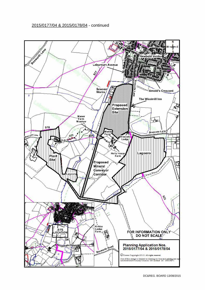
4. Cadeby Quarry is located approximately 6km north of Hinckley and 10km south of Ibstock. The existing site is 1.2km east of the A447 and 1.2km west of the village of Kirby Mallory. The closest settlement is Cadeby to the west and the surrounding land comprises largely agricultural fields.
5. The existing quarry processing plant, stocking area and quarry lagoons are located to the south of Brascote Lane. The current extraction area lies to the south of Bosworth Road and is connected to the quarry processing plant by a conveyor that passes under the road.
6. The proposed extension site is located to the north east of the existing quarry and lies to the south of Newbold Verdon and west of Brascote Lane. The nearest properties to the extension site include: Laburnum Avenue on the south side of Newbold Verdon; those around Manor Farm to the south of the site and The Windmill Inn public house on Brascote Lane.
7. The site is bounded to the north by woodland, to the east by Brascote Lane and to the west by a sewage treatment works and a hedgerow. A minor road forms the southern boundary of the site, together with Manor Farm, hedgerows and woodland. An electricity pylon is located towards the centre of the site.
8. ‘The site’ also includes the route of a proposed conveyor, which will connect into the existing conveyor system. The route of the conveyor passes through agricultural land to join the existing main conveyor.
DC®. BOARD 13/08/2015
2015/0177/04 & 2015/0178/04 - continued

DC®. BOARD 13/08/2015
2015/0177/04 & 2015/0178/04 - continued
Description of Proposal
Overview 9. Planning permission is sought to extend the mineral extraction area of Cadeby
Quarry. The proposed development provides for the extraction of between 341,000 and 420,000 tonnes of mineral. The extraction of mineral and restoration of the site would take place over a 2 to 3 year period. The restoration scheme provides for low-level restoration to agriculture, woodland and ponds using overburden from the site.
10. Mineral extracted from the extension area will be transported by conveyor back to the existing processing plant site and will make use of the existing settlement lagoons and associated infrastructure. Plant used for the extraction of mineral will access the site by means of an existing agricultural access off Brascote Lane.
11. Planning permission is also sought to retain the existing plant site, clean water
lagoon, settlement lagoons, pipes and conveyor system beyond May 2018 so that they can be used to process sand and gravel from the Manor Farm extension area. The applicant is seeking to retain these features until 31st December 2021.
Development Phases / Methods of Working
Initial works: installation of mineral conveyor, footbridge and conveyor culvert, soil stripping and screen bund construction
12. Prior to extraction operations commencing, existing hedgerows will be removed,
and the existing field conveyor system will be extended due north, for a distance of about 1300m, into the proposed extraction site. Soils will be stripped from a 10m wide corridor along the route and placed alongside the corridor. Hardcore/ballast will then be placed to provide a base upon which the conveyor trellis sections will be laid.
13. A stepped crossing will be installed over the conveyor where it crosses the footpath and a culvert/tunnel will be installed under the bridleway. Spoil from these works will be used to infill an area of uneven ground immediately to the north of the bridleway. During these works both the footpath and bridleway will be maintained and available for use by walkers and horse riders.
14. The route of the proposed conveyor extension initially crosses previously
restored land that comprises, in the main, agricultural land. Further north, closer to Manor Farm, it crosses mainly fields laid to pasture, including a short section through one which is a Local Wildlife Site (LWS). Where the conveyor and service road cross the LWS a different construction technique will be used to minimise potential impacts upon the ecology of the site. Soils will be stripped and stored in bunds no more than 3m high on previously worked land to the south. Terram or similar geotextile matting will be laid along the route of the conveyor and service track prior to the placing of ballast to form a firm base.
15. Mineral will continue to be processed at the current processing plant site and will
make use of the existing clean water lagoon and silt lagoon system. Proposed

DC®. BOARD 13/08/2015
2015/0177/04 & 2015/0178/04 - continued production rates will remain as current (about 170,000 tonnes per annum (tpa)). Processed sand and gravel will continue to be taken off site from the processing area by HGVs using the established existing access onto the main A447 Hinckley Road.
Phase 1A
16. Topsoil will be stripped from Phase 1A and 1B and placed in 3m high screen
bunds around the initial extraction areas. These bunds will be grassed, fenced with stock-proof fencing, grazed and maintained until required for site restoration.
17. Extraction will commence in the northernmost part of the site and generally progress southwards. The main conveyor will initially be extended to its maximum length and shortened as work progresses. Extraction operations within Phase 1A are anticipated to last approximately 5 months.
18. Clay interburden/overburden will be extracted and used to form a 4-5m high
screen bund located behind topsoil screen bunds. This bund will also be grassed.
19. During mineral extraction in Phase 1A, a quarry sump will be formed at the western margins. Clean water will be fed from the sump to the Thurlaston Brook flowing approximately 150m to the west. Phase 1B
20. Mineral extraction will progress southwards. Clay interburden/overburden
extracted from Phase 1B will be placed directly into the restoration void within Phase 1A. A replacement quarry sump will be formed during the mineral extraction works.
21. During the latter stages of working, topsoil will be stripped from Phase 2A and used to construct 3m high grassed screen bunds at the southern margins of the extraction site and to the west of the main field conveyor. Extraction operations within Phase 1B are anticipated to last approximately 7 months. Phase 2A
22. Clay interburden/overburden from Phase 2A will be placed directly into the Phase 1B and 2A restoration voids. During the latter stages of working, topsoil will be stripped from Phase 2B and placed directly over the graded restoration profiles within Phase 1B and 2A.
23. Stored clay and soil bunds at the northern margins of the site will be dismantled and used to complete the restoration of Phases 1A and 1B. Extraction operations within Phase 2A are expected to last approximately 7 months.
24. A water body will be formed at the western margins of the site. This will drain
surface water to the Thurlaston Brook to the west via an overflow ditch.
25. The soil screen in front of The Windmill Inn will be removed at this stage.

DC®. BOARD 13/08/2015
2015/0177/04 & 2015/0178/04 - continued
Phase 2B
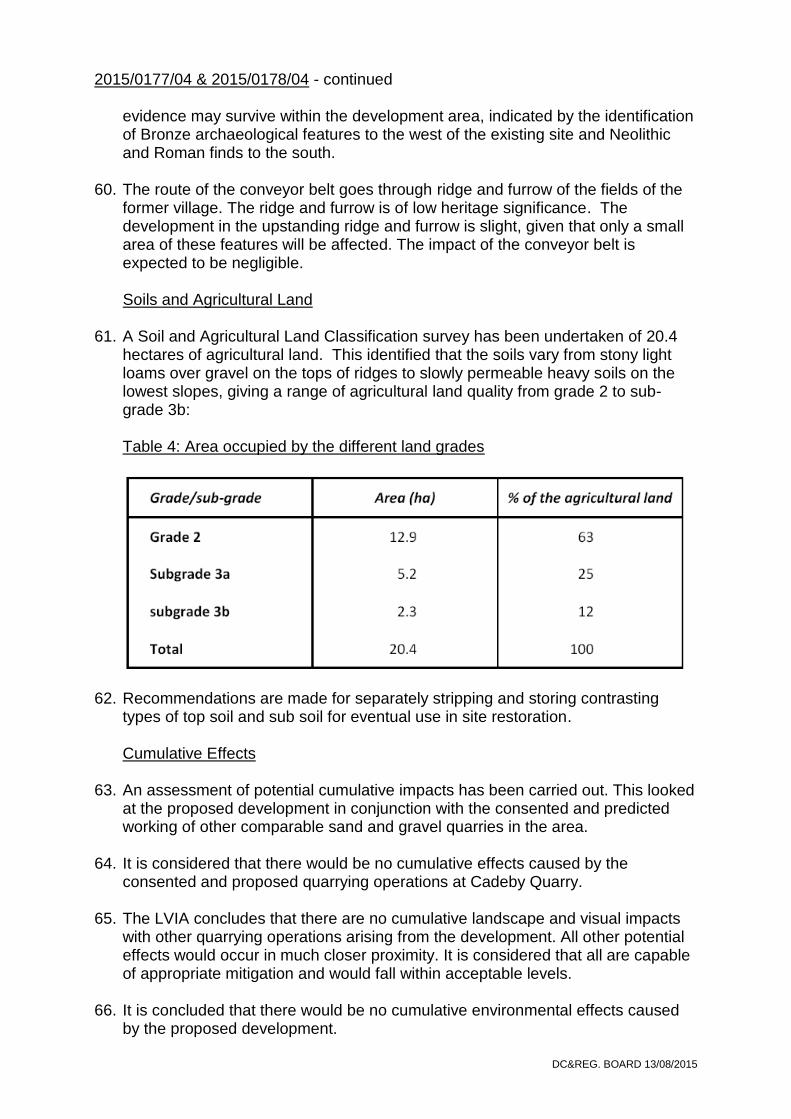
26. The final phase of working will coincide with deposition of clay interburden/overburden within Phases 2A and 2B. Following completion of mineral extraction, localised grading of the extraction margins and clay infill will be carried out and stored soils will be placed to achieve the restoration profiles. Extraction operations within Phase 2B are anticipated to last approximately 3 months. Final Restoration
27. The site will be restored to a mixture of agriculture, hedgerows, woodland and a
water body. The landform has been designed to provide adequate agricultural drainage with gradients typically ranging from 1:8 to 1:60. A shallow valley feature has been incorporated to facilitate this, allowing surface water drainage to the new water body. Gradients steeper than 1:8 are less suitable for use by agricultural machinery and will be planted with trees. These will occur mainly in close vicinity to the water body and will be linked by hedgerows to the wider network of habitats in the locality.
28. The restored landform would be achieved using only site derived materials. No imported material would be required.
Hours of Operation
29. Hours of working would be the same as for the existing quarry: 0700-1800 hours
Monday to Friday and 0700-1400 hours Saturday. There would be no working on Sunday or Public/Bank Holidays. However, where workings approach within 100m of The Windmill Inn or Brascote Lodge, reduced working hours will apply, as set out in paragraph 56 of this report. Transport
30. All mineral from the extension area will be transported to the existing plant site by conveyor. The existing plant site has been in operation for many years and is served by a short access road that leads directly onto the A447 Hinckley Road.
31. There is an existing agricultural access from Brascote Lane at the southern end of the application site, which will be used for daily access by the quarry operative (1 vehicle) and the occasional delivery/removal of items of mobile plant. Rights of Way
32. The development proposes the construction of a conveyor that will cross public footpath S24 and bridleway S25 to the west of Manor Farm.
33. A footbridge with hand rails and appropriate signing will be provided to allow walkers on footpath S24 to cross over the conveyor. A short length of permissive path will also be provided, which will link with the bridleway to the north for those who do not want to use the footbridge. A tunnel will be constructed beneath bridleway S25, which will require a temporary short term closure or diversion of

DC®. BOARD 13/08/2015
2015/0177/04 & 2015/0178/04 - continued the bridleway while the tunnel is excavated. Once these proposed works are completed, it will allow continued use of the rights of way in the vicinity of the site throughout the development. Environmental Statement
34. The planning application is accompanied by an Environmental Statement (ES)
which provides detailed assessments of: ecology; hydrology and hydrogeology; landscape and visual amenity; noise; archaeology; and agricultural land. A summary of the impact of the proposed quarry development identified in the ES, together with proposed mitigation and any compensation measures is set out below.
Ecology
35. A Phase 1 Habitat Survey, Hedgerow Evaluation and Grading System (HEGS)
Assessment and Protected Fauna Survey has been carried out.
36. The assessment confirms that there are no statutory designations within the site.
37. A walkover survey identified the following habits on or adjacent to the application site: arable fields; improved grassland; hedges and trees, native species poor, intact; fencing; and running water.
38. The survey area and immediate surrounding area was thoroughly searched for
the presence of the following protected species:
Species Comments
Badger There is a healthy badger population in the area around the quarry and the proposed extension area. There will be no material impact on the badger populations as the development does not result in the loss of significant setts, foraging grounds or impede access to the latter. A sett identified in Phase 1B would be closed under Licence from Natural England when that phase was being implemented.
Water vole, otter & crayfish
The small ditch identified centrally within the site provides no suitable habitat for these species. Therefore, no suitable habitat within the survey area.
Great crested newts
A number of ponds and lagoons were identified within 500m of the survey area. The application site is existing arable and grazing land with little suitable terrestrial habitat for great crested newts (GCN). No records of GCN or any other amphibians within 100m of the site.
Bat roosting potential
Two oak trees within the survey area were assessed as having bat roosting potential – a dusk emergence survey did not identify a bat roost in either tree. Therefore, works to these trees will have no impact on roosting bats.
Bat foraging potential
Some foraging potential due to hedgerows forming linear features.

DC®. BOARD 13/08/2015
2015/0177/04 & 2015/0178/04 - continued
Schedule 91 invasive species
No species identified
Nesting birds Vegetation provides opportunities during the nesting season. During the site visits, numerous birds were seen in the hedgerows, trees and in the crops.
Reptiles Low potential habitat. No reptiles were identified during the survey.
39. The existing hedgerows along the application boundary would be retained and
protected throughout the duration of the development. However, seven internal hedgerows within the application area would need to be removed (identified as H1 – 7). Whilst none of these hedgerows have been assessed as being ‘of importance’ in accordance with the Hedgerow Regulations 2007, H1-5 and H7 are deemed to be of a moderately high to high ecological value and H6 of a moderate ecological value.
40. The ecological survey makes a number of recommendations, which includes the removal of hedgerows outside the nesting bird season and that the loss of hedgerows are compensated for by the planting of new hedgerows of a similar total length, structure and species composition and/or areas of woodland including native species during the reinstatement of the site.
Manor Farm Meadow Local Wildlife Site (LWS)
41. Manor Farm Meadow comprises 1.75ha of land and is noted for its species rich
mesotrophic (neutral) and mixed (wet) grassland. It adjoins the south-western corner of the extension site. The proposed conveyor will pass through the eastern part of the LWS and the western tip of the adjacent grassland. The construction of the conveyor route through the LWS would involve the stripping and storage of soils and underlying substrate, and their replacement and re-establishment of disturbed grassland on decommissioning the conveyor.
42. The grassland survey of the LWS confirms that the route of the proposed conveyor is confirmed to be of high quality. Additionally, the adjacent grassland to the south of the LWS is assessed as being good quality, although the species present means it falls just short of meeting the minimum LWS criteria.
43. A mitigation plan has been submitted, which suggests a number of measures to
minimise harm to the LWS. These include stripping and storing separately the area with dry and damp vegetation and soil variants and fencing off the undisturbed grassland from the conveyor. If the mitigation is followed strictly, the grassland will be capable of re-establishment within 5 to 10 years resulting in no net loss of the grassland. The conveyor part of the development is therefore assessed as having a neutral impact on the LWS. Hydrology and Hydrogeology
44. A Hydrological and Hydrogeological Assessment has been undertaken, which
looked at the nature of, and interactions between, the groundwater and surface water systems operating at and around the site.
1 Of the Wildlife and Countryside Act 1981

DC®. BOARD 13/08/2015
2015/0177/04 & 2015/0178/04 - continued Surface water flow/levels
45. The extraction boundary falls within the catchment area of the Thurlaston Brook. The risk of fluvial flooding is confined to the narrow strip of land immediately adjacent to the Thurlaston Brook. There are no ponds within the proposed extraction area.
46. The proposed base of working in the majority of the extension area will coincide
with the base of the sand and gravel, which is generally about 4m below ground level. There are deeper pockets of mineral at the southern end of the workings (5m below ground level) and at the western margin close to the sewage treatment works (6-7m below ground level). Therefore, whilst approximately 1m of dewatering will be required across the majority of the site, 3 to 4m of localised and short-term dewatering is likely to be required to access the deepest sections of sand and gravel. This will have the effect of modifying existing groundwater flow patterns.
Local water supplies
47. The residents of Manor Farm and Holly House Farm fall within the predicted
160m radius of influence of dewatering drawdown (RIDD). However, the Applicant has already provided an alternative supply (mains water) for these properties, during mineral extraction to the south and east of these properties. All other water supplies are outside the predicted RIDD. For the allotment gardens to the east of Brascote Lane, the roots of the vegetables would not be expected to extend down to the water table. Therefore, quarry dewatering would not impact upon the crop. Manor Farm Meadow is alongside the south-western corner of the application site. Water levels in the meadow will already be lower than the proposed depth of dewatering and therefore quarry drawdown will not impact upon water levels in the meadow.
Groundwater quality
48. The operation of plant and machinery associated with extraction activities carries
the associated risk of pollutants entering the groundwater system. In the quarry context, pollutant risks are generally confined to accidental hydrocarbon spillage or leakage. The applicant is proposing a number of good-practice measures to ensure the risk of such a pollution incident is minimised, for example a fluid handling protocol, daily vehicle checks and sufficient oil absorbing material available.
Landscape and Visual Impact
49. A Landscape and Visual Impact Assessment (LVIA) has been undertaken, which
identifies that the application site is situated within the: National Character Area 71 – Leicestershire and South Derbyshire Coalfield Character Area; Regional Character Type – Upper Soar; and Hinckley and Bosworth Borough Council Character Area – Desford Vales.

DC®. BOARD 13/08/2015
2015/0177/04 & 2015/0178/04 - continued Effects on Landscape Character
50. The site is located in a rolling rural and agricultural landscape. The sensitivity of the site is assessed as ‘medium’ and potentially tolerant of the type of development proposed. The magnitude of impact during the development is assessed as ‘medium adverse’ given the nature of the landscape and operations proposed. The overall significance of effect is therefore assessed as ‘moderate adverse’. As the quarry is restored to an agricultural after-use with woodland and wetland conservation habitats, the landscape effects are predicted to improve to ‘moderate beneficial’.
51. There will be no physical or visual effect upon local conservation areas, listed buildings and scheduled ancient monuments. No ancient woodland will be affected by the development and there will be no effect upon the closest sites of scientific interest. Table 1: Comparison between existing and proposed elements within the extension site
Effects on Visual Amenity
52. The visibility of the site is influenced primarily by the combination of local topography and its location within a local landscape where woodland and hedgerows are influential in reducing views from local dwellings, roads and public rights of way. The assessment illustrates a 1km radius zone where the site might be theoretically visible. However, due to the presence of screening features, the zone within which the site is visible is much smaller and, particularly to the east and south, is defined by the site boundary. The existing quarry plant is located approximately 1km to the south west in an essentially agricultural landscape; there is no inter-visibility between the plant site and the site.
53. The assessment identified three categories of visual receptors: residents; road users; and visitors to the area.

DC®. BOARD 13/08/2015
Table 2: Predicted effects on visual amenity during operations
Receptor point
Comments Predicted effects
Brascote Lane, Newbold Verdon
Represents local Newbold Verdon residents and those travelling south along Brascote Lane. North-eastern corner of Phase 1A is visible. Majority of site partially screened by hedgerows, trees and residential buildings. Site topography screens Phases 1A and 1B to the south. View assessed as close distance and interrupted by screening elements.
Moderate Adverse
Water treatment works, access track
Represents residents in properties 80m to the north and on the southern side of Laburnum Avenue. Phase 1A is visible from properties to the north and first floors of Laburnum Avenue. Significant seasonal variation in the effectiveness of screening provided in trees to the north of phase 1A. View assessed as close distance and open (on the track) but also interrupted by screening vegetation.
Moderate / Major Adverse
The Windmill Inn
Fields to the west are screened by a 1.5m to 1.75m high boundary hedgerow. A field access onto Brascote Lane provides limited visibility through a 2.5m gap in the hedgerow. View assessed as close distance and interrupted at ground level but open at first floor level.
Moderate / Major Adverse
Brascote Lodge/Lane
Landscape to the north-west visible through occasional gaps in the mature boundary hedgerows that largely screen the site. View assessed as close distance and open/partially interrupted.
Moderate / Major Adverse
Holly House Farm Landscape to the west and north contained by trees and hedgerows. A mature hedgerow will provide a significant visual backdrop to the conveyor. View assessed as close and interrupted.
Minor / Moderate Adverse
Footpath S24 Site not visible at this location due to tree and hedgerow screening. Conveyor and conveyor tunnel would be visible. View to the conveyor is assessed as close and open.
Moderate / Major Adverse
Bridleway S25 Western boundary of Phases 2A and 2B and the conveyor link to the plant site would be visible. Majority of the site is screened by the rolling landform and hedgerows/trees.
Moderate / Major Adverse
Footpath S16 (south)
Southern section of the site (Phases 2A and 2B) is visible on rising ground. Development is partially screened by the existing hedgerow on its western boundary.
Moderate Adverse
Footpath S16 (north)
Majority of the site is screened at this location by the woodland, hedgerows and individual trees on the western boundary.
Moderate Adverse (winter) Negligible (summer)
54. The LVIA concludes that the development will have limited and short term
adverse effects upon landscape and visual receptors followed by moderate benefits to the developing green infrastructure in the local landscape.

DC®. BOARD 13/08/2015
2015/0177/04 & 2015/0178/04 - continued Noise
55. A Noise Assessment has been carried out, which considers the potential impact of the proposals at four receptors, which are considered to be situated in closest proximity to the proposed extension area. These are: Laburnum Avenue, Newbold Verdon; The Windmill Inn, Brascote Lane (commercial premises with no residential accommodation); Manor Farm / Holly House Farm; and The Lodge, Brascote Lane. All noise level predictions are ‘worst case’ and have been calculated with the combinations of plant working at the closest point to the assessment location.
56. During temporary operations, such as soil stripping and bund creation, the results show that noise levels are expected to remain within the Government’s recommended limit of 70dB(A) LAeq (free field). However, noise levels at The Windmill Inn are expected to be close to this limit at certain times and it is proposed to reduce the amount of plant and machinery when bund construction/removal is taking place within 50m. Additionally, a 100m zone surrounding The Windmill Inn and The Lodge will be delineated where there will be no Saturday working and operations will cease at 1700 hours Monday to Friday. Works within 100m of The Lodge will also not commence until 0800 hours Monday to Friday, given the residential nature of this property.
57. During normal extraction operations, noise levels are expected to remain within
the recommended limits at all identified noise sensitive properties. The mitigation measures outlined above in paragraph 56 will also apply during normal operations. Table 3: Recommended noise limits at identified noise-sensitive properties
Location Measured
Background Noise Level
Daytime LA90,1hr
Recommended Noise Limit (dB LAeq,1h) – Phase
1
Recommended Noise Limit (dB
LAeq,1h) – Phase 2
Recommended Noise Limit (dB
LAeq,1h) – Temporary Operations
Laburnum Avenue 39 52 49 56
Windmill Inn 40 55 52 70
Manor Farm / Holly House Farm
40 48 51 55
The Lodge 40 50 51 55
Archaeology
58. An Archaeological Desktop Assessment has been carried out, which concludes that the development is likely to have a severe impact upon the survival of buried archaeological remains associated with the former medieval hamlet of Brascote. The extraction area will impinge upon the north-western edge of the former village, while the proposed topsoil storage will further encroach upon the surviving earthworks.
59. The assessment also notes the presence of a rectangular fish pond to the west of the recorded house platforms; the latter lies within the extraction area and preserves the potential to contain rare waterlogged palaeoenvironmental and archaeological deposits. In addition to the medieval village, other archaeological
DC®. BOARD 13/08/2015
2015/0177/04 & 2015/0178/04 - continued evidence may survive within the development area, indicated by the identification of Bronze archaeological features to the west of the existing site and Neolithic and Roman finds to the south.
60. The route of the conveyor belt goes through ridge and furrow of the fields of the former village. The ridge and furrow is of low heritage significance. The development in the upstanding ridge and furrow is slight, given that only a small area of these features will be affected. The impact of the conveyor belt is expected to be negligible. Soils and Agricultural Land
61. A Soil and Agricultural Land Classification survey has been undertaken of 20.4
hectares of agricultural land. This identified that the soils vary from stony light loams over gravel on the tops of ridges to slowly permeable heavy soils on the lowest slopes, giving a range of agricultural land quality from grade 2 to sub-grade 3b: Table 4: Area occupied by the different land grades
62. Recommendations are made for separately stripping and storing contrasting types of top soil and sub soil for eventual use in site restoration. Cumulative Effects
63. An assessment of potential cumulative impacts has been carried out. This looked at the proposed development in conjunction with the consented and predicted working of other comparable sand and gravel quarries in the area.
64. It is considered that there would be no cumulative effects caused by the consented and proposed quarrying operations at Cadeby Quarry.
65. The LVIA concludes that there are no cumulative landscape and visual impacts
with other quarrying operations arising from the development. All other potential effects would occur in much closer proximity. It is considered that all are capable of appropriate mitigation and would fall within acceptable levels.
66. It is concluded that there would be no cumulative environmental effects caused
by the proposed development.

DC®. BOARD 13/08/2015
2015/0177/04 & 2015/0178/04 - continued Consideration of Alternatives
67. The applicant has considered three potential alternatives:
‘Do nothing’ – in such a scenario, a valuable mineral resource would not be worked. It is considered that the benefits of mineral extraction would outweigh any potential adverse effects, which could be monitored and mitigated against.
Alternate locations – mineral extraction can only take place where it is found and the proposed site is located in close proximity to the established working quarry. The operations at the site would also use the existing infrastructure. An alternative location is not considered practical in this instance.
Alternate method of working: the proposed method is well-established at Cadeby Quarry to ensure that the effects on the environment and residential amenity are minimised. An alternate method of working is not considered necessary.
Statement of Community Involvement
68. Lafarge Tarmac Ltd has carried out public consultations with local residents and statutory consultees about the proposed development. A public exhibition was held at the Newbold Verdon Methodist Church Hall in November 2014, which included display boards with plans and text detailing the planning proposals and projected timescales. The exhibition was staffed by employees and technical consultants representing the Company. The exhibition was attended by 40 local residents and twenty feedback forms were completed covering the following issues:
Water (potential water table impacts on nearby allotments and local watercourses);
Trees/hedgerows (potential loss and suggestion to retain more);
Footpath/existing lake (extend footpath along Brascote Lane and allow public access around the lake); and
Amenity (proximity to the village – potential noise impacts, concern that the land will not be restored, potential traffic impacts on local roads).
Planning Policy National Policy
69. The National Planning Policy Framework (NPPF) provides the government’s policies for the delivery of sustainable development through the planning system. It advocates a presumption in favour of sustainable development.
70. The NPPF recognises the essential role that minerals play in supporting sustainable economic growth and quality of life. It seeks to ensure that there is a sufficient supply of material to provide the infrastructure, buildings, energy and goods that the country needs. The NPPF also acknowledges that minerals are a finite resource and can only be worked where they are found.
71. The NPPF states, when determining planning applications, local planning
authorities should: give great weight to the benefits of the mineral extraction,

DC®. BOARD 13/08/2015
2015/0177/04 & 2015/0178/04 - continued
including to the economy; ensure that there are no unacceptable adverse impacts on the natural and historic environment and human health, and take into account any cumulative effects; ensure that any unavoidable noise, dust and particle emissions are controlled, mitigated or removed at source and establish appropriate noise limits for extraction in proximity to noise sensitive properties; provide for restoration and aftercare at the earliest opportunity to be carried out to high environmental standards, through the application of appropriate conditions.
72. National Planning Practice Guidance (PPG) provides additional guidance to
Authorities to ensure the effective implementation of the planning policy set out in the NPPF in relation to mineral extraction. It covers the following relevant matters: the proximity of mineral workings to communities; dust emissions; noise emissions; and restoration and aftercare.
73. The PPG advises on the control and mitigation of dust and noise emissions, and
establishes the use of noise limits for mineral extraction, providing a framework for the setting of noise standards. Maximum limits at noise sensitive properties during normal working hours, evening and night-time periods are given, together with higher limits for certain short-term activities.
74. The PPG seeks to implement the NPPF requirements to provide for the
restoration and aftercare of mineral sites at the earliest opportunity, carried out to high environmental standards. It advises on the use of reclamation conditions and aftercare schemes to achieve the desired after-use of the site following working.
Development Plan Policies
75. The Development Plan for the application site comprises the Leicestershire
Minerals Core Strategy and Development Control Policies (2009), the Hinckley and Bosworth Borough Council Core Strategy (2009) and the Hinckley and Bosworth Local Plan (2001).
76. Policy MCS1 of the Leicestershire Minerals Core Strategy aims to ensure an
adequate and steady supply of minerals. The strategy for aggregates (crushed rock and sand & gravel) contained in MCS2 is to meet the sub-regional apportionment and maintain a landbank of reserves in line with national policy. This is to be achieved either by releasing reserves of sand and gravel, worked as extensions to existing extraction sites to ensure a sustainable supply, or by allowing new aggregate extraction sites where it can be demonstrated that the landbank and production capacity cannot be maintained from existing sites and extensions to existing sites. MCS2 also seeks to allow proposals for aggregate extraction only where they would not cause unacceptable harm to the environment or communities. The Strategy also contains policies concerned with the protection of the environment (MCS11), transportation of minerals (MCS16) and the reclamation and after-use of mineral sites (MCS17).
77. The Minerals Development Control Policies contain a number of policies for use
in determining planning applications for minerals developments. These include the following: MDC1 (sustainable mineral development); MDC2 (sustainable design); MDC5 (countryside); MDC6 (landscaping and woodland); MDC7
DC®. BOARD 13/08/2015
2015/0177/04 & 2015/0178/04 - continued
(archaeology); MDC10 (agricultural land); MDC11 (the water environment); MDC12 (health and amenity); MDC13 (cumulative impact); MDC14 (transportation of minerals); MDC15 (public rights of way); MDC18 (planning conditions); MDC20 (reclamation and aftercare); and MDC21 (after-use).
78. The Hinckley and Bosworth Local Plan includes Policy NE5 (development in the
countryside) and NE7 (sites of County and Local nature conservation significance), which are of relevance.
79. The Leicestershire Minerals and Waste Local Plan (Consultation Draft) is being
consulted on currently (3rd July – 28th August 2015) and includes draft policies and proposals relating to the winning and working of minerals and waste management development in the County for the period to 2031. It includes a policy for the future location of sand and gravel operations. The site area the subject of this application has been put forward by the Applicant to be allocated in the Plan as a preferred potential future extraction site. Whilst the application site has been allocated in the emerging Plan, little weight can be given to this as it has not been tested through any formal consultation or examination at this stage. Consultations (2015/0177/04)
Hinckley and Bosworth Borough Council - Planning
80. The Borough Council raise no objection to the proposed retention of the
processing plant site, clean water lagoons, pipes and conveyor system until 31st December 2021, subject to the area being required for the stated purpose in association with the extraction of additional sand and gravel deposits to the north of the site and subject to planning permission being obtained for such extraction within a reasonable time period. Hinckley and Bosworth Borough Council – Environmental Health
81. No comments.
Newbold Verdon Parish Council
82. No comments.
Cadeby Parish Council
83. Response not received.
Peckleton Parish Council
84. Response not received.
Environment Agency
85. No objection.
DC®. BOARD 13/08/2015
2015/0177/04 & 2015/0178/04 - continued Natural England
86. No comments.
Highway Authority
87. The Highway Authority requests the same conditions and notes as those for permission no. 2010/0554/04.
Leicestershire County Council – Archaeology Advice
88. No comments.
Leicestershire County Council – Ecology Advice
89. No comments.
Leicestershire County Council – Landscape Advice
90. No comments.
Leicestershire County Council – Public Rights of Way Advice
91. No comments.
Leicestershire and Rutland Wildlife Trust
92. No comments. National Grid – Plant Protection
93. Response not received. Campaign to Protect Rural England (Leicestershire)
94. Response not received. Leicestershire Footpaths Association
95. Response not received.
Ramblers Association
96. Response not received. Consultations (2015/0178/04) Hinckley and Bosworth Borough Council - Planning
97. Hinckley and Bosworth Borough Council has no objection to the proposals subject to them being in accordance with Leicestershire County Council’s mineral
DC®. BOARD 13/08/2015
2015/0177/04 & 2015/0178/04 - continued policies, ecology policies and consideration of the comments raised by and imposition of conditions requested by the Borough Council’s Environmental Health Officer. Hinckley and Bosworth Borough Council – Environmental Health
98. No objections, subject to the imposition of conditions to control noise levels at the nearest sensitive properties. Newbold Verdon Parish Council
99. Whilst the Parish Council does not directly object to the proposals they are disappointed that there does not appear to be any provision or benefits for the village. There will inevitably be some disruption to villagers from noise and dust and it was suggested at the public exhibition that as some form of recompense the applicant could consider extending the public footpath on Brascote Lane up towards the Windmill public house. Whilst the application appears to acknowledge this, there is no mention of any contributions towards it.
Cadeby Parish Council
100. Response not received.
Peckleton Parish Council
101. Response not received.
Environment Agency
102. The proposed development will only meet the requirements of the National Planning Policy Framework if the measures detailed in the Flood Risk Assessment submitted with the application are implemented and secured by way of planning conditions on any planning permission. Natural England Wildlife and Countryside Act 1981 (as amended)
103. No objection, no conditions requested – this application is in close proximity to Botcheston Bog Site of Special Scientific Interest (SSSI). Natural England is satisfied that the proposed development being carried out in strict accordance with the details of the application, as submitted, will not damage or destroy the interest features for which the site has been notified. We therefore advise your authority that this SSSI does not represent a constraint in determining this application. Town and Country Planning (Development Management Procedure) (England) Order 2015
104. No objection, no conditions requested – the proposed development is unlikely to lead to significant and irreversible long term loss of agricultural land, as a
DC®. BOARD 13/08/2015
2015/0177/04 & 2015/0178/04 - continued resource for future generations. This is because the proposed restoration scheme has been designed to return as much of the site as possible to high quality agricultural land, as indicated in paragraph 6.98 of the Supporting Statement submitted as part of the application. Highway Authority
105. The Local Highway Authority’s advice is that, in its view, the residual cumulative impacts of the development are not considered severe in accordance with Paragraph 32 of the NPPF2.
106. The Highway Authority would normally have concerns in connection with a proposal that could lead to an increase in use of a substandard access. However, taking into consideration the existing potential for use as an agricultural access and the proposed use, the proposals will be acceptable to the Highway Authority, subject to a condition controlling the visibility splays. Leicestershire County Council – Archaeology Advice
107. The desk-based assessment submitted with the application concludes that the development is likely to have a severe impact upon the survival of buried archaeological remains associated with the former medieval hamlet of Brascote, apparently deserted by the mid-15th century. Previous earthwork survey of the site indicates that the extraction area will impinge upon the north-western edge of the former village, while the proposed topsoil storage will further encroach upon the surviving earthworks.
108. In addition to the medieval village other archaeological evidence may survive within the development area. The proposed extraction, subsoil storage and the works to establish the conveyor tunnel below the green land west of Manor Farm will destroy any evidence of archaeological remains within their limits.
109. It is therefore recommended that a comprehensive programme of archaeological
mitigation is secured by condition on any planning approval. This should entail LiDAR earthwork survey, geophysical survey of the application area (including extraction, spoil storage, conveyor belt, access and landscaping), trial trenching and subsequent targeted archaeological excavation. In the latter respect, the earthworks for the former medieval hamlet of Brascote, located in the southern part of the extraction area and also affected by the proposed topsoil storage area, represent the most obvious target for archaeological excavation prior to extraction. Leicestershire County Council – Ecology Advice
110. No objections, subject to the imposition of conditions to ensure that the specific proposals for mitigation and restoration of the Manor Farm Meadow LWS are controlled. As there is a large and active badger population locally, updated surveys should be provided during the development.
2 Paragraph 32 of the NPPF states that development should only be prevented or refused on transport
grounds where the residual cumulative impacts are severe.

DC®. BOARD 13/08/2015
2015/0177/04 & 2015/0178/04 - continued Leicestershire County Council – Landscape Advice
111. It is borne in mind that the proposed works are temporary and that the site will be restored within a 2-3 year timeframe. However, the following comments should be noted.
112. The results of the visual assessment are generally agreed with. The conclusion in Paragraph 9.11 of the LVIA that there would be ‘short term adverse effects upon the landscape and visual resources’ is generally agreed with, although the likely impacts would be moderate to major for the duration of the works.
113. The proposed protection of the boundary hedgerows and the specified 3.0m
standoff is satisfactory. In order to avoid any accidental breaches of the protected hedgerow areas, it is recommended that delineation posts are clearly visible. It is considered that the existing mature trees within the hedgerows and the individual isolated trees within the working area will require more robust protective fencing than delineation posts. With regard to the potential hydrological impact on the mature trees, in general, the most sensitive roots are located just beyond the canopy spread of the tree. A 1.0m stand-off beyond the crown of each individual/isolated tree is recommended. Leicestershire County Council – Public Rights of Way Advice
114. No objections, subject to the imposition of relevant conditions. Leicestershire and Rutland Wildlife Trust
115. The Wildlife Trust is satisfied that efforts have been made to minimise damage to the Local Wildlife Site grassland. The applicant has also indicated that it would be agreeable to the water feature in the application area being constructed to encourage natural colonisation of plant life, by not top-soiling a reasonably sized area around it. The water feature itself should not be planted. National Grid – Plant Protection
116. Response not received. Campaign to Protect Rural England (Leicestershire)
117. Response not received. Leicestershire Footpaths Association
118. Response not received.
Ramblers Association
119. Response not received.

DC®. BOARD 13/08/2015
2015/0177/04 & 2015/0178/04 - continued Publicity
120. The planning applications and accompanying environmental statement have
been publicised by a press notice in the Hinckley Times, site notices and neighbour notification letters on 27th February 2015.
121. Following the receipt of further ecological information and a supplementary LVIA, this information was publicised in the Leicester Mercury on 14th July 2015.
Representations Received
122. 10 representations have been received from local residents objecting to or raising concerns about the proposed development. Local residents raise the following concerns/comments:
Understand that best use of natural resources must be made, but hoped the applicant would give something to the community;
Requests that the Northern Working Area that has been restored to a lake at the southern end of Brascote Lane is made available for public use;
No additional vehicle movements on Brascote Lane;
Sink holes may appear as a result of quarrying;
Impact on property values;
Quarrying will affect drainage of properties and insurance should be provided by the quarry to cover this;
Very limited agricultural and green belt land surrounding the areas of Market Bosworth, Newbold Verdon and Kirkby Mallory;
Natural habitats and local wildlife will be destroyed by developing the lagoon areas;
Residents are already concerned about the regular bangs coming from the quarry, in order to extend the extraction sites;
The applicant has other sites that could be developed to the north-west of the County without interference of public amenities, highways and residential areas;
The application site is close to residential properties in Newbold Verdon and should be moved further away;
Potential noise and dust impacts;
Noise of the machines starting and alarms involved in the existing conveyor are noticeable. This is unacceptable and operations should not commence until 8am;
Large quarry vehicles will be passing through Newbold Verdon;
The quarry will remain unrestored;
Development will inhibit and inconvenience walkers using Brascote Lane. The footpath should be extended from where it currently stops, to link Newbold Verdon with the southern end of Brascote Lane; and
Impact on the landscape. It will be highly visible from the circular footpath that is very much used by local people. The conveyor plans to cross the bridleway that is used by horses.
123. 6 letters of support for the application have also been received. 5 of these are
from people currently employed at the quarry and one from the employee of a

DC®. BOARD 13/08/2015
2015/0177/04 & 2015/0178/04 - continued local business who uses the quarry daily. The letters of support make the following comments:
Employment – granting planning permission for a further extension will enable jobs to be retained;
Restoration of the land is carried out to a high standard; and
Consideration is given to the surrounding properties during site operations in terms of noise, dust and working plant times.
Assessment of Proposal
124. This proposal, like any other application, must be determined in accordance with the development plan unless material considerations indicate otherwise. In this case, it is appropriate to consider the following key matters: national policy background; Leicestershire Minerals Development Framework; the nature and need for the development; environmental impacts and other effects; and economic and other benefits. National Policy Background
125. The National Planning Policy Framework (NPPF) states that “Minerals are essential to support sustainable economic growth and our quality of life. It is therefore important that there is a sufficient supply of material to provide the infrastructure, buildings, energy and goods that the country needs. However, since minerals are a finite natural resource, and can only be worked where they are found, it is important to make best use of them to secure their long-term conservation.”
126. When determining planning applications, the NPPF states that local planning authorities should give great weight to the benefits of mineral extraction, including to the economy; ensure that there are no unacceptable impacts on the natural environment; ensure that any unavoidable noise and dust emissions are controlled, mitigated or removed at source; establish appropriate noise limits for extraction in proximity to noise sensitive properties; and provide for restoration and aftercare at the earliest opportunity. Leicestershire Minerals Core Strategy
127. A key function of the Leicestershire Minerals Core Strategy is to ensure an appropriate contribution to local, regional and national needs in line with the sustainable objectives for mineral development.
128. The strategy for the supply of minerals (Policy MCS1) is to release land for extraction where it is necessary to maintain an adequate and steady supply of minerals and it can be shown that demand could not be met from existing permitted reserves, having regard to sub-regional apportionment figures for aggregate minerals. The strategy also seeks to give priority to the extension of existing sites. In all cases, proposals will only be acceptable where they will not cause unacceptable harm to the environment or communities.

DC®. BOARD 13/08/2015
2015/0177/04 & 2015/0178/04 - continued Need for the Development Landbank
129. The County Council needs to be satisfied that a steady supply of minerals can be produced, and that its contribution to the regional/national aggregates provision can be met. In order to do so, the NPPF states that mineral planning authorities should make provision for the maintenance of landbanks of at least 7 years for sand and gravel.
130. Estimated permitted reserves of sand and gravel in Leicestershire as at the end of 2013 were around 9.03 million tonnes. This was sufficient permitted material to last 8 years at the end of 2013, based on the average rate of production over the last 10 years. Calculations published in the emerging Minerals and Waste Local Plan (Consultation Draft - July 2015) indicate that there would be a shortfall of approximately 10.95Mt of sand and gravel over the period up to 2031. Planning permission granted last month at Shawell Quarry (permission no. 2015/0295/03) has reduced this shortfall by 1 million tonnes and increased the current landbank to just over 7 years.
131. There are 5 sites currently active in Leicestershire, at Brooksby, Cadeby, Husbands Bosworth, Lockington and Shawell. The existing active sites have a total production capacity of around 1.7 million tonnes per annum, which means that they would be more than capable of providing sufficient material to satisfy the level of provision based on average sales of the last 10 years. Existing sites would not however be able to meet the County’s future requirements without the benefit of extensions to their currently permitted extraction areas. This means that additional land for the extraction of sand and gravel needs to be identified in order to ensure continuity of production to 2031.
Operational Need
132. The current permitted reserves at the site will be totally exhausted at current
output rates (approximately 170,000tpa) by December 2015. The proposed development would release up to 420,000 tonnes of additional reserve and ensure a continuity of supply of construction materials for a further 2-3 years.
133. In conclusion, in terms of meeting the requirements of Policies MCS1 and MCS2, it is considered that the need for additional reserves in terms of potential landbank and production capacity deficiencies has been sufficiently established. The proposed development would enable Cadeby Quarry to assist in maintaining an adequate and steady supply of sand and gravel in Leicestershire. Environmental and Other Effects
134. Policies MCS1 and MCS2 also require the consideration of proposals for aggregate extraction in terms of any unacceptable harm that may be caused to the environment or communities. This is a key consideration in determining proposals for mineral extraction, where the need for the development has to be balanced against the impacts that the proposal is likely to generate, including any

DC®. BOARD 13/08/2015
2015/0177/04 & 2015/0178/04 - continued mitigation and compensation of those impacts. These matters are considered below.
Ecology
Habitats
135. The dominant habitat throughout the application area is arable fields and
improved grassland, which have limited ecological value. Therefore, the loss of these habitats is considered to be a low impact.
136. The hedgerows on the site are of good conservation value as they provide good nesting and foraging habitats for birds and cover for other mammals and invertebrates. The seven internal hedgerows that will be removed are assessed as having good ecological value. The loss of these seven hedgerows will therefore have a high impact on the bird, mammal and invertebrate species that use these habitats, particularly as the majority of these adjoin existing hedgerows surrounding the application site and form linear features, which increases connectivity.
137. Hedgerows are included in the Leicester, Leicestershire and Rutland Biodiversity
Action Plan (LLRBAP) and are particularly important due to the low percentage of woodland cover over the county. Whilst none of the hedgerows are considered to be ‘Of Importance’ under the Hedgerow Regulations 2007, hedgerows 1-5 and 7 are considered to be of ‘moderate high to high’ conservation value and hedgerow 6 of ‘moderate conservation value’. The proposed works will therefore have a high impact on all seven of these hedgerows as they will be removed in their entirety.
138. To compensate for the loss of hedgerows as a result of the works, it is proposed
that new hedgerows of a similar total length, structure and species composition and/or areas of woodland including native species be planted during restoration of the site. It is also recommended that the hedgerows to be retained surrounding the site are specifically managed to encourage the development of favourable features. These include features such as increased height and width of the hedgerow, filling out the hedgerow base, filling of gaps, encouragement of species diversity and the development of grass verges at the bases of hedgerows.
139. Mature trees are also included in the LLRBAP as they provide good habitat for
bats, birds and invertebrates. The removal of internal hedgerows will require the removal of 7no. established trees in the early stages of maturity (6 Oak and 1 Ash), although none of which meet the LWS criteria for ‘mature’ trees. Whilst the applicant has designed the mineral extraction area to include the retention of 4no. oak trees, the development will nevertheless have a high impact on the trees that will be removed. Two oak trees to be removed within the survey area have bat roosting potential due to broken limbs and cracks in the trees. However, a bat survey did not identify a roost in either trees and therefore the removal of these trees will have no impact on roosting bats.

DC®. BOARD 13/08/2015
2015/0177/04 & 2015/0178/04 - continued
140. There are a number of trees within the hedgerows around the boundaries of the application site, but these will not be removed during the works. However, in light of the good conservation value of the hedgerows and trees surrounding the application site, the imposition of a condition requiring appropriate stand-offs between screening bunds and the existing vegetation is recommended to ensure these habitats are protected.
141. The conveyor route to the south of Manor Farm passes through a number of
species poor hedgerows, unimproved, semi-improved and improved grassland. Three of the semi-improved and improved areas of grassland have been assessed as species-poor and as such the impacts of the development on these areas is considered to be limited, subject to satisfactory restoration following decommissioning. An area of semi-improved grassland adjacent to the unimproved grassland (Manor Farm Meadow) was surveyed as having potential, but did not meet the Local Wildlife Site (LWS) grassland criteria for designation. The loss of a small percentage of this grassland (<10%) is therefore not of biological significance.
142. The unimproved grassland, Manor Farm Meadow, is designated as a LWS. The
conveyor would cross an area of dry grassland, which is of significance given the restricted distribution of this type of grassland and its biological content. The applicant has suggested a number of mitigation measures to enable the grassland to become re-established following removal of the conveyor. Subject to these measures being followed, there would be no net loss of LWS grassland and there would be a neutral impact on the LWS. The County Ecologist is in agreement with the specific proposals for mitigation and restoration, which should be controlled through planning condition.
Protected Species
143. The impact of the proposed operations on protected species has been assessed
and it is considered that there would be no impacts on water voles, otter, crayfish, butterflies and hazel dormice. Impacts on bats and birds as a result of the removal of internal hedgerows have been considered above.
144. Although grass-snakes were not recorded during the reptile surveys, the County Ecologist considers it is likely that they will be present along part of the conveyor belt route, especially in the LWS as it is an optimal habitat for these species. However, the impact of the conveyor on any grass-snakes that are present is considered to be minor.
145. The badger survey identified a sett present in the extraction area. It is an outlier sett of minor significance to the local badger population and can be closed under licence from Natural England prior to soil stripping/vegetation clearance. As there is a large and active badger population locally, there is a risk of them moving onto the site at any time and updated surveys should be required to be carried out to check for new outlier setts in areas of the site not yet extracted. This can be controlled through the imposition of a planning condition.
146. Natural England, the County Ecologist and the Leicestershire and Rutland
Wildlife Trust do not object to the proposed development. It is considered that
DC®. BOARD 13/08/2015
2015/0177/04 & 2015/0178/04 - continued
the proposed mitigation and compensatory measures are satisfactory, and should not result in impacts which are significant to a level which would not be acceptable. Subject to the control of the matters outlined above by planning conditions, it is considered that the issues relating to the protection of habitats and protected species are capable of being satisfactorily resolved within the site in accordance with the provisions of MCS11 (iii) and MDC4 of the Minerals Core Strategy.
Water Environment
147. An assessment of the water environment and its baseline conditions relating to
the geology, hydrology and hydrogeology has been undertaken.
148. In terms of the potential impact on surface water and groundwater resources and flow regimes, sub-water table working will require localised dewatering of the sand and gravel, which will modify existing local groundwater patterns. The dewatering of the mineral extraction areas would cause a lowering in the natural groundwater levels around the site, which is referred to as “drawdown”. Excessive drawdown may cause the derogation of groundwater supplies in wells and boreholes and may result in the surface water in ponds and streams being lowered. The magnitude of drawdown would reduce with increasing distance from the mineral extraction area. The maximum extent of drawdown, i.e. the point at which the drawdown ceases to be noticeable, is known as the “radius of influence”.
149. With regard to the impact of this on local water supplies, the spring collector system at Manor Farm and the well at Holly House Farm fall within the predicted 160m radius of influence of dewatering drawdown (RIDD) at the southern end of the extraction area. However, the applicant has already provided an alternative supply (mains water) when areas to the south and east of these properties were being worked for sand and gravel. All other water supplies are outside the RIDD.
150. Dewatering operations will similarly not have an impact on either the adjacent
allotment gardens, Manor Farm Meadows LWS and Botcheston Bog SSSI.
151. Subject to the imposition of a condition requiring a monitoring plan, the Environment Agency is satisfied with the assessment of possible impacts of the quarry dewatering operations on local hydrological features.
152. Concerns have been raised by local residents that the development will result in
drainage and subsidence problems and potentially create sink holes for properties located in Newbold Verdon. However, residents in Newbold Verdon would be located outside RIDD and as such any risk of structural damage to buildings appears to be negligible.
153. In terms of potential impacts on surface water and ground water quality, the risk
of hydrocarbon spillages will be minimised by adopting working procedures that conform to the Preferred Fluids Handling Protocol, which incudes the storage of fuels and oils, refuelling operations and fuel and oil spills. Additionally, the storage of fuels and oils is controlled by the Environment Agency under the Control of Pollution (Oil and Storage) (England) Regulations 2001. It is

DC®. BOARD 13/08/2015
2015/0177/04 & 2015/0178/04 - continued considered that these measures will prevent groundwater contamination during mineral extraction.
154. The proposed extraction area lies within Flood Zone 1 (‘Low Probability’). Table 2
of the Planning Practice Guidance3 lists sand and gravel workings as ‘water compatible development’, i.e. an appropriate activity for this setting. Notwithstanding this, the Environment Agency considers that the development will only meet the requirements of the NPPF if measures detailed in the Flood Risk Assessment (provision of an adequate rainfall storage volume and inclusion of a pond in the restored landform) are implemented and secure by way of a planning condition.
155. Subject to the imposition of a condition requiring the submission of a monitoring
plan and conditions to reduce the risk of flooding, it is considered that the issues relating to the water environment would be in accordance with the provisions of Policies MCS11 and MDC11 of the Minerals Core Strategy.
Landscape and Visual Impact
Landscape Character
156. The proposed development will result in modification and extension to existing,
permitted quarry development. Due to the nature and extent of the proposed extraction operations, the magnitude of impact upon the local landscape character area (LCA) is assessed as ‘low adverse’ during extraction operations. The sensitivity of the LCA locally is assessed as ‘medium’. The significance of effect upon the landscape character of the local area is therefore assessed as ‘minor/moderate adverse’ during extraction operations. As the quarry is restored to an agricultural afteruse with woodland and wetland conservation habitats, the landscape effects are predicted to improve to ‘moderate beneficial’.
157. There will be no visual impacts upon conservation areas, listed buildings, scheduled ancient monuments, ancient woodland or SSSIs as a result of the development. Visual Amenity
158. The LVIA accompanying the application concludes that the proposed
development will have limited and short term moderate to major adverse effects upon visual receptors. It is considered that hedgerows and woodland on the site’s perimeter will soften and screen views, which limit the visibility of the extension area. Only a small number of locations are predicted to experience any adverse visual impacts; namely the viewpoints close to Brascote Lane on the eastern side of the site (properties on the southern side of Laburnum Avenue, The Windmill Inn and Brascote Lodge).
159. Walkers and horse riders will experience a moderate to major adverse visual impact on footpath S24 and also on the adjacent Bridleway S25 due to the construction of the conveyor extension and tunnel.
3 Paragraph 66, Reference ID 7-066-20140306
DC®. BOARD 13/08/2015
2015/0177/04 & 2015/0178/04 - continued
160. A number of measures are proposed by the applicant in order to minimise impacts on the landscape character and visual receptors during the development. The key measures are considered to be: retention of existing boundary hedges and trees on the site boundary; and construction of grass-seeded screen bunds around the extraction area to mitigate visual impacts upon the nearest receptors. A phased programme of restoration is proposed which will return the land to agriculture (plus the woodland and wetland areas) at the earliest opportunity.
161. To ensure that the existing trees, hedges and woodland are retained and
protected, planning conditions can be imposed to control this, for example imposing stand-offs between the vegetation and screening bunds.
162. Subject to the control of the matters outlined above by planning condition, it is
considered that the issues relating to landscape and visual amenity are capable of being satisfactorily resolved in accordance with the requirements of policies MCS11(ii) and MDC12 of the Minerals Core Strategy.
Noise
163. Existing noise levels have been measured at 3 noise sensitive locations around
the application site, which has enabled noise predications to be calculated at the 4 closest noise sensitive properties (Laburnum Avenue, The Windmill Inn, Manor Farm / Holly House Farm and The Lodge). Temporary Operations
164. Planning Practice Guidance (PPG) acknowledges that all mineral operations will have some particularly noisy short-term activities that cannot meet the limits set for normal operations. Examples include soil-stripping and the construction and removal of soil storage mounds. However, it is acknowledged that these activities can bring longer-term environmental benefits. As such, the PPG states that increased temporary daytime noise limits of up to 70dB(A) LAeq 1h (free field) for periods of up to 8 weeks in a year should be considered to facilitate essential site preparation and restoration work.
165. The noise assessment demonstrates that noise levels are expected to remain within the recommended limit of 70dB at all of the nearest sensitive properties. Notwithstanding this, noise levels at The Windmill Inn are expected to be close to this limit at certain time and it is proposed that during bund construction/removal operations occurring within 50m of the building, the amount of plant being used is reduced.
Normal Operations
166. The PPG states that subject to a maximum of 55dB(A) LAeq, 1h (free field),
mineral planning authorities should aim to establish a noise limit at the noise sensitive property that does not exceed the background levels by more than 10dB(A). Where this poses an unreasonable burden on the mineral operator the

DC®. BOARD 13/08/2015
2015/0177/04 & 2015/0178/04 - continued limit should be as near the LA90 + 10 dB(A) criteria as practicable and should not exceed 55dB(A) LAeq,1h (free-field).
167. The noise assessment predicts that the + 10dB(A) criteria would be too burdensome for the applicant to comply with and could potentially result in a significant area of mineral being sterilised. Therefore, the limits proposed in Table 3 of this report are recommended. Whilst the + 10dB(A) will be exceeded at all sensitive receptors in either Phase 1 or 2, or both, the noise levels would remain below the maximum recommended limit of 55dB(A) LAeq, 1h (free field) and would be as close to the + 10dB(A) limit as possible.
168. A number of mitigation measures are proposed to minimise the potential noise
impact on nearby sensitive properties. This includes the delineation of a 100m zone around The Windmill Inn and The Lodge. Within these zones, there will be no Saturday working and operations will cease at 1700 hours Monday to Friday. In addition, works within 100m of The Lodge will not commence until 0800 hours Monday to Friday, given the residential nature of this property. These restricted hours of working will also apply during bund creation and removal operations.
169. The Hinckley and Bosworth Borough Council Environmental Health Officer is
satisfied that subject to the imposition of conditions to control the matters outlined above, the noise levels will be acceptable and comply with the relevant government guidance.
170. The issues relating to noise are capable of being satisfactorily resolved having
regard to the provisions of policies MCS11 and MDC12 of the Minerals Core Strategy.
Archaeology
171. The proposed extraction, subsoil storage and works to establish the conveyor
tunnel below the lane west of Manor Farm will destroy any evidence of archaeological remains within their limits. The applicant should therefore be required to undertake a staged programme of archaeological investigation, commencing with non-intrusive methods (fieldwalking / geophysical survey) followed by targeted trenching and area excavation to address this loss.
172. It is also uncertain how detrimental the proposed topsoil storage will be. Where this takes place the creation of the mounds is likely to require turf removal, which itself may expose archaeological remains. A similar issue arises during restoration where the necessary ground works are very likely to further damage the surviving remains. It is therefore recommended that the applicant is required to undertake a topographic survey (for example ground-based LiDAR) of the earthworks and their immediate context.
173. Subject to the control of the matters outlined above by planning conditions, it is considered that the issues relating to archaeology are capable of being satisfactorily resolved having regard to the provisions of Policy MDC7 of the Minerals Core Strategy.
DC®. BOARD 13/08/2015
2015/0177/04 & 2015/0178/04 - continued
Soils and Agricultural Land
174. Soil surveys and agricultural land classification has been carried out. The site mainly contains grade 2 (63%), with smaller areas of sub-grade 3a (25%) and 3b (12%).
175. It is proposed to conserve all soils and use them in the restoration of the land. The imposition of conditions based on DEFRA’s Good Practice Guide for Handling Soils would be appropriate to control the proposed soil handing activities.
176. Subject to the control of soil handling activities by planning condition, it is considered that the issues relating to soils and agricultural land are capable of being satisfactorily resolved in accordance with the provisions of policies MCS11 and MDC10 of the Minerals Core Strategy.
Dust
177. Operations involved in the extraction of sand and gravel have the potential to
generate dust if mitigation or control measures are not applied. The movement of soil and overburden will be a short term operation. The levels of dust generated by this activity will be determined by the moisture content of the soils and overburden material. The weather conditions will be considered when soil and overburden is moved and will be avoided in dry windy conditions.
178. However, in order to reduce potential sources of emissions to a minimum, a number of mitigation measures are proposed, which are based on current practice at the existing quarry workings. These include the use of a water bowser, road sweeper and seeding soils bunds.
179. Subject to the control of the matters outlined above by planning condition, it is
considered that the issues relating to dust are capable of being satisfactorily resolved having regard to the provisions of policies MCS11 and MDC12 of the Minerals Core Strategy.
Traffic, Transportation and Access
180. All mineral from the proposed extension area will be transported to the existing
plant site by conveyor. Therefore, there are no traffic impacts associated with the transport of the mineral itself.
181. An existing field access at the southern end of Brascote Lane will be used for daily access by the quarry operative (1 vehicle) and the occasional delivery/removal of items of mobile plant. The access is considered to be sub-standard and the Highway Authority would normally have concerns about the increase in use of such an access. However, taking into consideration the existing use as an agricultural access and proposed low-intensity use, the proposals are considered acceptable, subject to the imposition of a planning condition requiring adequate visibility splays to be provided.
DC®. BOARD 13/08/2015
2015/0177/04 & 2015/0178/04 - continued
182. Subject to the imposition of a condition controlling the matter outlined above, the development is considered to be in accordance with policies MCS16 and MDC14 of the Minerals Core Strategy.
Rights of Way
183. The development proposes the construction of a conveyor that will cross public
footpath S24 and bridleway S25 to the west of Manor Farm. A footbridge with handrails / permissive path will enable walkers to continue using footpath S24 and a tunnel will be constructed beneath S25, which will require a temporary short term closure or diversion. The Highway Authority has no objection to the principle of these measures, but requests conditions relating to detailed specifications of the works and reinstatement of the rights of way following removal of the conveyor.
184. Policy MDC15 of the Minerals Core Strategy states the opportunity will be taken wherever possible to secure appropriate, improved access into the countryside. The Parish Council has requested a path linking Newbold Verdon and The Windmill Inn to the south (a hard-surfaced path currently stops at the allotment gardens adjoining Newbold Verdon and access to the pub is gained either by walking on the grassed verge or on Brascote Lane itself). In light of this request, the applicant has agreed to provide a surfaced path in the verge running parallel to Brascote Lane, which will link the village and pub. The provision of this footway can be secured through the imposition of a planning condition.
185. The proposal is considered to be in accordance with policy MDC15 of the Minerals Core Strategy. The provision of increased access opportunities for local residents is welcomed.
Retention of Processing Plant and Silt Lagoons
186. The processing plant, silt lagoons and associated infrastructure are required to
be restored currently to a condition suitable for afteruse by May 2018. However, in the event that planning permission is granted for the Manor Farm extension, the existing infrastructure will be required for a further period to process the mineral extracted as part of this proposal.
187. The applicant is not seeking any additional infrastructure, simply to retain that already in existence. It is considered that the existing plant site is well-managed and does not generate noise or dust complaints from local residents. Conditions can be imposed to ensure that parts of the site not required for operational purposes are restored to a suitable after-use as soon as possible.
188. Other than being present for a longer period, it is not considered that there would
be any additional impacts for local residents or the environment as a result of the retention of the processing plant, silt lagoons and associated infrastructure until 31st December 2021.

DC®. BOARD 13/08/2015
2015/0177/04 & 2015/0178/04 - continued
Restoration and Aftercare
189. The existing site comprises arable agricultural land containing predominantly best and most versatile soils. The proposed restoration scheme has therefore been designed to return as much of the site as possible to beneficial agricultural use.
190. The removal of sand and gravel will require the re-contouring of the site as well
as the removal of internal hedgerows and some existing trees. The restoration scheme therefore incorporates proposals for the replacement of hedgerows and trees, as well as the provision of a permanent water feature and an associated belt of woodland planting, which will increase the biodiversity of the site.
191. The application includes an indicative restoration plan and conditions can be
imposed to require the detailed proposals to be submitted for approval, for example hedgerow and tree species to be planted. A scheme for how the restored land will be managed in the five-year aftercare period can also be required by planning condition.
192. Subject to the control of the matters outlined above by planning condition, it is
considered that the issues relating to restoration, aftercare and after-use are capable of being satisfactorily resolved in accordance with the provisions of policies MCS11, MCS17, MDC20 and MDC21 of the Minerals Core Strategy.
Economic Factors
193. The current permitted reserves at the site will be exhausted by December 2015
at current output rates. The quarry currently employs eight people directly and approximately twenty people indirectly. The main direct effects of the proposed development will be the protection of these existing jobs. The importance of this to the staff employed currently by the quarry is evident in the letters of support received. Additionally, the release of up to 420,000 tonnes of sand and gravel will ensure continuity of supply of construction into the local market place for a further 2-3 years.
194. These economic benefits are material to the determination of the application and should be given significant weight, particularly in light of the statement in the NPPF regarding the need to support economic growth through the planning system.
Other Considerations raised by Local Residents
195. A number of other concerns have been raised by local residents, which have not
been addressed previously in the report and are done so below: Making the northern fishing lake available for public use – this has been raised numerous times at the Cadeby Quarry Liaison Committee. The applicant has resisted allowing public access to date due to the health and safety implications involved. Loud ‘bangs’ from the quarry – the mineral being extracted from Cadeby Quarry is sand and gravel and does not require explosives to be extracted (unlike hard
DC®. BOARD 13/08/2015
2015/0177/04 & 2015/0178/04 - continued rock). The existing quarry is therefore not considered to be the source of the ‘bangs’. Impact on house value – this is not a material planning consideration and should not be taken into account in the determination of the application. Conclusions
196. It is considered that the proposed development is in general accordance with the
Development Plan, in particular Policies MCS2 and MCS11 of the Minerals Core Strategy which cover the supply of aggregates and environmental protection, together with relevant development control policies. The proposed development is also considered to reflect the principles of sustainable mineral development in the National Planning Policy Framework.
197. The key Development Plan policy is Policy MCS2. The proposed development will release up to 420,000 million tonnes of reserve, thereby enabling the quarry to assist in maintaining an adequate and steady supply of sand and gravel from Leicestershire. To that extent, the proposal accords with Policy MCS2.
198. As far as environmental effects are concerned:
ecology: mitigation measures will be put in place to protect the Manor Farm Meadow LWS; landscaping and restoration proposals will provide biodiversity benefits; water environment: the Environment Agency advises that the development will be acceptable subject to the imposition of conditions relating to flooding and groundwater monitoring; landscape and visual impact: there would be short term adverse effects upon the landscape and visual resources, which would be moderate to major for the duration of the works; phased restoration will ensure this is reduced to a minimum; noise: planning conditions are imposed to keep noise levels from the development in line with the government’s recommended noise limits; archaeology: the development is likely to have a severe impact upon the survival of buried archaeological remains; a programme of archaeological investigation is required; soils and agricultural land: conditions are proposed to control soil handling and ensure soils are conserved for use in restoration of the land; dust: mitigation measures are proposed to control dust emissions; traffic: all mineral would be transported by an overland conveyor to the existing processing plant site; processed mineral will be exported from the existing processing plant area by lorry but will not involve any additional HGV traffic above existing levels; rights of way: planning conditions are proposed to protect the users of footpath S24 and bridleway S25; restoration: the application includes an indicative final after-use plan, which would result in biodiversity benefits for the locality; economy: the development would secure local employment and other economic benefits to the area.
199. In conclusion, it is not considered that the proposed development conflicts with
either National planning policy and guidance, or the Development Plan
DC®. BOARD 13/08/2015
2015/0177/04 & 2015/0178/04 - continued (particularly the Minerals Core Strategy and Development Control Policies DPD). The main areas of concern are either overcome by various measures contained within the planning application or can be overcome through the imposition of conditions such that the proposed development would not cause unacceptable impacts to local residents and the local environment. It is therefore recommended that the proposed development be permitted subject to the imposition of conditions.
Recommendation
1. PERMIT planning application no. 2015/0177/04 subject to the conditions as set out in Appendix A.
2. PERMIT planning application no. 2015/0178/04 subject to the conditions as
set out in Appendix B.
3. To endorse as required by the Town and Country Planning (Development Management Procedure) Order 2010 (as amended), a summary of how the Mineral Planning Authority has worked with the applicant in a positive and proactive manner: In dealing with the application and reaching a decision account has been taken of paragraphs 186 and 187 of the National Planning Policy Framework.
DC®. BOARD 13/08/2015
2015/0177/04 & 2015/0178/04 - continued
Conditions
Duration 1. This permission shall be limited to 31st December 2021, by which time all plant,
machinery, buildings and conveyors shall have been removed, and the land restored to a condition suitable for an afteruse in accordance with a scheme of reclamation and aftercare, as required by conditions 37-40 below.
2. Notwithstanding condition no. 1 above, for the areas labelled H (dark blue) and I (light green) on Plan 2015/0177/04/M1 attached to and forming part of these conditions, by 4th May 2018 mineral extraction operations shall have ceased, all plant, machinery, buildings and conveyors shall have been removed, and site restored to a condition suitable for an afteruse in accordance with the scheme of reclamation and aftercare approved by condition no. 37.
Adherence to Approved Details
3. Unless otherwise required by conditions attached to this planning permission, the development shall be carried out in accordance with the following details:
Application form dated 18/02/2015
Drawing no. 2303/S73/1 dated Jan 2015
Drawing no. C180/34b – Phase 2 Working Plan
Cadeby Quarry Five Year Reclamation and Aftercare Scheme
Drawing no. 2275/LP/1 – Landscape Proposals
Drawing no. 12942-02 Rev. H – General Arrangement, Precast Concrete Underpass, dated May 2010
Drawing no. 12942-05 Rev. F – General Arrangement Road Reinstatement Plan, dated May 2010
4. A copy of the permission, plans and documents referred to in Condition 3 above, including any other plans and documents subsequently approved in accordance with any condition of this permission, shall be kept available on site for the duration of the development.
5. There shall be no extraction of sand and gravel from land outside the line edged pink on Drawing no. C180/34b.
Working and Phasing Details
6. The phasing of mineral extraction and progressive restoration on the land south
of Bosworth Road, Kirkby Mallory shall be carried out progressively in accordance with the details shown on Drawing nos. C180/34b and 2275/LP/1.
Restriction of Permitted Development Rights
7. Notwithstanding the provisions of the Town and Country Planning (General
Permitted Development) Order 2015 (or as amended):
APPENDIX A

DC®. BOARD 13/08/2015
2015/0177/04 & 2015/0178/04 - continued
a) no fixed plant or machinery, buildings, structures and erections shall be erected, extended, installed or replaced at the site without the prior approval in writing of the Mineral Planning Authority; and
b) no lighting shall be installed or erected at the site unless details of the location, height, design, hours of operation and luminance have been agreed in writing by the Mineral Planning Authority.
Hours of Operation
8. Except in emergencies to maintain safe working conditions (which shall be notified to the Mineral Planning Authority as soon as practicable):
a) No operations shall be carried out on the site except between the following times:
0700 to 1800 hours Monday to Friday
0700 to 1400 hours on Saturdays.
b) No operations in connection with: removal of soil bunds; removal of site accesses and temporary loading area; decommissioning of conveyor tunnel under Bosworth Road; relocation or dismantling of field conveyors; deliveries or collection of plant or machinery to and from the site; and soil replacement operations in connection with the reclamation of any part of the site shall take place outside the following hours: 0730 to 1800 hours Monday to Friday 0800 to 1400 hours Saturdays.
c) No operations shall be carried out at any time on Sundays, Bank Holidays and Public Holidays.
Access and Highways
9. The existing site access on Brascote Lane (Cadeby) shall be the only access
point to and from the public highway. No vehicles accessing or leaving the site shall do so by any other access other than the existing access onto Brascote Lane (Cadeby).
10. Any vehicles exiting the site shall have their wheels cleaned as may be
necessary so that no mud and other debris is deposited on the public highway. 11. The surfacing of the site access shall be maintained in a good state of repair and
kept clean and free of mud and other debris at all times and until such time as it is no longer required for these operations.
12. The temporary loading area on the south side of Bosworth Road, Kirkby Mallory shall not be used other than in connection with the delivery and collection of plant and machinery and for day-to-day access by quarry personnel as may be necessary.
DC®. BOARD 13/08/2015
2015/0177/04 & 2015/0178/04 - continued
13. Any vehicular access gates, barriers, bollards, chains or other such obstructions to be erected shall be set back a minimum distance of 15 metres behind the Highway boundary and shall be hung so as to open inwards only.
14. The access drive to the temporary loading area on the south side of Bosworth
Road, Kirkby Mallory shall be surfaced with tarmacadam, concrete or similar hard bound material (not loose aggregate) for a distance of at least 15 metres behind the highway boundary. The access drive and turning space shall be so maintained at all times for the duration of the development.
15. Any top soils and subsoils stripped in connection with the construction of the
temporary loading area on the south side of Bosworth Road shall be retained on site and shall be used in the restoration of the area.
16. Visibility splays of 2.4 metres by 90 metres shall be maintained at the junction of
the access to the temporary loading area and Bosworth Road, Kirkby Mallory. These shall be in accordance with the standards contained in the current County Council design guide and shall be so maintained for the duration of the development. Nothing shall be allowed to grow above a height of 0.9 metres above ground level within the visibility splays.
17. The gradient of the access to the temporary loading area on the south side of
Bosworth Road, Kirkby Mallory shall not exceed 1:12 for the first 15 metres behind the highway boundary.
18. All vehicles entering the temporary loading area on the south side of Bosworth
Road, Kirkby Mallory shall do so by turning right from Bosworth Road. Any vehicles exiting the temporary loading area shall do so by turning left onto Bosworth Road.
Transportation of Mineral
19. Sand and gravel extracted from any part of the site shall only be transported from
the extraction area to the processing plant by means of an overland conveyor.
Soil Stripping, Handling and Storage
20. All topsoil and subsoil shall be permanently retained on site and stored in mounds and used in the restoration of the site. All soil mounds shall be maintained in a weed-free condition.
21. All reasonable precautions shall be taken to avoid the mixing of topsoil, subsoil
and overburden and no topsoil, subsoil or other soil-making material or overburden shall be removed from the site.
22. No movement of topsoil shall take place except when the full depth of topsoil to
be stripped or otherwise transported is in a suitably dry soil moisture condition, i.e. the soil is in a non-plastic state such that damage to its structure shall be avoided. Conditions shall be sufficiently dry for the topsoil to be separated from the subsoil without difficulty.

DC®. BOARD 13/08/2015
2015/0177/04 & 2015/0178/04 - continued 23. No topsoil, subsoil or overburden shall be transferred from the Extraction Area to
other parts of the site.
Protection of Vegetation
24. All trees, shrubs and hedges planted or retained within or along the boundary of the site shall be protected and maintained throughout the duration of the mineral working and restoration operations hereby permitted. Such maintenance shall include the replacement of any plant that may die or be seriously damaged or become seriously diseased, to the satisfaction of the Mineral Planning Authority.
Amenity Protection
25. The development shall be carried out in such a manner as to ensure that
dewatering operations on the site do not give rise to drawdown effects in surface water bodies surrounding the site or cause interruptions to the drinking water supplies of any properties in the vicinity.
26. The development shall be carried out in such a manner as to ensure that operations do not give rise to environmental disturbance by reason of noise, dust, illumination, vibration or any other cause, all to the satisfaction of the Mineral Planning Authority.
Surface Water Drainage
27. The development shall be carried out in accordance with the approved Surface
Water Drainage Scheme Version 2.0, dated May 2011 and prepared by BCL Consultant Hydrogeologists Ltd.
28. The development shall be carried out in accordance with the approved Scheme
for Treatment of Suspended Soils in Surface Water Runoff, Version 2.0, dated May 2011 and prepared by BCL Consultant Hydrogeologists Ltd., as amended by the letter dated 9th September 2011 from BCL Consultant Hydrogeologists Ltd.
Groundwater Protection
29. The development shall be carried out in accordance with the approved
Hydrometric Monitoring Scheme Version 2.0, dated May 2011 and prepared by BCL Consultant Hydrogeologists Ltd.
Dust
30. All operations shall be carried out in a manner which minimises the emission of
dust from the site. All haul roads and vehicle movement areas shall be compacted. All haul roads, vehicle movement areas and dry exposed material shall be watered as necessary in dry and windy conditions to prevent dust becoming airborne.
31. At such times as operations on site give rise, in the opinion of the Mineral
Planning Authority, to unacceptable levels of dust leaving the site, such as during

DC®. BOARD 13/08/2015
2015/0177/04 & 2015/0178/04 - continued adverse conditions due to strong winds combined with dry weather, such operations shall be temporarily suspended until such time as the operations can be resumed without causing such nuisance, either by a change in working, weather conditions or by taking other additional measures.
Noise
32. Measures shall be taken to ensure that the operations carried out on the site do not give rise to noise nuisance/disturbance in the locality. Such measures shall include: a) the effective silencing and maintenance of all engines, exhausts, machinery,
plant and equipment, whether fixed or mobile; b) the location and organisation of on-site operations so as to minimise any
noise impact on nearby properties; c) the minimisation, so far as is practicably and legally possible, of the level and
penetration of noise emissions from reversing warnings fitted to vehicles; and d) no use of pure tone audible reversing bleepers.
33. Except for operations defined in condition 34 below, noise levels from operations
within the site and the associated field conveyors shall not exceed the following levels, when measured freefield at the most exposed façade, at the properties listed below:
a) Kirkby Lodge, Bosworth Road, Kirkby Mallory: 42 dB LAeq (1 hour) b) Mallory House, Bosworth Road, Kirkby Mallory 50 dB LAeq (1 hour) c) The Oaks, Stapleton Lane, Kirkby Mallory 43 dB LAeq (1 hour) d) The Cottage, Stapleton Lane, Kirkby Mallory 43 dB LAeq (1 hour).
34. Noise levels arising from removal of soil mounds and site restoration activities shall be minimised as far as is reasonably practicable, shall be limited to a maximum of 44 days in any 12 month period and in any case shall not exceed the following levels, when measured freefield at the most exposed façade, at the properties listed below:
a) Kirkby Lodge, Bosworth Road, Kirkby Mallory: 63 dB LAeq (1 hour) b) Mallory House, Bosworth Road, Kirkby Mallory 70 dB LAeq (1 hour) c) The Oaks, Stapleton Lane, Kirkby Mallory 59 dB LAeq (1 hour) d) The Cottage, Stapleton Lane, Kirkby Mallory 59 dB LAeq (1 hour).
35. Noise monitoring shall be carried out in accordance with the approved Noise Monitoring Scheme (Report no. R11.6809/1/AG dated 31st March 2011 and prepared by Vibrock Limited) for the duration of the development.
Archaeological Reporting and Recording
36. The development shall be carried out in accordance with the approved Written
Scheme of Investigation for Archaeological Work (reference no. 11/622) and prepared by University of Leicester Archaeological Services.
DC®. BOARD 13/08/2015
2015/0177/04 & 2015/0178/04 - continued Site Restoration, Planting and Aftercare
37. The area labelled light green (I) on Plan 2015/0177/04/M1 attached to and forming part of this permission shall be restored in accordance with Drawing no. 2275/LP/1 and the area labelled dark blue (H) shall be restored to agriculture. Following the restoration of any part of these areas, the restored land shall be treated and managed over a period of five years in accordance with the approved Five Year Reclamation and Aftercare Scheme, as amended by the Discharge of Condition Letter dated 2nd April 2015.
38. The area labelled dark green (C) on Plan 2015/0177/04/M1 attached to and forming part of this permission shall be restored in accordance with the details shown on drawing no. 2312/S73/2 dated Aug 2014.
39. Notwithstanding the details shown on Drawing no. 2303/ES/8 dated Nov 2014,
by 21st November 2015 a phased restoration scheme for the areas labelled D (orange), E (blue), F (red) and G (grey) on Plan 2015/0177/04/M1 attached to and forming part of this permission shall be submitted to the Mineral Planning Authority for approval. The scheme shall be informed by and include details of a comprehensive site survey, which should include:
extended Phase 1 habitat survey to JNCC 1993 methodology
protected species survey (the scope of which shall be agreed in writing before with the Mineral Planning Authority)
soil resource survey
site hydrology survey
The scheme shall set a timetable for the completion of restoration in a phased programme including provision for any necessary review. Only native plants of local provenance shall be used. The scheme shall be designed to deliver Local or National Biodiversity Action Plan (BAP) benefits to the same extent as drawing no. C180/21 dated May 2005 approved as part of planning permission no. 2005/0893/04. Local BAP habitats are wet woodland, open water, marsh, reedbed, scrapes/wetlands, species rich grassland, heath, early successional communities, rocks and open habitats. The reclamation of the site shall be carried out in accordance with the approved scheme as agreed in writing with the Mineral Planning Authority.
40. By 21st November 2015, the approved aftercare scheme for the areas labelled D (orange), E (blue), F (red) and G (grey) on Plan 2015/0177/04/M1 attached to and forming part of this permission (submitted under cover of the letter dated 12th September 2007 from David M Frost, Tarmac Estates and Geology Manager), shall be updated to include a revised woodland and hedgerow planting species list and submitted to the Mineral Planning Authority for approval. Following completion of restoration, these parts of the site shall be maintained in accordance with the approved aftercare programme as agreed in writing with the Mineral Planning Authority for a period of five years.
Topsoil Replacement
41. All available topsoil shall be re-spread evenly. The topsoil shall be ripped and
cultivated and stones greater than 100mm in any dimension shall be removed

DC®. BOARD 13/08/2015
2015/0177/04 & 2015/0178/04 - continued from site or buried on site not less than 2 metres below final surface contours. Compaction in areas underlying topsoil storage areas shall be similarly ameliorated.
Premature Cessation
42. In the event of a cessation of winning and working of minerals prior to the
achievement of the completion of the approved scheme as defined in this permission, and which in the opinion of the Mineral Planning Authority constitutes a permanent cessation within the terms of paragraph 3 of Schedule 9 of the Town and Country Planning Act 1990, a revised scheme, to include details of reclamation and aftercare, shall be submitted in writing to the Mineral Planning Authority for its approval, within 3 months of the cessation of winning and working. Following its approval in writing by the Mineral Planning Authority, the revised scheme shall be fully implemented within 1 year of the written approval.
Reasons 1. To provide for the restoration of the site within an agreed timescale in the
interests of the amenities of the area. 2. To provide for the restoration of the site within an agreed timescale in the
interests of the amenities of the area. 3. For the avoidance of doubt and to ensure that the development is carried out
in a satisfactory manner. 4. To ensure that the site operator is fully aware of the conditions and the
approved details. 5. For the avoidance of doubt. 6. For the avoidance of doubt and to ensure that the development is carried out
in a satisfactory manner. 7. There is an exceptional need here to secure control over additional plant,
machinery and lighting, in the interests of the amenity of the area and bearing in mind the degree of discretion otherwise allowed by the GPDO.
8. To protect the amenities of local residents. 9,10, In the interests of highway safety. 11,12, 13,14, 15,16, 17&18. 19. In the interests of highway safety and the amenity of the area. 20. To monitor soil resources and to aid the final restoration of the site.

DC®. BOARD 13/08/2015
2015/0177/04 & 2015/0178/04 - continued
21. To ensure that any damage to soil resources is minimised and to ensure the site is reclaimed to a condition capable of beneficial after-use.
22. To avoid damage to the soils caused by their movement when wet. 23. To monitor soil resources and to aid the final restoration of the site. 24. In the interests of the visual amenity of the area. 25. To maintain water levels in such water bodies and to safeguard the drinking
water supply of such properties which are not connected to a mains water supply.
26. In the interests of local amenity. 27. To prevent the increased risk of flooding, to improve and protect water
quality, improve habitat and amenity, and ensure future maintenance of these.
28. To protect the quality of the water environment. 29. To protect water quality and other groundwater uses within the area. 30&31. To protect the amenities of the locality from the effects of dust arising from
the development. 32,33 To minimise the adverse impact of noise generated by the operations on the 34&35. local community and environment. 36. In the interests of the archaeology of the site. 37&38. To ensure a satisfactory restoration of the site. 39. To ensure satisfactory restoration of the site and in the interests of habitat
creation and diversity. 40. To ensure that the scheme does not include species that are no longer being
planted (Ash and Elm). 41. To ensure that the site is reclaimed in an orderly manner to a condition
capable of beneficial after-use. 42. To enable the Mineral Planning Authority to control the development and to
ensure that the land is restored to a condition capable of beneficial after-use.

DC®. BOARD 13/08/2015
2015/0177/04 & 2015/0178/04 - continued
DC®. BOARD 13/08/2015
2015/0177/04 & 2015/0178/04 - continued
Conditions
General Provisions, Commencement and Duration
Commencement
1. The development to which this permission relates shall commence no later than 3 years from the date of this permission.
2. Written notification shall be provided to the Mineral Planning Authority within seven days of the commencement of:
a) the stripping of soils and overburden in Phase 1A of the development; and b) the winning and working of mineral in Phase 1A of the development.
Duration
3. This permission shall be limited to a period of 4 years from the commencement of the development, by which time the mineral working operations hereby permitted shall have ceased, all plant and machinery removed and the land reinstated in accordance with the restoration details approved under condition no. 35.
Adherence to Approved Details
4. Unless otherwise required by planning conditions, the development shall be carried out in accordance with the following details:
a) The planning application ref. 2015/0178/04 dated 18th February 2015 together with the accompanying Environmental Statement, Supporting Statement and drawings;
b) Environment Statement Addendum dated July 2015 c) The letter from Geoplan Limited dated 7th May 2015; d) Supplementary Landscape and Visual Assessment dated May 2015; e) The further ecological information submitted in support of the application
dated June 2015; and f) Drawing no. 2303/LWS/1.
5. A copy of the permission, plans and documents referred to in condition no. 4 above, including any other plans and documents subsequently approved in accordance with any condition on this permission, shall be kept available on site for the duration of the development.
6. There shall be no extraction of sand and gravel from land outside of the line dashed orange on Drawing Nos. 2303/ES/4C, 2303/ES/5C and 2303/ES/6C.
Working and Phasing Details
7. Working shall be carried out sequentially as indicated on Drawing Nos. 2303/ES/4C, 2303/ES/5C and 2303/ES/6C.
Restriction of Permitted Development Rights
8. Notwithstanding the provisions of the Town and Country Planning (General Permitted Development) Order 2015 (or as amended):
APPENDIX B

DC®. BOARD 13/08/2015
2015/0177/04 & 2015/0178/04 - continued a) No fixed plant or machinery, buildings, structures and erections shall be
erected, extended, installed or replaced on the site without the prior approval in writing of the Mineral Planning Authority.
b) No lighting shall be installed or erected at the site until details of the location, height, design, hours of operation and luminance have been agreed in writing by the Mineral Planning Authority.
Hours of Operation
9. Except in emergencies to maintain safe working conditions (which shall be notified to the Mineral Planning Authority as soon as practicable): a) Subject to the provisions of the sub-paragraphs below, operations (other than
water pumping) shall not be carried out at the site except between the following times: 0700 to 1800 hours Monday to Friday; and 0700 to 1400 hours Saturdays.
b) No operations shall be carried out within the 100m restriction zone around The
Windmill Inn shown on Drawing nos. 2303/ES/4C, 2303/ES/5C and 2303/ES/6C except between the following times: 0700 to 1700 hours Monday to Friday.
c) No operations shall be carried out within the 100m restriction zone around Brascote Lodge shown on Drawing nos. 2303/ES/4C, 2303/ES/5C and 2303/ES/6C except between the following times: 0800 to 1700 hours Monday to Friday.
d) No operations (other than water pumping) shall be carried out at any time on
Sundays, Bank Holidays and Public Holidays.
Access
10. Development shall not commence until visibility splays of 2.4 metres by 43 metres have been provided at the junction of the access with Brascote Lane, the location of which is shown on Drawing nos. 2303/ES/4C, 2303/ES/5C and 2303/ES/6C. These shall be in accordance with the standards contained in the current County Council design guide and shall thereafter be permanently so maintained throughout the lifetime of the development. Nothing shall be allowed to grow above a height of 0.6 metres above ground level within the visibility splays.
Operational Matters
11. No topsoil, subsoil, overburden or waste material shall be removed from the area outlined in red on Drawing No. 2303/ES/2.
12. No excavated sand and gravel or other material shall be removed from the mineral extraction area until the conveyor shown on Drawing No. 2303/ES/2 has been installed between the extraction area and the existing processing plant and is available for use.

DC®. BOARD 13/08/2015
2015/0177/04 & 2015/0178/04 - continued
13. Sand and gravel from the extraction area shall only be transported to the existing processing plant by means of the conveyor constructed in accordance with condition no. 12.
Soil Stripping, Handling and Storage
14. No stripping of soils within the extraction area and conveyor route shall take place unless and until a Soil Handling Strategy has been agreed in writing with the Mineral Planning Authority. The Strategy shall be based on the DEFRA Good Practice Guide for Handling Soils and have regard to the Soils and Agricultural Land Use and Quality Assessment dated October 2014, forming Appendix 7 of the Environmental Statement. The strategy should include the requirement for the two staged Examination and Consistency Tests to assess the soil’s condition and suitability for handling. All soil stripping, handling and storage shall be carried out in accordance with the approved Strategy for the duration of the development.
15. The Mineral Planning Authority shall be notified in writing at least 5 working days before each phase of soil stripping is due to commence.
16. By 31 January in any calendar year, the Mineral Planning Authority shall be supplied with a plan showing:
a) The area stripped of topsoil, subsoil and soil making material; b) The location of each storage mound; and c) The quantity and nature of material therein.
Ecology
17. The mitigation measures recommended in the Phase 2 Grassland Survey 2015 ‘Recommended Mitigation for Impacts on Grassland Flora at Manor Farm Meadow LWS, Newbold Verdon, Leicestershire’ shall be fully implemented throughout the lifetime of the development.
18. Vegetation clearance and soil stripping operations shall not be undertaken during the bird nesting season (months of March to August inclusive) unless the area has been first checked for nesting birds by a qualified ecologist and a report of the results submitted to and approved in writing by the Mineral Planning Authority.
19. Prior to the commencement of soil stripping operations in Phase 2, and Phase 1 if soil stripping does not take place before 1st May 2016, an updated badger survey shall be carried out of the relevant phase area and land within 50m of that phase, and the results shall be submitted to the Mineral Planning Authority within one month of the survey being completed. If badgers are present, a mitigation plan shall be submitted to the Mineral Planning Authority before commencement of that Phase and no commencement of soil stripping operations shall take place until the mitigation plan has been approved in writing by the Mineral Planning Authority.

DC®. BOARD 13/08/2015
2015/0177/04 & 2015/0178/04 - continued
Water Environment
Flood Risk
20. For each phase of working an adequate rainfall runoff storage volume must be provided to accommodate a 100 year plus 20% (for climate change) critical rain storm. This volume should be maintained dry in readiness for any storm event, by pumping water to the settlement lagoon. Discharge from the site must be restricted to the greenfield mean annual peak rate (QBAR).
21. Once mineral extraction is complete the restored landform must include a pond designed to provide flow-balancing capacity to restrict discharge to the pre-development greenfield mean annual peak rate (QBAR) of 4.4 l/s/ha. The storage volume between the low and high-level outlets must be sufficient to accommodate a 100 year plus 20% (for climate change) critical rain storm.
Groundwater Protection
22. Mineral extraction shall not commence until such time as a scheme for monitoring groundwater has been submitted to, and approved in writing by, the Mineral Planning Authority. Any such scheme shall be supported, where necessary, by detailed calculations, including a maintenance programme, and establish current and future ownership of the facilities to be provided. The scheme shall be fully implemented and subsequently maintained, in accordance with the timing / phasing arrangements embodied within the scheme, or any details as may subsequently be agreed, in writing, by the Mineral Planning Authority.
Noise
Mitigation of Operations
23. Measures shall be taken to ensure that the operations carried out on the site do not give rise to noise nuisance or unacceptable disturbance in the locality. Such measures shall include: a) The effective silencing and maintenance of all engines, exhausts, machinery,
plant and equipment, whether fixed or mobile in accordance with the manufacturer’s specification;
b) The location and organisation of on-site operations so as to minimise any noise impact on nearby properties;
c) The minimisation, so far as is practicably and legally possible, of the level and penetration of noise emissions from reversing warnings fitted to vehicles.
Monitoring Scheme
24. No stripping of soils within the site shall take place unless and until a scheme of noise monitoring has been agreed in writing with the Mineral Planning Authority. The scheme shall include details of: a) Noise monitoring at agreed locations to assess whether the limits specified in
condition nos. 25 and 26 are being complied with; b) Frequency and duration of monitoring; c) Monitoring equipment to be used;

DC®. BOARD 13/08/2015
2015/0177/04 & 2015/0178/04 - continued
d) Presentation of monitoring results, including details of dates, times, prevailing weather conditions and comments on significant noise sources and details of any ambient noise sources passed out of the measurements;
e) Maintenance and availability of monitoring results; f) Procedures to be implemented if noise emissions exceed approved levels; g) A methodology to keep the scheme under regular review subject to written
agreement with the Mineral Planning Authority.
Noise monitoring shall only be undertaken in full accordance with the approved details. Limits
25. Except for temporary operations defined in condition 26 below, noise levels from operations within the site and associated field conveyor shall not exceed the following levels when measured 3.5 metres from the most exposed façade of any noise sensitive property:
Measurement Location Noise Limit (dB LAeq,1h) – Phase 1
Noise Limit (dB LAeq,1h) – Phase 2
Laburnum Avenue 52 49
Windmill Inn 55 52
Manor Farm / Holly House Farm
48 51
The Lodge 50 51
26. Noise levels arising from temporary operations, which for the purposes of this condition are soil stripping and replacement, the construction and removal of soil and overburden mounds, shall be minimised as far as is reasonably practicable and shall not exceed the noise limits set out below. Temporary operations which exceed the normal day to day criterion set out in condition no. 25 shall be limited to a total of 44 days in any 12 month period. Advance notification of the commencement of each temporary operation shall be given to the Mineral Planning Authority and its duration shall be recorded by the operator and made available upon request. a) Laburnum Avenue – 56dB (LAeq,1h) b) Windmill Inn – 70dB (LAeq,1h) c) Manor Farm / Holly House Farm – 55dB (LAeq,1h) d) The Lodge – 55dB (LAeq,1h)
27. Within the 50m plant restriction zone around The Windmill Inn shown on Drawing Nos. 2303/ES/4C, 2303/ES/5C and 2303/ES/6C, during temporary operations including soil stripping and replacement, the construction and removal of soil and overburden mounds, the amount of plant in operation shall be restricted to:
1no. tracked excavator; 1no. dozer; 1no. tractor and bowser (dust suppression); and
1no. wheeled loading shovel or back actor.
DC®. BOARD 13/08/2015
2015/0177/04 & 2015/0178/04 - continued
Archaeology
28. Development shall not commence until a programme of archaeological work, informed by an initial phase of exploratory investigation (fieldwalking, geophysical survey and trial trenching), has been detailed within a Written Scheme of Investigation, submitted to and approved by the Mineral Planning Authority in writing. The scheme shall include an assessment of significance and research questions; and:
The programme and methodology of site investigation and recording (topographic survey, area excavation and archaeological attendance);
Provisions for in situ preservation of archaeological remains;
The programme for post investigation assessment and investigation;
Provision to be made for publication and dissemination of the analysis and records of the site investigation;
Provision to be made for archive deposition of the analysis and records of the site investigation; and
Nomination of a competent person or persons/organisation to undertake the works set out within the Written Scheme of Investigation.
29. No preparatory works or extraction shall take place other than in accordance with the Written Scheme of Investigation approved under condition no. 28. Dust
30. All operations shall be carried out in a manner which minimises the emission of dust from the site. Internal roads and dry exposed material shall be watered as necessary in dry and windy conditions to prevent dust becoming airborne.
31. At such times as, in the opinion of the Mineral Planning Authority, operations on site give rise to unacceptable levels of dust leaving the site, such as during adverse conditions due to strong winds combined with dry weather, such operations shall be temporarily suspended until such time as the operations can be resumed without causing such nuisance, either by a change in working practice, weather conditions or by taking other additional measures.
Public Rights of Way
Safeguarding and Enhancement of Routes
32. Notwithstanding any indications shown on Drawing No. 2831, details of the specifications for the footbridge proposed to be constructed to enable users of Footpath S24 to cross the conveyor, and the tunnel which will run underneath Bridleway S25, shall be submitted to and approved by the Mineral Planning Authority prior to either of these features being constructed.
33. Within six months of the commencement of development details of the design for off-site highway works for the provision of a surfaced footway between Newbold Verdon and The Windmill Inn shall be submitted to and approved in writing by the Mineral Planning Authority. No mineral extraction shall take place in Phase 2B of the development until the scheme has been constructed in accordance with the approved details.
DC®. BOARD 13/08/2015
2015/0177/04 & 2015/0178/04 - continued Landscape
Removal and Protection of Trees, Shrubs and Hedgerows
34. No soil stripping operations shall take place until a tree and hedgerow protection scheme has been submitted to and approved in writing by the Mineral Planning Authority, the details of which shall include:
a) Indication of all existing trees and hedgerows to be retained on the site and immediate adjoining land and a plan showing their root protection areas;
b) A plan showing stand-off distances between soil storage bunds and existing trees and hedges to be retained within and immediately adjoining the application site. This should be a minimum of 3 metres from the centre of hedgerows, and the edge of the root protection area for trees;
c) How stand-off distances will be delineated on site during soil stripping and bund creation operations;
d) How the trees and hedges will be protected in accordance with BS5837:2012.
No soil stripping operations shall take place until all trees and hedgerows have been protected in accordance with the approved scheme. When installed, the means of protection shall be maintained in situ until the nearby works are completed.
Site Restoration and Aftercare
Restoration
35. Notwithstanding the details shown on Drawing No. 2303/ES/7A, within six months of the commencement of development, a detailed scheme of restoration of the site shall be submitted to the Mineral Planning Authority for approval. The scheme shall be based on the restoration concept shown on Drawing No. 2303/ES/7A and shall include details of: a) How the ground will be prepared following the replacement of overburden and
prior to the replacement of topsoil; b) How the soils will be replaced, including measures taken to ensure that no
mixing of topsoil, subsoil and overburden takes place; c) Cultivation of soils following their placement; d) The seeding, planting of trees, shrubs, hedgerows or other vegetation; e) Grass seed mixtures; f) Hedgerow and tree species; g) The protection and maintenance of planted stock; h) Drainage provision; i) Fencing; j) How the water body will be created to encourage natural colonisation of plant
life; and k) How the Manor Farm Meadow Local Wildlife Site and adjacent grassland will
be restored in accordance with the Phase 2 Grassland Survey 2015.

DC®. BOARD 13/08/2015
2015/0177/04 & 2015/0178/04 - continued Only native plants of local provenance shall be used. The scheme shall be designed to deliver Local or National Biodiversity Action Plan (BAP) benefits. Local BAP habitats include wetland/open water and species-rich grassland. A minimum of 0.8 hectares of BAP habitats shall be provided.
Following its approval in writing by the Mineral Planning Authority, the restoration scheme shall be implemented in accordance with the approved scheme.
Aftercare
36. Following the restoration of any part of the site in accordance with the agreed restoration scheme, the restored land shall be treated and managed over a period of 5 years in accordance with an aftercare scheme, which has previously been agreed in writing with the Mineral Planning Authority. The agreed scheme shall provide a strategy for the five-year aftercare period and specify the steps that are to be taken in order to bring the newly restored land to the required standard for the approved after-use. The scheme shall: a) Be submitted for the written approval of the Mineral Planning Authority within 6
months of the approval of the restoration scheme submitted under condition no. 35;
b) provide an outline strategy, having regard to the guidance contained in the National Planning Policy Framework (NPPF) and National Planning Practice Guidance (NPPG) (or any superseding Government guidance on the reclamation of mineral sites) for the 5-year aftercare period. This shall specify the steps to be taken and the period during which they are taken to return the land to beneficial use and shall provide for annual meetings between the operator and Mineral Planning Authority;
c) provide for the annual submission and implementation of a detailed programme of aftercare works having regard to the NPPF and NPPG (or any superseding Government guidance on the reclamation of mineral sites) and other relevant guidance regarding biodiversity action plan targets.
Premature Cessation
37. In the event of a cessation of winning and working of minerals prior to the achievement of the completion of the approved scheme as defined by this permission, and to which in the opinion of the Mineral Planning Authority constitutes a permanent cessation within the terms of Paragraph 3 of Schedule 9 of the Town and Country Planning Act 1990, a revised scheme, to include details of reclamation and aftercare, shall be submitted in writing to the Mineral Planning Authority for its approval within 3 months of the cessation of winning and working. Following its approval in writing by the Mineral Planning Authority, the approved scheme shall be fully implemented within 1 year of the written approval.

DC®. BOARD 13/08/2015
2015/0177/04 & 2015/0178/04 - continued
Reasons 1. To comply with the requirements of Section 91 of the Town and Country
Planning Act 1990, as amended by Section 51 of the Planning and Compulsory Purchase Act 2004.
2. To enable the development to be monitored to ensure compliance with this
permission. 3. To provide for the restoration of the site within an agreed timescale in the
interests of the amenities of the area. 4&7 For the avoidance of doubt and to ensure that the development is carried out
in a satisfactory manner. 5. To ensure that the site operator is fully aware of the conditions and the
approved details. 6. For the avoidance of doubt. 8. There is an exceptional need here to secure control over additional plant,
machinery and lighting, in the interests of the amenity of the area and bearing in mind the degree of discretion otherwise allowed by the GPDO.
9. To protect the amenities of local residents. 10. To afford adequate visibility at the access/junction to cater for the expected
volume of traffic joining the existing highway network and in the interests of general highway safety.
11,12 In the interests of highway safety and the amenity of the area. &13. 14. To minimise structural damage and compaction of the soil and to aid the final
restoration of the site. 15&16. In the interests of satisfactory restoration of the site. 17&18 To minimise the adverse impact of the operations on ecological interests. 19 To monitor the effects of the development on ecological interests and to
safeguard protected species. 20&21. To prevent the increased risk of flooding by ensuring the satisfactory storage
of/disposal of surface water from the site, and to reduce the risk of flooding to the proposed development and future users.
22. To protect the underlying secondary A aquifer and local water features from
derogation.

DC®. BOARD 13/08/2015
2015/0177/04 & 2015/0178/04 - continued 23,24, To ensure that noise arising from the site does not become a source of 25,26 nuisance to local residents. &27. 28&29. To ensure satisfactory archaeological investigation and recording.
30&31. To protect the amenities of the locality from the effects of dust arising from
the development.
32. In the interests of protecting users of the rights of way network.
33. To improve local access routes for local residents. 34. To ensure that appropriate measures are taken to safeguard the existing
vegetation during the course of the development. 35. To ensure satisfactory restoration of the site. 36. To ensure that a suitable regime of husbandry is pursued to bring the land to
the required standard for the approved afteruse. 37. To enable the Mineral Planning Authority to control the development and to
ensure that the land is restored to a condition capable of beneficial after-use. Notes to Applicant 1. Before any works associated with the construction of the pedestrian footbridge and tunnel are commenced, the applicant Company should notify the Rights of Way Inspector for the area, Mr. A. Poole, either by emails [email protected] or by telephoning 0116 305 0001. The Inspector may wish to monitor the works in the interests of users of the public rights of way. 2. An Application Form for the making of an Order in respect of the temporary diversion of Bridleway S25 during the construction of the tunnel, together with further details in relation to the process involved, may be obtained by emailing [email protected]. A minimum period of 8 weeks should be allowed for the processing of the application and a temporary alternative route would need to be identified. Bridleway S25 and Footpath S24 should otherwise remain accessible at all time and be maintained in a safe condition for use by the public for the duration of the works.

DC®. BOARD 13/08/2015
2015/0177/04 & 2015/0178/04 - continued

DC®. BOARD 13/08/2015
DEVELOPMENT CONTROL AND REGULATORY BOARD The considerations set out below apply to all the preceding applications. EQUALITY AND HUMAN RIGHTS IMPLICATIONS Unless otherwise stated in the report there are no discernible equality and human rights implications. IMPLICATIONS FOR DISABLED PERSONS On all educational proposals the Director of Children and Family Services and the Director of Corporate Resources will be informed as follows: Note to Applicant Department Your attention is drawn to the provisions of the Chronically Sick and Disabled Person’s Act 1970 and the Design Note 18 “Access for the Disabled People to Educational Buildings” 1984 and to the Equality Act 2010. You are advised to contact the Equalities function of the County Council’s Policy and Partnerships Team if you require further advice on this aspect of the proposal. COMMUNITY SAFETY IMPLICATIONS Section 17 of the Crime and Disorder Act 1998 places a very broad duty on all local authorities 'to exercise its various functions with due regard to the likely effect of the exercise of those functions on, and the need to do all reasonably can to prevent, crime and disorder in its area'. Unless otherwise stated in the report, there are no discernible implications for crime reduction or community safety. BACKGROUND PAPERS Unless otherwise stated in the report the background papers used in the preparation of this report are available on the relevant planning application files. SECTION 38(6) OF PLANNING AND COMPULSORY PURCHASE ACT 2004 Members are reminded that Section 38(6) of the 2004 Act requires that: “If regard is to be had to the development plan for the purpose of any determination to be made under the planning Acts the determination must be made in accordance with the plan unless material considerations indicate otherwise.” Any relevant provisions of the development plan (i.e. any approved Local Plans) are identified in the individual reports. The circumstances in which the Board is required to “have regard” to the development plan are given in the Town and Country Planning Act 1990:
Section 70(2) : determination of applications; Section 77(4) : called-in applications (applying s. 70); Section 79(4) : planning appeals (applying s. 70); Section 81(3) : provisions relating to compensation directions by Secretary of State (this
section is repealed by the Planning and Compensation Act 1991); Section 91(2) : power to vary period in statutory condition requiring development to be begun; Section 92(6) : power to vary applicable period for outline planning permission; Section 97(2) : revocation or modification of planning permission; Section 102(1) : discontinuance orders; Section 172(1) : enforcement notices; Section 177(2) : Secretary of State’s power to grant planning permission on enforcement appeal; Section 226(2) : compulsory acquisition of land for planning purposes; Section 294(3) : special enforcement notices in relation to Crown land; Sched. 9 para (1) : minerals discontinuance orders.