Embed Size (px)
Citation preview
MENDELNET 2016
539 | P a g e
DEVELOPMENT AND EVALUATION OF LANDSCAPE TRENDS ON A LOCAL LEVEL (NEVERICE VILLAGE,
SLOVAKIA)
JOZEF TAZKY, JANA NOZDROVICKA, HANA BIELIKOVA, MARTIN IZSOFF
Department of Ecology and Environmental Sciences of the Faculty of Natural Sciences
Constantine The Philosopher University in Nitra Tr. A. Hlinku, 949 74 Nitra
SLOVAKIA [email protected]
Abstract: The paper presents an analysis of the development trends of landscape elements in the cadastral municipality of Neverice. The object of our study was to analyze the development of the secondary landscape structure over several time periods (1860, 1949 and 2015). Because of the limitation of the contribution, we present the evaluation of development trends concisely but sufficiently from our perspective.
Key Words: village Neverice, historical landscape structure, present landscape structure, landscape element, Slovakia
INTRODUCTION The development of landscape structure is a continual process formed by natural phenomena and
anthropogenic activities (Forman and Gordon 1993). In the study area, mostly anthropogenic activities prevail, which affect original ecosystems, thus changing the development of landscape structure (Kelle and Mariot 1983). Monitoring land-use changes over time is extremely important for the monitoring and evaluation of development trends. It is also important within financial investments in natural resource management (NLWRA 2006). The occupation of land is accompanied by contamination of soil, erosion, reduction of humus and also a reduction of agricultural production and crop yields (Zoppi and Lai 2014). Land use changes of agricultural land in rural areas are significantly affected by ownership relations (Muchova et al. 2015). This topic is part of our dissertation thesis. Our study area consists of several cadastral areas located in the foothill areas of Tribeč. The aim of this paper is to evaluate the development of a secondary landscape structure and to propose suitable land use of the Neverice village area based on historical landscape structures (1860, 1949, 1993), present landscape structure (2015) and evolutional trends arising from analysis.
MATERIAL AND METHODS The first step in order to meet the aim of the paper was undertaking field research in the study
area together with photo documentation. The second step was dedicated to graphical analysis of the study area, executed using ArcView software with landscape elements coding that was used in accordance with Petrovic et al. (2009). The authors divide landscape elements into 6 groups: 1. tree and shrubbery vegetation, 2. grassland, 3. agricultural cultures, 4. subbase baring and raw soils, 5. surface water and wetlands, 6. settlement and built-up areas. Each one of the group is further divided into four subgroups that create 4-digit coding.
Analysis of historical landscape structures were executed on the basis of: - Year 1993 was evaluated on the basis of a topographical map 1:10 000 - Year 1949 was mapped using aerial photos - Year 1860 was executed on the basis of secondary military mapping.
MENDELNET 2016
540 | P a g e
Analysis of the present landscape structure was carried out on the grounds of field research (2015) and aerial photo coverage carried out in 2007. Topographical maps from year 1993 were used for more precise documentation of roads. The processes influencing creation or extinction of certain landscape structure groups that affect changes of landscape structures were compiled in accordance with Cebecauerova (2007). The code mark is stated in Table 1 and used in Figure 6.
Table 1 Evolutional trends legend
Unchanged 0 Soil waterlogging 7
Urbanization 1 Draining 8
Industrialization 2 Environment remediation 9
Exploitation of natural resources 3 Loss of agricultural land 10
Agricultural intensification 4 Deforestation 11
Agricultural extensification 5 Wetlands destruction 12
Afforestation 6
In our study, we use differentiation of areal elements in four levels of code marking. This paper, according states a division in only the first two levels, which means that we can see 15 codes of areal elements – they are explained in Table 2. The code mark is used in Figure 2, 3, 4.
Table 2 Secondary landscape structures (SLS) legend
Sls1 Appellation 1 Sls2 Appellation 2 1 Tree and shrubbery vegetation 13 Non-forest timber vegetation 2 Grassland 22 Permanent grassland
31 Arable land
32 Gardens
33 Multiannual cultures
4 Subbase baring and raw soils 42 Quarries
6
Settlement and built-up areas
61 Housing and complex amenities
62 Urban and technical vegetation
63 Sports facilities
65 Industrial and technical objects
66 Transport objects
STUDY AREA Neverice village is 569 hectares large and with approximately 690 inhabitants. Through its
territory flows the Drevenica stream, which meets the Jelenec stream in the south. Geographic coordinates of the study area are 48°22´02´´ North latitude and 18°16´31´´ East longitude. Neverice belongs to the Zlaté Moravce district in the Nitra region. The cadastral area of Neverice village is situated in the Žitava wold which belongs to Danube lowland, to the sub province Small Danubian plain, to the province West Pannonian basin, to the subsystem Pannonian basin and to the Alpine Himalayan system Mazur and Drdos (1980). In Figure 1 we can see the location of the study area within Slovakia.

MENDELNET 2016
541 | P a g e
Figure 1 The study area within Slovakia
Flora in the study area belongs to Pannonian flora, European xeroterm flora zone. This indicates that alder forests, poplar-willow wetlands, but also ash-elm-oak forests, oak-hornbeam forests and oak forests are in the area. However, intensive agriculture suppressed this potential. Nowadays, only non-forest shrubbery and tree foliage in the form of accompanying greenery of roads and streams and greenery in agricultural, educational and recreational areas occupy this area. Black locust has the greatest representation of this type of greenery. Flora is represented only by groups of plants close to settlements and by arable plant species.
Fauna is only represented by invertebrates that are immune to anthropogenic activities. The vertebrates represented are mostly rodents, birds-common song-birds, and mammals are represented mostly by the European hare (Havrancik and Siklenka 2013).
RESULTS In the paper, we present the most important results. In Table 3 and Figure 4 we can see an overall
comparison of the gathered data.
Historical landscape structure, year 1860 (Figure 2) In this period the group of agricultural cultures elements was the most significant. In total it
represented an area of approximately 545 hectares (ha) which represented 83%. The most widespread element was group of large fields.
The second group of elements was group of permanent grassland. In this period this group was formed only by elements of intensive grassland. They occupied 84 hectares (13%).
The third group was group of settlements and built-up elements, covering an area of 19 ha (3%). The group of bared subbase and raw soils and group of water and wetland elements were not
recorded.
MENDELNET 2016
542 | P a g e
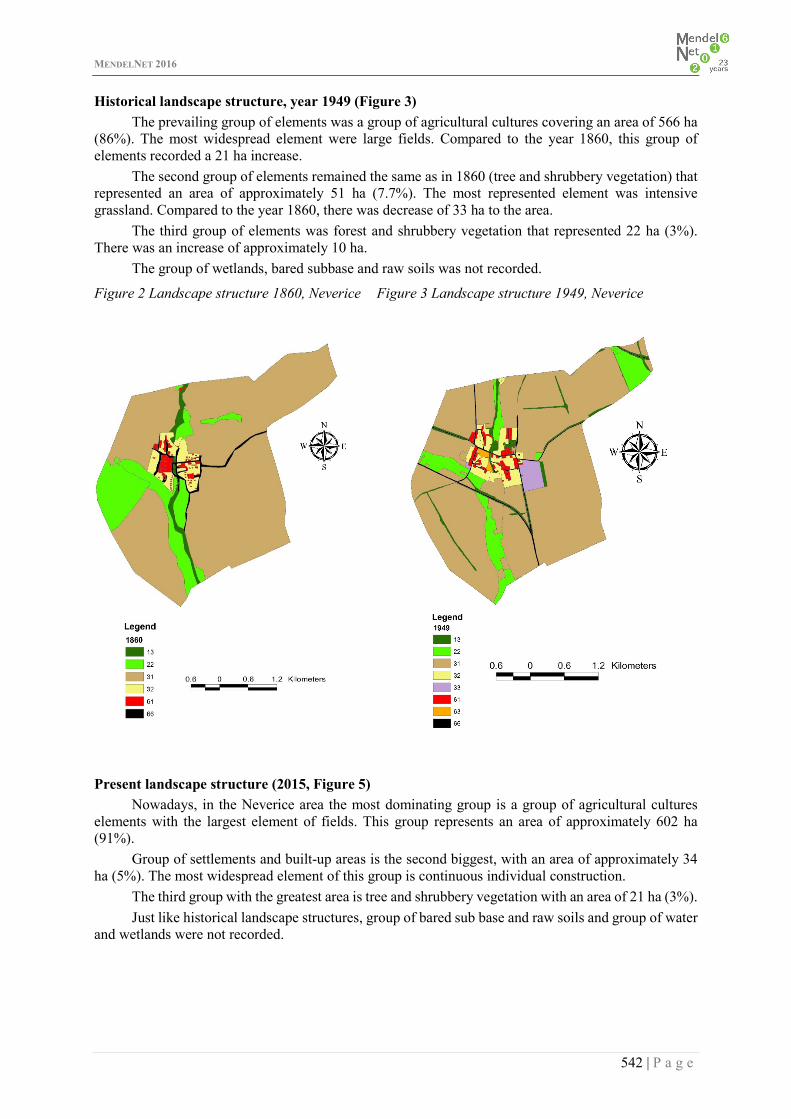
Historical landscape structure, year 1949 (Figure 3) The prevailing group of elements was a group of agricultural cultures covering an area of 566 ha
(86%). The most widespread element were large fields. Compared to the year 1860, this group of elements recorded a 21 ha increase.
The second group of elements remained the same as in 1860 (tree and shrubbery vegetation) that represented an area of approximately 51 ha (7.7%). The most represented element was intensive grassland. Compared to the year 1860, there was decrease of 33 ha to the area.
The third group of elements was forest and shrubbery vegetation that represented 22 ha (3%). There was an increase of approximately 10 ha.
The group of wetlands, bared subbase and raw soils was not recorded.
Figure 2 Landscape structure 1860, Neverice Figure 3 Landscape structure 1949, Neverice
Present landscape structure (2015, Figure 5)
Nowadays, in the Neverice area the most dominating group is a group of agricultural cultures elements with the largest element of fields. This group represents an area of approximately 602 ha (91%).
Group of settlements and built-up areas is the second biggest, with an area of approximately 34 ha (5%). The most widespread element of this group is continuous individual construction.
The third group with the greatest area is tree and shrubbery vegetation with an area of 21 ha (3%). Just like historical landscape structures, group of bared sub base and raw soils and group of water
and wetlands were not recorded.
MENDELNET 2016
543 | P a g e
Table 3 Comparison of results of the periods under review
SLS2 1860 1949 2015
Area (ha) Percentage (%)
Area (ha) Percentage (%)
Area (ha) Percentage (%)
13 12 1.82 21.6 3.28 21.85 3.32 22 83.78 12.71 50.78 7.7 1.16 0.18 31 523.68 79.47 516.75 81.69 565.19 85.84 32 21.27 3.23 38.27 5.81 36.8 5.48 33 - - 10.18 1.54 - - 61 17.72 2.69 9.09 1.38 17.41 2.64 62 - - 1.91 0.29 - - 63 - - - - 0.9 0.15 65 - - - - 4.63 0.7 66 0.55 0.08 10.42 1.59 11.06 1.69
Total 659 100 659 100 659 100
Figure 4 Comparison of representation of Figure 5 Present landscape structure (2015), Neverice each group of elements (ha) in Neverice
0
100
200
300
400
500
600
700
Tree andshrubberyvegetation
Grassland Subbasebaring andraw soils
Settlementand built-up areas
Comparison of representation of each group of elements (ha)
1860 1949 2015

MENDELNET 2016
544 | P a g e
Figure 6 Landscape evolution trends 1949 2015, Neverice
DISCUSSION AND CONCLUSION
On the basis of this study we can define the landscape of Neverice village according to Ruzicka et al. (1978) as cultural (anthropogenic) landscape that was differentiated by natural and socio-economical influences.
According to research, in every period there prevails a group of agricultural cultures with a dominating element of large fields, we can therefore define this cultural landscape as agricultural, which would go extinct without anthropogenic activities. Landscape of this type was created secondary and has mainly economical character.
The frequency of land use puts our area of interest into intensively cultivated landscapes, where widely developed farming has persisted over several centuries (Gabris 1998).
Neverice village is situated approximately 10 km from the district city of Zlate Moravce and is approximately 23 kilometers from Nitra. Commuting to work, to health care facilities and other socio-economical services is very comfortable.
Nowadays, the village could be a very attractive place to live, since in Nitra a new industrial zone is being created that could create 7000 jobs by the year 2019. This major investment could lead to new investment toward study area. We propose that building smaller industrial zones in Neverice could have a positive impact on the economic growth of Neverice and the surrounding villages.
Labor migration of the population should have a positive impact on population increase. This phenomenon supports our proposal to create new construction opportunities for the element of continuous individual construction in the area as well as supporting the sale of existing properties.
Villages could support the idea of improving the attractiveness of an area by reconstructing public communications and sewerage. Similar results were published by Petrovic (2005).
Proposals were communicated to municipal authorities, in the view of municipal documentation and our vision of potential village development, such as in study of Mederly et al. (2008).
Evaluation of evolutional trends In the Figure 6 we can see the results of evolutional trends in the years 1949 and 2015. Spatial representation of the Figure is as follows: 0–598 ha,
1–12 ha,
4–45 ha,
6–4 ha.
Size changes of spatial elements within the published periods were summarized in Table 3.
MENDELNET 2016
545 | P a g e
We propose the creation of several elements. In significantly agricultural landscape, we propose to complete the landscape with balks that would have a functional potential as anti-erosion barriers and a biocoridor that would connect surrounding areas with biocentres. Gardens and continuous individual constructions are some of the other proposed elements that are required in the village. Because of the location, we propose the construction of industrial zones and technical objects in the southern part of the area, close to the R1 highway.
The results of our study could be used for assessing the influences on the environment (E.I.A), for landscape-ecological planning and for the evaluation of biodiversity values (USES – The Local Territorial System of Ecological Stability) as well as serving as a great background for the creation of a new development plan of the village.
ACKNOWLEDGEMENTS The presented research was realised with the support of VEGA No. 1/0496/16 project.
REFERENCES Cebecauerova, M. 2007. Analýza a hodnotenie zmien štruktúry krajiny (na príklade časti Borskej nížiny a Malých Karpát. Bratislava: Geografický ústav SAV. Forman, T., Godron, M. 1993. Krajinná ekologie. Praha: Academia. Gabris, L. 1998. Ochrana a tvorba životného prostredia. Nitra: SPU. Havrancik, S., Siklenka, R. 2013. Chránené vtáčie územie Tribeč. Štátna ochrana prírody SR: CHKO Ponitrie. Kele, F., Mariot, P. 1983. Krajina, ľudia, životné prostredie. Bratislava: Veda. Mazur, E., Drdos, J., Urbanek, J. 1980. Krajinné syntézy – ich východiská pre tvorbu priestorových štruktúr životného prostredia. Životné prostredie, 14(2): 66–70. Mederly, P. 2008. Miestny územný systém ekologickej stability. Nitra: REGIOPLAN, Žilina: EKOPED. Muchova, Z., Leitmanova, M., Petrovic, F. 2016. Possibilities of optimal land use as a consequence of lessons learned from land consolidation projects (Slovakia). Ecological Engineering, pp. 294–306. NLWRA, 2006. Guidelines for land use mapping in Australia: principles, procedures and definitions - A technical handbook supporting the Australian Collaborative Land Use Mapping Programme. 3rd ed., Australian Goverment: Bureau of Rural Sciences. Petrovic, F. 2005. Vývoj krajiny v oblasti štálového osídlenia Pohronského Inovca a Tribeča. Bratislava: SAV. Petrovic, F., Hresko, J., Bugar G. 2009. Nitriansky kraj v kontexte regionálneho rozvoja. GEO Information, 5, pp. 116–124. Ruzicka, M., Ruzicková, H., Zigrai, F. 1978. Krajinné zložky, prvky a štruktúra v biologickom plánovaní. Bratislava: Veda. Tazky, J. 2016. Trendy vývoja krajiny obcí Ladice a Neverice. Rigorózna práca, UKF FPV v Nitre. Zoppi, C., Lai, S. 2014. Land-taking processes: An interpretive study concerning an Italian region. Land Use Policy, pp. 369–380.