Embed Size (px)
Citation preview

NCEP EMC Seminar, Camp Springs, 18 October 2005
Developing an Integrated Urban Modeling System for WRF
OutlineIssues associated with urbanizationOverview of an urban modeling frameworkExamples of applying this modeling system
Fei Chen
Research Application Laboratory/NCAR

NCEP EMC Seminar, Camp Springs, 18 October 2005
Urbanization Issues• Nearly 300 cities have a million or
more inhabitants• Adverse urbanization effects:
– Poor air quality, toxic contaminant dispersal
– Deterioration of visibility – Adverse impacts on human health– Damage to agriculture and ecosystems– Water and energy supply/demand– Impact on climate (ozone and aerosol,
greenhouse radiation budget)– Emergency response

NCEP EMC Seminar, Camp Springs, 18 October 2005
Air pollution is not a local problem
QuickTime™ and aYUV420 codec decompressor
are needed to see this picture.
March - December 2004 TERRA/MOPITT imagesConcentration of carbon monoxide (CO) at 15,000 feet
Red colors: highest levels of CO (450 parts per billion)Blue: lowest levels of CO (50 ppb)
John Gille, ACD/NCAR

NCEP EMC Seminar, Camp Springs, 18 October 2005
Temperatures in most cities are warmer than suburban rural areas.

NCEP EMC Seminar, Camp Springs, 18 October 2005
Urban Heat Island Phenomena• Increase the demand for energy
– 1/6 of the electricity consumed in US is used for cooling purposes ($ 40 billion /year)
• Higher air temperatures increase the amount of ground level ozone, or smog
• May enhance heat waves within cities. – The mortality rate during a heat wave increases
exponentially with the maximum temperature, an effect that is exacerbated by the urban heat island
– European Heat Wave of 2003: as many as 40,000 people died in Europe

NCEP EMC Seminar, Camp Springs, 18 October 2005
From TIMES magazine, Aug 2003

NCEP EMC Seminar, Camp Springs, 18 October 2005
Embrace the New-era of Urban Modeling and Application
• Urban problems can only be addressed in mesoscale/fine-scale modeling framework
• We can now bridge the gap between traditional mesoscale (~ 10 km) and fine-scale urban modeling (~ 10 m)– NWP models running at 1-km grid spacing– Availability of new data at urban scales – Techniques to couple NWP and CFD-type models
• Pathway to decision support systems and decision makers

Integrated Urban Modeling Framework
urban land use characteristics
Surface emission sources
High-res land data assimilation
system
Fine-scale atmospheric
analysis (4DDA, VDRAS)
WRF/Noah/Urban coupled modeling system
Computational Fluid Dynamic (CFD) models Transport and Dispersion models Chemistry models
Urban decision support systems

NCEP EMC Seminar, Camp Springs, 18 October 2005
Urban Modeling Methods• In-building scale modeling (typical grid
< 1 meter; using Computational Fluid Dynamic (CFD) model; forecast time: seconds to minutes)
• Single to many building scale modeling (typical grid: 1-100 meter; using CFD model; forecast time: minutes to a few hours)
• Urban-canopy model parameterization (> 100 meters; forecast time: many hours)
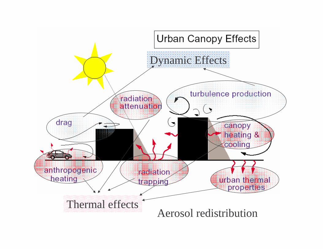
Dynamic Effects
Thermal effectsAerosol redistribution
NCEP EMC Seminar, Camp Springs, 18 October 2005
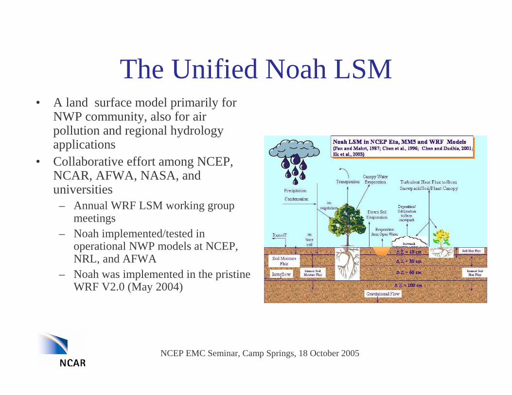
The Unified Noah LSM• A land surface model primarily for
NWP community, also for air pollution and regional hydrology applications
• Collaborative effort among NCEP, NCAR, AFWA, NASA, and universities – Annual WRF LSM working group
meetings – Noah implemented/tested in
operational NWP models at NCEP, NRL, and AFWA
– Noah was implemented in the pristine WRF V2.0 (May 2004)

NCEP EMC Seminar, Camp Springs, 18 October 2005
� Degree of complexity of urban modeling• We developed two methods for urban land-use modeling
� Simple bulk parameterization of urban effects in MM5/Noah – Complex Urban-Canopy Model coupled to WRF/Noah
• These urban models in MM5/WRF were applied for– Oklahoma City– Phoenix– Houston– Salt Lake City– Hong Kong– Beijing– Tokyo
Urban Modeling Methods in the Unified Noah Land Surface Model

Simple Parameterization of Urban Effects in the Noah LSM
• Large roughness length – turbulence generated by roughness elements – drag due to buildings
• Small albedo– radiation trapping
• Large thermal capacity and thermal conductivity– heat storage in soil
• Low evaporation• Implemented in MM5 V3.7 and WRF V2.0

NCEP EMC Seminar, Camp Springs, 18 October 2005
WRF/Noah LSM/Urban-Canopy Coupled Model
• Single layer urban-canopy model (UCM, based on Kusaka 2001)– 2-D urban geometry (orientation,
diurnal cycle of solar azimuth)– Street canyons with sky view
factor– Shadowing from buildings and
reflection of radiation– Anthropogenic heating– Multi-layer roof, wall and road
models

NCEP EMC Seminar, Camp Springs, 18 October 2005
Role of Vegetation and Canopy Resistance
• Urban canopy model is coupled to the Noah LSM
– Use fraction of urban coverage
• Vegetation: dry and wet deposition
• Canopy resistance (Rc)
– Photosynthesis and interaction with aerosol is a key link between biosphere and atmosphere (CO2 fluxes, BVOC emission, and evaporation, ozone effects)
– Large uncertain in Rc
• Recent model experiments at NCEP highlight the emerging need to address the uncertainty of Rc in Noah
NCEP EMC Seminar, Camp Springs, 18 October 2005
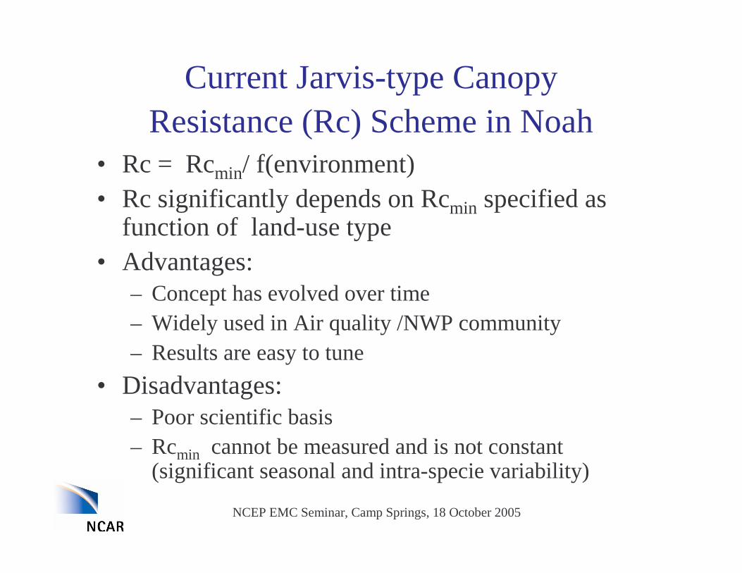
Current Jarvis-type Canopy Resistance (Rc) Scheme in Noah
• Rc = Rcmin/ f(environment)• Rc significantly depends on Rcmin specified as
function of land-use type• Advantages:
– Concept has evolved over time– Widely used in Air quality /NWP community– Results are easy to tune
• Disadvantages:– Poor scientific basis– Rcmin cannot be measured and is not constant
(significant seasonal and intra-specie variability)

NCEP EMC Seminar, Camp Springs, 18 October 2005
Effect of Change in Canopy Resistance on the simulated PBL structure
[Typically, Rs change by factor of 4 (from 30 to 120 s/m), altered energy fluxes by factor of 2!]
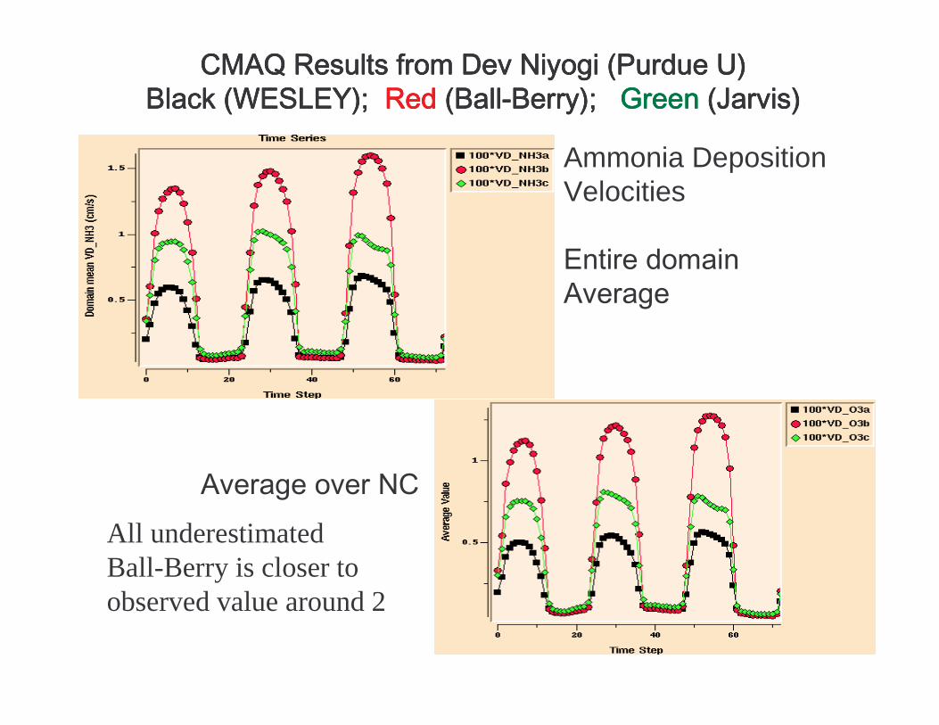
Ammonia DepositionVelocities
All underestimated Ball-Berry is closer to observed value around 2

NCEP EMC Seminar, Camp Springs, 18 October 2005
Integrate newremote-sensing data
ASTER - 15mBeijing land-cover April 9, 2004 30-m Landsat
land-cover Houston

NCEP EMC Seminar, Camp Springs, 18 October 2005
• BVOC (biogenic volatile organic compounds) type i (isoprene, monoterpene,)Fi=εi D (Lsun+Lshade)i Ti
• BVOC emission and anthropogenic Nox, from Eastern TX form O3 over central TX
Surface biogenic emission calculated by the Noah LSM (Gulden and Yang, 2005, U Texas)
Integrate surface emission map

High-resolution land surface and urban modeling and assimilation system
Vegetation type
Soil texture
Urban data
Terrain
snow
Vegetation cover
Leaf area index
High resolution land data assimilation system (HRLDAS)
Obs. PrecipitationRadiation, T, Q, U, V
Initial soil moisture, soil temperature, snow cover, canopy water, wall/roof/road temperature
Noah land surface model, Urban canopy model
Boundary layer parameterization Coupled mode

Domain 1: 40.5kmDomain 2: 13.5kmDomain 3: 4.5km
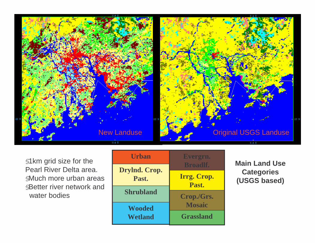
Original USGS LanduseNew Landuse
Grassland
Crop./Grs. Mosaic
Irrg. Crop. Past.
Evergrn. Broadlf. Main Land Use
Categories (USGS based)
Wooded Wetland
Shrubland
Drylnd. Crop. Past.
Urban§1km grid size for the Pearl River Delta area. §Much more urban areas§Better river network and
water bodies

Wind Direction
0.0
50.0
100.0
150.0
200.0
250.0
300.0
350.0
400.0
17/10 18/10 19/10 20/10 21/10 22/10 23/10 24/10 25/10 26/10 27/10 28/10 29/10 30/10 31/10 1/11 2/11 3/11
Magenta :ObservationBlue: LSM forecastYellow: MM5 forecast
LSM (with urban modification) capture well the land sea breeze circulation enhanced by urban
(Lowest sigma level)

NCEP EMC Seminar, Camp Springs, 18 October 2005
Terrain and Land-use of the Model Domain with 10-km grid spacing
1200km
Sea of Japan
Pacific Ocean

NCEP EMC Seminar, Camp Springs, 18 October 2005
Terrain and Land-use around Tokyo
Tokyo Metropolitan area

NCEP EMC Seminar, Camp Springs, 18 October 2005
Daytime Urban Heat Island 2-m Temperature on 1500 LST
Obs WRF

NCEP EMC Seminar, Camp Springs, 18 October 2005
Nighttime Urban Heat Island 2-m Temperature at 0300 LST
Obs WRF

NCEP EMC Seminar, Camp Springs, 18 October 2005
Landsat 30-meter resolutionLanduse for the Houston Area

NCEP EMC Seminar, Camp Springs, 18 October 2005
Simple urban treatment
Old urban landuse map
UCM Produce More Pronounced Nocturnal Heat Island
Lowest model level at 12 UTC 26 Aug 2000 (1-km WRF)
With Urban Canopy Model and new urban landuse

NCEP EMC Seminar, Camp Springs, 18 October 2005
Enhanced Strength of Sea Breeze by UCM
lowest-model level wind field at 21 UTC 25 Aug 2000
With Urban Canopy Model and new urban landuse
Simple urban treatment
Old urban landuse map

Diurnal Cycle of Wind Profile and PBL Depth 31 Aug 2000 @ LaMarque (near coast) and Houston
3-hr WRF 1-km simulationHourly observation
LaMarque site
Southwest Houston site

High-Resolution WRF/Noah/Urban Modeling Capability
Complex terrain on WRF nested D-5 (0.5 km grid spacing) over the Salt Lake City area Complex Urban land use
distribution over SLC
Single layer Urban Canopy Model
Domains: 40.5,13.5,4.5,1.5,0.5 km
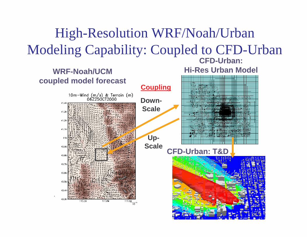
High-Resolution WRF/Noah/Urban Modeling Capability: Coupled to CFD-Urban
WRF-Noah/UCM coupled model forecast
Down-Scale
Up-Scale
Coupling
•
CFD-Urban:Hi-Res Urban Model
CFD-Urban: T&D

Diurnal Wind Direction in Northern Downtown
NIGHT DAYRed: Obs, Green: WRF/Noah, Blue: WRF/Noah/UCM
NCEP EMC Seminar, Camp Springs, 18 October 2005
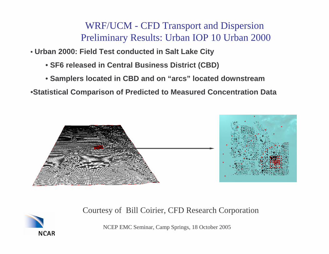
WRF/UCM - CFD Transport and DispersionPreliminary Results: Urban IOP 10 Urban 2000
• Urban 2000: Field Test conducted in Salt Lake City
• SF6 released in Central Business District (CBD)
• Samplers located in CBD and on “ arcs” located downstream
•Statistical Comparison of Predicted to Measured Concentration Data
Courtesy of Bill Coirier, CFD Research Corporation

NCEP EMC Seminar, Camp Springs, 18 October 2005
• Entire IOP 10
• 3 Releases/Pauses
• WRF Data for BC
•Quasi-steady approach:
• Wind/Turbulence fields at 15 minute intervals
• Unsteady T&D using Unified Frozen Hydro Solver
• Flow turning is replicated, which causes plume to travel NNW
WRF/UCM - CFD Transport and DispersionPreliminary Results: Urban IOP 10 Urban 2000
Courtesy of Bill Coirier, CFD Research Corporation

NCEP EMC Seminar, Camp Springs, 18 October 2005
Gas Dispersion Prediction
Near Source
R2 R3 R4 All
FB 0.85 1.59 1.44 1.7 0.87NMSE 14.03 15.8 14.4 26.1 21.9MG 25.42 14.1 4.58 5.06 15.8FAC2 0.12 0.17 0.36 0.38 0.18
Near Source
R2 R3 R4 All
FB -1.35 -0.2 0.1 0.9 -1.34NMSE 147.98 0.65 0.6 2.6 232MG 0.53 1.6 1.9 2.4 0.8FAC2 0.51 0.42 0.6 0.4 0.5
Using WRF 12-h forecast (left panel) significantly improve FAC2 (FAC>0.5 acceptable) and MG (0.7<MG<1.3 acceptable) over using single sounding approach (right panel)

NCEP EMC Seminar, Camp Springs, 18 October 2005
Summary
• Urban environmental problems can be addressed with an integrated mesoscale urban modeling system that should include– Urban canopy models
– Remote sensing/in situ data at urban scales• urban geomorphologic data base for urban modeling (EPA, Jason Ching)
• remote-sensing urban land-use data (NSF/NASA, JoeZehnder at ASU)
– Downscaling/upscaling with explicit CFD-type models • CFD model coupling (DTRA, Bill Coirier, CFDRC)
– Integration into decision support systems
– Surface biogenic and anthropogenic emission maps
– Companion land data assimilation system

NCEP EMC Seminar, Camp Springs, 18 October 2005
Summary
• A consistent canopy resistance treatment in Noah is critical for both NWP and air pollution applications– Plan to systematically evaluate different types of Rc schemes in the
context of NWP and air pollution modeling
• Capturing urban thermal effects is important not only for PBL thermodynamics and also for wind field
• Preliminary results of urban models are encouraging, however, much work remains to be done– Refine urban canopy model
– Need to explore two-way WRF/Noah/UCM and CFD coupling
– Integrate fine-scale urban land use and characteristic data
• Plan an urban workshop in 2006

NCEP EMC Seminar, Camp Springs, 18 October 2005
Acknowledgement
NCARMukul Tewari
Yubao LiuKevin ManningTom Warner
UniversitiesDev Niyogi (Purdue)Joe Zehnder (ASU)
Alexis Lau (HKUST)Other Institutions
Hiroyuki Kusaka (CREPI, Japan)Bill Coirier (CFD Res. Corp)
NCEPKen Mitchell
AFWAJerry Wegiel
NRL Teddy Holt

NCEP EMC Seminar, Camp Springs, 18 October 2005
Comprehensive Urban Modeling Framework
• Urban models• Integrate new in-situ and remotely sensed data for
better representing urban characteristics• Integrate natural (biogenic, wildfire) and
anthropogenic emissions• High-resolution land data assimilation system • Information transferable to decision support
systems
![Overview of the WRF/ChemOverview of the WRF/Chem modeling ...gurme/WRF - 01 - Overview [Compatibility Mode].pdf · Distant line-up for WRF/Chem, with various groups working on these](https://img.pdfslide.us/doc/110x75/5e76b2b733ffb837ea674751/overview-of-the-wrfchemoverview-of-the-wrfchem-modeling-gurmewrf-01-overview.jpg)