Embed Size (px)
Citation preview

The Sudbury, Assabet, and Concord RiversDeveloping a Report Card
Location of the Sudbury, Assabet, and Concord River watersheds within the Commonwealth of Massachusetts.
Stakeholder Workshop NewsletterGreat Meadows National Wildlife RefugeFebruary - March 2018
As part of the landscape that saw the start of both the American revolution and the industrial revolution, the Sudbury, Assabet, and Concord Rivers in Massachusetts have a long history of use and abuse. Restoring the health of these three interconnected rivers has been the mission of OARS, the watershed organization for the Sudbury, Assabet, and Concord Rivers, for 31 years. Restoration takes many years of committed work by local communities and support from many sources. Effective actions depend on a sound understanding of the science and the local context, which must be broadly understood and communicated.
In 2018, OARS partnered with the Integration and Application Network, University of Maryland Center for Environmental Science to initiate a river report card for the region. The report card will provide a snapshot of current river conditions and the historical trends and context of those conditions.
To start the process, two workshops were held at Great Meadows National Wildlife Refuge on 28 February and 1 March 2018, with key stakeholders from all three river basins. The initial workshop elicited what stakeholders value about the rivers, and the subsequent workshop focused on how to measure those values, and where to find data.
The Old North Bridge, spanning the Concord River, was the site of the first battle of the American Revolution. Photo: Massachusetts Office of Travel and Tourism.
In April and May, natural spring flows allow for whitewater rafting on the Concord River. Photo: Zoar Outdoor.
A great blue heron on the Assabet River. Photo: Dave Griffin.
10 mi
10 km
N
Assabet R
iver
Sudbury River
Conc
ord
Rive
r
SHERBORNASHLANDHOPKINTON
UPTON
GRAFTON
SHREWSBURY
NORTHBOROUGH
BOYLSTONMARLBOROUGH
SOUTHBOROUGH
FRAMINGHAM
NATICK
WESTON
WAYLAND
SUDBURY
LINCOLN
MAYNARD
STOW
BOLTON
BERLIN
CLINTON
HARVARD
BOXBOROUGH
LITTLETON
WESTFORD
CHELMSFORD
LOWELL
TEWKSBURY
BILLERICA
CARLISLE
BEDFORDACTON
CONCORD
HUDSON
WESTBOROUGH
Massachusetts
Assabet River WatershedConcord River WatershedSudbury River WatershedStreamsDesignated Wild & Scenic
Watersheds
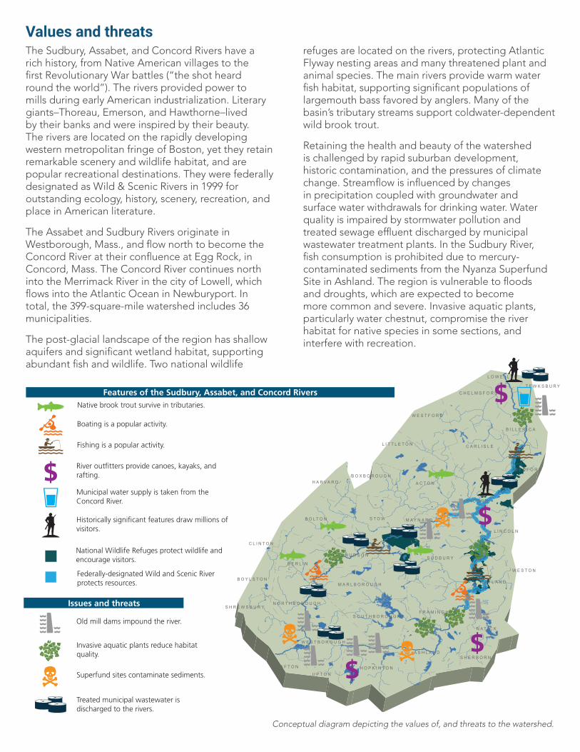
Values and threats
Conceptual diagram depicting the values of, and threats to the watershed.
The Sudbury, Assabet, and Concord Rivers have a rich history, from Native American villages to the first Revolutionary War battles (“the shot heard round the world”). The rivers provided power to mills during early American industrialization. Literary giants–Thoreau, Emerson, and Hawthorne–lived by their banks and were inspired by their beauty. The rivers are located on the rapidly developing western metropolitan fringe of Boston, yet they retain remarkable scenery and wildlife habitat, and are popular recreational destinations. They were federally designated as Wild & Scenic Rivers in 1999 for outstanding ecology, history, scenery, recreation, and place in American literature.
The Assabet and Sudbury Rivers originate in Westborough, Mass., and flow north to become the Concord River at their confluence at Egg Rock, in Concord, Mass. The Concord River continues north into the Merrimack River in the city of Lowell, which flows into the Atlantic Ocean in Newburyport. In total, the 399-square-mile watershed includes 36 municipalities.
The post-glacial landscape of the region has shallow aquifers and significant wetland habitat, supporting abundant fish and wildlife. Two national wildlife
refuges are located on the rivers, protecting Atlantic Flyway nesting areas and many threatened plant and animal species. The main rivers provide warm water fish habitat, supporting significant populations of largemouth bass favored by anglers. Many of the basin’s tributary streams support coldwater-dependent wild brook trout.
Retaining the health and beauty of the watershed is challenged by rapid suburban development, historic contamination, and the pressures of climate change. Streamflow is influenced by changes in precipitation coupled with groundwater and surface water withdrawals for drinking water. Water quality is impaired by stormwater pollution and treated sewage effluent discharged by municipal wastewater treatment plants. In the Sudbury River, fish consumption is prohibited due to mercury-contaminated sediments from the Nyanza Superfund Site in Ashland. The region is vulnerable to floods and droughts, which are expected to become more common and severe. Invasive aquatic plants, particularly water chestnut, compromise the river habitat for native species in some sections, and interfere with recreation.
Native brook trout survive in tributaries.
Fishing is a popular activity.
River outfitters provide canoes, kayaks, and rafting.
Features of the Sudbury, Assabet, and Concord Rivers
Issues and threats
Municipal water supply is taken from the Concord River.
Historically significant features draw millions of visitors.
National Wildlife Refuges protect wildlife and encourage visitors.
Old mill dams impound the river.
Invasive aquatic plants reduce habitat quality.
Superfund sites contaminate sediments.
Treated municipal wastewater is discharged to the rivers.
Boating is a popular activity.
Federally-designated Wild and Scenic River protects resources.
S T O W
A C T O N
S U D B U R Y
C O N C O R D
F R A M I N G H A M
B O L T O N
B E R L I N
H O P K I N T O N
W A Y L A N D
C A R L I S L E
M A R L B O R O U G H
H U D S O N
W E S T B O R O U G H
A S H L A N D
B I L L E R I C A
N O R T H B O R O U G H
C H E L M S F O R D
W E S T F O R D
S O U T H B O R O U G H
N A T I C K
L I T T L E T O N
H A R V A R D
M A Y N A R D
S H R E W S B U R Y
B O X B O R O U G H
L I N C O L N
B O Y L S T O N
B E D F O R D
S H E R B O R N
W E S T O N
G R A F T O N
C L I N T O N
U P T O N
T E W K S B U R Y
L O W E L L

SUDBURY, ASSABET, CONCORD
RIVER BASIN POTENTIAL INDICATORS
CULTURE
RECREATION
WAT
ER QUANTITY
WIL
DLIFE & HABITAT
ECONOMY
WAT
ER QUALITY
Identifying indicators of river health
List of proposed indicators identified during the workshop that will be investigated for suitability for inclusion in the Rivers Report Card.
Participants in the initial stakeholder workshops discussed key drivers and pressures, and their impacts on the watershed. On the first day of the workshop, participants then identified and ranked values of the Sudbury, Assabet, and Concord River watershed. Top values included water quality, water quantity, habitat/wildlife, recreation, economy, and cultural significance. During day two, participants selected potential indicators that would be useful in assessing the health of the river basins. The values and some possible indicator examples are listed below. The final list of indicators will be determined by several factors, including data availability and how well they represent the values of the basin.
During day one of the stakeholder workshop, participants identified values of the three rivers. Photo: Dave Griffin.
• OARS Water Quality Index (temperature, dissolved oxygen, pH, phosphorus, nitrates, suspended solids)
• Fecal bacteria counts
• Groundwater observation wells
• Municipal water withdrawals
• % effluent of flow
• Visitation/use• Tourism-based
business• Tourism-based
employment
• Aquatic vegetation• Fish communities• Habitat area• Land use
• Vegetation biomass• Public access• Passability
• Intact scenic landscapes• Trash• Soundscape• Public interface
Workshop participants Julie Wood, Charles River Watershed AssociationJudith Grove, City of FraminghamKarin Paquin, City of MarlboroughBob Hartzel, Comprehensive EnvironmentalLori Gill-Pazaris, Jim Pazaris, Concord BioCANSteven Weisman, Friends of SaxonvilleAndrea Braga, Geosyntec ConsultantsLaura Blake, Hydroanalysis Inc.Jane Calvin, Lowell Parks & Conservation TrustEliza Wallace, Metropolitan Area Planning Council-GISRyan Brown, Heidi Ricci, Massachusetts AudubonPam DiBona, Prassede Vella, Massachusetts Bays National Estuarine ProgramTherese Beaudoin, Warren Kimball (retired), Karen Pelto, Massachusetts Department of Environmental ProtectionAndrew Hrycyna, Mystic River Watershed AssociationMartha Morgan, Kathryn Nelson, Nashua River Watershed AssociationAlison Field-Juma, Julia Khorana, Sue Flint, OARSDon Burn, Allan Fierce, Richard Lawrence, Pam Rockwell, Lisa Vernegaard, OARS Board of DirectorsKim Kastens, OARS water quality monitoring volunteer, Green ActonChrista Collins, Sudbury Valley TrusteesBettina Abe, Town of ActonDavid Garabedian, Jeffrey Kalmes, John McGovern, Town of BillericaDelia Kaye, Town of Concord Pam Helinek, Town of HudsonStacy Carter, Town of LincolnRichard Morse, Town of SudburyMary Antes, Town of WaylandTrish Garrigan, Todd Borci, U.S. Environmental Protection AgencyPeter Weiskel, U.S. Geological SurveyBill Fadden, Ralph Hammond, Tom Sciacca, Wild & Scenic River Stewardship
Science communication, design & layoutBrianne Walsh, Bill Dennison, University of Maryland Center for Environmental Science Integration and Application Network
Participants at the initial stakeholder workshop (top) and data integration workshop (bottom) held at Great Meadows National Wildlife Refuge in February and March, 2018.
Continued progress towards a report cardGenerating a report card requires participation from a broad stakeholder group knowledgeable about resources and available data. The development and production of the report card will take about 14 months, with a release planned for April 2019. For the six months following the February 2018 stakeholder workshop, project staff will consult with stakeholders and other experts, collect and analyze data for the identified indicators, and prepare a draft report card for stakeholder review and discussion at a second workshop in October 2018. Project staff will update the report card grades, methodology, findings, and recommendations based on stakeholder feedback and distribute it for final review and agreement, prior to release to the public in April 2019.
Sudbury, Assabet, Concord River Project Initiation
Initial stakeholder workshop
Data acquisition, analysis, and methodology report
Review of draft report card
Second stakeholder workshop
Revision of report card scores and production of methodology report
Finalize report card scores
Release of report card to public
NOV DEC JAN FEB MAR APR MAY JUN JUL AUG SEP OCT NOV DEC JAN FEB MAR APR
2017 2018 2019
For more information and to track progress on the Report Card Process, visit www.oars3rivers.org
Thank you to the Massachusetts Environmental Trust and The Sudbury Foundation for sponsoring this project, and to the Cedar Tree Foundation and the National Park Service for additional support.
![Sediment Management - Geosyntec · Sediment Management 4UBUFNFOUPG2VBMJmDBUJPOT] About Geosyntec Section 1 About Geosyntec Technical Excellence, Teamwork and A Generous Spirit Recognized](https://img.pdfslide.us/doc/110x75/5d5dcc7788c993a30e8b8011/sediment-management-sediment-management-4ubufnfoupg2vbmjmdbujpot-about-geosyntec.jpg)