Embed Size (px)
Citation preview
Journal of Environmental Treatment Techniques 2015, Volume 3, Issue 4, Pages: 176-183
176
Determining the Changeability of Groundwater Level in the
Southwestern Part of Bangladesh using Geographic Information
System (GIS): A Spatio-Temporal Analysis
S. M. Saify Iqbal1, Md. Juel Rana Kutub2, Premanondo Debnath1, Nishat Falgunee1, Shahreen Muntaha Nawfee1,
Shahadat Islam Sojib3
1MS Student, Department of Geography and Environment, Faculty of Earth and Environmental Science, University of Dhaka 2Lecturer, Department of Geography, Faujdarhat Cadet College
3MS Student, Department of Oceanography, Faculty of Earth and Environmental Science, University of Dhaka
Received: 30/10/2015 Accepted: 09/11/2015 Published: 30/12/2015
Abstract Groundwater is one of the most important freshwater sources in Bangladesh which is used for drinking, household chores and
irrigation. Due to high population pressure and excessive withdrawal, this important resource is under a lot of pressure. This study
was designed to assess the present groundwater condition of the southwestern part of Bangladesh. Groundwater depth data of 231
wells from 20 districts were collected from Bangladesh Water Development Board (BWDB) and analyzed in ArcGIS 10.1 and
Microsoft Excel 2010. Data analysis showed that all over the year, groundwater lies beneath 0 to 10 m of sediment in the
southwestern part of this country. During the pre-monsoon season, groundwater level ranges from 6 to 10 m in Magura, Rajbari,
Jhenaidaha and its adjacent areas, but when the monsoon starts water level varies from 4 to 7 m except some parts of Magura as
the monsoon season is characterized by heavy rainfall. On the other hand, water level varies from 1-4 m in the coastal areas of the
southwestern part of this country. Basically, the larger values are mostly associated with urban areas having groundwater level
ranging between 6 and 12 m. During the monsoon season, there is a wide disparity of groundwater condition except the coastal
zone as it shows homogeneity. So significant variation in groundwater depth was observed throughout the study area. The impact
of the urbanization was seen clearly which leads to the lowering of groundwater level that can cause the catastrophic events like
earthquake, subsidence and pollution in this country.
Key Word: Groundwater, Freshwater Source, Monsoon, ArcGIS 10.1, Water Table.
1 Introduction1
Water resource, especially groundwater works as a
feeder for the domestic, agriculture, industry and waste
disposal use which is a pre-required condition for the
economic and social development of any country [1]. It is
considered as one of the most inevitable parts of the
hydrologic cycle. It is the largest potential freshwater source
in the hydrological cycle, larger than all the surface lakes and
streams combined. It is estimated that 8340000 cubic km of
water is present beneath the surface of the Earth [2]. In
Bangladesh, it is the single most important fresh water
source for urban areas. Groundwater is not an independent
source of water. It interacts with the surface water through
various mechanisms and contributes to the other freshwater
sources. Groundwater plays a vital role for hydraulic power
and energy production, but these productions have decreased
from 70% to 40% in 2004 [2]. It is widely used in the
minimum level of the technological and energy availability
because of its high quality [3] and is more attractive to the
S. M. Saify Iqbal, MS Student, Department of Geography and Environment, Faculty of Earth and Environmental Science,
University of Dhaka, Bangladesh. Email: [email protected], Cell No: +8801755882482.
consumers for its more comparative per unit volume value
than surface water and its local availability, reliability to
drought [4]. It is also considered as a vital resource for the
developing countries, because it is the prime source of
agricultural, industrial and domestic uses [5].
The favorable hydrological and geological condition of
Bangladesh indicates high potential groundwater storage.
Most of the unconsolidated and estuarine sediments from
Pleistocene to the recent fluvial land of Bangladesh form the
prolific aquifers, which indicate the high reserve of
groundwater [6, 7]. The aquifer’s productivity depends on
the lithological characteristics of soil, where soil porosity is
very significant. This unconsolidated sediment can reserve a
large volume of groundwater [8]. Groundwater level in the
shallow aquifers of Ganges_Brahmaputra_Meghna (GBM)
is dynamic and characterized by the monsoonal rainfall [9].
This shallow aquifer’s depth is less than 80 m [10]. The
seasonal variation of groundwater level in
Journal web link: http://www.jett.dormaj.com
J. Environ. Treat. Tech.
ISSN: 2309-1185
Journal of Environmental Treatment Techniques 2015, Volume 3, Issue 4, Pages: 176-183
177
Ganges_Brahmaputra_Meghna (GBM) area is very
considerable both in temporal and spatial scales and which
is ranged from 2 to 8 m [11].
Bangladesh is a country of huge population (14 million),
according to the 2011 population census report [12].
Agriculture is the primary occupation of the people. It
depended on surface water and the monsoonal rainfall during
the 1970s [13], but now 79.1% of the cultivated land use
groundwater through irrigation [14, 15]. Urban areas of
Bangladesh face huge water crisis during the dry season and
the groundwater table of those areas are rapidly decreasing
[16]. The quality of groundwater in Bangladesh which is a
prime source of supplying water for most of the cities is also
deteriorating due to the pollution of groundwater by sewage
and excessive exploitation [17]. The northeastern and
southeastern part of Bangladesh is mostly occupied by the
hilly and coastal floodplain areas which were formed by the
unconsolidated tertiary and Pleistocene sediments derived
from the tertiary rock [18]. The coastal areas are
characterized by salinity and an active floodplain which are
flooded regularly by the high tide [19]. Groundwater level is
declining rapidly due to some natural and man-made causes
all over the country. Southwestern part of the country is also
suffering from groundwater scarcity. This study was
conducted in the southwestern part of Bangladesh
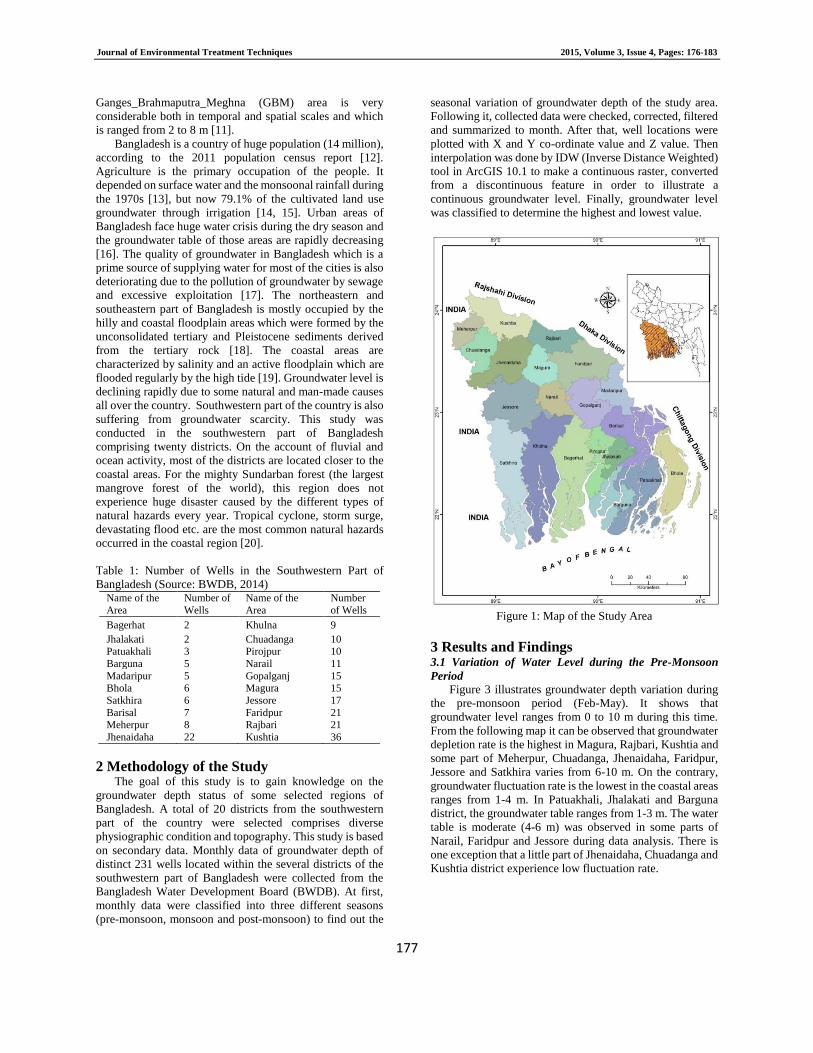
comprising twenty districts. On the account of fluvial and
ocean activity, most of the districts are located closer to the
coastal areas. For the mighty Sundarban forest (the largest
mangrove forest of the world), this region does not
experience huge disaster caused by the different types of
natural hazards every year. Tropical cyclone, storm surge,
devastating flood etc. are the most common natural hazards
occurred in the coastal region [20].
Table 1: Number of Wells in the Southwestern Part of
Bangladesh (Source: BWDB, 2014) Name of the
Area
Number of
Wells
Name of the
Area
Number
of Wells
Bagerhat 2 Khulna 9
Jhalakati 2 Chuadanga 10 Patuakhali 3 Pirojpur 10
Barguna 5 Narail 11
Madaripur 5 Gopalganj 15 Bhola 6 Magura 15
Satkhira 6 Jessore 17
Barisal 7 Faridpur 21 Meherpur 8 Rajbari 21
Jhenaidaha 22 Kushtia 36
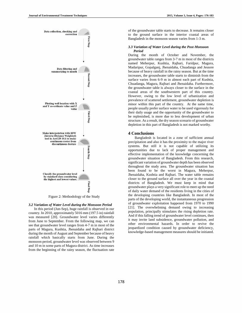
2 Methodology of the Study The goal of this study is to gain knowledge on the
groundwater depth status of some selected regions of
Bangladesh. A total of 20 districts from the southwestern
part of the country were selected comprises diverse
physiographic condition and topography. This study is based
on secondary data. Monthly data of groundwater depth of
distinct 231 wells located within the several districts of the
southwestern part of Bangladesh were collected from the
Bangladesh Water Development Board (BWDB). At first,
monthly data were classified into three different seasons
(pre-monsoon, monsoon and post-monsoon) to find out the
seasonal variation of groundwater depth of the study area.
Following it, collected data were checked, corrected, filtered
and summarized to month. After that, well locations were
plotted with X and Y co-ordinate value and Z value. Then
interpolation was done by IDW (Inverse Distance Weighted)
tool in ArcGIS 10.1 to make a continuous raster, converted
from a discontinuous feature in order to illustrate a
continuous groundwater level. Finally, groundwater level
was classified to determine the highest and lowest value.
Figure 1: Map of the Study Area
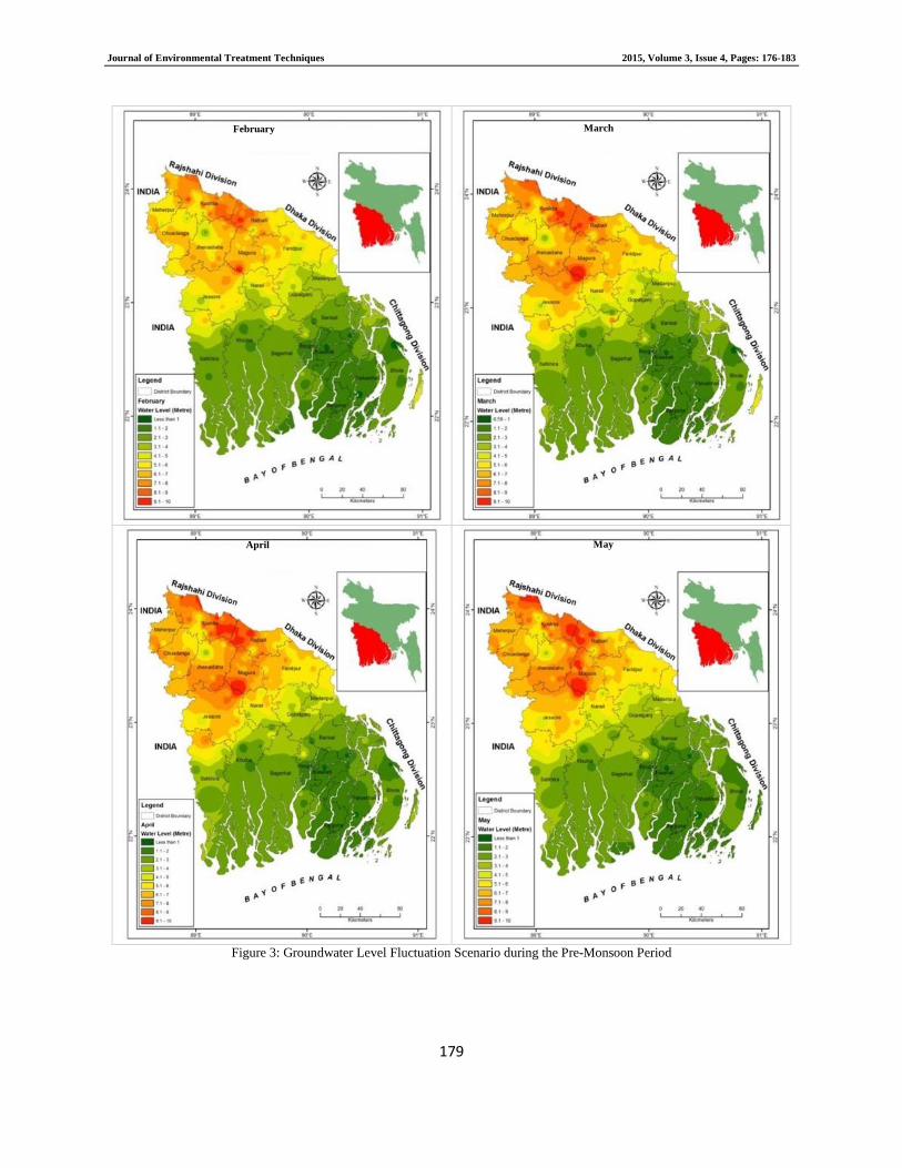
3 Results and Findings 3.1 Variation of Water Level during the Pre-Monsoon
Period
Figure 3 illustrates groundwater depth variation during
the pre-monsoon period (Feb-May). It shows that
groundwater level ranges from 0 to 10 m during this time.
From the following map it can be observed that groundwater
depletion rate is the highest in Magura, Rajbari, Kushtia and
some part of Meherpur, Chuadanga, Jhenaidaha, Faridpur,
Jessore and Satkhira varies from 6-10 m. On the contrary,
groundwater fluctuation rate is the lowest in the coastal areas
ranges from 1-4 m. In Patuakhali, Jhalakati and Barguna
district, the groundwater table ranges from 1-3 m. The water
table is moderate (4-6 m) was observed in some parts of
Narail, Faridpur and Jessore during data analysis. There is
one exception that a little part of Jhenaidaha, Chuadanga and
Kushtia district experience low fluctuation rate.
Journal of Environmental Treatment Techniques 2015, Volume 3, Issue 4, Pages: 176-183
178
Figure 2: Methodology of the Study
3.2 Variation of Water Level during the Monsoon Period
In this period (Jun-Sep), huge rainfall is observed in our
country. In 2010, approximately 5016 mm (197.5 in) rainfall
was measured [20]. Groundwater level varies differently
from June to September. From the following map, we can
see that groundwater level ranges from 4-7 m in most of the
parts of Magura, Kushtia, Jhenaidaha and Rajbari district
during the month of August and September because of heavy
rainfall which basically starts from June. During the
monsoon period, groundwater level was observed between 9
and 10 m in some parts of Magura district. As time increases
from the beginning of the rainy season, the fluctuation rate
of the groundwater table starts to decrease. It remains closer
to the ground surface in the interior coastal areas of
Bangladesh in the monsoon season varies from 1-3 m.
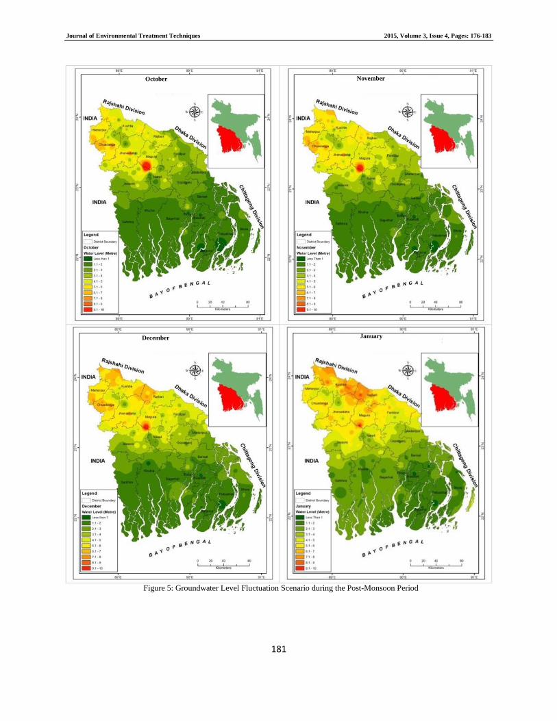
3.3 Variation of Water Level during the Post-Monsoon
Period During the month of October and November, the
groundwater table ranges from 3-7 m in most of the districts
named Meherpur, Kushtia, Rajbari, Faridpur, Magura,
Madaripur, Gopalganj, Jhenaidaha, Chuadanga and Jessore
because of heavy rainfall in the rainy season. But at the time
increases, the groundwater table starts to diminish from the
surface varies from 6-9 m in almost each part of Kushtia,
Chuadanga, Magura, Rajbari and Jhenaidaha. Furthermore,
the groundwater table is always closer to the surface in the
coastal areas of the southwestern part of this country.
However, owing to the low level of urbanization and
prevalence of scattered settlement, groundwater depletion is
minor within this part of the country. At the same time,
people usually prefer surface water to be used vigorously for
their daily usage and the opportunity of the groundwater to
be replenished, is more due to less development of urban
structure. As a result, the dry season scenario of groundwater
depletion in this part of Bangladesh is not marked worthy.
4 Conclusions Bangladesh is located in a zone of sufficient annual
precipitation and also it has the proximity to the major river
systems. But still it is not capable of utilizing its
opportunities due to lack of proper management and
effective implementation of the knowledge concerning the
groundwater situation of Bangladesh. From this research,
significant variation of groundwater depth has been observed
throughout the study area. The groundwater situation has
been found to be the worst in Magura, Meherpur,
Jhenaidaha, Kushtia and Rajbari. The water table remains
closer to the ground surface all over the year in the coastal
districts of Bangladesh. We must keep in mind that
groundwater plays a very significant role to meet up the need
of daily water demand of the residents living in the cities of
the developing countries like Bangladesh. In most of the
parts of the developing world, the instantaneous progression
of groundwater exploitation happened from 1970 to 1990
[21]. The overwhelming demand owing to increasing
population, principally stimulates the rising depletion rate.
And if this falling trend of groundwater level continues, then
it may invite land subsidence, groundwater pollution, and
other environmental hazards. In order to revive the
jeopardized condition caused by groundwater deficiency,
knowledge-based management measures should be initiated.
Journal of Environmental Treatment Techniques 2015, Volume 3, Issue 4, Pages: 176-183
179
Figure 3: Groundwater Level Fluctuation Scenario during the Pre-Monsoon Period
February March
April May

Journal of Environmental Treatment Techniques 2015, Volume 3, Issue 4, Pages: 176-183
180
Figure 4: Groundwater Level Fluctuation Scenario during the Monsoon Period
June July
August September
Journal of Environmental Treatment Techniques 2015, Volume 3, Issue 4, Pages: 176-183
181
Figure 5: Groundwater Level Fluctuation Scenario during the Post-Monsoon Period
October November
December January
Journal of Environmental Treatment Techniques 2015, Volume 3, Issue 4, Pages: 176-183
182
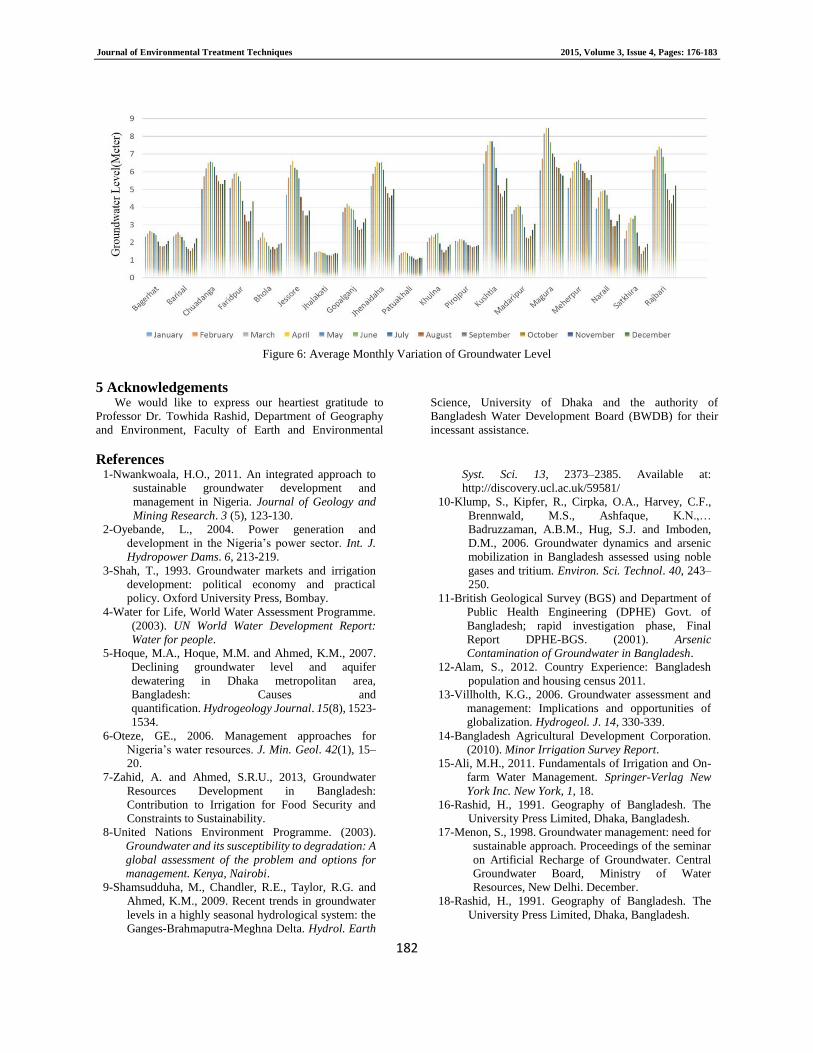
Figure 6: Average Monthly Variation of Groundwater Level
5 Acknowledgements
We would like to express our heartiest gratitude to
Professor Dr. Towhida Rashid, Department of Geography
and Environment, Faculty of Earth and Environmental
Science, University of Dhaka and the authority of
Bangladesh Water Development Board (BWDB) for their
incessant assistance.
References 1-Nwankwoala, H.O., 2011. An integrated approach to
sustainable groundwater development and
management in Nigeria. Journal of Geology and
Mining Research. 3 (5), 123-130.
2-Oyebande, L., 2004. Power generation and
development in the Nigeria’s power sector. Int. J.
Hydropower Dams. 6, 213-219.
3-Shah, T., 1993. Groundwater markets and irrigation
development: political economy and practical
policy. Oxford University Press, Bombay.
4-Water for Life, World Water Assessment Programme.
(2003). UN World Water Development Report:
Water for people.
5-Hoque, M.A., Hoque, M.M. and Ahmed, K.M., 2007.
Declining groundwater level and aquifer
dewatering in Dhaka metropolitan area,
Bangladesh: Causes and
quantification. Hydrogeology Journal. 15(8), 1523-
1534.
6-Oteze, GE., 2006. Management approaches for
Nigeria’s water resources. J. Min. Geol. 42(1), 15–
20.
7-Zahid, A. and Ahmed, S.R.U., 2013, Groundwater
Resources Development in Bangladesh:
Contribution to Irrigation for Food Security and
Constraints to Sustainability.
8-United Nations Environment Programme. (2003).
Groundwater and its susceptibility to degradation: A
global assessment of the problem and options for
management. Kenya, Nairobi.
9-Shamsudduha, M., Chandler, R.E., Taylor, R.G. and
Ahmed, K.M., 2009. Recent trends in groundwater
levels in a highly seasonal hydrological system: the
Ganges-Brahmaputra-Meghna Delta. Hydrol. Earth
Syst. Sci. 13, 2373–2385. Available at:
http://discovery.ucl.ac.uk/59581/
10-Klump, S., Kipfer, R., Cirpka, O.A., Harvey, C.F.,
Brennwald, M.S., Ashfaque, K.N.,…
Badruzzaman, A.B.M., Hug, S.J. and Imboden,
D.M., 2006. Groundwater dynamics and arsenic
mobilization in Bangladesh assessed using noble
gases and tritium. Environ. Sci. Technol. 40, 243–
250.
11-British Geological Survey (BGS) and Department of
Public Health Engineering (DPHE) Govt. of
Bangladesh; rapid investigation phase, Final
Report DPHE-BGS. (2001). Arsenic
Contamination of Groundwater in Bangladesh.
12-Alam, S., 2012. Country Experience: Bangladesh
population and housing census 2011.
13-Villholth, K.G., 2006. Groundwater assessment and
management: Implications and opportunities of
globalization. Hydrogeol. J. 14, 330-339. 14-Bangladesh Agricultural Development Corporation.
(2010). Minor Irrigation Survey Report.
15-Ali, M.H., 2011. Fundamentals of Irrigation and On-
farm Water Management. Springer-Verlag New
York Inc. New York, 1, 18.
16-Rashid, H., 1991. Geography of Bangladesh. The
University Press Limited, Dhaka, Bangladesh.
17-Menon, S., 1998. Groundwater management: need for
sustainable approach. Proceedings of the seminar
on Artificial Recharge of Groundwater. Central
Groundwater Board, Ministry of Water
Resources, New Delhi. December.
18-Rashid, H., 1991. Geography of Bangladesh. The
University Press Limited, Dhaka, Bangladesh.

Journal of Environmental Treatment Techniques 2015, Volume 3, Issue 4, Pages: 176-183
183
19-Rashid, H. and Pramanik, M.A.H., 1990. Visual
Interpretation of Satellite Imagery for Monitoring
Floods in Bangladesh. Springer-Verlag New York
Inc. U.S.A.
20-British Geological Survey and Mott MacDonald Ltd
(UK). (1999). Groundwater Studies for Arsenic
Contamination in Bangladesh. Phase-I: Rapid.
Investigation Phase.
21-Akhter, H., Ahmed, M.S. and Rashed, K.B.S., 2009.
Spatial and Temporal Analysis of Groundwater
Level Fluctuation in Dhaka City, Bangladesh.
Asian Journal of Earth Science. 2 (2), 49-57.