Embed Size (px)
Citation preview

Journal of Geoscience and Environment Protection, 2017, 5, 75-85 http://www.scirp.org/journal/gep
ISSN Online: 2327-4344 ISSN Print: 2327-4336
DOI: 10.4236/gep.2017.52006 February 14, 2017
Determine Stress Field of the Shirband Area by Geometric and Kinematic Analysis of Faults and Folds (North Damqan, Iran)
H. Roohafza, R. Ramesani, A. Taheri
Geology Department, Faculty of Science, Shahrood University, Shahrood, Iran
Abstract In this paper faults and folds of shirband area (north of damqan) investigated to determine the orient of the stress field. The study area is limited between the two faults with E-W strike and northward slip. Investigations result show major faults of the area have sinisteral mechanism. Waterways displacement and slicken slip of faults approve this issue. Three main folds of area has ap-proximately same trend along major faults (E-W). Orientation of stress field investigated and classified by using from some large and medium scale faults and folds. Analysis of stress field investigated by inversion method show that compression axis in the study area have approximately NE-SW strike.
Keywords Structural Analysis, Stress Field, Faults, Folds, Astaneh Fault, Eastern Alborz, Shirband Area
1. Introduction
Continental collision involves brittle and coeval compressional, extensional and strike-slip faulting in the upper crust. This broad depiction emerges from the consistency between active fault systems and the location and focal mechanisms of earthquakes, for example in Asia [1] [2] [3]. This paper presents paleostress tensors calculated from fault planes and striations measured along two main faults and two minor faults of the eastern alborz, in north of Iran. Finally inves-tigation on three fold has supplementary rule to determine stress field of study area.
There are several different ways (methods) to analysis stress tensors from slicken lines of faults. Final Results of these methods determine the position of stress field in study area. Using from these methods and investigate the structur-
How to cite this paper: Roohafza, H., Ra- mesani, R. and Taheri, A. (2017) Determine Stress Field of the Shirband Area by Geo-metric and Kinematic Analysis of Faults and Folds (North Damqan, Iran). Journal of Geoscience and Environment Protection, 5, 75-85. https://doi.org/10.4236/gep.2017.52006 Received: December 7, 2016 Accepted: February 7, 2017 Published: February 14, 2017
H. Roohafza et al.
76
al element of study area, show direction of stress field in study area [4] [5]. However, faults and slicken lines of faults is a key to find out orientation of pa-leostress in study area [6].
1.1. Location
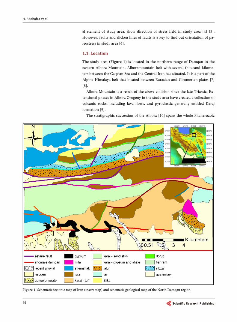
The study area (Figure 1) is located in the northern range of Damqan in the eastern Alborz Mountain. Alborzmountain belt with several thousand kilome-ters between the Caspian Sea and the Central Iran has situated. It is a part of the Alpine-Himalaya belt that located between Eurasian and Cimmerian plates [7] [8].
Alborz Mountain is a result of the above collision since the late Triassic. Ex-tensional phases in Alborz Orogeny in the study area have created a collection of volcanic rocks, including lava flows, and pyroclastic generally entitled Karaj formation [9].
The stratigraphic succession of the Alborz [10] spans the whole Phanerozoic
Figure 1. Schematic tectonic map of Iran (insert map) and schematic geological map of the North Damqan region.
H. Roohafza et al.
77
and it is about 11 to 13 km thick. The Precambrian and Cambrian succession is represented by coastal sandstones and dolostones, with continental deposits [11] [12]. The latest Precambrian to Middle Triassic succession is unconformably covered by the Shemshak Formation, up to 4000 m thick, deposited after dock-ing of the Iran microplate to the Eurasian margin. The formation consists of continental sandstones, shale and coal passing upward to shallow marine depo-sits blanketing the Eo-Cimmerian orogen and itsforeland. The Eo-Cimmerian unconformity is particularly evident in the Shemshak area, where the basal beds of the formation lie directly on the Permo-Carboniferous units [13].
They are succeeded by the Eocene volcanic and volcaniclastic complex of the Karaj Formation, more than 3000 mthick. The Karaj Formation records the ac-tivation, in an extensional regime, of an intracontinental volcanic arc related to northward subduction along the Zagros suture [14]. The Miocene succession (up to 200 m thick) consists of coastal fine-grained terrigenous units with evaporites and limestones.
1.2. Tectonic Setting
The study area has located in Eeastern Alborz-Lesser Caucasus physiographic province (Figure 1). Dominant structural trend in this area is E-W, NE-NW. From tectonics view, it contains deformed zone (fold and thrust belt) of Cimme-rian miniplate that formed in northern active margin until late Triassic. Then it has rifted by tension in a back arc basin of Neotethyiansubduction zone in the south margin of Cimmerian miniplate. Development of that rift stopped in the late Cretaceous and then, renewed in the Eocene by spreading in submarine arc basin of Neotethyiansubduction zone. In other words, this hinterland is a result of a magmatic arc system spreading in the evolutional back arc basin. After that, East-Central Alborz and Lesser Caucasus hinterland has formed by deformation and regional uplift from SE part of Caspian Sea to Black Sea [15] [16]. Based on previous works on the salt and mud diapirism [17] [18] and neotectonic regime in Iran [19] [20] [21], Zagros in south Iran is the most active zone [22] [23]. Then, Alborz [24] [25] and Central Iran [26] [27] have been situated in the next orders.
Central Alborz region have already affected by several strong structural tec-tonic events. There are some different ideas about its latest activities. This study utilities multiple inversion method for paleostress phase separation and struc-tural analysis in the North Damqanfault zone (north of Damqan).
The latest activity of the Damqan fault system on karaj formation, have printed by slickenside on the fault planes, so the result of analyses is reasonable to recognize and analyze of fault function and extend the results to the recent structural activities. The method enables us to determine the position of the principal paleostress axes and the geometrical shape of the stress ellipsoid for reconstruction of paleostress regime dominating the tectonic events by solving reduced stress tensors.
There is evidence of two young tectonic phases during Cenozoic in study area.
H. Roohafza et al.
78
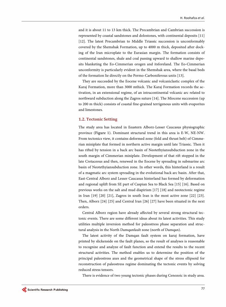
The first phase in late Eocene in the posterior with compressional stress has been N-Strend, and the second phase in the Middle Miocene (Sarmatin) compres-sional phase has been SW-NE trend that caused the evolution of the thrusts with N-S trend in this area. The tectonic events causing the Eocene to the Quaternary have been the formation of the current morphology of this part of the crust of Iran block. In this area, structural trend has changed from Northeast-Southwest to the East-West. The tectonic evidence of the region shows that the west sector (West block) has been stretched in the mid Paleocene and after the collision with Arabian plate, a depression has created towards the Eastern block. This depres-sion has located widely under the volcanic scrambling that formed the northern part of Damqan. This scrambling volcanic-magmatic has been extremely high since the late Paleocene and throughout the early Eocene. Then, it has decreased in the Miocene and Oligocene and there was a big scrambling under the influ-ence at the beginning of the Quaternary across the study area. Morphotectonic units of the study area can be separated and classified as following from South to North (Figure 2):
1) Neogen and quaternary sediment is the youngest sediments in south. North Damqan fault is northern border of this part.
2) Part 1 of the Eocene Karaj formation that contain gray-green vitric tuff and restricted between North Damqan fault and Shirband fault.
3) Part 2 of the Eocene Karaj formation that contain dark gray tuffaceous li-mestone and restricted between Shirband fault and Tamuza fault.
4) Limestone of ruteh formation that restricted between Tamuza fault and Astaneh fault.
5) High height mountain range (Permian to Jurassic) in the northern part of area.
Figure 2. Schematic of the structural represents the main structural elements from the North Damqan mountains can be seen in it study the area.
H. Roohafza et al.
79
2. Material and Methods
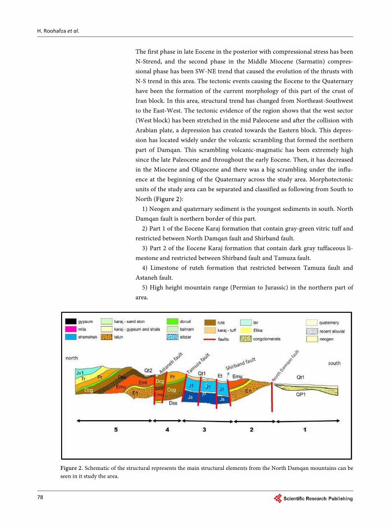
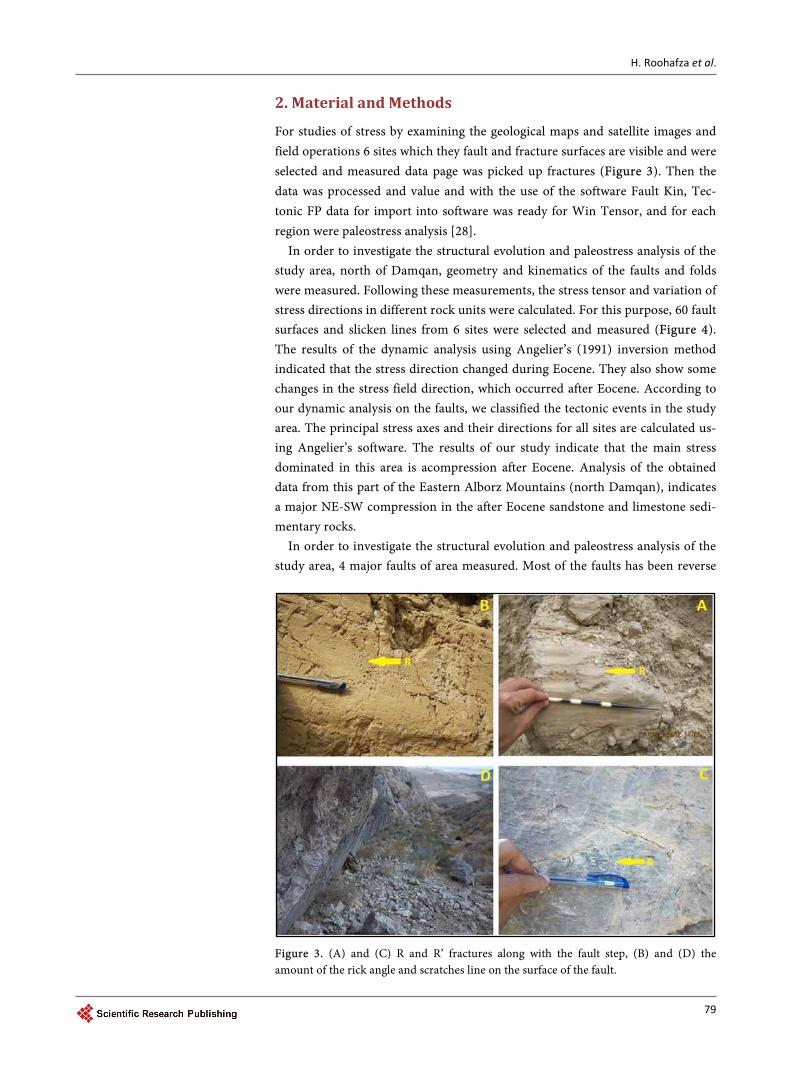
For studies of stress by examining the geological maps and satellite images and field operations 6 sites which they fault and fracture surfaces are visible and were selected and measured data page was picked up fractures (Figure 3). Then the data was processed and value and with the use of the software Fault Kin, Tec-tonic FP data for import into software was ready for Win Tensor, and for each region were paleostress analysis [28].
In order to investigate the structural evolution and paleostress analysis of the study area, north of Damqan, geometry and kinematics of the faults and folds were measured. Following these measurements, the stress tensor and variation of stress directions in different rock units were calculated. For this purpose, 60 fault surfaces and slicken lines from 6 sites were selected and measured (Figure 4). The results of the dynamic analysis using Angelier’s (1991) inversion method indicated that the stress direction changed during Eocene. They also show some changes in the stress field direction, which occurred after Eocene. According to our dynamic analysis on the faults, we classified the tectonic events in the study area. The principal stress axes and their directions for all sites are calculated us-ing Angelier’s software. The results of our study indicate that the main stress dominated in this area is acompression after Eocene. Analysis of the obtained data from this part of the Eastern Alborz Mountains (north Damqan), indicates a major NE-SW compression in the after Eocene sandstone and limestone sedi-mentary rocks.
In order to investigate the structural evolution and paleostress analysis of the study area, 4 major faults of area measured. Most of the faults has been reverse
Figure 3. (A) and (C) R and R’ fractures along with the fault step, (B) and (D) the amount of the rick angle and scratches line on the surface of the fault.
H. Roohafza et al.
80
Figure 4. The position of picked up stations for sampling paleostress.
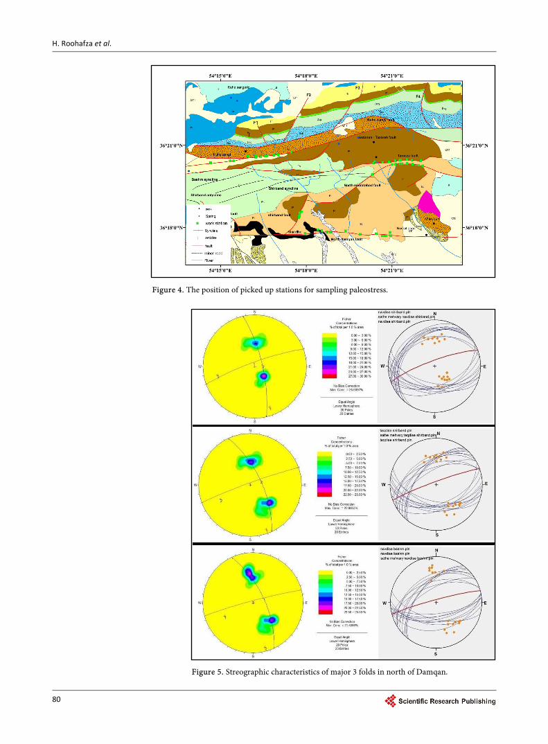
Figure 5. Streographic characteristics of major 3 folds in north of Damqan.
H. Roohafza et al.
81
and strike slip mechanism. This evidence show that area has been in compres-sional condition. All characteristic of faults (such as length, strike, dip) measured to the determine paleostress (Table 1). In next step, we use from folds parame-ters to compare paleostress field that obtained from faults. There is 3 main fold with approximately NE-SW strike in study area (Figure 5). Table 2 shows all characteristic of this folds.
3. Results and Discussion
The purpose of this paper is Geometric and kinematic analysis of the Shirband area faults and folds to determine stress field in study area. The faults of study area cut off quaternary sediment. This means faults are active in current days and determined stress field is related to current time [29].
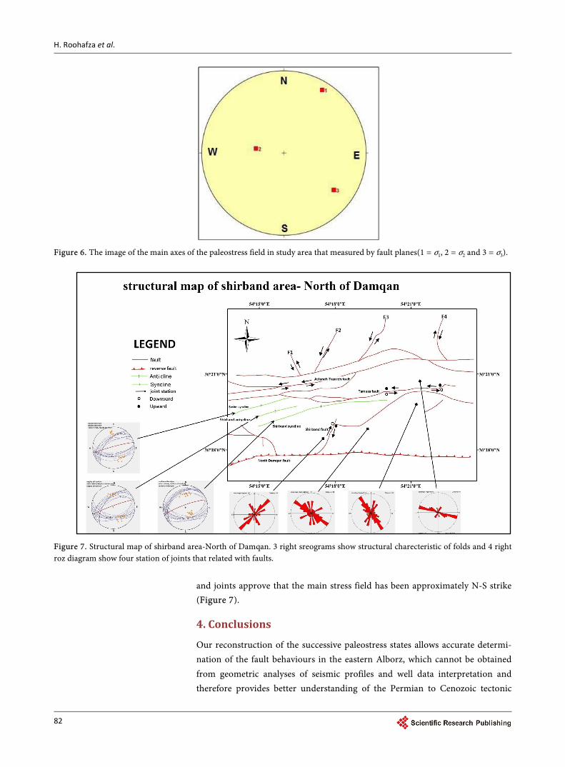
In an overview, same and similar trend between the major faults and axial plan of folds show specific stress field trend [30]. In the study area, from about 6 sites, in the longitude the range of 36˚18' to 36˚24' samples were that’s part of the North Damqan Mountains and Eastern Alborz belt (Figure 4). Stations in place of the North Damqan Mountains turns bending in place rotate the belt East Al-borz and changing trend of the structures of the NE-SW to the E-W in north of Damqan city.
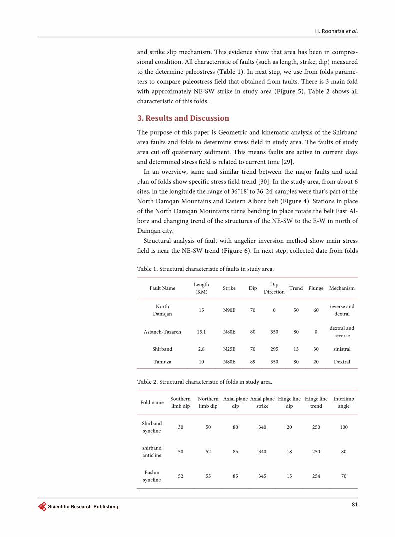
Structural analysis of fault with angelier inversion method show main stress field is near the NE-SW trend (Figure 6). In next step, collected date from folds
Table 1. Structural characteristic of faults in study area.
Fault Name Length (KM)
Strike Dip Dip
Direction Trend Plunge Mechanism
North Damqan
15 N90E 70 0 50 60 reverse and
dextral
Astaneh-Tazareh 15.1 N80E 80 350 80 0 dextral and
reverse
Shirband 2.8 N25E 70 295 13 30 sinistral
Tamuza 10 N80E 89 350 80 20 Dextral
Table 2. Structural characteristic of folds in study area.
Fold name Southern limb dip
Northern limb dip
Axial plane dip
Axial plane strike
Hinge line dip
Hinge line trend
Interlimb angle
Shirband syncline
30 50 80 340 20 250 100
shirband anticline
50 52 85 340 18 250 80
Bashm syncline
52 55 85 345 15 254 70
H. Roohafza et al.
82
Figure 6. The image of the main axes of the paleostress field in study area that measured by fault planes(1 = σ1, 2 = σ2 and 3 = σ3).
Figure 7. Structural map of shirband area-North of Damqan. 3 right sreograms show structural charecteristic of folds and 4 right roz diagram show four station of joints that related with faults.
and joints approve that the main stress field has been approximately N-S strike (Figure 7).
4. Conclusions
Our reconstruction of the successive paleostress states allows accurate determi-nation of the fault behaviours in the eastern Alborz, which cannot be obtained from geometric analyses of seismic profiles and well data interpretation and therefore provides better understanding of the Permian to Cenozoic tectonic
H. Roohafza et al.
83
processes. There are two main fault with two dominant strikes (North East- South West and East-West) and the main conclusions of this research are: • In general view, same trend between faults line and axial plan of folds dem-
onstrate special trend of stress field in north Damqan region. • The direction paleostress field that measured by fault plane is approximately
NE-SW. • The trend of paleostress field measured by fault plane is similar to the pa-
leostress field that measured by folds of study area.
Acknowledgements
This study was conducted as a part of MS dissertation by Science and Research Branch, Shahrood University, shahrood, Iran. Authors have got special thanks to Dr. P. Omidi from geology department of Shahrood University for his support.
References [1] Berberian, M. (1981) Active Faulting and Tectonics of Iran. Zagros Hindu Kush
Himalaya Geodynamic Evolution, 33-69.
[2] Berberian, M. and King, G. (1981) Towards a Paleogeography and Tectonic Evolu-tion of Iran. Canadian Journal of Earth Sciences, 18, 210-265. https://doi.org/10.1139/e81-019
[3] Jackson, J. and McKenzie, D. (1984) Active Tectonics of the Alpine-Himalayan Belt between Western Turkey and Pakistan. Geophysical Journal International, 77, 185- 264. https://doi.org/10.1111/j.1365-246X.1984.tb01931.x
[4] Angelier, J. (1979) Determination of the Mean Principal Directions of Stresses for a Given Fault Population. Tectonophysics, 56, T17-T26. https://doi.org/10.1016/0040-1951(79)90081-7
[5] Angelier, J. (1994) Fault Slip Analysis and Paleostress Reconstruction. Continental Deformation, 4, 101-120.
[6] Angellel, I.J. and Mechleh, P. (1977) Sur uneméthodegraphique de recherche des contraintesprincipaleségalementutilisable en tectonique et en séismologie: La méthode des dièdresdroits.
[7] Arian, M. and Pourkermani, M. (2004) Tectonic Elements of South Flank in the East-Central Alborz Mountain.
[8] Jackson, J., Priestley, K., Allen, M. and Berberian, M. (2002) Active Tectonics of the South Caspian Basin. Geophysical Journal International, 148, 214-245. https://doi.org/10.1046/j.1365-246x.2002.01588.x
[9] Hollingsworth, J., Walker, R., Jackson, J., Bolourchi, M. and Eshraghi, S. (2006) Left-Lateral Strike-Slip Faulting in the East Alborz, NE Iran. AGU Fall Meeting Ab-stracts.
[10] Alavi, M. (1991) Sedimentary and Structural Characteristics of the Paleo-Tethys Remnants in Northeastern Iran. Geological Society of America Bulletin, 103, 983- 992. https://doi.org/10.1130/0016-7606(1991)103<0983:SASCOT>2.3.CO;2
[11] Khavari, R., Ghorashi, M., Arian, M. and Khosrou, T.K. (2010) Geomorphic Signa-tures of Active Tectonics in the Karaj Drainage Basin in South Central Alborz, N Iran.
[12] Moghimi, H., Arian, M. and Sorbi, A. (2015) Fault Movement Potential of Marza-nabad Area, North Alborz, Iran. Open Journal of Geology, 5, 126.
H. Roohafza et al.
84
https://doi.org/10.4236/ojg.2015.53012
[13] Stoklin, J. (1974) Northern Iran: Alborz Mountains, Mesozoic-Cenozoic Orogenic Belt, Data for Orogenic Studies: Geological Society London, Scottish Academic Press, London.
[14] Arian, M. and Hashemi, S.A. (2008) Seismotectonic Zoning in the Zagros.
[15] Brunet, M.-F., Granath, J.W. and Wilmsen, M. (2009) South Caspian to Central Iran Basins: Introduction. Geological Society, London, 312, 1-6. https://doi.org/10.1144/SP312.1
[16] Jackson, J., Priestley, K., Allen, M. and Berberian, M. (2002) Active Tectonics of the South Caspian Basin. Geophysical Journal International, 148, 214-245. https://doi.org/10.1046/j.1365-246x.2002.01588.x
[17] Aleksandrowski, P. (1985) Graphical Determination of Principal Stress Directions for Slickenside Lineation Populations: An Attempt to Modify Arthaud’s Method. Journal of Structural Geology, 7, 73-82. https://doi.org/10.1016/0191-8141(85)90116-6
[18] Arian, M. and Aram, Z. (2014) Relative Tectonic Activity Classification in the Ker-manshah Area, Western Iran. Solid Earth, 5, 1277. https://doi.org/10.5194/se-5-1277-2014
[19] Maleki, Z., Arian, M. and Solgi, A. (2014) Structural Style and Hydrocarbon Trap of Karbasi Anticline, in the Interior Fars Region, Zagros, Iran. Solid Earth Discussions, 6. https://doi.org/10.5194/sed-6-2143-2014
[20] Maleki, Z., Arian, M. and Solgi, A. (2015) Folding Pattern in the Fars Province, Za-gros Folded Belt: Case Study on the Karbasi and Khaftar Anticlines, Interior Fars, Iran. Solid Earth Discussions, 7. https://doi.org/10.5194/sed-7-2347-2015
[21] Maleki, Z., Arian, M., Solgi, A. and Ganjavian, M.A. (2014) The Elements of Fold Style Analysis in the Khaftar Anticline, Zagros, Iran. Open Journal of Geology. https://doi.org/10.4236/ojg.2014.43008
[22] Ehsani, J. and Arian, M. (2015) Quantitative Analysis of Relative Tectonic Activity in the Jarahi-Hendijan Basin Area, Zagros, Iran. Geosciences Journal, 19, 751-765. https://doi.org/10.1007/s12303-015-0016-3
[23] Maleki, Z., Arian, M. and Solgi, A. (2015) Folding Pattern in the Fars Province, Za-gros Folded Belt: Case Study on the Karbasi and Khaftar Anticlines, Interior Fars, Iran. Solid Earth Discussions, 7. https://doi.org/10.5194/sed-7-2347-2015
[24] Khavari, R., Arian, M. and Ghorashi, M. (2009) Neotectonics of the South Central Alborz Drainage Basin, in NW Tehran, N Iran. Journal of Applied Sciences, 9, 4115-4126. https://doi.org/10.3923/jas.2009.4115.4126
[25] Stoklin, J. (1974) Northern Iran: Alborz Mountains, Mesozoic-Cenozoic Orogenic Belt, Data for Orogenic Studies: Geological Society London, Scottish Academic Press, London.
[26] Arian, M. and Ghoreyshi, M. (2006) The Movement Potential Evaluation of the Major Quaternary Faults in Alborz-Central Iran Border Zone, from the East of Te-hran to the East of Semnan.
[27] Brunet, M.-F., Granath, J.W. and Wilmsen, M. (2009) South Caspian to Central Iran Basins: Introduction. Geological Society, London, Special Publications, 312, 1-6. https://doi.org/10.1144/SP312.1
[28] Fry, N. (1999) Striated Faults: Visual Appreciation of Their Constraint on Possible Paleostress Tensors. Journal of Structural Geology, 21, 7-21. https://doi.org/10.1016/S0191-8141(98)00099-6
[29] Angelier, J. (1994) Fault Slip Analysis and Paleostress Reconstruction. Continental

H. Roohafza et al.
85
Deformation, 4, 101-120.
[30] Davis, G.H. and Reynolds, S. (1996) Structural Geology of Rocks and Regions. Wi-ley.
Submit or recommend next manuscript to SCIRP and we will provide best service for you:
Accepting pre-submission inquiries through Email, Facebook, LinkedIn, Twitter, etc. A wide selection of journals (inclusive of 9 subjects, more than 200 journals) Providing 24-hour high-quality service User-friendly online submission system Fair and swift peer-review system Efficient typesetting and proofreading procedure Display of the result of downloads and visits, as well as the number of cited articles Maximum dissemination of your research work
Submit your manuscript at: http://papersubmission.scirp.org/ Or contact [email protected]


![Resume: Ehsan Taheri-Nassaj, Professor in Materials ... · properties of PZT-Resin composite. Materials LettersVo. 75, pp. 61-64. [40] Alizadeh, A., and Taheri-Nassaj, E., 2012. Mechanical](https://img.pdfslide.us/doc/110x75/611d280b6ebbae26db6551a7/resume-ehsan-taheri-nassaj-professor-in-materials-properties-of-pzt-resin.jpg)