Embed Size (px)
Citation preview

Detection, Delineation and Characterization ofShallow Anomalies Using Dual Sensor Seismicand Towed Streamer EM dataA.J. McKay* (Petroleum Geo-Services ASA), M. Widmaier (Petroleum Geo-Services ASA), A.H. Bhuiyan (Petroleum Geo-Services ASA), J. Beenfeldt(Petroleum Geo-Services ASA) & F.E. Engelmark (Petroleum Geo-ServicesASA)
SUMMARYRecent developments in broadband marine seismic and EM technology enables high-resolution imagingand improved characterisation of shallow anomalies. In particular, broad-band dual sensor seismic dataenables separated wavefield imaging that produces high resolution images of the shallow sub-surface evenwhen a wide 3D seismic spread is employed in shallow water. In addition, by using the full wavefield in,for example, full waveform inversion, shallow velocity variations associated with channels, pock-marksand gas-pockets can be imaged. By using a Towed Streamer EM system it is now possible to acquireControlled Source Electromagnetic (CSEM) data simultaneously with seismic data using a single vessel.CSEM data enables the sub-surface resistivity to be determined, and the simultaneous acquisition enablesCSEM data to be acquired efficiently, cost-effectively and early in the exploration cycle. By combining thehigh-resolution structural and velocity seismic images with images of sub-surface resistivity, it is possibleto determine the origin, potential drilling hazard, and resource potential of shallow anomalies.
EAGE Shallow Anomalies Workshop
Indications of prospective petroleum systems? 23-26 November 2014, Malta
Introduction
By utilising broad-band dual sensor seismic data it is now possible to use the complete wave-field to image the overburden in great detail in complex geological settings. For example, Long et al. (2013) and Rønholt et al. (2014) presented shallow water case studies that illustrated how the free surface multiple reflections, i. e. down-going wave-field can be used to image the overburden, and remove the acquisition footprint that is evident if only the primary reflections are used. The fact that the 3D seismic acquisition footprint can be effectively eliminated, and that the shallow sub-surface can be imaged in great detail, opens up the possibility that exploration seismic data can be used to identify and interpret shallow anomalies with confidence. Using a Towed Streamer EM system it is now possible to acquire Controlled Source Electromagnetic (CSEM) data at the same time as broadband dual sensor seismic using a single vessel. One of the benefits of including CSEM data is that the sub-surface resistivity can be derived from the measurements, since resistivity is known to be sensitive to the presence of hydrocarbons (HC). Whilst seismic data are known to be sensitive to small amounts of gas saturation (e.g. fizz gas) CSEM data are most sensitive to high gas saturation. Therefore, by combining the two technologies, and by carefully interpreting the data, it is possible to address a number of questions relevant at various stages in the exploration workflow. For example, at an early stage we may simply be interested in whether or not shallow anomalies are caused by a HC accumulation to determine the extent of the working hydrocarbon system. Later in the exploration cycle we may also want to determine if the shallow anomalies are simply a hazard, or whether they could be considered a prospective resource.
Seismic imaging of shallow anomalies with dual-sensor towed streamers
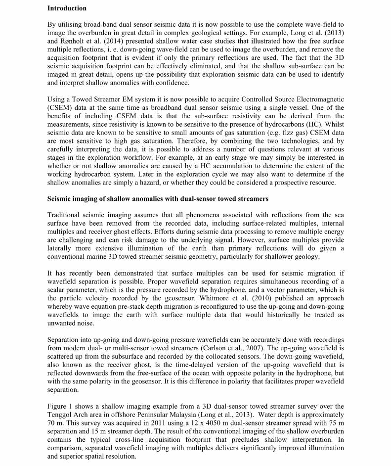
Traditional seismic imaging assumes that all phenomena associated with reflections from the sea surface have been removed from the recorded data, including surface-related multiples, internal multiples and receiver ghost effects. Efforts during seismic data processing to remove multiple energy are challenging and can risk damage to the underlying signal. However, surface multiples provide laterally more extensive illumination of the earth than primary reflections will do given a conventional marine 3D towed streamer seismic geometry, particularly for shallower geology. It has recently been demonstrated that surface multiples can be used for seismic migration if wavefield separation is possible. Proper wavefield separation requires simultaneous recording of a scalar parameter, which is the pressure recorded by the hydrophone, and a vector parameter, which is the particle velocity recorded by the geosensor. Whitmore et al. (2010) published an approach whereby wave equation pre-stack depth migration is reconfigured to use the up-going and down-going wavefields to image the earth with surface multiple data that would historically be treated as unwanted noise. Separation into up-going and down-going pressure wavefields can be accurately done with recordings from modern dual- or multi-sensor towed streamers (Carlson et al., 2007). The up-going wavefield is scattered up from the subsurface and recorded by the collocated sensors. The down-going wavefield, also known as the receiver ghost, is the time-delayed version of the up-going wavefield that is reflected downwards from the free-surface of the ocean with opposite polarity in the hydrophone, but with the same polarity in the geosensor. It is this difference in polarity that facilitates proper wavefield separation. Figure 1 shows a shallow imaging example from a 3D dual-sensor towed streamer survey over the Tenggol Arch area in offshore Peninsular Malaysia (Long et al., 2013). Water depth is approximately 70 m. This survey was acquired in 2011 using a 12 x 4050 m dual-sensor streamer spread with 75 m separation and 15 m streamer depth. The result of the conventional imaging of the shallow overburden contains the typical cross-line acquisition footprint that precludes shallow interpretation. In comparison, separated wavefield imaging with multiples delivers significantly improved illumination and superior spatial resolution.

EAGE Shallow Anomalies Workshop
Indications of prospective petroleum systems? 23-26 November 2014, Malta
Also Rønholt et al. (2014) have recently demonstrated how separated wavefield imaging can utilize the down-going wavefield to enhance shallow illumination and resolution in a North Sea case study. The fact that multiples illuminate the subsurface at smaller reflection angles than primary reflection has been utilized in both shallow velocity model building and seismic imaging. Shallow high resolution velocity variations associated with channels, pockmarks and gas pockets were nicely resolved from the towed dual-sensor 3D seismic streamer data (Figure 2).
Figure 1 Comparison of two time slices at 120 ms two-way travel-time. Water depth is 70 m. Traditional imaging applied to primary reflections (right) contains a pronounced cross-line acquisition footprint that precludes, e.g., shallow geohazard interpretation. In contrast, separated wavefield imaging (left) yields a remarkably continuous and high resolution image because of the superior illumination from surface multiples.
Figure 2: Conventional prestack depth migration based on primary reflections (right) compared to seismic imaging with separated wavefields (left). The images are shown with velocity overlay.
Electromagnetic imaging of resistivity anomalies with towed streamer EM
The Towed Streamer EM system is designed to operate in shallow waters (typically less than 400m or so), and to enable the cost-effective simultaneous acquisition of broadband dual sensor data from a single vessel. Recent case studies demonstrate that Towed Streamer EM data are suitable for characterisation of the sub-surface resistivity to depths of about 3km below mudline, in a variety of geological settings; see for example Key et al. (2014), Mattsson et al. (2014) and McKay et al. (2014). It is possible to detect and delineate accumulations of increased resistivity associated with Hydro-Carbon accumulations at depth provided the overall reservoir volume and resistivity is sufficiently high. In Figure 3 we show examples from the Johan Castberg “Skrugard” area (Norwegian PL532) of the Barents Sea, the discovery of which was a major milestone in Barents Sea exploration. The resistivity anomalies are shown in the form of apparent anisotropy (the ratio of the vertical to horizontal resistivity) which can be a useful attribute to detect zones of anomalous resistivity. We

EAGE Shallow Anomalies Workshop
Indications of prospective petroleum systems? 23-26 November 2014, Malta
used regularised unconstrained anisotropic 2.5D inversion to recover the sub-surface resistivity (Key et al., 2014 and references therein), and validated the resistivity using released log data where it is available (McKay et al., 2014). The strongest apparent anisotropy corresponds to the precise lateral location of Skrugard, and is remarkably well registered in depth given that we have used unconstrained inversion. The very dense spatial sampling facilitated by the towed streamer EM system improves the depth accuracy of the inverted model, making the inversion data driven rather than model based. At the appraisal well location the top Skrugard reservoir level is 1276 m below mean sea level; the Oil Water Contact is at 1395m. The apparent anisotropy anomaly is located at a depth between 1200 and 1500 m. In addition to detection and delineation of deeper resistivity anomalies the Towed Streamer EM system is ideally suited to detect shallow resistivity anomalies. Figure 4 shows an example from the vicinity of the Caurus discovery in the Barents Sea (PL659) where the seismic amplitude extraction helps to define possible shallow (~600-700m below mean sea-level) channel and/or “sand bar” like features, which overlay the slightly deeper gas discovery (~785 m below mean sea-level). The CSEM measurements suggest that that the channels contain either anisotropic sediments (un-likely in the presence of sands) or, potentially, increased resistivity that may be associated with hydrocarbons.
Figure 3 An example of apparent electrical anisotropy in the vicinity of the Skrugard discovery. The red colour indicates the areas that are strongly anomalous relative to the background trend in resistivity. The resistivity sections are co-rendered with the stacked dual sensor seismic data that were acquired at the same time. The seismic stacks were converted to depth using the velocities from seismic processing.
Conclusion and summary
Imaging of separated wavefields that includes down-going multiples requires seismic data acquired with dual-sensor streamers. The technology delivers de-ghosted broadband data that can eliminate the shallow acquisition footprint and provide continuous seismic imaging all the way up to, and including, the seafloor event. This is especially important in areas with very shallow water where the 3D seismic surveys have been acquired with wide streamer spreads to optimize survey efficiency. By combining the high-resolution seismic images of the shallow sub-surface structure with images of the sub-surface resistivity, it is possible to achieve a much better characterization of the origin and properties of the shallow anomalies than if either data-set was used in isolation.

EAGE Shallow Anomalies Workshop
Indications of prospective petroleum systems? 23-26 November 2014, Malta
Figure 4 Seismic attributes (RMS amplitude) on Top Snadd (left) and EM anisotropy anomalies over a depth interval from mud-line to ~1km (right).
Acknowledgements
We thank Lundin Malaysia, Petronas Carigali Sdn. Bhd, and Lundin Norway for support and the authorization to present the work on shallow high resolution imaging with dual-sensor streamer data. We thank Petroleum-Geo Services (PGS) for permission to publish this work.
References
Carlson, D., Long, A., Söllner, W., Tabti, H., Tenghamn, R. and Lunde, N. [2007] Increased resolution and penetration from a towed dual-sensor streamer. First Break, 25, 71-77. Key, K., Du, Z., Mattsson, J., McKay, A. and Midgley, J. [2014] Anisotropic 2.5D inversion of Towed Streamer EM data from three North Sea fields using parallel adaptive finite elements. 76th EAGE Conference & Exhibition. Long, A., Lu, S., Whitmore, D., LeGleut, H., Jones, R., Chemingui, N. and Farouki, M. [2013] Mitigation of the 3D cross-line acquisition footprint using separated wavefield imaging of dual-sensor streamer seismic. 75th EAGE Conference & Exhibition. Mattsson, J., Zhdanov, M. and Endo, M. [2014] 3D anisotropic inversion of towed streamer EM data over the Mariner field in the North Sea. 76th EAGE Conference & Exhibition. McKay, A, Bergh, K.F. and Bhuiyan, A.H. [2014] Determining resistivity from Towed Streamer EM data using unconstrained inversion – Tie to well and discovery examples. 76th EAGE Conference & Exhibition. Rønholt, G., Lie, J. E., Korsmo, O., Danielsen, B., Brandsberg-Dahl, S., Brown, S., Chemingui, N., Valenciano Mavilio, A. and Whitmore, D. [2014] Broadband velocity model building and imaging using reflections, refractions and multiples from dual-sensor streamer data. 76th EAGE Conference & Exhibition. Whitmore, N.D., Valenciano, A.A., Sollner, W. and Lu, S. [2010] Imaging of primaries and multiples using a dual-sensor towed streamer. 80th SEG Meeting, Expanded Abstracts, 3187-3192.