Embed Size (px)
Citation preview

Accepted Manuscript
Detection and characterisation of Black Death burials by multi-proxy geophysicalmethods
Henry C. Dick, Jamie K. Pringle, Barney Sloane, Jay Carver, Austin Haffenden,Stephen Porter, Honorary Archivist, Daniel Roberts, Nigel J. Cassidy
PII: S0305-4403(15)00150-8
DOI: 10.1016/j.jas.2015.04.010
Reference: YJASC 4413
To appear in: Journal of Archaeological Science
Received Date: 3 September 2014
Revised Date: 22 April 2015
Accepted Date: 23 April 2015
Please cite this article as: Dick, H.C., Pringle, J.K., Sloane, B., Carver, J., Haffenden, A., Porter,S., Roberts, D., Cassidy, N.J., Detection and characterisation of Black Death burials by multi-proxygeophysical methods, Journal of Archaeological Science (2015), doi: 10.1016/j.jas.2015.04.010.
This is a PDF file of an unedited manuscript that has been accepted for publication. As a service toour customers we are providing this early version of the manuscript. The manuscript will undergocopyediting, typesetting, and review of the resulting proof before it is published in its final form. Pleasenote that during the production process errors may be discovered which could affect the content, and alllegal disclaimers that apply to the journal pertain.

MANUSCRIP
T
ACCEPTED
ACCEPTED MANUSCRIPT

MANUSCRIP
T
ACCEPTED
ACCEPTED MANUSCRIPT
1
Detection and characterisation of Black Death burials by multi-proxy geophysical methods 1
2
Henry C. Dicka,b
, Jamie K. Pringlea*
, Barney Sloanec, Jay Carver
d, Austin Haffenden
a, Stephen 3
Portere, Daniel Roberts
a, & Nigel J. Cassidy
a 4
5
aSchool of Physical Sciences & Geography, Keele University, Keele, ST4 6DA, UK. Email 6
address: [email protected] [email protected] [email protected]; 7
[email protected]; [email protected] 8
bApplied Geophysics Group, Physics Dept., University of Port Harcourt, Nigeria 9
cEnglish Heritage, Swindon, UK. Email: [email protected] 10
dCrossRail Ltd, 25 Canada Square, Canary Wharf, London, E14 5LQ. UK. Email: 11
eHonorary Archivist, Sutton’s Hospital in Charterhouse, London, UK. Email: 13
15
*Corresponding author: Keele University, School of Physical Sciences & Geography, William 16
Smith Building, Keele, ST4 6DA, UK. Tel: +44 (0)1782 733163. Email address: 17
19
Keywords: burials; plague; Black Death; London; geophysics 20

MANUSCRIP
T
ACCEPTED
ACCEPTED MANUSCRIPT
2
Abstract 21
22
The Crossrail underground network extension discovered 25 well preserved skeletons 23
shallowly buried in Central London in 2013. Subsequent carbon dating and aDNA analysis 24
confirmed the archaeological age and presence of the Yersinia pestis “Black Death” plague 25
epidemic strain. Here we present the non-invasive multi-proxy geophysical survey of the 26
adjacent Charterhouse Square, rapidly undertaken to detect any further burials and 27
characterise the site. Historical records suggested the area was a burial ground for Black 28
Death plague victims, before subsequent cemetery and urban land use. Following initial 29
trial surveys, surveys imaged ~200 isolated and similar-sized burials in the south-west of the 30
site. There were also two contrasting burial orientations present at various depths which 31
suggested a series of controlled phased burials. A well-defined eastern burial boundary, 32
taking the form of a ditch and bank, was also discovered. Geophysical surveys also 33
identified a subsequent complex site history with multiple-aged features. This study revises 34
knowledge of Black Death aged-burials and provides important implications for successful 35
geophysical burial detection with significant time- and space-limited site constraints. 36
37

MANUSCRIP
T
ACCEPTED
ACCEPTED MANUSCRIPT
3
1. Introduction 38
39
In 2013 Europe’s biggest construction project, the Crossrail underground network extension, 40
discovered 25 well preserved skeletons, shallowly buried in close proximity to each other, in 41
Charterhouse Square in Central London. Historical records suggested that the site was an 42
emergency burial ground for Black Death victims during the 1348-1349 AD plague epidemic 43
(Porter, 2009; Sloane, 2011). A non-invasive archaeological geophysical survey of 44
Charterhouse Square with a limited time scale was commissioned because of active 45
construction deadlines. 46
47
There are generally accepted to be three plague pandemics in recorded human history, 48
Justinian’s Plague (541-542 AD) that was mostly contained within Mediterranean countries, 49
the much wider European so-called Black Death plague (1345-1750 AD) and the 19th
Century 50
Chinese plague epidemic which spread globally in 1894 AD (Haensch et al., 2010). The Black 51
Death was the first widespread outbreak of medieval plague in Europe, with recent 52
historical research estimating that it reduced London’s population by 30% - 50 % between 53
1347-1351 AD (Sloane, 2011). Contemporary accounts detail the sheer numbers of dead 54
prevented Christian burials from being undertaken “so great a multitude eventually died 55
that all the cemeteries of the aforesaid city were insufficient for the burial of the dead. For 56
this reason, many were compelled to bury their dead in places unseemly, not hallowed or 57
blessed; some, it was said, cast the corpses into the river” (Sloane, 2011). 58
59

MANUSCRIP
T
ACCEPTED
ACCEPTED MANUSCRIPT
4
Recent scientific advancements in dating skeletal remains have allowed research into age of 60
mortality in London during this period (DeWitte, 2010; DeWitte & Hughes-Morey, 2012), 61
subsequent population health improvements (DeWitte, 2014) and confirmation of plague 62
strains to be rapidly identified, usually in the pulp of teeth (Kacki et al., 2004; Drancourt et 63
al., 2004; Bianucci et al., 2009; Haensch et al., 2010). Research has also cast doubt on the 64
traditionally-held premise that rats (Rattus rattus/norvegicus) formed the intermediate host 65
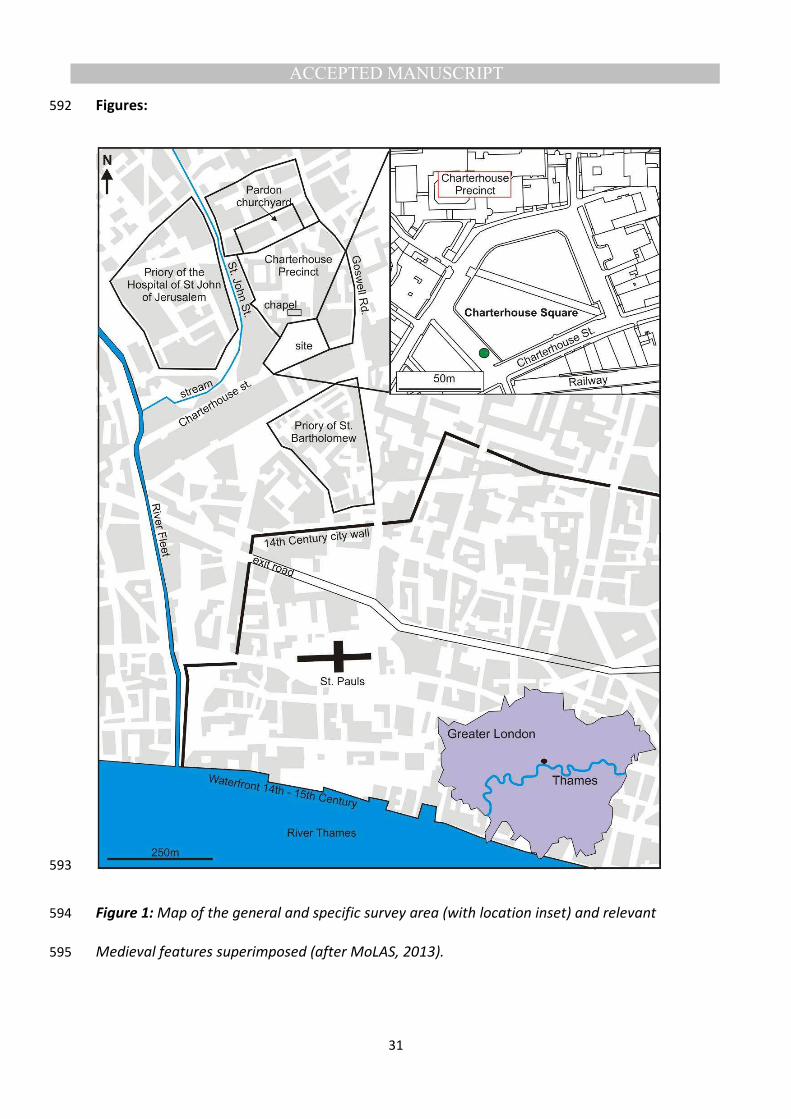
carrier in North European countries, with pneumonic (human to human via air droplets) 66
rather than bubonic plague now proposed to be the main dispersal method (Hufthammer & 67
Walloe, 2013). 68
69
Current search methods to detect both archaeological and modern human burials are highly 70
varied and have been reviewed (Hunter & Cox, 2005; Pringle et al., 2012a), with best 71
practice suggesting a phased approach, moving from large-scale remote sensing methods 72
(Kalacska, 2009), through to initial ground reconnaissance and control studies before full 73
searches are initiated (Harrison and Donnelly, 2009, Larsen et al., 2011). These full searches 74
can involve many and varied methods, depending upon the individual target(s) and site and 75
even seasonal parameters (see Pringle et al., 2012a; Jervis and Pringle, 2014) through to 76
physical excavation (e.g. see Hunter and Cox, 2005). 77
78
Near-surface geophysical surveys have been often applied in archaeological site 79
investigations, either to detect and/or characterise a site (e.g. see De Smedt et al., 2014) or 80
to decide where to start intrusive investigations. Archaeological geophysical searches for 81

MANUSCRIP
T
ACCEPTED
ACCEPTED MANUSCRIPT
5
unmarked burials are many and have had varied success, for example, locating 82
archaeological graves in Jordan (Frohlich and Lancaster, 1986) and Turkey (Arisoy et al., 83
2007), Kings’ Mounds in Sweden (Persson and Olofsson, 2004), Icelandic Viking/Medieval 84
graves (Damiata et al., 2013), North American Indian historic burial grounds (Bigman, 2012), 85
19th
century cemeteries and graveyards in New Zealand (Nobes, 1999), the USA (Bevan, 86
1991; Ellwood et al., 1994; Doolittle & Bellantoni, 2010; Dalan et al., 2010; Honerkamp and 87
Crook, 2012; Bigman, 2014), Australia (Buck, 2003), the UK (Hansen et al., 2014), to 19th
88
century Irish Famine victims (Ruffell et al., 2009) and 20th
century Svalbard Spanish Flu 89
victims (Davis et al., 2000). The advantages of archaeological surveys are that there is 90
usually little time constraint; however for forensic and time-limited geophysical surveys the 91
need to rapidly characterise a site and identify potential burial position(s) is paramount (e.g. 92
see Nobes, 2000; Pringle and Jervis, 2010; Novo et al., 2011). 93
94
Due to the limited survey time and site constraints, a multi-proxy geophysical rapid 95
assessment approach had to be used in this study. Study aims were : firstly to determine if 96
non-invasive geophysical methods could both detect and characterise the historic burial 97
ground; secondly to detect any further unmarked burials within the survey area and if there 98
were any particular concentrations and orientations; thirdly to determine the optimum 99
geophysical technique(s) for such an archaeological time-limited scenario and finally; 100
fourthly to compare results to other published studies. 101
102

MANUSCRIP
T
ACCEPTED
ACCEPTED MANUSCRIPT
6
2. Material and methods 103
104
2.1 Study site 105
106
The study site was at Charterhouse Square near St. Bartholomew’s Hospital in Central 107
London, UK, situated ~1 km north of the Thames river and ~15 m above sea level (Fig. 1). 108
Charterhouse Square is a 4 acre urban grassed park containing isolated mature deciduous 109
trees, surrounded by roads and buildings with Charterhouse hospital itself to the north-west 110
(Fig. 2). Available British Geological Survey boreholes detail an organic-rich silty topsoil 111
succeeded by unconsolidated fluvial sands, gravels and alluvium from previous courses of 112
the River Thames that overlie Eocene London Clay and Cretaceous Chalk bedrock types at 113
~30 m and ~50 m below ground level (bgl) respectively. 114
115
Historical records showed a 13 acre area north of the city walls (Fig. 1) was leased by Sir 116
Walter de Mauny in 1349 AD from St. Bartholomew’s priory as a burial ground for The Black 117
Death plague victims (Hope, 1925). In 1371 AD de Mauny also sponsored a Carthusian 118
priory and enlarged the site by 4 Acres to the east, the boundary between these areas being 119
a parish boundary that still remains today (Porter, 2009), with a chapel built in 1481 AD and 120
the priory’s meat kitchen (Temple, 2010). The priory was dissolved in 1538 AD with the 121
1348 AD chapel demolished in 1545 AD and the chapel erected in 1481 AD pulled down in 122
1615 AD; the meat kitchen was probably demolished c.1545 AD (Barber and Thomas, 2002). 123
The buildings of the former priory was rebuilt as a mansion, which was adapted in 1614 AD 124
as an almshouse and school, and after the priory’s dissolution the periphery of its outer 125
precinct was built upon, enclosing the modern Charterhouse Square. The construction of 126

MANUSCRIP
T
ACCEPTED
ACCEPTED MANUSCRIPT
7
the London Metropolitan Railway and a new street built in the 1860s - 1870s AD encroached 127
upon the southern area of the site (Porter, 2009). In 1939 AD as part of World War Two air-128
raid precautions, six underground emergency water tanks were installed in the square. 129
Lastly an exploratory excavation was undertaken in 1997-8 AD with an isolated skeleton 130
discovered in the north-east of the site (MoLAS, 1998). 131
132
Figure 1: 133
Figure 2: 134
135
2.2. Archaeological excavations 136
137
As part of the underground network extension, a 4.5 m diameter vertical shaft was dug on 138
the road to the south-west of the Square (Fig. 2). At 2.3 m bgl below compacted clay soil, 139
eight isolated earth-cut graves containing eleven relatively well preserved predominantly 140
human remains were encountered aligned northeast-southwest (Fig. 3a). These did not 141
show any signs of trauma although further disarticulated human remains were also 142
recovered from two of the grave fills. At 2.5 m bgl two isolated earth-cut graves containing 143
two relatively well preserved incomplete human remains were also encountered, again 144
aligned northeast-southwest. At 2.7 m bgl nine isolated earth-cut graves and one double-145
grave containing eleven well preserved predominantly adult human remains were 146
encountered, nine aligned northeast-southwest and two aligned north-south (Fig. 3b). The 147
deepest burials had two graves with multiple burials, one with remains on top of the first 148
and the other having them side by side (Fig. 3b). Recovered pottery shards from the 2.3m 149
bgl burials estimated a burial date of 1270-1350 AD. 150

MANUSCRIP
T
ACCEPTED
ACCEPTED MANUSCRIPT
8
151
Subsequent radio-carbon dating of the 2.5 m and 2.7 m bgl burials gave date ranges of 1275 152
AD -1405 AD ±20BP, with the 2.3 m bgl burials having a date range of 1430 AD – 1485 AD 153
±21BP (see MoLAS, 2013). Rapid aDNA analysis (see Kacki et al., 2004) of the recovered 154
human remains confirmed the presence of the Yersinia pestis Black Death plague epidemic 155
strain in all three burial phases (Fig. 3 and MoLAS, 2013). 156
157
Figure 3: 158
159
2.3 Near-Surface geophysical investigations 160
161
After initial trial surveys showed detectable anomalies following best practice (see Milsom 162
and Eriksen, 2011), a two day time-limited survey was then undertaken. 2D profile positions 163
(Fig. 2a) were all surveyed using a Leica™ 1200 total station theodolite and reflector prism 164
with an 0.005 m average position accuracy before being integrated with the digital sitemap 165
in ArcGIS™ ArcMap v.10 software. 166
167
A bulk ground conductivity survey was undertaken over the whole square using a Geonics™ 168
EM-31-Mark2 conductivity meter (Suppl. Mat.), not to identify individual grave positions but 169
in order to rapidly characterise the site and to determine the spatial limits of the burial area. 170
This instrument images bulk changes in the near-surface, typically down to ~10m bgl in ideal 171
conditions (see Milsom and Eriksen, 2011). It was expected that there should be a 172
measureable EM contrast across the burial area margins, any relict building infrastructure to 173

MANUSCRIP
T
ACCEPTED
ACCEPTED MANUSCRIPT
9
be clearly imaged as isolated high/low linear anomalies and the highly conductive water 174
tanks to be found if remaining. The instrument was zeroed at the northeast side of the 175
square which was determined to be relatively geophysically homogeneous from the trial 176
surveys. Due to potential cultural interference from above-ground conductive objects, the 177
dataset was collected with the meter in vertical orientation (VMD) mode which did reduce 178
its sensitivity to very near-surface objects (see Milsom and Eriksen, 2011). Both inphase and 179
quadrature data types were collected on 2 m spaced survey lines in a one-way, west-east 180
orientation across the square at ~0.5 m spatial position increments. A Garmin™ GPS also 181
logged sample positions and was used by Trackmaker31™ v.1.21 to check positional 182
locations. Standard post-survey data processing was undertaken in Geoscan™ Geoplot 183
v3.00 software, including data de-spiking to remove isolated anomalous data points and de-184
trending to remove long wavelength site trends from the data, before the dataset was 185
imported into ARCGIS ArcMAP™ v.10 software and a digital, colour contoured surface was 186
generated using ordinary kriging through the Geostastical Analyst extension. 187
188
An electrical resistivity survey was only collected over the south-west area of the site due to 189
time constraints as other studies (see e.g. Hansen et al., 2014; Ellwood et al., 1994) have 190
imaged relative low/high isolated resistivity anomalies associated with historic burials, 191
compared to background values. Whilst 0.5 m probe spacing configurations are commonly 192
used for such investigations (see e.g. Hansen et al., 2014; Pringle and Jervis, 2010), a 1 m 193
probe separation was used here to penetrate to the ~3 m depths of the discovered graves 194
(Fig. 3). Remote probes were set at least 10 m from sample positions following best 195
practice guidelines (see Milsom and Eriksen, 2011). Geoscan™ RM15-D bulk ground 196

MANUSCRIP
T
ACCEPTED
ACCEPTED MANUSCRIPT
10
electrical resistivity equipment (Suppl. Mat.), with a stated measurement accuracy of 0.1 Ω, 197
was used to collect 1 m x 0.1 m spaced data over a limited area of 8 m x 38 m, located 198
adjacent to the discovered burials (L1-8 in Fig.2 for location). After data download, standard 199
post-survey data processing were undertaken in Geoscan™ Geoplot v.3.00 software, 200
including; (i) conversion of measured resistance (Ω) values to apparent resistivity (Ω.m) to 201
account for probe configuration; (ii) data de-spiking to remove isolated anomalous data 202
points and; (iii) dataset de-trending to remove long wavelength site trends from the data 203
(see Milsom and Eriksen, 2011). The dataset was then imported into ARCGIS ArcMAP™ v.10 204
software and a digital, colour contoured surface was generated using ordinary kriging 205
through the Geostastical Analyst extension. 206
207
A Ground Penetrating Radar (GPR) dataset was also collected over the south-west area of 208
the site, as other authors have found this method effective to detect unmarked 209
archaeological burials as discussed in the introduction. Due to time constraints, widely-210
spaced and orientated 2D profiles were also collected in the rest of the square to detect if 211
further graves were present, and to determine the spatial burial area extent and its margins 212
(Fig. 2 for location). After the trial surveys determined the optimum radar frequency, GPR 213
PulseEKKO™ 1000 equipment was utilised with 225 MHz frequency antennae and a 32 v 214
transmitter antennae (Suppl. Mat.) to collect the data with 0.1 m trace spacings , 90 ns time 215
window and constant 32 repeat stacks. A grid of 1-m spaced 2D profiles were acquired 216
adjacent to the discovered archaeological graves (L1-21), three (L22-24) acquired on the 217
road to the north of the square, two (L25,29) orientated at right angles to the parish 218
boundary, one (L26) outside the parish boundary and a final profile (L28) mid-way across 219

MANUSCRIP
T
ACCEPTED
ACCEPTED MANUSCRIPT
11
the square. Standard data processing steps were undertaken in REFLEX-Win™ v.3.0 220
processing software, these included; (1) subtracting the mean from traces; (ii) picking first 221
arrivals and then (iii) applying static correction and moved trace start times to 10 ns; (iv) 222
time-cut to remove blank data and; (v) manual gain 1D filter to boost relative deeper radar 223
trace amplitudes whilst retaining shallow ones. 224
225
Two 2D Electrical Resistivity Imaging (ERI) profiles, orientated at right angles to the known 226
parish boundary, were also collected by a CAMPUS™ TIGRE system (Suppl. Mat.) to 227
determine if this marked the burial margin (Fig.2 for location). As with the conductivity 228
data, it would be expected that there would be a sharp contrast in resistive properties 229
across this margin. Both profiles used 32 steel electrodes inserted into the ground along 230
each profile, with ERI1 and ERI2 using 1 m and 0.5 m probe spacing respectively due to site 231
constraints. ImagerPro™ 2000 data acquisition software used a Wenner configuration and 232
10 ‘n’ levels that should penetrate to ~5 m bgl as shown by other researchers (see e.g. 233
Brown, 2006; Pringle et al., 2012b). Raw ERI datasets were then individually processed with 234
anomalous data points removed and inverted utilizing least-square inversions in Geotomo™ 235
Res2Dinv v.355 software following standard methods (see Milsom and Eriksen, 2011). Half 236
cell spacing was also utilized during the inversion process to remove potential edge effects 237
and reduce any probe contact resistance variations. Finalised models of true resistivity 238
sections were created with a relatively small RMS mis-fit of 2.5 % (ERI1) and 4.1 % (ER2) 239
between the respective calculated models and acquired datasets (see Milsom and Eriksen, 240
2011). 241
242

MANUSCRIP
T
ACCEPTED
ACCEPTED MANUSCRIPT
12
3. Results 243
The processed bulk ground EM conductivity dataset, acquired in order to characterise the 244
site and determine the spatial limits of the burial area, showed a relatively highly conductive 245
15 m2 rectangular area in the north-west of the square, compared to background values, 246
which will most probably be the location of the WW2 water tank (Fig. 4). There was also a 247
relatively high conductive area in the south, but this was probably due to the presence of 248
the above-ground metal fence that bordered the urban square. There was a relative low 249
conductive ~25 m2 area in the north-east of the square whose origin could not be 250
determined (Fig. 4). In contrast, there was also a ~20 m2 square anomaly with variable 251
relative high/low conductive values in the central area (Fig. 4); this was of similar size to a 252
meat kitchen documented to be onsite. Interestingly there was no measureable difference 253
in EM properties across the parish boundary as was expected (Fig. 4). 254
255
Figure 4: 256
257
The processed electrical resistivity survey of the south-west area of the square, adjacent to 258
the discovery shaft, showed a trend from very high resistivity values in the south to very low 259
resistivity values to the north (Fig. 5). The north area therefore agrees with the high 260
conductivity values in the EM dataset. However relative isolated anomalies compared to 261
background values, which may be expected from individual graves containing human 262
remains (see Frohlich & Lancaster, 1986; Hansen et al. 2014), were disappointedly not 263
observed in this dataset. This may be due to this survey not penetrating to their likely 2+ m 264
depths below ground level. 265

MANUSCRIP
T
ACCEPTED
ACCEPTED MANUSCRIPT
13
Figure 5: 266
267
The processed 2D GPR profiles in the western of the square (L1-21 – see Fig. 2) consistently 268
imaged isolated, evenly-spaced and similar-sized ½ hyperbolic reflection events produced 269
from buried objects in the southern half of all profiles (Fig. 6). These objects were between 270
~1.5 m to ~3 m bgl that were similar to the discovered historic graves (Fig. 3) and have been 271
observed in other mass burials (e.g. Ruffell et al., 2009). Smaller and shallower ½ hyperbolic 272
reflection events were due to tree roots from mature deciduous trees onsite . Consistent, 273
very strong horizontal reflections for ~10 m – 12 m were also present at the northern end 274
(Fig. 6), with both a top at ~0.5 m bgl and bottom ~2 m bgl reflector observed (cf. Fig. 6). 275
This significant-sized object was correlated to the high conductivity/low resistivity anomaly 276
present in both the EM and electrical resistivity datasets respectively and was the water 277
tank. Due to time constraints the profiles were too widely-spaced for meaningful horizontal 278
time slices to be generated. 279
280
The other 2D profile (L28) across the park (Fig. 2 for location) showed multiple isolated ½ 281
hyperbolic reflection events in the southern side, with none present in the north, although 282
there was no strong horizontal reflector present (Fig. 6). Three 2D profiles (L22-24) on the 283
north to the north of the square (Fig. 2 for location) did not image any objects, except 284
beside observed surface manhole covers. The 2D profile (L26) that was located east of the 285
parish boundary did not show any characteristic isolated ½ hyperbolic reflection events (Fig. 286
6). 287
288
Figure 6: 289

MANUSCRIP
T
ACCEPTED
ACCEPTED MANUSCRIPT
14
290
Both 2D ERI inverted models showed a clear contrast in resistivity properties across the 291
parish boundary, with relative higher resistivity values to the east of boundary and lower 292
values to the west, in contrast to the EM data (cf. Figs. 4 and 7). However, the GPR showed 293
much better resolution at this location, resolving a potential ditch and bank geometry at the 294
margin (Fig. 7). There were significant heterogeneities present in both profiles, as would be 295
expected in such urban environments, variable moisture content may also be a factor here 296
as others have found (Pringle et al., 2012b), especially in parklands (Jones et al., 2009). 297
298
Figure 7: 299
300

MANUSCRIP
T
ACCEPTED
ACCEPTED MANUSCRIPT
15
4. Discussion 301
302
The first aim of this study was “to determine if non-invasive geophysical methods could both 303
detect and characterise the historic burial ground”. The geophysical surveys have identified 304
the key characteristics of the site. These confirmed that the eastern boundary was the 305
marked parish boundary, a square anomaly in the centre may be buried foundations of the 306
priory’s meat kitchen, shown on mid-fifteenth century plans to have been a two-story 307
building, or, perhaps less likely, a demolished chapel. WW2 buried water tanks remain in 308
the north-west area and lastly, but most importantly, a concentration of ~200 isolated 309
buried objects were present in the south-west of the square. These 200 objects were most 310
probably further, and as yet undiscovered, isolated graves of Black Death plague victims 311
although this will need to be excavated for confirmation. The eastern boundary also had a 312
central ditch and eastern raised bank identified by GPR that that matched historical 313
accounts (Porter, 2009). Figure 8 and Table 1 summarise the study findings. These targets 314
were still geophysically detectable in a difficult urban survey environment, the burials after 315
660+ years, showing that archaeological geophysical surveys can both detect and 316
characterise historic burial sites. Note that any further archaeological targets in the 317
Square’s boundaries may not have been geophysically resolved due to local cultural noise. 318
319
Figure 8: 320
321
Table 1. 322

MANUSCRIP
T
ACCEPTED
ACCEPTED MANUSCRIPT
16
The second aim of this study was “to detect any further unmarked burials and if there were 323
any particular burial concentrations and orientations”. The SW of the square showed 324
multiple, evenly-spaced and shallow buried objects which were most likely to be historic 325
graves (Fig. 8). Simple identification of anomalies in GPR 2D profiles gave a conservative 326
estimate of ~200 individual graves; note that there will, most probably, be more due to co-327
mingled remains as both this study (Fig. 3) and others, for example, the Kacki et al. (2011) 328
study of contemporary remains in French cemeteries, have evidenced. Historical records 329
suggest that there may be several thousand individuals buried in this area (see Sloane, 330
2011), but it was unknown what burial style they may be, and if they had been removed 331
subsequently. The mostly isolated nature of burials was surprising; it was documented that 332
burials during the height of the Black Death plague epidemic were buried in mass pits 333
(Sloane, 2011) and thus this study has revised the knowledge of burials to more of an 334
emergency cemetery style. The discovered burials also had three clearly different burial 335
phases, with clay-rich soil being deposited between each, perhaps in an attempt to prevent 336
the spread of the disease (Fig. 8). Some geophysical anomaly orientations were similar to 337
the discovered graves, approximately northeast-southwest, but there were other 338
orientations, north-south orientated burials for example. There do not seem to be remains 339
in the north of the Square and indeed outside the eastern parish boundary. 340
341
The third aim of this study was “to determine the optimum geophysical technique(s) for such 342
an archaeological time-limited scenario”. To successfully detect and characterise historic 343
burials a multi- phased approach using different geophysical techniques should be 344
undertaken following best practise (see Harrison & Donnelly, 2009; Larsen et al., 2011; 345

MANUSCRIP
T
ACCEPTED
ACCEPTED MANUSCRIPT
17
Pringle et al., 2012a). In this case, after the desk study of historical records and remote 346
sensing data had identified the burial site, during initial site reconnaissance, as well as soil 347
and bedrock type being determined, trial surveys using available non-invasive geophysical 348
equipment were undertaken. Electro-magnetic, electrical resistivity and GPR methods were 349
all trialled to determine if targets were geophysically detectable, i.e. measureable from 350
background values. EM surveys then rapidly surveyed the site, with bulk ground change 351
areas being identified. These areas were then re-surveyed by higher resolution geophysical 352
methods, particular GPR, and this phased approach is recommended for other studies. Trial 353
surveys also determined optimal geophysical equipment configurations. For example, GPR 354
225 MHz frequency antennae were judged optimal, mid-range frequency have also been 355
shown by other studies to detect buried archaeological objects buried at least 1 m depth bgl 356
(see Davis et al., 2000; Ruffell et al. 2009; Ruffell & Kulessa 2009; Hansen et al., 2014) which 357
gave confidence in the survey data collected. The electrical resistivity survey equipment 358
configuration was also used with 1 m electrode spacing on mobile probes, a less-used 359
spacing as 0.5 m is conventional (see Pringle et al., 2012b; Hansen et al., 2014) but one 360
deemed to be able penetrate to the desired depth bgl. Whilst the WW2 underground tanks 361
were identified, individual remains were not using this method; this was most probably due 362
to the heterogeneous nature of the site. ERI 2D profiles were judged very useful in this 363
studyto characterise the burial boundaries, but the GPR 2D profiles on the same survey lines 364
had better resolution and allowed the nature of the boundary to also be determined. 365
Combining different geophysical techniques to gain extra information has also been 366
recommended by other authors (e.g. see Milsom & Eriksen, 2011; Pringle et al., 2012b). 367
368

MANUSCRIP
T
ACCEPTED
ACCEPTED MANUSCRIPT
18
The fourth and final aim of this study was “to compare results to other published studies”. In 369
the literature GPR has been commonly used to detect archaeological graves, for example 370
ancient graves in Jordan (Frohlich & Lancaster, 1986) and Viking/Medieval graves in Iceland 371
(Damiata et al., 2013), and unmarked graveyard and cemetery burials in New Zealand 372
(Nobes, 2000), Australia (Buck, 2003), the US (Doolittle & Bellantoni, 2013), Ireland (Rufell et 373
al., 2009) and the UK (Hansen et al., 2014), and marked burials in Germany (Fiedler et al., 374
2009b). These studies have all used mid-range GPR antennae which this study has also 375
utilised after trial surveys. There are fewer published studies using electrical resistivity to 376
locate individual remains and indeed characterise mass burial sites, Witten et al. (2001) 377
used electrical resistivity to locate a 1920s race riot burial site in the US and Brown (2006) 378
used ERI 2D profiles to locate 1990s burials in Bosnia. For bulk ground conductivity De 379
Smedt et al. (2014) documented an EM survey to characterise the Stonehenge 380
archaeological site, but there is only Bigman’s (2012) study to locate unmarked graves in 381
North American Indian burial grounds and Nobes (2000) New Zealand clandestine grave 382
search. However all of these were in rural environments which was not the case here, albeit 383
De Smedt et al. (2014) documented advanced processing was needed to remove the effect 384
of near-surface metallic clutter from the data. From the data in this study it is suggested to 385
use EM techniques to characterise the site before using ERI 2D profiles to characterise site 386
margins, followed by mid-frequency radar surveys to characterise their content. It was 387
impressive that near-surface geophysical surveys have been so effective in such a busy 388
urban environment. 389
390

MANUSCRIP
T
ACCEPTED
ACCEPTED MANUSCRIPT
19
4. Conclusions 391
392
Following the discovery of historic skeletal remains and subsequent radiocarbon dating and 393
aDNA analysis confirmed individuals were victims of the Yersinia pestis Black Death plague 394
epidemic in the 14th
and 15th
Centuries, a multi-technique near-surface geophysical survey 395
was undertaken in Charterhouse Square in central London. An EM, ERI and GPR survey 396
rapidly characterised the site, finding the eastern boundary of a burial ground with 397
suspected ditch and bank that matched historical records. There were concentrations of 398
~200 surprisingly isolated burials in the south-west of the site, with two different burial 399
orientations and three different burial depths below ground level. These suggest different 400
phases of burial over different time periods that was confirmed by radiocarbon dating. The 401
square formed part of an emergency cemetery at this time, rather than mass burial 402
pits/trenches that was documented in historical records. Geophysical investigations also 403
characterised the site with subsequent demolished building foundations and WW2 water 404
tanks remaining on site. This study revised existing knowledge of Black Death burials and 405
shows the potential of near-surface geophysical techniques to both detect and characterise 406
historic mass burials in busy and restrictive urban environments. 407
408

MANUSCRIP
T
ACCEPTED
ACCEPTED MANUSCRIPT
20
5. Acknowledgements 409
410
This study was financially supported by TrueNorthTV Productions. Sarah Aldridge from 411
University College London and Matteo Giubertoni from Polimi University are acknowledged 412
for field assistance. A 2003 SRIF3 grant supported the purchase of geophysical and survey 413
equipment at Keele University. 414
415

MANUSCRIP
T
ACCEPTED
ACCEPTED MANUSCRIPT
21
6. References 416
417
M.O. Arisoy, O. Kocak, A. Buyuksarac, F. Bilim, Images of buried graves in Bayat, Afon 418
(Turkey) from high-resolution magnetic data and their comparisons with preliminary 419
excavations. J. Arch. Sci. 34 (2007) 1473-1484. DOI:10.1016/j.jas.2006.11.005 420
421
B. Barber, C. Thomas, The London Charterhouse, Museum of London Archaeology Service, 422
10, 2002, pp. 73-74. 423
424
B.W. Bevan, The search for graves, Geophys. 56 (1991) 1310–1319. DOI:10.1190/1.1443152 425
426
R. Bianucci, L. Rahalison, A. Peluso, E.R. Massa, E. Ferroglio, M. Signoli, J-Y. Langlois, V. 427
Gallien, Plague immunodetection in remains of religious exhumed from burial sites in 428
central France, J. Arch. Sci. 36 (2009) 616-621. DOI:10.1016/j.jas.2008.10.007 429
430
D.P. Bigman, Mapping social relationships: geophysical survey of a 19th Century American 431
slave cemetery, Arch. Anthro. Sci. 6 (2014) 17-30. DOI:10.1007/s12520-013-0119-6 432
433

MANUSCRIP
T
ACCEPTED
ACCEPTED MANUSCRIPT
22
D.P. Bigman, The use of electromagnetic induction in locating graves and mapping 434
cemeteries: an example from Native North America, Arch. Prosp. 19 (2012) 31-39. 435
DOI:10.1002/arp.1416 436
437
A.G. Brown, The use of forensic botany and geology in war crimes investigations in NE 438
Bosnia. For. Sci. Int. 163 (2006) 204-210. DOI:10.1016/j.forsciint.2006.05.025 439
440
S.C. Buck, Searching for graves using geophysical technology: field tests with ground 441
penetrating radar, magnetometry and electrical resistivity, J. Forensic Sci. 48 (2003) 5–11. 442
DOI:10.1520/JFS2002165 443
444
R.A. Dalan, S.L. De Vore, R.B. Clay, Geophysical identification of unmarked historic graves, 445
Geoarch. 25 (2010) 572-601. DOI: 10.1002/gea.20325 446
447
B.N. Damiata, J.M. Stien berg, D.J. Bolender, Imaging skeletal remains with ground-448
penetrating radar: comparative results over two graves from Viking Age and Medieval 449
churchyards on the Stóra-Seyla farm, northern Iceland. J. Arch. Sci. 40 (2013) 268-278. 450
DOI:10.1016/j.jas.2012.06.031 451
452
MANUSCRIP
T
ACCEPTED
ACCEPTED MANUSCRIPT
23
J.L. Davis, J.A. Heginbottom, A.P. Annan, R.S. Daniels, B.P. Berdal, et al., Ground penetrating 453
radar surveys to locate 1918 Spanish flu victims in permafrost, J. Forensic Sci. 45 (2000) 68–454
76. DOI:10.1520/JFS14642J 455
456
S.N. DeWitte, Mortality risk and survival in the aftermath of the Medieval Black Death. 457
PLOSone 9 (2014) e96513. DOI:10.1371/journal.pone.0096513 458
459
S.N. DeWitte, G. Hughes-Morey, Stature and frailty during the Black Death: the effect of 460
stature on risks of epidemic mortality in London, A.D.1348-1350. J Arch. Sci. 39 (2012) 1412-461
1419. DOI:10.1016/j.jas.2012.01.019 462
463
S.N. DeWitte, Age patterns of mortality during the Black Death in London, A.D. 1349-1350. J 464
Arch. Sci. 37 (2010) 3394-3400. DOI:10.1016/j.jas.2010.08.006 465
466
J.A. Doolittle, N.F. Bellantoni, The search for graves with ground-penetrating radar in 467
Connecticut, J. Arch. Sci. 37 (2010) 941 – 949. DOI:10.1016/j.jas.2009.11.027 468
469
M. Drancourt, V. Roux, L.V. Dang, L. Tran-Hung, D. Castex, V. Chenal-Francisque, H. Ogata, P-470
E Fournier, E. Crubezy, D. Raoult, Genotyping, Orientalis-like Yersinia pestis, and Plague 471
Pandemics. Emerg. Inf. Diseases, 10 (2004) 1585-1592. DOI:10.3201/eid1009.030933 472

MANUSCRIP
T
ACCEPTED
ACCEPTED MANUSCRIPT
24
473
B.B. Ellwood, D.W. Owsley, S.H. Ellwood, P.A. Mercado-Allinger, P.A, Search for the grave of 474
the hanged Texas gunfighter, William Preston Longley, Hist. Arch. 28 (1994) 94–112. 475
http://www.jstor.org/stable/25616320 476
477
S. Fiedler, B. Illich, J. Berger, M. Graw, The effectiveness of ground-penetrating radar surveys 478
in the location of unmarked burial sites in modern cemeteries, J. App. Geophys. 68 (2009b) 479
380–385. DOI:10.1016/j.jappgeo.2009.03.003 480
481
B. Frohlich, W.J. Lancaster, Electromagnetic surveying in current Middle Eastern archaeology 482
– application and evaluation, Geophys. 51 (1986) 1414-1425. DOI:10.1190/1.1442190 483
484
S. Haensch, R. Bianucci, M. Sgnoli, M. Rajerison, M. Schultz, S. Kacki, M. Vermunt, D.A. 485
Weston, D. Hurst, M. Achtman, E. Carniel, B. Bramanti, Distinct clones of Yersinia pestis 486
caused the Black Death, PLOSpathogens 6 (2010) e1001134 487
DOI:10.1371/journal.ppat.1001134 488
489
J.D. Hansen, J.K. Pringle, J. Goodwin, GPR and bulk ground resistivity surveys in graveyards: 490
locating unmarked burials in contrasting soil types, For. Sci. Int. 237, (2014) e14-e29. 491
DOI:10.1016/j.forsciint.2014.01.009 492

MANUSCRIP
T
ACCEPTED
ACCEPTED MANUSCRIPT
25
493
M. Harrison, L.J. Donnelly, Locating concealed homicide victims: developing the role of 494
geoforensics, in: K. Ritz, L. Dawson, D. Miller, (Eds.), Crim. and Env. Soil For., Springer, 2009, 495
pp. 197–219. ISBN 978-1-4020-9204-6 496
497
N. Honerkamp, R. Crook, Archaeology in a Geechee graveyard, SE Arch. (2012) 103-114. 498
499
W. Hope, St. John, The History of the London Charterhouse, 1925, pp.7-8. 500
501
A.K. Hufthammer, L. Walløe, Rats cannot have been intermediate hosts for Yersinia pestis 502
during medieval plague epidemics in Northern Europe. J Arch. Sci. 40 (2013) 1752-1759. 503
DOI:10.1016/j.jas.2012.12.007 504
505
J. Hunter, M. Cox, M. Forensic archaeology: advances in theory and practice. Routledge 506
(2005). 507
508
J.R. Jervis, J.K. Pringle, A study of the affect of seasonal climatic factors on the electrical 509
resistivity response of three experimental graves, J App. Geophys. 108 (2014) 53-60. DOI: 510
10.1016/j.jappgeo.2014.06.008 511
512

MANUSCRIP
T
ACCEPTED
ACCEPTED MANUSCRIPT
26
G.M. Jones, N.J. Cassidy, P.A. Thomas, S. Plante, J.K. Pringle, Imaging and monitoring tree-513
induced subsidence using electrical resistivity tomography, Near. Surf. Geophys. 7 (2009) 514
191-206. DOI:10.3997/1873-0604.2009017 515
516
A. Juerges, J.K. Pringle, J.R. Jervis P. Masters, Comparisons of magnetic and electrical 517
resistivity surveys over simulated clandestine graves in contrasting burial environments, 518
Near Surf. Geophys. 8 (2010) 529–539. DOI:10.3997/1873-0604.2010041 519
520
S. Kacki, L. Rahalison, M. Rajerison, E. Ferroglio, R. Bianucci, Black Death in the rural 521
cemetery of Saint-Paurent-de-la-Cabrerisse Aude-Languedoc, southern France, 14th
century: 522
immunological evidence. J. Arch. Sci. 38 (2011) 581-587. DOI:10.1016/j.jas.2010.10.012 523
524
M. Kalacska, L.S. Bell, G.A. Sanchez-Azofeifa, T. Caelli, The application of remote sensing for 525
detecting mass graves: an experimental animal case study from Costa Rica. J. For. Sci. 54 526
(2009) 159-166. DOI:10.1111/j.1556-4029.2008.00938.x 527
528
D.O. Larson, A.A. Vass, M. Wise, Advanced scientific methods and procedures in the forensic 529
investigation of clandestine graves. J. Contemp. Crim. Just. 27 (2011) 149–182. 530
DOI:10.1177/1043986211405885 531
532

MANUSCRIP
T
ACCEPTED
ACCEPTED MANUSCRIPT
27
J. Milsom, A. Eriksen. Field Geophysics. 4th ed. Wiley, 2011. 533
534
Museum of London Archaeology Service (MoLAS), A Black Death cemetery at Charterhouse 535
Square, London EC1, 2013, pp. 364-370. 536
537
Museum of London Archaeology Service (MoLAS), Charterhouse Square, An Archaeological 538
Evaluation, 1998, pp. 16. 539
540
D.C. Nobes, The search for ‘‘Yvonne’’: a case example of the delineation of a grave using 541
near-surface geophysical methods, J. For. Sci. 45 (2000) 715–721. DOI:10.1520/JFS14756J 542
543
D.C. Nobes, Geophysical surveys of burial sites: a case study of the Oaro Urupa site, 544
Geophys. 64 (1999) 357–367. DOI:10.1190/1.1444540 545
546
A. Novo, H. Lorenzo, F. Ria, M. Solla, 3D GPR in forensics: finding a clandestine grave in a 547
mountainous environment, For. Sci. Int. 204 (2011) 134-138. 548
DOI:10.1016/j.forsciint.2010.05.019 549
550

MANUSCRIP
T
ACCEPTED
ACCEPTED MANUSCRIPT
28
K. Persson, B. Olofsson, Inside a mound: applied geophysics in archaeological prospecting at 551
the Kings’ Mounds, Gamla Uppsala, Sweden, J. Arch. Sci. 31 (2004) 551-562. 552
DOI:10.1016/j.jas.2003.10.003 553
554
S. Porter, The London Charterhouse, Amberley Pubs., 2009, pp. 107. ISBN: 978-1848680906 555
556
J.K. Pringle, A. Ruffell, J.R. Jervis, J.D. Donnelly, J. McKinley, J.D. Hansen, R. Morgan, D. Pirrie, 557
M. Harrison, The use of geoscience methods for terrestrial forensic searches. Earth Sci. Rev. 558
114 (2012a) 108-123. DOI:10.1016/j.earscirev.2012.05.006 559
560
J.K. Pringle, J.R. Jervis, J.D. Hansen, N.J. Cassidy, G.M. Jones, J.P. Cassella, Geophysical 561
monitoring of simulated clandestine graves using electrical and Ground Penetrating Radar 562
methods: 0-3 years, J. For. Sci. 57 (2012b) 1467-1486. DOI:10.1111/j.1556-563
4029.2012.02151.x 564
565
J.K. Pringle, J.R. Jervis, Electrical resistivity survey to search for a recent clandestine burial of 566
a homicide victim, UK, For. Sci. Int. 202 (2010) e1-e7. DOI:10.1016/j.forsciint.2010.04.023 567
568

MANUSCRIP
T
ACCEPTED
ACCEPTED MANUSCRIPT
29
A. Ruffell, A. McCabe, C. Donnelly, B. Sloan, Location and assessment of an historic (150–160 569
years old) mass grave using geographic and ground penetrating radar investigation, NW 570
Ireland, J. Forensic Sci. 54 (2009), 382–394. DOI:10.1111/j.1556-4029.2008.00978.x 571
572
A. Ruffell, B. Kulessa, Application of geophysical techniques in identifying illegally buried 573
toxic waste, Env. For. 10 (2009) 196–207. DOI: 10.1080/15275920903130230 574
575
E.M.J. Schotmans, J.N. Fletcher, J. Denton, R.C. Janaway, A.S. Wilson, Long-term effects of 576
hydrated lime and quicklime on the decay of human remains using pig cadavers as human 577
body analogues: field experiments. For. Sci. Int. (2014) 141.e1-e13. 578
DOI:10.1016/j.forsciint.2013.12.046 579
580
B. Sloane, The Black Death in London, The History Press, Stroud, UK, 2011. ISBN: 978-0-581
7524-2829-1 582
583
P. De Smedt, M. Van Meirvenne, T. Saey, E. Baldwin, C. Gaffney, V. Gaffney, Unveiling the 584
prehistoric landscape at Stonehenge through multi-receiver EMI, J. Arch. Sci. 50 (2014) 16-585
23. DOI:10.1016/j.jas.2014.06.020 586
587

MANUSCRIP
T
ACCEPTED
ACCEPTED MANUSCRIPT
30
P. Temple, P 2010. The Charterhouse, Survey of London Monograph 18, Yale University Press 588
for English Heritage, p.30. ISBN: 9780300167221 589
590
591
MANUSCRIP
T
ACCEPTED
ACCEPTED MANUSCRIPT
31
Figures: 592
593
Figure 1: Map of the general and specific survey area (with location inset) and relevant 594
Medieval features superimposed (after MoLAS, 2013). 595

MANUSCRIP
T
ACCEPTED
ACCEPTED MANUSCRIPT
32
596
Figure 1: Map of the general and specific survey area (with location inset) and relevant 597
Medieval features superimposed (after MoLAS, 2013). 598
599

MANUSCRIP
T
ACCEPTED
ACCEPTED MANUSCRIPT
33
600
Figure 2: a) Mapview of Charterhouse Square showing discovery shaft location (circle), 601
named geophysical survey lines and orientations, parish boundary (dotted), b) site 602
photograph and c) parish boundary building plaque. 603

MANUSCRIP
T
ACCEPTED
ACCEPTED MANUSCRIPT
34
604
Figure 2: a) Mapview of Charterhouse Square showing discovery shaft location (circle), 605
named geophysical survey lines and orientations, parish boundary (dotted), b) site 606
photograph and c) parish boundary building plaque. 607

MANUSCRIP
T
ACCEPTED
ACCEPTED MANUSCRIPT
35
608
Figure 3: Mapview of shaft discovered earth-cut graves with identified burials and confirmed 609
Yersinia pestis (see keys) at (a) 2.3 m and (b) 2.7 m BGL respectively (Fig. 2 for location). 610
Two graves discovered at 2.5 m BGL not shown. Modified from MoLAS (2013). 611

MANUSCRIP
T
ACCEPTED
ACCEPTED MANUSCRIPT
36
612
Figure 3: Mapview of shaft discovered earth-cut graves with identified burials and confirmed 613
Yersinia pestis (see keys) at (a) 2.3 m and (b) 2.7 m BGL respectively (Fig. 2 for location). 614
Two graves discovered at 2.5 m BGL not shown. Modified from MoLAS (2013). 615

MANUSCRIP
T
ACCEPTED
ACCEPTED MANUSCRIPT
37
616
Figure 4: Processed electro-magnetic (EM) conductivity Quadrature dataset with contoured 617
digital surface (see key) and annotated interpretations. 618

MANUSCRIP
T
ACCEPTED
ACCEPTED MANUSCRIPT
38
619
Figure 4: Processed electro-magnetic (EM) conductivity Quadrature dataset with contoured 620
digital surface (see key) and annotated interpretations. 621
622

MANUSCRIP
T
ACCEPTED
ACCEPTED MANUSCRIPT
39
623
Figure 5: Processed electrical resistivity dataset with contoured digital surface (see key) and 624
annotated interpretations. 625
626

MANUSCRIP
T
ACCEPTED
ACCEPTED MANUSCRIPT
40
627
Figure 5: Processed electrical resistivity dataset with contoured digital surface (see key) and 628
annotated interpretations. 629

MANUSCRIP
T
ACCEPTED
ACCEPTED MANUSCRIPT
41
630
Figure 6: Selected GPR 2D interpreted profiles all orientated south to north(Fig. 2 for 631
location). Note L26 is to the east of the parish boundary. 632
633

MANUSCRIP
T
ACCEPTED
ACCEPTED MANUSCRIPT
42
634
Figure 7: a) ERI1 and b) 2D GPR interpreted profile orientated west to east across the parish 635
boundary (Fig. 2 for location). 636
637

MANUSCRIP
T
ACCEPTED
ACCEPTED MANUSCRIPT
43
638
Figure 7: a) ERI1 and b) 2D GPR interpreted profile orientated west to east across the parish 639
boundary (Fig. 2 for location). 640

MANUSCRIP
T
ACCEPTED
ACCEPTED MANUSCRIPT
44
641
Figure 8: Summary showing geophysical interpretation, A) 2D Planview map and B) 3D 642
schematic visualisation of the site that is not to scale. 643

MANUSCRIP
T
ACCEPTED
ACCEPTED MANUSCRIPT
45
644
Figure 8: Summary showing geophysical interpretation, A) 2D Planview map and B) 3D 645
schematic that is not to scale. 646
647
648
649

MANUSCRIP
T
ACCEPTED
ACCEPTED MANUSCRIPT
46
650
Site targets
identified
Documented
Records
Geophysical responses
Historic burials Suggested burials in
mass pits
GPR data imaged ~200 burials in SW of
square, isolated, evenly spaced and ~1.5
m- 3 m bgl (Fig. 6/8)
Burial ground
eastern boundary
Suggested parish
boundary and ditch
and bank form
2D ERI and GPR profiles (Fig. 7) agreed
both boundary position and ditch and
bank geometries
Demolished building
foundations
Two chapels and
meat kitchen
recorded onsite
~20 m2 square-shaped EM anomalies in
central area (Fig. 4)
WW2 fire-fighting
water tanks
Present 1940 but
perhaps removed
~15 m2 object in NW of square (Fig. 4),
conductive, low resistance & strong
horizontal top/base radar reflectors
651
Table 1. List of targets identified in this study, documented records and their geophysical 652
responses (Fig. 8 for location). 653
654
MANUSCRIP
T
ACCEPTED
ACCEPTED MANUSCRIPT
Highlights:
• Multiple skeletons discovered during Europe’s largest construction project
• Near-surface geophysical survey of Charterhouse Square revealed hundreds more
• Burials were surprisingly isolated and not in mass burial pits
• Burials were also phased and in different orientations
• Radiocarbon dating and aDNA tooth analysis confirmed Black Death victims
• Study has implications for other mass burial searches

MANUSCRIP
T
ACCEPTED
ACCEPTED MANUSCRIPT