Embed Size (px)
Citation preview
1
Detailed Area Plan: Proposals to Meet
Housing Demand in Dhaka
Toufiq M. Seraj
Md. Ariful Islam
Introduction
Bangladesh is the most densely populated country in the world. Our population density is
about 950/Sq.km. and there is no other country in the world, where population density is near
to this figure. Dhaka, being the administrative, commercial and cultural capital of Bangladesh
serves as the most important city of the country. As a result, due to rapid urbanization process,
the city has turned into one of the most populous cities of the world. The size of Dhaka City
has grown from 1.59 sq. km in 1600 to 1528 sq. km in 1997. In 1906, the population of the city
was 0.1 million. It is growing at an alarming rate and in 2010 the population is estimated to be
14.96 million (DMDP area). As per future prediction of UNDP, this population will further
grow to 25 million by 2025. Dhaka city is projected to be one of the four largest mega cities
in the world within next 10 years. The main reason of such a rapid growth is over
concentration of major activities and development works in Dhaka city. Arguably, the limited
development in the other cities of the country in terms of infrastructure development,
economic activities, educational facilities and healthcare facilities is a major cause for
continued economic and population growth in Dhaka.
In the past three to four decades, rapid unplanned urbanization changed the scenario of Dhaka
city. The trend of such unplanned urbanization created enormous economic and social
externalities and social cost such as deterioration of environmental quality. Traffic congestion,
solid waste disposal, flooding, water logging, shortage in water and electricity supply, air and
noise pollution, pollution of water bodies by industrial discharges, are the common problems
of Dhaka City. Rapid population growth creates extra pressure on the housing and land market of
overcrowded Dhaka City. As a result, housing becomes a problem with indiscriminate
proliferation of slums and squatters. Dhaka, for instance, every year more than 0.5 million
people are added to this mass. It means that every year at least 0.1 million new household
units are needed to fulfil the growing housing demand. It is clear that the present housing
demand of the capital is hardly met, let alone fulfilling the future demand.
Most of the natural drainages of Dhaka City has already disappeared or are in the way to lose
their existence due to unauthorized occupation through encroachment. These encroachments
are taking place mostly through the unplanned development and unauthorized land filling to
develop new residential areas. Agricultural lands and low lands give way to housing
developments. These activities resulted in substantial increase in impervious area, created
obstruction to natural drainage pattern, and reduced detention basins, which in turn lead to
flooding situation in Dhaka City.
To cope with the existing problem of housing and the changing situations due to rapid
urbanization, Dhaka City needs a workable physical planning by means of development
control. At the same time, it is equally important to ensure proper implementation and
management of this plan for the sustainability of future Dhaka City. At the same time we also
require a comprehensive program to solve housing problem in Dhaka.
2
Preparation of Detailed Area Plan (DAP)
Detailed Area Plan provides the more detailed planning proposals for specific sub-areas of the
city. The Detailed area plans are prepared as detailed implementation guides that integrate the
development policies, guidelines and framework set by the Structure Plan for different sub-
areas of the city. The Detailed Area Plan provide planning proposals for specific sub-areas for
the provision or improvement of road network, access roads, community facilities, utilities
and services and a detail pattern of land uses. Since, the Detailed Area Plan is prepared at
community scale, community participation in their planning and implementation can be an
important consideration, and in this process, the plan is more likely to be implemented,
respected and followed by the community.
RAJUK initiated the Dhaka Metropolitan Development Plan (DMDP) project in early ‘90s.
The project was originally designed to prepare a set of three hierarchical plans- Structure
Plan, Urban Area Plan and Detailed Area Plans. Due to technical reason the project had to be
closed down in 1995 without preparing the Detailed Area Plan component.
The DMDP Structure Plan sets a 20 year (1995-2015) long term development strategy for
metro-Dhaka sub-region of 1528 sq. km. of RAJUK area. The DMDP Structure Plan report
identifies the order of magnitude and the direction of anticipated urban growth and sets forth a
series of policy guidelines for achieving the overall plan objectives. The DMDP Urban Area
Plan (UAP) on the other hand, provides an interim mid-term strategy for 10 years (1995-
2005) for the development of urban area within the RAJUK administrative boundary. Detailed
Area Plan (DAP), the lowest tier in the three level planning exercises, is basically a local level
plan which provides the proposed land use zoning, infrastructure and utility services.
Detailed Area Plan is a vital part of the DMDP as far as spatial development and development
control is concerned. Absence of Detailed Area Plans not only hampered undertaking
development projects by RAJUK but also led to uncontrolled and unwanted spatial
development by individuals. Absence of land use zoning provisions to be prepared under the
Detailed Area Plan also poised another problem that restricted approval of building plans,
particularly in the newly urbanizing areas of RAJUK. With a view to ameliorate all the above
problems, RAJUK decided to complete the Detailed Area Plan component of the DMDP
package and now it is at the verge of completion.
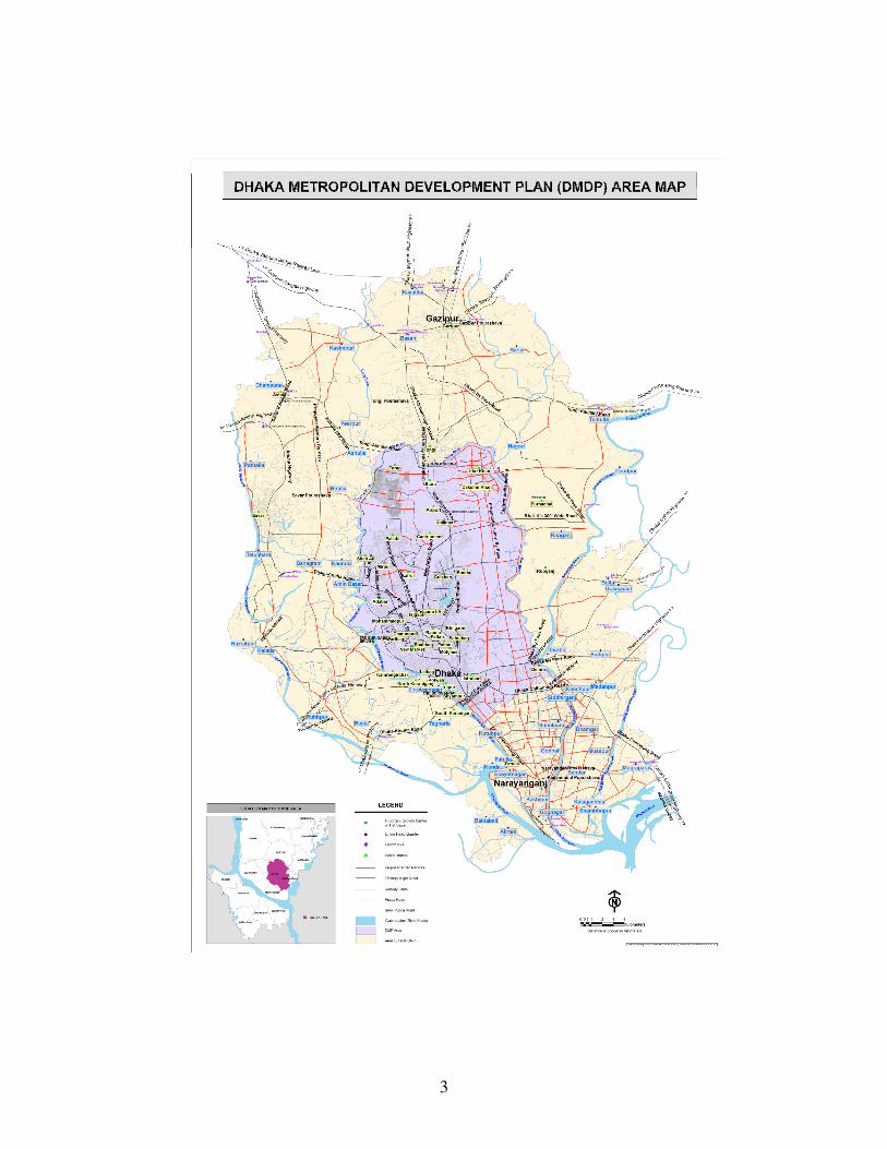
Area of Dhaka Metropolitan Development Plan (DMDP)
Total DMDP area is 590 Sq. Mile (1528 Sq. Km.) including surrounding areas of central
Dhaka city. The area includes up to the North corner of Gazipur Pourashava in North side,
Dholashwari River in South side, Bankshi and Dholashwari River in West side, Shitalakkha
and Meghna River in East Side. Dhaka City Corporation, Narayanganj Pourashava,
Kadamrasul Pourashava, Siddirganj Pourashava, Savar Pourashava, Savar EPZ, Keraniganj,
Kaliganj and part of Rupganj thana are included in DMDP area.
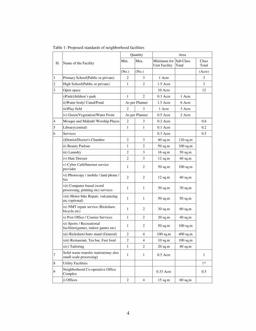
Planning Standards of DAP
It is necessary to mention here that whole area of DMDP area will not be urbanized. The area
includes urbanized area, commercial area, industrial area, open space, water body, flood flow
area, road, utility corridor, rural area and agricultural field etc. In this regard, it is very
important to finalize a planning standard. This Planning Standard was formulated based on
following guidelines of higher level plan, considering existing condition, reviewing
international standard and consulting with review committee. Proposed Standards of
Neighborhood Facilities of 12,500 people according to DAP is shown in Table 1.
3
Fig. 1: Dhaka Metropolitan Development Plan (DMDP) Area.
4
Table 1: Proposed standards of neighborhood facilities
Sl. Name of the Facility
Quantity Area
Min. Max. Minimum for
Unit Facility
Sub Class
Total
Class
Total
(No.) (No.) (Acre)
1 Primary School(Public or private) 2 3 1 Acre 3
2 High School(Public or private) 1 2 1.5 Acre 3
3 Open space 10 Acre 12
i)Park/children’s park 1 2 0.3 Acre 1 Acre
ii)Water body/ Canal/Pond As per Planner 1.5 Acre 6 Acre
iii)Play field 2 3 1 Acre 3 Acre
iv) Green/Vegetation/Water Front As per Planner 0.5 Acre 2 Acre
4 Mosque and Maktab/ Worship Places 2 3 0.2 Acre 0.6
5 Library(central) 1 1 0.1 Acre 0.2
6 Services 0.3 Acre 0.5
i)Dentist/Doctor's Chamber 2 3 40 sq.m 120 sq.m
ii) Beauty Parlour 1 2 50 sq.m 100 sq.m
iii) Laundry 2 3 16 sq.m 50 sq.m
iv) Hair Dresser 2 3 12 sq.m 40 sq.m
v) Cyber Café/Internet service
provider 1 2 50 sq.m 100 sq.m
vi) Photocopy / mobile / land phone /
fax 2 2 12 sq.m 40 sq.m
vii) Computer based (word
processing, printing etc) services 1 1 30 sq.m 30 sq.m
viii) Motor bike Repair, vulcanizing
etc.(optional) 1 1 50 sq.m 50 sq.m
ix) NMT repair service (Rickshaw,
bicycle etc) 1 2 30 sq.m 60 sq.m
x) Post Office / Courier Services 1 2 20 sq.m 40 sq.m
xi) Sports / Recreational
facilities(games, indoor games etc) 1 2 50 sq.m 100 sq.m
xii) Rickshaw/Auto stand (General) 2 4 100 sq.m 400 sq.m
xiii) Restaurant, Tea bar, Fast food 2 4 10 sq.m 100 sq.m
xiv) Tailoring 1 2 20 sq.m 40 sq.m
7 Solid waste transfer station(may also
small scale processing) 1 1 0.5 Acre 1
8 Utility Facilities 1*
9 Neighborhood Co-operative Office
Complex 0.33 Acre 0.5
i) Offices 2 4 15 sq.m 60 sq.m
5
Sl. Name of the Facility
Quantity Area
Min. Max. Minimum for
Unit Facility
Sub Class
Total
Class
Total
(No.) (No.) (Acre)
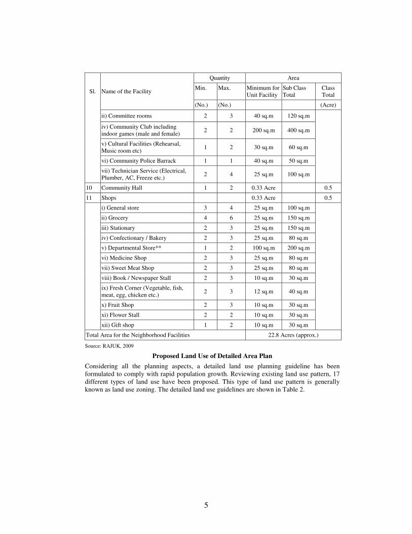
ii) Committee rooms 2 3 40 sq.m 120 sq.m
iv) Community Club including
indoor games (male and female) 2 2 200 sq.m 400 sq.m
v) Cultural Facilities (Rehearsal,
Music room etc) 1 2 30 sq.m 60 sq.m
vi) Community Police Barrack 1 1 40 sq.m 50 sq.m
vii) Technician Service (Electrical,
Plumber, AC, Freeze etc.) 2 4 25 sq.m 100 sq.m
10 Community Hall 1 2 0.33 Acre 0.5
11 Shops 0.33 Acre 0.5
i) General store 3 4 25 sq.m 100 sq.m
ii) Grocery 4 6 25 sq.m 150 sq.m
iii) Stationary 2 3 25 sq.m 150 sq.m
iv) Confectionary / Bakery 2 3 25 sq.m 80 sq.m
v) Departmental Store** 1 2 100 sq.m 200 sq.m
vi) Medicine Shop 2 3 25 sq.m 80 sq.m
vii) Sweet Meat Shop 2 3 25 sq.m 80 sq.m
viii) Book / Newspaper Stall 2 3 10 sq.m 30 sq.m
ix) Fresh Corner (Vegetable, fish,
meat, egg, chicken etc.) 2 3 12 sq.m 40 sq.m
x) Fruit Shop 2 3 10 sq.m 30 sq.m
xi) Flower Stall 2 2 10 sq.m 30 sq.m
xii) Gift shop 1 2 10 sq.m 30 sq.m
Total Area for the Neighborhood Facilities 22.8 Acres (approx.)
Source: RAJUK, 2009
Proposed Land Use of Detailed Area Plan
Considering all the planning aspects, a detailed land use planning guideline has been
formulated to comply with rapid population growth. Reviewing existing land use pattern, 17
different types of land use have been proposed. This type of land use pattern is generally
known as land use zoning. The detailed land use guidelines are shown in Table 2.
6
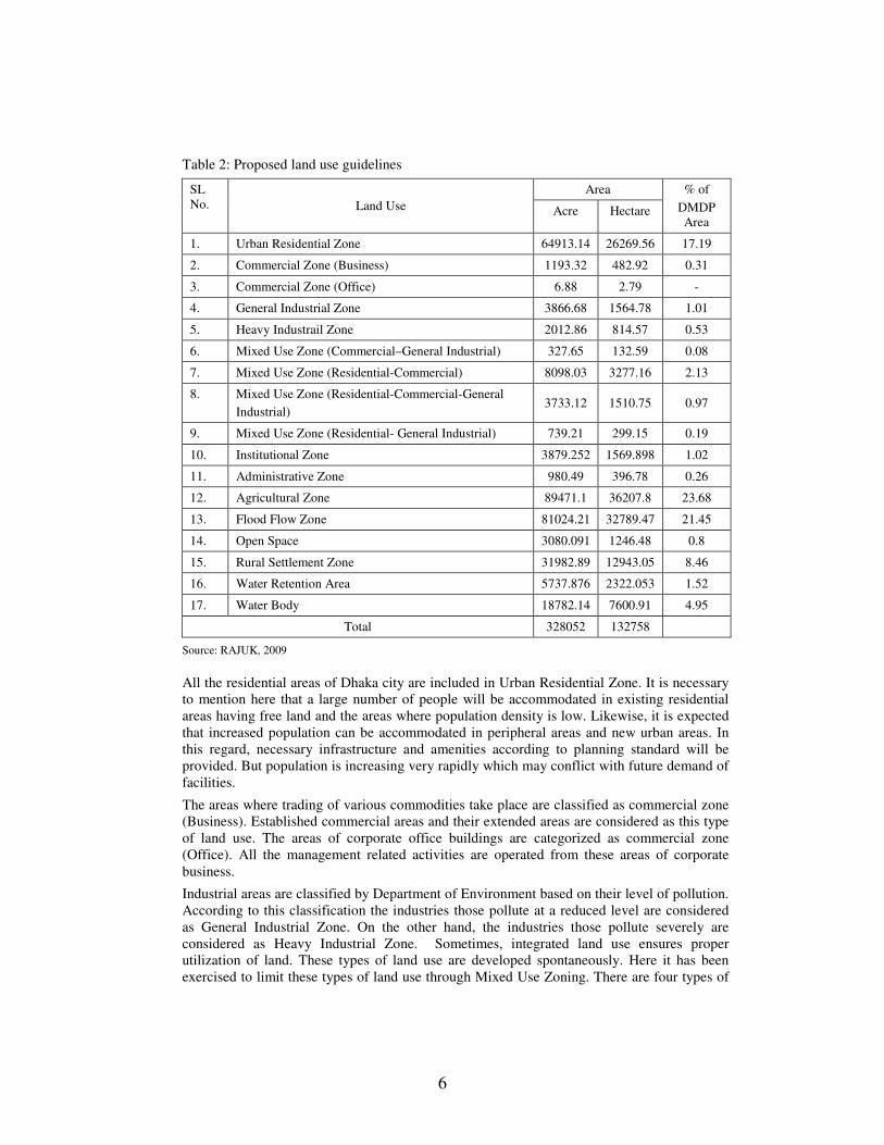
Table 2: Proposed land use guidelines
SL
No. Land Use
Area % of
DMDP
Area Acre Hectare
1. Urban Residential Zone 64913.14 26269.56 17.19
2. Commercial Zone (Business) 1193.32 482.92 0.31
3. Commercial Zone (Office) 6.88 2.79 -
4. General Industrial Zone 3866.68 1564.78 1.01
5. Heavy Industrail Zone 2012.86 814.57 0.53
6. Mixed Use Zone (Commercial–General Industrial) 327.65 132.59 0.08
7. Mixed Use Zone (Residential-Commercial) 8098.03 3277.16 2.13
8. Mixed Use Zone (Residential-Commercial-General
Industrial) 3733.12 1510.75 0.97
9. Mixed Use Zone (Residential- General Industrial) 739.21 299.15 0.19
10. Institutional Zone 3879.252 1569.898 1.02
11. Administrative Zone 980.49 396.78 0.26
12. Agricultural Zone 89471.1 36207.8 23.68
13. Flood Flow Zone 81024.21 32789.47 21.45
14. Open Space 3080.091 1246.48 0.8
15. Rural Settlement Zone 31982.89 12943.05 8.46
16. Water Retention Area 5737.876 2322.053 1.52
17. Water Body 18782.14 7600.91 4.95
Total 328052 132758
Source: RAJUK, 2009
All the residential areas of Dhaka city are included in Urban Residential Zone. It is necessary
to mention here that a large number of people will be accommodated in existing residential
areas having free land and the areas where population density is low. Likewise, it is expected
that increased population can be accommodated in peripheral areas and new urban areas. In
this regard, necessary infrastructure and amenities according to planning standard will be
provided. But population is increasing very rapidly which may conflict with future demand of
facilities.
The areas where trading of various commodities take place are classified as commercial zone
(Business). Established commercial areas and their extended areas are considered as this type
of land use. The areas of corporate office buildings are categorized as commercial zone
(Office). All the management related activities are operated from these areas of corporate
business.
Industrial areas are classified by Department of Environment based on their level of pollution.
According to this classification the industries those pollute at a reduced level are considered
as General Industrial Zone. On the other hand, the industries those pollute severely are
considered as Heavy Industrial Zone. Sometimes, integrated land use ensures proper
utilization of land. These types of land use are developed spontaneously. Here it has been
exercised to limit these types of land use through Mixed Use Zoning. There are four types of
7
mixed use zones i.e. commercial-general Industrial, Residential-Commercial, Residential-
Commercial-General Industrial, Residential-General Industrial.
One of the major land uses of Dhaka city is institutional. A large number of educational and
research institutions are established in the city. In this regard, provision of reserve land for
establishment of institution has been ensured. The proposal of institutional zone will be very
convenient for future development of Dhaka. Dhaka is the center point of all administrative
activities of Bangladesh. It must require more places to operate administrative activities
smoothly. So, administrative zone has been proposed in the Detailed Area Plan.
It is never expected to urbanize all the areas of a city. In that case, transportation system,
utility corridors and sewerage system cannot function properly. Nevertheless, food grain
production capacity makes a city self sustained. It is found that Agricultural Zone is
mandatory for DMDP area. So, all the agricultural areas of structure plan have been proposed
as unchanged in Detailed Area Plan. Any types of development works is strictly prohibited in
agricultural zone.
In structure plan, there is specific green line of flood flow zone. In the present context, some
of those areas are being changed due to excessive population pressure. To control this
situation, some of these areas have been proposed as non-conforming zone. There is severe
shortage of open spaces in Dhaka city. It is very costly to reserve land for open space as the
land value is very high in central city. Considering this situation, adequate open space has
been proposed at periphery of the city to make Dhaka environmentally sustainable. If land
use of any specific area is changed to other use and if that change is required, that is classified
as Overlay Zone. Any historical heritage or graveyard in residential areas is known as overlay
zone.
The entire homestead on agricultural land and flood flow areas is recognized as Rural
Settlement Zone. This type of zone will control filling flood flow area and agricultural land.
Water retention area is very important for storm sewer. There are several flood embankments
around Dhaka city. Adequate retention area is required to store rain water before discharging
to outfall. Total 1.52% land of DMDP area has been proposed as Water Retention Area.
There are a good number of Rivers, Lakes and ponds in Dhaka. The rivers are Shitalakha,
Buriganga, Balu, Turag, Dhaleshwari, Old Brahmaputra etc. Moreover there are huge number
of natural lakes and ponds. Nevertheless, it is a matter of great sorrow that many water bodies
have been filled. This is a serious reason for environment degradation. In this regard, all the
water bodies are recognized on mouza map.
Nevertheless all these land use proposal are made to make Dhaka environmentally sustainable
and improve living standard. But our one of the major problem is housing crisis. In Detailed
Area Plan 17.19% of total area is allocated for Urban Residential Use, 3.29% is for Mixed
Use having residential use, 8.46% is allocated for Rural Settlement. Rest of the DMDP area is
allocated for other necessary purposes. To make a city environmentally sustainable, various
types of land use are required along with residential use. Now the question is how can we
accommodate ever increasing population in Dhaka? In this regard, we must find out a strategy
in integrated manner to settle a large number of people in limited size of land. Moreover we
have to slow down population growth in Dhaka city.
Transportation
Communication network plays a vital role in development of urban housing. Houses and other
establishments always prefer road side lands to have easy access. Roads in the planning area
are developing without having any standard and proper plan. As a result, narrow roads with
circuitous pattern are common in Dhaka city. New houses and industrial structures are
8
cropping up along these sub-standard roads. This is one of the major reasons of traffic
problem in Dhaka as population density is very high. Deficiency in infrastructure and
services is another major problem. The reasons for such deficiency is many and varied and are
linked with development management capacity of the concerned public sector development
agencies, non-availability of resources and appropriate decision making process.
It is more important to ensure proper management of existing transportation system than that
of establishment of new roads. That is because we have failed to manage our existing
services. Without proper management any future planning will be failed. Nevertheless, there
are some proposals in Detailed Area Plan which are very crucial for improvement of
transportation network. To ensure uninterrupted vehicle movement, local roads have been
proposed on both sides of national and regional highways. Moreover, to avoid time sharing at
road intersections, cloverleaf overpass has been proposed. Special emphasis has been given to
establish dedicated lane for Rapid Bus Transit. It has been recommended to start commuter
train from Nayrayangonj to Gazipur. On the other hand, Dhaka is a deltaic city, water in the
form of rivers, canals, waterways, ponds and flood plains formed the matrix of Dhaka. It is
obvious that water can provide inexpensive transport solution for the city. So it has been
recommended to ensure movement through circular waterway around Dhaka.
Necessary Actions for Proper Implementation of DAP
In most of the cases, town planning is still ignored in our urban development process. People
prefer to develop their land without following planning norms. At the same time, concerned
authorities are unable to exercise full control over development. But stakeholders should be
compelled to follow existing plans and development rules. Awareness is to be built among the
people to follow the plan. Government agencies must be compelled to implement plans. In order
to achieve the goals set forward in the Detailed Area Plan, some follow up actions are required.
Among those some major actions are described below;
Awareness Building
As we know town planning practice is not very familiar in our country, mainly due to ignorance
about the advantage of planned development and the evils of haphazard /sprawl development.
This can be achieved by the way of mass campaign. Easy availability of plan document will
enable people to become aware of the plan and thereby follow the guidelines. As such RAJUK
should take initiatives so that the plan document can be easily accessible to the general people.
Honest Will to Implement the Plan by Concerned Authority
RAJUK on adoption of the planning document should show its intent to implement the plan through effective control measures and budget allocation. RAJUK needs to be better equipped with necessary logistics and efficient manpower to implement the plan properly.
Revision of Existing and Formulation of New Legal Provisions Relevant to DAP
There are a number rules and regulation in use for development and development control. But with the passage of time these rules and regulations have become obsolete which need review and refurbishment in the light of present context. Town Improvement (TI) Act, 1953 which empowers RAJUK to prepare Master Plan is one of the major ones. But in recent days Master Plan concept has become outdated and three tier development plans in the form of Structure Plan, Urban Area Plan and Detailed Area plans are prepared. This has to be accommodated in the TI Act.
Recommendations have been made to implement DAP through Action Area Plans with people’s participation. This is a new concept, hence it requires legal coverage and thereby it is necessary to enact new law for this purpose.
9
Action Plans for Participatory Development
Due to resource constraint, Detailed Area Plan may not be enough to ensure planned
development. Securing right of way for circulation network and utility corridors need huge funds
which cannot be met by the public exchequer. To reduce development cost RAJUK should
incorporate the land owners in the development process. This can be achieved by declaring some
of the developing corridors as concession for development through people’s participation where
land-owners will become development partners and share the development cost through
contribution of a portion of their land. RAJUK has to prepare Action Area Plan for those areas
utilizing development techniques like Guided Land Development or Land Readjustment. RAJUK
has to show strong determination and willingness as this is a very difficult task to accomplish
involving thousands of people. RAJUK has to increase its efficiency and do the work at
appropriate time.
Enlargement of Pourashava Jurisdiction and Formation of New Pourashava
There are many urban clusters within RAJUK jurisdiction where there is no municipal
authority. So it becomes very difficult to manage those areas. These areas should be brought
under municipal coverage both for service management and effective development control.
Strengthening Planning Department of RAJUK
Planning section of RAJUK especially plan implementation and monitoring wing should be
equipped with sufficient number of qualified planners and logistics to monitor the development
trend. It will ensure planned development in specific areas of urban expansion.
Provision of Penalty for Plan Violation
There should be provision of punishment for violation of the plan provision by individuals as well
as private and public sector agencies. Violation of planning provision will make it difficult to
implement planning provisions properly.
Plan Review
RAJUK should take initiative to review the performance and functioning of the plan during the
planning period. It should also make arrangement for regular updating of the plan. Provision
should also be made to prepare fresh plans on expiry of a plan period.
Necessary Actions to Ease Housing Problem in Dhaka
Proper implementation of plan is very rare in our country. There are several development
plans for major cities but development trends do not comply with plans. Moreover, we
prepared Detailed Area Plan 15 years later. A major change took place in last 15 years.
Similarly a periodical review of Structure Plan was required to cope with changing scenario.
It is a matter of concern that we did not review the Structure Plan. At the same time, Detailed
Area Plan has been prepared following Structure Plan after 15 years. In this situation,
Detailed Area Plan may not solve the housing crisis of Dhaka. In order to reduce continuous
pressure on housing sector following initiatives can be taken along with implementation of
DAP.
At first we have to ensure demand-supply management. It is impossible to supply enormous
amount of housing units. In that case, demand-supply discrimination in urban housing market
will continue until the urban growth is controlled. Introducing decentralization is mandatory
to slow down the growth of Dhaka.
In order to provide space for urban housing the need for a separate housing plan for Dhaka
metropolitan region is undeniable. What the city needs is to plan a few satellite towns around
10
it. Commercial uses will be provided there to ensure local employment in these towns. They
will be located centering major bus terminals or railway stations to facilitate the employment
outside the towns. Availability of proper communication system must encourage city dwellers
to live far away from central area.
Private developers cannot provide house for low income people because high land value
increases apartment price. In this situation, government should go for public private
partnerships. In such ventures the government typically contributes by providing land and the
private sector will be responsible for providing houses. Such partnership between the public
and private sector must lower the apartment price appreciably. The lower income people will
be able to afford the housing of their own.
The private developers are now concentrated within Dhaka city. So the land owners are
imposing high demand during the partnership apartment development. This, in turn, is
contributing to increase the land value within the city. That is because, in most of the cases,
private developers are reluctant to construct building out side Dhaka. On the other hand, there
is serious shortage of infrastructure and utility services in our district towns. If government
provides adequate infrastructure and utility services, many developers will show their interest
to work in other cities.
Conclusion
Since independence several physical development plans have been prepared for major cities
in Bangladesh, but have hardly received adequate patronization as far as their implementation
is concerned. It is now proven that plan execution is more difficult than plan preparation.
Huge public money is required to prepare a plan, but taking an account of their execution
reveals a frustrating scenario. A very few of the development plan proposals have so far been
implemented. A frustrating picture of implementation is revealed after formal acceptance of
DMDP in 1997. The Detailed Area Plan is a part of DMDP which opens up a new extent of
development opportunities and land use control at very lower level. The land use areas have
been marked indicating the mouza and dag numbers. It is expected that the controversies
regarding land use can be resolved by following DAP proposals. Now willingness and
sincerity are most important to make DAP successful.
It is quite impossible for RAJUK to implement DAP with its limited manpower and capacity.
Moreover, as an authority RAJUK should serve as a regulatory body rather than a developer.
It should only control, facilitate and promote development in the interest of the people. All the
development works should be done by the private sector. But it should develop mechanism to
realize its costs of infrastructure development so that no one can capitalize on public money to
make personal gains.
Rule of law must be established. A culture of abiding law must be created among the people
in general and such practice should start with government agencies that do not follow the
procedure of plan approval during building construction. It is hardly possible for the
government to control all anomalies if people are not conscious and helpful. Strict measures
should be taken against the violators to make people abide by the planning laws and rules.
Lastly, government should be more practical to realize the problem in the present context,
rather than following a utopian concept. In order to solve housing crisis in Dhaka, government
should consider the private sector as development partner. Similarly, the private sector needs
to work cooperating with the public sector following rules and regulations.
11
References
Ashraf, K. K. 2010. A New Dhaka is Possible. Monthly Magazine FURUM, The Daily Star.
Bangladesh Bureau of Statistics (BBS), 2006. Statistical Pocket Book. Dhaka: Government of
Bangladesh.
Rajdhani Unnayan Katripakha (RAJUK), 2009. Preparation of Detailed Area Plan for DMDP Area:
Final Report. Dhaka: RAJUK.
RAJUK. 1997a. Dhaka Metropolitan Development Plan (1995-2015): Volume I: Dhaka Structure Plan
(1995-2015). Dhaka: RAJUK.
RAJUK. 2010. Final Report of Group E, Preparation of Detailed Area Plan for DMDP Area. Dhaka:
RAJUK.
Seraj, T. M. and Tawhid K. G. 2006. Preparation of Detailed Area Plan: A New Hope for Planned
Development of Dhaka City, Souvenir on World Habitat Day, 2006. Dhaka: CUS & BIP.