Embed Size (px)
Citation preview
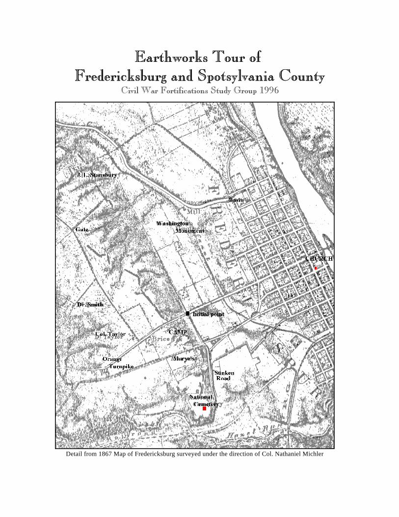
Detail from 1867 Map of Fredericksburg surveyed under the direction of Col. Nathaniel Michler
1
Begin at the Fredericksburg Battlefield Visitor Center on Lafayette Boulevard.
Directions: From I-95, take exit 130A driving east, follow Plank Road/William Street whichbecomes Blue and Gray Parkway to its intersection with Lafayette Blvd. (about 2 ½ miles). Turn left on Lafayette Blvd./Business Rt.1. Go past National Cemetery to brick Federal stylevisitor center 1/4 mile on left. Park behind the visitor center. Restrooms/book store.
Mile 0.0: Fredericksburg Battlefield Visitor CenterIn late November 1862, the Army of the Potomac, commanded by Maj. Gen. AmbroseBurnside, concentrated on Fredericksburg. Had Burnside forced an immediate crossing of theRappahannock River, he might have captured the town without a fight. Instead, he waited onthe opposite bank for nearly two weeks, allowing General Robert E. Lee time to gather hisscattered divisions. Lee positioned his 78,000 men on the heights west of town in an arc thatstretched about eight miles from Banks Ford to Hamilton’s Crossing. On December 11-12,Burnside crossed his 122,000 soldiers on five pontoon bridges, occupying the town and theflood plain to the south. On December 13, he launched a series of frontal assaults against thenearly impregnable Confederate position with disastrous results.
Marye’s Heights above the visitor center was the center of the main Confederate defensiveline. The stone fence that bordered the Sunken Road served as a ready-made fortification forConfederate infantrymen. Supporting artillery, entrenched on Marye's Heights above theSunken Road, swept the field with deadly crossfires.
Exit visitor center, right onto Lafayette Blvd. Go 0.7 mile and turn left onto Lee Drive at theNational Park Service sign. Pull into the parking area on the right at the park tour sign.
Mile 0.9 Lee's Hill Hiking TrailA paved hiking trail leads to an exhibit shelter that offers a panoramic view ofFredericksburg. This was General Lee's field headquarters during the battle ofFredericksburg. While observing Federal divisions advancing across the open fields belowwith parade ground precision, Lee stated, “It is well that war is so terrible--we should growtoo fond of it.” A 30-pounder Parrot Rifle is displayed behind a much-repaired earthwork. The work of the pioneers is described on an interpretive panel. Several other gun pits may beseen in the woods above the hiking trail, and a military road leads downhill to rejoin the trail.
Continue on Lee Drive 4.8 miles to turn around at parking lot. Notice the Confederatetrenches on the left of the road (later on both sides). Some of these rifle trenches wereconstructed during the battle of Fredericksburg but most were dug after the battle andcontinually improved throughout the winter of 1862-1863. Several portions were repaired orreconstructed by the Civilian Conservation Corps in the 1930s.
2
Mile 5.7 Hamilton's Crossing (See Site Map)The right flank of the Confederate defensive line was anchored here at Prospect Hill,overlooking the railroad and a depot at Hamilton's Crossing. Here, fourteen guns wereentrenched individually and provided with infantry support. The railroad embankment to thefront was used for defense. In the woods to the rear, there's a trace of the old military roadand a “Y” trench that leads back 1/4 mile to Confederate camps along Mine Road.
Return on Lee Drive. At mile 8.7 one of several feeder trenches can be seen crossing the roadand intersecting the main Confederate lines at a right angle. From its winter camp far to therear, a regiment could follow a feeder trench to its correct place in the firing line. At mile 9.0turn right into Pickett Circle Drive.
Mile 9.1 Pickett Circle (See Site Map)To the front of the circle was the front Confederate line in this sector. The entrenchmentswere probably constructed after the battle. An old farm drainage ditch leads from the salientof this line out to Landsdowne Road. The Confederates modified and incorporated suchagricultural features into their system of fortifications. A secondary Confederate line lies tothe rear along Lee Drive. A third parallel line lies in the woods several hundred yards fartherto the rear. The three lines were joined by feeders. This was a very sophisticated networkthat anticipated later doctrines of defense in depth.
Continue on Lee Drive until end at mile 10.8. Turn right onto Lafayette Blvd. Continue pastvisitor center to the train station at mile 12.2. Turn left onto Caroline Street and continuethrough old town Fredericksburg. Continue along the Rappahannock River (Caroline Streetbecomes Riverside Drive en route) to T-intersection at mile 14.4. Turn right onto Fall HillAvenue. Continue 0.4 mile to parking lot at canal crossing (look for footbridge and bikingtrail) at mile 14.8.
Mile 14.8 Fall Hill “Zig-Zag Trench” (See Site Map)You are now at Fall Hill, the far left flank of the Confederate defensive line. To reach thetrenches, cross the footbridge and bike path to reach the dirt road. Follow the road about 200yards south past the pond where a path leads uphill. The trench line is at the military crest.
These earthworks were constructed by Brig. Gen. Cadmus Wilcox’s brigade before the battleand could be enfiladed by Federal batteries on the far bank of the river. This is an indentedline or cremaillère, described by Luvaas and Nelson as “more typical of World War I than theCivil War.” The trench’s notoriety as possibly the Civil War's first “zig-zag” trench causedthe city to purchase the land and protect the resource.
Continue east on Fall Hill Avenue which eventually becomes Bragg Road to its intersectionwith Rt. 3 (originally the Germanna Plank Road) at mile 17.9. Turn right and continue 0.7mile to National Park Service pull off on right at monument to the 15th New JerseyVolunteers.
3
Mile 17.9 Salem ChurchYou are now in the heart of the Salem Church battle ground of May 3-4, 1863, where GeneralLee’s divisions frustrated the second prong of General Hooker’s Chancellorsville offensive. As you can see, little remains of the battlefield except for the few acres around the churchowned by the park service. The brick church dates from 1844. All else has been developedwithin the last five years. Salem Church battlefield has gone the way of Chantilly.
Continue west on Rt. 3. You will pass Zoan Church on the right side of the highway.
Mile 21.1 Zoan ChurchHere on the high ground, Confederates dug in on May 1, 1863, to confront General JosephHooker's army as it emerged from the wilderness around Chancellorsville. Some remnants ofthe Confederate rifle trenches survive in the woods on private property. Instead of pushingvigorously toward Fredericksburg, Hooker ordered his forces to withdraw to the vicinity ofthe Chancellor House and entrench.
Continue west on Rt. 3 to the entrance to the Chancellorsville battlefield visitor center at mile25.6 on the right. Park near the visitor center. Restrooms and bookstore.
Mile 25.7 Chancellorsville Visitor CenterMaj. Gen. Joseph Hooker assumed command of the Army of the Potomac after Burnside’s December debacle and in late April 1863 attempted to flank the Confederate armyout of its entrenchements. Hooker divided his 134,000-man army into two wings, leavingMaj. Gen. John Sedgwick to threaten Fredericksburg, while he directed a crossing of theRappahannock twenty miles upstream and moved on the rear of the town via Chancellorsville. General Robert E. Lee with only about 60,000 soldiers left Early’s division to hold the townand marched the bulk of his army to meet Hooker on May 1. At this point Hooker appearedto lose his nerve and hunkered down inside his entrenchments at Chancellorsville.
On May 2, Lt. Gen. Thomas J. Jackson conducted a grueling march in order to deploy onHooker’s right flank, which was essentially undefended. Jackson’s devastating flank attackon the afternoon of May 2 routed much of the Federal XI Corps but ground to a halt at darkabout 0.2 mile west of the visitor center. Jackson and his aides rode out into no man’s land toreconnoiter. The party was fired upon by Confederate troops, and Jackson was badlywounded. Maj. Gen. J.E.B. Stuart assumed command of Jackson’s corps and pressed theattack the next day. A four-mile loop trail visits many of the surviving field fortifications inthis portion of the park.
Exit the visitor center, right onto Bullock Road. After 0.3 mile, notice the Confederate rifletrench that crosses the road. This line was constructed on May 3 after Federal resistance inthis area collapsed. The Federals retreated into prepared earthworks north of Ely’s FordRoad. Continue to the T-intersection and park in the pull-off across from the intersection.
4
Mile 26.6 Hooker’s Apex (See Site Map)After losing the ground around the Chancellor House on May 3, 1863, Hooker withdrew toprepared entrenchments north of Ely’s Ford Road. The line was shaped like an inverted V”with wings stretching back toward the Rappahannock River. Confederate artillery officerEdward Porter Alexander described this line as “probably the strongest field entrenchmentever built in Virginia.” Hooker’s defensive posture here enabled Lee to detach two divisionsto march to Salem Church and drive Sedgwick’s column back across the Rappahannock.
The surviving entrenchments at Hooker's Apex are primarily of four types: artillery positions,infantry rifle trenches, infantry support trenches, and support “bunkers.” According to historicmaps, the original apex of the main line appears to have been in the vicinity of the BullockDrive-Ely's Ford Road intersection near the parking area. Trench segment 1 is a retrenchmentto prevent a break-through at the weak salient angle. To its rear 50-100 feet are severalshelter pits or “fox holes.” Trench segment 2 is a truncated artillery position that probablycontinued south to the apex proper. Remains are visible of as many as eight field guns placedon platforms 12-15 yards apart and separated by traverses. Only three of these platforms areeasily recognizable today, and the main parapet is severely eroded. Three longer traverses onthe right flank (north) of this line feed back into the gully to the rear and served as “coveredways” by which soldiers could come and go without being struck by sharpshooters.
The remaining trench segments, mostly on private property, are part of a complex for infantryreserves and include four well-preserved “bunkers,” nearly identical in appearance. Thesiting, design, relief, and thickening of the parapets associated with these features suggest thatthese were emplacements for four heavier caliber guns, such as 20-pounder Parrotts.
General Daniel Sickles III Corps held the apex of the line and most likely constructed thetrenches here. The Federals maintained their position here until the evening of May 5 whenHooker ordered a retreat back across the Rappahannock River, ending the campaign.
Go south on Ely’s Ford Road. Turn left on Hooker Trail at mile 26.9. On the left side of theroad are trenches constructed by Federals of Hancock’s division, II Corps, on May 1-2. Go tothe end of the road. Turn right on Miles Drive and right again onto Rt. 3 at mile 27.5. Continue 0.1 mile to Ely’s Ford Road and turn right. Pull into the parking lot at theChancellor House ruin.
Mile 27.7 ChancellorsvilleGeneral Joseph Hooker maintained his headquarters at the inn here during the battle. AConfederate solid shot fired from Hazel Grove struck the porch pillar against which Hookerwas leaning, stunning him badly. The Confederates captured the crossroads here on themorning of May 3. In the open fields south of the road, stood Fairfield, historically one of thefew farms in the area. A hiking trail passes surviving Federal artillery emplacements beyondFairfield Cemetery.
5
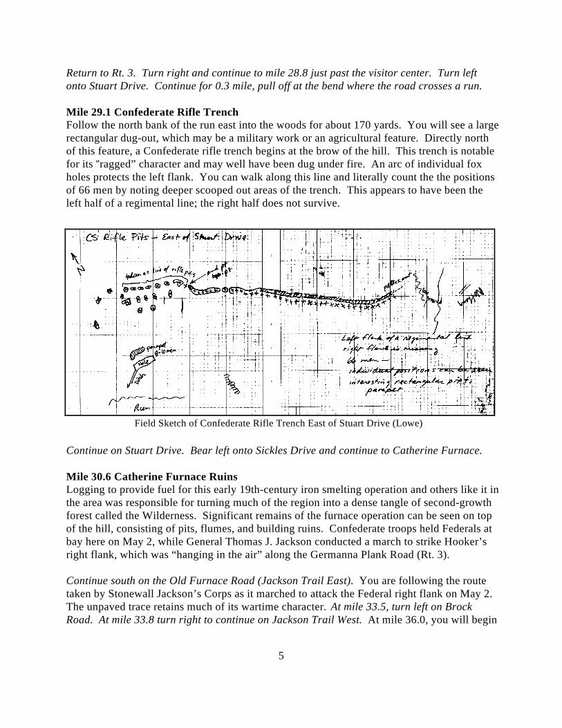
Field Sketch of Confederate Rifle Trench East of Stuart Drive (Lowe)
Return to Rt. 3. Turn right and continue to mile 28.8 just past the visitor center. Turn leftonto Stuart Drive. Continue for 0.3 mile, pull off at the bend where the road crosses a run.
Mile 29.1 Confederate Rifle TrenchFollow the north bank of the run east into the woods for about 170 yards. You will see a largerectangular dug-out, which may be a military work or an agricultural feature. Directly northof this feature, a Confederate rifle trench begins at the brow of the hill. This trench is notablefor its ragged” character and may well have been dug under fire. An arc of individual foxholes protects the left flank. You can walk along this line and literally count the the positionsof 66 men by noting deeper scooped out areas of the trench. This appears to have been theleft half of a regimental line; the right half does not survive.
Continue on Stuart Drive. Bear left onto Sickles Drive and continue to Catherine Furnace.
Mile 30.6 Catherine Furnace RuinsLogging to provide fuel for this early 19th-century iron smelting operation and others like it inthe area was responsible for turning much of the region into a dense tangle of second-growthforest called the Wilderness. Significant remains of the furnace operation can be seen on topof the hill, consisting of pits, flumes, and building ruins. Confederate troops held Federals atbay here on May 2, while General Thomas J. Jackson conducted a march to strike Hooker’sright flank, which was “hanging in the air” along the Germanna Plank Road (Rt. 3).
Continue south on the Old Furnace Road (Jackson Trail East). You are following the routetaken by Stonewall Jackson’s Corps as it marched to attack the Federal right flank on May 2. The unpaved trace retains much of its wartime character. At mile 33.5, turn left on BrockRoad. At mile 33.8 turn right to continue on Jackson Trail West. At mile 36.0, you will begin
6
to see the trace of a Federal rifle trench on the left side of the road. This is the left flank of theFederal II Corps position during the battle of the Wilderness, May 5-7, 1864. Jackson Trailrejoins Brock Road at mile 36.3. Turn left and continue to the stop sign at the intersection ofthe Orange Plank Road. Pull into the National Park Service pull-off on left.
Mile 37.5 Brock Road-Orange Plank Road IntersectionUnion Lt. Gen. Ulysses S. Grant and Confederate General Robert E. Lee confronted eachother for the first time here in the dense second-growth forest called The Wilderness. On May4, 1864, 118,000 troops of Grant's Army of the Potomac crossed the Rapidan River atGermanna and Ely's fords and moved south to threaten Richmond. General Lee directed hisArmy of Northern Virginia, 62,000 strong, to march east from the vicinity of Orange and stopthe Union spring offensive. The armies collided on May 5, when the Federals' line of marchcrossed two parallel east-west roads--the Orange Turnpike (modern Rt. 20) and the OrangePlank Road (Rt. 621). Though only about three miles apart, these roads were separated by thenearly impenetrable thickets that were characteristic of The Wilderness.
This intersection was the scene of some of the heaviest fighting during the battle of theWilderness. The wooded area south of the road is called Hamilton’s Thicket, a tract of landthat is privately owned and slated eventually for development. Several preservation groupshave been negotiating to purchase Hamilton’s Thicket for donation to the park. It is one ofthe most threatened parcels of blood soaked ground in the country.
Continue north on Brock Road. Note the cannon monument at mile 37.7 marking the spotwhere Federal General Alexander Hays was killed on May 5, 1864, while rallying troops. Atthe T-intersection turn left onto Rt. 3 (Jackson’s soldiers turned right here to attack theFederal right flank at Chancellorsville). Continue west to the intersection with Rt. 20 at mile40.2. Pull into the convenience store parking lot on the right.
Mile 40.2 Rest StopThis is the intersection of the Germanna Plank Road (Rt. 3) and the Orange Turnpike (Rt. 20),very near General Ulysses S. Grant’s headquarters during the Battle of the Wilderness. TheWilderness Tavern stood on the high ground to the east. Wilderness Run flows through theopen fields south of the intersection past the Lacy House (Elwood) which still stands on parkservice property. The Lacy House served as the headquarters of the Federal V Corps. OnMay 5-6, 1864, the Army of the Potomac’s reserve artillery was parked in the open fieldsbecause there were few opportunities to deploy batteries in the dense wilderness. StonewallJackson’s amputated arm is buried in the family cemetery there.
Follow Rt. 20 for 1.1 miles. Pull off at the side of the road at mile 41.3 where the electricwires cross the road.
Mile 41.3 Federal 12-gun Battery (See Site Map)Although difficult to find, the park’s hiking trail begins in the woods on the south side of the
7
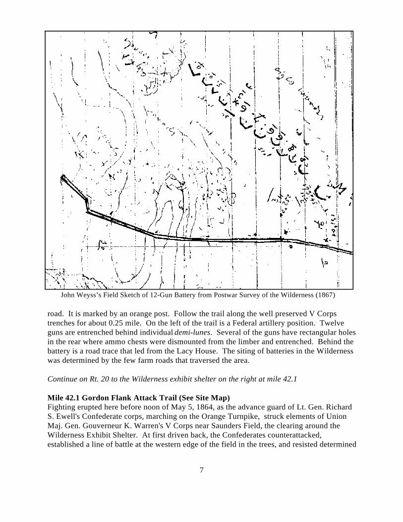
John Weyss’s Field Sketch of 12-Gun Battery from Postwar Survey of the Wilderness (1867)
road. It is marked by an orange post. Follow the trail along the well preserved V Corpstrenches for about 0.25 mile. On the left of the trail is a Federal artillery position. Twelveguns are entrenched behind individual demi-lunes. Several of the guns have rectangular holesin the rear where ammo chests were dismounted from the limber and entrenched. Behind thebattery is a road trace that led from the Lacy House. The siting of batteries in the Wildernesswas determined by the few farm roads that traversed the area.
Continue on Rt. 20 to the Wilderness exhibit shelter on the right at mile 42.1
Mile 42.1 Gordon Flank Attack Trail (See Site Map)Fighting erupted here before noon of May 5, 1864, as the advance guard of Lt. Gen. RichardS. Ewell's Confederate corps, marching on the Orange Turnpike, struck elements of UnionMaj. Gen. Gouverneur K. Warren's V Corps near Saunders Field, the clearing around theWilderness Exhibit Shelter. At first driven back, the Confederates counterattacked,established a line of battle at the western edge of the field in the trees, and resisted determined
8
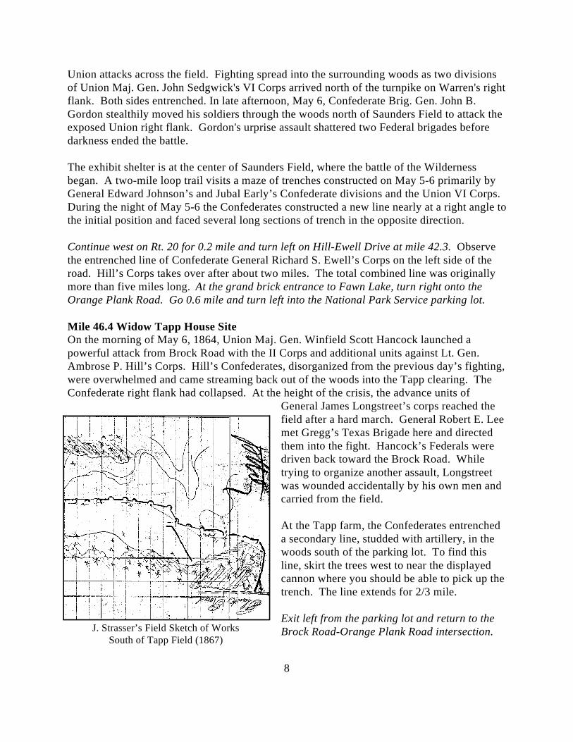
J. Strasser’s Field Sketch of WorksSouth of Tapp Field (1867)
Union attacks across the field. Fighting spread into the surrounding woods as two divisionsof Union Maj. Gen. John Sedgwick's VI Corps arrived north of the turnpike on Warren's rightflank. Both sides entrenched. In late afternoon, May 6, Confederate Brig. Gen. John B.Gordon stealthily moved his soldiers through the woods north of Saunders Field to attack theexposed Union right flank. Gordon's urprise assault shattered two Federal brigades beforedarkness ended the battle.
The exhibit shelter is at the center of Saunders Field, where the battle of the Wildernessbegan. A two-mile loop trail visits a maze of trenches constructed on May 5-6 primarily byGeneral Edward Johnson’s and Jubal Early’s Confederate divisions and the Union VI Corps. During the night of May 5-6 the Confederates constructed a new line nearly at a right angle tothe initial position and faced several long sections of trench in the opposite direction.
Continue west on Rt. 20 for 0.2 mile and turn left on Hill-Ewell Drive at mile 42.3. Observethe entrenched line of Confederate General Richard S. Ewell’s Corps on the left side of theroad. Hill’s Corps takes over after about two miles. The total combined line was originallymore than five miles long. At the grand brick entrance to Fawn Lake, turn right onto theOrange Plank Road. Go 0.6 mile and turn left into the National Park Service parking lot.
Mile 46.4 Widow Tapp House SiteOn the morning of May 6, 1864, Union Maj. Gen. Winfield Scott Hancock launched apowerful attack from Brock Road with the II Corps and additional units against Lt. Gen.Ambrose P. Hill’s Corps. Hill’s Confederates, disorganized from the previous day’s fighting,were overwhelmed and came streaming back out of the woods into the Tapp clearing. TheConfederate right flank had collapsed. At the height of the crisis, the advance units of
General James Longstreet’s corps reached thefield after a hard march. General Robert E. Leemet Gregg’s Texas Brigade here and directedthem into the fight. Hancock’s Federals weredriven back toward the Brock Road. Whiletrying to organize another assault, Longstreetwas wounded accidentally by his own men andcarried from the field.
At the Tapp farm, the Confederates entrencheda secondary line, studded with artillery, in thewoods south of the parking lot. To find thisline, skirt the trees west to near the displayedcannon where you should be able to pick up thetrench. The line extends for 2/3 mile.
Exit left from the parking lot and return to theBrock Road-Orange Plank Road intersection.
9
Turn right and follow Brock Road 9.8 miles toward Spotsylvania. This is the route taken bythe Federal army when it disengaged on May 7 and marched to capture the crossroads atSpotsylvania Court House. Confederate cavalry delayed the Federal advance. You will passthrough Todd’s Tavern intersection at mile 52.8. The Federal II Corps reached here at theopening of the Wilderness Campaign and entrenched before being recalled to join the fightingon the Orange Plank Road.
Turn left onto Grant Drive at the park service sign. Pull into the exhibit shelter parking lot.
Mile 56.8 Spotsylvania Exhibit ShelterThe battle of Spotsylvania Court House began in this area on May 8, 1864, as advanceelements of the Federal V Corps encountered Confederate infantrymen, who arrived barely intime to secure the important crossroads. Fighting raged in the fields to the south, an areaknown as Laurel Hill. The monument at the entrance to the park marks the spot whereGeneral John Sedgwick was killed by a sharpshooter’s bullet on May 9, 1864. Displays in theexhibit shelter recount the battle. Restrooms are available. After an initial repulse, the UnionV Corps entrenched here. These trenches can be seen along the south side of Grant Drive.
Continue on Grant Drive for 0.4 mile to near the bottom of the long slope. Pull over beforecrossing the run.
Mile 57.2 The Gallery (See Site Map)Locate the segment of rifle trench on the north (left) side of the road and follow it into thewoods. Cross the narrow run. This area was the far left flank of the Federal Army until May10 after which the fighting shifted to the Confederate Salient farther to the east. Here the VCorps line was refused back along the creek to your front.
The trenches here consist of a main line facing east and a series of eleven traverses that stepup the high ground in the form of a “gallery,” facing south. The traverses have beenimproved to provide cover for infantrymen. This appears to have been a holding area for aregiment. The narrow ravine running from the rear of the gallery leads past a series of otherholding areas--a secondary gallery, and several parallel rifle trenches. At the crest of the hill,Federal guns are individually entrenched in demi-lunes, some with ammo holes to the rear. These guns were sighted to enfilade the Confederate trenches at the Bloody Angle.
Continue on Grant Drive. On the left side of the road, observe trenches of the Federal VICorps that were constructed after the assault on the Bloody Angle of May 12. After 0.7 milepull into the parking lot for the Bloody Angle.
Mile 57.9 Bloody Angle (See Site Map)At 4:30 a.m., May 12, 1864, 20,000 men of the Federal II Corps, commanded by Maj. Gen.Winfield Scott Hancock, assaulted and overran the Confederate “Mule Shoe” salient,capturing as many as 3,000 Confederates, two generals, nearly 30 colors, and twenty guns.
10
By 6:00 a.m., the Federal VI Corps had joined in the assault on the right of the II Corps, andBurnside’s IX Corps began closing in on the east face of the salient. Maj. Gen. John B.Gordon organized a series of counterattacks to close the breach in the Confederate line. Fortwenty hours, the forces here battled face to face in the longest sustained firefight of the CivilWar. After the war, Francis Walker of the II Corps wrote with little exaggeration: “Neverbefore, since the discovery of gunpowder, had such a mass of lead been hurled into a space sonarrow as that which now embraced the scene of combat.” The Confederates recapturedmuch of the lost ground but were withdrawn after midnight when a new line of earthworkswas completed across the base of the salient.
The hiking trail leads along the area of the Federal breakthrough. The trenches here havebeen heavily impacted by visitors, and parts have been reconstructed. There are sections of“dead ground” in front of the Confederate line that enabled the Federals to get close to theline in the early morning fog without being fired upon. This undoubtedly contributed to thecollapse of the line. From the 22" oak marker, look to the left front to see a trace of the trenchdug by the VI Corps to join into the captured portion of the salient. The works from here tothe right were reversed by the Federals. From the East Angle (beyond the eastern parking lot),walk to the front of the cleared works and toward the trees to the right. In these trees, along aline extending down to the ravine, elements of the Federal II Corps regrouped. Walkingdown the central parapet, observe the chaos of holes and slit trenches dug under fire. Fartherdown the hill, the trenches gradually sort themselves out and become more organized. Thisprovides a graphic picture of the confusion that existed here on the morning of May 12.
Exit the parking lot and continue on Anderson Drive following the west face of the Salient. Bear to the right at the intersection and continue to the parking lot at the end of the road.
Mile 59.3 Lee’s Final Line (See Site Map)From here to the site of the Harrison House, a distance of about 500 yards, are some of themore interesting fortifications in Virginia. The line was sited by General Lee’s chiefengineer, M. L. Smith (who laid out the defenses of Vicksburg). It was roughed out whilebattle raged at the Bloody Angle and was continually strengthened during the following week. The Federals made one attempt against this line on May 18 but were decisively repulsed. Thefortification consists of a main line punctuated by artillery at regular intervals and secondarysupport trenches Col. Theodore Lyman visited these fieldworks in April 1866 and wrote:
This was a curiosity of field fortification! The high parapet was not only traversed asoften as every ten or twelve feet, but was inclosed in the rear, so that the line wasdivided into a series of square pens with banks of earth heavily revetted with oak logs. From space to space was what looked like a wooden camp chimney, but in truth was anelevated post for sharpshooters with a little loop hole in front. I never saw any likethem. We walked along the parapet till we got opposite the Harrison House.
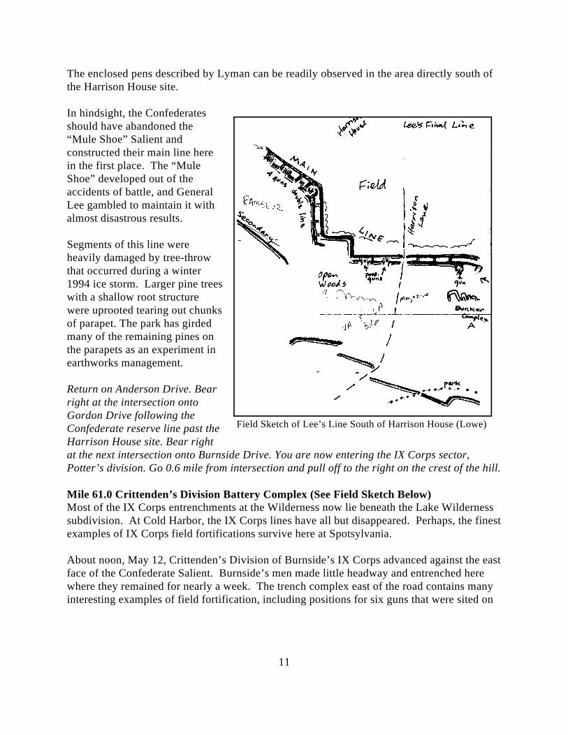
11
Field Sketch of Lee’s Line South of Harrison House (Lowe)
The enclosed pens described by Lyman can be readily observed in the area directly south ofthe Harrison House site.
In hindsight, the Confederatesshould have abandoned the“Mule Shoe” Salient andconstructed their main line herein the first place. The “MuleShoe” developed out of theaccidents of battle, and GeneralLee gambled to maintain it withalmost disastrous results.
Segments of this line wereheavily damaged by tree-throwthat occurred during a winter1994 ice storm. Larger pine treeswith a shallow root structurewere uprooted tearing out chunksof parapet. The park has girdedmany of the remaining pines onthe parapets as an experiment inearthworks management.
Return on Anderson Drive. Bearright at the intersection ontoGordon Drive following theConfederate reserve line past theHarrison House site. Bear rightat the next intersection onto Burnside Drive. You are now entering the IX Corps sector,Potter’s division. Go 0.6 mile from intersection and pull off to the right on the crest of the hill.
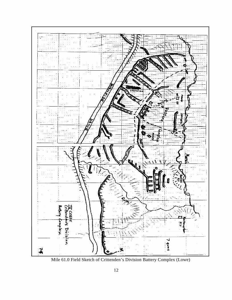
Mile 61.0 Crittenden’s Division Battery Complex (See Field Sketch Below)Most of the IX Corps entrenchments at the Wilderness now lie beneath the Lake Wildernesssubdivision. At Cold Harbor, the IX Corps lines have all but disappeared. Perhaps, the finestexamples of IX Corps field fortifications survive here at Spotsylvania.
About noon, May 12, Crittenden’s Division of Burnside’s IX Corps advanced against the eastface of the Confederate Salient. Burnside’s men made little headway and entrenched herewhere they remained for nearly a week. The trench complex east of the road contains manyinteresting examples of field fortification, including positions for six guns that were sited on
12
Mile 61.0 Field Sketch of Crittenden’s Division Battery Complex (Lowe)
13
Field Sketch of IX Corps Battery (Lowe)
the back side of the slope and aimed to fire indirectly over the infantry support trenches totheir front. The right flank of the line boasts a gallery of traverses and covered ways. Asecond gallery, heavily traversed, is on the hillock behind the left flank. A road trace leadsfrom the front line down to the swamp in the rear.
Continue on Burnside Drive for 0.7 mile and pull off at the side of the road.
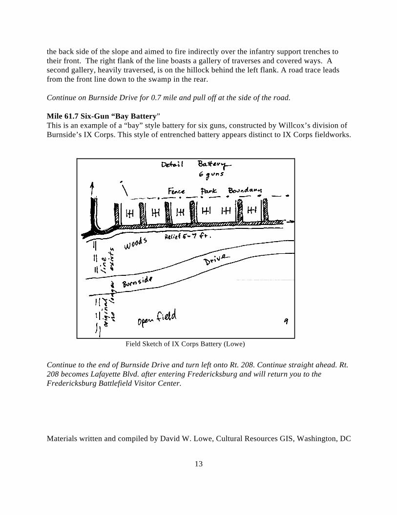
Mile 61.7 Six-Gun “Bay Battery”This is an example of a “bay” style battery for six guns, constructed by Willcox’s division ofBurnside’s IX Corps. This style of entrenched battery appears distinct to IX Corps fieldworks.
Continue to the end of Burnside Drive and turn left onto Rt. 208. Continue straight ahead. Rt.208 becomes Lafayette Blvd. after entering Fredericksburg and will return you to theFredericksburg Battlefield Visitor Center.
Materials written and compiled by David W. Lowe, Cultural Resources GIS, Washington, DC