Embed Size (px)
Citation preview

Michael Young – CISO - ProductsRandall Williams – Security Engineer - PSIRT Lead
Esri Software Security & Privacy Team
Designing a Web GIS Security Strategy

Agenda
• Introduction• Trends• Strategy• Mechanisms• Web GIS• Mobile• Cloud• Compliance

IntroductionWhat is a secure GIS?

Risk
Impact
IntroductionWhat is “The” Answer?

IntroductionWhere are the vulnerabilities?
*SANS Relative Vulnerabilities
Core component vulnerabilities were exposed in the past few years, application risks are still king

Michael Young
Trends & Real World Scenarios

*Verizon 2018 DBIR
TrendsBreaches: Is your industry a top target?
• Top five breached industries1. Healthcare2. Accommodation3. Public4. Retail5. Finance
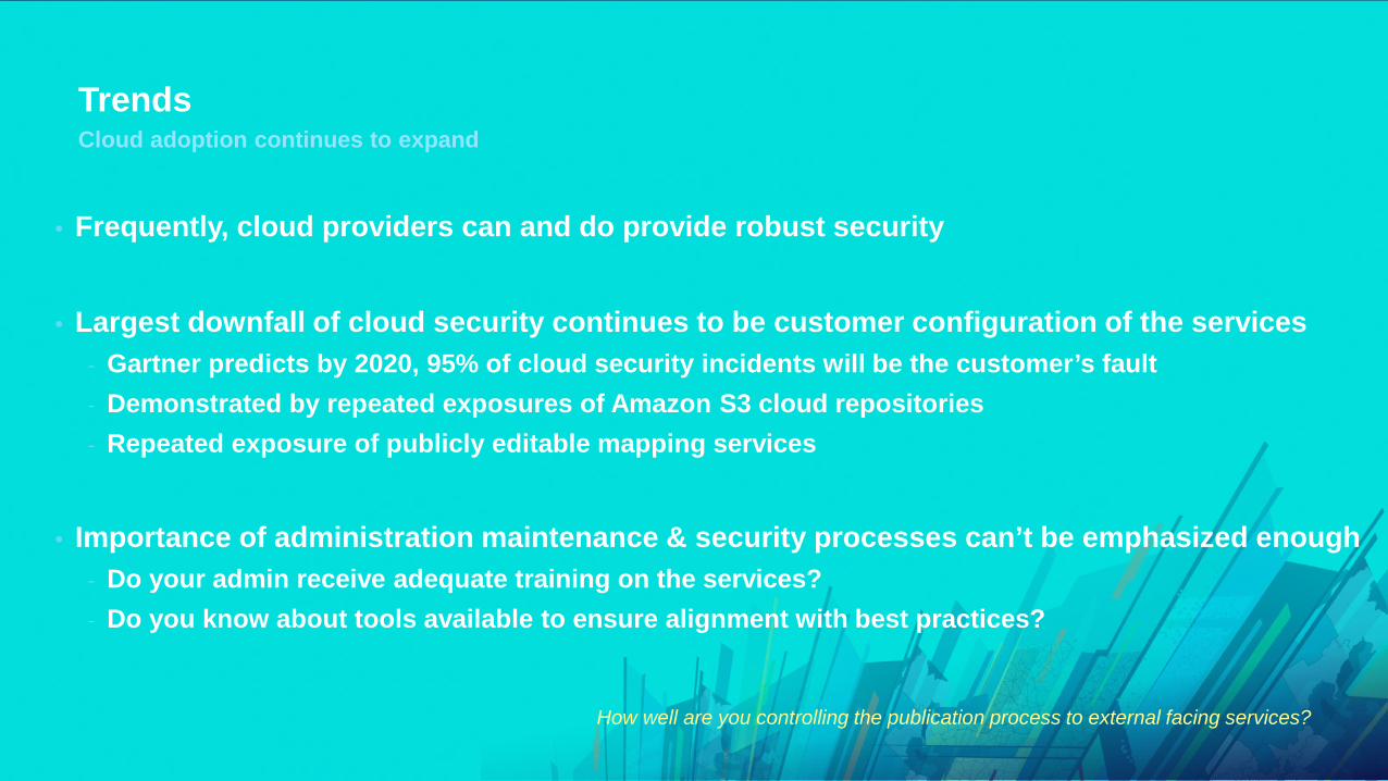
Trends
• Frequently, cloud providers can and do provide robust security
• Largest downfall of cloud security continues to be customer configuration of the services- Gartner predicts by 2020, 95% of cloud security incidents will be the customer’s fault- Demonstrated by repeated exposures of Amazon S3 cloud repositories- Repeated exposure of publicly editable mapping services
• Importance of administration maintenance & security processes can’t be emphasized enough- Do your admin receive adequate training on the services?- Do you know about tools available to ensure alignment with best practices?
Cloud adoption continues to expand
How well are you controlling the publication process to external facing services?

Trends
• Even if not sensitive data on a web server, it is still a desirable target for criminals
• Small web apps typically have the same number of instances of a given type of vulnerability as large ones
Importance of Web Application Security Remains High
*Verizon 2018 DBIR

Scenarios
• Your organization has received an email from the FBI explaining that a well known hacktivist group has threatened to attack your organizations IT systems in the next several weeks
• Press has obtained your organization’s internal announcement and shared with public
• You don’t think your Internet-facing geospatial repositories contain information that could be damaging to your organization or others if released, but you are not positive
• You use multiple ArcGIS Online organizations as well as ArcGIS Enterprise on-premises
• What would you do as the Geospatial IT Manager?- Nothing – Assume everything is good enough?- Shutdown the GIS systems and disable your AGO Orgs?- Something else?
Imagine Being Notified About a Hacktivist Group Threating To Attack Your Organization

Scenarios
1. Get expert help as possible1. Work with your incident response team2. Contact vendor response teams
2. Understand your attackers mode of operation as well as what they would be most likely be interested in exploiting within your organization
1. Recruitment2. Data exfiltration attempts3. DDoS attempts
Dealing with a hacktivism threat

Scenarios
• Ensure application layer is security hardened
• Apply patches for OS and GIS- Check Trust Center for latest security patches
• There are tools that check for GIS security best practices- Python admin scripts included with both Portal & Server
• What about ArcGIS Online?- Yes – NEW AGO Security Advisor- More on this to come
Dealing with a hacktivism threat
How likely is this to happen? Ask the customer it’s happening to right now…
Scenarios
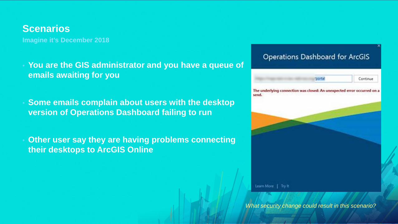
• You are the GIS administrator and you have a queue of emails awaiting for you
• Some emails complain about users with the desktop version of Operations Dashboard failing to run
• Other user say they are having problems connecting their desktops to ArcGIS Online
Imagine it’s December 2018
What security change could result in this scenario?

Scenarios
• ArcGIS Online transport security roadmap established
• Will disrupt a number of customer’s operations if not tested/validated ahead of transition
• TLS 1.0 & 1.1 will be disabled (In alignment with PCI & FedRAMP standards)- Check out our TLS guide to understand compatibility with product versions (Trust Center)
Imagine it’s December 2018 – TLS 1.0 & 1.1 were disabled for ArcGIS Online
Don’t be surprised by SaaS configuration changes – Stay in the loop of proposed changes and test accordingly!

Scenarios
• As the primary ArcGIS Online administrator, you are swamped with calls from your users wondering why their maps are failing to display – causing widespread disruption of your geospatial services
• Users have been complaining about Insecure messages from their browsers when visiting your site for months
Imagine it’s September 2019
Something changed, but what?

Scenarios
• In September 2019, ArcGIS Online will only allow organizations to use HTTPS• In October 2018, browsers like Chrome will flag sites with HTTP as insecure
- Nobody will want to consume your maps/apps if you don’t start correcting this immediately
• Ensure your systems can used HTTPS• Performance and cost are non-issues in 2018
- Free certificates are available if necessary- Let’s Encrypt provides free HTTPS certificates- Amazon is offering free security certificates to AWS customers
- Most browsers only support faster HTTP/2 with HTTPS- This means sites utilizing HTTPS can significantly outperform HTTP sites- See for yourself @ http://www.httpvshttps.com/
• Ensure the external services your organization and maps/apps use HTTPS
ArcGIS Online Allows Only HTTPS
The sooner you eliminate HTTP from your systems and the services you consume the better
Scenarios
• Scenario- Organization utilizes cloud based services for disseminating disaster communications- Required easy updates from home and at work- Drove allowing the public access to modify service information
• Lesson learned- Enforce strong governance processes for web publication- Don’t allow anonymous users to modify web service content- Minimize or eliminate “temporary” modification rights of anonymous users- If web services are exposed to the internet, just providing security at the application level
does not prevent direct access to web services
Disaster communications modified
Lack of strong governance leads to unexpected consequences

Scenarios
• Hint – The Trust.ArcGIS.com site will always have this answer handy…
QUIZ – When was the last ArcGIS Security patch released?
99.9% of vulnerabilities are exploited more than a year after being released

TrendsStrategic Shifts in Security Priorities for 2018 and Beyond
• HTTP is about to die- Migrate away from any HTTP dependences
• Stronger Privacy regulation driving security demands (GDPR / New State of CA law)• Enormous user password dumps now commonplace
- Use 2-factor auth / enterprise password management solutions
• Mobile security threats increasing quickly- Become familiar with vendor mobile app recommendations
• Utilization of named users provides more granular tracking of geospatial information- Become familiar with your application logging capabilities
• Customer configuration primary source of cloud breaches- Drives importance of admin training & tools/automation for discovery of configuration issues

Michael Young
Strategy

StrategyA better answer
• Identify your security needs- Assess your environment
- Datasets, systems, users- Data categorization and sensitivity- Understand your industry attacker motivation
• Understand security options- Trust.arcgis.com- Enterprise-wide security mechanisms- Application specific options
• Implement security as a business enabler- Improve appropriate availability of information- Safeguards to prevent attackers, not employees

StrategyEnterprise GIS Security Strategy
Security Risk Management Process Diagram - Microsoft

StrategySecurity Principles
Availability
CIA Security
Triad

StrategyDefense in Depth
• More layers does NOT guarantee more security
• Understand how layers/technologies integrate
• Simplify
• Balance People, Technology, and Operations
• Holistic approach to security TechnicalControls
PolicyControls
Physical Controls
Data and
Assets

Randall Williams
Mechanisms
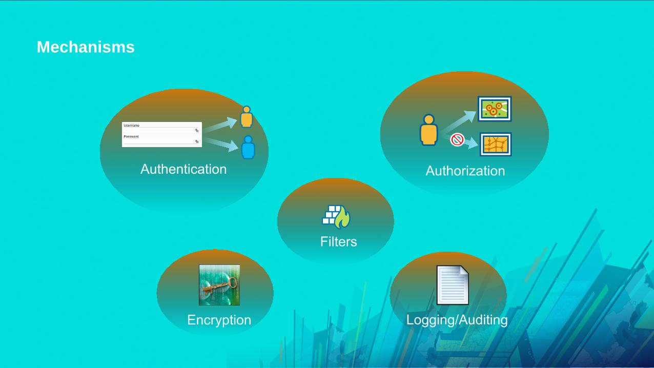
Mechanisms
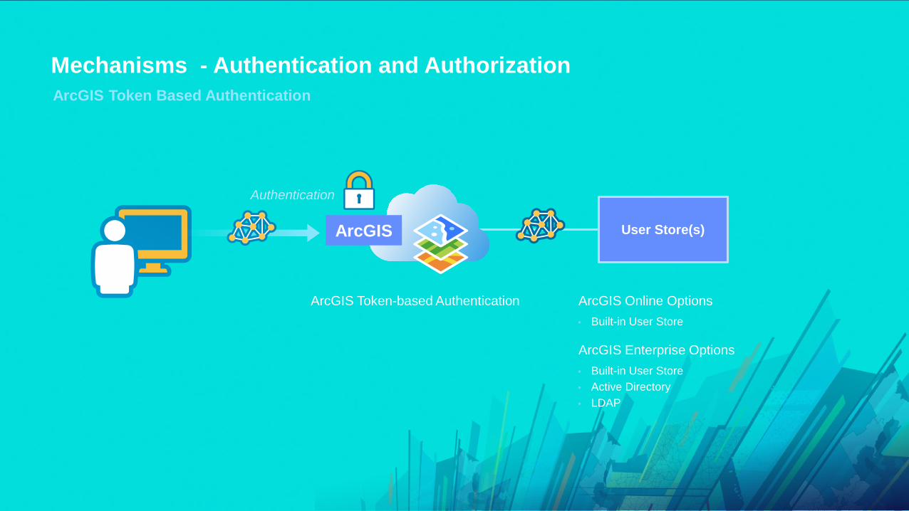
Mechanisms - Authentication and AuthorizationArcGIS Token Based Authentication
User Store(s)ArcGIS
ArcGIS Token-based Authentication
Authentication
• Built-in User Store
ArcGIS Online Options
• Built-in User Store• Active Directory• LDAP
ArcGIS Enterprise Options

Web Server
User Store(s)
Options Depend on Web Server…
Authentication
• Integrated Windows Authentication (IWA)• Client-Certificate Authentication (PKI)• HTTP Digest Authentication
Options Depend on Web Server…• Active Directory• LDAP
Only supported using ArcGIS Enterprise…
Mechanisms - Authentication and Authorization Web-Tier Authentication
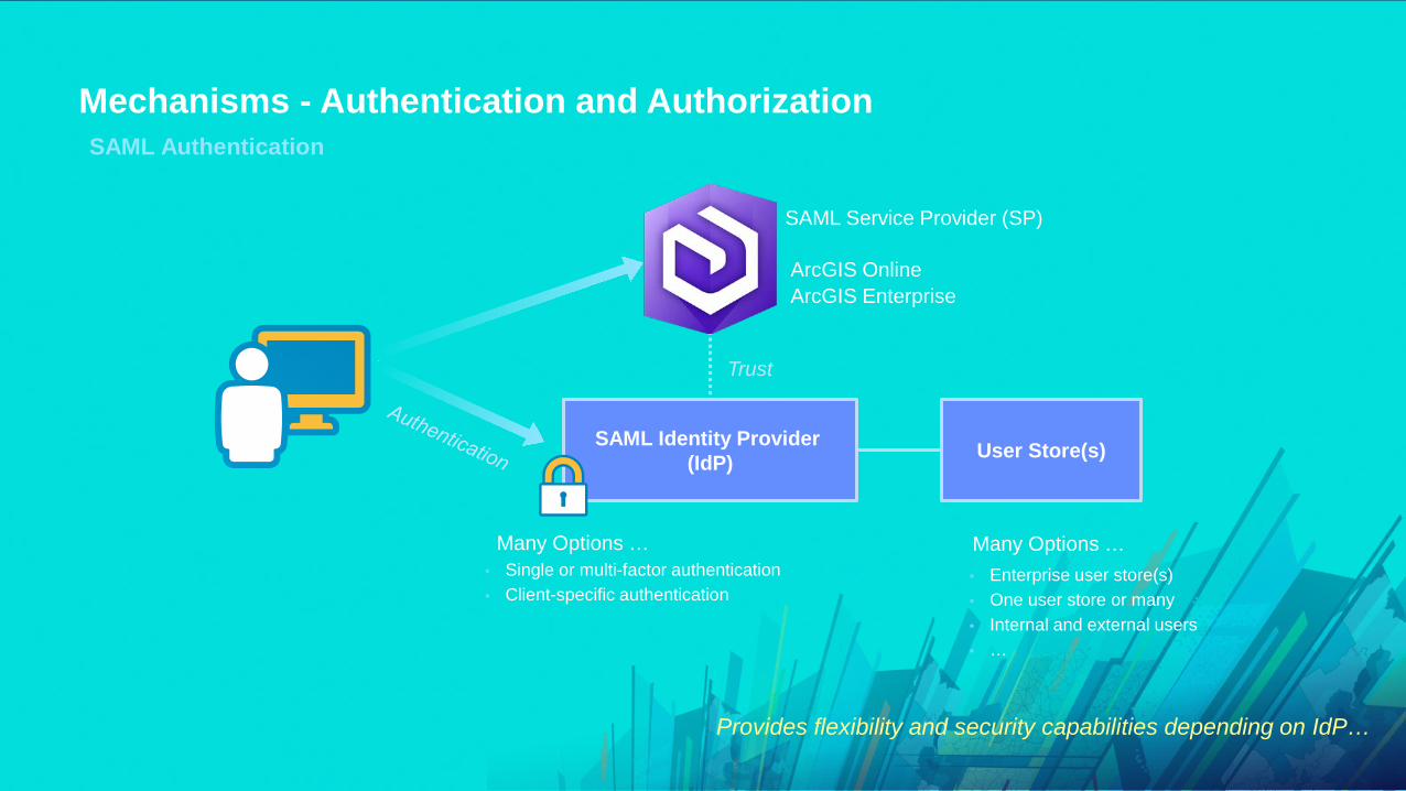
SAML Identity Provider (IdP) User Store(s)
Many Options … Many Options …• Single or multi-factor authentication• Client-specific authentication
• Enterprise user store(s)• One user store or many• Internal and external users• …
Trust
SAML Service Provider (SP)
Provides flexibility and security capabilities depending on IdP…
Mechanisms - Authentication and Authorization SAML Authentication
ArcGIS OnlineArcGIS Enterprise

Mechanisms – Firewalls and FiltersFilters – 3rd Party Options
• Firewalls- Host-based- Network-based
• Reverse Proxy• Web Application Firewall
- Open Source option ModSecurity
• Anti-Virus Software• Intrusion Detection / Prevention Systems• Limit applications able to directly access geodatabase

MechanismsEncryption – 3rd Party Options
• Network- IPSec (VPN, Internal Systems)- SSL/TLS (Internal and External System)- Cloud Encryption Gateways
- Only encrypted datasets sent to cloud
• File Based- Operating System – BitLocker- GeoSpatially enabled PDF’s combined with Certificates- Hardware (Disk)
• RDBMS- Transparent Data Encryption

• Logging involves recording events of interest from a system
• Auditing is the practice of inspecting those logs to ensure system is functioning desirably or to answer a specific question about a particular transaction that occurred.
Ensure logging across the system: Applications, Operating System and Network
Esri Apps & Capabilities- Geodatabase history- ArcGIS Workflow Manager- ArcGIS Enterprise logging- ArcGIS System Monitor
3rd Party Options- Web Server & Database- OS- Network- SIEM (for consolidation)
MechanismsLogging and Auditing

Randall Williams
Web GIS

Web GISArcGIS Online or Portal?
ArcGIS Online ArcGIS Enterprise
• SaaS- Releases often- Upgraded automatically (by Esri)
- Esri controls SLA
• Functionality (smart mapping, collaboration…)
• Enterprise Integration- Web SSO via SAML- Native MFA
• FedRAMP Low Tailored Low Certified 6/27/2018
• Software - ArcGIS Server, Portal, Datastore- Releases twice per year- Upgraded manually (by organization)
- Organization controls SLA
• Functionality (smart mapping, collaboration…)
• Enterprise Integration- Web SSO via SAML- Web-tier Authentication via Web Adaptor- Enterprise Groups- ArcGIS Server Integration…

Web GISArchitecture Options and Security Considerations
• What are the confidentiality and integrity needs of your GIS?- Drives extent to which cloud is used- Drives potential authentication options used- Drives encryption requirements
• What are the availability requirements of your GIS?- Redundancy across web tiers, GIS tier, and database tier
• Authentication requirements- Leverage centralized authentication (AD/LDAP)- For an on premise portal that can be Web-tier authentication or using Enterprise Logins

ArcGIS EnterpriseImplementation Guidance
• Don’t expose Server Manager, Server Admin, or Portal Admin interfaces to public
• Disable Services and Sharing Directories• Disable Service Query Operations (as feasible)• Limit utilization of commercial databases under
website- File GeoDatabase can be a useful intermediary
• Require authentication to web services• Require HTTPS
- Or at least make it available!
• Restrict cross-domain requests• Restrict Portal Proxy capability
- Implement a whitelist of trusted domains
Attack surface over time
Atta
ck s
urfa
ce
Time
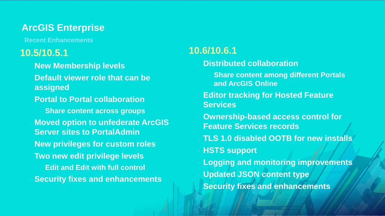
ArcGIS EnterpriseRecent Enhancements
10.6/10.6.1- Distributed collaboration
- Share content among different Portals and ArcGIS Online
- Editor tracking for Hosted Feature Services
- Ownership-based access control for Feature Services records
- TLS 1.0 disabled OOTB for new installs- HSTS support- Logging and monitoring improvements- Updated JSON content type- Security fixes and enhancements
10.5/10.5.1- New Membership levels- Default viewer role that can be
assigned- Portal to Portal collaboration
- Share content across groups- Moved option to unfederate ArcGIS
Server sites to PortalAdmin- New privileges for custom roles- Two new edit privilege levels
- Edit and Edit with full control- Security fixes and enhancements

Randall Williams
Mobile
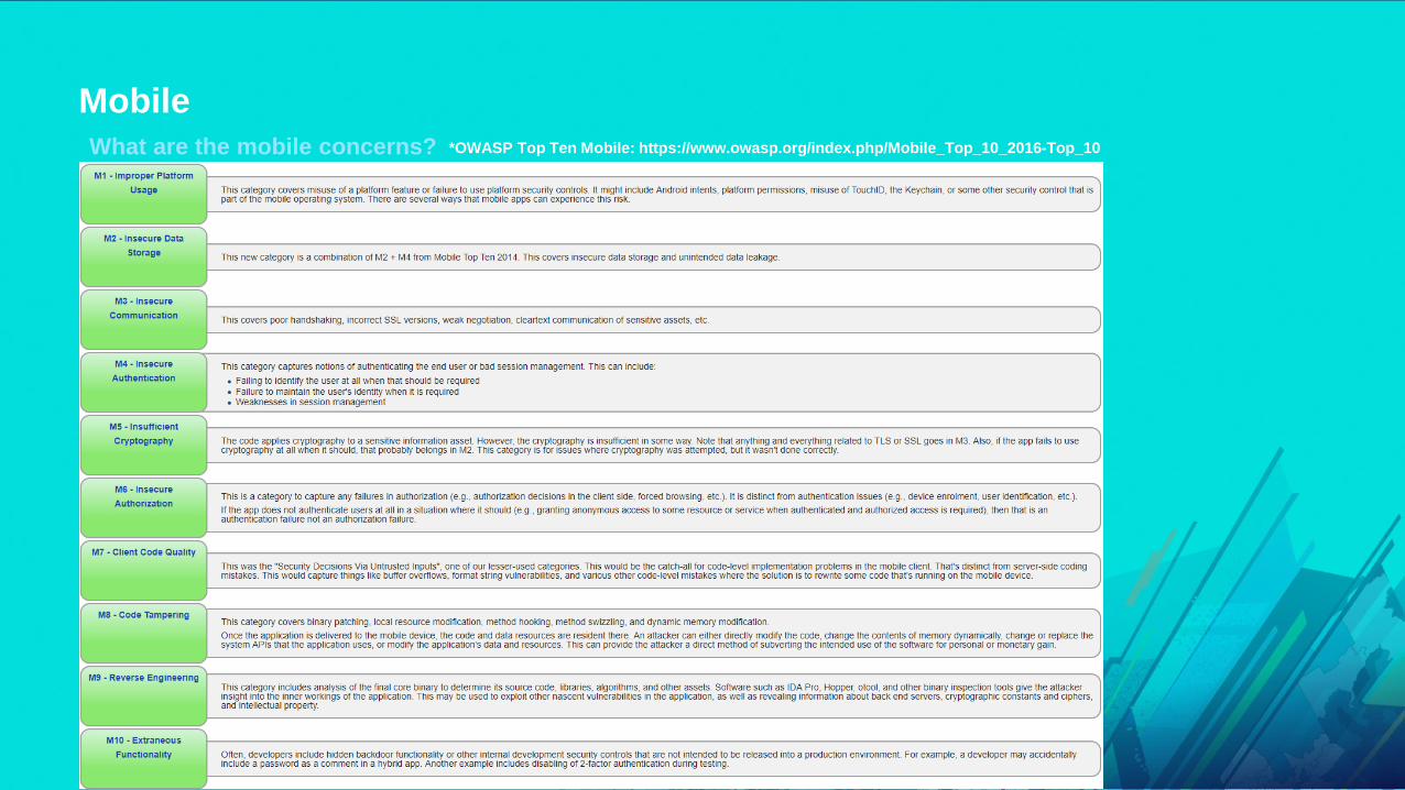
Mobile What are the mobile concerns? *OWASP Top Ten Mobile: https://www.owasp.org/index.php/Mobile_Top_10_2016-Top_10
• M1 – Improper Platform Usage• M2 – Insecure Data Storage• M3 – Insecure Communication• M4 – Insecure Authentication• M5 – Insufficient Cryptography• M6 – Insecure Authorization• M7 – Client Code Quality• M8 – Code Tampering• M9 – Reverse Engineering• M10 – Extraneous Functionality

MobileSecurity Touch Points
CommunicationDevice access
Storage
Project access
Dataaccess
Server authentication
Database permissions
Web Service authorization

MobileChallenges
• Users are beyond corporate firewall- To VPN or not to VPN?
• Authentication/Authorization challenges• Disconnected editing
- Local copies of data stored on device
• Management of mobile devices- Enterprise Mobility Management is the answer!
- Mobile Device Management- Mobile Application Management- Security Gateways- Examples: MobileIron, MaaS360, Airwatch, and many more…

MobileImplementation Guidance
• Encrypt data-in-transit (HTTPS) via TLS• Encrypt data-at-rest• Segmentation
- Use ArcGIS Online, Cloud, or DMZ systems to disseminate public-level data
• Perform Authentication/Authorization• Use an Enterprise Mobility Management (EMM) solution
- Secure e-mail- Enforce encryption- App distribution- Remote wipe- Control 3rd party apps & jailbreak detection- Distribute Certificates

MobileNeed More Granularity?
White Paper: ArcGIS Secure Mobile Implementation Patterns

Randall Williams
Cloud

CloudService Models
• Non-Cloud: On Premises- Traditional systems infrastructure deployment- ArcGIS Enterprise
• IaaS: Infrastructure as a Service- ArcGIS Enterprise- Some Citrix / Desktop
• SaaS: Software as a Service- ArcGIS Online- Business Analyst Online
Dec
reas
ing
Cus
tom
er R
espo
nsib
ility
Customer ResponsibleEnd to End
Customer ResponsibleFor Application Settings

CloudDeployment Models
Cloud On-premise
Intranet
Portal Server
On- Premises
Intranet
Portal Server
Read-onlyBasemaps
On-Premises +
Intranet
Server
Online
Hybrid 1Public
Intranet
Online
Intranet
Online ServerServerServer
Hybrid 2
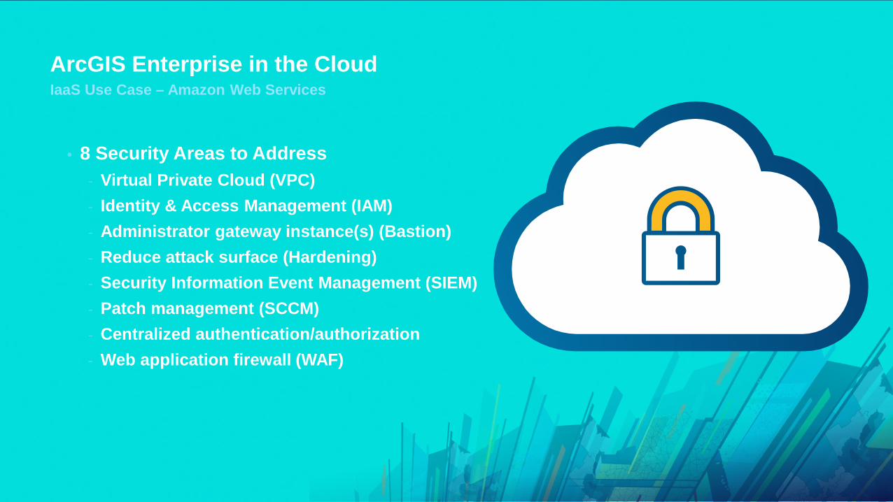
ArcGIS Enterprise in the CloudIaaS Use Case – Amazon Web Services
• 8 Security Areas to Address- Virtual Private Cloud (VPC)- Identity & Access Management (IAM)- Administrator gateway instance(s) (Bastion)- Reduce attack surface (Hardening)- Security Information Event Management (SIEM)- Patch management (SCCM)- Centralized authentication/authorization- Web application firewall (WAF)

Cloud
• Where are internal and cloud datasets combined?- At the browser - The browser makes separate requests for information to multiple sources and does
a “mash-up”- Token security with SSL or even a VPN connection could be used between the
device browser and on-premises system
Hybrid – Data sources
On-Premises Operational Layer Service
Cloud Basemap ServiceArcGIS Online
Browser Combines Layers
http://services.arcgisonline.com...https://YourServer.com/arcgis/rest...
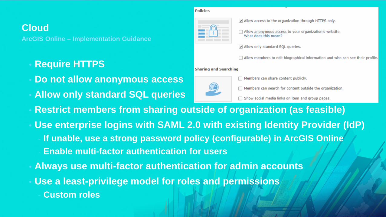
CloudArcGIS Online – Implementation Guidance
• Require HTTPS• Do not allow anonymous access• Allow only standard SQL queries• Restrict members from sharing outside of organization (as feasible)• Use enterprise logins with SAML 2.0 with existing Identity Provider (IdP)
- If unable, use a strong password policy (configurable) in ArcGIS Online- Enable multi-factor authentication for users
• Always use multi-factor authentication for admin accounts • Use a least-privilege model for roles and permissions
- Custom roles

CloudArcGIS Online – Implementation Guidance
How can you validate your configuration options?
New tool: ArcGIS Online Security Advisor - https://arcg.is/ago-advisor

Michael Young
Compliance

Compliance
• Milestones• Cloud Infrastructure Providers• Products and Services• Privacy Assurance / GDPR• Security Assurance / FedRAMP
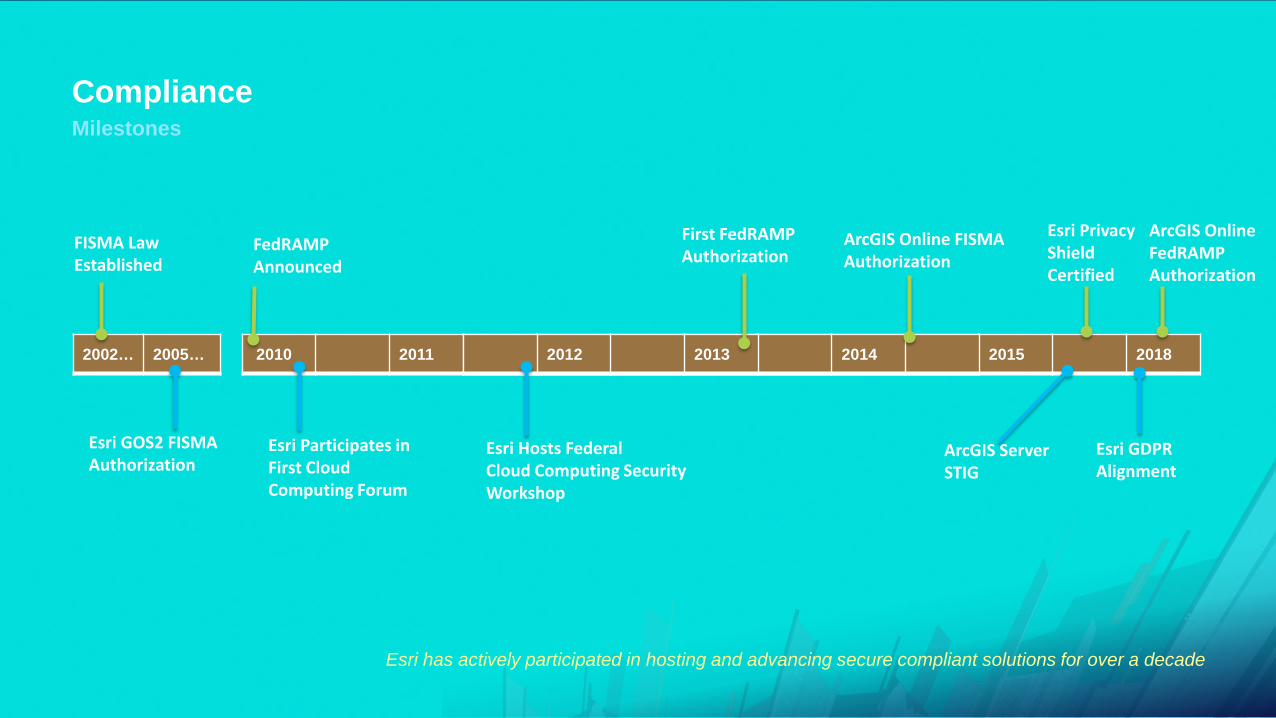
ComplianceMilestones
Esri has actively participated in hosting and advancing secure compliant solutions for over a decade
2010 2011 2012 2013 2014
FedRAMPAnnounced
ArcGIS Online FISMA Authorization
First FedRAMPAuthorization
2012 2013 2014 2015 2018
ArcGIS ServerSTIG
Esri Hosts FederalCloud Computing Security Workshop
ArcGIS OnlineFedRAMPAuthorization
Esri Participates in First Cloud Computing Forum
2002… 2005…
FISMA Law Established
Esri GOS2 FISMAAuthorization
Esri GDPRAlignment
Esri Privacy ShieldCertified

Compliance
• ArcGIS Online Utilizes World-Class Cloud Infrastructure Providers- Microsoft Azure- Amazon Web Services
Cloud Infrastructure Security Compliance
Cloud Infrastructure Providers

ComplianceProducts & Services
• Service Based Initiatives- EMCS Advanced Plus (Single-tenant) – FedRAMP Moderate - ArcGIS Online (Multi-tenant) – FedRAMP Tailored Low - NEW!
• Product Based Initiatives- ArcGIS Server
- DISA STIG – Completed in 2016- ArcGIS Server 10.3 (More STIGs to follow)- Last update was released in 2018- Confirmed compatibility through all current product versions
- ArcGIS Desktop (10.1 and above) and ArcGIS Pro (1.4.1 and above)- USGCB Self-Certified

ComplianceProducts & Services
• Security validation tools
- ArcGIS Server – Python script located in Admin tools directory
- Portal for ArcGIS – Python script located in Security tools directory
- NEW - ArcGIS Online Security Advisor- Checklist validates your org settings/usage against
secure best practice recommendations

CompliancePrivacy Assurance
• EU-U.S. Privacy Shield self-certified- General Esri Privacy Statement- Products & Services Privacy Statement Supplement
• TRUSTe provides privacy certification and dispute resolution
• General Data Protection Regulation (GDPR) *NEW

ComplianceGDPR / Privacy
Esri supports GDPR and continues to advance our privacy & security practices
GDPR
Privacy Impact
Assessment
Protect by design
Privacy Governance
Data Breach Notification
Right to be forgotten
Consent
Data Portability
Personal Data

ComplianceGDPR - Privacy Impact Assessment (PIA)
• Esri has been performing PIA’s since the early 2000’s for Online services- ArcGIS GDPR/Privacy Best Practices whitepaper to be released soon to help guide customers- We welcome assisting customers with their PIA’s as necessary
• Supplementary privacy statement created specifically for our Products & Services- Privacy Collection & storage of privacy information is minimized in our products- Online Telemetry service (EUEI) disabled by default for organizations outside the US
• Company-wide privacy improvements- Tracking cookies can now be disabled centrally across Esri.com & ArcGIS.com- When Esri is Controller of customer PI, requests handled through [email protected]

ComplianceGDPR - Protect By Design
• Esri established a formal Security Development Lifecyle in 2017• Addresses governance structure (CISO – Products, CISO – Corporate)• Guidelines practices based on BSIMM, OWASP, CWE/SANS• Most rigorous security measures starting with ArcGIS Enterprise & Online• Static, Dynamic, and Component Analysis + 3rd party testing• Product Security Incident Response Team (PSIRT) established• FedRAMP Tailored Low Authorization drives continuous monitoring• Customer datasets written/updated after March 10th, 2018 are encrypted at rest
- Pre-existing datasets to be encrypted by end of 2018

ComplianceFedRAMP
• ArcGIS Online received an Agency FedRAMP Tailored Low authorization-to-operate (ATO) on June 28, 2018
• Authorization known as a Low-Impact Software as a Service (Li-SaaS)
• Value to US Government Agencies- FedRAMP standardizes way US government agencies perform security authorizations for cloud
products and services, shifting the authorization process from years/months to weeks/days
• Value to Global Organizations- Recognized by many organizations around the globe as a gold standard for security- Mapping of ISO 27001 & 15408 controls is readily available via the Trust Center

Compliance
• A Customer Responsibility Matrix (CRM) details recommended Organization settings to align with FedRAMP guidelines (summarized below)
- Enable the HTTPS Only Security Policy- Enable Allow only Standard SQL Queries- Disable Security Policy allowing members to edit biographical information- Enable SAML v2.0 Enterprise Logins- Disable Social logins (w/exception for Google business accounts)- Add relevant domains for Allow Origins- Enable using Esri vector basemaps under Settings/Map/Basemap Gallery
FedRAMP Alignment

ComplianceSummary
Trust.ArcGIS.com
Privacy
Security
Answers

Michael Young
Summary
Summary
• Security demands are rapidly evolving- Prioritize efforts accord to your industry and needs- Don’t just add components, simplified Defense In Depth approach- Don’t get caught off-guard by security changes (Read the TLS Guide)
• Esri continues to advance their privacy and security- New FedRAMP Tailored Low authorization and GDPR alignment
• Secure Best Practice Guidance is Available- Check out the Trust.ArcGIS.com Site!- Mobile security whitepaper available now and GDPR paper coming soon- New security validation tools available use them now!
- Feel free to contact us:- [email protected]