Embed Size (px)
Citation preview

Designation of Critical Habitat for the Distinct Population Segments of Yelloweye Rockfish, Canary Rockfish, and
Bocaccio
Final Section 4(b)(2) Report
November 2014
Prepared by NMFS Protected Resources Division, West Coast Region 7600 Sand Point Way NE, Seattle, WA 98115

Table of Contents
I. STATUTE AND REGULATIONS.......................................................................................................... 1
Findings and Purposes of the Act Emphasize Habitat Conservation ........................................................ 1
“Critical Habitat” Is Specifically Defined ................................................................................................ 1
“Conservation” Is Specifically Defined .................................................................................................... 2
Certain Military Lands Are Precluded From Designation ........................................................................2
Impacts of Designation Must Be Considered and Areas May Be Excluded ............................................. 2
Federal Agencies Must Ensure Their Actions Are Not Likely to Destroy or Adversely Modify Critical Habitat....................................................................................................................................................... 2
Authority to Designate Critical Habitat Is Delegated to NOAA Fisheries ............................................... 3
Joint Regulations Govern Designation ..................................................................................................... 3
Approach to Designation .......................................................................................................................... 4
II. IDENTIFY SPECIFIC AREAS ELIGIBLE FOR CRITICAL HABITAT DESIGNATION ................. 5
Identify Areas Meeting the Definition of Critical Habitat ........................................................................ 5
Geographical Area Occupied by the Species ........................................................................................ 5
Physical or Biological Features Essential to Conservation ................................................................... 5
“Specific Areas” Within the Geographical Area Occupied by the Species .......................................... 6
Special Management Considerations or Protection .............................................................................. 7
Unoccupied Areas................................................................................................................................. 7
Military Areas Ineligible for Designation ............................................................................................. 7
III. IDENTIFY AND CONSIDER IMPACTS OF DESIGNATION .......................................................... 8
Identify “Particular” Areas........................................................................................................................ 8
Determine Impacts of Designation ........................................................................................................... 8
Economic Impacts ............................................................................................................................... 10
Impacts to National Security ............................................................................................................... 11
Other Relevant Impacts—Impacts to Tribal Sovereignty and Self-Governance ................................ 12
Other Relevant Impacts—Impacts to Landowners/Entities with Contractual Commitments to Conservation ....................................................................................................................................... 12
IV. DETERMINE WHETHER TO BALANCE BENEFITS AND CONSIDER EXCLUSIONS............ 14
Determine the Benefits of Designation ................................................................................................... 15
Balance Benefits of Designation against Benefits of Exclusion and Recommend Exclusions If Appropriate ............................................................................................................................................. 16
Balancing Economic Impacts .............................................................................................................. 16
Designation of Critical Habitat for the i November 2014 Distinct Population Segments of Yelloweye Rockfish, Canary Rockfish, and Bocaccio Final Section 4(b)(2) Report

Balancing Impacts to Tribal Sovereignty and Self-Determination ..................................................... 17
Balancing Impacts to Landowners/Entities with Contractual Commitments to Conservation ........... 18
Balancing Impacts to National Security .............................................................................................. 20
V. Determine Whether Exclusion Will Result in Extinction of the Species ............................................ 21
References ................................................................................................................................................... 22
Appendix A – Consideration of Impacts of Indian Tribes ........................................................................ A-1
Appendix B – Consideration of Impacts on Conservation Plans.............................................................. B-1
Appendix C – Consideration of U.S. Department of Defense INRMPs & Impacts to National Security C-1
List of Figures
Figure A1. Indian lands within the range of the listed rockfishes’ DPSs. ........................................... A3
Figure C-1. DOD INRMPs in Puget Sound. ........................................................................................ C3
List of Tables
Table 1. Comparison of conservation ratings (all High) from NMFS (2014a), and economic impact (expressed as Total Annualized Impacts – discounted by 7%) for Specific Areas from NMFS (2014b) occupied by listed rockfishes. Overlap with U.S. Department of Defense (DOD) and Indian lands are also shown......................................................................................... 24
Table A1. Summary of tribes that have lands overlapping with specific areas for canary rockfish and bocaccio. The conservation value of the affected specific area and the estimated miles of nearshore overlapping with Indian lands are shown. ........................................................ A8
Table A2. Forecast annual number of future Federal activities (subject to section 7 consultation) likely to occur within critical habitat of each specific area that overlaps Indian lands (from NMFS 2014a). .............................................................................................................................. A9
Table B1. Rockfish special management considerations that are covered activities in the two section 10(a)(1)(B) ITPs in Puget Sound. ...................................................................................... B8
Table C1. Summary of Navy Security Areas and nearshore or deepwater areas designated as critical habitat. ............................................................................................................................. C27
Appendix C Summary Tables for Navy Areas in Each of the Five Basins of Puget Sound
San Juan Basin/Strait of Juan de Fuca: Strait of Juan de Fuca Naval Air-to-Surface Weapon Range Restricted Area ...................................................................................................................................... C-9
San Juan Basin/Strait of Juan de Fuca: Operating Area R-6713 (Navy 3) ........................................ C-11
San Juan Basin/Strait of Juan de Fuca: Strait of Juan de Fuca, Eastern End; off the Westerly Shore of Whidbey Island; Naval Restricted Areas ............................................................................................ C-13
San Juan Basin/Strait of Juan de Fuca: Admiralty Inlet Naval Restricted Area ................................ C-15
Hood Canal: Hood Canal and Dabob Bay Naval Non-Explosive Torpedo Testing Area .................. C-17
Designation of Critical Habitat for the ii November 2014 Distinct Population Segments of Yelloweye Rockfish, Canary Rockfish, and Bocaccio Final Section 4(b)(2) Report

Hood Canal: Hood Canal, Bangor Naval Restricted Areas ............................................................... C-19
Hood Canal: Dabob Bay, Whitney Point Naval Restricted Area ....................................................... C-21
Whidbey Basin: Naval Station Everett Restricted Area .................................................................... C-23
South Sound: Carr Inlet Naval Restricted Area ................................................................................ C-25
Designation of Critical Habitat for the iii November 2014 Distinct Population Segments of Yelloweye Rockfish, Canary Rockfish, and Bocaccio Final Section 4(b)(2) Report

This report contains NOAA Fisheries West Coast Region’s analysis for designating critical habitat under section 4 of the Endangered Species Act (ESA) for the Distinct Population Segments (DPSs) of yelloweye rockfish (Sebastes ruberrimus), canary rockfish (Seb. pinniger), and bocaccio (Seb. paucispinus) of the Puget Sound/Georgia Basin (listed rockfishes). We listed the yelloweye rockfish and canary rockfish DPSs as threatened, and the bocaccio DPS as endangered on Aril 28, 2010 (75 Fed. Reg. 22276). This report describes the methods used, process followed, and conclusions reached for each step leading to the critical habitat designation.
I. STATUTE AND REGULATIONS
We determined which areas to recommend as critical habitat for yelloweye rockfish, canary rockfish, and bocaccio (listed rockfishes) consistent with statutory requirements and agency regulations, which are summarized below.
Findings and Purposes of the Act Emphasize Habitat Conservation
In section 2(a) of the ESA, “Findings,” Congress declared that:
. . . various species of fish, wildlife and plants in the United States have been rendered extinct as a consequence of economic growth and development untempered by adequate concern and conservation. . .
Section 2(b) of the ESA sets forth the purposes of the Act, beginning with habitat protection:
The purposes of this chapter are to provide a means whereby the ecosystems upon which endangered species and threatened species depend may be conserved, to provide a program for the conservation of such endangered species and threatened species, and to take such steps as may be appropriate to achieve the purposes of the treaties and conventions set forth in subsection (a) of this section.
“Critical Habitat” Is Specifically Defined
Section 3(5) of the ESA defines critical habitat:
(5)(A) The term “critical habitat” for a threatened or endangered species means –
(i) the specific areas within the geographical area occupied by the species, at the time it is listed in accordance with the provisions of section 4 of this act, on which are found those physical or biological features (I) essential to the conservation of the species and (II) which may require special management considerations or protection; and
(ii) specific areas outside the geographical area occupied by the species at the time it is listed in accordance with the provisions of section 4 of this act, upon a determination by the Secretary that such areas are essential for the conservation of the species.
(B) Critical habitat may be established for those species now listed as threatened or endangered species for which no critical habitat has heretofore been established as set forth in subparagraph (A) of this paragraph.
(C) Except in those circumstances determined by the Secretary, critical habitat shall not include the entire geographical area which can be occupied by the threatened or endangered species.
Designation of Critical Habitat for the 1 November 2014 Distinct Population Segments of Yelloweye Rockfish, Canary Rockfish, and Bocaccio Final Section 4(b)(2) Report

“Conservation” Is Specifically Defined
Section 3(3) of the Act defines conservation:
(3) The terms “conserve,” “conserving,” and “conservation” mean to use and the use of all methods and procedures which are necessary to bring any endangered species or threatened species to the point at which the measures provided pursuant to this chapter are no longer necessary.
Certain Military Lands Are Precluded From Designation
In 2003, Congress amended section 4(a)(3)(B)(i) of the ESA to limit the designation of land controlled by the Department of Defense (National Defense Authorization Act, P.L. No. 108-136):
The Secretary shall not designate as critical habitat any lands or other geographical areas owned or controlled by the Department of Defense, or designated for its use, that are subject to an integrated natural resources management plan prepared under section 101 of the Sikes Act (16 U.S.C. 670a), if the Secretary determines in writing that such plan provides a benefit to the species for which critical habitat is proposed for designation.
Impacts of Designation Must Be Considered and Areas May Be Excluded
Specific areas that fall within the definition of critical habitat are not automatically designated as critical habitat. Section 4(b)(2) of the ESA requires the Secretary to first consider the impact of designation and permits the Secretary to exclude areas from designation under certain circumstances. Exclusion is not required for any areas.
(2) The Secretary shall designate critical habitat, and make revisions thereto, under subsection (a)(3) of this section on the basis of the best scientific data available and after taking into consideration the economic impact, the impact to national security and any other relevant impact, of specifying any particular area as critical habitat. The Secretary may exclude any area from critical habitat if he determines that the benefits of such exclusion outweigh the benefits of specifying such area as part of the critical habitat, unless he determines, based on the best scientific and commercial data available, that the failure to designate such area as critical habitat will result in the extinction of the species concerned.
Federal Agencies Must Ensure Their Actions Are Not Likely to Destroy or Adversely Modify Critical Habitat
Once critical habitat is designated, section 7(a)(2) of the ESA provides that Federal agencies must ensure any actions they authorize, fund, or carry out are not likely to result in the destruction or adverse modification of designated critical habitat. Section 7 also requires Federal agencies to ensure such actions do not jeopardize the continued existence of the listed species:
(2) Each Federal agency shall, in consultation with and with the assistance of the Secretary, insure that any action authorized, funded, or carried out by such agency (hereinafter in this section referred to as an “agency action”) is not likely to jeopardize the continued existence of any endangered species or threatened species or result in the destruction or adverse modification of habitat of such species which is determined by the Secretary, after consultation as appropriate with affected States, to be critical, unless such agency has been granted an exemption for such action by
Designation of Critical Habitat for the 2 November 2014 Distinct Population Segments of Yelloweye Rockfish, Canary Rockfish, and Bocaccio Final Section 4(b)(2) Report
the Committee pursuant to subsection (h) of this section. In fulfilling the requirements of this paragraph each agency shall use the best scientific and commercial data available.
Authority to Designate Critical Habitat Is Delegated to NOAA Fisheries
The authority to designate critical habitat, including the authority to consider the impacts of designation, the authority to weigh those impacts against the benefit of designation, and the authority to exclude particular areas, has been delegated to the Assistant Administrator of the National Marine Fisheries Service (Department Organization Order 10-15 (5/24/04). NOAA Organization Handbook, Transmittal #61, February 28, 2006).
Joint Regulations Govern Designation
Joint regulations of the Services (50 CFR § 424.12) elaborate on those physical and biological features essential to conservation, and set criteria for the delineation of critical habitat.
(b) In determining what areas are critical habitat, the Secretary shall consider those physical and biological features that are essential to the conservation of a given species and that may require special management considerations or protection. Such requirements include, but are not limited to, the following:
(1) Space for individual and population growth, and for normal behavior;
(2) Food, water, air, light, minerals, or other nutritional or physiological requirements;
(3) Cover or shelter;
(4) Sites for breeding, reproduction, rearing of offspring, germination, or seed dispersal; and generally;
(5) Habitats that are protected from disturbance or are representative of the historic geographical and ecological distributions of a species.
When considering the designation of critical habitat, the Secretary shall focus on the principal biological or physical constituent elements within the defined area that are essential to the conservation of the species. Known primary constituent elements shall be listed with the critical habitat description. Primary constituent elements may include, but are not limited to, the following: roost sites, nesting grounds, spawning sites, feeding sites, seasonal wetland or dry land, water quality or quantity, host species or plant pollinator, geological formation, vegetation type, tide, and specific soil types.
(c) Each critical habitat area will be shown on a map, with more-detailed information discussed in the preamble of the rulemaking documents published in the Federal Register and made available from the lead field office of the Service responsible for such designation. Textual information may be included for purposes of clarifying or refining the location and boundaries of each area or to explain the exclusion of sites (e.g., paved roads, buildings) within the mapped area. Each area will be referenced to the State(s), county(ies), or other local government units within which all or part of the critical habitat is located.
The regulations also provide for circumstances in which smaller areas containing essential features are clustered within a larger area:
Designation of Critical Habitat for the 3 November 2014 Distinct Population Segments of Yelloweye Rockfish, Canary Rockfish, and Bocaccio Final Section 4(b)(2) Report
(d) When several habitats, each satisfying the requirements for designation as critical habitat, are located in proximity to one another, an inclusive area may be designated as critical habitat.
The regulations confine designation to areas within United States jurisdiction:
(h) Critical habitat shall not be designated within foreign countries or in other areas outside of United States jurisdiction.
The regulations define “special management considerations or protection” in 50 CFR § 424.02.
(j) Special management considerations or protection means any methods or procedures useful in protecting physical and biological features of the environment for the conservation of listed species.
Approach to Designation
Based on this statutory and regulatory direction, our approach to designation included the following steps: A. Identify specific areas eligible for critical habitat designation
Identify areas meeting the definition of critical habitat
Identify military areas ineligible for designation
B. Identify and consider impacts:
Determine the impacts of designation
C. Determine whether to exercise the discretion to exclude
Determine the benefits of designation
Balance benefits of designation against benefits of exclusion and recommend exclusions if appropriate
Determine whether the recommended exclusions will result in extinction of the species
Section 4(b)(2) of the ESA requires us to designate critical habitat for threatened and endangered species “on the basis of the best scientific data available and after taking into consideration the economic impact, the impact on national security, and any other relevant impact, of specifying any particular area as critical habitat.” This section grants the Secretary discretion to exclude any area from critical habitat if he determines “the benefits of such exclusion outweigh the benefits of specifying such area as part of the critical habitat.” In adopting this provision, Congress explained that, “[t]he consideration and weight given to any particular impact is completely within the Secretary’s discretion” H.R. No.95-1625, at 16-17 (1978). The Secretary’s discretion to exclude is limited, as he/she may not exclude areas that “will result in the extinction of the species.” We have discretion in whether and how we balance benefits. Moreover, the statute does not require that any area be excluded. For rockfish species, after considering impacts, we determined to evaluate potential exclusions and therefore identified benefits of designation and balanced them against benefits of exclusion. As a result of this balancing, we recommend exclusion of certain military areas and Indian lands. The discussion below and in the appendices describes how the recommendations are informed by various policy considerations.
Designation of Critical Habitat for the 4 November 2014 Distinct Population Segments of Yelloweye Rockfish, Canary Rockfish, and Bocaccio Final Section 4(b)(2) Report

II. IDENTIFY SPECIFIC AREAS ELIGIBLE FOR CRITICAL HABITAT DESIGNATION
Identify Areas Meeting the Definition of Critical Habitat
Areas that meet the section 3(5)(A) definition of critical habitat include specific areas: 1) within the geographical area occupied by the species at the time of listing, that contain physical or biological features essential to conservation, and those features that may require special management considerations or protection; and 2) outside the geographical area occupied by the species if the agency determines that the area itself is essential for conservation. Pursuant to section 3(5)(A), our first task was to determine “the geographical area occupied by the species at the time of listing.” In a separate report, we have documented our conclusions regarding which specific areas meet the definition of critical habitat and may therefore be eligible for designation (see Biological Report, NMFS 2014a). The conclusions from the report are summarized below.
Geographical Area Occupied by the Species In the status review for each species, NMFS identified a Puget Sound/Georgia Basin DPS for
yelloweye rockfish, canary rockfish, and bocaccio (Drake et al. 2010). The range of the DPSs includes all waters of Puget Sound, the Strait of Juan de Fuca east of Victoria Sill, and south of the North Strait of Georgia. This range can be subdivided into five interconnected basins including: 1) The San Juan/Strait of Juan de Fuca Basin, 2) Main Basin, 3) Whidbey Basin, 4) South Puget Sound, and 5) Hood Canal. Our review of the best available data confirmed that yelloweye rockfish, canary rockfish, and bocaccio occupy each of the major basins of the Puget Sound/Georgia Basin. The range of the DPSs includes portions of Canada; however, we cannot designate areas outside U.S. jurisdiction as critical habitat.
Physical or Biological Features Essential to Conservation Agency regulations at 50 CFR 424.12(b) interpret the statutory phrase “physical or biological
features essential to the conservation of the species.” The regulations state that these features include, but are not limited to, space for individual and population growth and for normal behavior; food, water, air, light, minerals, or other nutritional or physiological requirements; cover or shelter; sites for breeding, reproduction, and rearing of offspring; and habitats that are protected from disturbance or are representative of the historical geographical and ecological distribution of a species.
Based on the best available scientific information, we developed a list of physical and biological features essential to the conservation of each species and relevant to determining whether occupied areas are consistent with our regulations (e.g., 50 CFR § 424.12(b)) and the ESA section (3)(5)(A) definition of “critical habitat.” The physical or biological features essential to the conservation of listed rockfishes fall into several major categories reflecting key life history phases (NMFS 2014a):
Adult canary rockfish and bocaccio, and adult and juvenile yelloweye rockfish:
Benthic habitats or sites deeper than 98.4 feet (30 m) that possess or are adjacent to areas of complex bathymetry consisting of rock and/or highly rugose habitat are essential to conservation because these features support growth, survival, reproduction, and feeding opportunities by providing the structure for rockfish to avoid predation, seek food, and persist for decades. Several attributes of these sites determine the quality of the habitat and are useful in considering the conservation value of the associated feature, and whether the feature may require special management considerations or protection. These attributes are also relevant in the evaluation of the effects of a proposed action in a section 7 consultation if the specific area containing the site is designated as critical habitat. These attributes include:
Designation of Critical Habitat for the 5 November 2014 Distinct Population Segments of Yelloweye Rockfish, Canary Rockfish, and Bocaccio Final Section 4(b)(2) Report
Quantity, quality, and availability of prey species to support individual growth, survival, reproduction, and feeding opportunities.
Water quality and sufficient levels of dissolved oxygen to support growth, survival, reproduction, and feeding opportunities.
Structure and rugosity to support feeding opportunities and predator avoidance.
Juvenile canary rockfish and bocaccio only:
Juvenile settlement habitats located in the nearshore with substrates such as sand, rock, and/or cobble compositions that also support kelp are essential for conservation because these features enable forage opportunities and refuge from predators and enable behavioral and physiological changes needed for juveniles to occupy deeper adult habitats. Several attributes of these sites determine the quality of the area and are useful in considering the conservation value of the associated feature and in determining whether the feature may require special management considerations or protection. These features also are relevant to evaluating the effects of a proposed action in a section 7 consultation if the specific area containing the site is designated as critical habitat. These attributes include:
Quantity, quality, and availability of prey species to support individual growth, survival, reproduction, and feeding opportunities.
Water quality and sufficient levels of dissolved oxygen to support growth, survival, reproduction, and feeding opportunities.
Full descriptions of the life history of yelloweye rockfish, canary rockfish, and bocaccio and the physical and biological features essential to their conservation can be found in the Biological Report (NMFS 2014a).
“Specific Areas” within the Geographical Area Occupied by the Species
After determining the geographical area of the Puget Sound/Georgia Basin occupied by yelloweye rockfish, canary rockfish, and bocaccio, and the physical and biological features essential to their conservation, we next identified the specific areas within the geographical area occupied by the species that contain the essential features. We based our delineation of specific areas on the distribution of adult and juvenile rockfish, distribution of habitat features, and geographic and hydrologic conditions. The five specific areas we identified are the interconnected biogeographic basins described above: 1) The San Juan/Strait of Juan de Fuca Basin, 2) Main Basin, 3) Whidbey Basin, 4) South Puget Sound, and 5) Hood Canal. All of the essential physical and biological features for juvenile rearing and/or adult reproduction, sheltering, or feeding for yelloweye rockfish, canary rockfish, and bocaccio are located within each of these specific areas.
We first used available geographic data to identify the locations of benthic sites with or adjacent to complex bathymetry and shoreline sites with specific substrate types and conditions, as described in more detail in the Biological Report (NMFS 2014a). Once we identified these sites, we aggregated sites located in close proximity (NMFS 2014a), consistent with the regulatory guidance regarding designation of an inclusive area for sites in close proximity (50 CFR § 424.12(d)).
We relied on recent agency rulemaking to produce a critical habitat map that clearly delineates the sites within the specific areas where the essential features are found (NMFS 2014a). The agency recently amended its critical habitat regulations to state that instead of designating critical habitat “using lines on a map,” we will show critical habitat on a map, with more-detailed information discussed in the preamble of
Designation of Critical Habitat for the 6 November 2014 Distinct Population Segments of Yelloweye Rockfish, Canary Rockfish, and Bocaccio Final Section 4(b)(2) Report

the rulemaking and in agency records (50 CFR § 424.12(c)). In adopting this amendment to our regulations, we stated in response to comments:
[I]n instances where there are areas within a bigger area that do not contain the physical and biological features necessary for the conservation of the species, the Services would have the option of drawing the map to reflect only those parts of the area that do contain those features (77 Fed. Reg. 25611, May 1, 2012).
The maps we developed for the present designation conform to this new regulation. In addition, in agency records and available on our website, we provide the GIS plot points used to create these maps so interested persons may determine whether any place of interest is within critical habitat boundaries.
Special Management Considerations or Protection
Specific areas meet the definition of critical habitat if they contain physical or biological features that “may require special management considerations or protection.” Joint NMFS and U.S. Fish and Wildlife Service (USFWS) regulations at 50 CFR §424.02(j) define “special management considerations or protection” to mean “any methods or procedures useful in protecting physical and biological features of the environment for the conservation of listed species.” We identified a number of activities that may affect the physical and biological features essential to the listed rockfishes’ DPSs such that special management considerations or protection may be required. Major categories of such activities include: 1) nearshore development and in-water construction (e.g., beach armoring, pier construction, jetty or harbor construction, pile driving construction, residential and commercial construction); 2) dredging and disposal of dredged material; 3) pollution and runoff; 4) underwater construction and operation of alternative energy hydrokinetic projects (tidal or wave energy projects) and cable laying; 5) kelp harvest; 6) fisheries; 7) non-indigenous species introduction and management; 8) artificial habitats; 9) research activities; 10) aquaculture; and 11) activities that lead to global climate change and ocean acidification (NMFS 2014a). All of these activities may have an effect on one or more physical or biological features via their potential alteration of one or more of the following: adult habitat sites with complex bathymetry, food resources, juvenile settlement sites, and water quality.
Unoccupied Areas
Section 3(5)(A)(ii) of the ESA authorizes the designation of “specific areas outside the geographical area occupied at the time [the species] is listed” if these areas are essential for the conservation of the species. Regulations at 50 CFR § 424.12(e) emphasize that the agency “shall designate as critical habitat areas outside the geographical area presently occupied by a species only when a designation limited to its present range would be inadequate to ensure the conservation of the species.” We conducted a review of the documented occurrences of each listed rockfish in the five biogeographic basins (NMFS 2014a). We found that each of the basins are currently occupied by yelloweye rockfish, canary rockfish, and bocaccio. At the present time, we have not identified any unoccupied areas as critical habitat (NMFS 2014a), and we have not identified any areas outside the geographical area occupied by the species that are essential for their conservation. Therefore, we did not propose to designate any unoccupied areas for listed rockfishes.
Military Areas Ineligible for Designation
Section 4(a)(3) of the ESA precludes the Secretary from designating military lands as critical habitat if those lands are subject to an Integrated Natural Resource Management Plan (INRMP) under the Sikes Act that the Secretary certifies in writing benefits the listed species. We consulted with the
Designation of Critical Habitat for the 7 November 2014 Distinct Population Segments of Yelloweye Rockfish, Canary Rockfish, and Bocaccio Final Section 4(b)(2) Report
Department of Defense (DOD) and determined that several installations with INRMPs overlap with areas occupied by yelloweye rockfish, canary rockfish, and bocaccio: 1) Naval Base Everett, 2) Naval Air Station Whidbey Island, 3) Manchester Fuel Department, 4) Naval Base Kitsap and associated properties, and 5) Joint Base Lewis-McChord (Army and Air Force).
We identified habitat meeting the statutory definition of critical habitat at each of the above installations and reviewed the INRMPs, as well as other information available regarding the management of these military lands. Our review indicates that each of these INRMPs contain measures that provide benefits to each listed rockfish DPS (see Appendix C). Examples of the types of beneficial measures include: 1) implementing actions to protect water quality from land-based infrastructure and vessels; 2) conducting in-water actions during appropriate time periods; and 3) initiating surveys for listed fish.
III. IDENTIFY AND CONSIDER IMPACTS OF DESIGNATION
Section 4(b)(2) of the ESA requires us to use the best scientific data available in designating critical habitat. It also requires that before we designate any “particular” area, we must consider the economic impact, impact on national security, and any other relevant impact.
Identify “Particular” Areas
Section 3(5)(A) of the ESA defines critical habitat as “specific areas,” while section 4(b)(2) of the ESA requires the agency to consider certain factors before designating any “particular area.” Depending on the biology of the species, the characteristics of its habitat, and the nature of the impacts of designation, “specific” areas might be different from, or the same as, “particular” areas. For this designation, we identified the “specific” areas as 1) The San Juan/Strait of Juan de Fuca Basin, 2) Main Basin, 3) Whidbey Basin, 4) South Puget Sound, and 5) Hood Canal. For our economic impact analysis, the “particular” areas were equivalent to the “specific” areas. This approach allowed us to most effectively consider the conservation value of the different areas when balancing conservation benefits of designation against economic benefits of exclusion. However, to assess impacts of designation on national security and Indian lands, we instead used a delineation of “particular” areas based on ownership or control of the area. These “particular” areas consisted of marine areas that overlap with designated military areas and Indian lands. This approach allowed us to consider impacts and benefits associated with management by the military or land ownership and management by Indian tribes.
Determine Impacts of Designation
Section 4(b)(2) of the ESA provides that the Secretary shall consider “the economic impact, impact on national security, and any other relevant impact of specifying any particular area as critical habitat.” The primary impact of a critical habitat designation stems from the requirement under section 7(a)(2) of the ESA that Federal agencies ensure their actions are not likely to result in the destruction or adverse modification of critical habitat. Determining this impact is complicated by the fact that section 7(a)(2) contains the overlapping requirement that Federal agencies must ensure their actions are not likely to jeopardize the species’ continued existence. The true impact of designation is the extent to which Federal agencies modify their actions to ensure their actions are not likely to destroy or adversely modify the critical habitat of the species beyond any modifications they would make because of listing and the jeopardy requirement for the species. Additional impacts of designation include state and local protections that may be triggered as a result of the designation.
Designation of Critical Habitat for the 8 November 2014 Distinct Population Segments of Yelloweye Rockfish, Canary Rockfish, and Bocaccio Final Section 4(b)(2) Report
In determining the impacts of designation, we assessed the incremental change in Federal agency actions as a result of critical habitat designation and the adverse modification prohibition, beyond the changes predicted to occur as a result of listing and the jeopardy provision. In August 2012, the USFWS and NOAA published a proposed rule at 50 CFR § 424.19 to amend our joint regulations to make clear that in considering impacts of designation as required by section 4(b)(2) we would consider the incremental impacts (77 Fed. Reg. 51503, August 24, 2012). This approach is in contrast to our 2005 critical habitat designations for salmon and steelhead (70 Fed. Reg. 52630, September 2, 2005) where we considered the “coextensive” impact of designation. The consideration of coextensive impacts was in accordance with a Tenth Circuit Court decision (New Mexico Cattle Growers’ Association v. U.S. Fish and Wildlife Service, 248 F.3d 1277 (10th Cir. 2001)). More recently, several courts (including the 9th Circuit Court of Appeals) have approved an approach that considers the incremental impact of designation. The Federal Register Notice (78 Fed. Reg. 53058, August 28, 2013) announcing the policy on considering impacts of designation describes and discusses these court cases (Arizona Cattle Growers’ Association v. Salazar, 606 F3d 1160, 1172-74 (9th Cir. 2010), cert. denied, 131 S. Ct. 1471, 179 L. Ed. 2d 300 (2011); Homebuilders Ass’n v. FWS, 616 F3d 983, 991093j (9th Cir. 2010) cert. denied, 131 S. Ct. 1475, 179 L. Ed. 2d 301 (2011); M-3706 The Secretary’s Authority to Exclude Areas from Critical Habitat Designation Under 4(b)(2) of the Endangered Species Act (Oct. 3, 2008) (DOI 2008)). In more recent critical habitat designations, both NMFS and USFWS have considered the incremental impact of critical habitat designation (for example, NMFS’ designation of critical habitat for the Southern DPS of green sturgeon (74 Fed. Reg. 52300, October 9, 2009) and the Southern DPS of Pacific eulachon (76 Fed. Reg. 65324, October 20, 2011) Consistent with our regulatory amendments (78 Fed. Reg. 53058, August 28, 2013), the more recent court cases, and more recent agency practice, we estimated the incremental impacts of designation beyond the impacts that would result from the listing and jeopardy provision. In addition, because these designations almost completely overlap our previous salmonid, killer whale, and green sturgeon critical habitat designations in Puget Sound, and the essential features in previous designations are similar to those for listed rockfishes (NMFS 2014a), we estimated only the incremental impacts of designation beyond the impacts already imposed by those prior designations.
To determine the impact of designation, we examined what the state of the world would be with and without the designation of critical habitat for listed rockfishes. The “without critical habitat” scenario represents the baseline for the analysis. It includes process requirements and habitat protections already afforded listed rockfishes under their Federal listing or under other Federal, state, and local regulations. Such regulations include protections afforded listed rockfishes’ habitat from other co-occurring ESA listings and critical habitat designations, such as those for Pacific salmon and steelhead (70 Fed. Reg. 52630, September 2, 2005), North American green sturgeon (74 Fed. Reg. 52300, October 9, 2009), Southern Resident killer whales (71 Fed. Reg. 69054, November 29, 2006), and bull trout (75 Fed. Reg. 63897, October 18, 2010) (see the Final Economic Analysis for listed rockfishes (NMFS 2014a) for examples of protections for other species that would benefit listed rockfishes). The “with critical habitat” scenario describes the incremental impacts associated specifically with the designation of critical habitat for listed rockfishes. The primary impacts of critical habitat designation we found were: 1) the economic costs associated with additional administrative effort of including a critical habitat analysis in section 7 consultations for these three DPSs, 2) impacts to national security, and 3) the possible harm to our working relationship with Indian tribes and landowners and entities with conservation plans.
We discuss these impacts in more detail in the following sections devoted to each type of impact and provide a summary in Table 1.
Designation of Critical Habitat for the 9 November 2014 Distinct Population Segments of Yelloweye Rockfish, Canary Rockfish, and Bocaccio Final Section 4(b)(2) Report

Economic Impacts
Our economic analysis sought to determine the impacts on land uses and other activities from the designation of critical habitat, above and beyond—or incremental to—those “baseline” impacts as a result of existing or planned conservation efforts being undertaken because of other Federal, state, and local regulations or guidelines (NMFS 2014b). Other Federal agencies, as well as state and local governments, may also seek to protect the natural resources under their jurisdiction. If compliance with the Clean Water Act or state environmental quality laws, for example, protects habitat for the species, such protective efforts are considered to be baseline protections, and costs associated with these efforts are not quantified as impacts of critical habitat designation.
When critical habitat is designated, section 7 requires Federal agencies to ensure that their actions will not result in the destruction or adverse modification of critical habitat (in addition to ensuring that the actions are not likely to jeopardize the continued existence of the species). The added administrative costs of considering critical habitat in section 7 consultations and the additional impacts of implementing project modifications to protect critical habitat are the direct result of the designation of critical habitat. These costs are not in the baseline, and are considered incremental impacts of the rulemaking.
Incremental economic impacts may include the direct costs associated with additional effort for future consultations, reinitiated consultations, new consultations occurring specifically because of the designation, and additional project modifications that would not have been required to avoid jeopardizing the continued existence of the species. Additionally, incremental economic impacts may include indirect impacts resulting from reaction to the potential designation of critical habitat (e.g., developing habitat conservation plans in an effort to avoid designation of critical habitat), triggering of additional requirements under state or local laws intended to protect sensitive habitat, and uncertainty and perceptional effects on markets.
To evaluate the potential administrative and project modification costs of designating critical habitat, we examined our section 7 consultation record for rockfish for the years 2010 and 2011. As further explained in the supporting economic report (NMFS 2014b), to quantify the economic impact of designation we employed the following three steps:
1. Define the geographic study area for the analysis and identify the units of analysis (the “particular areas”). In this case, we defined the five biogeographic basins of the Puget Sound/Georgia Basin that encompass occupied marine areas as the particular areas.
2. Identify potentially affected economic activities and determine how management may increase because of the designation of listed rockfishes’ critical habitat, both in terms of project administration and potential project modification.
3. Estimate the economic impacts associated with both potential administrative costs and costs from project modifications. In this critical habitat designation, we did not identify potential project modification costs (NMFS 2014b).
When considering the additional administrative effort of including a listed rockfish critical habitat analysis in section 7 consultations, we acknowledge that efficiencies exist when considering both jeopardy and adverse modification at the same time (because staff time is already dedicated to reviewing the proposed project and writing a report). For this first category of impacts, we estimated that the additional effort to address adverse modification of critical habitat in a section 7 consultation is equivalent to one third of the effort already devoted to the consultation to consider the species. That is, for every 3 hours spent considering a jeopardy analysis for rockfish, an additional hour would be needed to consider rockfish
Designation of Critical Habitat for the 10 November 2014 Distinct Population Segments of Yelloweye Rockfish, Canary Rockfish, and Bocaccio Final Section 4(b)(2) Report

critical habitat. Based on that assumption, we estimated a total annualized incremental administrative cost of approximately $123,000 (discounted at 7 percent1) for designating the five specific areas as critical habitat for listed rockfishes. The greatest costs are associated with nearshore work, transportation, water quality, and utilities (see NMFS 2014b for more details). The estimated annual incremental costs across the five biogeographic regions range from $32,100 in the San Juan/Strait of Juan de Fuca Basin to $10,200 in Hood Canal (Table 1).
For the second category of impacts, we consider it unlikely there will be incremental costs for project modifications specific to rockfish critical habitat for most individual project types. This is because of the existing high level of protection afforded by previous salmonid, green sturgeon, and killer whale critical habitat designations, and the protections already afforded listed rockfishes through the separate jeopardy analysis (see NMFS 2014b for more details).
Impacts to National Security
During preparations for the proposed designation we sent a letter to the DOD seeking information to better understand their activities taking place in areas owned or controlled by them and the potential impact of designating critical habitat in these areas. We received two letters from the DOD in response to our initial inquiry. A single letter from the U.S. Air Force and U.S. Army stated that these services did not foresee any adverse impacts to their national security or training missions from proposed rockfish critical habitat designations. The second letter, from the Navy, identified 14 Restricted Areas, Operating Areas, and Danger Zones within the range of listed rockfishes in each of the five basins of Puget Sound. The Navy confirmed that it uses all of these areas and assessed the potential for critical habitat designation to adversely affect operations, testing, training, and other essential military activities. Of the 14 areas identified by the Navy, only one area is already designated as critical habitat for other ESA-listed species (Appendix C). The Navy letter identified several aspects of potential impacts from critical habitat designation and requested that areas owned or controlled by the Navy be excluded from designation. We had several conversations with the Navy subsequent to their letter to further understand their uses of the areas, concerns identified in their response letter, and any related habitat protections resulting from Navy policies and initiatives. A proposed critical habitat rule for the listed DPSs of rockfish was published in the Federal Register on August 6, 2013 (78 Fed. Reg. 47635). The Navy sent us a comment letter on the proposed designation, which contained additional information for us to consider for potential impacts to a subset of their 14 sites.
We assessed several factors to determine potential impacts of designating the sites that had potential habitat with essential features for listed rockfishes. These factors included the size and importance of the area to the Navy mission, and the administrative burden that would occur if critical habitat were designated. We also considered the letter and subsequent communications from the Navy in response to our proposed critical habitat designation. If critical habitat were designated at some of these sites the Navy could incur additional personnel costs because of the review and deliberation required by the need to assess the likelihood of adverse modification of critical habitat. This review would constitute an administrative burden on the Navy and potentially delay military activities.
1 Modifications to activities that affect rockfish habitat may involve costs that are spread out over time. If benefits or costs are delayed or otherwise separated in time, the difference in timing needs to be reflected in the analysis. For regulatory analysis, these costs are discounted using standard guidance from the Office of Management and Budget (OMB 2003), at rates of both 3 and 7 percent. Both of these rates are presented in the Economic Analysis (NMFS 2011b). For the 4(b)(2) exclusion process we used estimates based on a 7 percent discount rate (in accordance with OMB 2003), which is an estimate of the average before-tax rate of return to private capital in the U.S. economy.
Designation of Critical Habitat for the 11 November 2014 Distinct Population Segments of Yelloweye Rockfish, Canary Rockfish, and Bocaccio Final Section 4(b)(2) Report

Other Relevant Impacts—Impacts to Tribal Sovereignty and Self-Governance
During preparations for the proposed designation, we sent a letter to Puget Sound Indian tribes notifying them of our intent to propose critical habitat for listed rockfishes. We identified several areas under consideration for critical habitat designation that overlap with Indian lands in each of the specific areas. The federally recognized tribes with lands potentially affected are the Lummi, Swinomish, Tulalip, Puyallup, Squaxin Island, Skokomish, Port Gamble, and Port Madison. In addition to the economic impacts described above, designating these tribes’ Indian lands would have an impact on Federal policies promoting tribal sovereignty and self-governance. The longstanding and distinctive relationship between the Federal and tribal governments is defined by treaties, statutes, executive orders, judicial decisions, and agreements that differentiate tribal governments from the other entities that deal with, or are affected by, the U.S. Government. This relationship has given rise to a special Federal trust responsibility involving the legal responsibilities and obligations of the U.S. toward Indian tribes and the application of fiduciary standards of due care with respect to Indian lands, tribal trust resources, and the exercise of tribal rights. Pursuant to these authorities, lands have been retained by Indian tribes or have been set aside for tribal use. These lands are managed by Indian tribes in accordance with tribal goals and objectives within the framework of applicable treaties and laws.
Tribal governments have a unique status with respect to salmon, steelhead, and other marine resources in the Pacific Northwest, where they are co-managers of these resources throughout the region. The co-manager relationship crosses tribal, Federal, and state boundaries, and addresses all aspects of the species’ life cycle. The positive working relationship between the Federal government and tribes can be seen in Federal-tribal participation within the U.S. v. Oregon and U.S. v. Washington framework and the participation of tribes on interstate (Pacific Fisheries Management Council) and international (Pacific Salmon Commission) management bodies. Additionally, there are innumerable local and regional forums and planning efforts in which the tribes are engaged with the Federal government. While many of these activities currently concentrate on recovery of listed salmon and steelhead in Puget Sound, they nonetheless result in several benefits to habitats used by listed rockfishes through the conservation of habitats and prey sources of rockfish.
Our consultation with the tribes indicates that they view the designation of Indian lands as an unwanted intrusion into tribal self-governance. Based on this background, we concluded that the designation of Indian lands would have a negative impact on the longstanding, unique relationship between the tribes and the Federal government and have a corresponding negative impact on salmon protection and management. We considered these impacts to be relevant to the section 4(b)(2) consideration, consistent with recent case law addressing the designation of critical habitat on tribal lands. “It is certainly reasonable to consider a positive working relationship relevant, particularly when the relationship results in the implementation of beneficial natural resource programs, including species preservation” (Center for Biological Diversity et. al. v. Norton, 240 F. Supp. 2d 1090, 1105; Douglas County v. Babbitt, 48 F3d 1495, 1507 (1995) (defining “relevant” as impacts consistent with the purposes of the Act)).
Other Relevant Impacts—Impacts to Landowners/Entities with Contractual Commitments to Conservation
Our consideration of areas covered by a conservation plan is described in further detail in Appendix B. Conservation agreements with non-Federal landowners and other entities enhance species conservation by extending species’ protections beyond those available through section 7 consultations. We have encouraged non-Federal landowners to enter into conservation agreements, based on a view that we can
Designation of Critical Habitat for the 12 November 2014 Distinct Population Segments of Yelloweye Rockfish, Canary Rockfish, and Bocaccio Final Section 4(b)(2) Report
achieve greater species’ conservation on non-Federal land through such partnerships than we can through coercive methods (61 Fed. Reg. 63854, December 2, 1996). In past critical habitat designations, we have found there is a benefit to excluding areas covered by conservation agreements when there was affirmative evidence that the conservation partner considered exclusion beneficial to our relationship and beneficial to implementation of the conservation agreement (e.g., for Pacific salmon, 70 Fed. Reg. 52630, September 2, 2005). We considered the benefit of exclusion to be a conservation benefit to the affected species because of the enhanced implementation of the agreement and the incentive for others to enter into conservation agreements with us to further protect the species.
In the case of the listed rockfish species, there are two conservation agreements. The first is with the Washington Department of Natural Resources and covers geoduck harvest on lands managed by the department. The second is with the Washington Department of Fish and Wildlife and covers fisheries and research in Puget Sound that incidentally takes the listed rockfish species and may also affect rockfish habitat. We contacted both departments to discuss designation of critical habitat for rockfish, and both indicated that designation would have no effect on our relationship or their implementation of these agreements. Neither department commented on the proposed designation of critical habitat for listed rockfishes (78 Fed. Reg. 47635, August 6, 2013) regarding impacts to their conservation plan. We therefore conclude there would be little to no benefit of excluding the areas covered by these conservation agreements.
Section 10(a)(1)(B) of the ESA authorizes us to issue to non-Federal entities a permit for the incidental take of endangered and threatened species. This permit allows a non-Federal landowner/entity to proceed with an activity that is legal in all other respects, but that results in the incidental taking of a listed species (i.e., take that is incidental to, and not the purpose of, the carrying out of an otherwise lawful activity). The ESA specifies that an application for an incidental take permit (ITP) must be accompanied by a conservation plan, and specifies the content of such a plan. The purpose of such conservation plans is to describe and ensure that the effects of the permitted action on covered species are adequately minimized and mitigated, and that the action does not appreciably reduce the likelihood of the survival and recovery of the species. Conservation plans that cover habitat actions are common for terrestrial and freshwater species and can benefit species threatened by land use activities. Conservation plans that cover fisheries are less common and can benefit species and habitats threatened by fishing activities.
Designation of critical habitat in areas covered by conservation plans may affect activities that are initiated by the landowner (such as when the landowner needs a Federal permit or Federal funds to conduct a new activity) or that are initiated by a Federal agency and have no direct involvement by the landowner. For activities initiated by that landowner, although section 7 applies only to the Federal action of permitting or funding, the requirement to avoid adverse modification of critical habitat can affect the landowner’s ability to get the permit or funding.
The designation of critical habitat may also have impacts that are unrelated to section 7’s requirements (NMFS 2014b). For example, state environmental laws may contain provisions that are triggered if a state-regulated activity occurs in federally designated critical habitat. Another possibility is that critical habitat designation could have “stigma” effects, or impacts on the economic value of private land that are not attributable to any direct restrictions on the use of the land. Because of these potential impacts, landowners often are opposed to designation of the land as critical habitat.
In previous critical habitat designations, we have exercised discretion to exclude some (but not all) lands covered by a conservation plan from designation (e.g., for Pacific salmon, 70 Fed. Reg. 52630, September 2, 2005) after concluding that benefits of exclusion outweighed the benefits of designation. For
Designation of Critical Habitat for the 13 November 2014 Distinct Population Segments of Yelloweye Rockfish, Canary Rockfish, and Bocaccio Final Section 4(b)(2) Report

areas covered by a conservation plan, the benefits of designation typically arise from section 7 protections as well as enhanced public awareness. The benefits of exclusion generally include relieving regulatory burdens on existing conservation partners, maintaining good working relationships with them (thus enhancing implementation of existing HCPs), and encouraging the development of new partnerships.
There are two section 10(a)(1)(B) ITPs that overlap with the rockfish critical habitat in Puget Sound; one is with the Washington State Department of Natural Resources (WDNR), and the other with the Washington State Department of Fish and Wildlife (WDFW). The WDNR manages the submerged aquatic lands of Puget Sound in which wild geoduck grow, and offers at public auctions the right for private companies and individuals to harvest specific quantities from specific areas. The DNR completed a “low-impact” conservation plan with NMFS in 2008, which is effective for a period of 50 years. Yelloweye rockfish, canary rockfish, and bocaccio are not covered species in the DNR HCP. The geoduck conservation plan covers areas within the submerged lands of Puget Sound, the Strait of Juan de Fuca, and areas north to the Canadian border. Within this broad area, commercial geoduck harvest occurs subtidally in areas that have been surveyed between depth contours of –18 and –70 feet (–5.5 and –21.3 m) (corrected to mean lower low water) and found to contain geoduck at sufficient densities. The total acreage of surveyed tracts (i.e., the entire extent of the surveyed resource) fluctuates, but is about 30,000 acres. Future surveys could identify additional commercial tracts, and additional acres will be added to the total once the San Juan management region is surveyed and inventoried.
The WDFW manages several recreational and commercial fisheries that incidentally take listed rockfishes. The WDFW fisheries conservation plan addresses incidental take of listed rockfishes and several other listed fish in a recreational bottom fish fishery and a commercial shrimp trawl fishery in Puget Sound. The WDFW ITP was issued in 2012 and is effective for a period of 5 years. The WDFW conservation plan covers all areas that are critical habitat for listed rockfishes.
We contacted and met with the WDNR and WDFW to discuss proposed critical habitat designations for listed rockfishes to identify any possible impacts to the implementation of their conservation plans. During these meetings or in subsequent communications in response to proposed critical habitat, the WDNR and WDFW did not identify any possible impacts to the implementation of their conservation plans from the designation of rockfish critical habitat.
IV. DETERMINE WHETHER TO BALANCE BENEFITS AND CONSIDER EXCLUSIONS
Benefits of designation are those conservation benefits to the species, while benefits of exclusion result from avoiding the impacts of designation as identified above. For the present designation, we decided to balance benefits of designation against benefits of exclusion because some impacts of designation implicate competing Federal values, such as national security and tribal sovereignty and self-governance. In addition, some exclusions, such as exclusions of Indian lands or lands covered by conservation plans, may have a net conservation benefit for the species. Because we engage in a balancing process, we also balance economic benefits of exclusion against the conservation benefits of designation, although the economic benefits of exclusion are likely to be small.
The remainder of this report describes the benefits of designation then further considers and weighs the benefits of designation and exclusion for each type of impact. We discuss the legal and policy context
Designation of Critical Habitat for the 14 November 2014 Distinct Population Segments of Yelloweye Rockfish, Canary Rockfish, and Bocaccio Final Section 4(b)(2) Report

that informs our balancing for each type of impact, describe the results of the weighing process, and recommend exclusions.
Determine the Benefits of Designation
The principal benefit of designating critical habitat is that ESA section 7 requires every Federal agency to ensure that any action for which it authorizes funds or that it carries out is not likely to result in the destruction or adverse modification of designated critical habitat. This complements the section 7 provision that Federal agencies ensure their actions are not likely to jeopardize the continued existence of a listed species. The requirement that agencies avoid adversely modifying critical habitat is in addition to the requirement that they avoid jeopardy to the species; thus, the benefit of designating critical habitat is “incremental” to the benefit that comes with listing. Another possible benefit is that the designation of critical habitat can serve to educate the public regarding the potential conservation value of an area. Systematic analysis and delineation of important rockfish habitat has not been previously conducted in Puget Sound, so designating critical habitat may focus and contribute to conservation efforts by clearly delineating areas that are important to species conservation.
Ideally, the consideration and balancing of benefits would involve first translating all benefits into a common metric. Executive branch guidance from the Office of Management and Budget (OMB) suggests that benefits should first be monetized (converted into dollars). Benefits that cannot be monetized should be quantified (for example, numbers of fish saved). Where benefits can neither be monetized nor quantified, agencies are to describe the expected benefits (OMB 2003).
It may be possible to monetize benefits of critical habitat designation for a threatened or endangered species in terms of willingness-to-pay (OMB 2003). However, we are not aware of any available data at the scale of our designation (the five basins of Puget Sound) that would support such an analysis for listed rockfishes. In addition, section 4(b)(2) requires analysis of impacts other than economic impacts that are equally difficult to monetize, such as benefits to national security of excluding areas from critical habitat. In the case of rockfish designations, impacts to tribes or to our program to promote voluntary conservation agreements are “other relevant” impacts that also may be difficult to monetize.
Because we could not monetize or quantify the conservation benefit of designating the particular areas, we qualitatively describe their conservation value to the listed species. The rockfish critical habitat we have identified consists of only five areas. Each area is a biogeographic basin that represents a unique ecological setting with unique habitats and biological communities. This diversity of habitats is important to maintaining long-term viability of the DPSs. Four of the five areas are also relatively spatially isolated in terms of water circulation and exchange of some biota. Although we lack detailed genetic information to confirm that this isolation has led to reproductive isolation among basins, it is likely that there is some degree of reproductive isolation and that the unique habitat conditions in each basin have therefore resulted in important adaptations. The diversity this creates in the population, like the diversity in habitats, is important to long-term viability. These factors suggest that all of the populations and basins are important in maintaining the diversity and spatial structure of each DPS. We are developing a recovery plan for listed rockfishes, and it is likely that all five areas are important to recovery of the listed DPSs and therefore have high conservation value (NMFS 2014a).
Designation of Critical Habitat for the 15 November 2014 Distinct Population Segments of Yelloweye Rockfish, Canary Rockfish, and Bocaccio Final Section 4(b)(2) Report
Balance Benefits of Designation against Benefits of Exclusion and Recommend Exclusions If Appropriate
The balancing test in section 4(b)(2) contemplates weighing benefits that are not directly comparable—the benefit to species conservation that comes from critical habitat designation balanced against the economic benefit, benefit to national security, or other relevant benefit that results if an area is excluded from designation. As described above, we do not have data to monetize the conservation benefits of designating critical habitat for rockfish. Similarly, we do not have information to monetize benefits of exclusion to national security or the promotion of tribal sovereignty and self-governance. In addition, as noted above, there may be situations where exclusion of particular areas has a conservation benefit to the species, such as improving relationships with landowners who have contractually agreed to voluntary conservation measures, or with Indian tribes that participate in important conservation activities. Section 4(b)(2) does not specify a method for the weighing process, nor do our regulations. Legislative history and case law suggests that the consideration and weight given to impacts is within the Secretary’s discretion (H.R. 95-1625), and section 4(b)(2) makes clear that the decision to exclude is itself discretionary even when benefits of exclusion outweigh benefits of designation.
Balancing Economic Impacts
In our 2005 (final) and 2013 (proposed) critical habitat designations for salmon and steelhead, we balanced conservation benefits of designation against economic benefits of exclusion and excluded particular areas for many of the affected species. Our approach was informed by both biology and policy. In deciding to balance benefits, we noted that salmon and steelhead are widely distributed and their range includes areas that have both high and low conservation value; thus, it may be possible to construct different scenarios for achieving conservation. We also noted Administration policy regarding regulations, as expressed in Executive Order 12866, which directs agencies to select regulatory approaches that “maximize net benefits” and to “design regulations in the most cost-effective manner to achieve the regulatory objective.”
For the salmon and steelhead designations, we used a cost effectiveness approach in which we identified areas to consider for economic exclusion by balancing relative conservation value against relative economic impact. Where the relative conservation value of an area was lower than the relative economic impact, we considered the area eligible for exclusion. Relying on policies that promote conservation of threatened and endangered species in general and salmon in particular, we did not consider areas for exclusion if exclusion would significantly impede conservation. We concluded that exclusion of high conservation value areas would significantly impede conservation and therefore we did not consider any high conservation value areas for exclusion for salmon and steelhead.
In considering economic exclusions for listed rockfishes, we considered the following factors:
Section 2 of the ESA provides that a purpose of the act is “to provide a means whereby the ecosystems upon which endangered species and threatened species depend may be conserved.”
In listing the three listed rockfish DPSs under the ESA, we concluded that degradation of rocky habitat, loss of eelgrass and kelp, introduction of non-native habitat-modifying species, and degraded water quality were all threats to the species. We also noted that rocky habitats are rare in Puget Sound and have been affected by or are threatened by derelict fishing gear, development, and construction and dredging activities.
As described above, there are only five habitat areas and all are of high conservation value.
Designation of Critical Habitat for the 16 November 2014 Distinct Population Segments of Yelloweye Rockfish, Canary Rockfish, and Bocaccio Final Section 4(b)(2) Report

The economic impacts of designating any particular area are small (the largest impact is $32,100 in the San Juan/Strait of Juan de Fuca Basin), as is the economic impact of designating the entire area ($123,000).
For these reasons, we conclude that the economic benefit of excluding any of these particular areas does not outweigh the conservation benefit of designation. Therefore, none of the areas were eligible for exclusion based on economic impacts.
Balancing Impacts to Tribal Sovereignty and Self-Determination
Our consideration of Indian lands is described in detail in Appendix A and summarized here. We balanced the conservation benefits to rockfish of designation against the benefits of exclusion for Indian lands in light of the unique Federal-tribal relationship, the unique status of Indian lands, and the Federal policies promoting tribal sovereignty and self-determination, among others. Those policies are described more fully in Appendix A.
Indian lands potentially affected by a critical habitat designation occur within the range of the listed rockfishes and are specific to nearshore juvenile rearing sites for canary rockfish and bocaccio. We are not proposing any nearshore areas of Puget Sound as critical habitat for yelloweye rockfish (NMFS 2014a). There are eight tribes with Indian lands that overlap the critical habitat in all five basins (Table 1). Approximately 64.1 lineal miles (103.2 km) of shoreline within reservation boundaries overlap with the nearshore component of habitat with essential features for canary rockfish and bocaccio.
The principal benefit of designating critical habitat is section 7’s requirement that Federal agencies ensure their actions are not likely to result in adverse modification of that habitat. To understand the benefit of designating critical habitat on Indian lands, we considered the number of miles of shoreline affected and the types of activities occurring there that would be likely to undergo a section 7 consultation (these are described in Tables A1 and A2, respectively, of Appendix A).
The types of activities occurring in these areas that would be likely to undergo a section 7 consultation include activities associated with: nearshore development, utilities, dredging, water quality projects, transportation, and other project types (Appendix A).
The benefit of excluding these areas is that Federal agencies acting on behalf of, funding, or issuing permits to the tribes would not need to reinitiate consultation on ongoing activities for which consultation has been completed. Reinitiation of consultation would likely require some commitment of resources on the part of the affected tribe. Moreover, in a reinitiated consultation, or in any future consultation, it is possible that tribes may be required to modify some of their activities to ensure the activities would not be likely to adversely modify the critical habitat. The benefits of excluding Indian lands from designation include: 1) the furtherance of established national policies, our Federal trust obligations, and our deference to the tribes in management of natural resources on their lands; 2) the maintenance of effective long-term working relationships to promote the conservation of listed rockfishes; 3) the allowance for continued meaningful collaboration and cooperation in scientific work to learn more about the conservation needs of the species; and 4) continued respect for tribal sovereignty over management of natural resources on Indian lands through established tribal natural resource programs. We also considered the degree to which the tribes believe designation will affect their participation in regional management forums and their ability to manage their lands (Appendix A).
Based on our consideration, and given the following factors, we concluded that the benefits to conservation of listed rockfishes from full tribal participation in Puget Sound recovery efforts mitigates the
Designation of Critical Habitat for the 17 November 2014 Distinct Population Segments of Yelloweye Rockfish, Canary Rockfish, and Bocaccio Final Section 4(b)(2) Report

potential loss of conservation benefits that could result from designation of tribal lands. With this mitigating conservation benefit in mind, we further concluded that the benefits to tribal governments, with whom the Federal government has a unique trust relationship, particularly with regard to land held by the Federal government in trust for the tribes, outweigh the conservation benefits of designation for listed rockfishes. We considered the following factors in reaching this conclusion:
the unique relationship between the Federal government and Indian tribes in general and more specifically defined in the Pacific Northwest under U.S. v. Washington
the unique status of lands held in trust by the Federal government for the benefit of Indian tribes
the unique consideration to be given Indian lands under Secretarial Order 3206
the potential for critical habitat designation to have some impact on tribal participation in regional management forums
the potential for critical habitat designation to have some impact on tribal sovereignty and self-governance
our analysis of the type of activities likely to require a section 7 consultation
the fact that, collectively, these areas represent a small percentage of the total habitat available for listed rockfishes
The Indian lands specifically excluded are those defined in the Secretarial Order, including: 1) lands held in trust by the United States for the benefit of any Indian tribe; 2) land held in trust by the United States for any Indian tribe or individual subject to restrictions by the United States against alienation; 3) fee lands, either within or outside the reservation boundaries, owned by the tribal government; and, 4) fee lands within the reservation boundaries owned by individual Indians. Our consideration of whether these exclusions would result in extinction of listed rockfishes is described below.
Balancing Impacts to Landowners/Entities with Contractual Commitments to Conservation
Our consideration of the WDNR and WDFW conservation plans is described in detail in Appendix B and summarized here. We balanced the conservation benefits to rockfish of critical habitat designation against the benefits of exclusion (referring to the impacts of designation section above) of the areas covered in each conservation plan. Each plan covers several activities that may take listed species and harm habitats we propose as critical habitat for listed rockfishes in Puget Sound. Congress added section 10 to the ESA to encourage “creative partnerships between the private sector and local, state, and Federal agencies for the protection of endangered species and habitat conservation (H.R. Rep. No. 835, 97th Congress, 2nd Session 31; Reprinted in 1982 U.S. Code Congressional and Administrative New s2807, 2831). If excluding areas from critical habitat designation promotes such conservation partnerships, such exclusions may have conservation benefits that offset the loss of conservation benefit that would result from designation.
The covered areas of the WDNR conservation plan overlap with approximately 30,000 acres of nearshore critical habitat for canary rockfish and bocaccio. The covered areas of the WDFW conservation plan overlap with the entire critical habitat for yelloweye rockfish, canary rockfish, and bocaccio. The WDNR covered activities are geoduck research and harvest management. The WDFW covered activities are the management of recreational bottom fish fishing and commercial shrimp trawls. The types of activities occurring in these areas that would be likely to undergo a section 7 consultation include nearshore development, dredging, aquaculture operations, fisheries management, alternative energy projects and cable laying, and others (NMFS 2014a).
Designation of Critical Habitat for the 18 November 2014 Distinct Population Segments of Yelloweye Rockfish, Canary Rockfish, and Bocaccio Final Section 4(b)(2) Report

In general, the benefits of designating the covered areas of each conservation plan is that once critical habitat is designated, section 7(a)(2) of the ESA provides that Federal agencies must ensure any actions they authorize, fund, or carry out are not likely to result in the destruction or adverse modification of designated critical habitat.2 An additional benefit of inclusion is that a systematic analysis and delineation of important rockfish habitat has not been previously conducted in Puget Sound. Thus, for non-Federal activities occurring in the covered areas, designation may raise public awareness of habitats important to rockfish and encourage additional conservation measures and voluntary conservation agreements within the section 10 program. The benefits of designating areas covered by these two conservation plans may be less than what they would be on areas not covered by conservation plans because of the fact that the permit holder has put conservation measures in place. These measures provide protection when actions are allowed that could affect critical habitat (geoduck harvest and management by WDNR, and fisheries by WDFW). However, these conservation plans are unlike other land-based conservation plans in the Northwest (such as forestry conservation plans) because the WDNR and WDFW plans cover a small subset of potential actions that could be affected by future Federal actions in Puget Sound (i.e., Federal permits for nearshore development, fisheries that cause new derelict fishing nets, tidal energy or cable-laying, and others).
The benefits of excluding these covered areas from designation include the potential furtherance of our ongoing relationship with these entities; in particular, the potential that the exclusion of these areas may provide an incentive for other entities to seek conservation plans, and the general promotion of the section 10 conservation program. Conservation agreements on non-federally controlled areas of Puget Sound provide important benefits to listed species. Section 7 applies to only Federal agency actions. Its requirements protect listed fishes only when a Federal permit or funding is involved; thus, its reach is limited. Neither WDNR nor WDFW identified any potential impacts to our relationship or implementation of each conservation plan.
For each rockfish DPS, we considered the areas each conservation plan covered and the types of Federal activities in those areas that would likely undergo section 7 consultation. We also considered the degree to which the WDNR and WDFW believe the designation would affect the ongoing relationship that is essential to the continued successful implementation of the conservation plan and the extent to which exclusion provides an incentive to other entities.
Based on our consideration, and given the following factors, we concluded that the benefits of excluding the areas covered by each conservation plan do not outweigh the benefits of designation. We considered the following factors in reaching this conclusion:
the WDNR and WDFW did not identify any impacts to our ongoing relationship
the WDNR and WDFW did not identify any impacts to their implementation of the existing conservation plans, nor comment on our proposed critical habitat rule (78 Fed. Reg. 47635, August 6, 2013) in regard to their conservation plans
the WDNR and WDFW conservation plans only cover a subset of activities that could affect rockfish critical habitat conducted by other entities such as private landowners, municipalities, and Federal agencies in the covered areas
2 Though we did not identify any systematic project changes that may be needed because of rockfish critical habitat designation (over and above those required to protect the species and previously designated critical habitat for other species), it is possible that some future projects would need to be altered to avoid adverse modification of rockfish critical habitat. We were unable to forecast or quantify any such changes within our economic impact assessment (NMFS 2014b).
Designation of Critical Habitat for the 19 November 2014 Distinct Population Segments of Yelloweye Rockfish, Canary Rockfish, and Bocaccio Final Section 4(b)(2) Report
Thus, designation would not impact our relationship with WDNR and WDFW nor harm the implementation of their conservation plans. In general, designation would benefit rockfish conservation by enabling section 7 consultations for activities not covered by each conservation plan to ensure adverse modification is avoided by Federal activities.
Balancing Impacts to National Security
Our consideration of National Security is described in detail in Appendix C and summarized here. We consulted with the DOD through written correspondence and phone calls to better understand the activities taking place at sites managed by DOD, and the potential impact of designating critical habitat at these sites.
We received two letters from the DOD in response to our initial inquiry. The U.S. Air Force (USAF) and U.S. Army (USA) reply stated: “Based upon a review of USAF and USA, including Army National Guard, operations in the vicinity of the proposed Critical Habitat designated areas, we do not foresee any adverse impacts to our national security or training missions.”1
The Navy letter identified 14 Restricted Areas, Operating Areas, and Danger Zones (security zones) within the range of listed rockfishes in each of the five basins of Puget Sound (see NMFS 2014a for a description of the five basins of the Puget Sound). The DOD confirmed that all of the security zones are used by the Navy, and assessed the potential for critical habitat designation to adversely affect their ability to conduct operations, testing, training, and other essential military activities. The Navy letter identified several aspects of potential impacts from critical habitat designation: “The national security impacts that could result from the designation of critical habitat in these [14] areas include prevention, restriction, or delay of training or testing exercises or access to sites; restriction of, or delays in, activities associated with training or testing; and delayed response time for ship deployments and overall Naval Operations.”1 We had several conversations with the Navy subsequent to their letter to further understand their uses of the security zones, concerns identified in their response letter, and any related habitat protections derived by Navy policies and initiatives. We also had further discussions with the Navy regarding the extent of the proposed designation associated with these sites. After the proposed rule (78 Fed. Reg. 47635, August 6, 2013) the Navy clarified that Hood Canal and Dabob Bay Naval Non-Explosive Torpedo Testing Area and Dabob Bay, Whitney Point Naval Restricted Area are covered by the INRMP for Naval Station Kitsap. The Navy also clarified that the Strait of Juan de Fuca, Eastern End off the Westerly Shore of Whidbey Island Naval Restricted Area, and the Port Townsend, Indian Island, Walan Point Naval Restricted Area, Port Orchard Naval Restricted Area and the Puget Sound, Manchester Fuel Depot, Naval Restricted Area are also covered by an INRMP. Similar to the salmonid critical habitat designation (70 Fed. Reg. 52630, September 2, 2005), the Navy agreed that the military zone could be delineated in terms of the mean lower low tide without raising national security concerns at one site (detailed in Appendix C). Because many of the activities affecting rockfish in the nearshore zone are land-based, this refinement allowed us to retain most of the conservation benefit of designating nearshore areas as critical habitat at one site while still retaining the benefit to national security of excluding offshore military areas.
We balanced the conservation benefits of designation to rockfish against the benefits of exclusion for Naval security zones in the Puget Sound/Georgia Basin. The Navy requested that several areas be excluded from critical habitat designation, including areas in the San Juan/Strait of Juan de Fuca Basin, Hood Canal, the Whidbey Basin, the Main Basin, and the South Sound. The factors we consider relevant to assessing the benefits of exclusion include: 1) the percent of the military area that would be designated; 2)
Designation of Critical Habitat for the 20 November 2014 Distinct Population Segments of Yelloweye Rockfish, Canary Rockfish, and Bocaccio Final Section 4(b)(2) Report

the importance of the area to the Navy mission; and 3) the likelihood that the Navy activity would be changed to avoid adverse modification.
The factors we consider relevant to assessing the benefits of designation to rockfish conservation include: 1) the percent of the nearshore and deepwater critical habitat that would be designated in that basin; 2) uniqueness and conservation role of the particular DOD area; 3) the likelihood that Navy activities would destroy or adversely modify critical habitat; and 4) the likelihood that habitat would be adversely modified by other Federal or non-Federal activities, considering Navy protections.
All but the quantitative factors were given a qualitative rating of high, medium, or low. Based on our analysis, we recommend excluding all but one of the areas requested by the Navy. The total excluded areas total approximately 15.7 nearshore square miles (40.7 sq km) and 20.1 deepwater square miles (52.1 sq km) of potential critical habitat.
V. DETERMINE WHETHER EXCLUSION WILL RESULT IN EXTINCTION OF THE SPECIES
Section 4(b)(2) of the ESA limits our discretion to exclude areas from designation if exclusion will result in extinction of the species. We have not recommended excluding any habitat areas based on economic impacts or 10(a)(1)(B) permits (conservation plans). We have excluded 64.1 lineal miles (103.2 km) of marine habitat adjacent to Indian lands and a total of 35.8 square miles (92.7 sq km) of marine habitat area (15.7 square miles (40.7 sq km) of nearshore3, 20.1 square miles (52.1 sq km) of deepwater) controlled by the Navy as described above. We conclude that excluding Indian lands—and thereby furthering the Federal government’s policy of promoting respect for tribal sovereignty and self-governance—in addition to several areas controlled by the Navy, will not result in extinction of listed rockfishes. Listed rockfish habitat on Indian lands represents a small proportion of total area occupied by these DPSs, and the tribes are actively engaged in fisheries management, habitat management, and Puget Sound ecosystem recovery programs that benefit listed rockfishes. Listed rockfish habitat within areas controlled by the Navy represents approximately 3 percent of the nearshore area and approximately 5 percent of the deepwater area we determined to have essential features. However, the Navy actively seeks to protect actions that would impact their mission and these protections provide ancillary protections to rockfish habitat by restricting actions that may harm the Navy mission in the respective area.
In total, we are designating 590.4 square miles (1,529.1 sq km) of nearshore habitat for canary rockfish and bocaccio, and 414.1 square miles (1,072.5 sq km) of deepwater habitat for yelloweye rockfish, canary rockfish, and bocaccio. For the following reasons, we conclude that the exclusions in combination will not result in the extinction of these DPSs:
The Indian land exclusions involve nearshore habitats that are already managed by the tribes for conservation.
The Navy exclusions involve nearshore and deepwater habitats that are already afforded some protections by the Navy.
The extent of Indian lands exclusions and Navy exclusions are spread amongst each of the five biogeographic regions of Puget Sound, and cumulatively total a fraction of the overall habitats that have essential features for canary rockfish and bocaccio (yelloweye rockfish critical habitat is not designated along the nearshore).
3 The portion of the nearshore outside of mean high water to mean lower low tide.
Designation of Critical Habitat for the 21 November 2014 Distinct Population Segments of Yelloweye Rockfish, Canary Rockfish, and Bocaccio Final Section 4(b)(2) Report

REFERENCES
Drake J. S., E. A. Berntson, J. M. Cope, R. G. Gustafson, E. E. Holmes, P. S. Levin, N. Tolimieri, R. S. Waples, S. M. Sogard, and G. D. Williams. 2010. Status of five species of rockfish in Puget Sound, Washington: Bocaccio (Sebastes paucispinis), Canary Rockfish (Sebastes pinniger), Yelloweye Rockfish (Sebastes ruberrimus), Greenstriped Rockfish (Sebastes elongatus), and Redstripe Rockfish (Sebastes proriger). U.S. Department of Commerce, NOAA Technical Memorandum. NMFS-NWFSC-108, 234 pages.
Federal Register, Volume 61, page 63854, December 2, 1996. Notice of Document Availability: Notice of Availability of Final Handbook for Habitat Conservation Planning and Incidental Take Permitting Process.
Federal Register, Volume 70, page 52630. September 2, 2005. Final Rule: Designated Critical Habitat: Designation of Critical Habitat for 12 Evolutionarily Significant Units of West Coast Salmon and Steelhead in Washington, Oregon, and Idaho.
Federal Register, Volume 71, page 69054, November 29, 2006. Final Rule: Endangered and Threatened Species; Designation of Critical Habitat for Southern Resident Killer Whale.
Federal Register, Volume 74, page 52300. October 9, 2009. Final Rulemaking to Designate Critical Habitat for the Threatened Southern Distinct Population Segment of North American Green Sturgeon.
Federal Register, Volume 75, page 22276. April 28, 2010. Final Rule: Endangered and Threatened Wildlife and Plants: Threatened Status for the Puget Sound/Georgia Basin Distinct Population Segments of Yelloweye and Canary Rockfish and Endangered Status for the Puget Sound/Georgia Basin Distinct Population Segment of Bocaccio.
Federal Register, Volume 75, page 63897, October 18, 2010. Final Rule: Endangered and Threatened Wildlife and Plants: Revised Designation of Critical Habitat for Bull Trout in the Coterminous United States.
Federal Register, Volume 76, No.65324. October 20, 2011. Final rulemaking to Designate Critical Habitat for the threatened Distinct Population Segment of Eulachon.
Federal Register, Volume 77, page 25611, May 1, 2012. Final Rule: Endangered and Threatened Wildlife and Plants; Revised Implementing Regulations for Requirements to Publish Textual Descriptions of Boundaries of Critical Habitat.
Federal Register, Volume 77, page 51503, August 24, 2012. Proposed Rule: Endangered and Threatened Wildlife and Plants; Revisions to the Regulations for Impact Analyses of Critical Habitat.
Federal Register, Volume 78, Page 47635. August 6, 2013. Proposed rule: Endangered and Threatened Species; Designation of Critical Habitat for Yelloweye Rockfish, Canary Rockfish and Bocaccio of the Puget Sound/Georgia Basin.
Federal Register, Volume 78, page 53058, August 28, 2013. Final Rule: Endangered and Threatened Wildlife and Plants; Revisions to the Regulations for Impact Analyses of Critical Habitat.
Designation of Critical Habitat for the 22 November 2014 Distinct Population Segments of Yelloweye Rockfish, Canary Rockfish, and Bocaccio Final Section 4(b)(2) Report

NMFS (National Marine Fisheries Service). 2014a. Critical Habitat for the yelloweye rockfish, canary rockfish, and bocaccio Distinct Population Segments, Biological Report. NMFS West Coast Region, Protected Resources Division. Seattle, WA.
NMFS (National Marine Fisheries Service). 2014b. Economic Analysis of Critical Habitat Designation for the yelloweye rockfish, canary rockfish, and bocaccio Distinct Population Segments. Prepared by Industrial Economics Incorporated for NMFS West Coast Region, Protected Resources Division. Seattle, WA.
U.S. Office of Management and Budget (OMB). 2003. Circular A-4, Regulatory Analysis, Washington, D.C.
Designation of Critical Habitat for the 23 November 2014 Distinct Population Segments of Yelloweye Rockfish, Canary Rockfish, and Bocaccio Final Section 4(b)(2) Report

Table 1. Comparison of conservation ratings (all High) from NMFS (2014a), and economic impact (expressed as Total Annualized Impacts – discounted by 7%) for Specific Areas from NMFS (2014b) occupied by listed rockfishes. Overlap with U.S. Department of Defense (DOD) and Indian lands are also shown.
Specific Area
Rockfish Critical Habitat Square Miles with
Essential Features1
Conservation Value
Total Annualized Estimated Economic
Impacts (7%) Economic Exclusions
DOD INRMP or Other Areas2
Overlap with
Rockfish Habitat
DOD INRMP or Other Critical Habitat Areas
Overlap with
Indian Lands?
Indian Lands
Exclusions by
“particular areas”
Covered Area
within WDNR and
WDFW 10(a)(1)(B) Permits?
Exclusions for ITP Permit Holders
Proposed
San Juan/ Strait of Juan de Fuca
349.4 (203.6)
High $32,100 No Yes No/Yes3 Yes Yes Yes No
Whidbey Basin
52.5 (32.2)
High $30,100 No Yes No Yes Yes Yes No
Main Basin 129.2
(147.4) High $29,000 No Yes No Yes Yes Yes No
Hood Canal 20.4
(46.4) High $10,200 No Yes No Yes Yes Yes No
South Puget Sound
75.3 (27.1)
High $21,200 No Yes No/Yes Yes Yes Yes No
Totals
644.7 (438.5) square miles
$123,000 55.1 lineal miles
1 The numbers in parentheses are deepwater square miles designated as critical habitat for yelloweye rockfish, canary rockfish, and bocaccio (prior to exclusion of some DOD areas). The numbers not in parentheses are nearshore square miles designated as critical habitat for canary rockfish and bocaccio (prior to exclusion of some DOD and tribal areas).2 These other areas consist of Navy restricted areas, danger zones, and operating areas. 3 We do not recommend excluding Naval operating area 6713 from designation as critical habitat.
Designation of Critical Habitat for the 24 November 2014 Distinct Population Segments of Yelloweye Rockfish, Canary Rockfish, and Bocaccio Final Section 4(b)(2) Report

APPENDIX A – CONSIDERATION OF IMPACTS ON INDIAN TRIBES
November, 2014 MEMO To: PRD File From: Chris Yates Assistant Regional Administrator Protected Resources Division, West Coast Region Subject: Analysis of the Benefits of Designating versus the Benefits of Excluding Indian Lands from
Critical Habitat for the Yelloweye Rockfish, Canary Rockfish, and Bocaccio Distinct Population Segments.
This analysis was prepared to inform the agency’s exercise of discretion under section 4(b)(2) of the Endangered Species Act (ESA), which allows the Secretary to exclude any particular area from critical habitat designation if the benefits of exclusion outweigh the benefits of designation, so long as exclusion will not result in extinction of the listed species. The analysis first examines the benefits of designating Indian lands for the Puget Sound/Georgia Basin Distinct Population Segments of canary rockfish and bocaccio (hereafter “listed rockfishes”) (no yelloweye rockfish critical habitat is adjacent to Indian lands) then examines the benefits of excluding lands of eight Indian tribes. The analysis concludes that the benefits of exclusion outweigh the benefits of designation because excluding Indian lands is consistent with the Federal government’s policy of promoting respect for tribal sovereignty and self-governance, benefits NMFS’ relationships with the affected tribes, and the critical habitat area on Indian lands is a small proportion of total critical habitat for this species. The analysis further concludes that excluding this small amount of habitat will not result in extinction of these DPSs. Based on this conclusion, we recommend the agency exercise its discretion under ESA section 4(b)(2) to exclude Indian lands from designation for listed rockfishes.
Background The West Coast Region is recommending critical habitat designation for the listed rockfish DPSs of the Puget Sound/Georgia Basin. There are eight Indian tribes whose lands intersect with areas considered for critical habitat designation: Lummi, Swinomish, Tulalip, Port Gamble, Skokomish, Port Madison, Puyallup, and Squaxin Island (Figure A1).
Section 7(a)(2) of the ESA requires Federal agencies to ensure that any actions they authorize, fund, or carry out are not likely to result in the destruction or adverse modification of designated critical habitat. Section 7(a)(2) also requires Federal agencies to ensure such actions do not jeopardize the continued existence of the listed species. Section 3(5)(A) defines critical habitat, but areas meeting the definition are not automatically designated. Section 4(b)(2) establishes the process the agency is to use in designating critical habitat. It requires us to designate critical habitat for threatened and endangered species “on the basis of the best scientific data available and after taking into consideration the economic impact, and any other relevant impact, of specifying any particular area as critical habitat.” This section grants the
Designation of Critical Habitat for the A-1 November 2014 Distinct Population Segments of Yelloweye Rockfish, Canary Rockfish, and Bocaccio Final Section 4(b)(2) Report

Secretary of Commerce discretion to exclude any area from critical habitat if he determines “the benefits of such exclusion outweigh the benefits of specifying such area as part of the critical habitat.” The Secretary’s discretion is limited, as he may not exclude areas if it “will result in the extinction of the species.”
Unique Federal Relationship with Indian Tribes Executive Order 13175 reiterates the unique relationship between the Federal and tribal governments. The United States has a unique relationship with Indian tribal governments as set forth in the Constitution of the United States, treaties, statutes, Executive Orders, and court decisions. The nature of the relationship has been discussed from the earliest court cases (see Worcester v. Georgia). In his seminal work, Felix Cohen1 points out that, while treaties with Indian tribes are accorded the same dignity as that given to treaties with foreign nations, they differ in at least two important respects. Through the application of special canons of construction, Indian treaties are construed in favor of the Indians. Further, the courts will not find that Indian treaties have been abrogated by later treaties or legislation unless there is a clear and specific showing in the later enactment that abrogation was intended.
This description supports points that will be made later in this memo regarding the purpose of Indian lands as reserves for tribal governments. The reservations are both secure homelands for the tribes, as well as bases for their economic stability. The title to the land is held by the United States for the sole beneficial use of the tribes and their members. These are not Federal lands reserved for public use, but rather “Indian lands” reserved for use by tribal governments (and individual tribal members).
Unique Status of “Indian Country” and Indian Lands Before addressing specific characteristics of Indian Land, it is helpful to look at the legal status of the areas within which they are found, i.e., “Indian Country.” Indian Country is defined in 18 U.S.C. § 147635:
(a) all lands within the limits of any reservation under the jurisdiction of the United States Government, notwithstanding the issuance of any patent, and including rights-of-way running through the reservation,
(b) all dependent Indian communities within the borders of the United States whether within the original or subsequently acquired territory thereof, and whether within or without the limits of a State, and
(c) all Indian allotments, the Indian titles to which have not been extinguished, including rights-of-way running through the same.
1 Cohen, F. 2005. Cohen's Handbook of Federal Indian Law, 2005 edition. LexisNexis Matthew Bender Publications, San Francisco, CA.
Designation of Critical Habitat for the A-2 November 2014 Distinct Population Segments of Yelloweye Rockfish, Canary Rockfish, and Bocaccio Final Section 4(b)(2) Report
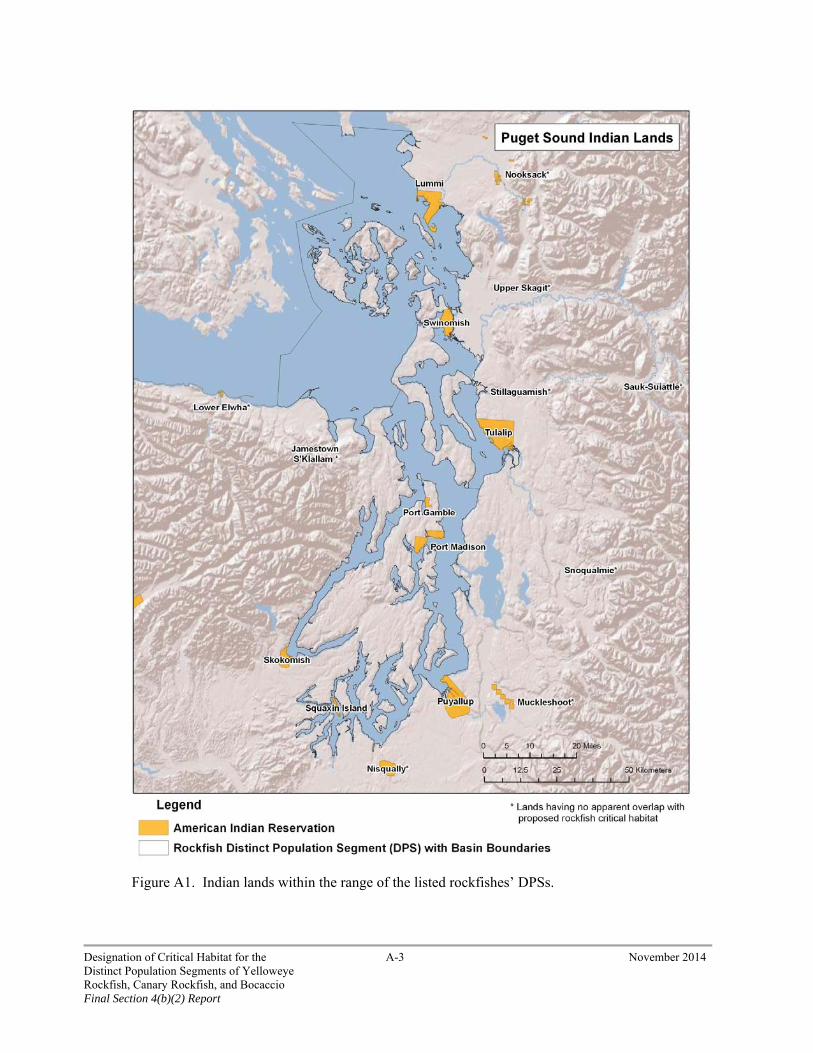
Figure A1. Indian lands within the range of the listed rockfishes’ DPSs.
Designation of Critical Habitat for the A-3 November 2014 Distinct Population Segments of Yelloweye Rockfish, Canary Rockfish, and Bocaccio Final Section 4(b)(2) Report

As Cohen (2005) points out, the Indian Country statute is thus of general importance in defining the special territory where Indians are governed primarily by tribal and Federal law rather than state law. “Indian lands” are defined in the Secretarial Order as “any lands title to which is either 1) held in trust by the United States for the benefit of any Indian tribe or individual, or 2) held by any Indian tribe or individual subject to restrictions by the United States against alienation.” Additionally, it is a stated principle of the Secretarial Order that Indian lands “are not subject to the controls or restrictions set forth in Federal public land laws. Indian lands are not Federal public land or part of the public domain, but are rather retained by tribes or set aside for tribal use pursuant to treaties, statutes, court orders, executive orders, judicial decision, or agreements. Accordingly, Indian tribes manage Indian lands in accordance with tribal goals and objectives, within the framework of applicable laws.” The above supports the conclusions of Sandi Zellmar’s discussion in “Indian Lands as Critical Habitat for Indian Nations and Endangered Species: Tribal Survival and Sovereignty Come First”:2
Thus, the trust responsibility arises not only from the nature of the relationship between tribes and the United States, but also from the massive transfer of lands from Indian Nations to the federal government and the retention and protection of a critical—though diminished—land base, as reflected in treaties. Just as sovereignty is at the very core of the trust responsibility, the tribal land base, retained by the tribes through treaties, is a critical component of sovereignty for most tribes.
Executive Policy Guides Treatment of Indian Lands in Designating Critical Habitat In addition to Executive Order 13175, we have Department of Commerce direction, via the Secretarial Order, stating that Indian lands shall not be designated, nor areas where the “tribal trust resources … or the exercise of tribal rights” will be impacted, unless such lands or areas are determined “essential to conserve a listed species.” In such cases we “shall evaluate and document the extent to which the conservation needs of the listed species can be achieved by designating only other lands.” The Secretarial Order is consistent with the long-standing policies of the Federal government regarding relationships with, and responsibilities to, Indian tribes. The Secretarial Order direction was developed in consultation with tribal governments, in recognition of their sovereign status and management authority. The Order’s purpose, in part, is to help ensure the tribes do not bear a disproportionate conservation burden.
This direction recognized the unique status of Indian lands. In the words of the Secretarial Order, “Indian lands are not Federal public lands or part of the public domain, and are not subject to Federal public land laws.” They were retained by tribes or were set aside for tribal use pursuant to treaties, statutes, judicial decisions, executive orders, or agreements. These lands are managed by Indian tribes in accordance with tribal goals and objectives, within the framework of applicable laws (for a description of the Federal government’s relationship and responsibility regarding Indian lands and trust resources, see United States v. Mitchell (463 U.S. 206 (1983)).
2 Zellmar, Sandi B. 1998. South Dakota Law Review [43 S.D.L. Rev. 381]
Designation of Critical Habitat for the A-4 November 2014 Distinct Population Segments of Yelloweye Rockfish, Canary Rockfish, and Bocaccio Final Section 4(b)(2) Report
The Relationship between the Federal and Tribal Governments is Unique and Longstanding The Federal government has long recognized the unique status of Indian tribes. The U.S. Constitution recognized tribal status via the “Indian commerce clause.” Additionally, treaties are identified as being part of the “supreme law of the land.” In addition to Constitutional recognition, there have been a number of executive branch expressions of the relationships3 between the Federal and tribal governments. Examples of executive direction include:
• Presidential Memorandum of April 28, 1994—directs executive departments and agencies to “assess the impact of Federal government plans, projects, programs, and activities on tribal resources to assure that tribal government rights and concerns are considered during … [their] development.”
• Executive Order 13175—Consultation and Coordination with Indian Tribal Governments (November 6, 2000)—directs departments and agencies to “encourage Indian tribes to develop their own policies to achieve program objectives;” “where possible, defer to Indian tribes to establish standards;” “in determining whether to establish Federal standards, consult with tribal officials as to the need for Federal standards and any alternatives that would limit the scope of Federal standards or otherwise preserve the prerogatives and authority of Indian tribes.”
• Department of Commerce—American Indian and Alaska Native Policy (March 30, 1995)— includes the following “Policy Principles:”
− Recognition of, and commitment to, “a government-to-government relationship with … tribal governments.” (First Principle)
− Recognition that “the tribal right to self-government flows from the inherent sovereignty of tribes and nations and that federally recognized tribes have a unique and direct relationship with the Federal government.” (Second Principle)
− Recognition of trust responsibility and commitment to “consult and work with tribal governments prior to implementing any actions when developing legislation regulations and/or policies that will affect tribal governments, their development efforts, and their land and resources.” (Third Principle)
− “Pledges to honor the Constitutional protections to Indian Commerce” by recognizing that tribes, as sovereign governments, “are responsible for the welfare and rights of their members and the right to regulate commerce within their reservation boundaries.” (Fourth Principle)
− Confirmation that the Department “will consult and work with tribal governments before making decisions or implementing policy, rules, or programs that may affect tribes to ensure tribal rights and concerns are addressed.” (Fifth Principle)
3 Rather than conduct an exhaustive historical review of executive (or judicial, for that matter) direction, this memo discusses the most recent examples. For more detail on the history of Federal-tribal relations see: (1) Cohen, F. 2005. Cohen's Handbook of Federal Indian Law, 2005 edition. LexisNexis Matthew Bender Publications, San Francisco, CA. (2) Getches, D. H., Wilkinson, C. F., and R. A. Williams, Jr. 2005. Cases and Materials on Federal Indian Law (5th edition).
Designation of Critical Habitat for the A-5 November 2014 Distinct Population Segments of Yelloweye Rockfish, Canary Rockfish, and Bocaccio Final Section 4(b)(2) Report
− Recognition “that as a sovereign government” tribes are “responsible for the welfare and rights” of their membership and have “the right to regulate commerce within [their] boundaries.” (Fifth Principle)
− Commitment to identify and take “appropriate steps to remove any impediments to working directly and effectively with tribal governments.” This includes applying the requirements of applicable executive orders (e.g., 13175 on intergovernmental partnerships (see above) and 12866 Regulatory Planning and Reviews) and legislative (e.g., Regulatory Flexibility Act) requirements “to design solutions and tailor Federal programs, when appropriate, to address specific or unique needs of tribal communities.” (Sixth Principle)
• SECRETARIAL ORDER—American Indian Tribal Rights, Federal-Tribal Trust Responsibilities, and the Endangered Species Act. The Secretaries of Commerce and the Interior jointly issued the Secretarial Order in June 1997. The stated purpose of the Order is the clarification of “the responsibilities of the component agencies, bureaus and offices” of the Department “when actions taken under authority of the [Endangered Species] Act and associated implementing regulations affect, or may affect, Indian lands, tribal trust resources or the exercise of … tribal rights.” The opening section continues by saying the Departments will strive “to ensure that Indian tribes do not bear a disproportionate burden for the conservation of listed species, so as to avoid or minimize the potential for conflict and confrontation.” Several sections of the Secretarial Order refer to, or specifically address, critical habitat. The following is from Appendix Section 3(B):
− (2) Recognize the right of Indian tribes to participate fully in the listing process by providing timely notification to, soliciting information and comments from, and utilizing the expertise of, Indian tribes whose exercise of tribal rights or tribal trust resources could be affected by a particular listing. This process shall apply to proposed and final rules to… (ii) designate critical habitat.
− (3) Recognize the contribution to be made by affected Indian tribes, throughout the process and prior to finalization and close of the public comment period, in the review of proposals to designate critical habitat and evaluate economic impacts of such proposals with implications for tribal trust resources or the exercise of tribal rights. The Services shall notify affected Indian tribes and the BIA, and solicit information on, but not limited to, tribal cultural values, reserved hunting, fishing, gathering, and other Indian rights or tribal economic development, for use in: (i) the preparation of economic analyses involving impacts on tribal communities; and (ii) the preparation of "balancing tests" to determine appropriate exclusions from critical habitat and in the review of comments or petitions concerning critical habitat that may adversely affect the rights or resources of Indian tribes.
− (4) In keeping with the trust responsibility, [the Services] shall consult with the affected Indian tribe(s) when considering the designation of critical habitat in an area that may impact tribal trust resources, tribally-owned fee lands, or the exercise of tribal rights. Critical habitat shall not be designated in such areas unless it is determined essential to
Designation of Critical Habitat for the A-6 November 2014 Distinct Population Segments of Yelloweye Rockfish, Canary Rockfish, and Bocaccio Final Section 4(b)(2) Report

conserve a listed species. In designating critical habitat, the Services shall evaluate and document the extent to which the conservation needs of the listed species can be achieved by limiting the designation to other lands.
− (6) Having first provided the affected Indian tribe(s) the opportunity to actively review and comment… provide affected Indian tribe(s) with a written explanation whenever a final decision on any of the following activities conflicts with comments provided by an affected Indian tribe: … (ii) designate critical habitat.
In summary, as articulated in the February 16, 2000 Federal Register Notice (65 Fed. Reg. 7764, February 16, 2000) designating critical habitat:
− …there is a unique and distinctive relationship between the United States and Indian tribes (as defined by the U.S. Constitution, treaties, statutes, executive orders, judicial decisions, and agreements), which differentiate tribes from the other entities that have a relationship with, or are affected by, actions of the federal government.
− This relationship has given rise to a special federal trust responsibility involving the legal responsibilities and obligations of the United States toward Indian tribes and the application of fiduciary standards of due care with respect to Indian lands, tribal trust resources, and the exercise of tribal rights.
− Pursuant to the treaties, statutes, judicial decisions, executive orders and other agreements that define the relationship between the United States and tribes, lands have been retained by Indian tribes or have been set aside for tribal use. These lands are managed by Indian tribes in accordance with tribal goals and objectives, within the framework of applicable laws.
Benefits of Designation The principal benefit of designating critical habitat is that ESA section 7 requires every Federal agency to ensure that any action it authorizes, funds, or carries out is not likely to result in the destruction or adverse modification of the designated critical habitat. This complements the section 7 provision that Federal agencies ensure their actions are not likely to jeopardize the continued existence of a listed species. Another possible benefit is that the designation of critical habitat can serve to educate the public regarding the potential conservation value of an area. This may focus and contribute to conservation efforts by clearly delineating areas that are important to species conservation.
In developing the critical habitat designation for listed rockfishes, we first established those areas that meet the definition of critical habitat. We identified critical habitat areas throughout the species’ range, including certain marine habitats of the Puget Sound/Georgia Basin.
In order to determine the true benefit of designation of a specific area, the likelihood of a section 7 consultation occurring in that area, and the degree to which a consultation would yield conservation benefits for the species must be taken into consideration. Based on past consultations for other migratory fish species, we estimated that 33.5 actions annually would require section 7 consultations within the specific areas being considered for listed rockfishes (NMFS 2014b). The most common activity type that would require a consultation is nearshore work (estimated 15.5 consultations annually), followed by
Designation of Critical Habitat for the A-7 November 2014 Distinct Population Segments of Yelloweye Rockfish, Canary Rockfish, and Bocaccio Final Section 4(b)(2) Report

“other” consultations (estimated 8 consultations annually), and transportation (estimated 6.5 consultations annually). Specific actions covered under these activities have the potential to negatively affect habitat for listed rockfishes (the economic impacts of critical habitat designation for listed rockfishes are detailed in the Economics Analysis Report, NMFS 2014b). Though we did not find a systematic likelihood of project modification as a result of rockfish critical habitat designation, consultation could yield conservation benefits for listed rockfishes by reducing or eliminating the extent and severity of harm to individual fish and their habitat for some individual projects, though we were unable to forecast or quantify any such changes within our economic impact assessment (NMFS 2014b).
To determine the benefit of designating critical habitat on Indian lands, we identified which specific areas that meet the criteria of critical habitat overlap with Indian lands (Table A1). The benefits of designation depend upon the extent of the habitat under consideration, its conservation value, and the number and types of Federal activities in that area likely to undergo section 7 consultations (Table A2) if the specific area is designated as critical habitat. Of the 590.4 square miles of marine nearshore habitat that meet the definition of critical habitat for listed rockfishes, approximately 64.1 nearshore miles overlap Indian lands. All of the specific areas that overlap with Indian lands are occupied and all are high conservation value. The primary types of Federal activities occurring on Indian lands that would require section 7 consultation if those lands are designated as critical habitat include nearshore work, transportation, utilities, water quality, and “other” activities that include fisheries and aquaculture (Table A2).
Table A1. Summary of tribes that have lands overlapping with specific areas for canary rockfish and bocaccio. The conservation value of the affected specific area and the estimated miles of nearshore overlapping with Indian lands are shown.
Tribe Specific Area(s) Overlapping
with Indian Lands
Conservation Value of Affected Specific
Area(s)
Total River Miles of Nearshore Rockfish
Habitat* Overlapping Indian Lands
Lummi San Juan/Straits of Juan de Fuca High Approx. 12.85 mi
Swinomish Whidbey Basin High Approx. 5.11 mi
Tulalip Whidbey Basin High Approx.7.1 mi
Port Gamble Hood Canal High Approx. 2.43 mi
Skokomish Hood Canal High Approx. 0.7 mi
Port Madison Main Basin High Approx. 10.5 mi
Puyallup Main Basin High Approx. 3.17 mi
Squaxin Island South Sound High Approx. 13.25 mi
* This is not the total miles of nearshore that is adjacent to tribal lands. It is the total miles of nearshore adjacent to tribal lands that we determined have essential features for rearing canary rockfish and bocaccio. See NMFS (2013a) for how we identified “essential features.”
Designation of Critical Habitat for the A-8 November 2014 Distinct Population Segments of Yelloweye Rockfish, Canary Rockfish, and Bocaccio Final Section 4(b)(2) Report

Table A2. Forecast annual number of future Federal activities (subject to section 7 consultation) likely to occur within critical habitat of each specific area that overlaps Indian lands (from NMFS 2014a).
Specific Area (Basin of the DPSs)
Nea
rsho
re W
ork
Tra
nsp
orta
tion
Uti
liti
es
Wat
er Q
ual
ity
Oth
er1
Tot
al
San Juan/Strait of Juan de Fuca 4.2 1.9 0.0 0.5 1.2 7.7
Whidbey Basin 2.9 2.4 0.3 0.2 2.1 7.8
Main Basin 3.9 0.9 0.8 1.0 2.3 8.7
Hood Canal 2.3 0.1 0.0 0.2 1.3 3.9
South Puget Sound 2.2 1.4 0.0 0.7 1.2 5.4
Total3 15.5 6.5 1.0 2.5 8.0 33.5 Notes: 1. The activity category “Other” includes projects related to military, research, restoration, fishing, and aquaculture activities. 2. Each section 7 action forecast receives costs associated with its consultation type (e.g., formal, informal, programmatic, or technical assistance) and activity. Estimates are based on the average number of past consultations for the rockfish in these watersheds over the last 2 years (i.e., 2010-2011). 3. Totals may not sum because of rounding.
An additional benefit of designation would be to educate the public about the importance of these areas to conservation of listed rockfishes. Because the Indian lands being considered for exclusion are not public or private lands, and because the tribes themselves are keenly aware of the importance of their lands to rockfish conservation, we consider the education benefit of designating these Indian lands to be low.
Benefits of Exclusion One benefit of excluding Indian lands from critical habitat designation is avoiding the cost of conducting a section 7 consultation on effects to critical habitat and avoiding potential project modification required solely to meet Federal obligations regarding destruction and adverse modification of critical habitat. Additional benefits of exclusion of Indian lands include enhanced conservation of the listed rockfish resource as a result of improved relationships with Indian tribes (the tribes are actively engaged in fisheries management, habitat management, and Puget Sound ecosystem recovery programs that benefit listed rockfishes), and furthering the Federal government policies to promote tribal sovereignty and self-governance.
Conservation Benefits of Exclusion Tribal governments are co-managers of marine resources throughout the region. Prior to the listing of rockfish in Puget Sound, the Regional Administrator, in testimony before the U.S. Senate Indian Affairs Committee (June 2003), emphasized the importance of this co-manager relationship:
Designation of Critical Habitat for the A-9 November 2014 Distinct Population Segments of Yelloweye Rockfish, Canary Rockfish, and Bocaccio Final Section 4(b)(2) Report

We have repeatedly stressed to the region’s leaders, tribal and non-tribal, the importance of our co-management and trust relationship to the tribes. NOAA Fisheries enjoys a positive working relationship with our Pacific Northwest tribal partners. We view that relationship as crucial to the region’s future success in recovery of listed salmon.
Examples of that “positive working relationship” can be seen in Federal-tribal participation within the U.S. v. Washington framework and the participation of tribes on interstate (Pacific Fisheries Management Council) and international (Pacific Salmon Commission) management bodies. Additionally, there are innumerable local and regional forums and planning efforts in which the tribes are engaged with the Federal government. While many of these activities currently concentrate on recovery of listed salmon and steelhead in Puget Sound, they nonetheless result in several benefits to habitats used by listed rockfishes through the conservation of habitats and prey sources of rockfish. The participation of the tribes is crucial to the management and recovery of listed rockfishes.
Though yelloweye rockfish, canary rockfish, and bocaccio have been listed just since 2010, our work with tribes to address these species’ habitats and conservation has already begun. In June 2011, NOAA Fisheries, the SeaDoc Society, and the Washington State Department of Fish and Wildlife hosted a workshop titled “Rockfish Recovery in the Salish Sea; Research and Management Priorities” that was attended by several tribal representatives and the Northwest Indian Fisheries Commission. This workshop convened scientists, managers, and industry professionals to focus on recent and on-going research and recovery efforts of rockfish and their habitats in the Salish Sea to enable further collaboration. The first day of the workshop included sessions detailing recent research on the historical context of rockfish depletion, benthic habitat surveys and abundance estimates, stressors, ecosystem and species interactions, juvenile recruitment, and genetics. The second day of the workshop focused on agency, tribal, and Canadian perspectives on rockfish recovery, and included concurrent sessions designed to list additional research priorities related to reserves and population biology.
Representatives of the Tulalip tribe presented on the second day of the workshop, and provided a paper for the workshop proceedings titled “Tribal Perspectives on Rockfish Recovery in the Salish Sea.” The paper4
summarizes the relationship between tribal governance and rockfish conservation in the area of the rockfish DPSs:
“With the decline of rockfish stocks over the past couple of decades, the non-Indian {rockfish} fishery has been reduced to almost nothing and the tribal {rockfish} fishery was never developed…It soon became clear that rockfish populations were not quickly responding to fishery reductions. At the same time, there was a national and regional movement to establish marine protected areas (MPAs), which was thought to be a potentially effective tool for restoring long-lived non-migrating species, such as rockfish. When MPAs were proposed within the Salish Sea, the question of how these could be established in light of treaty rights and tribal co-management immediately arose. In response, the tribes of the Northwest Indian Fisheries Commission (NWIFC) developed a policy statement on marine protected areas to explain some basic tribal
4 Rawson, K. and T. Williams. 2012. Tribal perspectives on Rockfish Recovery in the Salish Sea. Tulalip Tribes Natural Resources Department, Treaty Rights Office.
Designation of Critical Habitat for the A-10 November 2014 Distinct Population Segments of Yelloweye Rockfish, Canary Rockfish, and Bocaccio Final Section 4(b)(2) Report

positions (NWIFC 2003)…Tribes have been involved to one degree or another in development and implementation of some of the MPAs that have been established to date in the U.S. portion of the Salish Sea. A group of MPAs in the San Juan Islands, originally proposed by the Friday Harbor Laboratories, to protect important teaching and research sites are closed by all tribes in the area in their fishing regulations. Tribes in the San Juan Islands are participating in the San Juan Marine Stewardship Area (MSA), and two tribes are leading development of a marine stewardship area in Port Susan Bay. A tribal body advises the National Marine Protected Areas Center. To date, with the possible exception of the Port Susan MSA project, tribal participation has been reactive to proposals from others rather than proactively introducing proposals for establishing marine managed areas. However, in their own fishing regulations, tribes continue to use spatial management, applied to their own tribal members, for specific resource conservation or allocation purposes.
Despite being limited to no directed harvest, rockfish affect tribal fisheries management in a number of ways beyond MPAs. Tribal groundfish regulations often include limitations on the incidental harvest of rockfish. A very small number of tribal members harvest groundfish for subsistence purposes in the Salish Sea, and typically they are allowed to keep one or two rockfish per day as part of this subsistence fishing. We have little data on the actual number of rockfish harvested for this purpose, but it is likely de minimus. Of greatest significance are the implications to tribal salmon fisheries of the listing of three rockfish species under the Endangered Species Act. As a condition of approving the current co-managers’ salmon fishery management plan, NOAA is requiring immediate reporting of lost fishing nets to reduce or eliminate the recruitment of new derelict gear that might capture listed rockfish. To help implement this requirement, the tribes are using funding through the Northwest Straits Commission to enhance awareness and increase reporting of lost gear. Outreach and communication have already resulted in development of reporting systems tailored for tribal needs and enhanced awareness among tribal fishers and managers of the need to immediately report lost gear.
Since the June 2011 workshop, a group of interested entities continue to meet to discuss current research and management actions for rockfish conservation in the Salish Sea. Tribal representatives regularly attend and contribute to these meetings. In addition, in spring 2013 we convened a recovery team to assist NMFS in the development of a recovery plan for listed rockfishes. Tribal representatives participate on this team, and in summer of 2013 we briefed several Puget Sound treaty tribes on the status of the plan.
Exclusion Furthers Federal Policies Promoting Tribal Sovereignty and Self-Governance In the current designation effort, we have contacted all potentially affected tribes. Additionally, several meetings/conference calls were held with tribes and intertribal organizations (e.g., the Northwest Indian Fisheries Commission). We have also received numerous letters from tribes in response to our previous communications regarding salmonid critical habitat designation proposals in the Puget Sound region. In all of these communications and conversations, the tribes unanimously expressed their objections to Indian lands being designated as critical habitat.
Designation of Critical Habitat for the A-11 November 2014 Distinct Population Segments of Yelloweye Rockfish, Canary Rockfish, and Bocaccio Final Section 4(b)(2) Report

Interference with tribal sovereignty, including tribal reserved rights to manage their own lands and resources. One of the essential features of tribal sovereignty is the jurisdictional control the tribal government is able to exercise over its (and its members’) land. Numerous judicial opinions have stated that these essential government features include the ability to levy taxes and develop/enforce zoning requirements on its membership. In 2000, we recognized the inherent right of the tribe to manage the land set aside for the specific uses of the tribes and their members. EO 13175 states, in part, that “when formulating and implementing policies that have tribal implications,” we will, “to the extent permitted by law… defer to Indian tribes to establish standards, and…consult with tribal officials as to the need for Federal standards and any alternatives that would limit the scope of Federal standards or otherwise preserve the prerogatives and authority of Indian tribes.”
Economic impacts to both growth and stability. Tribes face the unique circumstance of being restricted to specific and limited geographic locations. Such restrictions have the result of limiting the economic opportunities open to the tribal governments. Further exacerbating the limitations inherent to the somewhat fixed land status (spatially) is the fact that the potential effect of designating critical habitat could further negatively impact the relatively limited economic development opportunities for tribes. Additionally, the economic options such as transfers or mobility of land ownership, are extremely limited. Tribal members, like their tribal government, are not in a position to sell their land and move to some other less affected area.
Violation of Trust Responsibility. An essential feature of Trust Responsibility is the management of tribal resources by Federal agencies, tribes themselves under Indian Self-Determination or Tribal Self-Governance arrangements, or through Federal-tribal co-management for the benefit of Indian tribes and/or Indian individuals. In the arena of salmonid management, the tribes and we are co-managers (with the states). NOAA Fisheries, tribal governments, and their fisheries programs work together cooperatively to ensure the conservation and recovery of fish as both ESA-listed species but also as trust resources. To designate critical habitat on Indian lands would be viewed as a negative impact to that relationship and would place future cooperation in jeopardy.
Contrary to Secretarial Order requirements. The Secretarial Order contains both general and specific guidance regarding the potential designation of critical habitat on Indian lands. The general guidance reinforces the “consultation principles” of the Federal government, i.e., whenever the Federal government is embarking on a course of action that has the potential to affect tribes, the action agency should consult with the affected tribal government. Specific guidance includes:
Evaluating critical habitat proposals with implications for tribal trust resources or the exercise of tribal rights
Soliciting information from potentially affected tribes on the various impacts that may result from the designation
Preparing economic analyses with impact to tribal communities
Preparing balancing tests to determine appropriate exclusions from critical habitat and in review of comments or petitions concerning critical habitat that may adversely affect the rights or resources of Indian tribes
Before designating Indian lands where “the exercise of tribal trust resources…or the exercise of tribal rights” will be impacted, first determine if those Indian lands are “essential to the conservation [of the] species” and, when such is the case, we will
Designation of Critical Habitat for the A-12 November 2014 Distinct Population Segments of Yelloweye Rockfish, Canary Rockfish, and Bocaccio Final Section 4(b)(2) Report
“evaluate and document the extent to which the conservation needs of the listed species can be achieved by” designating only other lands.
Balancing the Benefits of Designation with the Benefits of Exclusion Designation of the Indian lands under consideration would require Federal agencies to ensure that any actions they carry out, fund, or permit are not likely to adversely modify the areas designated. For listed rockfishes, critical habitat areas overlap with reservation boundaries on approximately 64.1 nearshore miles (103.2 km) of Puget Sound. The activities likely to have Federal involvement and therefore undergo consultation include permits for nearshore work, transportation projects, utilities, water quality projects, and “other” projects such as fisheries and aquaculture. Our economic analysis found that project modifications from rockfish critical habitat are unlikely in most instances. This overlap represents a fraction of total miles of nearshore habitat available.
Regarding the educational benefit of critical habitat designation, in previous letters to NOAA Fisheries regarding salmonid conservation, the tribes have documented how they are already working with us to address the habitat needs of the species on these lands as well as in the larger ecosystem, and they are fully aware of the conservation value of their lands. The Swinomish tribe reiterated this belief in a letter to us regarding rockfish conservation.
The major benefit to be derived from the exclusion of Indian lands is the positive, productive effect on our co-management and working relationship with the tribes. The Federal and tribal governments have a long relationship. The region’s tribal governments have repeatedly stated they are constantly confronting the allocation of scarce resources (personnel and financial) to address management of natural resources in Puget Sound. These resources are already committed to participation in the numerous regional planning and management forums, as well as the development and implementation of specific plans and projects that address habitat restoration and fisheries management. Including tribal lands within critical habitat designation would force the reallocation of these scarce resources to address additional regulatory and consultation requirements. This would be viewed as an unnecessary competitive pressure on the tribal resources leading the tribal governments to be less inclined, or able, to participate in these current and ongoing protection and conservation efforts we view as crucial to the restoration and recovery of the species. Exclusion of Indian lands would also further Federal government policies to promote tribal sovereignty and self-governance. These policies include the following:
The Secretarial Order states that Indian lands will not be designated as critical habitat unless they are essential for conservation, i.e., after the Secretary determines that the designation of all other non-Indian land is insufficient to conserve the species.
The exclusion is consistent with the April 28, 1994 executive memorandum and EO 13175.
The exclusion is consistent with past Federal Register-published secretarial determinations (65 Fed. Reg. 7764, February 16, 2000).
The exclusion is consistent with the recognition of the sovereignty of tribal governments and their jurisdiction over Indian and (where documented) non-Indian lands.
The exclusion is consistent with departmental/agency trust responsibility in that it supports an essential purpose of the Indian lands, including economic security; it recognizes tribal primacy regarding the
Designation of Critical Habitat for the A-13 November 2014 Distinct Population Segments of Yelloweye Rockfish, Canary Rockfish, and Bocaccio Final Section 4(b)(2) Report
management of tribal lands; and it complies with direction/statements found in the Secretarial Order and EO 13175.
The exclusion supports and affirms the Federal-tribal co-manager partnership crucial to the conservation and recovery of the species.
Conclusion Based on the foregoing analysis, I conclude that the benefits of excluding the identified Indian lands outweigh the benefits of designating those lands because: 1) excluding Indian lands has offsetting conservation benefits for listed rockfishes, and these lands are managed for conservation purposes, 2) excluding Indian lands benefits the Federal government’s policy of promoting respect for tribal sovereignty and self-governance, and 3) the small area (64.1 miles (103.2 km)) of nearshore habitat adjacent to tribal land excluded from critical habitat is spread among each of the five biogeographic regions of Puget Sound and a small fraction of the total area designated as nearshore critical habitat for canary rockfish and bocaccio.
This conclusion is consistent with relevant judicial decisions on what to consider in determining critical habitat. Center for Biological Diversity v. Norton, 240 F.Supp.2d 1090, 1005 (2003), found that “[i]t is certainly reasonable to consider a positive working relationship relevant, particularly when that relationship results in the implementation of beneficial natural resource programs, including species preservation.” Douglas County v. Babbit, 48 F.3d 1495 (1995), found that the impacts relevant for consideration are those which further the purposes of the ESA.
Designation of Critical Habitat for the A-14 November 2014 Distinct Population Segments of Yelloweye Rockfish, Canary Rockfish, and Bocaccio Final Section 4(b)(2) Report
APPENDIX B – CONSIDERATION OF IMPACTS ON CONSERVATION PLANS
November, 2014 MEMO To: PRD File From: Chris Yates Assistant Regional Administrator Protected Resources Division, West Coast Region Subject: Analysis of the Benefits of Designating versus the Benefits of Excluding Areas Subject to
Incidental Take Permit Coverage from Critical Habitat for the Yelloweye Rockfish, Canary Rockfish, and Bocaccio Distinct Population Segments.
This analysis was prepared to inform the agency’s exercise of discretion under section 4(b)(2) of the Endangered Species Act (ESA), which allows the Secretary to exclude any particular area from critical habitat designation if the benefits of exclusion outweigh the benefits of designation, so long as exclusion will not result in extinction of the listed species. There are two section 10(a)(1)(B) incidental take permits (ITPs) that overlap with the designated rockfish critical habitat in Puget Sound; one is with the Washington State Department of Natural Resources (WDNR), and the other with the Washington State Department of Fish and Wildlife (WDFW).
Background Conservation agreements with non-Federal landowners (or other entities) with management jurisdiction (e.g., conservation plans) enhance species conservation by extending species’ protections beyond that available through section 7 consultations. We have encouraged non-Federal entities to enter into conservation agreements, based on a view that we can achieve greater species’ conservation on non-Federal land through such partnerships than we can through coercive methods (61 Fed. Reg. 63854, December 2, 1996).
Section 10(a)(1)(B) of the ESA authorizes us to issue permits to non-Federal entities for the incidental take of endangered and threatened species. This permit allows a non-Federal entity to proceed with an activity that is legal in all other respects, but that results in the incidental take of a listed species (i.e., take that is incidental to, and not the purpose of, the carrying out of an otherwise lawful activity). The ESA specifies that an application for an incidental take permit (ITP) must be accompanied by a conservation plan and specifies the content of such a plan. The purpose of such a conservation plan is to describe and ensure that the effects of the permitted action on covered species are adequately minimized and mitigated, and that the action does not appreciably reduce the likelihood of the survival and recovery of the species.
In previous critical habitat designations for West Coast salmon and steelhead (70 Fed. Reg. 52630, September 2, 2005), we have exercised discretion to exclude some (but not all) lands covered by a conservation plan from designation after concluding that benefits of exclusion outweighed benefits of
Designation of Critical Habitat for the B-1 November 2014 Distinct Population Segments of Yelloweye Rockfish, Canary Rockfish, and Bocaccio Final Section 4(b)(2) Report
designation. For areas covered by a conservation plan, the benefits of designation typically arise from section 7 protections as well as enhanced public awareness. The benefits of exclusion generally include relieving regulatory burdens on existing conservation partners, maintaining good working relationships with them (thus enhancing implementation of existing conservation plans), and encouraging the development of new partnerships.
We contacted and met with the WDNR and WDFW to discuss proposed critical habitat designations for listed rockfishes to identify any possible impacts to the implementation of their conservation plans. During these meetings or in subsequent communications, the WDNR and WDFW did not identify any possible impacts to the implementation of their conservation plans from the proposed designation of rockfish critical habitat.
Conservation Plans in the Statutory Context The ESA and our implementing regulations include two important mechanisms for promoting conservation of listed rockfishes. Federal agencies must ensure their actions are not likely to jeopardize species’ continued existence or destroy or adversely modify designated critical habitat. This requirement protects listed rockfishes whenever a Federal permit or funding is involved in non-Federal actions. However, some activities occurring in Puget Sound do not require a Federal permit or funding and are not reached by section 7 (in contrast to nearshore activities or transportation projects, most of which do require a Federal permit).
The second important protection is that no one may “take” a listed species, with take broadly defined to include “harm.” The ability of the ESA to induce entities to adopt conservation measures lies in the take prohibitions of section 9(a) and 4(d), and many entities have chosen to put conservation plans in place to avoid any uncertainty. The primary mechanism for them to do this is to develop a habitat conservation plan, (commonly called an “HCP”), under the provisions of section 10 of the ESA.
Section 10 of the ESA as originally enacted in 1973 contained provisions allowing for the issuance of permits authorizing the taking of listed species under very limited circumstances for private entities. However, these provisions were not flexible enough to address situations in which a property owner’s otherwise lawful activities might result in an incidental take. The 1982 amendments to the ESA sought to address this concern by including provisions under section 10 that allowed us to issue permits authorizing the incidental take of listed species in the course of otherwise lawful activities, provided those activities were conducted according to an approved conservation plan and complied with several provisions. In adopting these amendments, Congress emphasized the importance of “creative partnerships” between the private sector and local, state, and Federal agencies for the protection of endangered species and habitat conservation (H.R. Rep. No. 835, 97th Congress, 2nd Session 31 (Reprinted in 1982 U.S. Code Congressional and Administrative New §2807, 2831)).
To receive a permit under section 10, an entity must develop a conservation plan that meets several criteria. The plan must specify the impact likely to result from take, what steps the applicant will take to minimize and mitigate such impacts, and the funding available to implement such steps. The applicant must have considered alternative actions and explained why other alternatives are not being pursued, and
Designation of Critical Habitat for the B-2 November 2014 Distinct Population Segments of Yelloweye Rockfish, Canary Rockfish, and Bocaccio Final Section 4(b)(2) Report

we may require additional actions necessary or appropriate for the purposes of the plan. Before the conservation plan can be finalized, we must conclude that any take associated with implementing the plan will be incidental; that the impact of such take will be minimized, monitored, and mitigated; that the plan is adequately funded; and that the take will not appreciably reduce the likelihood of the survival and recovery of the species in the wild. The conservation plan undergoes environmental analysis under the National Environmental Policy Act and we conduct a section 7 consultation with ourselves to ensure granting the permit is not likely to jeopardize the continued existence of the plan-covered species or destroy or adversely modify designated critical habitat.
Because conservation plans provide an important voluntary mechanism to secure conservation of listed species, we have, since 1994, actively sought to promote the conservation plan program by developing incentives for landowners. One of the most important was the “No Surprises” policy, which we adopted in August of 1994 (63 Fed. Reg. 8859, February 23, 1998). It is our understanding of congressional intent, and our view of the value of the conservation program generally, that:
Congress thus envisioned and allowed the Federal government to provide regulatory assurances to non-Federal property owners through the section 10 ITP process. Congress recognized that conservation plans could provide early protection for many unlisted species and, ideally, prevent subsequent declines and, in some cases, the need to list covered species.
The Services decided that we needed a clearer policy regarding the assurances provided to landowners entering into a conservation plan. This need prompted the development of the No Surprises policy, which was based on the 1982 Congressional Report language and a decade of working with private landowners during the development and implementation of conservation plans. The Services believed that non-Federal property owners should be provided economic and regulatory certainty regarding the overall cost of species conservation and mitigation, provided that the affected species were adequately covered by a properly functioning conservation plan, and the permittee was properly implementing the conservation plan and complying with the terms and conditions of the ITP in good faith. A driving concern during the development of the policy was the absence of adequate incentives for non-Federal landowners to factor endangered species conservation into their day-to-day land management activities (63 Fed. Reg. 8859, February 23, 1998).
Our experience working with private landowners and other entities, as described above, and in subsequent implementation of the conservation plan program, has informed our balancing of benefits of excluding or including conservation plan-covered areas in critical habitat designation.
Impacts of Designation The primary effect of critical habitat designation is that it imposes the requirement on Federal agencies to ensure their actions are not likely to destroy or adversely modify the designated habitat. The impact of designating critical habitat on areas covered by an approved conservation plan or other type of conservation agreement depends upon the type and extent of Federal activities expected to occur in that area in the future. Activities may be initiated by the holder of the ITP, such as when the landowner seeks a permit for bank armoring or dredging. Where the area is covered by a conservation plan, the activity for
Designation of Critical Habitat for the B-3 November 2014 Distinct Population Segments of Yelloweye Rockfish, Canary Rockfish, and Bocaccio Final Section 4(b)(2) Report

which a permit is sought may or may not be covered by the conservation plan. For example, a conservation plan covering fishery activities may include provisions governing harvest methods and monitoring, but may not include other fisheries or aquaculture operations in the same area. The activity may be initiated by the Federal agency without any landowner or entity involvement, such as when a Federal agency is involved in permitting a dredging and dredge disposal operation within the same conservation plan-covered area.
The designation of critical habitat may also have impacts that are unrelated to section 7’s requirements. For example, state or county environmental laws or regulations may contain provisions that are triggered if a state- or county-regulated activity occurs in federally designated critical habitat. Another possibility is that critical habitat designation could have “stigma” effects, or impacts on the economic value of private land that are not attributable to any direct restrictions on the use of the land. Conversely, for non-Federal activities occurring in the covered areas, designation may raise public awareness of habitats important to rockfish and encourage additional conservation measures and voluntary conservation agreements within the section 10 program.
Benefits of Designation versus Exclusion Generally Landowners often are opposed to a critical habitat designation on their land. In previous rulemaking (70 Fed. Reg. 52630, September 2, 2005) we received comments asserting that landowners frequently view designation of critical habitat as imposing a burden, and exclusion from critical habitat as removing that burden. Many commenters also asserted that excluding lands covered by conservation plans would strengthen the Federal-private or Federal-local government relationship. Benefits of exclusion generally cited in the comments included: avoiding damage to, or enhancing, the relationship between the conservation plan partner and our agency; reducing the regulatory burden imposed by the ESA as well as state and local requirements such as Washington’s State Environmental Policy and Growth Management Acts; reducing uncertainty associated with these regulatory requirements; and providing incentives to other landowners to seek agreements with us for conserving salmon and steelhead.
In contrast, we also received comments from the City of Seattle, which has a conservation plan in place, noting the benefits of designation and stated that it entered into its conservation plan not to avoid designation but because it is a useful mechanism by which to formulate and implement a comprehensive, scientifically based conservation strategy for the city’s water supply. This conservation plan partner therefore welcomed the designation of critical habitat on its lands. Similarly, the City of Portland recently submitted comments in support of designating critical habitat in areas associated with the city’s Bull Run water supply conservation plan.
Based on this information, we conclude that some landowners with current conservation plans view exclusion as having benefits to them and to our relationship; that some landowners with current conservation plans do not view exclusion as benefiting them; and that some landowners contemplating a conservation agreement with us may view our exclusion of current conservation plans as an incentive to seek conservation plans on their land. On the evidence before us, therefore, we cannot draw the conclusion that all landowners with conservation plans view designation of critical habitat as interfering with our relationship.
Designation of Critical Habitat for the B-4 November 2014 Distinct Population Segments of Yelloweye Rockfish, Canary Rockfish, and Bocaccio Final Section 4(b)(2) Report
Balancing Benefits of Designation against Benefits of Exclusion In analyzing the benefits of designating these conservation plan-covered areas, we must consider the area affected and the number and type of Federal activities expected to occur in the area that would likely undergo a section 7 consultation. We must also consider which activities are covered by the conservation plan and which are not, and the extent to which a section 7 consultation on that particular activity would result in beneficial changes to the proposed action over and above what would be obtained under the conservation plan.
In analyzing the benefits of excluding these conservation plan-covered areas, we must consider the value of the conservation plan for species conservation and the importance of its ongoing implementation. An additional benefit of exclusion may be that the landowner or a Federal agency will avoid economic costs that would result if a planned activity must be altered to avoid adverse modification of the affected habitat. Our analysis revealed only minor economic impacts related to administrative costs from considering rockfish critical habitat in section 7 consultations (NMFS 2014b). We therefore considered the economic benefits of exclusion to be slight.
Washington State Department of Fish and Wildlife The WDFW manages several recreational and commercial fisheries that incidentally take listed rockfishes in Puget Sound. In November of 2009, WDFW initiated discussions with NMFS on pursuing ESA take coverage for state-authorized fisheries and research activities that are likely to encounter yelloweye rockfish, canary rockfish, and bocaccio (listed rockfishes) in state waters within the range of the DPSs. Because of those discussions, and over the ensuing months and years, NMFS worked with WDFW to advise them on development of a fishery conservation plan (FCP)1 and an application for an ITP that covers ESA-listed rockfishes and other listed species taken by a state-authorized recreational bottom fish fishery and a commercial shrimp trawl fishery.
In October 2012, NMFS issued a 10(a)(1)(B) ITP to WDFW for these two fisheries. The ITP authorizes the incidental take of listed rockfishes and other listed fish from these two fisheries for a period of 5 years. The ITP covers incidental take of covered activities across the full area of Puget Sound.
To determine the benefits of designating critical habitat areas within the WDFW ITP boundaries, we considered the acreage of waters in the ITP, and the type and number of Federal agency actions expected to occur that would likely undergo a section 7 consultation. Because the ITP covers all of the U.S. portion of the listed rockfish DPSs, it completely overlaps the area of critical habitat designation for listed rockfishes and thus encompasses all areas where section 7 consultation would occur to consider adverse modification.
1 Section 10(a)(2)(A) of the ESA states that a “conservation plan” must be submitted to the Secretary by the applicant as part of an application for an ITP. In the West Coast Region, “conservation plans” are often termed “habitat conservation plans” (HCP). WDFW has submitted a plan titled a “fishery conservation plan,” which more accurately reflects the intent of the plan and in all other respects is comparable to an HCP.
Designation of Critical Habitat for the B-5 November 2014 Distinct Population Segments of Yelloweye Rockfish, Canary Rockfish, and Bocaccio Final Section 4(b)(2) Report

The benefit of excluding this area from designation is that it may enhance our relationship with the WDFW which could provide an incentive to other landowners/entities to seek conservation agreements with us. This benefit is minimized by the fact that WDFW did not indicate that it views designation as a burden and does not view exclusion from critical habitat as a reward for the conservation plan, and the WDFW also did not provide comments on our proposed critical habitat designation published in the Federal Register on August 6, 2013 (78 Fed. Reg. 47635). The benefit of including this area as critical habitat is that it covers all of the area in the U.S. used by the three rockfish DPSs, and will enable a section 7 review of some of the special management considerations not covered by the WDFW conservation plan (see Table B1 below). An additional benefit of inclusion is that a systematic analysis and delineation of important rockfish habitat has not been previously conducted in Puget Sound. Thus, for non-Federal activities occurring in the covered areas, designation may raise public awareness of habitats important to rockfish and encourage additional conservation measures and voluntary conservation agreements within the section 10 program. Based on the foregoing analysis, I conclude that the benefits of designation for the areas covered by the WDFW conservation plan outweigh the benefits of exclusion because:
The permit holder does not view exclusion as beneficial to our ongoing relationship.
The permit holder does not view designation as harming the implementation of the conservation plan.
Our analysis shows numerous Federal and non-Federal activities likely to occur in the area not addressed by the conservation plan. Though we did not find a systematic likelihood of project modifications as a result of rockfish critical habitat designation, consultation could yield conservation benefits for listed rockfishes by reducing or eliminating the extent and severity of harm to individual fish and their habitat for some individual projects, though we were unable to forecast or quantify any such changes within our economic impact assessment (NMFS 2014b).
Though important to rockfish, implementation of this conservation plan will only occur over 5 years.
Because this is the first systematic delineation of important rockfish habitat in Puget Sound, designating this area is likely to have benefits by promoting public awareness and voluntary conservation agreements for non-Federal activities.
Washington State Department of Natural Resources The WDNR manages the submerged aquatic lands of Puget Sound in which wildstock geoduck grow, and offers at public auctions the right for private companies and individuals to harvest specific quantities from specific areas. In December 2000, the WDNR initiated discussions with us on pursuing ESA compliance for the state’s commercial geoduck fishery program. From 2001 through 2004, the USFWS and NMFS (together, the Services) provided technical and policy assistance to the WDNR in development of a conservation plan for listed and unlisted species likely to be affected by the underlying harvest program. In 2006, WDNR renewed the effort to complete the conservation plan process, sharing a draft plan with the Services. The WDNR completed a “low-impact” conservation plan with NMFS in 2008, and it is effective for a period of 50 years.
A low-impact conservation plan is one that the Services determine to have minor or negligible effects on federally listed, proposed, or candidate species and their habitats covered under the conservation plan, but
Designation of Critical Habitat for the B-6 November 2014 Distinct Population Segments of Yelloweye Rockfish, Canary Rockfish, and Bocaccio Final Section 4(b)(2) Report

that still might cause some level of incidental take. Work conducted under a low impact conservation plan is determined to have minor or negligible effects on other environmental values or resources. The WDNR conservation plan covers listed salmonids and several other species, but yelloweye rockfish, canary rockfish, and bocaccio are not covered species. However, the WDNR’s management of the geoduck fishery includes measures that would nonetheless benefit listed rockfishes and their habitats because the plan was designed to protect listed salmonid habitat which has some generally similar features to rockfish critical habitat (NMFS 2014b). These measures include managing harvest of geoduck to limit turbidity levels and negative impacts to sensitive habitats such as eelgrass. The action area for the WDNR conservation plan includes the submerged lands of Puget Sound, Hood Canal, the Strait of Juan de Fuca, and the San Juan archipelago north to the Canadian border. Within this broad area, commercial geoduck harvest occurs sub-tidally in areas that have been surveyed between depth contours of –18 and –70 feet (-5.5 and –21.3 m) (corrected to MLLW) and found to contain geoducks at sufficient densities. The total acreage of surveyed tracts (i.e., the entire extent of the surveyed resource) fluctuates, but is about 30,000 acres. Future surveys could identify additional commercial tracts and additional acres will be added to the total once the San Juan management region is surveyed and inventoried.
To determine the benefits of designating critical habitat areas within the WDNR ITP boundaries, we considered the acreage of waters in the ITP, and the type and number of Federal agency actions expected to occur that would likely undergo a section 7 consultation. All of the areas covered by the WDNR conservation plan overlap with 16 percent of the nearshore habitat designated as critical habitat for canary rockfish and bocaccio.2
A possible benefit of excluding this area from designation is that it may enhance our relationship with the WDNR which could provide an incentive to other landowners/entities to seek conservation agreements with us. This possible benefit is questionable because the WDNR did not indicate that it views designation as a burden and does not view exclusion from critical habitat as a reward for the conservation plan, and the WDNR also did not provide comments on our proposed critical habitat designation published in the Federal Register on August 6, 2013 (78 Fed. Reg. 47635). The benefit of inclusion of this area as critical habitat is that it would enable a section 7 review of some of the special management considerations not covered by the WDNR conservation plan (see Table B1 below). Similar to the WDFW conservation plan, an additional benefit of inclusion is that a systematic analysis and delineation of important rockfish habitat has not been previously conducted in Puget Sound. Thus, for non-Federal activities occurring in the covered areas, designation may raise public awareness of habitats important to rockfish and encourage additional conservation measures and voluntary conservation agreements within the section 10 program. Based on the foregoing analysis, I conclude that the benefits of designation of the areas covered by the WDNR conservation plan outweigh the benefits of exclusion because:
The permit holder does not view exclusion as beneficial to our ongoing relationship.
The permit holder does not view designation as harming the implementation of the conservation plan.
Our analysis shows numerous Federal and non-Federal activities likely to occur in the area, thus increasing the benefit of designation.
2 Not including the San Juan/Strait of Juan de Fuca Basin. The WDNR conservation plan does not include habitat in the San Juan Islands area as of this writing.
Designation of Critical Habitat for the B-7 November 2014 Distinct Population Segments of Yelloweye Rockfish, Canary Rockfish, and Bocaccio Final Section 4(b)(2) Report
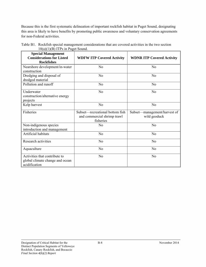
Because this is the first systematic delineation of important rockfish habitat in Puget Sound, designating this area is likely to have benefits by promoting public awareness and voluntary conservation agreements for non-Federal activities.
Table B1. Rockfish special management considerations that are covered activities in the two section 10(a)(1)(B) ITPs in Puget Sound.
Special Management Considerations for Listed
Rockfishes WDFW ITP Covered Activity WDNR ITP Covered Activity
Nearshore development/in-water construction
No No
Dredging and disposal of dredged material
No No
Pollution and runoff No No
Underwater construction/alternative energy projects
No No
Kelp harvest No No
Fisheries Subset—recreational bottom fish and commercial shrimp trawl
fisheries
Subset—management/harvest of wild geoduck
Non-indigenous species introduction and management
No No
Artificial habitats No No
Research activities No No
Aquaculture No No
Activities that contribute to global climate change and ocean acidification
No No
Designation of Critical Habitat for the B-8 November 2014 Distinct Population Segments of Yelloweye Rockfish, Canary Rockfish, and Bocaccio Final Section 4(b)(2) Report

APPENDIX C – CONSIDERATION OF U.S. DEPARTMENT OF DEFENSE INRMPS AND IMPACTS TO NATIONAL SECURITY
November, 2014
MEMO
To: PRD File
From: Chris Yates Assistant Regional Administrator Protected Resources Division, West Coast Region
Subject: Analysis of Integrated Resource Management Plans by the U.S. Department of Defense within the Range of the Yelloweye Rockfish, Canary Rockfish, and Bocaccio Distinct Population Segments
Background
The West Coast Region is designating critical habitat for the yelloweye rockfish, canary rockfish, and bocaccio (listed rockfishes) Distinct Population Segments (DPSs). Under ESA section 4(a)(3)(B), the Secretary may not designate military lands as critical habitat if those lands are covered by an Integrated Natural Resource Management Plan (INRMP) under the Sikes Act (16 U.S.C. 670a) that the Secretary certifies in writing benefits the listed species (National Defense Authorization Act is Public Law. No. 108-136)). An INRMP integrates implementation of the military mission of the installation with stewardship of the natural resources found there. Each INRMP includes an assessment of the ecological needs on the installation, including the need to provide for the conservation of listed species; a statement of goals and priorities; a detailed description of management actions to be implemented to provide for these ecological needs; and a monitoring and adaptive management plan. Installations must review and update INRMPs every 5 years.
Under the Sikes Act, the U.S. Department of Defense (DOD) consults with the USFWS on the development and implementation of INRMPs for installations with listed species. The Sikes Act does not give NMFS a formal role in reviewing INRMPs and INRMP recommendations are typically general in nature. However, in recent years NMFS has provided feedback to DOD on a number of INRMPs, especially within the range of listed rockfishes where the Army and Navy have a relatively high concentration of military installations. In addition, since 1999 NMFS has consulted with the Army and Navy under ESA section 7(a)(2) on dozens of proposed actions that may affect ESA-listed salmon and steelhead, and since 2010 has conducted several consultations that may affect listed rockfishes. Those proposed actions are related to various INRMP elements and the resultant consultations provide staff with insights into how the DOD implements particular INRMPs. In December 2011, NMFS met with the DOD
Designation of Critical Habitat for the C-1 November 2014 Distinct Population Segments of Yelloweye Rockfish, Canary Rockfish, and Bocaccio Final Section 4(b)(2) Report

to discuss proposed rockfish critical habitat and provide feedback on the draft Naval Base Kitsap and Naval Air Station Whidbey Island.
The Navy has not determined the extent of marine waters covered by INRMPs, nor has it set forth a process or timeline to determine this. In considering the benefits of the INRMPS, we have determined that they may influence habitat of the nearshore. These areas are contiguous with the shoreline from the line of extreme high water out to a depth no greater than 98.4 feet (30 m) relative to mean lower low water (NMFS 2014a). This zone includes the photic zone (upper layer of a water body delineated by the depth at which enough sunlight can penetrate to allow photosynthesis) that can be readily affected by actions occurring in intertidal waters or adjacent land.
The following is our assessment of the INRMPs in Washington that overlap with areas under consideration for designation as critical habitat for listed rockfishes.
INRMPs in Puget Sound:
The U.S. DOD Puget Sound INRMPs include one Army facility (Joint Base Lewis-McCord) and five Navy facilities1: Naval Station Everett, Naval Magazine Indian Island, the Manchester Fuel Department, Naval Station Whidbey Island, and Naval Base Kitsap and associated properties (Figure C-1). Naval Station Everett does not overlap with essential features for listed rockfishes in the nearshore and thus is not a candidate for critical habitat designation. A small portion of the Naval Station Everett restricted area would be eligible for deepwater critical habitat for yelloweye rockfish, canary rockfish, and bocaccio. This area is assessed in the Consideration of National Security section below.
Summary of Common Navy INRMP Benefits to Listed Rockfishes:
In each of the INRMPs, the Navy identified responsibilities of the Natural Resource Manager. These responsibilities include ensuring that:
Surveys will be conducted as needed for listed fish species use along shorelines.
Eelgrass and microalgae surveys for in-water construction projects will be conducted in order to avoid or minimize impacts to eelgrass beds.
Structures that extend below the MHHW line (such as security booms around ships) and shorelines will be regularly inspected and kept free of debris or other materials that could hinder fish movement along the shoreline.
Inspections of the shorelines will occur for man-made debris, and such debris will be removed.
1 Final and signed INRMPS: Manchester Fuel Department (signed June 2009, updates underway), Naval Station Everett (signed August 2009, updates underway), Naval Magazine Indian Island (signed September 2009, updates underway), and Joint Base Lewis McCord. Naval Air Station Whidbey Island was scheduled for finalization March 2013. Naval Base Kitsap was scheduled for finalization on March 30, 2013.
Designation of Critical Habitat for the C-2 November 2014 Distinct Population Segments of Yelloweye Rockfish, Canary Rockfish, and Bocaccio Final Section 4(b)(2) Report

Figure C-1. DOD INRMPs in Puget Sound.
Designation of Critical Habitat for the C-3 November 2014 Distinct Population Segments of Yelloweye Rockfish, Canary Rockfish, and Bocaccio Final Section 4(b)(2) Report
Proposed projects and programs will be reviewed for stormwater or other discharges to ensure that these discharges do not degrade the water or sediment quality of the surrounding waters.
Spill prevention, control, and countermeasures for facilities and operations will be developed and implemented.
Pesticide/herbicide/fertilizer use will be reduced and managed to help protect surface and groundwater quality at the installation, as well as the quality of the surrounding marine waters.
Actions that may take place in the marine environment will be restricted to the approved in-water work windows as published by the Corps of Engineers Seattle Regulatory Branch.
All projects, operations, and training plans will be reviewed for potential impacts to Essential Fish Habitat. If impacts are identified, the Natural Resource Manager will provide recommendations to minimize or avoid them.
Project and program managers will work to reduce the effects of anthropogenic noise on sensitive species.
In addition to these common benefits, the Navy recently completed a cooperative agreement with the Suquamish Tribe at the Manchester Fuel Department, which resulted in 2 years of aquatic surveys adjacent to the fuel pier. These surveys enable a more comprehensive understanding of potential listed species use and habitat conditions of this site. The Naval Base Kitsap and associated properties INRMP identifies the Navy’s low impact development (LID) policy for stormwater management. The LID policy has set a goal of no net increase in stormwater volume, sediment, or nutrient loading from major renovations and construction projects. A strong component of LID stormwater management is maintaining or mimicking the natural functions of wetland and riparian buffers to infiltrate, dissipate, and filter runoff from developed areas. These provisions reduce or eliminate the disruption of natural runoff and maintain water quality in marine areas used by listed rockfishes.
As a further demonstration of the Navy’s commitment to providing benefits to listed rockfishes, they are working with the Washington State Department of Fish and Wildlife (WDFW) to conduct surveys to provide a preliminary assessment of rockfish presence, habitat, and prey base in the immediate waters adjacent to Navy installations in Puget Sound. A cooperative agreement was awarded by the Navy to WDFW, and the information obtained from this rockfish pilot study will be used to update the INRMPs. The Navy initiated these surveys to assess the potential use of habitat by rockfish and other bottom fish adjacent to Navy installations in order to make appropriate management decisions for shorelines and adjacent waters around the facilities. A survey of nearshore areas will provide a better understanding of local rockfish use and the available prey base, as well as identify potential areas for improving habitat quality through enhancement or mitigation programs.
Designation of Critical Habitat for the C-4 November 2014 Distinct Population Segments of Yelloweye Rockfish, Canary Rockfish, and Bocaccio Final Section 4(b)(2) Report

Summary of Departments of the Army and Air Force, Fort Lewis INRMP Benefits to Listed Rockfishes:
Fort Lewis consists of approximately 86,000 acres of military lands in South Puget Sound. Most of the lands of Fort Lewis are located away from rockfish habitats, though there are approximately 2 miles of marine shoreline along North Fort Lewis that are maintained in forested conditions. The Fort Lewis INRMP emphasizes the protection of wetlands and riparian areas along streams and rivers that travel through the base. These measures protect water quality as these water bodies enter Puget Sound. Maintaining the marine riparian areas of the marine shoreline, as well as ensuring water quality is protected in the streams and rivers entering Puget Sound, will benefit listed rockfishes.
Conclusion
Our assessment indicates that many of the DOD’s specific habitat-related actions will benefit listed rockfishes and their habitat and promote the species’ conservation. This assessment is informed by staff review of each INRMP as well as correspondence between NMFS and DOD regarding potential issues related to critical habitat designation. Moreover, NMFS staff has direct experience working closely with each military facility and has documented DOD’s proven interest and ability to protect and restore habitats important to Puget Sound listed fish. Therefore, given the scope and intent of each INRMP, and the overall protective work of each DOD facility with respect to water quality and other habitat features, it is likely that implementing each of these INRMPs will benefit listed rockfishes and the areas subject to the INRMPs are ineligible for designation as critical habitat. This conclusion is consistent with NMFS’ previous critical habitat assessments for ESA-listed Puget Sound Chinook salmon and Hood Canal summer-run chum salmon (70 Fed. Reg. 52630, September 2, 2005), where we concluded that the INRMPs provided a benefit to each species and thus were ineligible for designation.
Consideration of National Security
Section 4(b)(2) of the ESA provides that the Secretary shall designate critical habitat “after taking into consideration the economic impact, the impact on national security, and any other relevant impact, of specifying any particular area as critical habitat” {emphasis added}. The Secretary has discretion to exclude an area from critical habitat designation if the benefits of exclusion outweigh the benefits of designation, so long as the failure to designate such area as critical habitat will not result in the extinction of the species. In keeping with recent agency practice when designating critical habitat for salmonids (70 Fed. Reg. 52630, September 2, 2005), killer whales (71 Fed. Reg. 69054, November 29, 2006), and green sturgeon (74 Fed. Reg. 52300, October 9, 2009) we consulted with the DOD through written correspondence and phone calls to better understand the activities taking place at sites managed by DOD, and the potential impact of designating critical habitat there. We report the sequence of our communications with the DOD below.
We received two letters from the DOD in response to our initial inquiry prior to proposing critical habitat for listed rockfishes. The U.S. Air Force (USAF) and U.S. Army (USA) reply dated December 7, 2011) stated: “Based upon a review of USAF and USA, including Army National Guard, operations in the
Designation of Critical Habitat for the C-5 November 2014 Distinct Population Segments of Yelloweye Rockfish, Canary Rockfish, and Bocaccio Final Section 4(b)(2) Report

vicinity of the proposed Critical Habitat designated areas, we do not foresee any adverse impacts to our national security or training missions.”2
The Navy letter dated November 23, 2011 identified 14 Restricted Areas, Operating Areas, and Danger Zones (security zones) within the range of listed rockfishes in each of the five basins of Puget Sound (see NMFS 2014a for a description of the five basins of Puget Sound). Designation as one of these security zones means that it is used to conduct activities that require restriction of access to the public (often for safety reasons). The Restricted Areas are governed by specific regulations at 33 CFR § 334.120 stating that “persons and vessels shall not enter these areas except at their own risk” and that persons and vessels entering these areas must comply with orders from the Navy.
The DOD confirmed that all of the security zones are used by the Navy, and assessed the potential for critical habitat designation to adversely affect their ability to conduct operations, testing, training, and other essential military activities. The Navy letter identified several aspects of potential impacts from critical habitat designation: “The national security impacts that could result from the designation of critical habitat in these [14] areas include prevention, restriction, or delay of training or testing exercises or access to sites; restriction of, or delays in, activities associated with training or testing; and delayed response time for ship deployments and overall Naval Operations.”3 We had several conversations with the Navy subsequent to their letter to further understand their uses of the security zones, concerns identified in their response letter, and any related habitat protections derived by Navy policies and initiatives.
Prior to our proposed critical habitat rule, we conducted an initial assessment of the Navy security zones. We contacted the Navy office in Silverdale, Washington and informed them that we had initially determined that for two of the areas (Carr Inlet Naval Restricted Area and Operating Area R-6713 (Navy 3)) the benefits to national security of excluding these particular areas did not appear to outweigh the benefits to rockfish conservation of designating them and that we may recommend designation. The Navy provided us additional information regarding their uses and concerns of designating critical habitat at deepwater areas (>98.4 ft/30 m) at Carr Inlet Naval Restricted Area, but stated that critical habitat designation of the nearshore (<98.4 ft/30 m) of this site would not impact their operations. The Navy stated that critical habitat designation in areas with essential features at Operating Area R-6713 would not meaningfully impact their operations.
In response to our proposed rule (Fed. Reg. 47635, August 6, 2013) the Navy sent us a letter dated November 1, 2013 from their Pentagon office, and subsequent electronic communications. The Navy requested that Operating Area R-6713 not be designated as critical habitat and requested clarification on our proposed nearshore designation in some areas of Puget Sound. In response to their request, we contacted the Navy regarding their uses and concerns regarding our proposed critical habitat designation of Operating Area R-6713. As background, in 2009 we designated critical habitat for southern green sturgeon (74 Fed. Reg. 52300, October 9, 2009). Prior to the green sturgeon final designation, the Navy provided us language regarding how critical habitat designation for that species would affect their operations. The Navy stated that the potential impacts of a southern green sturgeon critical habitat
2 December 7, 2011 letter from the Department of Defense Regional Environmental Coordinator, Region 10 to Donna Darm.
3 November 23, 2011 letter from the Navy to Donna Darm.
Designation of Critical Habitat for the C-6 November 2014 Distinct Population Segments of Yelloweye Rockfish, Canary Rockfish, and Bocaccio Final Section 4(b)(2) Report

designation in Navy 3 would be similar to critical habitat designation for listed rockfishes, and we considered this information in our below analysis.
Also in response to our proposed rule (Fed. Reg. 47635, August 6, 2013), the Navy clarified which of their security zones are also covered by INRMPs (see summary table page C-27). As described above, we consider the nearshore (from extreme high tide to 98.4 feet (30 m)) to be covered by the INRMP, and have determined that each of the INRMPs provide a benefit to listed rockfishes and thus are not eligible for critical habitat designation. As a result, four of the security zones (all in the Main Basin) were completely removed from the weighing process as the entire area is within the nearshore and therefore is covered by the INRMP.
Section 7(a)(2) and Navy Areas
As described in the introduction to this report, once critical habitat is designated, section 7(a)(2) of the ESA requires Federal agencies to ensure such actions do not jeopardize the continued existence of the listed species. It also provides that Federal agencies must ensure that any actions they authorize, fund, or carry out are not likely to result in the destruction or adverse modification of designated critical habitat. This review of Federal actions to assess whether they may affect critical habitat, and identify ways to avoid its adverse modification if necessary, is a primary benefit of its designation. If a particular area is excluded from critical habitat designation for any reason, all Federal activities are exempt from the duty to avoid destruction and adverse modification of critical habitat (but not jeopardy). In our analysis, we therefore assess the likelihood of other Federal activities occurring in the area that would no longer be governed by the section 7(a)(2) requirement to avoid adverse modification of critical habitat.
There is one reoccurring Federal activity that covers all of the Navy areas and all of the areas considered for critical habitat in Puget Sound, and that occurs under the ESA 4(d) rule governing take of threatened salmonid and steelhead (65 Fed. Reg. 42422, July 10, 2000). Under limit 6 of this 4(d) rule, the State of Washington and Puget Sound treaty tribes develop resource management plans (RMPs) for salmon fisheries in Puget Sound (Puget Sound Chinook salmon and Hood Canal summer-run chum salmon). The current Chinook salmon RMP specifies the management of commercial, recreational, subsistence, and tribal salmon fisheries as potentially affecting listed Puget Sound Chinook salmon from May 1, 2014 through April 30, 2015. Because issuance of an approval under the 4(d) rule is a Federal action, NMFS must consider the effects of the RMP fisheries on all listed species and designated critical habitat that may be affected and consult with itself under section 7 of the ESA. Listed rockfishes are bycatch of salmon fisheries, and fishing nets lost in these fisheries settle on benthic habitat used by rockfish (Good et al. 2010; Drake et al. 2010), potentially harming rockfish critical habitat (NMFS 2014a). The exclusion of any Navy area would remove the review of the Chinook salmon fishery for its effects on rockfish critical habitat in that area. NMFS would still be required to review the fishery for its effects on critical habitat areas outside of the particular Navy area.
One indicator of the likelihood of future Federal actions occurring within any of the Navy areas is the proximity of the area to the nearshore (waters shallower than 98.4 feet (30 m)). Many Federal actions that may affect listed species and their habitats in Puget Sound originate in the nearshore, as opposed to deeper waters, because this area is often the site of projects that include shoreline armoring, pier construction, and repair and dredging projects (NMFS 2014a). Examples of Federal projects that can originate in (or affect)
Designation of Critical Habitat for the C-7 November 2014 Distinct Population Segments of Yelloweye Rockfish, Canary Rockfish, and Bocaccio Final Section 4(b)(2) Report
deeper waters outside the nearshore include research, dredge disposal, cable laying, tidal energy development, and fisheries (NMFS 2014a). These types of projects are less frequent than nearshore projects in each of the basins of Puget Sound.
Navy Areas in Each of the Five Basins of Puget Sound
The following discussion includes the Navy’s description of activities and national security impacts, and our recommendations as to whether such impacts outweigh the benefits of designating the site as critical habitat. We assess these factors for each of the Navy areas grouped within the five basins of Puget Sound. We based our recommendations on an evaluation of the benefits of exclusion to the Navy and the benefits of designation to rockfish conservation.
The factors we considered relevant in determining benefits of exclusion to the Navy include:
(1) the percent of the military area that would be designated. This factor affects the spatial area of listed rockfishes critical habitat that the Navy would need to assess for adverse modification within each area (factor 3, below).
(2) the importance of the area to the Navy mission. This factor considers the size of the site, its frequency of use, complexity of the Navy actions within it, and significance and uniqueness of the site to the overall Navy mission.
(3) the extent and complexity of the analysis required to consult on potential adverse modification. This factor considers the type and frequency of Navy actions that occur in each site, which affect the personnel costs, time required, and administrative burden on the Navy to assess an action’s effect on rockfish critical habitat.
The benefits of designation to rockfish conservation include:
(1) the percent of the nearshore and deepwater critical habitat that would be designated.
(2) the uniqueness and conservation role of the area. These two factors consider the area and function of the rockfish habitat that would be designated relative to the rest of the potential nearshore and deepwater critical habitat within the particular basin.
(3) the likelihood that Navy activities would destroy or adversely modify critical habitat. This factor considers the type and frequency of Navy actions that occur in each site and their potential effect on rockfish habitat features, which informs the benefit to conservation that would occur by a section 7 consultation that considers rockfish critical habitat.
(4) the likelihood that habitat would be adversely modified by other Federal or non-Federal activities, considering Navy restrictions on non-Navy activities. This factor considers the likelihood of other Federal and non-Federal actions occurring in the Navy area and how the existing Navy safeguards and protections may influence or prevent these actions. Navy safeguards are generally regulations that restrict activities within designated areas to protect national security and the implementation of the Navy mission. These safeguards may have ancillary benefits to protect habitat for listed rockfishes. We include non-Federal actions in this consideration because there are actions that may harm rockfish habitat but that do not have a Federal nexus.
Designation of Critical Habitat for the C-8 November 2014 Distinct Population Segments of Yelloweye Rockfish, Canary Rockfish, and Bocaccio Final Section 4(b)(2) Report
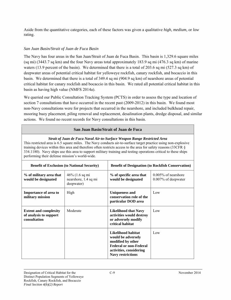
Aside from the quantitative categories, each of these factors was given a qualitative high, medium, or low rating.
San Juan Basin/Strait of Juan de Fuca Basin
The Navy has four areas in the San Juan/Strait of Juan de Fuca Basin. This basin is 1,329.6 square miles (sq mi) (3443.7 sq km) and the four Navy areas total approximately 183.9 sq mi (476.3 sq km) of marine waters (13.9 percent of the basin). We determined that there is a total of 203.6 sq mi (527.3 sq km) of deepwater areas of potential critical habitat for yelloweye rockfish, canary rockfish, and bocaccio in this basin. We determined that there is a total of 349.4 sq mi (904.9 sq km) of nearshore areas of potential critical habitat for canary rockfish and bocaccio in this basin. We rated all potential critical habitat in this basin as having high value (NMFS 2014a).
We queried our Public Consultation Tracking System (PCTS) in order to assess the type and location of section 7 consultations that have occurred in the recent past (2009-2012) in this basin. We found most non-Navy consultations were for projects that occurred in the nearshore, and included bulkhead repair, mooring buoy placement, piling removal and replacement, desalination plants, dredge disposal, and similar actions. We found no recent records for Navy consultations in this basin.
San Juan Basin/Strait of Juan de Fuca
Strait of Juan de Fuca Naval Air-to-Surface Weapon Range Restricted Area This restricted area is 6.5 square miles. The Navy conducts air-to-surface target practice using non-explosive training devices within this area and therefore often restricts access to the area for safety reasons (33CFR § 334.1180). Navy ships use this area to support military training and testing operations critical to these ships performing their defense mission’s world-wide.
Benefit of Exclusion (to National Security) Benefit of Designation (to Rockfish Conservation)
% of military area that would be designated
46% (1.6 sq mi nearshore, 1.4 sq mi deepwater)
% of specific area that would be designated
0.005% of nearshore 0.007% of deepwater
Importance of area to military mission
High Uniqueness and conservation role of the particular DOD area
Low
Extent and complexity of analysis to support consultation
Moderate Likelihood that Navy activities would destroy or adversely modify critical habitat
Low
Likelihood habitat would be adversely modified by other Federal or non-Federal activities, considering Navy restrictions
Low
Designation of Critical Habitat for the C-9 November 2014 Distinct Population Segments of Yelloweye Rockfish, Canary Rockfish, and Bocaccio Final Section 4(b)(2) Report
Importance of Area to Navy Mission: This factor is rated high because this restricted area provides regular use to the Navy, serves multiple missions, supports activities worldwide, and is proximate to other facilities and restricted areas.
Uniqueness and Conservation Role of Area: This factor is rated low because the potential critical habitat areas within the restricted area are very small relative to the rest of the critical habitat in the nearshore and deepwater of the San Juan/Strait of Juan de Fuca Basin. The features or functions provided by the Navy areas are not unique compared to the rest of the critical habitat in this basin.
Extent and Complexity of Analysis to Support Consultation: This factor is rated moderate for benefits of exclusion to the Navy because the Navy actions in this area are diverse and complex; thus, section 7 consultations that consider rockfish critical habitat would constitute an administrative burden on Navy resources. This administrative burden is offset somewhat by the lack of a consultation record in this basin for the past 3 years and the small size of this restricted area, resulting in an overall moderate rating.
Likelihood That Navy Activities Would Destroy or Adversely Modify Critical Habitat: This factor is rated low for benefits of designation to rockfish conservation because the Navy activities in this area are unlikely to affect rockfish habitat features such as water quality, prey, or habitat structure in the nearshore and deepwater areas. Thus, the benefit to rockfish conservation from a section 7 consultation that considers rockfish critical habitat effects from Navy activities would be minimal.
Likelihood That Habitat Would Be Adversely Modified by Other Federal or Non-Federal Activities Considering Navy Protections: As described above, there were seven consultations in this basin in our database covering a variety of activities, all in the nearshore. Although there have been consultations on Federal actions in this basin, we nevertheless rated this factor low for benefits of designation to rockfish conservation because the total critical habitat area is a fraction of the total for this basin (0.4 percent of nearshore areas). In addition, the Navy would have oversight and input about other Federal or non-Federal activities that might impact benthic habitats.
Conclusion: We conclude that the benefits to national security of excluding this particular area outweigh the benefits to rockfish conservation of designating it and recommend exclusion. The benefit to national security of excluding this area from rockfish critical habitat designation would be moderate to high because: 1) the portion of the area that would be designated is moderate (46 percent); 2) the importance of the area to the Navy mission is high because it is uniquely located near several Navy facilities, is frequently used for a variety of activities, and supports several types of missions; and 3) the variety of Navy activities in the area would require extensive and complex analysis in a section 7 consultation on adverse modification of critical habitat, which would constitute an administrative burden. In contrast, the benefit to rockfish conservation of designating this particular area would be low because: 1) the area represents a very small proportion of critical habitat in this basin; 2) Navy activities are unlikely to adversely modify the habitat; and 3) because of Navy restrictions, it is unlikely other Federal or non-Federal activities that adversely modify habitat will occur in this area.
Designation of Critical Habitat for the C-10 November 2014 Distinct Population Segments of Yelloweye Rockfish, Canary Rockfish, and Bocaccio Final Section 4(b)(2) Report

San Juan Basin/Strait of Juan de Fuca
Operating Area R-6713 (Navy 3) This area is 65.4 square miles. This area has been historically utilized by Navy surface ships for unit level training critical to these ships performing their defense missions all over the world. The area supports surface ship operations, including basic tactical operations, formation maneuvers, engineering trials, aviation trials, and testing electronic equipment.
Benefit of Exclusion (to National Security) Benefit of Designation (to Rockfish Conservation)
% of military area that would be designated
36% (10.0 sq mi of nearshore CH, 7.5 sq mi of deepwater CH)
% of specific area that would be designated
2.8% of nearshore 3.7% of deepwater
Importance of area to military mission
Moderate Uniqueness and conservation role of the particular DOD area
Moderate
Extent and complexity of analysis to support consultation
Low Likelihood that Navy activities would destroy or adversely modify critical habitat
Low
Likelihood habitat would be adversely modified by other Federal or non-Federal activities, considering Navy restrictions
Moderate
Importance of Area to Navy Mission: This factor is rated moderate because this restricted area is the second largest in Puget Sound, but was initially identified by the Navy as being used historically for surface ship use and transport. In response to our proposed rule (78 Fed. Reg. 47635, August 6, 2013) the Navy subsequently stated that this area is used for unit level training to achieve and sustain readiness of ships, submarines, aviation squadrons, and other units and overall operations.
Uniqueness and Conservation Role of Area: This factor is rated moderate for several reasons. Though the potential critical habitat areas within this operating area are relatively small, they are centrally located between the San Juan Islands and the mainland to the south. These areas provide a corridor of high rugosity benthic habitats that extend from near Lopez Island several miles to similarly high rugosity habitats off Whidbey Island and Partridge Bank. This high-rugosity habitat corridor thus provides important spatial structure to listed rockfish populations.
Extent and Complexity of Analysis to Support Consultation: This factor is rated low for benefits of exclusion to the Navy because section 7 consultations that consider rockfish critical habitat are unlikely to constitute an administrative burden to the Navy because the Navy uses in this area are unlikely to have significant effects to rockfish habitat. In addition, this area is already designated as critical habitat for Southern Resident killer whales, and thus we assessed the extent of Navy consultations for actions in this
Designation of Critical Habitat for the C-11 November 2014 Distinct Population Segments of Yelloweye Rockfish, Canary Rockfish, and Bocaccio Final Section 4(b)(2) Report

operating area. We have no consultation records for Navy actions within the area, indicating that use of this area by the Navy is sporadic and their activities will not affect Southern Resident killer whale critical habitat. We consider the complexity of analysis for rockfish in this Operating Area to be lower than Southern Resident killer whale critical habitat, as elaborated below.
Likelihood That Navy Activities Would Destroy or Adversely Modify Critical Habitat: This factor is rated low for benefits of designation to rockfish conservation because the potential Navy use of this area for surface ship transport and training is unlikely to alter the physical environment of benthic habitats with high rugosity (i.e., rock and shelf structures) through propeller turbulence, and for navigational safety reasons ships are likely to avoid any shallow nearshore areas that host kelp or other rearing habitats. Thus, the benefit to rockfish conservation from a section 7 consultation that considers rockfish critical habitat effects from Navy activities would be minimal.
Likelihood Habitat Would Be Adversely Modified by Other Federal or Non-Federal Activities Considering Navy Protections: This factor is rated moderate for benefits of designation to rockfish conservation for several reasons. The overall Operating Area is large (65.4 sq mi (169.4 sq km)) and thus it is likely that future Federal and non-Federal actions may occur that modify habitat. For instance, a recent analysis shows that this area is potentially affected by open-water dredge disposal activities (DMMP 2012). This area also encompasses portions of several popular recreational and commercial fishing areas including Smith Island Bank, McArthur Bank, and Partridge Bank and has accumulated several derelict fishing nets. In addition, given that habitats in this area are already affected by non-navy actions (i.e., fishing, potential dispersion of dredge disposal materials) there is evidence that Navy restrictions would not meaningfully protect rockfish habitats within the site.
Conclusion: We conclude that the benefits to national security of excluding this particular area do not outweigh the benefits to rockfish conservation of designating it and recommend designation. The benefit to national security of excluding this area from rockfish critical habitat designation would be moderate because: 1) the portion of the area that would be designated within the Operating Area consists of only 17.5 square miles (45.3 sq km) (27 percent of the site); 2) we consider the importance of the area to the Navy mission as moderate because it largely consists of surface ship, submarine, and aviation squadrons, but the area may not be as readily used compared to other Operating Areas and Security Zones; and 3) the Navy activities in the area largely consist of surface ship use. We have determined that surface ship operations are not a special management consideration, and such operations conducted by the Navy are unlikely to alter physical and biological features and specifically benthic areas with complex bathymetry. Therefore, these actions would not require extensive or complex analysis in a section 7 consultation on adverse modification of critical habitat; thus, there would be only a low administrative burden. The benefit to rockfish conservation of designating this particular area is also moderate because: 1) the area is relatively large (65.4 square miles (169.4 sq km)), and though the habitats within it with essential features are only 17.5 square miles (45.3 sq km), they are centrally located between the San Juan Islands and the mainland to the south, thus providing important spatial structure to habitat for listed rockfishes; 2) the size of the area (65.4 square miles (169.4 sq km)) makes it very likely that future Federal or non-Federal activities will occur there that could adversely affect rockfish critical habitat; and 3) there are few or no Navy restrictions in this area that would prevent the occurrence of these other Federal or non-Federal
Designation of Critical Habitat for the C-12 November 2014 Distinct Population Segments of Yelloweye Rockfish, Canary Rockfish, and Bocaccio Final Section 4(b)(2) Report

activities that may harm critical habitat (such as derelict fishing nets). Because the benefit of exclusion does not outweigh the benefit of designation, we do not recommend exclusion.
San Juan Basin/Strait of Juan de Fuca
Strait of Juan de Fuca, Eastern End; off the Westerly Shore of Whidbey Island; Naval Restricted Areas These two restricted areas total 1.9 square miles and are adjacent to the Ault Field property within Naval Air Station (NAS) Whidbey Island, but are not included within the boundaries of the NAS base. These Accident Potential Zones are areas airplane crashes are most likely to occur from the adjacent runways on Whidbey Island, and public access is restricted (33 CFR § 334.1200). The primary Navy activities in this area would be rescue operations in the event of an airplane crash.
Benefit of Exclusion (to National Security) Benefit of Designation (to Rockfish Conservation)
% of military area that would be designated
39% (0.1 sq mi deepwater)
% of specific area that would be designated
0.0001% of deepwater
Importance of area to military mission
Moderate Uniqueness and conservation role of the particular DOD area
Low
Extent and complexity of analysis to support consultation
Low Likelihood that Navy activities would destroy or adversely modify critical habitat
Low
Likelihood habitat would be adversely modified by other Federal or non-Federal activities, considering Navy restrictions
Low
Importance of Area to Navy Mission: This factor is rated moderate because these two restricted areas were identified by the Navy as serving as response zones for potential plane and salvage rescue operations. We anticipate that this type of activity would be infrequent yet important to the overall Navy mission.
Uniqueness and Conservation Role of Area: This factor is rated low because the potential critical habitat areas within the restricted area are very small relative to the rest of the critical habitat in the nearshore and deepwaters of the San Juan/Strait of Juan de Fuca Basin. These areas are connected to potential critical habitat to the north and south along Whidbey Island and thus do not provide any unique spatial structure or other habitat functions to listed rockfish populations compared to the rest of the critical habitat in this basin.
Extent and Complexity of Analysis to Support Consultation: This factor is rated low for benefits of exclusion to the Navy because a section 7 consultation that considers rockfish critical habitat because of a plane crash response would be very rare.
Designation of Critical Habitat for the C-13 November 2014 Distinct Population Segments of Yelloweye Rockfish, Canary Rockfish, and Bocaccio Final Section 4(b)(2) Report
Likelihood That Navy Activities Would Destroy or Adversely Modify Critical Habitat: This factor is rated low for benefits of designation to rockfish conservation because the act of responding to a plane crash is likely to further protect habitat features essential for rockfish such as water quality, prey, or habitat structure in the deepwater areas by removing artificial structure from benthic habitats and a potential source of water contaminants such as fuel and other petroleum products. Thus, the benefit to rockfish conservation from a section 7 consultation that considers rockfish critical habitat effects from Navy activities would be minimal.
Likelihood That Habitat Would Be Adversely Modified by Other Federal or Non-Federal Activities Considering Navy Protections: This factor is rated low for benefits of designation to rockfish conservation because the Navy has control of the land adjacent to the nearshore and this area is covered by an INRMP; thus, it is unlikely that other Federal or non-Federal activities would occur in this area and the essential nearshore features for canary rockfish and bocaccio would be protected.
Conclusion: We conclude that the benefits to national security of excluding this particular area outweigh the benefits to rockfish conservation of designating it and recommend exclusion. The benefit to national security of excluding this area from rockfish critical habitat designation would be low to moderate because: 1) the portion of the area that would be designated is a small proportion of the site; 2) the importance of the area to the Navy mission is moderate because it is strategically located near several Navy facilities yet is a small area; and 3) the variety of Navy activities in the area would be infrequent, but would nonetheless require analysis in a section 7 consultation on adverse modification of critical habitat, which would constitute an administrative burden. In contrast, the benefit to rockfish conservation of designating this particular area would be low because: 1) the area represents a very small proportion of critical habitat in this basin; 2) Navy activities are unlikely to adversely modify the habitat; and 3) because of Navy ownership of the nearshore, it is unlikely other Federal or non-Federal activities will occur in this area that adversely modify habitat.
Designation of Critical Habitat for the C-14 November 2014 Distinct Population Segments of Yelloweye Rockfish, Canary Rockfish, and Bocaccio Final Section 4(b)(2) Report

San Juan Basin/Strait of Juan de Fuca
Admiralty Inlet Naval Restricted Area This restricted area is 69.0 square miles. This restricted area is located at the eastern terminus of the Strait of Juan de Fuca at the entrance to Admiralty Inlet. This area is used by Navy vessels and submarines transiting into and out of Puget Sound, as well as monitoring and experimental deployment of devices near the seafloor. Federal regulations prohibit the use of any equipment such as anchors, fishing gear, grapnels, etc., which may foul underwater installations within the restricted area (33 CFR § 334.1210).
Benefit of Exclusion (to National Security) Benefit of Designation (to Rockfish Conservation)
% of military area that would be designated
40% (12.0 sq mi nearshore, 10.0 sq mi deepwater)
% of specific area that would be designated
3.4% of nearshore 4.9% of deepwater
Importance of area to military mission
High Uniqueness and conservation role of the particular DOD area
Moderate
Extent and complexity of analysis to support a consultation
Moderate Likelihood that Navy activities would destroy or adversely modify critical habitat
Low
Likelihood habitat would be adversely modified by other Federal or non-Federal activities, considering Navy restrictions
Moderate
Importance of Area to Navy Mission: This factor is rated high because this area is used by Navy ships and submarines for transit to all bases and destinations in Puget Sound and Hood Canal. There are underwater installations in this area that support Navy missions and uses in Puget Sound eastward of this restricted area.
Uniqueness and Conservation Role of Area: This factor is rated moderate because the potential critical habitat areas within this restricted area are a small component of the critical habitat in the nearshore and deep waters of the San Juan/Strait of Juan de Fuca Basin, yet these areas are spatially important for rockfish because they are located near the Admiralty Inlet sill that serves as a demarcation area between the San Juan/Strait of Juan de Fuca Basin and the Main Basin. Any movement of rockfish between these two basins occurs through this area; thus, these habitats provide important spatial structure and continuity between the two basins.
Extent and Complexity of Analysis to Support Consultation: This factor is rated moderate for benefits of exclusion to the Navy because section 7 consultations that consider rockfish critical habitat would be fairly routine, but because the Navy uses this area frequently and for diverse and unique uses, designation would constitute an administrative burden.
Designation of Critical Habitat for the C-15 November 2014 Distinct Population Segments of Yelloweye Rockfish, Canary Rockfish, and Bocaccio Final Section 4(b)(2) Report
Likelihood That Navy Activities Would Destroy or Adversely Modify Critical Habitat: This factor is rated low for benefits of designation to rockfish conservation because it is unlikely that the transport of ships and submarines would alter rockfish habitat features such as water quality, prey, or habitat structure in the nearshore and deepwater areas. Thus, the benefit to rockfish conservation from a section 7 consultation that considers rockfish critical habitat effects from Navy activities would be minimal.
Likelihood That Habitat Would Be Adversely Modified by Other Federal or Non-Federal Activities Considering Navy Protections: This factor is rated moderate for benefits of designation to rockfish conservation because, though the overall restricted area is large (69.0 sq mi (178.7 sq km)) and thus there is a greater likelihood that future Federal and non-Federal actions may occur within its boundaries, Navy restrictions are likely to prevent other activities (such as cable installation and tidal energy development) in the area that would impede the transit of ships and submarines. Federal regulations prohibit the use of any equipment such as anchors, fishing gear, grapnels, etc., which may foul underwater installations. Dumping of any non-buoyant objects is also prohibited. These regulations and restrictions by the Navy would provide protection to rockfish habitat.
Conclusion: We conclude that the benefits to national security of excluding this particular area outweigh the benefits to rockfish conservation of designating it and recommend exclusion. The benefit to national security of excluding this area from rockfish critical habitat designation would be moderate to high because: 1) the portion of the military area that would be designated is 40 percent; 2) the importance of the area to the Navy mission is high because it is uniquely located to provide access to several Navy facilities, is frequently used for a variety of activities, and supports several types of missions; and 3) the Navy activities in the area would not require extensive and complex analysis in a section 7 consultation on adverse modification of critical habitat, but would nonetheless constitute an administrative burden. In contrast, the benefit to rockfish conservation of designating this particular area would be low to moderate because: 1) the area represents a small proportion of the critical habitat in this basin; 2) Navy activities are unlikely to adversely modify the habitat; and 3) because of Navy restrictions, it is unlikely other Federal or non-Federal activities will occur in this area that adversely modify habitat.
Hood Canal
The Navy has three restricted areas in the north-central portion of Hood Canal. Hood Canal is 116.7 square miles (302.3 sq km) and the three Navy restricted areas total approximately 24.7 square miles (64 sq km) of marine waters (21 percent of Hood Canal). We determined that there is a total of 46 square miles (119.1 sq km) of deepwater habitats of potential critical habitat for yelloweye rockfish, canary rockfish, and bocaccio in this basin. We determined that there is a total of 20.4 square miles (52.8 sq km) of nearshore habitats of potential critical habitat for canary rockfish and bocaccio in this basin. We rated all potential critical habitat in this basin as having high value (NMFS 2014a).
The Navy has recently partnered with The Nature Conservancy, the Washington State Department of Natural Resources, and the Trust for Public Land to seek conservation gains in Hood Canal and northward to include the restricted areas of Indian Island and Maristone Island in the Main Basin. The partnership was formed, in part, to implement the DOD’s Readiness and Environmental Protection Initiative (REPI) program. The REPI program enables the military to work with outside stakeholders to limit incompatible development and protect open space and habitat around key test and training areas to support military
Designation of Critical Habitat for the C-16 November 2014 Distinct Population Segments of Yelloweye Rockfish, Canary Rockfish, and Bocaccio Final Section 4(b)(2) Report

readiness. The program goal is to prevent incompatible land uses next to existing Navy lands and restricted areas to avoid future use conflicts and to prevent excessive vessel traffic congestion and noise that could impact the Navy’s use of Hood Canal.
We queried PCTS in order to assess the type and location of section 7 consultations that have occurred in the recent past (2009-2012) in this basin. We found most non-Navy consultations were for projects that occurred in the nearshore, and included bulkhead repair, mooring buoy placement, piling removal and replacement, habitat restoration actions, and similar actions. The Navy informal consultations included wharf piling replacements, acoustic Doppler current profiler deployment, mooring systems, and swimmer interdiction security systems. The Navy formal consultations included wharf construction and test pile program projects.
Hood Canal
Hood Canal and Dabob Bay Naval Non-Explosive Torpedo Testing Area This restricted area is 23.2 square miles. The area is used intermittently by the Navy for non-explosive torpedo testing (33 CFR § 224.1190).
Benefit of Exclusion (to National Security) Benefit of Designation (to Rockfish Conservation)
% of military area that would be designated
36.2% (8.4 sq mi deepwater)
% of specific area that would be designated
18 % of deepwater
Importance of area to military mission
High Uniqueness and conservation role of the particular DOD area
Moderate
Extent and complexity of analysis to support consultation
Low Likelihood that Navy activities would destroy or adversely modify critical habitat
Low
Likelihood habitat would be adversely modified by other Federal or non-Federal activities, considering Navy restrictions
Low
Importance of Area to Navy Mission: This factor is rated high because, even though it is used intermittently, this area provides important technology and personnel training grounds for Navy activities in Hood Canal and at 23.2 square miles (60.1 sq km) is relatively large.
Uniqueness and Conservation Role of Area: This factor is rated moderate because the potential deepwater area is 18 percent of the basin, but these areas do not appear to provide any unique spatial structure or other habitat functions to listed rockfish populations compared to the rest of the critical habitat in this basin.
Designation of Critical Habitat for the C-17 November 2014 Distinct Population Segments of Yelloweye Rockfish, Canary Rockfish, and Bocaccio Final Section 4(b)(2) Report

Extent and Complexity of Analysis to Support Consultation: This factor is rated low for benefits of exclusion to the Navy because section 7 consultations that consider rockfish critical habitat are unlikely to constitute an administrative burden to the Navy because the Navy uses in this area are unlikely to have significant effects to rockfish habitat.
Likelihood That Navy Activities Would Destroy or Adversely Modify Critical Habitat: This factor is rated low for benefits of designation to rockfish conservation because the Navy uses the area for non-explosive torpedo training. This activity is unlikely to affect habitat features essential for rockfish as it would not impact water quality, prey, or habitat structure in the deepwater areas. Thus, the benefit to rockfish conservation from a section 7 consultation that considers rockfish critical habitat effects from Navy activities would be minimal.
Likelihood That Habitat Would Be Adversely Modified by Other Federal or Non-Federal Activities Considering Navy Protections: This restricted area is large (23.2 sq mi (60.1 sq km)) and thus there is a greater likelihood that future Federal and non-Federal actions may occur within its boundaries. Federal regulations prohibit the use of any equipment such as anchors, fishing gear, grapnels, etc., which may foul underwater installations or impede the transit of ships and submarines. Dumping of any non-buoyant objects is also prohibited. In addition, the Navy’s work with The Nature Conservancy and Trust for Public Land within the REPI program will likely result in habitat protections within or near this restricted area, making it unlikely that other Federal or non-Federal actions will occur that adversely modify the habitat.
Conclusion: We conclude that the benefits to national security of excluding this particular area outweigh the benefits of designation to rockfish conservation and recommend exclusion. The benefit to national security of excluding this area from rockfish critical habitat designation would be moderate to high because: 1) the portion of the area that would be designated is moderate (32 percent); 2) the importance of the area to the Navy mission is high because it supports torpedo testing operations; and 3) the Navy activities in the area would not require extensive and complex analysis in a section 7 consultation on adverse modification of critical habitat, but would nonetheless constitute an administrative burden. In contrast, the benefit to rockfish conservation of designating this particular area would be low to moderate because: 1) the area represents a moderate amount of deepwater critical habitat in this basin; 2) Navy activities are unlikely to adversely modify the habitat; and 3) because of Navy restrictions, it is unlikely other Federal or non-Federal activities will occur in this area that adversely modify habitat.
Designation of Critical Habitat for the C-18 November 2014 Distinct Population Segments of Yelloweye Rockfish, Canary Rockfish, and Bocaccio Final Section 4(b)(2) Report
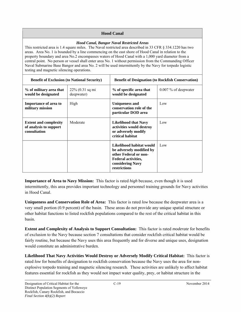
Hood Canal
Hood Canal, Bangor Naval Restricted Areas This restricted area is 1.4 square miles. The Naval restricted area described in 33 CFR § 334.1220 has two areas. Area No. 1 is bounded by a line commencing on the east shore of Hood Canal in relation to the property boundary and area No.2 encompasses waters of Hood Canal with a 1,000 yard diameter from a central point. No person or vessel shall enter area No. 1 without permission from the Commanding Officer Naval Submarine Base Bangor and area No. 2 will be used intermittently by the Navy for torpedo logistic testing and magnetic silencing operations.
Benefit of Exclusion (to National Security) Benefit of Designation (to Rockfish Conservation)
% of military area that would be designated
22% (0.31 sq mi deepwater)
% of specific area that would be designated
0.007 % of deepwater
Importance of area to military mission
High Uniqueness and conservation role of the particular DOD area
Low
Extent and complexity of analysis to support consultation
Moderate Likelihood that Navy activities would destroy or adversely modify critical habitat
Low
Likelihood habitat would be adversely modified by other Federal or non-Federal activities, considering Navy restrictions
Low
Importance of Area to Navy Mission: This factor is rated high because, even though it is used intermittently, this area provides important technology and personnel training grounds for Navy activities in Hood Canal.
Uniqueness and Conservation Role of Area: This factor is rated low because the deepwater area is a very small portion (0.9 percent) of the basin. These areas do not provide any unique spatial structure or other habitat functions to listed rockfish populations compared to the rest of the critical habitat in this basin.
Extent and Complexity of Analysis to Support Consultation: This factor is rated moderate for benefits of exclusion to the Navy because section 7 consultations that consider rockfish critical habitat would be fairly routine, but because the Navy uses this area frequently and for diverse and unique uses, designation would constitute an administrative burden.
Likelihood That Navy Activities Would Destroy or Adversely Modify Critical Habitat: This factor is rated low for benefits of designation to rockfish conservation because the Navy uses the area for non-explosive torpedo training and magnetic silencing research. These activities are unlikely to affect habitat features essential for rockfish as they would not impact water quality, prey, or habitat structure in the
Designation of Critical Habitat for the C-19 November 2014 Distinct Population Segments of Yelloweye Rockfish, Canary Rockfish, and Bocaccio Final Section 4(b)(2) Report
deepwater areas. Thus, the benefit to rockfish conservation from a section 7 consultation that considers rockfish critical habitat effects from Navy activities would be minimal.
Likelihood That Habitat Would Be Adversely Modified by Other Federal or Non-Federal Activities Considering Navy Protections: This factor is rated low for benefits of designation to rockfish conservation because use of any equipment such as anchors, grapnels, or any object that may foul underwater installations within the restricted area is prohibited at all times. In addition, the area is regularly patrolled by Navy personnel; thus, public access is observed and controlled. These factors make it unlikely that other Federal or non-Federal activities would occur in this area that adversely modify rockfish critical habitat.
Conclusion: We conclude that the benefits to national security of excluding this particular area outweigh the benefits to rockfish conservation of designating it and recommend exclusion. The benefit to national security of excluding this area from rockfish critical habitat designation would be moderate to high because: 1) the portion of the area that would be designated is somewhat moderate (22 percent); 2) the importance of the area to the Navy mission is high because it supports important technology and personnel training; and 3) the Navy activities in the area would not require extensive and complex analysis in a section 7 consultation on adverse modification of critical habitat, but would nonetheless constitute an administrative burden. In contrast, the benefit to rockfish conservation of designating this particular area would be low to moderate because: 1) the area represents a small proportion of critical habitat in this basin; 2) Navy activities are unlikely to adversely modify the habitat; and 3) because of Navy restrictions, it is unlikely other Federal or non-Federal activities will occur in this area that adversely modify habitat.
Designation of Critical Habitat for the C-20 November 2014 Distinct Population Segments of Yelloweye Rockfish, Canary Rockfish, and Bocaccio Final Section 4(b)(2) Report
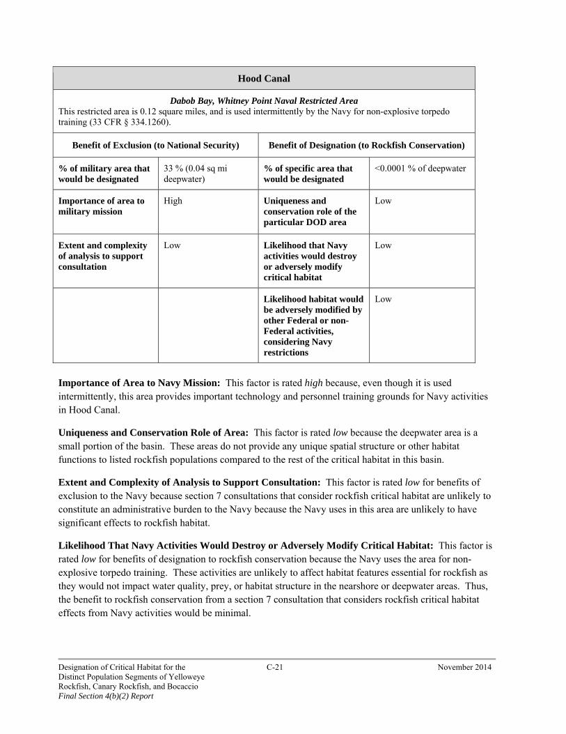
Hood Canal
Dabob Bay, Whitney Point Naval Restricted Area This restricted area is 0.12 square miles, and is used intermittently by the Navy for non-explosive torpedo training (33 CFR § 334.1260).
Benefit of Exclusion (to National Security) Benefit of Designation (to Rockfish Conservation)
% of military area that would be designated
33 % (0.04 sq mi deepwater)
% of specific area that would be designated
<0.0001 % of deepwater
Importance of area to military mission
High Uniqueness and conservation role of the particular DOD area
Low
Extent and complexity of analysis to support consultation
Low Likelihood that Navy activities would destroy or adversely modify critical habitat
Low
Likelihood habitat would be adversely modified by other Federal or non-Federal activities, considering Navy restrictions
Low
Importance of Area to Navy Mission: This factor is rated high because, even though it is used intermittently, this area provides important technology and personnel training grounds for Navy activities in Hood Canal.
Uniqueness and Conservation Role of Area: This factor is rated low because the deepwater area is a small portion of the basin. These areas do not provide any unique spatial structure or other habitat functions to listed rockfish populations compared to the rest of the critical habitat in this basin.
Extent and Complexity of Analysis to Support Consultation: This factor is rated low for benefits of exclusion to the Navy because section 7 consultations that consider rockfish critical habitat are unlikely to constitute an administrative burden to the Navy because the Navy uses in this area are unlikely to have significant effects to rockfish habitat.
Likelihood That Navy Activities Would Destroy or Adversely Modify Critical Habitat: This factor is rated low for benefits of designation to rockfish conservation because the Navy uses the area for non-explosive torpedo training. These activities are unlikely to affect habitat features essential for rockfish as they would not impact water quality, prey, or habitat structure in the nearshore or deepwater areas. Thus, the benefit to rockfish conservation from a section 7 consultation that considers rockfish critical habitat effects from Navy activities would be minimal.
Designation of Critical Habitat for the C-21 November 2014 Distinct Population Segments of Yelloweye Rockfish, Canary Rockfish, and Bocaccio Final Section 4(b)(2) Report
Likelihood That Habitat Would Be Adversely Modified by Other Federal or Non-Federal Activities Considering Navy Protections: This factor is rated low for benefits of designation to rockfish conservation because use of any equipment such as anchors, grapnels, or any object that may foul underwater installations within the restricted area is prohibited at all times. These factors make it unlikely that other Federal or non-Federal activities would occur in this area. In addition, the area is regularly patrolled by Navy personnel; thus, public access is observed and controlled.
Conclusion: We conclude that the benefits to national security of excluding this particular area outweigh the benefits to rockfish conservation of designating it and recommend exclusion. The benefit to national security of excluding this area from rockfish critical habitat designation would be moderate to high because: 1) the portion of the area that would be designated is moderate (33 percent); 2) the importance of the area to the Navy mission is high because it provides important technology and personnel training grounds; and 3) the Navy activities in the area would not require extensive and complex analysis in a section 7 consultation on adverse modification of critical habitat, but would nonetheless constitute an administrative burden. In contrast, the benefit to rockfish conservation of designating this particular area would be low because: 1) the area represents a small proportion of critical habitat in this basin; 2) Navy activities are unlikely to adversely modify the habitat; and 3) because of Navy restrictions, it is unlikely other Federal or non-Federal activities will occur in this area that adversely modify habitat.
Whidbey Basin
The Navy has two restricted areas in the Whidbey Basin. In our proposed critical habitat rule we assessed the benefits of exclusion and designation of a portion of the Crescent Harbor Explosive Ordnance Disposal Area because a small area (0.02 sq mi (0.05 sq km)) of deepwater habitat was determined to have essential features for listed rockfishes. Our final designation of deepwater critical habitat utilized refined methods (see NMFS 2014a) and as a result this small area of Crescent Harbor has been removed from the final deepwater areas. As a result, we no longer consider the Crescent Harbor site within this weighing analysis. The Whidbey Basin is 245.7 square miles (636.4 sq km) and the one Navy restricted area we assess here totals approximately 0.24 square miles (0.62 sq km) of marine waters (less than one percent of the basin). We determined that there is a total of 32.2 square miles (83.4 sq km) of deepwater habitats of potential critical habitat for yelloweye rockfish, canary rockfish, and bocaccio in this basin. We determined that there is a total of 52.2 square miles (135.2 sq km) of nearshore habitats of potential critical habitat for canary rockfish and bocaccio in this basin. We rated all potential critical habitat in this basin as having high value (NMFS 2014a).
We queried PCTS in order to assess the types and location of section 7 consultations that have occurred in the recent past (2009-2012) in this basin. We found most non-Navy consultations were for projects that occurred in the nearshore, and included bulkhead repair, mooring buoy placement, dredging and marina maintenance, and piling removal and replacement. The Navy informal consultations included wharf piling replacements, swimmer defense system repairs, and small craft launch installation.
Designation of Critical Habitat for the C-22 November 2014 Distinct Population Segments of Yelloweye Rockfish, Canary Rockfish, and Bocaccio Final Section 4(b)(2) Report

Whidbey Basin
Naval Station Everett Restricted Area This restricted area is 0.24 square miles. This area support vessel moorage and maintenance and base operations. This area is near areas covered by the Naval Station Everett Integrated Natural Resource Plan (33 CFR § 334.1215).
Benefit of Exclusion (to National Security) Benefit of Designation (to Rockfish Conservation)
% of military area that would be designated
1.6 % (0.004 mi deepwater)
% of specific area that would be designated
<0.0001 % of deepwater
Importance of area to military mission
High Uniqueness and conservation role of the particular DOD area
Low
Extent and complexity of analysis to support consultation
High Likelihood that Navy activities would destroy or adversely modify critical habitat
Low
Likelihood habitat would be adversely modified by other Federal or non-Federal activities, considering Navy restrictions
Low
Importance of Area to Navy Mission: This factor is rated high because this restricted area provides extensive support to a large number of Navy vessels, infrastructure, and personnel.
Uniqueness and Conservation Role of Area: This factor is rated low because there is no potential nearshore critical habitat area within this restricted area and the deepwater area is an extremely small portion (<0.0001 percent) of the basin. This small portion of deepwater habitat does not provide any unique spatial structure or other habitat functions to listed rockfish populations compared to the rest of the critical habitat in this basin.
Extent and Complexity of Analysis to Support Consultation: This factor is rated high for benefits of exclusion to the Navy because the Navy regularly consults under section 7 for a variety of actions in this area. These consultations include piling maintenance, swimmer defense repairs, and other actions. A rockfish critical habitat designation would require the Navy to assess the effects of these activities to designated habitats and would constitute an administrative burden.
Likelihood That Navy Activities Would Destroy or Adversely Modify Critical Habitat: This factor is rated low for benefits of designation to rockfish conservation because the area is small and activities occurring here are unlikely to affect habitat features essential for rockfish as they would not impact water quality, prey, or habitat structure in the deepwater areas, and only impact these considerations on a
Designation of Critical Habitat for the C-23 November 2014 Distinct Population Segments of Yelloweye Rockfish, Canary Rockfish, and Bocaccio Final Section 4(b)(2) Report
transitory basis in the nearshore. Thus, the benefit to rockfish conservation from a section 7 consultation that considers rockfish critical habitat effects from Navy activities would be minimal.
Likelihood That Habitat Would Be Adversely Modified by Other Federal or Non-Federal Activities Considering Navy Protections: This factor is rated low for benefits of designation to rockfish conservation because other Federal and non-Federal actions are unlikely to occur in this area. The nearshore and land associated with this restricted area is owned and controlled by the Navy and private boats are not allowed access to much of this area; thus, private activities that would require Federal approval in this area, such as pier construction, would not be allowed by the Navy. For similar reasons, most non-Federal activities would also not be allowed by the Navy in this area.
Conclusion: We conclude that the benefits to national security of excluding this particular area outweigh the benefits to rockfish conservation of designating it and recommend exclusion. The benefit to national security of excluding this area from rockfish critical habitat designation would be moderate to high because: 1) the portion of the area that would be designated is very small (1.6 percent); 2) the importance of the area to the Navy mission is high because it provides important infrastructure and services; and 3) the Navy activities in the area that undergo section 7 consultations are numerous and would require additional analysis in a section 7 consultation on adverse modification of critical habitat, and would constitute an administrative burden. In contrast, the benefit to rockfish conservation of designating this particular area would be low because: 1) the area represents a very small proportion of critical habitat in this basin; 2) Navy activities are unlikely to adversely modify the habitat; and 3) because of Navy restrictions, it is unlikely other Federal or non-Federal activities will occur in this area that adversely modify habitat.
South Sound
The Navy has one restricted area in the central portion of the South Puget Sound bordered by Fox Island and McNeil Island in Carr Inlet. The South Puget Sound is 173 square miles (448.1 sq km) and the one Navy restricted area totals approximately 17.54 square miles (45.4 sq km) of marine waters (10 percent of the South Sound). We determined that there is a total of 27.1 square miles (70.2 sq km) of deepwater habitats of potential critical habitat for yelloweye rockfish, canary rockfish, and bocaccio in this basin (NMFS 2014a). We determined that there is a total of 73.7 square miles (190.9 sq km) of nearshore habitats of potential critical habitat for canary rockfish and bocaccio in this basin (NMFS 2014a). We rated all potential critical habitat in this basin as having high value (NMFS 2014a).
We queried PCTS in order to assess the types and location of section 7 consultations that have occurred in the recent past (2009-2012) in this basin. We found most non-Navy consultations were for projects that occurred in the nearshore, and included bulkhead repair, mooring buoy placement, dredging and dredge disposal, piling removal and replacement, and similar actions. There were no Navy consultations during this time period.
Below, we describe this restricted area in terms of its size, areas with essential rockfish habitat features, and use and protections by the Navy.
Designation of Critical Habitat for the C-24 November 2014 Distinct Population Segments of Yelloweye Rockfish, Canary Rockfish, and Bocaccio Final Section 4(b)(2) Report
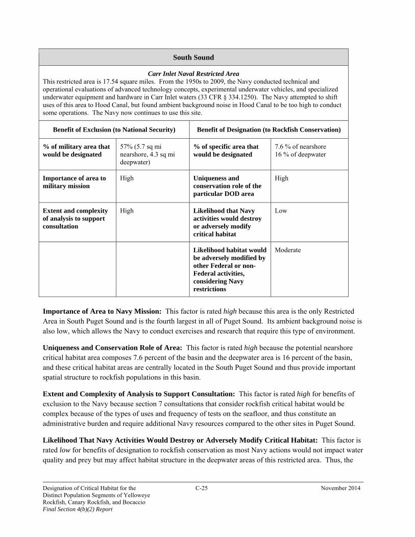
South Sound
Carr Inlet Naval Restricted Area This restricted area is 17.54 square miles. From the 1950s to 2009, the Navy conducted technical and operational evaluations of advanced technology concepts, experimental underwater vehicles, and specialized underwater equipment and hardware in Carr Inlet waters (33 CFR § 334.1250). The Navy attempted to shift uses of this area to Hood Canal, but found ambient background noise in Hood Canal to be too high to conduct some operations. The Navy now continues to use this site.
Benefit of Exclusion (to National Security) Benefit of Designation (to Rockfish Conservation)
% of military area that would be designated
57% (5.7 sq mi nearshore, 4.3 sq mi deepwater)
% of specific area that would be designated
7.6 % of nearshore 16 % of deepwater
Importance of area to military mission
High Uniqueness and conservation role of the particular DOD area
High
Extent and complexity of analysis to support consultation
High Likelihood that Navy activities would destroy or adversely modify critical habitat
Low
Likelihood habitat would be adversely modified by other Federal or non-Federal activities, considering Navy restrictions
Moderate
Importance of Area to Navy Mission: This factor is rated high because this area is the only Restricted Area in South Puget Sound and is the fourth largest in all of Puget Sound. Its ambient background noise is also low, which allows the Navy to conduct exercises and research that require this type of environment.
Uniqueness and Conservation Role of Area: This factor is rated high because the potential nearshore critical habitat area composes 7.6 percent of the basin and the deepwater area is 16 percent of the basin, and these critical habitat areas are centrally located in the South Puget Sound and thus provide important spatial structure to rockfish populations in this basin.
Extent and Complexity of Analysis to Support Consultation: This factor is rated high for benefits of exclusion to the Navy because section 7 consultations that consider rockfish critical habitat would be complex because of the types of uses and frequency of tests on the seafloor, and thus constitute an administrative burden and require additional Navy resources compared to the other sites in Puget Sound.
Likelihood That Navy Activities Would Destroy or Adversely Modify Critical Habitat: This factor is rated low for benefits of designation to rockfish conservation as most Navy actions would not impact water quality and prey but may affect habitat structure in the deepwater areas of this restricted area. Thus, the
Designation of Critical Habitat for the C-25 November 2014 Distinct Population Segments of Yelloweye Rockfish, Canary Rockfish, and Bocaccio Final Section 4(b)(2) Report
benefit to rockfish conservation by a section 7 consultation that considers rockfish critical habitat effects from Navy activities would be minimal.
Likelihood That Habitat Would Be Adversely Modified by Other Federal or Non-Federal Activities Considering Navy Protections: This factor is rated moderate for benefits of designation to rockfish conservation because the land along the nearshore of this area is privately held and there is existing altered shoreline with bulkhead and docks. Thus, it is likely there would be new and maintenance shoreline armoring and pier/dock construction that would be reviewed under section 7. Activities that would impact long-term ambient noise levels would receive greater Navy oversight than underwater ambient noise created by short-term construction projects along the shoreline. The Navy agreed that all nearshore habitat (extreme high water out to a depth no greater than 98.4 feet (30 m) relative to mean lower low water) could be designated as critical habitat for canary rockfish and bocaccio, and thus subsequent Federal actions (such as permits for bulkheads) would consider the potential for adverse modification.
Conclusion: We conclude that the benefits to national security of excluding this particular area outweigh the benefits to rockfish conservation of designating it and recommend exclusion. The benefit to national security of excluding this area from rockfish critical habitat designation would be high because: 1) a large majority of the area would be designated; 2) the importance of the area to the Navy mission is high because of its location and unique environment with low ambient noise; and 3) the Navy activities in the area would be complex and thus require detailed analysis in a section 7 consultation on adverse modification of critical habitat, and would constitute an administrative burden. In contrast, the benefit to rockfish conservation of designating this particular area would be low to high because: 1) the area represents a moderate proportion of critical habitat in this basin; 2) most, if not all, Navy activities would not adversely modify the habitat; and 3) because of Navy restrictions, it is unlikely other Federal or non-Federal activities that adversely modify habitat will occur in the deepwater area, and the nearshore of this restricted area is designated as rockfish critical habitat.
Summary: After consulting with the Navy, we have designated critical habitat in a narrow nearshore zone (from extreme high tide down to mean lower low water (MLLW)) within two Navy security zones that are not subject to an approved INRMP or associated with Department of Defense easements or rights-of-way. This narrow zone is expected to contain many of the activities likely to trigger a section 7 consultation, but its designation is not likely to have significant impacts on national security. The “deeper” nearshore zone (i.e., from MLLW out to a depth of 98.4 feet (30 m) associated with these sites is excluded from designation because of impacts on national security. This approach was taken in previous rule-making for salmonid critical habitat designation in Puget Sound (70 Fed. Reg. 52630, September 2, 2005). As mentioned above, at one restricted area (Carr Inlet in South Sound) we designate critical habitat from extreme high tide to a depth of 98.4 feet (30 m) (the nearshore) but not deepwater areas.
For clarification, the table below summarizes whether a particular Navy Security Area is also covered by an INRMP, and if any portion of the nearshore or deepwater areas are designated as critical habitat for yelloweye rockfish, canary rockfish, and bocaccio.
Designation of Critical Habitat for the C-26 November 2014 Distinct Population Segments of Yelloweye Rockfish, Canary Rockfish, and Bocaccio Final Section 4(b)(2) Report

Table C1. Summary of Navy Security Areas and nearshore or deepwater areas designated as critical habitat.
Navy Security Area
Extent of Nearshore with
Essential Features
INRMP for Security Area?
Area Designated as Nearshore Critical Habitat for Canary
Rockfish and Bocaccio
Area Designated as
deepwater Critical Habitat
for Listed Rockfishes
Strait of Juan de Fuca Naval Air-to-Surface Weapon Range Restricted Area
1.6 sq mi No None None
Operating Area R-6713 (Navy 3)
10 sq mi No 10 sq. mi 7.5 sq. mi
Strait of Juan de Fuca, Eastern End; off the Westerly Shore of Whidbey Island; Naval Restricted Areas
0.5 sq mi Yes None None
Admiralty Inlet Naval Restricted Area
12.0 sq mi No From extreme high tide down to mean lower low water.
None
Hood Canal and Dabob Bay Naval Non-Explosive Torpedo Testing Area
2.5 sq mi Yes None None
Hood Canal, Bangor Naval Restricted Areas
0.7 sq mi Yes None None
Dabob Bay, Whitney Point Naval Restricted Area
0.02 sq mi Yes None None
Crescent Harbor Explosive Ordnance Disposal Area
6.8 sq mi Yes None None
Naval Station Everett Restricted Area
0.004 sq mi Yes None None
Port Townsend, Indian Island, Walan Point Naval Restricted Area
0.15 sq mi Yes None None
Port Orchard Naval Restricted Area
2.24 sq mi No None None
Sinclair Inlet Naval Restricted Area
3.2 sq mi Yes None None
Puget Sound, Manchester Fuel Depot, Naval Restricted Area
0.11 sq mi Yes None None
Carr Inlet Naval Restricted Area
5.7 sq mi No Extreme high tide to a depth of 98.4 feet.
None
Designation of Critical Habitat for the C-27 November 2014 Distinct Population Segments of Yelloweye Rockfish, Canary Rockfish, and Bocaccio Final Section 4(b)(2) Report