Embed Size (px)
Citation preview

Design of a Riffle Grade Control on Whitemarsh Run
24Sept
2015
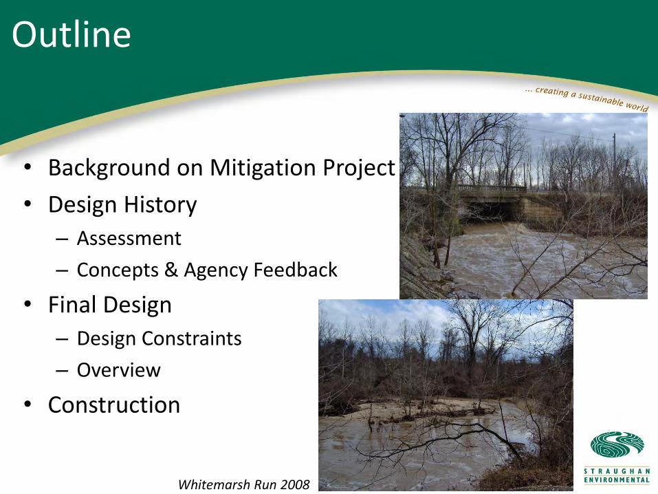
• Background on Mitigation Project
• Design History
– Assessment
– Concepts & Agency Feedback
• Final Design
– Design Constraints
– Overview
• Construction
Outline
Whitemarsh Run 2008

Project Background

Background: I-95 Express Toll Lanes
• I-95 Express Toll LanesSM
• 8-mile segment of I-95 = Section 100
– 12,199 linear feet of streams impacted
– 2.89 acres of wetlands impacted
– Mitigation achieved at King Avenue Mitigation Site and Whitemarsh Run Mitigation Site

Whitemarsh Run
▲
Mitigation Site Location
• Whitemarsh Run
– Coastal plain sand and gravel-bedded stream located in Baltimore County, Maryland

Watershed and Site Assessments

Whitemarsh Run Watershed
• Urbanized 13.5-mi2 watershed
• History of gravel mining
• Upstream restoration projects have had varying success
• Straughan measured large bedload supply to downstream reaches

White Marsh Run Site
• Whitemarsh Run Mitigation Site
– 184 acres containing streams, forest, and wetlands
– Degraded streams, wetlands, and habitat
– History of gravel mining
– MD 43 and BGE ROW

Geomorphic and Hydrology Assessment
– Stream gage installations
– Discharge and bedload measurements during storm events
– Sediment transport modeling
– Baseflow analysis
Site Assessment

Hydrology Measurements
Summary of Discharges Used in HEC-RAS Modeling
Whitemarsh Run
Drainage Area
Low Flows (cfs) High Flows (cfs)
50% 90% 1-year 2- year 10- year 100- year
Downstream of U.S. Route 40
10.88 6.7 14.2 1,154 1,694 2,841 4,030
12.97 4.3 16.9 1,220 1,767 3,453 7,502
Bankfull & Effective Discharge SummaryU.S. Route 40
Bankfull 1,024 cfsEffective 555 cfs

Sediment Transport Model
Wilcock (2001) Calibrated Two-Fractional Bedload Transport Model Results:
Total Transport at Ebenezer Road
1
10
100
1000
10000
10 100 1000 10000
Discharge (cfs)
To
tal B
ed
loa
d T
ran
sp
ort
(to
ns
/da
y)
Measured TransportBest FitLower BoundUpper Bound

• Primarily sand and gravel
• Annual bedload yield
– MD Route 7: 5,300 tons
– MD Route 43: 17,400 tons
– Ebenezer Road: 8,900 tons
• Localized sources and sinks
• General aggradation
Sediment Supply
Lane/Borland stable channel stability relation (Borland, 1960)

Design Process and Agency Negotiations

• Initial mitigation goals
– Replace the functions and values of the wetlands and streams unavoidably impacted by the Section 100 project
– Preserve, enhance, and create wetlands and forest
– Restore Whitemarsh Run to a geomorphically stable dimension, pattern, and profile that transports the sediment and water of the watershed without further aggradation or degradation
Whitemarsh Run: Initial Goals

Whitemarsh Run Design Process
• Initial concept design
– (1) Natural channel design
• Use reference reach to design stable Bc channel
• Reconnect floodplain
• Remove riprap andconcrete
• Provide grade control
• Create emergent andoxbow wetlands
• Control Phragmites

• Limitations of initial concept design– Client and review agencies were wary of traditional
stream restoration design due to restoration history in Whitemarsh Run watershed
– Viewed as cost-prohibitive
– Wells indicated that existing groundwater elevation was too low at proposed wetland creation site
– No mitigation credit to be allowed for oxbow wetlands
– Ground penetrating radar and soil analysis indicated 10 to 20 feet of waste concrete and diesel fuel contamination southeast of US 40 crossing
Whitemarsh Run Design Process

Whitemarsh Run Design Process
• Other concept stream designs – (2) Shallow braided stream
through wetlands • Suspended sediment and
nitrogen removal
• Fish passage may be limited
• Gravel aggregation expected
• Historical images and topomaps suggest stream is naturally single-threaded

Whitemarsh Run Design Process
• Other concept stream designs
– (3) Valley plugs to form distributary channels
• Estimated ability to store 37K tons of sediment over a 7-year period
• Similar concept recommended by peer reviewer
• Fish passage may be concern
• Future stability uncertain

• Other concept stream designs
– (4) In-situ enhancement
• Limited bank grading
• Fish ladder required
• No sediment storage
• Improvements at BGE right-of-ways not possible
Whitemarsh Run Design Process

• Other concept stream designs– (5) Bypass channel
• Bypass solely for fish passage at baseflow
• Primary channel below structural spillway for bedload transport and high discharge conveyance
• Bypass channel may aggrade and require maintenance
Whitemarsh Run Design Process

Whitemarsh Run Design Process
• Revised Goals– Primary Objectives
• Carry out wetland creation, enhancement, preservation, and restoration activities at selected locations
• Manage Phragmites and Bittersweet
• Protect existing infrastructure
• Stabilize stream banks at selected locations
• Improve fish passage for selected anadromous species at the Route 40 culvert
– MDE and NOAA/NMFS recommended a rock riffle grade control structure

• 184-acre mitigation site
• 1,407-foot long riffle grade control/fish passage structure
• 338 feet of streambank stabilization
• 14.6 acres of invasive species eradication
• 3.3 acres of wetland enhancement
• 43 acres of wetland preservation
• 3.8 acres of vernal pools created in 13 complexes
• 0.8 acres of additional wetland creation
White Marsh Run Proposed Mitigation

Riffle Grade Control Design Process

– Fish Passage
• Minimum Spring baseflow depth = 9 in
• Maximum Spring baseflow velocity = 3 ft/s
– Structural stability during the 10- and 100-year discharges
– Competence and capacity to transport existing bedloads
– Maintenance of the existing 100-yr floodplain elevation along U.S. 40
– Strict grading limitations due to measured diesel fuel soil contamination and utility right-of-ways
– Ensure surficial flow
Whitemarsh Run: Design Constraints

Whitemarsh Run Riffle Grade Control
• Riffle grade controls installed successfully at other Maryland coastal plain streams– Previous designs did not
consider fish passage, but post-construction monitoring showed positive results for stability and fish passage
– White Marsh Run presented challenges because of lower baseflow and higher storm discharges

Fish Passage: Baseflow Constraints
• Goal: Spring baseflow at least 9 inches deep and less than 3 ft/s
• 4.2-foot vertical barrier at Whitemarsh Run– Alaskan fish ladder was not successful
• Target fish: alewife, blueback herring, and white perch– Fish swimming performance tests
– Refugia boulders
– Dr. Piotr Parasiewicz of Rushing Rivers Inc

• Goal: Immobile D30 stone size at the highest expected shear stresses (10-year and 100-year)
• Stability Checks: 1. Mussetter relationship (1989) used to develop Manning's 'N‘
at baseflow conditions
2. Rosgen's Rock Size Relationship (Rosgen, 2007) for refugiaboulders
3. Riprap Sizing Methods from USACE EM 1110-2-1601 for D30
4. Wilcock and Crowe (2003) sediment transport function
5. Modified Andrews critical shear stress
• Grouted sections where needed
Structural Stability

• Goal: Threshold Channel – “Green Pipe”
• Utilized iSURF (Wilcock and Crowe, 2003) transport relation to determine the required cross-sectional width, depth, and slope required to transport the sediment supply input through a channel section.
• Steeper channel will be more "efficient" in transporting sediment.
Sediment Transport Capacity
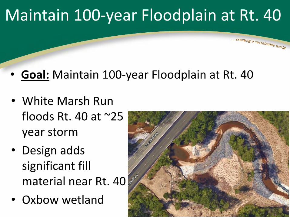
• Goal: Maintain 100-year Floodplain at Rt. 40
Maintain 100-year Floodplain at Rt. 40
• White Marsh Run floods Rt. 40 at ~25 year storm
• Design adds significant fill material near Rt. 40
• Oxbow wetland

Whitemarsh Run Riffle Grade Control
• Iterative design process– Stone size and gradation determine roughness at baseflow
• Which determines baseflow depth and velocity
– Slope and cross-sectional parameters drive:• Baseflow depth and velocity and• Required stone sizes for structural stability at 10- and 100-year storms,
which must be available stone sizes
– Bedload competence and capacity determined with models including iSURF
– Final depths, velocities, and floodplain elevations modeled with HEC-RAS
– HEC-RAS sheer stress values assisted with stone sizing

Whitemarsh Run Riffle Grade Control
• Riffle Grade Control– Plunge pool downstream of
U.S. 40 and downstream of RGC
– Loosely follows the existing stream alignment to maximize length (1,407 ft)
– Slope = 0.0092 (0.92 %),3X existing stream slope
– Contains refugia boulders to provide fish resting areas

• Mitigation proposed at Mitigation Site– Plunge pools and riffle grade control structure (1,407 ft)
– Streambank stabilization (338 ft, reducing erosion by an estimated 362 ton/yr)
– Wetland enhancement (3.2 ac) and preservation (43 ac)
– Vernal pools (3.3 ac)(Design by )
– Invasive species eradication (14.6 ac)
– Reforestation (1.3 ac)
– Native plantings
• Total construction cost = $4.2M
Whitemarsh Run Mitigation Site

Construction: Riffle Grade Control

Riffle Grade Control Fish Passage

Riffle Grade Control Fish Passage

Riffle Grade Control Fish Passage
Stream channel/RGC construction (December 2014)

Pump-around established for stream work; note grouted riprap section (lighter area immediately left of pump). (December 2014)
Riffle Grade Control Fish Passage

Riffle Grade Control Fish Passage
Grading a section of stream prior to placing riprap (December 2014)

Riffle Grade Control Fish Passage
Stream channel/RGC construction (January 2015)

Riffle Grade Control Fish Passage

Riffle Grade Control Fish Passage

Riffle Grade Control Fish Passage

Riffle Grade Control Fish Passage

Construction: Bank Stabilization, Vernal
Pools, Habitat Enhancements

Bank Stabilization

Bank Stabilization
Imbricated riprap, bank grading and stabilization at an area downstream of the RGC. (January 2015)

Bank Stabilization
Red line plans were needed due to stream movement from topo (2008) to construction (2014).

Vernal Pool Construction
Vernal pool after construction; note use of root wads from trees cleared on site. (December 2014)

Vernal Pools Post Construction
Signs of life in the vernal pools (April 2015)

Wetland Creation

Treatment of Invasive Species

Lessons Learned and Discussion

• The Riffle Grade Control held up after a 10-year storm shortly after construction
– Isolated damage to new trees
• Anecdotal evidence of fish passage in the spring and fall (gizzard shad)
Initial Results are Positive

• Regulatory agencies drive priorities– Fish passage requirement
– Resistance to unproven concepts
– Lengthy negotiations for out of kind mitigation
• Uncertainty drives costs– Initial studies, peer reviews, independent experts
– Iterative designs and multiple models
• Large rock provides stability but drives costs– More natural solutions can reduce costs
Discussion

www.straughanenvironmental.com
Straughan Environmental, Inc.10245 Old Columbia Road | Columbia, MD 21046
Justin Haynes301.362.9200