Embed Size (px)
Citation preview

Design Surrey
A strategic guide for quality built environments

Surrey Local Government Association (SLGA):
Elmbridge Borough Council
Epsom & Ewell Borough Council
Guildford Borough Council
Mole Valley District Council
Reigate & Banstead Borough Council
Runnymede Borough Council
Spelthorne Borough Council
Surrey County Council
Surrey Heath Borough Council
Tandridge District Council
Waverley Borough Council
Woking Borough Council
The advice freely given by members and officers of the following organisations during the production of Surrey Design is also gratefully acknowledged:
House Builders Federation (HBF)
Royal Institute of British Architects (RIBA)
Surrey Access Forum
Landscape Institute
Surrey Police
1

Surrey is one of the most attractive, safest and popular places to live in Britain. It is also the most urbanised shire county and pressure for development is intense.The challenge is how to accommodate new development, whilst at the sametime enhancing the qualities that make Surrey so attractive.
There is an ongoing debate about where to accommodate new development.Surrey Design moves this debate on to the issue of quality. What sort of places are we creating? Are they safe and attractive? Are they sustainable?
New development should stand the test of time. Over recent decades we haveapplied strong planning policies and have generally been successful in ensuringdevelopment is located in the right place within or adjacent to our towns andvillages. However, little of the development during recent decades is held up asbeing of a quality that can rival our best historic heritage.
The agenda is changing. The Government is now committed to good design andsustainable development. The creation of quality environments within our townsand cities where people will want to live is seen as one of the most importantplanning goals of the 21st Century.
Surrey Design is Surrey Local Government Association’s response to the nationalagenda. It gives a strong message that we are committed to improving the qualityof our new development and ensuring that community safety is a key aspect ofdesign, not just in our towns – but also in our villages. This means developingplaces that are safe, attractive, sustainable and well kept. We will need to promotethe principles that have worked well in the past to produce our best historicvernacular and settlement forms. These need to be combined with principleswhich allow for genuine contemporary quality and innovation and helpconserve resources, reduce waste and prevent pollution. To do that we need tochange our approach to how we develop the built environment in response toquality design and sustainable construction. These changes won’t happenovernight, but over the next decade we should begin to see a markedimprovement to our environment and our quality of life.
Surrey Local Government Association is committed to good design and SurreyDesign is a significant and exciting step towards achieving this goal. However itcan only be the first stage. Better design needs to be the goal of all those involvedin the development process and I welcome the commitment of the public, privateand voluntary sectors to achieving this. Together we can make a difference.
David Davis
Chairman
Surrey Local Government Association
January 2002
2
Foreword

3

INTRODUCTION 6
IMPLEMENTATION AND MONITORING 9
OBJECTIVES & PRINCIPLES 11
Chapter 1 PROCESS 13
Chapter 2 QUALITY 18
Chapter 3 CHARACTER 31
Chapter 4 RESOURCES 43
Chapter 5 PEOPLE 55
Chapter 6 MOVEMENT 60
Chapter 7 LAND 70
GLOSSARY 80
BIBLIOGRAPHY 84
NOTES 89
4
Contents
Supporting document:
Surrey Design: Technical Appendix

5

Introduction
6
1 The purpose of this design guide is to promote high quality design of newdevelopment in Surrey. It aims to supplement the principles in national andregional planning guidance, and guide the implementation of the Surrey StructurePlan. It will contribute to making Surrey a better place to live in the 21st centuryand further the objectives in The Common Agenda for a Sustainable Surrey and theUrban White Paper, Our Towns and Cities: The Future.
2 The guide has been produced on behalf of the Surrey Local GovernmentAssociation (SLGA). Its preparation has been a collaborative effort between SurreyCounty Council, all eleven Surrey districts, the House Builders Federation (HBF),Royal Institute of British Architects (RIBA), the Landscape Institute, the SurreyAccess Forum and Surrey Police.
Background
3 At the heart of national, regional and local planning strategy is a commitment tosustainable development – the integration of economic, environmental and socialobjectives. Part of the commitment is to focus new development in existing urban areas, and at the same time to improve the quality of life in cities, townsand villages.
4 The government’s vision as set out in the Urban White Paper includes:
• People shaping the future – people must come first
• People living in attractive, well kept towns and cities which use space andbuildings efficiently
• Good design and planning which makes it practical to live in anenvironmentally sustainable way
5 Quality design will play a crucial role in enhancing people’s quality of life inurban areas. This is reiterated in Regional Planning Guidance for the South East(RPG9), national planning guidance (PPG1 & PPG3) and the emerging SurreyStructure Plan.
What is Good Design?
6 The outcome of good design should be economically vibrant, attractive, and saferplaces that use land and natural resources in an efficient way. Good design istherefore an holistic process that brings together social, environmental andeconomic needs with aesthetic concerns.

7 This guide brings together the following themes that will help achieve good design:
• The need for a coherent design process for newdevelopment based on local participation
• Creating attractive places with buildings andplants defining streets and public spaces
• Making efficient use of available land bypromoting well designed, high density andmixed use development
• Designing for low energy and resource use
• Protecting and enhancing existing habitats tomaintain diversity
• Creating places and streets for people ratherthan the motor car
• Creating integrated developments that are, andfeel, safe
• Providing variety in terms of uses, buildingsand tenure
8 The principles in the guide may be applied to any form and type of developmentwhether housing, mixed use or commercial, although most of the photos and casestudy examples are of housing and mixed use development.
Why a Design Guide for Surrey?
9 There is much guidance available at national level, nevertheless there is a role fora county level document to:
• Provide a link between national and local guidance and policy in a form thatcan be adopted as Supplementary Planning Guidance
• Address the particular development pressures on land within Surrey which isalready the most urbanised and densely populated shire county
• Promote higher quality design in Surrey
• Update and incorporate current Surrey design guidance relating to roads andfootpaths to ensure that it conforms with the new principles
• Act as a framework in which to develop more detailed local guidance
Status of the Guide
10 Surrey Design and the Technical Appendix will be adopted by the County Council asSupplementary Planning Guidance (SPG). As such they will be a materialconsideration in determining planning applications. However, the documents willnot take precedence over local design guidance. It will be open to the DistrictCouncils to decide whether or not to adopt the guidance as part of their own SPGor to support the documents as strategic design guidance.
7
Introduction
Leafy Surrey Suburb – An attractiveenvironment but built in a time of plentifuland cheap land and not a solution for today

Using this Guide
11 Surrey Design is relevant to allinvolved in the development process.It is not intended to be a textbookand cannot substitute for the use ofqualified architects, planners anddesigners. Neither is the guide arulebook to slavishly follow. Rather it sets out objectives and guidingprinciples within which genuineinspiration and design creativity can be encouraged.
12 As a strategic document this guide focuses on design principles that havecountywide relevance. It does not attempt to prescribe architectural detail and localstyle nor does it promote design solutions based on the historic vernacular at theexpense of more modern design. The principles allow a wide variety of appropriatedesign responses whatever the context.
13 It is intended that this guide be read in conjunction with the DTLR’s ownpublications on design. Reference should also be made to the wealth of goodpractice information listed in the bibliography and mentioned under specificsections of this document.
Structure of the Design Guide
14 The themes identified in paragraph 7 are developed into seven key objectives,within which there are a number of design principles. These design principles areexpanded upon with case studies or practical examples to indicate how the broadobjectives can be achieved.
15 The detailed implications of the design principles on road, cycleway and footpathdesign, together with information relating to landscape design in the highway, areset out in the loose-leaf Technical Appendix to the guide.
8
Introduction
Reference should be made to the wealth of national designguidance and text books
Walnut Tree Close, Guildford

Implementation
1 Local authorities will use the principles set out in this guide in reviewing theirmore detailed local plan policies, design guidance and site specific guidance. These will help provide a clear indication of the standard of design expected innew development. However, local authorities cannot achieve the objective of good design alone. Unless the principles in this guide are shared by all involved in the development process the objective of good design will prove elusive.
2 Developers and landowners should refer to these principles when commissioningdesign work. At the same time architects, urban designers and landscape architectsworking within the principles should feel more confident in influencing clientsand in the likely success of their proposals.
3 The implementation of design principles will be encouraged through seminars and workshops that will address the following issues:
• A fuller understanding of the design principles and their application
• The relevance of principles to mainstream planning policy and development control
• Best practice examples and lessons to be learnt
4 At the end of each chapter is an implementation checklist. This is intended to bean aide memoir for all those involved in the design process.
Monitoring
5 Good design will be achieved when the strategic principles set out in the guideand elsewhere have become widely established as part of mainstream policy andpractice in Surrey. This guidance will form part of this process and its effectivenessin promoting good design will need to be monitored.
9
Implementation and Monitoring

6 In order to do this, feedback will be sought on a wide range of implementationissues based on the following checklist:
• Is the design guide an effective tool for helping achieve quality design? Howcan its effectiveness be improved?
• Are there other issues that need to be addressed by the guide?
• Is the implementation checklist useful for designers and planners? How can it be improved?
• Has the guide been used to support reasons for refusal and has it been givensupport at appeal?
• Are local plan policies being developed based on the principles in the guide?
• Are there best practice examples, which need to be incorporated in a review?
• Has the information in the Technical Appendix helped the process of achievinggood design?
• Is the guide used as a tool for assessing design quality where district councilsgive design awards?
Best practice comparisons:
• Where schemes are acknowledged as being of high design quality, do theprinciples set out in the guide apply? If not, would their application result in further improvement or do the principles need to be reviewed?
• How do the principles in the guide compare with acknowledged nationalprinciples of good design?
7 The quality of outcomes is more difficult to monitor but the principles in thisguide can be used as a catalyst for encouraging a more consistent and objectiveapproach. Most monitoring will be based on judgement but more objectiveperformance indicators can be encouraged where appropriate such as the BuildingResearch Establishment’s Environmental Assessment Method (BREEAM). Themonitoring of design outcomes will be addressed in seminars and workshops aspart of the general promotion of good design and examples of best practice.
10
Implementation and Monitoring

Chapter 1 - PROCESS
Objective: To promote good design through the development process
Principle 1.1 - A framework for development based on site appraisal should beestablished and agreed at the earliest opportunity
Principle 1.2 - Applicants should demonstrate that their proposal is the clear outcome of good design
Principle 1.3 - Good design requires collaboration between professionals and with thecommunity
Chapter 2 - QUALITY
Objective: To create attractive and accessible places
Principle 2.1 - New development should be integrated within the existing settlement
Principle 2.2 - Public space should consist of places and streets, which are comfortable at a human scale
Principle 2.3 - Landscape design should be an integral part of new development
Principle 2.4 - Attention to detail is crucial to the quality of the public realm
Principle 2.5 - Open space should be an integral part of the built environment
Principle 2.6 - The function and maintenance responsibilities for all land and plantingshould be clearly identified
Chapter 3 - CHARACTER
Objective: To ensure that all development contributes to localdistinctiveness and character
Principle 3.1 - Begin with an understanding of existing character
Principle 3.2 - The design of new development should evolve from Surrey’s richlandscape and built heritage
Principle 3.3 - Distinctive local character and design quality should be protected and enhanced
Chapter 4 - RESOURCES
Objective: To conserve energy and water, maintain biodiversity and reducewaste and pollution
Principle 4.1 - All development should be designed to be energy efficient
Principle 4.2 - Water should be used efficiently
Principle 4.3 - Existing landscape and habitats should be retained and wildlife enhanced
11
SURREY DESIGN
Objectives and Principles

Principle 4.4 - All development should prevent water pollution and flooding,conserve groundwater and improve water habitats
Principle 4.5 - Buildings and building materials should be reused and recycled
Principle 4.6 - Building materials should be sustainably sourced
Chapter 5 - PEOPLE
Objective: To encourage vibrant and mixed communities where peoplefeel safe
Principle 5.1 - Good design should encourage a mix of uses appropriate to the location
Principle 5.2 - Good design should incorporate a mix of house types and tenure
Principle 5.3 - All public space should feel safe
Principle 5.4 - There should be a clear demarcation between public and private space
Chapter 6 - MOVEMENT
Objective: To create places for people that are safe and easy to movethrough and are accessible to all
Principle 6.1 - The emphasis in design will be on pedestrians, people with mobilityimpairments, cyclists and public transport
Principle 6.2 - The layout of the highway is only one design consideration
Principle 6.3 - Speed restraint should be incorporated into design
Principle 6.4 - Car parking should not dominate or overly influence urban form
Chapter 7 - LAND
Objective: To make best use of the available land
Principle 7.1 - The appropriate density of development will depend on accessibilityand character of surrounding development
Principle 7.2 - Promote design quality in town centres
Principle 7.3 - Development in existing urban areas should create a high qualityurban form
Principle 7.4 - Maximise the potential of internal building space
12
Objectives and Principles

Introduction
1.0.1 Principles of good design should be established early in the development process.By establishing clear design objectives for specific sites developers are able to takethese into account before land is secured and values are fixed. However, this is notto imply that good design has a net financial cost. Good design adds economic,social and environmental value and does not necessarily cost more to deliver.
1.0.2 It is important to emphasise that design objectives and principles will not inthemselves achieve quality. It is fundamental that the design process is carried outby suitably skilled design professionals within the framework of development planpolicy, the principles set out in the guide and local design guidance.
FURTHER INFORMATION
CABE & DETR The Value of Urban Design Thomas Telford 2001
This research suggests that good urban design adds value by increasing the economic viability ofdevelopment and by delivering social and environmental benefits
PRINCIPLE 1.1 A framework for development based on siteappraisal should be established and agreed atthe earliest opportunity
1.1.1 Local authority development plans set out the overall design policy frameworkagainst which development proposals will be assessed. These may be supplementedby more detailed guidance to look at ways of applying policies to specific areas orsites. Where this is prepared in consultation with the public, businesses andinterested parties and adopted as Supplementary Planning Guidance (SPG), it maycarry considerable weight. Examples of SPG are given below.
13
CHAPTER 1
ProcessObjective: To promote good design through the development process

Urban Design Frameworks/ Strategies
1.1.2 This design guidance is more than site specific. At a wider level, it can identifyweaknesses in the built environment and transport system as well as promotedesign quality. It can be prepared by local authorities, landowners, developers,partnerships or regeneration agencies.
Key characteristics of urban designframeworks/ strategies:
• Set out comprehensivedesign principles andproposals for areaswhere there is a needto guide, promote ormanage change suchas in:
- Town centres (seePrinciple 7.2 )
- Villages (see VillageDesign Statements,Principle 3.3)
- Neighbourhoods and districts
- Town extensions
- Special policy areas e.g. conservation areas
• Strategy for implementation and phasing of development opportunities
• Context for more detailed development briefs for specific sites
• Framework for development control purposes
• Non-prescriptive basis for discussion between all parties involved in that area
Development Briefs
1.1.3 Development briefs supplement development plan policies and proposals for specificsites. They can be prepared by a developer, landowner and/or local authority wherethey would help secure a higher standard of design than would otherwise beachieved through the development plan or existing SPG.
Briefs are particularly useful for:
• Large, complex or particularly sensitive sites
• Large brownfield sites likely to support mixed use development
• Town centre sites
• Strategic housing/employment sites
• Sites referred to as requiring SPG in local plans
14
Process
Civic Trust Regeneration Unit – Leatherhead Report

Key characteristics of development briefs:
• Identify key development opportunities and constraints and access links withsurrounding development
• May suggest alternative solutions that meet the design objectives
• Identify any significant concerns raised through public participation orconsultation and possible responses
• Identify the scale and types of use required to ensure financial viability
• Allow scope for creativity in developing design solutions to meet objectives
• Avoid prescriptive detail
FURTHER INFORMATION
DETR Planning and Development Briefs: A Guide to Better Practice 1998
DETR Planning Officers Society & House Builders Federation Housing Layouts - Lifting the Quality 1998
15
Process
Godalming Key Site – Draft Development FrameworkRoger Evans Associates August 2000
Waverley Borough Council has adopted an Urban DesignFramework for a key Godalming town centre site. Theframework sets out design principles and covers a range ofdevelopment options for the site.
PRINCIPLE 1.2 Applicants should demonstrate that theirproposal is the clear outcome of good design
‘Local Planning Authorities should reject poor designs....’(PPG1, General Policy and Principles; paragraph 17)
1.2.1 Applicants must demonstrate how their proposals have taken account of, andsupport, design policies and guidance in local plans and SPG, as well as how theproposals relate to the site’s character and context. PPG1 General Policy andPrinciples, paragraph A4 states that:
‘Applicants for planning permission should, as a minimum, provide a shortwritten statement setting out the design principles adopted as well asillustrative material in plan and elevation.’

Design Statements
1.2.2 A design statement is a tool to be used by applicants in response to therequirements in PPG1. The degree of detail will depend on the size and nature of the proposed development. Smaller incremental developments can have asignificant cumulative impact. Therefore, it is just as important that smallerdevelopments outline how the design principles have been applied.
Key characteristics of a design statement:
• Written statement accompanied by illustrative material relevant to the typeand scale of the proposal
• Should relate to the surrounding area as well as the site
• Will show how the design solution is a clear outcome of site appraisal and the application of appropriate design principles
• Will show how a planting scheme has evolved as an integral part of the design process
1.2.3 PPG1 encourages applicants to consult with local planning authorities early in theprocess, to establish the most important design considerations and address anylikely conflicts, in the context of development plan policies and SPG.
PRINCIPLE 1.3 Good design requires collaboration betweenprofessionals and with the community
Professional Collaboration
1.3.1 The quality of the built environment will depend on a team approach to ensurethat all issues are dealt with in an integrated way. This requires a team approachto assess larger or complex developments. Ideally a team would include highwayengineers, planning officers and, as appropriate, other professionals such asarchitects, landscape architects, ecologists, access officers, police architecturalliaison officers and archaeologists.
Community Involvement
1.3.2 Local communities have a legitimate interest in new development and can provide awealth of local knowledge and insight that can help inform the design process. Localcommunities will not only include residents, but those who work in an area, localinterest groups, disability groups and the voluntary/community sector.
1.3.3 Community participation is demanding of time and resources but can reapconsiderable benefits in terms of design quality, the effective provision of facilitiesand community acceptance. The type and scale of project will influence the stageof the design process at which public participation is encouraged.
1.3.4 Traditionally, consultation is carried out through the statutory planning process as part of the preparation of local plans, planning briefs or the processing ofplanning applications. Whilst this is a valid opportunity for consultation,proposals may be already well developed by the time the local community are able to have an input. Larger, potentially more controversial schemes may offerthe opportunity for greater public involvement in the early stages of the process.This may encourage greater public support if communities feel they havecontributed from the outset, rather than having a development imposed on them.
16
Process

Process
17
FURTHER INFORMATION
The Community Planning Handbook 2000 is an easy to read best practice guide on public participation techniques
Princes Foundation Sustainable Urban Extensions Sept 2000 promotes a collaborative approach to developingsustainable town extensions through workshops known as Enquiry by Design. As well as giving insights intothe process of running large collaborative workshops the publication promotes many of the principles setout in this design guide
The One Stop Shop Approach to Development Consents, the DETR Planning Research Programme can beviewed on the DTLR web site, www.dtlr.gov.uk
Implementation Checklist for the Process Chapter• For larger schemes, what provision has been made to include the local
community in the design process?
• Has a design statement been submitted with a planning application todemonstrate how the scheme design is a logical response to planning policy,design guidance and site context?
EARLY PARTICIPATION AND ‘PLANNING FOR REAL’Former Caterham Barracks Site, Caterham-on-the-Hill
Developer - Linden Homes
The former barracks for the Guards Regiment was purchased without the benefit of planningpermission. A planning brief was under preparation by the District Council but had not beenadopted. The future of the site was a matter of some concern to the local residents as a formerhospital adjacent to the Barracks had been recently redeveloped, with little or no benefit to thewider community.
A planning weekend was organised to involve thecommunity in drawing up a redevelopment schemefor the site and to enable them to have a say in thetype of community facilities they wished to seeprovided. The event took place before the proposalswere finalised and very much influenced the finaloutcome for a proposed development based on an‘urban village’ with residential, commercial, retail andcommunity uses.
Although there was some local opposition to theredevelopment proposals submitted, mainly from localretailers, the broader community seemed to besupportive. This was due to a large extent to their earlyinvolvement in the process. Following the granting ofplanning permission, the developer has distributednewsletters to keep the community informed.

Introduction
2.0.1 What are the essentials of gooddesign that make a place attractive?These apply universally whether totraditional or contemporary designand relate as much to the spacecreated between the buildings as tothe buildings themselves. Buildingsshould be laid out to create welldefined spaces and prevent thecreation of incidental areas that dolittle to contribute to the structure,function or visual appearance ofthe urban environment.
2.0.2 Designing for quality is not justabout appearance. It is also aboutcreating places that work andwhere people feel comfortable. Quality design therefore adds value to a scheme interms of the quality of life of users and, as a result, in terms of the financialreturns for investors. It is a truly win-win approach to development.
Space in the public realm needs to be:
• Well connected and accessible (Principles 2.1 & 6.1)
• Well defined and enclosed forming streets and places (Principle 2.2)
• Overlooked, safe and well used (Principle 5.3)
• Characterised by high quality materials and detail (Principle 2.4 & 3.2)
• Easy to navigate and interesting (Principle 2.1)
• Linked to a network of open space (Principle 2.5)
• Well landscaped (Principle 2.3)
FURTHER INFORMATION FOR AN OVERVIEW OF DESIGN PRINCIPLES
Bentley et al Responsive Environments 1985
DETR By Design 2000
DETR Places, Streets & Movement 1997
English Partnerships Urban Design Compendium 2000
DTLR Better Places to Live 2001
18
CHAPTER 2
QualityObjective: To create attractive and accessible places
Greenwich Millennium Village – Creating quality streets and squares at a human scale is one of the objectives of the master plan

PRINCIPLE 2.1 New development should be integrated withinthe existing settlement
‘Priority must be given to the design of the public realm. From the front door tothe street, to the square, the park and on out to the countryside, designs shouldcreate a hierarchy of public spaces that relate to buildings and their entrances,to encourage a sense of safety and community.’
(Urban Task Force, Towards an Urban Renaissance; page 71)
2.1.1 Public space (that is streets,squares, parks etc.) within newdevelopment should be designedas an integral part of a settlement.This will encourage opportunitiesfor walking and cycling as well asuse of the car. New estates basedon cul-de-sacs may engenderfeelings of safety and communityfor the residents. However, manycul-de-sacs are linked by circuitous‘car friendly’ roads often flankedby blank walls, planting or fences.Consequently they can maketheir surroundings feel less safe,discourage pedestrian movementand hinder the creation of awider sense of community.
2.1.2 Where existing street patterns aredominated by hierarchical layoutand cul-de-sacs, new developmentopportunities should increaseconnectivity for pedestrians andcyclists rather than replicate theexisting pattern.
19
Quality
Disjointed settlement pattern of roads designed primarily for the car
Integrated settlement pattern based on a block structure and a network ofinter-connected streets

Quality
20
Legibility
2.1.3 It is important to be able to easily navigate through a neighbourhood and thishelps build a sense of place and community. The following will help improve howeasy a place is to understand or its legibility:
• Streets – In general, highly connected lattice forms oflayout with a greater number of route choices will tend tobe far more legible than those based on cul-de-sacs whichlead to dead ends and disorientation
• Focus points or nodes - Urban spaces at junctions ofstreets may be created that can aid orientation and act as a focus for higher density residential development,important buildings or local shops and services
• Character areas - A larger residential area can be dividedinto areas of distinct character with different space andbuilding forms, materials and architectural style
• Landmarks - These can be buildings, trees, lighting,works of art or natural features. Corner buildings canprovide important points of orientation
• Historic patterns and features – Where dominant theseare part of local distinctiveness (see Chapter 3) but theywill also aid legibility
FURTHER INFORMATION
Bentley et al Responsive Environments 1999 for a wider discussion on legibility
PRINCIPLE 2.2 Public space should consist of places andstreets, which are comfortable at a human scale
2.2.1 The character of traditional towns and villagesis due to a large extent to the definition andenclosure of space.
2.2.2 A clear definition and enclosure of space isoften missing from twentieth century suburbia.Housing is too dense to enable trees or hedgesto dominate and yet the buildings are tooloosely grouped to contain space satisfactorily.The grouping of buildings has in fact been farmore influenced by the design requirements ofroads and car parking which have come todominate public space (see Principle 6.2).
Stoughton Barracks, GuildfordHistoric features enhance localdistinctiveness and legibility
Goldsworth Park, Woking – Design requirementsof roads have dominated

2.2.3 The aim of good design should be to create quality built environments based onstreets and places that feel comfortable at the human scale. Importantcharacteristics are:
• Active public frontages – A traditional andpractical approach to development basedon buildings of any density being located atthe perimeter of blocks. Buildings showtheir public (front) faces to the street, orother public space, with private space tothe rear (see also Principles 5.3 & 5.4)
• Streets – Use strong building frontages, or acombination of buildings, trees and hedges,to enclose streets. The form of enclosurewill give streets their character. Enclosure isnot absolute and there should be glimpsesof key landmarks both in the street andbeyond
• Diversity - Use different approaches tourban form to create diverse streets andplaces such as mews courts, courtyards,squares, ‘village’ streets, shared surfaces and greens, boulevards and strong urban terraces
FURTHER INFORMATION
DTLR Better Places to Live 2001 Chapter 5 for a discussion of layout of streets and buildings
21
Quality
The perimeter block has proved to be aneffective way of creating streets and places.The above is an example of rigid rectangularor square blocks but in most cases the layoutwill be more irregular

2.2.4 Most new developments will be at densities that result in a building dominatedenvironment. Buildings should strongly define and enclose streets and public spaceas in the ‘urban tradition’ with blocks of buildings following simple building lines.
CHANCELLOR PARK, CHELMSFORDThe use of ‘wide fronted’ dwellings brought up to the pavement in the urban tradition which:
• Facilitate the creation of continuousstreet frontages to create a strong urban character
• Facilitate the use of traditional steeperpitched roofs
• Enable parking to be more readilyaccommodated both on-street and to the rear
• Allow extensions such as conservatories and porches to be more readily accommodated
• Ensure rear gardens are well proportioned
2.2.5 As well as buildings and other structures,trees and hedges help define and enclosespace. This helps to provide variety wherebuildings dominate. Alternatively, trees andhedges can also dominate the street scene.A design approach which uses trees andhedges to define and enclose street space istermed ‘Boulevard Planning’ andcorresponds to the typical leafy suburbanavenues that are characteristic of much ofinter-war Surrey.
2.2.6 The boulevard approach will be particularlyappropriate in the following situations:
• To provide a ‘grander’ character and improve amenity for dwellings frontingbusier access and distributor roads
• Where it is justified as being appropriate in keeping with the special characterof the surrounding area (see Principle 3.3)
• To add variety in an otherwise strong urban environment
22
Quality
Typical Surrey BoulevardHere trees are located on a grass verge or ingardens. In high density schemes structural trees canbe planted in a hard carriageway, verge or pavement
Chancellor Park, ChelmsfordModern development in the urban tradition
House builders are developing a wide range ofhouse types that can be adapted to suit a range of situations and produce continuous frontages.These include corner units, drive through units,single aspect dwellings, three and four storey dwellings Taywood Homes

2.2.7 If buildings, walls, hedges and trees areto define public space they must do thisin a satisfactory way from the perspectiveof the pedestrian. One useful measure ofenclosure is the ratio of the height ofbuildings (to eaves) against the distancebetween buildings across a street. Urbandesigners advise that a ratio of 1:1 isabout the minimum for streets and mewscourts. In streets this can be increased toabout 1:3 without losing a sense ofplace. Deep open front gardens willgenerally not facilitate enclosure unlesspositively designed to accommodatetrees and create boulevards. Squares can comfortably be 1:5 without losingspatial definition. The ratio for a villagegreen may be much higher in order toachieve a greater sense of openness. It isthe way in which spaces are defined andenclosed that creates a variety ofexperience for the user. It is not just the enclosure of space, but also the ebb and flow of alternating enclosureand openness, or the predominance of enclosed spaces punctuated by moreopen spaces and views, that can help toachieve this.
23
Quality
Lion & Lamb Yard, Farnham Victorian street character defined by the strongsense of enclosure created by the buildings

PRINCIPLE 2.3 Landscape design should be an integral part ofnew development
2.3.1 Landscape design is concerned with the integration of people’s needs fordevelopment with the existing natural environment. The term ‘landscape’ notonly applies to the countryside or rural areas, but to cities and towns (sometimesreferred to as ‘townscape’). It can be man made or natural and does not simplyrefer to plants (frequently but inappropriately referred to as ‘landscaping’).Although important, landscape design is not just about aesthetics, but about theway in which people use and experience the outdoor environment in going abouttheir daily business. Landscape analysis and design should be a key considerationat the beginning of any project, with sufficient resources allocated to achieve highquality schemes and to ensure adequate ongoing maintenance (see Principle 2.6).
Green Environment
2.3.2 The environmental, community and even psychological benefits of the ‘greenenvironment’ cannot be underestimated. Particularly in areas where higherdensity development is promoted, it will be essential to provide quality openspace and opportunities for interaction with the green environment.
2.3.3 Where existing landscape features make a positive contribution to localdistinctiveness these should be retained and inform the layout of newdevelopment (see Principle 4.3). Existingtrees and appropriate species can addconsiderable aesthetic and monetaryvalue to the development. However, thiswill only be the case if the proper stepsare taken to ensure that the trees to beretained are of good quality, well sitedand appropriate to their surroundings.
2.3.4 A survey of existing vegetation, its location,condition and whether it is to be retainedshould accompany development proposals.This should also include information onthe likely impacts of site clearance,construction works and the developmentproposal. Excavations for foundations,changes to ground levels and surfacewater drainage, soil compaction, thelocation and space needed for servicesand access for construction vehicles, areall a potential cause of damage to existing trees. Fencing should define ‘no go’areas around trees in order to ensure that the root system is protected and shouldbe erected prior to any site clearance works being carried out on site and retainedduring the construction period.
2.3.5 New planting should be an integral part of any development proposal. The designmust create the space required for plants to establish, whether this be part of anextensive planting strategy or an individual tree that may, in time, become a newlandmark or focal point within its setting. Proposals should not simply include anindicative list of species to be used in a scheme, but should include details aboutthe size, density and general arrangement of species to be used, as well asinformation on preparation of planting areas. This should be backed up with anoutline specification covering implementation and maintenance operations.
24
Quality
Black Notley, BraintreeExisting tree retained as a feature

2.3.6 The choice of species, age and location of new planting should be influenced bythe following:
• Benefits of using native and traditional species
• Character and appearance of the locality (see Principle 3.2)
• Design intention and available space
• Ultimate height and spread of species – they should not outgrow theirlocation, causing damage to structures, surfacing or underground services,overshadow buildings or require frequent pruning
• Visual appearance of plants in terms of their shape, seasonal interest, the way in which they will compliment or contrast with adjacent buildings and surface finishes
• Need to avoid compromising highway safety or creating obstacles topedestrians or to people with mobility impairments
• Where relevant, the plant’s ability to withstand vandalism, pollution andother damage e.g. salt tolerance
• Need for irrigation and the type of growing medium which may be suitable for a particular area
• Vulnerability of the plant and need for protection
• Future maintenance and replacement (see Principle 2.6)
• Future climate change - with wetter winters and drier, warmer summers
• Opportunities to enhance or create new habitats
FURTHER INFORMATION
BS 5837 Guide for Trees in Relation to Construction 1991 provides detailed advice on how to enabledevelopment to be successfully integrated with trees
Hard Landscape
2.3.7 Use of hard landscape can have asignificant impact on the appearanceof external spaces. More often thannot they are characterised by poordesign. A plethora of materials, streetfurniture, signing and lighting simplyresults in a cluttered, visually chaoticenvironment.
25
Quality
Onslow Street, GuildfordStreet furniture as public art combined with planting helps toenliven this rather harsh urban scene
PRINCIPLE 2.4 Attention to detail is crucial to the quality ofthe public realm
2.4.1 Attention to the design of buildings, the public realm and the interface betweenthem is essential if quality environments are to be created and maintained.
Building Design
2.4.2 The following interrelated design issues should be carefully considered (seeGlossary for further definitions). These include some traditional rules that canserve as a useful guide to building design. However, where justified, majordepartures from these guidelines can be appropriate and make a positivecontribution to local character.
Scale – the overall scale and the relative scale ofindividual elements (doors, windows etc.) both inrelation to adjoining buildings and people.
Height – minor variations in height can add interestespecially to a skyline. Larger variations can alsocreate landmarks, which assist legibility.
Form – the shape of a building is largely determined byits floorplan and the profile of the roof and shouldvisually express the way it is constructed.
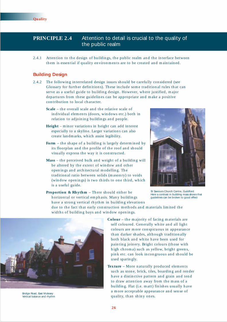
Mass – the perceived bulk and weight of a building willbe altered by the extent of window and otheropenings and architectural modelling. Thetraditional ratio between solids (masonry) to voids(window openings) is two thirds to one third, whichis a useful guide.
Proportion & Rhythm – There should either behorizontal or vertical emphasis. Many buildingshave a strong vertical rhythm in building elevationsdue to the fact that early construction methods and materials limited thewidths of building bays and window openings.
Colour – the majority of facing materials areself coloured. Generally white and all lightcolours are more conspicuous in appearancethan darker shades, although traditionallyboth black and white have been used forpainting joinery. Bright colours (those withhigh chroma) such as yellow, bright greens,pink etc. can look incongruous and should beused sparingly.
Texture – More naturally produced elementssuch as stone, brick, tiles, boarding and renderhave a distinctive pattern and grain and tendto draw attention away from the mass of abuilding. Flat (i.e. matt) finishes usually havea more acceptable appearance and sense ofquality, than shiny ones.
26
Quality
St Saviours Church Centre, GuildfordHere a contrast in building mass shows thatguidelines can be broken to good effect
Bridge Road, East MoleseyVertical balance and rhythm

Design Buildings to Turn Corners
2.4.3 Buildings at the apex of street cornersshould be designed as corner turnunits that face two ways. This willmaintain a continuity of frontage andvisual surveillance (see Principle 5.3).Tailored designs may be neededparticularly where corners are not at a convenient 90° angle.
Consider the setback from the street
2.4.4 The setback of dwellings from thestreet is an important designconsideration. This will help definecharacter and provide a degree ofprivacy to ground floor windows.
Design for public spaces
2.4.5 Buildings can create the structure of public space but it is the detail of materials,street furniture, lighting, security and use of planting that can help transform thespace into a successful place. Some key aspects that need to be considered are:
• Accessibility
• Orientation – sunshine or shade are important to how the space is used
• Seating – where people can rest or socialise
• Places for children to play – not just in designated areas
• Design of pedestrian routes with paths that follow desire lines
• Use of quality and durable surface materials
• Co-ordinate and minimise street furniture and signage to reduce clutter
• Creative use of public art to add interest and quality
• Creative use of lighting and at a pedestrian scale
2.4.6 Useable, quality public space should not be cluttered, particularly bearing in mindthe needs of people with mobility impairments. Careful thought should be givento how the design of the landscape will affect their independence and ability togain access within public space. Tactile paving should be properly integrated intoany scheme, so that it is both functional and co-ordinated with surroundingmaterials. Alternative materials to the traditional red tactile paving are availableand should be considered.
27
Quality
Corner turn building, Reigate

FURTHER INFORMATION
Llewelyn-Davies Urban Design Compendium 2000 Chapter 5 gives more information on design detail in thepublic realm
Hass-Klau, Crampton, Dowland and Nold Streets as Living Space 1999 considers how to encourage morepublic street life in town and city centres with examples from around the world
PRINCIPLE 2.5 Open space should be an integral part of thebuilt environment
2.5.1 The design and location of open space should never be an afterthought andshould be seen as a focus for streets and buildings in the same way as publicsquares. The emphasis must be on quality and a perception of safety as a result ofactivity and surveillance.
2.5.2 Open space should:
• Generally be fronted onto and not backed onto by buildings and visible toensure that vulnerable groups do not feel insecure (unless the objective is tocreate informality and seclusion in keeping with a particular landscapecharacter, see Principle 3.2, or to promote biodiversity)
• Be part of the circulationnetwork for both thedevelopment and wider area
• Have a clear function serving theneeds of the community
• Be robust and adaptable andsuited to a number of uses
• Be accessible to people withmobility impairments
28
Quality
Guildford Park entrance, GuildfordBack garden fences and no through activity provides a poor environment for this open space
LEATHERHEAD HIGH STREETThe enhancement of the public realm is a keyelement in the town centre revitalisation strategy.The scheme comprises:
• High quality surface materials and finishes
• Public art
• Co-ordinated and purpose designed streetfurniture
• High quality and imaginative lighting
Particular care has been taken to ensure theimproved High Street is ‘user friendly’ to peoplewith mobility impairments.

2.5.3 Well located open space can also beseen as part of a wider framework orgreen space strategy that contributesto biodiversity. It can be builtaround natural elements such aswatercourses and landscape featuresas well as features associated withSustainable Urban Drainage Systems(SUDS) (see Principle 4.4).
FURTHER INFORMATION
National Playing Fields Association The 6 Acre Standard (currently being revised) considers all recreationalneeds. It provides guidance on a hierarchy of playspaces and on the location and design of a variety offormal and informal children’s play provision.
PRINCIPLE 2.6 The function and maintenance responsibilities for all land and planting should be clearly identified
2.6.1 A management plan for landscape establishment and ongoing maintenanceshould be included with planning applications, together with details of fundingarrangements. Maintenance regimes could include:
• Adoption by the highway authority under the Highways Act
• Adoption of the drainage and sewerage elements of the scheme (see Principle 4.4)
• Maintenance by the highway or local authority under a commuted sumsarrangement
• Maintenance carried out separately by a bonded management company
• Maintenance carried out by residents through special arrangement
29
Quality
HOEBROOK GLADE, WESTFIELD, WOKINGA development of 20 houses adjacent to the Hoe Valley - alinear open space following the Hoe Stream. The developmentincludes:
• Structural planting using native broadleaf species
• Footpath links to the adjoining open space
• A pond which acts as a hold for stormwater
• Commuted payments to the council to allow for ongoingmaintenance costs
Houses front onto open space, former Caterham Barracks, Caterham

Relevant Regional and Strategic Policies
RPG 9: Q2Surrey Structure Plan Deposit Draft, January 2001: SE3
Implementation Checklist for the Quality Chapter• Does the design of new development indicate how it will be integrated into
the existing and potential pedestrian movement pattern and the physical form of the neighbourhood?
• Does the form and layout of new buildings create well defined streets andplaces with active frontages?
• Does the site provide opportunities to introduce landmarks or create aparticular character and form of development that will help people navigatethrough the local area?
• Is open space logically linked and related to other green space as part of astrategy for the development and enhancement of the green space network in the wider settlement?
• Is the function, ownership, long term maintenance and funding of all openspace clearly addressed?
30
Quality

Introduction
3.0.1 A place with its own identity or character is memorable and appreciated. Surrey isno exception. Building on local distinctiveness is important if quality places areto be sustained and created.
3.0.2 We are now familiar with the standard housing layouts found all over the UK. Theresult is that everywhere could be anywhere. This happens when context is ignored.
PRINCIPLE 3.1 Begin with an understanding of existing character
3.1.1 An understanding of the existing characteristics of the site and area and thefeatures that help define its distinctiveness should be the starting point of gooddesign. This is often referred to as site appraisal. A site appraisal should form thebasis for preparing design options, possibly in a design statement or developmentbrief, or may feed directly into detailed scheme design.
3.1.2 Site appraisal is not simply an inventory of existing features. The appraisal shoulddescribe the historical development of an area and identify the design qualitiesthat will continue to influence the design of all new development.
31
CHAPTER 3
CharacterObjective: To ensure that all development contributes to local
distinctiveness and character
Onslow Village, GuidlfordHedgerows reinforce a close knit street pattern andcontribute to local character
New development that ignores local distinctiveness is often monotonous and unimaginative

3.1.3 Site appraisal can consist of the following:
• Overview of the site’s historic background
• Assessment of the area’s design qualities
• Site constraints
• Opportunities and capacity for development
• Assessment of uses likely to be viable
3.1.4 Local knowledge and perceptions will be invaluable and it is at the stage of siteappraisal that the local community can first participate in the design process (see Principle 1.3).
FURTHER INFORMATION
Urban Design Alliance Placecheck: A user’s guide www.placecheck.com Placecheck is a method of assessing the qualities of a place, showing what improvements are needed andfocusing people on working together to achieve them
Llewelyn-Davies Urban Design Compendium 2000 Chapter 2 ‘Appreciating the Context’ including a CharacterAppraisal Inventory
32
Character
Queen Elizabeth Barracks, GuildfordSite Appraisal – Redevelopment offers the opportunity toprovide new routes based on a network of green space

Site Appraisal Checklist
The following checklist is a guide and contains some key questions that should be asked regardingthe site and its surroundings before design work progresses. Relevant issues will vary according tothe scale and location of development. This list can be adapted and developed to suit circumstances.
Historic InfluencesLocal vernacular: Is this distinctive?Development: How has the site and its surroundings evolved?Landscape: Is the site part of a distinctive landscape (see paragraph 3.2.5)?Settlement form: Is there a clear land use or street pattern?Important features: Are there buildings or features of historic, architectural or townscape value?Archaeology: Does the site contain archaeological features? (Check with County Archaeologist)
Existing Design QualityGeneral design: Does the surrounding area have any particular positive features relating to
street patterns and width, plots, layout of buildings within plots, set backs,building scale and height, planting etc?
Detailed design: Are there important elements relating to vertical/horizontal rhythm, materials,corner treatment, windows and doors, distinctive art and craft and the like?
Development Plan: Is the character of the area recognised as being of special quality?Local perceptions: How do local people perceive the quality and function of the place?
ConstraintsLegal: Are there any wayleaves and easement strips that cannot be built on?Ecology: Are there any features of importance including hedges, streams, ponds
or woodlands that may act as wildlife corridors?Vegetation: Are there trees, hedges or boundary features? Are they historic, what is
their condition and should they be retained?Water: Does the site contain watercourses and has the Environment Agency
been consulted?Development Plan: Are there policy constraints?Viability: Are site conditions likely to impose unusually high construction costs?
Is the proposed mix and density of uses likely to be the most economicbearing in mind local market conditions?
Surroundings: Is there a need to protect the amenity of surrounding housing or dosurrounding uses pose particular problems?
OpportunitiesLocation: Where is the site located in relation to the settlement centre, local centres,
public transport and schools and other amenities?Movement patterns: Where are existing and potential access points to the site? Are there
barriers to movement, particularly for pedestrians and cyclists, that need to be removed?
Focal points: Are there existing or potential focal points which could become importantpublic space, sites for landmark buildings, or be used to locate other featuresor facilities?
Topography: Are there existing slopes, wind shelters, shaded areas which should beexploited to reduce energy consumption and to maximise the quality of the living environment?
Green networks: Is there any open space close to the site? Can it be linked to the site as partof a wider network?
Biodiversity: Are there opportunities for enhancing biodiversity by improving existinghabitats or creating new ones?
Safety: Are there existing public spaces that could feel safer if overlooked by new buildings?
Policy: Does the Development Plan and Government policy offer new opportunities?Views: Are there views into and out of the site that can be exploited?
33
Character

PRINCIPLE 3.2 The design of new development should evolvefrom Surrey’s rich landscape and built heritage
‘New housing development of whatever scale should not be viewed in isolation.Considerations of design and layout must be informed by the wider context,having regard not just to any immediate neighbouring buildings but thetownscape and landscape of the wider locality. The local pattern of streets andspaces, building traditions, materials andecology should all help to determine thecharacter and identity of a development,recognising that new building technologiesare capable of delivering acceptable builtforms and may be more efficient.’
(PPG 3, Housing; paragraph 56)
3.2.1 The design of all new development shouldtake into account the character of the siteand surroundings (the context). This will help ensure that the design of contemporarybuildings evolves from the qualities thatmake many parts of Surrey so distinctive.
3.2.2 Quality contemporary design can incorporatea wide variety of interrelated and legitimateresponses to context:
• Build on the positive. The positive design features of an area should bereinforced such as building lines, scale, street patterns, massing and landscape.Using local historic details, style or use of materials will also add to character ifdone convincingly.
• Continued evolution. Character and local distinctiveness have evolved overtime. This process of change should be encouraged in response to contemporarypriorities such as lifestyle and sustainability issues and the opportunitiesafforded by modern materials and building techniques.
• Creating new character. Where there is little of positive significance to buildon there may be opportunities to create a new local character.
• Planned change. There may be good planning reasons for justifying anoccasional significant departure from context where this is combined with acomprehensive approach to land assembly (see Principle 7.3).
• Copying the past. This can be anappropriate solution but must be done in aconvincing way. Often there is a lack ofunderstanding of the design principles thathave shaped Surrey buildings. The result isa variety of styles and superficial use ofmaterials with no unifying features to givethe development a sense of identity.
Genuine innovation and design quality will contribute to local characterSurrey Institute of Art and Design (SIAD), Farnham
Mix of styles – New development should avoid a confused applicationof architectural styles or inappropriate historic interpretation
34
Character

Surrey Landscape
3.2.3 Surrey’s landscape is varied, reflecting underlying geology, land cover and landuse. A character appraisal has identified 25 separate landscape character areas.These variations in local distinctiveness should be reflected in new development.The density of woodland and hedgerows in Surrey often creates a sense of smallenclosed space and this is a feature which new development should respect. Theretention of important trees and hedgerows, along with new planting, will help to enhance elements of the existing landscape structure.
3.2.4 The transition between new development and the countryside requires carefulattention. Traditionally there would be a gradual transition between the settlementedge and open countryside. The boundaries of extensions to a settlement will bemore clearly defined today but the harmful visual effect of abrupt settlement edgesshould be avoided, particularly where this is in the form of tall urban style fencing,conifer hedges and brick walls. Better integration can be achieved by a combinationof planting to provide selective screening and by allowing some new developmentto face into the countryside with views in and out.
3.2.5 There will be benefits in using native plant species. They not only ‘fit’ with thelocal landscape but they also tend to be more resistant to plant growth problemswith the added benefit of reducing long-term management costs. As well as nativespecies a number ofspecies have beenintroduced into theCounty and are nowcharacteristic of theSurrey landscape.
3.2.6 As in the past, there will continue to beopportunities tointroduce new species as part of a creative andmore ornamentalscheme. Climate changemay also allow newspecies to more readilyadapt to conditions insouthern England thansome native species.
FURTHER INFORMATION
Surrey County Council The Future of Surrey’s Landscape and Woodlands 1997. The County has been dividedinto 25 landscape character areas. This document describes each of these areas and the features that makethem distinctive including locally native tree and shrub species
Surrey Historic Landscape Characterisation Project County wide information on a GIS base which elaboratesupon the above document and provides a valuable insight into how landscape types have developed(intended to be available on the Surrey County Council web site)
35
Character
View from Box Hill

Historic Settlement Patterns
3.2.7 Older settlement patterns developed pre motor car. The presumption that mostjourneys would be made on foot resulted in highly interconnected street patterns.The return to a design ethos that seeks to encourage movement on foot or by bikewill tend to result in similar interconnected streets. This will also help newdevelopment to integrate with, and reflect, the street pattern of the older establishedparts of settlements.
Surrey Building Form and Traditions
3.2.8 Traditional Surrey buildings, aselsewhere, have a simple rectangularform with a pitched roof and centralridge. Roofs span the narrowerdimension, generally up to amaximum of 6.5 metres in width.Where deeper plan forms were used,the scale of the roof was typicallyreduced by using a double roof witha central valley gutter. The pitch andform of a roof follow the practice ofrelating pitch to material – e.g. notless than 47° for clay tiles and notless than 22° for natural slate. Thesimple form could easily be adaptedand extended in a variety of waysand could be ‘stepped down’ a slopeto follow the topography rather thanrequire extensive earthworks.
3.2.9 In recent decades there has been a tendency to design buildings with deep floorplans. This is often appropriate – particularly close to town centres and whenbuildings are part of a continuous frontage and traditional roof pitches may beused as eaves, with a flat section in the centre. However, deep plans can result inoverly dominant and shallow pitched roof forms that appear bulky and alien whenviewed against traditional building materials and styles. This is one of the reasonswhy bungalows can often appear to be inappropriate in rural areas. Narrower planbuildings can often be designed without reducing density or roofs can be designedto span the narrower dimension.
36
Character
BrockhamTraditional simple rectangular form with tile hanging, brick and clay tiles

Materials and Detailing
3.2.10. The following materials, and correct detailing, are those that are particularlyassociated with Surrey’s character. It is not prescriptive. Such details are only one aspect of local character. On occasions they can be disregarded in favour of genuinely innovative design solutions. Attention to materials and detailingshould be seen as an opportunity to enhance the quality and distinctiveness ofnew development. On the other hand a distinctive local character can be dilutedor destroyed by the inappropriate use of materials and detailing, particular onsmaller infill developments in villages. Heavier materials were usually used closeto their origin and therefore a move towards sustainably sourced materials (seePrinciple 4.6) will tend to reinforce local character:
Stone – is the oldest surviving vernacular building material. Early examples mayinclude parish churches and manor houses, but where it was available it becamecommonplace by the eighteenth century. Being heavy, its use was extremelylocalised. It is still available today and its continuing use for buildings, boundariesand hard landscaping close to its source will help reinforce local distinctiveness.
Exposed oak timber framing – with rendered panels has ahistory as long as stone within the county, but survivingexamples are generally 16th or 17th century. There is amarked difference between the Kent style of framing in the east and the Hampshire form in the west, as well asbetween town and country. Timbers of unfinished naturaloak are characteristic of historic Surrey with the blackeningof timbers stemming from the 19th century.
Rendering – is a traditional method of weatherproofingtimber-framed buildings and was once common in Surrey.Fashion dictated that it would have been more common intown locations than in the countryside but this distinctionhas now been blurred.
Tile hanging – belongs essentially to southern counties ofEngland. It was used originally to weatherproof timber-framed buildings, especially outside towns, but by the 19thcentury it had become a decorative finish applied over newbrick buildings. Walls commonly incorporated bands ofshaped tiles, but roofs seldom did. The continued use ofclay tiles in the countryside is a natural progression fromtraditional local building techniques. Surrey hanging tileshave a characteristic orange colour.
Weatherboarding – is found on older timber-framedhouses in the east of the county where the Kentinfluence prevails and on later clap-boarded cottagesrelated to railways. Weatherboarding was generallypainted white on houses. Elsewhere its use was reservedfor timber-framed buildings of lower status such asouthouses, barns and stables where surviving exampleswere generally tarred black.
Brick – has become the dominant building material inSurrey. This change took place in the 17th century inareas without good building stone such as the clayWeald, but was delayed until the 20th century instone districts such as Waverley: brick still remainssubservient to stone in such districts. Surrey clays
37
Character
Timber framing – Charter Quay, Kingston upon Thamesused in a convincing way on a new building
Modern design sits easily against the old in St. Catherine’sconservation area, Guildford

traditionally produced red or orange bricks withindividual bricks being of a single colour but witha range of hues. This is unlike modern ‘multis’which have a darker core and with a lighter rindto the exposed face. A characteristic of east Surreyis the use of blue flared headers in Flemish bondbrickwork. The use of Flemish or English bondcan contribute greatly to any new development.
Horsham slab roof tiles – are the oldest commonlysurviving vernacular roofing material to be foundin Surrey. It should be retained where it survivesbut it is unlikely to feature in new developments.
Clay roof tiles – by the late 18th Century, clay rooftiles superseded thatch and Horsham Stone on allbut the most humble or highest status houses.
Welsh slates – arrived with the canals and railways.Although not a vernacular building material, slatewas extensively used in urban locations close torailways from the C19 but only on roofs with ashallow pitch. Slate, or its manufacturedequivalent, should therefore be used with cautionin rural areas if the traditional distinction betweenurban and rural Surrey is to be maintained.
Detailing of eaves and gables – is treateddifferently around the country. In Surrey theywere traditionally simple with little use ofbargeboards and no boxing in of rafter feet.
Windows – in timber or tile-hung buildings wereflush to the outside face of the building, whereasin masonry buildings they were recessed. Windowsthemselves were traditionally side-hung casements in sub-frames so that fixedand opening lights have the same glazed areas. Later, double-hung sashes becamecommon. Both of these forms are characteristic of not only Surrey, but also theBritish Isles as a whole. The use of top-hung fanlights or hinged sashes dilutesboth the national and local character and should be avoided.
FURTHER INFORMATION
Gradidge The Surrey Style 1991
A celebration of ‘Surrey Style’ based on the County’s historic vernacular. This provides a reference fortraditional Surrey building styles and detailing and how local vernacular was reinterpreted on a large scale inthe 19th and 20th century
R. W. Brunskill Vernacular Architecture 2000
Chilterns Building Design Guide 1999 contains useful general principles about building in rural areas that canbe applied to Surrey. Available from the Chilterns Conservation Board Tel: 01844 271300
38
Character
Mytchett Heath, MytchettExample of modern development using traditionalSurrey materials
Merrow Place, GuildfordAppropriate use of flint on boundary walls. Oftenthe material of boundary walls can be a practicaland appropriate way to mirror the local vernacular

PRINCIPLE 3.3 Distinctive local character and design qualityshould be protected and enhanced
3.3.1 Local design quality and character is an important and valued aspect of Surrey andcan be identified as part of design guidance that focuses on a particular geographicalarea. Such guidance may take a number of forms. However, local quality shouldnot be used to prescribe an historic style and form of new development. It isperfectly possible for modern architecture to be used in a way that builds onestablished local urban design quality.
Village Design Statements and Plans
3.3.2 Villages tend to be less dominated by 20th century development and the scale ofdevelopment is smaller, more intricate and often characterised by locally producedmaterials. The existing design qualities tend, therefore, to be fragile and easilyharmed by development that takes no account of local street patterns and buildingscale and form. For example, the ‘bolt-on’ cul-de-sacs in villages with standard‘anywhere’ house designs have caused particular harm to village environments.
3.3.3 A Village Design Statement offers a positive way to manage change in a village. It should set out clear and simple guidance for the design of all development in avillage, based on the characteristics and qualities that make it distinctive. Far fromlimiting designers to simply copying the past, it can identify the characteristicsthat should inspire new and locally distinctive design. Village Design Statementsshould be produced by the village community with help from the local planningauthority and can be adopted as supplementary planning guidance.
3.3.4 The following objectives have been set out for Village Design Statements by theCountryside Agency:
• To describe the distinctive character of the village and the surroundingcountryside
• To show how the character can be identified at three levels:– landscape setting of the village
– shape of the settlement
– nature of the buildings
• To draw up design principles based on distinctive local character
• To encourage the community to work in partnership with the local planningauthority to implement and develop local plan policies
39
Character
SURREY HILLS JIGSAW PROJECT 2The Jigsaw Project 2 aims to give people who live or work in The SurreyHills Area of Outstanding Natural Beauty an opportunity to identify whatthey value about country lanes and the improvements that need to bemade in the way they are designed and managed.
A best practice design guide will be produced during 2002 which aims to ensure that the management of country lanes is consistent andappropriate to the character of the area.
FURTHER INFORMATION TEL: 01306 879365

3.3.5 Village and Town Plans are now also proposed under the Rural White Paper, OurCountryside: The Future. These are intended to take a broader look at the issues thatface local communities. They will consider not only the need for all newdevelopment to achieve a high standard of design, but also the local services andfacilities required to safeguard the future of the community. Parish Councils willplay a key part in drawing up these plans.
FURTHER INFORMATION
Countryside Agency Village Design – Making Local Character Count in New Development 1996
Rural White Paper Our Countryside: The Future – A Fair Deal for Rural England 2000
Conservation Areas
3.3.6 Areas of special architectural or historic interest will be designated asConservation Areas, and will receivestatutory protection through theplanning process. The definition ofwhat gives them their special qualityshould be derived from an appraisal.This will include an assessment of thecharacter and hierarchy of spaces andthe quality and relationship ofbuildings, trees and other landscapefeatures, together with a justification of the architectural and historic interestof the area. Where character appraisalshave been prepared, they are availablefrom the local authority.
40
Character
THE ELSTEAD VILLAGE DESIGN STATEMENTThe Statement highlights the qualities that resident’s value. It aims to ensure that the design offuture development and change in Elstead is based on an understanding of the village’s past andpresent, that it contributes to the protection and improvement of Elstead’s special character andmaintains the high quality of its environment.
The Statement offers design advice to all thoseconsidering development in Elstead villageregarding:
• Pattern of the settlement and open spaces
• Scale, height and proportion of buildings
• Detailing of buildings and architecturalfeatures
• Treatment of boundaries
• Materials and finishes
• Local highway considerations
• Trees and landscape context
Source: Elstead Village Design Statement; page 4Stacey’s Place, Elstead VillageNew development in Elstead based on the Village Design Statement
High Street, LimpsfieldHistoric Quality in Surrey

Suburban Character
3.3.7 Surrey’s built environment is as much dominated by 20th century suburbandevelopment as historic buildings. It is important that the qualities of the bestsuburban areas are protected as one of the characteristics of Surrey that make itsuch an attractive place to live. Piecemeal development that cumulatively underminesthis character should be avoided. The qualities of these areas can be promotedthrough local plan policies, designations or SPG to give a clear indication of thequalities that give an area its distinct character.
3.3.8 Density alone is not an indicator of design quality and it is important to identifythose special qualities that make an area distinctive. In Surrey there are manyareas of low density residential development where the spacious settings ofindividual houses, large gardens and mature landscapes contribute as much to thepositive character of the area as the buildings themselves. In other suburban areasbuildings may dominate and can provide their own, more urban, design quality.New development should not undermine these features.
41
Character
SUBURBAN CHARACTERPolicies in the Waverley Borough Local Planseek to preserve the special environmentalquality of pre-war residential areascharacterised by:
• Low density landscape setting
• Wide verges and street trees
Wonersh Park, Wonersh
This Area of Good Urban Character asdefined in the Surrey Heath Local Plan2000, aims to protect the built form andcharacter of this predominantly Victorianand Edwardian part of Camberley. It ischaracterised by a distinctive street patternand buildings that front onto the street.
Gordon Road, Camberley

Relevant Regional and Strategic Policies
RPG 9: Q2Surrey Structure Plan Deposit Draft January 2001: SE3, SE4
Implementation Checklist for the Character Chapter• Has the designer carried out a site appraisal?
• Is it clear how the design of the proposed development has responded to site appraisal?
• In what ways does the development help build local distinctiveness?
• Are local materials used in an appropriate way?
• Would the proposed development dilute or destroy locally distinctive andimportant design characteristics?
42
Character

Introduction
4.0.1 Our quality of life and that of futuregenerations depends on the conservationof natural resources. Being wastefulwith natural resources is uneconomic,produces pollution, reduces biodiversityand impacts on climate.
4.0.2 Climate change is considered one of the greatest environmental threatsfacing the world. Following the WorldClimate Conference at Kyoto, the UKGovernment committed itself toreducing carbon dioxide (CO2)emissions by 20%. This cannot beachieved without a radical reduction in the energy wasted in our buildingsand in transport.
4.0.3 There are also strong social andeconomic benefits in adopting a moresustainable approach to development.These include:
• A better quality and healthier living and working environment
• Reductions in cost (particularly when whole-life costs are assessed)
• Improved efficiency and productivity in use
• Minimising the cost of ownership
• Improving corporate image
• Reducing fuel costs
• Providing greater housing choice
4.0.4 Resource issues cut across traditional areas of responsibility. Thus this chapterdeals with issues that concern land-use planning, building control, pollution andenvironmental control. A sustainable approach to development has to be holisticand the planning system has to operate as part of an integrated developmentprocess and is well placed to take a strategic overview of all issues that effectresource use.
FURTHER INFORMATION
Somerset Trust for Sustainable Development (STSD) Planning for Sustainable Development and Construction 2001
This document provides a wealth of information on sustainable development and construction and how topromote it within the Planning Process
43
CHAPTER 4
ResourcesObjective: To conserve energy and water, maintain biodiversity and
reduce waste and pollution
Manor Crescent, Woking – November 2000
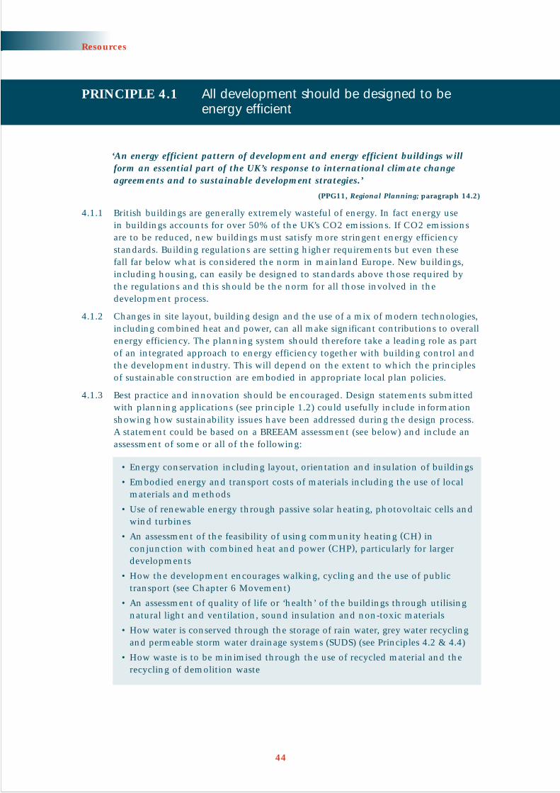
PRINCIPLE 4.1 All development should be designed to beenergy efficient
‘An energy efficient pattern of development and energy efficient buildings willform an essential part of the UK’s response to international climate changeagreements and to sustainable development strategies.’
(PPG11, Regional Planning; paragraph 14.2)
4.1.1 British buildings are generally extremely wasteful of energy. In fact energy use in buildings accounts for over 50% of the UK’s CO2 emissions. If CO2 emissionsare to be reduced, new buildings must satisfy more stringent energy efficiencystandards. Building regulations are setting higher requirements but even these fall far below what is considered the norm in mainland Europe. New buildings,including housing, can easily be designed to standards above those required bythe regulations and this should be the norm for all those involved in thedevelopment process.
4.1.2 Changes in site layout, building design and the use of a mix of modern technologies,including combined heat and power, can all make significant contributions to overallenergy efficiency. The planning system should therefore take a leading role as partof an integrated approach to energy efficiency together with building control andthe development industry. This will depend on the extent to which the principlesof sustainable construction are embodied in appropriate local plan policies.
4.1.3 Best practice and innovation should be encouraged. Design statements submittedwith planning applications (see principle 1.2) could usefully include informationshowing how sustainability issues have been addressed during the design process.A statement could be based on a BREEAM assessment (see below) and include anassessment of some or all of the following:
• Energy conservation including layout, orientation and insulation of buildings
• Embodied energy and transport costs of materials including the use of localmaterials and methods
• Use of renewable energy through passive solar heating, photovoltaic cells andwind turbines
• An assessment of the feasibility of using community heating (CH) inconjunction with combined heat and power (CHP), particularly for largerdevelopments
• How the development encourages walking, cycling and the use of publictransport (see Chapter 6 Movement)
• An assessment of quality of life or ‘health’ of the buildings through utilisingnatural light and ventilation, sound insulation and non-toxic materials
• How water is conserved through the storage of rain water, grey water recyclingand permeable storm water drainage systems (SUDS) (see Principles 4.2 & 4.4)
• How waste is to be minimised through the use of recycled material and therecycling of demolition waste
44
Resources

BREEAM – The Building Research Establishment’s (BRE) EnvironmentalAssessment Method
BREEAM, including its residential equivalent EcoHomes, is a voluntary scheme thatrewards those developers of commercial and residential property who improveenvironmental performance through good design. BREEAM goes beyond BuildingRegulation requirements in order to encourage best practice and includes planningcontrol issues such as building location, transport issues, ecology, health and buildingdesign. BREEAM results in the award of a certificate and detailed report and givesmarketing advantages through a credible label promising energy efficiency, lowerrunning costs and a healthy environment.
BREEAM is a very useful benchmark environmental assessment that could be used insupport of planning applications.
Current publications : Offices - BREEAM 98 for OfficesNew Homes – EcoHomes April 2000
www.bre.co.uk
Layout
4.1.4 Changes in site layout (orientation,location on slope, landscaping) canreduce the energy requirements of atypical dwelling by 20%, throughpassive solar gain and microclimateimprovements.
4.1.5 Passive solar gain takes advantage of natural light and heat from the sun and usesthe wind to assist ventilation. The nearer the orientation is to due south, thegreater the solar gain. In order to optimise solar gain, houses should be orientatedwithin 30° of south. Clearly, this approach needs to be applied flexibly along withother design considerations relating to quality and character. The result maytherefore often be shading or building orientations that do not optimise solar gain.The application of these principles can nearly always produce significant energyconservation benefits when applied in association with high levels of insulation.
4.1.6 The design of buildings and landscape should consider aspects of microclimateand acknowledge the potential for exploiting and influencing these to improveliving conditions and reduce energy consumption. For example planting can bedesigned to provide shade in the summer months and provide shelter and allowlight penetration in winter.
FURTHER INFORMATION
DETR Energy Efficiency Best Practice Programme General Information Report 27 Passive Solar Estate Layoutand Good Practice Guide 73 Energy Efficient House Design – Exploiting Solar Energy
Littlefair et al. Environmental Site Layout Planning 2000
45
Resources
The Greenwich Millennium Village layoutis designed to optimise solar gain anddaylight through the careful placing ofstructures and planting

4.1.7 Detached housing is the leastenergy efficient form, especiallybungalows. Terraced housing andflats are the most energy efficient.Therefore, higher densitydevelopments that use buildingsto enclose space will be moreenergy efficient and at the sametime meet other design principles.
Building Design
4.1.8 Modern building design should seek to exploit renewable energy resources. The following aspects of building design can have a significant effect on energy efficiency:
• Locate rooms that need highertemperatures on the southern side
• Utilise conservatories to maximisepassive solar gain and the conservationof heat (it is important that they areunheated spaces and open into homesonly when warmed by adequate sun)
• Maximise window areas to the south,with smaller window areas to the north
• Make provision for active solar systems(use of photovoltaics and solar panels)
• Aim for high levels of insulation, wellin excess of minima required by theBuilding Regulations
• Consider using thermally massive materials to store heat and release it slowly
• A building that is narrow fronted and deep in plan form (generally above 16metres) will be difficult to light and ventilate naturally. This also affects thevariety of uses that can be accommodated and in turn the building’s robustness
46
Resources
Energy use by house type (assuming equal floor area and orientation) BRE
Detachedhouse
End of terrace
Top floor flat
Centre of terrace house
Centre floor flat
Bill Dunster Architects, Hope House, East MoleseyA Surrey based example of a low energy dwellingmaking best use of passive solar energy throughinnovative design with a high quality living andhome office environment

FURTHER INFORMATION
DETR Building a Better Quality of Life: Strategy for more Sustainable Construction 2000
Developers should take account of this advice when designing and constructing schemes
District or Community HeatingSchemes and Combined Heatand Power Schemes
4.1.9 The use of combined heatand power (CHP) technologyshould be encouraged. CHPutilises the waste heatgenerated during theproduction of electricity toheat or cool buildings.Overall fuel efficiency can beincreased to 70-90%compared to 30-50% withconventional heating andelectricity generation.
4.1.10 Most efficiency is possible when CHP is used to serve a number of local buildingsas part of a community heating scheme. Residential only schemes are quitefeasible and residents can benefit by lower heating/electricity costs. Nevertheless,community heating schemes will work most efficiently when supplying a mix ofnearby residential and commercial buildings because of the diverse heating andelectricity requirements throughout the day.
47
Resources
INTERNATIONAL BUILDING, ROYAL HOLLOWAY COLLEGE, EGHAMHigh level of insulation
Low tech temperature control system and norequirement for conventional air conditioningsystems based on:
• Sliding external louvres over the windowsthat reduce glare AND unlike conventionalblinds prevent heat build up
• Computerised system that allows for air tobe drawn in - ventilates and cools concretefloor slabs during the night to allow themto absorb more heat during the day
• Fan assisted cooling system to cool largeground floor computer rooms - Air is drawninto the room through grills in concretefloor slabs and out through ducters
ECD Architects
CHP uses the heat that is usually wasted when electricity is generated from fossil fuels
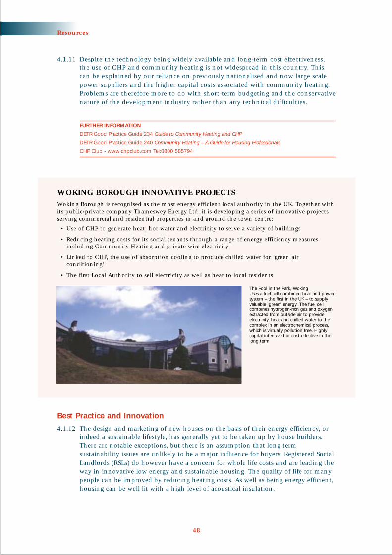
4.1.11 Despite the technology being widely available and long-term cost effectiveness,the use of CHP and community heating is not widespread in this country. Thiscan be explained by our reliance on previously nationalised and now large scalepower suppliers and the higher capital costs associated with community heating.Problems are therefore more to do with short-term budgeting and the conservativenature of the development industry rather than any technical difficulties.
FURTHER INFORMATION
DETR Good Practice Guide 234 Guide to Community Heating and CHP
DETR Good Practice Guide 240 Community Heating – A Guide for Housing Professionals
CHP Club - www.chpclub.com Tel:0800 585794
Best Practice and Innovation
4.1.12 The design and marketing of new houses on the basis of their energy efficiency, orindeed a sustainable lifestyle, has generally yet to be taken up by house builders.There are notable exceptions, but there is an assumption that long-termsustainability issues are unlikely to be a major influence for buyers. Registered SocialLandlords (RSLs) do however have a concern for whole life costs and are leading theway in innovative low energy and sustainable housing. The quality of life for manypeople can be improved by reducing heating costs. As well as being energy efficient,housing can be well lit with a high level of acoustical insulation.
48
Resources
WOKING BOROUGH INNOVATIVE PROJECTSWoking Borough is recognised as the most energy efficient local authority in the UK. Together withits public/private company Thameswey Energy Ltd, it is developing a series of innovative projectsserving commercial and residential properties in and around the town centre:
• Use of CHP to generate heat, hot water and electricity to serve a variety of buildings
• Reducing heating costs for its social tenants through a range of energy efficiency measuresincluding Community Heating and private wire electricity
• Linked to CHP, the use of absorption cooling to produce chilled water for ‘green airconditioning’
• The first Local Authority to sell electricity as well as heat to local residents
The Pool in the Park, WokingUses a fuel cell combined heat and powersystem – the first in the UK – to supplyvaluable ‘green’ energy. The fuel cellcombines hydrogen-rich gas and oxygenextracted from outside air to provideelectricity, heat and chilled water to thecomplex in an electrochemical process,which is virtually pollution free. Highlycapital intensive but cost-effective in thelong term

FURTHER INFORMATION
Building Research Establishment (BRE) Energy Efficiency Office and the Association for EnvironmentConscious Builders (AECB)
The Somerset Sustainable Housing Study The Why, What and How of Sustainable Housing 1999 Available fromThe Somerset Trust for Sustainable Development Tel: 01458 274854
49
Resources
THE BEDDINGTON ZERO ENERGYDEVELOPMENT (BEDZED),BEDDINGTON SUTTONThis is a collaboration between the Peabody Trustand BioRegional Development Group to develop aworking example of urban sustainability. Thedevelopment includes:
• High density housing that maintains high levelsof amenity (including sunlight, external greenroof terraces, gardens and conservatories)
• Office accommodation to encourage localeconomic development and reduce the need for commuting
• Energy efficient design and renewable energysupply to avoid consumption of fossil fuels
• CHP, rainwater collection and grey water recycling
• Provision of integrated transport for residents and workers to reduce dependence on the car
• Provision of advanced IT connections and telecentre
• Simple construction techniques and materials fromlocal sources e.g. brickworks in Cranleigh and Surreyoak cladding from local sawmills (see Principle 4.6)
For more information contact BioRegional Development Group
Tel: 020 8773 2878
www.bioregional.com or www.bedzed.org.uk
The architecturecould be adaptedto suit otherlocations in Surreywithout significantlycompromising onenergy conservationobjectives
THE INTEGER MILLENNIUM HOUSEThe Integer project is a holistic approach to innovation inhousing that has resulted in more rapid construction and bettervalue. There was a high degree of off-site fabrication includingpre-cast concrete, timber panel superstructure, commercialglasshouse conservatory and pre-fabricated bathroom modules.This reduced waste and the need to cut materials on site. Thecomplete structure including bathrooms was erected on site in aperiod of less than a week, enabling trades people to carry out their work within a dry building shell.
www.integerproject.co.uk
Bill Dunster Architects

Managing Light Pollution
4.1.13 Light “spillage” is an increasingly recognised source of pollution and is wasteful ofenergy. The aim should be to light only the area required and to an intensity andquality fit for the purpose. It is important that sufficient light is maintained in theintended direction for visibility and security reasons but modern technology meansthat street lighting can be designed to minimise both light spill and energy use.
FURTHER INFORMATION
Guidance Notes for the Reduction of Light Pollution Available free from the Institute of Lighting Engineerswww.ile.org.uk
PRINCIPLE 4.2 Water should be used efficiently
4.2.1 Peak demands for clean piped drinking water in Surrey will be increasinglydifficult to meet as a result of increasing per capita consumption, more housingand the implications of climate change. The provision of piped water also requiresexpensive infrastructure and considerable storage provision.
4.2.2 New houses can easily includemeasures designed to reduce wateruse, reuse water and make use ofrainwater. For instance,bath/washing machine/dishwasher(‘grey’) water can be recycled,stored in a reservoir and used forflushing toilets, in the garden orfor washing cars. More recentlythe term “Green Water” has beendeveloped. This is defined as wastewater that has been treated. It haswider uses including toiletflushing, horticultural irrigationpurposes, laundries, industrialprocesses or washing,heating/cooling functions.
4.2.3 New properties can also be fittedwith a water butt/undergroundtank for collecting rainwater foruse in the garden. There are also systems availablethat can supply up to 50% of household needs.Rainwater is collected, stored, possibly mixedwith ‘grey’ water and, after filtration andcleaning, made available for a variety of domesticpurposes as ‘green water’.
50
Resources
The reuse of water and use of rainwater can reducetap water demand by up to 50%

PRINCIPLE 4.3 Existing landscape and habitats should beretained and wildlife enhanced
4.3.1 Existing watercourses and well-formed landscape features such as hedgerows andtrees help to maintain local biodiversity and contribute to local character (seeChapter 3). First preference should always be to integrate new developmentaround such features. ‘Ancient Trees’ and hedgerows are particularly important.
4.3.2 A site appraisal should identify landscape features to be retained. This should alsoinclude identification of Tree Preservation Orders, Planning Conditions andConservation Area designations affecting the site as well as any legal obligationsthat relate to tree retention and replacement. A qualified arboriculturalist shouldcarry out tree surveys.
4.3.3 Established urban environments can often be rich in plant species and wildlifeand in all new developments opportunities should be sought to maintain andenhance biodiversity. Wildlife corridors can be provided as part of an overallframework of green space to include open space, water courses (including SUDS –see Principle 4.4), landscape features and transport corridors.
FURTHER INFORMATION
Surrey County Council Wildlife on your Doorstep A Biodiversity Action Plan for Urban Surrey 2000
Surrey is the most urbanised of English shire counties. Surrey County Council together with the SurreyWildlife Trust, The Environment Agency, English Nature and others, have produced Wildlife on your Doorstepas part of the Surrey Biodiversity Action Plan. This plan aims to ensure that all new developments safeguardexisting wildlife where possible and always create new provision for wildlife
PRINCIPLE 4.4 All development should prevent waterpollution and flooding, conserve groundwaterand improve water habitats
‘Local planning authorities should work closely with the Environment Agency,sewerage undertakers, navigation authorities and prospective developers toenable surface-water run-off to be controlled as near to the source as possible bythe encouragement of sustainable drainage systems.’
(PPG25, Development and Flood Risk; paragraph 42)
4.4.1 Sustainable Urban Drainage Systems (SUDS) is the term used to refer to a range ofdifferent drainage systems that provide an alternative to traditional piped surfacewater drainage systems. Surface water run-off from impermeable surfaces, drainingdirectly to watercourses through pipes, produces considerable environmental damage:
• Water quality is harmed by surface contaminants such as dust, oil and litter
• Risk of flooding will be increased due to sudden peaks in water runoff. Thismay require large scale engineering solutions to reduce the risk
• Impermeable areas reduce water infiltration and can reduce groundwater levelsto the detriment of established vegetation
• Habitats in watercourses can be damaged by sudden increases in water flow
51
Resources

Resources
52
4.4.2 SUDS reduce the potential for flooding and improve water quality, resources andbiodiversity. There are a range of design options that can fit into almost anysetting and should be considered by developers early in the design process:
• Source control techniques - based on the principle of capturing water near tosource and allowing direct filtration into the ground e.g. soakaways, porouspavements and infiltration trenches and basins
• Permeable conveyance systems -move run-off water slowlytowards a watercourse allowingstorage, filtering and some lossthrough evaporation andinfiltration e.g. French Drainsand Swales
• Passive treatment systems - usenatural processes to remove andbreak down pollutants fromsurface water run-off e.g.detention basins, retention pondsand wetlands with or withoutreed beds. Reed beds can also bea reliable method for dealingwith domestic sewage
4.4.3 By making water a feature rather than being hidden underground, drainagesystems can be used to add to biodiversity, provide wildlife corridors and generallyimprove the visual quality of new developments.
FURTHER INFORMATION
For further information see CIRIA publications:
Sustainable urban drainage – design manual for England and Wales
Sustainable urban drainage – best practice handbook
The Environment Agency can provide site specific advice on the use of SUDS
Reigate and Banstead Borough Council Horley Design Guide This is a detailed design guide for thedevelopment of some 2,600 houses at Horley. It advocates grey water recycling and the use of rainwaterbutts, grass swales, porous paths and drives, ponds and storm water wetlands and reed beds for thetreatment of run-off
Willow Bank, WestfieldExample of a storm water storage pond

PRINCIPLE 4.5 Buildings and building materials should bereused and recycled
4.5.1 On redevelopment sites it is possible to reuse materialssuch as bricks and lintels in their entirety. Othermaterials can be crushed and used as hard-core in the construction of roads and other hard surfaces.Where materials are reused to create an historiceffect, careful selection of materials and crafts peoplewill be necessary. If it is not possible to reuse materialsfrom the site, it is suggested that opportunities forusing recycled materials are explored (refer also to theBRE Materials Exchange at www.cig.bre.co.uk/waste).
4.5.2 The Government has set a target for 60% of all newhousing to be built on previously developed land,known as ‘brownfield sites’. It is more sustainable toreuse previously developed land within urban areasthan it is to develop on greenfield sites. It is also moresustainable to convert existing buildings, if they arecapable of conversion, than it is to redevelop.
4.5.3 With eventual reuse in mind,new buildings should be versatileor robust enough to cater for anumber of different occupiersand be accessible and capable ofconversion from the start. Officesthat are deep in plan form arethe least versatile of all buildingsbecause they are not readilyconverted to other uses,especially residential use. TheBuilding Research Establishment(BRE) defines ‘deep plan’ ashaving a total building depth of greater than 16 metres. Deepplan buildings tend to haveinsufficient natural light andventilation to readily supportconversion (see paragraph 4.1.8).The avoidance of load bearinginternal walls will also facilitatefuture internal flexibility.
53
Resources
The relationship between plan form, ventilation and natural light
The Rodboro Buildings, GuildfordOlder buildings are a valuable resource and canconvert to completely new uses, in this caseoffices and a pub

Resources
54
PRINCIPLE 4.6 Building materials should be sustainably sourced
4.6.1 The energy used in transporting materials is a major component of the overall energyand CO2 efficiency of construction. Materials should be sourced locally or regionallyif at all possible. Locally sourced materials have the added benefit of helping thelocal economy and reinforcing local identity and character (see Principle 3.2).
4.6.2 Embodied energy is the energy used in obtaining the raw materials andmanufacturing a product. Materials such as PVC and aluminium use up to 50times as much energy to produce as wood. In general, materials with very highembodied energy should be avoided or their use minimised. However this willneed to be assessed in conjunction with energy used in transport of a material, its maintenance costs and estimated life span.
4.6.3 Much greater use of sustainably managed and renewable organically grown timber and materials from plants (oils, fibres, etc.) is an important move towardssustainable construction.
4.6.4 Off-site fabrication uses less time and materials, can lead to better quality controland less construction waste. However, it can result in greatly increased deliverydistances. There is potential for conflict here and the environmental benefits ofusing locally sourced materials as compared with the benefits of off-site fabricationneed to be addressed, if appropriate as part of an environmental impact assessmentand sustainability statement.
FURTHER INFORMATION
BRE The Green Guide for Housing Specification April 2000. A simple reference aid to the environmentalimpacts of materials and components commonly used in house building
Association for Environment Conscious Builders (AECB) – an excellent source of information
Kent County Council Kent Design: The Directory 2001 is a guide to sustainable construction products andservices for Kent, but contains useful general information and will be of particular relevance to East Surrey
Relevant Regional and Strategic Policies
RPG 9: INF2 INF4Surrey Structure Plan Deposit Draft January 2001: SE1 SE2 SE5 SE7 SE8 SE9
Implementation Checklist for the Resources Chapter• Does the design statement required by PPG1 contain a ‘sustainability
statement’ to show how the design has responded to the need to minimise the use of scarce resources including water and energy?
• Does the layout of the development and design of the buildings take accountof the potential to exploit natural light, heat and ventilation?
• If buildings are close together can they be joined to improve energy efficiency?
• Has landscape design taken into account the benefits of modifyingmicroclimate to improve living conditions and enhance energy efficiency?
• Has the feasibility of using combined heat and power and district heatingschemes been assessed?
• Are existing landscape features and ecological resources retained and/orenhanced? Are there opportunities to improve biodiversity?
• Are Sustainable Urban Drainage Systems (SUDS) used in preference to pipeddrainage to watercourses?
• Is maximum use made of existing buildings and is demolition material to be recycled?

Introduction
5.0.1 Good design should always be about designing for people. In this section specificdesign issues are dealt with that can particularly help to build communities. Theterm community is used here to refer to a sense of local identity, ‘neighbourliness’and shared ownership.
PRINCIPLE 5.1 Good design should encourage a mix of usesappropriate to the location
5.1.1 In recent decades there has been an over emphasis on zoning different uses, theeffect being to discourage movement other than by car and create public areasthat are often empty and unwelcoming to the pedestrian. Many modern uses arecompatible side-by-side and can form part of a wide mix of activities within aperimeter block system. Uses can also vary over time. For example, an area or abuilding can cater for office uses during the day and social or cultural uses in theevening. A mix of uses can occur within the same building or within adjacentbuildings, although it is important to ensure that it does not reduce the quality of life of residents.
5.1.2 A greater mix of uses in an area can have the following benefits:
• Encourage activity throughout theday and evening
• Reduce the need to travel by car towork and local facilities
• Encourage a greater mix of peopleand a feeling of safety with ‘eyes onthe streets’
• Encourage greater energy efficiencyand more efficient use of space andbuildings, due to the spacerequirements of different uses
• Provide more opportunity for socialinteraction
• Increase the vitality of local centres and town centres
• Increase shared use of car parking
55
CHAPTER 5
PeopleObjective: To encourage vibrant and mixed communities where
people feel safe
Mixed uses withina perimeter block

5.1.3 An appropriate mix of uses will clearlyrelate to location with, in general, agreater variety and scale of uses closerto town or neighbourhood centres.
5.1.4 Home working can help reducecommuting and encourage daytimeactivity and surveillance in residentialareas. In new housing, purpose designedoffice accommodation can be provided.It may be better to provide flexibleaccommodation that allows for theadaptation of living or storage spacefor office use (such as roof space,garages, cellars – see Principle 7.4).
PRINCIPLE 5.2 Good design should incorporate a mix ofhouse types and tenure
‘Local planning authorities should encourage the development of mixed andbalanced communities: they should ensure that new housing developments helpto secure a better social mix by avoiding the creation of large areas of housing ofsimilar characteristics.’
(PPG3, Housing; paragraph 10)
5.2.1 New residential developments should include a range of house types and sizes that will be attractive to a broad cross-section of the community and appeal to a variety of future occupiers.Housing of mixed size and type will help encourage daytime andevening surveillance.
5.2.2 Mixed tenure is promoted by nationalpolicy to avoid social ghettos.Affordable housing should be integratedinto new development and not beobvious through location, segregationor the design and style of buildings.
FURTHER INFORMATION
Surrey Local Government Association Housing toUnderpin Economic Success September 2001
56
People
Flexible accomodation within a dwelling
Caterham-on-the-Hill, CaterhamAffordable housing and market housing side by side

5.2.3 A variety of house types may also help to achieve specific design objectives. Forexample, it may be possible to achieve a strong sense of enclosure (see Principle2.2) through the use of smaller dwellings at corners and above archway entrancesto rear parking courts.
PRINCIPLE 5.3 All public space should feel safe
5.3.1 The layout of any new estate is a fundamental issue in determining the susceptibilityto crime. The emphasis should be on activity and visibility. In general, as activity,visibility and hence surveillance increase, crime and fear of crime decrease.
5.3.2 The following design objectives will help deter crime and increase the perceptionof safety:
• Permeability (i.e. the choice of routes)should be a paramount objective in thelayout of new developments to encouragewalking and reduce car dependency.Where they are incorporated into a newdevelopment, cul-de-sacs should be linearand not introduce ‘internal’ surveillanceat the expense of surveillance of the mainfeeder street
• Dwellings and workplaces should bedesigned to front onto streets withentrances onto it and windows located tomaximise overlooking (see Principle 2.2)
• Non-vehicular routes through an areashould be designed so that they will bevisible, clear, direct, busy and lit
• Neighbourhoods should be designed so that visitors feel they are entering an area that is watched over by residentsand those working in local businesses
• Public or semi-public areas should bevisible from nearby buildings or wellused rights of way
• Open parking should be visible byowners of vehicles or neighbours
• Superfluous and secluded access and‘rear alleys’ should be avoided
57
People
Central DorkingGated estates – Provide internal security but do little to promote wider feelings of safety and community or enable pedestrian links with the surrounding area
Poundbury, DorsetBuildings, doors and windows should front access routes

People
5.3.3 The whole of the public realm within neighbourhood areas should be seen as apotential play and recreation area. However the safety of all users should be aparamount consideration. Historically, communities made great use of the outdoorenvironment. For example, street play was an important part of a child’s developmentand understanding of the world. Spontaneous street play is now often confined to older children, if it happens at all, due to fears of crime or accidents. Given theopportunity, children will use the whole of an estate or neighbourhood for playincluding streets and informal spaces and not just special play facilities (seePrinciple 2.5).
FURTHER INFORMATION
Bill Hillier and Simon Shu Crime and Urban Layout: the need for evidence
In Ballintyne et al Eds Secure Foundations: Key issues in Crime Prevention, Crime Reduction and CommunitySafety 2000. This research questions the justification for the recent emphasis on cul-de-sacs in preference to the traditional street
58
Police Architectural Liaison
The Police Architectural Liaison Officer will advise applicants andthe planning authority during the design and planning applicationprocess. Early consultation is recommended.
Designing Out Crime at the planning stage is a comparatively recentdevelopment in crime prevention, but growing evidence shows thatsecurity can be incorporated into the design and layout of a projecteconomically. Police crime prevention officers have extensiveknowledge of criminal behaviour and can use this knowledge toprovide advice to architects, planners and developers involved in new developments and in refurbishment of existing buildings.
Contact: Force Architectural Liaison Officer, Surrey Police, Tel: 01483 571212

PRINCIPLE 5.4 There should be a clear demarcation betweenpublic and private space
5.4.1 There should always be a clear demarcation betweenpublic and private space. This is best achieved bydesigning buildings with a public frontage facing the street. This approach leads to a layout based on perimeter blocks (see Principle 2.2), with a clear distinction between public and private areas.
5.4.2 At a more detailed level, effective demarcation can be achieved through the use of barriers ranging frombuildings to walls, planting, railings and fences orthrough definite changes in surface treatment such as block paving and cobbles. Street surveillance isimportant (see Principle 5.3) so consider using railings,low barriers and low growth shrubs or changes insurface treatment, rather than high barriers, unless it is desirable as an exceptional design solution.
5.4.3 Private areas should be secure and not open to entryfrom secluded areas. It is generally safer for the reargardens of houses to back onto other gardens ratherthan streets, service roads or footways. Where rearparking is provided this should be made as secure aspossible through natural surveillance or by providing entrance gates.
Relevant Regional and Strategic Policies
RPG 9: Q2, H4Surrey Structure Plan Deposit Draft January 2001: DN11
Implementation Checklist for the People Chapter• Has the Police Architectural Liaison Officer been consulted?
• Do all public spaces, including footpaths and cycle routes have naturalsurveillance from surrounding buildings?
• Is movement choice maximised particularly for cyclists and pedestrians?
• Is affordable housing integrated into the design and layout of the developmentsuch that it is not obviously set apart from market housing?
• Where provided, are cul-de-sacs a logical response to the site’s developmentwithout compromising the choice of routes and wider surveillance?
• Is there a mix of residential building types and tenure that will encouragesurveillance and activity throughout the day?
• Have a mixture of uses been encouraged appropriate to the location, including workspace linked to individual dwellings, to promote street activity and vitality and to reduce the need to travel?
• Is there a clear definition between public and private space?
• Are back gardens secure?
• In neighbourhood areas can children play safely in all public space?
59
People
Traditional street scene where there is a cleardemarcation between public and private space

Introduction
6.0.1 The aim of good design is to ensure that development is accessible to all by a choiceof transport modes. In all situations the emphasis must be on creating places andstreets for people, rather than on design solutions that are rigidly tailored to themovement and parking requirements of vehicles. To ensure residential and mixeduse streets are as safe as possible for all users they must be generally designed tokeep vehicle speeds below 20mph.
6.0.2 This section is supported by a Technical Appendix, which contains detailedtechnical engineering information, including geometric design and pavementspecifications. It will contain a range of options that can be applied, depending on the circumstances of a particular development.
FURTHER INFORMATION
Institute of Civil Engineers Designing Streets for People 2001 a report explores ways of designing streets forpeople in a co-ordinated way. www.icenet.org.uk/streets
PRINCIPLE 6.1 The emphasis in design will be on pedestrians,people with mobility impairments, cyclists andpublic transport
‘New development should help to create places that connect with each othersustainably, providing the right conditions to encourage walking, cycling and theuse of public transport. People should come before traffic.’
(PPG 13, Transport; paragraph 28)
6.1.1 Previous design guidance in Surrey waswritten with the primary aim of safelyaccommodating the car by restrictingtraffic speeds. Cars will no longer haveprecedence. Access to developmentsshould be considered with reference to the user access hierarchy.
60
CHAPTER 6
MovementObjective: To create places for people that are safe and easy to
move through and are accessible to all

User Access Hierarchy1. Pedestrians and people with mobility impairments (e.g. using
wheelchairs, buggies)1
2. Cyclists
3. Public Transport
4. Service Vehicles
5. Private Cars
6.1.2 All proposals are expected to follow this hierarchy, although public transportinfrastructure will generally only be required on larger sites. Pedestrian and cycle links to existing bus routes, stations and facilities are important in all sizes of development.
Pedestrians and Cyclists
6.1.3 Pedestrians and cyclists should have a convenient and direct route to localfacilities (such as schools, shops,surgeries etc.), respecting desire linesand surrounding movement patternsand taking into account the safe routes to school programme (see Technical Appendix).
6.1.4 The preference should always be todesign street patterns and buildingblocks around these routes with carsincorporated in a way that does notproduce conflict. In this way theenvironment for pedestrians and cyclists will be safer and more pleasant and theadvantage of the car, especially for local journeys, will be reduced. Pedestrians andcyclists should have priority at junctions and where appropriate this will be reflectedin the use of raised junctions. Where separate routes are provided for pedestrians andcyclists, these should ideally be part of the street pattern, overlooked and well lit.
61
Movement
Raised junctions
A Consider how site can be best connectedwith nearby main routes, public transport and local schools and facilities
B Maximise integration and movement choicewith direrct links particularly for pedestrians and cyclists
C Use this pattern as a basis for building blocksto create streets which will positively enhancethe public realm (see principle 6.2)
1. Subsequent reference to pedestrians and travel on foot includes people with mobility impairments
Source: Urban Design Compendium

6.1.5 A lattice network of routes effectively divides an area into blocks (see Principle 2.2).The emphasis is on roads that lead somewhere and so improve movement choice,particularly for pedestrians and cyclists. Small blocks give a greater choice of routesthan large blocks, and will be most appropriate where the need for interconnectivityis greatest near to town or local centres. Cul-de-sacs can be incorporated into gooddesign but they should be added to a lattice form of layout and not be a substitutefor it. However many smaller sites, cul-de-sacs and private drives are likely to remainthe only practicable solution.
6.1.6 Secure convenient cycle storage is as important as providing safe cycle routes.Developers should therefore ensure that there are secure cycle storage facilities in all developments.
Public Transport
6.1.7 The DTLR suggests that no property should be morethan 400m walking distance from a bus stop. This willnot be applied rigidly, but developments should aimto connect to, or create, a good bus corridor linkedinto existing networks. The technology exists for theconstruction of bus-only links within developments.Cars can be prevented from travelling through a site(rat running) and forced to take a less direct route,whereas buses can travel directly through.
6.1.8 Provision of a bus stop does not consist of just a polewith a board on it. They must be accessible to peoplewith mobility impairments, provide shelter andinformation and allow easy access to low floor buses.The trip to the bus stop needs to be considered aspart of the whole journey and designed as such, withsafe and convenient routes to bus stops accessible toall users.
6.1.9 Larger developments will provide opportunities for improvements to bus and railservices and infrastructure. These may include improvements to existing orprovision of new bus stops and stations. Smaller developments may be expectedto contribute towards CCTV, better lighting, improved timetable information etc.
Caterham-on-the-Hill, CaterhamA bus service linking the site to Caterham stationand other local facilities is funded through a servicecharge levied on new residents on the site
FASTWAY, HORLEY
A new high quality bus route designed to provide anattractive, reliable and realistic alternative to the private car.The service will link new development planned in Horleywith railway stations, Horley and Crawley town centres, andGatwick Airport. ‘Fastway’ will include:
• Fully accessible, air-conditioned, low noise and low emission buses
• Bus lanes, bus priority and guided busways
• Real time passenger information
• Raised kerbs and comfortable bus shelters at stops
• High frequency service
62
Movement

Movement
63
PRINCIPLE 6.2 The layout of the highway is only one design consideration
6.2.1 Over recent decades, design of thehighway and parking has takenprecedence over other designconsiderations. These criteria cannotbe ignored. However, the form andgrain of the built environment,pattern of streets (rather than a roadhierarchy based on the car) and theenclosure of space must also be givenequal weight and considered at theoutset of any new development.
6.2.2 Highways are laid out to achieve theobjectives listed below. It is possibleto achieve these objectives in a waythat does not conflict with otheraspirations of good design. This canbe done by applying the highwaydesign principles in a creative and flexible way. It is important to ensure, however,that safety standards are not compromised.
Highway Design Objectives:• Provide safe and convenient pedestrian and cycle routes and accessible public
transport facilities
• Create safe routes for vehicles, including buses, minimising the danger andnuisance from through traffic
• Keep vehicle flows and speeds low near dwellings
• Accommodate on-street parking whilst reducing danger to pedestrians andenabling access to emergency and service vehicles
A typical cul-de-sac where the road system takes precedence and dictatesthe location of houses

Highway Design Principles:• Highway design should not dictate urban form. Designers should exploit
the minimum appropriate technical highway solution for any given location
• Traffic speeds should not exceed 20mph. This can be achieved through the use of speed control features and through limiting straight lengths of road
• The pattern of streets is likely to resemble a highly interconnected lattice. Cul-de-sacs should be added to a lattice layout rather than being the predominant form
• Residential layouts should discourage through movement of private vehiculartraffic unconnected with the site or immediate neighbourhood
• Layouts should allow for necessary direct pedestrian and cycle movementacross the site, such as to schools, local shops, employment, public transportand community facilities
• Roads providing direct access to dwellings will generally be flanked byfootways unless specifically designed as surfaces shared by vehicles, pedestriansand cyclists. Shared surfaces are preferred where vehicle speeds are low,pedestrians are few and design/layout considerations allow
• Minimum widths for vehicular passage are determined by traffic flow. The minimum width should not usually be exceeded
64
Movement
Master Plan, Oakwood Hospital Site, Maidstone – PRP ArchitectsHighway design objectives and principles are used flexibly to create streets and squares based on: • Perimeter blocks• Lattice street system• Built in speed restraint• A mixture of on-street and rear parking courts

PRINCIPLE 6.3 Speed restraint should be incorporated into design
Highway Safety
6.3.1 Within neighbourhoods all development should be designed to ensure that trafficspeeds do not exceed 20 mph. Within larger developments there will be exceptionsto this general rule and streets that serve a wider traffic distribution function canhave a design speed of 30mph.
6.3.2 Speed restraint is best achieved through layout design at the earliest stage in thedevelopment process. This can be achieved through a combination of buildings,landscape and junction design with the emphasis being as much on urban designas car use. The following methods can be used to reduce speed (for further detailssee Technical Appendix):
• Tight bends rather than sweeping curves
• More frequent junctions
• Reduce straight lengths of road forbuilding up speed
• Buildings, walls, trees and hedges closeto the road
6.3.3 Vertical features such as humps and tablesshould only be used to traffic calm existingstreets or to solve specific problems thatcannot be dealt with in other ways. Forexample, to provide pedestrian priority atjunctions. In general avoid more obviousmeasures such as speed control islands and chicanes.
FURTHER INFORMATION
More detailed information is providedas part of the Technical Appendix
The Surrey County Council Highwaysexperts will advise practitioners as tothe adequacy and options for speedrestraint within the highway
65
Movement
Caterham-on-the-Hill, CaterhamHere an engineering solution dominates (speed control bendwith forward visability) to control speed rather than junctionsand buildings
Built in speed restraint – junctions, squares and buildings can keep vehicle speeds low

Movement
66
Home Zones
6.3.4 ‘Home zones’, broadly based on the Dutch Woonerf principle, may be consideredas a way of encouraging an attractive and safe on-street residential environmentwhere priority is given to pedestrians and cyclists. Home Zones will be mostapplicable in redevelopment areas where the existing road layout is to be retained.For more information see the Technical Appendix.
PRINCIPLE 6.4 Car parking should not dominate or overlyinfluence urban form
6.4.1 The overall parking requirement will be set by the Local Planning Authority, whoshould be consulted on parking requirements before and during layout design.The aim should be to minimise parking provision in accordance with use, locationand adopted standards. Where appropriate, parking should be designed so that itcan be used by different user groups throughout the day. The needs of disableddrivers must always be taken into account and may require special design solutions.
6.4.2 As with the general highway layout,parking should not dictate urban form.The emphasis should be on using a rangeof design solutions to accommodateparking. Parking that is situated in frontof buildings, such as in front of integralgarages, will require buildings to be setback and therefore tend to make theenclosure of space more difficult. Thesolution is to bring buildings forward andlocate parking between, beneath or to therear of buildings. This does not precludeon-street parking and is the most spaceefficient solution. On-street parking canbe designed into a scheme, often performing an additional traffic calming function.
6.4.3. The location of car parking is important to the success of a scheme. It is thegeneral expectation of car owners that they should be able to park as close to theirdestination as possible, preferably within view. If there is not suitable spaceavailable, residents will often park on verges and even on footways.
Parking should not dominate

Movement
67
On-street parking
Benefits• Good surveillance
• Flexible and efficient use of land
Design Issues• Needs careful design to create
streets and places rather thancar parks
• Can conceal pedestrians so it is important that on-street parking is only introducedin an environment where traffic speeds will be low
• On-street parking can be accommodated in parking squares where the road opensout to incorporate parking at right angles to the carriageway and to allow other usesin the street. Care should be taken to ensure parked cars do not dominate thesurroundings. Such an arrangement will not generally be appropriate for roadsaccommodating traffic generated by more than 200 dwellings
On-street parking in a new development
Parking within the curtilage
Benefits• Control and security
• Can enable efficient use of landwhere a second open parking space isallocated to the rear garden and onlyprovided when necessary
Design Issues• Parking may be seen as an intrusion to
rear garden of dwelling and thereforeis best combined with wider gardens
• Inefficient use of space
• Needs to be combined with adequatevisitor parking possibly on-street
• Integral garages should not dominateand thus ‘deaden’ a street frontage
Different design solutions including flexible parking
Black Notley, BraintreeEntrance to rear parking through archway

Movement
68
Parking court, Claygate Village, EsherSurveillance and quality
Rear parking – Poor surveillance, poor quality
Rear Parking Courts
Benefits• Economical of street frontage and
therefore enables buildings to dominatestreet with continuous frontages
Design Considerations• In residential areas should be relatively
small scale to avoid visual dominanceand nuisance
• Maximise security through surveillanceand/or gates within a street block
• Aim to create attractive places
• Front doors should face the street and not theparking court to maintain active street frontages
Traffic Free Environments
6.4.4 The provision of traffic free environments should be encouraged in appropriatelocations subject to provision for emergency vehicles and people with mobilityimpairments. In most situations parking will still need to be provided around theperiphery of the development. This will only be manageable where overall parkingprovision is reduced to significantly less than the maximum standard in locationswith good public transport accessibility.
Rear court showing surveillance
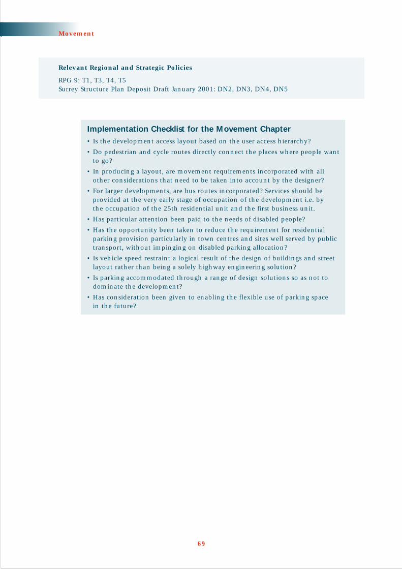
Movement
69
Implementation Checklist for the Movement Chapter• Is the development access layout based on the user access hierarchy?
• Do pedestrian and cycle routes directly connect the places where people wantto go?
• In producing a layout, are movement requirements incorporated with all other considerations that need to be taken into account by the designer?
• For larger developments, are bus routes incorporated? Services should beprovided at the very early stage of occupation of the development i.e. by the occupation of the 25th residential unit and the first business unit.
• Has particular attention been paid to the needs of disabled people?
• Has the opportunity been taken to reduce the requirement for residentialparking provision particularly in town centres and sites well served by publictransport, without impinging on disabled parking allocation?
• Is vehicle speed restraint a logical result of the design of buildings and streetlayout rather than being a solely highway engineering solution?
• Is parking accommodated through a range of design solutions so as not todominate the development?
• Has consideration been given to enabling the flexible use of parking space in the future?
Relevant Regional and Strategic Policies
RPG 9: T1, T3, T4, T5Surrey Structure Plan Deposit Draft January 2001: DN2, DN3, DN4, DN5

Introduction
‘The problem with parts of English towns and cities - particularly the rebuiltareas of the 1960s and the car based suburbs of the 1980s and 1990s - is thatdensities are just too low.’
(Urban Task Force Report)
7.0.1 Land suitable for development is a particularly valuable and scarce resource inSurrey. The challenge is to achieve quality development whilst increasing netdensity. This will require a design-led approach to enable the benefits of urbanliving to be maximised and to ensure that:
• It is in the right location with access to jobs, shops, entertainment, servicesand community facilities
• It is firmly based on a strong urban design form
• Where the existing urban structure or local character is of value it is not harmed
• The potential space within buildings is used effectively
• The vitality and safety of urban centres is enhanced
• Car parking is reduced where appropriate
• Mixed uses are promoted, particularly in town centres
PRINCIPLE 7.1 The appropriate density of development willdepend on accessibility and character ofsurrounding development
7.1.1 Good design will open up opportunities for quality higher density and mixed use development. However, the designer must make decisions regarding the form and scale of development based on location of the site. This will beinfluenced by consideration of the site’s accessibility and on the character of surrounding development.
Accessibility considerations
‘By shaping the pattern of development and influencing the location, scale,density, design and mix of land uses, planning can help to reduce the need totravel, reduce the length of journeys and make it safer and easier for people toaccess jobs, shopping, leisure facilities and services by public transport, walkingand cycling.’
(PPG13, Transport; Paragraph 3)
70
CHAPTER 7
LandObjective: To make best use of the available land

7.1.2 Town centres with good public transport access anda mix of facilities offer the best opportunities toaccommodate higher density development whilstreducing the need to travel by car. A 5-10 minutewalking time to facilities is generally accepted asreasonable, depending on the destination. It iswithin this area close to town centres that a rangeof mixed use higher density development can makemost efficient use of land and maximise access toservices and facilities for all users and residents.
FURTHER INFORMATION
Llewelyn-Davies Sustainable Residential Quality in the South East –Final Report October 1998 and Sustainable Residential Quality:Exploring the Housing Potential of Large Sites 2000 for moreinformation on pedestrian accessibility to facilities (the ‘ped-shed’)
7.1.3 In urban areas more remote from public transportroutes and interchanges or on the periphery of settlements, progressively lowerdensities may be appropriate. Lower density development at the settlement edgecan also help integrate development into the wider landscape.
71
Land
Central DorkingHigh density residential development acts as a focuson this prominent corner site
HORLEY DESIGN GUIDEThis advocates at least three different character areasfor the new neighbourhood areas depending ondistance from the neighbourhood core:
• Neighbourhood core: buildings tightly enclosespace (min. 40 dpha net)
• Transition area: buildings and trees enclose space(min. 35 dpha net)
• Countryside edge: larger houses, buildings andtrees enclose space (20-25 dpha net)

7.1.4 Where alternative means of transport are available, particularly close to centres,reductions in provision for car parking will help to achieve development at higherdensities. The use of maximum parking standards for all types of development,including residential, is now encouraged.
72
Land
High density residential development Northampton (68 dwellings per hectare) – PRP Architects/Wilcon Homes• Perimeter blocks• Reduced Parking accomodated on street and within blocks• Secure cycle storage

The Character of Surrounding Development
7.1.5 In reality settlements will rarely comprisehigh density cores surrounded by progressivelylower density suburbs. The geography andhistorical development of Surrey settlementshas produced a complex mixture of urbancharacter with quality low density developmentoften located close to the centre of towns.Hence there may be situations where thesafeguarding of a locally distinctive characteris paramount and an appropriate form ofnew development may result in densities of less than 30 dwellings per hectare (seePrinciple 3.3).
PRINCIPLE 7.2 Promote design quality in town centres
7.2.1 It is essential that the potential of our town centres to deliver high density mixed usesis maximised in order to drive forward an urban renaissance. Well designed higherdensity and mixed use development can improve sustainability and vitality by:
• Connecting the built fabric in a morelogical way
• Creating quality public space
• Improving movement choice forpedestrians
• Helping the economic vitality of centres
• Improving personal security byincreasing evening activity and byremoving ‘dead’ frontages to public space
7.2.2 Higher density residential and mixed usedevelopment in town centres can beencouraged as part of a coherent strategy.Such a strategy, setting out a vision for anarea and a plan for achieving this, can be part of community planning. Thestrategy can be endorsed by the community and local businesses (see Principle1.3) and could be part of the Local Plan or developed as Supplementary Planning Guidance.
73
Land
Low density character area in Esher, a ‘stones throw’ from thetown centre
Charter Quay, Kingston upon ThamesHigh density mixed use creating quality public spaceand new pedestrian connections

FURTHER INFORMATION
DETR Planning for Sustainable Development: Towards Better Practice 1998 provides guidance on preparingurban strategies and mixed use urban villages
The Urban Villages Forum seeks to promote the concept of urban villages – Urban Villages (Revised Edition) 1992
7.2.3 In or close to town centres, the following designprinciples are particularly important:
• Exploit height with tallest buildings restrictedto widest streets to afford maximum sunlightpenetration at street level
• Be flexible with building form to maintainactive street frontages at a pedestrian scale.Wrap smaller scale buildings around largeboxes such as cinemas and car parks
• Use building modules with narrow fronts (5-7 metres) and depths of between 9 and 13metres to maximise flexibility of use,maintain active frontages and utilise naturallight and ventilation
• Mix uses horizontally and vertically tomaximise vitality and promote eveningactivity with residential and leisure uses
• Maximise movement choice with a networkof interconnected streets
• Provide minimal parking for residential and operational uses only, as part of a wider parking strategy
74
Land
HORLEY MASTER PLANThe study prepared by consultants for Reigate &Banstead Borough Council as part of the HorleyMaster Plan includes the redevelopment of keysites at higher densities as a major element inthe design-led revitalisation strategy.
Guildford Town Centre – Active street frontages

PRINCIPLE 7.3 Development in existing urban areas shouldcreate a high quality urban form
7.3.1 Pressure to build on previously developed land can only increase and this pressureis reinforced by policies that promote higher density development. However, higherdensity development must also be judged against policies that emphasise designquality. Proposals for infill development will therefore only be acceptable ifconsistent with creating or maintaining a high quality urban form and should:
• Not prejudice a more comprehensive and efficient redevelopment appropriateto the area’s location and character
• Fit into the existing street patterns and building grain or create logical newstreet patterns and urban forms (see Principle 2.1)
• Respond to local character (see Principle 3.1)
• Maintain or create streets with active building frontages (see Principle 2.2)
• Ensure rear gardens back onto each other and not onto the street (see Principle 5.4)
• Make use of corner sites (see paragraph 2.4.3)
• Address the capacity of existing infrastructure to accommodate additionaldemand (see Infrastructure SPG Surrey County Council 2002)
7.3.2 Land assembly is often the key to achieving successful infill development. Infilldevelopment will fail where the application site area is too restricted to achieve theabove design objectives. For larger sites, particular attention needs to be given tomovement choice, which may require additional land.
75
Land
Acceptable infill development based on comprehensive land assembly Unacceptable piecemeal backland development

Privacy and Amenity Issues
7.3.3 Higher density development raises issues of amenity and privacy both within thedevelopment and in relation to existing adjoining properties. The rigid applicationof minimum planning standards relating to housing layouts has been justified bya desire to protect amenity – but the effect has rarely been to enhance design quality.A more flexible approach is desirable to issues such as privacy, garden size, daylightand sunlight taking into account the following:
• Remoteness can achieve acceptable privacy but there are other acceptabledesign solutions based on providing visual barriers or considering the locationof rooms and windows in upper-storeys
• Privacy expectations are lower on the public or street side of a dwelling
• Dwellings can be brought to, or close to, the back edge of a footway withoutcompromising privacy expectations by using narrow, vertically proportionedwindows
• Minimum garden size criteria should be used flexibly with the use of balconiesand roof terraces as appropriate
• Layouts should be designed to maximise daylight and sunlight but not at theexpense of considerations such as an attractive streetscape and privacy
• Ground floor windows can be raised above street level to facilitate the use of basements
7.3.4 Sound insulation between neighbours is an issue where buildings and dwellingsare joined. The Building Regulations recommend various forms of party wallwhich, when tested, achieve a minimum level of sound insulation betweenneighbouring premises. Designers should aim to increase the noise insulation of party walls, and floors, above levels set by the Building Regulations.
FURTHER INFORMATION
Essex County Council & Planning Officers Association Essex Design Guide 1997 page 27 onwards for furtherinformation on designing for privacy
BRE Report BR 358 Quiet Homes 1998
76
Land

PRINCIPLE 7.4 Maximise the potential of internal building space
7.4.1 An extreme increase in building height, is not a suitable option for Surrey.However, a flexible approachshould be taken wherepromoted by good designarguments. Three and four-storey developments (andhigher in central areas) willmake far better use of urbanland than traditional two-storey development and areparticularly suited to thecreation of strong buildingfrontages to enclose space.Four-storey development isthe maximum storey heightbefore the installation of liftsis required.
7.4.2 Increasing heights anddensities should not be usedas a means of providingexclusively larger dwellings.The local authority’s policy of mixed uses will still be applicable to such sites andwill need to be agreed before design work starts.
Use of Roof Space
7.4.3 Developers have largely neglected the potential use of roof space other than forstorage. Steeper pitched roofs, in keeping with the traditional Surrey vernacular,enable efficient use of roof space thus maximising internal space without the needfor excessive building height. Developers should consider building living spaceinto roofs or alternatively using a form of roof construction and design that allowsfor future adaptation.
7.4.4 Making maximum use of roof space should not be at the expense of buildingdesign. Dormer windows at an appropriate scale are common in older buildingsand are the traditional way to provide light and additional headroom in an attic.Other features, such as raised eaves and the use of roof lights, should be used withcare so as not to produce an unbalanced and alien building form.
77
Land
Thorley Lane, Bishops StortfordHouses fronting onto the street, a layout not dominated by roads and attention to detail, help to create a well-designed 3-storey development

Basements
7.4.5 The potential for including basements within new housing developments shouldalso be considered. They have a number of advantages:
• Efficient use of land
• Provision of storage, workshop, office and general living space, or anadditional option for providing parking
• Reduced energy consumption
• Improving the economics of building on land where deep foundations are required
The risks of future flooding and higher water tables have to be taken into accountin designing for basements.
FURTHER INFORMATION
A number of advisory and technical documents are available from the British Cement Association (BCA),which include guidance on costing, obtaining adequate water-resistance and case study examples. Alsoavailable is an Approved Document – basements for dwellings which gives guidance on how to meet theBuilding Regulations. These publications were progressed through the Basement Development Group (BDG)which can also provide information on companies specialising in basement design and construction
Comprehensive information about basements and specialist services and a summary of available publicationscan be found on the BDG website www.basement.org.uk
78
Land
By combining a basement with habitable roof space, the useable floor area of a 2-storey house can be increasedby about 70%. Alternatively, the same floor space can be provided on a reduced building footprint

Implementation Checklist for the Land Chapter• Can the density of development be increased without compromising the
quality of the built environment, sustainable transport objectives andimportant amenity considerations?
• Would continuous frontages be more appropriate to the context and give a more pleasing and stronger enclosure of public space, whilst also makingbetter use of the land?
• Is the amount of parking justified bearing in mind the availability of publictransport and accessibility of local amenities?
• Does the development make maximum use of internal space throughappropriate variations in building height and use of loft space?
• Have basements been considered?
79
Land
Relevant Regional and Strategic Policies
RPG 9: Q2, Q3, Q5, T3Surrey Structure Plan Deposit Draft January 2001: SE3, DN1, DN3, DN12

Adoption The process by which land for open space, landscaping or highway use is transferred to a localauthority to maintain.
Amenity A pleasant or useful feature or facility. It can also relate to the quality of life enjoyed byoccupants, for example the quietness of their environment.
Ancient Trees Trees that by virtue of their great age, size or condition are of exceptional value both culturallyand ecologically. Also known as veteran trees.
Best Practice To pursue the best approach.
Biodiversity A term used to describe the variety of species on earth, from the simplest bacterium to themost highly developed primate. Effectively it is synonymous with the term “variety of wildlife”where wildlife means all plants and animals.
Boulevard A broad main street which is usually lined with trees and can be dedicated to a range ofdifferent users.
Brief This guide refers to site-specific briefs as development briefs. Site-specific briefs are also called a variety of other names, including design briefs, planning briefs and development frameworks.
Bulk The combined effect of the arrangement, volume and shape of a building or group ofbuildings. Also called massing.
Combined Heat A system which generates electricity and heat in a cost effective and environmentallyand Power (CHP) responsible way. CHP uses a machine to drive an electricity generator, or a fuel-cell to produce
electricity directly, and makes practical use of the heat which is an inevitable by-product. Thisheat can be used for space heating, domestic hot water and for cooling using absorptionchillers, and is distributed widely between buildings or within an urban district.
Community Heating A number of buildings or dwellings heated from a central source usually by means of pipedSystem (CH) hot water. Can be linked with CHP to produce private use electricity. Also known as
District Heating.
Conservation Area A published document defining the special architectural or historic interest which justifies Character Appraisal designation of the area.
Context The setting of a site or area, including factors such as traffic, activities and land uses as well as landscape and built form.
Defensible Space “Public and semi-public space that is ‘defensible’ in the sense that it is surveyed, demarcatedor maintained by somebody. Derived from Oscar Newman’s 1973 study of the same name,and an important concept in securing public safety in urban areas, defensible space is alsodependent upon the existence of escape routes and the level of anonymity which can beanticipated by the users of the space.” DETR By Design 2000.
Density The floorspace of a building or buildings or some other unit measure in relation to a given areaof land. Built density can be expressed in terms of a plot ratio (for commercial development);number of units or habitable rooms per hectare (for residential development); site coverageplus the number of floors or a maximum building height; or a combination of these.
Design Assessment An independent assessment of a design usually carried out for a local authority by consultants,another local authority or some other agency.
Design Principle One of the basic design ideas at the heart of an urban design framework, design guide,development brief or a development.
80
Glossary

Design Statement A planning application design statement sets out the design principles that the planning applicant has adopted in relation to the site and its wider context, as required by PPG1.
Desire Line An imaginary line linking facilities or places that people would find it convenient to travel along.
Development Brief A document that sets out the key issues to be taken into consideration when producingdetailed proposals for a site. It can give an indication of potential uses for a site and detaileddesign matters including identifying relevant constraints. It may be prepared by a localplanning authority, a developer, or jointly, providing guidance on how a site of significant sizeor sensitivity should be developed. Site-specific briefs are sometimes known as planning briefs,design briefs and development frameworks.
Embodied Energy The amount of energy consumed in the extraction, manufacture, transport, assembly on siteand eventual removal/demolition of building materials.
Enclosure The use of buildings, trees and hedges to create a sense of defined space.
Energy Efficiency The extent to which the energy consumption of a building or group of buildings is reducedthrough the way in which buildings are designed, constructed and arranged on site.
English Bond A pattern of bricks where a course of headers is alternated with a course of stretchers.
Environmental A comprehensive method of assessing the relevant environmental factors in a systematicImpact Assessment manner so as to advise on appropriate action.
Flemish Bond A pattern of bricks where a course of stretchers alternate with a course of headers, eachheader being placed centrally over a stretcher.
Form The layout (structure and urban grain), density, scale (height and massing), appearance(materials and details) and landscape of development.
Fuel Cell A device that generates electricity directly via an electro-chemical reaction.
Grain See ‘urban grain’.
Green Water Rain water and waste water from washing that has been filtered and treated.
Grey Water Rain water and waste water from washing that has been filtered but not treated.
Home-zone A mainly residential and pedestrian area where speeds are regulated to around 10mph -making existing streets into multi-use spaces.
Human-scale The use within development of elements which relate well in size to an individual humanbeing and their assembly in a way which makes people feel comfortable rather thanoverwhelmed.
Landmark A building or structure that stands out from its background by virtue of height, size or someother aspect of design.
Landscape The character and appearance of land, including its shape, form, ecology, natural features,colours and elements and the way these components are combined. Landscape character canbe expressed through landscape appraisal, and maps or plans. In towns ‘townscape’ describesthe same concept.
Layout The way buildings, routes and open spaces are placed in relation to each other.
Legibility The degree to which a place can be easily understood and moved through.
Local Distinctiveness The particular positive features of a locality that contribute to its special character and sense of place. Distinguishes one local area from another.
Microclimate Localised climatic conditions within, or part of, a site.
Mixed use A mix of uses, usually complimentary, within a building, on a site or within a neighbourhood.‘Horizontal’ mixed uses are side by side, usually in different buildings. ‘Vertical’ mixed uses areon different floors of the same building.
Natural Surveillance The discouragement to wrong-doing by the presence of passers-by or the ability of people to be seen out of surrounding windows. Also known as passive surveillance (or supervision).
81
Glossary

Neighbourhood A district of distinct character usually on a scale that makes internal movement easy forpedestrians.
Nodes Points at which routes for public transport and other modes of movement intersect. Placeswhere activity and routes are concentrated. Often used as a synonym for a junction.
On-curtilage Parking Parking within a building’s site boundary, rather than on a public street or space.
Passive Solar Gain The collection of solar radiation to meet a building’s heating needs using the fabric of thebuilding rather than solar panels which are active solar systems.
Ped-sheds A pedestrian catchment area around a particular place. The outer extent being the limit of a 5 or 10 minute walk, of average pace.
Permeability The degree to which an area has a variety of pleasant, convenient and safe routes through it.
Photovoltaics Special cells which generate electricity directly from sunlight.
Planning Brief This guide refers to site-specific briefs as development briefs. Other names include planningbriefs, design briefs and development frameworks.
Planning For Real A participation technique (pioneered by the Neighbourhood Initiatives Foundation) thatinvolves residents and others with an interest coming together to make a model of their areaand using it to help them determine their priorities for the future.
Planning Policy Documents embodying Government guidance on general and specific aspects of planning Guidance Notes policy to be taken into account in formulating development plan policies and in making(PPGs) planning decisions.
Private Wire Local electrical distribution system not owned by the local electricity company.Electricity
Public Art Permanent or temporary physical works of art visible to the general public, whether part ofthe building or free-standing, it can include sculpture, lighting effects, street furniture, paving,railings and signs.
Public Realm The parts of a village, town or city (whether publicly or privately owned) that are available,without charge, for everyone to use or see, including streets, squares and parks. Also calledpublic domain.
Reedbed Technology An alternative system to conventional sewage treatment that uses wetland areas containingreed beds to treat waste water. Also used to remove pollutants from surface water runoff.
Robustness The ability to use a building for a variety of uses throughout its lifetime.
Scale The impression of a building when seen in relation to its surroundings, or the size of parts of abuilding or its details, particularly as experienced in relation to the size of a person. Sometimesit is the total dimensions of a building which give it its sense of scale, at other times it is thesize of the elements and the way they are combined. The concept is a difficult and ambiguousone: often the word is used simply as a synonym for ‘size’. See ‘Human scale’.
Sense of Place Local characteristics which give a place identity.
Settlement Pattern The distinctive way that the roads, paths and buildings are laid out in a particular place.
Sight Line The line of sight from a travelling vehicle or person. Sight lines will help to determine how fastvehicles are likely to move and how safe other road users are likely to be.
Site Appraisal An assessment of an area’s land uses, built and natural environment, historic development andsocial and physical characteristics. This may focus on a single site or wider areas.
Solar Panels Sometimes referred to as ‘solar collectors’. Devices which convert solar radiation to heat. Heatis transferred by a fluid – usually water.
Speed Restraints Design features applied to new streets and roads to keep traffic speeds low. These can behighway features such as bends or junctions or ‘incidental’ features associated with the widerurban form.
82
Glossary
Superinsulation A term used to describe very high levels of insulation achieved by eliminating thermal bridges,achieving high standards of airtight construction, using high efficiency, low emissivity, doubleor triple glazing and a minimum of 300 mm of rockwool insulation (U value 0.1 Wm2/degCor the equivalent).
Sustainable An aspect of sustainable development relating more specifically to building design and theConstruction construction process.
Sustainable Defined by the Brundtland Commission (1987, and quoted in PPG1) as ‘development whichDevelopment meets present needs without comprising the ability of future generations to achieve their own
needs and aspirations’. The UK’s strategy for sustainable development A Better Quality of Life(May 1999) highlights the need for environmental improvement, social justice and economicsuccess to go hand-in-hand.
Sustainable Urban A range of different drainage systems that are designed to promote the filtration and Drainage System evaporation of water as close to the source as possible and to break down pollutants. SUDS (SUDS) are an alternative to drainage through pipes directly to a watercourse and will help enhance
water quality and biodiversity, maintain groundwater levels and reduce the risk of flooding.
Townscape Landscape not only applies to the countryside or rural areas, but also to cities and towns. Here it refers to the way in which buildings relate to each other and the space around them.
Traffic calming Measures applied to existing roads to keep traffic speeds low.
Urban Design The art of making places. Urban design involves the design of buildings, groups of buildings,spaces and landscapes, in villages, towns and cities, and the establishment of frameworks andprocesses which facilitate successful and sustainable development.
Urban Design A document which sets out in detail how development plan policies are to be implementedFramework in a particular area where there is a need to control, guide and promote change. Area
development frameworks are also called a variety of other names, including urban designstrategies, area development frameworks, spatial masterplans, and planning and urban designframeworks.
Urban Grain The pattern of the arrangement and size of buildings and their plots in a settlement; and thedegree to which an area’s pattern of street-blocks and street junctions is respectively small andfrequent (fine), or large and infrequent (coarse).
Urban Village A mixed-use neighbourhood maximising community involvement and movement on foot.
Vernacular The way in which ordinary buildings were built in a particular place, making use of local styles,techniques and materials and responding to local economic and social conditions of the past.
Village Design An advisory document, usually produced by a village community, suggesting how developmentStatement might be carried out in harmony with the village and its setting. A village design statement
can be given weight by being approved as supplementary planning guidance. The use ofvillage design statements is promoted by the Countryside Agency.
Whole-life The overall impact or cost of a development from sourcing of materials to the end of thebuilding’s lifespan.
Zero Energy One definition is: “Development which over the course of a year takes no more power than itDevelopment returns to the National Grid.”
A more rigorous definition has been applied to the term at the Beddington Zero (fossil) Energyproject: “Development, which on balance, over the course of a year, has met all of its thermaland electrical energy requirements from renewable sources.” This effectively makes thedevelopment ‘carbon neutral’ - resulting in zero CO2 emissions.
83
Glossary

Useful General References
Bently, Ian et al; Responsive Environments – A Manual for Designers; Architectural Press; Oxford; 1999
Birmingham City Council; Places for Living; Birmingham City Council; Birmingham; 2001
Department of the Environment, Transport and the Regions (DETR); Places, Streets and Movement – A CompanionGuide to Design Guide Bulletin 32: Residential Roads and Footpaths; HMSO; London; September 1998
DETR; By Design – Urban Design in the Planning System: Towards Better Practice; DETR; London; 2000
DETR; Living Places – Urban Renaissance in the South East; URBED; UCL; December 2000
DTLR and CABE; Better Places to Live – A companion guide to PPG3; DTLR & CABE; 2001
Llewelyn-Davies; Urban Design Compendium; English Partnerships; The Housing Corporation; 2000. This is availablefree and can be ordered from English Partnerships
Other Useful General References
Civic Trust and OVE Arup; Sustainable Renewal of Suburban Areas; Joseph Rowntree Foundation; 1999
Cowan, R; The Connected City – A New Approach to Making Cities Work; Urban Initiatives; London; 1997
DETR; Housing Layouts – Lifting the Quality; House Builders Federation; London; August 1998
Edwards & Turrent; Sustainable Housing Principles and Practice; E & FN Spon; 2000
Essex Planning Officers Association; The Essex Design Guide for Residential and Mixed Use Areas; Essex CountyCouncil; Essex; 1997
Gwilliam, M et al; Sustainable Renewal of Suburban Areas; York Publishing Services; Layerthorpe; 1998
Has-Klau, Crompton, Dowland & Nold; Streets as Living Space; Landor Publishing Ltd.; July 1999
Kent County Council; Kent Design: A Guide to Sustainable Development; Kent County Council; Maidstone; 2000
Lucas et al; Implementing Sustainable Property Development; Landor Publishing; June 2000
Rudlin, D & Falk, N (URBED); Building the 21st Century Home: The Sustainable Urban Neighbourhood;Architectural Press; London; 1999
Williams et al; Achieving Sustainable Urban Form; E&FN Spon; 2000
Policy Background
DETR; Design Bulletin 32: Residential Roads and Footpaths – Layout Considerations; Second Edition; HMSO;London; April 1992
DETR; Planning Policy Guidance 1: General Policy and Principles; HMSO; London; February 1997
DETR; Planning for Sustainable Development: Towards Better Practice; HMSO; London; October 1998
DETR; A Better Quality of Life: A Strategy for Sustainable Development for the UK; The Stationary Office; May 1999
DETR; Planning Policy Guidance 3: Housing; HMSO; London; March 2000
DETR; Our Towns and Cities: The Future (Urban White Paper); The Stationary Office; November 2000
DETR; Planning Policy Guidance 13:Transport; HMSO; London; March 2001
DTLR; White Paper; Our Towns and Cities : The Future – Delivering an Urban Renaissance, July 2001
84
Bibliography

Government Office for the South East; Regional Planning Guidance for the South East (RPG9); GOSE; March 2001
Surrey Local Government Association; Housing to Underpin Economic Success, Surrey County Council, September 2001
Surrey County Council; Roads and Footpaths: A Design Guide for Surrey (Vols.1, 2 & 3); Surrey County Council;Kingston-upon-Thames; 1981
Surrey County Council; Roads and Footpaths: A Design Guide for Surrey Vol.4; Surrey County Council; Kingston-upon-Thames; 1989
Surrey County Council; Surrey Structure Plan 1994; Surrey County Council; Kingston-upon-Thames; May 1995
Surrey County Council; The Surrey Structure Plan- Deposit Draft 2000; Surrey County Council; Kingston-upon-Thames; January 2001
Urban Task Force; Towards an Urban Renaissance – Final Report; DETR, London; July 1999
Process
Beer, A R; Environmental Planning for Site Development; E & F N Spon; 1990
Llewelyn-Davies; Planning and Development Briefs: A Guide to Better Practice; DETR; April 1998; ISBN 1 851120 69 6
Planning Officers Society; Planning and Design; Local Government Association; London; June 1999
Prince’s Foundation; Sustainable Urban Extensions: Planned Through Design; English Partnerships; September 2000
Wates, N; The Community Planning Handbook; Earthscan Publications; 2000
Mixed use/higher density development
Llewelyn-Davies; Sustainable Residential Quality in the South East – Final Report; GOSE; London; October 1998
Llewelyn-Davies; Sustainable Residential Quality: Exploring the Housing Potential of Large Sites; LPAC; London;January 2000
Urban Villages Group & Aldhous, T; Urban Villages; Urban Villages Group; London; 1992
Sustainable Construction
Anderson J & Howard N; The Green Guide to Housing Specification; Third Edition; BRE; April 2000
DETR; General Information Reports & Good & New Practice Case Studies; BRE; Watford
DETR; Building a Better Quality of Life: A Strategy for more Sustainable Construction; DETR; Free Literature; April 2000
Kent Architecture Centre and Kent County Council; Kent Design: The Directory; Kent County Council; Maidstone;May 2001
Littlefair et al; Environmental Site Layout Planning; BRE; 2000
Somerset Trust for Sustainable Housing; The Somerset Housing Study: The Why, What and How of SustainableHousing, A Step by Step Guide; Somerset Trust for Sustainable Development; November 1999
Somerset Trust for Sustainable Development; Planning for Sustainable Construction and Development: A Guide toPositive Planning for 21st Century Buildings and Development; Somerset Trust for Sustainable Development;2001
Woolley, T; Green Building Handbook; Bliss Books; 1997
Landscape & Ecology
British Standard 5837; Guide for Trees in relation to Construction. Second Edition; 1991
Surrey County Council; The Future of Surrey’s Landscape and Woodlands; Surrey County Council; Kingston uponThames; 1997
Surrey Biodiversity Partnership; The Surrey Biodiversity Action Plan; Surrey County Council Kingston upon Thames;September 1999
85
Bibliography

People and safety
Ballintyne et al; Secure Foundations – Key Issues in Crime Prevention, Crime Reductions and Community Safety;IPPR; 2000
Centre for Accessible Environments; Designing for Accessibility – An Essential Guide for Public Buildings; Centrefor Accessible Environments; London; September 1999
DETR; Personal Security Issues in Pedestrian Journeys; HMSO; London; November 1999
Home Office Crime Prevention College; Police Architectural Liaison – Manual of Guidance; HOCPC; York; 1994
Millward, A & Wheway, R; Child’s Play: Facilitating Play on Housing Estates; Chartered Institute of Housing; 1997;ISBN 1 900396 26 2
National Playing Fields Association; The Six Acre Standard – Minimum Standards for Outdoor Playing Space;NPFA; London; 1992; ISBN 0 946085 31 5
Local Identity
Brunskill R.W; Vernacular Architecture; 4th Edition; Faber & Faber; March 2000
CABE & DETR; The Value of Urban Design; Thomas Telford; 2001
Chilterns Conservation Board Chilterns Building Design Guide – A Countryside Design Summary; ChilternsConference; 1999
Countryside Agency; Village Design; Countryside Agency CCP 501; 1996
DEFRA; Rural White Paper; Our Countryside: The Future – A Fair Deal for Rural England; November 2001
Gradidge, R; The Surrey Style; Surrey Historic Buildings Trust; Kingston upon Thames; 1991
Urban Design Alliance; Placecheck : A User’s Guide; Urban Design Alliance; 2000
Movement
Institution of Civil Engineers; Designing Streets for People: Pre-consultation Draft; UDAL/ICE; 2001
Surrey County Council; Cycle Facility Design Guide – First Edition; Surrey County Council; Kingston-upon-Thames;November 1996
Surrey County Council; Manual of Policies and Standards – Volume 3, Transportation Planning; Surrey CountyCouncil; Kingston-upon-Thames; March 1997
Surrey County Council; A Parking Strategy for Surrey – Interim Report; Surrey County Council; Kingston-upon-Thames; November 1999
Surrey County Council; Surrey Local Transport Plan 2001/02 to 05/06; Surrey County Council; Kingston-upon-Thames; July 2000
The Institution of Highways and Transportation; Transport in the Urban Environment; IOHT; London; June 1997
The Institution of Highways and Transportation; Guidelines for Planning for Public Transport in Developments;IOHT; London; March 1999
86
Bibliography

List of Useful Websites
Association for Environment Conscious Building www.aecb.net
Basement Development Group www.basements.org.uk
Beddington Zero Energy Development www.bedzed.org.uk
BioRegional Development Group www.bioregional.com
Building Research Establishment www.bre.co.uk
Commission for Architecture and the Built Environment (CABE) www.cabe.org.uk
Centre for Alternative Technology www.cat.org.uk
Civic Trust www.civictrust.org.uk
Construction Best Practice Programme www.cbpp.org.uk
Construction Industry Board www.ciboard.org.uk
Construction Industry Environmental Forum www.ciria.org.uk
Countryside Agency www.countryside.gov.uk
Department of Transport Local Government and the Regions www.dtlr.gov.uk
English Partnerships www.englishpartnerships.gov.uk
Energy Efficiency Best Practice Programme www.energy-efficiency.gov.uk
English Nature www.english-nature.org.uk
Environment Agency www.environment-agency.gov.uk
House Builders Federation www.new-homes.co.uk
Institution of Highway Engineers www.ile.org.uk
Integer Project www.integerproject.co.uk
Placecheck Initiative www.placecheck.com
Planners Web www.planweb.co.uk
Planning Magazine www.planning.haynet.com
Quality of Life Capital www.qualityoflifecapital.org.uk
Resource for Urban Design Information www.rudi.net
Royal Institute of British Architects www.architecture.com
Royal Town Planning Institute www.rtpi.org.uk
Secured by Design www.securedbydesign.com
Somerset Trust for Sustainable Development www.sustainablehousing.org.uk
Surrey County Council www.surreycc.gov.uk
Sustainable Development Commission www.sd-commission.gov.uk
The Landscape Institute www.landscape.institute.org.uk
Transport Research Laboratory www.trl.co.uk
UK Government and related web sites www.ukonline.gov.uk
Urban Design Alliance www.udal.org.uk
87
Bibliography

88
Notes

89
Notes


01/02/3k/icdesign/scc003069