Embed Size (px)
Citation preview
1
Design Considerations for Living Shorelines in Connecticut
Jennifer E.D. O’Donnell Department of Marine Sciences
University of Connecticut
October 2015
2
Contents Contents ........................................................................................................................................................ 2
1 Why Living Shorelines? ......................................................................................................................... 4
1.1 Benefits of living shorelines .......................................................................................................... 5
2 The Connecticut Coast .......................................................................................................................... 6
2.1 Marshes ......................................................................................................................................... 6
2.2 Beaches and Dunes ..................................................................................................................... 11
2.3 Bluffs ........................................................................................................................................... 16
2.4 Currently Defended Shorelines ................................................................................................... 21
2.4.1 Groins .................................................................................................................................. 23
2.4.2 Jetties .................................................................................................................................. 23
2.4.3 Breakwaters ........................................................................................................................ 24
2.4.4 Seawalls ............................................................................................................................... 25
2.4.5 Bulkheads ............................................................................................................................ 25
2.4.6 Revetment ........................................................................................................................... 25
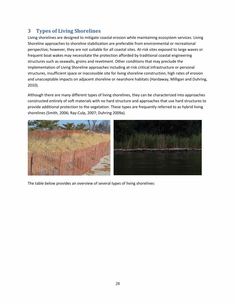
3 Types of Living Shorelines ................................................................................................................... 28
3.1 Non-structural Approaches ......................................................................................................... 32
3.1.1 Vegetation Management .................................................................................................... 32
3.1.2 Slope or Bank Grading ......................................................................................................... 32
3.1.3 Marsh Restoration or Creation ........................................................................................... 32
3.1.4 Beach Nourishment ............................................................................................................ 33
3.1.5 Dune Creation and Restoration .......................................................................................... 33
3.2 Hybrid Approaches ...................................................................................................................... 34
3.2.1 Fiber Logs ............................................................................................................................ 35
3.2.2 Marsh Toe Revetment ........................................................................................................ 35
3.2.3 Marsh Sills ........................................................................................................................... 36
3.2.4 Oyster Reefs ........................................................................................................................ 37
3.2.5 Breakwaters ........................................................................................................................ 37
3.2.6 Wave Attenuation Devices .................................................................................................. 38
3.2.7 Alternative Technologies .................................................................................................... 39
4 Site Considerations ............................................................................................................................. 40
4.1 Design Parameters ...................................................................................................................... 40
3
4.1.1 Wave Climate and Fetch ..................................................................................................... 40
4.1.2 Tidal Range .......................................................................................................................... 41
4.1.3 Ice ........................................................................................................................................ 41
4.1.4 Storm Surge ......................................................................................................................... 42
4.1.5 Nearshore Bathymetry ........................................................................................................ 43
4.1.6 Shoreline Geomorphology .................................................................................................. 43
4.1.7 Shoreline Change ................................................................................................................ 43
4.1.8 Site characteristics .............................................................................................................. 43
4.1.9 Vegetation ........................................................................................................................... 44
4.1.10 Shellfish Beds ...................................................................................................................... 44
4.1.11 Shore Zone .......................................................................................................................... 44
4.1.12 Existing Coastal Structures .................................................................................................. 44
4.1.13 Shoreline Usage .................................................................................................................. 45
4.2 Summary ..................................................................................................................................... 45
5 Permitting Steps .................................................................................................................................. 47
6 Resources ............................................................................................................................................ 48
6.1 Websites...................................................................................................................................... 48
6.2 Literature Cited ........................................................................................................................... 48
6.3 Printable Marsh Checklist ........................................................................................................... 50
6.4 Printable Beach and Dune Checklist ........................................................................................... 53
6.5 Printable Bluff Checklist .............................................................................................................. 56
6.6 Printable Currently Defended Checklist ...................................................................................... 59
4
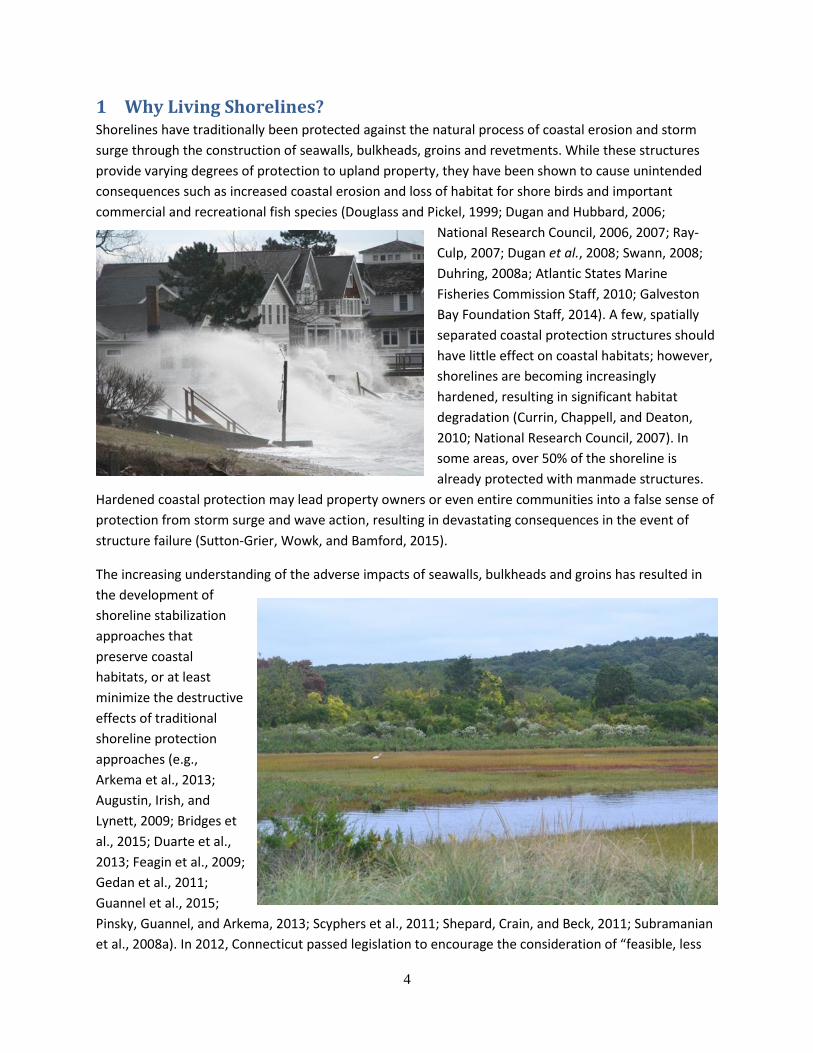
1 Why Living Shorelines? Shorelines have traditionally been protected against the natural process of coastal erosion and storm
surge through the construction of seawalls, bulkheads, groins and revetments. While these structures
provide varying degrees of protection to upland property, they have been shown to cause unintended
consequences such as increased coastal erosion and loss of habitat for shore birds and important
commercial and recreational fish species (Douglass and Pickel, 1999; Dugan and Hubbard, 2006;
National Research Council, 2006, 2007; Ray-
Culp, 2007; Dugan et al., 2008; Swann, 2008;
Duhring, 2008a; Atlantic States Marine
Fisheries Commission Staff, 2010; Galveston
Bay Foundation Staff, 2014). A few, spatially
separated coastal protection structures should
have little effect on coastal habitats; however,
shorelines are becoming increasingly
hardened, resulting in significant habitat
degradation (Currin, Chappell, and Deaton,
2010; National Research Council, 2007). In
some areas, over 50% of the shoreline is
already protected with manmade structures.
Hardened coastal protection may lead property owners or even entire communities into a false sense of
protection from storm surge and wave action, resulting in devastating consequences in the event of
structure failure (Sutton-Grier, Wowk, and Bamford, 2015).
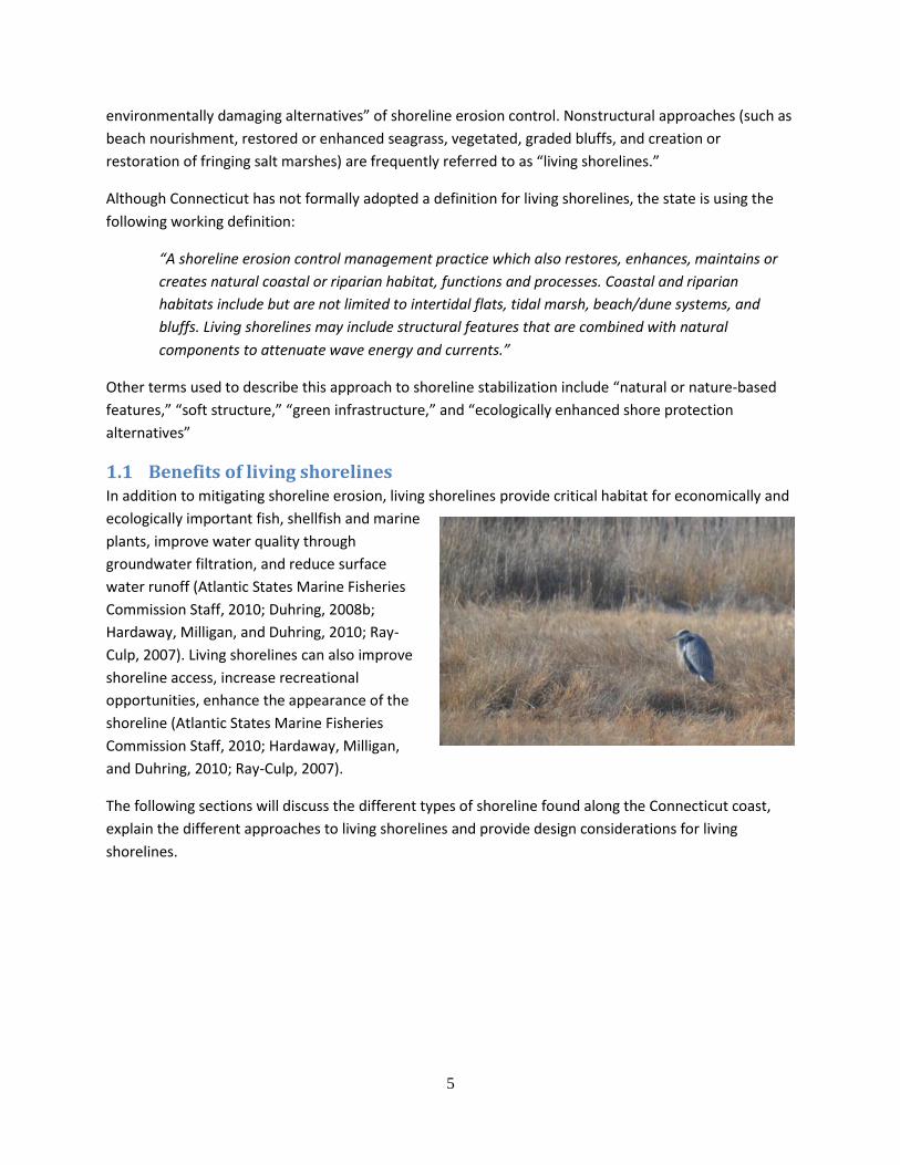
The increasing understanding of the adverse impacts of seawalls, bulkheads and groins has resulted in
the development of
shoreline stabilization
approaches that
preserve coastal
habitats, or at least
minimize the destructive
effects of traditional
shoreline protection
approaches (e.g.,
Arkema et al., 2013;
Augustin, Irish, and
Lynett, 2009; Bridges et
al., 2015; Duarte et al.,
2013; Feagin et al., 2009;
Gedan et al., 2011;
Guannel et al., 2015;
Pinsky, Guannel, and Arkema, 2013; Scyphers et al., 2011; Shepard, Crain, and Beck, 2011; Subramanian
et al., 2008a). In 2012, Connecticut passed legislation to encourage the consideration of “feasible, less
5
environmentally damaging alternatives” of shoreline erosion control. Nonstructural approaches (such as
beach nourishment, restored or enhanced seagrass, vegetated, graded bluffs, and creation or
restoration of fringing salt marshes) are frequently referred to as “living shorelines.”
Although Connecticut has not formally adopted a definition for living shorelines, the state is using the
following working definition:
“A shoreline erosion control management practice which also restores, enhances, maintains or
creates natural coastal or riparian habitat, functions and processes. Coastal and riparian
habitats include but are not limited to intertidal flats, tidal marsh, beach/dune systems, and
bluffs. Living shorelines may include structural features that are combined with natural
components to attenuate wave energy and currents.”
Other terms used to describe this approach to shoreline stabilization include “natural or nature-based
features,” “soft structure,” “green infrastructure,” and “ecologically enhanced shore protection
alternatives”
1.1 Benefits of living shorelines In addition to mitigating shoreline erosion, living shorelines provide critical habitat for economically and
ecologically important fish, shellfish and marine
plants, improve water quality through
groundwater filtration, and reduce surface
water runoff (Atlantic States Marine Fisheries
Commission Staff, 2010; Duhring, 2008b;
Hardaway, Milligan, and Duhring, 2010; Ray-
Culp, 2007). Living shorelines can also improve
shoreline access, increase recreational
opportunities, enhance the appearance of the
shoreline (Atlantic States Marine Fisheries
Commission Staff, 2010; Hardaway, Milligan,
and Duhring, 2010; Ray-Culp, 2007).
The following sections will discuss the different types of shoreline found along the Connecticut coast,
explain the different approaches to living shorelines and provide design considerations for living
shorelines.
6
2 The Connecticut Coast The Connecticut shoreline of Long Island Sound is highly variable, consisting of three major
geomorphological types: beaches and dune, bluffs and wetlands. The different shoreline types provide
nesting and foraging habitat for a wide range of aquatic plants and animals. Maintaining the shoreline’s
ability to absorb wave energy and reduce coastal flooding while preserving the ecosystem services
provided by the natural shoreline is the goal of Living Shorelines. The most appropriate type of Living
Shoreline for stabilization will depend on the natural geomorphological conditions.
2.1 Marshes Coastal marshes are low-lying areas of salt tolerant plants that are subjected to regular or occasional
flooding by tides and storm surges.
Marsh plants are highly dependent
on salinity resulting in distinct zones
of plant species based on elevation
and the occurrence of salt water
flooding (Bendell and The North
Carolina Estuarine Biological and
Physical Processes Work Group,
2006).
Marshes in Connecticut can be
extensive meadows of salt tolerant
plants, such as at Barn Island
Wildlife Management Area or
Hammonasset Beach State Park, usually dominated by high marsh, or fringe marshes, located along
protected coastlines or at the toe of eroding bluffs. Fringe marshes may be bordered by mud flats.
Tidal salt marshes, whether natural or restored, can provide critical protection to coastal communities
by reducing wave heights and therefore wave energy, storm surge levels and durations, and mitigating
coastal erosion (O’Donnell, submitted). In addition, marshes improve water quality by filtering
7
groundwater, reduce surface water runoff, and decrease sediment transport (Ray-Culp, 2007; Duhring,
2008a; Augustin et al., 2009; Hardaway et al., 2010; Thomas-Blate, 2010).
Marshes occur in sheltered areas with low to moderate wave energy; however, they still may be
experience erosion caused by:
WAVES
Salt water marshes generally experience low wave energy, but constant wave action can erode marsh edges. Storm waves can be especially damaging to marsh stability. The elevated water level associated with storm surge enables storm waves to damage vegetation that is normally not subjected to wave action. The larger the fetch (the distance wind blows over water), the larger the waves that will affect the marsh.
BOAT WAKES
Marshes, especially those located near marinas or navigable rivers, are subjected to large wakes from motorboat traffic. In some areas, boat wakes are larger and cause more damage than storm waves.
CURRENTS Currents, including tidal flows, can erode marsh surfaces and edges.
WRACK
Ewanchuk and Bertness (2003) suggest that wrack disturbance is the most important natural disturbance in New England marshes. Wrack primarily affects high marsh where storm waves and surge deposit large amounts of seaweed and algae, smothering the marsh vegetation and resulting in bare areas vulnerable to erosion.
ICE
Ice can be an extremely destructive force in New England marshes, affecting low marsh due to tidal fluctuations. Ice in the coastal ocean is never stationary; its motion can kill marsh vegetation and also move large portions of vegetation and the underlying peat on ebb tides. It can take over 10 years for a marsh to recover from intense ice damage (Ewanchuk and Bertness, 2003).
PUBLIC ACCESS
Foot traffic through the marsh can damage the vegetation leading to erosion of the marsh surface.
CLIMATE CHANGE
Marshes will be not be adversely affected by sea level rise as long as the rate of sedimentation on the marsh surface is able to keep pace with the rate of sea level rise. If sea level rise exceeds the rate of marsh elevation increase, the marsh will be submerged, potentially killing vegetation and enabling larger waves to reach further into the marsh.
Several options are available for addressing erosion of coastal marshes; the most appropriate method
will depend on site specific conditions. There are many parameters to consider before selecting a Living
Shoreline approach. Some questions to ask are:
1. Is there an existing coastal engineering structure (seawall, groin, revetment, etc.) at the site? The presence of an existing engineering structure may affect the coastal processes at the site and must be considered before an appropriate living shoreline approach can be determined. If the structure is functioning as designed, or easily repaired, the most appropriate approach may be to do nothing or repair the structure, while considering alternatives for future needs. See Section 2.4 Currently Defended Shorelines for more information on coastal engineering structures.
2. What is the condition of the marsh? Is there presently a vegetated wetland at the edge of the property? Is the vegetation dense or sparse? How wide is the marsh?
8
The condition of the existing marsh is an indication of the potential success of a living shoreline approach. A marsh with dense, healthy vegetation is likely to be a suitable site for a non-structural approach. A less dense marsh may be enhanced with vegetation management, trimming or overhanding branches and removal of fallen trees and debris. For more information, see the section
on Vegetation.
3. Is the marsh eroding? If so, what is the rate of erosion and what is causing it? Do nothing or vegetation management may be suitable approaches for a stable marsh with little to no erosion. With higher rates of erosion, it is necessary to determine what is causing the erosion. Mitigating erosion from frequent boat wakes may indicate a different approach than one used to reduce storm flooding and wave damage. While seasonal damage may not be a cause for concern, a marsh may take years to recover from significant ice damage (Ewanchuk and Bertness, 2003). The section on Shoreline Change provides more information on how to determine the long-term rate of shoreline change.
4. Is there infrastructure at risk? If the existing infrastructure cannot be moved back or up, it may be necessary to select an approach that would provide more protection than a non-structural approach. Evaluation of the site may determine that a living shoreline approach is unsuitable.
5. What is the wave climate? The wave climate is a critical parameter in determining the most appropriate approach to shoreline protection. Vegetation-only approaches are usually only suitable for site exposed to low wave heights. The wave climate will determine the type of living shoreline, and the height and composition of the protective structure. Fetch, the distance wind blows of water, is frequently used as an estimate of the wave conditions at a site. More information on can be found in the section on Wave Climate and Fetch.
6. What is the boat traffic? Some sites, particularly those along navigable rivers streams, may experience larger waves due to boat wake than wind waves. The proximity to a powerboat marina or navigational channel, and the frequency and size of vessels are an important design consideration. For more information on boat wakes, see Wave Climate and Fetch.
7. Is the site affected by tidal, riverine or alongshore currents? Nearshore currents can scour protective structures and transport fill material away from the project site.
8. What is the shoreline geometry? The Connecticut shoreline of Long Island Sound is highly variable. The shoreline geometry may be straight, curved or irregular. This high variability is one reason why the most suitable approach to shoreline protection is so site-specific. A headland beach (also known as a pocket beach) is generally crescent or crenulate-shaped, bounded by protective headlands so the shoreline is relatively protected and the sediment supply usually remains between the headlands. A straight shoreline is more exposed to large waves and transport of sediment away from the site. For more information, see the section on Shoreline Geomorphology.
9
9. What is the intertidal slope/nearshore bathymetry? The intertidal slope and nearshore bathymetry determine the size of the waves at the shoreline. A gradually sloping nearshore region will cause larger waves to break further offshore, reducing the wave energy at the marsh. Steep nearshore bathymetry will allow larger waves to break near or at the marsh edge. See the section on Nearshore Bathymetry for more information.
10. Is the upland bank vegetated? Upland vegetation is an indication of the stability of the bank. However, mature vegetation may provide too much shade for marsh plant survivability. See the section on Vegetation for more information.
11. What is the tidal range? The tidal range will impact the height and location of the shoreline protection approach. Most of the existing living shoreline structures have been constructed in areas with low tidal ranges on the order of a couple of feet. Tidal ranges along the Connecticut shoreline vary from about 2.4 ft in Stonington to 7.5 ft in Greenwich. In addition, storm surge heights are typically larger in Connecticut than where living shorelines have been constructed previously. See Tidal Range for more information.
12. Does the project site flood regularly during normal or spring tides? Storm surge? Flooding of coastal marshes is a natural process; however, if the site floods during normal or spring tides, the marsh may not provide sufficient protection from storm waves. Marshes typically do not provide protection from storm surge, so the potential risk from coastal inundation is an important design consideration.
13. Is the project site affected by ice? The Connecticut coast is affected by ice damage, exacerbated by nor-easters and tidal flow. The approach selected must withstand anticipated ice forces at the site. For more information, see the section on Ice.
14. Does the site have submerged aquatic vegetation or nearshore oyster beds? Submerged aquatic vegetation or the presence of nearshore recreational oyster beds may affect the type of living shoreline that can be permitted at the site. See the section on Vegetation.
15. What is the composition of the nearshore region? Some soils may not be able to tolerate the weight of living shoreline approaches such as marsh sills or reef balls. Settling of the structure could render it ineffective. The presence of offshore vegetation or aquatic species may be negatively impacted by the living shoreline. For instance, fill material could bury aquatic plants and animals, or sills and breakwaters could damage nearshore habitats.
16. What is the condition of the adjacent properties? Depending on the width of the project site, the condition of adjacent properties may affect the suitability of living shoreline approaches. For instance, the presence of marsh may indicate the suitability of the site for marsh creation or restoration. Hard coastal structures may limit the effectiveness of a living shoreline.
17. Is the project site accessible from land or water?
10
Access to the project site will affect the cost and constructability of a living shoreline.
18. What are the potential effects of sea level rise on the project site? Depending on the anticipated lifetime of the living shoreline, the effects of sea level rise on the erosion mitigation approach may be a selection factor.
A printable checklist of design considerations can be found here.
Some of the options for mitigating coastal erosion on marshes are:
For marshes that are not eroding:
Do nothing
Vegetation Management
For marshes experiencing erosion, options to consider include:
Slope or bank grading
Marsh restoration
Toe protection with fiber logs
Marsh Toe Revetment
Marsh Sills
Oyster Reefs
Wave Attenuation Devices
Breakwaters
11
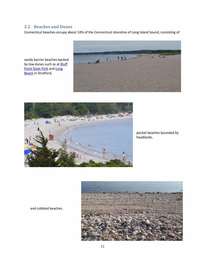
2.2 Beaches and Dunes Connecticut beaches occupy about 14% of the Connecticut shoreline of Long Island Sound, consisting of
and cobbled beaches.
sandy barrier beaches backed by low dunes such as at Bluff Point State Park and Long Beach in Stratford,
pocket beaches bounded by headlands,
12
Beaches and dunes are natural barriers to the destructive forces of waves and storm surge. By absorbing
the impact of storm surge and waves, they prevent or delay erosion, flooding of inland areas and
damage to coastal infrastructure. During storms, beaches and dunes provide sacrificial sediment which
is transported offshore into a sand bar system to causing waves to break and reducing wave energy
reaching the beach.
In addition to storm protection, beaches and dunes provide critical nesting and foraging habitat for
shore birds and other aquatic species, and recreation opportunities for property owners and the public.
Beaches and dunes are dynamic features affected by short and long term changes in waves, wind, tides,
storm surge, sand availability and sea level rise. These changes may be seasonal, episodic or storm-
related, or slow, barely noticeable change over many years. Beach and dune erosion along the
Connecticut shoreline of Long Island Sound is generally caused:
SEASONAL CHANGES
Seasonal storms and variations in local wind speed and direction can cause short-term changes in the beach profile. Summer beaches tend to be wider than their corresponding winter beach, with a well-developed berm. Winter beaches are steeper and narrower. These changes are minimized along Connecticut beaches due to the buffering effect of ocean winds and the limited fetch caused by Long Island.
STORMS
Storm impacts occur over a very short period but recovery of the beach may occur with seasonal changes or over a much longer period of time. In the case of severe storms, recovery of the beach may not occur at all.
SAND AVAILABILITY
Sand availability can change when sand is moved offshore during storms and is no longer available for beaches, or when sand transported landward during storms is removed as debris.
MANMADE STRUCTURES
Groins, seawalls and jetties can exacerbate coastal erosion by interrupting the natural transport of sediment.
CURRENTS Alongshore and cross-shore currents can transport sediment away from beaches, contributing to shoreline erosion.
PUBLIC ACCESS Foot traffic can damage the dune vegetation reducing dune stability against wave and winds.
CLIMATE CHANGE
The Connecticut shoreline has been affecting for decades by rising sea levels. Sea level rise may adversely affect beaches that are not able to migrate landward over time.
Several options are available for addressing beach and dune erosion; the most appropriate method will
depend on site specific conditions. There are many parameters to consider before selecting a Living
Shoreline approach. Some questions to ask are:
1. Is there an existing coastal engineering structure (seawall, groin, revetment, etc.) at the site? The presence of an existing engineering structure may affect the coastal processes at the site and must be considered before an appropriate living shoreline approach can be determined. If the structure is functioning as designed, or easily repaired, the most appropriate approach may be to do
13
nothing or repair the structure, while considering alternatives for future needs. See Section 2.4 Currently Defended Shorelines for more information on coastal engineering structures.
2. Is there a sand dune at the seaward edge of the property? If so, is it vegetated? If not, is a dry beach present (sand above normal high tide)? If yes, how wide? An existing dune indicates the suitability and viability of dune restoration at the project site. The presence of vegetation on the dune not only provides an indication of the stability of the dune system, but is important when creating a dune restoration and planting plan.
If the beach is not currently backed by a dune, there needs to be sufficient dry beach width to create a dune system. In some areas, beach nourishment may be permitting which could extend the width of the beach to allow dune creation. See Beach Nourishment and Dune Creation and Restoration for more information.
3. Is there evidence that your dune or backshore is regularly overtopped and overwashed by waves, and/or that flooding occurs landward of the dune or beach crest? During normal or spring tides? Storm surges? The frequency of dune or backshore overtopping and flooding is important when determining the necessary elevation of coastal protection to mitigate coastal inundation.
4. Does the dune and beach naturally gain sand after each winter season? Beach and dune systems change in response to seasonal variations in waves, wind, tides, and storm surge, transforming from a. wider, flatter “summer” beach to a narrower, steeper “winter” profile. Because the Connecticut shoreline is protected from ocean winds by Long Island, the seasonal variation in winds is less pronounced than on more exposed shorelines. It is important to consider seasonal variations in beach profile when selecting and designing a Living Shoreline.
5. Is the beach eroding? If so, what is the rate of erosion and what is causing it? Do nothing or dune vegetation management may be suitable approaches for a stable beach/dune system with little to no erosion. With higher rates of erosion, it is necessary to determine what is causing the erosion. Mitigating erosion from frequent boat wakes may indicate a different approach than one used to reduce storm flooding and wave damage. The section on Shoreline Change provides more information on how to determine the long-term rate of shoreline change.
6. Is there infrastructure at risk? If the existing infrastructure cannot be moved back or up, it may be necessary to select an approach that would provide more protection than a non-structural approach. Evaluation of the site may determine that a living shoreline approach is unsuitable.
7. What is the wave climate? The wave climate is a critical parameter in determining the most appropriate approach to shoreline protection. Vegetation-only approaches are usually only suitable for site exposed to low wave heights. The wave climate will determine the type of living shoreline, and the height and composition of the protective structure. Fetch, the distance wind blows of water, is frequently used as an estimate of the wave conditions at a site. More information on can be found in the section on Wave Climate and Fetch.
14
8. What is the boat traffic? Some sites, particularly those along navigable rivers streams, may experience larger waves due to boat wake than wind waves. The proximity to a powerboat marina or navigational channel, and the frequency and size of vessels are an important design consideration. For more information on boat wakes, see Wave Climate and Fetch.
9. Is the site affected by tidal, riverine or alongshore currents? Nearshore currents can scour protective structures and transport fill material away from the project site.
10. What is the shoreline geometry? The Connecticut shoreline of Long Island Sound is highly variable. The shoreline geometry may be straight, curved or irregular. This high variability is one reason why the most suitable approach to shoreline protection is so site-specific. A headland beach (also known as a pocket beach) is generally crescent or crenulate-shaped, bounded by protective headlands so the shoreline is relatively protected and the sediment supply usually remains between the headlands. A straight shoreline is more exposed to large waves and transport of sediment away from the site. For more information, see the section on Shoreline Geomorphology.
11. What is the intertidal slope/nearshore bathymetry? The intertidal slope and nearshore bathymetry determine the size of the waves at the shoreline. A gradually sloping nearshore region will cause larger waves to break further offshore, reducing the wave energy at the beach. Steep nearshore bathymetry will allow larger waves to break on the beach. Larger winter waves or storm waves typically transport available sand offshore, forming protective sand bars. See the section on Nearshore Bathymetry for more information.
12. What is the tidal range? The tidal range will impact the height and location of the shoreline protection approach. Most of the existing living shoreline structures have been constructed in areas with low tidal ranges on the order of a couple of feet. Tidal ranges along the Connecticut shoreline vary from about 2.4 ft in Stonington to 7.5 ft in Greenwich. In addition, storm surge heights are typically larger in Connecticut than where living shorelines have been constructed previously. See Tidal Range for more information.
13. Is the project site affected by ice? The Connecticut coast is affected by ice damage, exacerbated by nor-easters and tidal flow. The approach selected must withstand anticipated ice forces at the site. For more information, see the section on Ice.
14. Does the site have submerged aquatic vegetation or nearshore oyster beds? Submerged aquatic vegetation or the presence of nearshore recreational oyster beds may affect the type of living shoreline that can be permitted at the site. See the section on Vegetation.
15. What is the composition of the nearshore region? Some soils may not be able to tolerate the weight of living shoreline approaches such as marsh sills or reef balls. Settling of the structure could render it ineffective. The presence of offshore vegetation or aquatic species may be negatively impacted by the living shoreline. For instance, fill
15
material could bury aquatic plants and animals, or sills and breakwaters could damage nearshore habitats.
16. How will the shoreline be used? The intended use of the shoreline may affect the suitable types of living shoreline. For instance, swimming and boating require different access to the water than fishing or nature watching. The selected type of living shoreline must be compatible with the intended usage of the shoreline.
17. What is the condition of the adjacent properties? Depending on the width of the project site, the condition of adjacent properties may affect the suitability of living shoreline approaches. For instance, traditional, hard coastal protection structures may limit the effectiveness of a living shoreline.
18. Is the project site accessible from land or water? Access to the project site will affect the cost and constructability of a living shoreline.
19. What are the potential effects of sea level rise on the project site? Depending on the anticipated lifetime of the living shoreline, the effects of sea level rise on the erosion mitigation approach may be a selection factor.
A printable checklist of design considerations can be found here.
Some of the options for mitigating coastal erosion on beach and dune systems are not eroding include:
Do nothing
Vegetation Management
For beaches with low waves and limited boat traffic, gradual nearshore and insufficient land to create a
dune system:
Do nothing
Plant native vegetation
Beach Nourishment
Wave Attenuation Devices
Breakwaters
If there is sufficient dry beach for a dune, the above approaches are suitable as well as
Dune Creation or Restoration
16
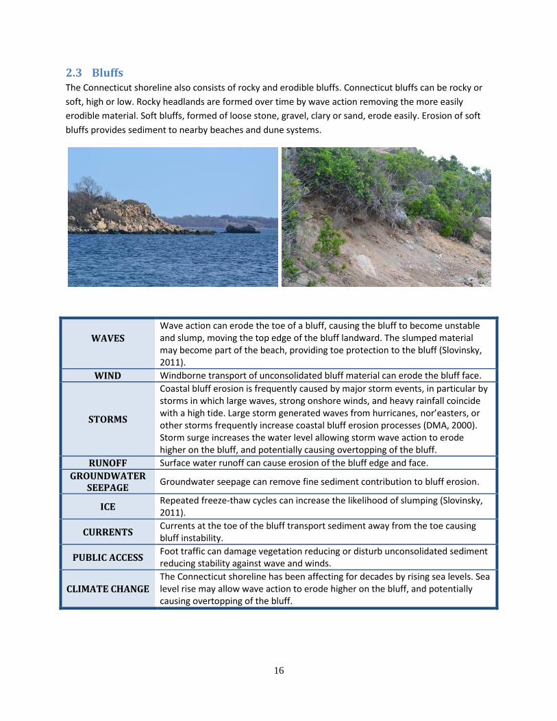
2.3 Bluffs The Connecticut shoreline also consists of rocky and erodible bluffs. Connecticut bluffs can be rocky or
soft, high or low. Rocky headlands are formed over time by wave action removing the more easily
erodible material. Soft bluffs, formed of loose stone, gravel, clary or sand, erode easily. Erosion of soft
bluffs provides sediment to nearby beaches and dune systems.
WAVES
Wave action can erode the toe of a bluff, causing the bluff to become unstable and slump, moving the top edge of the bluff landward. The slumped material may become part of the beach, providing toe protection to the bluff (Slovinsky, 2011).
WIND Windborne transport of unconsolidated bluff material can erode the bluff face.
STORMS
Coastal bluff erosion is frequently caused by major storm events, in particular by storms in which large waves, strong onshore winds, and heavy rainfall coincide with a high tide. Large storm generated waves from hurricanes, nor’easters, or other storms frequently increase coastal bluff erosion processes (DMA, 2000). Storm surge increases the water level allowing storm wave action to erode higher on the bluff, and potentially causing overtopping of the bluff.
RUNOFF Surface water runoff can cause erosion of the bluff edge and face.
GROUNDWATER SEEPAGE
Groundwater seepage can remove fine sediment contribution to bluff erosion.
ICE Repeated freeze-thaw cycles can increase the likelihood of slumping (Slovinsky, 2011).
CURRENTS Currents at the toe of the bluff transport sediment away from the toe causing bluff instability.
PUBLIC ACCESS Foot traffic can damage vegetation reducing or disturb unconsolidated sediment reducing stability against wave and winds.
CLIMATE CHANGE The Connecticut shoreline has been affecting for decades by rising sea levels. Sea level rise may allow wave action to erode higher on the bluff, and potentially causing overtopping of the bluff.
17
Several options are available for addressing bluff erosion; the most appropriate method will depend on
site specific conditions. There are many parameters to consider before selecting a Living Shoreline
approach. Some questions to ask are:
1. Is there an existing coastal engineering structure (seawall, groin, revetment, etc.) at the site? The presence of an existing engineering structure may affect the coastal processes at the site and must be considered before an appropriate living shoreline approach can be determined. If the structure is functioning as designed, or easily repaired, the most appropriate approach may be to do nothing or repair the structure, while considering alternatives for future needs. See Section 2.4 Currently Defended Shorelines for more information on coastal engineering structures.
2. If soft, what is the composition of your bluff? Fine, mixed or coarse (sand or cobble)? The composition of the bluff material will affect the rate of bluff erosion. Finer material is more susceptible to wave damage than coarser sand or cobbles.
3. Is marsh or a dry beach present (sand above normal high tide) at the toe of your bluff? If yes, how wide? The presence of an established marsh or dry beach will provide protection to the bluff toe from wave action.
4. If you have a low bluff, is there evidence that your bluff is regularly overtopped and overwashed by waves, and/or that flooding occurs landward of the bluff? During normal or spring tides? Storm surges? The frequency of bluff overtopping and flooding is important when determining the necessary elevation of coastal protection to mitigate coastal inundation and wave damage.
5. Is the bluff eroding? If so, what is the rate of erosion and what is causing it? Is the base of the bluff eroding? Storms, coastal flooding, waves, and tides contribute to erosion of coastal bluffs and the transport of bluff sediments in the coastal zone; however, coastal bluffs do not recover from destructive forces in the same manner as beach faces do. As the toe of a bluff is eroded by wave action and rising sea level, the bluff becomes unstable and slumps to the shoreline below, causing the top edge of the bluff to move landward. This natural process becomes a hazard when it threatens structures or property at the top of the bluff. The rate of bluff erosion usually varies from year to year. Even a steep bluff may remain unchanged for many years, or slump a large amount of sediment only every few years. Sand, gravel and glacial deposits eroded from the bluff may become part of the beach at the base of the bluff, helping to stabilize the shoreline (Slovinsky, 2011).
Do nothing or dune vegetation management may be suitable approaches for a stable bluff with little to no erosion. With higher rates of erosion, it is necessary to determine what is causing the erosion.
Mitigating erosion from frequent boat wakes may indicate a different approach than one used to
reduce storm flooding and wave damage. Surface water runoff and groundwater seepage, as well as freeze/thaw cycles all contribute to soft bluff erosion. The section on Shoreline Change provides more information on how to determine the long-term rate of shoreline change of coastal bluffs.
6. Is the upland bank vegetated? Has the bluff been planted or graded?
18
Upland vegetation is an indication of the stability of the bank and will mitigate bank erosion. For relatively protected sites or those without at-risk structures, bank grading and slope planting may be an appropriate solution to reduce erosion. See the sections on Vegetation Management and Slope of Bank Grading for more information.
7. Is there evidence of rainfall impacts or surface runoff? Is there evidence of groundwater in the slope (seepage, damp surfaces on slope face, etc.)? Not all erosion of coastal bluffs is caused by wave action. Many slopes are eroded by surface water runoff or groundwater seepage. Mitigating erosion caused by runoff or groundwater necessitates different approaches than for reducing wave impact at the toe of the slope.
8. What is at the toe of your bluff? Beach? Marsh? Ledge? Do waves or normal tides reach the base of the bluff? The type of shoreline at the toe of the bluff and its width will impact rate of erosion at the toe of the slope and also the type of living shoreline which is suitable. A wider marsh, beach or ledge will provide more protection to the toe of the bluff than a narrower shoreline. The width of the shoreline may also affect the living shoreline approach suitability.
9. What is the composition of the nearshore region? Some soils may not be able to tolerate the weight of living shoreline approaches such as marsh sills or reef balls. Settling of the structure could render it ineffective. The presence of offshore vegetation or aquatic species may be negatively impacted by the living shoreline. For instance, fill material could bury aquatic plants and animals, or sills and breakwaters could damage nearshore habitats.
10. What is the intertidal slope/nearshore bathymetry? The intertidal slope and nearshore bathymetry determine the size of the waves at the shoreline. A gradually sloping nearshore region will cause larger waves to break further offshore, reducing the wave energy at the toe of the bluff. Steep nearshore bathymetry will allow larger waves to break near or at the bluff toe. See the section on Nearshore Bathymetry for more information.
11. What is the tidal range? The tidal range will impact the height and location of the shoreline protection approach. Most of the existing living shoreline structures have been constructed in areas with low tidal ranges on the order of a couple of feet. Tidal ranges along the Connecticut shoreline vary from about 2.4 ft in Stonington to 7.5 ft in Greenwich. In addition, storm surge heights are typically larger in Connecticut than where living shorelines have been constructed previously. See Tidal Range for more information.
12. Is there infrastructure at risk? If the existing infrastructure cannot be moved back or up, it may be necessary to select an approach that would provide more protection than a non-structural approach. Evaluation of the site may determine that a living shoreline approach is unsuitable.
13. What is the wave climate? The wave climate is a critical parameter in determining the most appropriate approach to shoreline protection. Vegetation-only approaches are usually only suitable for site exposed to low wave heights. The wave climate will determine the type of living shoreline, and the height and
19
composition of the protective structure. Fetch, the distance wind blows of water, is frequently used as an estimate of the wave conditions at a site. More information on can be found in the section on Wave Climate and Fetch.
14. What is the boat traffic? Some sites, particularly those along navigable rivers streams, may experience larger waves due to boat wake than wind waves. The proximity to a powerboat marina or navigational channel, and the frequency and size of vessels are an important design consideration. For more information on boat wakes, see Wave Climate and Fetch.
15. Is the site affected by tidal, riverine or alongshore currents? Nearshore currents can scour protective structures and transport fill material away from the project site.
16. Is the project site affected by ice? The Connecticut coast is affected by ice damage, exacerbated by nor-easters and tidal flow. The approach selected must withstand anticipated ice forces at the site. Additionally, slope stability may be affected by freeze/thaw cycles. For more information, see the section on Ice.
17. What is the shoreline geometry? The Connecticut shoreline of Long Island Sound is highly variable. The shoreline geometry may be straight, curved or irregular. This high variability is one reason why the most suitable approach to shoreline protection is so site-specific. A headland beach (also known as a pocket beach) is generally crescent or crenulate-shaped, bounded by protective headlands so the shoreline is relatively protected and the sediment supply usually remains between the headlands. A straight shoreline is more exposed to large waves and transport of sediment away from the site. For more information, see the section on Shoreline Geomorphology.
18. Does the site have submerged aquatic vegetation or nearshore oyster beds? Submerged aquatic vegetation or the presence of nearshore recreational oyster beds may affect the type of living shoreline that can be permitted at the site. See the section on Vegetation.
19. How will the shoreline be used? The intended use of the shoreline may affect the suitable types of living shoreline. For instance, swimming and boating require different access to the water than fishing or nature watching. The selected type of living shoreline must be compatible with the intended usage of the shoreline.
20. What is the condition of the adjacent properties? Depending on the width of the project site, the condition of adjacent properties may affect the suitability of living shoreline approaches. For instance, traditional, hard coastal protection structures may limit the effectiveness of a living shoreline.
21. Is the project site accessible from land or water? Access to the project site will affect the cost and constructability of a living shoreline.
22. What are the potential effects of sea level rise on the project site?
20
Depending on the anticipated lifetime of the living shoreline, the effects of sea level rise on the erosion mitigation approach may be a selection factor.
For soft bluffs experiencing little to no erosion, some options are
Do nothing
Vegetation Management
For more exposed bluffs experiencing greater rates of erosion or those with critical infrastructure at risk,
some options to consider are:
Some of the options for consideration are:
Slope or bank grading
Marsh restoration
Toe protection with fiber logs
Marsh Toe Revetment
Marsh Sills
Oyster Reefs
Wave Attenuation Devices
Breakwaters
21
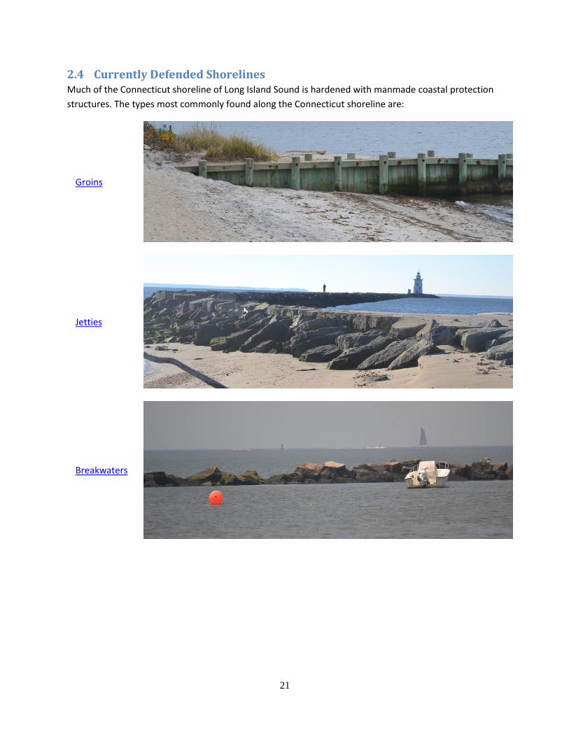
2.4 Currently Defended Shorelines Much of the Connecticut shoreline of Long Island Sound is hardened with manmade coastal protection
structures. The types most commonly found along the Connecticut shoreline are:
Groins
Jetties
Breakwaters
22
Seawalls
Bulkheads
Revetments
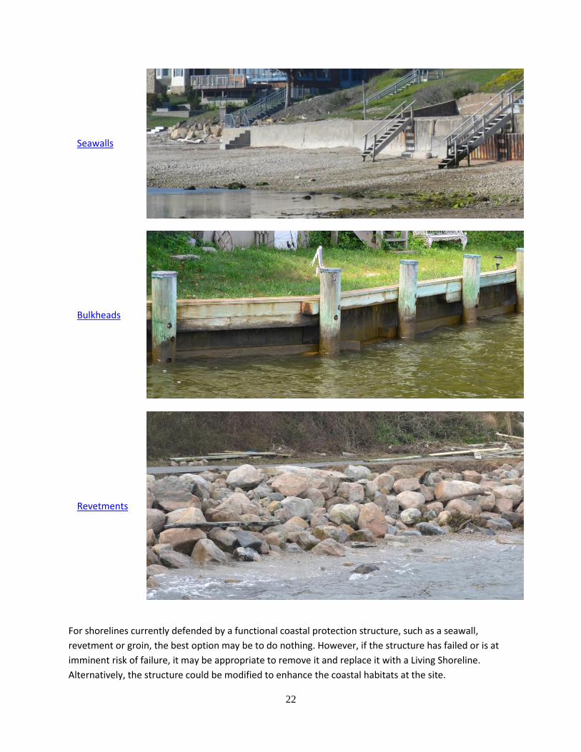
For shorelines currently defended by a functional coastal protection structure, such as a seawall,
revetment or groin, the best option may be to do nothing. However, if the structure has failed or is at
imminent risk of failure, it may be appropriate to remove it and replace it with a Living Shoreline.
Alternatively, the structure could be modified to enhance the coastal habitats at the site.
23
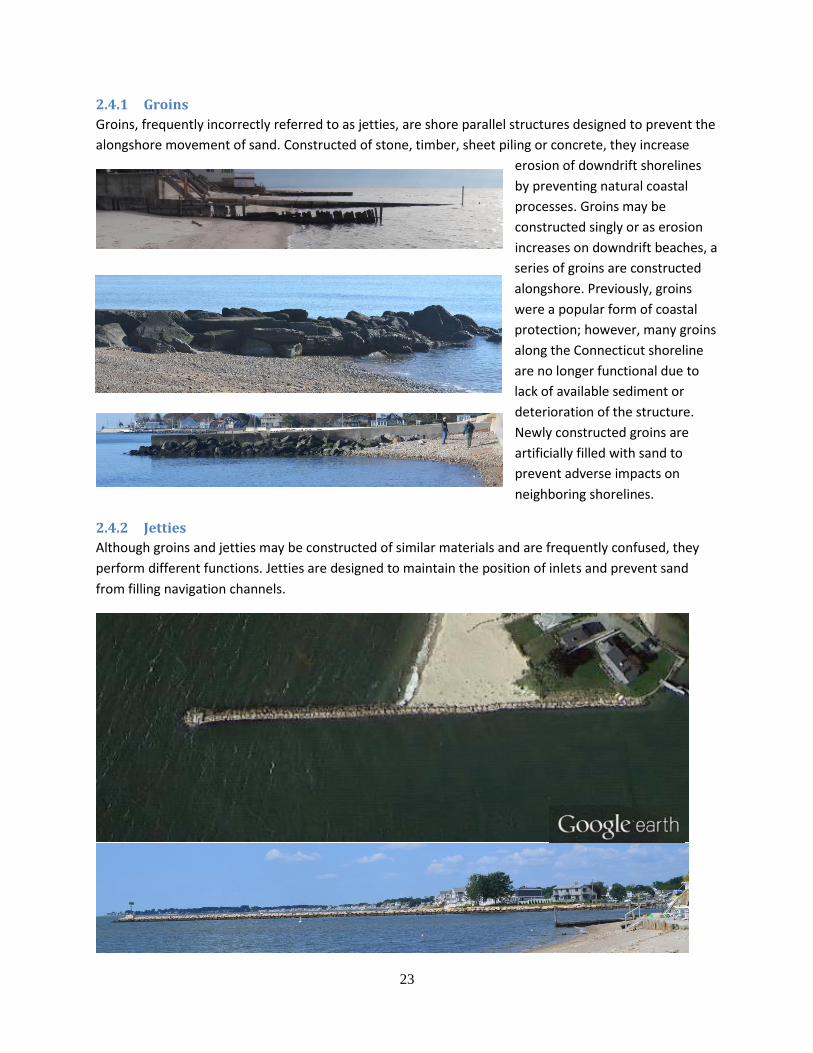
2.4.1 Groins
Groins, frequently incorrectly referred to as jetties, are shore parallel structures designed to prevent the
alongshore movement of sand. Constructed of stone, timber, sheet piling or concrete, they increase
erosion of downdrift shorelines
by preventing natural coastal
processes. Groins may be
constructed singly or as erosion
increases on downdrift beaches, a
series of groins are constructed
alongshore. Previously, groins
were a popular form of coastal
protection; however, many groins
along the Connecticut shoreline
are no longer functional due to
lack of available sediment or
deterioration of the structure.
Newly constructed groins are
artificially filled with sand to
prevent adverse impacts on
neighboring shorelines.
2.4.2 Jetties
Although groins and jetties may be constructed of similar materials and are frequently confused, they
perform different functions. Jetties are designed to maintain the position of inlets and prevent sand
from filling navigation channels.
24
2.4.3 Breakwaters
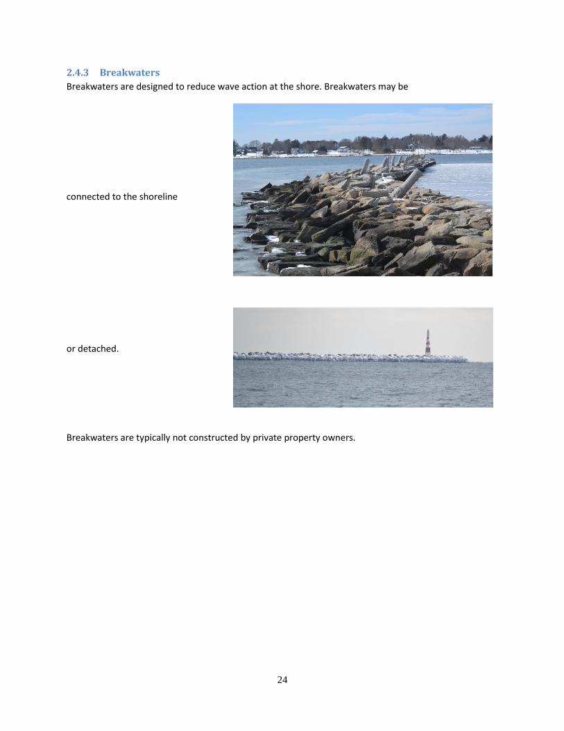
Breakwaters are designed to reduce wave action at the shore. Breakwaters may be
connected to the shoreline
or detached.
Breakwaters are typically not constructed by private property owners.
25
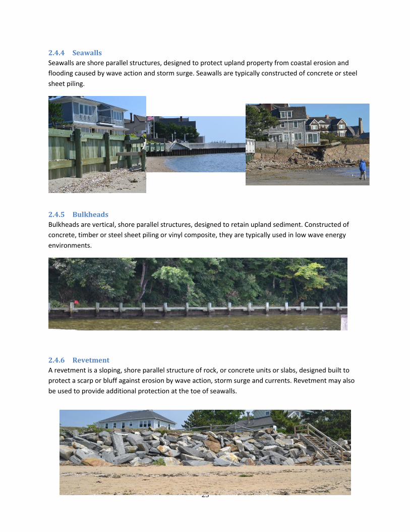
2.4.4 Seawalls
Seawalls are shore parallel structures, designed to protect upland property from coastal erosion and
flooding caused by wave action and storm surge. Seawalls are typically constructed of concrete or steel
sheet piling.
2.4.5 Bulkheads
Bulkheads are vertical, shore parallel structures, designed to retain upland sediment. Constructed of
concrete, timber or steel sheet piling or vinyl composite, they are typically used in low wave energy
environments.
2.4.6 Revetment
A revetment is a sloping, shore parallel structure of rock, or concrete units or slabs, designed built to
protect a scarp or bluff against erosion by wave action, storm surge and currents. Revetment may also
be used to provide additional protection at the toe of seawalls.
26
Several options are available for addressing erosion along currently defended shorelines. The most
appropriate method will depend on site specific conditions. There are many parameters to consider
before selecting a Living Shoreline approach. Some questions to ask are:
1. What is the existing engineered structure at the site? Coastal engineering structures are designed to perform different functions to provide protection from wave action and storm surge. For instance, groins are designed to interrupt alongshore transport of sand away from the site, creating or maintaining a beach to mitigate wave action. Alternatively, a seawall is a physical barrier to wave action.
2. Is the existing structure functional or easily repaired? Is the existing structure performing the protective function for which it was designed? Is a different form of protection needed now? If the existing structure is serviceable and performing the protective function which is needed at the site, no action may be the most suitable approach. Even if the existing structure is function, adding a hybrid Living Shoreline could enhance the ecosystem services at the project site.
3. Is the project site experiencing erosion? Do nothing may be the most suitable approach if the site is experiencing little to no erosion, The engineered structure may no longer be functioning as designed or the site conditions could have changed since completion of the structure.
4. If you have a seawall or revetment, is there evidence that it is regularly overtopped and overwashed by waves, and/or that flooding occurs landward of the structure’s crest? Seawalls, bulkheads and revetments that are regularly overtopped are susceptible to scouring landward of the structure, and to potential failure.
5. Is the structure damaged on a regular basis? Is it being flanked (erosion around the ends of the structure)? It is critical to address existing and potential damage to the structure before it leads to failure of the structure and potential damage to existing landward buildings and infrastructure. A Living Shoreline may provide sufficient protection to reduce potential damage to the existing coastal structure.
6. Does the existing coastal structure provide sufficient protection? A Living Shoreline may increase the protection provided by the existing structure.
7. Is shoreline usage changing? Changes to shoreline usage may warrant a change to the existing protection. For example, a seawall may not be compatible with swimming, sunbathing or small boat access.
8. Are changes being made to neighboring shoreline protection? Changes made on adjacent or nearby properties may affect the coastal processes at the project site. This needs to be considered when evaluating existing or future coastal protection requirements.
Little information is available in the literature on removing and replacing traditional coastal engineering structures with Living Shoreline approaches, and even less information exists on the best approach to
27
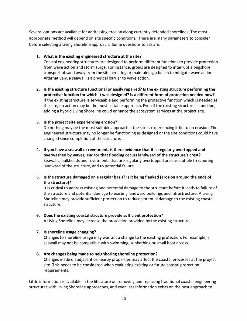
enhance the ecosystem services of hardened structures. Since a large proportion of the Connecticut shoreline is already armored with traditional coastal protection structures, it is critically important to determine through research and experience the best methods of improving coastal habitats in the presence of hardened structures. This photograph shows a healthy marsh that was planted in front of an existing seawall. The marsh mitigates the wave heights at the wall.
If the existing coastal structure is functional or easily repaired, the best approach is to consider
alternatives for the future replacement, or techniques to enhance the shoreline habitat. With the
current state of knowledge, some options to consider are:
Replacing impervious surface landward of your structure, with salt-tolerant plants.
Roughening the surface of your seawall or adding tidal pools to enhance the shoreline habitat
Placing rubble mound rock at the base of your seawall to reduce wave energy
Using environmentally friendly concrete
Planting dune grass on dry beach to increase sand trapping
28
3 Types of Living Shorelines Living shorelines are designed to mitigate coastal erosion while maintaining ecosystem services. Living
Shoreline approaches to shoreline stabilization are preferable from environmental or recreational
perspective; however, they are not suitable for all coastal sites. At-risk sites exposed to large waves or
frequent boat wakes may necessitate the protection afforded by traditional coastal engineering
structures such as seawalls, groins and revetment. Other conditions that may preclude the
implementation of Living Shoreline approaches including at-risk critical infrastructure or personal
structures, insufficient space or inaccessible site for living shoreline construction, high rates of erosion
and unacceptable impacts on adjacent shoreline or nearshore habitats (Hardaway, Milligan and Duhring,
2010).
Although there are many different types of living shorelines, they can be characterized into approaches
constructed entirely of soft materials with no hard structure and approaches that use hard structures to
provide additional protection to the vegetation. These types are frequently referred to as hybrid living
shorelines (Smith, 2006; Ray-Culp, 2007; Duhring 2009a).
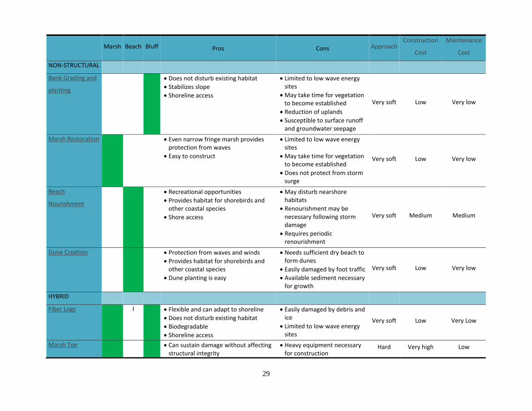
The table below provides an overview of several types of living shorelines:
29
Marsh Beach Bluff Pros Cons Approach Construction
Cost
Maintenance
Cost
NON-STRUCTURAL
Bank Grading and
planting
Does not disturb existing habitat
Stabilizes slope
Shoreline access
Limited to low wave energy sites
May take time for vegetation to become established
Reduction of uplands
Susceptible to surface runoff and groundwater seepage
Very soft Low Very low
Marsh Restoration Even narrow fringe marsh provides protection from waves
Easy to construct
Limited to low wave energy sites
May take time for vegetation to become established
Does not protect from storm surge
Very soft Low Very low
Beach
Nourishment
Recreational opportunities
Provides habitat for shorebirds and other coastal species
Shore access
May disturb nearshore habitats
Renourishment may be necessary following storm damage
Requires periodic renourishment
Very soft Medium Medium
Dune Creation Protection from waves and winds
Provides habitat for shorebirds and other coastal species
Dune planting is easy
Needs sufficient dry beach to form dunes
Easily damaged by foot traffic
Available sediment necessary for growth
Very soft Low Very low
HYBRID
Fiber Logs l Flexible and can adapt to shoreline
Does not disturb existing habitat
Biodegradable
Shoreline access
Easily damaged by debris and ice
Limited to low wave energy sites
Very soft Low Very Low
Marsh Toe Can sustain damage without affecting structural integrity
Heavy equipment necessary for construction
Hard Very high Low
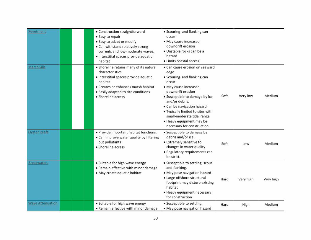
30
Revetment Construction straightforward
Easy to repair
Easy to adapt or modify
Can withstand relatively strong currents and low-moderate waves.
Interstitial spaces provide aquatic habitat
Scouring and flanking can occur
May cause increased downdrift erosion
Unstable rocks can be a hazard
Limits coastal access
Marsh Sills Shoreline retains many of its natural characteristics.
Interstitial spaces provide aquatic habitat
Creates or enhances marsh habitat
Easily adapted to site conditions
Shoreline access
Can cause erosion on seaward edge
Scouring and flanking can occur
May cause increased downdrift erosion
Susceptible to damage by ice and/or debris.
Can be navigation hazard.
Typically limited to sites with small-moderate tidal range
Heavy equipment may be necessary for construction
Soft Very low Medium
Oyster Reefs Provide important habitat functions.
Can improve water quality by filtering out pollutants
Shoreline access
Susceptible to damage by debris and/or ice.
Extremely sensitive to changes in water quality
Regulatory requirements can be strict.
Soft Low Medium
Breakwaters Suitable for high wave energy
Remain effective with minor damage
May create aquatic habitat
Susceptible to settling, scour and flanking.
May pose navigation hazard
Large offshore structural footprint may disturb existing habitat
Heavy equipment necessary for construction
Hard Very high Very high
Wave Attenuation Suitable for high wave energy
Remain effective with minor damage
Susceptible to settling
May pose navigation hazard Hard High Medium
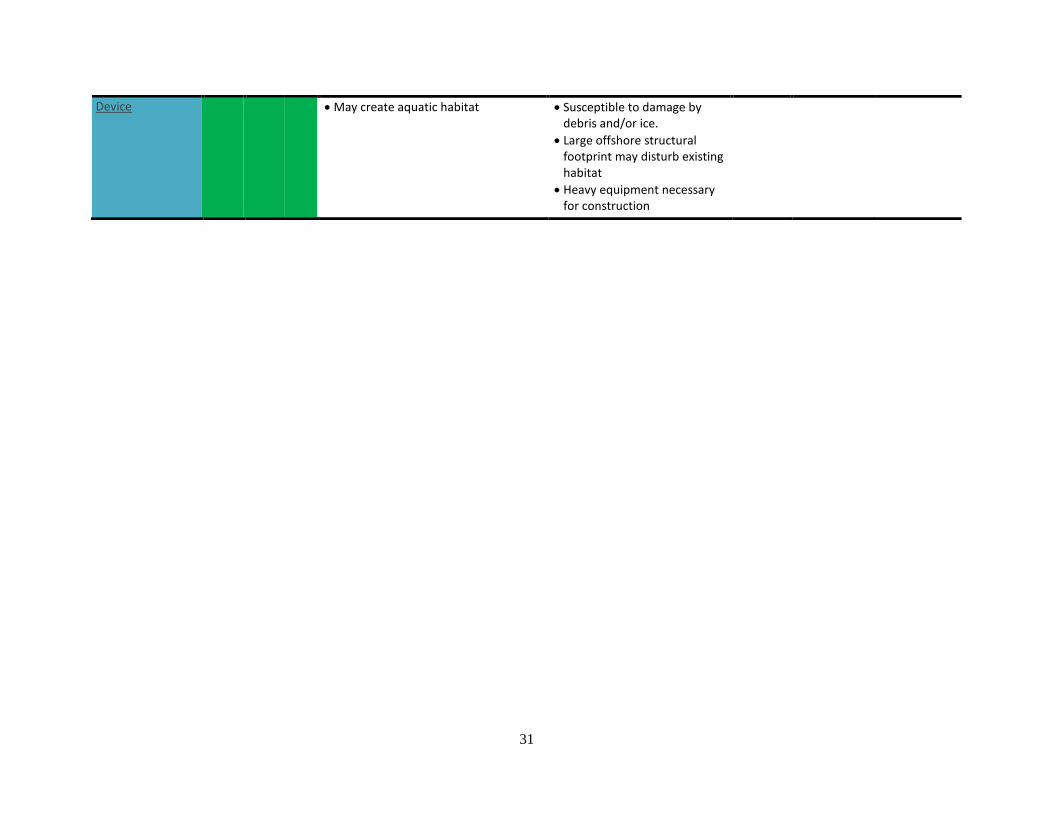
31
Device May create aquatic habitat
Susceptible to damage by debris and/or ice.
Large offshore structural footprint may disturb existing habitat
Heavy equipment necessary for construction
32
3.1 Non-structural Approaches
Shoreline stabilization approaches using only vegetation or fill material are most effective at sheltered
sites without critical infrastructure.
3.1.1 Vegetation Management
The most minimally disruptive approach to living shoreline protection is vegetation management.
Removal of overhanging tree branches reduces shade and thereby increases marsh grass growth (VIMS-
CCRM, 2006). Removal of unstable trees reduces the risk of slope destabilization that can occur when
upland or slope trees are uprooted.
3.1.2 Slope or Bank Grading
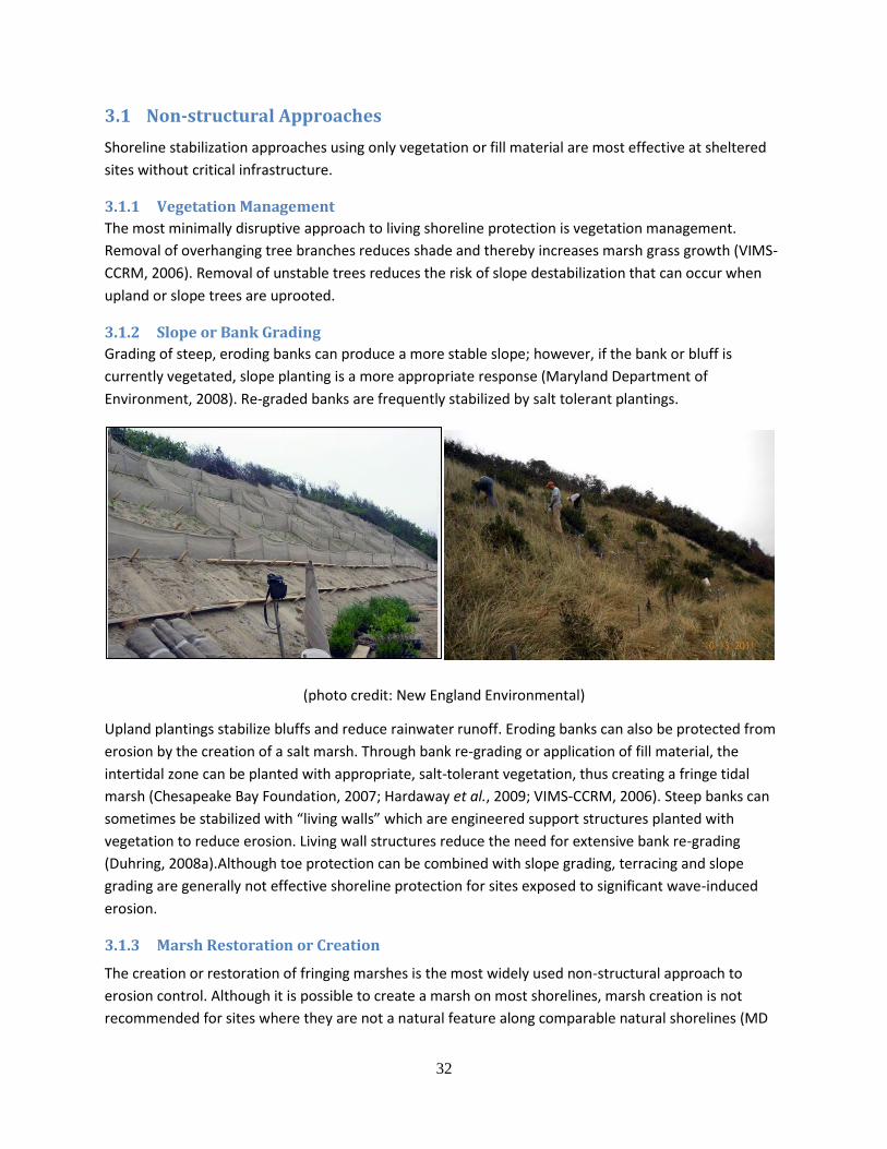
Grading of steep, eroding banks can produce a more stable slope; however, if the bank or bluff is
currently vegetated, slope planting is a more appropriate response (Maryland Department of
Environment, 2008). Re-graded banks are frequently stabilized by salt tolerant plantings.
(photo credit: New England Environmental)
Upland plantings stabilize bluffs and reduce rainwater runoff. Eroding banks can also be protected from
erosion by the creation of a salt marsh. Through bank re-grading or application of fill material, the
intertidal zone can be planted with appropriate, salt-tolerant vegetation, thus creating a fringe tidal
marsh (Chesapeake Bay Foundation, 2007; Hardaway et al., 2009; VIMS-CCRM, 2006). Steep banks can
sometimes be stabilized with “living walls” which are engineered support structures planted with
vegetation to reduce erosion. Living wall structures reduce the need for extensive bank re-grading
(Duhring, 2008a).Although toe protection can be combined with slope grading, terracing and slope
grading are generally not effective shoreline protection for sites exposed to significant wave-induced
erosion.
3.1.3 Marsh Restoration or Creation
The creation or restoration of fringing marshes is the most widely used non-structural approach to
erosion control. Although it is possible to create a marsh on most shorelines, marsh creation is not
recommended for sites where they are not a natural feature along comparable natural shorelines (MD
33
DOE, 2008). For narrow or eroding marshes, tidal marsh maintenance and enhancement is appropriate.
Sparse marsh can be enhanced with plugs of marsh grass (Broome, Rogers, and Seneca, 1992). If
necessary, fill material can be deposited to provide a suitably gradual slope for marsh creation or to
enable a marsh to maintain its elevation with respect to the water level (VIMS-CCRM, 2006). While
shoreline stabilization using only plants may be a viable solution on protected sites, along more exposed
shorelines, fringe marsh plantings will likely require temporary or permanent supplemental structures,
such as toe protection or sills, to ensure planting establishment. Plugs or live stakes are planted
landward of MLW with the expectation that they will fill in within one to two growing seasons, providing
the wave attenuation and habitat services of natural marsh vegetation. The success of the restored
fringe marsh depends on width of the existing shoreline, the depth and composition of the existing soil,
the slope of the shoreline, the shoreline configuration, exposure and orientation, and sun/shade
conditions (MD DOE, 2008).
3.1.4 Beach Nourishment
Natural beaches are in a constant state of flux, responding to changes in wave energy and sea level
(Lithgow et al., 2013). Post-storm beaches can become too narrow and steep for recreational
opportunities or coastal protection. Storms can create steep scarps which could be dangerous for beach
goers. With sufficient time, appropriate wave climate and sufficient supply of sand, beaches may restore
themselves but few coastal communities can risk the loss of recreational services or erosion control
while waiting for natural restoration to occur. Beach nourishment (also referred to as fill or
replenishment) “restores” the beach quickly by importing sand from a land or offshore site. While
nourishment may recover some of the ecosystem services that are typically lost on a developed and
armored beach, nourishment does not “restore” a beach. Beaches nourished for optimum recreation or
scenic views are graded too flat and low to provide storm protection. Nourishment can also bury native
vegetation which can provide an opportunity for invasive species to colonize. Nourished sediment may
also adversely affect nesting and foraging of shorebirds and other coastal animals (Nordstrom, Lampe,
and Vandemark, 2000).
It is not unusual for large volumes of fill material to be transported away from the nourished site within
the first winter or after the first storm (Dias et al., 2003). Although frequently identified as a “failure” by
property owners, this is typically the result of the beach transforming into a more natural profile and
had been accounted for during the design process (Committee on Beach Nourishment and Protection,
National Research Council, 1995). Therefore, periodic maintenance of nourished beaches should be
expected and included in the life-cycle costs of the project.
3.1.5 Dune Creation and Restoration
Dune creation or restoration may be a component of a beach nourishment effort or a stand-alone
project. Although it is more effective to maintain existing dunes, coastal development and storm
damage can render intervention necessary. The same process is used to create a dune as is found in
nature, but at a faster pace. Dune restoration will be most successful if: it is located where the natural
dune line should be and if possible, tied into existing dunes; there is sufficient space for the dune to
form and move naturally; manmade damage is mitigated or prevented and; nature is assisted not
destroyed (Salmon, Henningsen, and McAlpin, 1982).
34
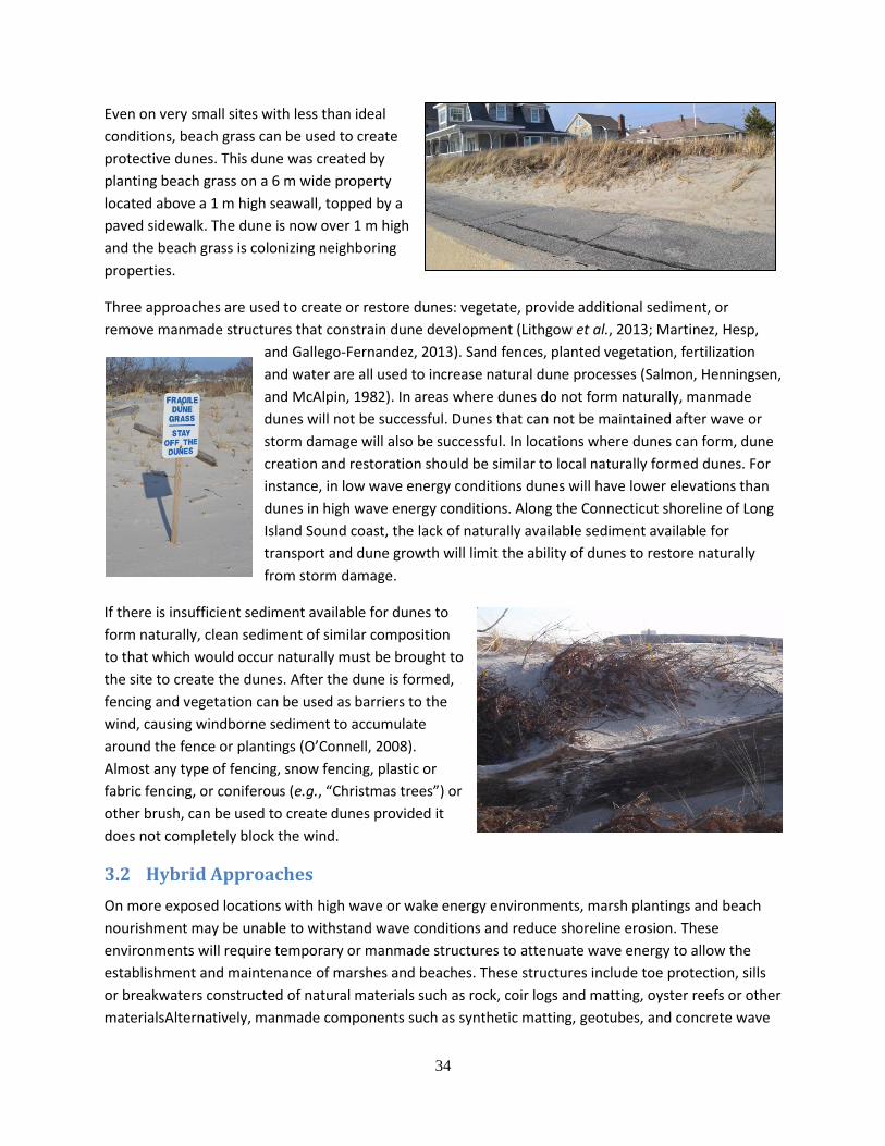
Even on very small sites with less than ideal
conditions, beach grass can be used to create
protective dunes. This dune was created by
planting beach grass on a 6 m wide property
located above a 1 m high seawall, topped by a
paved sidewalk. The dune is now over 1 m high
and the beach grass is colonizing neighboring
properties.
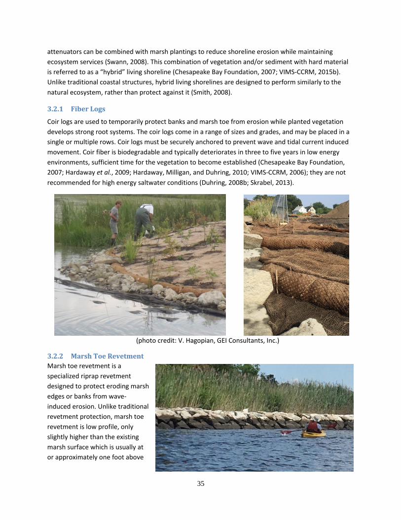
Three approaches are used to create or restore dunes: vegetate, provide additional sediment, or
remove manmade structures that constrain dune development (Lithgow et al., 2013; Martinez, Hesp,
and Gallego-Fernandez, 2013). Sand fences, planted vegetation, fertilization
and water are all used to increase natural dune processes (Salmon, Henningsen,
and McAlpin, 1982). In areas where dunes do not form naturally, manmade
dunes will not be successful. Dunes that can not be maintained after wave or
storm damage will also be successful. In locations where dunes can form, dune
creation and restoration should be similar to local naturally formed dunes. For
instance, in low wave energy conditions dunes will have lower elevations than
dunes in high wave energy conditions. Along the Connecticut shoreline of Long
Island Sound coast, the lack of naturally available sediment available for
transport and dune growth will limit the ability of dunes to restore naturally
from storm damage.
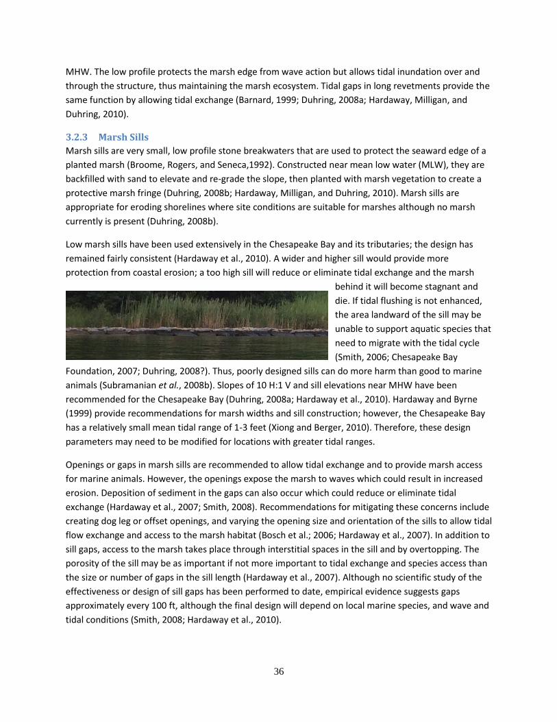
If there is insufficient sediment available for dunes to
form naturally, clean sediment of similar composition
to that which would occur naturally must be brought to
the site to create the dunes. After the dune is formed,
fencing and vegetation can be used as barriers to the
wind, causing windborne sediment to accumulate
around the fence or plantings (O’Connell, 2008).
Almost any type of fencing, snow fencing, plastic or
fabric fencing, or coniferous (e.g., “Christmas trees”) or
other brush, can be used to create dunes provided it
does not completely block the wind.
3.2 Hybrid Approaches
On more exposed locations with high wave or wake energy environments, marsh plantings and beach
nourishment may be unable to withstand wave conditions and reduce shoreline erosion. These
environments will require temporary or manmade structures to attenuate wave energy to allow the
establishment and maintenance of marshes and beaches. These structures include toe protection, sills
or breakwaters constructed of natural materials such as rock, coir logs and matting, oyster reefs or other
materialsAlternatively, manmade components such as synthetic matting, geotubes, and concrete wave
35
attenuators can be combined with marsh plantings to reduce shoreline erosion while maintaining
ecosystem services (Swann, 2008). This combination of vegetation and/or sediment with hard material
is referred to as a “hybrid” living shoreline (Chesapeake Bay Foundation, 2007; VIMS-CCRM, 2015b).
Unlike traditional coastal structures, hybrid living shorelines are designed to perform similarly to the
natural ecosystem, rather than protect against it (Smith, 2008).
3.2.1 Fiber Logs
Coir logs are used to temporarily protect banks and marsh toe from erosion while planted vegetation
develops strong root systems. The coir logs come in a range of sizes and grades, and may be placed in a
single or multiple rows. Coir logs must be securely anchored to prevent wave and tidal current induced
movement. Coir fiber is biodegradable and typically deteriorates in three to five years in low energy
environments, sufficient time for the vegetation to become established (Chesapeake Bay Foundation,
2007; Hardaway et al., 2009; Hardaway, Milligan, and Duhring, 2010; VIMS-CCRM, 2006); they are not
recommended for high energy saltwater conditions (Duhring, 2008b; Skrabel, 2013).
3.2.2 Marsh Toe Revetment
Marsh toe revetment is a
specialized riprap revetment
designed to protect eroding marsh
edges or banks from wave-
induced erosion. Unlike traditional
revetment protection, marsh toe
revetment is low profile, only
slightly higher than the existing
marsh surface which is usually at
or approximately one foot above
(photo credit: V. Hagopian, GEI Consultants, Inc.)
36
MHW. The low profile protects the marsh edge from wave action but allows tidal inundation over and
through the structure, thus maintaining the marsh ecosystem. Tidal gaps in long revetments provide the
same function by allowing tidal exchange (Barnard, 1999; Duhring, 2008a; Hardaway, Milligan, and
Duhring, 2010).
3.2.3 Marsh Sills
Marsh sills are very small, low profile stone breakwaters that are used to protect the seaward edge of a
planted marsh (Broome, Rogers, and Seneca,1992). Constructed near mean low water (MLW), they are
backfilled with sand to elevate and re-grade the slope, then planted with marsh vegetation to create a
protective marsh fringe (Duhring, 2008b; Hardaway, Milligan, and Duhring, 2010). Marsh sills are
appropriate for eroding shorelines where site conditions are suitable for marshes although no marsh
currently is present (Duhring, 2008b).
Low marsh sills have been used extensively in the Chesapeake Bay and its tributaries; the design has
remained fairly consistent (Hardaway et al., 2010). A wider and higher sill would provide more
protection from coastal erosion; a too high sill will reduce or eliminate tidal exchange and the marsh
behind it will become stagnant and
die. If tidal flushing is not enhanced,
the area landward of the sill may be
unable to support aquatic species that
need to migrate with the tidal cycle
(Smith, 2006; Chesapeake Bay
Foundation, 2007; Duhring, 2008?). Thus, poorly designed sills can do more harm than good to marine
animals (Subramanian et al., 2008b). Slopes of 10 H:1 V and sill elevations near MHW have been
recommended for the Chesapeake Bay (Duhring, 2008a; Hardaway et al., 2010). Hardaway and Byrne
(1999) provide recommendations for marsh widths and sill construction; however, the Chesapeake Bay
has a relatively small mean tidal range of 1-3 feet (Xiong and Berger, 2010). Therefore, these design
parameters may need to be modified for locations with greater tidal ranges.
Openings or gaps in marsh sills are recommended to allow tidal exchange and to provide marsh access
for marine animals. However, the openings expose the marsh to waves which could result in increased
erosion. Deposition of sediment in the gaps can also occur which could reduce or eliminate tidal
exchange (Hardaway et al., 2007; Smith, 2008). Recommendations for mitigating these concerns include
creating dog leg or offset openings, and varying the opening size and orientation of the sills to allow tidal
flow exchange and access to the marsh habitat (Bosch et al.; 2006; Hardaway et al., 2007). In addition to
sill gaps, access to the marsh takes place through interstitial spaces in the sill and by overtopping. The
porosity of the sill may be as important if not more important to tidal exchange and species access than
the size or number of gaps in the sill length (Hardaway et al., 2007). Although no scientific study of the
effectiveness or design of sill gaps has been performed to date, empirical evidence suggests gaps
approximately every 100 ft, although the final design will depend on local marine species, and wave and
tidal conditions (Smith, 2008; Hardaway et al., 2010).
37
3.2.4 Oyster Reefs
Marsh sills are also formed with oyster reefs, constructed of bagged or loose oyster shell, to provide the
same erosion control as rock sills, but with additional ecosystem benefits (Atlantic States Marine
Fisheries Commission Staff, 2010; Duhring, 2008b; Scyphers et al., 2011; Skrabel, 2013; Swann, 2008).
Oyster reefs provide a substrate for oyster recruitment and thus are self-maintaining, building the reef
dimensions and therefore, protection and restoration benefits with time (Atlantic States Marine
Fisheries Commission Staff, 2010; Gedan et al., 2011; Scyphers et al., 2011) so oyster reefs are
sometimes referred to as “living breakwaters” (NOAA National Marine Fisheries Service, 2015). Like rock
sills, oyster reefs provide habitat and foraging areas for aquatic species, however, as oysters are filter
feeders they also improve water quality and clarity by removing sediment and algae, which improves
light transmission and enhances the environment for SAV (Atlantic States Marine Fisheries Commission
Staff, 2010).
At present, there is limited understanding of the value of oyster reefs for planted marshes (Atlantic
States Marine Fisheries Commission Staff, 2010; National Research Council, 2014), and it is not clear if
uncontained oyster shell is
sufficiently resistant to wave action
and tidal currents to provide
adequate protection.
The effectiveness for shore
protection of low profile marsh sills
is limited due to the larger tidal
ranges experienced in New England.
Large scale oyster reefs are similar
to traditional breakwaters but are
seeded with oysters to reduce risk to coastal storms while providing ecosystem services enhancement
(Rebuild by Design, 2015). The persistence and growth on oyster beds depend on wind, waves, tidal
currents and ice. Currently, the Connecticut’s natural beds are only a few oysters deep and since most of
the subtidal areas are designated harvest areas, the pyramid shape commonly found in the Chesapeake
Bay does not exist in Long Island Sound (Getchis, 2015). In Long Island Sound, commercial oystering
limits the feasibility of oyster reefs. Most of the nearshore sites suitable for oyster reef construction are
designated town, state or privately held commercial harvesting beds. Additionally, the CT Bureau of
Aquaculture has a policy of removing oysters when they reach 5-6 years old to reduce the potential
occurrence of MSX (Carey, 2015). Thus, the feasibility of oyster reef sills and breakwaters for living
shorelines in Long Island Sound is limited.
3.2.5 Breakwaters
(photo credit: B. Branco, Brooklyn College)
38
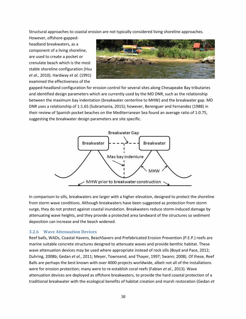
Structural approaches to coastal erosion are not typically considered living shoreline approaches.
However, offshore-gapped-
headland breakwaters, as a
component of a living shoreline,
are used to create a pocket or
crenulate beach which is the most
stable shoreline configuration (Hsu
et al., 2010). Hardway et al. (1991)
examined the effectiveness of the
gapped-headland configuration for erosion control for several sites along Chesapeake Bay tributaries
and identified design parameters which are currently used by the MD DNR, such as the relationship
between the maximum bay indentation (breakwater centerline to MHW) and the breakwater gap. MD
DNR uses a relationship of 1:1.65 (Subramania, 2015); however, Berenguer and Fernandez (1988) in
their review of Spanish pocket beaches on the Mediterranean Sea found an average ratio of 1:0.75,
suggesting the breakwater design parameters are site specific.
In comparison to sills, breakwaters are larger with a higher elevation, designed to protect the shoreline
from storm wave conditions. Although breakwaters have been suggested as protection from storm
surge, they do not protect against coastal inundation. Breakwaters reduce storm-induced damage by
attenuating wave heights, and they provide a protected area landward of the structures so sediment
deposition can increase and the beach widened.
3.2.6 Wave Attenuation Devices
Reef balls, WADs, Coastal Havens, BeachSavers and Prefabricated Erosion Prevention (P.E.P.) reefs are
marine suitable concrete structures designed to attenuate waves and provide benthic habitat. These
wave attenuation devices may be used where appropriate instead of rock sills (Boyd and Pace, 2012;
Duhring, 2008b; Gedan et al., 2011; Meyer, Townsend, and Thayer, 1997; Swann; 2008). Of these, Reef
Balls are perhaps the best known with over 4000 projects worldwide, albeit not all of the installations
were for erosion protection; many were to re-establish coral reefs (Fabian et al., 2013). Wave
attenuation devices are deployed as offshore breakwaters, to provide the hard coastal protection of a
traditional breakwater with the ecological benefits of habitat creation and marsh restoration (Gedan et
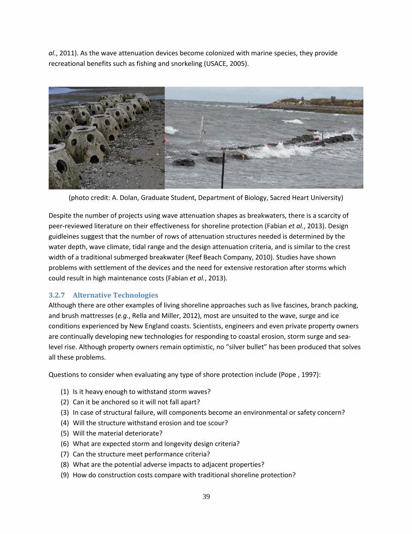
39
al., 2011). As the wave attenuation devices become colonized with marine species, they provide
recreational benefits such as fishing and snorkeling (USACE, 2005).
Despite the number of projects using wave attenuation shapes as breakwaters, there is a scarcity of
peer-reviewed literature on their effectiveness for shoreline protection (Fabian et al., 2013). Design
guidleines suggest that the number of rows of attenuation structures needed is determined by the
water depth, wave climate, tidal range and the design attenuation criteria, and is similar to the crest
width of a traditional submerged breakwater (Reef Beach Company, 2010). Studies have shown
problems with settlement of the devices and the need for extensive restoration after storms which
could result in high maintenance costs (Fabian et al., 2013).
3.2.7 Alternative Technologies
Although there are other examples of living shoreline approaches such as live fascines, branch packing,
and brush mattresses (e.g., Rella and Miller, 2012), most are unsuited to the wave, surge and ice
conditions experienced by New England coasts. Scientists, engineers and even private property owners
are continually developing new technologies for responding to coastal erosion, storm surge and sea-
level rise. Although property owners remain optimistic, no “silver bullet” has been produced that solves
all these problems.
Questions to consider when evaluating any type of shore protection include (Pope , 1997):
(1) Is it heavy enough to withstand storm waves?
(2) Can it be anchored so it will not fall apart?
(3) In case of structural failure, will components become an environmental or safety concern?
(4) Will the structure withstand erosion and toe scour?
(5) Will the material deteriorate?
(6) What are expected storm and longevity design criteria?
(7) Can the structure meet performance criteria?
(8) What are the potential adverse impacts to adjacent properties?
(9) How do construction costs compare with traditional shoreline protection?
(photo credit: A. Dolan, Graduate Student, Department of Biology, Sacred Heart University)

40
(10) What are maintenance and repair costs?
(11) What is its effective life?
(12) What will it cost to remove the system if necessary?
4 Site Considerations The most appropriate Living Shoreline design is highly dependent on the site conditions. Many
parameters must be evaluated to determine the best approach.
Wave Climate
Tidal Range
Ice
Storm Surge
Nearshore Bathymetry
Shoreline Geomorphology
Site Characteristics
Vegetation
Shore Zone
Existing Coastal Structures
Shoreline Usage
4.1 Design Parameters Before an appropriate course of action can be determined, the nature of the problem must be identified,
the desired outcome resolved and the characteristics of the site understood. Numerous parameters affect
the shoreline; however, the relative importance of each parameter will depend on the site, the problem and
the project goal (Hardaway et al., 2010). These parameters include: location, fetch, wave climate, tidal
range, storm surge height and frequency, nearshore bathymetry, shoreline exposure, rate of existing
shoreline change (erosion/accretion), upland bank characteristics (height, composition, condition, usage,
proximity to infrastructure), existing vegetation, width and elevation of beach or marsh, functionality of
any existing coastal structures and sea level rise (Duhring, Barnard and Hardaway, 2006; Frizzera, 2009;
Hardaway, Milligan and Duhring, 2010;U.S. Department of Agriculture, 1996).
4.1.1 Wave Climate and Fetch
As wave action is the primary mechanism for coastal erosion, determining the wave climate is essential
for development of a suitable approach for coastal protection. In locations protected from wind generated
waves, proximity to powerboat marinas and navigational channels can cause the shoreline to be adversely
impacted by boat wakes (Hardaway et al., 2010). Many researchers consider fetch, the distance that wind
can travel over open water, to be one of the most important parameters in determining the feasibility of a
living shoreline approach because longer fetches can result in larger wave heights making areas less
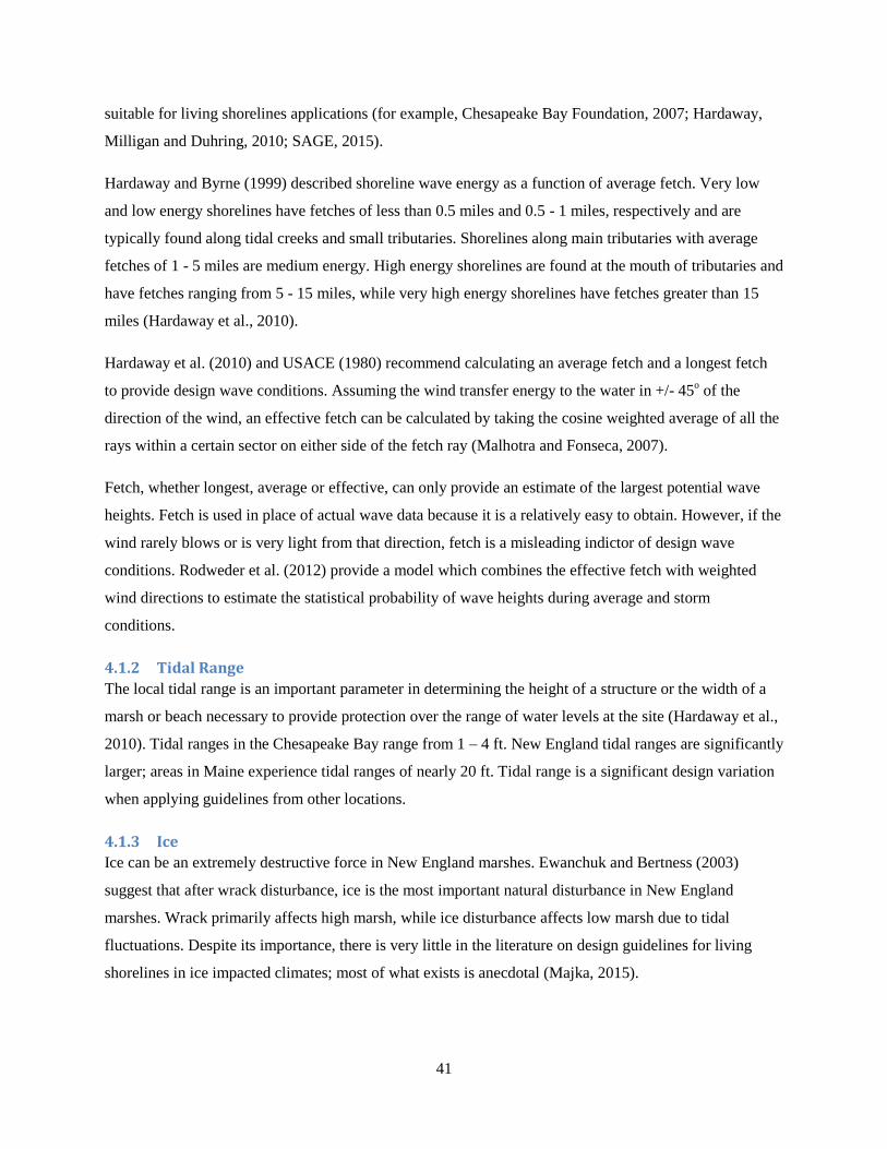
41
suitable for living shorelines applications (for example, Chesapeake Bay Foundation, 2007; Hardaway,
Milligan and Duhring, 2010; SAGE, 2015).
Hardaway and Byrne (1999) described shoreline wave energy as a function of average fetch. Very low
and low energy shorelines have fetches of less than 0.5 miles and 0.5 - 1 miles, respectively and are
typically found along tidal creeks and small tributaries. Shorelines along main tributaries with average
fetches of 1 - 5 miles are medium energy. High energy shorelines are found at the mouth of tributaries and
have fetches ranging from 5 - 15 miles, while very high energy shorelines have fetches greater than 15
miles (Hardaway et al., 2010).
Hardaway et al. (2010) and USACE (1980) recommend calculating an average fetch and a longest fetch
to provide design wave conditions. Assuming the wind transfer energy to the water in +/- 45o of the
direction of the wind, an effective fetch can be calculated by taking the cosine weighted average of all the
rays within a certain sector on either side of the fetch ray (Malhotra and Fonseca, 2007).
Fetch, whether longest, average or effective, can only provide an estimate of the largest potential wave
heights. Fetch is used in place of actual wave data because it is a relatively easy to obtain. However, if the
wind rarely blows or is very light from that direction, fetch is a misleading indictor of design wave
conditions. Rodweder et al. (2012) provide a model which combines the effective fetch with weighted
wind directions to estimate the statistical probability of wave heights during average and storm
conditions.
4.1.2 Tidal Range
The local tidal range is an important parameter in determining the height of a structure or the width of a
marsh or beach necessary to provide protection over the range of water levels at the site (Hardaway et al.,
2010). Tidal ranges in the Chesapeake Bay range from 1 – 4 ft. New England tidal ranges are significantly
larger; areas in Maine experience tidal ranges of nearly 20 ft. Tidal range is a significant design variation
when applying guidelines from other locations.
4.1.3 Ice
Ice can be an extremely destructive force in New England marshes. Ewanchuk and Bertness (2003)
suggest that after wrack disturbance, ice is the most important natural disturbance in New England
marshes. Wrack primarily affects high marsh, while ice disturbance affects low marsh due to tidal
fluctuations. Despite its importance, there is very little in the literature on design guidelines for living
shorelines in ice impacted climates; most of what exists is anecdotal (Majka, 2015).
42
Ice in the coastal ocean is never stationary; its motion creates several different types of forces impacting
the shoreline and coastal structures. Wind, tides and currents move ice sheets creating horizontal forces
on vertical structures such as seawalls and building foundations. Thermal expansion and contraction
creates static forces on structures. Ice sheet adhesion to structures creates uplift and drawdown forces (US
Army Corps of Engineers, 1981).
Ewanchuk and Bertness (2003) found that ice disturbances that killed the vegetation, but left the
underlying peat intact, recovered quickly, but in marshes where ice damage killed the vegetation and
removed the underlying peat, only the most stress-tolerant plants re-colonized. They asume that the
recovery process is likely to exceed 10 years for intense ice damage.
Southern and Northern New England are affected somewhat differently from ice forces. In Southern New
England, ice damage primarily affects low marsh. Ice adhesion can remove large portions (1 - 3 m2) and
transport the vegetation on the ebb tide (Bertness and Ellison 1987; Brewer et al., 1998; Ewanchuk and
Bertness, 2003). Further north, ice damage destroys low marsh vegetation every winter (Bertness, 1999;
Ewanchuk and Bertness, 2003). In northern New England, ice disturbances also affect the middle and
high marsh when ice sheets melt and deposit sediment that had been transported within the ice sheet from
other locations (Ewanchuk and Bertness, 2003). Ice damage also consists of the formation of ice ridges
and scouring and gouging of the marsh substrate (Majka, 2015).
The four primary methods of addressing the effects of ice are:
Do nothing
Do nothing then restore: this may be the most appropriate and most cost-effective solution if ice
damage will be minimal, or no structural or human health risk is anticipated.
Protect against ice’s strength: this is typically accomplished through coastal structures composed
of steel, stone or concrete. This approach is rarely used with living shorelines; however, it may be
appropriate if structures are at a significant risk to ice damage.
Attack ice’s weakness: although extremely strong in compression, ice is weak in tension. By
roughening the surface or installing obstructions, ice can be weakened. Gentle slopes (10 - 20%)
allow ice to slide up and down. The addition of ribs to the slope can encourage this mechanism.
Plants, particularly emergent vegetation or shrubs, weaken ice, primarily because decaying
vegetation produces CO2 and thermal energy. Ice grows weaker around shrubs because stems
flexible obstructions (Majka, 2015).
4.1.4 Storm Surge
The predicted surge for storms of different statistical probability is critical to the design of effective
43
protection against coastal erosion and inland flooding. Surge elevations help identify areas at risk of
inundation, volume of floodwaters expected and provide an estimate of the expected level of protection an
approach can provide.
4.1.5 Nearshore Bathymetry
The nearshore bathymetry determines the height of the waves approaching the site. A gradual nearshore
slope will cause incoming waves to break as they approach the shore, resulting in less erosive wave
energy. Steeper nearshore bathymetry will allow larger waves to reach the shoreline. Tidal flats and sand
bars can attenuate wave heights reaching the shoreline. Sandy intertidal regions and sand bars indicate
sediment available in the systems for natural beach and dune nourishment. Thus, the nearshore
bathymetry will determine the size and feasibility of shore protection structures (Hardaway et al., 2010).
4.1.6 Shoreline Geomorphology
Shorelines can be categorized into three major geomorphologic types: beaches and dunes, rocky and soft
bluffs, and mudflats and vegetated communities (NRC, 2007). In addition to the types of shorelines,
shorelines in New England are highly variable; they can be long and straight, bounded by rocky
headlands, or highly irregular. Pocket beaches tend to be crenulated; the waves diffract as they approach
the shoreline and sediment transported tends to remain within the pocket beach system. Linear shorelines
and headlands are more exposed to erosive wave action, while irregular shorelines are interrupted by
headlands, marshes or coastal structures tend to receive reduced wave effects (Hardaway et al., 2010).
The coastal morphology also determines the ability of the substrate to support protective structures. The
composition of the substrate is critical to the types of vegetation and its ability to support a structure, such
as a sill or oyster reef.
4.1.7 Shoreline Change
“Understanding how a shore reach has evolved is important to assessing how to manage it,” (Hardaway et
al., 2010). The appearance of erosion does not necessarily indicate an erosion problem. An undercut bank
may be stable so a landscaping approach may be sufficient, or it could be a result of recent storm effects
and with time, naturally restore itself. Thus, the rate of shoreline change must be assessed to determine
the appropriate approach.
4.1.8 Site characteristics
While many parameters for assessing the feasibility of various coastal protections can be evaluated from
maps and online sources, it is usually necessary and frequently valuable to visit the site. Although the
length of the site may influence the impact of boundary effects, a primary concern is how the site is
bounded. Neighboring eroding shorelines may provide sediment while adjacent harden shorelines will
44
limit the amount of sediment available. Headlands and groins may provide wave protection but limit
sediment transport into the site.
The upland usage must be considered when evaluating shoreline protection techniques. The importance of
coastal development and infrastructure, the cost and feasibility of moving upland structures, and the risk
of erosion and flooding all affect the level of protection required.
For a shoreline with no existing shoreline structure or hardening, the condition of the backshore or bank
can provide an indication of its stability. Sandy beaches without shoreward dunes may indicate an
overwash area that is susceptible to coastal flooding, while a healthy dune system indicates an adequate
supply of sediment for repairing storm induced damage. A gradually sloping bank covered with salt
tolerant vegetation is a good indicator of bank stability. Steep banks devoid of vegetation frequently
exhibit signs of undercutting or slumping. The slumped sediment may act as a buffer to wave action and
thus temporarily reducing erosion, but once the slumped sediment is eroded, the toe of the bank is once
again exposed to waves and thus susceptible to slumping (Hardaway et al., 2010). The composition of
the bank material will affect its erodibility. Rocky bluffs are obviously less susceptible to wave action
than unconsolidated sand banks but may be affected by splashover effects.
4.1.9 Vegetation
The presence of marsh plants and nearshore submerged aquatic vegetation (SAV) demonstrates that site
conditions are suitable for vegetative protection but also may affect the regulatory acceptability of certain
erosion control structures (Hardaway et al., 2010).
4.1.10 Shellfish Beds
Nearshore shellfish beds are a clear indication that the conditions are suitable for shellfish; however,
their existence may also preclude the creation of some types of Living Shorelines. The construction and
presence of Living Shorelines may negatively impact the shellfish beds. For instance, fill material can
bury shellfish; sills and breakwaters can damage shellfish beds.
4.1.11 Shore Zone
The width and elevation of the shoreline, whether sandy beach or intertidal marsh, are indications of its
capability to attenuate waves. Typically, a higher, wider shoreface will lead to greater wave attenuation;
however, studies have shown that even a narrow marsh region can significantly reduce wave heights
(Möller and Spencer, 2002; Gedan et al., 2011).
4.1.12 Existing Coastal Structures
Existing coastal protection structures may indicate an attempt to rectify a pre-existing problem; however,
they do not necessarily mean the problem was erosion. Many coastal property owners originally built low
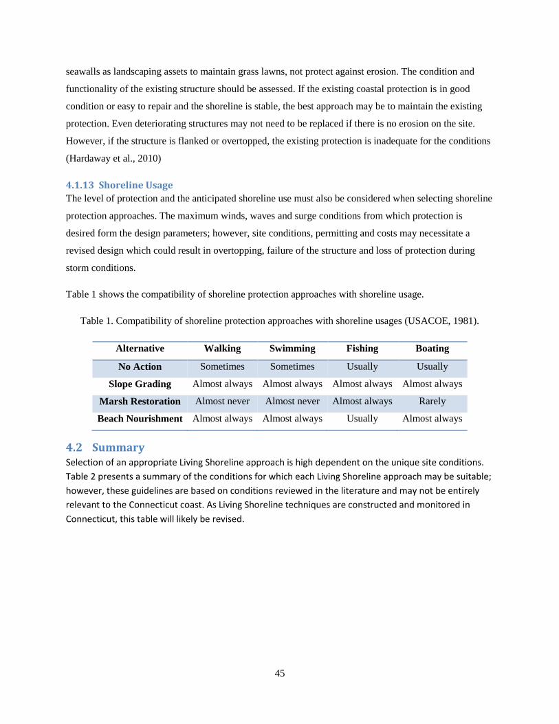
45
seawalls as landscaping assets to maintain grass lawns, not protect against erosion. The condition and
functionality of the existing structure should be assessed. If the existing coastal protection is in good
condition or easy to repair and the shoreline is stable, the best approach may be to maintain the existing
protection. Even deteriorating structures may not need to be replaced if there is no erosion on the site.
However, if the structure is flanked or overtopped, the existing protection is inadequate for the conditions
(Hardaway et al., 2010)
4.1.13 Shoreline Usage
The level of protection and the anticipated shoreline use must also be considered when selecting shoreline
protection approaches. The maximum winds, waves and surge conditions from which protection is
desired form the design parameters; however, site conditions, permitting and costs may necessitate a
revised design which could result in overtopping, failure of the structure and loss of protection during
storm conditions.
Table 1 shows the compatibility of shoreline protection approaches with shoreline usage.
Table 1. Compatibility of shoreline protection approaches with shoreline usages (USACOE, 1981).
Alternative Walking Swimming Fishing Boating
No Action Sometimes Sometimes Usually Usually
Slope Grading Almost always Almost always Almost always Almost always
Marsh Restoration Almost never Almost never Almost always Rarely
Beach Nourishment Almost always Almost always Usually Almost always
4.2 Summary Selection of an appropriate Living Shoreline approach is high dependent on the unique site conditions.
Table 2 presents a summary of the conditions for which each Living Shoreline approach may be suitable;
however, these guidelines are based on conditions reviewed in the literature and may not be entirely
relevant to the Connecticut coast. As Living Shoreline techniques are constructed and monitored in
Connecticut, this table will likely be revised.
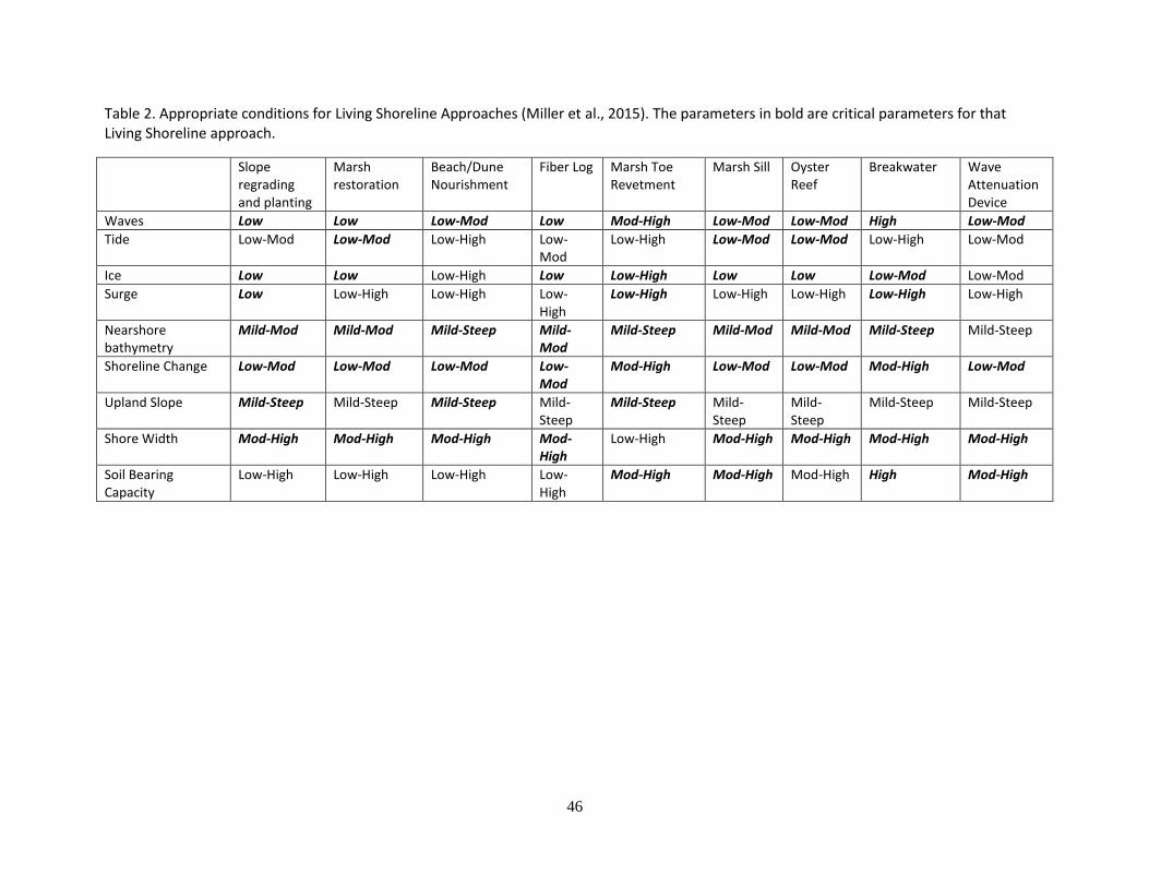
46
Table 2. Appropriate conditions for Living Shoreline Approaches (Miller et al., 2015). The parameters in bold are critical parameters for that Living Shoreline approach.
Slope regrading and planting
Marsh restoration
Beach/Dune Nourishment
Fiber Log Marsh Toe Revetment
Marsh Sill Oyster Reef
Breakwater Wave Attenuation Device
Waves Low Low Low-Mod Low Mod-High Low-Mod Low-Mod High Low-Mod
Tide Low-Mod Low-Mod Low-High Low-Mod
Low-High Low-Mod Low-Mod Low-High Low-Mod
Ice Low Low Low-High Low Low-High Low Low Low-Mod Low-Mod
Surge Low Low-High Low-High Low-High
Low-High Low-High Low-High Low-High Low-High
Nearshore bathymetry
Mild-Mod Mild-Mod Mild-Steep Mild-Mod
Mild-Steep Mild-Mod Mild-Mod Mild-Steep Mild-Steep
Shoreline Change Low-Mod Low-Mod Low-Mod Low-Mod
Mod-High Low-Mod Low-Mod Mod-High Low-Mod
Upland Slope Mild-Steep Mild-Steep Mild-Steep Mild-Steep
Mild-Steep Mild-Steep
Mild-Steep
Mild-Steep Mild-Steep
Shore Width Mod-High Mod-High Mod-High Mod-High
Low-High Mod-High Mod-High Mod-High Mod-High
Soil Bearing Capacity
Low-High Low-High Low-High Low-High
Mod-High Mod-High Mod-High High Mod-High
47
5 Permitting Steps It would be useful here to provide some guidelines or steps for readers interested in constructing a living
shoreline in Connecticut. However, if the steps are still in the develop stage or if we decide that it is too
technical or confusing for the audience we can modify the content.
48
6 Resources
6.1 Websites
DEEP
CIRCA
CLEAR
Maine Coastal Hazards
Who else on living shorelines?
6.2 Literature Cited Arkema et al., 2013; Atlantic States Marine Fisheries Commission Staff, 2010; Augustin, Irish, and Lynett, 2009; Barnard, 1999; Bendell, Bonnie and The North Carolina Estuarine Biological and Physical Processes Work Group , 2006,
RECOMMENDATIONS FOR APPROPRIATE SHORELINE STABILIZATION METHODS FOR THE DIFFERENT NORTH CAROLINA ESTUARINE SHORELINE TYPES, North Carolina Coastal Resources Commission Estuarine Shoreline Stabilization Subcommittee
Berenguer and Fernandez (1988 Bosch et al.; 2006; Boyd and Pace, 2012; Bridges et al., 2015; Broome, Rogers, and Seneca, 1992 Carey, 2015 Chesapeake Bay Foundation, 2007; Currin, Chappell, and Deaton, 2010; Dias et al., 2003 Disaster Mitigation Act (DMA) 2000 Hazard Mitigation Plan – Suffolk Country, New York, October 2008,
Section 5.4.5: Risk Assessment – Coastal Erosion. Douglass and Pickel, 1999; Duarte et al., 2013; Duhring, 2008a; Duhring, 2008b; Duhring 2009a
Duhring, Barnard and Hardaway, 2006; Dugan et al., 2008; Dugan and Hubbard, 2006; Ewanchuk and Bertness (2003) Fabian et al., 2013 Feagin et al., 2009; Frizzera, 2009 Galveston Bay Foundation Staff, 2014 Gedan et al., 2011; Getchis, 2015 Guannel et al., 2015; Hardaway and Byrne (1999) ; Hardway et al. (1991
49
Hardaway et al., 2007; Hardaway et al., 2009; Hardaway, Milligan, and Duhring, 2010; Hsu et al., 2010). Lithgow et al., 2013 Martinez, Hesp, and Gallego-Fernandez, 2013 Maryland Department of Environment, 2008 Meyer, Townsend, and Thayer, 1997; Committee on Beach Nourishment and Protection, National Research Council, 1995 National Research Council, 2006 National Research Council, 2007; National Research Council, 2014 NOAA National Marine Fisheries Service, 2015 Nordstrom, Lampe, and Vandemark, 2000 O’Connell, 2008 O’Donnell, J.E.D., 2015, submitted to the Journal of Coastal Research. Pinsky, Guannel, and Arkema, 2013; Pope , 1997 Ray-Culp, 2007; Rebuild by Design, 2015 Reef Beach Company, 2010 Rella and Miller, 2012 Salmon, Henningsen, and McAlpin, 1982 Scyphers et al., 2011; Shepard, Crain, and Beck, 2011; Skrabel, 2013 Slovinsky, 2011 Smith, 2006; Smith, 2008 Subramanian et al., 2008a Subramanian et al., 2008b Subramania, 2015 Sutton-Grier, Wowk, and Bamford, 2015, Swann, 2008; Thomas-Blate, 2010 USACE, 2005
U.S. Department of Agriculture, 1996 VIMS-CCRM, 2006 VIMS-CCRM, 2015b Xiong and Berger, 2010)
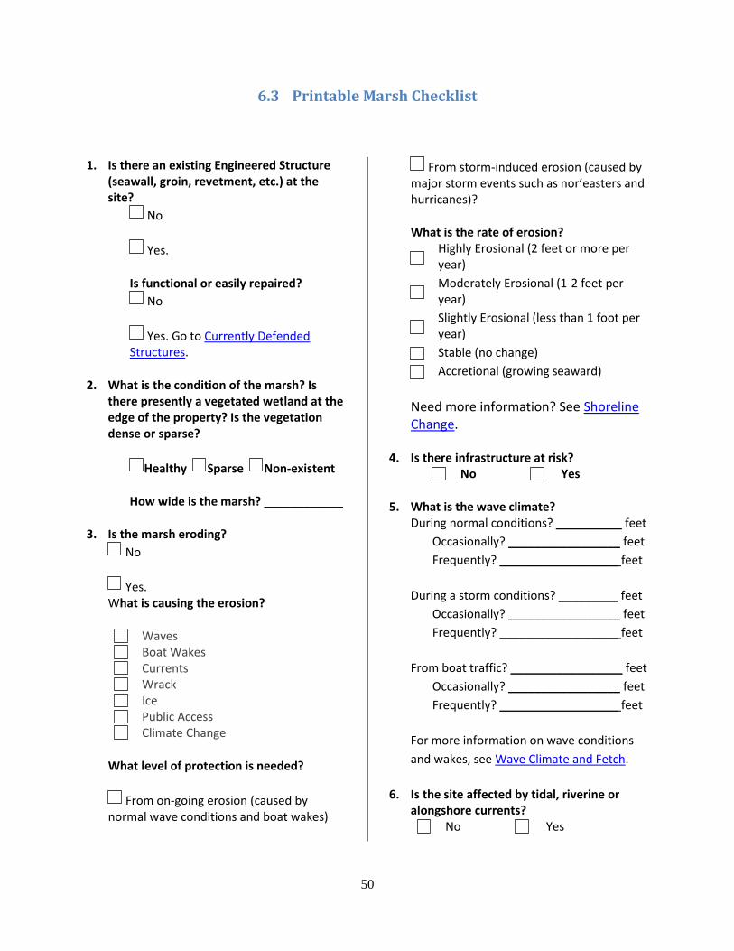
50
6.3 Printable Marsh Checklist
1. Is there an existing Engineered Structure (seawall, groin, revetment, etc.) at the site?
No
Yes.
Is functional or easily repaired?
No
Yes. Go to Currently Defended Structures.
2. What is the condition of the marsh? Is there presently a vegetated wetland at the edge of the property? Is the vegetation dense or sparse?
Healthy Sparse Non-existent
How wide is the marsh? ____________
3. Is the marsh eroding?
No
Yes. What is causing the erosion?
Waves
Boat Wakes
Currents
Wrack
Ice
Public Access
Climate Change
What level of protection is needed?
From on-going erosion (caused by normal wave conditions and boat wakes)
From storm-induced erosion (caused by major storm events such as nor’easters and hurricanes)?
What is the rate of erosion?
Highly Erosional (2 feet or more per year)
Moderately Erosional (1-2 feet per year)
Slightly Erosional (less than 1 foot per year)
Stable (no change)
Accretional (growing seaward)
Need more information? See Shoreline Change.
4. Is there infrastructure at risk?
No Yes
5. What is the wave climate? During normal conditions? __________ feet
Occasionally? _________________ feet
Frequently? __________________ feet
During a storm conditions? _________ feet
Occasionally? _________________ feet
Frequently? __________________ feet
From boat traffic? _________________ feet
Occasionally? _________________ feet
Frequently? __________________ feet
For more information on wave conditions
and wakes, see Wave Climate and Fetch.
6. Is the site affected by tidal, riverine or alongshore currents?
No Yes
51
7. What is the shoreline geometry?
Irregular
Straight
Headland
Unsure? Check out Shoreline Geomorphology.
8. Is the marsh backed by High sediment bank (is there a steep slope above the water line, more than 3 feet over 5 yards?)
No
Yes. Go to the Section on Bluffs
Low sediment bank (is there a gentle slope above the water line, less than 3 feet over 5 yards?)
No
Yes. Is your low bank face
Erosional?
Stable?
Transitional?
Undercut?
9. Does the bank have
Mature upland vegetation?
No Yes
Fallen or uprooted trees?
No Yes
Will existing vegetation shade created or restored marsh?
No Yes
10. What is the intertidal slope/nearshore bathymetry? Is the slope
Gradual
Moderate
Steep
For more information see Nearshore Bathymetry.
11. What is the tidal range?
__________________ feet
Need more information. See Tidal Range.
12. Does the project site flood regularly during normal tides?
No Yes
Spring tides?
No Yes
Storm surge?
No Yes
13. Is the project site affected by ice?
No Yes
For more information see the section on Ice.
14. Does the site have submerged aquatic vegetation?
No Yes
Nearshore oyster beds?
No Yes
15. What is the nearshore region?
Fine
Medium-coarse sediment
Rocky or cobbles
Ledge
Offshore Sand Bars
Tidal Flats
16. What is the condition of the adjacent properties? Are they experiencing similar rates of erosion?
No Yes
52
Do they have existing coastal structures?
No Yes
How will this project affect the adjacent properties? ____________________________________________________________________________________________________________
17. Is the project site accessible for construction from land?
No Yes
Water?
No Yes
18. What is the current rate of sea level rise? __________________ feet
What is the predicted rate of rise?
__________________ feet
What are the potential effects of sea level rise on the project site? ____________________________________________________________________________________________________________
53
6.4 Printable Beach and Dune Checklist
1. Is there an existing Engineered Structure (seawall, groin, revetment, etc.) at the site?
No
Yes.
Is functional or easily repaired?
No
Yes. Go to Currently Defended Structures.
2. Is there a sand dune at the seaward edge of the property?
No
Yes.
Is it vegetated?
Yes
No.
Is a dry beach present (sand above normal high tide)?
No
Yes.
What is the width of the dry beach? _____25 feet or less
_____between 25 and 50 feet
_____between 50 and 75 feet
_____greater than 75 feet
3. Is there evidence that your dune or backshore is regularly overtopped and overwashed by waves, and/or that flooding occurs landward of the dune or beach crest?
No Yes
During normal or spring tides? Storm surges?
No Yes
4. Does your dune and beach naturally gain sand after each winter season?
No Yes
5. Is the beach or dune eroding?
No
Yes. What is causing the erosion?
Seasonal Changes
Storms
Sand Availability
Manmade structures
Currents
Public Access
Climate Change
What level of protection is needed?
From on-going erosion (caused by normal wave conditions and boat wakes)
From storm-induced erosion (caused by major storm events such as nor’easters and hurricanes)?
What is the rate of erosion?
Highly Erosional (2 feet or more per year)
Moderately Erosional (1-2 feet per year)
Slightly Erosional (less than 1 foot per year)
Stable (no change)
Accretional (growing seaward)
54
Need more information? See Shoreline Change.
6. Is there infrastructure at risk?
No Yes
7. What is the wave climate? During normal conditions? __________ feet
Occasionally? _________________ feet
Frequently? __________________ feet
During a storm conditions? _________ feet
Occasionally? _________________ feet
Frequently? __________________ feet
From boat traffic? _________________ feet
Occasionally? _________________ feet
Frequently? __________________ feet
For more information on wave conditions
and wakes, see Wave Climate and Fetch.
8. Is the site affected by tidal, riverine or alongshore currents?
No Yes
9. What is the shoreline geometry?
Irregular
Straight
Headland
Unsure? Check out Shoreline Geomorphology.
10. Is the beach backed by High sediment bank (is there a steep slope above the water line, more than 3 feet over 5 yards?)
No
Yes. Go to the Section on Bluffs
Low sediment bank (is there a gentle slope above the water line, less than 3 feet over 5 yards?)
No
Yes. Is your low bank face
Erosional?
Stable?
Transitional?
Undercut?
11. Does the bank have
Mature upland vegetation?
No Yes
Fallen or uprooted trees?
No Yes
Will existing vegetation shade created or restored marsh?
No Yes
12. What is the intertidal slope/nearshore bathymetry? Is the slope
Gradual
Moderate
Steep
For more information see Nearshore Bathymetry.
13. What is the tidal range?
__________________ feet
Need more information. See Tidal Range.
14. Does the project site flood regularly during normal tides?
No Yes
Spring tides?
No Yes
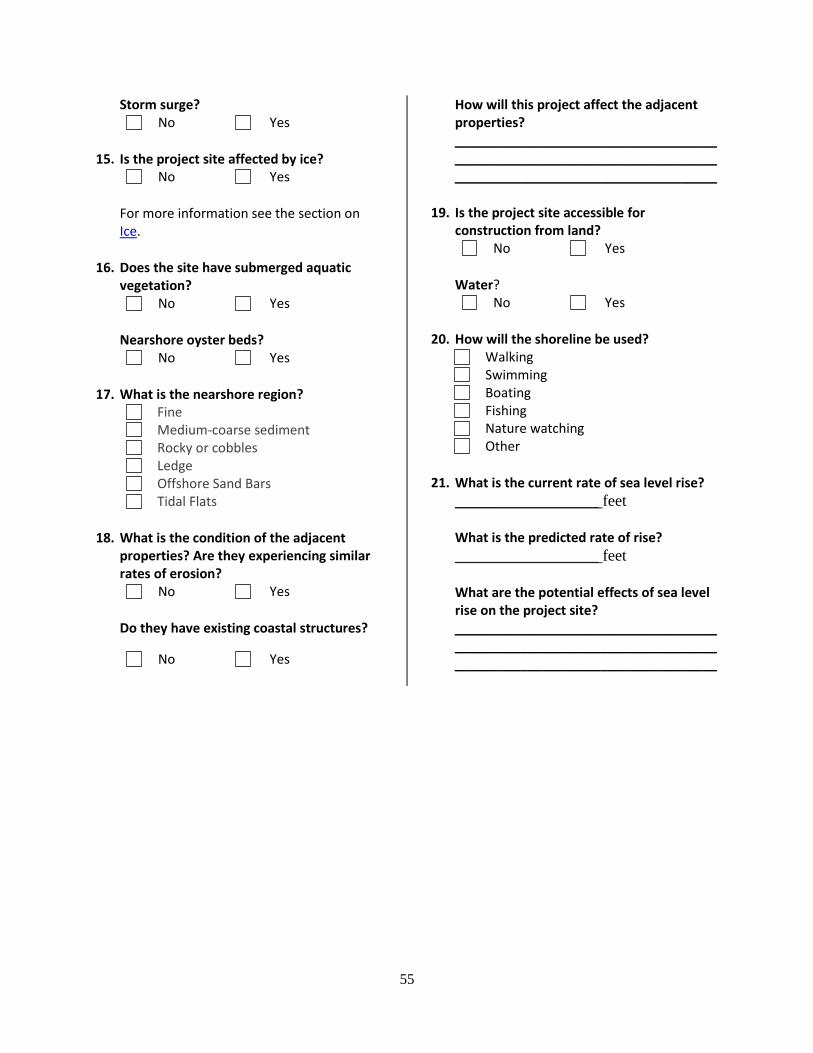
55
Storm surge?
No Yes
15. Is the project site affected by ice?
No Yes
For more information see the section on Ice.
16. Does the site have submerged aquatic vegetation?
No Yes
Nearshore oyster beds?
No Yes
17. What is the nearshore region?
Fine
Medium-coarse sediment
Rocky or cobbles
Ledge
Offshore Sand Bars
Tidal Flats
18. What is the condition of the adjacent properties? Are they experiencing similar rates of erosion?
No Yes
Do they have existing coastal structures?
No Yes
How will this project affect the adjacent properties? ____________________________________________________________________________________________________________
19. Is the project site accessible for construction from land?
No Yes
Water?
No Yes
20. How will the shoreline be used?
Walking
Swimming
Boating
Fishing
Nature watching
Other
21. What is the current rate of sea level rise?
__________________ feet
What is the predicted rate of rise?
__________________ feet
What are the potential effects of sea level rise on the project site? ____________________________________________________________________________________________________________
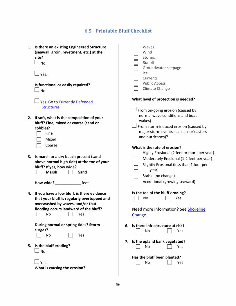
56
6.5 Printable Bluff Checklist
1. Is there an existing Engineered Structure (seawall, groin, revetment, etc.) at the site?
No
Yes.
Is functional or easily repaired?
No
Yes. Go to Currently Defended Structures.
2. If soft, what is the composition of your bluff? Fine, mixed or coarse (sand or cobble)?
Fine
Mixed
Coarse
3. Is marsh or a dry beach present (sand above normal high tide) at the toe of your bluff? If yes, how wide?
Marsh Sand
How wide? ____________ feet
4. If you have a low bluff, is there evidence that your bluff is regularly overtopped and overwashed by waves, and/or that flooding occurs landward of the bluff?
No Yes
During normal or spring tides? Storm surges?
No Yes
5. Is the bluff eroding?
No
Yes. What is causing the erosion?
Waves
Wind
Storms
Runoff
Groundwater seepage
Ice
Currents
Public Access
Climate Change
What level of protection is needed?
From on-going erosion (caused by normal wave conditions and boat wakes)
From storm-induced erosion (caused by major storm events such as nor’easters and hurricanes)?
What is the rate of erosion?
Highly Erosional (2 feet or more per year)
Moderately Erosional (1-2 feet per year)
Slightly Erosional (less than 1 foot per
year)
Stable (no change)
Accretional (growing seaward)
Is the toe of the bluff eroding?
No Yes
Need more information? See Shoreline Change.
6. Is there infrastructure at risk?
No Yes
7. Is the upland bank vegetated?
No Yes
Has the bluff been planted?
No Yes
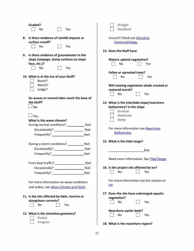
57
Graded?
No Yes
8. Is there evidence of rainfall impacts or surface runoff?
No Yes
9. Is there evidence of groundwater in the slope (seepage, damp surfaces on slope face, etc.)?
No Yes
10. What is at the toe of your bluff?
Beach?
Marsh?
Ledge?
Do waves or normal tides reach the base of the bluff?
No
Yes. What is the wave climate? During normal conditions? __________ feet
Occasionally? _________________ feet
Frequently? __________________ feet
During a storm conditions? _________ feet
Occasionally? _________________ feet
Frequently? __________________ feet
From boat traffic? _________________ feet
Occasionally? _________________ feet
Frequently? __________________ feet
For more information on wave conditions
and wakes, see Wave Climate and Fetch.
11. Is the site affected by tidal, riverine or alongshore currents?
No Yes
12. What is the shoreline geometry?
Irregular
Straight
Headland
Unsure? Check out Shoreline Geomorphology.
13. Does the bluff have
Mature upland vegetation?
No Yes
Fallen or uprooted trees?
No Yes
Will existing vegetation shade created or restored marsh?
No Yes
14. What is the intertidal slope/nearshore bathymetry? Is the slope
Gradual
Moderate
Steep
For more information see Nearshore Bathymetry.
15. What is the tidal range?
__________________ feet
Need more information. See Tidal Range.
16. Is the project site affected by ice?
No Yes
For more information see the section on Ice.
17. Does the site have submerged aquatic vegetation?
No Yes
Nearshore oyster beds?
No Yes
18. What is the nearshore region?
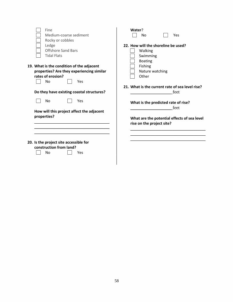
58
Fine
Medium-coarse sediment
Rocky or cobbles
Ledge
Offshore Sand Bars
Tidal Flats
19. What is the condition of the adjacent properties? Are they experiencing similar rates of erosion?
No Yes
Do they have existing coastal structures?
No Yes
How will this project affect the adjacent properties? ____________________________________________________________________________________________________________
20. Is the project site accessible for construction from land?
No Yes
Water?
No Yes
22. How will the shoreline be used?
Walking
Swimming
Boating
Fishing
Nature watching
Other
21. What is the current rate of sea level rise?
__________________ feet
What is the predicted rate of rise?
__________________ feet
What are the potential effects of sea level rise on the project site? ____________________________________________________________________________________________________________
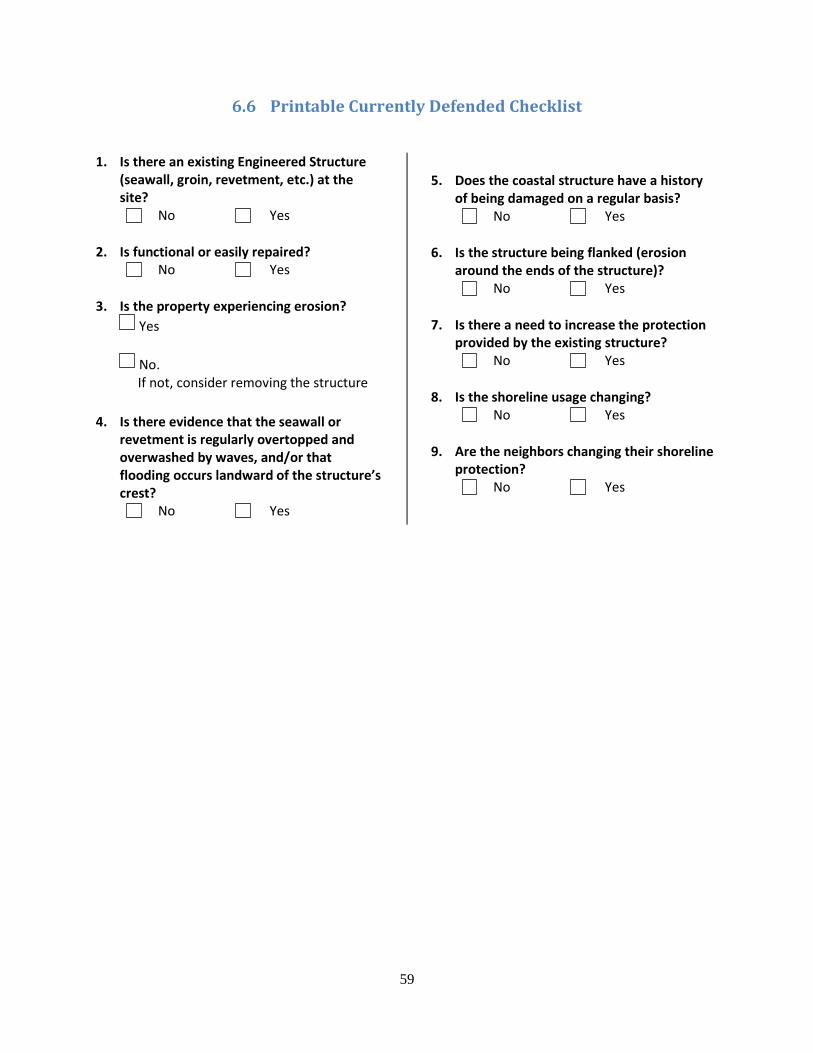
59
6.6 Printable Currently Defended Checklist
1. Is there an existing Engineered Structure (seawall, groin, revetment, etc.) at the site?
No Yes
2. Is functional or easily repaired?
No Yes
3. Is the property experiencing erosion?
Yes
No. If not, consider removing the structure
4. Is there evidence that the seawall or revetment is regularly overtopped and overwashed by waves, and/or that flooding occurs landward of the structure’s crest?
No Yes
5. Does the coastal structure have a history of being damaged on a regular basis?
No Yes
6. Is the structure being flanked (erosion around the ends of the structure)?
No Yes
7. Is there a need to increase the protection provided by the existing structure?
No Yes
8. Is the shoreline usage changing?
No Yes
9. Are the neighbors changing their shoreline protection?
No Yes