Embed Size (px)
Citation preview
WORLD BANK TECHNICAL PAPER NO. 436
WTP496far public diScumsIan ~~~~April 2001Work In progress
for PUbliC discussion
Design and Appraisalof Rural TransportInfrastructureEnsuring Basic Access for RuralCommunities
A "F~-
101'A1
Jerry LeboDieter Schelling
Pub
lic D
iscl
osur
e A
utho
rized
Pub
lic D
iscl
osur
e A
utho
rized
Pub
lic D
iscl
osur
e A
utho
rized
Pub
lic D
iscl
osur
e A
utho
rized

Recent World Bank Technical Papers
No. 414 Salman and Boisson de Chazoumes, International Watercourses: Enhancing Cooperation and ManagingConflict, Proceedings of a World Bank Seminar
No. 415 Feitelson and Haddad, Identification of Joint Management Structuresfor Shared Aquifers: A CooperativePalestinian-Israeli Effort
No. 416 Miller and Reidinger, eds., Comprehensive-River Basin Development: The Tennessee Valley Authority
No. 417 Rutkowski, Welfare and the Labor Market in Poland: Social Policy during Economic Transition
No. 418 Okidegbe and Associates, Agriculture Sector Programs: Sourcebook
No. 420 Francis and others, Hard Lessons: Primary Schools, Community, and Social Capital in Nigeria
No. 421 Gert Jan Bom, Robert Foster, Ebel Dijkstra, and Marja Tummers, Evaporative Air-Conditioning: Applicationsfor Environmentally Friendly Cooling
No. 422 Peter Quaak, Harrie Knoef, and Huber Stassen, Energyfrom Biomass: A Review of Combustion and Gasifica-tion Technologies
No. 423 Energy Sector Unit, Europe and Central Asia Region, World Bank, Non-Payment in the Electricity Sector inEastern Europe and the Former Soviet Union
No. 424 Jaffee, ed., Southern African Agribusiness: Gaining through Regional Collaboration
No. 425 Mohan, ed., Bibliography of Publications: Africa Region, 1993-98
No. 426 Rushbrook and Pugh, Solid Waste Landfills in Middle- and Lower-Income Countries: A Technical Guide toPlanning, Design, and Operation
No. 427 MariAo and Kemper, Institutional Frameworks in Successful Water Markets: Brazil, Spain, and Colorado, USA
No. 428 C. Mark Blackden and Chitra Bhanu, Gender, Growth, and Poverty Reduction: Special Program of Assistancefor Africa, 1998 Status Report on Poverty in Sub-Saharan Africa
No. 429 Gary McMahon, Jose Luis Evia, Alberto Pasc6-Font, and Jose Miguel Sanchez, An Environmental Study ofArtisanal, Small, and Medium Mining in Bolivia, Chile, and Peru
No. 430 Maria Dakolias, Court Performance around the World: A Comparative Perspective
No. 431 Severin Kodderitzsch, Reforms in Albanian Agriculture: Assessing a Sector in Transition
No. 432 Luiz Gabriel Azevedo, Musa Asad, and Larry D. Simpson, Management of Water Resources: Bulk WaterPricing in Brazil
No. 433 Malcolm Rowat and Jose Astigarraga, Latin American Insolvency Systems: A Comparative Assessment
No. 434 Csaba Csaki and John Nash, eds., Regional and International Trade Policy: Lessonsfor the EU Accession in theRural Sector-World Bank/FAO Workshop, June 20-23, 1998
No. 435 lain Begg, EU Investment Grants Review
No. 436 Roy Prosterman and Tim Hanstad, ed., Legal Impediments to Effective Rural Land Relations in Eastern Europeand Central Asia: A Comparative Perspective
No. 437 Csaba Csaki, Michel Dabatisse, and Oskar Honisch, Food and Agriculture in the Czech Republic: From a"Velvet" Transition to the Challenges of EU Accession
No. 438 George J. Borjas, Economic Research on the Determinants of Immigration: Lessonsfor the European Union
No. 439 Mustapha Nabli, Financial Integration, Vulnerabilities to Crisis, and EU Accession in Five Central EuropeanCountries
No. 440 Robert Bruce, Ioannis Kessides, and Lothar Kneifel, Overcoming Obstacles to Liberalization of the TelecomSector in Estonia, Poland, the Czech Republic, Slovenia, and Hungary: An Overview of Key Policy Concerns andPotential Initiatives to Facilitate the Transition Process
No. 441 Bartlomiej Kaminski, Hungary: Foreign Trade Issues in the Context of Accession to the EU
No. 442 Bartlomiej Kaminski, The Role of Foreign Direct Investment and Trade Policy in Poland's Accession to theEuropean Union
No. 443 Luc Lecuit, John Elder, Christian Hurtado, Francois Rantrua, Kamal Siblini, and Maurizia Tovo,DeMIStifying MIS: Guidelinesfor Management Information Systems in Social Funds
No. 444 Robert F. Townsend, Agricultural Incentives in Sub-Saharan Africa: Policy Challenges
No. 445 Ian Hill, Forest Management in Nepal: Economics of Ecology
No. 446 Gordon Hughes and Magda Lovei, Economic Reform and Environmental Performance in Transition Economies
No. 447 R. Maria Saleth and Ariel Dinar, Evaluating Water Institutions and Water Sector Performance
(List continues on the inside back cover)
WORLD BANK TECHNICAL PAPER NO. 496
Design and Appraisalof Rural TransportInfrastructureEnsuring Basic Access for Rural Communities
Jerry LeboDieter Schelling
The WorldBankWasAington, D.C.

Copyright (C 2001The International Bank for Reconstructionand Development/THE WORLD BANK1818 H Street, N.W.Washington, D.C. 20433, U.S.A.
All rights reservedManufactured in the United States of AmericaFirst printing April 20011 23404030201
Technical Papers are published to communicate the results of the Bank's work to the developmEntcommunity with the least possible delay. The typescript of this paper therefore has not been prepai ed inaccordance with the procedures appropriate to formal printed texts, and the World Bank accepts n;)responsibility for errors. Some sources cited in this paper may be informal documents that are notreadily available.
The findings, interpretations, and conclusions expressed in this paper are entirely those of theauthor(s) and should not be attributed in any manner to the World Bank, to its affiliated organizations,or to members of its Board of Executive Directors or the countries they represent. The World Bank (toesnot guarantee the accuracy of the data included in this publication and accepts no responsibility for anyconsequence of their use. The boundaries, colors, denominations, and other information shown on anymap in this volume do not imply on the part of the World Bank Group any judgment on the legal si atusof any territory or the endorsement or acceptance of such boundaries.
The material in this publication is copyrighted. The World Bank encourages dissemination of itswork and will normally grant permission promptly.
Permission to photocopy items for intemal or personal use, for the internal or personal use ofspecific clients, or for educational classroom use, is granted by the World Bank, provided that theappropriate fee is paid directly to Copyright Clearance Center, Inc., 222 Rosewood Drive, Danvers, VIA01923, U.S.A., telephone 978-750-8400, fax 978-750-4470. Please contact the Copyright Clearance Ceriterbefore photocopying items.
For permission to reprint individual articles or chapters, please fax your request with completeinformation to the Republication Department, Copyright Clearance Center, fax 978-750-4470.
All other queries on rights and licenses should be addressed to the World Bank at the address aboveor faxed to 202-522-2422.
ISBN: 0-8213-4919-8ISSN: 0253-7494
Jerry Lebo is a senior transport specialist in the Transport and Urban Development Department athe World Bank. Dieter Schelling is a lead rural transport specialist in the Africa Regional Office of theWorld Bank.
Library of Congress Cataloging-in-Publication Data has been applied for.

CONTENTS
Foreword ............................................................... iv
Abstract ............................................................... v
Acknowledgments ............................................................... vi
Acronyms and Abbreviations ............................................................... vii
Overview and Conclusions ................................................................ 1Rural Transport Infrastructure and Poverty Alleviation ............................................... 1The Concept of Basic Access ................................................................ 1Designing Rural Transport Infrastructure for Basic Access .................... ......................2Appraising Rural Transport Infrastructure for Basic Access .................. ......................2Conclusions ............................................................... 3
1. Introduction ................................................................ 4The Rationale for Action ............................................................... 4Structure and Context ............................................................... 5
2. Concepts and Definitions ................................................................ 6Rural Transport and Poverty Reduction Strategies ........................................................ 6A Holistic Approach to Rural Transport ........................................... 6....................6What is Rural Transport Infrastructure? ................................................................ 8A Basic Access Approach to RTI Investments ................................................................ 9
3. Designing RTI for Basic Access ............................................................... 11Access and "Level of Service" ................................................................ 11Basic Access ............................................................... 12Engineering Design of Basic Access RTI ............................................................... 16Implementation Methods ............................................................... 18Maintenance of Basic Access RTI ............................................................... 20
4. Appraising RTI for Basic Access ............................................................... 21A Participatory Planning Approach ............................................................... 21Selection and Priority Setting Methods ............................................................... 24Multi-Criteria Analysis ............................................................... 25Cost-Effectiveness Analysis ............................................................... 25Cost-Benefit Analysis ............................................................... 28Extending the CBA Framework for RTI ........................................................... .... 29
Appendix A: Road Network, Mobility and Accessibility in Selected Countries .......... .......... 34
Appendix B: Designing Basic Access Roads ............................................................... 35
Appendix C: Designing Basic Access RTI for Non-motorized Means of Transport ............. 59
Appendix D: Low-cost Traffic Survey Methods for RTI ......................................................... 65
Appendix E: Samples of Innovative Economic Appraisals of RTI Investments .................... 68
Appendix F: Low Volume Roads Economic Decision Model (RED) ................ ...................... 80
Notes ............................................................... 83
Bibliography ............................................................... 91
iii
FOREWORD
The purpose of this paper is to assist rural transport planners, rural road agencies, donor agenci -s,local governments, and communities in the design and appraisal of rural transport infrastructure(RTI) interventions. It especially focuses on how RTI can contribute to poverty reduction.Design and Appraisal of Rural Transport Infrastructure appears as part of a four-volumecompendium of rural transport knowledge under development by the World Bank's RuralTransport Thematic Group. The other three publications are Options for the Managing andFinancing of Rural Transport Infrastructure, published in 1998,' Improving Rural Mobility, andDeveloping Rural Transport Policies and Strategies.2
The poor condition of rural transport networks in many developing countries blocks poverty-reduction efforts and stifles economic growth. A period of government and donor focus on themanagement and financing of main road networks is beginning to yield increased institutionaland financial capacity, as well as improved main roads. Coupled with the clear emphasis D)npoverty reduction, this has led developing countries and the donor community to show newinterest in building sustainable rural transport networks.
Meanwhile, a more holistic view of rural transport has emerged. Instead of narrowly focusing onroads, it takes into account the provision and affordability of transport services, intermediatemeans of transport, and the location and quality of services. The sustainable provision of ruraltransport networks (referred to as rural transport infrastructure, so as to include tracks, paths, andfootbridges) crucially depends on appropriate management and financing arrangements, includinga sound approach to design and appraisal.
This paper focuses on the design and appraisal of rural transport infrastructure. The task isespecially urgent considering evidence that developing countries often adopt excessively highstandards of access, particularly when donor financing is involved. Given scarce resources, suzhan approach raises long-term maintenance costs and denies access to underserved populations.Instead, a basic access approach is recommended, whereby priority is given to the provision ofreliable, least-cost, all-season basic access to as many people as possible.
For some time now, it has been clear that rural transport infrastructure is ill-suited for appraisalusing the conventional economic cost-benefit analysis, as it is applied to highly trafficked mainroads. Rather, a wider view is needed to assess the role of low-volume transport infrastructureinterventions, including the social importance of ensuring a minimal level of access to resourcesand opportunities. Examples of economic appraisals applied in recent World Bank rural transportprojects illustrate this approach.
John FloraDirector
TransportUrban Development
iv

ABSTRACT
Isolation contributes to rural poverty. Without a minimum of reliable and efficient access tolocations of basic social and economic activities, rural life stagnates and local developmentprospects remain limited. Providing and maintaining a minimum level of access, referred to inthis paper as basic access, is therefore a necessary element of any rural development strategy.
Overcoming isolation necessitates holistic strategies. Approaches include improved logistics tosupport trade and communication, the promotion of transport services and intermediate means oftransport, improved quality and location of services, and the sustainable provision of cost-effective transport infrastructure. Among these, the cost-effective design and appraisal of ruraltransport infrastructure (RTI) is the topic of this paper.
A basic access approach to the provision of RTI is presented which gives priority to the provisionand maintenance of reliable, all-season access. Basic access interventions are defined as theleast-cost investments which provide a minimum level of all-season passability. In a majority ofcases, this means single-lane, spot-improved earth or gravel roads. In situations where motorizedbasic access is not affordable, improvement of the existing path network and the construction offootbridges may be the only alternative.
Resources are scarce. Therefore the basic access approach should only employ the mostappropriate and cost-effective interventions. In this context, participatory selection proceduresand analytical prioritization tools are presented, and examples given, which take into account thesocial and economic importance of RTI.
v

ACKNOWLEDGMENTS
This paper is a collaborative effort of the World Bank's Rural Transport Thematic Group andpartners and experts from the global rural transport community. It was prepared by Jerry Leboand Dieter Schelling of the Transport Department (INFTD) within the Private SectorDevelopment and Infrastructure Vice Presidency of the World Bank Group. Financing wasprovided by the Swiss Government and the World Bank..
Particular contributions to the design aspects of the paper were made by David Stiedl, AndreasBeusch, Arnaud Desmarchelier, and Sally Burningham. Alan Ross made valuable contributionson road safety, as did Sonia Kapoor for environmental impact mitigation. Thampil Pankaj,Rodrigo Archondo-Callao, Liu Zhi and Colin Gannon were major contributors to the appraisalaspects of the paper. Walter Osterwalder contributed both the cover photograph and valuablecomments.
Valuable feedback at various stages was provided by experts from the international rural transportcommunity including, John Howe, Collins Makoriwa, Peter Roberts, John Hine, Simon Ellis,Setty Pendakur, Richard Robinson, Peter Winkelmann, Fatemeh Ali-Nejadfard, Terje Tessein,Jane Tournee and Margaret Grieco.
A number of colleagues at the Bank provided important feedback: Moctar Thiam, Susann-eHolste, Andreas Schliessler, Hatim Hajj, Louis Pouliquen, Paul Guitink, Subhash Seth and HernriBeenhakker.
We are especially grateful for the extremely useful in-depth comments and reviews provided byChristina Malmberg Calvo, Juan Gaviria, John Riverson and George Banjo.
The publication was edited by Steve Dorst of Dorst Mediaworks and formatted by BarbaraGregory and Tipawan Bhutaprateep.
vi

ACRONYMS AND ABBREVIATIONS
AC Asphalt ConcreteADT Average Daily TrafficCBA Cost-Benefit AnalysisCBR California Bearing RatioCEA Cost-Effectiveness AnalysisEA Environmental AssessmentERR Economic Rate of ReturnEMAP Environmental Management Action PlanHDM-4 Highway Development and Management Model - Version 4IFRTD International Forum for Rural Transport and DevelopmentIMT Intermediate Means of TransportLGR Local Government RoadMCA Multi-Criteria AnalysisMOC Moving Observer CountMTS Manual Traffic SurveyNMT Non-Motorized Means of TransportNPV Net Present ValuePAD Project Appraisal DocumentPCU Passenger Car UnitRAP Resettlement Action PlanRED Road Economic Decision ModelRT Rural TransportRTI Rural Transport InfrastructureRTS Rural Transport ServicesRTTP Rural Travel and Transport ProgramSA Social AssessmentSD Surface DressingSP Shrinkage ProductSSATP Sub-Saharan African Transport Policy ProgramTOR Terms of ReferenceTRL Transport Research Laboratory, UKVPD Motorized, four-wheeled Vehicles Per DayVOC Vehicle Operating CostsWB World Bank$ United States Dollar
vii


OVERVIEW AND CONCLUSIONS
Rural transport networks in most developing countries are underdeveloped and of poor quality. Itis estimated that about 900 million rural dwellers in developing countries do not have reliable all-season access to main road networks, and about 300 million do not have motorized access at all.At the same time, resources are being spent on upgrading roads to higher than economicallyjustified standards for populations that already have a reasonable level of access.
Rural Transport Infrastructure and Poverty Alleviation
Various studies have provided evidence that poverty is more pervasive in areas with no orunreliable (motorized) access-what are referred to as unconnected areas. For example, in Nepal,where the percentage of people below the poverty line is as high as 42 percent, the incidence ofpoverty in unconnected areas is 70 percent. In Bhutan, the enrollment of girls in primary schoolsis three times as high in connected villages compared to unconnected ones. In Andhra Pradesh,India, the female literacy rate is 60 percent higher in villages with all-season road accesscompared to those with unreliable access.
There is a growing body of evidence that rural transport infrastructure (RTI) is an essential, butnot sufficient, ingredient of rural development and sustained poverty reduction. Additionalbuilding blocks for rural development include complementary public and private investment, suchas water and energy supply, productive activities, and social and economic services.
For rural transport interventions, a new approach is emerging which requires a more holisticunderstanding of the mobility and access needs of rural communities. The affected communitiesthemselves are leading this demand-driven, participatory approach. In this context, ruraltransport consists of three elements: (a) transport services, (b) location and quality of facilities,and (c) transport infrastructure. This approach acknowledges that intervention may be required inall three categories, not simply the latter. To effectively utilize and target available resources,country specific rural transport policies and strategies are required.
The Concept of Basic Access
Basic access is the minimum level of RTI network service required to sustain socioeconomicactivity. Accordingly, the provision of basic access is often viewed as a basic human right,similar to the provision of basic health and basic education. Consistent with a basic needs focus,the basic access approach gives priority to the provision of reliable, all-season access, to as manyvillages as possible, over the upgrading of individual links to higher than basic access standard.A basic access intervention, in this context, can be defined as the least-cost (in terms of total life-cycle cost) intervention for ensuring reliable, all-season passability for the locally prevailingmeans of transport.
In a particular context or country, the ability to provide basic access is limited by resources. Akey questions, therefore, that must be posed: what is affordable? Resources for RTI are typicallyscarce, with very limited support from the central govemment or other external sources.3
Affordability therefore will primarily be determined by a population's capacity to maintain theirbasic access infrastructure over the long term. In cases where motorized basic access is notaffordable, improvements to the existing path network and the provision of footbridges may bethe only affordable alternative.
1
Designing Rural Transport Infrastructure for Basic Access
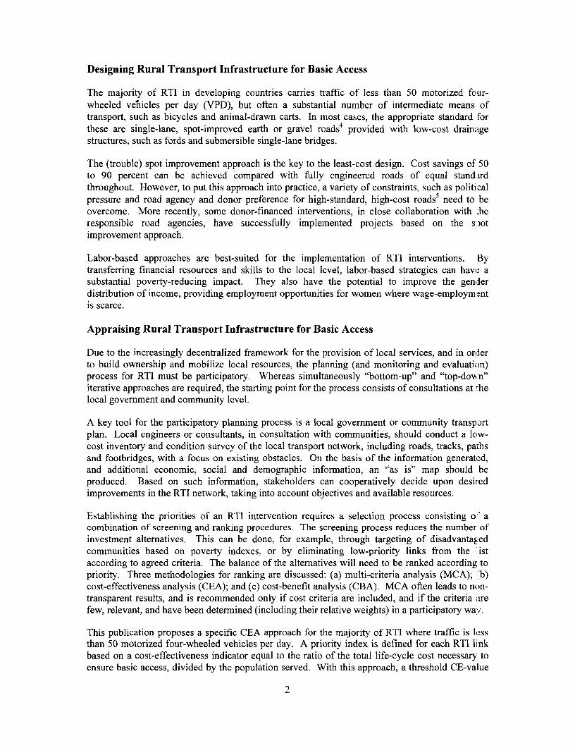
The majority of RTI in developing countries carries traffic of less than 50 motorized four-wheeled veliicles per day (VPD), but often a substantial number of intermediate means oftransport, such as bicycles and animal-drawn carts. In most cases, the appropriate standard forthese are single-lane, spot-improved earth or gravel roads4 provided with low-cost drainagestructures, such as fords and submersible single-lane bridges.
The (trouble) spot improvement approach is the key to the least-cost design. Cost savings of 50to 90 percent can be achieved compared with fully engineered roads of equal standardthroughout. However, to put this approach into practice, a variety of constraints, such as politicalpressure and road agency and donor preference for high-standard, high-cost roads5 need to beovercome. More recently, some donor-financed interventions, in close collaboration with .heresponsible road agencies, have successfully implemented projects based on the s;:otimprovement approach.
Labor-based approaches are best-suited for the implementation of RTI interventions. Bytransferring financial resources and skills to the local level, labor-based strategies can have asubstantial poverty-reducing impact. They also have the potential to improve the genderdistribution of income, providing employment opportunities for women where wage-employm ;ntis scarce.
Appraising Rural Transport Infrastructure for Basic Access
Due to the increasingly decentralized framework for the provision of local services, and in orderto build ownership and mobilize local resources, the planning (and monitoring and evaluation)process for RTI must be participatory. Whereas simultaneously "bottom-up" and "top-dovrn"iterative approaches are required, the starting point for the process consists of consultations at :helocal government and community level.
A key tool for the participatory planning process is a local government or community transpjrtplan. Local engineers or consultants, in consultation with communities, should conduct a low-cost inventory and condition survey of the local transport network, including roads, tracks, pathsand footbridges, with a focus on existing obstacles. On the basis of the information generatl d,and additional economic, social and demographic inforrnation, an "as is" map should beproduced. Based on such information, stakeholders can cooperatively decide upon desiledimprovements in the RTI network, taking into account objectives and available resources.
Establishing the priorities of an RTI intervention requires a selection process consisting o- acombination of screening and ranking procedures. The screening process reduces the number ofinvestment alternatives. This can be done, for example, through targeting of disadvantagedcommunities based on poverty indexes, or by eliminating low-priority links from the istaccording to agreed criteria. The balance of the alternatives will need to be ranked according topriority. Three methodologies for ranking are discussed: (a) multi-criteria analysis (MCA); 'b)cost-effectiveness analysis (CEA); and (c) cost-benefit analysis (CBA). MCA often leads to non-transparent results, and is recommended only if cost criteria are included, and if the criteria arefew, relevant, and have been determined (including their relative weights) in a participatory way.
This publication proposes a specific CEA approach for the majority of RTI where traffic is lessthan 50 motorized four-wheeled vehicles per day. A priority index is defined for each RTI linkbased on a cost-effectiveness indicator equal to the ratio of the total life-cycle cost necessary toensure basic access, divided by the population served. With this approach, a threshold CE-value
2

needs to be determined below which a link should not be considered for investment. Therecommended method for determining a threshold CE-value is to do a sample cost-benefitanalysis on a few selected links applying enhanced benefit measurement approaches forestablishing a threshold CE-value. 6
For roads where higher than basic access standards seem justified-for example, those thatprovide an alternative access to the. same location, or experience traffic levels above 50 VPD (butbelow 200 VPD)-the use of standard cost-benefit analysis is recommended. Appropriatecomputer-assisted models exist to aid transport planners and road agencies to optimize decisionson, among others, the threshold traffic for upgrading to a higher standard gravel or bituminoussurface road. Such models include enhanced CBA and RED (Box 4.4). For roads that carryabove 200 VPD, the utilization of HDM-4 is recommended.
Conclusions
In order to complement poverty reduction strategies, rural transport interventions must be anintegral part of rural development interventions and focus on the mobility and access needs ofrural communities. Substantial gains in accessibility-for more communities, in more regions ofa country-are possible if rural transport infrastructure interventions are designed in a least-cost,network-based manner focusing on eliminating trouble spots. In view of budget constraints,selecting interventions requires a participatory physical planning process undertaken jointly withconcerned local governments and communities, supported and coordinated by regional or centralgovernment agencies. Simple screening methods facilitate the selection process, reducing thenumber of alternatives to a manageable level. Ranking is then applied to the remaining options,and in most cases (below 50 VPD) the use of cost-effectiveness methods is recommended,supported by sample cost-benefit analysis on selected links, where appropriate.
3
1. INTRODUCTION
Three billion people in developing countries, or about two-thirds of their population, live in ruralareas. The majority of them survive on less than two dollars a day, and about 1.2 billion live onless than a dollar a day.' Their lives are characterized by isolation, exclusion, and unreliableaccess to even the most basic economic opportunities and social services. For the majority oftheir transport needs, they rely on non-motorized means and on rugged paths, tracks and roadswhich are typically in poor condition and often only passable in dry weather.
For purposes of this paper, rural roads, tracks, paths and footbridges are referred to as ruraltransport infrastructure (RTI). The RTI network in developing countries consists of an estimated5-6 million kilometers of designated8 rural roads and an additional expansive network, ofundesignated roads, tracks, and paths. While the length of the undesignated network is unknown,it is estimated to be several times the extent of the designated network.9 The vast majority oftrips that take place over RTI (more than 80 percent) are short distances (less than fivekilometers) and made by non-motorized means, including walking, animals, bicycle, andporterage.10
The Rationale for Action
Rural transport networks in most developing countries are still underdeveloped and of poorquality. Rural households, and particularly women, spend much time and effort on transportactivities to fulfill their basic needs. Too many communities still do not have reliable access tomain road networks or motorized access,"1 while at the same time resources are being spentupgrading roads to economically unjustified standards for populations that already have asufficient level of access.
In recent years, renewed emphasis on assisting very poor populations through sustained ruraldevelopment12 has led governments and donors to accelerate resource flows to ruralinfrastructure, with a large proportion being directed at improving transport infrastructure. Whhilethese projects are sometimes sector-focused, they are increasingly taking the shape of millti-component rural development projects or social funds with an emphasis on local government andcommunity-based program management. While a cross-sector orientation in such projects isdesirable, there is a need for sound technical advice on the design of sub-components anci, inparticular, on appropriate design and appraisal methods for RTI.
Ensuring an effective RTI system is an essential requirement for rural development, although byitself, it is not sufficient to guarantee success. Without adequate RTI, communities lack thenecessary physical access for basic domestic chores, agricultural activities, social and econcmicservices and job opportunities. Without reliable access to markets and productive resources,economic development stagnates, and poverty reduction cannot be sustained. Improvements ofthe intra- and near-village path and track network, and the provision of all-season basic motorizedaccess-if affordable and appropriate-are therefore essential conditions for rural development.
There is clear evidence that poverty is more pervasive in areas with no or unreliable (motorizedaccess) as compared to more accessible areas. For example, in Nepal, where the percentage ofpeople below the poverty line is as high as 42 percent, in unconnected areas 70 percent of peopleare living below the poverty line.13 In Bhutan, the enrollment of girls in primary schools is threetimes as high in connected villages compared to unconnected ones.14 In Andhra Pradesh, India,the female literacy rate is 60 percent higher in villages with all-season road access compared tothose with unreliable access. Plenty of further evidence of the socioeconomic impact of ruralroads exists.'6
4

Worldwide experience from past rural development programs and policies suggests thatimproving the poverty impact of RTI interventions requires attention to three guiding principles:17
* An emphasis on reliable, cost-effective access to as many of the rural population aspossible, rather than high access standards for a few;
* Cost-effective and innovative techniques such as spot improvement, labor-basedapproaches, and low-cost structures, and;
* A decentralized and participatory approach with strong local govemment andcommunity involvement in decision making on local transport investment andmaintenance.
Consistent with this experience, this paper proposes approaches to the design and appraisal ofrural transport infrastructure that emphasize innovative least-cost solutions for providing locallyaffordable basic access, as well as appropriate analytical tools and participatory methods for theselection of interventions.
Structure and Context
The paper is presented in four chapters. Chapter One introduces the topic. Chapter Two definesthe terminology and concepts that will be used throughout the paper. Chapter Three explains thekey elements of design for basic access transport infrastructure. Chapter Four gives guidance forselecting and prioritizing basic access-oriented interventions. Appendix A compares roadnetwork, mobility and accessibility indicators of selected countries. In Appendixes B and C,good practice examples are shown for basic access solutions to both motorized and non-motorized transport in a variety of geographic conditions. Appendix D presents low-cost trafficsurvey methods. Appendix E provides samples of innovative economic appraisals of RTIinvestments, and Appendix F describes the low volume Roads Economic Decision Model.
This paper is part of a four-volume series of publications on rural transport promoted by theWorld Bank's Rural Transport Thematic Group under the aegis of its knowledge managementactivities. The four volumes are: Options for Managing and Financing Rural TransportInfrastructure, Improving Rural Mobility, Developing Rural Transport Policies and Strategies,and this paper on Design and Appraisal of Rural Transport Infrastructure.18
5

2. CONCEPTS AND DEFINITIONS
Rural Transport and Poverty Reduction Strategies
Poverty reduction strategies require a comprehensive framework for implementation.19 Thesimultaneous development of adequate rural infrastructure, productive sectors, social andeconomic services, an appropriate macroeconomic framework, and good governance and localownership, is required for rural poverty alleviation (Figure 2.1 below). Effective transport, as acomplementary input to nearly every aspect of rural activity, is an essential element of ruralpoverty reduction.
Figure 2.1. The Elements of Rural Development
n truc ro ucEdueatton
/ TrTransport arAgriculturet*Water *FisheryEnergy Non-Farn Sector
A Irrigation spNatural ResourceA C ommunica tion Management
Social and Econfc t erv ces
*Health\ * ~Education/
been the c iAdm invistrat ion \-Transportn
Source: Authors.
A Holistic Approach to Rural Transport
A new approach to rural transport interventions is emerging. It requires a more holisticunderstanding of the mobility and access needs of the rural communities than has traditiornallybeen the case in rural road sub-sector investments. It is a demand-led, or people-centered,approach with an emphasis on the needs expressed by affected communities. In this context,rural transport is more broadly seen as an input into successful rural livelihood strategies, withinwhich access consists of three complementary elements: (a) means of transport, (b) location andquality of facilities, and (c) transport infrastructure. The approach acknowledges that interventionmay be required in all three categories, not simply the latter (Figure 2.2).20
6

Figure 2.2. Elements of Rural Transport
Rural TransportServices and IMT
/\ ~~~Rural / \ ~~Accessibilit/\
/ LocaLion \/ual Transpiorand Quality Infrastructureof Facilities Management and Finance
Design and Appraisal
Source: Authors.
Promoting Rural Transport Services (RTS) and Intermediate Means of Transport (IMT):2'The availability and affordability of rural transport services and intermediate means of transportare crucial to rural development. The single pick-up truck that arrives once a week with essentialsupplies for the health center and school, as well as agricultural inputs, can be of immeasurableimportance to a local community. Any investment program for improving RTI needs to carefullyexamine the constraints to effective RTS provision and to the ownership of IMT. Suchconstraints include excessive taxation, regulatory restrictions, inadequate markets, and theabsence of credit facilities. Successful approaches to improving transport services must deal withissues related to low population density and transport demand in rural areas, should be cost-effective and use flexible technology.
Few poor rural dwellers own IMT such as bicycles and animal-drawn carts, let alone motorizedmeans of transport. Most of the rural population walk and carry their loads, while the slightlybetter-off make use of IMT and RTS for the transportation of their products and themselves. Fordistances up to five kilometers, and even as far as 20 kilometers in some circumstances, walkingis by far the most common mode of transportation in rural areas of developing countries.22 WhereRTS are provided, they usually consist of (a) privately provided transport services, often by pick-up trucks for both passengers and freight; and (b) for-hire non-motorized services such asbicycles, rickshaws, donkey carts, and so forth. Government extension services in the agriculture,health and education sectors may also provide informal transport services.
Location and Quality of Facilities: The second element of a comprehensive rural transportframework is the location and quality of facilities. The distance from households to facilitiessuch as wells, forests, grinding mills, schools, and health centers determines the amount of timerural dwellers spend on transport activities. Numerous studies on rural transport have shown thatrural households, and particularly women, spend a substantial amount of time and effort on
23transport activities. The bulk of these efforts is required for domestic subsistence activities,particularly the collection of water and firewood, and trips to grinding mills. In the view ofplanners, this time is unproductive and wasted, and a drain on potentially productive labor-theprincipal economic resource for most rural households.24 Therefore, improved quality and better
7
locations of facilities are important to consider when examining alternative access25improvements.
Since the majority of time rural households spend on transport is for domestic activities, the nwosteffective transport-reducing interventions are usually related to better provision of water (sucl- aswell construction) and energy-supply facilities and the provision of grinding mills nlearhouseholds. Most countries have policies of providing primary social services (for example,primary schools and dispensaries) at the village level, while secondary level units are provide(i atmore central places. For social services, improving quality is often a more serious concern tbanimproving location.2 6
Rural Transport Infrastructure (RTI): Complementing means of transport and the location andquality of facilities is the third element of rural transport-RTI. The main requirement for thesustainable delivery of RTI is a conducive framework for management and finance. Ti heframework should include effective resource allocation and a logical system for setting priorities.This, in turn, requires sound advice on design and appraisal. Few developing countries, however,have managed to establish a favorable paradigm for managing and financing RTI. In the cases ofthese countries, the focus should first be on the development of such a framework in collaborationwith all key stakeholders.
Developing a Rural Transport Policy and Strategy: To address the issues mentioned above, toensure that rural transport is an effective facilitator of rural development, and to coordinate theactivities of the various actors in the sub-sector, it is essential that rural transport policies andstrategies are formulated and implemented. This process must address a broad range of issues,including physical, financial, economic, social, and environmental aspects of rural transport, andmust relate to existing rural development and general transport policies and strategies.2 ' Withoutsuch a comprehensive policy and strategy framework, the management and financing of RTI,especially maintenance, often fails. It is therefore highly recommended that countries formu.ateand enact an explicit rural transport strategy prior to undertaking an RTI investment program.
What is Rural Transport Infrastructure?
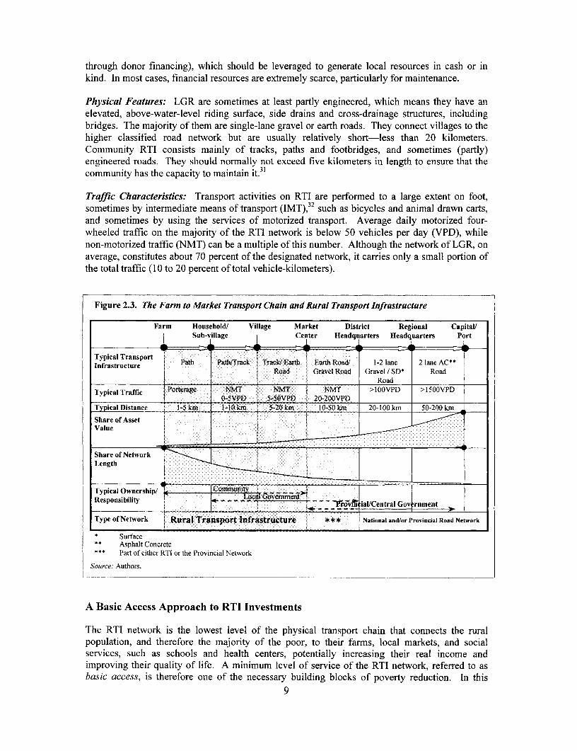
RTI is the rural road, track, and path network on which the rural population performs its transportactivities, which includes walking, transport by non-motorized and motorized vehicles, andhaulage and transport of people by animals. RTI includes the intra- and near-village transportnetwork, as well as the infrastructure that provides access to higher levels of the road network.Following are the key features of RTI (see also Figure 2.3.).
Ownership: By definition, RTI is the local access infrastructure that is normally owned by 1ccalgovernments and communities. Local government roads (LGR) usually have formally definedownership arrangements, i.e., they are designated. Community RTI is usually undesignated. ornot part of the formally recognized transport network. In the absence of a respective legalframework, community RTI belongs to communities. Even designated roads are sometimesinformally adopted by the local communities, who take responsibility for their maintenar:ce.However, the capacity of communities to own and take care of RTI is limited usually to the in ra-and near-village network and to short links to the main road network.28
Managing and Financing: Many different arrangements exist for managing and financingRTI.29 LGR are often better managed by more central agencies on behalf of local governments,30
or through joint-services arrangements (such as in Guatemala). Financial resources available forRTI include transfers from central government (from the Treasury, dedicated road funds, or
8
through donor financing), which should be leveraged to generate local resources in cash or inkind. In most cases, financial resources are extremely scarce, particularly for maintenance.
Physical Features: LGR are sometimes at least partly engineered, which means they have anelevated, above-water-level riding surface, side drains and cross-drainage structures, includingbridges. The majority of them are single-lane gravel or earth roads. They connect villages to thehigher classified road network but are usually relatively short-less than 20 kilometers.Commtnity RTI consists mainly of tracks, paths and footbridges, and sometimes (partly)engineered roads. They should normally not exceed five kilometers in length to ensure that thecommunity has the capacity to maintain it.3'
Traffic Characteristics: Transport activities on RTI are performed to a large extent on foot,sometirnes by intermediate means of transport (IMT),2 such as bicycles and animal drawn carts,and sometimes by using the services of motorized transport. Average daily motorized four-wheeled traffic on the majority of the RTI network is below 50 vehicles per day (VPD), whilenon-motorized traffic (NMT) can be a multiple of this number. Although the network of LGR, onaverage, constitutes about 70 percent of the designated network, it carries only a small portion ofthe total traffic (10 to 20 percent of total vehicle-kilometers).
Figure 2.3. The Farm to Market Transport Chain and Rural Transport Infrastructure
Farm Household/ Village Market District Regional Capital/Sub-village Center Headquarters Headquarters Port
Typical Transport Path Path/Track Track! Earth Earth Road! 1-2 lane 2 lane AC**Infrastructure
Road Gravel Road Gravel / SD* Road_ . . ~~~~~~~~~~~~~~~~Road
Typical Traffic Porteragc NMT NMT NMT >I00VPD >I500VPD_ ~~~~0-5VPD 5-SOVPD 20-200VPD
Typical Distance 1-5 km 1-10 km 5-20 km I 0-50 km 20-100 km 50-200 krn
Share of AssetValue ......
m ,,~~~~~~~~~~~~~~~~~~~~~~. , , ' - - , , , . :. ' . : . . , . . .. . . . . . . . . . . . . . . . . . .Share of NetworkLength
: :-:::::::-'.... : ~1 .. . . . . . . . . . .1
Typical Ownership/ Xomunity T >Responsibility -- Loc _r _ _f, ialUCentral Gov rnment
Type of Network Rural Transport Infrastructure * ** National and/or Provincial Road Network
* Surface** Asphalt Concrete** * Part of either RTI or the Provincial Network
Source: Authors.
A Basic Access Approach to RTI Investments
The RTI network is the lowest level of the physical transport chain that connects the ruralpopulation, and therefore the majority of the poor, to their farms, local markets, and socialservices, such as schools and health centers, potentially increasing their real income andimproving their quality of life. A minimum level of service of the RTI network, referred to asbasic access, is therefore one of the necessary building blocks of poverty reduction. In this
9
context, the provision of basic access should be considered a basic human right, similar to theprovision of basic health and basic education.33
In line with the poverty focus of RTI investments, a basic access approach is proposed whiichgives priority to the provision of reliable, all-season access to as many villages as possible overupgrading individual links to higher than necessary standards, thereby giving priority to netv'orkequity. The optimal distribution of available resources between such equity- and growth-orieintedinvestments needs to be defined in each particular case. IHowever, there is ample of evidenc of"'over-investment" on parts of the RTI and main road networks, and the potential for the transferof resources to more equity-oriented investments is substantial.34 A key indicator of networkequity is the coverage of all-season access within one to two kilometers of rural households 'seeAppendix A).
A basic access intervention is defined as the least-cost intervention (in terms of total life-c Mclecost) for providing reliable, all-season passability by the prevailing means of transport. Ifaffordable (see next paragraph), this may mean all-season passability for a pick-up truck, a sinallbus, or a truck, even if these present only a small fraction of total traffic. However, it should berecognized that appropriate RTI is also required for the efficient and economical use of non-motorized (or intermediate) transport.35
The provision of motorable basic access roads is constrained by available resources, especiallymaintenance and capital budgets. What is affordable depends on the local population's capicityto maintain their own basic access infrastructure over the long-term.36 Determining wha.t isaffordable depends on the complex relationship between this local capacity, available skills,income levels, population density, geographic conditions, and political will.3 7 Appraising thesefactors will shed light on RTI sustainability, and should be undertaken as part of the investnientappraisal process. Another broad indicator of the long-term affordability of RTI investmen' s iswhether or not a country has the capacity and resources to maintain its main road network.38
Below a certain per capita income, and particularly in situations of difficult terrain and lowpopulation density, even least-cost basic access roads will not be affordable (notwithstandingexisting suitable management arrangements and political will). In these cases, basic ac essprovision may need to be focused on improving existing paths and constructing footbridges.
The road infrastructure of a particular country will generally grow in proportion to its levc I ofdevelopment. Gradually, the originally existing path and track network will develop into a loadnetwork until finally all the households are served with road access, as is the case in develkpedcountries.39 To assist the understanding of network affordability, it is therefore recommended tocompare road network indicators of a particular country with those of countries of a similar I -velof development. Appendix A provides the rural transport planner with some basic road net ork,mobility and accessibility data from selected low-, middle-, and high-income countries. The Jatademonstrate the relatively high burden of infrastructure cost and high existing inaccessibility inlow-income countries. Moreover, the table shows that almost universally, motorized mobilitygrows proportionally to GDP.
10

3. DESIGNING RTI FOR BASIC ACCESS
This chapter discusses engineering design requirements for RTI. A differentiation is madebetween four categories of access: no, partial, full, and basic access, with a subsequent focus onthe specific requirements of basic access. Design requirements for full access are ignored here,since they are substantially covered in the existing literature. As discussed in the previouschapter, basic access is defined as the level of service which provides the minimum accessibilityrequired for rural socioeconomic development. In a majority of situations, where traffic is below50 motorized four-wheeled vehicles per day (VPD), this means (trouble) spot improved, single-lane gravel or earth roads. If these are not affordable, the provision of basic access could involvethe improvement of paths and construction of footbridges. Some guidelines for the engineeringdesign of basic-access roads, paths, and low-cost structures for different climates and terrain arediscussed in this chapter. More technical guidelines for the design of basic access roads are givenin Appendix B, and those for paths and footbridges can be found in Appendix C.
Access and "Level of Service"
It can be useful to think of RTI, and its impact on "accessibility," from the perspective of "levelof service." The following four levels of service, or access, need to be considered:
* No (motorized) access: defined as no motorized access within one to two kilometers ofa household or a village;
* Partial access: defined as motorized access with interruptions during substantialperiods of the year (the rainy season);
* Full access: defined as uninterrupted all-year, high quality (high-speed, low-roughness)access, and
* Basic access: defined as reliable all-season access for the prevailing means of transport,with limited periods of inaccessibility.
No Access or Partial Access: A substantial portion of the rural population in developingcountries still does not have motorized access to transport networks at all, or only unreliable orpartial access.40 This portion of the population is nearly always less well-off compared to thosewho have reliable access.41 Due to the low density of the unconnected population, the path andtrack network that connects them to the existing road network is vast, and is often several timesits length.42 To upgrade this network to even basic access standard, and maintain it at that level,would require enormous resources which in most cases are not available. Furthermore, in manysituations the concemed population, if provided with motorable roads, could not afford motorizedtransport services, let alone private motor vehicles. Therefore, as the previous chapter hasattempted to show, when resources are available to ease the transport burden of the unconnectedpopulations, they should be carefully spent on a variety of access-enhancing measures, whichmay include basic access RTI.
FullAccess: Full access means the provision of a fully engineered road with a consistent cross-section throughout its alignment and water crossings of high standard.43 Such designs, which areconsidered the minimal standard for rural roads in many countries, are usually based on "designspeed," and are to provide uninterrupted access throughout the year. Costs for a fully engineeredrural road will typically be in the range of $20,000 to $100,000 per kilometer. Justification for
11
such standards must be made on economic grounds (see Chapter 4), which is usually not possibleon RTI with prevailing traffic levels of less than 50 VPD.44 Literature on the design of fiillyengineered rural roads abounds, and this paper will not deal with the issue.45
Basic Access
The challenge in meeting basic access needs is deriving standards that can deliver the minimumlevel of service necessary to promote and sustain the development of rural communities, whileproviding such access to as many people as possible. Given the practical requirements of ruralhousehold socioeconomic activities, basic access RTI should meet the following minimumcriteria:
* Passability or reliability: One of the most important aspects of basic access ispassability or reliability. While it may be technically difficult to define when a road er apath becomes impassable, the impacts on the well-being and livelihood of the populationfrom unreliable access are severe and well-documented.46 The first priority for transportoperators is the safety of their vehicles or animals, and they will often not travel if theyconsider a road or a path impassable-even if it is a decision based on unreliableinformation.
- Adequate access to higher-level networks: Functioning transport requires integratedsystems. Access to main markets, to non-agricultural job opportunities, to higher-levelhealth and educational facilities, and to administrative services requires reliable andaffordable access from the community to the higher-level regional or national transportnetwork.
- Adequate access to local social and economic facilities: Appropriate access to primaryhealth and education facilities, and to local markets, both by the household and from theoutside for the supply of inputs, is a fundamental requirement of basic access.
* Adequate access to domestic activities: Improved basic access infrastructure mustreduce the time that households, particularly women and their daughters, spend ondomestic activities, such as water and firewood collection, trips to the fields and to rhegrinding mill. It must enhance their productivity, and improve their lives and those oftheir families.
* Trafficable by prevailing rural transport vehicle: Basic access infrastructure mustensure that the prevailing type of rural transport vehicles (motorized or non-motorize,d)can expect reliable access. Reasonable levels of delays at river crossings or temporaryroad closings during the rainy season must be tolerated. Accepting such temporaryclosures can reduce investment costs considerably, as is shown later in this chapter. lThemaximum time allowed for temporary closures is both a political decision and anaffordability issue.47
Basic Access "Standards" and Key Design Considerations: RTI standards, in countries whsrethey exist, are often far in excess of what can be economically justified or what is necessary forthe provision of basic access. The definition of the standards of basic access is ultimatelhy apolitical matter and will depend on the development objectives, budget constraints, and social andnatural environment of a particular country. In industrial countries, where basic access needs arenearly universally met, the standards of access roads are often defined on the basis of comfort andare not subjected to rigorous economic analysis.48 On the other hand, in developing countries,where isolation and poverty are key targets of development investments, and resources are
12

usually very limited, least-cost and economic criteria are required for maximizing the impact ofinterventions.
The removal of surface water is crucial for the success of basic access RTI, since at this trafficlevel, the weather causes more damage than does the traffic.49 This means that a good camber of5 to 8 percent, adequate side drains, and carefully designed cross drainage structures are required.Stone or concrete drifts, or splashes, are acceptable as a substitute for culverts. Major rivercrossings can be designed to allow traffic passage at low flows, and be closed at high flows. Inmany situations, peak flows may only last for a short duration (less than three hours). However,where rivers can not to be crossed for long periods, high-level and relatively expensive crossingsshould be provided to achieve basic access standards. If these are not affordable, providing anall-season footbridge should be considered, to allow pedestrian and IMT crossings during therainy season.
Although roughness and speed are not important design parameters for basic access RTI, thereare certain limits of roughness that should not be exceeded to avoid damage to vehicles. Speedsshould normally not exceed 30 km/h, taking into account the varied use of basic access roads, bypeople, non-motorized, and motorized traffic on the carriage way. The most important criterionfor the infrastructure is to be able to withstand the elements and traffic without extensive damage.
The (Trouble) Spot Improvement Approach: Many rural communities are still without roadaccess. Connecting them will be a slow process. Increasingly, however, the situation faced bythe rural transport planner is a deteriorating network of roads, tracks, and paths, passable only inthe dry season, with difficulty, and not at all in the rainy season. In these situations, the spotimprovement approach, focusing interventions only on difficult sections, is an appropriatemethod to provide basic access at a lower cost.
Spot improvement interventions require considerable judgment on the part of the design engineer.The types of interventions will vary according to the terrain, weather, and vehicle types.However, the construction cost savings can be in the order of 50 to 90 percent when compared tofull inmprovement.
Road failure is most likely to occur on steep hills, at water crossings, and in low-lying areas.Solutions include realignment, paving of steep sections, provision of simple but permanent watercrossings, and raising low-lying areas on embankments (see Appendix B). All interventions mustbe properly designed and engineered, but will only apply to a specific spot. In many situations,upgrading an existing track or earth road to basic access standard will only require interventionson 10 percent of the road length-greatly lowering the costs of providing all-season passability.
It is essential to ensure that untreated sections have sufficient capacity for the prevailingconditions and transport types. If the in-situ soils are incapable of bearing traffic loads whensoaked, then it may be necessary to provide camber and drainage throughout. If the soils are notof sufficient strength, even in this condition, then a gravel surface should be provided throughout.During the design process, each section must be carefully analyzed in order to find the least-costsolution.
It is also essential to remember that very limited resources will be available for maintenance.Maintenance should not be confused with rehabilitation. If there is any concern that untreatedsections will require more attention than basic vegetation clearing, cleaning drainage facilities,and minor surface reshaping to retain access, then a more substantial intervention should beundertaken. On the other hand, the spot improvement approach also applies to periodicmaintenance, where in many situations spot regravelling, instead of full gravelling, is the rightapproach.
13
There is generally a great deal of resistance to spot improvement as a technical solution,especially in donor-financed interventions. A number of issues need to be addressed if ihisapproach is to be pursued effectively:
* Political pressure: Politicians who are responsible for marshaling funds (includingdonor financing) for sector investments must answer to their constituencies, and theref;reare under pressure to demonstrate effective and visible outcomes. This often leads tco adecision to rehabilitate roads to fully engineered standards, rather than to undertake lIssvisible spot improvements.
* Road agency resistance: Road engineers and managers want to remove particularlytroublesome roads from their work programs. They may also view it as inappropriate touse "borrowed" donor money to produce what could be considered an inferior product.Many engineers are not well-informed about the merits of the spot improvementapproach.
* Private sector incentives: Contractors and consultants prefer continuous upgrading tospot improvements. Upgrading (which entails higher quantities of earth movements andmaterials) is often the basis for mark-ups and therefore directly affects profits. Smaller,decentralized, and less visible spot improvements are viewed as unprofitable and are alsodifficult to define and supervise. Small-scale local contractors, however, may find thistype of work very suitable.
* Donor preferences: Donor agencies often prefer a fully rehabilitated road to the proce; ssof identifying and financing investments in a series of dispersed trouble spots. Individualproject financing may favor a quickly executed fully engineered approach because of theshort time frame and the requirement to fully disburse funds. However, a long-termprogram approach is more appropriate for the gradual spot-improvement of a rural accessnetwork.50
In addition to the above-mentioned problems, spot improvement approaches will not work inareas that have very poor soils or are prone to flooding. Despite these problems, there is a strongcase for the spot improvement approach. Without it, most developing countries simply cannotafford to provide basic access to the majority of their rural populations. An example of asuccessful spot improvement program is given in Box 3.1. Further good examples of successfiulspot improvement programs exist.5 '
Great potential for furthering the spot improvement approach is also seen in the implementationof performance-based road management and maintenance contracts. Until recently, thesecontracts have only been applied on major highways, and not on low-volume unpaved roads. Arecent World Bank-financed project in Chad is proposing to introduce such types of contracts onapproximately 450 kilometers of the unpaved main road network.52 Performance criteria are. a)passability at all times; and the assurance of (b) a specified average speed; (c) minimal ridingcomfort; and (d) road durability and preservation. This type of contract should guarantee anapproach whereby the contractor, in his own self-interest, will focus on the critical spots of thenetwork, while assuring a minimal comfort for the road user.
14

Box 3.1. The Roads 2000 Program in Kenya: A Spot Improvement and Labor-Based Approach toNetwork Rehabilitation and Maintenance
The Roads 2000 Program is a maintenance implementation strategy that supports a number of policyobjectives of the Kenya Road Maintenance Initiative. It was developed as a solution to the deterioratingunpaved road network of 53,000 km. Road condition surveys identified a limited number of troublespots, rather than general conditions, as the main cause of non-trafficable roads. Furthermnore, thesurveys found that the traditional equipment-based maintenance approach could not provide the requiredservices with the current funding levels.
Building on the successful experience of the labor-based Rural Access and Minor Roads Programs,Roads 2000 adopted a new approach to rapidly bring the network up to a maintainable standard andplace it under effective maintenance with the optimum use of local resources.
The three principal components of the Roads 2000 approach were:
. Rehabilitation Phase: Bring roads back to minimum maintainable standard
. Routine Maintenance: Establish labor-based maintenance system* Spot Improvement: Plan and carry out a follow-up program of selected spot improvements
During initial preparation work, the road was brought to a passable and maintainable standard by laborunits. The role of these work-units was to clear the vegetation and drainage system and re-establish theroad camber.
This preparation phase was followed by the establishment of small-scale contractors (group or singleperson contracts) to carry out routine maintenance on a permanent basis. On the more heavily-traffickedroads (> 50vpd), they were supported by tractor-towed graders.
During the rehabilitation phase, required spot improvements were identified and implemented as fundsand resources allowed. Typical works included:
. Installation of new culverts (on average one new line per kin);
. Replacement or rehabilitation of existing culverts;
. Spot regravelling (to a maximum of 4 percent of the road network length);
. Provision of alternative surfacing over limited distance (for example, steep sections, approachesto structures);
. Full road reconstruction over a limited distance; and
. Bridge and drift rehabilitation;
The following costs have been established for unpaved roads (adjusted to year 2000 prices):
. Partial rehabilitation and spot improvement $ 2,000 / KM. Labor-only routine maintenance $240 / KM / Year. Routine towed grading $280 / KM
Source: Authors.
Staged Construction-Not Recommendedfor RTI:5 3 Staged construction is understood here asinvestment into structural elements of RTI to accommodate upgrading needs which might berequired in the future due to traffic growth. This could mean, for example, the straightening ofthe vertical or horizontal alignment of an existing basic access road to accommodate a future fullyengineered road, the provision of "two-lane" culverts for a single lane road, or the construction oftwo-lane bridges, where currently single-lane structures would be sufficient. While it might bepossible to demonstrate long-term savings through staged construction in the case of trunk orprovincial roads, where substantial traffic growth can be expected, the same is normally notpossible for RTI, especially when initial traffic levels are very low. Where road agencies insiston such "advance" investments, economic analysis (see Chapter 4) should be carried out todetermine their justification. Such analysis must take into account the additional short-termmaintenance because of higher-than-necessary investments.
15

Engineering Design of Basic Access RTI
Basic access RTI has to be properly designed if it is to resist the weather and traffic, and producea maintainable and sustainable asset. Unfortunately, even where the private sector is welldeveloped, local consultants may have limited experience in the design of this type of ruralproject. It is necessary to produce designs, specifications, and quantities so they can be pack;.gedout to small-scale contractors and supervised in a cost-effective manner. In addition, the des gnsthemselves must be cost-effective, considering the low cost of the planned infrastructure (de,igncosts should not exceed 6 percent of investment costs). There is limited experience in using I )calconsultants for these services, and design tends to be carried out by technical assist.-.nceconsultants recruited by projects and programs as part of a technical support package. For lo ng-term sustainability, there is a need to stimulate the involvement of the local consulting indu.try.For assistance to communities, local NGOs are often the right partners and should be giver theopportunity to acquire the necessary engineering skills.
With appropriate terms of reference that clearly specify the required approach, and speciallydesigned training programs for local consulting firms, it is possible to secure local professionalservices. The absence of the time-consuming tasks involved in a fully surveyed design, detailedbill of quantities, and re-measurement serves to reduce costs. However, there is a much greaterneed for exercising engineering judgment in the design (and the supervision) of project x )rk.The essential requirements for engineering services for basic access RTI are summarized inAppendix B.
Design Considerations-Traffic, Safety, Environment, and Social Impact: The enginee-ingdesign needs to take into account a few key design considerations. These are related to the typeof traffic use expected on the RTI, road safety considerations, the expected impact on theenvironment, and the social impact of RTI interventions. These requirements are explained in theparagraphs below.
Traffic: A wide variety of motorized and non-motorized traffic should be expected on I-KTI.However, roads and structures need to be designed to allow the largest and heaviest users to passsafely without damaging the structures. Often these largest users are seven-ton trucks, and, inother cases, pick-up trucks or motorcycles, and power tillers. In some cases, a design for ron-motorized means of transport might suffice. Design to a low standard suitable only for 4N',/D-drive vehicles should normally be avoided, since these vehicles are rarely used by lo caltransporters or the local population.
One potential problem is the possibility of large trucks using the road to evacuate heavy nat 1ralproducts and resources, such as crops, timber, minerals, etc. One excessively heavy truck candestroy the running surface of a basic access road. The likelihood of such traffic must beconfirmed at project appraisal. Ideally, such traffic should be excluded by barriers (width indheight restrictions at the start of the road), at the very least during the rainy season. If it isconsidered impossible to exclude such traffic, then the road must be designed for it, and systemsput in place to ensure that the operators contribute their disproportionate share of maintenancecosts.54
Because traffic levels will determine the type of intervention necessary (for example, basic versusfull access), a thorough traffic survey is a prerequisite for all RTI interventions. In order to keepcosts down to acceptable levels, it is necessary to select a few strategically correct locatiDns(between villages). If resources are scarce, traffic counts can be correlated with populationfigures along different alignments in order to establish traffic estimates for links where trafficcounts were not possible. Seven-day, 12-hour counts at selected locations are recommende(d to
16

capture weekly variations. If possible, these can be complemented by counts during varioustimes of the year to capture seasonal variations, as well as origin-destination and trip-purposesurveys. Both motorized and non-motorized traffic should be counted. Special considerationshould be given to traffic-generating facilities such as hospitals, natural resource exploitingactivities, or others. In Appendix D, low-cost traffic survey methodologies are presented.
Road Safety: Road safety is of primary importance for all road users. However, the safetyconcerns of basic access RTI are different than those for higher-level infrastructure. Typicalproblems are single-vehicle accidents and accidents between motorized and non-motorizedvehicles, pedestrians and animals. Economic considerations will normally not allow separation ofdifferent modes of transport, and it must be accepted that foot and wheeled traffic of differentspeeds will intermingle in the traffic stream (exceptions see last paragraph of this sub-chapter).
The challenge for the rural transport planner is, therefore, to ensure that the speed of motorizedtraffic is low, say, not more than 30 km/h, particularly within villages. Spot improved, winding,single-lane roads with a relatively rough surface will, to an extent, automatically achieve this.However, it might be necessary to slow down traffic even more by narrowing the roads onstraight sections (similar to urban traffic-calming designs). In such cases, it is essential for sightdistances to remain in proportion to vehicle speeds.
On long, straight sections of flat terrain, the provision of trees adjacent to (but set back slightlyfrom) the edge of the road (as is a common practice in Bangladesh) will have the effect ofvisually narrowing the road and slowing traffic, while providing shade and refuge to foot traffic.Where there is a sharp bend on such roads, painting middle sections of the tree trunks on theapproaches to such bends can provide delineation and advance warning of the bend at night or inconditions of poor visibility.
All bridges, drifts, and culvert headwalls should be clearly marked with paint. Road widths mustbe consistent (even if consistently narrow, except for designated passing, vehicle loading orparking places), and weak road edges next to dangerous drops should be fenced (local bushfencing is acceptable, if maintained. However, metal road furniture such as signs and barriersoften have limited life spans in resource-starved rural areas). The objective is to alert unfamiliarroad users to obstacles and hazards ahead, so they can pass them safely.
It is often argued that since single-lane roads with passing places are inherently dangerous, widerroads should be built for safety reasons even when the traffic levels are low. However, the risk ofvehicle-to-vehicle collision only increases slightly,55 even if the volumes increase from 10vehicles per day to 50 vehicles per day, and this level of traffic can be accommodated by passingplaces. However, where the road is expected to carry large volumes of pedestrian, or NMT,consideration needs to be given to their safety and a wider road shoulder or separate pedestrianand NMT-ways should be constructed (particularly within villages).
Environmental and Social Impact Mitigation: Basic access RTI interventions have both directand indirect environmental and social impacts. Improved access might require the acquisition ofproductive agricultural land and housing, which might necessitate resettlement. Suchresettlement will likely be minimal in the case of improvements to existing roads.56 Other majordirect environmental impacts are dust from vehicles and erosion of RTI surfaces, drainagestructures, and outlets. Indirect impacts are the opening up of previously inaccessible, ormarginally accessible, territory to immigration and resource harvesting.
The processes that help to identify and mitigate the potentially adverse impacts of RTI projects,while enhancing their positive effects, are the environmental assessment (EA) and socialassessment (SA). Both EA and SA processes must be initiated at the beginning of the project
17

cycle and continued throughout. To make them sustainable, they need to involve local experienceand must be done with the participation of the local communities. Particularly in the case of newRTI, the SA might be extended to include studies encompassing baseline, mid-term and ex-postsocioeconomic data collection, contrasting these with appropriately selected control areas toenable the monitoring and evaluation of the planned poverty-alleviating impact of the proj-.ct.For this purpose, data will need to be collected at both the household and the community lcvelfrom appropriate sample populations in the influence area.
The EA process involves six primary elements: a study of the baseline conditions in the region toestablish benchmarks; an analysis of the existing institutional, legal, and administrativeframeworks with respect to implementation; identification of potential environmental impacts;mitigation measures; an analysis of alternatives; and an environmental management action plan(EMAP). The EMAP is the output of the EA process and reflects the main impacts at majorstages of the project, the relevant mitigation measures, the time-frame of their implementation,the institutional responsibilities, the costs, and the appropriate references to the contractdocuments.5 ' The result of the SA might be a Resettlement Action Plan (RAP). Since the RAI isdemand-driven, its implementation needs to be participatory and locally based. Involx ingexperienced NGOs in the implementation is strongly recommended.
The need for EA and SA processes will vary greatly with the type of RTI intervention. In thecase of small-scale improvement on existing networks, EA and SA might not be required at all,while in the case of new roads and particularly in mountainous areas, these processes might beextremely demanding. Relevant information on EA and SA can be found in the World Bank'sOperational Manual and other relevant literature.58
Implementation Methods
Labor-Based Technology: The application of labor-based approaches to basic access RTIinterventions contributes to their poverty-alleviating impact. Constructing RTI with labor-basedmethods requires between 2,000 and 12,000 person-days per kilometer for construction and 200to 400 person-days per kilometer for maintenance. Utilizing local labor allows the lccalcommunity to earn wages, as does procuring materials and tools from local sources.Furthermore, labor-based methods contribute to local empowerment through skills-transfer .mdcreation of ownership. Also, if correctly designed, labor-based methods can have a substantialgender-specific impact.59
The type of work associated with basic access is ideal for labor-based methods. Spotimprovement interventions are small-scale and varied, requiring attention to detail, and often donot require heavy construction equipment. In the case of community RTI, the full involvement ofthe community gives them the opportunity to acquire the skills for the eventual infrastructuremaintenance by labor-based methods. It is important to note that equipment (for example,graders) are seldom available for subsequent maintenance activity for RTI, a fact that should beplanned for at design.
There are certain prerequisites for effective labor-based contract execution, including laboravailability in sufficient numbers, supervision experience, and the availability of qualifiedcontractors. These contractors must be small-scale and have experience in labor-based proiectexecution. They should possess, or have access to the appropriate equipment. If they have nodirect experience in labor-based execution of works, they must at least be willing to undergorespective training.60 Box 3.2 elaborates on the relevance of labor-based approaches.
18
Box 3.2. Relevance of Labor-Based Execution
Road construction and maintenance works are often described as equipment-based or labor-based,depending on the relative intensity of productive factor use. The term "labor-based" is used todescribe projects where labor is substituted for equipment when it is cost-effective. This covers mostroad-related activities apart from compaction and heavy earthworks. The term also includes the useof appropriate light equipment (mostly tractor-trailer) which supports the utilization of labor inspecific essential activities such as compaction and gravel haulage for surfacing.
In most developing countries, especially in rural areas, unemployment is high, jobs are scarce, and theaverage daily wage rate for workers in the agricultural sector is somewhere between less than $1 and$5 per day. Equipment is usually owned by a few large-scale contractors or government departments.Maintenance and back-up services can be problematic and expensive, and real equipment costs areprohibitively high. The lower unit-cost of labor relative to capital therefore makes labor-based roadworks both economical and socially desirable.
In their recent publication Employment-Intensive Infrastructure Programs: Labor Policies andPractices, 1998, the International Labor Organization concludes that* labor-based construction andmaintenance: (a) was about 10 percent to 30 percent less costly, in financial terms, than moreequipment-intensive works; (b) reduced foreign exchange requirements by 50 percent to 60 percent;and (c) created, for the same amount of investment, two to five times more employment.
Several important factors contribute to the viability of labor-based construction techniques, such asgovernment attitude, economic conditions (especially labor and capital markets), the location of theproject, road agency administrative and financial procedures, capacity for management and humanresource development, and the provision of adequate training.
* Based on comparative studies carried out in a number of countries, such as Ghana, Lesotho,Madagascar, Rwanda, Zimbabwe, Cambodia, Lao People's Democratic Republic (Lao PDR) andThailand.
Source: Authors.
Despite these advantages, it has been difficult to mainstream labor-based approaches. Thedifficulties encountered include inflexible labor laws, the availability of cheap second-hand heavyequipment, unsuitable procurement laws, and a lack of capacity to rapidly pay labor-basedcontractors.61 To mainstream labor-based approaches, these obstacles need to be overcome at thepolicy level.
Small-Scale Contractor Development: By their very nature, basic access interventions are small-scale, varied, and scattered. The work is ideal for execution by small-scale labor-basedcontractors and by community contracts. Such types of contracting require (a) an appropriatepolicy environment; (b) capacity building programs for designing, managing, and execution ofcontracts; and (c) appropriate procurement procedures.
Considerable experience is available for the development of small-scale labor-based contractors.62
An enabling environment must be created. If the contractors are to survive, they require a regularworkload, rapid payment of bills, and access to credit facilities and equipment rentalopportunities. The key is the management capacity of the contracting agency. To overcomecapacity constraints at the local government level, it is often recommended that governmententities join together to form joint-services committees or hire consultants to assist in contractmanagement.63 Contractors' associations have an important role to play in the capacity buildingprocess as well.
The limited capacity of single small-scale contractors may require the employment of numerouscontractors if major earthworks are involved (average capacity will be about 1 km of earthworks
19
per month and 0.5 km of gravelling per month). Part of the capacity building process isassistance to the contractors with appropriate equipment, which in most cases is tractor-tcwedequipment, such as trailers, water bowsers, rollers and towed graders.65
Community Contracting: Community contracting has become a major means of channelinggrant funding to the rural poor. Community contracting means procurement by, on behalf of, orfrom communities. Implementing agencies are the communities themselves who take directresponsibility for their own development, and the role of government here is to providefacilitating support (usually through the assistance of NGOs). Participation from the communityhas to be an overriding consideration in designing the various procedures, including procurementand disbursement. Simplified procurement procedures for community contracting are requir.d.66
Experience from such community-based investment operations has shown that participationgreatly assists accountability. A key feature for successful community contracting is theexistence of a legal framework that gives communities legal status, without which they are unableto receive or manage funds.
Maintenance of Basic Access RTI
A common feature of RTI is insufficient or non-existent maintenance. Financial allocatior-s toRTI maintenance are almost always inadequate, both relative to the main road network and
67compared to general expenditures for construction. Moreover, capacity to execute maintenanceis lacking. A good indicator for the lack of maintenance capacity is the need for rehabilitaz:ion,which by definition is caused by a lack of maintenance. Earth and gravel roads and paths arevery vulnerable to the elements and will often not survive a single season without prapermaintenance. A road or path is no better than its weakest link, and one failed drainage structureor section can be sufficient to disrupt access. The principle roots of maintenance neglect areinstitutional and financial. These must be addressed prior to any consideration of investments inRTi.
6 8
Maintaining an earth or gravel road is relatively costly. As a rule of thumb, undiscouritedmaintenance costs over the typical life of RTI will equal the initial construction costs. Forexample, a typical $5,000/km basic access road may cost an average of $250 a year per km tomaintain over its assumed twenty-year life.
From an engineering point of view, there are important tradeoffs between routine, recurrent, andperiodic maintenance, and further investments. Often, enhanced routine maintenance is able toprovide the required "passability," which reduces the need for periodic maintenance or furtherinvestments in the form of spot improvements. This is of particular importance with respec.t toperiodic maintenance.69 In many developing countries, reserves of naturally occurring gravelused for periodic renewal of gravel layers are simply no longer available. The maintenance of aproper camber and the protection of drainage structures will reduce the need for periadicmaintenance and rehabilitation. If comparing the costs of increasing the grading frequency onearth roads against gravelling at low traffic levels, the former is usually much more economical.70
20

4. APPRAISING RTI FOR BASIC ACCESS
Appraisal, in the widest sense, includes the analysis and assessment of social, economic,financial, institutional, technical, and environmental issues related to a planned intervention. Thischapter discusses appraisal in the context of participatory approaches for the selection andpriority setting of RTI interventions and projects, as well as the economic rationale of theplanning process. It also describes alternative screening and ranking methods, in particular cost-effectiveness and cost-benefit approaches. For further information on these methodologies, thereader is referred to the relevant literature.7' For a discussion of technical issues, see the previouschapter. Examples of recent economic appraisals of World Bank financed RTI projects are givenin Appendix E.
A Participatory Planning Approach
Local communities are the main stakeholders and users of RTI. In recognition of this, there isnow wide acceptance that their participation in the preparation and implementation of investmentprograms enhances local ownership and commitment, and fosters better accountability,management and sustainability.72
Although ongoing decentralization efforts in many developing countries have made localgovernments and communities responsible for the provision of local facilities, including RTI, acomprehensive planning process for these assets has not usually been put in place. In a first step,at both the local government and community level, priorities must be assessed across sectors.Once the need for a RTI intervention or project has been agreed upon, care must be taken thatmaintenance of existing RTI is incorporated into the early stages of the planning process.
The planning framework must be built on a participatory and iterative process, simultaneouslybottom-up and top-down. A national or state-based agency for RTI should set guidelines.However, the driving force of the process must consist of priority setting and consultations at thelocal government and community level.73 For ensuring and building capacity for effectiveparticipation, in most cases it is necessary to employ local NGOs or consultants that areprofessionally trained in participatory methods.74
Local consultations are also emphasized in the planning process in industrialized countries thatrarely apply strict economic analysis to capital investments for local roads. In developingcountries, however, where resources are extremely scarce (and often provided by donors)coherent selection tools that include economic considerations and are understandable to the localplanners and communities can usefully support the participatory decision-making process (forexample by illustrating opportunity cost and incremental trade-offs).
It has been argued that participatory decision-making can replace the economic selection process.This might be the case if investments are entirely locally financed, but even then the "wish list"will typically be more sizeable than available resources and a rational process (using economiccriteria) should be used to help prioritize alternative investments. However, even modestcontributions from outside sources can make economic planning tools useful, since the outsidefunding agencies, be it a road fund, government or a donor agency, will need to be convinced thatthe proposed investment is a sound and prudent use of its contribution.
Local Transport Plans-A Key Tool for the Participatory Process: Key tools for theparticipatory planning process are local transport plans, in the form of elaborate local government(district) transport "master plans" or simple community transport sketches (Figure 4.1).
21

Comprehensive coverage of transport infrastructure (including roads, paths, waterways, etc.) andtransport producing facilities (villages, schools, health centers markets, etc.) should be containedin these plans. Guidelines for their preparation should be provided by the focal institutional enitityresponsible for rural roads in the country.75 The objectives and core design criteria for these Flansshould ideally be contained in a country's National Rural Transport Policy and Strategy.Furthermore, they should be based on regional development plans which reflect the various scctorstrategies (such as health, education, infrastructure and agricultural development). They shouldbe prepared in a participatory way in close consultation with the communities. A complementaryplanning tool for the community level planning process is the Rural Accessibility Planning (RAP)(Box 4.1).
Box 4.1. Rural Accessibility Planning (AP)
To improve rural access effectively, an appropriate planning tool has been developed, with 110technical assistance, through pilot projects in Asia and Africa. It partners with communities and localorganizations to identify their access problems and propose solutions. AP focuses on the househclld,and measures its access needs in terms of time spent to get access. The underlying principle of AP i;, toreduce time spent on access which could then be spent on other activities.
Steps 1 and 2: Data Collection and Processing. Trained local enumerators collect data on househ )Idtime spent and mode used to gain access to services and facilities. Processed data results in a demand-oriented access spread sheet for the target area.
Step 3: Preparation of Accessibility Profiles, Indicators and Maps. Access profiles for target areascover basic information on location of facilities and services and the difficulties people have accessingthem. Accessibly Indicators (Al) are calculated by multiplying the number of households (N) with :hesubtraction of the average travel time to a facility (T) minus the acceptable/target travel time Tm, tinesthe frequency of travel (F): AI=N*(T-Tm)*F. Finally, maps are established with the availableinformation.
Step 4: Prioritization. The larger the value of the Al, the greater the problem.
Steps 5, 6 and 7: Data Validation and Defining Targets and Objectives, and Project Identfifcation.Results of the AP are presented and discussed in a participatory decision making workshop wherepending on available budgets interventions are identified, which most effectively reduce time Eandefforts spent in obtaining access (including improved transport infrastructure, provision of means oftransport and relocation of facilities).
Step 8: Implementation, Monitoring and Evaluation. Identified projects are integrated into the overalllocal planning system for implementation, monitoring and evaluation with local communities fu.llyinvolved.
Source: Adapted from Fatemeh Ali-Nejadfard, 2000.
Most of the necessary data for the master plan can be obtained by means of a low-cost road andpath inventory and condition survey conducted by local engineers or consultants in consultationwith communities.76 Planners and engineers conducting the survey assess the expenditure andtype of works necessary to bring each link to basic access standard.77 In addition, when existingtraffic levels merit, the condition survey should assess the costs of bringing links to fullyengineered standard. During the condition survey, traffic data (see Appendix D) and otherinformation such as location of villages, schools, health centers and major traffic-generatingfacilities such as markets are collected simultaneously. On the basis of the condition surve-. andsocioeconomic data, an "as is" map is established. An example is shown in Figure 4. 1.
22
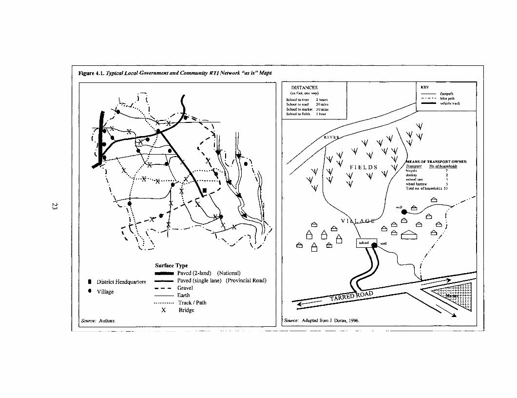
Figure 4.1. Typical Local Government and Community RTINetwork "as is"Maps
DISTANCES KEY.- (on foot, one Nay) footpath
' J t l School to river 2 hotrs n ooeobike path
t a tt~~~~~~~~~~~~~~~~~~~~~~~~~~~~SchOi to road 200 in hil t_ac
Surface Type l l mins_ Paved (2-land) (National)
* District Headquarters - Paved (single lane) (Provincial Road)
" Village --- Gravel I hwr =
. .......... ....Track/Path \VuFELADS \ R. 7
S_uce: Authors. .. uce Adpe __o J _o._ 1996.
Selection and Priority Setting Methods
Screening and Ranking: Selection and priority-setting methods for basic access RTIinterventions consist of two broad types of methodologies which are usually applied insuccession: (a) screening and (b) ranking. Screening decreases the number of investn entalternatives given budgetary constraints, which may involve: (a) targeting disadvantaged area:; orcommunities based on poverty indexes, or (b) eliminating investments into low-priority sectionsof the network selected based on agreed criteria.
Targeting Poor and Disadvantaged Communities: One of the purposes of screening is to targetinvestrnents to disadvantaged regions, local governments and communities. Screer ingapproaches were developed initially for targeting isolated or economically deprived communitiesand regions. They have since been adapted for the selection of districts, communities, mdmunicipalities on the basis of poverty criteria-measuring economic standing and potential. aswell as social development (such as literacy and health statistics). This might also be a usefulapproach for identifying areas adversely affected by structural adjustment measures or naturaldisaster. In China, for example, poverty-based pre-screening was used to identify "prioritycounties," with a second- and third-stage screening process was then used to identify specificroad sections and corresponding design standards (Box 4.2).
Box 4.2. Selecting Road Improvement Componentsfor Poverty Alleviation
Two recent Bank-financed highway projects in China (Second Henan Provincial Highway Project,1996, and Second Shaanxi Provincial Highway Project, 1996) included a poverty-focused component.The component was proposed in line with the provincial government programs of Road Improvementfor Poverty Alleviation (RIPA), which aimed to provide all-weather access through rehabilitation,upgrading, and construction of rural roads to a main provincial road axis for every poor countytownship and the majority of villages.
A three-stage screening procedure was developed to select rural roads to be included in the project'sRIPA component. The first stage of screening identified the "priority counties" that were most in necdof improved road transport as an element in alleviating their poverty. The criteria used to prioritizeincluded average income per capita, number of the "very poor" per 10,000 population, value fagriculture production, value of mineral production, and other social development indicators (includiiigliteracy rate, health workers per thousand population, and access to clean drinking water).
The second stage of screening used a cost-effectiveness criterion to select rural road systems from thesepriority counties. In this stage, rural roads for improvement in these counties were grouped into tieRIPA systems based on three criteria: (1) continuity of the system; (2) maximization of the populationserved; and (3) connectivity to as many settlements as possible. Then a cost-effectivenesscriterion-the proposed investment cost divided by population served in the influence area of tiesystem-was used to screen the RIPA road systems. The very high unit cost systems were dropped.Finally, available financial resources were taken into consideration in deciding the number of systerisand size of the RIPA packages that passed this stage of the screening.
The third stage of screening consisted of an analysis of the economic and social benefits of each of tieroad systems included for consideration at the end of the second stage. The analysis also included areview of motorization trends to guide the selection of proper road class and road engineering designthat would meet the future needs of both motorized and non-motorized traffic in these rural areas.
Source: Hajj and Pendakur, 2000.
24
Eliminating Low-Priority Links of the Network: Another use of screening is to eliminate lowpriority links from consideration for investments. For example, in the case of the districttransport master planning process in Andhra Pradesh, it was decided that for each village onlyone link, normally the shortest one, would be upgraded to basic access standard. This reduced theroad network that was considered for interventions from about 5000 kilometers to 3000 km perdistrict (Figure 4.2 and Appendix E.1). There are many other examples of elimination byscreening.78
Ranking: After screening methods have been applied to a given set of investment choices,resources are still unlikely to be sufficient to finance the balance of the remaining desirableinterventions, and hence a ranking or prioritization exercise is required. The following three mainranking methods for RTI are discussed in the following paragraphs: (a) multi-criteria analysis; (b)cost-effectiveness analysis; and (c) cost-benefit analysis.
Multi-Criteria Analysis
Multi-criteria analysis (MCA) is commonly used to rank RTI investments. Criteria such as trafficlevel, proximity to health and educational facilities and agricultural assets receive weights(points) relative to their perceived importance. Each road link is then allocated the number ofpoints corresponding to the fulfillment of the particular criteria. The aggregate number of pointsthat each intervention receives is computed by simply adding the points allocated per indicator, orthrough the application of a more complex formula. The result of this process leads to a rankingof the investment options.
In most examples, indicators used under MCA implicitly reflect economic and subjectiveevaluations. If the weights and points are decided upon and allocated in a participatory way,MCA has the potential to be a participatory planning method based on implicit socioeconomicvaluation. However, it tends to be applied by consultants or planners in isolation withoutconsultation with the concerned users and stakeholders. The outcome of the MCA methodology,is often, unfortunately, non-transparent, especially if too many factors are considered and acomplicated formula applied. Therefore, if adopted, this method has to be used with great careand kept simple, transparent, and participatory.
Cost-Effectiveness Analysis
A subset of the MCA is the cost-effectiveness analysis (CEA). CEA compares the cost ofinterventions with their intended impacts. CEA is widely used to appraise investments in thesocial sector, however, has rarely been used in the transport sector. This has largely been due tothe belief that the impacts of transport interventions are mainly economic in nature and should bemeasured. With the increased focus on the poverty and social impacts of transport investments,and their justification on these broader grounds, CEA has recently become more prominent.
The operational policies79 of the World Bank allow the use of CEA in situations where benefitscannot be measured in monetary terms, or where measurement is difficult. There are provisions,however, that (a) the objectives of the intervention are clearly stated and are part of a widerprogram of objectives (such as poverty alleviation); and (b) the intervention represents the least-cost way of attaining the stated objectives. "Least-cost" in the context of RTI means that "basicaccess standards" have been applied as elaborated in Chapter 3.
For example, one of the first Bank-financed rural transport projects where CEA was intensivelyused for the ranking of rural road investments was the Rural Roads Component of the AndhraPradesh Economic Restructuring Project. The selection process used in this project is described
25
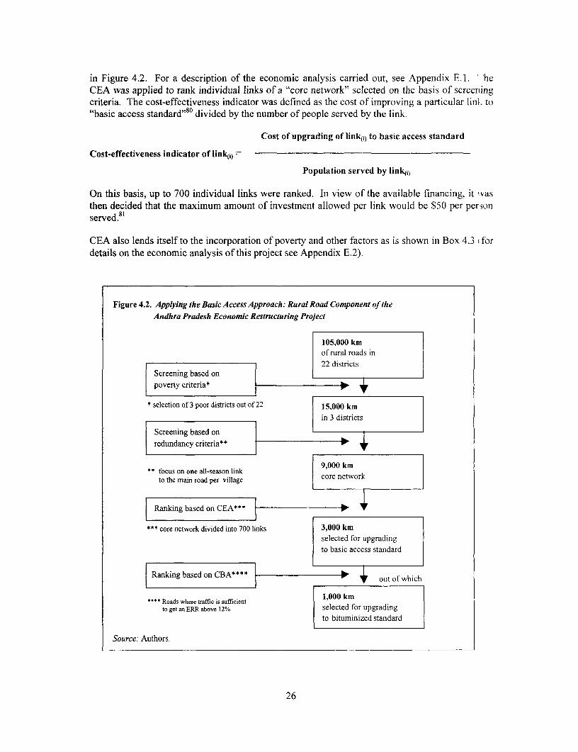
in Figure 4.2. For a description of the economic analysis carried out, see Appendix E. 1. '-heCEA was applied to rank individual links of a "core network" selected on the basis of screeningcriteria. The cost-effectiveness indicator was defined as the cost of improving a particular link to"basic access standard"80 divided by the number of people served by the link.
Cost of upgrading of link({) to basic access standard
Cost-effectiveness indicator of link(j) =
Population served by lin4<i)
On this basis, up to 700 individual links were ranked. In view of the available financing, it 'vasthen decided that the maximum amount of investment allowed per link would be $50 per per ;onserved.81
CEA also lends itself to the incorporation of poverty and other factors as is shown in Box 4.3 1 fordetails on the economic analysis of this project see Appendix E.2).
Figure 4.2. Applying the Basic Access Approach: Rural Road Component of the
Andhra Pradesh Economic Restructuring Project
105,000 kmof rural roads in22 districts
Screening based on
poverty criteria* *
* selection of 3 poor districts out of 22 15,000 km
in 3 districts
Screening based on i 3
redundancy criteria**
** focus on one all-season link 9,000 kmto the main road per village core network
Ranking based on CEA***
* core network divided into 700 links 3,000 kmselected for upgrading
to basic access standard
Ranking based on CBA**** out of which
"" Roads where traffic is sufficient 1,000 kmto get an ERR above 12% selected for upgrading
to bituminized standard
Source: Authors.
26

Box 4.3. Applying the Basic Access Approach: Vietnam's Second Rural Transport Project
The overall goal of this project is to contribute to poverty reduction in rural Vietnam. To meet thisobjective, the project aims to provide "basic road access" to all communes in participating provinces.For purposes of the project, basic road access is defined as year-round motorized access from thecommune center to the closest district center. District centers have many of the higher level facilities-hospitals, upper secondary schools, market centers. Effective year-round road access to thedistrict center can be expected to make significant impacts on living standards in the communes.
A4) Basic access roads: Before project implementation, it was not clear whether the budget would besufficient to provide basic access roads to all communes; (there was also the possibility that it wouldbe too much). A cost-effectiveness methodology that takes poverty, population and project costs intoaccount was thus used to prioritize between eligible roads. Among the different grqups in thepopulation, the formula put about three times more weight on the poor than on the non-poor. Thechoice of three as the relative weight on the poor was discussed and agreed to in focus-groupmeetings with local non-transport experts and with the Ministry of Transport. The index for rankingalternative basic access roads is then:
CE, = (# of poor + 0.3* # of non-poor)/total cost of rehabilitation
B) Selected rehabilitation and spot improvement on other roads: Once basic road access needs aremet, remaining funding can be devoted to selected rehabilitation and upgrading of other roads. Thisbudget is allocated to the highest priority road projects as deternined by cost-effectiveness rankingsbased on a formula that takes into account poverty, population served, potential for agriculturaldevelopment (as measured by unused land with agricultural potential and number of social and otherfacilities) and costs of the proposed works. The index for ranking roads for rehabilitation/spotimprovement is:
CE2 = {ll + (unused land/per person) + (facilities /per person)I*l# of poor + 0.3* # of non-poor]}/ total cost of rehabilitation
Again, the choice of variables (subject to data availability) were discussed and agreed to in focusgroup meetings with local non-transport experts and with the ministry of transport.
Source: Dominique Van de Walle, 1999.
Thresholds for Cost-Effectiveness: Unlike CBA, where projects normally are deemed"uneconomic" when their ERR falls below 10-12%, there are no well established criteria fordetermining "opportunity cost" thresholds when ranking on the basis of cost-effectiveness. Sucha determination is then left to policy makers. For example, if access can be provided to two,otherwise similar communities at $100 per person served and $50 per person served, respectively,cost-effectiveness criteria would clearly "rank" the latter community higher. However, thequestion that remains is whether $50 per capita is a sufficient "return" to justify intervention(could that $50 per person be spent with more impact in another sector, or would it yield an ERRof 10-12% considering the opportunity cost of capital in the country?). In practice, for basicaccess RTI, such thresholds do not usually become a point of debate, because project budgets arenormally pre-set and are exhausted before what most planners agree are reasonable cost-effectiveness limits.
Sample Study to Indicate Economic Viability: To overcome the problem of open-endedthresholds associated with the CEA method, it may be desirable to complement the CEA methodwith a sample study based on cost-benefit analysis for one or two roads in the project area (seebelow). If this sample study can establish that a per-capita threshold of investment meets the
27

prescribed economic rate of return for the sample link (such as the $50 used in the AndhraPradesh appraisal mentioned above), then all links above the threshold are likely to be viable.Such an approach has been shown to provide a good economic basis for applying the CEAmethod to a broad RTI investment program, especially where socioeconomic characteristics donot vary greatly.
Cost-Benefit Analysis
A more common alternative to CEA is to undertake an economic evaluation of road investmentsusing cost-benefit analysis (CBA). CBA is a comprehensive accounting of all the real costs nmdbenefits associated with a project. In the case of road projects, this includes users and non-users,as well as road agency costs. Where the impact on non-users is negligible, a CBA of roadalternatives centers around the trade-offs between total life-cycle costs of infrastructure (capitaland maintenance) and user costs and benefits (operating cost of the primarily vehicle and timesavings). The outcome of CBA permits ranking of alternative interventions on a particular linkbased on the net present value (NPV). Where a number of different but independent links arebeing considered (and there is a fixed capital budget) ranking can be based on the net presentvalue per financial investment outlay ratio (NPV/INV), or net present value per kilometer(NPV/KM) if road infrastructure costs (capital and maintenance) are the same for all links. ;hebenefit from cost savings for transport users can be considered an increase in "consumer surplus",if such savings accrue to the users as reduction in transport costs or charges. Alternatively, iftransport cost reductions lower producers' input and output costs, and result in higher net incoine,then the benefits can be considered as an increase in "producers' surplus."82
Producer Surplus Methods are discussed in detail in the well known works of Carnemark,Beenhakker and others.83 The method requires assumptions concerning the impact of transportinvestments on local agricultural productivity and output which are difficult to assess, particularlyin a situation where interventions are expected to open up new areas and adequate productiondata may be difficult to compile. To the extent that RTI investments are increasingly focused onexisting networks and often put more emphasis on social rather than economic objectives, theapplication and relevance of the producer surplus method has decreased in recent years.
Consumer Surplus Methods are well established and applied in road investment models, sucl, asthe Highway Development and Management Model, Version 4 (HDM-IV). The methods arereliable to apply to higher-volume roads (>200 VPD). However, its application to low-volumeroads encounter problems related to the small magnitude of user benefits and the strongerinfluence of the environment rather than traffic on infrastructure deterioration. With traffic lex elsbetween 50 and 200 VPD, and particularly with regard to unpaved roads, a modified andcustomized approach can be taken, as is done in the recently developed Roads EconomicDecision Model (RED) (see Appendix F). This method attempts to take into account uncertaintyrelated to the input assumptions and an expanded treatment of user benefits (Box 4.4).
For traffic levels below 50 VPD, as is the case on the majority of RTI, the consumer surplusapproach is usually not recommended because the main benefits from such projects are not fromsavings in motor vehicle operating costs, but relate to the provision of access itself. As discussedpreviously, for various reasons the benefits of access are difficult to quantify. Also, traffic onsuch very low volume RTI typically consists of a majority of non-motorized vehicles (where partof the costs are human energy needed to pull or push the vehicles, which cannot be easily priced),animal transport such as haulage by mules, walking and head loading (porterage). Therefore, thefollowing section proposes some extensions or special adaptations to the traditional CBA anddiscusses their appropriate application for RTI.
28
Box 4.4. Roads Economic Decision Model (RED)
The Roads Economic Decision Model (RED) provides an approach for improving the decision-makingprocess for the development and maintenance of low-volume roads. RED is a consumer surplus modeldesigned to help evaluate investments in roads with traffic volumes between 50 and 200 vehicles perday. The model is implemented in a series of Excel workbooks that estimate vehicle operating costsand speeds, perfonn economic comparisons of investment and maintenance options, switching valuesand stochastic risk analysis.
RED simplifies the economic evaluation process but at the same time addresses the following concernsrelated to low-volume roads: (a) reduces the input requirements; (b) takes into account the higheruncertainty related to the inputs; (c) computes internally generated traffic based on a defined priceelasticity of demand to which induced traffic can also be added; (d) quantifies the economic costsassociated with the days-per-year when the passage of vehicles is further disrupted by a highlydeteriorated road condition; (e) optionally, uses vehicle speeds as a surrogate parameter to roadroughness to define the level of service of low-volume roads; (f) includes road safety benefits; (g)includes in the analysis other benefits (or costs) such as those related to non-motorized traffic, socialservice delivery, and environmental impacts, if they are computed separately; and (h) presents theresults with the capacity for sensitivity, switching values and stochastic risk analyses. RED can bedownloaded free of charge at http://www.worldbank.org/html/fpd/transport/roads/tools.htm
Source: Archondo-Callao, 1999.
Extending the CBA Framework for RTI
Because traditional CBA approaches do not account for many of the benefits of RTI investments,extending the framework of CBA holds promise for improved analysis. The proposedenhancements of traditional CBA techniques are aimed at finding broader measures of economicbenefits and costs applicable to RTI. That is, while the principles of analysis are the same, thespecial features of RTI call for special methods of analysis. The methods described here canserve as a useful foundation for "pilot" or "sample" CBA to supplement CEA, or in the case of alow-volume road that presents a major investment, a new access option to a given area, or aproposed upgrading to a higher than basic access level. Possible enhancements of CBA include:
* Better assessment of the costs of interrupted access
* Estimating operating cost savings of NMT
* Savings due to mode changes (from NMT to motorized transport)
* Improved valuation of time savings, and
* Valuation of social benefits from improved access to schools and health centers
Better Assessment of the Cost of InterruptedAccess: For cases where passability suffers duringthe rainy season, an assessment can be made of the extent of interruption. Seasonal changes intransport quality can be assessed on the basis of local socioeconomic impact, such as highergoods prices, lost productivity, or decreased social travel. In such cases, an assessment of theimpact on particular activities may be necessary, since losses associated with seasonalinterruptions will vary by activity (agriculture, marketing, travel for jobs and related wageearnings, school attendance and consequent decline in quality of education, health visits, etc). Itmay be difficult to directly observe the impact of seasonal access variations, and such informationwill usually need to be collected either through a local survey or other participatory processes. In
29
addition, it may be possible to examine the costs associated with alternative (but longer) routes(that increase transport cost and time), or substitutes for transport (migration, storage), or evenlost opportunities and income, to better understand the impact.
Estimating Operating Costs Savings of NMT: Methods for calculating the non-motorizedtransport user cost savings from road improvements have only recently become a part of projectevaluation. Studies in Bangladesh and Indonesia have estimated user costs for a set of NMT .ndthe results of these studies has been integrated in the HDM-4 model.84 In particularcircumstances, additional country- or area-specific field work may be necessary to get realisticestimates of NMT costs. Particular information is required regarding operating costs in relai ionto differing road surface conditions. Box 4.5 gives an example from Bangladesh.
Box 4.5. Rickshaw Operating Costs in Bangladesh
Studies in Bangladesh indicate how to realistically assess (changes in) the cost of transport services byrickshaws and rickshaw-vans that are used as a major form of rural transport The rickshaw-van is themost common NMT used for goods in rural Bangladesh, and it is driven (pedaled) by a van driver. It Sancarry about 400 kg weight per trip. Since the main cost of its operation is the time and food-energy usedby its driver, its operating cost is difficult to estimate. For project analysis, therefore, charges actuallymade by the rickshaw-van operators on different types of road conditions were collected through survcys.The vehicle operating cost savings used in the study are based on actual differentials in charges betw :enexisting poor roads and improved roads, as they substantially reflect the cost variations due to greaterexertion, time and additional food for higher level of effort and energy needed for plying on rougherroads. Since NMT transporters operate in a highly competitive market where there are no significantexternalities, these financial rate differences are taken to reflect economic cost differences. The surv cysshowed that the rate per ton-km on moving on a rough (earth) road was more than double the rate fcr asmooth asphalt road (about $0.50 per ton-km for the rough road, compared to $0.20 per ton-km onsmooth roads). An interesting aspect of the case in Bangladesh was the realization that human-pulledvehicles need smooth surfaces even more than motor vehicles, and that road investments in black-topp ingcould be justified when heavy NMT traffic exists, even though the number of motor vehicles in use isless than 50 per day. It was also clear that the people generally had small parcel loads or a few bags at atime to transport over short distances, which was best suited for the efficient form of NMT in Banglade,sh(the rickshaw-van). Indeed, with road improvements there was a fast increase in both motor vehicles andNMT traffic. The Bangladesh studies also established that after road development there is dynanicgrowth in traffic and a change in vehicle composition: buses starting to appear for the first time, andoverall traffic growth exceeded 100 percent even in the first year after project completion. The stL..dyalso found that cost differences between the with- and without-project situations are best estima:edthrough likely changes in the composition of vehicles (decline of bullock carts and head porterage, a.ndincrease in both NMT and motor vehicles) and related unit costs.
Source: (1) "Bangladesh Rural Infrastructure Impact Study," with special reference to RDP-7 and otlerprojects, 1999. (2) Bangladesh Rural Infrastructure Strategy Study, 1996.
Savings due to Mode Changes (from NMT to motorized transport): Very significant savinigscan be made due to road improvement- or construction-induced changes in the modes oftransport. Resulting cost reduction can ten fold as shown in Box 4.6 below.
Improved Valuation of Time Savings: A critical aspect of examining alternative RTIinterventions is an understanding of the impact of improvements in infrastructure on journeytimes, and therefore (beyond the impact on vehicle operating costs) on productive time saved,including those associated with non-motorized travel and transit time of freight. The process ofvaluing time in transport operations is not without controversy (Box 4.7), and while there arecurrently no universally accepted methods for determining a "value of time," some general
30
guidance is possible8 5 For additional, information on valuing travel time savings, see Gwilliam(1997).
Box 4.6. Savings due to Mode Changes in Ghana and Elsewhere
Studies in Ghana (and elsewhere) have established that head porterage takes about two person-days tomove one ton-km, using factors of average load size, walking speed per hour, and time for the returntrip (without load). Using the minimum wage rate, this amounted to about $2 to 2.50 per ton-km. Theminimum wage is taken as a proxy for the resource costs (food, expenses, etc.), and for the time andeffort involved.
More recent studies indicate that where transport is not available, the rural poor experience a shortageof productive time in doing various chores in their daily lives and farming, marketing, and transportactivities, and therefore their time should be given a higher monetary value. This is indeed a validconsideration, but not reflected in the price noted above (see also next paragraph on the valuation oftime savings). The estimated rate of $2 to 2.50 per ton-km mentioned above was also found to reflectthe actual market charges for such operations.
This rate range is found valid for head porterage in many developing countries. In Balochistan(Pakistan), Nepal, and Bhutan, where mule transport is a common form of transport in rural areas, theactual cost is found to be about $3 to 4 per ton-km, including the cost of the mules and the personswalking with them. In Bhutan, a similar rate was found through market inquiries of actual chargeslevied, and also from indicative tariff rates published by the Royal Government of Bhutan. This rateshould be compared with about $0.20 per ton-km for trucking operating costs on low-volume roads,which would become applicable after road construction or improvement.
Source: Adapted from Tampil Pankaj, 1991.
Box 4.7. Valuing "Journey Time Saving" in Developing Countries
The issue of valuing time, or more specifically journey time savings, has been the subject of extensivetheoretical and empirical investigation. However, most of this work has focused on conventionaljourneys of people by road and reflects the traditional arguments of transport economics. These revolvearound the use of resource assessments of value, or inferring resource values from the behavior oftravelers. Walking trips and those by other non-motorized means of transport have largely beenignored. Moreover, debate has generally centered around the issue of valuing journeys in working timeor non-working time. The first of these categories refers to time for which the traveler is paid out ofemployment remuneration, and the second to all other uses of time such as commuting, shopping orsocial purposes. These categorizations are appropriate to the economic and social structures ofdeveloped countries, yet they are less helpful when the study population comprises rural householdmembers who are: (a) predominantly self-employed; and (b) characteristically engage in multi-purpose,or simultaneous task trips. The latter is especially true of women who in many societies are thedominant transporters at the household level (see Bryceson 1995).
Most transport economics literature assumes that the majority of the rural population in developingcountries will be in non-wage employment, and it is therefore considered to be traveling in non-working time which is ascribed a zero value. This clearly does not make sense, either in resource orbehavioral terms. Walking journeys consume both energy and time, which are both valuable resourcesin rural subsistence households. The creation of energy is rarely a free good. Moreover, there arenumerous examples where the behavior of such societies indicates that they place a relatively highvalue on their time.
Source: Howe, 1997.
31
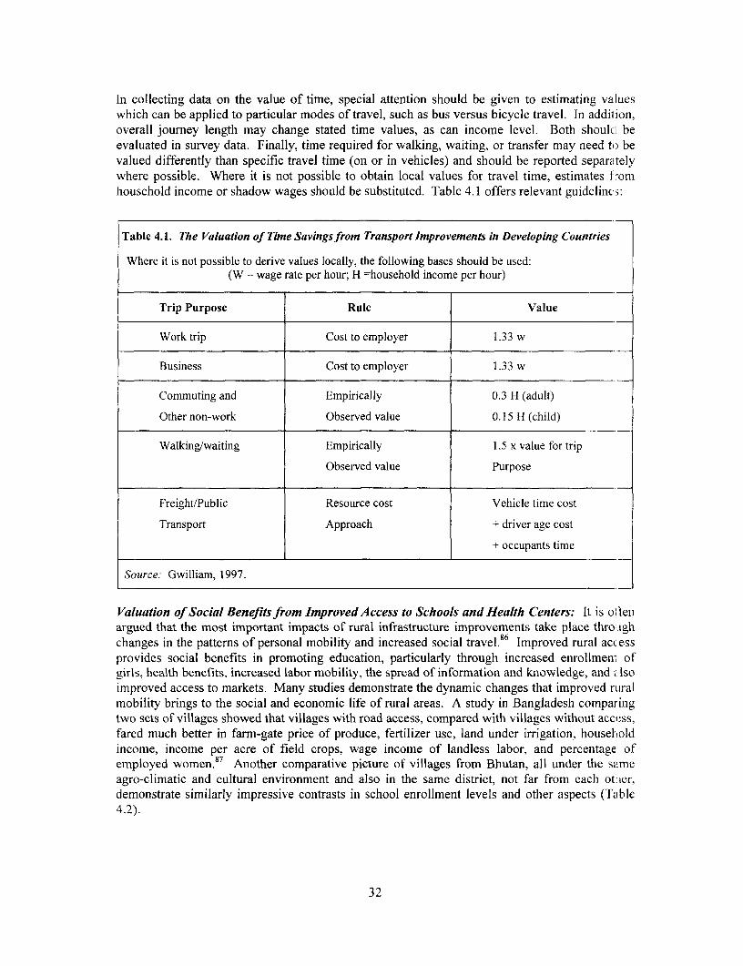
In collecting data on the value of time, special attention should be given to estimating valueswhich can be applied to particular modes of travel, such as bus versus bicycle travel. In addilion,overall journey length may change stated time values, as can income level. Both should beevaluated in survey data. Finally, time required for walking, waiting, or transfer may need to bevalued differently than specific travel time (on or in vehicles) and should be reported separatelywhere possible. Where it is not possible to obtain local values for travel time, estimates I-.omhousehold income or shadow wages should be substituted. Table 4.1 offers relevant guideline,:
Table 4.1. The Valuation of Time Savings from Transport Improvements in Developing Countries
Where it is not possible to derive values locally, the following bases should be used:(W = wage rate per hour; H =household income per hour)
Trip Purpose Rule Value
Work trip Cost to employer 1.33 w
Business Cost to employer 1.33 w
Commuting and Empirically 0.3 H (adult)
Other non-work Observed value 0.15 H (child)
Walking/waiting Empirically 1.5 x value for trip
Observed value Purpose
Freight/Public Resource cost Vehicle time cost
Transport Approach + driver age cost
t occupants time
Source: Gwilliam, 1997.
Valuation of Social Benefits from Improved Access to Schools and Health Centers: It is oltenargued that the most important impacts of rural infrastructure improvements take place throuigh
86-eschanges in the patterns of personal mobility and increased social travel. Improved rural acc essprovides social benefits in promoting education, particularly through increased enrollment ofgirls, health benefits, increased labor mobility, the spread of information and knowledge, and Isoimproved access to markets. Many studies demonstrate the dynamic changes that improved raralmobility brings to the social and economic life of rural areas. A study in Bangladesh comparingtwo sets of villages showed that villages with road access, compared with villages without access,fared much better in farm-gate price of produce, fertilizer use, land under irrigation, householdincome, income per acre of field crops, wage income of landless labor, and percentage ofemployed women.87 Another comparative picture of villages from Bhutan, all under the sameagro-climatic and cultural environment and also in the same district, not far from each othler,demonstrate similarly impressive contrasts in school enrollment levels and other aspects (Table4.2).
32
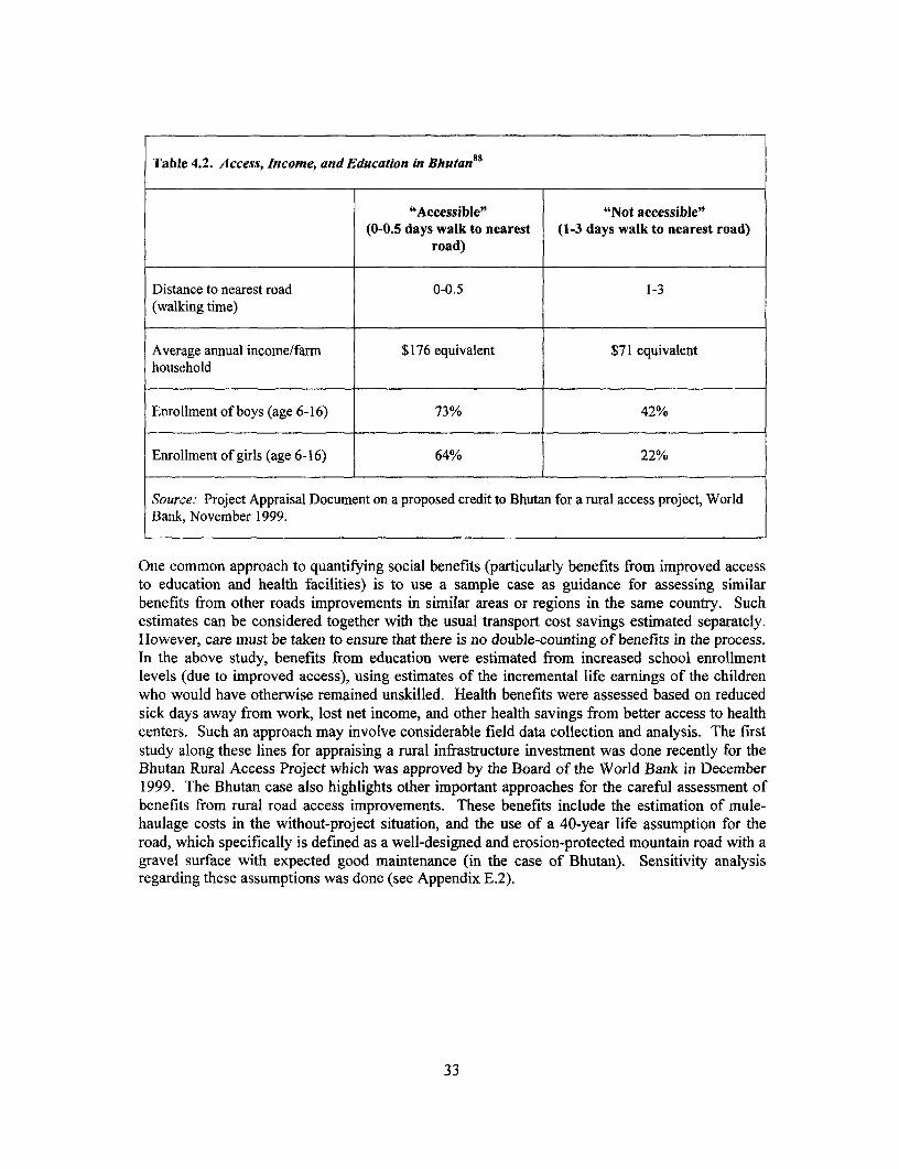
Table 4.2. Access, Income, andEducation in Bhutan8 8
"Accessible" "Not accessible"(0-0.5 days walk to nearest (1-3 days walk to nearest road)
road)
Distance to nearest road 0-0.5 1-3(walking time)
Average annual income/farm $176 equivalent $71 equivalenthousehold
Enrollment of boys (age 6-16) 73% 42%
Enrollment of girls (age 6-16) 64% 22%
Source: Project Appraisal Document on a proposed credit to Bhutan for a rural access project, WorldBank, November 1999.
One common approach to quantifying social benefits (particularly benefits from improved accessto education and health facilities) is to use a sample case as guidance for assessing similarbenefits from other roads improvements in similar areas or regions in the same country. Suchestimates can be considered together with the usual transport cost savings estimated separately.However, care must be taken to ensure that there is no double-counting of benefits in the process.In the above study, benefits from education were estimated from increased school enrollmentlevels (due to improved access), using estimates of the incremental life earnings of the childrenwho would have otherwise remained unskilled. Health benefits were assessed based on reducedsick days away from work, lost net income, and other health savings from better access to healthcenters. Such an approach may involve considerable field data collection and analysis. The firststudy along these lines for appraising a rural infrastructure investment was done recently for theBhutan Rural Access Project which was approved by the Board of the World Bank in December1999. The Bhutan case also highlights other important approaches for the careful assessment ofbenefits from rural road access improvements. These benefits include the estimation of mule-haulage costs in the without-project situation, and the use of a 40-year life assumption for theroad, which specifically is defined as a well-designed and erosion-protected mountain road with agravel surface with expected good maintenance (in the case of Bhutan). Sensitivity analysisregarding these assumptions was done (see Appendix E.2).
33
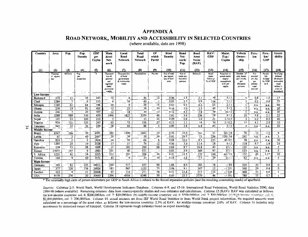
APPENDIX A
ROAD NETWORK, MOBILITY AND ACCESSIBILITY IN SELECTED COUNTRIES(where available, data are 1998)
Country Area Pop. Pop. GDP Main Local Total Of Road Road Road RAV/ Maint. Vehicle Pers.- Pers.- AccessDensity per Road Road Road which Density Net- Asset GDP Exp./ Owner- km km/ -ibility
Capita Net- Network Network Payed worl/ Value Capita ship GDPwork Pop. (RAV)
(I) (2) (3) (4) (5 ( (7) 8) (9) (10) (11) (12) (13) (14) 15X (16) (17) (18)Thousan Millions Pop. s Thousand Thousand km Thousand km Percent Km of road Km of Billion S Road Required vs Number of Km Person- % of popd square per km of of local per square roads per Asset actual maint- cars, buses traveled km withoutkm square km national govnmment km of land thousand value an enance and trucks per day divided all-season
and & community urea person % of GDP expenditure per per by GDP motorubleregional
1roads in S per thousand person; in $ road
state/ capito persons rood within 1-pmrovincial and rail 2 km of
roalds household
Low-lncomeBurkina F. 274 11 39 243 10 6 16 12 0.06 1.5 2.1 79 5 / 1 5 0.8 1.2 17Chad 1284 7 6 233 6 34 40 1 0.03 5.7 1.9 116 7/ 1 3 0.2 0.4 75Ethiopia 1104 61 61 106 20 9 29 15 0.03 0.5 4.2 65 2/ I1 n.a. n.a. 60Ghana 239 19 81 405 15 23 38 24 0.16 2.0 3.5 45 5 /2 7 n.a. n.a. 20Guinea 246 7 29 507 12 18 30 17 0.12 4.3 2.8 79 10/2 5 n.a. n.a 30India 3288 980 330 439 1496 1823 3320 46 1.01 3.4 336 78 9/3 10 5.8 2.1 22Nepal 147 23 160 210 5 7 13 31 0.09 0.6 1.0 21 1 /0.5 3 0.2 0.3 40Nigeria 924 121 133 343 63 73 136 27 0.15 1.1 14 34 3 / 0.2 1 1 4.1 2.9 10
r Tanzania 945 32 36 249 28 60 88 4 0.09 2.8 6.8 85 54/2 n.a. n.a. 30Middle-Income . . _Brazil 8547 166 20 4691 265 1400 1665 10 0.20 10.0 161 21 20 / 14 76 15 1.2 9Latvia 65 2 40 2667 20 39 59 39 0.91 29.5 12 226 120/34 241 n.a. n.a. 3Namibia 824 2 2 1824 14 50 64 8 0.08 32.0 8.5 233 85 /21 78 n.a. n.a. 30Peru 1285 25 19 2528 17 57 74 12 0.06 3.0 11.4 18 9/3 118 9.7 1.4 25Romania 238 23 98 1698 15 185 200 68 0.84 8.7 16.8 43 15/ - 135 n.a. n.a. 5Russia 17075 147 9 1883 531 40 571 - 0.03 3.9 269 97 37 / - 153 n.a. n.a. 5S. Africa 1221 41 34 3225 233 301 506 34 0.41 12.5 132 100 64/ 15 137 45 5.1 * 20Tunisia 164 9 60 2151 14 9 23 79 0.14 2.6 7.5 39 21/- 63 n.a. n.a 5High-Income l . _
Germany 349 82 235 26012 140 517 657 99 1.88 8.0 383 18 - /93 529 30 0.4 0Japan 377 126 336 29926 187 965 1152 75 3.06 9.1 567 15 / 131 560 29 0.4 0
Sweden 412 9 21 20608 97 114 211 78 0.51 23.4 217 116 / 150 468 33 0.6USA 9159 270 30 30449 1394 4954 6348 59 0.69 23.5 3779 46 -/ 101 780 55 0.7
* The unusually high ratio of person-kilometers per GDP in South Africa is related to the forced separation policies (and the resulting commuting needs) of apartheid.
Sources: Columns 2-5: World Bank, World Development Indicators Database. Columns 6-9, and 15-16: International Road Federation, World Road Statistics 2000, data1994-98 (where available). Remaining columns: data from country-specific studies and own estimates and calculations. Column 12 (RAV): RAV was calculated as follows:(a) low-income countries: col. 6: $200,000/km, col. 7 $20,000/kin (h) middle-income countries: col. 6: $500000/km col 77 $1l 000/lcm (r"l hiph-inr-rm, .-. ,s,tri.'c .-o _
$2,000,000/km, col. 7: 200,000/km. Column 14: actual amounts are from IRF World Road Statistics or from World Bank project information; the required amounts werecalculated as a percentage of the asset value, as follows: for low-income countries: 2.5% of RAV; for middle-income countries: 2 .0% of RAV. Column 16 includes onlymovements by motorized means of transport. Column 18 represents rough estimates based on expert knowledge

APPENDIX BDESIGNING BASIC ACCESS ROADS
General
This appendix provides guidance on the design of basic access roads.89 Further guidance to thetopic can be found in the literature.90
The design of motorized basic access necessitates a return to the guiding principles of highwayengineering. Determining the minimum interventions necessary to ensure passability at least costrequires a thorough understanding of the complex interactions of soils, terrain, climate, andtraffic. Moreover, creating sustainable solutions to the problems posed by these interactionsrequires a significant level of engineering judgment, technical skills, and local knowledge.
Standard solutions are often insufficient. Terrain conditions can vary considerably withincountries and between regions. Traffic types and needs depend on the circumstances ofindividual communities. To achieve cost-effective basic access, it is important to tailorinterventions to the specific situation and not to impose rigid designs. However, there are anumber of basic engineering standards that should be adhered to, and these are summarized inTable B. I below.
The supporting notes are not intended to present a comprehensive design procedure, but tosupplement good engineering practices with low-cost solutions not normally included inconventional highway manuals.
Table B.1. Basic Access Road Standards for Various Terrain
Feature Terrain
Flat Rolling Mountainous
Carriageway width 3.0 meters 2.5 to 3.0 meters {2.5 to 3.0 meters
If shoulders are insufficient to allow passing of the prevailing vehicles, passingplaces of 20 meters length must be provided every 200 meters.Parking place for buses and trucks will be required in villages and towns.
Formation width 3.5 to 5.0 meters 3.0 to 5.0 meters 3.0 to 4.0 meters
Minimum curve 12 meters 12 meters 8 metersradius
Road surface type (in- Gravel on weak soils Gravel or stone paving Gravel or stone paving onsitu material unless on steep sections or steep sections or weakotherwise stated) weak soils soils
Camber 5 to 8% 5 to 8% 3 to 5%
Maximum gradient N/A 12% 12 to 15%
Water crossings Concrete or stone drifts. 600mm diameter culverts. Vented fords for majorcrossings. Single-lane submersible or high-level bridges where water flow issubstantial and perennial.
Cross-sections and Road required to be Scour checks Lined drains >10%Side drains about 50 cm above
flood level
Source: Authors.
35
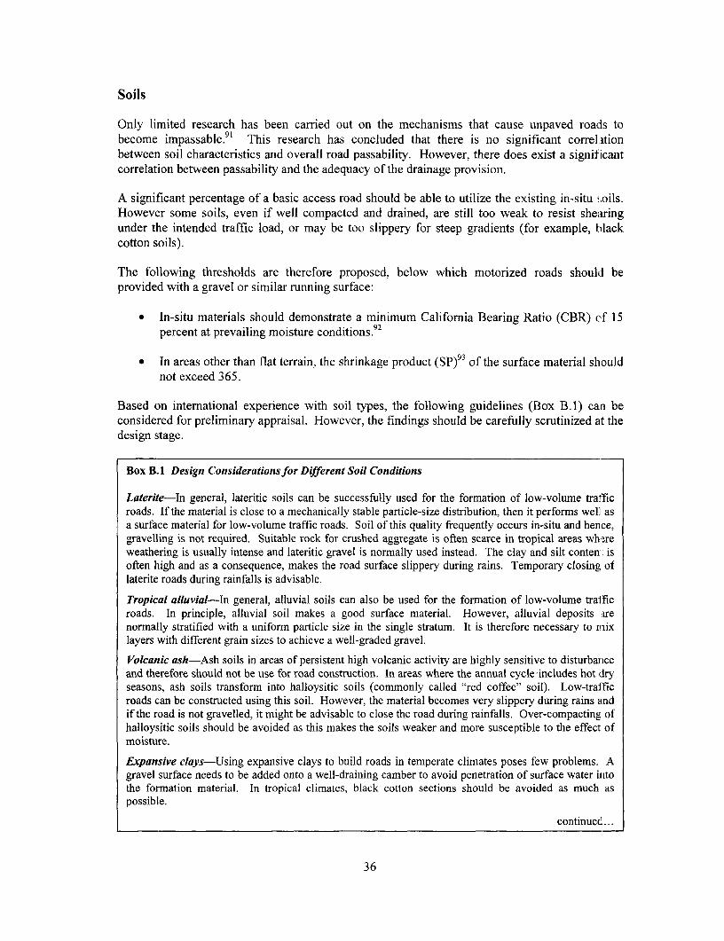
Soils
Only limited research has been carried out on the mechanisms that cause unpaved road:ls tobecome impassable.9 ' This research has concluded that there is no significant correlationbetween soil characteristics and overall road passability. However, there does exist a signif'icantcorrelation between passability and the adequacy of the drainage provision.
A significant percentage of a basic access road should be able to utilize the existing in-situ soils.However some soils, even if well compacted and drained, are still too weak to resist shearingunder the intended traffic load, or may be too slippery for steep gradients (for example, blackcotton soils).
The following thresholds are therefore proposed, below which motorized roads should beprovided with a gravel or similar running surface:
* In-situ materials should demonstrate a minimum California Bearing Ratio (CBR) Cf 15percent at prevailing moisture conditions.92
* In areas other than flat terrain, the shrinkage product (SP)93 of the surface material shouldnot exceed 365.
Based on international experience with soil types, the following guidelines (Box B.1) carl beconsidered for preliminary appraisal. However, the findings should be carefully scrutinized at thedesign stage.
Box B.1 Design Considerations for Different Soil Conditions
Laterite-In general, lateritic soils can be successfully used for the formation of low-volume trafficroads. If the material is close to a mechanically stable particle-size distribution, then it performs well asa surface material for low-volume traffic roads. Soil of this quality frequently occurs in-situ and hence,gravelling is not required. Suitable rock for crushed aggregate is often scarce in tropical areas wh:.reweathering is usually intense and lateritic gravel is normally used instead. The clay and silt conten: isoften high and as a consequence, makes the road surface slippery during rains. Temporary closing oflaterite roads during rainfalls is advisable.
Tropical alluvial-In general, alluvial soils can also be used for the formation of low-volume trafficroads. In principle, alluvial soil makes a good surface material. However, alluvial deposits arenormally stratified with a uniform particle size in the single stratum. It is therefore necessary to mixlayers with different grain sizes to achieve a well-graded gravel.
Volcanic ash-Ash soils in areas of persistent high volcanic activity are highly sensitive to disturbanceand therefore should not be use for road construction. In areas where the annual cycle 'includes hot dryseasons, ash soils transform into halloysitic soils (commonly called "red coffee" soil). Low-trafficroads can be constructed using this soil. However, the material becomes very slippery during rains andif the road is not gravelled, it might be advisable to close the road during rainfalls. Over-compacting ofhalloysitic soils should be avoided as this makes the soils weaker and more susceptible to the effect ofmoisture.
Expansive clays-Using expansive clays to build roads in temperate climates poses few problems. Agravel surface needs to be added onto a well-draining camber to avoid penetration of surface water initothe formation material. In tropical climates, black cotton sections should be avoided as much aspossible.
continued...
36

...Box B.1 continued
Where this is not possible, it is advisable to raise the road above the surrounding level and to providewide and shallow ditches. Two layers of compacted gravel surface are required. In addition, theshoulders should be covered (haunched) with the gravel course in order to avoid any rainwaterpenetrating the surface and weakening the formation material. Expansive soils in tropical climates canseverely erode if adequate protection measures are not taken, especially in ditches with slopes greaterthan 2 percent, culvert outlets and embankment slopes.
Desert soils-Wind-blown sands dominate and are often single-sized material, which makes it difficultto compact. At the same time, there is hardly sufficient water available for effective compaction. Sandalone should not be used as road-surface material and needs to be sealed or covered with an adequatesurface material, such as seal, gravel, or calcrete. It is often difficult to find suitable gravel as surfacematerial. Calcrete has been tried in a number of cases (such as Botswana, Namibia) with good results,but can be difficult to extract by labor-based methods.
Source: Authors.
Terrain
The terrain through which a road or track leads can conveniently be classified as flat, rolling, ormountainous, defined by both subjective descriptions and average ground slope.94 The terraintype has considerable impact on the nature of the drainage, alignment, road structure,performance after construction, and ultimately, costs.
Recommendations for basic standards applicable to each terrain category are set out below forrolling terrain, very flat, and very steep conditions.
Rolling Terrain: Rolling terrain is the most commonly encountered terrain type. Whereasexisting tracks in this terrain are normally motorable for the majority of their length, there oftenare distinct problem areas that make access difficult. Bearing-capacity problems are moreprevalent on level sections or shallow grades, while slipperiness problems tend to occur onsteeper grades. These sections need careful inspection in determining where imported soils orgravel surfacing are required.
Typically, the existing alignment will have developed naturally over time to connect villages bythe most direct route, possibly following non-motorized transport routes that avoid minorobstacles. Therefore, it may be necessary to realign short sections to avoid steep grades andoverly tight curves for motorized traffic. However, finding an alternative alignment is relativelystraightforward in this terrain.
Drainage provision is the most important aspect, and all existing cross-drainage points willrequire inspection and treatment. The solution may be as simple as a stone-surfaced "splash," butwork must always be done to ensure that the road is not cut by erosion as a consequence of heavyrunoff. Up to five splashes, drifts, or culverts may be required in a typical kilometer of road. Allstructures and drainage outlets must be securely protected against erosion.
Runoff from the road surface must be quickly diverted to adjacent land to avoid ponding andsoftening. This may not require side drains throughout, but the road surface must be correctlyshaped with adequate camber or cross slopes. Although 5 percent is usually specified forengineered roads, 8 percent has been found to perform better on low-traffic earth and gravelroads.
37

Where side ditches are provided, they must be equipped with scour checks if the gradient exceeds 4percent and mitre drains every 20 meters to protect against erosion (Figure B. 1).
Figure B.I. Typical Scour Checks
120 cm 120 cm
30 cm 30cm
40 cm 40 cm
Perennial vegetation planted every 30cmon the ditch external side.
Source: Authors. 5m (slope>8%); 8m (8%> >6%); 1 5m (<6%)
Basic access roads in rolling terrain are single lane with a carriageway width between 2.5 aird 3meters. The total formation width should be between 3 and 5 meters. The wider formation a] lowslight vehicles to pass at low speeds if the shoulder can be driven on.
However, sufficient passing places (bypasses) at suitable places (minimum every 200 meters) 1aveto be provided. The width of the carriageway at these passing places should be at least 5 meters.The length of the passing places must be a minimum of 20 meters.
The absolute minimum horizontal radius for curves is 12 meters. This is just within the minimumturning radius of small commercial vehicles and buses. If much larger vehicles are expected andrequired, the road geometry must be amended accordingly, but this would not normally be expectedon basic access roads. The most important issue is to ensure that the geometry is consistent. Long,straight sections and shallow high-speed curves must not be followed by unmarked tight curves.This would be hazardous for motorized traffic, and even more so for the pedestrians they mayencounter.
38
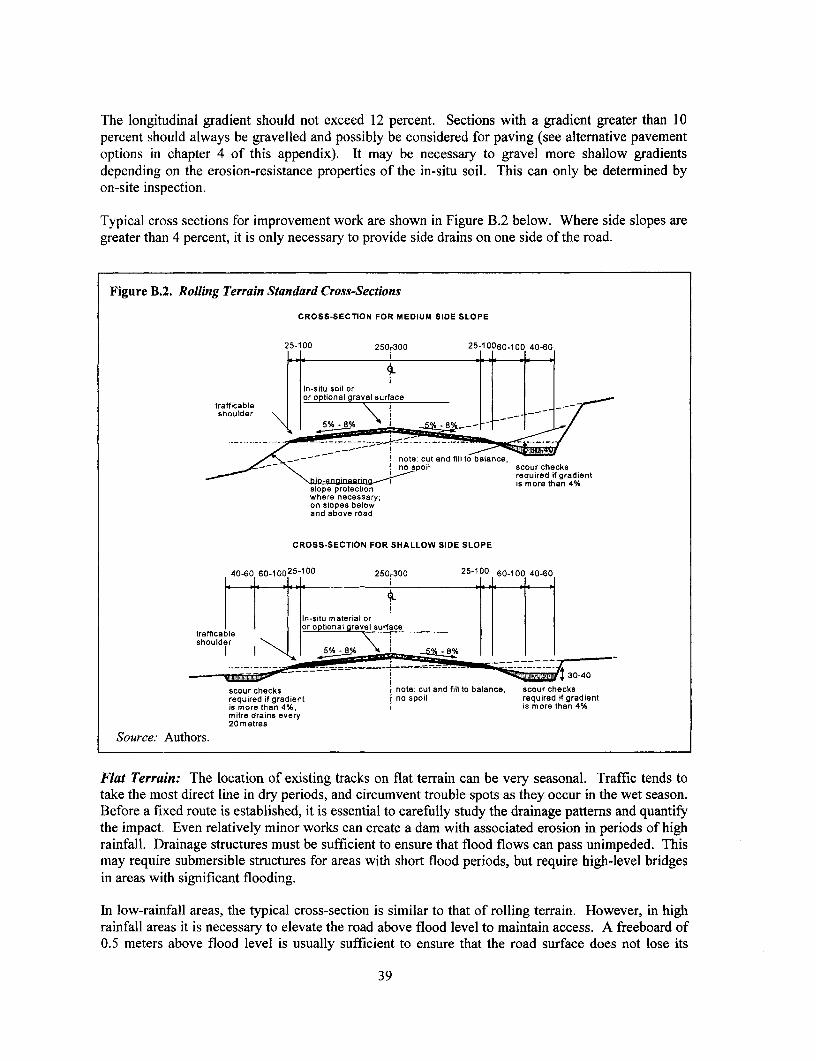
The longitudinal gradient should not exceed 12 percent. Sections with a gradient greater than 10percent should always be gravelled and possibly be considered for paving (see alternative pavementoptions in chapter 4 of this appendix). It may be necessary to gravel more shallow gradientsdepending on the erosion-resistance properties of the in-situ soil. This can only be determined byon-site inspection.
Typical cross sections for improvement work are shown in Figure B.2 below. Where side slopes aregreater than 4 percent, it is only necessary to provide side drains on one side of the road.
Figure B.2. Rolling Terrain Standard Cross-Sections
CROSS-SECTION FOR MEDIUM SIDE SLOPE
25-100 250,300 25-10060-100 40-60
Inssitu soil oror optional gravel surface
trafficableshoulder _-_ -_
scour hecks ;note: cut and fill to balance,-~~~ \ . ~~~~no spoil scour checks
required if gradient no spoil required if gradient
is more than 4% ~~~~~~~~~is more than 4%
slope protectionwhere necessarymon s2otpes belwand above road
CROSS-SECTION FOR SHALLOW SIDE SLOPE
40-60 60-10025-100 250,300 25-100 60-100 40460
In-situ material or
Ft ri theflcation of or optional gravel surface
shoulder \\
scour checks t notel cut and fis ao balance, scour checksrequired if gradient i no spoil required if gradientis more than 4%, w is more than 4%mitre drains every20 metres
Source: Authors.
Flat Terrain: The location of existing tracks on flat terrain can be very seasonal. Traffic tends totake the most direct line in dry periods, and circumvent trouble spots as they occur in the wet season.Before a fixed route is established, it is essential to carefully study the drainage patterns and quantifythe impact. Even relatively minor works can create a dam with associated erosion in periods of highrainfall. Drainage structures must be sufficient to ensure that flood flows can pass unimpeded. Thismay require submersible structures for areas with short flood periods, but require high-level bridgesin areas with significant flooding.
In low-rainfall areas, the typical cross-section is similar to that of rolling terrain. However, in highrainfall areas it is necessary to elevate the road above flood level to maintain access. A freeboard of0.5 meters above flood level is usually sufficient to ensure that the road surface does not lose its
39

strength. Material can be used from adjacent land, but such embankments usually need surfacingwith imported material. In these circumstances, spot improvement is not a feasible option.
Embankment widths may be up to 6.5 meters, which is wider than that applied in rolling terrai l, toallow for possible softening of the edges during flood conditions. A minimum gradient of 1 percentshould be applied, if possible, to all side drainage to avoid ponding. In seasonally flooded areashowever, side drains have limited usefulness. A typical embankment section is shown in Figure B.3below. Since the natural material may be highly erodible, building protection with natural materialsbecomes a priority activity. The embankment slope must be matched to the stable angle of theprevailing material.
Material for the embankment should not be excavated directly along the embankment foot, as thisallows water to penetrate the fill. Borrow-areas or trenches should be located at some distance Iromthe embankment (10 meters). These borrow-areas should be excavated to be as shallow as possible,and after the construction, they should be reinstated (slopes made shallow, topsoil brought back andvegetation planted). In agricultural areas, excavation planning should be carried out in participationwith farmers to optimize location and methods. This will also ensure that the borrow places are bestutilized (such as, for fish ponds, rice paddies, and so forth).
Figure B.3. Flat Terrain: Embankment Cross-Section
80-100 250-300 80-100
shoulderpreferably In situ soil or optionalgraveled gravel surfacing
protection-. ….i-.-.-.-~~~~-.--..--.-.-.-.-.- ~~required;
note:membankmentefill orit p lgrass planting,
/ ae slope depending on jwith material from the road / ilmaterial !reserve \
Source: Authors.
Expansive clays, often termed black cotton, present a formidable problem that will always needspecial treatment (expansive clays occur in all terrain types, but are more prevalent and difficult tocircumvent in flat terrain). For low-traffic levels, the cross-section shown in Figure B.4, below,usually provides sufficient strength.
40
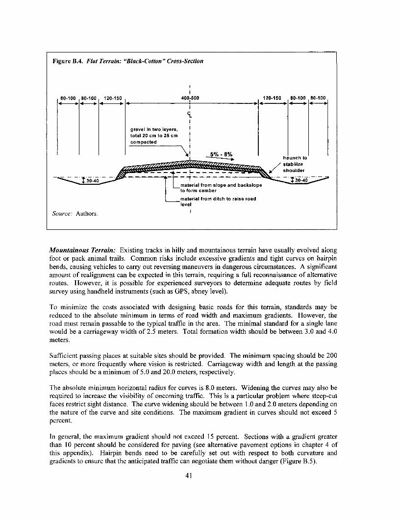
Figure B.4. Flat Terrain: "Black-Cotton" Cross-Section
80-100 80-100 120-150 400-500 120-150 80-100 80-100
gravel in two layers, itotal 20 cm to 25 cmcompacted
i r ~~~~~~haunch to
<g/ ~~~~~~~~~~~~~~shoulder
material from slope and backslopeto form camber
material from ditch to raise roadlevel
Source: Authors.
Mountainous Terrain: Existing tracks in hilly and mountainous terrain have usually evolved alongfoot or pack animal trails. Common risks include excessive gradients and tight curves on hairpinbends, causing vehicles to carry out reversing maneuvers in dangerous circumstances. A significantamount of realignment can be expected in this terrain, requiring a full reconnaissance of alternativeroutes. However, it is possible for experienced surveyors to determine adequate routes by fieldsurvey using handheld instruments (such as GPS, abney level).
To minimize the costs associated with designing basic roads for this terrain, standards may bereduced to the absolute minimum in terms of road width and maximum gradients. However, theroad must remain passable to the typical traffic in the area. The minimal standard for a single lanewould be a carriageway width of 2.5 meters. Total formation width should be between 3.0 and 4.0meters.
Sufficient passing places at suitable sites should be provided. The minimum spacing should be 200meters, or more frequently where vision is restricted. Carriageway width and length at the passingplaces should be a minimum of 5.0 and 20.0 meters, respectively.
The absolute minimum horizontal radius for curves is 8.0 meters. Widening the curves may also berequired to increase the visibility of oncoming traffic. This is a particular problem where steep-cutfaces restrict sight distance. The curve widening should be between 1.0 and 2.0 meters depending onthe nature of the curve and site conditions. The maximum gradient in curves should not exceed 5percent.
In general, the maximum gradient should not exceed 15 percent. Sections with a gradient greaterthan 10 percent should be considered for paving (see alternative pavement options in chapter 4 ofthis appendix). Hairpin bends need to be carefully set out with respect to both curvature andgradients to ensure that the anticipated traffic can negotiate them without danger (Figure B.5).
41
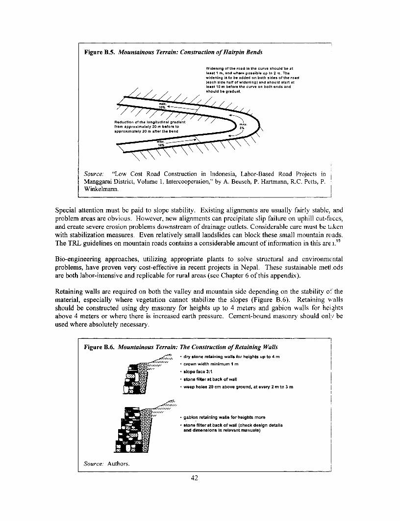
Figure B.5. Mountainous Terrain: Construction of Hairpin Bends
Widening of the road in the curve should be atleast 1 m, and where possible up to 2 m. Thewidening is to be added on both sides of the roadleach side half of widening) and should start atleast 10 m before the curve on both ends and
/ / /
Reduction of the longitudinal gradientfrom approximately 20 m before toapproximately 20 m after the bend
Source: "Low Cost Road Construction in Indonesia, Labor-Based Road Projects inManggarai District, Volume 1, Intercooperation," by A. Beusch, P. Hartmann, R.C. Petts, P.Winkelmann.
Special attention must be paid to slope stability. Existing alignments are usually fairly stable, andproblem areas are obvious. However, new alignments can precipitate slip failure on uphill cut-faces,and create severe erosion problems downstream of drainage outlets. Considerable care must be ta.kenwith stabilization measures. Even relatively small landslides can block these small mountain roads.The TRL guidelines on mountain roads contains a considerable amount of information in this are .9'
Bio-engineering approaches, utilizing appropriate plants to solve structural and environmcntalproblems, have proven very cost-effective in recent projects in Nepal. These sustainable meti odsare both labor-intensive and replicable for rural areas (see Chapter 6 of this appendix).
Retaining walls are required on both the valley and mountain side depending on the stability of thematerial, especially where vegetation cannot stabilize the slopes (Figure B.6). Retaining wallsshould be constructed using dry masonry for heights up to 4 meters and gabion walls for hei ghtsabove 4 meters or where there is increased earth pressure. Cement-bound masonry should onlu beused where absolutely necessary.
Figure B.6. Mountainous Terrain: The Construction of Retaining Walls_,< * dry stone retaining walls for heights up to 4 m
crown width minimum 1 m
*slope face 3:1
* stone filter at back of wall
* weep holes 20 cm above ground, at every 2 m to 3 m
" * gabion retaining walls for heights more
* stone filter at back of wall (check design details
and dimensions in relevant manuals)9-..
Source: Authors.
42

Drainage structures can be similar to those adopted in rolling terrain. Protection of the outfalls iscritical and may need to be taken well beyond the road reserve, possibly for the entire drop to thevalley floor. Gully erosion related to drainage outfalls is causing severe environmental damage inmany rural areas.
Two typical mountain road cross-sections are shown in Figure B.7 below. These use altemativeapproaches to the problem of dealing with drainage and minimizing costs. Advantages anddisadvantages of the two approaches are given.
Figure B.7. Mountainous Terrain: Alternative Cross-Sections
Cross-Section vAth Cross-Fall to Valley Side Cross-SectionwithCooss-Fatilto Mountain Side
sho.i cw2D -? Ie 2006 S rold cn drainsl
note cwt11 ltocha w ,q.Ird,-in to Soil o t V rcnnertdnt ia .. /. flonyliedc nnl 0.0.erIyhdoposti gn.vsi I^ othn ros - nsinrAde aed/oh po,4tne sP. t/.
dltch and cor-a drdln, tosnold vetr Ircrn nh. *inoil or / | bNidrhn
.WiongIntoroe L /nnv
X j~~~~~~~e. not ort illht len....al dh no stos I _ib no wid Inlul d.bt~ cod
bi,"inamirg ~ ~ antatn telao o euAn nishvi~~~~~~~~~~~~~~~~~~~~~~~~~~~~~~~~saaio l.aete h.b.al af b
... " bd- I.b.:-I.~~~ndtno e llop n %m.. I et ',,,,nao lop .d br leota, .-t d
/,. .... ioet ca Ie-on ele gnod 9-W conpvckd CM lan no smi geuolnd
Advantages Disadvantages Advantages Disadvantages
-no side drains required, -potentially dangerous for -safer for vehicles in wet and -more earthworks because ofresulting in substantial vehicles sliding when slippery conditions the increased width toreduction in earthworks surface slippery -wider formation improves accomodate drainage
-less cross-drainage -careful maintenance of site distance -higher back slopes requiringstructures required surface required to ensure -critical outside edge of road protection
-evenly spread surface water water drains evenly over less prone to damage -frequent cross-drainagerunoff along road edge shoulders -controlled surface drainage structures requiredreduces erosion problems -when gradient exceeds 8 outlets -more expensive
percent, cross-fall must bechanged to mountain side
Source: Authors.
Alternative Pavement Options
Alternative pavement types may be required for roads or road sections where the in-situ material orgravel does not provide the required quality surface. This may be the case on steep sectionsexceeding 10 percent, sections passing villages, or simply where the in-situ soils are too weak andgravel is not available or too expensive. Some of the available options for paving are discussed inBox B.2.
43

Box B.2. Paving Options
Stone Paving (see also Fi ure B.8)Description Natural stones measuring no more than 20 to 30 cm are laid on a 5 cm sand/groivel bed
with the top surface set to the final cross-fall. The large stones are set with the widerface to the bottom. Empty spaces are filled with smaller stones and firmly wedgedinto place. Compaction is carried out with a vibrating pedestrian roller. The surfaceis then sealed with a gravel-sand-clay mixture and the finished paving is co:rnpactedagain.
Uses * Surface for low-traffic roads* Base for urban roads* Base for low-traffic roads which would require upgrading to asphalt standa.rd if the
traffic level is likely to increase beyond the economical threshold of gravel andstone-paved roads
Characteristics * Labor-based construction method* Use of locally occurring materials* Ease of maintenance
Trafric * For low-volume roads as surface* All traffic categories as a base
Cost Comparable with gravel surfacing if stones occur in road localityLife Stone paving can have a very long life if maintained properly. Resealing should be
done an average of every three years. Stones broken out of the pavement or camagededges should be replaced immediately in order to avoid costly repairs
Clay or Concrete Brick PavingDescription Burnt clay or concrete brick (200 x 100 x 80 mm approximately) laid on a tlin layer
(about 4 cm) of clean sand, on a conventional road base.Uses * Surface for low-traffic roads, especially short sections
* Surface for urban roads, where speeds are below 50 km/hCharacteristics * Labor-based construction method
* High load-carrying capacity* Reusable surfacing and can have high local resources component* Ease of maintenance
Traffic * For low volume as surface for short sections* From residential streets to heavy industrial application
Cost Competitive with asphalt concrete in Europe where labor costs are high. Potential forsignificant cost savings in developing countries.
Life Initial life 20 years and more, reusable bricks and blocks
Bituminous Surface Dres singDescription A thin film of bitumen applied mechanically or by hand onto the road surface and
covered with a layer of stone chipping, then lightly rolled.Uses * Surface for low-traffic roads and for short sections
* Surface for urban roads(Multiple coats may be applied if circumstances warrant)
Characteristics * Permits labor-based construction method* Provides durable dust-free running surface* Provides waterproof pavement seal and arrests surface deterioration* Allows for ease of maintenance
Traffic * Can be used for all traffic categoriesCost Inexpensive: typically 25% of the cost of an asphalt concrete surfacing. On average
$1 to $2 per square meter and coat.Life Typically five to 15 years in a tropical environment
Source: Authors.
44

Slurry seal, hand-mixed asphalt, and stone sets are additional options that also may be applicable forvery-low-volume situations where gravel is scarce.
Figure B.8. Typical Cross Section for Stone-Paved Road
I shoulder, slope,kerbstone protected by protected byevery 15 m roa way planting grass planting grass
6% ° | 5 side ditch /
dry stone F e/retaining wallI
stone pavementi- 30 cm high,sealed with a mikture of gravel,sand and clay (1r1:1 compacted)
*10 _ 300 cm 6 0 0
Source: Authors.
Water C'rossings
Water crossings are the most essential and potentially the most expensive intervention to securebasic access. The conventional solution is usually a clear-span low-maintenance structure of steel orreinforced concrete on substantial abutments for river crossings, and pre-cast concrete pipes or boxculverts for lower flows, designed to accommodate flood flows under all conditions other thanexceptional events.96 However, this is often not an affordable solution and for basic access, it isnecessary to explore other options.
One option is the use of timber bridges on masonry, gabion, or reinforced earth abutments. Thisprovides considerable savings on initial costs and maximizes the use of local skills and resources.However, it is only viable where suitable timber is readily available and spans are usually limited tosix meters. There is also the likelihood of high maintenance costs and a short life span if the timberis not insect- and rot-resistant (either naturally or through special treatments).
Another option is to build a structure that can easily be overtopped without damage. These optionsinclude drifts and vented drifts. The decision should be based on flow patterns and communityusage. Small rivers and streams in tropical regions are often wet-weather flow only, and high-floodlevels are of short duration. A simple drift is usually adequate to secure vehicle access in thesecircumstances. For continuous flows, vented drifts can be designed to pass normal discharge, onlysubmerging during floods.
It must be remembered that foot and non-motorized traffic constitute a significant portion of thetraffic on basic access roads. Consideration should be given to providing safe passage for pedestrianand bicycle traffic. On long single-lane bridges, railings and a one-side elevated foot and bicyclepath should be considered. Where submersible structures are frequently and deeply submerged, theprovision of a separate low-cost footbridge might be considered.
Thorough site investigations and hydraulic design are necessary not only for large structures but alsofor relatively small structures on low-volume traffic roads. Figure B.9 shows some options fordrainage structures appropriate for labor-intensive implementation by small-scale or community
45
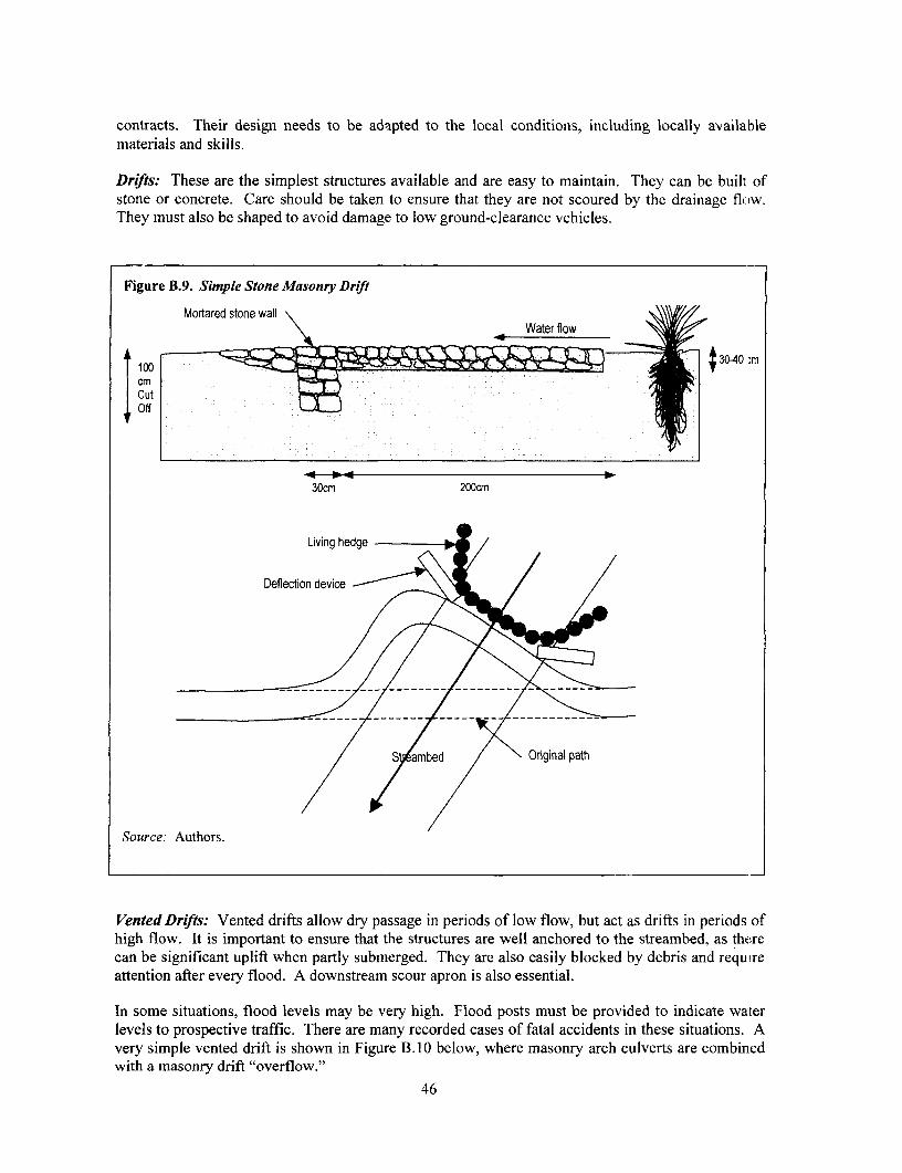
contracts. Their design needs to be adapted to the local conditions, including locally availablematerials and skills.
Drifts: These are the simplest structures available and are easy to maintain. They can be built ofstone or concrete. Care should be taken to ensure that they are not scoured by thc drainage flow.They must also be shaped to avoid damage to low ground-clearance vehicles.
Figure B.9. Simple Stone Masonry Drift
Mortared stone wall
| Cut 0 ~ [ t 3040 :m
Off :000;00
30cm 200cm
Living hedge
Deflection device
S ambed Original path
Source: Authors.
Vented Drifts: Vented drifts allow dry passage in periods of low flow, but act as drifts in periods ofhigh flow. It is important to ensure that the structures are well anchored to the streambed, as therecan be significant uplift when partly submerged. They are also easily blocked by debris and requireattention after every flood. A downstream scour apron is also essential.
In some situations, flood levels may be very high. Flood posts must be provided to indicate waterlevels to prospective traffic. There are many recorded cases of fatal accidents in these situations. Avery simple vented drift is shown in Figure B.1O below, where masonry arch culverts are combinedwith a masonry drift "overflow."
46
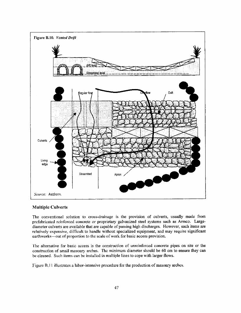
Figure B.10. Vented Drift
t eg~~~ular flo > UV flow Driftt
Culverts or
Livingedge
9 ~~Streambed Apro
Source: Authors.
Multiple Culverts
The conventional solution to cross-drainage is the provision of culverts, usually made fromprefabricated reinforced concrete or proprietary galvanized steel systems such as Armco. Large-diameter culverts are available that are capable of passing high discharges. However, such items arerelatively expensive, difficult to handle without specialized equipment, and may require significantearthworks-out of proportion to the scale of work for basic access provision.
The alternative for basic access is the construction of unreinforced concrete pipes on site or theconstruction of small masonry arches. The minimum diameter should be 60 cm to ensure they canbe cleaned. Such items can be installed in multiple lines to cope with larger flows.
Figure B. 11 illustrates a labor-intensive procedure for the production of masonry arches.
47
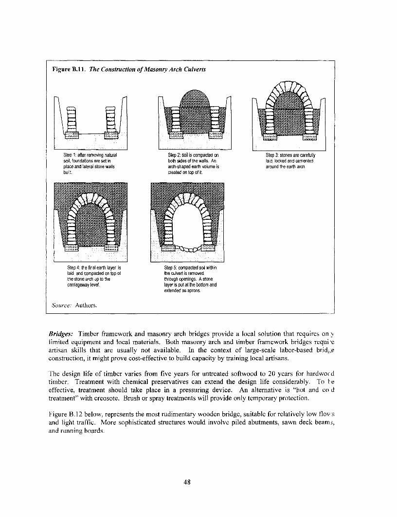
Figure B.1 1. The Construction of Masonry Arch Culverts
Step 1: after removing natural Step 2: soil is compacted on Step 3: stones are carefullysoil, foundations are set in both sides of the walls. An laid, locked and cementedplace and lateral stone walls arch-shaped earth volume is around the earth arch.built. created on top of it.
Step 4: the final earth layer is Step 5: compacted soil withinlaid and compacted on top of the culvert is removedthe stone arch up to the through openings. A stonecarriageway level. layer is put at the bottom and
extended as aprons.
Source: Authors.
Bridges: Timber framework and masonry arch bridges provide a local solution that requires on vlimited equipment and local materials. Both masonry arch and timber framework bridges requi-eartisan skills that are usually not available. In the context of large-scale labor-based brid:;econstruction, it might prove cost-effective to build capacity by training local artisans.
The design life of timber varies from five years for untreated softwood to 20 years for hardwo dtimber. Treatment with chemical preservatives can extend the design life considerably. To l-eeffective, treatment should take place in a pressuring device. An alternative is "hot and co dtreatment" with creosote. Brush or spray treatments will provide only temporary protection.
Figure B.12 below, represents the most rudimentary wooden bridge, suitable for relatively low flowsand light traffic. More sophisticated structures would involve piled abutments, sawn deck beams,and running boards.
48
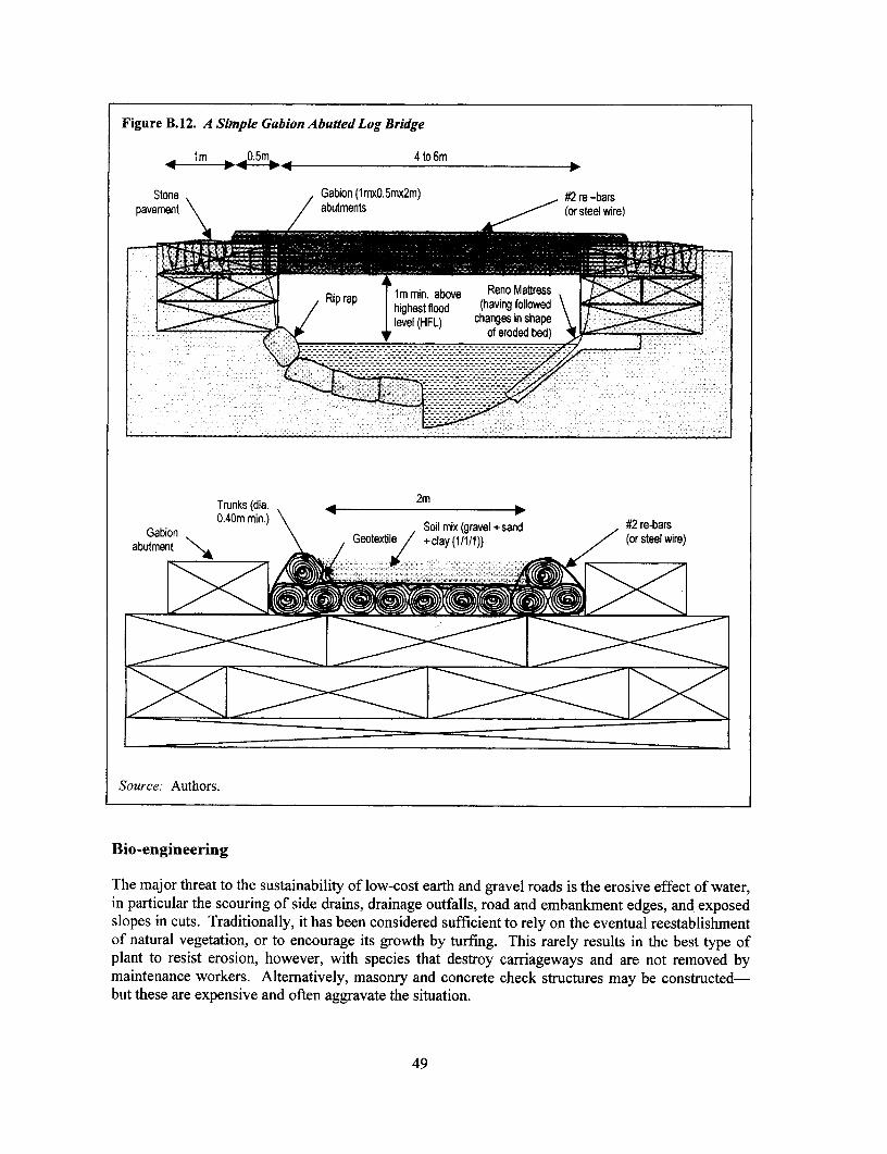
Figure B. 12. A Simple Gabion Abutted Log Bridge
lm 0.5m 4to6m*-**- -* 4-- -
Stone Gabion (1mxO.5mx2m) #2 re -barspavement abutments (or steel wire)
m mmin. above Reno MattressRip rap highest flood (having followedlevel(HFL) changes in shape,</ 1, level (HFL) of eroded bed) i/ ' _
Trunks (dia. < 2m
The~ ~0.0 maomhett h utin abi)t of lo- ost eart andgravel roandsi the eroiebefetafratr
sloesion cus rdiinly it ha beenonsxidere sufc ient(torely)o th eventualwireesalsmn
/\- -- - -- - ---- ---l ~~~~~~~~- ---- - - - -- - - - -
of natural vegetation, or to encourage its growth by turfing. This rarely results in the best type ofplant to resist erosion, however, with species that destroy carriageways and are not removed bymaintenance workers. Alternatively, masonry and concrete check structures may be constructed-but these are expensive and often aggravate the situation.
49

Innovative work in several countries, but particularly Nepal97 and the Caribbean islands, hasdemonstrated that it is possible to select and utilize particular combinations of plant species toprovide sound engineering solutions. A common example is Vetiver grass,98 which is used tostabilize terraces and gullies. Likewise, trees, shrubs, and other grasses may be used to stabi izeslopes, protect embankments, and provide live check structures in drains.99
Suitable plant species can be grown in locally established nurseries. Works are very labor-intensiveand require little capital investment. Skills developed may be useful in the community for olherconservation projects. Some examples of the bio-engineered solutions to slope stability are giveni inFigures B.13 and B.14.
Figure B. 13. Bio-engineering Retaining Walls
Anchoring Living hedge Anchoring Living hedges (grassshrubs (grass plants) shrubs (cuttings) plants)
(cuttings)
Treated wood
poles e [ : Slope max.: 5:1Foundations
(if necessary)
Slope max.: 5:1 Drainage (if
Source: Authors.
Wood "cages" are a temporary solution and their anti-erosion and anchoring functions will beperformed by the plants as they become established. Dense grass hedges put on top of the "wall"anchor the top soil through their roots and reduce speed of run-off. Shrubs planted on the laceprovide deep anchorage.
The two solutions presented in Figure B.14 are aimed at stabilizing less-steep slopes with noimported fill. The solution presented on the left uses wood poles to build a mesh for plant cuttinigs.The wood trellis has only a medium-term operational life that the shrubs will replace. The solutionon the right utilizes plants to complement the effect of the gabions.
50

Figure B. 14. Bio-engineered Slope Protection
Anchoring Living hedge (grassshrubs plants)
(cuttings)AnchoArig shrubs lm
(cuttings)
trellis ~~~~~~~~~~Foundations(slope 10%)
Anchoring shrubs Stone bunts Silting(cuttings placed Grass plantsbetween stones) Anchoring (living hedge)
shrubs (livinghedge) Buried
Gabions cn(1 mx0.5m
Wood Fascine
Source: Authors.
The solutions above are aimed at controlling erosion on a moderate slope. The diagram on the leftdemonstrates the use of gabions that are durable. Cuttings are placed between the stones andcomplement stabilization in the long term. The diagram on the right presents three solutions formoderate slopes. The life of the fascines will be limited and plants are therefore the only long-termsolution. Bushes or grasses can be used interchangeably as long as the density is high enough.
Appropriate Engineering Design of RTI
Often, the terms of reference (TOR) used as the basis for RTI designs are adapted from those usedfor the design of major highways. Such designs require a thorough survey with cross-sections atshort intervals and vertical and horizontal alignments. However, such an approach is not justified forRTI if the costs are to remain within reasonable proportion of the planned investment (about 6percent). The approach for RTI should be simpler and directed towards the production of linediagrams focusing on trouble spots for the solutions of which detailed designs need to be produced.Further details as to the design approach for RTI is discussed in Box B.3.
51

Box B.3. Essential Requirements for RTI Engineering Services
An Initial Road-Condition Survey
This survey should look at the existing level of access and determine the types of interventions necessary tosecure the agreed basic access standard. Surveys should include a simple linear access plan indicating surfaceconditions, gradients, water crossings, and an outline of proposed remedial action. The survey should alsoinclude assessments of existing traffic, population densities, and prevailing economic activities. This strveywill form the basis for initial project screening and prioritization. Depending on the program design, it mrny benecessary to carry out participatory planning exercises at this point to assess community interest andcompetence. This may be beyond the competence of the engineering consultants, but they should be inv Ilvedin the exercise as resource persons.
Cut New Backsopes as 3.0 km Engineering Design of Spot ImprovementsRequiredtoWide Cut Special Ditches in This
-- Use Excess Material to Area as Required to Drain The linear plan should incorporate all proposed interventio'ls,Raise Grade - 29 showing their location and the type of activity required.
Details should be sufficient to allow a contractor to make aK2- 2.8, realistic estimate of costs, but is generally based on typical
Warp Alignment and works rather than measured quantities. Typical work items willRaise Grade 0.5m 2 Ditch to Avoid Tree include:
Clearing roadway of vegetation to stated width
_ f - -2.6 * Reshaping existing roadway to provide camber
2 Raising road grade to the specified level
0 Providing side drains with scour checks as indicated
2.4 Surface Material * Providing stone masonry or concrete drift
Omit Surface Course * Providing turnouts at stated intervals, andFrom km 2.1 to km 2.6
2.3 * Providing gravel surface of 0.1 Scm compactedAdjust to Improve
Alignment km 2.3 to km 2.5 thickness.2.2 Items should be summarized by linear quantity, and detailed
with a simple specification.
Place 9mO -24" RCP 2.1 Raise Grade to Drawings and Bill of Quantities should be provided for mcreCut Outlet to Drain Provide Cover for Pipe complex structures such as bridges, vented fords, and retainling
2.0 km walls.
Preparation of contract documents
The nature of these documents depend on the contract method adopted. For full competitive bidding wherethere is an active contracting sector, following the common procedures in the country or region isrecommended. If these procedures are considered inappropriate for these types of small-scale works, then theFIDIC Short Form of Contract is recommended as a basis for the development of tailor-made documentation.
If non-competitive community contracting is used, the documents should be designed to ensure that the pricesare adequate to cover the labor and material inputs required from the community, and to provide sufficientchecks on progress and output.
Supervision and administration of the contract
For the level of works involved in basic access, a full-time consulting engineer as the employer'srepresentative may not be justified. A trained "clerk of works" or the equivalent should ensure day-to-dayquality with monthly visits by the engineer to monitor progress and certify payment.
However, if the services of the engineer are to include an element of training and development for thecontractors, different arrangements will have to be put in place. This should not be considered as a cost to theroad intervention but rather as an element of the overall program development process.
Source. H. Beenhakker et al, 1987, and authors.
52

Executing the Works
Rural transport infrastructure has traditionally been executed directly by a road agency or localgovernment organization as a force account operation. Evidence in many countries has shown thatthis approach is ineffective and inefficient and one of the root causes for the poor state of many ruralroad networks.
The favored approach is to use existing commercial procedures, contracting out the work on acompetitive basis wherever possible. However, it has to be recognized that commercialization of theroad sector is in its infancy in many developing countries and the private sector is ofteninexperienced and poorly equipped for road work at the central level. The situation at the local levelis generally much worse.
While this makes commercial implementation difficult, basic access interventions have theadvantage that they are relatively simple and straightforward, and training local firms andorganizations is therefore relatively easier. In addition, the use of labor-based methods ensures thatequipment investment costs are low and more within the means of small contractors.
The basic requirements are: to identify potential contractors, including their needs and limitations;introduce appropriate contract procedures; develop training and support packages; and thenimplement the work in parallel with a capacity-building exercise for the client (in this case theidentified owner of the infrastructure), and the local construction industry.
There is now considerable experience in this process and a number of alternative routes that can befollowed. The recent ILO publication Capacity Building for Contracting in the ConstructionSector100 is primarily aimed at rural roads using labor-based methods and draws on worldwideexamples over the past decade.
Contracts are not limited to commercial competitive bidding, but include the use of governmentcontracting agencies, appointed agents that use a development team approach, large-scale contractorsthat manage small emerging firms as subcontractors, and community contracts with the benefitingcommunities.
An overview of alternative arrangements is shown in the Table B.2 below.1Oi The choice is totallydependent on local experience and resources, but the long-term aim must be to develop proceduresand practices that will be sustainable in the local economic and political framework once donorfunding ceases. Future maintenance will be largely dependent on the success of this phase.
53
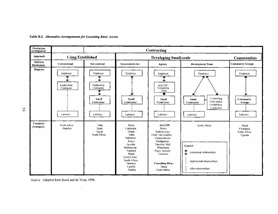
Table B.2. Alternative Arrangementsfor EJxecuting Basic Access
ProductionArrangement l Contracting
Approach Using Established Developing Small-scale CommunitiesDelivery
Mechanism Conventional Sub-contract Government-run Agency Development Team Community Groups
DiagramDiagram | Employer l | Employe r l | Employer lEployer Employer Employer
|Ekstablished F tablshed AGETIP /Contractor Contracto r Consulting
Small SmallSmall Small Consulting CommunityConContractnractor l Contractor Contractor Firm and/or Groups
EstablishedU) Co| | | [ga | | S ' (ontractor
Laoers Laoers Laoers I brers Labrers F abrers
Countries South Africa India Benin AGETIP: South Africa Nepal(examples) Namibia Nepal Cambodia Benin, Nicaragua
Egypt Ghana Burkina Faso, South AfricaSouth Africa Iidia Chad, I'he Gambia, Uganda
Indonesia Guinea-BissauiKenya Madagascar,
Lesotho Nanmibia, Mali, Legend:Madagascar Mauritania,
Namibia Niger, Senegal contractial relationshipsNepal Tanzania,
Sierra LeoneSouth Africa employment relationships
Tanzania Consuilting Firm:Uganda South Africa other relationships
Source: Adapted from Stock and de Veen, 1996.
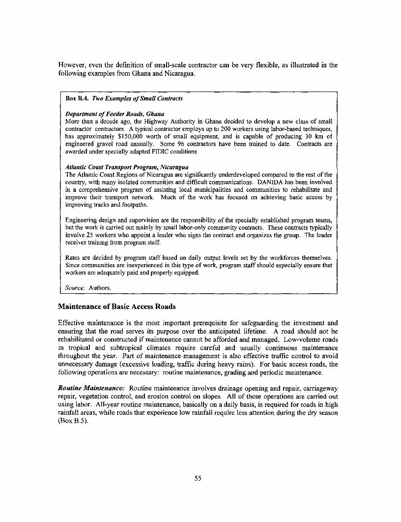
However, even the definition of small-scale contractor can be very flexible, as illustrated in thefollowing examples from Ghana and Nicaragua.
Box B.4. Two Examples of Small Contracts
Department of Feeder Roads, GhanaMore than a decade ago, the Highway Authority in Ghana decided to develop a new class of smallcontractor contractors. A typical contractor employs up to 200 workers using labor-based techniques,has approximately $150,000 worth of small equipment, and is' capable of producing 30 krn ofengineered gravel road annually. Some 96 contractors have been trained to date. Contracts areawarded under specially adapted FIDIC conditions
Atlantic Coast Transport Program, NicaraguaThe Atlantic Coast Regions of Nicaragua are significantly underdeveloped compared to the rest of thecountry, with many isolated communities and difficult communications. DANIDA has been involvedin a comprehensive program of assisting local municipalities and communities to rehabilitate andimprove their transport network. Much of the work has focused on achieving basic access byimproving tracks and footpaths.
Engineering design and supervision are the responsibility of the specially established program teams,but the work is carried out mainly by small labor-only community contracts. These contracts typicallyinvolve 25 workers who appoint a leader who signs the contract and organizes the group. The leaderreceives training from program staff.
Rates are decided by program staff based on daily output levels set by the workforces themselves.Since communities are inexperienced in this type of work, program staff should especially ensure thatworkers are adequately paid and properly equipped.
Source. Authors.
Maintenance of Basic Access Roads
Effective maintenance is the most important prerequisite for safeguarding the investment andensuring that the road serves its purpose over the anticipated lifetime. A road should not berehabilitated or constructed if maintenance cannot be afforded and managed. Low-volume roadsin tropical and subtropical climates require careful and usually continuous maintenancethroughout the year. Part of maintenance management is also effective traffic control to avoidunnecessary damage (excessive loading, traffic during heavy rains). For basic access roads, thefollowing operations are necessary: routine maintenance, grading and periodic maintenance.
Routine Maintenance: Routine maintenance involves drainage opening and repair, carriagewayrepair, vegetation control, and erosion control on slopes. All of these operations are carried outusing labor. All-year routine maintenance, basically on a daily basis, is required for roads in highrainfall areas, while roads that experience low rainfall require less attention during the dry season(Box B.5).
55

Box B.5. Labor-Based Routine Maintenance
Labor-based methods are particularly suitable for routine maintenance of basic access roads. Allactivities can be carried out using labor only with the exception of grading and compaction, which ireonly necessary on higher traffic roads. There are basically four different labor-based contract types forroutine maintenance:
. Single-length person contract: a contract for a defined section of a road (I to 2 km) is given to anindividual
. Petty contract (or labor group): a contract is given to a very small contractor who in turn employsa small team (5 to 10 laborers) to maintain a defined section of a road (5 to 20 kam)
* Small-scale contract for a particular road: a contract is given to a small-scale contractor whoemploys laborers to maintain a particular road or a longer road section (20 to 100 km), and
* Small-scale contract for a specified road network: a contract is given to a small-scale contractorto maintain a specified road network, such as a full maintenance area covering all earth and gravelroads (100 to 300 km of roads).
The length-person system, whereby small and manageable tasks are allocated to individual workers(according to priorities throughout the seasons), is the cornerstone of all the approaches, and is thereforeexplained in more detail below.
System:A laborer is appointed for each section of road, typically I to 2 km in length. A supervisor provi lestools and monitors the condition of the road, directs operations, makes reports, and authorizes paymentsfor satisfactory work. This person may be able to supervise up to 10 laborers or 20 km of roads. "'helaborer lives adjacent to the location of the maintenance activities and therefore does not require anytransport. The task rate system is ideal for this sort of work.
The advantage of the length-person system is that a continuous maintenance of the entire road can beguaranteed at all times and that one person is responsible for a specific road section. This systenm isparticularly useful in high rainfall areas where, for example, the opening of culverts and mitre dra.insneeds to be carried out on the entire stretch of road almost on a daily basis.
The disadvantage is that supervision has to take place on each and every section of the road, whichmeans that each laborer has to be individually instructed. The supervisor therefore must be very mobileand the laborers must be well-trained so that they can work independently. A large part of the time thesupervisor is busy traveling from length-person to length-person. The length-person system can easilybe transformed into a group system by pulling a number of laborers together and giving them a grouptask. This is of particular interest to contractors who would like to rationalize their supervision input
Transport and Tools:Transport is required for the supervisor (bicycle) and for the contractor (pick-up) to oversee allmaintenance work and to transport tools and materials.
Each length-person requires a standard set of hand tools: hoe, shovel, grass-cutter, bush knife, and arake or spreader.
Two or three length-persons may share: a wheelbarrow (to haul gravel from stockpiles or remove siltand organic material) and an earth rammer (for pothole filling). The gang leader requires a basic se,: ofmeasuring aids: tape measure, ditch template, spirit level, strings, and pegs. In some projects it mayalso be necessary to provide the leader with a long-handled shovel and trowel to clean out culverts.
Source: Authors.
Grading: Grading is part of the routine maintenance procedure for unpaved roads. It is requiredto remove ruts and corrugations and generally reestablish the water-shedding qualities of thesurface. The operation can require heavy machinery but, fortunately, this is not typically requiredfor the lowest-volume roads. Labor equipped with handtools can achieve adequate results forlow-speed basic access. However, where grading is unavoidable due to higher traffic volumes,one to two cycles may be required annually for low-volume roads. This operation can be carried
56
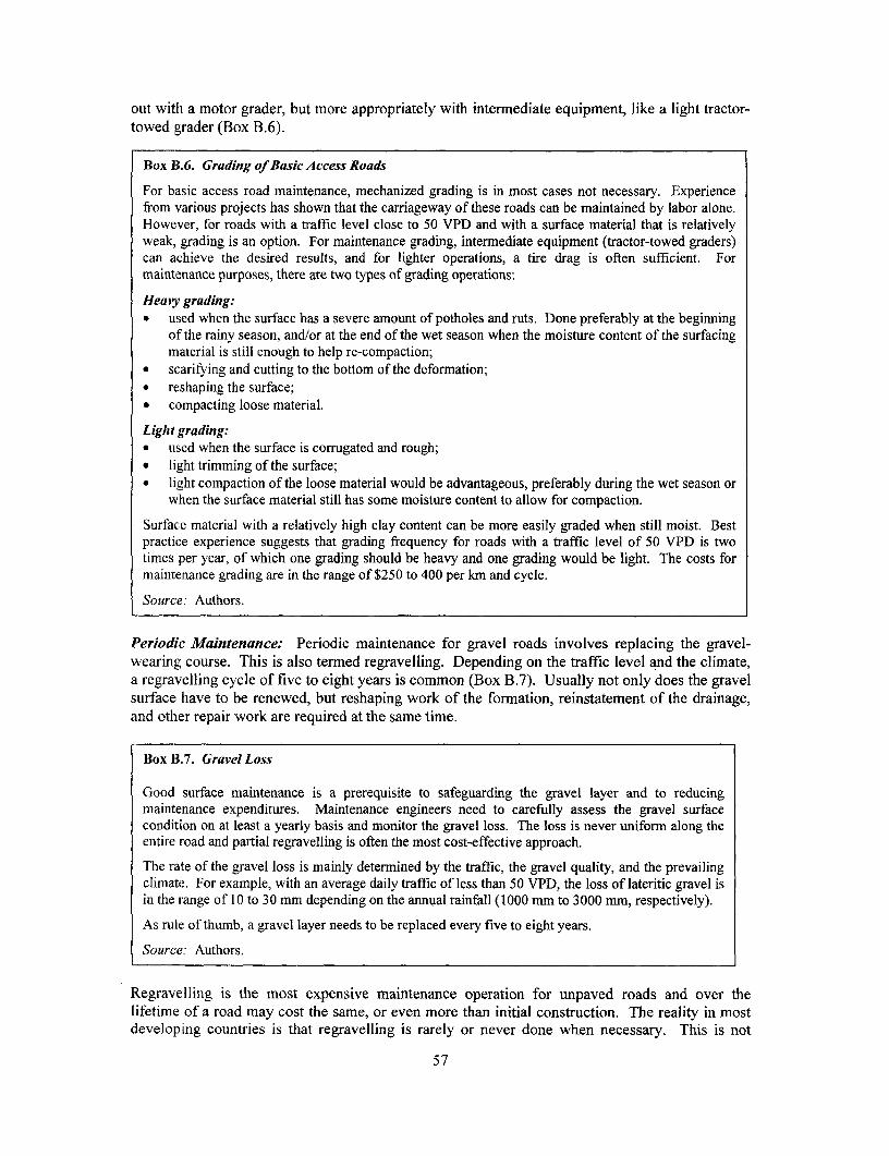
out with a motor grader, but more appropriately with intermediate equipment, like a light tractor-towed grader (Box B.6).
Box 1B.6. Grading of Basic Access Roads
For basic access road maintenance, mechanized grading is in most cases not necessary. Experiencefrom various projects has shown that the carriageway of these roads can be maintained by labor alone.However, for roads with a traffic level close to 50 VPD and with a surface material that is relativelyweak, grading is an option. For maintenance grading, intermediate equipment (tractor-towed graders)can achieve the desired results, and for lighter operations, a tire drag is often sufficient. Formaintenance purposes, there are two types of grading operations:
Heavy grading:. used when the surface has a severe amount of potholes and ruts. Done preferably at the beginning
of the rainy season, and/or at the end of the wet season when the moisture content of the surfacingmaterial is still enough to help re-compaction;
* scarifying and cutting to the bottom of the deformation;. reshaping the surface;* compacting loose material.
Light grading:. used when the surface is corrugated and rough;* light trimming of the surface;* light compaction of the loose material would be advantageous, preferably during the wet season or
when the surface material still has some moisture content to allow for compaction.
Surface material with a relatively high clay content can be more easily graded when still moist. Bestpractice experience suggests that grading frequency for roads with a traffic level of 50 VPD is twotimes per year, of which one grading should be heavy and one grading would be light. The costs formaintenance grading are in the range of $250 to 400 per km and cycle.
Source: Authors.
Periodic Maintenance: Periodic maintenance for gravel roads involves replacing the gravel-wearing course. This is also termed regravelling. Depending on the traffic level and the climate,a regravelling cycle of five to eight years is common (Box B.7). Usually not only does the gravelsurface have to be renewed, but reshaping work of the formation, reinstatement of the drainage,and other repair work are required at the same time.
Box B.7. Gravel Loss
Good surface maintenance is a prerequisite to safeguarding the gravel layer and to reducingmaintenance expenditures. Maintenance engineers need to carefully assess the gravel surfacecondition on at least a yearly basis and monitor the gravel loss. The loss is never uniform along theentire road and partial regravelling is often the most cost-effective approach.
The rate of the gravel loss is mainly determined by the traffic, the gravel quality, and the prevailingclimate. For example, with an average daily traffic of less than 50 VPD, the loss of lateritic gravel isin the range of 10 to 30 mm depending on the annual rainfall (1000 mm to 3000 mm, respectively).
As rule of thumb, a gravel layer needs to be replaced every five to eight years.
Source: Authors.
Regravelling is the most expensive maintenance operation for unpaved roads and over thelifetime of a road may cost the same, or even more than initial construction. The reality in mostdeveloping countries is that regravelling is rarely or never done when necessary. This is not
57

entirely due to bad management and lack of funds. In some countries, suitable gravel is repoTtedto be a rapidly diminishing resource. The result is that roads deteriorate until they are no longermaintainable and have to be reconstructed long before their planned design life expires.
Most basic access roads will not be fully gravelled. However, all those sections that are grave ledwill still be subject to a wearing process and will need renewal at some stage. Rather than settingup a periodic program that may not be affordable by local government or the communities. analternative is to integrate regravelling operations into routine maintenance. Spot regravelling santhen be carried out annually as required. Gravel is stockpiled at key points and the entireoperation can then be carried out labor-intensively by the routine maintenance contractors.
The Costs of Alternative RTI Road Improvements
Exact figures for the construction and maintenance costs of basic access roads cannot be provi ded(as prevailing conditions and input costs differ from country to country, and project to project).There can also be significant differences in the logistics of a project, especially the costs forhauling material, the availability of suitable tools and equipment, and the skills and experience ofsupervisors and workers. However, some guidance from best practice projects is useful forproviding likely ranges. Box B.8 gives a general indication of the likely range of costs for 'potimprovement, construction, and maintenance of basic access roads in different circumstanzes.Before any conclusions can be drawn in a particular circumstance, detailed cost analysis of thepossible alternatives should be carried out. Such analysis should always investigate total life-cycle-cost (construction and maintenance).
Box B.8. Estimated Costs for Spot Improvement, New Construction, and Maintenance of Basic 4ccessRoads (all single-lane roads)
Spot improvement to existing motorable trackIn rolling and flat terrain and low rainfall $1,500 to 2,500/kmIn mountainous and high-rainfall area $5,000 to 20,000/km
ConstructionEarth-road construction in mountainous areas $ 10,000 to 50,000/kmEarth-road construction in hilly and flat areas, no embankmentrequired $6,000 to 15,000/kmEarth-road construction in flat areas, embankment required $8,000 to 30,000/kmGravel surface, 12 to 15 cm compacted, 3.5 to 4.5 m wide,hauling distance between 2 and 8 km $5,000 to 8,000/kmStone pavement, 20 to 30 cm strong, sealed, three to four m wide $10,000 to 15,000/kmSurface dressing, (single seal, double seal) $2 to 3 per square meterClay or concrete brick paving (or 5cm asphalt concrete layer) $8 to 10 per square meter
MaintenanceRoutine maintenance of gravel road (by labor) $200 to 600 km/yearGrading of gravel road (by equipment: average of light and heavy) $250 to 400 km/cyclePeriodic maintenance (regravelling every five to eight years) $5,000 to 8,000/km
Note: Construction costs include all construction work (contracted out) plus design and contract supervision, but do notinclude agency costs. The costs include an average number of small structures (for example, drifts, multiple cul% erts)and water crossings (splashes, small drifts, or culverts), but not bridges.
Source: Authors.
58
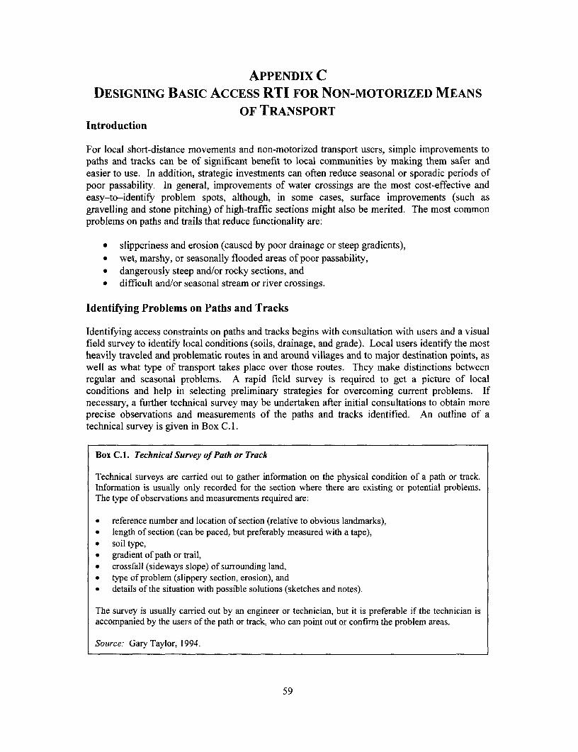
APPENDIX CDESIGNING BASIC ACCESS RTI FOR NON-MOTORIZED MEANS
OF TRANSPORTIntroduction
For local short-distance movements and non-motorized transport users, simple improvements topaths and tracks can be of significant benefit to local communities by making them safer andeasier to use. In addition, strategic investments can often reduce seasonal or sporadic periods ofpoor passability. In general, improvements of water crossings are the most cost-effective andeasy-to-identify problem spots, although, in some cases, surface improvements (such asgravelling and stone pitching) of high-traffic sections might also be merited. The most commonproblems on paths and trails that reduce functionality are:
* slipperiness and erosion (caused by poor drainage or steep gradients),* wet, marshy, or seasonally flooded areas of poor passability,* dangerously steep and/or rocky sections, and* difficult and/or seasonal stream or river crossings.
Identifying Problems on Paths and Tracks
Identifying access constraints on paths and tracks begins with consultation with users and a visualfield survey to identify local conditions (soils, drainage, and grade). Local users identify the mostheavily traveled and problematic routes in and around villages and to major destination points, aswell as what type of transport takes place over those routes. They make distinctions betweenregular and seasonal problems. A rapid field survey is required to get a picture of localconditions and help in selecting preliminary strategies for overcoming current problems. Ifnecessary, a further technical survey may be undertaken after initial consultations to obtain moreprecise observations and measurements of the paths and tracks identified. An outline of atechnical survey is given in Box C. 1.
Box C.1. Technical Survey of Path or Track
Technical surveys are carried out to gather information on the physical condition of a path or track.Information is usually only recorded for the section where there are existing or potential problems.The type of observations and measurements required are:
. reference number and location of section (relative to obvious landmarks),• length of section (can be paced, but preferably measured with a tape),* soil type,* gradient of path or trail,. crossfall (sideways slope) of surrounding land,. type of problem (slippery section, erosion), and. details of the situation with possible solutions (sketches and notes).
The survey is usually carried out by an engineer or technician, but it is preferable if the technician isaccompanied by the users of the path or track, who can point out or confirrn the problem areas.
Source: Gary Taylor, 1994.
59

Design of Improvements
As is the case with motorized access, the design of path and track improvements requiresknowledge concerning local conditions (terrain, soils, and environment), local institutionalcapacity and arrangements, transport patterns and other problems. After initial technicalinformation concerning problems (and possible solutions) has been collected, the next step is toobtain information concerning the level and types of traffic. For high-volume paths and tracks,this may require traffic counts, while for very low-volume situations, estimates based onpopulation served may yield sufficient accuracy. For engineering requirements, the primaryconcern of the transport survey is to assess design options based on users (types and sizes of loadsand vehicles) and the level of daily traffic along the path or tracks. The information that shouldbe collected includes daily and hourly counts of the numbers and types of means of transport andporters and their loading characteristics. If there is a need to prioritize among alternaliveinvestments, these counts can be supplemented with on-site user surveys to collect theinformation for priority evaluation. The survey process described in Appendix D can be adaptedto paths and tracks.
Typical Improvements
Once traffic and loading characteristics have been determined, standard design parameters areused to determine the appropriate level of investment. Most often, the least-cost method forimproving paths and trails to all-weather passability is community-driven spot improvements. Insome cases, where transport demand is high and benefits adequate, full upgrading of the path ortrack along its entire length may be justified. Technical assistance is needed for designing thespot improvements and managing the works.
Essential first-stage design parameters for basic access paths or trails are camber and crossf'all,width, and gradient:
* Camber and Crossfall-Camber and crossfall are essential for proper surface drainageand should be a minimum of 5 percent in rainy areas, and higher in areas of heavyseasonal rain. A camber as low as 3 percent is possible in arid areas, but flat paths andtracks are not recommended.
* Width-Width is determined by the requirements for passing and the loadingcharacteristics (dimensions) of the NMT using the path. For basic access footpaths, one-way pedestrian traffic requires a width of approximately one meter. For tracks, animal orcart-loading characteristics will determine the required width and should be considered.A typical single-lane track will have a width of 1.4 meters.
* Maximum Gradient-Paths are common in hilly or mountainous areas where ioadconstruction is difficult or too costly. The maximum gradient depends on thecomposition of the traffic. Pedestrians can ascend very steep slopes, although steps arenecessary above 26 percent. However, wheeled vehicles and heavily loaded portersrequire much shallower gradients. The desirable maximum longitudinal gradientstogether with a summary of basic access standards for non-motorized access aresummarized in Table C. 1.
60

Table C.1. Basic Standards for Non-MotorizedAccess
Feature Terrain
Flat Rolling SteepPath width I to 2 m, depending on I to 2 m, depending on I m
traffic density and type traffic density and typePath surface In-situ soils except on sard or steep erodible slopesCamber 5% 5% 5%
Maximum gradient N/A 7% for bicycles8% for animal drawn carts12% for pedestrians and pack animals26 to 70% for pedestrians when steps provided
Drainage structures Stepping stones, timber footbridges, suspension bridgesand water crossingsSpecial features Earth or brushwood Timber water bars Hairpin bends, steps,
causeways in marshy handrails, timber waterareas bars
Source: Authors.
Surfacing
Most paths and tracks have developed naturally from the passage of traffic. The compaction ofthe soil by pedestrians, animals, and light vehicles is usually sufficient to give a satisfactorysurface. The addition or replacement of surfacing material is relatively expensive and can only bejustified in special circumstances such as the occurrence of marshy areas, very rough terrain, verysandy soils, or easily erodible soils on steep slopes.
Where the major problem is an erodible surface, a single layer of well compacted gravelly soilmay be adequate. A certain amount of clay mixed in with the gravel helps bind the material toproduce a dense impermeable surface layer. Stone pitching or "Telford" construction may benecessary for heavy traffic or on steep gradients. Figure C. 1 illustrates some of these methods.
In wet or marshy areas, it is necessary to use different techniques to minimize the costs. Thereare three main approaches:102
* Stepping stones or stone causeways, in which large stones are firmly set in the ground toprovide a stable walkway. This is only suitable for pedestrian traffic.
* Rafts or boardwalks, in which a timber walkway is built to sit on top of the wet soil.These are usually of light construction, for pedestrian or cycle traffic only.
* Turnpike sections, where the path or track is raised as a small embankment, with the edgeconstrained by logs or rocks. Brushwood or geo-textile membranes may be used toprevent the embankment from sinking. This is a relatively expensive solution suitable forshort stretches of 50 meters or less. This approach is also useful for areas of loose sand.
61

Figure C.I. Surfacing Methods
Smaller stones packed
Thin binding layer of fine and hammered inmaterial with some clayfor binding One or two layers of coarse Fine surfacing material Large stones laid on sdge
gravelly material to provide (approx. half depth)strength F
100-200mmi
Well used paths * Strong construction * Good for heavy traffic and wei3k soils
(a) Typical construction (b) 'Telford' construction
Large boulders Small bouldersStones (approx. 100mm x 150mm) on the inside o the inside
Larger edging stone ong axis
; Ru b b ~~~~~~~~~~~~~~~~~~~~~~~~~ubei75mm sand
* Strong construction Steep gradients * Rough terrain - Rocky or bouldery areas* Rough terrain Can be rough to walk on
(c) Stone pitching (d) Boulder pavement
Source: Gary Taylor.
Erosion Control
Surface water running down paths and tracks must be diverted before it erodes or saturates thesurface. Similarly, surface water in ditches must also be diverted from those ditches before thebottoms begin to erode. Areas of natural water cross-flow must be managed in order to properlymaintain surface and formation integrity. The primary low-cost methods of diverting water fromnon-motorized road surfaces are water-bars and drifts.
Design guidelines for the use of water-bars are given in Figure C.2.
For very steep gradients where only foot traffic is anticipated, it may be appropriate to buildsteps. However, these must be properly dimensioned to allow people carrying heavy loads tokeep up a constant rhythm when ascending or descending. Tread lengths should be between one-half and one meter (equivalent to one or two paces) and the rise should be in the order of 160 to250 mm. In any flight of steps, the rise should be consistent throughout.
62

Figure C.2. Water-Bar Guidelines
Grcadient Angle of Back fillingofpath water-bar
5%/o 250Upstream
10% 350
12%/o 450
Recommended spacing of water-bars (meters)
Longitudinal Gradient in %
Type of soil 2 4 6 8 10 12
Loam 100 50 30 20 15 *Downstream
Clay-sand 150 100 60 50 30 15
Clay or clay-gravel - 150 90 60 50 30
Gravel/rocky - - 230 150 100 80
* Gradient not recommended in this type of soil- Water-bar not usually required
Source: Authors.
Timber, Culverts, and Footbridges
It is not usually necessary or cost-effective to use concrete culverts or other substantial structuresfor non-motorized access. However, timber culverts and footbridges can be used for continuousor deep stream and river crossings.
These structures do not have the strength of normal highway structures, and it is important thataccess is restricted to avoid overloading. Ensuring that the structures are less than two-meterswide is the most reliable approach.
Examples of a timber culvert, and design parameters for a timber footbridge are given in TableC.2 and Figure C.3 below. For long spans over deep water or gorges, the best approach is theconstruction of a suspension bridge. This is a specialized structure that should be designed by anexperienced engineer. A number of publications are available covering this area.'03
63

T he following table relates the maximum clear span to the diameter of the logs required.
Table C.2. Timber Footbridge
Maximum clear span (meters) 3 6 9 12 1
Log diameter (centimeters) 20 25 30 40 51-
Source: Authors.
Figure C.3. Timber Culvert
Clear span: 3 to 15 m
I - l | r 1ll F ~~~#2 Re-barsSill log ,5cm1120 cm /(or steel\ =~~~L G- M, I wire)
Railing
s l \ ~~lm minimum above /3p\ highest flood level / Cross planks
\ (HFL) y / (5cm > 15 cm)
Trunk:s(dia. 2 cm min.)
Sill hc(dia. :0 cm)
* ~~ ~~9m */Geo-textle
Timber _ = ==logs_
1lm 1 .50m
Source: Authors.
64

APPENDIX DLow-COST TRAFFIC SURVEY METHODS FOR RTI
Rural transport planners often face a lack of traffic data concerning RTI, and scarce resources forcollecting new data. In addition, there may be weak institutional capacity for data collection andmanagement at the local government or community level, which can be further compounded bypoorly defined networks, ownership, and responsibilities.
Information on traffic, however, is essential for effective design and appraisal of RTI, particularlywhen upgrading to a higher than least-cost basic access standard or for investments motivated byeconomic objectives. If proposed improvements are to be appraised on a cost-effectiveness basis,traffic data samples should be collected and correlated with other indicators, such as populationsserved by the particular RTI. For socioeconomic impact studies, household-level mobility studiesare required, including data on means of transport, trip purpose, origin and destination of trip andduration, in addition to other socioeconomic data.
The following two types of low-cost traffic surveys are described here:
* Moving Observer Count (MOC)Manual Traffic Survey (MTS)
The MOC is a rapid method of assessment suitable for categorizing roads into broad flow bands.The MTS is a more discerning and complete survey method, but requires considerable capacityand resources for appropriate execution.
Traffic Survey Form and Calculation of Average Daily Traffic (ADT)
A sample of a typical survey form is attached to this appendix. It can be used for both MOC andMTS surveys. Different categories of motorized and non-motorized vehicles are listed. Thesecan be adjusted to reflect the actual existing types of vehicles in use in a particular area."Weights" for the different means of transport are sometimes used for converting differentvehicle types to Passenger Car Units (PCU).,04 Manual traffic counts normally should last 12daylight hours. To get daily (24 hours) traffic, the 12-hours traffic would then normally have tobe multiplied by a factor of 1.33. The Average Daily Traffic (ADT) would be calculated as theaverage of the seven days' count of the total daily "weighted" traffic.
Moving Observer Count (MOC)
MOC can be carried out by the evaluation team or by an inspector from the local governmentrural roads agency. The survey can be executed at any location of a particular road section butshould last at least one hour. Utilizing the form proposed in this appendix, the different types ofvehicles need to be put into three different categories: (a) vehicles traveling in the oppositedirection (x); (b) vehicles overtaking observer (y); and (c) vehicles overtaken by the observer (z).Following will then be the hourly traffic in both directions (HT):
65
HT = (x+ y- z) /t
(t = period of survey measured in hours). To convert the hourly flow into daily flows thefollowing formula normally applies:
DT= 16xHT
Manual Traffic Survey (MTS)
Manual traffic counts, using an adaptation of the form introduced in (1) above, should be used onall RTI network sections which are earmarked for upgrading to higher than basic access standard(including the upgrading from non-motorized basic access to motorized basic access). Asmentioned in (2) above, a seven-day, 12-hour count is recommended. In particularcircumstances, for example, in hotter climates where night travel is common, 24-hour countsmight be warranted. It is important that both motorized and non-motorized traffic is counted and,in the case of non-motorized access only, obviously, human porterage must be counted as F&ell.Seasonal variations might be important, and, if possible, counts should be conducted duringvarious seasons of high- and low-traffic flows. Counts should be done far enough away fiomurban or village areas, so results are not distorted by local traffic activities.
Origin-destination (OD)-surveys, including trip purpose and duration of trips might be warrartedin certain circumstances, especially if new RTI and major new alignments are planned. Ifoverloaded trucks are prevalent, an axle-load survey might be required.
Rural roads agencies should carry out traffic surveys on all major sections of their network cn aregular basis (at least annually). With experience, certain patterns will be established and timeand efforts for individual surveys will be reduced. Such patterns include: typical seasonalvariations, traffic composition, the share of night-time to day-time traffic, growth factors, and thecorrelation between traffic and villages size.
66
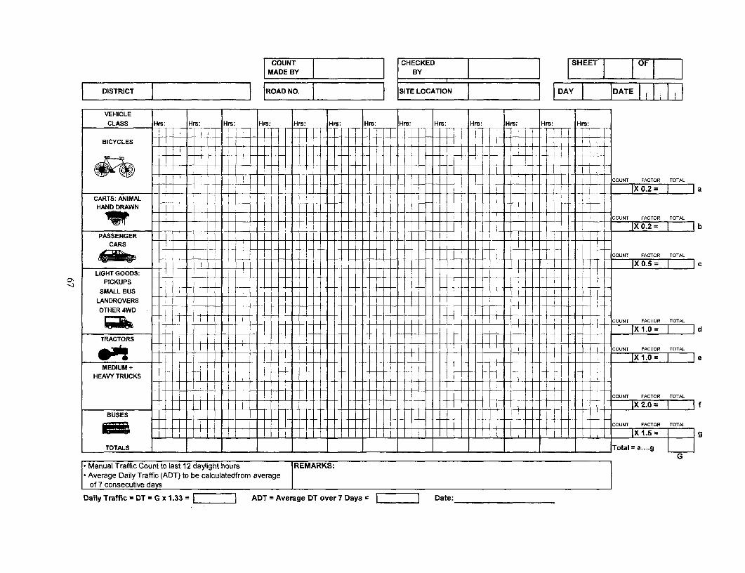
COUNT [CHECKED SHEET OFMADE BY BY I
DISTRICT ROAD NO. SITE LOCATION DAY DATE
VEHICLE I .CLASS His: Hrs: Hrs: His: Hrs: Hrs: Hrs: Hrs: Hrs: Hrs: Hrs: His: His:
BICYCLES
4 <X 0lCOUNT FACTOR TOTAL
PASSENGER ---------- X-T4 X X 4 < +X =IXO.2= aCARTS: ANIMAL
COUNT FACTOR TOTAL
X 0.2 ~ bPASSENGER
CARS
COUNT FACTOR TOTAL
LIGHT GOODS:ON PICKUPS
SMALL BUS
LANDROVERSOTHER 4WD
COUNT FACTOR TOTAL
IX1.0 IdTRACTORS
COUNT FACTOR TOTAL
XI T.af= e I eMEDIUM +
HEAVY TRUCKS
- - - - - - -- - -]~~~~~~COUINT FACTOR TOTAL
BUSES ---- ---- - - -X20=I If
I _COUINT FACTOR TOTAL
TOTALS _ _ ___ _ _ _ _ _ __ _ _ _ _ _ __ _ __ _ _ __ _ _ _ _ _ _ _ __ Total a.... g
G
[Average Daily Traffic (ADT) to be calculatedfrom average
Daily Traffic = DT = G x 1.33 ADT = Average DT over 7 Days Date:___________

APPENDIX ESAMPLES OF INNOVATIVE ECONOMIC APPRAISALS OF RTI
INVESTMENTS
Appendix E.1India - Andhra Pradesh
Rural Roads Component of Economic Restructuring Project(Based on World Bank Infrastructure Note RT-5, January 2000, prepared by Liu Zhi)
Introduction
Rural road projects that aim to improve basic road accessibility from villages to markets andsocial services are expected to yield not only savings in vehicle operating cost (VOC) and road-user travel time cost (TTC), but also substantial social values in the form of broadenedsocioeconomic opportunities for the rural population. As most rural access roads have very low-traffic volumes, the social values generated from the improvement of basic access are often amore important item of project benefits than the direct road-user cost savings. Due to thedifficulties in quantifying the social values in monetary terms, the road cost-benefit analysismethodology that quantifies road-user benefits mainly as VOC and TTC savings is unsuitable forevaluating rural basic access road projects. Alternative methodologies should be adopted. Thisappendix describes an application of cost-effectiveness analysis (CEA) to supplement cost-benefitanalysis (CBA) in the evaluation and selection of road works for financing under a Bank ruralroad project in the state of Andhra Pradesh, India. An overview of the project is provided in aseparate World Bank Infrastructure Note (Transport No. RT-4, January 2000).
An Overview of the Economic Analysis
The project area includes three selected poor rural districts, Adilabad, Karimnagar, and Warangal,with a total population of 6.8 million. The project is proposed to improve the rural road networkto at least basic, all-weather passable standard. The rural road network totals 15,000 krm, mcst ofwhich is in poor condition. Almost 60 percent of the network are tracks and earth roads, 10percent gravel, and 30 percent water-bound macadam (WBM) roads. Neither tracks nor ;^arthroads are all-weather passable. Both gravel and WBM roads can be all-weather passable, butmany of them do not meet the all-weather standard due to broken or missing cross-drainagefacilities. The role of economic analysis is to assist the design, prioritization, and selection ofroad works for financing under the project.
The demand for network investment greatly exceeds the project budget. The key to maximizinginvestment is focusing on the improvement of a core network that would ensure minimumconnectivity for each village to a nearby main road or market center. The core network isidentified through a rural road master planning process.105 Its links that do not meet the basic all-weather standard are identified as candidate roads for improvement, and economic analysis isonly applied to these roads.
Road works for candidate roads fall into two major categories: (a) basic accessibility uorks,including upgrading tracks and earth roads to gravel or WBM roads, and all minor and majorcross drainage works on existing gravel and WBM roads; and (b) black-topping works on ex lstingearth, gravel, and WBM roads. Since basic accessibility works are considered as a valuableinstrument for poverty reduction, they are given first priority. Black-topping, on the other hand,is carried out primarily for economic reasons. When traffic volume (especially motor vehicle
68
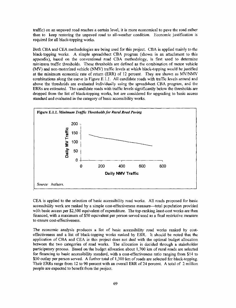
traffic) on an unpaved road reaches a certain level, it is more economical to pave the road ratherthan to keep restoring the unpaved road to all-weather condition. Economic justification isrequired for all black-topping works.
Both CBA and CEA methodologies are being used for this project. CBA is applied mainly to theblack-topping works. A simple spreadsheet CBA program (shown in an attachment to thisappendix), based on the conventional road CBA methodology, is first used to determineminimum traffic thresholds. These thresholds are defined as the combination of motor vehicle(MV) and non-motorized vehicle (NMV) traffic levels at which black-topping would be justifiedat the minimum economic rate of return (ERR) of 12 percent. They are shown as MV/NMVcombinations along the curve in Figure E. 1. 1. All candidate roads with traffic levels around andabove the thresholds are evaluated individually using the spreadsheet CBA program, and theERRs are estimated. The candidate roads with traffic levels significantly below the thresholds aredropped from the list of black-topping works, but are considered for upgrading to basic accessstandard and evaluated in the category of basic accessibility works.
Figure E.1.1. Minimum Traffic Thresholdsfor Rural Road Paving
200
t 150
> 100 =
._ 50-
0 200 400 600 800
Daily NMV Traffic
Source: Authors.
CEA is applied to the selection of basic accessibility road works. All roads proposed for basicaccessibility work are ranked by a simple cost-effectiveness measure-total population providedwith basic access per $2,500 equivalent of expenditure. The top-ranking least-cost works are thenfinanced, with a maximum of $50 equivalent per person served used as a final restrictive measureto ensure cost-effectiveness.
The economic analysis produces a list of basic accessibility road works ranked by cost-effectiveness and a list of black-topping works ranked by ERR. It should be noted that theapplication of CBA and CEA in this project does not deal with the optimal budget allocationbetween the two categories of road works. The allocation is decided through a stakeholderparticipatory process. Based on the budget allocation about 1,700 km of rural roads are selectedfor financing to basic accessibility standard, with a cost-effectiveness ratio ranging from $14 to$50 outlay per person served. A further total of 1,300 km of roads are selected for black-topping.Their ERRs range from 12 to 90 percent with an overall ERR of 24 percent. A total of 2 millionpeople are expected to benefit from the project.
69
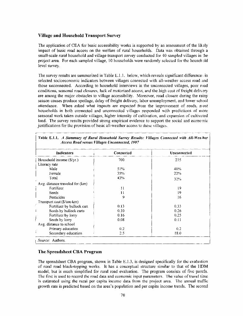
Village and Household Transport Survey
The application of CEA for basic accessibility works is supported by an assessment of the lik; lyimpact of basic road access on the welfare of rural households. Data was obtained throughi asmall-scale rural household and village transport survey conducted for 40 sampled villages in :heproject area. For each sampled village, 10 households were randomly selected for the househ )ldlevel survey.
The survey results are summarized in Table E. 1.1. below, which reveals significant difference ; inselected socioeconomic indicators between villages connected with all-weather access road andthose unconnected. According to household interviews in the unconnected villages, poor roadconditions, seasonal road closures, lack of motorized access, and the high cost of freight deli-eryare among the major obstacles to village accessibility. Moreover, road closure during the rainyseason causes produce spoilage, delay of freight delivery, labor unemployment, and lower schoolattendance. When asked what impacts are expected from the improvement of roads, n osthouseholds in both connected and unconnected villages responded with predictions of moreseasonal work taken outside villages, higher intensity of cultivation, and expansion of cultivv tedland. The survey results provided strong empirical evidence to support the social and econo-nicjustifications for the provision of basic all-weather access to these villages.
Table E.1.1. A Summary of Rural Household Survey Results: Villages Connected with All-Wea,/herAccess Road versus Villages Unconnected, 1997
Indicators Connected Unconnected
Household income (S/yr.) 700 275Literacy rate
Male 51% 40%Female 35% 22%Total 43% 32%
Avg. distance traveled for (km)Fertilizer 11 19Seeds 11 19Pesticides 9 16
Transport cost ($/ton-km)Fertilizer by bullock cart 0.13 0.33Seeds by bullock carts 0.10 0.26Fertilizer by lorry 0.16 0.25Seeds by lorry 0.08 0.11
Avg. distance to schoolPrimary education 0.2 0.2Secondary education 2.5 18.0
Source: Authors.
The Spreadsheet CBA Program
The spreadsheet CBA program, shown in Table E.1.3, is designed specifically for the evaluationof rural road black-topping works. It has a conceptual structure similar to that of the 1HDMmodel, but is much simplified for rural road evaluation. The program consists of five panels.The first is used to record the road data and economic input parameters. The value of travel timeis estimated using the rural per capita income data from the project area. The annual trafficgrowth rate is predicted based on the area's population and per capita income trends. The second
70

panel contains engineering unit cost data obtained from the field. The third panel presents theestimated unit VOCs and travel speeds by both road type and vehicle type. The average roadsurface condition for each type of road in the project area is measured by a range of internationalroughness index (IRI).106 The unit VOC data for motor vehicles are obtained from the empiricalVOC-IRI relationships estimated for a Bank-financed state highway project in Andhra Pradesh,and extended to cover the worst IRI levels typically found on the rural road network. Averagetravel speed on each type of road surface is estimated by local engineers based on their fieldexperience. The VOC-IRI relationships for bullock carts and bicycles are estimated using theNMV basic cost data (Table 2) collected from the field and the empirical relationships developedby recent studies in South Asia.107 The fourth panel calculates savings in VOC and value oftravel time (VOT) for the users of each mode of transport. Finally, the bottom panel calculatesthe economic cost and benefit streams over the project life, the net present value (NPV), and theERR.
Table E.1.2. NMV Basic Cost Data, 1997
Item Unit Bullock Cart Bicycle
Vehicle price US$ 62.5 30.0
Price of a pair of ox US$ 312.5 n.a.
Annual cost of feeding the ox US$/pair 150.0 n.a.
Annualized maintenance cost US$ 75.0 5.0
Vehicle depreciation US$/yr. 12.5 5.0 (a)
Annual average usage Km 2,400 1,000
Average year of life Years 5 10
Average VOC per km US$ 0.13 0.01
Note: (a) Annual depreciation for the first three yearsSource: Authors.
Lessons Learned
1. Where the provision of basic road access is mainly for social equity reasons, cost-effectiveness analysis can be used to evaluate or highlight the impact of the project, and economicefficiency can be considered implicitly through an emphasis on the least-cost design to achievethe project objectives.
2. The economic analysis described here requires systematic data collection. This particularexperience may not be transferable to other rural road projects. However, one important lessonlearned from this experience is that data collection at low cost can be possible with the activeparticipation of the client in the preparation of the project.
3. Where systematic data do not exist or are costly to collect, effort should be made to at leastestablish a transport/poverty profile through a small-scale household survey, and to collect trafficdata on the proposed rural roads.
4. While the methods used in this project help ensure the application of economic criteria,they do not deal with the optimal allocation of budget between the two categories of road works.This allocation should be decided through a participatory process.
71

Table E. 1.3. Cost-Benefi Analysis Program for Rural Road Paving Project
Distdct name: Warangal Road name: PWD to ChilpoorDivision name: Warangal Road No.: L101Road length (km): 15 Population served: 12,000Current road type (enter 0 for No. of minor CD/km: 0.5earth, 1 for gravel, 2 for WBM) 2 Major CD (m/km): 1.0Value of travel time (US$/hr) 0.06 Annual traffic growth rate 5%Annual per capital income growth 3% Standard Conversion Factor 0.90
Capital Cost ('000 US$/km) Annualized Maint Cost ('000 US$/km)Financial Economic Financial Economic
Formation 5.00 4.50 Earth 0.55 0.50Gravel (when available on site) 5.00 4.50 Gravel 0.68 0.61WBM (each layer) 6.25 5.63 WBM 0.88 0.79Blacktop 7.50 6.75 Blacktop 0.93 0.83Minor CD ('000 USS/each) 5.00 4.50Major CD ('000 US$/m) 3.75 3.38
Unit VOC by Road Type (US$/km) Travel SPeed by Road Type (Min,/km)Earth Gravel WBM BT Earth Gravel WBM BT
VehicleType IRI=14-18 IRI=9-11 IRI=9-11 IRI=5-7 IRI=14-18 IRI=9-11 IRI=9-11 IRI=5-7Buses 0.303 0.250 0.245 0.225 2.4 1.7 1.7 1.2Mini buses 0.170 0.123 0.118 0.100 2.4 1.7 1.7 1.2Cars/Jeeps 0.170 0.123 0.118 0.100 2.4 1.7 1.7 1.2Trucks 0.343 0.280 0.268 0.240 2.4 1.7 1.7 1.2TractorTrailors 0.250 0.225 0.200 0.150 3.0 2.0 2.0 1.5LCV/Tempo 0.170 0.123 0.118 0.100 2.4 1.7 1.7 1.2Three wheelers 0.075 0.063 0.050 0.038 2.4 1.7 1.7 1.2Two wheelers 0.063 0.038 0.038 0.025 2.4 t.7 1.7 1.2Bullock carts 0.147 0.129 0.118 0.115 20.0 15.0 15.0 15.0Bicycles 0.010 0.008 0.008 0.006 7.5 7.0 7.0 6.5Pedestrains n.a. n.a. n.a. n.a. 17.0 16.0 16.0 15.5
Base yr. Avg. Veh. VOC(US$/km) Speed (Mm./kn) Savings (US$/km)Vehicle Type Traffic Occup. w/o. Proj w. Proj. w/o. Proj w. Proj. VOC VOTBuses 20 35 0.25 0.23 1.70 1.20 0.40 0.36Mini buses 16 10 0.12 0.10 1.70 1.20 0.28 0.08Cars/Jeeps 40 4 0.12 0.10 1.70 1.20 0.70 0.08Trucks 24 0 0.27 0.24 1.70 1.20 0.66 0.00Tractor Trailors 22 5 0.20 0.15 2.00 1.50 1.10 0.06LCV/Tempo 37 1 0.12 0,10 1.70 1.20 0.65 0.02Three wheelers 32 3 0.05 0.04 1.70 1.20 0.40 0.05Two wheelers 68 1.5 0.04 0.03 1.70 1.20 0.85 0.05Bullock carts 60 1.5 0.12 0.12 15.00 15.00 0.15 0.00Bicydes 320 1 0.01 0.01 7.00 6.50 0.56 0.17Pedestnans 680 1 n.a. n.a. 16.00 15.50 n.a. 0.35MVs (2 2w = 1 MV) 225 Annual sum (325 days/year) = 1868 400N MVs 380
(All in thousand US$)Traffic Capital Maint, VOC VOT Net
Year Growth Cost Cost Savings Savings Benefit1998 5% 20.25 0.045 1.87 0.40 -18.031999 5% 0.045 1.96 0.43 2.352000 5% 0.045 2.06 0.47 2.482001 5% 0.045 2.16 0.51 2.622002 5% 0.045 2.27 0.55 2.772003 5% 0.045 2.38 0.59 2.932004 5% 0.045 2.50 0.64 3.102005 5% 0.045 2.63 0.69 3.282006 5% 6.75 J.045 2.76 0.75 -3.292007 5% 0.045 2.90 0.81 3.662008 5% 0.045 3.04 0.88 3.872009 5% 0.045 3.19 0.95 4.102010 5% 0.045 3,35 1.03 4.332011 5% 0.045 3.52 1.11 4.592012 5% 0.045 3.70 1.20 4.852013 5% 0.045 3.88 1.30 5.13NPV 0.81ERR 12.8%
Source: Authors.
72
Appendix E.2Bhutan Rural Access Project: Economic Analysis108
Introduction
An IDA Credit for a "'Rural Access Project' in the Kingdom of Bhutan was approved by theIDA Board in December 1999. The main project objective is to improve access of ruralcommtnities to markets, schools, health centers and other economic and social infrastructure, inorder to improve the quality of life and productivity of rural communities. The project will,among other things, help construct about 120 kilometers of rural access roads in four districts(dzongkhag) in Bhutan, where people have to walk an average of two days to reach the nearestroad. Bhutan has good agricultural potential, but its villages are on the slopes of the Himalayanrange, and a lack of access roads is a major socioeconomic problem. The Royal Government ofBhutan (RGOB) attaches great importance to improving rural access, as it will provide ruralcommunities better access to markets, schools and health centers, and also help prevent rural-to-urban migration.
The note presented below is essentially Annex 4 of the Project Appraisal Document (PAD; IDAreport rio. 19795-BHU, dated November 19, 1999). It summarizes the economic analysis of oneproject road, the Dakpai-Buli road (37 km), which is representative of the rest of the project.The case study presented is a first of its kind done in the Bank where an effort was made toquantify both social benefits and transport cost savings as part of the evaluation of improvingrural access roads.
General Approach
A cost benefit analysis of the project investments has been carried out; its main assumptions andfindings are summarized below. Since gathering socio-economic data for each project rural roadfor purposes of estimating its economic rate of return (ERR) is difficult and expensive, and sincethese are low-volume roads (less than 30 vehicles per day), the following methodology has beenused: for one typical project road (such as the 37 km. Dakpai-Buli road which has the advantageof considerable area-specific socio-economic data collected and analyzed by the Netherlandsfunding agency NEDA under their integrated development project for the district), its ERR wasestimated in detail based on quantification of social and economic benefits.109 Based on thissample exercise, socio-economic norms and criteria were developed to test the viability of allother project roads.
Cost-Benefit Analysis of Dakpai-Buli Road
Project Benefits: The project roads will provide many types of benefits: (a) it will improveaccess to social infrastructure (schools and health centers), providing many benefits fromincreased education and health facilities and improved social interaction and mobility, which areimportant for social and economic development; (b) it will provide better access to markets byreducing transport costs, and by making it physically feasible for the first time to transport certaintypes of goods (such as construction materials), since the existing modes of mule transport andporterage are unable to handle such key capital inputs (for construction of houses, schools, smallhydro-electric projects) and for general economic development; (c) it will improve themarketability of perishable goods through timely and cheaper transport, and this will provide adirect incentive for more market-oriented agriculture, with more profitable cash crops, and alsoraise rural income and employment; and (d) it will help isolated rural communities spread overthe difficult mountain slopes of the country (home to 85 percent of Bhutan's population and 36
73
percent of its national income) to remain connected to the national economy. It will preventtheir migration to urban areas that do not have the capacity to absorb them. Project impact in allthese benefit-categories will be limited primarily to the project areas.
In what follows, an attempt is made to quantify some of the project benefits described above: (a)social benefits, (b) transport cost savings, and (c) agricultural benefits. Other benefits fr)mindustrial and regional development will be difficult to quantify and therefore no attempt is madeto assess these impacts. A lack of data only permits a partial assessment, resulting in aconservative estimates of project economic return. The analysis focuses on one project road, theDakpai-Buli road, as discussed above.
Social Benefits: A novel feature of the analysis is quantification of part of the social benefits (inaddition to transport cost savings); we have made rough estimates of the value of better acces; toeducation which the road will provide, using Bhutanese data on enrollment levels with impro vedroad access, and income levels of educated and uneducated persons. Improved road access(removing the present constraint of about 2 days' walking) will allow easy transport of childreii toschools, or schools may get located closer to the communities, leading to higher schoolenrollment levels, and improvement in the quality of schools. RGOB already plans on buildingnew elementary and junior high schools following road construction when transport costs arereduced. Preliminary estimates, based on higher enrollment rates in the more accessible areas inthe same district, indicate that about 75-100 children, would additionally go to schools every yearif the road is built. More girls would attend because of proximity, and more boys would bereleased from the task of transporting goods. The life-time earnings of the educated versusuneducated samples provide an estimate of the income differentials. The net incremental incomehas been assessed after deducting estimated education and continuing education costs. This isattributable as net value added by the road since the additional enrollment would not I avehappened without the improved access provided by the road. Indeed education (especiallyeducation of girls) brings many more social benefits than income benefits, but we limited ourestimate to incremental income from education. We have also estimated some health benefits (inreduced sick days, and reduced maternity and other deaths) attributable to improved access tohealth facilities, based on available local data. Overall, about 30% of the project benefits derivefrom quantifiable social benefits.
Box E.2.1. Defining Accessibility in Bhutan
It should be added that in a region where 2-3 days walking to the nearest road is usual, reducing this toeven one day walking distance to/from a road is considered beneficial. Villagers have said that adistance of one day walking allows them to go to the road for sending produce by truck or for otherservices (often staying with relatives overnight), or for services such as health centers or communityschools to be located within such villages. It was mentioned that a common practice is for schcolchildren to stay with relatives, if the road/school area is within at least a day's walking distance so thatparents can visit them often with food and other supplies. Longer distance is considered too far lorsuch purposes. We have therefore considered villages within a day's walking distance (say 25 km) asfalling within the direct beneficiary zone of project roads
Source: Authors.
74

Transport Cost Savings: Basic traffic data estimates were supported by traffic surveys from theproject area (particularly existing mule traffic, and household consumption patterns) conductedby local consultants. Estimates also used traffic growth data gathered during a feeder roadproject that was completed about five years ago in a similar area of the district. The currenttraffic level in goods (all trafic that is likely to shift to the road, currently moved as mule trafficor porterage) is about 10 tonsper day, which is small. However, with road transport supplantingmule transport, traffic will increase. The estimates assume a traffic growth from about 10vehicles per day (three trucks, two buses and five light vehicles/pick-ups) for the first year(2002) to about 22 vehicles per day in the fifth year, which is supported both by traffic demand(growth) in the area, and the growth pattern observed after road development in a similar area inthe district. These may even be modest assumptions. The unit cost savings will be significantsince the alternative cost of mule transport is very high, or about $3 per ton-km (as field surveysand mule tariffs established). This is compared to an estimated trucking cost of about $0.40 perton-km (assumed high iii this terrain).
The transport benefits have been calculated for the following four major categories: (a) transportsavings on the normal growth of non-agricultural goods traffic assuming traffic levels without theroad project (agricultural traffic is excluded since the benefits from transporting agriculturalgoods will be indirectly included in the estimate of incremental agricultural income); (b) transportsavings on the induced non-agricultural goods traffic (additional non-agricultural traffic inducedby the availability of the road); (c) transport savings on the normal growth of passenger traffic(persons traveling in the without road assumption; and (c) transport savings on the inducedpassenger traffic.
The unit cost savings are significant since the alternative cost of mule transport is very high,about $3.0 equivalent per ton-km (as per field surveys and mule tariff established by RGOB), asagainst possible trucking cost of about $0.4 per ton-km (assumed high in this terrain) after theroad is built. For normal growth in existing traffic, the full reduction in costs is counted asproject benefits; for induced traffic, only 50% of net benefits is counted as project benefits. Roadtransport benefits are assumed frozen at the level reached in 27th year since the road will reachsaturation level of traffic at that time; the 27th year level of benefits is continued for the full roadlife of 40 years.
For normal growth in existing traffic, the full reduction in costs is counted as project benefits.For induced traffic, only 50 percent of net benefits is counted as project benefits. Road transportbenefits are assumed frozen at the level reached in the 27th year since the road will reachsaturation level of traffic at that time. The 27th year level of benefits is continued for the fullroad life of 40 years.
Using traffic growth data from a similar road constructed five years earlier in the same districtand assuming similar traffic growth, total traffic was assumed (conservatively) to double in fiveyears after completion of the road, reaching about 22 vehicles per day in year five. It is assumedto reach a level of about 100 vehicles per day in year 27. This projected traffic is an aggregationof all traffic (agricultural, non-agricultural, for existing, normal and induced growth).
75

Box E.2.2. Avoiding the Error of Double Counting Benefits
The passenger traffic estimates are modest, since normally passenger traffic growth is found toexceed goods traffic growth in most cases. These figures exclude fiuture bus traffic, if any, ofchildren to/from schools or of people to/from health centers; since education benefits and healthbenefits are estimated separately on a different basis, we did not want to count their transportsavings also as it would have meant double-counting of benefits; moreover such traffic isconsidered not significant. In the case of agricultural traffic, which is significant, the traffic wasconsidered only for estimating road capacity/saturation levels, but their transport savings wereexcluded to avoid double-counting of benefits.
Source: Authors.
Agricultural Benefits: In terms of the agricultural benefits induced by the road, the estimate isbased on a detailed analysis of the present cropping patterns in the area and the likely switclh incropping patterns to more profitable cash crops which will be facilitated by easier access tomarkets. A farm model with local production and cost co-efficients has been used for thisestimate. It estimates the net value added in agricultural production due to reduced transportcosts of farm inputs and output, and increased switch-over to cash crops (such as oranges, chilies,and other vegetables), based on similar experiences in other parts of Bhutan. It has been veri fiedthat apart from a marginal increase in extension services and the use of more fertilizers andimproved seeds, no significant agricultural investments in land improvements would be requLredfor the expected change to marketable crops. The net incremental benefits from agriculture (aftermeeting all additional costs of farming and transport) have been taken as benefits brought aboutby the road, since the absence of a road is the main bottleneck in producing more market-orientedcrops in this area.
Project Costs
Road construction and maintenance requires major initial investments, followed by periodicmaintenance costs. The Dakpai-Buli road is being built from year one (1999) to year three(2001). The first year of full road use is taken as year four (2002), ignoring interim benefits fromthe partial use of completed road sections. The stream of benefits and costs has been calculatedfor a 40-year period, (year 2002 to year 2041). This is justified since a well-designed mourtainroad with low traffic will last much more than 40 years if routine maintenance is done every year,and if periodically major repair works are undertaken. Adequate routine maintenance and a four-year cycle of periodic maintenance has been assumed in the cost stream to ensure a long life forthe road. Moreover, Bhutan has a good past record on road maintenance, and communityinvolvement in road maintenance is increasing, which will help sustain the road over a long life.For converting financial costs into economic costs, foreign components (mainly in constructioncosts) have been converted using c.i.f. (import) prices without adjustments; all other local costsand benefits have been converted into economic (border) prices using a factor of 0.9.
76

Overview of Results
Table E.2.1 summarizes the results of ERR analysis:
Table E.2.1. Net Present Value (NPV) of Economic Cost Benefit Streams(at 12 percent discount rate, in thousands of US$)
Cost of road investment and maintenance 3,817Total Benefit attributable to the road 6,244Transport benefits (non-agricultural traffic) 3,476Net agricultural benefits 56Net education benefits 1,699Net health benefits 113
ERR (base case) 15.1%
Source: Authors.
The main assumptions relate to higher school enrollment levels after road construction; trafficgrowth and transport savings; agricultural benefits; project life, and maintenance costs aredescribed in the previous chapter.
Sensitivity Analysis /Switching Values of Critical Items: Varying the economic cost and benefitstreams of the base case produces the following sensitivity table (Table E.2.2):
Table E.2.2. Results of Sensitivity Analysis
Variations in Cost Stream Variations in Benefit Stream80% 100% 120%
80% ERR 15.1% ERR 16.9% ERR 18.5%100% ERR 13.6% ERR 15.1% ERR 16.5%120% ERR 12.5% ERR 13.9% ERR 15.1%
Source: Authors.
Varying the economic cost and benefit streams produces the following switching values (at 10percent and at 12 percent) for the ERR (Table E.2.3):
Table E.2.3. Switching Values
Variations in Cost Stream Variations in Benefit Stream42% 61% 100%
100% ERR 10.0% ERR 12.0% ERR 15.1%162% ERR 12.0%237%
Source: Authors.
The above figures show that the ERR estimates are robust, under varying pessimisticassumptions.
77

Assumption Regarding the Life of the Road: A separate sensitivity analysis was conductedwith regard to the life of the road. The base-case ERR is based on a 40-year life of the road. 'fhisis a realistic assumption, because this is a well-designed mountainous road with low traffic--thisroad should have an even longer life. Moreover, adequate maintenance allocation has been madein the analysis. Bhutan has a good past record of satisfactory road maintenance, and local usercommunity involvement in road maintenance is part of the project design and understanding withRGOB.
For life assumptions of 30 years and 20 years, the base-case ERR will decline to 12.9 percent and10.1 percent respectively. As noted above, these reduced-life assumptions are not realistic. Theresults, however, highlight the need for good maintenance policies and practices to ensureviability of such road investments.
Applying the Dakpai-Buli Road ERR Analysis to the Total Project
Dakpai-Buli is considered typical of other project roads. The above analysis shows that the r)adproduces an ERR of above 15 percent for 37 kilometers, costing about $3.6 million and serningabout 8000 direct beneficiaries. This amounts to a per capita cost of about $450 in terms ofproject cost per beneficiary. Based on this, the per capita investment corresponding to 12 percentERR is about $560. In other words, based on the Dakpai-Buli road impact analysis, a per capitainvestment per beneficiary of $560 (in 1999 prices mention the base price factor early in yournarrative) is considered viable at 12 percent ERR.
In view of the difficulty of repeating such detailed studies for all the project roads, and since theaccess problems and economic conditions are similar in the service areas of other project roads,the norm of a maximum per capita (per beneficiary) cost of $560 is applied as an acceptablethreshold for economic viability. These criteria will need to be satisfied for all project roads. 'Thepreliminary analysis for the other project roads shows that the per-capita investment for theremaining project roads will be less than $450, indicating a higher than 15 percent ERR, based onthe Dakpai-Buli road norm of Dakpai-Buli road. This indicates that the overall Project ERRwould exceed the 15 percent estimated for the Dakpai-Buli Road. More details are given in theproject files.
Road Selection Criteria for Project Roads: Based on the above analysis, the following criteria(among others) have been agreed upon with RGOB for the selection of new roads under theproject:
(a) Project roads must be part of the list of feeder roads included as priority roads in theongoing Eighth Five-Year Plan. These road priorities have been decided upon on the basis ofextensive participatory discussions involving local communities, district administrations, thePlanning Commission and sector Ministries, and the King, who visited all districts for discussionson plan priorities with the local communities. They reflect a participatory, socioeconomicprioritization process, based on national economic and regional development objectives; and
(b) Based on the economic return calculations made for the Dakpai-Buli road, a per capitainvestment per beneficiary of $560 is considered viable at 12 percent ERR. All project roadsshould satisfy this criteria. The direct beneficiaries are estimated using the populations fromvillages that directly benefit from the project (defined as villages within one day's walk :ngdistance to or from project road). It can be increased by about 10 percent to include otherbeneficiaries who would directly benefit from trade with or visits to the newly accessible areas.(This was the procedure followed for the Dakpai-Buli Road). The road construction costs are tobe calculated in 1999 prices, including 15 percent physical contingency.
78
Concluding Remarks
This case study presents an extreme case where (a) the road investment cost is very high at about$100,000 per kilometer, even for a one-lane gravel road (because of mountainous terrain and thedecision to use environmentally friendly 'cut and fill methods'); (b) the number of beneficiariesper road is small due to sparse population density (about 8,000 direct beneficiaries); and (c) percapita investment is high, at about $450 per beneficiary (compared to below $100 in othercountries).
The case illustrates that by attempting to carefully quantify the true economic costs of presenttransport bottlenecks, and the socioeconomic benefits which the investment will bring, the projectcould be justified. The use of realistic mule transport costs in the absence of the project,quantification of social benefits, and the use of realistic 40-year life assumption for the road,have all contributed to the viable ERR estimate, in spite of high investment costs. The 40-yearlife span assumption for the project road was endorsed by experienced road engineers, since itwill be a well-built mountain road with relatively little traffic and good maintenance standardsbased on the good past road maintenance record of Bhutan.
The detailed studies carried out to assess the socioeconomic benefits were expensive, but can beeffectively undertaken on a sample basis to establish an acceptable threshold of investment.
IDA Executive Directors, during Board consideration of the project, commended this newapproach in assessing social benefits in rural road projects. The Quality Assurance Group of theBank, which reviewed the project for quality at entry, also commended it for overall quality,including the innovative methods used in the economic analysis.
One lesson learned concerns estimating separate benefits from net value added in agriculture dueto the switch to market-based crops after road construction. This was an elaborate procedure,using farm models from other parts of Bhutan where road availability has induced changes incropping patterns. However, we later concluded that this exercise was not essential. The ERRestimates would have been almost similar if agricultural traffic was included as part of totaltraffic, and their benefits assessed using transport cost savings and reasonable traffic growthassumptions. This would have made the analysis much simpler and less time-consuming.
79

APPENDIX FLow VOLUME ROADS ECONOMIC DECISION MODEL (RED)
Introduction
The Low Volume Roads Economic Decision Model (RED) was developed under the PRoadMaintenance Initiative (RMI), a key component of the Sub-Saharan Africa Transport PclicyProgram (SSATP), to improve the decision making process for the development and maintenanceof low-volume roads. The model performs an economic evaluation of road investments optionsusing the consumer surplus approach and is customized to the characteristics of low-volameroads such as a) the high uncertainty of model inputs, particularly the traffic and condition ofunpaved roads; b) the importance of travel time measurements to characterize the conditionl ofunpaved roads and for model validation; c) the need for a comprehensive analysis of generatedtraffic; and d) the need to clearly define all accrued benefits. RED computes benefits for nonnal,generated and diverted traffic and takes into account changes in road length, condition, geometry,type, accidents and days per year when the passage of vehicles is further disrupted by a higllhlydeteriorated road condition (wet season). Users can add other benefits or costs to the analysis,such as non-motorized traffic, social services and environmental impacts, if computed separalely.The model is presented on a series of Excel 5.0 workbooks that collect all user inputs, present theresults in an efficient manner, and perform sensitivity, switching values, and stochastic riskanalyses. RED is available at the World Bank Road Software Tools Internet site:
http://www. worldbank. org/html/fpd/transport/roads/tools. htm
Sample Model Applications
Two typical RED applications are presented, which consist of the economic justificatior ofsurfacing a gravel road and justifying maintenance expenditures needed to maintain a certainlevel of service.
Surfacing a Gravel Road: A two-lane gravel road, with 200 vehicles per day, rece-vesmaintenance that consists of grading every 90 days and regravelling every 5 years, which yields aroad with good passability and average roughness equal to 11.0 IRI. RED is used to evaluate thefollowing project-options: (a) rehabilitate the road and improve the maintenance policy increasingthe grading frequency to one grading every 60 days, (b) upgrade the road to surface treatntentstandard, and (c) surface the road with concrete blocks. The basic inputs are given in Table F. Ibelow.
Table F. I. Inputsfor Example No. I
Without Project Project-Option I Project-Option-2 Project-Option 3
Description Grading every Grading every Surface Treatment Concrete Blo-k90 days 60 days Surface Surface
Average roughness (IRI) 11.0 9.0 3.5 5.0
Investrnent cost ($/km) 15,000 125,000 48,000
Maintenance costs 4,200 4,800 1,000 2,400($/km/year)
Source: Authors.
80
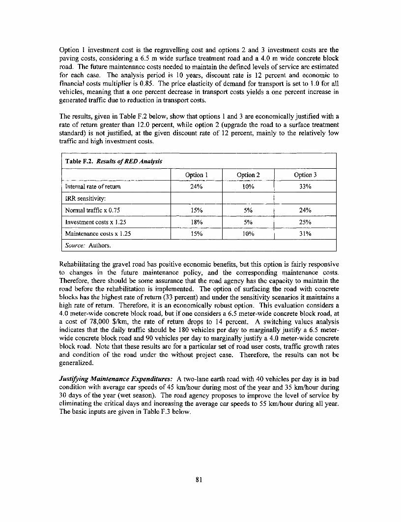
Option 1 investment cost is the regravelling cost and options 2 and 3 investment costs are thepaving costs, considering a 6.5 m wide surface treatment road and a 4.0 m wide concrete blockroad. The future maintenance costs needed to maintain the defined levels of service are estimatedfor each case. The analysis period is 10 years, discount rate is 12 percent and economic tofinancial costs multiplier is 0.85. The price elasticity of demand for transport is set to 1.0 for allvehicles, meaning that a one percent decrease in transport costs yields a one percent increase ingenerated traffic due to reduction in transport costs.
The results, given in Table F.2 below, show that options 1 and 3 are economically justified with arate of return greater than 12.0 percent, while option 2 (upgrade the road to a surface treatmentstandard) is not justified, at the given discount rate of 12 percent, mainly to the relatively lowtraffic and high investment costs.
Table F.2. Results of RED Analysis
Option 1 Option 2 Option 3
Internal rate of return 24% 10% 33%
IRR sensitivity:
Normal traffic x 0.75 15% 5% 24%
Investment costs x 1.25 18% 5% 25%
Maintenance costs x 1.25 15% 10% 31%
Source: Authors.
Rehabilitating the gravel road has positive economic benefits, but this option is fairly responsiveto changes in the future maintenance policy, and the corresponding maintenance costs.Therefore, there should be some assurance that the road agency has the capacity to maintain theroad before the rehabilitation is implemented. The option of surfacing the road with concreteblocks has the highest rate of return (33 percent) and under the sensitivity scenarios it maintains ahigh rate of return. Therefore, it is an economically robust option. This evaluation considers a4.0 meter-wide concrete block road, but if one considers a 6.5 meter-wide concrete block road, ata cost of 78,000 $/km, the rate of return drops to 14 percent. A switching values analysisindicates that the daily traffic should be 180 vehicles per day to marginally justify a 6.5 meter-wide concrete block road and 90 vehicles per day to marginally justify a 4.0 meter-wide concreteblock road. Note that these results are for a particular set of road user costs, traffic growth ratesand condition of the road under the without project case. Therefore, the results can not begeneralized.
Justi[ying Maintenance Expenditures: A two-lane earth road with 40 vehicles per day is in badcondition with average car speeds of 45 km/hour during most of the year and 35 km/hour during30 days of the year (wet season). The road agency proposes to improve the level of service byeliminating the critical days and increasing the average car speeds to 55 km/hour during all year.The basic inputs are given in Table F.3 below.
81
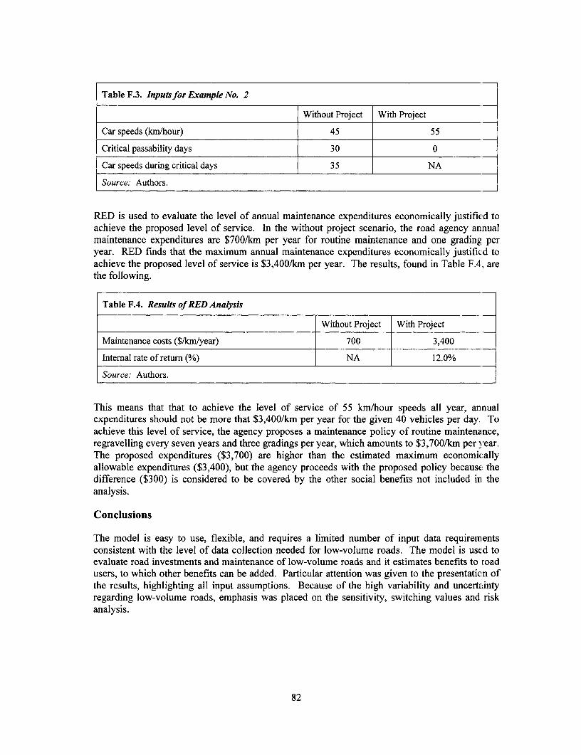
Table F.3. Inputs for Example No. 2
Without Project With Project
Car speeds (km/hour) 45 55
Critical passability days 30 0
Car speeds during critical days 35 NA
Source: Authors.
RED is used to evaluate the level of annual maintenance expenditures economically justified toachieve the proposed level of service. In the without project scenario, the road agency annualmaintenance expenditures are $700/km per year for routine maintenance and one grading peryear. RED finds that the maximum annual maintenance expenditures economically justified toachieve the proposed level of service is $3,400/km per year. The results, found in Table F.4, arethe following.
Table F.4. Results of RED Analysis
Without Project With Project
Maintenance costs ($/kmlyear) 700 3,400
Internal rate of return (%) NA 12.0%
Source: Authors.
This means that that to achieve the level of service of 55 km/hour speeds all year, annualexpenditures should not be more that $3,400/km per year for the given 40 vehicles per day. Toachieve this level of service, the agency proposes a maintenance policy of routine maintenance,regravelling every seven years and three gradings per year, which amounts to $3,700/km per year.The proposed expenditures ($3,700) are higher than the estimated maximum economicallyallowable expenditures ($3,400), but the agency proceeds with the proposed policy because thedifference ($300) is considered to be covered by the other social benefits not included in theanalysis.
Conclusions
The model is easy to use, flexible, and requires a limited number of input data requirementsconsistent with the level of data collection needed for low-volume roads. The model is used toevaluate road investments and maintenance of low-volume roads and it estimates benefits to roadusers, to which other benefits can be added. Particular attention was given to the presentation ofthe results, highlighting all input assumptions. Because of the high variability and uncertaintyregarding low-volume roads, emphasis was placed on the sensitivity, switching values and riskanalysis.
82

NOTES
1. See Malmberg Calvo 1998.
2. Both under preparation. To be published in 2001.
3. Particularly for maintenance, the support of central government can rarely be relied upon.Exceptions are some road funds and other transfer mechanisms. See Christina MalmbergCalvo.
4. In some cases, at steep hills (see Appendix B) or where suitable gravel material cannot befound (as in Bangladesh), paving may be the most economical solution.
5. Often justified based on anticipated lack of maintenance and a lack of willingness to tacklethis problem.
6. I'his approach is further elaborated upon in Chapter 4 and Appendix E.
7. Poverty Net: http. //www. worldbank. orM/voverty/data/trends/index. htm.
8. "Designated" means formal government responsibility or ownership has been established.
9. See Malmberg Calvo 1998.
10. Barwell 1996.
11. The authors estimate that of the 3 billion rural population in developing countries, 30percent (900 million) are living in villages without reliable access, while 10 percent (300million) are not provided with motorized access at all. To improve access to these people,an estimated $40 billion of investment and an annual $1 billion in maintenance would berequired.
12. During the 1970s and 1980s many so-called integrated rural development projects wereexecuted, supporting various sub-sectors. Most of them failed because they were notdelivered in a manner consistent with national or local institutional and financialf'rameworks.
13. P'AD Nepal Road Maintenance and Development Project 1999.
14. PAD Bhutan Rural Access Project 1999.
15. Rural household survey conducted in preparation of the Rural Roads Component of theAndhra Pradesh Economic Restructuring Project 1997.
16. Pankaj 1999.
17. Adapted from World Bank 1996a.
83

18. Volume I (Malmberg Calvo) was published in 1998. Volume II is this paper. Volumes IIIand IV are planned to be published in 2001.
19. For example, see the Comprehensive Development Framework (CDF) or PovertyReduction Strategy Papers (PRSP) at: http.//www.worldbank.org/
20. "Rural Transport Projects: Concept Development, Justification, and Appraisal," a lectureseries given by Prof. John Howe at the World Bank, September 20-24, 1999.
21. Intermediate means of transport not only include non-motorized means of transport (N,MT)such as bicycles and animal drawn carts, but also appropriate low-cost motorized means oftransport such as scooters and single-axle tractors.
22. See Barwell 1996.
23. For example, see Malmberg Calvo 1998.
24. Geoff Edmonds (1998): Wasted Time: The Price of Poor Access.
25. Avoiding some transport needs altogether, for example, through improvedcommunications, is a promising and cost-effective alternative.
26. Refer to Education Advisory Services, World Bank.
27. The topic is being addressed in a World Bank Technical Paper entitled "Developing RturalTransport Policies and Strategies," planned for publication in 2001.
28. Often projects "assign" responsibilities to communities (in the absence of local governmentcapacity) which exceed their capacity in the long-run, or which are too complicated tomanage (for example, links that provide access to several villages). This is often djoneinstead of the necessary, but difficult, task of promoting capacity building at localgovernment and community levels.
29. See Malmberg Calvo 1998.
30. For example, in Ghana, rural roads are managed by the Department of Feeder Roads ef theMinistry of Roads and Highways in collaboration with local governments. Similararrangements exist in Bangladesh and India.
31. This will require a one-hour walk from the village to the most remote part oi thecommunity road and one hour back, which reduces the available effective work time formaintenance to six hours. However, in countries with a low population density,community RTI is often much longer than five km (which often means that roads are notaffordable).
32. See Note 21.
84
33. In some countries, such as France, access is stated as a fundamental human right in theconstitution.
34. Many roads are being upgraded to higher standards at (despite negative rates of return) or(despite dubious measurements of their development effectiveness and economicprofitability), Therefore, the potential for the reallocation of resources to basic accessexists. However, if real transport bottlenecks are observed (such as congested or heavilydeteriorated high-traffic roads), these can be economically very costly and need to beaddressed in priority.
35. As in the case of Bangladesh where non-motorized rickshaw-vans (for goods) andpassenger rickshaws dominate traffic.
36. In the rare cases where transfer arrangements from central budgets or road funds exist forfinancing RTI maintenance, local communities must still provide substantial contributions.This is one of the main reasons for local level ownership through a participatory approachto planning, monitoring and evaluation for this type of intervention.
37. Some empirical evidence from recent World Bank projects (see Appendix E) suggests thatthe limit of what can be afforded in terms of RTI investment is close to the annual percapita GDP of the population served.
38. If a country is not maintaining its main road network, it is also unlikely to be maintainingits secondary road network and new public investments should be avoided.
39. For example, in Burkina Faso the existing path network (that provides access to all therural households) has been estimated at 112,000 kilometers. If this network would bedeveloped to roads and added to the e'xisting road network of 16,000 kilometers, the roaddensity of Burkina Faso would be comparable to that of a developed country with similarpopulation density.
40. See Note 11.
41. See Notes 13, 14 and 15.
42. For example, in Burkina Faso, Gnanderman 1999, found that there are about 112,000 kmof paths versus 16,000 km of roads.
43. Normally designed for ten or twenty year flood levels.
44. Up to a traffic range of 50-150 VPD, "full access" will normally require a gravel road ofone-and-a-half lanes (carriageway width of 4.5 to 5.5 meters), while above 150 VPD, atwo-lane road will be appropriate (6 meters carriageway with shoulders). The provision ofa bituminous sealed surface (double/triple surface dressing or OTTA seals) is usually onlyjustified at traffic levels of above 200 to 400 vehicles per day, depending on terrain,rainfall, and soils. In India, the "standard" full access rural road is a single-lane road with acarriageway width of 3.6 meters, a formation width of 7.5 meters, and a surface layer of 40
85

cm consisting of a 2 cm bituminous layer on a triple layer of water-bound macadam and agravel layer costing a total of $40,000 equivalent per kilometer.
45. "Road Building in the Tropics," TRL 1993.
46. See Note 41.
47. In India, the policy is that rural road closures should not exceed 12 hours per event anJ notmore than 15 days per year in total. In most francophone African countries, the roadagencies operate rain barriers on rural roads. Normally, the rule is that these barriers mustbe closed during heavy rains and at least four hours thereafter. In Nepal, due to theseverity of the monsoon season and the high cost of permanent river crossings, most iloadsother than the national highways and urban roads are seasonal access roads that are c osedfor about three months during the monsoon season.
48. However, in the USA, about 40 percent of the approximately 6 million kilometer roadnetwork are gravel or earth roads and are in their majority single-lane (Highway Sta1 stics1998, Federal Highway Administration).
49. See Richard Robinson.
50. For example, new lending instruments, such as the World Bank's Adaptable ProgramLending programs, allow for a longer-term performance-based approach to project lending.
51. For example, the SRR (Structures on Rural Roads) component of the first and second lturalRoads and Market Improvement Projects of the World Bank in Bangladesh, and theMorogoro Road Support Project assisted by the Swiss Development Cooperaticn inTanzania.
52. The National Transport Program Support Project, 2000. Also see, Asif Faiz et al. TRBRecord.
53. However, a "phased" approach can be recommended, as practiced in the "Green RoadApproach" in Nepal, where first a trail is constructed and then gradually expanded to aroad, particularly in a mountainous environment.
54. For example, see Heggie and Vickers 1998.
55. As demonstrated by Ellis and Hine, "a road with traffic of 10 vehicles per day has 0.05conflicts per day at a speed of 40 km/h. This will increase to 1.3 conflicts per da) at avolume of 50 vehicles per day."
56. Although encroachment into existing alignment is a situation encountered frequently.
57. For environmentally friendly RTI design, see Appendix B, particularly the chapter on bio-engineering.
86
58. OP/BP/GP 4.01 Environmental Assessment and OP/BP/GP 4.30 Involuntary Resettlement;Roads and the Environment, WB Technical Paper 376, 1997; and Managing the SocialDimension of Transport. The Role of Social Assessment. World Bank, Social DevelopmentWeb site.
59. For example, the "Destitute Women Program" implemented in Bangladesh.
60. Good guidelines for the training of small scale contractors can be found in a ILOpublication: Capacity Buildingfor Contracting in the Construction Sector.
61. See Stock and de Veen 1996.
62. See Bentall, Beusch and de Veen 1999.
63. See Malmberg Calvo 1998.
64. See Larcher 1999.
65. See MART Working Papers Nos. I to 14.
66. World Bank. 1994. Bank-Financed Projects with Community Participation: A ManualforDesigning Procurement and Disbursement Mechanisms. Africa Technical Department,Washington, DC.
67. As a rule of thumb, expenditures for maintenance should be 50-80 percent of totalexpenditures for roads in a growing network and 90-95 percent in a mature network.
68. See Malmberg Calvo 1998.
69. In Burkina Faso, for example, the systematic execution of grading operations incombination with spot recharging of gravel has greatly reduced the need for periodicregravelling.
70 Hine, J and Cundill, M. "Economic assessment of road projects: Do our currentprocedures tell us what we want to know?" International Workshop On Impact Evaluationand Analysis of Transportation Projects In Developing Countries. Bombay, December,1994.
71. Tsunokawa and Hoban 1997; Beenhakker 1987; Chapter 4, Handbook of EconomicAnalysis in Transport Project Work.
72. For more on participatory approaches see World Bank, Social Development web site:http://www.worldbank org - Topics and Sectors - Social Development.
73. For further information on participatory planning tools see Malmberg Calvo 1998.
74. For more information on participatory techniques see World Bank Participation SourceBook, 1996.
87
75. A good example are the guidelines and Thana Planning Handbook prepared by the L ocalGovernment Engineering Department (LGED) in Bangladesh.
76. A low-cost survey should assess the existing level of access and determine the types ofinterventions necessary to secure basic access. A small team (driver, engineer, ]calforeman) with vehicle should be able to survey around 40km/day of roads, or 20km/day ofpaths on foot or by means of IMT.
77. Basic access is understood here as defined in Chapter 3 and elaborated in Appendixes Band C.
78. For example, in the province of Saskatchewan in Canada, wheat farms are based on sql,iaremile lots. Along the perimeter of the lot, there is normally a public access road from w iicha penetration road leads to the farm house. When selecting which of these access roadsshould be gravelled (which means the provision of costly "crusher-run" material becausethe in-situ soils are mainly clays) it has been decided that, per farm, only one access road tothe main road system (and normally the shortest one) is being gravelled (and thereforebecomes an all-season road) while the others remain seasonal earth roads. This i; anexample of a "basic access" approach that has been applied in a developed country.
79. World Bank, OP 10.04 1994.
80. Normally, life cycle costs should be used in this formula (including maintenance).However, in this case, maintenance costs were found to be uniform over the network andthere was no need to consider them..
81. The cost of upgrading of all link that cost less than $50 per person served would exhaustthe available budget.
82. For a further discussion, see Gannon and Lebo 1999.
83. The producer surplus (PS) method has been widely applied throughout the developingworld, especially where road improvements are intended to increase agricultural v llueadded. This method was codified in the work of Carnemark, Biderman and Bovet (1976),and later expanded and simplified by Beenhakker and Lago (1983).
84. For example, see Padeco (1996), Non-Motorized Transport (NMT) Modeling in HDM-4,Draft Final Report for Transport Division of the World Bank. Also see World Bank(1996), Bangladesh, Second Rural Roads and Markets Improvement and MaintenanceProject, Project Implementation Document No. 15, Economic Appraisal of FRB Roads,South Asia Regional Office, World Bank.
85. For additional information on valuing travel time savings, see Gwilliam 1997.
86. See Cook 1990.
88

87. R. Ahmed and M. Hosain, Development Impact of Rural Infrastructure in Bangladesh.International Food Policy Research Institute (IFPRI) in collaboration with BangladeshInstitute of Development Studies (BIDS), 1990.
88. World Bank. 1999. Project Appraisal Document-Kingdom of Bhutan, Rural AccessProject. South Asia Regional Office, Washington, DC.
89 As elaborated in Chapter 3 of this paper, basic access roads provide all-season access(within certain limits) to the prevailing vehicles. Traffic levels on basic access roads areless than 50 motorized, four-wheeled vehicles per day, but often there is a substantialamount of NMT.
90. TRL Road Note No. 6: A Guide to Geometric Design and TRL publication: Road Buildingin the Tropics.
91. Paige-Green, P and A Bam. Passability criteriafor unpaved roads. Research Report RR91/172, Department of Transport, South Africa, 1994; also Ellis, SD and JL Hine. Rapidappraisal techniques for identifying maintenance priorities on low volume rural roads.Unpublished Project Report PRIOSC/122/97, Transport Research Laboratory, 1998.
92. An equivalent laboratory test would be an unsoaked CBR of 15 percent with modifiedproctor compaction.
93. See Box B.1
94. A Guide to Geometric Design, TRL Overseas Road Note 6, Transport ResearchLaboratory, Crowthorne, 1988 defines the three categories as follows:
Level (0 to 10 five-meter ground contours per km): Level or gently rolling terrain withlargely unrestricted horizontal and vertical alignment.
Rolling (11 to 25 five-meter ground contours per km): Rolling terrain with low hillsintroducing moderate levels of rise and fall with some restrictions on vertical alignment.
Mountainous (greater than 25 five-meter ground contours per km). Rugged, hilly andmountainous with substantial restrictions in both horizontal and vertical alignment.
95. Principles of Low-Cost Road Engineering in Mountainous Regions, TRL Overseas RoadNote 16, Transport Research Laboratory, Crowthome, 1997.
96. Bridges are normally designed to accommodate annual high flows without excessivelyrestricting flow or incurring damage either to the structure or surrounding land. A highflood which may only occur once in every 100 years may cause damage to approachembankments but should not damage the superstructure. See: A Design Manualfor SmallBridges, Overseas Road Note 9, Transport and Road Research Laboratory.
97. Nepal 1997.
89
98. National Research Council, Washington DC, 1993. Vetiver Grass, a Thin Line AgainstErosion.
99. Clark, J., and J. Hellin. Bio-engineeringfor Effective Road Maintenance in the Caribhbean.Natural Resources Institute, Chatham. 1996.
100. Bentall P., A. Beusch and J. de Veen 1999.
101. Extracted from Stock A., and J. de Veen 1996.
102. ATBrief 8, Improving Paths and Tracks in Appropriate Technology, Vol. 21 No. 1, givesmore details on these approaches.
103. Wagner et al. 1992. Survey, Design, and Construction of Trail Suspension Bridges forRemote Areas, Volumes A to E, SKAT. Switzerland.
104. These "weights" are based on the standard measure of road capacity, Passenger Car UJnits(PCU), an approach applied on higher-category roads, which allows consistent comparisonof traffic throughout the network. However, for RTI where traffic capacity is not usuallyan issue, the merit of this conversion is not clear.
105. For details on the rural road master planning process, see World Bank Infrastructure N Aes,Transport No. RT-4, January 2000.
106. While the appropriateness of using IRI for rural road project evaluation remains debatable,for this particular project, it is judged appropriate by the project team, given the substantialdifferences in roughness found among different types of rural road and the relativeuniformity within each type of rural road in the area.
107. (1) See PADECO (1996), Non-Motorized Transport (NMT) Modeling in HDM-4, D)raftFinal Report for Transport Division of the World Bank. (2) World Bank (1996),Bangladesh: Second Rural Roads and Markets Improvement and Maintenance Pro;ect:Project Implementation Document No. 15: Economic Appraisal of FRB Roads, South AsiaRegional Office, World Bank.
108. The main economic analysis and report was done by a team consisting of Thampil Pankaj,and Eddy Bynens, with considerable support from Kynghkhor consultants of Bhutan whoconducted various field studies and some of the analysis. The study received valuableguidance from Frannie Leautier, and support and advice from Juan Gaviria and other Bankcolleagues. The detailed study is available from the World Bank's Rural Roads ThematicGroup Web site at http://www.worldbank.org/html/f4d1transport/rt over. htm.
90

BIBLIOGRAPHY
Ahmed, R., and M. Hosain. 1990. "Development Impact of Rural Infrastructure in Bangladesh."International Food Policy Research Institute (IFPRI) in collaboration with BangladeshInstitute of Development Studies (BIDS).
Airey, T., and G. Taylor. 1999. "Prioritization Procedure for Improvement of Very Low-Volume Roads." Transportation Research Record 1652, Transportation Research Board,Washington, D.C.
Ali-Nejadfard, F. 2000. Rural Accessibility Planning. ASIST Bulletin 10.http://www. ilo. org/asist.
Andersson, C., A. Beusch, and D. Miles. 1996. Road Maintenance and Regravelling(ROMAR). Using Labour-Based Methods. International Labour Organization, Geneva.
Archondo-Callao, R., and A. Faiz. 1994. Estimating Vehicle Operating Costs. World BankTechnical Paper 234. Washington, D.C.
Archondo-Callao, R. 1999. "Roads Economic Decision Model (RED) for Economic Evaluationof Low Volume Roads." Sub-Saharan Africa Transport Policy Program Technical NoteNo. 18. World Bank, Africa Regional Office, Washington, D.C.
Bangladesh Local Government Engineering Department. 1999. "Bangladesh RuralInfrastructure Impact Study, with special reference to RDP-7 and other projects." Socio-economic Monitoring and Environmental Research, Dhaka.
Banjo, G., and R. Robinson. 1999. "Rural Transport Policies and Strategies." Draft RuralTravel and Transport Program Approach Paper. World Bank, Africa Regional Office,Washington, D.C.
Barwell, Ian. 1996. Transport and the Village. World Bank Discussion Paper 344. Washington,D.C.
Beenhakker, H., and A. Lago. 1983. "Economic Appraisal of Rural Roads: SimplifiedOperational Procedures for Screening and Appraisal." Staff Working Paper 610. WorldBank, Washington, D.C.
Beenhakker, H., et al. 1987. Rural Transport Services: A Guide to Their Planning andImplementation. London: Intermediate Technologies Publications.
Bentall, P., A. Beusch, and J. de Veen. 1999. Employment Intensive InfrastructureProgrammes: Capacity Building for Contracting in the Construction Sector. InternationalLabour Organization, Development and Policies Department, Geneva.
Beusch, A., P. Hartmann, R.C. Petts, and P. Winkelmann. 1997. Low Cost Road Construction inIndonesia: Labour-Based Road Projects in Manggarai District. Bern: Intercooperation.
Bryceson, D.B. 1995. Wishful Thinking - Theory and Practise of Western Donor Efforts toRaise the Women's Standard in Rural Africa In Bryceson (ed.): Women Wielding theHoe: Lessons from Rural Africa for Feminist Theory and Development Practice. Oxford:Berg Publishers.
91

Carnemark, C., J. Biderman, and D. Bovet. 1976. "The Economic Analysis of Rural R.oadProjects. " Staff Working Paper 241. World Bank, Washington, D.C.
Carney, D. 1998. "Sustainable Rural Livelihoods: What Contribution Can We Make?" P'aperpresented at the Department for International Development's National Resources Advisers'Conference, London, U.K, July 1998.
Clark, J., and J. Hellin. 1996. Bio-engineeringfor Effective Road Maintenance in the Caribbean.Natural Resources Institute, Chatham.
Connerly, E. and L. Schroeder. 1996. "Rural Transport Planning." Sub-Saharan AfricaTransport Policy Program Working Paper 19. World Bank and Economic Commission forAfrica, Washington, D.C.
Cook, C. 1983. "Review of Research on Personal Mobility in Rural Areas of the DevelcopingWorld." Paper presented at the 25th Annual Meeting of the Transportation ResearchF orum, Washington, D.C., 1983.
Cook, P. and C. Cook. 1990. "Methodological Review of the Analyses of Rural TransportationImpacts in Developing Countries." Transportation Research Record 1274, TransportationResearch Board, Washington,.D.C.
Dennis, R. 1998. Rural Transport and Accessibility, A Synthesis Paper. International LabourOrganization, Development Policies Department, Geneva.
Department for International Development (DFID). 1998. Sustainable Rural Livelihood. IrhatContribution Can We Make? London.
Department for International Development (DFID). 1999. Local Level Planning and InvestmnentPrioritisation Final Report. Department for International Development, London andInternational Labour Organization/ASIST, Geneva.
Department for International Development (DFID). 1999. Sustainable Livelihoods: Lessonsfrom Early Experience. London.
Deutsche Gesellschaft fuir Technische Zusammenarbeit (GTZ) GmbH. 1999. "Rural Transportand Sustainability." Transport Working Paper 2a. Eschborn, Germany.
Devres, Inc. 1980. Socio-Economic and Environmental Impacts of Low Volume Rural Roac`s: AReview of the Literature. A.I.D. Program Evaluation Discussion Paper 7. Office ofEvaluation, Bureau for Program and Policy Coordination, Agency for InternationalDevelopment, Washington, D.C.
Dixou-Fyle, K. 1998. Accessibility Planning and Local Development. International LabourOrganization, Development Policies Department, Geneva.
Doran, J. 1996. Rural Transport. Energy and Environment Technology Source Books. Lonion:Intermediate Technology Publications in association with the United Nations DevelopmentFund for Women (UNIFEM), New York.
Edmonds, G. 1998. Wasted Time: The Price of Poor Access. International LabourOrganization, Development Policies Department, Geneva.
92

Ellis, S.D., and J.L. Hine. 1998. "The Provision of Rural Transport Services." Sub-SaharanAfrica Transport Policy Program Working Paper 37. World Bank, Africa Regional Office,Washington, D.C.
Ellis, S.D., and J.L. Hine. 1998. "Rapid Appraisal Techniques for Identifying MaintenancePriorities on Low Volume Rural Roads." Unpublished Project Report PR/OSC/122/97.Transport Research Laboratory, Crowthome, Berkshire.
Federal Highway Administration. 1998. Highway Statistics. Washington, D.C.
Gannon, C., and Z. Liu. 1997. "Poverty and Transport". Transportation Water and UrbanDevelopment Discussion Paper 30. World Bank, Transport Division, Washington, D.C.
Gannon, C., and J. Lebo. 1999. "Design and Evaluation of Very Low-Volume Rural Roads inDeveloping Countries." Transportation Research Record 1652, Transportation ResearchBoard, Washington, D.C.
Gnandermann, S. 1999. "Etude Preparatoire en voie de l'Elaboration d'une StrategieGouvernementale des Transports en Milieu Rural." Cellule de Coordination et de Suivi duPASEC-T, Ouagadougou, Burkina Faso.
Greenstein, J. 1993. "Issues Related to Administration of Low-Volume Roads in DevelopingCountries." Transportation Research Record 1426, Transportation Research Board,Washington, D.C.
Gwilliam, K. 1997. "The Value of Time in Economic Evaluation of Transport Projects: Lessonsfrom Recent Research." Transportation, Water and Urban Development DepartmentInfrastructure Note OT-5. World Bank, Transport Division, Washington, D.C.
Hajj H., and V. Setty Pendakur. 2000. "Roads Improvement for Poverty Alleviation in China."Working Paper 1. World Bank, East Asia and Pacific Region, Washington, D.C.
Hancox, W., and R. Petts. 1999. Guidelines for the Development of Small-Scale Tractor-BasedEnterprises in the Rural and Transport Sectors. Department for IntemationalDevelopment, London.
Heggie, I., and P. Vickers. 1998. Commercial Management and Financing of Roads. WorldBank Technical Paper 409. Washington, D.C.
Hine, J. and M. Cundill. 1994. "Economic assessment of road projects: Do our currentprocedures tell us what we want to know?" International workshop on Impact Evaluationand Analysis of Transport Projects in Developing Countries, Bombay, December 1994.
Howe, J. 1997. Transportfor the Poor or Poor Transport? International Labour Organization,Geneva.
Howe, J. 1997. "Least-Cost Planning Methodologies in Rural Transport." Working PaperT&RE 19. International Institute for Infrastructural, Hydraulic and EnvironmentalEngineering, Delft. Holland.
Howe, J. 1999. "Rural Transport Projects: Concept Development, Justification and Appraisal."Lecture Series at the World Bank, September 20-24, 1999.
93

Hindson, J. 1996. Earth Roads:. Their Construction and Maintenance. London: IntermediateTechnology Publications.
International Road Federation. 2000. World Road Statistics. Washington, D.C.
Kumar, A., and P. Kumar. 1999. "User-Friendly Model for Planning Rural Roads,"Transportation Research Record 1652, Transportation Research Board, Washington, 1.).C.
Larcher, P. 1998. Labour-Based Road Construction. London: Intermnediate TechnologyPublications.
Larcher, P. 1999. "A Model for a Contractor Support Agency." Management of AppropriateTechnology (MART) Working Paper 14. Institute of Development Engineering,Loughborough University, Leicestershire.
Larcher, P., and R. Petts. 1996. "Selective Experience of Training, Contracting and Use ofIntermediate Equipment for Labour-Based Roadworks." Management of Appro riateTechnology (MART) Working Paper 2. Institute of Development Engineering,Loughborough University, Leicestershire.
Liu, Zhi. 2000. "Economic Analysis of a Rural Basic Access Road Project: The Case of AndhraPradesh, India." Transportation, Water and Urban Development Department InfrastructureNote RT-5. World Bank, Transport Division, Washington, D.C.
Malmberg Calvo, C. 1998. Options for Managing and Financing Rural Tram portInfrastructure. World Bank Technical Paper 411. Washington, D.C.
Meyer, W.P., B.N. Acharya, R. Aryal, and B. Karmacharya. 1999. Green Roads in Nepal, BestPractices Report, 2Sd Edition. Deutsche Gesellschaft fur Technische Zusammena beit(GTZ) GmbH and Swiss Agency for Development and Cooperation, Kathmandu, Nepal.
Miles, D. 1996. Towards Guidelines for Labour-Based Contracting. Working Paper 1.Management of Appropriate Technology, Leicestershire in association with InternationalLabour Organization, Geneva.
Millard, S. 1993. Road Building in the Tropics, State of the Art Review, 9. Transport ResearchLaboratory, Crowthorne, Berkshire.
National Research Council. 1993. Vetiver Grass, a Thin Line Against Erosion. WashingtonD.C.
Nepal, Ministry of Works and Transport, Department of Roads, Geo-environmental Unit. 1997.Use of Bio-engineering and Bio-engineering Information.
PADECO Co., Ltd. 1996. "Non-Motorized Transport (NMT) Modeling in HDM-4." (I)raftFinal Report). Report prepared for World Bank, Transportation, Water and UrbanDevelopment Department, Washington, D.C.
Paige-Green, P., and A. Bam. 1994. Passability Criteria for Unpaved Roads. Research ReportRR 91/172. Department of Transport, South Africa.
94
Pankaj, T. 1991. "Designing Low-cost Rural Transport Components to Reach the Poor."Transportation, Water and Urban Development Infrastructure Note RD-3. World Bank,Transport Division, Washington, DC
Pankaj, T. 1999. "Socio-Economic Impact of Rural Roads in South Asia: Evidence from Studiesand Lessons of Experience." Presentation at the XXIst World Road Congress, KualaLumpur, October 5, 1999.
Riverson, J., J. Gaviria, and S. Thriscutt. 1991. Rural Roads in Sub-Saharan Africa. WorldBank Technical Paper 141. Washington, D.C.
Robinson, R., M.S. Snaith, and Uno Danielson. 1998. Road Maintenance Management,Concepts and Systems. London: Macmillan.
Schelling, D., and Z. Liu. 2000. Designing a Rural Basic Access Road Project:The Case ofAndhra Pradesh, India. Transportation, Water and Urban Development Infrastructure NoteRT-4. World Bank, Transport Division, Washington, D.C.
Schliessler, A. 1993. Roads. A New Approach for Road Network Management andConservation. United Nations Economic Commission for Latin America and theCaribbean, Santiago, Chile.
Sieber, N. 1997. An Annotated Bibliography on Rural Transport. The Intemational Forum forRural Transport and Development, London.
Starkey P. 1999. "Intermediate Means of Transport: People, Paradoxes and Progress." PaperPrepared for an RTTP-organized Workshop on IMT in Kenya, June 1999.
Stock, E. 1995. "Labor-Based Road Rehabilitation: Can Employment Generation be Combinedwith Private Sector Delivery? The Ghana Experience." Sub-Saharan Africa TransportPolicy Program Newsletter 11. World Bank, Africa Regional Office, Washington, D.C.
Stock, A. and J. de Veen. 1996. Expanding Labor-based Methods for Road Works in Africa.World Bank Technical Paper 347. Washington, D.C.
Tajgmann, D. and J. de Veen. 1998. Employment Intensive Infrastructure Programmes: LabourPolicies and Practices. International Labour Organization, Development PoliciesDepartnent, Geneva.
Taylor, G. 1994. "Improving Paths and Tracks." ATBrief 8. Appropriate Technology (21) 1,June 1994. IT Transport, Ardington, Oxfordshire.
Transport and Road Research Laboratory. 1988. A Guide to Geometric Design. Overseas RoadNote 6. TRL, Crowthorne, Berkshire.
Transport and Road Research Laboratory. 1988. A Guide to Road Project Appraisal. OverseasRoad Note 5. TRL, Crowthome, Berkshire.
Transport and Road Research Laboratory. 1992. A Design Manualfor Small Bridges. OverseasRoad Note 9. TRL, Crowthorne, Berkshire.
95

Transport and Road Research Laboratory. 1993. A Guide to the Structural Design of Bitumen-Surfaced Roads in Tropical and Subtropical Countries. Overseas Road Note 31. FRL,Crowthorne, Berkshire.
Transport and Road Research Laboratory. 1997. Principles of Low Cost Road Engineerinig inMountainous Regions. Overseas Road Note 16. TRL, Crowthome, Berkshire.
Tsunokawa, K. and C. Hoban (ed.). 1997. Roads and the Environment: A Handbook. WorldBank Technical Paper 376. Washington, D.C.
Van de Walle, D. 2000. "Choosing Pro-Poor Rural Road Investments." Draft Paper. VWorldBank, Development Research Group, Washington, D.C.
Wagner, A. et al. 1992. Survey, Design, and Construction of Trail Suspension Bridges forRemote Areas, Volumes A to E. Swiss Centre for Development Cooperation in Techncologyand Management (SKAT), St. Gallen.
Winkelman, P. 1999. Self-Help for Road Construction: When it Applies-How it car beEncouraged and Supported. Experience in Flores, East Indonesia and Other Counmries.IC Technical Report No 2. Bern: Intercooperation.
World Bank. 1994. Operational Policies (OP) 10.04, Economic Evaluation of InvesvnentOperations. Washington, D.C.
World Bank. 1994. Bank-Financed Projects with Community Participation: A Manua' forDesigning Procurement and Disbursement Mechanisms. Africa Technical Departnient.Washington, D.C.
World Bank. 1996. Sustainable Transport: Priorities for Policy Reform. Development inPractice Series. Washington, D.C.
World Bank. 1996. The World Bank Participation Sourcebook. Washington, D.C.
World Bank. 1998. "Economic Analysis in Transport Project Work." World Bank, TransportEconomic and Sector Policy Thematic Group, Washington, D.C.
World Bank. 1999. Managing the Social Dimension of Transport. The Role of SocialAssessment. World Bank, Social Assessment Thematic Team, Washington, D.C.
World Bank. 1999. Vietnam Second Rural Transport Project. Project Appraisal Document.East Asia and Pacific Regional Office, Washington, D.C.
World Bank. 1999. Nepal Road Maintenance and Development Project. Project AppraisalDocument. South Asia Regional Office, Washington, D.C.
World Bank. 1999. Bhutan Rural Access Project. Project Appraisal Document. South AsiaRegional Office, Washington, D.C.
World Bank. 1999. World Development Indicators Database. Washington, D.C.
World Bank. 1996. Bangladesh Rural Infrastructure Strategy Study. Dhaka: University Press.
96

Distributors of World Bank Group Publications
Prices and credn terms vary from CZECH REPUBLIC INDiA Eulyoo Publishing Co., Ltd. PERU SWEDENcountry to country. Consut your USIS, NIS Prodejna Allied Publishers Ltd. 46-1. Susong-Dong Editorial Desarrollo SA Wennergren-Williams Aglocal distributorbeoreplacngn Havelkova 22 751 Mount Road Jongro-Gu Apartado 3824, Ica 242 OF. 106 P0. Box 1305order. 130 00 Praoue 3 Madras - 600 002 Seoul Lma 1 S-171 25 Solna
Tel: (4202) 2423 1486 Tel: (91 44) 852-3938 Tel: (82 2) 734-3515 Tel: (51 14) 285380 Tel: (46 8) 705-97-50ARGENTINA Fax: (420 2) 2423 1114 Fax (91 44) 652-0649 Fax: (92 2) 732-9154 Fax: (61 14) 286628 Fax: (46 8) 27-00-71World Publicatons SA URL: http:/lvmw.nis.czt INDONESIA LEBANON PHILIPPINES E-mail: moailohwi.se
1120 Cordoat deBuno7 Are DENMARK Pt. Indira Limited Librairie do Liban International Bookisource Center Inc. SWITZERLANMD1l (Ci 1 e Buenos4Aires SamfondLitteraturl Ja Borobudor 20 P0. Boo 11-9232 1127-A Antipolo St. Barangay, Librairie Payot Service InsttuionnelFan: (54 11) 4815-8156 Rosenoemas All 1 1RPO. Boo 191 Beirut Venezoela C(tin)tes-de-Moneberon 30Fax: (54 11) 4815-8156 DK-1970 Frederiksberg C Jakarta 10320 Tel: (961 9) 217 944 Maekai Coiy 1002 Lausanne
E-mal: wbock~infvjacm.ar Tel: (45 35) 351942 Tel: (62 21) 390-4290 Fan: (061 9) 217 434 Tel: (63 2) 806 6501: 6505: 6507 Tel: (41 21) 341-3229AUSTRALIA, FIJI, PAPUA NEW Fax: (45 35) 357822 Fax: (62 21) 390-4289 E-mail: hsayegh@bbraine-du- Fax (63 2) 896 1741 Fax: (41 21) 341-3235GUINEA, SOLOMON ISLANDS, URL: http./twwvv.sl.cbs.dk IRAN liban.com.lb POUND ADECO Van DiemnVANUATU, AND SAMOA ECUADOR Ketab Sara Co. Poblioshers URL: htepWwww.Jibrairie-do-. ItratinalPbihnDevc dtoiTcneD.A. Information Service liban.corn.lb InentinlPblsigSevc dinesTrchn4iqoe649 Whiteorse RoadLibri Mundi Khaled Eslariboli Ave., 6th Street UI. Piektna 31/37 C.d aor4648 J Whitehorse RoadLibreta Internacional Delafrooz All7 No.8 MALAYSIA 00-677 Warzawa CH1807 Blon
iTcha: 36139210 7icori P.O. Bun 17-01-3029 P.O. Boo 157 5-733 Ulniversity ofMalaya Cooperative Tel: (48 2) 628-6069 Tel: (41 21) 3 2673Tel: (61) 3 9210 778B Juan Leon Mera 851 Tehran 15117 Bookshop, Limited Fax: (482 621-7255 Fax: (41 21) 943 3605Faa: (61) 3 9210 7768 seled2)i9Quito Tel: (98 21) 8717819; 8716104 PO. Box 1127 E-mail: books%[email protected] THAILANDE-RaL: [email protected] Tel: (593 2) 521-8606; (593 2(544- Fax: (98 21) 8712479 Jula0 Pamtai Baur URL: eta oksDsrbtoURL. ttp:llww.dMW direct.com.au 185 E-ral: [email protected] 59700 Kuala Lumpur http://aw.ipscg.waw.plfipsexport 306Stralm RBosadistbufon
AUSTRIA Fax: (593 2) 504-209 Kowkab Publishers Tel: (60 3) 756-5000 PORTUGAL Bangkok 10500Gerold and Co. E-mail:x:brimo@e imudicomnc P0 Box19575-511 fan:(603) 755-4424 Livraria Portunal Tel: 6(82) 2336930-9Weihburggasse 26 E-mail: librimu21ibrimundi.com.ec Trn E-mal: [email protected] Apartdo 268 , Rua Do Carm Fax: (66 2) 237-8321A-1011 27en CODEU Tel: (98 21) 258-3723 MEXICO o 70-74Tel: (431) 512-47-31-0 Ruiz de Castilla 763, Edi. Expocolor Fax: (98 21) 258-3723 INFOTEC 1200 Lisbon TRINIDTHA& BTOBAGOFax: (43 1)512-47-31-29 Prnmer piso, Of. #2 IRELAND AC. San Femando No. 37 Tel: (1) 347-4982 SystHmEcsAStudiesNdURL: hltp://wftwv.gerold.colt.ornline Qahto GvmetSupisAgency Cul. Tuoiello Guerra Fao: (1) 347-0264 SyttemAugtics Studpies Cetd.BANGLADESH TeI/Far (5932)507-383: 253-091 Gofvemmets upapiesA 14050 Mexico, D.F. SAstine Sng CenterMicro Industries Development E-mail: [email protected] 4Te: (52 S) 624-28002 Easter Mad & Road, st. Indries(MIDAS) ~ ~~~~~~~~~ianILrct RoadTe:(2582-00EsrnMnRodStAusie
AsitneSc MDS EGYPT, ARAB REPUBLIC OF Dublin 2 Fax: (52 5) 624-2622 RtOMANIATnia&Tog,WetIdsAssise Road1(M ) E-mail: infotecantn.neLmx Compani De Librarii Bucuresti S.A. Tel: (868) 645-8466HouseS, Road 1 Al Abram Distribution Agency Tel: (353 1)661-3111 FRa:xhtp:ltn4netm SL L6ipcanino 26 sector3 Eail868)64ed8467Ohanemoodi R/Area FR:ht:/t.em t.Lisain.2,sco -anl: (868) t 6 i5-8467
Daa1209 Al Galaa Street Fax: (353 1) 475-2670Dhaka1 Cairo Mundi-Prensa Mexico S.A. de C.V BucharestTel: (880 2) 326427 Te:)02 7-63ISRAEL c// aec,11ClnaTel: (40 1) 313 9645 UGANDAFax: (880 2) 811188 Tel: (20 2) 578-6083 Yozmot Lnterature Ltd. ctRo Panuco, 141 Coionia Fa: (40 1) 312 4000 Gustro Ltd.
FUn: )880 2(811186 Fax: (20 2) 578-6833 P.O. Box 56055 uautemoc PO Box 9997, Madhvani BuiidingBELGIUM The Middle East Observer 3 Yohanan Hasandbar Street 06500 Mexico 3D.F. RUSSIAN FEDERATIMO Plo0 1694 JmdJa Rd.Jean De Lannoy 41 hrfSre e nn650Tel: (52 5) 533-5658 lsdatelstvo nVes Mir> anIA. du Roa 202 41SherStreet Tel Aviv 61560 Fax: (52 5) 514-6799 9a, Kolpachny Pereulok apa1060 Brussels Cairo Te(: (972 3) 5285-397 Moscow 101931 Tel: 1256 41) 251 467Tel (32 2) 538-5169 Tel: (20 2) 393-9732 Fax: (972 3) 5285-397 NEcL s Tel (7095)9178749 Fax: (256 41) 251 469Faa: (32 2) 538-0841Fa:P0591929Fax:(322)538-084N1 P Bo 13086239-93 (PY.nerai)a LvretMd. tLmOnaSri Fan (7 095)9179259 E-aigose1svwftugauda.com
BRAZIL FINLAND PO Box 13056 (GPO Bu 5443 [email protected] UNITED KINGDOMPbliacZIL cicsltrncoa Akateeminren Kirjakauppa Tel Aviv 61130 Kathrimandu SINGAPORE; TAIWAN, CHINA P.O. Ban 3. Orraeg Parkc Alton,Pubiicacoes Tecnicas Internaciomais P.O. Box 128 Tel: (972 3) 649 94689 Tel: (977 1) 416 026 MYANMAIP BRUNEI Mkreinio4Ltd.Rta PeiootnlGomideei209 P Hesid Fao: (972 3)648,6039 Fax: (977 1) 224 431 HeamphireGU 2PGRTa 3)848to 6839ide 4109Kuera PubicaddlRoa Serv03 T( 4 901 409 San Paulo, SP. Tel. (358 0)E121 4418EE-nria: roy(97 ne(vision.net.d 41 nihe a PuabLeincoiue rvicsco EnglandTel: i3)7459S65 Fax: (358 0)4121-4435 URLc hottpAww.rcatA.cnoJ NETHERLANDS Golden $ee Boita ing Fan: (44 1420) 89884Tex: (55 11) 259-6640 E-mait akatilausestockmunnJi Palestinian Author(Middle East Do Lindebuon2Nlntemationale Sir4gapre 349316F(55 11) 258-6990 URL http://rwww.akateeminen.cum lodn Inueo -ces Piblicatios b.c.- E-mal: w65tkmicr1ef5166oE-mail: postmasterUpVudl.br UR2 Firenze ZAalk361c3o47f220oeo.URL: httpilwwwuL .r FRANCE P0.B. 19502 Jerusalem P9O. Ban 202, 7480 AE Haaksbergen Fan: (65) 742-9356 URL: http:Awn w.mnicroibroscS.ukCANADA Editons Eska: BJ Tel: (972 2) 6271219 Tel: 131 53) 574-0604 E-mail: as,gate0asimAcoNect.com The Stationery OffieReinofPishcia ong Co. Ltd. (2148, ru4e Gay Lussac Fax: (972h2) 6271634 Fan: (31 53) 572-9290 SLOVENIA 51 Nine tIns Lane
ReofPublishingHCu.std 75U htPtwurrs eagd E-mt ail: lineboolnrloa .n LondonvrstPnssothr Fx(8)SgaSS3R
5369 Canotek Road TALY, LIBERIA Gospodarski etnik Publishing DOtawa, Ontario KlJ 9J3Te: (33-1) 55-42-73-08 Licosa Cormriissionaria Sansoni SPA URL~ hUogtwwwwoldoinfine.nl(lin- GroupTl:(4 7o 7-Tel: (g613) 7451-2865 Epp900ksSercFaa: (33-1) 43-29-91-67 Via Deco Di Calabria, 1/1 N1 DunajsKa cesta FnUR: tp171)w 83-82neryFax: (613) 745-7660 GERMANY Caselxu Postule 552 NEW ZEALAND 1000 a bljana URLc Zambb . e -E-mail: UNO-Verag 50125 Firenze FBCNZTel: (28 61)(1338347:0132 12P30 o
order.depnit'renoufbnoks.om Poppulsdnifer Allen 55Tel: (39 55) 645-415 Private Mail Bag!399014 Fan: (386 61) 133 8630 VENEZUIELAURL: botp:/J wwrecDufbooks,com 53115 Bonn Faa: (39 55) 641-257 ,' ~E-mail:, repansk"tgestnik.si Tecri-Ciencia Libros. S.A.
PO. Box 2825 ~~Tel: 4 223178) 4902 EJAPAlt fcsfticei NEwmi:ai Ma cktri.e 2 Eml xodo aLsk
CHIMA Auckland SOUTH AFRICA, BOTSWANA ~~~~~~~~~~~~~~~~~~~~~~~~~~Centro Cuidad Comercial TamancoChina Financial & Economic Fax: (49228) 217492 URL http:nww3ftbcc.ithlicosa TeP:( 9) 524-8119 For sin I dtitl Tel: (5280) C59 547
Publisman House URL http:S.wwao-verg.de JAMAICA Fan: (649) 524-8067 O3f) 38J4e8s6 press Southern Teal:(58 2) 959 5636 5035s 0016B, Da Fo Silung JAe E-mail: [email protected] Ian Rancle Publishers Ltd. AfMac Bag Fx Jhan u 24 LBeijn GHANA 286 Old Hope Road. Kinigston 6 Oasio Official Vasco Boulevard, Goodwood ZAMBIATel 186 10)6B401-7365 EBo9 okbsServces Tel:8B76-927-2085 P.O. Boxu3627 P.O. Bus 12119. NIt Ci1y 7463 lnioroity Babsbop. UJniversityof
Fao: (86 10) 6401-7365 P BOa 44 Faa: 876-977-0243 Welli ngn Cape Town ZambiaCTiel Bank Import Centnt TUC E-mail: irplcolis.com Tel: 64a 4499 1551 Tel: (27 21) 595 4400 Great East Road CampusFax: Bunk 2825 T: 2321t 788r43 JAPAN Fan: (84 4) 499 1972 Fax: (27 21) 595 4430 P.O. Box 32379PO. Bon F 22 9E r o v E-mail: oasis( actrix.gen.rn E-mail: oxferderoup.cou.a Lusaka
oin Humanities2GRECuElture tekyook 3-ce URL: hItp:lww.Oasisbooks.co.nz/ For subscrption orders: Tel: (260 1)252576Chinese Corporon fr Promotin NE RKISTAN MIntemfionsa Subsrpton Service Fax: (260 1) 25395252A Ya Fang Ho Tong, Papasotiriou SA. Tel: (81 3) 3818-0861 UniveoStte 65 Lirr-ted P.O. Boo 41095 ZIMBABWEXean Nei Da Jie 3SoraaSrFa:(13388 64Three Crowns Buildi Jericho Craighual Acader-ic and Baubabm Buoks (Pvt.)Beiina 100 82 Atheo E-mail: orders*svt-ebs.ceJp Private Mail Bag 507Johannesburg 2024 Ltd.Tel (A 16(866072 494 Tel: (30 1) 364-1826 URL lbadan Tel: (27 11) 880-1448 4 Conald Road, GranitesideFan: (8610) 66072494 Fax: (301) 364-8254 hTep:I5www.be)koamne.orjp-ovt- Tel: (234 22) 41-1356 Fux: (271 1)988-6248 P0. Baa 567COLOMaBIA HAITI eax Fax: (234 72) 41-2056 Te:mail: i26i34 7a55035rerInfoenlace Ltda. Culture Diffusion KENYA SPAINTe:234755
Current 6 No. 51-21 5, Rue Capois Africa Book Serce (EA) Ltd. PAKISTAN Mundi-Prensa Libros, SA. Fan: 263 4 781913Apartado Aeres 34S270 C.P. 257 -eQuaran House, Mfangao Street Mirnia Book Agency Costello 37
0t m Bogota, D.C. Pert-au-Prince PO. Box 45245 65, Shahrah-e-Quaid-e-Azam 28001 MadridTel: (571) 2851-2798 Tel: (509) 23 9260 Nairobi LhOore 54000 Tel: (34 91) 4 363706Fax: (57 1) 285-2799 Fan (509) 23 485 Tel: (254 2) 223 641 Tel: (92 42) 735 3601 Fan: (34 91) 5 753998
COTE D(IVOIRE HONG KONG, CHINA,- MACAO Fax: (2542) 330 272 Fax: (92 42) 576 3714 E-mail: [email protected] ddFon Applio Diffurch URL http:asion Asia 2000 Ltd. Legacy Beoks Ud r UL: hup:/Iwwwonokhopresaco
Cioenters'dko Uel et Difusonl Oxfor InoUrseItmaiivD zi hmers 21 Oueenss Ra MuncahPenaBacln
Afnicires (CEDA) Sales & Circulation Departmaem Loita ouse P 9on-Don Town Mosenl d-renta B04 8.2. 541 202 Seabird House Memnaine 1 Sharae Faisal Con00l dareCenta9Abidjan 04 22-28 Wynidham Street, Central P0O. Boo 88077 PO Ban 13033 08009 B34rce48u349Tel: (225) 24 8510: 24 6511 Hong Kong, Chin Nairobi Karachi 75350 e:~34839
Fax: (2257 25 90573 H-189dpetScok Tel: (92 421) 4630 322:66m88Tl: ba941) 32105 rena.e
Fa: (25) 25 620567 Tel: (32) 30-1409 Tel: (254) 2-330853, 221426 T 6307 Fax: (34 3) 497-7659Fax: (852) 2528-1107 Fan: (254) 2-3308545 561654 Fax: (92 21) 4547640E-mail: LHresnandiprnat
CYPRUS E-mail: solesrlasia2000.com.hk E-mail: Legacy(8 orm-nm.com E-mail: [email protected] SRI LANKA, THE MALD5VESCenter for Applied Research URL http:Jlwww.asia2oO.comn.hk KGREA, REPUBLIC OF Lake House BookshopCypus College HUNGARY Dayang Snobks Trading Co. Pakr Book Corporation 106O, Sir Chittampalamn Gardiner6. Dogenes Street, Engomi Euro Info Service Intemaiornal Division Asiz Chaetbers 21, Queen's Road MawathaP.O, Bus 2006 Margtsze urEorpa Han 783-20, Pangha Ban-Dung, Lahore Colombo 2Nic ls3a Hi 138 Budapest Socho-ku Tel: (92 42) 63683222: 636 0885 Tel: (94 1) 32105Tel: (357 2)596-20730 Tel: (38 1) 350180 24, 360 80 25 Seoul Fan: (92 42) 636 2328 Fan: (94 1) 432104
Fan: (357 2) 66-2051Fax: (36 1) 380 90 32 Tel: (82 2) 538-9555 E-maoil: pbctnbrain.net.pk E-mail: LHL-Wsri.lanka.netE-mnail: euroinfoOmail.rnatav.hu Fan: (82 2) 536-G825
E-mail: [email protected]


Recent World Bank Technical Papers (continued)
No. 449 Keith Oblitas and J. Raymond Peter in association with Gautam Pingle, Halla M. Qaddumi, and JayanthaPerera, Transferring Irrigation Management to Farmers in Andhra Pradesh, India
No. 450 Andr6s Rigo Sureda and Waleed Haider Malik, eds., Jlidicial Challenges in the New Millennium: Proceedingsof the Second Summit of the Ibero-American Supreme Courts
No. 451 World Bank, Privatization of the Power and Natural Gas Industries in Hungary and Kazakhstan
No. 452 Lev Freinkman, Daniel Treisman, and Stephen Titov, Subnational Budgeting in Russia: Preempting aPotential Crisis
No. 453 Bartlomiej Kaminski and Michelle Riboud, Foreign Investment and Restructuring: The Evidencefromi Hungary
No. 454 Gordon Hughes and Julia Bucknall, Poland: Complying with EU Environmental Legislature
No. 455 Dale F. Gray, Assessment of Corporate Sector Value and Vulnerability: Links to Exchange Rate and FinancialCrises
No. 456 Salman M.A. Salman, ed., Groundwater: Legal and Policy Perspectives: Proceedings of a World Bank Seminar
No. 457 Mary Canning, Peter Moock, and Timothy Heleniak, Reforming Edutcation in the Regions of Russia
No. 458 John Gray, Kazakhstan: A Review of Farm Restructuring
No. 459 Zvi Lerman and Csaba Csaki, Ukraine: Review of Farm Restructuring Experiences
No. 460 Gloria La Cava and Rafaella Y. Nanetti, Albania: Filling the Vulnerability Gap
No. 461 Ayse Kudat, Stan Peabody, and Caglar Keyder, eds., Social Assessment and Agricultutral Reform in CentralAsia and Turkey
No. 462 T. Rand, J. Haukohl, and U. Marxen, Municipal Solid Waste Incineration: Requiremientsfor a Successfiil Project
No. 463 Stephen Foster, John Chilton, Marcus Moench, Franklin Cardy, and Manuel Schiffler, Groundwater inRural Development: Facing the Challenges of Supply and Resource Sustainability
No. 465 Csaba Csaki and Zvi Lerman, eds., Structiural Change in the Farming Sectors in Central and Eastern Europe:Lessonsfor EU Accession-Second World Bank!FAO Workshop, June 27-29, 1999
No. 466 Barbara Nunberg, Readyfor Europe: Public Administration Reform and European Union Accession in Centraland' Eastern Europe
No. 467 Quentin T. Wodon with contributions from Robert Ayres, Matias Barenstein, Norman Hicks, Kihoon Lee,William Maloney, Pia Peeters, Corinne Siaens, and Shlomo Yitzhaki, Poverty and Policy in Latin Americaand the Caribbean
No. 469 Laurian Unnevehr and Nancy Hirschhom, Food Safety Issues in the Developing World
No. 470 Alberto Valdes, ed., Agricultural Support Policies in Transition Economies
No. 471 Brian Pinto, Vladimir Drebentsov, and Alexander Morozov, Dismantling Russia's Nonpayments System:Creating Conditionsfor Growth
No. 472 Jit B. S. Gill, A Diagnostic Frameworkfor Revenie Administration
No. 473 Esen Ulgenerk and Leila Zlaoui, From Transition to Accession: Developing Stable and Competitive FinancialMarkets in Bulgaria
No. 474 loannis N. Kessides, ed., Hungary: A Regulatory and Structiral Review of Selected Infrastructire Sectors
No. 475 Csaba Csaki, Zvi Lerman, and Sergey Sotnikov, Farm Sector Restrictiuring in Belarus: Progress andConstraints
No. 476 Katherine Terrell, Czech Republic: Labor Market Report
No. 481 Csaba Csaki, John Nash, Achim Fock, and Holger Kray, Food and Agricultuire in Bulgaria: The Challenge ofPreparingfor EU Accession
No. 482 Peter Havlik, Trade and Cost Competitiveness in the Czech Republic, Hungary, Poland, and Slovenia
No. 483 Mojmir Mrak, Communal Infrastructure in Slovenia: Suirvey of Investment Needs and Policies Aimed atEncouiraging Private Sector Participation
No. 484 Csaba Csaki and Laura Tuck, Rural Development Strategy: Eastern Europe and Central Asia
No. 488 Nina Bubnova, Governance Impact on Private Investment
No. 489 Tim Schwarz and David Satola, Telecommunications Legislation in Transitional and Developing Economies
No. 490 Jesko Hentschel and Radha Seshagiri, The City Poverty Assessment: A Primer
No. 492 Tuntivate Voravate, Douglas F. Barnes, and V. Susan Bogach, Assessing Marketsfor Renewvable Energy inRural Areas of Northwestern China

0THE WORLD BANK
1818 H Street, N.W;
XNashiligtol. D).C. 20433 USA
'I'elephone: 202-477-1234
IFacsimile: 202-477-6391
Internet: www.svN,orldhank.org
F.-mail: feedbackC@ worldbank.org
ISBN 0-8213-4919-8