Embed Size (px)
Citation preview
Description of the Projection Used in the Topographical Department of the War Office forMaps Embracing Large Portions of the Earth's SurfaceAuthor(s): Henry JamesSource: Journal of the Royal Geographical Society of London, Vol. 30 (1860), pp. 106-111Published by: Wiley on behalf of The Royal Geographical Society (with the Institute of BritishGeographers)Stable URL: http://www.jstor.org/stable/1798292 .
Accessed: 22/05/2014 14:58
Your use of the JSTOR archive indicates your acceptance of the Terms & Conditions of Use, available at .http://www.jstor.org/page/info/about/policies/terms.jsp
.JSTOR is a not-for-profit service that helps scholars, researchers, and students discover, use, and build upon a wide range ofcontent in a trusted digital archive. We use information technology and tools to increase productivity and facilitate new formsof scholarship. For more information about JSTOR, please contact [email protected].
.
Wiley and The Royal Geographical Society (with the Institute of British Geographers) are collaborating withJSTOR to digitize, preserve and extend access to Journal of the Royal Geographical Society of London.
http://www.jstor.org
This content downloaded from 195.78.109.32 on Thu, 22 May 2014 14:58:21 PMAll use subject to JSTOR Terms and Conditions

Valtles of n. | Vt4lues of ".
n = 1 n = a n = ? n = 3 i 8 = 1 8-23 8 = 2 8 = s
p= = v_ v- = p= e= v= v= v- o o o o O O o o o o
? ? ??? 0 000 0 000 0S000 80 0 839 0S890 0S916 0 943 10 0s087 0@197 0*296 0 444 90 1 000 1@000 1 000 1@000 20 0@176 0v314 0@420 0*561 100 1*]92 1@124 1@092 1*060 3() 0v268 0v416 0v518 0v645 110 1-428 1v268 1v195 1@126 40 0@364 0@510 0*603 0*714 120 1v732 1@442 1s316 1s201 50 0e466 0 601 0*683 0*776 130 2s144 1*663 16464 16290 ()0 0*577 0 693 0*760 0*833 140 2@747 1@962 1*657 1*401 70 0 * 700 0 * 788 0 * 837 0 g 888 1 50 3 * 732 2 * 406 1 * 932 1 * 55 1 80 0*839 0*890 0*916 0*943 160 5e671 3e173 2e381 1-783
'rhe first series of numbers exhibits the projection of the radii of the successive projected parallels in the stereographic projection; the second, in that which occupies a section of 240?, such as by cutting out the unoccupied portiorl would roll up into a cone, well adapted for a transparent map on a lamp-shade; the third, in that which occupies a semicircle (exhibited in fig. B), a convenient form for a reference chart, rejecting lateral continuations, but which becomes too much distended beyond the 55th parallel of south latitude; and the last, that comprised in a sector of 120?, as in figure A, which is preferable to either, and seems to me not un- likely to supersede all other prc)jections for a general chart.
VIII.-Description of fAe Projection used in the Topographical Department of the War Office for lArIaps embracing larye portio7zs of the Earth's Surface.*
Communicated by COLONEL SIR HENRY JAMES, R.E., F.R,G.S., &C., Director of the Topographical Depart.ment.
'THE method of development adopted in the Topographical De- partment for the construetion of the maps of North arld South SIR, * Ordnance Survey Office, Southampton, 2nd July, 1858.
The projection which I have adopted for the construction of maps embracing large areas possesses, as I conceive, great advantages over any other with which I am acquainted; and thinking that a description of the mode of constructing such maps, with a table of the lengths of the radii of the arcs of parallels, and the dis- tances between the meridians on the several parallels, which renders the construc- tion on any scale extremely easy, would be acceptable to the Royal Geographical Society, I requested Captain Ale2zander Clarke, R.E., to dras up the following account of the method employed by us. Every meridian in this projection cuts the parallels at right angles, and the distortion (which is incidental to every pro- jection) is in this diminished to a greater extent thaxl in any other.
I am, Sir, your obedient servant EXENRY JAMES, Colonel Royal Engineers,
Wortog Shaw, Esq., Director Topographical Department. Secretary Royal Geogrclphical Societ7y.
106 106 War-Offce Maps. War-Offce Maps.
This content downloaded from 195.78.109.32 on Thu, 22 May 2014 14:58:21 PMAll use subject to JSTOR Terms and Conditions

This content downloaded from 195.78.109.32 on Thu, 22 May 2014 14:58:21 PMAll use subject to JSTOR Terms and Conditions

(B) 80
- t .- r -s - <
^-1 g . u , {
E . .
., I ,
_\ - \ /
\ /
/ fX
1 2 'I
| r1--
'#I ..:S. .
LA e? of::0 t; \z:E'SX
io : \:4>
:0 y: S lt : - X : \
r ' fi 1' -- 20 ) 10 - 0 ek
I . _
1: 1 . t
:' ' - 1l a
' & 1 \ - 3 I ...
/ . I . I ,. >-1 i : 1' :'1 '-': *
l' 'l
1-' '-1- '- p - l - I
.t 10 } sCdehL Greenwich.
This content downloaded from 195.78.109.32 on Thu, 22 May 2014 14:58:21 PMAll use subject to JSTOR Terms and Conditions

,C S t t :KEt!
170 c t-; ' ' 'n?E
This content downloaded from 195.78.109.32 on Thu, 22 May 2014 14:58:21 PMAll use subject to JSTOR Terms and Conditions

War-Office Maps. 107
America differs from any that has been hitherto employed, and has several advantages which Seem to give it a claim to special notice.
1. Every projection or method of development, when applied to a very large tract of country, such as Asia, must necessarily exhibit distortion. If, as in the Stereographic or Mercator's Projection, we maintain the correct representation of all small portions, con- sidered merely in themselves, alld without reference to adjoining parts, we must put up with considerable distortion of areas or of the linear scale; and if, on the other hand, we endeavour to avoid this misrepresentation of area, we must have a distortion of form in the small portions-squares on the actual surface being deve- loped into parallelograms, often very oblique. In the system of development which forms the subject of this paper, every square on the actual surface having its sides parallel and perpendicular to the meridian becomes in the development a rectangle having its meridional (limensions greatest.
2. Imagine a hollow globe formed of a mere surface of paper; suppose it actually cut by a great number of parallel planes along equidistant parallels of latitude; let also one meridian (from North Pole to South Pole, 180?) be entirely cut through. In this state let the whole be opened out into a plane from the meridian exactly opposite to the otle cut through, and the previously spherical surface iS converted into a number of strips of paper, each of which is part of a circular belt, with the exception of the equator, which will be straight. All points which lay on the parallel whose co- latitude is u on the sphere, now lie on the arc of a circle whose radius is tan. u and length 2 9r sin. u, moreover, the centres of .a11 these arcs or ciroular strips lie in the same straight line, viz. the central meridian. In fig. 1, let P be the North Pole, PM the
Fig. 1.
central meridian, U any point in that meridian whose latitude is 90-u. Make PU=u, U(J-tanz and, with C as a centre,
This content downloaded from 195.78.109.32 on Thu, 22 May 2014 14:58:21 PMAll use subject to JSTOR Terms and Conditions

108 War-Offee Maps.
describe the circular arc U Q. This arc will represent the parallel of latitude passing through U on the sphere, and the curves which Cllt all circles described according to this law (u variable) at right angles, are taken to represent meridian lines. To investigate the nature of this curve take another point, U' indefinitely near to U, and let UU'=du, U'C'-tan (u+du), and with the centre (8' and radius (S' U' describe the circular arc U' Q' indefinitely near to U 9. Let P Q Q' be a part of one of the curves we are investi- gating; join C Q, (:'Q'; these lines will being perpendicular to the circles-be tangents to the curve. Let U C Q= 2 ; tJ C' Q' = 2 (@+d ), then the small angle (S Q C' or the inclina tion of the tangents at Q and Q' will = 2 d @. Now, C Ct - C'U'-CU-UU'
-tan (v + d)-tan u-du -tan2 v. dm
And from the triangle Q C C' tan2 a . dg . sin 2 + = -2 tan ae df
2df .*.-tan v . du = sin 2+
Integrating this equation, we have log cos u = log tan + + constallt
.s. tan + = w cos u AVhere w is a constant determining any one particular curve. 3. To determine in what point this cuts the equator, we observe that the distance of any point Q in the curve frooll the central meridian is tan u . sin 2 @; which
2 tan u tan + 2w sin u 1 + ta* + 1 + wi2 coS2 8
and this at the equator = 2 w. Let any equatorial point whose actual longitude is 2 w o11 the sphere be represented by a point on the developed equator at the distance 2 w from the central meridian; then, remembering that in colatitude u the radius of parallel is sin u, we have the fUllow- ing simple construction:- 4. Let P (fig. 2) be the pole, U any point in the central meridian, Q U Q' the circular arc representing the parallel through U. Draw the tangent S U S' perpendicular to P U through the point U: then to determine the point Q whose longi- tude is given (say 3? O') lay off U S equal to half the true length of the arc of parallel on the sphere (10 30', to radius sin u), and with the centre S and distance S U describe a circular arc which will intersect the parallel in the required pcint Q. FOF if wc
This content downloaded from 195.78.109.32 on Thu, 22 May 2014 14:58:21 PMAll use subject to JSTOR Terms and Conditions

AMar-OSce Map.v. 109
i'ig. 2,
s
sr
sllppose 2 w to be the longitude of the required point. Q (whose colatitu(le is u), U S is by constructiotl equal to zv sin u, anel since C U = tan u, the angle subten(led by S U at C is
taIl i l t t = tAll (W C0S tG) - 0
and therefore Q C U _ 2 , and the distance of Q from the central meridian C tT is tan u sin 2 , as it should be
This very simple con3truction was given to me by Mr. O'Fwarrell, of this office, who obtained it from an ingenious process of tri and error.
The advantages of this method are that, with a remarkably ficile construction, we have a map ixl which the meridians and parallels intersect at right angles, and the effect is pleasing to tlle eye. The circles for parallels are drawn in the UsU.Il manner, but the lneridians, not being circular arcs, may be drawn in after the construction of the points of intersection by suitable me- chanical curves.
5. 'rhe radius of curvature o-f the meridian whose longitude is 2 s, at the colatitude u, is readily determined. In the first figure we have C'Q'_CQ+C(D' cos22+QQ'. lIere QQ' is the element of length of the curve, or Q Q' = ds, 41130 C C' = tan Su . dll; therefore we have
ds-(sec2 te-tan2 ae f0S 2 o) (18
= (2 (1 + W2) C0S'2 9-1) M
This content downloaded from 195.78.109.32 on Thu, 22 May 2014 14:58:21 PMAll use subject to JSTOR Terms and Conditions
110 War- OSce Maps.
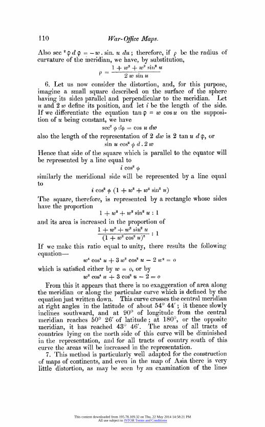
Also sec 2 p d p = - w . sin. u du; therefore, if p be the radius of curvature of the meridiall, we have, by substitution, l + to2 + TV Sill U
P 2 w sitl u 6. Let us now consider the distortion, and, for this purpose, imagine a small square described on the surface of the sphere llaving its sides parallel and perpendicular to the meridian. Let u and 2 w define its p(sition, and let i be the length of the sizle. If we differentiate the equation tan g - w cos u on the supposi- tion of u being constant, we have sec2 + o70 = cos u dw also the length of the representation of 2 dw is 2 tan u d @, or sin az cosi + d .2 w Hence that side of the square which is parallel to the equator will be represented by a line equal to
t cos2 + similarly the meridional side will be represented by a line equal to
i cos2 f (1 w2+w2 sin2 u) The square, therefore, is represented by a rectangle whose si(les have the proportion 1 -t- Wa + We sin2 N 1 antl its area i3 increased in the proportion of + t2 + to2 sin2 U .
(1 +W2 cos2u)2 If we make this ratio equal to unity, there results the followint, equation- u74 cos4 u + 3 w2 cose u-2 ru;S = O which is satisfied either by w = oS or by
w2 cos4 u + 3 cosi tz -2 = o From this it appears that there is no exaggeration of area along the meridian or along the particular curve which is defined by the eqllation just written down. This curve crosses the central meridian at right angles in the latitude of about 54? 44'; it. thence slowly inclines southward, and at 90? of longitllde from the central meridian reaches 50? 26' of latitude; at 180? or the opposite lneri(lian, it has reached 43? 46'. The areas of all tracts of countries lying on the north side of this curve will be diminished in the representation, and for all tracts of country south of this cllrve the areas -ill be increased in the representation. 7. rrhis method is particularly well adapted for the construction of maps of continents, and evell in the map of Asia there is very little distortion, as may be seen hy an examination of the lines
This content downloaded from 195.78.109.32 on Thu, 22 May 2014 14:58:21 PMAll use subject to JSTOR Terms and Conditions

E+planatLon. 7i5e >MIBZB'zbs thei CtraV,ffievijan PieXotehPole. 3Wake 2 f>8O,Ug wetoff2B-BCXCO-SZ=k:7nSP-]O eabh. lha potrt;r -1 gteyond mgzzzJ,S,'c,D,'>c. are the c*es ot the, CErrtes paM'v^CtC Xoavah 4B,C,:S,&c. reJpex.twe.Ey, 2d vre deS-
-mied by X/-99+239;3Bt-6<<2vX2;CCtheOS;9Z7t33>088;kssS 208854;.7St--ZO87bl3 which nurrzbers are fourd opp><te ir correspondiw i;zAes 7o affikz p. 72.
lto draw a Xeian_way thzzt of SG7P:, whi 2s 30 ef ior fiomABP. f7troe7h X,B,R,-r. dro 7S 7irmsSa,Bb,Ce,z.
perpffldi tz7 VBP, and 7.7 - e Xasa a =.81i6X 2 =a..99;Bbbb -766X]5=g.4>9; ('< =^ c' .683 xi5'7.64;Jddd' 5sS00 xlS-
7..<;0; dsc. z2gve t cz7nt2eahna the pori2t;s dz b c...< is the proZection Ot thiss 701eritw. Xe romr2e 6/antffies rserve
for drawi g2eXerin 3a?on the ttt h2d wge of 43<,- and 27gbZrg2y ^bEr tAze otg2er ^ffid>ffi2.
B' JZor d2ese as SHoS
fD72br7zes foZZowz7ag gv.
S i cz g r aX rn>, Jhowcwg tim czppZicafionv of GzbZe ve>.iZ7 to 2SZr,oyeOon of c2 poraon of dm Stfmne of z ( Zarcwe,) JVor of *7mPcxrczAeZ cvf 30?
I ,< R SeSzrvou v
I at. foz ParaDt. Sonbzz*.
i t'SCP vV 239 . 86603 40 68. 282 . 76608 S0 #. 077 . 64279 60 33. 080 .50000 70 20. 854 . 3v202 60 wZ8. iZ03 .<z736S
PEdi for 1ize Jourrtal of tfi Rovg SeographicaT Socizty,by ToAL7t Murrayt /4Zbee7tar7c Strt l o7qdo7z,lo760. .j.'SJ.Lomrry.
This content downloaded from 195.78.109.32 on Thu, 22 May 2014 14:58:21 PMAll use subject to JSTOR Terms and Conditions

for Parallel. Longitude. Lat- P;rallefl?r LOenggete ?df Lat Radills for Degree of
War-OSce Ma7)s. 111
in the accompallying figureX which is suicient to embrace the
whole of Asia. If we represent the surface of tlle whole globe
continuously, the area of the representation is
(4 + T2) tan-l 2 + 27r
which is greater thall the true surface of the g]obe in the propor-
tion of 8 to 5. The perimeter of the representation is equal
to the circumference of the globe multiplied by ,/ 4 + xZ _ 1,
or 2 72. The following Table contains tlle lengths of the radius for the
different arcs of parallel, and also the lengths of a degree of longi-
tude in different latitudes; the unit of length being that chosen
for one degree at the equator. By the aid of this Table the
construction of a projection on any scale is rendered extremely
simple.
? m 1000000 30 99'239 *86603 1 60 330080 *50000
1 32820473 *9998.=, 51 9S?356 *85717 61 31 760 *48481
2 1640* 736 *99939 32 91v692 *84805 62 30-465 *46947
3 1093*268 *99863 33 88*228 *83867 63 299194 *45399
4 8194368 t 99756 34 84 944 * 82904 64 274945 * 43837
5 6540894 *99619 35 81-827 *8191.5 65 269717 *42262
6 .54o 133 *994.59 36 786861 *80902 66 25v510 *40674
7 466@637 *99255 37 76-0%4 * 79864 67 249321 *39073
8 4079681 *99027 38 73*335 ^ 78801 68 23 149 *37461
9 3616751 * 98769 39 706754 * 77715 69 21 * 994 * 35837
10 324-940 *98481 40 68S282 *76604 70 206854 34202
11 294 761 *98163 41 65-911 *75471 71 19@729 *32557
12 269@556 *97815 42 63-633 *74314 72 18-617 *30902
13 248* 175 *97437 43 61 ̂ 442 * 73135 73 17- 517 *29237
14 2292801 *97030 44 59*331 *71934 74 16s429 *27o64
15 2130831 *96593 45 57@296 *70711 75 15w352 *25882
16 1992814 *96126 46 552330 *69466 76 144285 *24192
17 1872406 *95630 47 530429 68200 77 13-228 *22495
18 1762338 *95106 48 51?589 *66913 78 126179 *20791
19 166@399 *94552 49 49*80G *65606 79 l1 137 * 19081
20 157l419 *93969 50 489077 *64279 80 10*103 *1*36,5
91 1499261 *93358 51 46w397 *62932 81 9 075 *15643
22 1416812 *92718 52 44@764 *61566 82 8*052 *]3917
93 134 980 *920.50 53 43-175 @60181 83 7s035 *12187
24 1285688 *9135,5 54 415628 *58779 84 6w092 * 10453
25 12') * 871 * 90631 55 4() * 119 * 55358 85 55013 * 08716
26 1172474 * 89879 ,r) 38 * 646 .5,re919 86 4 - 007 * 06976
')7 112*449 *891()1 57 37*i()8 *54464 87 3-(}()S *()5234
28 107-758 *88i)95 58 359802 *59992 88 290(}1 *()349()
99 103' 3f;4 * 87462 ,rvg 34)4 7 * 515()4 89 1 - 0(>() * 01745
30 99 * 939 * 86603 60 33608t) * 500OU 90 0* 00i) * 0()0t(
Degree of Equator = Degree of Meridiail = 1.
Raclius of sphere _ 57 ̂ 2958.
This content downloaded from 195.78.109.32 on Thu, 22 May 2014 14:58:21 PMAll use subject to JSTOR Terms and Conditions