Embed Size (px)
Citation preview
DESCRIPTION OF THE DEMING QUADRANGLE,
By N. H. Darton.
INTRODUCTION.RELATIONS OF THE QUADRANGLE.
The Deming quadrangle is bounded by parallels 32° and 32° 30' and by meridians 107° 30' and 108° and thus includes one-fourth of a square degree of the earth's surface, an area, in that latitude, of 1,008.69 square miles. It is in southwestern New Mexico (see fig. 1), a few miles north of the international
33
109° 108° 107"
109 108 IO7
FIGURE 1. Index map of southwestern New Mexico and adjacent regionsin Arizona and Texas.
The location of the Deminpr quadrangle (No. 307) is shown by the darker ruling. Lighter ruling shows other quadrangles described in folios : 129, Clifton ; 166, El Paso; 199, Silver City.
boundary and is wholly within Luna County. The town of Deming, from which it is named, is near the center of the quadrangle.
The quadrangle forms a part of the great region of open basins and short, detached, almost parallel mountain ranges, called the Great Basin, that lies south and southwest of the Rocky Mountain province and extends far southward into Mexico. (See fig. 2.) The greater part of the quadrangle is
FIGURE 2. Relief map showing the mountain ranges in southwestern New Mexico and the desert plains out of which they rise.
occupied by bolsons or desert plains, which form a part of the wide belt of such plains that extend south westward for many miles from the valley of Pecos River. Its surface is broken, however, by Cooks Range and Florida Mountains, two of the short mountain ranges that characterize the region, as well as by several small groups of hills. The area is traversed by the wide but shallow valley of Mimbres River.
A preliminary account of the survey of the quadrangle and the surrounding region has been published. 1
1 Darton, N. H., Geology and underground waters of Luna County, N. Mex.: U. 8. Qeol. Survey Bull. 618, 1916.
GENERAL GEOLOGY AND GEOGRAPHY OF SOUTHWESTERNNEW MEXICO.
STRUCTURE.
The Rocky Mountains extend into northern New Mexico, but the southern part of the State is characterized by detached mountain ridges separated by wide desert bolsons. Many of the ridges consist of uplifted Paleozoic strata lying on older granites, but in some of them Mesozoic strata also are exposed, and a large amount of volcanic material of several ages is generally included. The strata are deformed to some extent. Some of the ridges are fault blocks; others appear to be due solely to flexure. The bolsons, some of which are 30 miles or more wide, are former deep valleys, now filled with Tertiary and Quaternary deposits, which in many places are more than 1,000 feet thick and form a nearly level desert floor. This floor is deeply trenched by the Rio Grande, which flows through a valley 400 feet deep near El Paso. In some areas lavas are interbedded with the bolson deposits or have overflowed them. The ridges rise abruptly from a few hundred to more than 5,000 feet above the bolsons and range in length from less than a mile to 90 miles and in places reach a width of 15 miles. The chief ridges of southwestern New Mexico shown in figure 2 are the Mimbres Mountains, Caballos Mountains, Cooks Range, Black Range, Burro Mountain, Mogollon Mountain, Florida Mountains, Big Hatchet Mountains, Sierra Madre, and Pelon- cillo Mountains.
STRATIGRAPHY.
Pre-Cambrian rocks. Rocks of pre-Cambrian age are exposed at but few places in southwestern New Mexico. They outcrop in the Burro and Florida mountains, in Cooks, San Andres, Caballos, San Cristobal, and Sierra Oscura ranges, and at a few
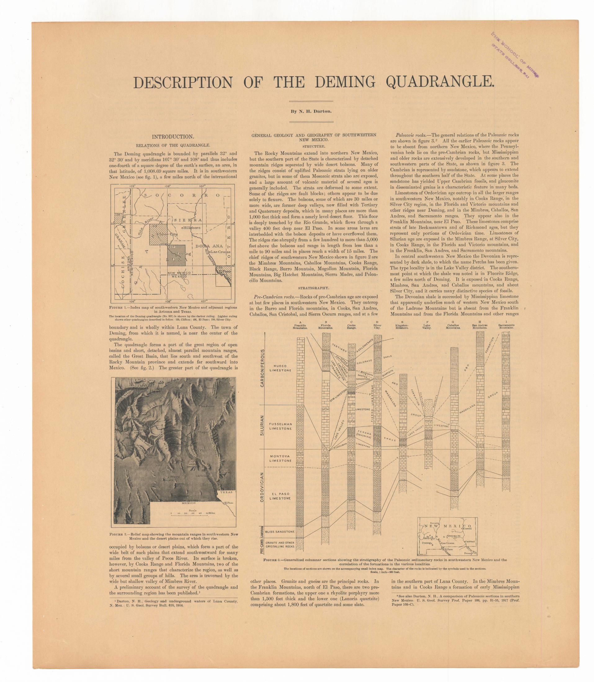
Paleozoic rocks. The general relations of the Paleozoic rocks are shown in figure 3. 2 All the earlier Paleozoic rocks appear to be absent from northern New Mexico, where the Pennsyl- vanian beds lie on the pre-Cambrian rocks, but Mississippian and older rocks are extensively developed in the southern and southwestern parts of the State, as shown in figure 3. The Cambrian is represented by sandstone, which appears to extend throughout the southern half of the State. At some places the sandstone has yielded Upper Cambrian fossils, and glauconite in disseminated grains is a characteristic feature in many beds.
Limestones of Ordovician age outcrop in all the larger ranges in southwestern New Mexico, notably in Cooks Range, in the Silver City region, in the Florida and Victorio mountains and other ridges near Deming, and in the Mimbres, Caballos, San Andres, and Sacramento ranges. They appear also in the Franklin Mountains, near El Paso. These limestones comprise strata of late Beekmantown and of Richmond ages, but they represent only portions of Ordovician time. Limestones of Silurian age are exposed in the Mimbres Range, at Silver City, in Cooks Range, in the Florida and Victorio mountains, and in the Franklin, San Andres, and Sacramento mountains.
In central southwestein New Mexico the Devonian is repre sented by dark shale, to which the name Percha has been given. The type locality is in the Lake Valley district. The southern most point at which the shale was noted is in Fluorite Ridge, a few miles north of Deming. It is exposed in Cooks Range, Mimbres, San Andres, and Caballos mountains, and about Silver City, and it carries many distinctive species of fossils.
The Devonian shale is succeeded by Mississippian limestone that apparently underlies much of western New Mexico south of the Ladrone Mountains but is absent from the Franklin Mountains and from the Florida Mountains and other ranges
BFlorida
Mountains
HUECO
LIMESTONE
FUSSELMAN
LIMESTONE
M O N T O YA
LIMESTONE
EL PASO
LIMESTONE
E wM E x i ic o :oswell
BLISS SANDSTONE
GRANITE AND OTHER CRYSTALLINE ROCKS
FIGURE 3. Generalized columnar sections showing the stratigraphy of the Paleozoic sedimentary rocks in southwestern New Mexico and thecorrelation of the formations in the various localities.
The locations of sections are shown on the accompanying small index map. The character of the rocks is indicated by the symbols used in the sections.Scale, 1 inch=500 feet.
other places. Granite and gneiss are the principal rocks. In the Franklin Mountains, north of El Paso, there are two pre- Cambrian formations, the upper one a rhyolite porphyry more than 1,500 feet thick and the lower one (Lanoria quartzite) comprising about 1,800 feet of quartzite and some slate.
in the southern part of Luna County. In the Mimbres Moun tains and in Cooks Range a formation of early Mississippian
2 See also Darton, N. H., A comparison of Paleozoic sections in southern New Mexico: TJ. S. Geol. Survey Prof. Paper 108, pp. 31-55, 1917 (Prof. Paper 108-C).

age, called the Lake Valley limestone, is extensively developed; it is well represented at Silver City, in Fluorite Ridge, and in San Andres and Sacramento mountains. The later Carbon iferous rocks are of widespread occurrence and great thickness throughout New Mexico. They consist of limestones in the lower part and of red beds, limestones, and sandstones in the upper part. Limestone increases toward the south, and in the Franklin Mountains no red beds appear. Limestone also predominates about Silver City, but in Cooks Range dark shale is the principal rock. In central New Mexico the upper part of the series is called the Manzano group and the lower part the Magdalena group. The upper part is prominent in the Florida Mountains, about Tres Hermanas Mountains, and in some other ranges in southern New Mexico and lies uncon- formably on limestones of Ordovician and Silurian ages.
Hesozoic rocks. In Cooks Range and in the Florida Moun tains the rocks of known Pennsylyanian age are separated from the known Cretaceous strata by a thin formation consisting largely of conglomerate, which is of undetermined age but which is here tentatively classified as Triassic (?).
Probably Cretaceous shales underlie many of the wide bol sons of southwestern New Mexico, but rocks of that age are not extensively exposed. Sandstones of the Comanche series out crop in Cooks Range, in Fluorite Ridge, and near Silver City and are in places overlain by Colorado shale. In the southern part of the State impure limestones of Comanche age appear.
Cenozoic rocks. In southwestern New Mexico the Tertiary system is represented mostly by igneous rocks, partly frag- mental and partly surface flows, but definite evidence as to their exact age is lacking. Their outcrops are extensive, and doubtless these materials underlie portions of the bolsons also. The many flows included in this Tertiary succession present a certain sequence in places, but the relative positions of some of the sheets have not been determined and it is difficult to distinguish between Tertiary and Quaternary eruptive rocks.
The principal Quaternary deposits are widespread sheets of sand, gravel, and clay, which occupy most of the great desert plains. In southwestern New Mexico the plain built of Qua ternary deposits extends from the Rio Grande to the Conti nental Divide and merges into all the larger valleys or bolsons.
CLIMATE.
The climate of the region is similar to that of the wide district extending from western Texas to the eastern part of southern California. The winters are mild, and although in summer the temperature at midday is high, the air is so dry that the heat is more endurable than the heat of the Eastern and Central States. As the altitude of the greater part of the bolson area ranges from 4,200 to 4,800 feet, the heat is much less than in the lower lands of the Southwest. The rainfall is small, averaging less than 10 inches a year in the lowlands and reaching its maximum in July, August, and September. On the mountains the precipitation is greater, as the higher lands receive many snows and showers which do not extend over the valleys. The region lies far south of the normal storm track extending across the central United States, and in consequence the weather is much more uniform than in districts farther north. Nearly 300 days a year have sunshine for the greater part of the day, and long cloudy periods and storms are rare. The following figures of precipitation, temperature, and frost are taken from publications of the Weather Bureau:
Precipitation, in inches, at Deming, N. Hex.
The mean monthly and annual temperatures of the Deming region are much more uniform than the rainfall. The hottest month is June in some years and July or August in other years. December is usually the coldest month.
Monthly and annual temperatures, in degrees Fahrenheit, at Deming,N. Mex,
1882 ___1883 18841885 _ - 1886 1887 - -1888 - 18891890- ____ -1891- ______1892- __ - __1893 ____ 1894 -___ __1695 ______1896 ___ 1897 -1898 __ . _ _1899 _____ 1900- ____ . _1CW11
1902. _ - _ - 1903- - - ___1(W1_
1905 __-_____.1906 _. __ __ _1907- ___ 1908 ______1909 ......1910 ____ ._1911 ___ . ______
Mean - _
10.75
.10
.80
.00,6S.00.26
1.09.58.40.45.19.05.50.60
1.55.75.05.56.40T..49.00
1.58.66
1.4264
T.00
.77
.53
11.00
.00
.70
.75
.50
.201.77
.10
.00
.53
.86
.59
.66
.15T. .20T.T..46
1.87T..85.00
2.03.68.08.31
1.08.00
1.40
.58
fe S
0.501.77.20.52
'.00
.00
.24
.12
.00
.641.84.42.45.00.00 .42
1.42.00.74.11T.
1.00.00
2.15.56.06.18.61.19.67
.49
10.00
.00
.20
.00
.00
.00
.50
.05
.18
.00
.10
.00
.00T..20 .00.80.00.00T..00.00.00
1.87.10.19.94.00.02.88
.18
:*,
0.00.00.00.77.00.00.70.00.00.48.00
1.45.00.58.00 .00.00.00.10T..20.18.00.00.05.89.03.00.00.00
.18
10.48
.10
.001.88
.00
.00
.50
.90
.16
.14
.90
.01
.00
.25
.15
.50T.T.T.T..00
8.32.60
1.05.00.85.08.02.43.96
.59
£
§
1.222.95
.521.831.182.021.081.094.09.18.20
2.82.65
8.764.80 2.891.668.922.10
98.91.01
1.57.90
1.988.181.18.40.96
7.13
2.07
!2.551.411.04
.814.198.46
.60
.642.201.30
.894.38
.95
.851.95 1.411.78.78.08.90
1.61.40
1.581.252.981.951.011.581.02.30
1.86
103
0.52.58.80.09
4.868.39
.008.553.26
.80
.082.64T..00
2.00 1.87.21.54
8.10.05.36
2.844.162.74.64
2.40.00.88.80
1.77
1.43
-u? o O
0.001.821.53
.28
.502.131.60
.84
.47
.001.21.00.45.15
8.25 1.57
.00T..20.75.01.00.80.82.02.41.00.89.00
1.80
.69
11.54
.80
.54
.50
.00
.811.45.80.42.00
1.80.06.00.90.25 .00.10.45.04.8127
.00.64
2 721.841.26T..00.00.00
.52
:§ ft
0.20.88
1.85.91.00.05.27.00
1.25.18.60.10.86.15.00 T.
IV)
T..08T.
1.30.05
1.18QR
1.8800
.18
.70
.00
.42
.63
Annual.
8.719.367 68
7.8411.8611.568.979.18
11.514.557.93
12.663.576.79
12.70 10.416.775.747.415.874.669 no
18.5317.5910.7911.694.506,018.42
15.10
9.70
Year
1QrtR
1909. _ _1910 _______1911 _ __ _'___
Mean 1908-1911
§ ^
41.845.848.0 43.3
,0 CD fe
43.643.044.8 43.2
March.
52.648.257.2 54.9
!56.458.653.9 57.2
164.464.070.3 65.8
§s1-5
76.678.678.0 76.1
^
1
72.281.280.6 76.7
ti3
72.674.478.5 78.6
a<Dt»
70870.276.2 72.7
4J Oo
56.262.562.3 62.6
i£
46.752.051.7 45.2
s?o41.987.042.8 88.4
Annual.
57.959.562.0 59.1
59.6
1908. First killing frost Oct. 19; last, Mar. 19; 28 rainy days; 281 clear; 91 part cloudy; 44 cloudy; 1 foot snow.
1909. First killing frost Oct. 9; last, April 28; 28 rainy days; 230 clear; 107 part cloudy; 28 cloudy ; 10J inches snow.
1910. First killing frost Oct. 20; last, Mar. 30; 14 rainy days; 136 clear; 186 part cloudy; 96 cloudy; no snow.
1911. First killing frost Oct. 22; last, Mar. 18; 40 rainy days; 167 clear; 120 part cloudy; 96 cloudy; 5 inches snow.
VEGETATION.
The natural vegetation of the region is of the kind that results from an arid climate. The bolsons bear scattered shrubs and grasses, locally groves of scrubby mesquite, and more or less yucca. The mountains are mostly rocky slopes that bear only a few small trees, sotol, and cacti of various kinds. Near the springs and at some of the old ranches small clumps of cottonwood are found, but along the dry arroyos the yucca is the dominant growth. Yucca also grows extensively on the sandy plains and at the foot of the ridges. In the Florida Mountains and on Cooks Range there are scattered junipers and some small pines. Grasses grow sparsely on parts of the bolsons and afford scant pasturage for cattle, except in unusu ally dry periods, when it becomes very scarce.
SETTLEMENT.
The Deming quadrangle is thinly populated,' and large areas are not settled at all. The principal town is Deming, a city of about 3,200 population. It has been in existence many years and of late has shown considerable growth. Hondale and lola are small villages, and at Carne, Spalding, Tunis, and Mountain View there are a few houses. Parma and Luxor are only railroad sidings. Formerly the only inhabitants in the country surrounding Deming lived at the widely separated cattle ranches. The very few roads led straight across country from one settlement to another. Recently a large number of settlers have come into the region, taken up homestead claims, and installed irrigation plants. The development of home steads has resulted in the clearing and fencing of an extensive district, and accordingly many of the roads have been changed to follow section lines. Most of the ranches are in the wide plain south and southeast of Deming. Some are scattered along the Mimbres Valley as far as Birchfield ranch, several are near Spalding and east, north, and southeast of Red Mountain, and a few are at other places. The quadrangle is crossed by the main line of the Southern Pacific Co. and by the Silver City branch of the Atchison, Topeka & Santa Fe Railway. The Deming branch of the El Paso & Southwestern Railroad also crosses part of it. Years ago a line was graded from Deming southward through Columbus into Mexico, but the rails were not laid. The grade remains and is utilized as ,a public road. The old Butterfield trail crosses the northern part of the quadrangle and was much used as an emigrant road in earlier days. Fort Cummings, now abandoned and in ruins, was then a military post with troops to convoy travelers through the mountain pass on the west, where at times the Apache Indians were a serious menace.
TOPOGRAPHY.
BELIEF.
General features. The principal features of relief are the ridges constituting the southern termination of Cooks Range and the Florida and Little Florida mountains. These three prominent ridges extend from north to south across the eastern half of the quadrangle, and the Tres Hermanas Mountains,,a short distance south of the quadrangle, are,apparently part of the same range. The gap between Cooks Range and the Little Florida Mountains is 6 miles wide. Red Mountain and Black Mountain are two prominent isolated buttes rising out of the bolson west of Deming, and there are a few other low rocky mounds, among which the Burdick Hills, Snake Hills, and White Hills are conspicuous. About 80 per cent of the area is a plain, nearly level but sloping gently into the wide central valleys and rising steeply at the base of the ridges. The altitude of this plain is about 4,350 feet above sea level near Deming and about 500 feet higher in the northwest corner of the quadrangle. It slopes down to about 4,050 feet in the southeast corner, which is the lowest point in the area. The highest point is a summit of the Florida Mountains, at Arco del Diablo, which is slightly higher than 7,400 feet above sea level.
Mountains. The southern half of Cooks Range extends about 12 miles into the Deming quadrangle, and its higher ridges are prominent topographic features. Cooks Peak, the culminating summit of the range, with an altitude of 8,408
feet, lies 1|- miles north of the margin of the quadrangle. South of that peak the altitude decreases sharply to 7,200 feet at latitude 32° 30' and to 5,125 feet in the pass west of Fort Cummings. South of that pass the range is continued by a series of detached ridges and knobs, some of which rise to 5,500 feet, as far as the railroad northeast of Mirage siding, where the altitude is -about 4,500 feet. Fluorite Ridge (alti tude 5,700 feet) and Massacre Peak (5,450 feet) are outlying ridges.
The main ridge of Cooks Range is characterized by rugged slopes and irregular summit knobs about Cooks Peak flanked by a succession of cliffs rising in huge steps, a feature due to the alternation of harder and softer beds'of limestone lying nearly horizontal. A part of the range, known as Sarten Ridge, is characterized by high cliffs of sandstone facing north and east and by long slopes in the opposite direction. This ridge dies out 3 miles southrsouthwest of Fryingpan Spring. Fluorite Ridge has rocky slopes of sandstone on the north and east sides, porphyry ridges on the south side, and a high limestone knob at the southeast corner. Goat Ridge lies a short distance northwest of Fluorite Ridge. Volcanic rocks in successive sheets and masses form a series of ridges and knobs, several of them rising to an altitude of 5,500 feet, that extends for some distance along the east side of Cooks Range and south of Fort Cummings and reaches southeastward beyond the end of Sarten Ridge.
The Florida Mountains form a high, rugged ridge, in greater part single crested, which begins 9 miles southeast of Deming and extends 9 miles farther south. Its higher sum mits exceed 7,000 feet in altitude, or nearly 3,000 feet above the adjoining bolson. The highest peak, which is just above the Arco del Diablo, has an altitude of about 7,400 feet. One of the peaks near the south end of the ridge rises to 7,200 feet, and Gym Peak is slightly higher than 7,000 feet. The ridge is crossed by several gaps at altitudes of. 6,000 to 6,400 feet, and a prominent outlying butte at the north end of the mountain has an altitude of 5,600 feet. The greatest width of the mountain, near Gym Peak, is nearly 6 miles, but its average width is considerably less., The surface of the moun tain, which is one of the steepest and roughest in the South west, is practically all bare rock, presenting steep slopes, with many precipices and pinnacles. Three kinds of topography are represented on the north, a rugged mass of volcanic agglomerate weathered into crags and pinnacles (see PL II); on the south, precipitous cliffs and peaks of granite; and on the southeast, the Gym Peak ridge mostly limestone, with long rocky slopes due to steeply dipping strata. The Arco del Diablo is an archway eroded through a high wall of agglom erate near the top of the highest part of the ridge. As shown in Plates I and II on the illustration sheet the mountains rise very abruptly out of the surrounding bolson plain.
The Little Florida Mountains lie north of the Florida Mountains, from which they are separated by a low gap about half a mile wide, filled with ; bolson deposits. The ridge is
about 6 miles long, .with south-southeastward trend, and has a maximum width of slightly more than 2 miles; The sides are steep, and the top is in part an; irregular plateau with, knobs and low ridges, the highest of which have an altitude of slightly more than 5,600 feet, or 1,400 feet above the plain. The north end of the mountain consists of.. an outlying butte about 600 feet high, separated from the main ridge by a low rocky gap., The steep west face of, the mountain consists of a thick cap produced by a succession .of sheets of igneous rock lying on softer beds. Some of the steps and irregularities at the southern end are due to faulting. The east slope in places consists of coarse agglomerate,, mostly in \ steep cliffs deeply cut by canyons..
Black Mountain arises abruptly from the bolson about 9 miles due northwest: of Deming. (See PI. IX.) It trends nearly east and! west,, its crest line gradually rising at the west end to a small knob-like summit 5,376 feet above sea level;and 900 feet above, its base. The> dark: color. of its thick cap of basalt has given the; mountain its .name..
Red Mountain is a large conical butte, rising abruptly out of the bolson 10 miles southwest of Deming. Its altitude of 5,418 feet is nearly the same as that of Black Mountain and it rises to approximately the same height above the surrounding plain. Red Mountain is nearly bare of soil and consists mostly of ledges of igneous rock, with long talus slopes of loose slabs along its base.
The conical buttes rising out of the bolson 3 miles south of Red Mountain are known as the Snake Hills. They are from 100 to 200 feet high, and in greater part their slopes are steep, with limestone ledges and cliffs due to the alternation of hard and soft beds. The higher knobs are formed of more resistant cherty beds.
Bolsons. The wide valleys or bolsons which constitute a large part of the Deming quadrangle have a general rise from southeast to northwest. Their altitude in the southeast corner of the quadrangle is 4,000 to 4,100 feet, and they attain an altitude of 4,800 feet 3 miles northwest of Spalding, an up grade of about 750 feet in 44 miles, or about 17 feet to the

mile but the rate is considerably higher from Deming north ward. The bolson surface appears to be perfectly flat except for some few low mounds of sand and shallow arroyos. Near the mountains the bolson slope becomes much steeper or gives place to long, stoping alluvial fans, which are especially conspicuous about the Florida Mountains. (See PI. II.)
DRAINAGE.
The main stream in the Deming quadrangle is Mimbres River, which has a surface flow only in times of exceptional rainfall. Its freshet flow has not been known to reach beyond the central part of T. 25 S., R. 7 W., where the channel spreads out widely in the desert bottom. Nearly every year the water passes Spalding at times of heavy rainfall. Not infrequently it extends to Deming and beyond, but its flow period is very short and for the greater part of the year its bed in the Deming quadrangle is dry sand. (See PI. VI.) An important affluent is San Vicente Arroyo, which joins the Mimbres a mile south of Spalding and in time of flow brings a large volume of water from the Silver City district. The drainage of Cooks Range, Little Florida Mountains, and the east side and north end of Florida Mountains belongs to the main Mimbres system but rarely reaches the river channel. A line from Red Mountain to White Hills and the center of the west side of Florida Mountains approximately defines a watershed, south of which the surface slopes into the valley of Palomas Arroyo, whose channel crosses the southwest corner of the quadrangle. This arroyo passes through the gap at the south end of Florida Mountains and into the southern exten sion of the Mimbres valley near the international boundary line. This valley extends into a large inclosed basin in Mexico.
DESCRIPTIVE GEOLOGY.
STRATIGRAPHY.
ROCK FORMATIONS.
The rocks of the Deming quadrangle are in part of sedi mentary and in part of igneous origin. The sedimentary rocks range in age from Cambrian to Quaternary and include strata known to belong to all the systems except the Triassic and Jurassic, but the Silurian, Devonian, and Cretaceous systems are only slightly represented. The Paleozoic and Mesozoic strata consist of widespread sheets of limestone, shale,
Devo nian.Silu rian.
Unconformity
Upper Dev.
Niag ara.
.HOKQ
Bolson deposits.
Agglomerate and associated detrital rocks.
Unconformity
Colorado shale. Unconformity
Sarten sandstone.
Unconformity
Lobo formation. Unconformity
Unconformity
Lake Valley lime stone.
I, I
Percha shale. Unconformity -
1,665 f
1,600+
8004-
30-1,000
Fusselman limestone.
Montoya limestone.
Unconformity
El 1'aso limestone.
Unconformity '( -
Bliss sandstone.
Unconformity
Granite.
Character of rocks.
Basalt lava flow.
Mountain wash of sand, gravel, and clay, cemented into caliche near surface. The sand and gravel are water bearing. Overlain in places by alluvium and dune sand.
Agglomerate, tuff, flow breccia, ash, sand, gravel, sandstone, and con glomerate. Sheets of andesite, la- tite, quartz basalt, rhyolite, felsitic rhyolite, and keratophyre are inter- bedded with the sediments.
Dark-gray argillaceous shale with limy concretions and sandy layers.
Light-gray sandstone mostly hard and massive.
l?ed and gray shale with layers of impure pink limestone; conglom erate at base.
Light-gray massive limestone, partly brecciated, with dark-gray fissile shale and oherty limestone in upper part.
3ray limestone, slabby to massive, with interbedded calcareous shale; thick chert at top.
Dark-gray to black fissile shale.
Dark-gray compact limestone.
Light-gray limestone with chert layers at two horizons; dark massive lime stone at base.
Lighkgray slabby limestone; dark limestone locally at base.
Gray to buff hard massive sandstone; pebbly arkose at base; shaly, glau- conitic, and limy near top.
Pinkish massive granite with subor dinate darker varieties, gneissic granite, and diorite.
FIGURE 4. Generalized columnar section of the rocks of the Deming quad rangle, N. Mex. .
Scale, 1 inch=l,000 feet.
and sandstone, which belong chiefly to the Ordovician, Car boniferous, and Cretaceous systems. The Cenozoic deposits consist in part of volcanic agglomerate and other pyroclastic
Deming
rocks of Tertiary age, interbedded with more or less ordinary detrital sediment, and in part of clay, sand, and gravel of Quaternary age, filling the former deep valleys between the mountain ranges and forming the extensive bolson deposits. Prdbably considerable areas of the bolsons are also underlain by Tertiary and Cretaceous rocks. The sequence, thickness, and general character of the beds are shown in figure 4.
The igneous rocks are in part of pre-Cambrian and in part of Cenozoic age. The pre-Cambrian rocks are granite and associated small masses of other crystalline rocks, that form a floor upon which the stratified rocks are deposited. The Cenozoic igneous rocks are in part intrusive porphyry, and in part latite, andesite, and rhyolite of Tertiary age, mostly in effusive flows extensively interbedded with the pyroclastic deposits, and basalt flows of Quaternary age. There are also intrusive sheets, stocks, and dikes cutting the older rocks. The whole complex of Tertiary igneous rocks and inclosing beds is undoubtedly the product of a single epoch of great volcanic activity.
SEDIMENTARY ROCKS.
PEE-CAMBEIAN EOCKS.
The sedimentary rocks of the quadrangle lie unconformably upon a floor of pre-Cambrian crystalline rocks. The basal contact of the sedimentary rocks is exposed in a number of places in the quadrangle, and everywhere the underlying rock is granite of a rather uniform type. The age of the granite is not known, except that it is pre-Cambrian. Associated with it are small masses of rock of syenitic or monzonitic character and of granite porphyry. The granite is cut by a few hornblendic dikes of unknown age. Some portions of the granite and asso ciated rocks are gneissic and possibly may be inclusions derived from a complex of older rocks. The rocks associated with the granite are not mapped separately.
GRANITE.
Distribution. The granite is most prominently exposed in the southern half and on the southwestern slope of the Florida Mountains, where it occupies an area of more than 30 square miles and forms peaks and ridges which rise 2,500 feet or more above the adjoining bolson. It is also exposed on both the southern and the northern slopes of Fluorite Ridge, on Goat Kidge, and in the Pony Hills. It may be of wide extent immediately beneath the bolson deposits.
Relations and age. The granite is overlain unconformably by the Bliss sandstone, of Upper Cambrian age. At the con tact the usual features of shore deposition are displayed a slightly irregular floor of granite overlain by* coarse sediments showing no evidence of metamorphism. At numerous places the granite is in contact with other Paleozoic rocks, but these contacts are faults. On the slope 2 miles south of Gym Peak the granite is so intricately faulted that it appears to include and to penetrate the upper part of the Gym limestone, but the limestone is not metamorphosed, the granite retains its coarse grain up to the contact and shows evidence of crushing, and the relations indicate a complex overthrust along several planes. In the Pony Hills the granite may be overlain by the Sarten sandstone, which would indicate a great overlap; but faulting is more likely.
Character. The granite is chiefly a massive coarse-grained pale-reddish to light greenish-gray rock, weathering into rugged forms of brownish tint. There are some local variations in character and composition, notably the development of band ing or gneissic structure in a few places. There are also small included masses of darker rocks, mostly dioritic and por phyritic, some of which may represent an older complex, as suggested, and some of which may be younger intrusive masses.
Petrography. 1 Most of the granite is of uniform mineralogic constitution, consisting essentially of quartz, feldspar, chlorite, and iron oxides, but in general the granite in the Florida Mountains contains a larger proportion of sodic feldspars than that in Fluorite Ridge. The granite near and south of Capitol Dome consists almost entirely of feldspar and quartz, the former predominating. Microscopic examination shows the feldspar to be a peculiar microperthitic intergrowth of orthoclase and albite or oligoclase. The quartz crystals are somewhat deformed. Ferromagnesian minerals, other than magnetite, are entirely altered to aggregates of chloritic material mixed with magnetite or hematite. The outlines indicate the former presence of mica, which, however, was not abundant. Magnetite, apatite, and zircon are accessories.
The light-colored granite of the Florida Mountains shows some local variations from the type described, but the outcrops are of small extent. In one area, south of Capitol Dome, the rock contains abundant quartz, microperthitically inter- grown orthoclase and albite, and aggregates of green chlorite and of yellowish secondary biotite and magnetite, which is fairly abundant. Accessory minerals are zircon and apatite. The rock is gray to drab in color, of rather fine texture,
1 The petrographic descriptions in this folio were prepared by John L. Bich.
and is in places somewhat porphyritic. A normal pinkish granite from south of The Park differs from the type only in having a higher proportion of quartz and, perhaps, a more pronounced red color. The red color of this, as well as of most of the granite of the Florida Mountains, is due, in part, to staining by hematite, which, as a product of the decompo sition of the mafic minerals, has spread into the cleavage cracks of the feldspar and into the fracture planes of the quartz crystals.
In the granite of Fluorite Ridge the albite and the ortho clase are in separate crystals, but the rock is closely similar to that of the Florida Mountains in most of its features. The granite of the Pony Hills is mostly of light pinkish-gray color and of uniformly medium coarse texture, the crystals averaging from 2 to 5 millimeters in diameter. Pink and white unstriated feldspar, quartz, and biotite are the most noticeable minerals in the granite, with smaller amounts of dark minerals.
Gneissic phases. Portions of the granite on the slope south of Capitol Dome are gneissic. At one place a fine-grained, light-gray granitic or aplitic gneiss is composed almost entirely of quartz and feldspar, with very subordinate ferromagnesian minerals. Gneissic banding, revealed by the stringing out of the dark constituents, is distinct. Microscopic examination of the powdered rock shows abundant quartz, orthoclase, and albite in about equal proportions, and subordinate biotite, generally altered to chlorite. At Another place not far distant the granite is gray to drab and is notably granulated. The microscope reveals a medium-grained, slightly porphyritic texture, with perthite (orthoclase and albite) and quartz as essential minerals. The quartz crystals are markedly granu lated, and fragments of them are pressed into the feldspars. Ferromagnesian minerals are represented by secondary aggre gates of deep-green chlorite and yellow biotite. Accessory minerals are apatite, magnetite, and considerable zircon.
The gneiss occurring in large fragments in the breccia on the southern slope of Fluorite Ridge is a gray rock, consisting of quartz, feldspar, and brown-green biotite, of typical granitic character but having pronounced gneissic banding. The feld spar crystals, whose maximum length is 3 millimeters, are mostly orthoclase and microcline, with subordinate albite. The pink orthoclase in the gneiss gives it a pink to purplish tint.
A somewhat similar gneissic granite occurs in places in the Pony Hills. It is rather fine grained, of dull-gray color, and has a well-defined banding.
A third notable variety of gneissic granite outcrops on the lower slope of Fluorite Ridge half a mile southwest of Fluor Camp and about 500 yards south of the breccia just described It is of bright-red color and of medium-grained, evenly gran ular texture, with gneissic banding only slightly developed. Individual crystals measure 3 millimeters in diameter. The minerals visible are pink feldspar, quartz, and subordinate altered ferromagnesian silicates. Under the microscope the rock exhibits strong granulation, as most of the quartz is crushed into small fragments. The feldspar is microcline and albite in about equal proportions. Most of the microcline is fresh, but the albite is considerably altered to sericite. Another product of alteration is an iron stain that gives the rock a red color. Green, strongly pleochroic chlorite is the principal ferromagnesian mineral. Apatite' is an abundant accessory; magnetite is rare. (
Although these three granitic gneisses exhibit differences in color, texture, gneissic banding, and granulation of the com ponent minerals, they are closely similar in composition and are doubtless all of the same age.
Part of the granite at the foot of Fluorite Ridge, southwest of Fluor Camp, is notably porphyritic. It is of marked green color and shows scattered phenocrysts of pink orthoclase, 2 centimeters in length and 1 centimeter in width, embedded in a granular matrix composed essentially of abundant biotite and quartz and of light-green sericitized albite in crystals, some of which measure as much as 1 centimeter across. The micro scope shows also a subordinate amount of microcline in the groundmass, in addition to the cloudy sericitized albite. Accessory minerals are apatite, magnetite, and leucoxene, probably derived from original ilmenite. The rock has been crushed, for the quartz shows much granulation and undula- tory extinction. There is a slight tendency toward gneissic banding revealed by the arrangement of the mica flakes.
ROCKS ASSOCIATED WITH GRANITE.
Gray granite. The granite of the Florida Mountains includes some masses of rocks, of a character somewhat dif ferent from normal, which outcrop on the slope west of Arco del Diablo, in the pass east of The Park, and at other places in the central and southern parts of the mountains. They are either inclusions or local developments of the ordinary pinkish granite, or possibly they are irregular dikes of post-Cambrian intrusion.
The rock is moderately coarse grained, the crystals averaging about a centimeter in diameter. Fresh specimens have a slaty
specimens unstriated feldspar and subordinate quartz, much of blue to drab color and weather yellowish brown. In the hand it interstitial, are the only minerals recognizable. Microscopic examination of the powdered rock shows that the feldspar is mainly anorthoclase, with a little orthoclase and some albite. There is considerable variety in the amount of quartz in the granite from different outcrops. Rock from the slope west of Arco del Diablo contains a moderate amount of quartz but much less than a normal granite, and the rock from the pass northeast of The Park contains none that could be detected with the hand lens, although a little could be seen in the powdered rock. A finer-grained, more siliceous phase at the "Window Mountain" mine, southwest of Arco del Diablo, differs from the coarser variety in containing a greater amount of quartz and slightly more orthoclase, and in the size of its component crystals, which do not average half the size of those of the other. A closely similar rock is associated with the granite just south of Capitol Dome. In it, as in the coarser variety first described, anorthoclase and albite are the domi nant feldspars. This rock is in turn cut by a fine-grained dike of altered diabase.
In these exceptional rocks the sodic feldspars, anorthoclase and albite, are predominant, and orthoclase, although present in small amounts, is distinctly subordinate. The quartz is subordinate, indicating a transition to syenite. The color of the rocks, blue-gray when fresh, greenish or brownish yellow when weathered, distinguishes them from the typical granite, which always has a pronounced pink or red cast.
Granite porphyry. Some rocks cutting or included in the granite of the Florida Mountains approach sodic granite por phyry in character, but as they are rocks of intermediate com position they are difficult to classify definitely. The more siliceous types approach the sodic granite porphyries, and the more mafic are related to the quartz monzonite porphyries. All are moderately dark and have a general greenish-gray cast. White feldspar phenocrysts, 15 millimeters across,, lie in a darker fine-grained groundmass. In some of the rocks of this class, included in the granite along the southern slope of the Florida Mountains, the porphyritic character is lacking. Micro scopic examination shows that the phenocrysts are prevailingly albite, but at one locality, a quarter of a mile southeast of Capitol Dome, part of the phenocrysts are perthitic inter- growths of orthoclase, albite, and oligoclase in various pro portions, quartz, green hornblende, and subordinate biotite. Quartz is everywhere present but in various amounts; in general it is subordinate and interstitial. The dark silicates are in inverse proportion to the amount of quartz. They include augite, green hornblende, and biotite. Hornblende is the most abundant and is evidently, at least in part, an altera tion product of the augite; for in some places cores of unaltered augite surrounded by green hornblende still remain. Biotite is the brown variety, with pleochroism from yellow to deep brown, in places altered to green chlorite. Accessory minerals include magnetite, ilmenite, apatite, titanite, and a little pyrite.
Hornblendic dikes. The dark rock of the dikes cutting the granite southwest of Capitol Dome is an amphibolite com posed mainly of hornblende and subordinate feldspar. The rock associated with the granite and probably cut by it half a mile southwest of Fluor Camp is of similar character. More or less gneissic banding is developed at both places. The rock southwest of Fluor Camp is almost black, and the banding is brought out by white specks of feldspar. The texture varies, but some crystals are as much as a centimeter across, and the larger ones lie in definite bands. Under the microscope the powdered rock shows green hornblende as well as feldspar ranging from oligoclase to andesite.
The rock south of Capitol Dome is finer grained, and the feldspar is albite. Quartz is also present in small amount. In this vicinity the granite is cut by a dike or includes a mass of porphyritic diorite containing white labradorite crystals meas uring 8 millimeters across, which contrast strongly with the dense, dark-green to black, fine-grained groundmass. The labradorite is considerably altered to sericite. The ground- mass consists of laths of andesite-labradorite, between which is packed an aggregate of secondary green hornblende, subordi nate biotite, perhaps also secondary, and chlorite. Magnetite and ilmenite or leucoxene are abundant accessories.
CAMBKIAN SYSTEM.
UPPER CAMBRIAN SERIES.
BLISS SANDSTONE.
Name and distribution. Lying on the eroded surface of the granite and forming the base of the Paleozoic strata is a sand stone that stratigraphically and lithologically so closely resem bles the Bliss sandstone of the El Paso quadrangle that the name Bliss is here applied to it. It is exposed in the' Florida Mountains for about a mile on the slope west of Capitol Dome, for about half a mile in the cliffs east of The Park, and on the slope north of Gym Peak. It outcrops also on the southeast ern slope of Fluorite Ridge, just west of Fluor Camp.
Character and thickness. The formation consists of gray to buff massive sandstone, partly quartzitic, in beds 30 to 40 feet
thick, separated and overlain by beds of slabby sandstone and of sandy shale containing much green glauconite in dissemi nated grains, a feature characteristic of later Cambrian rocks in other places in the West. The upper beds contain a few limy layers.
The exposed thickness is about 200 feet in the north end of the Florida Mountains, about 160 feet on Fluorite Ridge, and considerably less near Gym Peak.
Relations. The basal contact is well exposed for nearly a mile on the northwestern side of the Florida Mountains, where the coarse sandstone lies on the slightly uneven eroded surface of the granite. (See PI. III.) The basal beds are arkosic and pebbly. In the exposures west of Fluor Camp the basal quartzite stands nearly vertical and appears to be separated from the granite by a small fault.
At the top of the formation the sandstone grades into sandy shale and slabby sandstone, which give place abruptly to the El Paso limestone without discernible evidence of erosional unconformity to represent the supposed interval between the deposition of the two formations.
Age and correlation. No fossils have been found in the formation in the Deming quadrangle, but in the Franklin Mountains near El Paso, the type locality, the Bliss sandstone contains Upper Cambrian fossils. Its stratigraphic relations and general character indicate that it is equivalent to the "S hand on quartzite" of central New Mexico and to the basal sandstone of the Silver City region.
OKDOVICIAN SYSTEM.
ROCK FORMATIONS.
In the Deming quadrangle the Ordovician S3rstem is repre sented by a thick deposit of limestone, the lower part of which is of Beekmantown (Lower Ordovician) and the upper part of Richmond (Upper Ordovician) age. A large part of Ordovi cian time, however, is not represented by deposits, the whole of the Middle Ordovician and parts of the Upper and Lower Ordovician being absent, so that there must be an unconform ity between the formations. On the basis of lithology, fossils, and stratigraphic position the lower formation has been corre lated with the El Paso limestone of the El Paso quadrangle, and the upper formation with the Montoya limestone of the same quadrangle. In most places it is difficult to determine the upper limit of the Montoya and to separate it from the Fusselman limestone, of Silurian age, which overlies it nearly everywhere. Therefore the Montoya and Fusselman limestones have not been separated in this folio but are mapped together.
LOWER ORDOVICIAN SERIES.
BL PASO LIMESTONE.
General character. The El Paso limestone, ,500 to 800 feet thick, consists mainly of light-gray slabby limestone and dolomitic limestone. It begins abruptly at the top of the Bliss sandstone and ends abruptly at the base of the Montoya lime stone. Portions of the formation are slightly cherty, and some beds contain considerable sand or clay. Pale reddish-brown elongated blotches on the bedding planes are characteristic, and the slabby bedding and light tint on weathering are also distinctive of the formation.
Distribution and occurrence. The most extensive outcrops are in several localities in the Florida Mountains and in the Snake Hills. A smaller area is exposed in the southeastern part of Fluorite Ridge.
The exposures in the Florida Mountains near Capitol Dome, east of The Park, and north of Gym Peak show all the beds. Small outcrops of the upper beds lie at the foot of the western slopes of the two ridges west of The Park. The out crop west of Capitol Dome extends for more than a mile along the lower slope of the mountain, rising steeply from the ledges of Bliss sandstone to the dark massive limestone at the base of the Montoya and in places to unconformable overlap by the Lobo formation. At this locality the beds are about 800 feet thick. The rock is gray limestone, in part dolomitic, and con tains a few layers or nodules of chert. Most of it is light gray, in beds 2 to 6 inches thick, but about 140 feet of the basal beds is more massive and much darker than the rest. The exposures east of The Park on the summit and on the west ward-facing slope show about 700 feet of beds lying on Bliss sandstone and capped by Montoya or Gym limestone. The formation is exposed extensively on the northern slope of the Gym Peak ridge and in outlying ridges on the north, where it underlies the Montoya and is cut by several faults. Its thick ness appears to be fully 800 feet and possibly more, notably in one long section of nearly vertical beds on the north side of the draw about 1^- miles due northwest of the peak. A small mass lies just north of the road half a mile east of Byer Spring. On the slope a mile southeast of the spring the formation includes a thick mass of brown chalcedony, apparently due to local replacement of some of the limestone, and other similar masses appear along a fissure on the slope east of The Park.
The formation constitutes the central and eastern parts of the Snake Hills, where the thickness exposed is not more than 700 feet. The lowest beds exposed at the east end of the
ridge are a typical light-gray slabby limestone, which extends to the first knob west of the county road, where it gives place abruptly to dark massive sandy limestone at the base of the Montoya. The contact displays unconformity by planation, with some slight channeling.
The formation also outcrops for nearly a mile in the knob just west of Fluor Camp, where it lies on or against Bliss sandstone, and its nearly vertical beds are so crushed that a thickness of only 400 feet is exposed in the eastern part of the knob and somewhat less farther west.
fossils and age. Fossils are scarce in the formation, but a few were found in each area of exposure. They were examined by Ulrich and Kirk and most of them found to be a species of Ophileta, of Beekmantown age. A few fossils were collected from light-gray limestone near the top of the formation. Those found at this horizon in the Snake Hills were identified by Edwin Kirk as Dalmanella cf. D. pogonipensis Hall and Whitfield and Hormotoma sp. On the west slope of Gym Peak were found Strophomenaf near S. nemea Hall and Whit- field, Hormotoma sp., and Trochonema sp. The brachiopods are close to forms described from the upper part of the Pogonip limestone, of the Eureka and White Pine districts in Nevada, and indicate late Beekmantown age. On the evidence of these fossils and on its close similarity in lithologic character and stratigraphic relations the formation is correlated with the El Paso limestone of the type locality in the Franklin Mountains, near El Paso. It also represents the lower part of the Mimbres limestone, as it has been called by Gordon, in the region north of the Deming quadrangle.
UPPER ORDOVICIAN SERIES.
MONTOYA LIMESTONE.
General character. The Montoya limestone in the Derning quadrangle has the same general character as in the type local ity near El Paso. Its thickness in the quadrangle is nearly everywhere 250 to 300 feet. Most of it is light gray. Several beds contain a large amount of chert, which makes the rock more resistant to weathering and hence more prominent in outcrop. Much of the chert is in thin layers alternating with pure limestone. At the base of the formation is a dark-gray, more massive member.
The formation overlies the El Paso limestone without notice able difference in attitude, but in places an abrupt change in lithologic character and some other features indicate uncon formity. The upper limit of the formation, as exposed in the quadrangle, is somewhat indefinite and is arbitrarily placed at the top of the highest beds containing distinctive fossils. In places the formation is overlain unconformably by the Gym limestone, at Capitol Dome by the Lobo formation, and in other places by the Fusselman limestone. As the Fusselman is thin and not very distinct, it is not separately mapped in this folio.
Distribution and occurrence. The formation outcrops exten sively about Gym Peak and in The Park in the Florida Moun tains, at the west end of the Snake Hills, and in the knob south of Fluorite Ridge. A small mass is exposed on the slope west of Capitol Dome.
The most extensive exposures are along the westward-facing cliffs east of The Park and along the western and southern slopes of Gym Peak and of the ridge next northeast of that peak. The beds extend down the northern slope of Gym Peak in an outcrop If miles long and appear again a mile southeast of Byer Spring. The formation outcrops also on the western sides of the two ridges west of The Park. The thickness of the small mass on the slope west of Capitol Dome is 145 feet, comprising 50 feet of dark massive limestone at the base, overlain by 25 feet of cherty limestone and 30 feet of dark sandy limestone, capped by 40 feet of cherty limestone.
The formation is extensively exposed in the high knobs and ridges forming the western half of the Snake Hills and begin ning a short distance west of the main road. At the base is dark impure massive limestone, abruptly separated from the El Paso limestone by apparent erosional unconformity. This is succeeded in order by cherty limestone, with alternate layers of pure limestone, by 30 feet of massive sandy dark-gray lime stone forming low cliffs and grading into 35 feet of purer, partly massive limestone weathering to a dirty olive, and by 60 feet of alternate thin layers of cherty limestone and purer limestone containing fossils. At the top, capping the highest butte on the ridge, is a thick mass of highly cherty rock. Apparently all these beds about 300 feet thick and forming the whole height of the ridge are Montoya limestone.
In the hill west of Fluor Camp the formation is prominent on account of the conspicuous silica or chert beds that it con tains. As in other exposures there is dark massive limestone at the base, followed by cherty limestone, the chert mostly in thin layers alternating with relatively pure limestone. Higher up is purer slabby gray limestone containing many fossils and still higher a thick body of highly cherty rock. At the top is 50 feet of massive limestone of unknown age, possibly Fusselman. A short distance to the southeast are several small but promi nent ridges made up of thick beds of massive chert apparently
replacing a limestone, probably the Montoya, but as the chert is nearly surrounded by porphyry and is cut by faults its relations could not be determined.
Fossils and age. In the medial beds of the Montoya lime stone between the cherty members fossils are particularly abundant. The following species have been identified by Ulrich and Kirk:
Eurydictya cf. E. montifera. Dinorthis subquadrata. Plectorthis whitfieldi. Hebertella occidentalis. Dalmanella cf. D. meeki. Damianella near D. jugosa. Platystrophia acutilirata var. Strophomena cf. S. subtenta. Rhynchonella anticostiensis
(argenturbica White).
Rafinesquina loxorhy tis. Leptaena unicostata. Plectambonites saxea. Rhynchotrema capax. Zygospira recurvirostris. Cyrtodonta sp. Vanuxemia sp. Buinastus sp.
In beds between the two chert series on the limestone knob west of Fluor Camp Strophomena cf. S. subtenta, Platystrophia acutilirata var., Rhynchotrema perlamellosa, and Streptelasma rusticum were obtained.
These species are characteristic of the Richmond fauna, which is found in various parts of the Rocky Mountain region. The formation is therefore of Richmond age throughout.
SILURIAN SYSTEM.
FUSSELMAN LIMESTONE.
Character and distribution. The Fusselman limestone prob ably overlies the Montoya limestone in most areas in the Deming quadrangle, but as it is not well characterized and is difficult to separate, it is not separately mapped in this folio. It has been identified in the Victorio Mountains a short dis tance to the west and in Cooks Range not far to the north, but the evidence of its presence in the Deming quadrangle is less satisfactory. About Gym Peak and near The Park the fossil iferous beds of Montoya limestone are overlain in most places by dark-gray limestone, in part thin bedded, which contains a few corals believed to be of Fusselman age. It is succeeded by the Gym limestone, which lies on an irregular surface of unconformity that cuts down into the Montoya limestone in places but in general is difficult to locate precisely. On Fluor ite Ridge the upper cherty member of the Montoya is overlain by or faulted against a massive gray limestone that may be Fusselman but has more the character of the Lake Valley limestone, and is so mapped.
Age and correlations. In the Cooks Peak and Silver City regions the Fusselman limestone is thin but it contains large numbers of a distinctive Pentamerus, and in the Victorio Mountains it contains an abundant and characteristic coral fauna, which indicates that it is of upper Niagara age. On the basis of its lithology and fossils the formation is, therefore, correlated with the Fusselman limestone in the type locality in the Franklin Mountains near El Paso.
DEVONIAN SYSTEM.
PEBCHA SHALE.
Outcrop and relations. Black fissile shale, lithologically like the Percha shale of the Silver City, Lake Valley, and Cooks Peak districts, is exposed in a deep valley' on the east side of Cooks Range, at the northern margin of the quad rangle, and in two small areas north and northwest of Fluor Camp. No fossils were obtained from this shale in the Deming quadrangle, and the only evidence of its age is its close similarity in material and stratigraphic position to the fossiliferous Percha shale (late Devonian) in the type locality, in Lake Valley district not far north. The thickness in Cooks Range is about 150 feet, measured from porphyry below to basal ledges of Lake Valley limestone above. Apparently the plane of porphyry intrusion is close to the base of the forma tion. In Fluorite Ridge the thickness of Percha shale is about 150 feet, with the base cut off by a cross fault in the western exposure, and by porphyry and a fault in the outcrops north of Fluor Camp. In the Florida Mountains the Percha shale and the Lake Valley limestone are lacking or overlapped, for younger limestones appear to lie directly on the Montoya limestone. There is a small showing of black shale along the fault between granite and limestone half a mile west of Gym Peak, which is probably of the same age as the dark shale apparently included in the Gym limestone a mile southeast of that peak. This shale may be the Percha lifted by a fault.
CARBONIFEROUS SYSTEM.
GENERAL CHARACTER.
The Carboniferous system is represented in the quadrangle by parts of both the lower and the upper-Carboniferous beds, separated by a very considerable hiatus. The rocks are chiefly limestone, with some shale and conglomerate. The Missis- sippian series is represented by the Lake Valley limestone, of early Mississippian age, and the upper part of the Carbon iferous system by the Gym limestone. Possibly the Lobo formation belongs in the late Carboniferous, though that for mation is regarded as Mesozoic, and because of its unconform- able relations it is classified as Triassic (?). The higher formations overlap southward, and in the Florida Mountains
Ueinmg.
the Lake Valley limestone is absent and the younger limestone lies directly on Montoya and El Paso .limestones.
MISSISSIPPIAIT SERIES.
LAKE VALLEY LIMESTONE.i
Name and distribution. The Lake Valley limestone was named from Lake Valley, in the region on the north, where the formation is conspicuously exposed. In the Deming quad rangle it consists chiefly of slabby to massive gray limestone, which has a thickness of 500 feet in Cooks Range, but it thins southward and is lacking in the Florida Mountains. The formation occupies much of the central slopes of Cooks Range, but the southerly dip in Sarten Ridge carries the beds below the surface about a mile south of the northern margin of the quadrangle. A small mass is exposed in the limestone knobs at the southeast end of Fluorite Ridge.
Character. In Cooks Range the beds form a succession of cliffs separated by steep slopes, the latter marking the outcrop of soft, calcareous shales. At -the base is a massive bed of light-gray limestone lying on Percha shale with ;no noticeable difference in dip. At the top are thick deposits of chert, above which is probably the Gym limestone, capped in turn by conglomerate of the Lobo formation. One measured sec tion, including 100 feet of the upper cliff-making bed of massive gray limestone, is as follows:
Section of upper part of Lake Valley limestone, Gym limestone (f), andLobo formation in Cooks Range. \
Lobo formation: Feet. Conglomerate, with limestone matrix._.__________ 30Shale, red _________________ -_____, 50Conglomerate _____________ ._____________ 10
Gym limestone (?):Limestone, nodule bearing ______._____.. ___ 5Limestone, blue ____________ -__.. ______ 20Conglomerate, with some red jasper pebbles..__ __ _ 5
Lake Valley limestone:Limestone, cherty_________________.._____ 3Limestone, gray, with Mississippian fossils ________ 3Conglomerate or breccia of white chert ____.__!-___ 10Chert, white, with crinoid stems___.___________ 20Limestone, gray, massive ______.____________.__ 100
There are no fossils to prove the presence of the Gym limestone, and therefore all the beds may be Lake Valley. The top of the lowest bed in the section is about 450 feet above the Percha shale.
At the southeast end of Fluorite Ridge about 100 feet of the formation outcrops on the northern side of the first porphyry knob and 300 feet on the southern side. It lies on Percha shale at both places, as shown in figure 9 (p. 11), and is cut off laterally by faults or igneous intrusives.
Fossils and age. The formation is abundantly fossiliferous at some localities. The following species, obtained from the cliffs 4 miles northwest of Fort Cummings, were determined byG. H. Girty:
Endothyra sp. Rhombopora sp. Leptaena rhomboidalis. Schuchertella sp. Productus semireticulatus. Productus laevicostata.
Productus aff. P. burlingtonensis.Dielasma sp.Spirifer sp.Composita? sp.Paraparchites sp.Bairdia sp.
In exposures at the southeast end of Fluorite Ridge half a mile west by south of Fluor Camp were found Spirifer cen- tronatus, Leptaena rhomboidalis, Pinnalopora sp., and several species of Fenestella.
These fossils are regarded by Girty as characteristic of the lower part of the Mississippian series. The upper part of the series is not present in the Southwest.
LATER CARBONIFEROUS ROCKS.
GYM LIMESTONE.
Definition. The Gym limestone is named from Gym Peak, where the formation is extensively exposed. Its maximum thickness in the quadrangle, in and southwest of Gym Peak, is 1,000 feet.
Distribution and relations. The formation occupies the summits of the high ridges at and northwest of Gym Peak and of the two ridges west of The Park, and it extends down the southeastern slope of Gym Peak. Several small out lying masses are intricately faulted into the granite on the lower slopes, 2 miles south of the peak. The formation appears to be absent in Fluorite Ridge but apparently occurs in Sarten Ridge.
In most places it lies on an uneven, eroded surface of the Montoya limestone and possibly in places on the El Paso limestone. In the Florida Mountains it is overlain only by the bolson deposits of Quaternary age. In Sarten Ridge the supposed Gym limestone rests on Lake Valley limestone and is overlain by the Lobo formation.
Character and local features. The formation consists chiefly of limestone, in great part massively bedded, of light-gray color and showing a brecciated structure in many beds. On and west of Gym Peak the lower part is dark and the upper part much lighter colored, the change from one to the other being abrupt. The thickness in this vicinity is about 700 feet. In the canyon a mile southeast of Gym Peak, where the beds dip steeply southward, the limestone apparently in the middle of
the formation is overlain by 80 feet of dark-gray fissile shale, which is traceable for about half a mile and reappears along the fault on the trail a .shprt distance west of Gym Peak* This shale may be the Percha, lifted by a branch fault and elsewhere overlapped by Gym limestone. This shale is over lain on the east by cherty .beds of Gym limestone containing abundant Manzano fossils and is cut off on the west by the great fault which crosses the mountains. Eastward the forma tion passes beneath the bolson deposits. In the outlier 2 miles south of Gym Peak the rock is light-colored massive limestone, weathering dark gray and containing many fossils. In the mass lying farther southwest the limestone is faulted against the granite, and in one area it is separated by an irregular deposit of gray quartzitic sandstone 12 feet thick, possibly marking an overlap. A few rods east and northeast are several large irregular masses of limestone, on and into which the granite has been complexly faulted, as described under the heading "Structure" (pp. 9-11).
The supposed Gym limestone in Sarten Ridge, 4 miles northwest of Fort Cummings, lies between the cherty limestone supposed to mark the top of the Lake Valley and a 10-foot bed of conglomerate underlying the red shale of the Lobo for mation. It consists of 20 feet of blue limestone closely similar to that containing abundant Manzano fossils a few miles to the northwest and is overlain by 5 feet of nodular limestone. Beneath the blue limestone is 5 feet of conglomerate contain ing some red jasper pebbles, which probably marks the base of the formation.
Possibly the upper part of the formation is exposed in Sarten Ridge, in the draw just north of the sandstone quarry, a mile south of Fryingpan Spring. A few rods northeast of the quarry and just east of the road a small wedge of limestone (almost certainly Gym limestone), lying on conglomerate, out crops along the great fault.
Fossils and age. On the east side of the Florida Mountains the lower beds have yielded only a few fossils, which are all classed by G. H. Girty as probably of Manzano (late Carbon iferous) age. The 'fauna is well represented, however, in the limestone above the dark-gray shale member southeast of the peak, where the following species, determined by Girty, were found: Chonetes platynotusf, Marginifera splendensf, Beller- ophon crassus, Phymatifer n. sp.
From slightly higher beds a short distance farther southeast the following forms were collected: Fusulinella sp., sponge and sponge spicules, Fchinocrinus ornatus, Productus aff. P. semireticulatus, Ambocoeliaf sp., Composita sp., Parallelodon politusf, Astartella sp., Plagioglypta cannaf, Bellerophon crassus var. wewokanusf, Bucanopsis modesta, Pleurotomaria iexana, Pleurotomaria 3 sp., Murchisonia 4 sp., DiscohelixP n. sp., Rhynchomphalus obtusispira, Sphaerodoma aff. S. humilis, Sphaerodoma aff. S. primigenia, Cyclonema sp., Gflyplobasis f sp., Orthonema socorroensef, Orthonema sp., Pseudomelaniaf 4 sp., Zygopleura n. sp., Loxonema f 2 sp., Bulimorpha inornata.
Echinocrinus cratis was also collected from the Gym lime stone near the Mahony mine.
In the small mass of limestone faulted into the granite on the south side of the Florida Mountains the following species, identified by Girty, were obtained, mostly as fragments:
Fusulinella ? sp. Productus semireticulatus. Pugnax utah. Composita subtilita. Astartella ? sp.
Pleurotomaria sp. Bellerophon aff. B. crassus. Buomphalus aff. E. pernodosus. Meekospira sp. Orthonema sp.
TBIASSIC (?) SYSTEM.
LOBO FORMATION.
Definitions The Lobo formation consists of shale, conglom erate, and impure limestone. It is named from Lobo Draw on the eastern slope of the Florida Mountains, where it is exten sively exposed. Its thickness at the type locality is 350 feet.
Distribution and relations. The outcrop of the formation extends about 5 miles in a general northwest direction across the higher slopes of the northern third of the Florida Moun tains. Apparently the same formation appears again in the northern and eastern faces of the high ridge of Sarten sand stone in Cooks Range and in small outcrops on Goat Ridge and Fluorite Ridge. A small exposure is revealed by the deep hollow near the south end of Sarten Ridge, just north of the sandstone quarry.
At the north end of the Florida Mountains the formation lies on the El Paso and Montoya limestones, but at Capitol Dome it overlaps on granite. A few rods southeast of the base of the dome it extends across a fault that brings the granite against the El Paso limestone, showing that its deposition was later than the faulting and subsequent planation. The rela tions at this place are shown in figure 7 (p. 10). In the Florida Mountains the formation is overlain by agglomerate without any great discordance in dip, and in Sarten Ridge by the Sarten sandstone, into which it may possibly grade.
Character. The formation consists largely of reddish and gray shale and pinkish, impure limestone, but it includes much conglomerate at its base. Southeast of Capitol Dome, where it
6
lies on granite, it contains some basal arkosic sandstone. A section on the west slope of Capitol Dome is as follows:
UPPER CRETACEOUS SERIES.
COLORADO SHALE.
Section of Lobo formation at Capitol Dome.Feet.
Sandstone, soft, reddish, with a few thin conglomeratic layers and some limy beds_______________________. 50
Conglomerate, light colored, with limestone pebbles .._____ 8Sandstone, pink, soft, with conglomeratic streaks__-____ 30 Limestone, slabby, in beds 3 to 10 feet thick, separated by
buff and reddish shale with thin limestone layers ____. 180 Shale, dark reddish ___ ___ __ ___ ___._. _ _. 20Limestone, massive, impure, with pebbly streaks _____ 10 Limestone conglomerate, coarse, with chert and quartzite
pebbles in a red sand matrix ____.________._.___ 20
318
Some of the limestone beds at this place resemble litho graphic stone but are harder and contain only 27 per cent of calcium carbonate, the remainder consisting of 10 per cent of magnesium carbonate and of material insoluble in acid.
In Cooks Range the formation is thinner and of somewhat different character. The following section was measured at the north end of Sarten Ridge, 4 miles northwest of Fort Cummings:
Section of Lobo formation and underlying beds at north end of SartenRidge.
Lobo formation: Feet. Sandstone, snuff-colored___________________..... 20Conglomerate, with limy matrix _____________________ 25Shale, red-.__..______.___.__________________________ 40Conglomerate _------....-_-______________...__._______ 5
Gym limestone:Limestone, nodular, in red shale ________________________ 5Limestone, blue______ .._,_ __________________ 20Conglomerate, with red jasper pebbles..______________ 5
The three beds at the base of the section doubtless represent Gym limestone, for the nodular limestone contains Gym fossils on the west side of the range.
Age. No fossils have been found in the Lobo formation, so that its age is not determined. In the central part of Cooks Range it lies unconformably on the Gym limestone, of late Carboniferous age, and is separated from the overlying Sarten sandstone (Lower Cretaceous) by an unconformity; hence its age may be Permian, Triassic, or even earliest Cretaceous. Because of its unconformable relations with both the overlying and the underlying formations, however, the Lobo is tenta tively classified as Triassic (?).
CRETACEOUS SYSTEM.
The Cretaceous system is represented in the quadrangle by a few hundred feet of sandstone and shale. The sandstone is at the base and is of Comanche (Lower Cretaceous) age, and the shale above is Upper Cretaceous.
COMANCHE SERIES (LOWER CRETACEOUS).
SARTEN SANDSTONE.
Name and distribution. The Sarten sandstone is named from Sarten Ridge, in the northern part of the quadrangle. Its maximum thickness in the area is 300 feet. It occupies the greater part of Sarten Ridge and is extensively exposed in Fluorite Ridge, Goat Ridge, Pony Hills, and along part of the flank of the laccolith, 5 miles north of China Tank.
Character and relations. The formation consists almost wholly of light-gray massive sandstone, most of it quartzitic or very hard. At the base there is more or less conglomerate containing some angular and subangular fragments. Some beds are slabby, and a few contain a little calcium carbonate.
The formation lies nearly everywhere on the Lobo forma tion, with no notable discordance of dip and only slight evidence of erosional unconformity. In the Pony Hills it lies on or against pre-Cambrian granite, but this relation is prob ably due to faulting. Similar relations are suggested in the western part of Fluorite Ridge, where outcrops of the Sarten and the granite are closely associated but not in contact. It is overlain by the Colorado shale.
Fossils and age. Some beds of the formation contain abun dant fossils, notably at a locality in the ridge about a mile north of Fryingpan Spring, where a limy bed not far below the middle of the formation yielded the following species, determined by T. W. S tan ton:
Cardita belviderensis Cragin. Cardium kansasense Meek. Protocardia texana Conrad. Protocardia quadrans Cragin. Tapes belviderensis Cragin ? Turritella cf. T. seriatum-gran-
ulata Roemei'.
Ostrea sp. Nucula sp. Trigonia sp. Lunatia sp. Cyprimeria sp. Anchura sp.
This fauna, which is nearly the same as that found in the marginal beds of Comanche age in southern Kansas and near Tucumcari, N. Mex., is regarded by Stanton as indicating that the beds are of the age of the Washita group of the Comanche series of Texas.
The following fossils, which were obtained at the west end of Fluorite Ridge, at apparently about the same horizon as those enumerated above, were also determined by Stanton: Ostrea sp., Trigonia sp., Leptosolen sp., Homomya sp., and Turritella sp.
Distribution and character. Dark-gray shale of Colorado age outcrops in two areas northwest of Fryingpan Spring. It occupies the basin in' the southwest side of Cooks Range and possibly underlies an area of considerable extent beneath the agglomerate and bolson deposits between there and Goat Ridge. The outcrop farther west is narrow, but the outcrop in the basin is nearly a square mile in extent. The thickness of beds exposed is about 300 feet.
Most of the material is dark shale, but there are intercalated beds of sandstone that breaks into thin slabs and some concre tions and thin beds of fine-grained dark blue-gray limestone, which weathers to a dirty buff color. The uppermost shale is darker than that below, and a slabby buff sandstone appears at one place. The formation is separated from the underlying Sarten sandstone by an abrupt change in the character of the material but by no notable discordance of dip and no deposits of coarse fragmental sediments. The hiatus at this horizon, however, represents a large part of Cretaceous time.
Fossils and age. The formation contains numerous fossils in the shallow basin 2^ miles northwest of Fryingpan Spring. Gryphaea newberryi Stanton, Inoceramus labiatus Schlotheim ?, Metacoceras sp., and Prionotropis sp., determined by T. W. Stanton, belong to the Benton fauna. The little gryphaeas weather out in large numbers and accumulate on the surface. A limestone bed*" in the middle of the exposure contains many scattered cephalopods, which are difficult to obtain in good condition.
TERTIAEY SYSTEM.
AGGLOMERATE AND ASSOCIATED ROCKS.
General character and relations. The Tertiary system is represented in the quadrangle by a great thickness of irregu larly stratified, nonfossiliferous deposits, chiefly of volcanic origin and fragmental (pyroclastic) character, interbedded with intrusive sheets and volcanic flows. The material here described consists of agglomerate, tuff, volcanic ash, flows of volcanic mud, and some flow breccias. A characteristic expo sure of the well-bedded rock is shown in Plate IV. The greater part of the finer material is wind borne, but portions have been deposited or rearranged by water. Some beds of sand, sandstone conglomerate, and gravel of ordinary sedi mentary origin are also included.
The thickness of the deposits is more than 2,000 feet. As they are extensively exposed in nearly all of the mountain ranges, it is probable that they underlie a large part of the bolson area. They lie unconformably on various formations, including the Colorado shale of middle Upper Cretaceous age, and are believed to be of Tertiary age, although their lower part may be late Cretaceous, and some of the top beds may be Quaternary. They are undoubtedly contemporaneous and closely associated with the eruption of the volcanic rocks with which they are so extensively interbedded.
The typical agglomerate is a massive rock, mostly very hard, made up of angular masses of eruptive rocks chiefly dark- gray andesite and purplish latite embedded in a gray or purplish matrix of tuff or ash. Some of the rock has a crystal line matrix and is probably a flow breccia. Interbedded with the stratified rocks are beds derived from volcanic mud and thin sheets of lava that flowed over loose fragmental material and in places include considerable amounts of it. Accumu lations of tuff and irregular bodies of volcanic ash of con siderable thickness and extent, in part deposited by water, are abundant. Some of the included beds of sandstone, shale, gravel, and conglomerate formed of ordinary detrital materials are difficult to'distinguish from the bolson deposits.
Distribution. The most extensive exposures of pyroclastic rocks are on the north end of the Florida Mountains, the crest and eastern side of the Little Florida Mountains, and the eastern side and south end of Cooks Range. Smaller masses are exposed about Fluorite and Goat ridges and on the south side of Red Mountain. Ash and gravel lying beneath the basalt of Black Mountain are classed with the formation but may be somewhat younger than the main body of agglomerate in other areas.
Local features. The agglomerate forming the rugged peaks and deeply dissected slopes of the north end of the Florida Mountains exhibits the relations shown in the sections in figure 3. Its greatest exposed thickness is about 1,600 feet, but some of it has been removed by erosion, and doubtless some higher beds underlie the bolson east of the mountains. It lies unconformably on the Lobo formation but without notable discordance in dip, which is at a low angle to the east and northeast. Much of the agglomerate in the Florida Mountains is a hard gray rock in massive beds 50 to 80 feet thick in many places. (See PI. III.) It consists mostly of large angular fragments of andesite and other contemporaneous eruptive rocks in a matrix of partly crystalline nature. Toward the base at Capitol Dome there is an alternation of less massive beds as follows:
Section of volcanic fragmental rocks at Capitol Dome.
Feet.Agglomerate, very massive, purplish gray______ __ 150Sandstone, gray to reddish______________.___ .._ 4Conglomerate, coarse; boulders 1 to 6 inches, mostly of
andesite but some of blue-gray Paleozoic limestone and coarse reddish granite._______________ ___________ 30
Sandstone, light dirty green, slabby, made up mostly of comminuted volcanic rocks__________________________ 12
Boulders, coarse; largely volcanic rocks, some blue lime stone and coarse reddish granite____________.._ __ 10
Agglomerate and tuff, massive, fine grained; full of small angular fragments of andesite and other eruptive rocks_ . 50
Keratophyre, flow, slabby to massive, gray, fine grained, with beds of andesite tuff in thicker and thinner layers, some showing mud cracks_____________ _________ _ 40
Agglomerate, with rounded to subangular masses of andes ite, bedded____________________--_ 25
Keratophyre, flow, gray, slabby, fine grained _____ __ 3Conglomerate, coarse, with rounded boulders of andesite,
Paleozoic limestone, granite, and other rocks (base)___ 20
The basal bed lies on 50 feet of soft reddish sandstone of the Lobo formation (see PI. Ill), and although there is some evidence of erosion at the contact there is no great difference in direction or rate of dip. In places the middle and upper parts of the series contain finer-grained beds, such as the body of fine-grained light-colored tuff that has been quarried for build ing stone on the east end of a spur 2 miles northeast of Arco del Diablo. The agglomerate in the faulted block 1^ miles south east of Arco del Diablo, is capped by a sheet of considerably leached andesite and contains masses of epidote.
The agglomerate in the Little Florida Mountains has the relations shown in figure 8 (p. 10). Part of it underlies the great sheet of felsitic rhyolite, but the greater part lies above that sheet and dips gently eastward down the eastern slope of the range. Presumably this body is at a higher horizon than the agglomerate in the Florida Mountains, but the relations ofOO '
the two could not be ascertained, because of the covering of bolson deposits in the intervening gap, under which there may be a fault. The agglomerate above the rhyolite is a massive deposit of dark-reddish, coarse, angular to subangular frag ments, some of them 4 feet in diameter. This rock gives a rugged topography to the top and the western slope of the mountain, notably in the deep canyon just north of Black Rock. The coarse deposit thins greatly at the low pass across the range toward its north end. Possibly it gives place to finer sediments, for volcanic ash is exposed in slopes just east of the northern ridge of the mountain. The deposits exposed underlying the main igneous flow are mostly tuff and volcanic ash, considerably silicified in places.
A thick succession of agglomerates, ash beds, and eruptive sheets is exposed in the south end of Cooks Range. It is cut off on the west by the great fault and on the east it passes beneath the bolson deposits. Besides igneous materials the series includes sandstone and sand, and some of the fragmental material of igneous origin or nature has been deposited by water. Some brecciated mud flows are included, probably the edges of the larger eruptive sheets or small separate extrusions. The beds are all uplifted to moderately high angles, so that the general order of succession is exhibited from southwest to northeast. It begins with a thick series of agglomerates and ash, with included sandstone, the latter being prominent in two high buttes 3 miles northwest of Mirage siding, in which the rock is a red quartzite. In the next series of ridges to the north tuff is overlain by several sheets of andesite and latite, then follow quartz basalt and hornblende-mica rhyolite, inter bedded in gray agglomerate and ash beds. The succession is
O / OO
irregular, but some of the beds of fragmental rocks and igne ous sheets outcrop continuously for 5 to 6 miles along the strike. The thicknesses differ greatly, however, especially the dimensions of bodies of volcanic ash, which thicken and thin in short distances.
Volcanic fragmental rocks of various kinds are extensively exposed about the foot of Fluorite Ridge, Goat Ridge, and the southern slope of Cooks Range west of Sarten Ridge. There is some agglomerate and many beds of ash and of sand stone, the latter composed of grains mostly of volcanic rocks.
The material under the basalt cap of Black Mountain is largely waterlaid and therefore stratified, but it consists mainly of volcanic ash with some coarser tuff. In all, about 400 feet of these materials is exposed above the level of the bolson at the south end of the mountain. The beds and overlying basalt cap dip east.
The exposure of agglomerate at the foot of the southern slope of Red Mountain is only a few rods long and a few yards wide. The material is a typical agglomerate, with angu lar fragments largely of dark purplish gray hornblende andes ite and with matrix of finer material of the same general character. A low mound of bluish-gray agglomerate that rises above the bolson on the southern margin of the quadrangle about 5 miles southwest of lola is cut by dikes of various kinds, one of latite and another of quartz porphyry 10 feet thick.
Age. The agglomerates and associated rocks have yielded no fossils. According to the relations shown here and in adjoining areas they were accumulated during Tertiary time and probably in the later part of that period, for the agglom-
7
erate appears to be later than the porphyry intrusions, although no porphyry masses or boulders have been observed in the agglomerate. The deposition may possibly have begun at a somewhat earlier epoch in the Tertiary and may have con tinued into the Quaternary, for the relatively young basalts lie on volcanic ash.
QUATERNARY SYSTEM.
BOLSON DEPOSITS.
In the Deming quadrangle thick deposits of sand, gravel, and clay of Quaternary age, washed from the mountains, underlie the wide bolsons. Accumulations of recent alluvium along the lower flats can not be separated from the older deposits. Some portions of the alluvium consist of loose sand, which blows from place to place and gives rise to local sand dunes, a feature mainly confined to the vicinity of Mimbres River near Deming. More or less talus accumulating on the slopes of hills and mountains is of Quaternary age, but its limits are too indefinite for representation on the geologic map.
The deposits in the great bolsons between the mountains are not very deeply incised by the present streams, but their thickness and character are known at certain localities from well borings, a few of which have reached bedrock. A deep hole bored in Deming in 1887 penetrated rock at 963 to 980 feet, having passed through a succession of clay, sand, "cement," and gravel in alternate deposits 5 to 18 feet thick.
A representative record north of the river in sec. 30, T. 23 S., E. 7 W., is as follows:
Record of boring in SW. i sec. 30, T. 28 S., R. 7 W.Feet.
Loam and clay __________________ ______________________ 0-22Gravel___.__________________________________________ 22 - 24|-Clay_______________________________________ _____ 24i-29Gravel, with much water_______________ 29 - 34£Sand, tightly packed.____..__ _______..____ 34^-40Clay___________________________________________ 40 - 50Sand, tightly packed.._.__________________ 50-55Clay__________________________ ______________________ 55-63Sand compact_______________ ____________________ 63 - 65Quicksand________________.__..______ 65-66Gravel and sand, water________________________ 66 - 72Clay_____________.___._____._._________ 72- 75Gravel, coarse_____.___..____..__._____.__._____ 75 - 76Gravel, water _______________________ 76-79Sandrock, soft_____-__--______.___..____. _______________ 79 -111
IGNEOUS ROCKS.
By N. H. DARTON and J. L. RICH. 1
GENERAL CHARACTER.
The younger igneous rocks comprise porphyries of several sorts, an extensive series of latites and andesites, rhyolites and felsitic rhyolites; and basalt. The porphyry forms laccoliths and sills cutting strata as late as Upper Cretaceous and is believed to be of early Tertiary age. The latites, andesites, and rhyolites are mainly flows included in a thick deposit of agglomerate and other fragmental deposits regarded as of later Tertiary age. Keratophyre and quartz keratophyre occur in dikes and thin sheets, but their position in the sequence is not known. The relative position of the felsitic rhyolite also is not apparent. The basalt occurs as lava flows on the Quater nary sediments and also in dikes.
EARLIER TERTIARY IGNEOUS ROCKS.
GRANITE PORPHYRY AND QUARTZ MONZONITB PORPHYRY.
Distribution and character. Sodic granite porphyry grading into quartz monzonite porphyry forms a large part of the western side of Cooks Range, at the north margin of the quad rangle, and a large mass about 3 miles long constitutes the greater part of Fluorite Ridge. The rock is intrusive and occurs chiefly in large laccolithic bodies. It cuts beds ranging in age from Cambrian to Upper Cretaceous, and probably it cuts also the lower part of the agglomerate. It is, however, older than the great igneous flows in the agglomerate series. Several dikes and sills form offshoots of the larger masses. Some small masses of rock of similar character but apparently of greater age cut the granite of the Florida Mountains.
The rock in Fluorite Ridge, which may be regarded as typical of the more sodic phase, is medium to light gray and of pronounced porphyritic aspect. The phenocrysts recognizable with the unaided eye are colorless and white feldspars, com monly striated, and hornblende, biotite, and quartz, the feld spars being the most conspicuous and giving the rock its typical mottled appearance. Some of them are as much as a centimeter in size, with an average of about 5 millimeters. Quartz is inconspicuous. The groundmass is dark gray and felsitic.
Petrography. Under the microscope the feldspar pheno crysts are found to be mainly albite, generally much altered to sericite. Hornblende and brown biotite are distinctly sub ordinate in amount. In some outcrops biotite predominates over hornblende; in others the hornblende is more abundant; and in places both are greatly altered, the biotite more so than the hornblende, which is partly changed to chlorite and mag netite. The biotite shows alteration by development of zoisite and epidote between the laminae in such a way that the mica which remains is bent about the grains of zoisite and epidote,
1 The petrographic descriptions were prepared by John L. Rich.Deming.
around whose margins are rims of abundant grains of magnet ite. Within the biotite areas titanite is also abundant. In some specimens the hornblende is only slightly or not at all altered, but in all specimens the biotite is consider ably changed. Quartz phenocrysts are moderately abundant. Many have irregular outlines indicating secondary growth. The groundmass consists principally of orthoclase and quartz, with som.e plagioclase and a little augite in minute rods. The quartz is abundant but interstitial. Accessory minerals are apatite and rather abundant magnetite scattered in specks through the groundmass.
A rock from the south slope of Fluorite Ridge marks the transition to the quartz monzonites; It contains abundant good-sized phenocrysts of quartz and considerable biotite. The feldspar phenocrysts are mainly andesine, but many of them grade to albite in the outer zone.
Variations from the typical porphyry are also found in dikes and sills extending from the larger masses. The variations take the form either of a reduction in the amount of quartz, accompanied by an increase in the proportion of hornblende which occurs characteristically in many places as long crystals crossed or gathered in rosettes or of a change to the more calcic feldspars oligoclase and andesine which mark the transition to typical quartz monzonite porphyry.
LATER TERTIARY IGNEOUS ROCKS.
GENERAL RELATIONS.
A thick series of agglomerate and other fragmental deposits, with extensive intercalated flows of erupted rocks of several sorts and at several horizons, occupies a large part of the quad rangle. The largest outcrops of agglomerate are in the south ern end of Cooks Range, in the Little Florida Mountains, and in the north end of the Florida Mountains. Smaller masses outcrop about Fluorite Ridge and in some of the other rocky areas rising above the bolsons and probably extensive deposits underlie the bolson deposits, which are described on page 6. Dikes of several sorts cut the agglomerate and some of the flows.
In the south end of Cooks Range the thickness exposed is more than 2,000 feet, allowance being made for some duplica tion by faulting. From two to six thick sheets of eruptive rock are included, some of great extent and others small, so far as can be judged from outcrops. The largest flows, which are near the middle of the series, are latite. Those below are andesite and those above are andesite, quartz basalt, and rhyolite. In the Little Florida Mountains the agglomerate includes a thick sheet of felsitic or vitreous rhyolite containing local intrusions of keratophyre. The great mass of agglom erate at the north end of the Florida Mountains consists largely of fragmental material, with thin local sheets of keratophyre. The total thickness in these mountains appears to be from 1,700 to 1,800 feet.
The mutual relations of these three large masses are not known, but the one in the Little Florida Mountains appears to be higher stratigraphically than that in the Florida Mountains and probably is equivalent to at least a part of the series in Cooks Range.
QUARTZ LATITE.
Relations and character. Quartz latite occurs as extensive and thick flows, interbedded at several horizons among the agglomerates and other pyroclastic deposits, and as dikes that cut the agglomerate. In general the rock is compact, pink to purplish, coarse grained, and porphyritic. Some varieties are dark gray and vesicular; others are of lighter color and include more or less tuff. Two general types are recognized hornblende-quartz latite and hornblende-augite-quartz latite
' differing somewhat in color, texture, and degree of alteration as well as in mineral composition. The varieties can not well be separated in the field, for they occur in the same body in
\ some places as alternate flows making up the thick sheet. Some of the latite is similar to the andesite but differs from it in being much coarser grained and in containing a large amount of potassic feldspar, the latter distinction being observ able only with the microscope.
Distribution. The largest masses of latite are two thick sheets, separated by an irregular thickness of agglomerate, ash, and other detrital material, that form the crest and part of the slopes of the high ridge at the south end of Cooks Range, southwest of Florida station. Each sheet is probably made up of several flows, but there is no definite evidence as to their structure. Another thick mass, probably at the same horizon, is embedded in the agglomerate 4 miles northwest of 1'prfc Cummings. Smaller detached outcrops rise out of the bolson near the southwest corner of the quadrangle and are probably parts of a large flow and possibly also of some dikes, but their structural relations are not exposed. In the outcrop 2 miles north of Mirage a dike of hornblende-augite-quartz latite cuts the agglomerate. In the ridges,south of Fort .Cummings and in a small outcrop west of Florida station the rhyolite is overlain by a thin sheet of brown rock, which appears to be hornblende-augite-quartz latite. This is the highest horizon at which quartz latite has been observed in the quadrangle.
Augite-bearing : quartz latite predominates in Cooks Range and occurs 3 miles southwest of 76 Ranch. Quartz latite with little or no augite forms the mass 3 miles northwest of Fort Cummings, a small intermediate flow a mile northeast of Wilson Ranch, a small mass 1-J- miles southwest of Fort Cum mings, the outcrops 7 miles west and southwest of lola, and perhaps others.
Petrography. The quartz latite is generally light pink to purplish, moderately compact, and somewhat porphyritic. Phenocrysts of feldspar and altered hornblende, although not conspicuous, make up about one-third of the rock and are embedded in a felsitic groundmass. Under the microscope the rock is seen to be made up of a fine, partly crystalline ground- mass containing phenocrysts of andesine-labradorite, dark red- brown hornblende, with scattered large biotite crystals. Some varieties contain considerable augite. Flow structure is indi cated by a pronounced tendency toward a linear arrangement Of the phenocrysts. The feldspars are almost wholly unaltered and generally are zonal, with the rims full of minute inclu sions. The hornblende is so much altered, probably by mag- matic agencies, that in most specimens only cores of the unaltered mineral, bordered by zones of hematite, remain. The augite is generally less altered than the hornblende, but in places it is almost wholly changed to a chloritic aggregate. Accessory minerals are magnetite and apatite, some of the apatite being pleochroic. The groundmass is finely crystalline and contains abundant minute laths of feldspar and, in most specimens, more or less quartz. The quartz in the groundmass is difficult to distinguish in most of the thin sections. Deter minations of silica in two specimens by Chase Palmer in the laboratory of the United States Geological Survey gave 64.75 and 60.94 per cent, which indicate the presence of free silica. The first of the samples was from the upper part of the large flow north of Wilson Ranch, the second from a thin flow 2^ miles southwest of Florida station. An index of refraction much lower than that of Canada balsam characterizes the groundmass. Gas cavities are commonly filled with chal cedony, opal, and zeolites, of which thomsonite is one of the commonest.
In some of the hornblende latite the feldspar and horn blende phenocrysts are embedded in a finely crystalline matrix, mostly orthoclase but containing scattered small plagioclase rods.
A hornblende-augite-quartz latite of a peculiar copper-green color is found in the upper part of the main flow 4 miles west of Florida station and in the basal part of the second flow a mile northeast of Wilson Ranch. Its distinctive color is due to alteration of part of the augite to rather unusual fibrous aggregates of chlorite and an undetermined mineral, probably one of the amphiboles, which is characterized by strong pleo- chroism from greenish yellow for the slowest ray to brilliant bluish green for the fastest and by a high double refraction about 0.025.
The latite in the southwestern part of the quadrangle is mostly nonaugitic and consists essentially of a felsitic matrix composed chiefly of orthoclase and containing scattered pheno crysts of andesine with some hornblende and a little biotite. The rock in the large mass west of lola is dense and has few phenocrysts, particularly of mafic minerals. That exposed 3 miles southwest of 76 Ranch is hornblende-augite-quartz latite containing anhedrons of augite. At another place the rock is dark red to maroon, slightly vesicular, and somewhat porphy ritic, with phenocrysts of hornblende and colorless feldspar. All these rocks differ from the quartz latite of the south end of Cooks Range in having less hornblende.
ANDESITE.
Character and relations. The andesite of the Deming quadrangle includes varieties containing abundant augite as well as those with little or none of that mineral. It differs from latite only in having a groundmass composed principally of albite instead of orthoclase. It is not, therefore, typical andesite, being richer in soda than the normal type of that rock. Some of the andesites and latites are not easily distin guished in the field, especially where they are much weathered, but most of the andesite is much finer grained than the latite.
The andesite occurs chiefly in sheets interbedded in the agglomerate and tuff. Although some of the sheets are higher stratigraphically than the latites and some are lower, they all belong to the same general period of eruption. A number of andesite dikes cut Paleozoic strata and granite, latite, and agglomerate.
Distribution. The largest sheet of andesite is in the foot hills of Cooks Range, 4 miles northwest of Fort Cummings. It is 200 to 300 feet thick and lies somewhat below the latite. Several thin sheets of andesite are interbedded in the tuff 4 miles west and southwest of Florida station at a horizon some what above that of the upper long sheet of latite. The lowest is 80 feet thick and extends southeast nearly to the railroad; the others are thinner and their outcrops are short. A small sheet or stock of andesite inclosed in the agglomerate lies a short distance below the base of the thick latite sheet 3 miles
8
northeast of Mirage siding and forms a small knob a few hundred yards west of the railroad. An eastward-trending 20-foot dike of andesite cuts the latite of the main sheet a mile northwest of this locality, and other dikes of andesite, with little or no augite, cut the agglomerate 2 miles northeast of Mirage. One of the dikes, or a sheet from it, extends to the railroad and is exposed in a 100-foot cut, where it contains a little augite. Large dikes of andesite outcrop in Massacre Peak (see PI. VIII), in the small ridge half a mile west, and in the high ridge north of Puma Spring. They cut the agglom erate, and the mass in Massacre Peak is a stock. The dikes in the ridge next west and south trend northwest or at right angles to the larger masses. A dike of very mafic character cuts the granite 2£ miles northeast of China Tank. Other dikes cut the granite just south of Capitol Dome in the Florida Mountains. A thin sheet of andesite occurs in the agglomerate at Capitol Dome, and another caps the small knob of agglomerate in the faulted block a mile southeast of Arco. del Diablo. A small outcrop on the slope west of Little Florida Mountains is apparently overlain by rhyolite. The andesite in the Florida and Little Florida Mountains contains little or no augite. Fragments of andesite occur in the agglom erate at many places.
Petrography. The andesites of the area are of medium-dark color, with inclination toward purple tones. All are fine grained and compact, and none are vesicular, though fluidal texture is commonly revealed by thin sections. Phenocrysts of oligoclase-andesine or andesine and brown hornblende, with a few good-sized crystals of biotite, are embedded in a finely and in places imperfectly crystalline groundrnass of feldspar ranging from albite to oligoclase. The hornblende phenocrysts are commonly altered to chlorite, and in most specimens there is considerable calcite. The andesite contains more or less augite in some localities; in others none is recognizable though it may once have been present in small amounts. Accessory minerals are magnetite, titanite, and apatite.
The andesite occurring in dikes shows no special character istics but is finer grained and darker than that of the sheets. Some of it contains augite. A dike of andesite of highly mafic character cuts the granite 2| miles northeast of China Tank. It is a dark dense rock containing small phenocrysts of horn blende and augite. The groundmass is made up mostly of minute rods of andesine-labradorite. Secondary calcite is abundant. The andesite of the dikes cutting the granite of the Florida Mountains is dense, dark, finely crystalline, and porphyritic.
QUARTZ BASALT.
Character and distribution. In the region south and south west of Fort Cummings the igneous sheet next above the latite consists of dark coarse-grained, distinctly porphyritic rock, having white phenocrysts of striated feldspar in a purp lish-gray aphanitic groundmass. Its composition ranges from that of quartz basalt to that of olivine-bearing andesite, but it is all of the same general appearance and quite unlike the igneous rocks above and beneath it. Parts of the rock now contain no olivine, but apparently its absence is due to alteration, for in some specimens there are outlines of an altered mineral which appear to indicate its former presence.
The largest exposures are in the center and on the eastern slope of the large dome-shaped uplift half a mile south of Fort Cummings, where the sheet has been bared by the removal of the overlying rhyolite and tuff. It is also exposed along the bases of the ridges, 2 and 3 miles south of the fort, where the outcrop is repeated by faulting, and remnants of a widespread sheet cap some of the ridges on either side of the main road, east and north of Massacre Peak. An interrupted outcrop also extends along the slope south and southeast of that peak, on the west side of the structural dome. The south- westernmost exposure is a quarter of a mile northwest of Puma Spring.
The sheet is at least 200 feet thick in the dome south of Fort Cummings, but it thins toward the west and is probably discontinuous in places along its western outcrop. In the center of the dome south of the fort the lowest rock looks very coarse grained, whereas the main body appears to be only moderately coarse; both have the same mineralogic composi tion. The sheet is overlain by tuff and agglomerate contain ing a thin sheet of andesite and extending up to the base of the thick rhyolite sheet capping the main ridge. This relation is general throughout the area south and southwest of the fort, but the thickness of the intervening body of pyroclas.tic rocks ranges from 40 to 150 feet. Beneath the quartz basalt sheet there is also some agglomerate between it and the main latite body. This is well shown in the outcrop 2 miles west of the fort, where 40 feet of ash intervenes between the two sheets.
Petrography, The quartz basalt has a rough surface and is almost black. It contains moderately abundant phenocrysts of andesine-labradorite. Mica and hornblende phenocrysts in fair abundance are indicated by typical outlines filled with secondary minerals, but the original minerals are gone. In
some specimens the olivine, completely altered to an aggregate of what appears to be serpentine and limonite, is moderately abundant; in others it is represented only by outlines which resemble it. Augite (forms small phenocrysts as well as rods and anhedrons in the groundmass, which is fine grained and is composed of small plagioclase laths, augite rods, and magnetite specks, in a matrix of poorly crystalline feldspar, some of which, probably orthoclase, has a blocky habit. Accessory minerals are apatite, magnetite, and zircon. The rocks from different outcrops differ somewhat either in having more or less olivine or else in having more or less orthoclase in the matrix. Therefore they range from olivine-bearing latite to basalt, although in the character of their feldspar they show a closer relation to the more sodic rocks.
Quartz, in xenocrysts measuring 1.1 millimeters across, is common, some sections showing ten or more fragments of it, though two of the sections examined did not include any. The grains are bordered by a reaction rim of augite, and most of them have the irregular outline indicative of resorption by the magma.
In all these rocks the majority of the feldspar phenocrysts are bordered by rims of inclusion and many of them show indistinct boundaries against the groundmass, as if the pheno crysts had continued to grow after the groundmass had begun to crystallize. Areas having outlines suggesting hornblende and now filled with aggregates of augite crystals indicate that the hornblende was resorbed by the magma and recrystallized as augite.
KERATOPHYRE.
Distribution and relations. Keratophyre occurs in sheets and dikes in numerous places in the quadrangle. The largest mass outcrops for a short distance along the foot of the western slope of the Little Florida Mountains. (See section b, fig. 8, p. 10.) Its relations are not well exposed, but it appears to cut or to be faulted against the obsidian and tuff that underlie the main sheet of felsitic rhyolite. A thick dike, characterized by thin, nearly vertical plates of reddish rock, cuts the rhyolite, obsidian, and tuff in the southeast corner of the same range. Thin sheets, too small to be mapped, are interbedded in the lower part of the pyroclastic deposits at and near Capitol Dome. A large vertical south westward-trending dike, 20 to 30 feet thick in places and nearly a mile long, cuts the agglom erate 4 miles northwest of China Tank and outcrops as a long, narrow ridge. It has two short branches near its middle. A similar dike with nearly the same thickness and trend crosses the bolson slope a mile farther south. A small dike cuts the El Paso limestone half a mile north of Capitol Dome, and similar dikes cut the granite south of the dome. A small dike of quartz keratophyre traverses the granite west of Capitol Dome. A short distance south of Arco del Diablo a large dike of keratophyre, 15 to 25 feet thick, extends from the bottom of the mountain nearly to the top, cutting the granite for a thousand feet or more. As it is less resistant than the granite, its course is marked by a deep ravine in the slope, in which the relations are clearly exposed in places. Along the contacts much epidote is developed in nodules arranged parallel to the granite.
Character. The rock in general is fine grained and dark gray; it has no quartz and few mafic minerals and is highly sodic. It is apparently intermediate in composition between hornblende andesite and the felsitic rhyolite and the quartz keratophyre west of Capitol Dome. Its texture is generally felsitic but with a tendency toward the development of small feldspar phenocrysts, commonly less than half a millimeter long. Some-masses have a light-greenish tinge due to grains of epidote.
Petrography. The microscope reveals a well-developed por phyritic fabric, though individual crystals are everywhere small. The groundmass is microfelsitic and contains abundant small phenocrysts of feldspar ranging from albite to oligoclase. Most of the original ferromagnesian minerals are replaced by calcite or epidote, which are abundant secondary minerals. The epidote, to which most of the greenish color is due, is irregularly disseminated. Magnetite, apatite, and titanite are accessory minerals.
The dike of quartz keratophyre traversing the granite west of Capitol Dome has orthoclase phenocrysts 5 millimeters long rather sparsely distributed in a microgranular groundmass of quartz and albite, with a few grains of magnetite. The pheno crysts are apparently of local development, for some specimens contain none.
RHYOLITE.
Distribution and relations. Rhyolite occurs at many places in the quadrangle, but the largest exposures are in a widely extended sheet or succession of lava sheets lying not far above the sheet of quartz basalt west and south of Fort Cummings. Originally the sheet was much more extensive, but much of it has been removed by erosion, especially in the wide, dome above Massacre Peak. The easterly dip carries it beneath the bolson southeast of the fort, and it may extend underground in that direction for some distance. A dike of a
similar rock appears on the western side of the Little Florida Mountains and there is a small outcrop of it near the north end of that range. Other exposures are found near the south west corner of the quadrangle and in a small knoll 4 miles west of Black Mountain. A small sheet caps the hill of agglomerate east of Fluor Camp, and another mass appears in a low knoll half a mile southeast of the cap. A small wedge of the rock occurs in the prominent knob half a mile northeast of Massacre Peak.
The sheet south and west of Fort Cummings lies on tuff 20 to 150 feet thick and beneath a flow of quartz basalt. In most places it consists of two flows, the lower one light colored and coarse grained, the upper one pinkish and fine grained. At one place on the ridge, 1J miles south of the fort, the two are separated by a bed of volcanic ash 15 feet thick. No overly ing beds are exposed except near the fort, where there is a much younger basalt.
Character. The rhyolite presents some diversity in appear ance though but little in composition. In texture it ranges from compact and semivitreous to dense and porphyritic with prominent phenocrysts of quartz, feldspar, and mica and in color from white, in the more vesicular varieties, through vari ous shades of gray and pink, the pink inclining to purple tones. In mineral composition it is uniform, consisting of a glassy axiolitic, partly devitrified groundmass, in which are phenocrysts of quartz, sanidine, plagioclase, biotite, and gener ally brown hornblende. Biotite is everywhere present, but hornblende is moderately abundant in some places and absent in others.
Petrography. The dense porphyritic rock of the large sheet 1-J- miles southwest of Fort Cummings is representative of the rhyolite as a whole. It is pinkish and to the unaided eye shows small phenocrysts of quartz, feldspar, hornblende, and biotite in a pink felsitic groundmass. The biotite flakes have a characteristic coppery brown color. Quartz pheno crysts are abundant and commonly have corroded outlines, although some single crystals which in part have well-rounded outlines are also angular in part. Fragments of quartz crystals are partly resorbed and associated with other fragments not so affected. These conditions indicate fracturing, probably by flow movement in the cooling lava at the surface or during eruption, subsequent to the corrosion by the magma.
The feldspars are sanidine and plagioclase in about equal proportions. The plagioclase differs somewhat in composition, but in general, as indicated by the index of refraction, it is sodic andesine, approaching oligoclase. The feldspar pheno crysts, like those of quartz, are both resorbed and fractured, the plagioclase in particular showing marked corrosion. Horn blende is conspicuous, though nowhere abundant. Biotite phenocrysts are more abundant than those of hornblende.
The groundmass is strikingly axiolitic, and it seems almost certain that the axiolites have been formed by devitrification around flattened or collapsed gas cavities, as they have in a similar rhyolite from the Silver City quadrangle, on the north west. There is considerable glass remaining, more in some specimens than in others. The index of refraction of the groundmass as a whole is almost exactly the same as that of the sanidine. The ratio between groundmass and pheno crysts averages about 3 to 1. Accessory minerals are titanite, in crystals nearly 0.5 millimeter in length, and magnetite.
Other specimens of rhyolite range in color from white through varying shades of gray and pink, and in texture from moderately vesicular to compact and almost glassy. A few specimens contain abundant fragments of pumice, most of which was doubtless showered into the lava during its eruption. In mineralogic composition there is variety in the propor tions of the feldspar phenocrysts, plagioclase, and sanidine. In some of the rocks plagioclase is slightly in excess, in others sanidine predominates slightly. Some of the masses contain no hornblende, in others it is abundant. The proportion of glass in the groundmass differs; a black obsidian from the west base of the Little Florida Mountains is almost wholly glass. Its relations are shown in figure 8, b (p. 10).
FELSITIC RHYOLITE.
Distribution. Felsitic 'rhyolite, or dacite, of varying com position, closely related to the biotite-hornblende rhyolite, outcrops at several localities in the quadrangle. Some of it is in irregular masses, formed perhaps in the necks of old volcanoes, as in Red Mountain and in the White Hills. In the Little Florida Mountains there is a widespread sheet of this rock. It also occurs in dikes, one of which cuts the agglomerate on the Florida Mountains east of Capitol Dome. A long dike crosses the Florida Mountains south of Arco del Diablo, cutting the Lobo formation, agglomerate, and granite. Several masses of unknown structure rise out of the bolson southwest of lola and northeast of Spalding, and another Small mass separates rhyolite from latite in a hill 6 miles west of lola.
Character. The felsitic rhyolite is fine grained and mostly white, though in places it is brownish red, gray, or light purplish gray. Its composition ranges from nearly that of
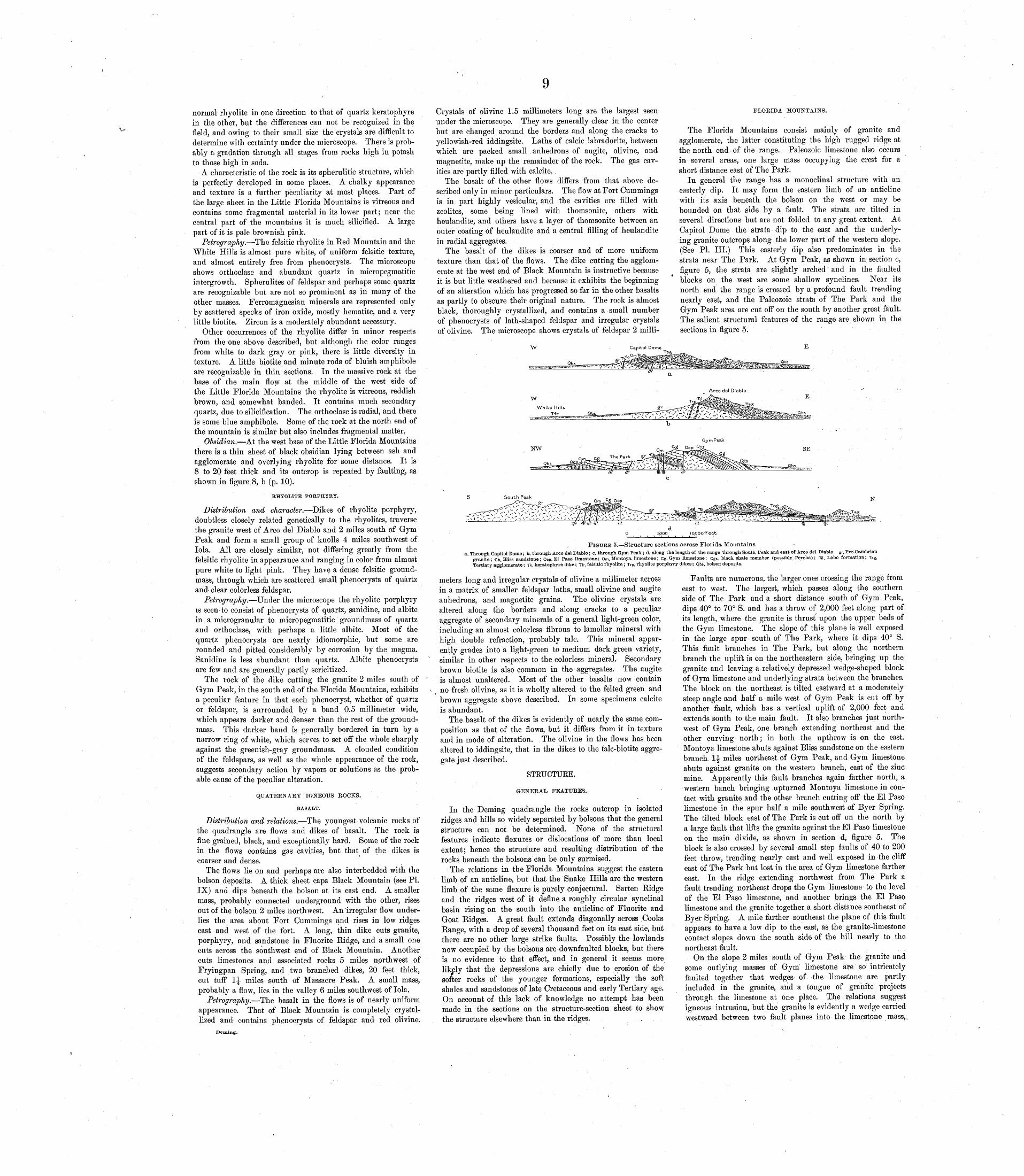
normal rhyolite in one direction to that of quartz keratophyre in the other, but the differences can not be recognized in the field, and owing to their small size the crystals are difficult to determine with certainty under the microscope. There is prob ably a gradation through all stages from rocks high in potash to those high in soda.
A characteristic of the rock is its spherulitic structure, which is perfectly developed in some places. A chalky appearance and texture is a further peculiarity at most places. Part of the large sheet in the Little Florida Mountains is vitreous and contains some fragmental material in its lower part; near the central part of the mountains it is much silicified. A large part of it is pale brownish pink.
Petrography. The felsitic rhyolite in Red Mountain and the White Hills is almost pure white, of uniform felsitic texture, and almost entirely free from phenocrysts. The microscope shows orthoclase and abundant quartz in micropegmatitic intergrowth. Spherulites of feldspar and perhaps some quartz are recognizable but are not so prominent as in many of the other masses. Ferromagnesian minerals are represented only by scattered specks of iron oxide, mostly hematite, and a very little biotite. Zircon is a moderately abundant accessory.
Other occurrences of the rhyolite differ in minor respects from the one above described, but although the color ranges from white to dark gray or pink, there is little diversity in texture. A little biotite and minute rods of bluish amphibole are recognizable in thin sections. In the massive rock at the base of the main flow at the middle of the west side of the Little Florida Mountains the rhyolite is vitreous, reddish brown, and somewhat banded. It contains much secondary quartz, due to silicification. The orthoclase is radial, and there is some blue amphibole. Some of the rock at the north end of the mountain is similar but also includes fragmental matter.
Obsidian. At the west base of the Little Florida Mountains there is a thin sheet of black obsidian lying between ash and agglomerate and overlying rhyolite for some distance. It is 8 to 20 feet thick and its outcrop is repeated by faulting, as shown in figure 8, b (p. 10).
RHYOLITB PORPHYRY.
Distribution and character. Dikes of rhyolite porphyry, doubtless closely related genetically to the rhyolites, traverse the granite west of Arco del Diablo and 2 miles south of Gym Peak and form a small group of knolls 4 miles southwest of lola. All are closely similar, not differing greatly from the felsitic rhyolite in appearance and ranging in color from almost pure white to light pink. They have a dense felsitic ground- mass, through which are scattered small phenocrysts of quartz and clear colorless feldspar.
Petrography. Under the microscope the rhyolite porphyry is seen-to consist of phenocrysts of quartz, sanidine, and albite in a microgranular to micropegmatitic groundmass of quartz and orthoclase, with perhaps a little albite. Most of the quartz phenocrysts are nearly idiomorphic, but some are rounded and pitted considerably by corrosion by the magma. Sanidine is less abundant than quartz. Albite phenocrysts are few and are generally partly sericitized.
The rock of the dike cutting the granite 2 miles south of Gym Peak, in the south end of the Florida Mountains, exhibits a peculiar feature in that each phenocryst, whether of quartz or feldspar, is surrounded by a band 0.5 millimeter wide, which appears darker and denser than the rest of the ground- mass. This darker band is generally bordered in turn by a narrow ring of white, which serves to set off the whole sharply against the greenish-gray groundmass. A clouded condition of the feldspars, as well as the whole appearance of the rock, suggests secondary action by vapors or solutions as the prob able cause of the peculiar alteration.
QUATERNARY IGNEOUS KOCKS.
BASALT.
Distribution and relations. The youngest volcanic rocks of the quadrangle are flows and dikes of basalt. The rock is fine grained, black, and exceptionally hard. Some of the rock in the flows contains gas cavities, but that of the dikes is coarser and dense.
The flows lie on and perhaps are also interbedded with the bolson deposits. A thick sheet caps Black Mountain (see PI. IX) and dips beneath the bolson at its east end. A smaller mass, probably connected underground with the other, rises out of the bolson 2 miles northwest. An irregular flow under lies the area about Fort Cummings and rises in low ridges east and west of the fort. A long, thin dike cuts granite, porphyry, and sandstone in Fluorite Ridge, and a small one cuts across the southwest end of Black Mountain. Another cuts limestones and associated rocks 5 miles northwest of Fryingpan Spring, and two branched dikes, 20 feet thick, cut tuff 1^ miles south of Massacre Peak. A small mass, probably a flow, lies in the valley 6 miles southwest of lola.
Petrography. The basalt in the flows is of nearly uniform appearance. That of Black Mountain is completely crystal lized and contains phenocrysts of feldspar and red olivine,
Demhig.
Crystals of olivine 1.5 millimeters long are the largest seen under the microscope. They are generally clear in the center but are changed around the borders and along the cracks to yellowish-red iddingsite. Laths of calcic labradorite, between which are packed small anhedrons of augite, olivine, and magnetite, make up the remainder of the rock. The gas cav ities are partly filled with calcite.
The basalt of the other flows differs from that above de scribed only in minor particulars. The flow at Fort Cummings is in part highly vesicular, and the cavities are filled with zeolites, some being lined with thomsonite, others with heulandite, and others have a layer of thomsonite between an outer coating of heulandite and a central filling of heulandite in radial aggregates.
The basalt of the dikes is coarser and of more uniform texture than that of the flows. The dike cutting the agglom erate at the west end of Black Mountain is instructive because it is but little weathered and because it exhibits the beginning of an alteration which has progressed so far in the other basalts as partly to obscure their original nature. The rock is almost black, thoroughly crystallized, and contains a small number of phenocrysts of lath-shaped feldspar and irregular crystals of olivine. The microscope shows crystals of feldspar 2 milli-
FLOKIDA MOUNTAINS.
The Florida Mountains consist madnly of granite and agglomerate, the latter constituting the high rugged ridge at the north end of the range. Paleozoic limestone also occurs in several areas, one large mass occupying the crest for a short distance east of The Park.
In general the range has a monoclinal structure with an easterly dip. It may form the eastern limb of an anticline with its axis beneath the bolson on the west or may be bounded on that side by a fault. The strata are tilted in several directions but are not folded to any great extent. At Capitol Dome the strata dip to the east and the underly ing granite outcrops along the lower part of the western slope. (See PI. III.) This easterly dip also predominates in the strata near The Park. At Gym Peak, as shown in section c, figure 5, the strata are slightly arched and in the faulted blocks on the west are some shallow synclines. Near its north end the range is crossed by a profound fault trending nearly east,, and the Paleozoic strata of The Park and the Gym Peak area are cut off on the south by another great fault. The salient structural features of the range are shown in the sections in figure 5.
Arco del Diablo
W E
White Hills
Tfr
Gym Peak
.NW SE
Qbs
FIGURE 5. Structure sections across Florida Mountains. -a, Through Capitol Dome; b, through Arco del Diablo; c, through Gym Peak; d, along the length of the range through South Peak and east of Arco del Diablo. gr, Pre-Cambrian
granite; b. Bliss sandstone; Oep, El Paso limestone; Om, Montoya limestone; Cg, Gym limestone; Cgs, black shale member (possibly Percha); Til, Lpbo formation; Tag, Tertiary agglomerate; Tk, keratophyre dike; Tfr, felsitic rhyolite; Trp, rhyolite porphyry dikes; Qbs, bolson deposits.
meters long and irregular crystals of olivine a millimeter across in a matrix of smaller feldspar laths, small olivine and augite anhedrons, and magnetite grains. The olivine crystals are altered along the borders and along cracks to a peculiar aggregate of secondary minerals of a general light-green color, including an almost colorless fibrous to lamellar mineral with high double refraction, probably talc. This mineral appar ently grades into a light-green to medium dark green variety, similar in other respects to the colorless mineral. Secondary brown biotite is also common in the aggregates. The augite is almost unaltered. Most of the other basalts now contain no fresh olivine, as it is wholly altered to the felted green and brown aggregate above described. In some specimens calcite is abundant.
The basalt of the dikes is evidently of nearly the same com position as that of the flows, but it differs from it in texture and in mode of alteration. The olivine in the flows has been altered to iddingsite, that in the dikes to the talc-biotite aggre gate just described.
STRUCTURE.
GENERAL FEATURES.
In the Deming quadrangle the rocks outcrop in isolated ridges and hills so widely separated by bolsons that the general structure can not be determined. None of the structural features indicate flexures or dislocations of more than local extent; hence the structure and resulting distribution of the rocks beneath the bolsons can be only surmised.
The relations in the Florida Mountains suggest the eastern limb of an anticline, but that the Snake Hills are the western limb of the same flexure is purely conjectural. Sarten Eidge and the ridges west of it define a roughly circular synclinal basin rising on the south into the anticline of Fluorite and Goat Ridges. A great fault extends diagonally across Cooks Range, with a drop of several thousand feet on its east side, but there are no other large strike faults. Possibly the lowlands now occupied by the bolsons are downfaulted blocks, but there is no evidence to that effect, and in general it seems more likely that the depressions are chiefly due to erosion of the softer rocks of the younger formations, especially the soft shales and sandstones of late Cretaceous and early Tertiary age. On account of this lack of knowledge no attempt has been made in the sections on the structure-section sheet to show the structure elsewhere than in the ridges. .
Faults are numerous, the larger ones crossing the range from east to west. The largest, which passes along the southern side of The Park and a short distance south of Gym Peak, dips 40° to 70° S. and has a throw of 2,000 feet along part of its length, where the granite is thrust upon the upper beds of the Gym limestone. The slope of this plane is well exposed in the large spur south of The Park, where it dips 40° S. This fault branches in The Park, but along the northern branch the uplift is on the northeastern side, bringing up the granite and leaving a, relatively depressed wedge-shaped block of Gym limestone and underlying strata between the branches. The block on the northeast is tilted eastward at a moderately steep angle and half a mile west of Gym Peak is cut off by another fault, which has a vertical uplift of 2,000 feet and extends south to the main fault. It also branches just north west of Gym Peak, one branch extending northeast and the other curving north; in both the upthrow is on the east. Montoya limestone abuts against Bliss sandstone on the eastern branch 1J miles northeast of Gym Peak, and Gym limestone abuts against granite on the western branch, east of the zinc mine. Apparently this fault branches again farther north, a western banch bringing upturned Montoya limestone in con tact with granite and the other branch cutting off the El Paso limestone in the spur half a mile southwest of Byer Spring. The tilted block east of The Park is cut off on the north by a large fault that lifts the granite against the El Paso limestone on the main divide, as shown in section d, figure 5. The block is also crossed by several small step faults of 40 to 200 feet throw, trending nearly east and well exposed in the cliff east of The Park but lost in the area of Gym limestone farther east. In the ridge extending northwest from The Park a fault trending northeast drops the Gym limestone to the level of the El Paso limestone, and another brings the El Paso limestone and the granite together a short distance southeast of Byer Spring. A mile farther southeast the plane of this fault appears to have a low dip to the east, as the granite-limestone contact slopes down the south side of the hill nearly to the northeast fault. , .
On the slope 2 miles south of Gym Peak the granite and some outlying masses of Gym limestone are so intricately faulted together that wedges of the limestone are partly included in the granite, and a tongue of granite projects through the limestone at one place. The relations suggest igneous intrusion, but the granite is evidently a wedge carried westward between two fault planes into the limestone mass,.
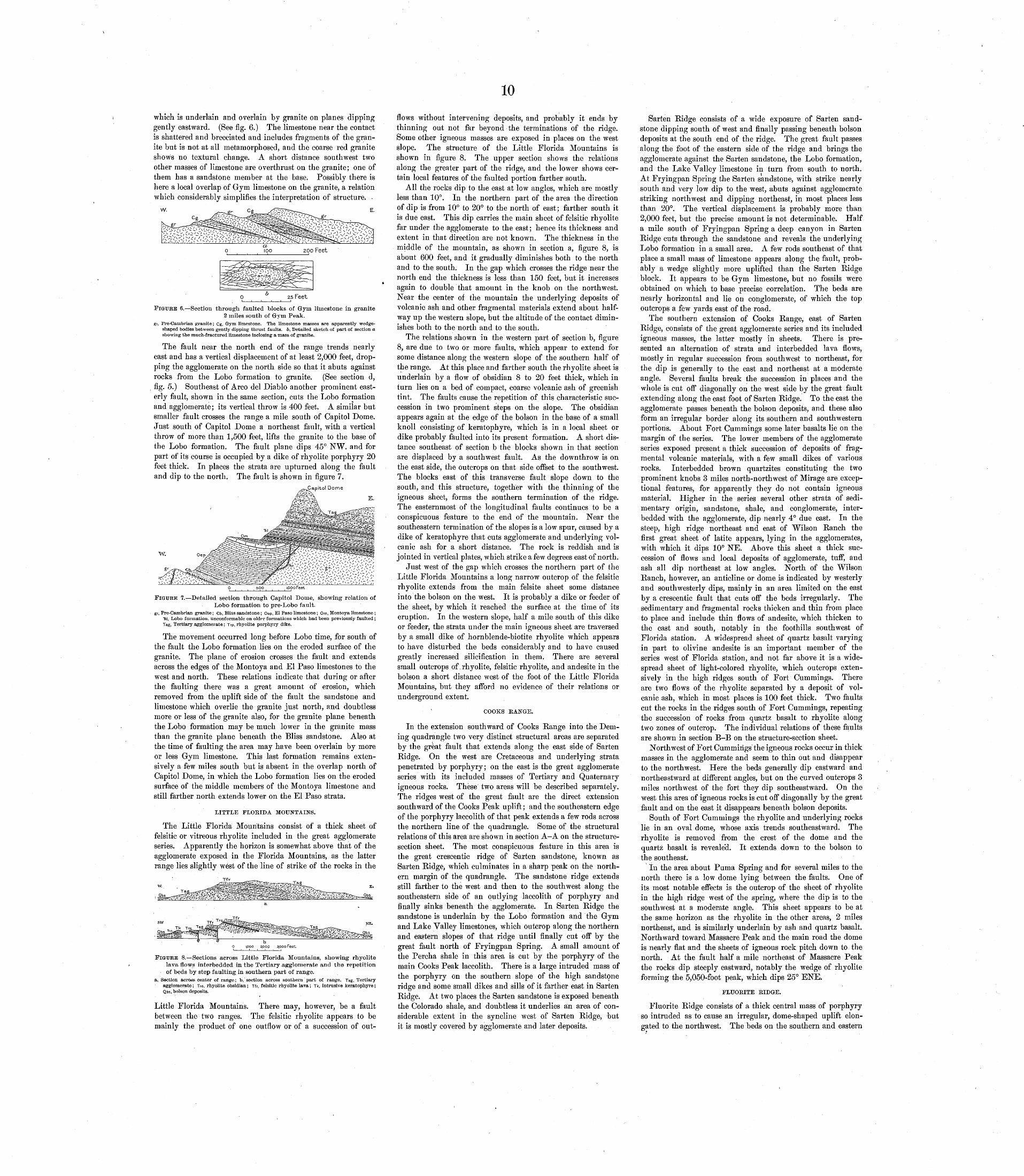
10
which is underlain and overlain by granite on planes dipping gently eastward. (See fig. 6.) The limestone near the contact is shattered and breccia ted and includes fragments of the gran ite but is not at all metamorphosed, and the coarse red granite shows no textural change. A short distance southwest two other masses of limestone are overthrust on the granite; one of them has a sandstone member at the base. Possibly there is here a local overlap of Gym limestone on the granite, a relation which considerably simplifies the interpretation of structure. -
FIGURE 6. Section through faulted blocks of Gym limestone in granite 2 miles south of Grym Peak.
gr, Pre-Cambrian granite; Cg, Gym limestone. The limestone masses are apparently wedge- shaped bodies between gently dipping thrust faults. 6, Detailed sketch of part of section a showing the much-fractured limestone inclosing a mass of granite.
The fault near the north end of the range trends nearly east and has a vertical displacement of at least 2,000 feet, drop ping the agglomerate on the north side so that it abuts against rocks from the Lobo formation to granite. (See section d, fig. 5.) Southeast of Arco del Diablo another prominent east erly fault, shown in the same section, cuts the Lobo formation and agglomerate; its vertical throw is 400 feet. A similar but smaller fault crosses the range a mile south of Capitol Dome. Just south of Capitol Dome a northeast fault, with a vertical throw of more than 1,500 feet, lifts the granite to the base of the Lobo formation. The fault plane dips 45° N.W. and for part of its course is occupied by a dike of rhyolite porphyry 20 feet thick. In places the strata are upturned along the fault and dip to the north. The fault is shown in figure 7.
.Capitol Dome
E.
W.
FIGURE 7. Detailed section through Capitol Dome, showing relation of Lobo formation to pre-Lobo fault.
gr, Pre-Cambrian granite; Cb, Bliss sandstone; Oep, El Paso limestone; Om, Montoya limestone ; "El, Lobo formation, unconformable on older formations which had been previously faulted; Tag, Tertiary agglomerate; Trp, rhyolite porphyry dike.
The movement occurred long before Lobo time, for south of the fault the Lobo formation lies on the eroded surface of the granite. The plane of erosion crosses the fault and extends across the edges of the Montoya and El Paso limestones to the west and north. These relations indicate that during or after the faulting there was a great amount of erosion, which removed from the uplift side of the fault the sandstone and limestone which overlie the granite just north, and doubtless more or less of the granite also, for the granite plane beneath the Lobo formation may be much lower in the granite mass than the granite plane beneath the Bliss sandstone. Also at the time of faulting the area may have been overlain by more or less Gym limestone. This last formation remains exten sively a few miles south but is absent in the overlap north of Capitol Dome, in which the Lobo formation lies on the eroded surface of the middle members of the Montoya limestone and still farther north extends lower on the El Paso strata,
LITTLE FLOKIDA MOUNTAINS.
The Little Florida Mountains consist of a thick sheet of felsitic or vitreous rhyolite included in the great agglomerate series. Apparently the horizon is somewhat above that of the agglomerate exposed in the Florida Mountains, as the latter range lies slightly west of the line of strike of the rocks in the
ipoo 2,000 3,000 Feet
FIGURE 8. Sections across Little Florida Mountains, showing rhyolite lava flows interbedded in the Tertiary agglomerate and the repetition of beds by step faulting in southern part of range.
a, Section across center of range; b, section across southern part of range. Tag, Tertiary agglomerate; Tro, rhyolite obsidian; Tit, felsitic rhyolite lava; Tk, intrusive keratophyre; Qbs, bolson deposits.
Little Florida Mountains. There may, however, be a fault between the two ranges. The felsitic rhyolite appears to be mainly the product of one outflow or of a succession of out
flows without intervening deposits, and probably it ends by thinning out not far beyond the terminations of the ridge. Some other igneous masses are exposed in places on the west slope. The structure of the Little Florida Mountains is shown in figure 8. The upper section shows the relations along the greater part of the ridge, and the lower shows cer tain local features of the faulted portion farther south.
All the rocks dip to the east at low angles, which are mostly less than 10°. In the northern part of the area the direction of dip is from 10° to 20° to the north of east; farther south it is due east. This dip carries the main sheet of felsitic rhyolite far under the agglomerate to the east; hence its thickness and extent in that direction are not known. The thickness in the middle of the mountain, as shown in section a, figure 8, is about 600 feet, and it gradually diminishes both to the north and to the south. In the gap which crosses the ridge near the north end the thickness is less than 150 feet, but it increases again to double that amount in the knob on the northwest. Near the center of the mountain the underlying deposits of volcanic ash and other fragmental materials extend about half way up the western slope, but the altitude of the contact dimin ishes both to the north and to the south.
The relations shown in the western part of section b, figure 8, are due to two or more faults, which appear to extend for some distance along the western slope of the southern half of the range. At this place and farther south the rhyolite sheet is underlain by a flow of obsidian 8 to 20 feet thick, which in turn lies on a bed of compact, coarse volcanic ash of greenish tint. The faults cause the repetition of this characteristic suc cession in two prominent steps on the slope. The obsidian appears again at the edge of the bolson in the base of a small knoll consisting of keratophyre, which is in a local sheet or dike probably faulted into its present formation. A short dis tance southeast of section b the blocks shown in that section are displaced by a southwest fault. As the downthrow is on the east side, the outcrops on that side offset to the southwest. The blocks east of this transverse fault slope down to the south, and this structure, together with the thinning of the igneous sheet, forms the southern termination of the ridge. The easternmost of the longitudinal faults continues to be a conspicuous feature to the end of the mountain. Near the southeastern termination of the slopes is a low spur, caused by a dike of keratophyre that cuts agglomerate and underlying vol canic ash for a short distance. The rock is reddish and is jointed in vertical plates, which strike a few degrees east of north.
Just west of the gap which crosses the northern part of the Little Florida Mountains a long narrow outcrop of the felsitic rhyolite extends from the main felsite sheet some distance into the bolson on the west. It is probably a dike or feeder of the sheet, by which it reached the surface at the time of its eruption. In the western slope, half a mile south of this dike or feeder, the strata under the main igneous sheet are traversed by a small dike of hornblende-biotite rhyolite which appears to have disturbed the beds considerably and to have caused greatly increased silicification in them. There are several small outcrops of .rhyolite, felsitic rhyolite, and andesite in the bolson a short distance west of the foot of the Little Florida Mountains, but they afford no evidence of their relations or underground extent.
COOKS BANGE.
In the extension southward of Cooks Range into the Dem- ing quadrangle two very distinct structural areas are separated by the great fault that extends along the east side of Sarten Ridge. On the west are Cretaceous and underlying strata penetrated by porphyry; on the east is the great agglomerate series with its included masses of Tertiary and Quaternary igneous rocks. These two areas will be described separately. The ridges west of the great fault are the direct extension southward of the Cooks Peak uplift; and the southeastern edge of the porphyry laccolith of that peak extends a few rods across the northern line of the quadrangle. Some of the structural relations of this area are shown in section A-A on the structure- section sheet. The most conspicuous feature in this area is the great crescentic ridge of Sarten sandstone, known as Sarten Ridge, which culminates in a sharp peak on the north ern margin of the quadrangle. The sandstone ridge extends still farther to the west and then to the southwest along the southeastern side of an outlying laccolith of porphyry and finally sinks beneath the agglomerate. In Sarten Ridge the sandstone is underlain by the Lobo formation and the Gym and Lake Valley limestones, which outcrop along the northern and eastern slopes of that ridge until finally cut off by the great fault north of Fryingpan Spring. A small amount of the Percha shale in this area is cut by the porphyry of the main Cooks Peak laccolith. There is a large intruded mass of the porphyry on the southern slope of the high sandstone ridge and some small dikes and sills of it farther east in Sarten Ridge. At two places the Sarten sandstone is exposed beneath the Colorado shale, and doubtless it underlies ain area of con siderable extent in the syncline west of Sarten Ridge, but it is mostly covered by agglomerate and later deposits.
Sarten Ridge consists of a wide exposure of Sarten sand stone dipping south of west and finally passing beneath bolson deposits at the south end of the ridge. The great fault passes along the foot of the eastern side of the ridge and brings the agglomerate against the Sarten sandstone, the Lobo formation, and the Lake Valley limestone in turn from south to north. At Fryingpan Spring the Sarten sandstone, with strike nearly south and very low dip to the west, abuts against agglomerate striking northwest and dipping northeast, in most places less than 20°. The vertical displacement is probably more than 2,000 feet, but the precise amount is not determinable. Half a mile south of Fryingpan Spring a deep canyon in Sarten Ridge cuts through the sandstone and reveals the underlying Lobo formation in a small area. A few rods southeast of that place a small mass of limestone appears along the fault, prob ably a wedge slightly more uplifted than the Sarten Ridge block. It appears to be Gym limestone, but no fossils were obtained on which to base precise correlation. The beds are nearly horizontal and lie on conglomerate, of which the top outcrops a few yards east of the road.
The southern extension of Cooks Range, east of Sarten Ridge, consists of the great agglomerate series and its included igneous masses, the latter mostly in sheets. There is pre sented an alternation of strata and interbedded lava flows, mostly in regular succession from southwest to northeast, for the dip is generally to the east and northeast at a moderate angle. Several faults break the succession in places and the whole is cut off diagonally on the west side by the great fault extending along the east foot of Sarten Ridge. To the east the agglomerate passes beneath the bolson deposits, and these also form an irregular border along its southern and southwestern portions. About Fort Cummings some later basalts lie on the margin of the series. The lower members of the agglomerate series exposed present a thick succession of deposits of frag mental volcanic materials, with a few small dikes of various rocks. Interbedded brown quartzites constituting the two prominent knobs 3 miles north-northwest of Mirage are excep tional features, for apparently they do not contain igneous material. Higher in the series several other strata of sedi mentary origin, sandstone, shale, and conglomerate, inter bedded with the agglomerate, dip nearly 4° due east. In the steep, high ridge northeast and east of Wilson Ranch the first great sheet of latite appears, lying in the agglomerates, with which it dips 10° NE. Above this sheet a thick suc cession of flows and local deposits of agglomerate, tuff, and ash all dip northeast at low angles. North of the Wilson Ranch, however, an anticline or dome is indicated by westerly and southwesterly dips, mainly in an area limited on the east by a crescentic fault that cuts off the beds irregularly. The sedimentary and fragmental rocks thicken and thin from place to place and include thin flows of andesite, which thicken to the east and south, notably in the foothills southwest of Florida station. A widespread sheet of quartz basalt varying in part to olivine andesite is an important member of the series west of Florida station, and not far above it is a wide spread sheet of light-colored rhyolite, which outcrops exten sively in the high ridges south of Fort Cummings. There are two flows of the rhyolite separated by a deposit of vol canic ash, which in most places is 100 feet thick. Two faults cut the rocks in the ridges south of Fort Cummings, repeating the succession of rocks from quartz basalt to rhyolite along two zones of outcrop. The individual relations of these faults are shown in section B-B on the structure-section sheet.
Northwest of Fort Cummings the igneous rocks occur in thick masses in the agglomerate and seem to thin out and disappear to the northwest. Here the beds generally dip eastward and northeastward at different angles, but on the curved outcrops 3 miles northwest of the fort they dip southeastward. On the west this area of igneous rocks is cut off diagonally by the great fault and on the east it disappears beneath bolson deposits.
South of Fort Cummings the rhyolite and underlying rocks lie in an oval dome, whose axis trends southeastward. The rhyolite is removed from the crest of the dome and the quartz basalt is reveale'd. It extends down to the bolson to the southeast.
In the area about Puma Spring and for several miles to the north there is a low dome lying between the faults. One of its most notable effects is the outcrop of the sheet of rhyolite in the high ridge west of the spring, where the dip is to the southwest at a moderate angle. This sheet appears to be at the same horizon as the rhyolite in the other areas, 2 miles northeast, and is similarly underlain by ash and quartz basalt. Northward toward Massacre Peak and the main road the dome is nearly flat and the sheets of igneous rock pitch down to the north. At the fault half a mile northeast of Massacre Peak the rocks dip steeply eastward, notably the wedge of rhyolite forming the 5,050-foot peak, which dips 25° ENE.
FLUOKITE RIDGE.
Fluorite Ridge consists of a thick central mass of porphyry so intruded as to cause an irregular, dome-shaped uplift elon gated to the northwest. The beds on the southern and eastern

11sides of the dome stand nearly vertical, but those on the north ern and western sides have more moderate dips. The plane of intrusion is low in the Paleozoic strata at the southeast end of the uplift, but it rises rapidly north and west to the base of the Sarten sandstone. Along part of the southwestern slope of the ridge, where the porphyry extends down to the edge of the bolson, the structural relations are not revealed. At the south end of the ridge two faults cause considerable complexity of structure. (See fig. 9.) The crystalline rocks
NNW. SSE.
FIGURE 9. Section across the eastern part of Pluorite Ridge.gr, Pre-Cambrian granite and diorite; b, Bliss sandstone; Oep, El Paso limestone; OSfm, Mon-
toya and probably Fusselman limestones; Dp, Percha shale; civ, Lake Valley limestone; Ks, Sarten sandstone; Tag, Tertiary agglomerate; Tgp, granite porphyry; Qbs, bolson depos" its; Qb, basalt dike.
exposed on the lower slopes southwest of Fluor Camp are red granite and diorite, both of them in part gneissic and the granite in places porphyritic. A slight vertical fault on the north side of the granite at one point brings it in contact with beds as high as the middle of the Bliss sandstone. In some places at the contact of the granite and Bliss sandstone there are limy shales, in others reddish quartzitic sandstone which extends in conspicuous ledges along the slope of the ridge for half a mile. At one place they are offset to the north by a cross fault. The sedimentary beds dip steeply north and pre sent a succession above the Bliss sandstone of El Paso lime stone, Montoya limestone and cherty beds, probable Fusselman limestone, Percha shale, and the lower part of the Lake Valley limestone. Some of them are greatly squeezed, notably the El Paso limestone, which presents a thickness of only 400 feet at the east end of the ridge "and somewhat less on the west side. The cherty members of the Montoya limestone are very conspicuous in the high knob at the southeast corner of the ridge. There is lack of evidence as to the age of the lime stone north of the Montoya ledges, and possibly the succession is interrupted by one or two faults running west near the north end of this limestone knob.
The plane of porphyry intrusion descends considerably southward across the beds in the saddle at the north end of this knob, but in the slopes just east and west of the saddle the Percha shale appears, and where the plane of porphyry intrusion rises still higher to the northeast, several hundred feet of the lower part of Lake Valley limestone are exposed. Farther east and north are several great masses of white silica rock, mostly surrounded by porphyry. Its character indicates that it is limestone replaced by silica. One of these masses extends as a foothill ridge for some distance north of Fluor Camp, where at one place it is 90 feet thick. A small out lying knob of it rises above the agglomerate a quarter of a mile east of the camp. The age of this silica rock is not known, and it may be either the Lake Valley or the Montoya limestone probably the Montoya, as shown on the map.
A fault of considerable magnitude, with downthrow on the east, extends along the east end of Fluorite Eidge and cuts off the granite and sedimentary beds west of Fluor Camp so that they all abut against the porphyry on the east. Possibly, however, the porphyry was intruded since the faulting. There are some indications that a branch of the fault extends northeast just beyond Fluor Camp arid passes east of the silica ridge, and if so it may be a continuation of the great fault north of the bolson deposits, that passes through Fryingpan Spring. The slickensided plane of this fault is exposed in some of the fluorite workings just west of the camp, but whether it cuts the agglomerate or only separates it from the porphyry is not known. The agglomerate appears all around the flanks of Fluorite Ridge, but the exposures are so obscure that the relar tions to the porphyry are not exhibited; in places they are undoubtedly separated by faults. No fragments of granite porphyry similar to that in the intrusive mass were observed in the agglomerate, a fact which suggests that the porphyry may be younger than the agglomerate, or at least of the por tion of it in this vicinity. A mass of breccia of considerable size lies on the southern slope of Fluorite Eidge, just west of the limestone knob that constitutes the southeast end of the ridge. This breccia consists mainly of large masses as well as abundant smaller fragments of gneiss, apparently brought up by the porphyry as a friction breccia, or by explosive eruption, from the pre-Cambrian rocks, which are not far beneath.
The structure of the central part of Fluorite Eidge, as shown in section B-B on the structure-section sheet, is very different from that of the east end. There is a long slope of porphyry down to the bolson on the southern side, and the Sarten sand stone dips steeply on the northern side, forming a dip slope from the top of the ridge, where it presents a high cliff facing south, east, and west. On the eastern side of this high central ridge there is probably a cross fault continuous with the fault crossing the road 2 miles farther north. At one point in the cliff at the summit of Fluorite Eidge the sandstone is under lain by a small amount of conglomerate of the Lobo formation, which lies on the porphyry. (See PI. VII.) West of the
Doming.
high central ridge the plane of porphyry intrusion descends to the point where the Sarten sandstone arches over the igneous body in an anticline that pitches into a shallow cross syncline in the gap across the west end of the ridge. West of this place the porphyry rises again, creating a low ridge whose crest and northern slope are composed of porphyry. Large masses of agglomerate project above the bolson along the base of this portion of the ridge, especially on its northern side. Contacts of the porphyry and sedimentary rocks are exposed in several places in this area, notably near the central peak, where long projections of igneous rock extend into and across the strata and cause considerable alteration of all the rocks.
The Sarten sandstone of the central peak of Fluorite Eidge dips north, as before stated, and is probably cut off on the east by a fault that crosses the ridge and trends northward through the Pony Hills. The sandstone extends some dis tance north from the foot of the ridge in a line of low cliffs facing east and marking this fault, which is traceable through Pony Hills and beyond the old Butterfield road. Near that road granite appears on the east side of the fault, also farther west in the midst of the Pony Hills, and it also extends along the ridge just north of China Tank.
PONY HILLS.
The Pony Hills, the small group of low hills in the center of the structural basin lying between Sarten Eidge and Fluor ite Eidge, consist of outcrops of Sarten sandstone and of granr ite, but the relations of the rocks are obscured considerably, especially on the west, where they are mostly covered by gravel and sand of the bolson deposits. The most conspicuous feature is a cliff of Sarten sandstone which extends south from the old Butterfield road and which is nearly continuous south ward with a low spur of the Fluorite Eidge. Low hills of gneissic granite, separated from the sandstone by a fault, rise just east of this sandstone area. (See fig. 10.)
FIGURE 10. Section across Pony Hills, showing supposed block faulting.gr, Pre-Cambrian granite; Ks, Sarten sandstone; Qbs, bolson deposits.
In the rolling hills west of the main body of sandstone there are outcrops of schistose granite, in one place penetrated by a dike of diorite. These rocks are in contact with sandstone, and, although possibly there is regular overlap along an old shore line, the relations are probably due to faulting of several small blocks. The lowest sandstone exposed is coarse but not more so than some of the beds at higher horizons. Much of the contact of the larger mass of sandstone and of the smaller masses to the west is covered by sand and gravel. The sandstone in the two knolls northeast of the road is typical Sarten, but its relations to the granite are not revealed.
GOAT RIDGE.
Goat Eidge rises about 500 feet above the bolson and is on the prolongation of the strike of the anticline of Fluorite I\idge. It is an elongated dome, whose axis trends northwest and brings up the Sarten sandstone. The slopes and crest consist of rocky ledges of sandstone and quartzite which have been eroded through along the western slope and in the south end of the ridge and expose the underlying Lobo formation nearly if not quite to its base. At the foot of the ridge more or less agglomerate is exposed, which at the north end is cut by a dike, of keratophyre extending northeastward beyond the main road which passes east of the ridge.
SNAKE HILLS.
The Snake Hills, sometimes called the Eattlesnake Hills, consist of a ridge of limestone which crops out across the south ern part of T. 24 S., E. 10 W. Its length is about 2£ miles, and the knobs of the high summits are mostly from 150 to 200 feet above the plain. The east half consists of the El Paso limestone, dipping 5°-8° W. and thus exposing about 700 feet of beds. The west half consists of the overlying Montoya limestone, which first dips west and then is flexed in a low dome, deeply eroded in its center and almost flat along the west side of the ridge. The cherty beds of the Montoya limestone form the dominant topographic features, giving rise to the high central buttes. The structure is shown in figure 11.
0m
3,ooo Feet
FIGURE 11. Section across Snake Hills.Oep, El Paso limestone; Om, Montoya limestone (including a, limestone with chert in large bodies;
b, limestone with chert mostly in thin alternating layers; c, massive dark sandy limestone; d, cherty limestone; e, dark massive limestone with unconformity at base); Qbs, bolson deposits.
The succession of rocks in the Montoya comprises a dark massive limestone at base, next a lower chert member, then a medial member of dark massive limestone presenting low
cliffs, and at the top a highly cherty member capping the highest knob and extending down the west end of the ridge. This rock appears again in a small outcrop rising out of the bolson a few rods northeast of the west end of the ridge. The basal contact of the massive lower member of the Montoya limestone on the El Paso limestone shows evidence of uncon formity by erosion or channeling but no notable discordance in dip.
BED MOUNTAIN.
Eed Mountain consists of a large mass of nearly white fel- sitic rhyolite rising abruptly out of the bolsou 10 miles south west of Deming. Much of the rock is closely jointed so that it weathers into nearly vertical plates and slabs mostly trend ing north. At its northeast end the mass appears to dip to the northwest but presents no other suggestion of structure and no evidence as to its thickness. At the base of the slope on the south a small exposure of dark bluish-gray agglomerate, pre sumably underlying the rhyolite, consists of fragments, all angular, of andesite or latite. At other points the rhyolite or its talus extends down to the edge of the bolson deposits. It is probable that the igneous mass of Eed Mountain was extruded in a highly viscous condition, so that it piled up thickly without extending far beyond its present area. The time of its extrusion and its subsequent history are not known, but if it is of the same age as the other masses of similar rock it was once covered by agglomerate.
BLACK MOUNTAIN.
Black Mountain, which rises high above the bolson 8 miles northwest of Deming, consists of a sheet of basalt about 250 feet thick, capping a mass of volcanic ash and sand. (See PL IX.) Apparently the basalt sheet is the remnant of a flow or series of flows which originally had considerably greater extent. At the west end of the mountain the base of the basalt is about 500 feet above the bolson, and the long slope below shows deposits of sand and volcanic ash and tuff, largely covered by talus of the black rock from the cliffs above. The sheet dips to the east at a low angle, which carries it beneath the surface at the east end of the mountain. How much farther it extends underground and its former extent to the west are not known. A small outly ing mass separated by erosion caps a knob on the south-central slope of the mountain. A small area of similar rock appears in two low buttes 2 miles northwest of Black Mountain, and the two masses may be connected underground. The basalt of Black Mountain is mostly dense and massive, but portions are somewhat cellular, and in a few places, especially near the basal contact, the cellular structure is so highly devel oped that the rock is a scoria or pumice. The basal contact appears to be a smooth plain, so far as can be inferred from widely scattered exposures. The underlying beds of frag- mental materials dip .east at about the same angle as the over lying igneous sheet. The principal component is sand, more or less mixed with volcanic material in the form of ash and pumice. Some portions contain cross-bedded pebbly streaks. Low down the southwest corner of the mountain igneous rocks cutting these sediments are exposed. One mass is a sheet of dark-gray obsidian glass or perlite 4 or 5 feet thick. It has a circular outcrop and presents low cliffs to the south and west and is apparently connected with a vertical dike on the east. In the center of this area is a small intrusive body of a light- colored biotite rhyolite, with pronounced cleavage into slabs. A few rods southwest of this locality a small knob about 50 feet high, separated from the foot of Black Mountain by a low saddle, consists of a vertical dike of basalt 15 to 20 feet wide, cutting the agglomerate along a northerly course. Possibly this was a feeder for the main outflow of the basalt of Black Mountain, but the surface connection has been removed by erosion.
BURDICK HILLS.
The Burdick Hills are a series of outlying knolls at the edge of a higher level or step in the plains of bolson deposits south of the valley of Palomas Arroyo. These hills are made up largely of small masses of various igneous rocks, which show but little of their relations to one another. There is an eastern or outer rim of hornblende latite, some dikes and probable stocks of felsitic rhyolite and quartz porphyry, and some small showings of hornblende-biotite rhyolite. No contacts are clearly exposed except in the larger area in the southeast corner of T. 26 S., E. 11 W., where the agglomerate appears, cut by dikes of rhyolite and quartz porphyry. At one point farther west there is a small showing of black basalt similar to that which appears in Black Mountain.
MIDWAY BUTTE.
Midway Butte is a knob of felsitic rhyolite rising out of the bolson 3 miles south-southeast of Midway. A short distance to the southwest is another very small knob of th9 same rock. The knobs appear to be stocks, but no details of their structure or relations are revealed.
12
GEOLOGIC HISTORY.GENERAL SEDIMENTARY RECORD.
The rocks of the Deming quadrangle afford a partial record of geologic events in the region from pre-Cambrian time to the present. The sedimentary rocks consist of limestone, sand stone, shale, sand, loam, and gravel, all presenting more or less variety in composition and appearance. The principal materials of which they are composed were originally gravel, sand, or mud derived from the waste of older rocks, or chemi cal precipitates from salty waters. The composition, appear ance, and relations of the strata indicate in some measure the conditions under which they were deposited. Sandstone that is ripple-marked by water and cross-bedded by-currents and shale that is cracked by drying on mud flats indicate deposits in shallow water; pure limestone indicates open seas and scarcity of land-derived sediment. The fossils in the strata may belong to species known to inhabit waters that are fresh, brackish, or salt, warm or cold, muddy or clear.
The character of the adjacent land may be indicated by the sediments derived from its waste. The quartz sand and peb bles in coarse sandstones and conglomerates had their source in older rocks, but much of them has been repeatedly redis tributed by streams and concentrated by wave action on beaches. Red shale, such as that of the Lobo formation, results as a rule from the revival of erosion on a land surface long exposed to rock decay and oxidation and hence covered by deep residual soil. Limestone, on the other hand, if deposited near the shore, indicates that the land was low and that the streams were too sluggish to carry off coarse material, the sea receiving only fine sediment and matter in solution.
The older formations exposed about Deming were laid down in seas that covered a large part of the west-central United States, for many of the formations are continuous throughout a vast area. The land surfaces were probably large islands of an archipelago coextensive in a general way with the present Rocky Mountain province, but the peripheral shores are not even approximately determined for any one epoch, and the relations of land and sea varied greatly from time to time. The strata brought to view by the uplifts in southwestern New Mexico record many local variations in the geography and topography of the ancient land.
PALEOZOIC ERA.
CAMBRIAN PERIOD.
One of the notable events of early Paleozoic time in North America was the wide expansion of an interior sea over the west-central region. The submergence reached the Rocky Mountain province in the Cambrian period, and for a time a large part of the province remained as land rising above the waters. Its rocks were granites, gneisses, and in some areas limestones, sandstones, and quartzites of Algonkian age. From these ancient cr}7stalliue rocks streams and waves gathered and concentrated sand and pebbles, which were deposited as a wide spread sheet of sandstone on sea beaches, partly in shallow waters offshore and partly in estuaries. Sediments containing this local material abut against the irregular surface of the crystalline rocks which formed the shore. Subsequently, the altitude being reduced by erosion and the area possibly lessened by submergence, the land yielded the finer-grained mud now represented by the shale in the upper portion of the Cambrian in some areas. In southern New Mexico and the adjoining regions on the east and the west the surface of the crystalline rocks was finally buried beneath the sediments.
ORDOVICIAN AND SILURIAN PERIODS.
Southern New Mexico was submerged by the sea during parts of Ordovician and Silurian time, and thick deposits of calcium carbonate were laid down, forming limestones that are now prominent members of the stratigraphic series. Several widespread uplifts of the region during this long period of time caused protracted interruption of sedimentation, and doubtless also the resulting land surfaces were more or less extensively reduced by erosion. The older formations were not deformed, however, and the erosion of the land progressed in such a way as to produce no marked irregularities in the floor on which the succeeding formation was deposited. To what extent the interruptions in the rock succession were' due to the cessation of deposition and to what extent to the removal of sediments is not known, but presumably the former was the principal, agency.
DEVONIAN PERIOD.
In parts of the Southwest the Devonian is represented by extensive deposits of limestone, but in southern New Mexico only black shale appears and it represents but a small part of later Devonian time. This meager record is probably due to the fact that during a large part of the period the region was covered by an extensive but shallow sea or that the land was so low as to leave no noticeable evidence of erosion. On the other hand, it is possible that the sea was so deep and the area so far from shore that it did not receive appreciable deposits.
Whether it remained land or sea or alternated from one con dition to the other, the region shows no evidence of having undergone any considerable general uplift or depression until early Carboniferous time, when there was an extended subsi dence, which deeply submerged a large part of the Rocky Mountain province.
CARBONIFEROUS PERIOD.
Under the marine conditions of early Carboniferous time calcareous sediments, now represented by several hundred feet of nearly pure limestone, known as the Lake Valley lime stone, were laid down in southern New Mexico and adjoining regions. As no coarse deposits of this age occur, it is probable that no crystalline rocks were then exposed above water in the immediate region.
In later Carboniferous time several widespread oscillations of land and sea alternately submerged the region and pro duced shore and land conditions which continued for various lengths of time and affected somewhat different areas during different parts of the period. Apparently the entire Rocky Mountain province was under water at times, when calcium carbonate, red mud, sand, and gravel were deposited in a widespread mantle. In the Deming region the earlier sedi ments of the Pennsylvanian series are absent, but the later por tion of the Carboniferous period is represented by limestones, which are thick in the Florida Mountains and lie on an irreg ular surface that was developed by subaerial erosion. There is uncertainty as to the representation of latest deposits of the Carboniferous period, for the age of the Lobo formation is not indicated by any evidence at present available, and it is tenta tively classified as Triassic (?). That before the deposition of the Lobo there was uplift accompanied by more or less tilting and that great erosion ensued is shown by the fault at Capitol Dome, where an uplifted block was planed off 1,000 feet or more before Lobo deposition.
MESOZOIC ERA.
As the Triassic and Jurassic systems are not known to be represented in southern New Mexico, it is probable that the area was a land surface for a long time during the early part of the Mesozoic era. Because of the unconformable relations of the Lobo formation to both the overlying and underlying rocks, however, that formation is tentatively classified as Tri assic (?), but it may represent late Carboniferous or even early Cretaceous time. It is not unlikely that some deposits were laid down in the Triassic or Jurassic period, even if they were only the products of streams or lakes and were removed by erosion prior to the Cretaceous period.. Aside from some widespread planation there was at this time no notable defor mation of preceding formations and apparently no develop ment of irregularities of land surface that persisted. During the Cretaceous period a great series of deposits of several kinds, but generally uniform throughout wide areas, was accumulated in a large part of the western United States. Probably, however, some portions of the central part of the Rocky Mountains were not submerged at the time or were land surfaces during parts of it. In the southern part of the general area there were open seas in the earlier part of the period in which extensive deposits of calcium carbonate were laid down. The Cretaceous sediments began with such as are characteristic of shallow seas and estuaries along a coastal plain, passing into sediments from marine waters and chang ing toward the end to fresh-water sands and clays with marsh vegetation. In the Deming region a thick body of nearly pure sand was deposited in Comanche time, mainly on the surface of the Lobo formation but possibly overlapping on granite in the Pony Hills region. It is now the Sarten sand stone, and, although that formation does not outcrop in the southern part of the quadrangle and in adjoining regions on the east and the west, it probably was deposited over a wide area. The later Comanche deposits and also the Dakota sand stone appear to be absent, as the Sarten sandstone is succeeded by the Colorado shale but without notable evidence of uncon formity to represent the long period of time between them. The shale is a product of marine deposition, which was of great extent in the Rocky Mountains and adjoining provinces. In the Deming region only a small thickness of the shale appears, and, although later rocks of the Cretaceous period were probably deposited, they are buried under the agglom erate or the bolson deposits.
CENOZOIC ERA.
TERTIARY PERIOD.
The great accumulation of agglomerate, which occupies so large a part of southwestern New Mexico, is believed to have taken place chiefly during Tertiary time, although some of the deposits may be of Quaternary age, and some may be as old as Cretaceous. The Tertiary was a period of great igneous activ ity, for at times thick sheets of lavas of various kinds were extruded and a vast amount of fragmental volcanic material was ejected. The location of the vents or volcanoes is not known, but undoubtedly they were largely local and are
represented in part by the stocks and dikes now visible. There were also intrusions of igneous rocks among the sedi mentary strata, mainly the porphyries, which welled up as great laccoliths in Cooks Range and Fluorite Ridge, as well as in the Tres Hermanas Mountains south of the quadrangle. Water was an important agency of deposition during the accumulation of the agglomerate, for there are intercalated beds of sand, conglomerate, and ash which were laid by water. The great mass of the agglomerate, however, was erupted, largely, no doubt, as mud flows and showers of coarse ash and rock fragments. At intervals surface lavas of several kinds were extruded, first andesite and latite and then quartz basalt and rhyolite. The felsitic rhyolite and keratophyre were also extruded, but their relations to the other sheets are not known.
After this epoch there was extensive tilting and faulting of the region, and probably much of the present configuration was out lined. The depressions, filled later with bolson deposits, were then excavated and the country was rougher than at present.
QUATERNARY PERIOD.
In Quaternary time the wide depressions received a thick filling of gravel, sand, and clay, borne mainly by streams, which built up the great plain or series of wide bolsons now extending from the Rio Grande to the Continental Divide. The material came from the mountains and ridges; some of it was brought from afar; and, as much of it is fine grained and its thickness is great, a long time was required for its deposi tion. At times there were outflows of basalt on the surface. Erosion has since cut trenches in the bolson deposits. The canyons and draws in the mountains and ridges are now being cut deeper; the alluvial fans on the mountain slopes receive more or less detritus from time to time; and freshets spread a thin mantle of sand or silt on parts of the bolsons during the occasional freshet overflows.
ECONOMIC GEOLOGY.
Several minerals of commercial value occur in the Deming quadrangle and some of them have been worked to a moderate extent. Fluorite from mines north of Deming has been the principal product, and small amounts of lead, copper, and silver ores have been mined in the Florida Mountains. Lime stone has been quarried for burning lime, a small amount of loam has been burned into brick, the sandstone of Sarten Ridge has been quarried for building stone, and caliche has been utilized for road metal.
FLUORITE.
The following statements are condensed from a detailed account of the fluorite deposits by E. F. Burchard. 1
From the southeast end of Fluorite Ridge there was mined in 1909 to 1911 about 9,000 tons of the mineral fluorite. Fluorite consists of calcium fluoride and a small amount of impurities and is in considerable demand in the manufacture of open-hearth steel and for several other purposes. The fluorite occurs in steep-dipping veins, mostly in the porphyry, and ordinarily it is of exceptionally good quality. The veins range in thickness from a few inches to 12 feet or more, but their general range in the workings is from 2 to 5 feet. They extend along planes of fracture of the rock, some of which are slightly faulted. One set of veins strikes N. 17° E. to N. 27° E. and another set N. 6° E. to N. 18° W., but others strike at different angles between N. 17° E. and N. 18° W. There are three principal areas, one at Fluor Camp, a second a quarter of a mile or more to the northeast, and the third about a mile to the northwest. In 1912 a fourth mine was opened 'still farther west, and a vein was uncovered in the bolson nearly a mile east of the camp.
The opening at the camp is in porphyry near the fault plane which passes along the east side of the limestone ridge and separates the Ordovician limestones from an extension of the main porphyry mass, In the largest pits the vein has been worked to a depth of 80 feet and for a distance of about 100 feet along its north-northeast course. The vein dips 65°- 70° SE. and is from 4 to 12 feet thick. Other veins have been opened at other points in the immediate vicinity.
At the openings northeast of the camp the fluorite vein appears to be along a fault plane, with agglomerate on the east side and chert on the west side. The deepest workings are 75 feet deep. The vein is 1 to 8 feet thick; its course is S. 10° W., and it stands nearly vertical. There are several minor twists in it and some slickensides and other indications of faulting.
In the locality a mile northwest of the camp two veins of fluorite have been opened but not worked. They are in the porphyry not far below the overlying sandstone and stand nearly vertical. One vein is 1 foot to 4 feet thick and another averages about 1 foot, but the mineral is not all pure.
Analyses made by the Colorado Fuel & Iron Co. of carload lots of fluorite from Fluorite Ridge show a content of 88.3 to
1 Darton, N. H., and Burchard, E. P., Fluorspar near Deming, N. Mex.: U. S. Geol. Survey Bull. 470, pp. 583-545, 1911.
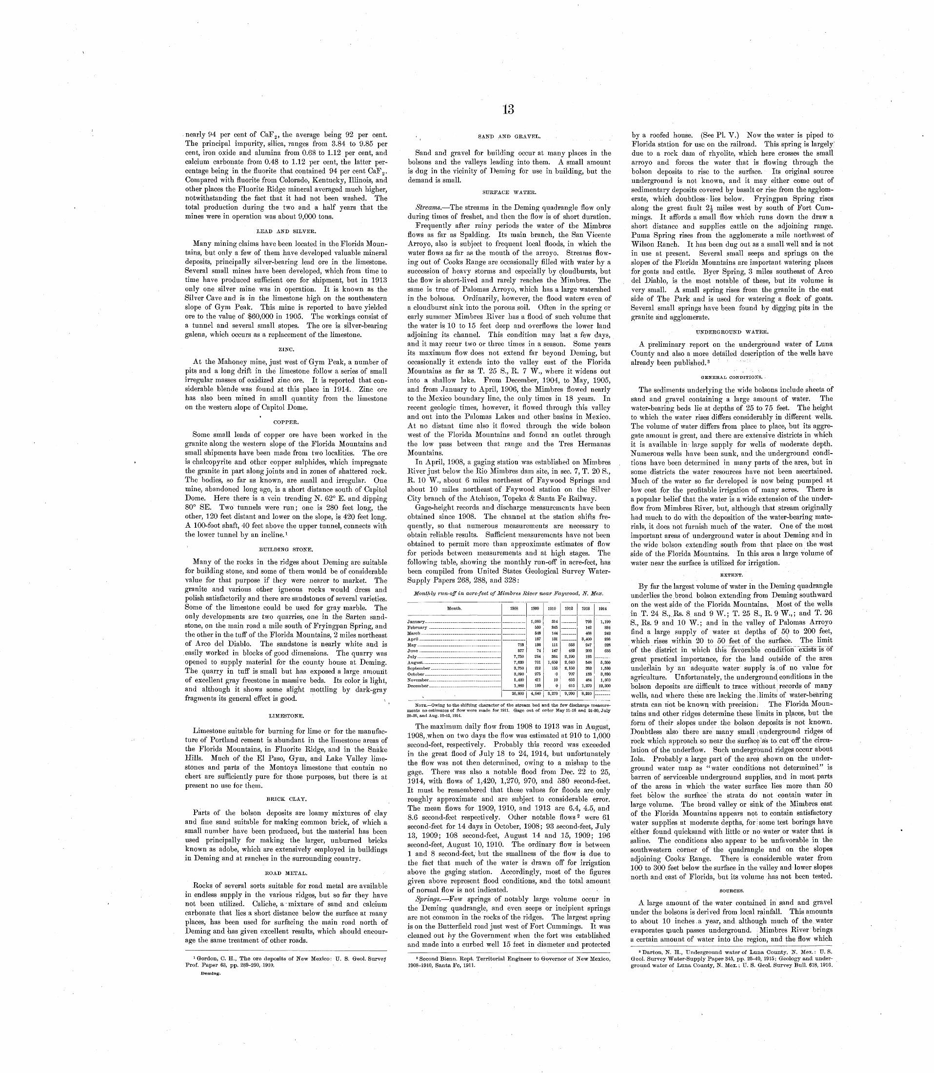
13
nearly 94 per cent of CaF 2 , the average being 92 per cent. The principal impurity, silica, ranges from 3.84 to 9.85 per cent, iron oxide and alumina from 0.68 to 1.12 per cent, and calcium carbonate from 0.48 to 1.12 per cent, the latter per centage being in the fluorite that contained 94 per cent CaF 2 . Compared with fluorite from Colorado, Kentucky, Illinois, and other places the Fluorite Ridge mineral averaged much higher, notwithstanding the fact that it had not been washed. The total production during the two and a half years that the mines were in operation was about 9,000 tons.
LEAD AND SILVER.
Many mining claims have been located in the Florida Moun tains, but only a few of them have developed valuable mineral deposits, principally silver-bearing lead ore in the limestone. Several small mines have been developed, which from time to time have produced sufficient ore for shipment, but in 1913 only one silver mine was in operation. It is known as the Silver Cave and is in the limestone high on the southeastern slope of Gym Peak. This mine is reported to have yielded ore to the value of $60,000 in 1905. The workings consist of a tunnel and several small stopes. The ore is silver-bearing galena, which occurs as a replacement of the limestone.
ZINC.
At the Mahoney mine, just west of Gym Peak, a number of pits and a long drift in the limestone follow a series of small irregular masses of oxidized zinc ore. It is reported that con siderable blende was found at this place in 1914.. Zinc ore has also been mined in small quantity from the limestone on the western slope of Capitol Dome.
COPPER.
Some small leads of copper ore have been worked in the granite along the western slope of the Florida Mountains and small shipments have been made from two localities. The ore is chalcopyrite and other copper sulphides, which impregnate the granite in part along joints and in zones of shattered rock. The bodies, so far as known, are small and irregular. One mine, abandoned long ago, is a short distance south of Capitol Dome. Here there is a vein trending N. 62° E. and dipping 80° SE. Two tunnels were run; one is 280 feet long, the other, 120 feet distant and lower on the slope, is 420 feet long. A 100-foot shaft, 40 feet above the upper tunnel, connects with the lower tunnel by an incline. 1
BUILDING STONE.
Many of the rocks in the ridges about Deming are suitable for building stone, and some of them would be of considerable value for that purpose if they were nearer to market. The granite and various other igneous rocks would dress and polish satisfactorily and there are sandstones of several varieties. Some of the limestone could be used for gray marble. The only developments are two quarries, one in the Sarten sand stone, on the main road a mile south of Fryingpan Spring, and the other in the tuff of the Florida Mountains, 2 miles northeast of Arco del Diablo. The sandstone is nearly white and is easily worked in blocks of good dimensions. The quarry was opened to supply material for the county house at Deming. The quarry in tuff is small but has exposed a large amount of excellent gray freestone in massive beds. Its color is light, and although it shows some slight mottling by dark-gray fragments its general effect is good. \
LIMESTONE.
Limestone suitable for burning for lime or for the manufac ture of Portland cement is abundant in the limestone areas of the Florida Mountains, in Fluorite Ridge, and in the Snake Hills. Much of the El Paso, Gym, and Lake Valley lime stones and parts of the Montoya limestone that contain no chert are sufficiently pure for those purposes, but there is at present no use for them.
BRICK CLAY.
Parts of the bolson deposits are loamy mixtures of clay and fine sand suitable for making common brick, of which a small number have been produced, but the material has been used principally for making the larger, unburned bricks known as adobe, which are extensively employed in buildings in Deming and at ranches in the surrounding country.
EOAD METAL.
Rocks of several sorts suitable for road metal are available in endless supply in the various ridges, but so far they have not been utilized. Caliche, a mixture of sand and calcium carbonate that lies a short distance below the surface at many places, has been used for surfacing the main road north of Deming and has given excellent results, which should encour age the same treatment of other roads.
1 Gordon, C. H., The ore deposits of New Mexico: U. S. Gfeol. Survey Prof. Paper 63, pp. 289-290, 1910.
Deming.
( SAND AND GRAVEL.
Sand and gravel for building occur at many places in the bolsons and the valleys leading into them. A small amount is dug in the vicinity of Deming for use in building, but the demand is small.
SUEFACE WATEE.
Streams. The streams in the Deming quadrangle flow only during times of freshet, and then the flow is of short duration.
Frequently after rainy periods the water of the Mimbres flows as far as Spalding. Its main branch, the San Vicente Arroyo, also is subject to frequent local floods, in which the water flows as far as the mouth of the arroyo. Streams flow ing out of Cooks Range are occasionally filled with water by a succession of heavy storms and especially by cloudbursts, but the flow is short-lived and rarely reaches the Mimbres. The same is true of Palomas Arroyo, which has a large watershed in the bolsons. Ordinarily, however, the flood waters even of a cloudburst sink into the porous soil. Often in the spring or early summer Mimbres River has a flood of such volume that the water is 10 to 15 feet deep and overflows the lower land adjoining its channel. This condition may last a few days, and it may recur two or three times in a season. Some years its maximum flow does not extend far beyond Deming, but occasionally it extends into the valley east of the Florida Mountains as far as T. 25 S., R. 7 W., where it widens out into a shallow lake. From December, 1904, to May, 1905, and from January to April, 1906, the Mimbres flowed nearly to the Mexico boundary line, the only times in 18 years. In recent geologic times, however, it flowed through this valley and out into the Palomas Lakes and other basins in Mexico. At no distant time also it flowed through the wide bolson west of the Florida Mountains and found an outlet through the low pass between that range and the Tres Hermanas Mountains.
In April, 1908, a gaging station was established on Mimbres River just below the Rio Mimbres dam site, in sec. 7, T. 20 S., R. 10 W., about 6 miles northeast of Fay wood Springs and about 10 miles northeast of Faywood station on the Silver City branch of the Atchison, Topeka & Santa Fe Railway.
Gage-height records and discharge measurements have been obtained since 1908. The channel at the station shifts fre quently, so that numerous measurements are necessary to obtain reliable results. Sufficient measurements have not been obtained to permit more than approximate estimates of flow for periods between measurements and at high stages. The following table, showing the monthly run-off in acre-feet, has been compiled from United States Geological Survey Water- Supply Papers 268, 288, and 328:
Monthly run-off in acre-feet of Mimbres River near Faywood, N. Mex.
Month.
January
AprilMavJun6July
s '
1908
718577
7,7507,6208,7503,0901,4301,860
26,800
1909
1,06053054818713674
264701212275411139
4,640
1910
314245144131111147364
1,650155
0100
3,270
1912
558482
2,1902,6402,150
707655615
9,990
1918
793142468
8,400847202198548352183464
1,270
8,210
1914
1 ion334243236228655
5 qfy\
1,5903,8901,300
12,300
NOTE. Owing to the shifting character of the stream bed and the few discharge measure ments no estimates of flow were made for 1911. Gage out of order May 11-16 and 24-30, July 20-25, and Aug. 12-15,1914.
The maximum daily flow from 1908 to 1913 was in August, 1908, .when on two days the flow was estimated at 910 to 1,000 second-feet, respectively. Probably this record was exceeded in the great flood of July 18 to 24, 1914, but unfortunately the flow was not then determined, owing to a mishap to the gage. There was also a notable flood from Dec. 22 to 25, 1914, with flows of 1,420, 1,270, 970, and 580 second-feet. It must be remembered that these values for floods are only roughly approximate and are subject to considerable error. The mean flows for 1909, 1910, and 1913 are 6.4, 4.5, and 8.6 second-feet respectively. Other notable flows 2 were 6.1 second-feet for 14 days in October, 1908; 93 second-feet, July 13, 1909; 108 second-feet, August 14 and 15, 1909; 196 second-feet, August 10, 1910. The ordinary flow is between 1 and 8 second-feet, but the smallness of the flow is due to the fact that much of the water is drawn off for irrigation above the gaging station. Accordingly, most of the figures given above represent flood conditions, and the total amount of normal flow is not indicated.
Springs. Few springs of notably large volume occur in the Deming quadrangle, and even seeps or incipient springs are not common in the rocks of the ridges. The largest spring is on the Butterfield road just west of Fort Cummings. It was cleaned out by the Government when the fort was established and made into a curbed well 15 feet in diameter and protected
2 Second Bienn. Kept. Territorial Engineer to Governor of New Mexico, 1908-1910, Santa Fe, 1911. -
by a roofed house. (See PL V.) Now the water is piped to Florida station for use on the railroad. This spring is largely" due to a rock dam of rhyolite, which here crosses the small arroyo and forces the water that is flowing through the bolson deposits to rise to the surface. Its original source underground is not known, and it may either come out of sedimentary deposits covered by basalt or rise from the agglom erate, which doubtless lies below. Fryingpan Spring rises along the great fault 2J miles west by south of Fort Cum mings. It affords a small flow which runs down the draw a short distance and supplies cattle on the adjoining range. Puma Spring rises from the agglomerate a mile northwest of Wilson Ranch. It has been dug out as a small well and is not in use at present. Several small seeps and springs on the slopes of the Florida Mountains are important watering places for goats and cattle. Byer Spring, 3 miles southeast of Arco del Diablo, is the most notable of these, but its volume is very small. A small spring rises from the granite in the east side of The Park and is used for watering a flock of goats. Several small springs have been found by digging pits in the granite and agglomerate.
UNDERGROUND WATER.
A preliminary report on the underground water of Luna County and also a more detailed description of the wells have already been published. 3
GENERAL CONDITIONS.
The sediments underlying the wide bolsons include sheets of sand and gravel containing a large amount of water. The water-bearing beds lie at depths of 25 to 75 feet. The height to which the water rises differs considerably in different wells. The volume of water differs from place to place, but its aggre gate amount is great, and there are extensive districts in which it is available in large supply for wells of moderate depth. Numerous wells have been sunk, and the underground condi tions have been determined in many parts of the area, but in some districts the water resources have not been ascertained. Much of the water so far developed is now being pumped at low cost for the profitable irrigation of many acres. There is a popular belief that the water is a wide extension of the under flow from Mimbres River, but, although that stream originally had much to do with the deposition of the water-bearing mate rials, it does not furnish much of the water. One of the most important areas of underground water is about Deming and in the wide bolson extending south from that place on the west side of the Florida Mountains. In this area a large volume of water near the surface is utilized for irrigation.
EXTENT.
By far the largest volume of water in the Deming quadrangle underlies the broad bolson extending from Deming southward on the west side of the Florida. Mountains. Most of the wells in T. 24 S.,.Rs. 8 and 9 W.; T, 25 S., R. 9 W.,; and T. 26 S., Rs. 9 and 10 W.; and in the valley of Palomas Arroyo find a large supply of water at depths of 50 to 200 feet, which rises within 20 to 50 feet of the surface. The limit of the district in which this favorable condition exists is of great practical importance, for the land outside of the area underlain by an adequate water supply is of no value for agriculture. Unfortunately, the underground conditions in the bolson deposits are difficult to trace without records of many wells, and where these are lacking the limits: of water-bearing strata can riot be known with precision; The Florida Moun tains and other ridges determine these limits in places, but the form of their slopes under the bolson deposits is npt known. Doubtless also there are many small ; underground ridges of rock which approach so near the surface as to; cut off the circu lation of the underflow. Such underground ridges occur about lola. Probably a large part of the area shown on the under ground water map as "water conditions not determined" is barren of serviceable underground supplies, and in most parts of the areas in which the water surface lies more than 50 feet below the surface' the strata do not contain water in large volume. The broad valley or sink of the Mimbres east of the Florida Mountains appears not to contain satisfactory water supplies at moderate depths, for;some test borings have either found quicksand with little or no water or water that is saline. The conditions also appear to be unfavorable in the southwestern corner of the quadrangle and on the slopes adjoining Cooks Range. There is considerable water from 100 to 300 feet below the surface in the valley and lower slopes north and east of Florida, but its volume has not been tested.
SOURCES.
A large amount of the water contained in sand and gravel under the bolsons is derived from local rainfall. This amounts to a,bout 10 inches a year, and although much of the water evaporates much passes underground. Mimbres River brings a certain amount of water into the region, and the flow which
8 Darton, N. H., Underground water of Luna County, N. Mex.: U. S. Greol. Survey Water-Supply Paper 345, pp. 25-40* 1915; Geology and under ground water of Luna County, N. jMex.; U. S. Gr,eol. Survey Bull. 618, 1916.
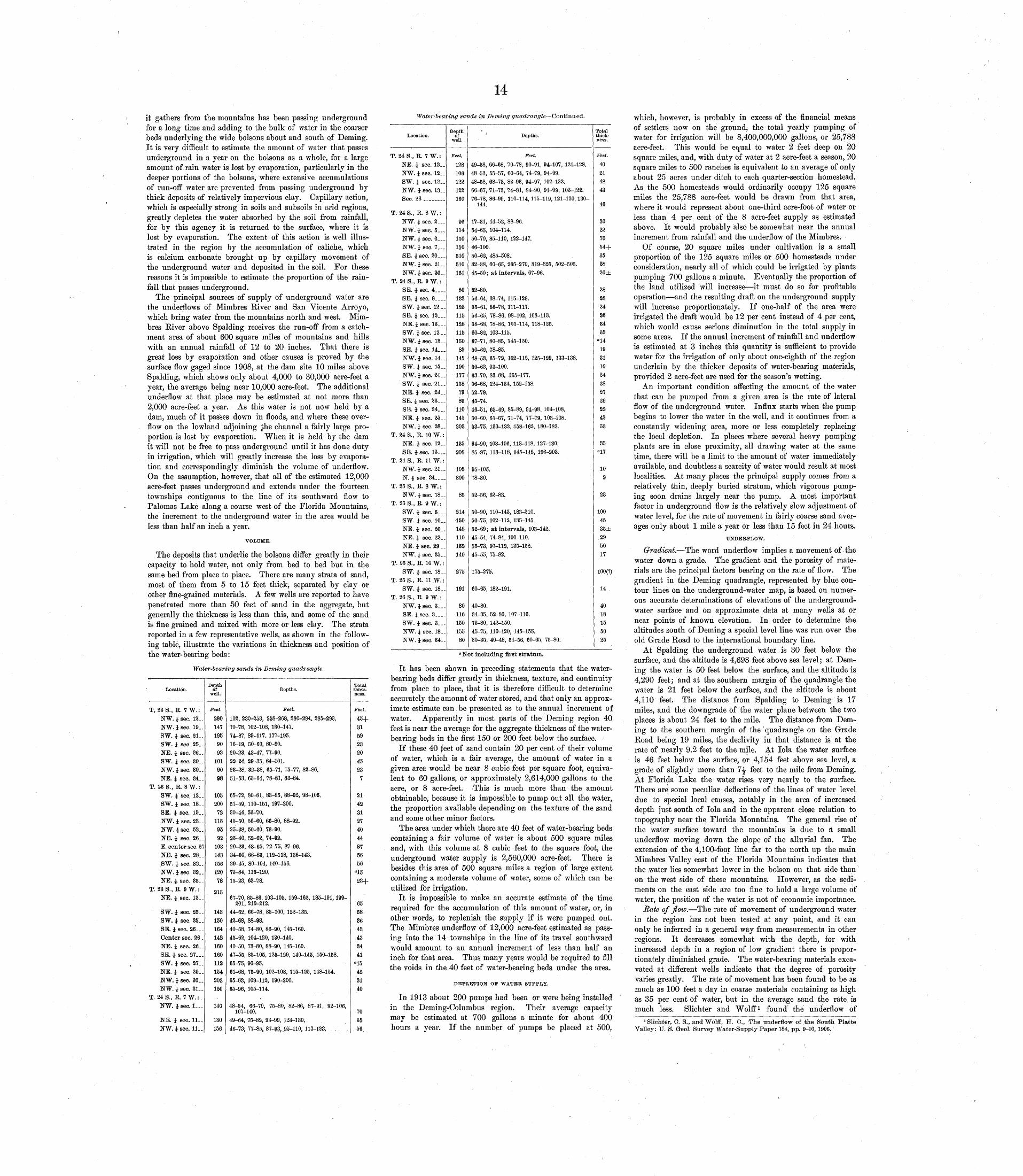
14
it gathers from the mountains has been passing underground for a long time and adding to the bulk of water in the coarser beds underlying the wide bolsons about and south of Deming. It is very difficult to estimate the amount of water that passes underground in a year on the bolsons as a whole, for a large amount of rain water is lost by evaporation, particularly in the deeper portions of the bolsons, where extensive accumulations of run-off water are prevented from passing underground by thick deposits of relatively impervious clay. Capillary action, which is especially strong in soils and subsoils in arid regions, greatly depletes the water absorbed by the soil from rainfall, for by this agency it is returned to the surface, where it is lost by evaporation. The extent of this action is well illus trated in the region by the accumulation of caliche, which is calcium carbonate brought up by capillary movement of the underground water and deposited in the soil. For these reasons it is impossible to estimate the proportion of the rain fall that passes underground.
The principal sources of supply of underground water are the underflows of Mimbres River and San Vicente Arroyo, which bring water from the mountains north and west. Mim bres River above Spalding receives the run-off from a catch ment area of about 600 square miles of mountains and hills with an annual rainfall of 12 to 20 inches. That there is great loss by evaporation and other causes is proved by the surface flow gaged since 1908, at the dam site 10 miles above Spalding, which shows only about 4,000 to 30,000 acre-feet a year, the average being near 10,000 acre-feet. The additional underflow at that place may be estimated at not more than 2,000 acre-feet a year. As this water is not now held by a dam, much of it passes down in floods, and where these over flow on the lowland adjoining £he channel a fairly large pro portion is lost by evaporation. When it is held by the dam it will not be free to pass underground until it has done duty in irrigation, which will greatly increase the loss by evapora tion and correspondingly diminish the volume of underflow. On the assumption, however, that all of the estimated 12,000 acre-feet passes underground and extends under the fourteen townships contiguous to the line of its southward flow to Palomas Lake along a course west of the Florida Mountains, the increment to the underground water in the area would be less than half an inch a year.
Water-bearing sands in Deming quadrangle Continued.
VOLUME.
The deposits that underlie the bolsons differ greatly in their capacity to hold water, not only from bed to bed but in the same bed from place to place. There are many strata of sand, most of them from 5 to 15 feet thick, separated by clay or other fine-grained materials. A few wells are reported to have penetrated more than 50 feet of sand in the aggregate, but generally the thickness is less than this, and some of the sand is fine grained and mixed with more or less clay. The strata reported in a few representative wells, as shown in the follow ing table, illustrate the variations in thickness and position of the water-bearing beds:
Water-bearing sands in Deming quadrangle.
Location.
T, 288., K. 7W.:NW.isec. 12_.NW. 1 sec. 19..SW. i sec. 21 _.SW. i sec 25..NE. i sec. 26. .SW. i sec. 30. .NW. i sec. 30. .NE. i sec. 34__
T. 288., R. 8W.:SW. i sec. 12..SW. i sec. 18. _SE. i sec. 19__NW. i sec. 23..NW.isec. 52. .NE. i sec. 26__E. center sec. 21NE. i sec. 28..SW. i sec. 32. .NW. i sec. 32. .NE. i. sec. 35..
T. 23 S., R. 9W.: NE. i sec. 13.-
SW. i sec. 25. _SW. i sec. 25.-SE. i sec. 26...Center sec. 26 .NE. i sec. 26..SE. 1 sec. 27. _.SW. i sec. 27. .NE. i sec. 29..NW. i sec. 30..NW. i sec. 31..
T. 24 S., R. 7W.:NW. i sec. 1...
NE. i sec. 11..NW.isec, ll._
Depth of
well.
Feet.
290
1471959092
1019098
10520072115959210314315612078
215
143150164142160160112154203120
140
130156
Depths.
Feet.
102, 230-253, 258-268, 280-284, 285-293.70-78, 102-108, 130-147.74-87, 89-117, 177-195.16-19, 50-60, 80-90.20-23, 43-47, 77-90.22-24, 29-35, 64-101.23-28, 32-38, 65-71, 75-77, 82-86.51-53, 63-64, 78-81, 83-84.
65-72, 80-81, 83-85, 88-92, 98-105.51-59, 110-151, 197-200.30-44, 53-70.45-50, 56-60, 66-80, 88-92.25-38, 50-60, 73-90.25-40, 52-62, 74-92.20-23, 43-65, 72-75, 87-96.34-60, 66-83, 112-118, 136-143.29-45, 80-104, 140-156.73-84, 116-120.15-23, 63-78.
67-70, 85-86, 103-105, 159-162, 185-191, 199- 201, 210-212.
44-62, 66-78, 85-100, 122-135.42-68, 88-98.40-58, 74-80, 86-90, 145-160.45-62, 104-120, 130-140.40-50, 73-80, 88-90, 145-160.47-55, 85-105, 125-129, 140-145, 150-158.65-75, 90-95.61-68, 75-90, 102-108, 115-125, 148-154.65-83, 109-112, 190-200.65-96, 105-114.
.48-54, 66-70, 75-80, 82-86, 87-91, 92-106,
107-140.49-64, 75-82, 93-99, 123-130.46-73, 77-85, 87-93, .95-110, 113-133. ,
Total thick ness.
Feet.
45+3159232045237
214231274044375656°15
23+
65583643433441
°15
423140
703556;
Location.
T. 24S..R. 7W.:NE. i sec. 12._NW. i sec. 12..SW. i sec. 12..NW. isec. 13. _ Sec. 26 ________
T. 24S.,R. 8W.:NW. i sec. 2___NW.isee. 5__-NW. i sec. 6___NW. I sec. 7...SE. i sec. 20__.NW. i sec. 21 _.NW. i sec. 30__
T. 24 S., R. 9 W.:SE. isec. 4__._SE. i sec. 8 _ _SW. isec. 12 __SE. isec. 12. _.NE. isec. 13...SW. isec. 13 _.NW. i sec. 13..SB. i sec. 14___NW. i sec. 14. .SW. i sec. 15_.NW. i sec. 21 ..SW. i sec. 21_.NE. i sec. 28..SE. i sec. 23. __SE. i sec. 24...NE. i see. 25__NW. i sec. 28. _
T. 24 S., R. 10 W.:NE. i sec. 12__SE. isec. 13 _
T. 24 S., R. 11 W.:NW.isec. 21 __N. i sec. 34 __
T. 25 S., R. SW.:NW. i sec. 18_-
T. 25 S., R. 9 W.:SW. i sec. 6___SW. i sec. 10__NE. i sec. 20_.NE. i sec. 22_.NE. isec. 29 __NW. i sec. 35..
T. 25 S., R. 10W.:SW. i sec. 18__
T. 25 S., R. 11 W.:SW.i sec. 18__
T. 26 S., R. 9 W.:NW.isec. 3__-SE. i sec. 3___-SW. i sec. 3___NW. i sec. 18__NW.isec. 34_ _
Depth of
well.
Feet.
128
106
122122 160
96114150150510510161
8013312311512811515085
1451001771587989110145203
135208
105300
85
214150148110152140
275
191
8011615015580
' Depths.
Feet.
49-58, 66-68, 70-78, 90-91, 94-107, 121-128.48-53, 55-57, 60-64, 74-79, 94-99.48-58, 68-73, 83-93, 94-97, 102-122.66-67, 71-73, 74-81, 84-90, 91-99, 103-122. 76-78, 86 99, 110 114, 115 119, 121 130, ISO-
144.
17-31, 44-52, 88-96.54-65, 104-114.50-70, 85-110, 122-147.46-100.50-62, 485-508.32-38, 60-65, 265-270, 319-325, 502-505.45-50; at intervals, 67-96.
52-80.56-64, 68-74, 115-129.55-61, 66-78, 111-117.56-65, 78-86, 98-102, 108-113.58-68, 78-86, 105-114, 118-125.60-82, 103-115.67-71, 80-85, 145-150.50-62, 78-85.48-53, 65-72, 102-112, 125-129, 133-138.59-62, 93-100.63-70, 83-88, 165-177.56-68, 124-134, 152-158.52-79.45-74.46-51, 65-69, 85-89, 94-98, 103-108.50-60, 65-67, 71-74, 77-79, 103-108.53-75, 130-132, 158-162, 180-182.
64-90, 103-106, 113-118, 127-130.85-87, 113-118, 145-148, 196-203.
95-105.78-80.
52-56, 62-83.
50-90, 110-143, 183-210.50-75, 102-112, 135-145.52-69; at intervals, 103-142.45-54, 74-84, 100-110.55-73, 97-112, 135-152.45-55, 75-82.
175-275.
60-65, 182-191.
40-80.34-35, 52-80, 107-116.73-80, 142-150.45-75, 110-120, 145-155.30-35, 40-48, 54-56, 60-65, 75-80.
Total thick ness.
Feet.
40
21
4843
46
30227054+352820±
282824263435«14
19811024282729224253
35"17
102
23
1004535±295017
100(?)
14
4018155025
"Not including first stratum.
It has been shown in preceding statements that the water bearing beds differ greatly in thickness, texture, and continuity from place to place, that it is therefore difficult to determine accurately the amount of water stored, and that only an approx imate estimate can be presented as to the annual increment of water. Apparently in most parts of the Deming region 40 feet is near the average for the aggregate thickness of the water bearing beds in the first 150 or 200 feet below the surface.
If these 40 feet of sand contain 20 per cent of their volume of water, which is a fair average, the amount of water in a given area would be near 8 cubic feet per square foot, equiva lent to 60 gallons, or approximately 2,614,000 gallons to the acre, or 8 acre-feet. 'This is much more than the amount obtainable, because it is impossible to pump out all the water, the proportion available depending on the texture of the sand and some other minor factors.
The area under which there are 40 feet of water-bearing beds containing a fair volume of water is about 500 square miles and, with this volume at 8 cubic feet to the square foot, the underground water supply is 2,560,000 acre-feet. There is besides this area of 500 square miles a region of large extent containing a moderate volume of water, some of which can be utilized for irrigation.
It is impossible to make an accurate estimate of the time required for the accumulation of this amount of water, or, in other words, to replenish the supply if it were pumped out. The Mimbres underflow of 12,000 acre-feet estimated as pass ing into the 14 townships in the line of its travel southward would amount to an annual increment of less than half an inch for that area. Thus many years would be required to fill the voids in the 40 feet of water-bearing beds under the area.
DEPLETION OP WATER SUPPLY.
In 1913 about 200 pumps had been or were being installed in the Deming-Columbus region. Their average capacity may be estimated at 700 gallons a minute for about 400 hours a year. If the number of pumps be placed at 500,
which, however, is probably in excess of the financial means of settlers now on the ground, the total yearly pumping of water for irrigation will be 8,400,000,000 gallons, or 25,788 acre-feet. This would be equal to water 2 feet deep on 20 square miles, and, with duty of water at 2 acre-feet a season, 20 square miles to 500 ranches is equivalent to an average of only about 25 acres under ditch to each quarter-section homestead, As the 500 homesteads would ordinarily occupy 125 square miles the 25,788 acre-feet would be drawn from that area, where it would represent about one-third acre-foot of water or less than 4 per cent of the 8 acre-feet supply as estimated above. It would probably also be somewhat near the annual increment from rainfall and the underflow of the Mimbres.
Of course, 20 square miles under cultivation is a small proportion of the 125 square miles or 500 homesteads under consideration, nearly all of which could be irrigated by plants pumping 700 gallons a minute. Eventually the proportion of the land utilized will increase it must do so for profitable operation and the resulting draft on the underground supply will increase proportionately. If one-half of the area were irrigated the draft would be 12 per cent instead of 4 per cent, which would cause serious diminution in the total supply in some areas. If the annual increment of rainfall and underflow is estimated at 3 inches this quantity is sufficient to provide water for the irrigation of only about one-eighth of the region underlain by the thicker deposits of water-bearing materials, provided 2 acre-feet are used for the season's wetting.
An important condition affecting the amount of the water that can be pumped from a given area is the rate of lateral flow of the underground water. Influx starts when the pump begins to lower the water in the well, and it continues from a constantly widening area, more or less completely replacing the local depletion. In places where several heavy pumping plants are in close proximity, all drawing water at the same time, there will be a limit to the amount of water immediately available, and doubtless a scarcity of water would result at most localities. At many places the principal supply comes from a relatively thin, deeply buried stratum, which vigorous pump ing soon drains largely near the pump. A most important factor in underground flow is the relatively slow adjustment of water level, for the rate of movement in fairly coarse sand aver ages only about 1 mile a year or less than 15 feet in 24 hours.
UNDERFLOW.
Gradient. The word underflow implies a movement of the water down a grade. The gradient and the porosity of mate rials are the principal factors bearing on the rate of flow. The gradient in the Deming quadrangle, represented by blue con tour lines on the underground-water map, is based on numer ous accurate determinations of elevations of the underground- water surface and on approximate data at many wells at or near points of known elevation. In order to determine the altitudes south of Deming a special level line was run over the old Grade Road to the international boundary line.
At Spalding the underground water is 30 feet below the surface, and the altitude is 4,698 feet above sea level; at Dem ing the water is 50 feet below the surface, and the altitude is 4,290 feet; and at the southern margin of the quadrangle the water is 21 feet below the surface, and the altitude is about 4,110 feet. The distance from Spalding to Deming is 17 miles, and the downgrade of the water plane between the two places is about 24 feet to the mile. The distance from Dem ing to the southern margin of the' quadrangle on the Grade Road being 19 miles, the declivity in that distance is at the rate of nearly 9.2 feet to the mile. At lola the water surface is 46 feet below the surface, or 4,154 feet above sea level, a grade of slightly more than 1\ feet to the mile from Deming. At Florida Lake the water rises very nearly to the surface. There are some peculiar deflections of the lines of water level due to special local causes, notably in the area of increased depth just south of lola and in the apparent close relation to topography near the Florida Mountains. The general rise of the water surface toward the mountains is due to a small underflow moving down the slope of the alluvial fan. The extension of the 4,100-foot line far to the north up the main Mimbres Valley east of the Florida Mountains indicates that the water lies somewhat lower in the bolson on that side than on the west side of these mountains. However, as the sedi ments on the east side are too fine to hold a large volume of water, the position of the water is not of economic importance.
Rate of flow. The rate of movement of underground water in the region has not been tested at any point, and it can only be inferred in a general way from measurements in other regions. It decreases somewhat with the depth, for with increased depth in a region of low gradient there is propor tionately diminished grade. The water-bearing materials exca vated at different wells indicate that the degree of porosity varies greatly. The rate of movement has been found to be as much as 100 feet a day in coarse materials containing as high as 35 per cent of water, but in the average sand the rate is much less. Slichter and Wolff 1 found the underflow of
^lichter, 0. S., and Wolff, H. C., The underflow of the South Platte Valley: U. S. Geol. Survey Water-Supply Paper 184, pp. 9-10, 1906.
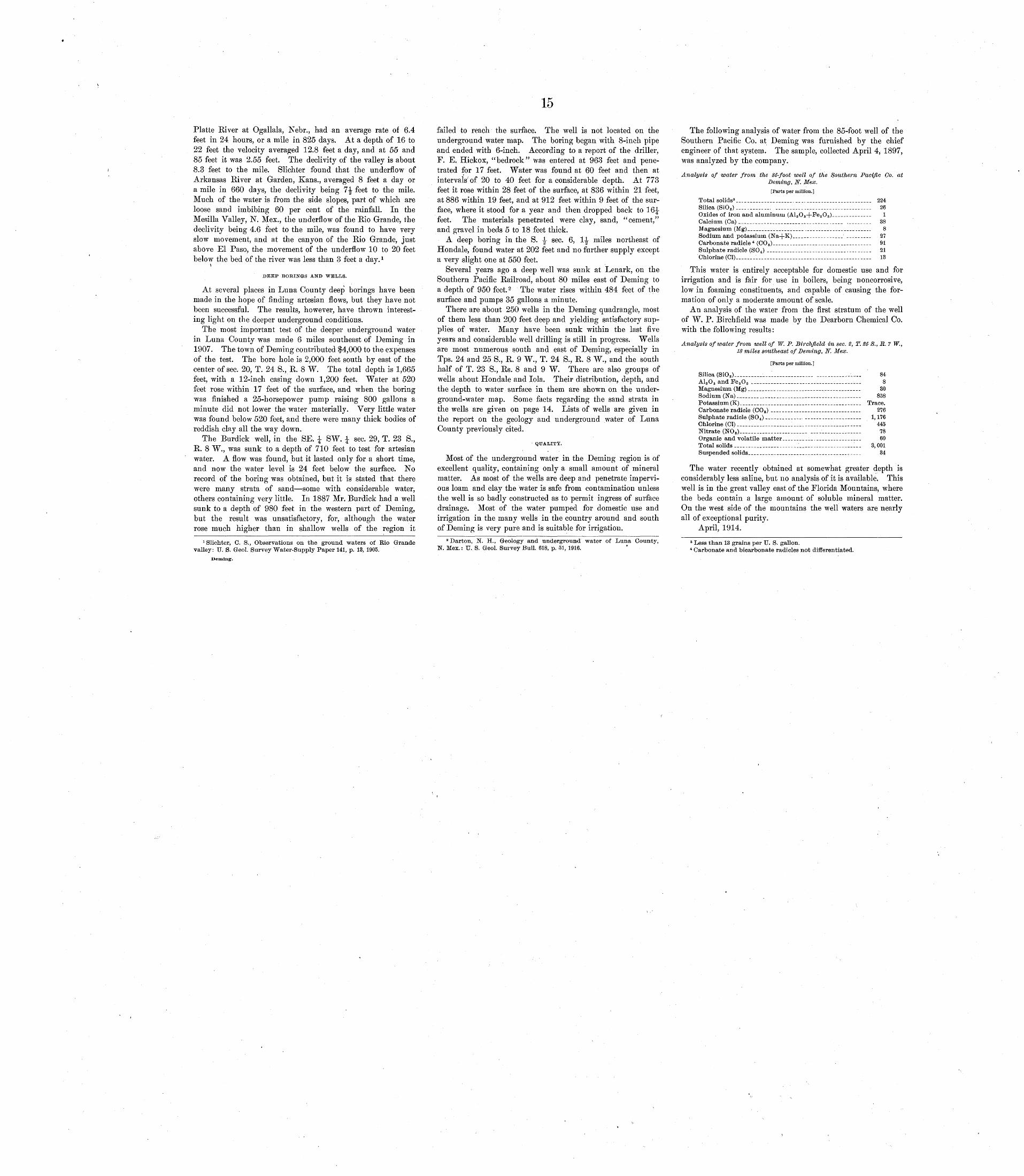
15
Platte River at Ogallala, Nebr., had an average rate of 6.4 feet in 24 hours, or a mile in 825 days. At a depth of 16 to 22 feet the velocity averaged 12.8 feet a day, and at 55 and 85 feet it was 2.55 feet. The declivity of the valley is about 8.3 feet to the mile. Slichter found that the underflow of Arkansas River at Garden, Kans., averaged 8 feet a day or a mile in 660 days, the declivity being 7^ feet to the mile. Much of the water is from the side slopes, part of which are loose sand imbibing 60 per cent of the rainfall. In the Mesilla Valley, N. Mex., the underflow of the Rio Grande, the declivity being 4.6 feet to the mile, was found to have very slow movement, and at the canyon of the Rio Grande, just above El Paso, the movement of the underflow 10 to 20 feet below the bed of the river was less than 3 feet a day. 1
DEEP BORINGS AND WELLS.
At several places in Luna County deep borings have been made in the hope of finding artesian flows, but they have not been successful. The results, however, have thrown interest ing light on the deeper underground conditions.
The most important test of the deeper underground water in Luna County was made 6 miles southeast of Deming in 1907. The town of Deming contributed $4,000 to the expenses of the test. The bore hole is 2,000 feet south by east of the center of sec. 20, T. 24 S., R. 8 W. The total depth is 1,665 feet, with a 12-inch casing down 1,200 feet. Water at 520 feet rose within 17 feet of the surface, and when the boring was finished a 25-horsepower pump raising 800 gallons a minute did not lower the water materially. Very little water was found below 520 feet, and there were many thick bodies of reddish clay all the way down.
The Burdick well, in the SE. £ SW. J sec. 29, T. 23 S., R. 8 W., was sunk to a depth of 710 feet to. test for artesian water. A flow was found, but it lasted only for a short time, and now the water level is 24 feet below the surface. No record of the boring was obtained, but it is stated that there were many strata of sand some with considerable water, others containing very little. In 1887 Mr. Burdick had a well sunk to a depth of 980 feet in the western part of Deming, but the result was unsatisfactory, for, although the water rose much higher than in shallow wells of the region it
1 Slichter, C. S., Observations on the ground waters of Rio Grande valley: U. S. Greol. Survey Water-Supply Paper 141, p. 13, 1905.
Deming.
failed to reach the surface. The well is not located on the underground water map. The boring began with 8-inch pipe and ended with 6-inch. According to a report of the driller, F. E. Hickox, "bedrock" was entered at 963 feet and pene trated for 17 feet. Water was found at 60 feet and then at intervals' of 20 to 40 feet for a considerable depth. At 773 feet it rose within 28 feet of the surface, at 836 within 21 feet, at 886 within 19 feet, and at 912 feet within 9 feet of the sur face, where it stood for a year and then dropped back to 16^ feet. The materials penetrated were clay, sand, "cement," and gravel in beds 5 to 18 feet thick.
A deep boring in the S. \ sec. 6, \\ miles northeast of Hondale, found water at 202 feet and no further supply except a very slight one at 550 feet.
Several years ago a deep well was sunk at Lenark, on the Southern Pacific Railroad, about 80 miles east of Deming to a depth of 950 feet. 2 The water rises within 484 feet of the surface and pumps 35 gallons a minute.
There are about 250 wells in the Deming quadrangle, most of them less than 200 feet deep and yielding satisfactory sup plies of water. Many have been sunk within the last five years and considerable well drilling is still in progress. Wells are most numerous south and east of Deming, especially in Tps. 24 and 25 S., R. 9 W., T. 24 S., R. 8 W., and the south half of T. 23 S., Rs. 8 and 9 W. There are also groups of wells about Hondale and lola. Their distribution, depth, and the depth to water surface in them are shown on the under ground-water map. Some facts regarding the sand strata in the wells are given on page 14. Lists of wells are given in the report on the geology and underground water of Luna County previously cited.
QUALITY.
Most of the underground water in the Deming region is of excellent quality, containing only a small amount of mineral matter. As most of the wells are deep and penetrate impervi ous loam and clay the water is safe from contamination unless the well is so badly constructed as to permit ingress of surface drainage. Most of the water pumped for domestic use and irrigation in the many wells in the country around and south of Deming is very pure and is suitable for irrigation.
3 Darton, N. H., Geology and underground water of Luna County, N. Mex.: U. S. Geol. Survey Bull. 618, p. 51, 1916.
The following analysis of water from the 85-foot well of the Southern Pacific Co. at Deming was furnished by the chief
O /
engineer of that system. The sample, collected April 4, 1897, was analyzed by the company.
Analysis of water from the 85-foot well of the Southern Pacific Co. atDeming, N. Mex.
[Parts per million.]
Total solids8 ....__._._.__...... _________________ 224Silica (SiO,) ____._____._. ________._.___.___._.____ _____. 26Oxides of iron and aluminum (Al2 O 8+Pe 2 O 8 )_-___--------- 1Calcium (Ca) __._.._____._......._..__ -.__--... 38Magnesium (Mg)_______.__ .....______.__. 8Sodium and potassium (Na-j-K)___.___..._____ .__ ___. 27Carbonate radicle * (CO 8)___.______..____ ___._- 91Sulphate radicle (SO 4 ) _______. _..._..._.__._..-__._ 21Chlorine (Cl). ___ __________________________________..____ 13
This water is entirely acceptable for domestic use and for irrigation and is fair for use in boilers, being noncorrosive, low in foaming constituents, and capable of causing the for mation of only a moderate amount of scale.
An analysis of the water from the first stratum of the well of W. P. Birchfield was made by the Dearborn Chemical Co. with the following results:
Analysis of water from well of W. P. Birchfield in sec. S, T. 25 S.,JR.7W., 18 miles southeast of Deming, JW. Mex.
[Parts per million.]
Silica (SiO_)_____________l______________ __________ __._ 84A12 0 8 and Fe 2 O 8 ________________________________ 8Magnesium (Mg) _____ ._ __ ___ ____ ____ 30Sodium (Na).__....._..______.__.._..._________ 858Potassium (K)_________._..__..____._______________ Trace.Carbonate radicle (CO 8 ) _------___-________. 276Sulphate radicle (S0 4 ) ______________ ______. ________ 1,176Chlorine (Cl) ___________________:___.____________________ 445Nitrate (NO,)_____________ .______ __________ ______ 78Organic and volatile matter____..._. ________ 60Total solids.____.___.__.__.____.._____ 8,001Suspended solids___....__.__________..__. 34
The water recently obtained at somewhat greater depth is considerably less saline, but no analysis of it is available. This well is in the great valley east of the Florida Mountains, where the beds contain a large amount of soluble mineral matter. On the west side of the mountains the well waters are nearly all of exceptional purity.
April, 1914.
8 Less than 13 grains per U. S. gallon.4 Carbonate and bicarbonate radicles not differentiated.