Embed Size (px)
Citation preview

Deschutes National Forest
Fall Trail Access and Conditions Update KNOW BEFORE YOU GO
Updated October 10 2014 - Columbus Day Weekend Report
Trail crew members and COIC youth crew working on
debris removal along Sun-Lava Paved Path Cleanup with
temporary closures will wrap-up Oct 10
Student Conservation Volunteers worked thousands of hours on
trail reconstruction this summer Thanks SCA
Summer Trail Highlights
Likely cooler and wet weather with shorter
daylight hours are signs that Fall conditions
are with us over the coming months We
will increasingly see snow at higher
elevations over the coming weeks Watch
weather forecasts closely and go prepared
Two recent search and rescue missions on
Broken Top and just west of Middle Sister
due to sudden coldwet weather confirm
the need to go prepared for the
unexpected Unprepared hikers became
lost in poor visibility and were experiencing
late stages of hypothermia before being
found by Deschutes County SAR volunteers
370 Road is open for the season and
scheduled to remain open until snowfall
Summer trails are currently snow free 80-
85 of Deschutes National Forest trails
are cleared of downed trees
Flagline Trail is open for the season
Green Lks Moraine Lk basins currently
snow free Overnight camping permitted
only in Designated Campsites no campfires
Three Sisters Loop is currently snow free
Go prepared with your Ten Essential
Systems
Navigation (map and compass)
Sun protection (sunglassessunscreen)
Insulation (extra clothing)
Illumination (headlampflashlight)
First-aid supplies
Fire(waterproofmatcheslightercandles)
Repair kit and tools
Nutrition (extra food)
Hydration (extra water)
Emergency shelter
GENERAL SUMMER TRAIL CONDITIONS AS OF OCT 10
PCT trail clearing
Backcountry trail access is generally good Approximately 85 of the Deschutes
National Forest Trails are clear of blowdown or readily passible to hiker biker and
stock travel Down trees are possible yet on some trails and a few trails thru beetle
or fire kill areas may have higher numbers of downed trees With recent warm and
dry weather trails are again becoming dusty Enjoy the great Fall trail conditions
Be prepared for possible snow fall at higher elevations over the coming weeks 925 a
ldquodustingrdquo of snow fell above 8700rsquo along the Pacific Crest peaks
Camping in Moraine and Green Lakes
basins permitted only at designated
campsites Tents must be within 15
ft of campsite post Campfires
prohibited and please pack out toilet
paper Expect campsites near or at
capacity on weekends If full you
must camp outside of signed basin
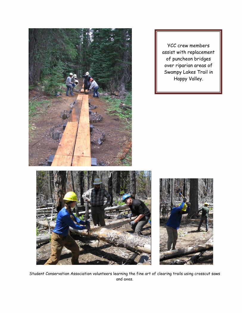
Student Conservation Association volunteers learning the fine art of clearing trails using crosscut saws
and axes
YCC crew members
assist with replacement
of puncheon bridges
over riparian areas of
Swampy Lakes Trail in
Happy Valley
Allingham Trail College students learning to appreciate trail drainge improvements using large (heavy)
rocks
Fall planting and
continued riparian
restoration along
Metolius River
begins again next
week Watch for
workers along
trails
Trail volunteers hitting
the trails for logout and
general maintenance
Each year hundreds of
trail volunteers put in
thousands of hours
towards maintaining
over 2000 miles of
Deschutes National
Forest trails summer
and winter Without
volunteers your public
access trails would not
be as enjoyable as they
are Remember to
ldquoThankrdquo our volunteers
DESCHUTES NATIONAL FOREST SUMMER TRAILHEADSTRAILS
BendFort Rock Ranger District summer trailsaccess
Phils TH area trails are cleared of down trees moderate to high use and in good
condition Benrsquos and Philrsquos Trails are now one-way trails See map and additional
information below For more information on COTA who they are what they do and how
you can help go to httpcotamtbcom Deschutes National Forest and COTA are
asking for your help in preventing vandalism on public access trails If you see or have
information regarding vandalism on public trails and facilities please contact local land
managers or law enforcement
Tumalo Falls Trailhead is OPEN North Fork Trail is currently snow free and in good
condition The trail is cleared of blowdown and open to bikers in the uphill only direction
Reminder for bikers biking is permitted in the uphill direction only on North Fork to the
Metolius-Windigo Trail for a downhill return trip on Mrazek and or Farewell Trails Bridge
Creek Trail is hiking only and closed to bikes stock animals and dogs as it passes thru the
Bend Municipal Watershed North Fork Trail is open to hikers dogs and bikers (uphill
only) South Fork trail to Swampy trail system might have light blowdown Flagline Trail
is open for the season Be aware of water line constructiontraffic delay in progress along
Skyliner Road to Tumalo Falls Trailhead
Mrazek Trail beyond Shevlin Park currently has a short detour due to the Two Bulls
Fire Follow the trail detour signs to the 4609 road
Deschutes River TrailheadsTrails are in good condition from Entrada to Benham Falls and
on to Sunriver The new Sun-Lava paved path is now open East Benham Falls day use area
trails received a new layer of packed gravel for a barrier free trail experience Be aware
of additional work on the Sun-Lava Trail just east of Benham East Day Use area
Sun-Lava paved path is now open These 53 miles of 10 ft wide paved trails are open to
non-motorized wheeled vehicles (bikes wheel chairs strollers roller blades skate boards
unicycles etc) and connect Sunriver to Lava Lands and Benham East day use area The
paths are very popular on weekends with hikers and wheeled traffic Please slow down on
hills at roadtrail crossings and in congested areas Watch for other trail users and be
courteous October 10 is the last scheduled day for removal of over 200 slash piles and
firewood from the trail edges Temporary closures were in place for public and worker
safety
Another short term trail closure will be in place for the trail section between the Benham
Foot Bridge and Black Rock mt bike trail This work will correct the steep cut slope along
the trail Trail traffic will be rerouted during the project with possible start date
sometime within the next 2 weeks
The seasonal DOG LEASH regulations along the Deschutes River and Wilderness trails
around Todd Lake Broken Top Green and Moraine Lakes and South Sister have been
lifted as of September 15 Please continue to practice ldquocanine courtesyrdquo with your pets by
maintaining full voice or physical control as necessary and when near other users and
wildlife The leash requirement will go into effect with next yearrsquos high use periods
Lava Lands Trails - Lava Lands seasonal closure begins cob October 12 Lava Lands
interpretive trails and the trail on Lava Butte are open Blackrock Trail to Benham East
has reopened with minor reroutesconnections with the newly opened Sun-Lava paved path
Lava River Cave closed for the 2014 season on Sept 8 early due to stair reconstruction
Wanoga Mt Bike Trails are snow free and in good condition
Swampy Lake Trails are mostly cleared of blowdown Flagline is open for the season
Snow is likely over coming weeks
Tumalo Mt ndash Trail is cleared of blowdown Snow is likely over coming weeks
Todd Lake Trailhead and parking area are open Todd Lake basin normally begins to see
snow in October There are about 15 trees down on the trail around the lake and the
meadows may be soft and possible with mud please stay on trails Road 370 is open for
the season This includes access to road 380 which provides vehicle access to the
Broken Top Trailhead Road 380 is very rough and high clearance vehicle
recommended The road is subject to snow closure without notice during the month
of October or early November
Todd Creek Horse Camp ndashAccess on the Metolius-Windigo Horse trail southbound to
Quinn Meadow is good and northbound to Happy Valley also good Snow is possible over
coming weeks
Sparks Lake Trailhead ndash Trailhead is currently accessible with trail to MetWin TR
cleared Snow is possible over coming weeks
Ray Atkison Trailhead and Sparks Lake boat ramp ndash Trails cleared of blowdown
Green LakesSoda Creek Trailhead ndash Currently snow free and mostly cleared of
blowdown Snow is likely over coming weeks See Wilderness sections below
Devils LakeSouth Sister Trailhead ndash Currently snow free on Climbers Trail but a light
snow fell on the volcanoes above 8700rsquo in late September Most trails in area are cleared
of blowdown Snow is likely over coming weeks See Wilderness sections below
Quinn Meadow Horse Camp area trails ndash Snow free access with most non-Wilderness
trails near the camp now cleared of blowdown
Metolius-Windigo Trail - 90 of the trail has been cleared with the remaining 10 not
scheduled to be cleared this year Trail sections are cleared or light blowdownpassible
from Bear Valley TH (see TH closure below) to Three Creeks HC and then cleared from
Todd Ck HC to approx Moore Creek Trail Then cleared along Crescent Lake to Windigo
Pass Snow is likely over coming weeks
Cultus Lake and Winopee Lk TH - Accessible Winopee Lk Trail is cleared from TH at
Cultus Lk to Winopee Lk Trails beyond Winopee Lk to PCT possible light to moderate
blowdown Trails around Cultus to Deer Lk Little Cultus and on to Many Lakes Trailheads
are also cleared
Lemish Lake TH ndash Accessible with trail to LemishCharlton Lks then west to Many Lks
Trailhead cleared of blowdown Road access to Little Cultus Lake bumpy but good with
the road to IrishTaylor snow free and though rough is passable to high clearance
vehicles Snow is likely over coming weeks
Charlton Lake TH ndash Accessible with PCT mostly cleared north to IrishTaylor Lakes and
beyond The trees that were blocking stock traffic north of IrishTaylor Lks to Six Lks
Trail have been cleared Lily Lake Trail from PCT has not been cleared for approx 10 yrs
with approx 150 trees down is brushy and difficult to follow and not passible by stock
Volunteers will attempt to clear this access to Lily Lk sometime in Fall Snow is likely over
coming weeks
Osprey Point TH ndash Accessible and light blowdown likely
Fall River Trail ndash Light blowdown possible
SouthNorth Twin Lakes area trails ndashLight blowdown likely
Horse Butte to Swamp Wells area trails ndash Horse Butte to Swamp Wells area trails ndash
Area trails are mostly in good condition Blowdown either cleared or light north of Swamp
Wells CG Swamp Wells Trail south towards Crater Rim Trail is mostly cleared with
blowdown likely within 1-2 miles of Crater Rim Trail These are primary use horse trails
bikers if you do use these trails yield to equestrians use extra caution around horses
remove litter and help prevent user conflicts Be aware of recent prescribed burn
activities along some trails
Newberry Caldera trails currently accessible from the caldera floor to the rim with all
trails cleared of blowdown The road to Paulina Peak is open but subject to snow closure
without notice Snow is likely over coming weeks
Peter Skene Ogden (PSO) Trail - Cleared of blowdown Bikers are allowed in uphill
direction only
Lava Cast Forest Trailhead ndash Trailhead and trail are accessible and free of blow down
PCT ndash Trailhead accesses from the Deschutes National Forest approaches are currently
accessible PCT trail clearing completed or in progress along most sections Hwy 242
Mckenzie Pass currently open but subject to snow closure without notice Snow is likely
over coming weeks
3 lost hikers recently rescued near Mirror Lake Trio of lost hikers were found very
near the trail after becoming disoriented when leaving the trail If ldquodirectionally
challengedrdquo not experienced in backcountry settings unfamiliar with area etc stay on
trails
Wilderness Trails ndash See special wilderness trails section below
Sisters Ranger District summer trailsaccess
Black Butte Trail ndash Trailhead is accessible Hiker use only on both upper and new lower
Black Butte Trails Upperlower trails now cleared Snow is likely over coming weeks
Metolius River Trails ndash Good condition An ongoing trail project involving rock hardening
of eroding river bank from Head of the Metolius to Bridge 99 has begun and will continue
into fall with further riparian restoration and planting Please avoid walking thru the many
trail and river side restoration sites Hiker only trails
Metolius River Restoration with Northwest Youth Corps
Peterson Ridge Trails - Area trails and trailheads are mostly fair to good conditions
Trail maintenance in progress with most trails cleared of blowdown Rodeo ground tie trail
horse ford on Wychus Creek is now cleared for fording
Suttle Lake Trail is in good condition Recent yearrsquos shorelinetrail stabilization project
to repair shoreline trail erosion continues Watch for ongoing trail restoration work and
rock materials that have been moved onto the trail for repairs Please do not move or play
on any of this rock as it may move unexpectedly
Lake Creek Trail is open to bikerhiker use along its entire length from Suttle Lake
Resort to Camp Sherman This trail is mostly located on closed roads and makes for
mostly easy family friendly biking and hiking Watch your head when going under the Hwy
20 bridge and with its limited vertical clearance of less than 6 ft Approximately 2 miles
of the mid-section are open to horse traffic with access from the Metolius-Windigo Trail
Metolius-Windigo Trail - SEE DETAILS IN BENDFORT ROCK RANGER DISTRICT
ABOVE
Head of Jack Creek Trail ndash Accessible and cleared of blow down from the trailhead and
the campground to the head springs area The hiker only foot bridge at the head of the
Jack Creek has been removed due to poor condition Please stay on trail in this area and
avoid walking in the remaining fragile riparian area
PCT ndash SEE PCT DETAILS IN BENDFORT ROCK RANGER DISTRICT ABOVE
Wilderness Trails ndash See special wilderness trails section below
Crescent Ranger District summer trailsaccess
PCT ndash SEE PCT DETAILS IN BENDFORT ROCK RANGER DISTRICT ABOVE
Oldenberg Trail is cleared from Whitefish HC to Windigo Pass Snow is likely over coming
weeks
Summit Lk Trail ndash Access to Summit Lake from Crescent is a rough road First 3 miles of
trail cleared with light to moderate blowdown beyond Snow is likely over coming weeks
Meek Lk Trail ndash Unknown conditions but expect blowdown Snow is likely over coming
weeks
Windy Lakes Trail ndash Trail conditions of moderate blowdown with first 15 mile cleared
Windigo Pass ndashrough road Snow is likely over coming weeks
Whitefish Horse Camp ndash Whitefish Trail cleared and very passible from Horse Camp to
Trapper Ck TH and Oldenberg trail cleared to Windigo Pass Crater Butte Trail east of
Whitefish Ck Trail mostly cleared of blowdown Fawn Lk Trail cleared Snow is likely over
coming weeks
Metolius-Windigo Trail - SEE DETAILS IN BENDFORT ROCK RANGER DISTRICT
ABOVE
Maiden Peak ndash Cleared of blowdown Snow is likely over coming weeks
Wilderness Trails ndash See special wilderness trails section below
Special Deschutes National Forest Wilderness Trails Report Updated 101014
Wilderness Permits Required
Wilderness permits are required thru
October 31 within all Deschutes National
Forest Wildernesses Please be sure to
read trailhead information and fill out the
free self-issue permit at the permit
station
ldquoLEAVE NO TRACErdquo REMINDER
PLEASE PRACTICE THE SEVEN LEAVE NO TRACE PRINCIPALS Plan Ahead and Prepare Travel and Camp on Durable Surfaces Dispose of Waste Properly ndash See photo and information below on wrong disposal and effects
Leave What You Find Minimize Campfire Impacts Respect Wildlife Be Considerate of Other Visitors For details on the 7 LNT Principals httplntorglearn7-principles
POLE CREEK BURN AREA NOTICE
Hazardous tree conditions exist within the Pole Creek burn area Use within the
Wilderness sections of this burn is restricted to the trails no cross country travel
and no camping until you exit the burn area
boundary 95 of the Wilderness trails
within the burn have been cleared of
blowdown Burn area boundaries are posted
with maps and signing indicating either
entering or leaving the burn area You cannot legally access lower Snow Creek from
Snow Creek Ditch or Park Meadow Trail The Ditch has been removed and placed in
restoration not passible and is closed
Example of area closure map for Pole Creek
Burn Area within the Wilderness area of the
burn is closed except for travel limited to the
trails no off trail use or camping permitted
If you are passing thru the effected burn
area closure along the Green Lakes Trail be
aware that there are approx 8 trail miles you
are not allowed to travel off the Green Lakes
Trail or camp along Add these miles to those
trail miles before or after the restricted
boundaries to calculate your distance between
campsites
Deschutes National Forest Wilderness trailheads are accessible except as noted below
Approx 80 of Wilderness trails have been cleared of blowdown
Mt Jefferson Wilderness
BEWARE Since 2003 Brush Ck Minto Lake northern end of Jefferson Lake and
Sugar Pine Ridge Trails have been in a no current maintenance condition With
heavy blowdown dense brush lack of identifiable trail surface and erosion due to B
and B Fire damage these trails are considered impassable and are not recommended
In recent years several hikers have reported becoming lost trying to follow these
trails from the west with a few turning into search and rescue missions Jefferson
Lake Trail is currently extremely difficultchallenging (likely impassable) for hikers
beyond mile 23 and impassable for stock as well due to dense brush and blow down
Jefferson Lake TH ndash Jefferson Lake Trail Dense brush has been cleared for 23 miles
of this 9 mile trail Limited clearing of down trees has also occurred in this 23 miles with
ldquostep oversrdquo to 24rdquo high remaining Beyond the cleared section the brush for 3-4 miles is
again very dense up to 8rsquo high and impassable Sections of trail tread are buried in
downed trees (400-500 of them) and overgrown with vegetation and YOU WILL LOSE
THE TRAIL in areas This trail is not recommended and currently not being maintained
due to the extreme post fire impacts over the past 11 years
August 2014 photos of Jefferson Lk Trail between miles 23 and 6 Dense snowbrush up
to 8rsquo tall overgrown trail tread and hundreds of downed logs effectively block trail Losing
the trail is very likely Use not recommended
Brush Creek TH ndash TH accessible Brush Creek Trail currently impassable to all traffic
No trail maintenance scheduled at this time
Cabot Lake TH ndash Trailhead and trails to Cabot Lake Shirley Lake Carl Lake and Junction
LakeTrail are mostly cleared and open Cabot Lk Trail north of Junction Lake Sugar Pine
Ridge and Jefferson Lake Trails are closed due to wild fire See Jefferson Lk TH above
for heavy blowdownbrush warning on Jefferson Lk Trail Snow is likely over coming
weeks
Bear Valley TH ndash Road and trailhead now accessible Rockpile Lake trail has 87 trees
down with no clearing scheduled this season Minto Lake Trail is impassable to all
traffic due to erosion brush blowdown with no maintenance since the 2003 B and B
Fire
Jack Lake TH ndash TH accessible with trails blowdown free Canyon Creek loop trail has been
cleared Trail to Wasco Lake and PCT cleared Old Summit Trail south cleared of
blowdown to Santiam Pass Snow is likely over coming weeks
Round Lake TH ndash Accessible trail cleared to Square Lk Old Summit Trail cleared of
blowdown Snow is likely over coming weeks
PCT ndash SEE PCT DETAILS IN BENDFORT ROCK RANGER DISTRICT ABOVE
Mt Washington Wilderness
Dry Creek TH ndash Dry Creek trail has not been maintained for years and has heavy blow
down through extensive fire kill forest Considered impassible This trail is under a non-
maintenance condition
PCT ndash SEE PCT DETAILS IN BENDFORT ROCK RANGER DISTRICT ABOVE
Three Sisters Wilderness
Three Sisters Loop ndash Eastside trails are mostly cleared of blowdown PCT may have
downed trees yet If you are passing thru the effected Pole Creek burn area closure along the
Green Lakes Trail be aware that there are approx 8 trail miles you are not allowed to travel off
the Green Lakes Trail or camp along Add these 8 miles to those trail miles before or after the
restricted boundaries to calculate your distance between campsites Snow is likely over coming
weeks
Volunteers logging
out Canyon Creek
Trail on 619
Trails
snowblowdown
free
PCT ndash SEE PCT DETAILS IN BENDFORT ROCK RANGER DISTRICT ABOVE
PCT TH at Irish and Taylor Lakes ndash Road to IrishTaylor Lks passable to high clearance
vehicles with road in rough condition PCT north of IrishTaylor Lks to 6 Lks Trail has
been cleared of ldquostock blockingrdquo trees and is in good condition Snow is likely over coming
weeks
Many Lakes TH ndash TH accessible with MetWin Trail cleared to Lemish and on to Moore Ck
and towards Cultus Lk and on to Todd Lake area Snow is likely over coming weeks
Deer Lake TH ndash Trailhead accessible trail cleared of blowdown to Many Lakes Little and
Big Cultus Lakes
Winopee Lake TH ndash Accessible with Winopee Lk Trail cleared of blowdown to Winopee
Lake Trail on to Snowshoe Lakes light blowdown with some brush encroaching Snow is
likely over coming weeks
Corral Swamp TH ndash Accessible TH Trail cleared to MetWin and for some distance north
and south on MetWin
Lucky Lake TH ndash Accessible with trail cleared to Lake Senoj Lk Tr cleared
Six Lakes TH ndash Accessible with trail cleared to PCT Snow is likely over coming weeks
Elk Lake TH ndash TH accessible and trails to PCT free of blowdown Snow is likely over
coming weeks
Mirror Lk TH ndash TH accessible and trails cleared of blowdown Campfires prohibited within
frac14 mile of Mirror Lakes management area Snow is likely over coming weeks
3 hikers recently rescued near Mirror Lake Trio of lost hikers were found very near a
trail after becoming disoriented when leaving the trail If ldquodirectionally challengedrdquo not
experienced in backcountry settings unfamiliar with area etc stay on trails
Devils Lakes TH ndash TH accessible and trails mostly cleared of blowdown Wilderness
Permit registration station on Wickiup Plains Trail moved to just west of culvert under
Highway Snow is likely over coming weeks
South Sister Climbers ndash Trailheads accessible with Climbers Trail Have a map and
navigation equipment compassGPS Also pack all of your ldquoTen Essentialsrdquo Be aware of
possible thunderstorm activity and avoid mountain weather can change with little warning
Fall snow is possible and likely over the coming weeks
Green Lakes TH ndash TH accessible and trails clear of blowdown to Green Lakes on Fall Ck
Trail Soda Ck Trail cleared of blowdown Snow is likely over coming weeks
Todd Lake Trailhead and parking area are open There are about 15 trees down on the
trail around the lake and the meadows are currently saturated with muddy sections of
trail Road 370 is open This includes access to road 380 (very rough high clearance only)
which provides vehicle access to the Broken Top Trailhead Do not block closed gates
Snow is likely over coming weeks
Broken Top TH ndash Road 370380 open high clearance vehicles only on road 380 Snow
closures of these roads subject with little to no notice Snow is likely over coming weeks
Tam RimThree Creek Lake area Trailheads ndash TH accessible Trail cleared to rim Most
trails around lakes cleared of blowdown Snow is likely over coming weeks
Park Meadow TH ndash Accessible with trail cleared for 4 miles then a few trees on trail to
the meadows 1 mile section of trail has been reconstructed into single track from the old
road bed with improved drainage for erosion control 16 road gate open Snow is likely
over coming weeks
Pole Creek TH ndash Trailhead accessible with trail cleared to Green Lks Trail then south on
Green Lks Trail to the ponds or boundary of the Pole Ck Burn and Green Lks Trail cleared
north to Scott Pass Trail Limited trail clearing to Camp Lk with one large tree reported
to be challenging for stock Scott Pass Tr cleared of blowdown to PCT Snow is likely over
coming weeks
Scott Pass and Millican Crater Trailheads ndash Trailheads accessible Scott Pass Tr Trout
Creek Tie and Millican Crater Trails cleared of blowdown Snow is likely over coming weeks
Black Crater TH ndash Hwy 242 open trail to summit cleared of blow down Snow is likely over
coming weeks Hwy closure subject to little or no notice due to snow
Lava Camp Lake TH ndash Hwy 242 open TH accessible some blowdown possible to North
Mathieu Lk
Diamond Peak Wilderness
PCT ndash SEE PCT DETAILS IN BENDFORT ROCK RANGER DISTRICT ABOVE
YCC crew working
on finishing
touches on section
of reconstructed
Park Meadow
Trail
Pengra Pass TH ndash Accessible SouthNorthbound PCT trail clearing in progress Snow is
likely over coming weeks
Yoran Lk TH - Accessible Trail to Yoran Lk currently has 30 blowdown Limited
maintenance in progress
Fawn Lk TH is accessible with Fawn Lake trail cleared to lake and then on Crater Butte to
Whitefish Creek Trail Approx 25 down trees on Crater Butte Trail to C B Trailhead
Another 30 trees on Crater Butte Trail west of Whitefish Ck Trail
Whitefish Horse Camp Whitefish Creek Trail cleared and very passible from Horse Camp
to Trapper Ck TH and Oldenberg trail cleared to Windigo Pass Crater Butte Trail east of
Whitefish Ck Trail cleared of blowdown to Fawn Lk Fawn Lk Trail cleared
Summit LkPCT ndash Road access from Crescent Lk clear to Summit Lk and to the pass 3
miles of Summit Lk trail is cleared with blowdown beyond Snow is likely over coming
weeks
One-Way Trails
BenrsquosPhilrsquos Loop
Benrsquos Trail will be uphill only from the trailhead to Road 300
Philrsquos Trail will be downhill only from Junction 18 (at Kentrsquos
Trail) to the trailhead
The one-way loop trail will
Increase safety by reducing user collisions
Reduce user conflict by reducing high-speed passing
Provide better continuity by reducing stopping to allow others to pass
Increase the feeling of solitude Even in high use areas directional trails can
make it seem like there are fewer people on the trails
ldquoKeep single track singlerdquo Trails will be less impacted by users riding off-trail to
pass each other going in opposite directions
Allow for more challenging mountain bike rides Directional trails allow riders
to challenge themselves with fewer interruptions
For additional information
Visit the COTA website at wwwcotamtbcom
Contact the Deschutes National Forest 541-383-4700
Philrsquos
Trailhead
SEASONAL ROAD CLOSURESOPENINGS
Hwy 46
Cascade Lks
Hwy
Fully open from Bend to Crescent Cutoff Road Snow is likely over
coming weeks with road closure subject to little or no notice due to
snow
Road 370 OPEN from Todd Lake parking area to Road 16 (Three Creeks area)
Sections of road very rough high clearance recommended Please
keep vehicles on open roadways and parking spurs Road subject to
snow closure without notice Normal closure occurs mid-late Oct
Tumalo Falls
Road
OPEN to Tumalo Falls Trailhead
Road 21
Into Newberry
Cauldera
OPEN Road to Paulina Peak also open Good access to recreation
sites and lower trailheads Peak road subject to snow closure
without notice
Hwy 242
Mckenzie Pass
Mckenzie Pass OPEN for the season Snow is likely over coming
weeks with road closure subject to little or no notice due to snow
Road 16
To Three Ck Lks
Road open from Sisters to Three Creek Lakes Snow is likely over
coming weeks with road closure subject to little or no notice due to
snow
Road 60
Around
Crescent Lake
OPENED Snow is likely over coming weeks with road closure
subject to little or no notice due to snow
Know before you go
All trail and backcountry users be aware that your responsibilities include going
prepared for the conditions looking out for your safety and that of others if you can
render assistance in event of an accident familiarize yourself with the area thru maps
and other media and look out for and abide by signing and area regulations
SPECIAL TRAIL EVENTS AFFECTING TRAILHEADS AND TRAILS
Sun-Lava paved trail
connecting Sunriver to
Benham East and on to
Lava Lands is now open
Please watch for trail
traffic and road
crossings Maintain safe
speeds on downhill
sections bikers wear
helmets and avoid
distractions ie phone
use while biking
TEN ESSENTIAL SYSTEMS
ldquoWhat are The Ten Essentialsrdquo
rdquoThe Ten Essentials are items The Mountaineers recommends everyone carry on all trips The Pacific
Northwest is a beautiful place that can be wild and unpredictable Being prepared for anything is
essential This is as important on short local trips as it is on long backcountry trips It is easy to
forget first aid kits and warm layers short trips but a short trip can quickly turn to a long trip if you
get lost or injuredrdquo ldquoThe Ten Essentials started as a list of ten simple items and is now a systems approach that guides you
in preparing for any trip in any season The two basic questions are (1) Can you respond positively to an
accident or emergency (2) Can you safely spend a night or more out Here is a list of The Ten
Essential Systems
1 Navigation (map amp compass)
2 Sun Protection (sun glasses sun screen lip balm)
3 Insulation (extra clothing)
4 Illumination (flashlight or headlamp spare bulb amp batteries)
5 First-Aid Supplies (gauze tape etc)
6 Fire (fire starter matches lighter)
7 Repair Kit (knife duct tape tools spare parts)
8 Nutrition (extra food)
9 Hydration (extra water water purification)
10 Emergency Shelter (tarp garbage bag)
Further details on the ldquoTen Essential Systemsrdquo httpwwwreicomexpertadvicearticlesten+essentialshtmls_kwcid=TC|13029|ten20essentials||S|p|7499840765ampcm_mmc=ps_google_CH-_-Category20-20Camp2fHike-_-Camping2fHiking_GeneralTerms_Essentials-_-ten20essentialsampgclid=CNq_h8Xbsq4CFQN8hwodYhH-PQ
SPECIAL SAFETY NOTES
Go prepared for changeable weather conditions Spring to summer season
conditions exist Be sure to go prepared with plenty of warm clothing water and food
as well as other emergency essentials
For further Deschutes National Forest winter or summer trails information please
call
Deschutes National Forest Headquarters (541) 383-5300
BendFort Rock Ranger District (541) 383-4000
Sisters Ranger District (541) 549-7700
Crescent Ranger District (541) 433-3200
Find this weekly trail access and condition report in the Deschutes National Forest Website at
httpwwwfsusdagovInternetFSE_DOCUMENTSstelprdb5299503pdf
Have a safe Fall trails season
Where did the summer go

GENERAL SUMMER TRAIL CONDITIONS AS OF OCT 10
PCT trail clearing
Backcountry trail access is generally good Approximately 85 of the Deschutes
National Forest Trails are clear of blowdown or readily passible to hiker biker and
stock travel Down trees are possible yet on some trails and a few trails thru beetle
or fire kill areas may have higher numbers of downed trees With recent warm and
dry weather trails are again becoming dusty Enjoy the great Fall trail conditions
Be prepared for possible snow fall at higher elevations over the coming weeks 925 a
ldquodustingrdquo of snow fell above 8700rsquo along the Pacific Crest peaks
Camping in Moraine and Green Lakes
basins permitted only at designated
campsites Tents must be within 15
ft of campsite post Campfires
prohibited and please pack out toilet
paper Expect campsites near or at
capacity on weekends If full you
must camp outside of signed basin
Student Conservation Association volunteers learning the fine art of clearing trails using crosscut saws
and axes
YCC crew members
assist with replacement
of puncheon bridges
over riparian areas of
Swampy Lakes Trail in
Happy Valley
Allingham Trail College students learning to appreciate trail drainge improvements using large (heavy)
rocks
Fall planting and
continued riparian
restoration along
Metolius River
begins again next
week Watch for
workers along
trails
Trail volunteers hitting
the trails for logout and
general maintenance
Each year hundreds of
trail volunteers put in
thousands of hours
towards maintaining
over 2000 miles of
Deschutes National
Forest trails summer
and winter Without
volunteers your public
access trails would not
be as enjoyable as they
are Remember to
ldquoThankrdquo our volunteers
DESCHUTES NATIONAL FOREST SUMMER TRAILHEADSTRAILS
BendFort Rock Ranger District summer trailsaccess
Phils TH area trails are cleared of down trees moderate to high use and in good
condition Benrsquos and Philrsquos Trails are now one-way trails See map and additional
information below For more information on COTA who they are what they do and how
you can help go to httpcotamtbcom Deschutes National Forest and COTA are
asking for your help in preventing vandalism on public access trails If you see or have
information regarding vandalism on public trails and facilities please contact local land
managers or law enforcement
Tumalo Falls Trailhead is OPEN North Fork Trail is currently snow free and in good
condition The trail is cleared of blowdown and open to bikers in the uphill only direction
Reminder for bikers biking is permitted in the uphill direction only on North Fork to the
Metolius-Windigo Trail for a downhill return trip on Mrazek and or Farewell Trails Bridge
Creek Trail is hiking only and closed to bikes stock animals and dogs as it passes thru the
Bend Municipal Watershed North Fork Trail is open to hikers dogs and bikers (uphill
only) South Fork trail to Swampy trail system might have light blowdown Flagline Trail
is open for the season Be aware of water line constructiontraffic delay in progress along
Skyliner Road to Tumalo Falls Trailhead
Mrazek Trail beyond Shevlin Park currently has a short detour due to the Two Bulls
Fire Follow the trail detour signs to the 4609 road
Deschutes River TrailheadsTrails are in good condition from Entrada to Benham Falls and
on to Sunriver The new Sun-Lava paved path is now open East Benham Falls day use area
trails received a new layer of packed gravel for a barrier free trail experience Be aware
of additional work on the Sun-Lava Trail just east of Benham East Day Use area
Sun-Lava paved path is now open These 53 miles of 10 ft wide paved trails are open to
non-motorized wheeled vehicles (bikes wheel chairs strollers roller blades skate boards
unicycles etc) and connect Sunriver to Lava Lands and Benham East day use area The
paths are very popular on weekends with hikers and wheeled traffic Please slow down on
hills at roadtrail crossings and in congested areas Watch for other trail users and be
courteous October 10 is the last scheduled day for removal of over 200 slash piles and
firewood from the trail edges Temporary closures were in place for public and worker
safety
Another short term trail closure will be in place for the trail section between the Benham
Foot Bridge and Black Rock mt bike trail This work will correct the steep cut slope along
the trail Trail traffic will be rerouted during the project with possible start date
sometime within the next 2 weeks
The seasonal DOG LEASH regulations along the Deschutes River and Wilderness trails
around Todd Lake Broken Top Green and Moraine Lakes and South Sister have been
lifted as of September 15 Please continue to practice ldquocanine courtesyrdquo with your pets by
maintaining full voice or physical control as necessary and when near other users and
wildlife The leash requirement will go into effect with next yearrsquos high use periods
Lava Lands Trails - Lava Lands seasonal closure begins cob October 12 Lava Lands
interpretive trails and the trail on Lava Butte are open Blackrock Trail to Benham East
has reopened with minor reroutesconnections with the newly opened Sun-Lava paved path
Lava River Cave closed for the 2014 season on Sept 8 early due to stair reconstruction
Wanoga Mt Bike Trails are snow free and in good condition
Swampy Lake Trails are mostly cleared of blowdown Flagline is open for the season
Snow is likely over coming weeks
Tumalo Mt ndash Trail is cleared of blowdown Snow is likely over coming weeks
Todd Lake Trailhead and parking area are open Todd Lake basin normally begins to see
snow in October There are about 15 trees down on the trail around the lake and the
meadows may be soft and possible with mud please stay on trails Road 370 is open for
the season This includes access to road 380 which provides vehicle access to the
Broken Top Trailhead Road 380 is very rough and high clearance vehicle
recommended The road is subject to snow closure without notice during the month
of October or early November
Todd Creek Horse Camp ndashAccess on the Metolius-Windigo Horse trail southbound to
Quinn Meadow is good and northbound to Happy Valley also good Snow is possible over
coming weeks
Sparks Lake Trailhead ndash Trailhead is currently accessible with trail to MetWin TR
cleared Snow is possible over coming weeks
Ray Atkison Trailhead and Sparks Lake boat ramp ndash Trails cleared of blowdown
Green LakesSoda Creek Trailhead ndash Currently snow free and mostly cleared of
blowdown Snow is likely over coming weeks See Wilderness sections below
Devils LakeSouth Sister Trailhead ndash Currently snow free on Climbers Trail but a light
snow fell on the volcanoes above 8700rsquo in late September Most trails in area are cleared
of blowdown Snow is likely over coming weeks See Wilderness sections below
Quinn Meadow Horse Camp area trails ndash Snow free access with most non-Wilderness
trails near the camp now cleared of blowdown
Metolius-Windigo Trail - 90 of the trail has been cleared with the remaining 10 not
scheduled to be cleared this year Trail sections are cleared or light blowdownpassible
from Bear Valley TH (see TH closure below) to Three Creeks HC and then cleared from
Todd Ck HC to approx Moore Creek Trail Then cleared along Crescent Lake to Windigo
Pass Snow is likely over coming weeks
Cultus Lake and Winopee Lk TH - Accessible Winopee Lk Trail is cleared from TH at
Cultus Lk to Winopee Lk Trails beyond Winopee Lk to PCT possible light to moderate
blowdown Trails around Cultus to Deer Lk Little Cultus and on to Many Lakes Trailheads
are also cleared
Lemish Lake TH ndash Accessible with trail to LemishCharlton Lks then west to Many Lks
Trailhead cleared of blowdown Road access to Little Cultus Lake bumpy but good with
the road to IrishTaylor snow free and though rough is passable to high clearance
vehicles Snow is likely over coming weeks
Charlton Lake TH ndash Accessible with PCT mostly cleared north to IrishTaylor Lakes and
beyond The trees that were blocking stock traffic north of IrishTaylor Lks to Six Lks
Trail have been cleared Lily Lake Trail from PCT has not been cleared for approx 10 yrs
with approx 150 trees down is brushy and difficult to follow and not passible by stock
Volunteers will attempt to clear this access to Lily Lk sometime in Fall Snow is likely over
coming weeks
Osprey Point TH ndash Accessible and light blowdown likely
Fall River Trail ndash Light blowdown possible
SouthNorth Twin Lakes area trails ndashLight blowdown likely
Horse Butte to Swamp Wells area trails ndash Horse Butte to Swamp Wells area trails ndash
Area trails are mostly in good condition Blowdown either cleared or light north of Swamp
Wells CG Swamp Wells Trail south towards Crater Rim Trail is mostly cleared with
blowdown likely within 1-2 miles of Crater Rim Trail These are primary use horse trails
bikers if you do use these trails yield to equestrians use extra caution around horses
remove litter and help prevent user conflicts Be aware of recent prescribed burn
activities along some trails
Newberry Caldera trails currently accessible from the caldera floor to the rim with all
trails cleared of blowdown The road to Paulina Peak is open but subject to snow closure
without notice Snow is likely over coming weeks
Peter Skene Ogden (PSO) Trail - Cleared of blowdown Bikers are allowed in uphill
direction only
Lava Cast Forest Trailhead ndash Trailhead and trail are accessible and free of blow down
PCT ndash Trailhead accesses from the Deschutes National Forest approaches are currently
accessible PCT trail clearing completed or in progress along most sections Hwy 242
Mckenzie Pass currently open but subject to snow closure without notice Snow is likely
over coming weeks
3 lost hikers recently rescued near Mirror Lake Trio of lost hikers were found very
near the trail after becoming disoriented when leaving the trail If ldquodirectionally
challengedrdquo not experienced in backcountry settings unfamiliar with area etc stay on
trails
Wilderness Trails ndash See special wilderness trails section below
Sisters Ranger District summer trailsaccess
Black Butte Trail ndash Trailhead is accessible Hiker use only on both upper and new lower
Black Butte Trails Upperlower trails now cleared Snow is likely over coming weeks
Metolius River Trails ndash Good condition An ongoing trail project involving rock hardening
of eroding river bank from Head of the Metolius to Bridge 99 has begun and will continue
into fall with further riparian restoration and planting Please avoid walking thru the many
trail and river side restoration sites Hiker only trails
Metolius River Restoration with Northwest Youth Corps
Peterson Ridge Trails - Area trails and trailheads are mostly fair to good conditions
Trail maintenance in progress with most trails cleared of blowdown Rodeo ground tie trail
horse ford on Wychus Creek is now cleared for fording
Suttle Lake Trail is in good condition Recent yearrsquos shorelinetrail stabilization project
to repair shoreline trail erosion continues Watch for ongoing trail restoration work and
rock materials that have been moved onto the trail for repairs Please do not move or play
on any of this rock as it may move unexpectedly
Lake Creek Trail is open to bikerhiker use along its entire length from Suttle Lake
Resort to Camp Sherman This trail is mostly located on closed roads and makes for
mostly easy family friendly biking and hiking Watch your head when going under the Hwy
20 bridge and with its limited vertical clearance of less than 6 ft Approximately 2 miles
of the mid-section are open to horse traffic with access from the Metolius-Windigo Trail
Metolius-Windigo Trail - SEE DETAILS IN BENDFORT ROCK RANGER DISTRICT
ABOVE
Head of Jack Creek Trail ndash Accessible and cleared of blow down from the trailhead and
the campground to the head springs area The hiker only foot bridge at the head of the
Jack Creek has been removed due to poor condition Please stay on trail in this area and
avoid walking in the remaining fragile riparian area
PCT ndash SEE PCT DETAILS IN BENDFORT ROCK RANGER DISTRICT ABOVE
Wilderness Trails ndash See special wilderness trails section below
Crescent Ranger District summer trailsaccess
PCT ndash SEE PCT DETAILS IN BENDFORT ROCK RANGER DISTRICT ABOVE
Oldenberg Trail is cleared from Whitefish HC to Windigo Pass Snow is likely over coming
weeks
Summit Lk Trail ndash Access to Summit Lake from Crescent is a rough road First 3 miles of
trail cleared with light to moderate blowdown beyond Snow is likely over coming weeks
Meek Lk Trail ndash Unknown conditions but expect blowdown Snow is likely over coming
weeks
Windy Lakes Trail ndash Trail conditions of moderate blowdown with first 15 mile cleared
Windigo Pass ndashrough road Snow is likely over coming weeks
Whitefish Horse Camp ndash Whitefish Trail cleared and very passible from Horse Camp to
Trapper Ck TH and Oldenberg trail cleared to Windigo Pass Crater Butte Trail east of
Whitefish Ck Trail mostly cleared of blowdown Fawn Lk Trail cleared Snow is likely over
coming weeks
Metolius-Windigo Trail - SEE DETAILS IN BENDFORT ROCK RANGER DISTRICT
ABOVE
Maiden Peak ndash Cleared of blowdown Snow is likely over coming weeks
Wilderness Trails ndash See special wilderness trails section below
Special Deschutes National Forest Wilderness Trails Report Updated 101014
Wilderness Permits Required
Wilderness permits are required thru
October 31 within all Deschutes National
Forest Wildernesses Please be sure to
read trailhead information and fill out the
free self-issue permit at the permit
station
ldquoLEAVE NO TRACErdquo REMINDER
PLEASE PRACTICE THE SEVEN LEAVE NO TRACE PRINCIPALS Plan Ahead and Prepare Travel and Camp on Durable Surfaces Dispose of Waste Properly ndash See photo and information below on wrong disposal and effects
Leave What You Find Minimize Campfire Impacts Respect Wildlife Be Considerate of Other Visitors For details on the 7 LNT Principals httplntorglearn7-principles
POLE CREEK BURN AREA NOTICE
Hazardous tree conditions exist within the Pole Creek burn area Use within the
Wilderness sections of this burn is restricted to the trails no cross country travel
and no camping until you exit the burn area
boundary 95 of the Wilderness trails
within the burn have been cleared of
blowdown Burn area boundaries are posted
with maps and signing indicating either
entering or leaving the burn area You cannot legally access lower Snow Creek from
Snow Creek Ditch or Park Meadow Trail The Ditch has been removed and placed in
restoration not passible and is closed
Example of area closure map for Pole Creek
Burn Area within the Wilderness area of the
burn is closed except for travel limited to the
trails no off trail use or camping permitted
If you are passing thru the effected burn
area closure along the Green Lakes Trail be
aware that there are approx 8 trail miles you
are not allowed to travel off the Green Lakes
Trail or camp along Add these miles to those
trail miles before or after the restricted
boundaries to calculate your distance between
campsites
Deschutes National Forest Wilderness trailheads are accessible except as noted below
Approx 80 of Wilderness trails have been cleared of blowdown
Mt Jefferson Wilderness
BEWARE Since 2003 Brush Ck Minto Lake northern end of Jefferson Lake and
Sugar Pine Ridge Trails have been in a no current maintenance condition With
heavy blowdown dense brush lack of identifiable trail surface and erosion due to B
and B Fire damage these trails are considered impassable and are not recommended
In recent years several hikers have reported becoming lost trying to follow these
trails from the west with a few turning into search and rescue missions Jefferson
Lake Trail is currently extremely difficultchallenging (likely impassable) for hikers
beyond mile 23 and impassable for stock as well due to dense brush and blow down
Jefferson Lake TH ndash Jefferson Lake Trail Dense brush has been cleared for 23 miles
of this 9 mile trail Limited clearing of down trees has also occurred in this 23 miles with
ldquostep oversrdquo to 24rdquo high remaining Beyond the cleared section the brush for 3-4 miles is
again very dense up to 8rsquo high and impassable Sections of trail tread are buried in
downed trees (400-500 of them) and overgrown with vegetation and YOU WILL LOSE
THE TRAIL in areas This trail is not recommended and currently not being maintained
due to the extreme post fire impacts over the past 11 years
August 2014 photos of Jefferson Lk Trail between miles 23 and 6 Dense snowbrush up
to 8rsquo tall overgrown trail tread and hundreds of downed logs effectively block trail Losing
the trail is very likely Use not recommended
Brush Creek TH ndash TH accessible Brush Creek Trail currently impassable to all traffic
No trail maintenance scheduled at this time
Cabot Lake TH ndash Trailhead and trails to Cabot Lake Shirley Lake Carl Lake and Junction
LakeTrail are mostly cleared and open Cabot Lk Trail north of Junction Lake Sugar Pine
Ridge and Jefferson Lake Trails are closed due to wild fire See Jefferson Lk TH above
for heavy blowdownbrush warning on Jefferson Lk Trail Snow is likely over coming
weeks
Bear Valley TH ndash Road and trailhead now accessible Rockpile Lake trail has 87 trees
down with no clearing scheduled this season Minto Lake Trail is impassable to all
traffic due to erosion brush blowdown with no maintenance since the 2003 B and B
Fire
Jack Lake TH ndash TH accessible with trails blowdown free Canyon Creek loop trail has been
cleared Trail to Wasco Lake and PCT cleared Old Summit Trail south cleared of
blowdown to Santiam Pass Snow is likely over coming weeks
Round Lake TH ndash Accessible trail cleared to Square Lk Old Summit Trail cleared of
blowdown Snow is likely over coming weeks
PCT ndash SEE PCT DETAILS IN BENDFORT ROCK RANGER DISTRICT ABOVE
Mt Washington Wilderness
Dry Creek TH ndash Dry Creek trail has not been maintained for years and has heavy blow
down through extensive fire kill forest Considered impassible This trail is under a non-
maintenance condition
PCT ndash SEE PCT DETAILS IN BENDFORT ROCK RANGER DISTRICT ABOVE
Three Sisters Wilderness
Three Sisters Loop ndash Eastside trails are mostly cleared of blowdown PCT may have
downed trees yet If you are passing thru the effected Pole Creek burn area closure along the
Green Lakes Trail be aware that there are approx 8 trail miles you are not allowed to travel off
the Green Lakes Trail or camp along Add these 8 miles to those trail miles before or after the
restricted boundaries to calculate your distance between campsites Snow is likely over coming
weeks
Volunteers logging
out Canyon Creek
Trail on 619
Trails
snowblowdown
free
PCT ndash SEE PCT DETAILS IN BENDFORT ROCK RANGER DISTRICT ABOVE
PCT TH at Irish and Taylor Lakes ndash Road to IrishTaylor Lks passable to high clearance
vehicles with road in rough condition PCT north of IrishTaylor Lks to 6 Lks Trail has
been cleared of ldquostock blockingrdquo trees and is in good condition Snow is likely over coming
weeks
Many Lakes TH ndash TH accessible with MetWin Trail cleared to Lemish and on to Moore Ck
and towards Cultus Lk and on to Todd Lake area Snow is likely over coming weeks
Deer Lake TH ndash Trailhead accessible trail cleared of blowdown to Many Lakes Little and
Big Cultus Lakes
Winopee Lake TH ndash Accessible with Winopee Lk Trail cleared of blowdown to Winopee
Lake Trail on to Snowshoe Lakes light blowdown with some brush encroaching Snow is
likely over coming weeks
Corral Swamp TH ndash Accessible TH Trail cleared to MetWin and for some distance north
and south on MetWin
Lucky Lake TH ndash Accessible with trail cleared to Lake Senoj Lk Tr cleared
Six Lakes TH ndash Accessible with trail cleared to PCT Snow is likely over coming weeks
Elk Lake TH ndash TH accessible and trails to PCT free of blowdown Snow is likely over
coming weeks
Mirror Lk TH ndash TH accessible and trails cleared of blowdown Campfires prohibited within
frac14 mile of Mirror Lakes management area Snow is likely over coming weeks
3 hikers recently rescued near Mirror Lake Trio of lost hikers were found very near a
trail after becoming disoriented when leaving the trail If ldquodirectionally challengedrdquo not
experienced in backcountry settings unfamiliar with area etc stay on trails
Devils Lakes TH ndash TH accessible and trails mostly cleared of blowdown Wilderness
Permit registration station on Wickiup Plains Trail moved to just west of culvert under
Highway Snow is likely over coming weeks
South Sister Climbers ndash Trailheads accessible with Climbers Trail Have a map and
navigation equipment compassGPS Also pack all of your ldquoTen Essentialsrdquo Be aware of
possible thunderstorm activity and avoid mountain weather can change with little warning
Fall snow is possible and likely over the coming weeks
Green Lakes TH ndash TH accessible and trails clear of blowdown to Green Lakes on Fall Ck
Trail Soda Ck Trail cleared of blowdown Snow is likely over coming weeks
Todd Lake Trailhead and parking area are open There are about 15 trees down on the
trail around the lake and the meadows are currently saturated with muddy sections of
trail Road 370 is open This includes access to road 380 (very rough high clearance only)
which provides vehicle access to the Broken Top Trailhead Do not block closed gates
Snow is likely over coming weeks
Broken Top TH ndash Road 370380 open high clearance vehicles only on road 380 Snow
closures of these roads subject with little to no notice Snow is likely over coming weeks
Tam RimThree Creek Lake area Trailheads ndash TH accessible Trail cleared to rim Most
trails around lakes cleared of blowdown Snow is likely over coming weeks
Park Meadow TH ndash Accessible with trail cleared for 4 miles then a few trees on trail to
the meadows 1 mile section of trail has been reconstructed into single track from the old
road bed with improved drainage for erosion control 16 road gate open Snow is likely
over coming weeks
Pole Creek TH ndash Trailhead accessible with trail cleared to Green Lks Trail then south on
Green Lks Trail to the ponds or boundary of the Pole Ck Burn and Green Lks Trail cleared
north to Scott Pass Trail Limited trail clearing to Camp Lk with one large tree reported
to be challenging for stock Scott Pass Tr cleared of blowdown to PCT Snow is likely over
coming weeks
Scott Pass and Millican Crater Trailheads ndash Trailheads accessible Scott Pass Tr Trout
Creek Tie and Millican Crater Trails cleared of blowdown Snow is likely over coming weeks
Black Crater TH ndash Hwy 242 open trail to summit cleared of blow down Snow is likely over
coming weeks Hwy closure subject to little or no notice due to snow
Lava Camp Lake TH ndash Hwy 242 open TH accessible some blowdown possible to North
Mathieu Lk
Diamond Peak Wilderness
PCT ndash SEE PCT DETAILS IN BENDFORT ROCK RANGER DISTRICT ABOVE
YCC crew working
on finishing
touches on section
of reconstructed
Park Meadow
Trail
Pengra Pass TH ndash Accessible SouthNorthbound PCT trail clearing in progress Snow is
likely over coming weeks
Yoran Lk TH - Accessible Trail to Yoran Lk currently has 30 blowdown Limited
maintenance in progress
Fawn Lk TH is accessible with Fawn Lake trail cleared to lake and then on Crater Butte to
Whitefish Creek Trail Approx 25 down trees on Crater Butte Trail to C B Trailhead
Another 30 trees on Crater Butte Trail west of Whitefish Ck Trail
Whitefish Horse Camp Whitefish Creek Trail cleared and very passible from Horse Camp
to Trapper Ck TH and Oldenberg trail cleared to Windigo Pass Crater Butte Trail east of
Whitefish Ck Trail cleared of blowdown to Fawn Lk Fawn Lk Trail cleared
Summit LkPCT ndash Road access from Crescent Lk clear to Summit Lk and to the pass 3
miles of Summit Lk trail is cleared with blowdown beyond Snow is likely over coming
weeks
One-Way Trails
BenrsquosPhilrsquos Loop
Benrsquos Trail will be uphill only from the trailhead to Road 300
Philrsquos Trail will be downhill only from Junction 18 (at Kentrsquos
Trail) to the trailhead
The one-way loop trail will
Increase safety by reducing user collisions
Reduce user conflict by reducing high-speed passing
Provide better continuity by reducing stopping to allow others to pass
Increase the feeling of solitude Even in high use areas directional trails can
make it seem like there are fewer people on the trails
ldquoKeep single track singlerdquo Trails will be less impacted by users riding off-trail to
pass each other going in opposite directions
Allow for more challenging mountain bike rides Directional trails allow riders
to challenge themselves with fewer interruptions
For additional information
Visit the COTA website at wwwcotamtbcom
Contact the Deschutes National Forest 541-383-4700
Philrsquos
Trailhead
SEASONAL ROAD CLOSURESOPENINGS
Hwy 46
Cascade Lks
Hwy
Fully open from Bend to Crescent Cutoff Road Snow is likely over
coming weeks with road closure subject to little or no notice due to
snow
Road 370 OPEN from Todd Lake parking area to Road 16 (Three Creeks area)
Sections of road very rough high clearance recommended Please
keep vehicles on open roadways and parking spurs Road subject to
snow closure without notice Normal closure occurs mid-late Oct
Tumalo Falls
Road
OPEN to Tumalo Falls Trailhead
Road 21
Into Newberry
Cauldera
OPEN Road to Paulina Peak also open Good access to recreation
sites and lower trailheads Peak road subject to snow closure
without notice
Hwy 242
Mckenzie Pass
Mckenzie Pass OPEN for the season Snow is likely over coming
weeks with road closure subject to little or no notice due to snow
Road 16
To Three Ck Lks
Road open from Sisters to Three Creek Lakes Snow is likely over
coming weeks with road closure subject to little or no notice due to
snow
Road 60
Around
Crescent Lake
OPENED Snow is likely over coming weeks with road closure
subject to little or no notice due to snow
Know before you go
All trail and backcountry users be aware that your responsibilities include going
prepared for the conditions looking out for your safety and that of others if you can
render assistance in event of an accident familiarize yourself with the area thru maps
and other media and look out for and abide by signing and area regulations
SPECIAL TRAIL EVENTS AFFECTING TRAILHEADS AND TRAILS
Sun-Lava paved trail
connecting Sunriver to
Benham East and on to
Lava Lands is now open
Please watch for trail
traffic and road
crossings Maintain safe
speeds on downhill
sections bikers wear
helmets and avoid
distractions ie phone
use while biking
TEN ESSENTIAL SYSTEMS
ldquoWhat are The Ten Essentialsrdquo
rdquoThe Ten Essentials are items The Mountaineers recommends everyone carry on all trips The Pacific
Northwest is a beautiful place that can be wild and unpredictable Being prepared for anything is
essential This is as important on short local trips as it is on long backcountry trips It is easy to
forget first aid kits and warm layers short trips but a short trip can quickly turn to a long trip if you
get lost or injuredrdquo ldquoThe Ten Essentials started as a list of ten simple items and is now a systems approach that guides you
in preparing for any trip in any season The two basic questions are (1) Can you respond positively to an
accident or emergency (2) Can you safely spend a night or more out Here is a list of The Ten
Essential Systems
1 Navigation (map amp compass)
2 Sun Protection (sun glasses sun screen lip balm)
3 Insulation (extra clothing)
4 Illumination (flashlight or headlamp spare bulb amp batteries)
5 First-Aid Supplies (gauze tape etc)
6 Fire (fire starter matches lighter)
7 Repair Kit (knife duct tape tools spare parts)
8 Nutrition (extra food)
9 Hydration (extra water water purification)
10 Emergency Shelter (tarp garbage bag)
Further details on the ldquoTen Essential Systemsrdquo httpwwwreicomexpertadvicearticlesten+essentialshtmls_kwcid=TC|13029|ten20essentials||S|p|7499840765ampcm_mmc=ps_google_CH-_-Category20-20Camp2fHike-_-Camping2fHiking_GeneralTerms_Essentials-_-ten20essentialsampgclid=CNq_h8Xbsq4CFQN8hwodYhH-PQ
SPECIAL SAFETY NOTES
Go prepared for changeable weather conditions Spring to summer season
conditions exist Be sure to go prepared with plenty of warm clothing water and food
as well as other emergency essentials
For further Deschutes National Forest winter or summer trails information please
call
Deschutes National Forest Headquarters (541) 383-5300
BendFort Rock Ranger District (541) 383-4000
Sisters Ranger District (541) 549-7700
Crescent Ranger District (541) 433-3200
Find this weekly trail access and condition report in the Deschutes National Forest Website at
httpwwwfsusdagovInternetFSE_DOCUMENTSstelprdb5299503pdf
Have a safe Fall trails season
Where did the summer go
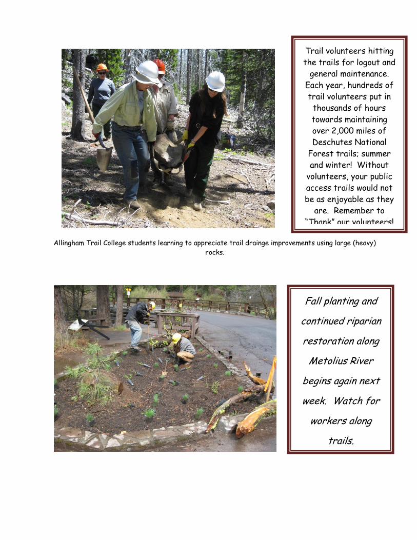
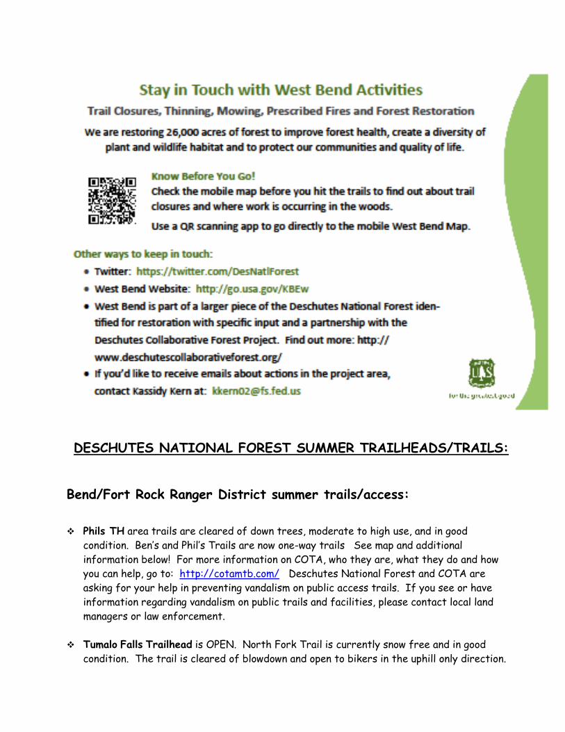
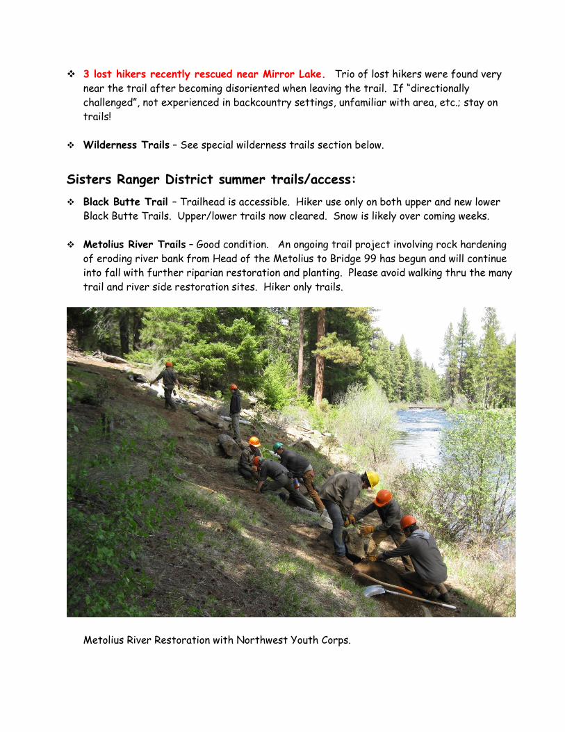
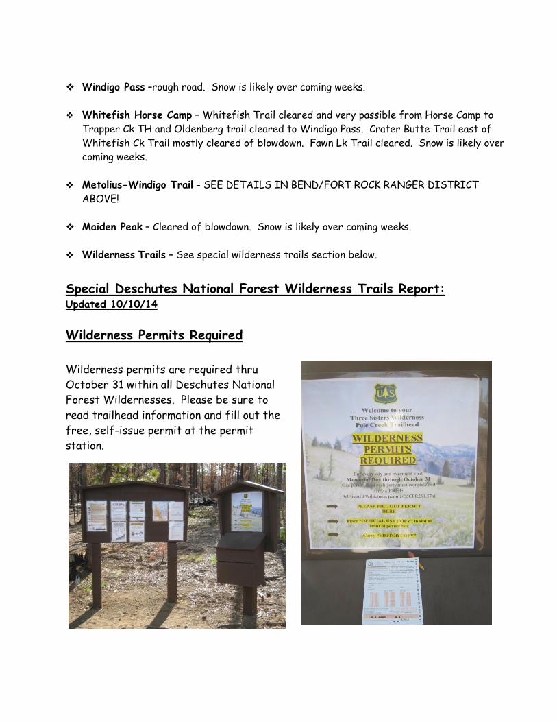
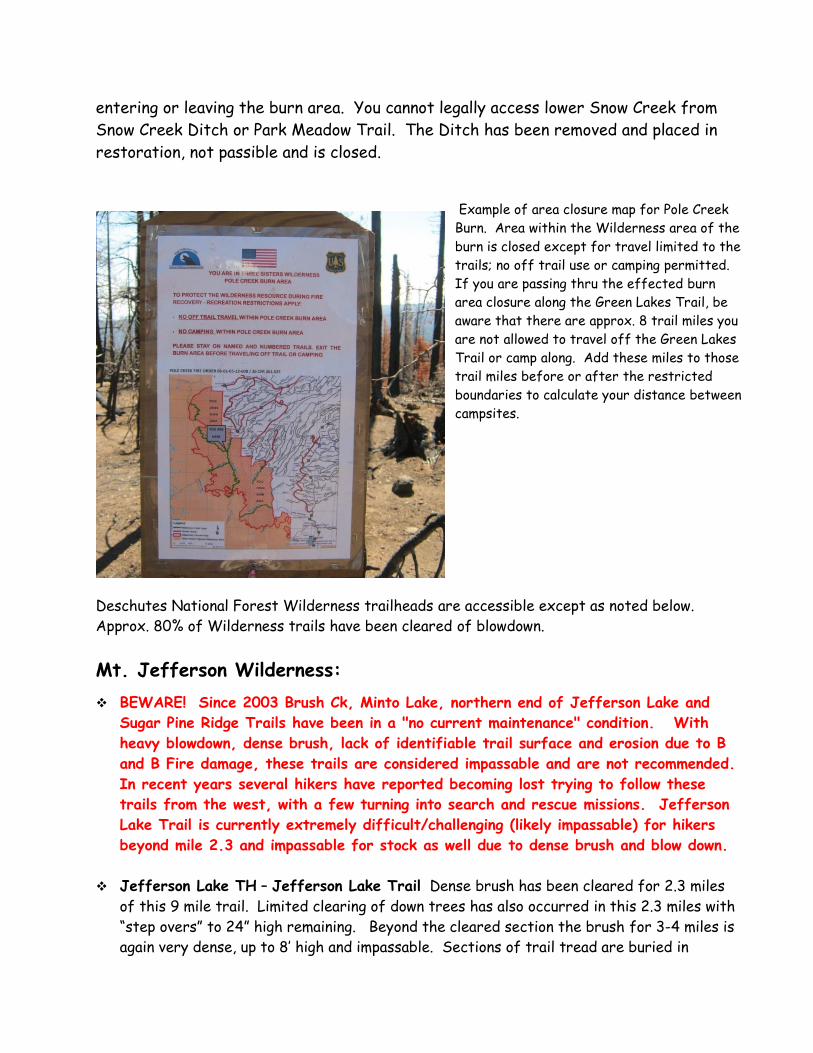
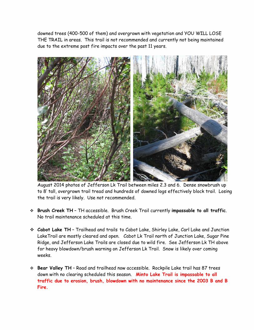
PCT ndash SEE PCT DETAILS IN BENDFORT ROCK RANGER DISTRICT ABOVE
PCT TH at Irish and Taylor Lakes ndash Road to IrishTaylor Lks passable to high clearance
vehicles with road in rough condition PCT north of IrishTaylor Lks to 6 Lks Trail has
been cleared of ldquostock blockingrdquo trees and is in good condition Snow is likely over coming
weeks
Many Lakes TH ndash TH accessible with MetWin Trail cleared to Lemish and on to Moore Ck
and towards Cultus Lk and on to Todd Lake area Snow is likely over coming weeks
Deer Lake TH ndash Trailhead accessible trail cleared of blowdown to Many Lakes Little and
Big Cultus Lakes
Winopee Lake TH ndash Accessible with Winopee Lk Trail cleared of blowdown to Winopee
Lake Trail on to Snowshoe Lakes light blowdown with some brush encroaching Snow is
likely over coming weeks
Corral Swamp TH ndash Accessible TH Trail cleared to MetWin and for some distance north
and south on MetWin
Lucky Lake TH ndash Accessible with trail cleared to Lake Senoj Lk Tr cleared
Six Lakes TH ndash Accessible with trail cleared to PCT Snow is likely over coming weeks
Elk Lake TH ndash TH accessible and trails to PCT free of blowdown Snow is likely over
coming weeks
Mirror Lk TH ndash TH accessible and trails cleared of blowdown Campfires prohibited within
frac14 mile of Mirror Lakes management area Snow is likely over coming weeks
3 hikers recently rescued near Mirror Lake Trio of lost hikers were found very near a
trail after becoming disoriented when leaving the trail If ldquodirectionally challengedrdquo not
experienced in backcountry settings unfamiliar with area etc stay on trails
Devils Lakes TH ndash TH accessible and trails mostly cleared of blowdown Wilderness
Permit registration station on Wickiup Plains Trail moved to just west of culvert under
Highway Snow is likely over coming weeks
South Sister Climbers ndash Trailheads accessible with Climbers Trail Have a map and
navigation equipment compassGPS Also pack all of your ldquoTen Essentialsrdquo Be aware of
possible thunderstorm activity and avoid mountain weather can change with little warning
Fall snow is possible and likely over the coming weeks
Green Lakes TH ndash TH accessible and trails clear of blowdown to Green Lakes on Fall Ck
Trail Soda Ck Trail cleared of blowdown Snow is likely over coming weeks
Todd Lake Trailhead and parking area are open There are about 15 trees down on the
trail around the lake and the meadows are currently saturated with muddy sections of
trail Road 370 is open This includes access to road 380 (very rough high clearance only)
which provides vehicle access to the Broken Top Trailhead Do not block closed gates
Snow is likely over coming weeks
Broken Top TH ndash Road 370380 open high clearance vehicles only on road 380 Snow
closures of these roads subject with little to no notice Snow is likely over coming weeks
Tam RimThree Creek Lake area Trailheads ndash TH accessible Trail cleared to rim Most
trails around lakes cleared of blowdown Snow is likely over coming weeks
Park Meadow TH ndash Accessible with trail cleared for 4 miles then a few trees on trail to
the meadows 1 mile section of trail has been reconstructed into single track from the old
road bed with improved drainage for erosion control 16 road gate open Snow is likely
over coming weeks
Pole Creek TH ndash Trailhead accessible with trail cleared to Green Lks Trail then south on
Green Lks Trail to the ponds or boundary of the Pole Ck Burn and Green Lks Trail cleared
north to Scott Pass Trail Limited trail clearing to Camp Lk with one large tree reported
to be challenging for stock Scott Pass Tr cleared of blowdown to PCT Snow is likely over
coming weeks
Scott Pass and Millican Crater Trailheads ndash Trailheads accessible Scott Pass Tr Trout
Creek Tie and Millican Crater Trails cleared of blowdown Snow is likely over coming weeks
Black Crater TH ndash Hwy 242 open trail to summit cleared of blow down Snow is likely over
coming weeks Hwy closure subject to little or no notice due to snow
Lava Camp Lake TH ndash Hwy 242 open TH accessible some blowdown possible to North
Mathieu Lk
Diamond Peak Wilderness
PCT ndash SEE PCT DETAILS IN BENDFORT ROCK RANGER DISTRICT ABOVE
YCC crew working
on finishing
touches on section
of reconstructed
Park Meadow
Trail
Pengra Pass TH ndash Accessible SouthNorthbound PCT trail clearing in progress Snow is
likely over coming weeks
Yoran Lk TH - Accessible Trail to Yoran Lk currently has 30 blowdown Limited
maintenance in progress
Fawn Lk TH is accessible with Fawn Lake trail cleared to lake and then on Crater Butte to
Whitefish Creek Trail Approx 25 down trees on Crater Butte Trail to C B Trailhead
Another 30 trees on Crater Butte Trail west of Whitefish Ck Trail
Whitefish Horse Camp Whitefish Creek Trail cleared and very passible from Horse Camp
to Trapper Ck TH and Oldenberg trail cleared to Windigo Pass Crater Butte Trail east of
Whitefish Ck Trail cleared of blowdown to Fawn Lk Fawn Lk Trail cleared
Summit LkPCT ndash Road access from Crescent Lk clear to Summit Lk and to the pass 3
miles of Summit Lk trail is cleared with blowdown beyond Snow is likely over coming
weeks
One-Way Trails
BenrsquosPhilrsquos Loop
Benrsquos Trail will be uphill only from the trailhead to Road 300
Philrsquos Trail will be downhill only from Junction 18 (at Kentrsquos
Trail) to the trailhead
The one-way loop trail will
Increase safety by reducing user collisions
Reduce user conflict by reducing high-speed passing
Provide better continuity by reducing stopping to allow others to pass
Increase the feeling of solitude Even in high use areas directional trails can
make it seem like there are fewer people on the trails
ldquoKeep single track singlerdquo Trails will be less impacted by users riding off-trail to
pass each other going in opposite directions
Allow for more challenging mountain bike rides Directional trails allow riders
to challenge themselves with fewer interruptions
For additional information
Visit the COTA website at wwwcotamtbcom
Contact the Deschutes National Forest 541-383-4700
Philrsquos
Trailhead
SEASONAL ROAD CLOSURESOPENINGS
Hwy 46
Cascade Lks
Hwy
Fully open from Bend to Crescent Cutoff Road Snow is likely over
coming weeks with road closure subject to little or no notice due to
snow
Road 370 OPEN from Todd Lake parking area to Road 16 (Three Creeks area)
Sections of road very rough high clearance recommended Please
keep vehicles on open roadways and parking spurs Road subject to
snow closure without notice Normal closure occurs mid-late Oct
Tumalo Falls
Road
OPEN to Tumalo Falls Trailhead
Road 21
Into Newberry
Cauldera
OPEN Road to Paulina Peak also open Good access to recreation
sites and lower trailheads Peak road subject to snow closure
without notice
Hwy 242
Mckenzie Pass
Mckenzie Pass OPEN for the season Snow is likely over coming
weeks with road closure subject to little or no notice due to snow
Road 16
To Three Ck Lks
Road open from Sisters to Three Creek Lakes Snow is likely over
coming weeks with road closure subject to little or no notice due to
snow
Road 60
Around
Crescent Lake
OPENED Snow is likely over coming weeks with road closure
subject to little or no notice due to snow
Know before you go
All trail and backcountry users be aware that your responsibilities include going
prepared for the conditions looking out for your safety and that of others if you can
render assistance in event of an accident familiarize yourself with the area thru maps
and other media and look out for and abide by signing and area regulations
SPECIAL TRAIL EVENTS AFFECTING TRAILHEADS AND TRAILS
Sun-Lava paved trail
connecting Sunriver to
Benham East and on to
Lava Lands is now open
Please watch for trail
traffic and road
crossings Maintain safe
speeds on downhill
sections bikers wear
helmets and avoid
distractions ie phone
use while biking
TEN ESSENTIAL SYSTEMS
ldquoWhat are The Ten Essentialsrdquo
rdquoThe Ten Essentials are items The Mountaineers recommends everyone carry on all trips The Pacific
Northwest is a beautiful place that can be wild and unpredictable Being prepared for anything is
essential This is as important on short local trips as it is on long backcountry trips It is easy to
forget first aid kits and warm layers short trips but a short trip can quickly turn to a long trip if you
get lost or injuredrdquo ldquoThe Ten Essentials started as a list of ten simple items and is now a systems approach that guides you
in preparing for any trip in any season The two basic questions are (1) Can you respond positively to an
accident or emergency (2) Can you safely spend a night or more out Here is a list of The Ten
Essential Systems
1 Navigation (map amp compass)
2 Sun Protection (sun glasses sun screen lip balm)
3 Insulation (extra clothing)
4 Illumination (flashlight or headlamp spare bulb amp batteries)
5 First-Aid Supplies (gauze tape etc)
6 Fire (fire starter matches lighter)
7 Repair Kit (knife duct tape tools spare parts)
8 Nutrition (extra food)
9 Hydration (extra water water purification)
10 Emergency Shelter (tarp garbage bag)
Further details on the ldquoTen Essential Systemsrdquo httpwwwreicomexpertadvicearticlesten+essentialshtmls_kwcid=TC|13029|ten20essentials||S|p|7499840765ampcm_mmc=ps_google_CH-_-Category20-20Camp2fHike-_-Camping2fHiking_GeneralTerms_Essentials-_-ten20essentialsampgclid=CNq_h8Xbsq4CFQN8hwodYhH-PQ
SPECIAL SAFETY NOTES
Go prepared for changeable weather conditions Spring to summer season
conditions exist Be sure to go prepared with plenty of warm clothing water and food
as well as other emergency essentials
For further Deschutes National Forest winter or summer trails information please
call
Deschutes National Forest Headquarters (541) 383-5300
BendFort Rock Ranger District (541) 383-4000
Sisters Ranger District (541) 549-7700
Crescent Ranger District (541) 433-3200
Find this weekly trail access and condition report in the Deschutes National Forest Website at
httpwwwfsusdagovInternetFSE_DOCUMENTSstelprdb5299503pdf
Have a safe Fall trails season
Where did the summer go
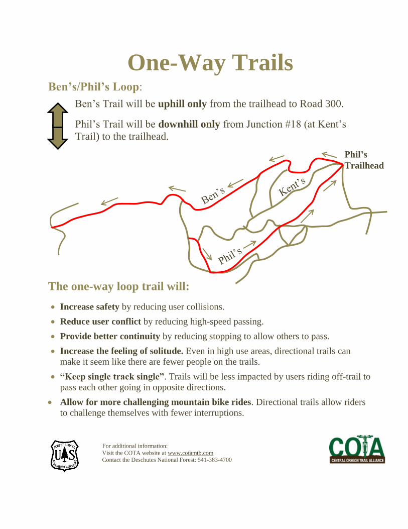
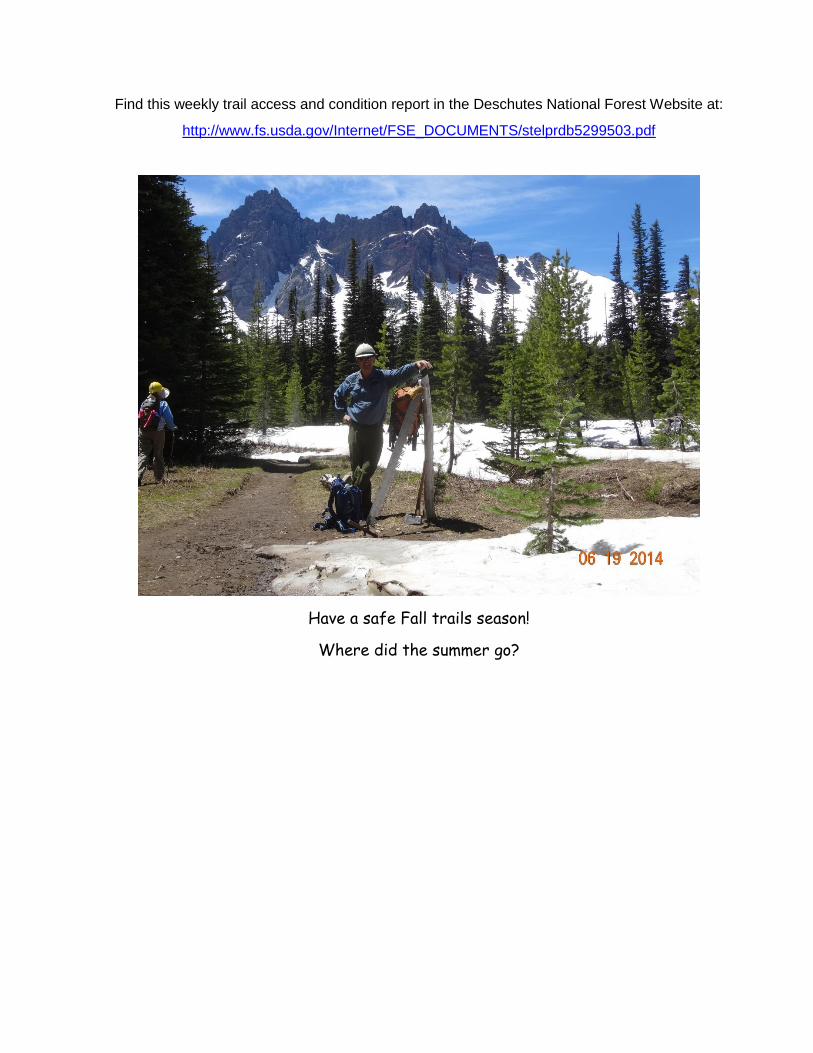
Find this weekly trail access and condition report in the Deschutes National Forest Website at
httpwwwfsusdagovInternetFSE_DOCUMENTSstelprdb5299503pdf
Have a safe Fall trails season
Where did the summer go