Embed Size (px)
Citation preview

Revista Mexicana de Ciencias Agrícolas Vol.6 Núm.6 14 de agosto - 27 de septiembre, 2015 p. 1253-1264
Desarrollo y validación de una estación meteorológica automatizada de bajo costo dirigida a agricultura*
Development and validation of a low price automatic weather station for agriculture
Víctor Daniel Velasco Martínez1, Francisco Gerardo Flores García1, Guillermo González Cervantes2§, María de Jesús Flores Medina1 y Héctor Aurelio Moreno Casillas1
1Instituto Tecnológico de la Laguna. Blvd. Revolución S/N esq. con Av. Cuauhtémoc. Torreón, Coahuila. C. P. 27200. Tel: 871 70 51 331 Ext. 515. ([email protected]; [email protected]; [email protected]; [email protected]). 2Centro Nacional de Investigación Disciplinaria en Relación Agua, Suelo, Planta, Atmósfera-INIFAP. Margen derecha canal Sacramento km 6.5. Gómez Palacio, Durango. C. P. 35140. Tel 52871-1590105. §Autor para correspondencia: [email protected].
* Recibido: marzo de 2015
Aceptado: junio de 2015
Resumen
Las observaciones meteorológicas cuantificadas son importantes en la agricultura para incrementar la productividad. Uno de los instrumentos más utilizados para realizarlas son las estaciones meteorológicas automatizadas. Las estaciones que se utilizan en México son generalmente tecnologías adquiridas en países desarrollados, por lo que los equipos que se descomponen no pueden ser reparados por costos y falta de conocimiento. Para investigación agronómica, la mayoría de las estaciones comerciales no siempre son las más adecuadas, ya que no son ajustables a los parámetros requeridos por la investigación. El presente trabajo presenta el desarrollo de un prototipo de estación meteorológica automatizada realizado por alumnos del Instituto Tecnológico de la Laguna, que puede ser ajustado a diferentes sensores y tiempos de muestreo. Después se detalla la instalación del prototipo en el campo experimental de la Universidad Autónoma Agraria Antonio Narro, Unidad Laguna, seguido de la validación estadística obtenida al correlacionar las lecturas del prototipo con el histórico de dos estaciones comerciales instaladas en un radio menor a los 10 km. Para radiación global se obtuvo una correlación de 0.95 y para temperatura de 0.91. Finalmente se analizan alcances y limitaciones del prototipo en agricultura.
Abstract
The quantified meteorological observations are important in agriculture to increase productivity. One of the instruments used are automatic weather stations. Stations used in Mexico, generally acquired technologies in developed countries, so that, when the equipment brakes, cannot be repaired because of the cost and lack of knowledge. For agricultural research, most commercial stations are not always the most appropriate, since they are no adjustable parameters required for the research. This paper presents the development of a prototype of an automatic weather station by students from the Technological Institute of the Laguna, which can be adjusted to different sensors and sampling times. Also, the installation of the prototype is detailed in the experimental field of Antonio Narro Agrarian Autonomous University, Unit the Laguna, followed by the statistical validation obtained by correlating readings to historical prototype of two commercial stations installed in a smaller radius than 10 km. Global radiation for a correlation of 0.95 and 0.91 temperature was obtained. Finally scope and limitations of the prototype in agriculture are also analysed.
Keywords: automatic weather station, development, sensors.

1254 Rev. Mex. Cienc. Agríc. Vol.6 Núm.6 14 de agosto - 27 de septiembre, 2015 Víctor Daniel Velasco Martínez et al.
Palabras clave: desarrollo, estación meteorológica automatizada, sensores.
Introducción
Los factores meteorológicos son determinantes para la producción agrícola por el efecto que tienen en las plantas. Por lo tanto, el monitoreo ambiental en la agricultura es importante para lograr el incremento de la productividad (Seeman et al., 1979) (Mavi, 2004). Los datos meteorológicos pueden obtenerse en campo utilizando métodos e instrumentos tradicionales, o una serie de instrumentos mecánicos que pueden graficar las diversas variables, como los heliógrafos y actinógrafos para la radiación solar, o el pluviógrafo para las precipitaciones (Torres Ruiz, 2006).
También pueden ser obtenidos por instrumentos electrónicos automáticos, como las estaciones meteorológicas automatizadas (EMA) (Sivakumar, 2000) y las redes inalámbricas de sensores (RIS) (Rehman et al., 2014). Últimamente se han utilizado técnicas más nuevas que involucran telemetría satelital (TS) y sistemas de información geográfica (SIG) (Sivakumar et al., 2004; Al-Mahdi et al., 2014).
Estación meteorológica automatizada. Una EMA es un dispositivo electrónico automático con autonomía energética, que mide y registra las condiciones meteorológicas a través del uso de sensores electrónicos (Medina-García et al., 2008). La información es recuperada por el operador utilizando medios manuales, o por alguna especie de transmisión a distancia (WMO, 2012a). Las estaciones meteorológicas que se usan para agricultura tienen especificaciones algo diferentes a las que se usan para otros servicios. La WMO (2012b) ha detallado estas diferencias, así como las características de las estaciones, distancias y posiciones de los sensores.
El Instituto Nacional de Investigaciones Forestales, Agrícolas y Pecuarias (INIFAP) cuenta con una red de 1 016 estaciones agrometeorológicas disponibles en línea (INIFAP, 2015), y es la única cuyo enfoque es totalmente dirigido a auxiliar al sector agrícola. Las demás estaciones tienen enfoques muy diferentes y específicos a otras ramas. No todas las estaciones están siempre en las mejores condiciones operativas, como lo reportan Vázquez-Aguirre (2006) y Prieto-González (2010).
Introduction
Meteorological factors are crucial for agricultural production, because of the effect they have on the plants. Therefore, environmental monitoring in agriculture is important to achieve increased productivity (SeAWSn et al., 1979) (Mavi, 2004). Weather data can be obtained in the field, using traditional methods and instruments, or a series of mechanical devices that can plot the variables, such as heliographs and actinograph for solar radiation and a pluviograp for precipitation (Torres Ruiz, 2006)
They can also be obtained by automatic electronic instruments, such as automatic weather stations (AWS) (Sivakumar, 2000) and wireless sensor networks (RIS) (Rehman et al., 2014). Lately, people have used newer techniques, involving satellite telemetry (TS) and geographic information systems (GIS) (Sivakumar et al., 2004; Al-Mahdi et al, 2014).
Automatic weather station. An AWS is an automatic electronic device with energy independence, which measures and records the weather conditions through the use of electronic sensors (Medina-García et al., 2008). The information is retrieved by the operator, using manual means, or some kind of remote transmission (WMO, 2012a). The weather stations used for agriculture have something different specifications to those used for other services. The WMO (2012b) has detailed these differences, and the characteristics of the stations, distances and positions of the sensors.
The National Research Institute for Forestry, Agriculture and Livestock (INIFAP) has a network of 1016 of agro-meteorological stations available online (INIFAP, 2015), and is the only one whose approach is entirely aimed at assisting the agricultural sector. Other stations have very different and specific approaches to other branches. Not all stations are always in the best operating conditions, as reported by Vázquez-Aguirre (2006) and Prieto-González (2010).
Technological backwardness. The technological dependence of Mexico (Medina- Ramírez, 2004) also observed in the field of meteorology, as is borne out by the World Meteorological Organization (WMO) to talk about the difficulty of the National Weather Service (NWS) to maintain stations operating by the lack of spare parts (CONAGUA, 2010). The

1255Desarrollo y validación de una estación meteorológica automatizada de bajo costo dirigida a agricultura
Rezago tecnológico. La dependencia tecnológica de México (Medina-Ramírez, 2004) también se observa en el ámbito de la meteorología, como es corroborado por la Organización Meteorológica Mundial (WMO) al hablar de la dificultad del Servicio Meteorológico Nacional (SMN) para mantener las estaciones operativas por la falta de refacciones (CONAGUA, 2010). También se presenta la falta de personal capacitado para la calibración y operación (CONAGUA, 2010) (Prieto-González, 2010). La mayoría de las EMA utilizadas en el país son modelos comerciales importados de países desarrollados, como se puede inferir de que las empresas participantes en la creación de la Norma Oficial Mexicana de estaciones meteorológicas (Secretaría de Economía, 2013), en su mayoría venden tecnología comprada en el extranjero.
Esta dependencia impacta los costos de la adquisición, transporte e importación, la instalación y el mantenimiento. Una EMA comercial enfocada a la agricultura, con comunicación inalámbrica de 300 metros de alcance, tiene un costo aproximado de 1750USD (Davis Instruments, 2015) después de incluir los impuestos, el envío y los gastos de aduana. Para una estación con alcance de 100 kilómetros, los costos rebasan los 5 000 USD (Future Ops, 2015).
Es con todas estas consideraciones que se inicia un proyecto multidisciplinario en las áreas de agronomía, electrónica e informática por investigadores de INIFAP CENID-RASPA y del Instituto Tecnológico de la Laguna (ITL), con el objetivo de diseñar e implementar una EMA de bajo costo para su uso en investigaciones enfocadas a incrementar la productividad agrícola.
El presente artículo presenta el diseño, la instalación y las pruebas de validación de un prototipo de EMA para verificar que el sistema propuesto mide las variables de interés, y se discuten sus alcances y limitaciones para lograr el objetivo de ser utilizada en meteorología agrícola.
Material y métodos
Esta investigación se desarrolló en el laboratorio de posgrado en instrumentación electrónica del ITL y en el campo experimental de la Universidad Autónoma Agraria Antonio Narro (UAAAN), Unidad Laguna (25° 33' 26'' latitud norte, 103° 22' 20'' longitud oeste). Fue desarrollado en cinco etapas:
lack of trained for calibration and operation (CONAGUA, 2010) (Prieto-González, 2010) will also be presented. Most AWS used in the country are business models imported from developed countries, as can be inferred that the participants in the creation of the Mexican Official Standard of weather stations (Ministry of Economy, 2013) firms, mostly sold technology purchased abroad.
This dependence impacts the cost of the purchase, transport and import, installation and maintenance. AWS focused commercial agriculture, wireless communication range of 300 meters, has cost about 1750USD (Davis Instruments, 2015) after including taxes, shipping and customs charges. For a station with a range of 100 kilometres, costs exceed 5 000 USD (Future Ops, 2015).
It is with all these considerations that a multidisciplinary project was initiated in the areas of agriculture, electronics and computer science researchers from INIFAP CENIDs-RASPA and, the Technological Institute of the Laguna (ITL), with the aim of designing and implementing an AWS inexpensive for use in research focused on increasing agricultural productivity.
This article presents the design, installation and validation testing of a prototype AWS to verify that the proposed system measures variables of interest, and its scope and limitations are discussed to achieve the goal of being used in agricultural meteorology.
Material and methods
This research was conducted in the laboratory of electronic instrumentation graduate of ITL and the experimental field of the Universidad Autonoma Agraria Antonio Narro (UAAAN), Unit Laguna (25° 33' 26'' North latitude, 103° 22' 20'' west longitude). It was developed in five stages:
Electronic integration. The prototype is made up of a business development PICPLC16B rev.5 (Mikroelektronika, Belgrade, Serbia) with PIC18F4620 microcontroller (Microchip, Phoenix, USA), a business real time clock RTC2 Board (Mikroelektronika, Belgrade, Serbia) and a card sensor coupling. The communication is performed with two RF modems X-Tend 9 (Digi, Minnetonka, USA) with long-range antennas Yagi-Uda of 11 elements. The prototype is powered by a sealed lead-acid battery (SLA)

1256 Rev. Mex. Cienc. Agríc. Vol.6 Núm.6 14 de agosto - 27 de septiembre, 2015 Víctor Daniel Velasco Martínez et al.
12V 12 Amp/Hr (Steren, Mexico, Mexico), charged with a KHN1224-10 (Shanghai Kirtun Electrical Equipment Group, Zheijang, China) and a solar panel WK5012 (Epcom, El Paso, USA). The sensors used: thermistor # 7817, pyranometer # 6450, anemometer and wind vane # 6410 and pluviometer # 7852 (Davis Instruments, Hayward, USA). The connections are shown in Figure 1.
Characterization of sensors. For the analogue sensors (wind vane, pyranometer and thermistor) MCP3204 digital analogue converter (Microchip, Phoenix, USA) with which account the development board was used. This converter is connected digitally to the microcontroller through an SPI bus, with a resolution of 12 bits, and four channels. The anemometer and the pluviometer sensor were connected using circuits of pulse detectors into the microcontroller. The equations were previously presented by the working group (Velasco-Martínez et al., 2013).
Programming. The microcontroller is programmed in MikroC Pro v6.0 for PIC (Mikroelektronika, Belgrade, Serbia). The program is constantly polling flags. Every second, the real time clock asks the PIC to activate the flags: one second, one minute, 5 min, 15 min, 30 min, 60 min, or at midnight. The actions for the flags are in the Table 1.
The act of transmitting the information recorded by the sensors can be configured to be performed in any of the flags, allowing adjusting the frequency of the readings.
Integración electrónica. El prototipo está conformado de una tarjeta de desarrollo PICPLC16B rev.5 (Mikroelektronika, Belgrado, Serbia) con microcontrolador PIC18F4620 (Microchip, Phoenix, USA), una tarjeta de reloj de tiempo real RTC2 Board (Mikroelektronika, Belgrado, Serbia), y una tarjeta de acoplamiento de sensores. La comunicación se realiza con dos módems de radiofrecuencia X-Tend 9 (Digi, Minnetonka, USA) con antenas de largo alcance Yagi-Uda de 11 elementos. El prototipo es alimentado con una batería sellada de ácido-plomo (SLA) de 12V 12 Amp/Hr (Steren, México), cargada con un cargador KHN1224-10 (Shanghai Kirtun Electrical Equipment Group, Zheijang, China) y un panel solar WK5012 (Epcom, El Paso, USA). Los sensores usados: Termistor #7817, Piranómetro #6450, Anemómetro y Veleta #6410 y Pluviómetro #7852 (Davis Instruments, Hayward, USA). Las conexiones se presentan en la Figura 1.
Caracterización de sensores. Para los sensores analógicos (veleta, piranómetro y termistor) se utilizó el convertidor analógico digital MCP3204 (Microchip, Phoenix, USA) con el que cuenta la tarjeta de desarrollo. Este convertidor se conecta de manera digital con el microcontrolador por un bus SPI, tiene una resolución de 12 bits, y cuatro canales. El anemómetro y el pluviómetro se conectaron utilizando circuitos detectores de pulsos al microcontrolador. Las ecuaciones fueron anteriormente presentadas por el grupo de trabajo (Velasco-Martínez et al., 2013).
Programación. El microcontrolador se programó en MikroC Pro para PIC v6.0 (Mikroelektronika, Belgrado, Serbia). El programa realiza un sondeo constante de banderas. Cada segundo, el reloj de tiempo real solicita al PIC que active las banderas: un segundo, un minuto, 5 min, 15 min, 30 min, 60 min, o a medianoche. Las acciones para las banderas están en el Cuadro 1.
La acción de transmitir la información registrada por los sensores es configurable para que se realice en cualquiera de las banderas, permitiendo ajustar la frecuencia de las lecturas.
Instalación. La electrónica fue alojada en un gabinete metálico NSYCRN54200P (Schneider Electric, Rueil Malmaison, Francia), con protección IP66 para protección completa contra el polvo y resistencia a ráfagas fuertes de agua (NEMA, 2004). Se instaló en el campo experimental, a 1.5m sobre el nivel del suelo en un poste de acero galvanizado. Por no tener sensores, la altura fue elegida para que sea accesible al operador. El tubo fue anclado al
Sensores Prototipo
ANEMOMETRO
PLUVIOMETRO
VELETA
PIRANOMETRO
TERMISTOR
CAD
MCP3804Microcontrolador
PIC18F4620
Entradas digitales
HCPL2630
+12V
100n 330
470 10k 10k
GND
GND
GND
GND
GND
10k
+12V
100n 330
470 10k
HCPL2630
+4.096v
+3.3v
+4.096v10k
Bus SPI
Figura 1. Esquemático de conexión de sensores.Figure 1. Schematic of sensor connection.

1257Desarrollo y validación de una estación meteorológica automatizada de bajo costo dirigida a agricultura
suelo utilizando cables de acero para resistir las ráfagas de viento.El termistor fue colocado en el interior de una caja plástica sin paredes laterales para que esté en contacto con el aire y se evite la incidencia directa de la luz solar, como lo recomienda el fabricante (Davis Instruments, 2007). En la Figura 2 se presenta el interior del gabinete y la distribución de los componente como se instaló en el campo.
El pluviómetro fue montado en una base a 64 cm del suelo, separado 1.5 m de la estación para evitar que el gabinete obstruyera la lluvia.
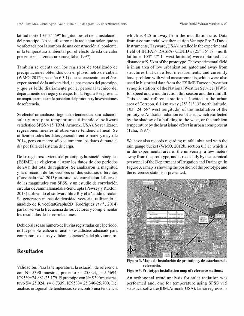
Validación. Se configuró el prototipo para transmitir cada 5 min los datos almacenados en la memoria del prototipo por solicitud del personal de la UAAAN. Las lecturas fueron transmitidas a una oficina que se encuentra a 425 m de distancia del sitio de instalación. Se obtuvieron datos de una estación meteorológica comercial Vantage Pro 2 (Davis Instruments, Hayward, USA) instalada en el campo experimental del CENID RASPA de INIFAP (25° 35' 18'' latitud norte, 103° 27' 1'' latitud oeste) una distancia de 9.5 km del prototipo. El campo experimental se encuentra en una zona de poca urbanización, cercada y lejos de estructuras que puedan afectar las mediciones, y presenta actualmente un problema con las mediciones de viento, por lo que también se utilizaron los históricos de la ESIME Torreón (estación sinóptica meteorológica) del servicio meteorológico nacional (SMN) para la velocidad y dirección de viento de esta estación, así como el totalizado de precipitaciones. Esta segunda estación de referencia se encuentra está ubicada en la zona urbana de Torreón, a 6.1Km de distancia (25º 31' 13"
Installation. The electronics were housed in a metal cabinet NSYCRN54200P (Schneider Electric, Rueil Malmaison, France), IP66 for complete protection against dust and strong wind resistance of water (NAWS, 2004). It was installed in the experimental field at 1.5m above the ground on a galvanized steel pole. By not having sensors, the height was chosen to be accessible to the operator. The tube was anchored to the ground using steel cables to resist blasts of wind. The thermistor was placed inside a plastic box without side walls so that it is in contact with air and to avoid direct incidence of sunlight, as recommended by the manufacturer (Davis Instruments, 2007). In Figure 2, the inside of the cabinet and the distribution of component as it is installed in the field it is presented.
The pluviometer was mounted on a 64 cm soil, separated 1.5 m from the station to avoid obstructing the cabinet rain.
Validation. The prototype is configured to transmit data every 5 min stored in memory prototype as the UAAAN staff requested. The readings were transmitted to an office
Evento de tiempo
Acciones
1 Segundo • Monitoreo de batería• Apagado de Sensores Inactivos
1 Minuto • Lectura de pulsos de anemómetro y puesta a 0
• Lectura de señal de veleta y anexado a vector de velocidad
• Cálculo de máximo y mínimo de viento• Lectura de pulsos de pluviómetro, y puesta
a 0• Cálculo de intensidad de totalizado del
pluviómetro5 Minutos • Lectura de señal del piranómetro y de
termistor• Actualización de máximo del piranómetro• Actualización de máximo y mínimo diario
del termistor15 Minutos • Reestablecimiento de máximos y mínimos
de ventana de viento0:00 AM • Reestablecimiento de totalizadores
• Reestablecimiento de máximos y mínimos diarios
• Reestablecimiento de promedios diariosConfigurado • Transmisión de lecturas en memoria
Cuadro 1. Listado de acciones planificadas del prototipo.Table 1. List of planned actions of the prototype.
Figura 2. Componentes e instalación de prototipo.Figure 2. Components and installation of prototype.
Tarjeta de desarrollo
Tarjeta sensores
RTC
Módem
Bateria sellada
Cargador
Anemómetro Veleta
h= 2.75 m
Piranómetro h= 2.57 m
Antena
Panel solarSur
Inclinación 30.75°
Termisor h= 2.38 m
Gabinete h= 1.5 m
Pluviómeto h= 0.64 m
s= 1.5 m
Latitud 25°33’27.046967’’ N
Longitud103°22’19.249992’’O
Altitud1127 m
1258 Rev. Mex. Cienc. Agríc. Vol.6 Núm.6 14 de agosto - 27 de septiembre, 2015 Víctor Daniel Velasco Martínez et al.
which is 425 m away from the installation site. Data from a commercial weather station Vantage Pro 2 (Davis Instruments, Hayward, USA) installed in the experimental field of INIFAP- RASPA- CENID’s (25° 35' 18' ' north latitude, 103° 27' 1'' west latitude) were obtained at a distance of 9.5 km of the prototype. The experimental field is in an area of low urbanization, gated and away from structures that can affect measurements, and currently has a problem with wind measurements, which were also used in historical data from the ESIME Torreon (weather synoptic station) of the National Weather Service (NWS) for speed and wind direction this season and the rainfall. This second reference station is located in the urban area of Torreon, 6.1 km away (25° 31' 13" north latitude, 103° 24' 59" west longitude) of the installation of the prototype. And solar radiation is not used, which is affected by the shadow of a building to the west, or the ambient temperature by the heat island effect in urban areas present (Taha, 1997).
We have also records regarding rainfall obtained with the rain gauge bucket (WMO, 2012b, section 6.3.1) which is in the experimental area of the university, a few meters away from the prototype, and is read daily by the technical personnel of the Department of Irrigation and Drainage. In Figure 3, a map is showing the position of the prototype and the reference stations is presented.
An orthogonal trend analysis for solar radiation was performed and, one for temperature using SPSS v15 statistical software (IBM, Armonk, USA). Linear regressions
latitud norte 103º 24' 59" longitud oeste) de la instalación del prototipo. No se utilizaron ni la radiación solar, que se ve afectada por la sombra de una construcción al poniente, ni la temperatura ambiental por el efecto de isla de calor presente en las zonas urbanas (Taha, 1997).
También se cuenta con los registros de totalizado de precipitaciones obtenidos con el pluviómetro de cubeta (WMO, 2012b, sección 6.3.1) que se encuentra en el área experimental de la universidad, a unos metros del prototipo, y que es leído diariamente por el personal técnico del departamento de riego y drenaje. En la Figura 3 se presenta un mapa que muestra la posición del prototipo y las estaciones de referencia.
Se efectuó un análisis ortogonal de tendencias para radiación solar y otro para temperatura utilizando el software estadístico SPSS v15 (IBM, Armonk, USA). Se realizaron regresiones lineales al observarse tendencia lineal. Se utilizaron todos los datos generados entre marzo y mayo de 2014, pero en marzo sólo se tomaron los datos durante el día por falta del sistema de carga. De los registros de viento del prototipo y la estación sinóptica (ESIME) se eligieron al azar los datos de dos periodos de 24 h del total de registros. Se analizaron la magnitud y la dirección de los vectores en dos estudios diferentes (Carvahalo et al., 2013): un estudio de correlación de Pearson de las magnitudes con SPSS, y un estudio de correlación circular de Jammalamadaka-SenGupta (Pewsey y Ruxton, 2013) utilizando el software libre R y el añadido circular. Se generaron mapas de densidad vectorial utilizando el añadido de R vecStatGraphs2D (Rodríguez et al., 2014) para observar la frecuencia de los vectores y complementar los resultados de las correlaciones.
Debido al escaso número de lluvias registradas en el periodo, no fue posible realizar un análisis estadístico adecuado para comparar los datos y validar la operación del pluviómetro.
Resultados
Validación. Para la temperatura, la estación de referencia con N= 5390 muestras, presentó x ¯= 25.024, s= 5.5694, IC95%= 24.881-25.179. El prototipo con N= 5 390 muestras, tuvo x ¯= 25.024, s= 6.7339, IC95%= 25.340-25.700. Del análisis ortogonal de tendencias se encontró una tendencia
Figura 3. Mapa de instalación de prototipo y de estaciones de referencia.
Figure 3. Prototype installation map of reference stations.
CENID RASPA
PROTOTIPOOFICINA RIEGO Y
DRENAJE
ESIME TORREÓN
id LUGAR x y
0 PROTOTIPO -103.372222 25.557222
1 OFICINA RIEGO Y DRENAJE -103.375933 25.557087
2 ESIME TORREÓN -103.416389 25.520278
3 CENID RASPA -103.450278 25.588333

1259Desarrollo y validación de una estación meteorológica automatizada de bajo costo dirigida a agricultura
lineal significativa con p< 0.0001. La regresión mostró β=1.1011, un coeficiente de determinación R2= 0.83 y un coeficiente de correlación de Pearson r= 0.911. Para la radiación solar, la estación de referencia presentó con N= 5 392 muestras, x ¯= 354.995, s= 384.2054, IC95%= 344.52-365.04. El prototipo presentó con N= 5 392 muestras, x ¯= 333.682, s= 374.1326, IC95%= 322.96-342.83. Se encontró una tendencia lineal significativa con p< 0.0001, β=0.924, un coeficiente de determinación R2 de 0.842 y r= 0.918. En la Figura 4 se muestran las regresiones lineales para las dos variables.
Para la magnitud del viento, la estación de referencia con N= 278 muestras presentó x ¯= 2.251, s=1.154, IC95%=2.115482-2.386676. El prototipo, con N= 278 muestras, presentó x ̄= 1.217, s= 0.978, IC95%= 1.101862-1.101862. Se obtuvo una r de Pearson igual a 0.515, con una p< 0.001.
Para la dirección del viento, la estación de referencia, con N= 278 muestras, presentó una correlación circular de Jammalamadaka-Sengupta igual a 0.501, con una p< 0.0001.
En la Figura 5, en la ESIME se observa una mayor concentración de vectores en la zona cercana a 1.9 km h-1 en dirección NE, una segunda zona de menor concentración más hacia el E, a 3 km h-1, y una tercer zona a 1 km h-1 al NO. El prototipo mostró la mayor concentración al centro, en 0 km h-1, con una segunda zona de menor concentración a 1 km h-1 al NE, y más datos dispersos en el radio de 2 km h-1 en todo el cuadrante NE, pero no presenta la zona al NO visible en la referencia.
were performed. All data generated between March and May 2014 were used, but only in March data were taken during the day due to lack of system load.
The wind logs of the prototype and the synoptic station (ESIME) were randomly selected data from two periods of 24 h of total registrations. The magnitude and direction of the vectors in two different studies were analysed (Carvahalo et al., 2013): a study of Pearson correlation of the magnitudes with SPSS, and a correlation study circular
by Jammalamadaka-SenGupta (Pewsey and Ruxton, 2013) using the free software R and the circular added. Vector density maps were generated using the addition of R vec Stat Graphs 2D (Rodríguez et al., 2014) to observe the frequency of vectors and complement the results of the correlations.
Due to the small number of registered rainy period, it was not possible to perform a proper statistical analysis to compare the data and validate the operation of the gauge.
Results
Validation. For temperature, the reference station with N= 5390 samples presented x ¯= 25.024, s= 5.5694, IC 95%= 24881-25179. The prototype with N = 5390 samples had x ¯= 25.024, s= 6.7339, IC 95% = 25340-25700. From the orthogonal analysis we found trends with a significant linear
Figura 4. Regresiones lineales de temperatura y radiación global.Figure 4. Linear regressions of temperature and global radiation.
Referencia
45
40
35
30
25
20
15
10
5
Prot
otip
o
5 10 15 20 25 30 35 40 45
R2= 0.8297191118
Correlación de temperaturaTemperaturaLineal (Temperatura)
Correlación de radiación solar1500
1200
900
600
300
0
Prot
otip
o
0 300 600 900 1200 1500Referencia
R2= 0.9110991215
Radiación de prototipo (W/m2)Lineal (Radiación de prototipo (W/m2))

1260 Rev. Mex. Cienc. Agríc. Vol.6 Núm.6 14 de agosto - 27 de septiembre, 2015 Víctor Daniel Velasco Martínez et al.
trend with p< 0.0001. The regression showed β= 1.1011, a determination coefficient R2= 0.83 and a Pearson correlation coefficient r= 0.911. For solar radiation, the reference station provided with N= 5392 samples x ̄= 354.995, s = 384.2054, IC 95%= 344.52-365.04. The prototype presented with N = 5392 samples x ¯= 333.682, s = 374.1326, IC 95%= 322.96-342.83. A significant linear trend p< 0.0001, β= 0.924, a determination coefficient R2 of 0.842 and r= 0.918 was found. In Figure 4, linear regressions for the two variables are shown.
For the magnitude of the wind, the reference station with N= 278 samples submitted x ¯= 2.251, s= 1.154, IC 95%= 2.115482-2.386676. The prototype, with N= 278 samples presented x ¯= 1.217, s= 0.978, IC95% = 1.101862-1.101862. Obtaining one r of Pearson equal to 0.515 with p< 0.001.
For the wind direction, the reference station, with N= 278 samples, presented a circular correlation of Jammalamadaka-Sengupta, equal to 0.501 with a p< 0.0001.
In the Figure 5, in the ESIME, a higher concentration vectors is observed in the area near 1.9 km h-1, NE direction, a second zone of lower concentration farther E, 3 km h-1 and a third area 1 km h-1 NW. The prototype showed the highest concentration in the centre, 0 km h-1, with a second area of concentration less than 1 km h-1 NE, and data scattered in a radius of 2 km h-1 around the NE quadrant, but no area NW visible in the reference.
In the second pair of vector density maps (Figure 6), the prototype shows the highest concentration at the centre, with scattered points in the 2 km h-1 NE and SE quadrants. The reference has a higher concentration than 1 km h-1, with an area of 2 km h-1 to E, and in a zone closer than 2 km h-1 SE.
En el segundo par de mapas de densidad vectorial (Figura 6), el prototipo muestra la mayor concentración al centro, con puntos dispersos a 2 km h-1 en los cuadrantes NE y SE. La referencia presenta una mayor concentración a 1 km h-1, con una zona a 2 km h-1 al E, y una zona menor a 2 km h-1 al SE.
En el Cuadro 2, se presentan los dos eventos de lluvia que ocurrieron y fueron registrados por la ESIME y el prototipo, así como los datos registrados en el pluviómetro del campo experimental de UAAAN. La precipitación registrada por el pluviómetro de la UAAAN es la misma que la registrada por el prototipo. La precipitación reportada por la ESIME en el primer evento está cercana a los otros dos, pero el segundo evento es menor que los otros dos.
Costo. El costo del prototipo fue cercano a los 2000USD. La mayor parte del costo fue causado por los radio-módems de largo alcance y sus antenas (60%), el segundo impacto en el costo fue causado por la tarjeta de desarrollo utilizada (10%) y el gabinete adecuado al tamaño completo del prototipo (10%). El resto es el costo de los sensores y la instalación.
Discusión
Validación. La estación de referencia del CENID-RASPA se encuentra a 9.5 km de distancia del prototipo, los campos experimentales tienen las mismas condiciones, y los sensores son iguales. Las alturas de los sensores son las mismas que las del prototipo. La separación entre las estaciones de referencia y el prototipo puede ser un factor que influya en la comparación de los históricos. De acuerdo a Camargo y
Figura 5. Mapas de densidad vectorial de viento de 1era
prueba.Figure 5. Wind vector density maps in the first test.
*Áreas más oscuras a mayor concentración de vectores en la zona.**La distancia del origen indica magnitud de la velocidad.
ESIME Prototipo
-4
-
2
0
2
4
-4
-2
0
2
4
-4 -2 0 2 4 -4 -2 0 2 4
Figura 6. Mapas de densidad vectorial de viento de 2da prueba.Figure 6. Wind vector density maps in the second test.
ESIME Prototipo
-4
-
2
0
2
4
-4
-
2
0
2
4
-4 -2 0 2 4 -4 -2 0 2 4*Áreas más oscuras a mayor concentración de vectores en la zona.**La distancia del origen indica magnitud de la velocidad.

1261Desarrollo y validación de una estación meteorológica automatizada de bajo costo dirigida a agricultura
Hubbard (1999), para una distancia de 30 km, en condiciones de terreno similar, hay 90% de probabilidades de que la variable sea igual. La FAO (Allen et al., 2006) habla de una técnica para utilizar los datos de una estación cercana para suplir datos perdidos en otra. Los criterios que establecen para determinar si es viable utilizar estos datos como reemplazo es que de una regresión lineal entre una serie de datos conocidos, del mismo periodo, de las dos estaciones meteorológicas, la β esté entre 0.7 y 1.3.
Así mismo, el coeficiente de determinación R2 debe ser mayor a 0.7. La β y el coeficiente R2 obtenidos para la radiación solar y la temperatura se encuentran dentro de los criterios establecidos por la FAO, por lo que se puede inferir que las dos estaciones están midiendo valores similares, lo que puede hacer que sea válido reemplazar los datos de una con otra. Para el viento, aunque están dentro del rango de los 10 km aceptables para que la variable sea igual (Camargo y Hubbard, 1999), ni la correlación de la magnitud, ni la de dirección, alcanzan el criterio de 0.7, por lo que no se realizó ninguna regresión lineal.
En los mapas de densidad vectorial del prototipo hay algunos vectores en las mismas zonas que en los de referencia, pero la mayoría están concentrados en el centro. Esto puede puede estar provocado por la variabilidad de la estación de referencia por su ubicación dentro de una zona urbana, ya que como se ha descrito, la urbanización afectará a la variable (Collier, 2006). Con la falta de datos de referencia confiable no se tienen suficientes elementos para confirmar estas lecturas. Lo mejor será repetir el experimento utilizando una estación de referencia con las mismas condiciones del prototipo, para descartar fallas en el sensor o en el algoritmo.
Siguiendo el criterio de Camargo y Hubbard (1999), la medición de lluvia de la ESIME está fuera del rango de 5km donde la lectura es confiable, lo que pudiera explicar las diferencias de la ESIME con el prototipo, no obstante, las mediciones son similares con el pluviómetro de cubeta ubicado en el mismo sitio que el prototipo. Aun así, se requieren más datos de lluvia para compararlo contra el pluviómetro de cubeta para realizar un análisis estadístico que corrobore la relación entre métodos.
Costo. La fabricación del prototipo funcional fue 60% más barata que una estación de largo alcance, y mayor 14.24% que las estaciones de corto alcance. Lo segundo es explicado porque el prototipo tiene un alcance mayor que la de corto alcance contra la que se compara, además de que el prototipo
In the Table 2, both rain events that occurred are presented and were recorded by the ESIME and the prototype as well as the data recorded in the gauge of the UAAAN the experimental field. The rainfall recorded by the gauge of the UAAAN is the same as that recorded by the prototype. The precipitation reported by the ESIME in the first event is close to the other two, but the second event is smaller than the other two.
Cost. The cost of the prototype was close to 2000 USD. Most of the cost was caused by radio modems reaching and antennas (60%), the second impact on cost was caused by the development board used (10%) and the appropriate cabinet to the full-size prototype (10%). The rest is the cost of sensors and installation.
Discussion
Validation. The reference station CENID-RASPA is 9.5 km away from the prototype; the experimental fields have the same conditions, and the sensors are the same. The heights of the sensors are the same as those of the prototype. The separation between the reference stations and the prototype can be a factor influencing the historical comparison. According to Camargo and Hubbard (1999) for a distance of 30 km, in similar conditions of terrain, there is a 90% chance that the variable is equal. FAO (Allen et al., 2006) speaks of a technique to use data from a nearby station to supply data lost in another. The criteria for determining the feasibility of using this data as a replacement is that of a linear regression between a series of known data in the same period, of the two weather seasons, the β is between 0.7 and 1.3.
Also, the coefficient of determination R2 must be higher than 0.7. The β and the R2 coefficient obtained for solar radiation and temperature are within the criteria established by the FAO, so we can infer that the two stations are measuring similar values, which can make it valid replace data of each other. Regarding the wind, even when the values are within the range of 10 km, acceptable for the variable to be equal
Fecha ESIME Pluvióm. UAAAN Prototipo22 may. 2014 11.4mm 10.4mm 10.04mm23 may. 2014 1.6mm 2.5mm 2.44mm
Cuadro 2. Eventos de lluvia registrados en periodo de pruebas.
Table 2. Events of rain recorded on probation.

1262 Rev. Mex. Cienc. Agríc. Vol.6 Núm.6 14 de agosto - 27 de septiembre, 2015 Víctor Daniel Velasco Martínez et al.
utiliza componentes discretos, especiales para desarrollo, más costosos. Considerando los precios de los mismos componentes en sus versiones comerciales, se espera lograr una reducción del costo al 52.5% en la siguiente fase de diseño, pero aún es pronto para definirlo.
Uso en agricultura. La WMO (2012a) define posiciones adecuadas para la toma de mediciones, y que sean representativas en meteorología agrícola. La posición en la que se instalaron los sensores se eligió más de acuerdo a la posición que tenía la estación de referencia que a la posición estándar para meteorología. Sólo el pluviómetro se ajustó cercano al suelo, por solicitud del agrometeorólogo de UAAAN. Las variables consideradas críticas para la producción agrícola por Hoogenboom (2000) son la temperatura del aire, la radiación solar y la precipitación pluvial. Después de un ajuste de altura de los sensores, y la validación de la precipitación, el prototipo ya puede medir estas variables.
Hoogenboom (2000) también habla sobre la importancia de la evapotranspiración potencial (ET0), calculada de otras variables utilizando el modelo de Pentman-Monteith propuesta por la FAO (FAO-PM), el modelo de Hargreaves-Samani (HS), u otros (Santiago-Rodríguez et al, 2012). Estos modelos pueden ser programados en el prototipo para calcular la ET0 in situ. El modelo HS sólo requiere temperaturas máxima, mínima y promedio, que la estación ya mide, aunque es menos preciso y requiere lecturas de más días (Pereira et al., 2015). Para el modelo FAO-PM se pueden estimar las variables faltantes (Allen et al., 2006) (Jabloun y Sahli, 2008) (Cai et al., 2007) de las variables que ya mide el prototipo, o se puede añadir un sensor de humedad relativa para aumentar la eficacia del cálculo.
Conclusiones
Este prototipo ya mide algunas de las variables meteorológicas básicas. Con la validación de históricos, además de comprobar que dos de las variables son comparables a una estación en las mismas condiciones, otras dos aún requieren mayor comprobación. También son necesarios ajustes en la instalación, por la altura de los sensores. Al poder modificar enteramente su programación, se puede utilizar para calcular variables de mayor interés a la meteorología agrícola. Al tener también acceso a la electrónica, se pueden integrar nuevos sensores, como un sensor de humedad relativa, que permitiría calcular la ET0 in situ utilizando el modelo FAO-PM.
(Camargo and Hubbard, 1999), neither the correlation magnitude nor the direction, reach the criterion of 0.7, so no linear regression was performed.
In the vector density maps of the prototype, there are some vectors in the same areas as in the reference, but most of them are concentrated in the centre. This might be caused by the variability of the reference station for its location within an urban area, because as described, urbanization affects the variable (Collier, 2006). With the lack of reliable reference data, there are not sufficient elements to confirm these readings. It is best to repeat the experiment using a reference station with the same prototype conditions, in order to rule out failures on the sensor or the algorithm.
Following the criteria of Camargo and Hubbard (1999), measurement of rain in the ESIME is outside the range of 5 km, where the readings are reliable, which could explain the differences in the ESIME with the prototype; however, the measurements are similar with bucket rain gauge located on the same site as the prototype. Still, more data are needed to compare it against the rain gauge bucket for statistical analysis to corroborate the relationship between those methods.
Cost. Making the functional prototype was 60% cheaper than a long-range station, and 14.24% higher than the short-range stations. The second is explained that the prototype has a longer range than the short range against which, in addition to the prototype uses discrete, especially for development, more expensive components in comparison. Considering the prices of the same components in their commercial versions, it is expected to achieve a cost reduction to 52.5% in the next phase of design, but it is too early to define it.
Use in agriculture. The WMO (2012a) defines suitable positions for taking measurements, which are representative in agricultural meteorology. The position where the sensors are installed over elected according to the position having the reference station to the standard position for meteorology. Only the gauge was adjusted closer to the ground, at the request of agro-meteorologist of the UAAAN. The variables considered critical for agricultural production by Hoogenboom (2000) are the air temperature, solar radiation and precipitation. After a height adjustment of the sensors and the validation of the precipitation, and the prototype, these variables can measure.

1263Desarrollo y validación de una estación meteorológica automatizada de bajo costo dirigida a agricultura
Agradecimientos
Al CONACYT por becas para estudios de posgrado. Al departamento de Riego y Drenaje de la UAAAN-UL por recursos bibliográficos y económicos para prototipo. A investigadores del INIFAP por información de estación. A la Coordinación General del Servicio Meteorológico Nacional por históricos de ESIME Torreón. Víctor y María también desean agradecer a todas las personas, amigos y familiares que nos han apoyado y guiado a lo largo de nuestros proyectos.
Literatura citada
Allen, R. G.; Pereira, L. S.; Raes, D. y Smith, M. 2006. Evapotranspiración del cultivo. Traducción al español. Food and Agriculture Organization of the United Nations. Roma, Italia. 342 p.
Al-Mahdi, A. M.; Ndahi, E. M. S.; Yahaya, B. and Maina, M. L. 2014. integrated gis and satellite remote sensing in mapping the growth, managing and production of inland water fisheries and aquaculture. Eur. Sci. J. 6(10):178-183.
Cai, J.; Liu, Y.; Lei, T. and Pereira, L. S. 2007. Estimating reference evapotranspiration with the FAO Penman-Monteith equation using daily weather forecast messages. Agric. Forest Meteorol. (145):22-35.
Camargo, M. B. and Hubbard, K. G. 1999. Spatial and temporal variability of daily weather variables in sub-humid and semi-arid areas of the united states high plains. Agric. Forest Meteorol. (93):141-148.
Carvalho, D.; Rocha, A.; Gómez-Gesteira, M.; Alvarez, I. and Silva-Santos, C. 2013. Comparison between CCMP, QuikSCAT and buoy winds along the Iberian Peninsula coast. Remote Sensing of Environment. (137):173-183.
Collier, C. G. 2006. The impact of urban areas on weather. Quarterly Journal of the Royal Meteorology Society. (132):1-25.
CONAGUA (Comisión Nacional del Agua). 2010. proyecto de modernización del servicio meteorológico nacional de México: diagnóstico institucional y propuesta de plan estratégico 2010-2019. 67 p.
Davis Instruments. 2015. Wireless Vantage Pro2 Plus. http://www.davisnet.com/weather/products/weather_product.asp?pnum= 06162.
Future Ops Intelligence Moving Water. 2015. http://motorolairrigation.com/agriculture-comparison/
Hoogenboom, G. 2000. Contribution of agrometeorology to the simulation of crop production and its applications. Agric. Forest Meteorol. (103):137-157.
INIFAP (Instituto Nacional de Investigaciones Forestales, Agrícolas y Pecuarias). 2015. http://clima.inifap.gob.mx/redinifap/.
Jabloun, M. a Sahli, a. 2008. Evaluation of FAO-56 methodology for estimating reference evapotranspiradtion using limited climatic data: application to Tunisia. Agricultural Water Management. (95):707-715.
Hoogenboom (2000) also discusses the importance of potential evapotranspiration (ET0), calculated from other variables, using the Pentman-Monteith model proposed by FAO (FAO-PM), the model of Hargreaves-Samani (HS), or others (Santiago-Rodríguez et al., 2012). These models can be programmed to calculate the prototype ET0 in situ. The HS model only requires high temperatures, minimum and average, that the station already measures, even though it is less accurate and required more days for the readings (Pereira et al., 2015). For the FAO-PM model, the missing variables can be estimated (Allen et al., 2006) (Jabloun and Sahli, 2008) (Cai et al., 2007) of the variables which the prototype already measures, or a relative humidity sensor can be added for increasing the efficiency of the calculation.
Conclusions
This prototype measure some of the basic meteorological variables. With the historical validation in addition to checking that two of the variables are comparable to a station in the same conditions, other two still require further testing. Adjustments in the installation are also necessary, due to the height of the sensors. Being able to entirely modify its programming, it can be used to calculate variables of interest to for agricultural meteorology. With access to the electronics, new sensors can be integrated, such as a relative humidity sensor, which would allow calculating the ET0 in situ, using the FAO-PM model.
Jabloun, M. and Sahli, a. 2008. Evaluation of FAO-56 methodology for estimating reference evapotranspiration using limited climatic data: application to Tunisia. Agricultural Water Management. (95):707-715.
Medina-García, G.; Grageda- Grageda, J.; Ruiz-Corral, J. A. and Báez-González A. D. 2008. Uso de estaciones meteorológicas en la agricultura. México. INIFAP.
Medina-Ramírez, S. 2004. La dependencia tecnológica en México. Economía informa. 330:73-81.
NEMA. 2004. ANSI/IEC 60529-2004. National Electrical Manufacturers Association. 8 p.
Pereira, L. S.; Allen, R. G.; Smith, M. and Raes, D. 2015. Crop evapotranspiration estimation with FAO 56: Past and future. Agricultural Water Management. (147):4-20.
Pewsey, A.; Neuhäuser, M. and Ruxton, G. D. 2013. Circular Statistics in R. OXFORD Press. 1st. Ed. NY, USA. 208p.
Prieto-González, R. 2008. Diagnóstico de las capacidades, fortalezas y necesidades para la observación, monitoreo, pronóstico y prevención del tiempo y el clima ante la variabilidad y el cambio climático en México. 173 p.
End of the English version
1264 Rev. Mex. Cienc. Agríc. Vol.6 Núm.6 14 de agosto - 27 de septiembre, 2015 Víctor Daniel Velasco Martínez et al.
Rehman, A.; Azafar, A. A.; Islam, N. and Ahmed, S. Z. 2014. A review of wireless sensors and networks’applications in agriculture. Computer Standards & Interfaces. 2(36):263-270.
Rodríguez, P. G.; Polo, M. E.; Cuartero, A. and Felicísimo, Á. M. 2014. VecStatGraphs2D, a tool for the analysis of two-dimensional vector data: an example using QuikSCAT Ocean Winds. IEEE Geoscience and Remote Sensing Letters. 5(11):921-925.
Santiago-Rodríguez, S.; Arteaga- Ramírez, R.; Sangerman- Jarquín, D.; Cervantes-Osornio, R. Navarro-Bravo, A. 2012. Evapotranspiración de referencia estimada con Fao-Penman-Monteith,Priestley-Taylor, Hargreaves y RNA. México. Rev. Mex. Cienc. Agríc. 8(3):1535-1549.
Secretaría de Economía. 2013. NMX-AA-166/1-SCFI-2013. Estaciones meteorológicas, climatológicas e hidrológicas – Parte 1. 43 p.
Seeman, J.; Chirkov, Y. I.; Lomas, J. and Primault, B. 1979. Agrometeorology. Berlin. Ed. Springer-Verlag.
Sivakumar, M. V. K.; Gommes, R. and Baier, W. 2000. Agrometeorology and sustainable agriculture. Agric. Forest Meteorol. (103):11-26.
Sivakumar, M. V. K.; Roy, P. S.; Harmsen, K. and Saha, S. K. 2004. Satellite remote sensing and gis applications in agricultural meteorology. In: satellite remote sensing and GIS applications in meteorology. Sivakumar, M. V. K.; Roy, P. S.; Harmsen, K. and Saha, S. K. (Eds.).World Meteorological Organization. Dehra Dun, India.427 p.
Taha, H. 1997. Urban climates and heat islands: albedo, evapotranspiration, and anthropogenic heat. Energy and Buildings, 96(25):99-103.
Torres-Ruiz, E. 2006. 2° (Ed.). Agrometeorología. México, D. F. Ed. Trillas. 156 p.
Vázquez-Aguirre, J. L. 2006. Datos climáticos de la República Mexicana: panorama actual y requerimientos inmediatos. In: 1er Foro del Medio Ambiente Atmosférico. Xalapa, Veracruz, México. 1-14 pp.
Velasco-Martínez, V. D.; Juárez, C. and Flores-García, F. G. 2013. Design and deployment experiencies of Automatic Weather Station EC-LAG3. In: 5o Encuentro regional de investigadores y 4o encuentro de jóvenes investigadores. Espinoza, A.; Meza J. L.; Cepeda, M. F. J. y Guerrero, G. D. (Eds.). RUCERHALL, S.A. de C.V. Torreón, Coahuila, México. 501-509 pp.
World Meteorological Organization. 2012. 2008 ed. Guide to Meteorological Instruments and Methods of Observation. WMO No. 8. Geneva. 716 p.
World Meteorological Organization. 2012. (Ed.). Guide to Agricultural Meteorological Practices. WMO No 134. Geneva.
799 p.