Embed Size (px)
Citation preview
Deriving Semantic Description Using Deriving Semantic Description Using Conceptual Schemas Embedded into a Conceptual Schemas Embedded into a
Geographic ContextGeographic Context
Centre for Computing Research, IPNCentre for Computing Research, IPN
Geoprocessing LaboratoryGeoprocessing Laboratory
Miguel TorresMiguel TorresNovember, 2006November, 2006
Presentation Overview
• Introduction
• Goals
• Related works
• Geospatial domain conceptualization
• Case study
• Conclusion and future works
Introduction (1)
• Ontology has gained increased attention among researchers in GIScience.– This notion plays an important role in establishing
robust theoretical foundation for GIScience.
• It is possible to unify several interrelated research subfields, each of which deals with different perspectives on geospatial ontologies and their roles in GIScience
Introduction (2)
• Three broad sets of foundational issues need to be resolved:– Conceptual issues concerning what would be required
to establish an exhaustive ontology of the geospatial domain
– Representational and logical issues relating to the choice of appropriate methods for formalizing ontologies
– Issues of implementation regarding the ways in which ontology ought to influence the design of information systems
Introduction (3)
• Up-to-date geospatial information can not be sometimes represented in “adequate” way
– It presents ambiguities:• Several meanings• Imprecision of information• Heterogeneity and isolation sources
– Whereby, it’s difficult to develop interoperable applications that allow us to share, integrate and represent geospatial information
Introduction (4)
• These facts bear with searching solutions oriented to:
– Geospatial data representation and integration– Semantic heterogeneity and,– Imprecise geographic objects issues
• Consequently, commercial GISs don’t have tools to extensibly explore the essential properties and relations of geographic objects
– Therefore, by means of these GIS applications, it’s difficult to explore the semantics of a set of geographic objects
Introduction (5)
• Ontologies are essential for the knowledge representation, they allow to solve problems associated to:– Heterogeneity, interoperability, representation,
integration and exchange of geospatial data
• These problems imply incompatibility between diverse geographic objects, as well as different conceptualizations according to a specific context

Introduction (6)
• The conceptualization of geospatial domain is diverse– Geospatial data are often imprecise or many
subjects have different points of view• It’s important to consider alternative object
representations, which are independent of the imprecise nature of the geospatial data
Goals (1)
• Our research is mainly oriented to propose:
– An approach related to conceptual issues concerning what would be required to establish ontologies of the geospatial domain
• We propose an approach to make a conceptualization of the real world based on conceptual schemas, which are used to generate a semantic description of the geospatial domain
– This description can provide the guidelines to formalize this domain in form of geospatial ontologies according to specific contexts
Related works (1)
• Guarino coined the term “ontology-driven information systems” and provided a broad discussion on their place in the computer and information science.
• Gruber, one of the pioneers of the use of ontological methods in information science, defines an ontology as “a specification of a conceptualization”
• Smith reported the results of a series of experiments designed to establish how non-expert subjects conceptualize geospatial phenomena. The results yield an ontology of geographical categories – a catalogue of the prime geospatial concepts and categories
Related works (2)
• Bishr argued that information modeling requires to be controlled to allow successful sharing of information. Also, he suggest that any coherent information model need to be based on accepted ontological foundation to guarantee unambiguous interpretation.
• Fonseca proposed a framework to link the formal representation of semantics (i.e., ontologies) to conceptual schemas describing information stored in databases. The main result is a formal framework that explains the mapping between a spatial ontology and a geographic conceptual schema.
Geospatial Domain Conceptualization (1)
• In the modeling approach, the modeler is required to capture a user’s view of the real world in a formal conceptual model
• Such an approach forces the modeler to mentally map concepts acquired from the real world to instances of abstractions available in his paradigm choice
• Consolidation of concepts and knowledge represented by a conceptual schema can be useful in the initial steps of ontology construction.
• To adequately represent the geographic world, we must have computer representations capable not only of capturing descriptive attributes about its concepts, but also of describing the relations and properties of these concepts.

Geospatial Domain Conceptualization (2)
• We propose conceptual schemas to describe the contents of the real world abstraction in order to specify the behavior of the geospatial entities
• Conceptual schemas certainly correspond to a level of knowledge formalization
• Conceptual schemas are built to abstract specific parts of the geospatial domain and to represent schematically which geographic entities should be collected and how they must be organized
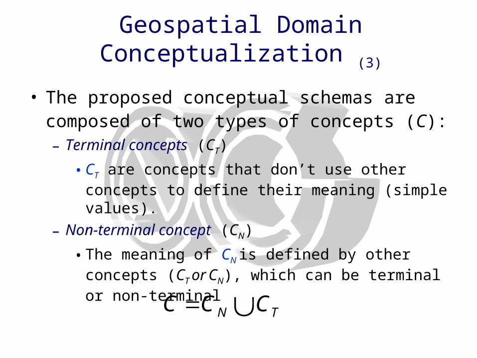
Geospatial Domain Conceptualization (3)
• The proposed conceptual schemas are composed of two types of concepts (C): – Terminal concepts (CT)
• CT are concepts that don’t use other concepts to define their meaning (simple values).
– Non-terminal concept (CN)
• The meaning of CN is defined by other concepts (CT or CN), which can be terminal or non-terminal
TN CCC
Geospatial Domain Conceptualization (4)
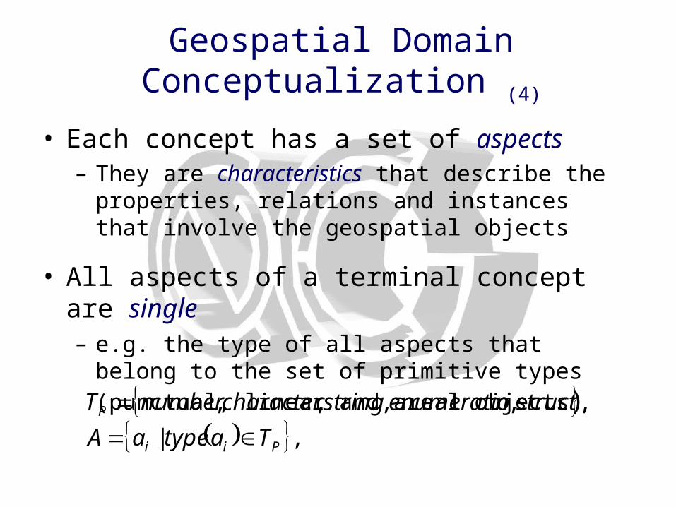
• Each concept has a set of aspects – They are characteristics that describe the properties,
relations and instances that involve the geospatial objects
• All aspects of a terminal concept are single – e.g. the type of all aspects that belong to the set of
primitive types (punctual, linear and areal objects)
,|
,,,,,
Pii
P
TatypeaA
structnenumeratiostringcharacternumberT
Geospatial Domain Conceptualization (5)
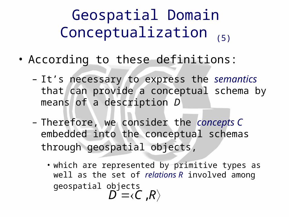
• According to these definitions:
– It’s necessary to express the semantics that can provide a conceptual schema by means of a description D
– Therefore, we consider the concepts C embedded into the conceptual schemas through geospatial objects,
• which are represented by primitive types as well as the set of
relations R involved among geospatial objects
RCD ,

Geospatial Domain Conceptualization (6)
Geospatial Domain Conceptualization (7)
• This schema is adaptive for any context
• It attempts to reflect the main features involved in this domain
• The main features involved into geospatial domain have been abstracted of the real world in order to obtain a conceptualization
• This conceptualization provides us explicit vocabulary that represents the ontological commitment of the cognitive and intuitive perception of the subjects
• We are looking for a compact conceptual schema-based abstraction that drives the cognitive process of phenomenon semantic description under specific context
Case Study (1)
• We will describe two scenarios, which are focused on showing how to conceptualize the geospatial domain, by means of conceptual schemas in order to obtain a semantic description regarding specific context
• The goal is to depict how these scenarios converge in the same semantic description
– Although their representations are different, they belong to the same context; thereby their semantic description is the same as well as their conceptualization.

Case Study (2)
• Scenario 1: Imagining the real world. Suppose that we are looking at a landscape, which depicts several entities such as a forest that has a lake and a river. Moreover, the freeway F25 crosses the highway I37. F25 is used to arrive to Santa Cruz that is
the main town of the surroundings
• It’s important to make a conceptualization about our observations. – In other words, we are making and abstraction process that is used to
conceptualize the landscape
– Then this kind of conceptualization can be represented in a conceptual schema and restricted by a context
Case Study (3)
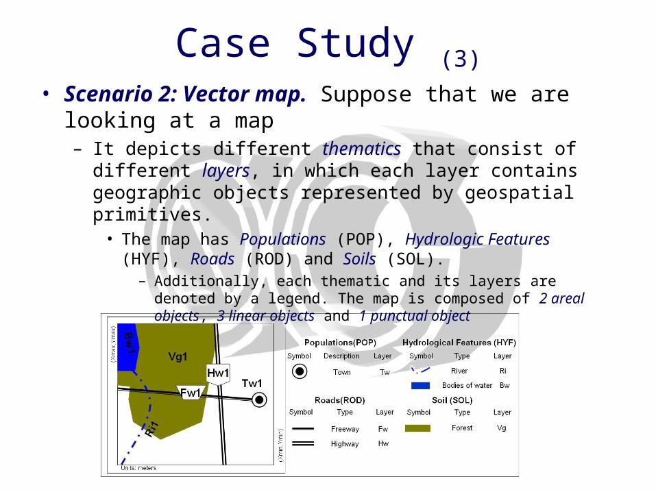
• Scenario 2: Vector map. Suppose that we are looking at a map – It depicts different thematics that consist of different layers, in
which each layer contains geographic objects represented by geospatial primitives.
• The map has Populations (POP), Hydrologic Features (HYF), Roads (ROD) and Soils (SOL).
– Additionally, each thematic and its layers are denoted by a legend. The map is composed of 2 areal objects, 3 linear objects and 1 punctual object
Case Study (4)
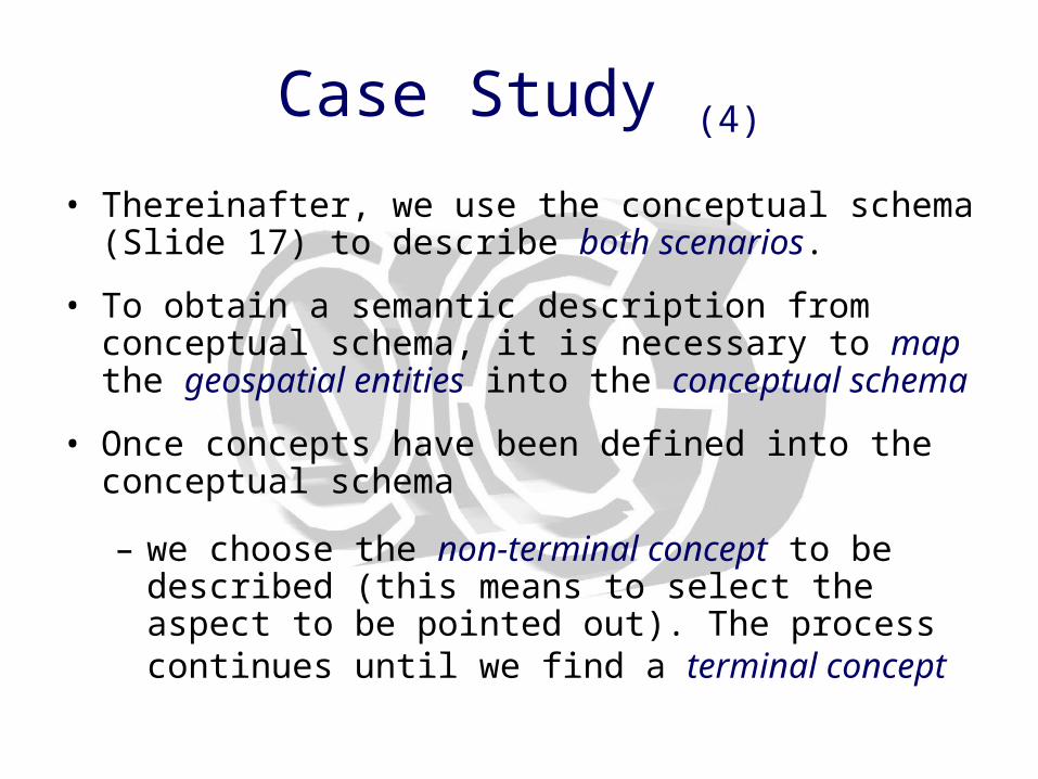
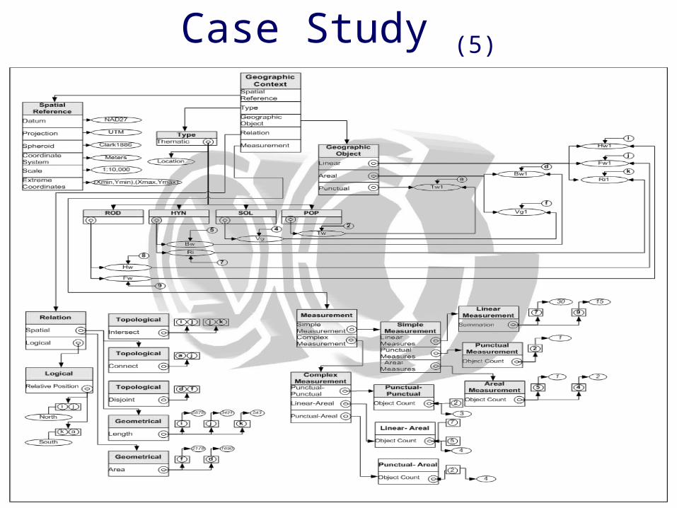
• Thereinafter, we use the conceptual schema (Slide 17) to describe both scenarios.
• To obtain a semantic description from conceptual schema, it is necessary to map the geospatial entities into the conceptual schema
• Once concepts have been defined into the conceptual schema
– we choose the non-terminal concept to be described (this means to select the aspect to be pointed out). The process continues until we find a terminal concept
Case Study (5)
Conclusions and future works (1)
• We propose an approach to make a conceptualization of the real world based on conceptual schemas, which are used to generate a semantic description of the geospatial domain.
• This description attempts to provide the guidelines to formalize the geographic domain in form of geospatial ontologies according to specific contexts.
• We perceive that geographic data modeling requires models that are more specific and capable of capturing the semantics of geospatial data, offering higher abstraction mechanisms and implementation independence

Conclusions and future works (2)
• This approach allows us to process imprecise data and aid to information integration and semantic heterogeneity tasks– Thus, the method is focused on describing the semantic content
based on conceptual schemas embedded into geographic
context
• We have introduced two types of concepts: “terminal” and “non-terminal” as well as two kinds of relations: “has” and “is-a” to build the conceptual schema
Conclusions and future works (3)
• We approach conceptual schemas to describe
– The contents of the real world abstraction to specify the behavior of the geospatial entities, in which context plays an important role to guarantee shared and explicit conceptualizations
• Future works are mainly oriented to propose:
– Conceptual issues related to translate semantic descriptions into geospatial ontologies, as well as what would be required to establish these kinds of ontologies
• In addition, our work is led to formalize:
– Appropriate methods to represent ontologies of the geospatial domain and to measure semantic contents between geospatial ontologies