Embed Size (px)
Citation preview
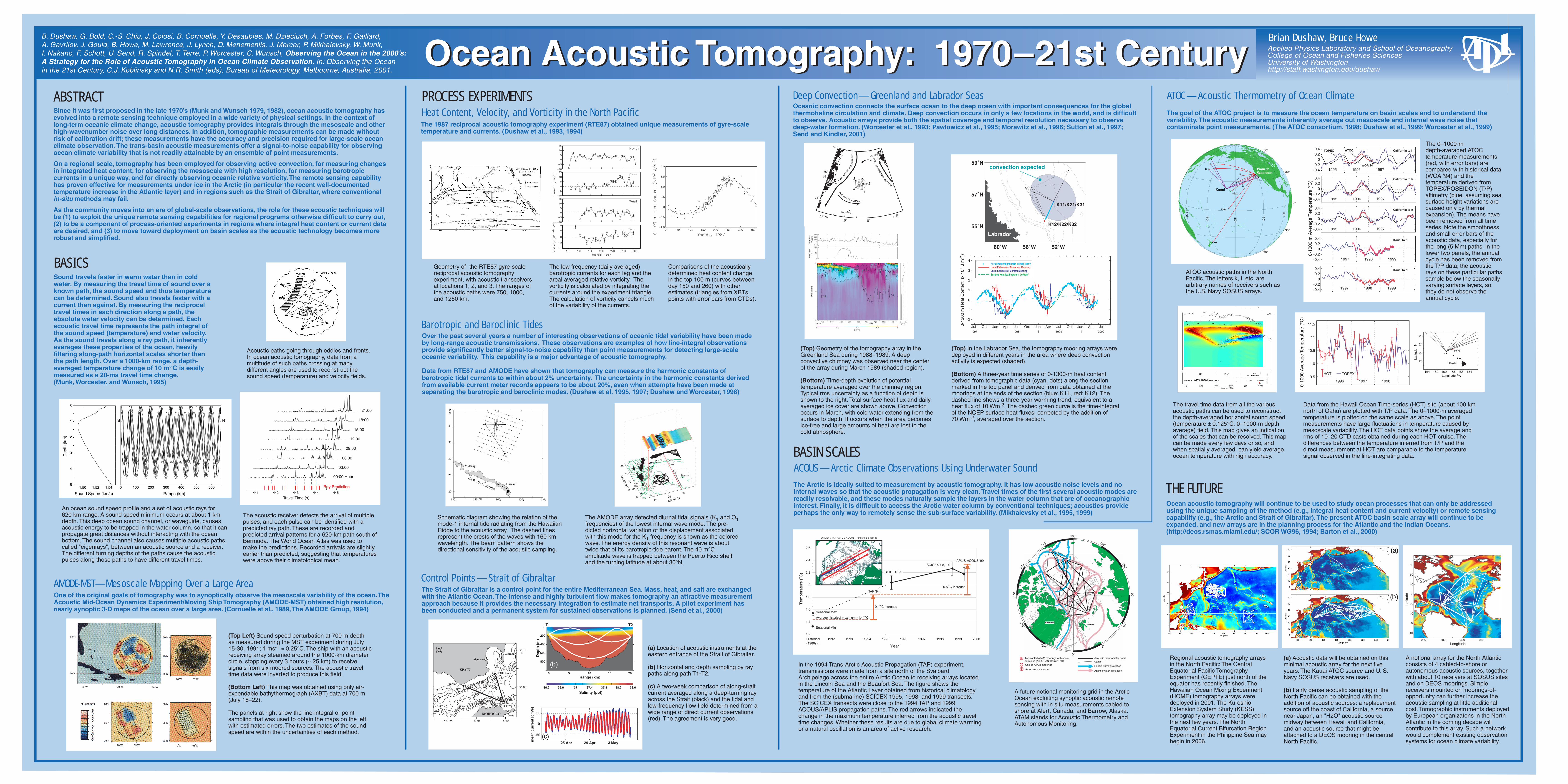
Ocean Acoustic Tomography: 1970–21st CenturyOcean Acoustic Tomography: 1970–21st CenturyBrian Dushaw, Bruce HoweApplied Physics Laboratory and School of OceanographyCollege of Ocean and Fisheries SciencesUniversity of Washingtonhttp://staff.washington.edu/dushaw
B. Dushaw, G. Bold, C.-S. Chiu, J. Colosi, B. Cornuelle, Y. Desaubies, M. Dzieciuch, A. Forbes, F. Gaillard, A. Gavrilov, J. Gould, B. Howe, M. Lawrence, J. Lynch, D. Menemenlis, J. Mercer, P. Mikhalevsky, W. Munk, I. Nakano, F. Schott, U. Send, R. Spindel, T. Terre, P. Worcester, C. Wunsch, Observing the Ocean in the 2000’s: A Strategy for the Role of Acoustic Tomography in Ocean Climate Observation. In: Observing the Ocean in the 21st Century, C.J. Koblinsky and N.R. Smith (eds), Bureau of Meteorology, Melbourne, Australia, 2001.
ABSTRACT ATOC—Acoustic Thermometry of Ocean Climate
ACOUS—Arctic Climate Observations Using Underwater SoundBASIN SCALES
THE FUTURE
Deep Convection—Greenland and Labrador SeasSince it was first proposed in the late 1970’s (Munk and Wunsch 1979, 1982), ocean acoustic tomography has evolved into a remote sensing technique employed in a wide variety of physical settings. In the context of long-term oceanic climate change, acoustic tomography provides integrals through the mesoscale and other high-wavenumber noise over long distances. In addition, tomographic measurements can be made without risk of calibration drift; these measurements have the accuracy and precision required for large-scale ocean climate observation. The trans-basin acoustic measurements offer a signal-to-noise capability for observing ocean climate variability that is not readily attainable by an ensemble of point measurements.
On a regional scale, tomography has been employed for observing active convection, for measuring changes in integrated heat content, for observing the mesoscale with high resolution, for measuring barotropic currents in a unique way, and for directly observing oceanic relative vorticity. The remote sensing capability has proven effective for measurements under ice in the Arctic (in particular the recent well-documented temperature increase in the Atlantic layer) and in regions such as the Strait of Gibraltar, where conventional in-situ methods may fail.
As the community moves into an era of global-scale observations, the role for these acoustic techniques will be (1) to exploit the unique remote sensing capabilities for regional programs otherwise difficult to carry out, (2) to be a component of process-oriented experiments in regions where integral heat content or current data are desired, and (3) to move toward deployment on basin scales as the acoustic technology becomes more robust and simplified.
2
2.2
2.4
2.6
1991 1992 1993 1994 1995 1996 1997 1998 1999 2000
Seasonal Max
1.2
1.4
1.6
1.8
Year
Tem
pera
ture
(o C
)
Seasonal Min
Historical(1980s)
0.4o C increase
SCICEX '98, '99
Average historical maximum =1.44 C
0.5o C increase TAP '94
APLIS-ACOUS '99
SCICEX '95
o
S C IC E X / TA P / A PL IS -A C O U S T ransa rctic S ections
SCICEX CTD Transect
TAP Experim
ent April
1994
APLIS/ACOUS Experim
ent April 1
999
Greenland
R
R
R
R
R
R
R Two cabled ATAM moorings with shoreterminus (Alert, CAN; Barrow, AK)
R Cabled ATAM moorings
Autonomous sources
Acoustic thermometry paths
Cable
Pacific water circulation
Atlantic water circulation
280 300 320 340
-10
0
10
20
30
40
50
60
Longitude
Latit
ude
(a)
(b)
GREENLAND
SPITSBERGEN
JAN MAYEN I.
80¡N
78¡
76¡
74¡
72¡
70¡
20¡W
10¡ 0¡
10¡E
EAST
GREE
NLAND
CU
RR
EN
T
CURRENT
CURRENT
JAN
MAYEN
WE
ST
2
15
43
SPITSBER
GEN
76˚N
72˚
0˚10˚10˚ E20˚ W
80˚
6
0
50
100
Ice
Cov
er(%
)
-2000
200400600
Hea
t Flu
x(W
/m2 )
0
1
2
Dep
th (
km)
-1.6 -1.2 -0.8 -0.4 0θ (˚C)
Oct Nov Dec Jan Feb Mar Apr May Jun1988 1989
0 (˚C)
0.1
Oceanic convection connects the surface ocean to the deep ocean with important consequences for the global thermohaline circulation and climate. Deep convection occurs in only a few locations in the world, and is difficult to observe. Acoustic arrays provide both the spatial coverage and temporal resolution necessary to observe deep-water formation. (Worcester et al., 1993; Pawlowicz et al., 1995; Morawitz et al., 1996; Sutton et al., 1997; Send and Kindler, 2001)
(Top) Geometry of the tomography array in the Greenland Sea during 1988–1989. A deep convective chimney was observed near the center of the array during March 1989 (shaded region).
(Bottom) Time-depth evolution of potential temperature averaged over the chimney region. Typical rms uncertainty as a function of depth is shown to the right. Total surface heat flux and daily averaged ice cover are shown above. Convection occurs in March, with cold water extending from the surface to depth. It occurs when the area becomes ice-free and large amounts of heat are lost to the cold atmosphere.
(Top) In the Labrador Sea, the tomography mooring arrays were deployed in different years in the area where deep convection activity is expected (shaded).
(Bottom) A three-year time series of 0-1300-m heat content derived from tomographic data (cyan, dots) along the section marked in the top panel and derived from data obtained at the moorings at the ends of the section (blue: K11, red: K12). The dashed line shows a three-year warming trend, equivalent to a heat flux of 10 Wm-2. The dashed green curve is the time-integral of the NCEP surface heat fluxes, corrected by the addition of 70 Wm-2, averaged over the section.
The Arctic is ideally suited to measurement by acoustic tomography. It has low acoustic noise levels and no internal waves so that the acoustic propagation is very clean. Travel times of the first several acoustic modes are readily resolvable, and these modes naturally sample the layers in the water column that are of oceanographic interest. Finally, it is difficult to access the Arctic water column by conventional techniques; acoustics provide perhaps the only way to remotely sense the sub-surface variability. (Mikhalevsky et al., 1995, 1999)
In the 1994 Trans-Arctic Acoustic Propagation (TAP) experiment, transmissions were made from a site north of the Svalbard Archipelago across the entire Arctic Ocean to receiving arrays located in the Lincoln Sea and the Beaufort Sea. The figure shows the temperature of the Atlantic Layer obtained from historical climatology and from the (submarine) SCICEX 1995, 1998, and 1999 transects. The SCICEX transects were close to the 1994 TAP and 1999 ACOUS/APLIS propagation paths. The red arrows indicated the change in the maximum temperature inferred from the acoustic travel time changes. Whether these results are due to global climate warming or a natural oscillation is an area of active research.
A future notional monitoring grid in the Arctic Ocean exploiting synoptic acoustic remote sensing with in situ measurements cabled to shore at Alert, Canada, and Barrow, Alaska. ATAM stands for Acoustic Thermometry and Autonomous Monitoring.
The goal of the ATOC project is to measure the ocean temperature on basin scales and to understand the variability. The acoustic measurements inherently average out mesoscale and internal wave noise that contaminate point measurements. (The ATOC consortium, 1998; Dushaw et al., 1999; Worcester et al., 1999)
Ocean acoustic tomography will continue to be used to study ocean processes that can only be addressed using the unique sampling of the method (e.g., integral heat content and current velocity) or remote sensing capability (e.g., the Arctic and Strait of Gibraltar). The present ATOC basin scale array will continue to be expanded, and new arrays are in the planning process for the Atlantic and the Indian Oceans. (http://deos.rsmas.miami.edu/; SCOR WG96, 1994; Barton et al., 2000)
ATOC acoustic paths in the North Pacific. The letters k, l, etc. are arbitrary names of receivers such as the U.S. Navy SOSUS arrays.
-0.4-0.2
00.20.4 Kauai to n
-0.4-0.2
00.20.4 California to n
-0.4-0.2
00.20.4 California to k
1995 1996 1997
1995 1996 1997
1997 1998 1999
0-10
00 m
Ave
rage
Tem
pera
ture
(o C
)
-0.4-0.2
00.20.4 TOPEX ATOC California to l
1995 1996 1997
Kauai to d
-0.4-0.2
00.20.4
1997 1998 1999
WOA'94
The 0–1000-m depth-averaged ATOC temperature measurements (red, with error bars) are compared with historical data (WOA ’94) and the temperature derived from TOPEX/POSEIDON (T/P) altimetry (blue, assuming sea surface height variations are caused only by thermal expansion). The means have been removed from all time series. Note the smoothness and small error bars of the acoustic data, especially for the long (5 Mm) paths. In the lower two panels, the annual cycle has been removed from the T/P data; the acoustic rays on these particular paths sample below the seasonally varying surface layers, so they do not observe the annual cycle.
Data from the Hawaii Ocean Time-series (HOT) site (about 100 km north of Oahu) are plotted with T/P data. The 0–1000-m averaged temperature is plotted on the same scale as above. The point measurements have large fluctuations in temperature caused by mesoscale variability. The HOT data points show the average and rms of 10–20 CTD casts obtained during each HOT cruise. The differences between the temperature inferred from T/P and the direct measurement at HOT are comparable to the temperature signal observed in the line-integrating data.
The travel time data from all the various acoustic paths can be used to reconstruct the depth-averaged horizontal sound speed (temperature ± 0.125°C, 0–1000-m depth average) field. This map gives an indication of the scales that can be resolved. This map can be made every few days or so, and when spatially averaged, can yield average ocean temperature with high accuracy.
Regional acoustic tomography arrays in the North Pacific: The Central Equatorial Pacific Tomography Experiment (CEPTE) just north of the equator has recently finished. The Hawaiian Ocean Mixing Experiment (HOME) tomography arrays were deployed in 2001. The Kuroshio Extension System Study (KESS) tomography array may be deployed in the next few years. The North Equatorial Current Bifurcation Region Experiment in the Philippine Sea may begin in 2006.
(a) Acoustic data will be obtained on this minimal acoustic array for the next five years. The Kauai ATOC source and U. S. Navy SOSUS receivers are used.
(b) Fairly dense acoustic sampling of the North Pacific can be obtained with the addition of acoustic sources: a replacement source off the coast of California, a source near Japan, an "H2O" acoustic source midway between Hawaii and California, and an acoustic source that might be attached to a DEOS mooring in the central North Pacific.
A notional array for the North Atlantic consists of 4 cabled-to-shore or autonomous acoustic sources, together with about 10 receivers at SOSUS sites and on DEOS moorings. Simple receivers mounted on moorings-of-opportunity can further increase the acoustic sampling at little additional cost. Tomographic instruments deployed by European organizatons in the North Atlantic in the coming decade will contribute to this array. Such a network would complement existing observation systems for ocean climate variability.
PROCESS EXPERIMENTSHeat Content, Velocity, and Vorticity in the North PacificThe 1987 reciprocal acoustic tomography experiment (RTE87) obtained unique measurements of gyre-scale temperature and currents. (Dushaw et al., 1993, 1994)
Geometry of the RTE87 gyre-scale reciprocal acoustic tomography experiment, with acoustic transceivers at locations 1, 2, and 3. The ranges of the acoustic paths were 750, 1000, and 1250 km.
Comparisons of the acoustically determined heat content change in the top 100 m (curves between day 150 and 260) with other estimates (triangles from XBTs, points with error bars from CTDs).
The low frequency (daily averaged) barotropic currents for each leg and the areal averaged relative vorticity. The vorticity is calculated by integrating the currents around the experiment triangle. The calculation of vorticity cancels much of the variability of the currents.
80
75
70
65
6020
2530
1
23
4 5
6
Latitude o N
Longitude oW
USA
PuertoRico
Bermuda
Cuba
55005500
5500
4000
4000
20001000
P.R
. Trench
K1 Turning Latitude
Barotropic and Baroclinic TidesOver the past several years a number of interesting observations of oceanic tidal variability have been made by long-range acoustic transmissions. These observations are examples of how line-integral observations provide significantly better signal-to-noise capability than point measurements for detecting large-scale oceanic variability. This capability is a major advantage of acoustic tomography.
Data from RTE87 and AMODE have shown that tomography can measure the harmonic constants of barotropic tidal currents to within about 2% uncertainty. The uncertainty in the harmonic constants derived from available current meter records appears to be about 20%, even when attempts have been made at separating the barotropic and baroclinic modes. (Dushaw et al. 1995, 1997; Dushaw and Worcester, 1998)
Schematic diagram showing the relation of the mode-1 internal tide radiating from the Hawaiian Ridge to the acoustic array. The dashed lines represent the crests of the waves with 160 km wavelength. The beam pattern shows the directional sensitivity of the acoustic sampling.
The AMODE array detected diurnal tidal signals (K1 and O1 frequencies) of the lowest internal wave mode. The pre-dicted horizontal variation of the displacement associated with this mode for the K1 frequency is shown as the colored wave. The energy density of this resonant wave is about twice that of its barotropic-tide parent. The 40 m°C amplitude wave is trapped between the Puerto Rico shelf and the turning latitude at about 30°N.
45¡N
40¡
35¡
30¡
25¡
20¡
180¡ 170¡ W 160¡ 150¡ 140¡
HAWAIIAN RIDGE
Midway
Hawaii
AMODE-MST—Mesoscale Mapping Over a Large AreaOne of the original goals of tomography was to synoptically observe the mesoscale variability of the ocean. The Acoustic Mid-Ocean Dynamics Experiment/Moving Ship Tomography (AMODE-MST) obtained high resolution, nearly synoptic 3-D maps of the ocean over a large area. (Cornuelle et al., 1989, The AMODE Group, 1994)
(Top Left) Sound speed perturbation at 700 m depth as measured during the MST experiment during July 15-30, 1991; 1 ms-1 ≈ 0.25°C. The ship with an acoustic receiving array steamed around the 1000-km diameter circle, stopping every 3 hours (~ 25 km) to receive signals from six moored sources. The acoustic travel time data were inverted to produce this field.
(Bottom Left) This map was obtained using only air-expendable bathythermograph (AXBT) data at 700 m (July 18–22).
The panels at right show the line-integral or point sampling that was used to obtain the maps on the left, with estimated errors. The two estimates of the sound speed are within the uncertainties of each method.
Control Points—Strait of GibraltarThe Strait of Gibraltar is a control point for the entire Mediterranean Sea. Mass, heat, and salt are exchanged with the Atlantic Ocean. The intense and highly turbulent flow makes tomography an attractive measurement approach because it provides the necessary integration to estimate net transports. A pilot experiment has been conducted and a permanent system for sustained observations is planned. (Send et al., 2000)
(a) Location of acoustic instruments at the eastern entrance of the Strait of Gibraltar.
(b) Horizontal and depth sampling by ray paths along path T1-T2.
(c) A two-week comparison of along-strait current averaged along a deep-turning ray across the Strait (black) and the tidal and low-frequency flow field determined from a wide range of direct current observations (red). The agreement is very good.
SPAIN
MOROCCO
Tarifa
Ceuta
Algeciras
GibraltarGibraltar
T1T1
T2T2
T3//HLAT3//HLA
Gibraltar
T1
T2
T3/HLA
5 20’5 40’W 5 30’
36 00’
36 10’N
200
200
200
200
400600
800
600
400
L
J
U
(a)
Salinity (ppt)36.2 36.6 37 37.4 37.8 38.2 38.6
0
200
400
600
800
T1 T2
Dep
th (
m)
0 5 10 15 20Range (km)
+2
–2
–1
(b)
25 Apr 29 Apr 3 May
-50
0
50
mea
n c
urr
ent
[cm
/s]
(c)
BASICSSound travels faster in warm water than in cold water. By measuring the travel time of sound over a known path, the sound speed and thus temperature can be determined. Sound also travels faster with a current than against. By measuring the reciprocal travel times in each direction along a path, the absolute water velocity can be determined. Each acoustic travel time represents the path integral of the sound speed (temperature) and water velocity. As the sound travels along a ray path, it inherently averages these properties of the ocean, heavily filtering along-path horizontal scales shorter than the path length. Over a 1000-km range, a depth-averaged temperature change of 10 m° C is easily measured as a 20-ms travel time change. (Munk, Worcester, and Wunsch, 1995)
An ocean sound speed profile and a set of acoustic rays for 620 km range. A sound speed minimum occurs at about 1 km depth. This deep ocean sound channel, or waveguide, causes acoustic energy to be trapped in the water column, so that it can propagate great distances without interacting with the ocean bottom. The sound channel also causes multiple acoustic paths, called "eigenrays", between an acoustic source and a receiver. The different turning depths of the paths cause the acoustic pulses along those paths to have different travel times.
The acoustic receiver detects the arrival of multiple pulses, and each pulse can be identified with a predicted ray path. These are recorded and predicted arrival patterns for a 620-km path south of Bermuda. The World Ocean Atlas was used to make the predictions. Recorded arrivals are slightly earlier than predicted, suggesting that temperatures were above their climatological mean.
0 100 200 300 400 500 600
Range (km)
1.50 1.52 1.545
4
3
2
1
0
Sound Speed (km/s)
Dep
th (
km)
S R
441 442 443 444 445
Travel Time (s)
00:00 Hour
03:00
06:00
09:00
12:00
15:00
18:00
21:00
Ray PredictionRay Prediction
60˚W 56˚W 52˚W
55˚N
57˚N
59˚N
Labrador
K11/K21/K31
K12/K22/K32
convection expected
Jul Oct Jan Apr Jul Oct Jan Apr Jul Oct Jan Apr Jul
-2
-1
0
1
2
3
4
0-13
00 m
Hea
t Con
tent
(x
10
J m
)
-2
1997 1998 1999 2000| | |
Horizontal Integral from Tomography Local Estimate at Boundary Mooring Local Estimate at Central Mooring Surface Heatflux Integral + 70 W/m 2
9
0°
30°
30°
60°
60°
150°
180°
120°
90°
150°
Kauai
PioneerSeamount
k
l
nd
vla1
vla2
nz
r f
o
(a)
(b)
1997 1998
9.5
10
10.5
11
11.5
HOT TOPEX
1996 1997 1998
164 162 160 158 156 154
20
22
24
26
Longitude
Latit
ude HOT
Hawaii
N
oW
0-10
00 A
vera
ge T
empe
ratu
re (
°C)
Acoustic paths going through eddies and fronts. In ocean acoustic tomography, data from a multitude of such paths crossing at many different angles are used to reconstruct the sound speed (temperature) and velocity fields.


![Cooling Plate Depth vs. Age ~120 km. Temperature vs. Depth vs. time—Erf For Plates (rocks), cooling skin thickness L=10km x (Age[m.y.]) 1/2](https://img.pdfslide.us/doc/110x75/56649d365503460f94a0ef75/cooling-plate-depth-vs-age-120-km-temperature-vs-depth-vs-timeerf-for.jpg)