Embed Size (px)
Citation preview

Dept. of Geography / Remote Sensing Laboratories
5 Feb 2014 Page 1
Relating SAR backscatter to in-situ measurements and models of snow liquid water content
Christoph Rohner (UZH), Tobias Jonas (WSL-SLF), David Small (UZH)

Dept. of Geography / Remote Sensing Laboratories
Relating SAR backscatter to in-situ measurements and models, Christoph Rohner5 Feb 2014 Page 2
Introduction
- Only few studies investigate the relation SAR modeled/measured snow parameters on time series (e.g. Longépé et al., 2009)1
- Knowledge of agreement between radar imagery and modeled snow water equivalent important for integration of SAR products in snow-hydrological models
- We have 10 years of ASAR C-Band backscatter (time-series) of Switzerland and wish to test connections to in-situ snow station measurements
1 Longépé, N., Allain, S., Ferro-Famil, L., Pottier, E., & Durand, Y. (2009). Snowpack Characterization in Mountainous Regions Using C-Band SAR Data and a Meteorological Model. IEEE Transactions on Geoscience and Remote Sensing, 47, 406–418.

Dept. of Geography / Remote Sensing Laboratories
Relating SAR backscatter to in-situ measurements and models, Christoph Rohner5 Feb 2014 Page 4
Research Questions
- Which parameters influence the SAR based wet snow retrieval and what is the relative sensitivity to each?
- What are the relations between the parameters measured and modeled at IMIS/MeteoSwiss and wet snow signals retrieved from Envisat ASAR/RADARSAT-2?
- Is it possible to retrieve information about the sensitivity of the SAR backscatter to in-situ/modeled information on the locally known depth of the melting process?

Dept. of Geography / Remote Sensing Laboratories
Relating SAR backscatter to in-situ measurements and models, Christoph Rohner5 Feb 2014 Page 5
Data
Remote Sensing data
- Envisat ASAR (Radiometrically Terrain Corrected)1
- RADARSAT-2 (Radiometrically Terrain Corrected)1
Meteorological/snow-hydrological parameters
- IMIS measurements (SLF)
- Physical SNOWPACK model (SLF)
- Gridded data sets (MeteoSwiss)
1 Small, D. (2011). Flattening Gamma: Radiometric Terrain Correction for SAR Imagery. IEEE Transactions on Geoscience and Remote Sensing, 49, 3081–3093.

Dept. of Geography / Remote Sensing Laboratories
Relating SAR backscatter to in-situ measurements and models, Christoph Rohner5 Feb 2014 Page 6
Envisat ASAR (C-Band, WS, VV pol)
- ASAR WSM product has nominal 150 m resolution, swath width 400 km
- > 300 RTC scenes of Switzerland between 2007 – 2012 used
Envisat ASARData & Products
© European SpaceAgency (2009)
Dept. of Geography / Remote Sensing Laboratories
Relating SAR backscatter to in-situ measurements and models, Christoph Rohner5 Feb 2014 Page 7
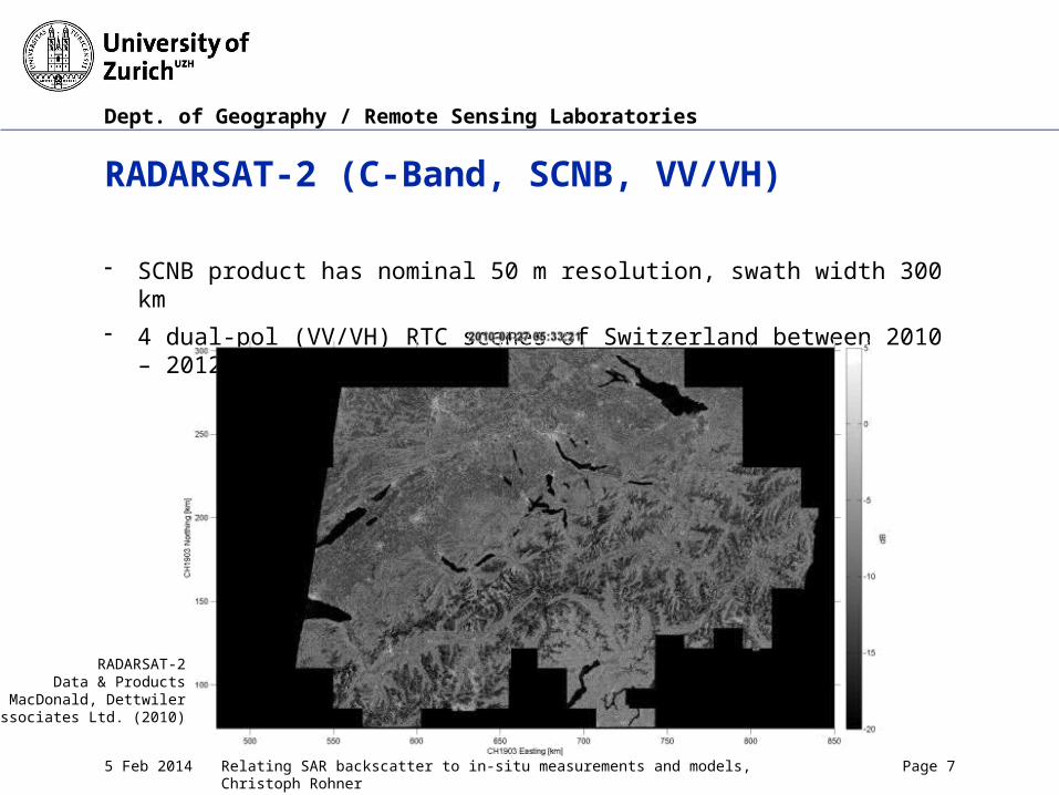
RADARSAT-2 (C-Band, SCNB, VV/VH)
- SCNB product has nominal 50 m resolution, swath width 300 km
- 4 dual-pol (VV/VH) RTC scenes of Switzerland between 2010 – 2012 used
RADARSAT-2Data & Products
© MacDonald, Dettwilerand Associates Ltd. (2010)
Dept. of Geography / Remote Sensing Laboratories
Relating SAR backscatter to in-situ measurements and models, Christoph Rohner5 Feb 2014 Page 8
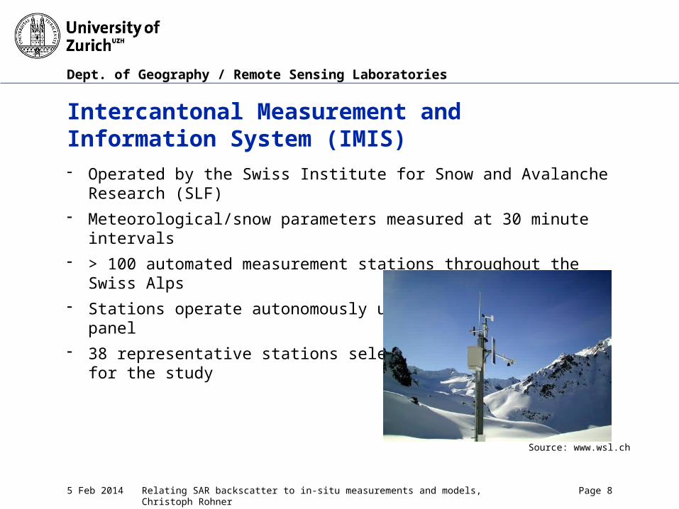
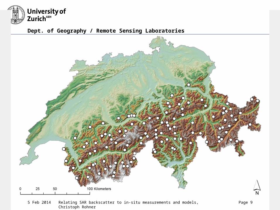
Intercantonal Measurement and Information System (IMIS)- Operated by the Swiss Institute for Snow and Avalanche Research (SLF)
- Meteorological/snow parameters measured at 30 minute intervals
- > 100 automated measurement stations throughout the Swiss Alps
- Stations operate autonomously using battery/solar panel
- 38 representative stations selectedfor the study
Source: www.wsl.ch
Dept. of Geography / Remote Sensing Laboratories
Relating SAR backscatter to in-situ measurements and models, Christoph Rohner5 Feb 2014 Page 9

Dept. of Geography / Remote Sensing Laboratories
Relating SAR backscatter to in-situ measurements and models, Christoph Rohner5 Feb 2014 Page 10
Dept. of Geography / Remote Sensing Laboratories
Relating SAR backscatter to in-situ measurements and models, Christoph Rohner5 Feb 2014 Page 11
Physical SNOWPACK Model (Lehning et al., 2002)
- Finite-element based physical snowpack model
- Snow is modeled as a three-phase (ice/water/air) porous medium
- Data input based on IMIS measurements of meteorological and snow parameters
Lehning, M., Bartelt, P., Brown, B., Fierz, C., & Satyawali, P. (2002). A physical SNOWPACK model for the Swiss avalanche warning. Cold Regions Science and Technology, 35, 123–184.
Dept. of Geography / Remote Sensing Laboratories
Relating SAR backscatter to in-situ measurements and models, Christoph Rohner5 Feb 2014 Page 12
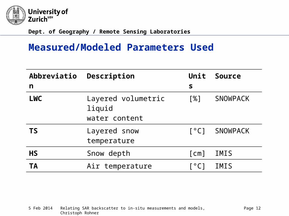
Measured/Modeled Parameters Used
Abbreviation Description Units
Source
LWC Layered volumetric liquidwater content
[%] SNOWPACK
TS Layered snow temperature [°C] SNOWPACK
HS Snow depth [cm] IMIS
TA Air temperature [°C] IMIS
Dept. of Geography / Remote Sensing Laboratories
Relating SAR backscatter to in-situ measurements and models, Christoph Rohner5 Feb 2014 Page 13
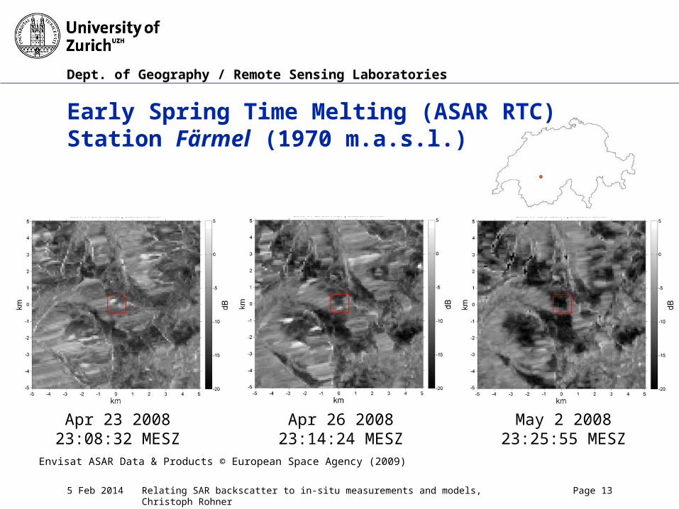
Early Spring Time Melting (ASAR RTC)Station Färmel (1970 m.a.s.l.)
Apr 23 200823:08:32 MESZ
Apr 26 200823:14:24 MESZ
May 2 200823:25:55 MESZ
Envisat ASAR Data & Products © European Space Agency (2009)
Dept. of Geography / Remote Sensing Laboratories
Relating SAR backscatter to in-situ measurements and models, Christoph Rohner5 Feb 2014 Page 14
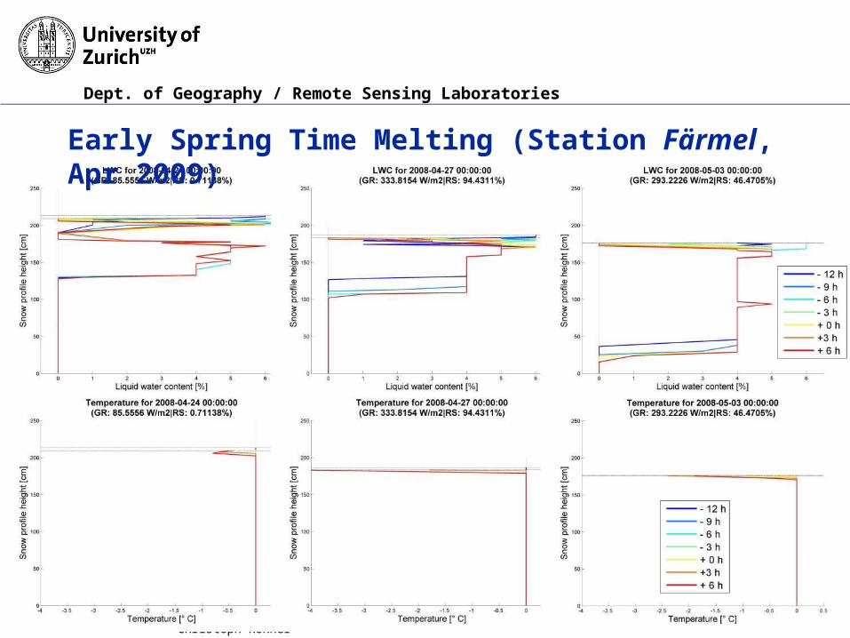
Early Spring Time Melting (Station Färmel, Apr 2009)

Dept. of Geography / Remote Sensing Laboratories
Relating SAR backscatter to in-situ measurements and models, Christoph Rohner5 Feb 2014 Page 15
Early Spring Time Melting (ASAR RTC)Station Färmel (1970 m.a.s.l.)

Dept. of Geography / Remote Sensing Laboratories
Relating SAR backscatter to in-situ measurements and models, Christoph Rohner5 Feb 2014 Page 16
Disappearance of the Snow Cover (ASAR RTC)Station First (2110 m.a.s.l.)
Apr 29 200823:20:23 MESZ
May 18 2008 23:22:57 MESZ
Jun 03 200823:20:25 MESZ
Envisat ASAR Data & Products © European Space Agency (2008)

Dept. of Geography / Remote Sensing Laboratories
Relating SAR backscatter to in-situ measurements and models, Christoph Rohner5 Feb 2014 Page 17
Disappearance of the Snow Cover (Station First, Apr 2008)

Dept. of Geography / Remote Sensing Laboratories
Relating SAR backscatter to in-situ measurements and models, Christoph Rohner5 Feb 2014 Page 18
Disappearance of the Snow Cover (ASAR RTC)Station First (2110 m.a.s.l.)

Dept. of Geography / Remote Sensing Laboratories
Relating SAR backscatter to in-situ measurements and models, Christoph Rohner5 Feb 2014 Page 19
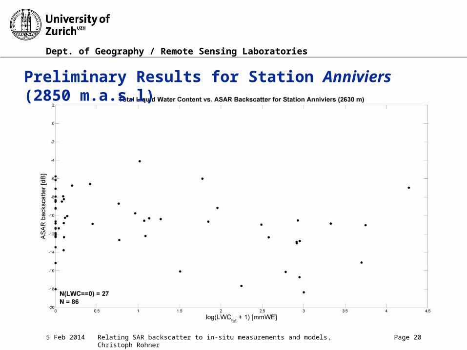
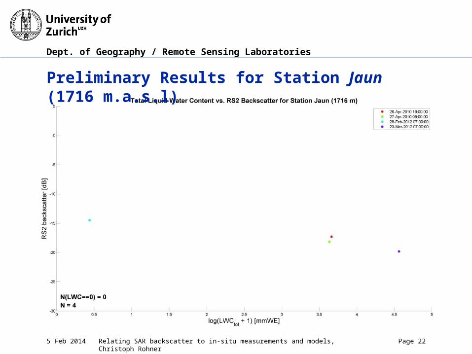
Preliminary Results for Selected Stations
Non-trivial to establish connection between areal radar backscatter and in situ station LWC (point observation combined with model)
Dept. of Geography / Remote Sensing Laboratories
Relating SAR backscatter to in-situ measurements and models, Christoph Rohner5 Feb 2014 Page 20
Preliminary Results for Station Anniviers (2850 m.a.s.l)

Dept. of Geography / Remote Sensing Laboratories
Relating SAR backscatter to in-situ measurements and models, Christoph Rohner5 Feb 2014 Page 21
Preliminary Results for Station Nara (2070 m.a.s.l)
Dept. of Geography / Remote Sensing Laboratories
Relating SAR backscatter to in-situ measurements and models, Christoph Rohner5 Feb 2014 Page 22
Preliminary Results for Station Jaun (1716 m.a.s.l)

Dept. of Geography / Remote Sensing Laboratories
Relating SAR backscatter to in-situ measurements and models, Christoph Rohner5 Feb 2014 Page 23
Preliminary Conclusions
- Early stage of the study
- Promising preliminary results found for certain stations, but no simple connection visible in first juxtaposition of datasets
- Deeper understanding of multivariate combined data set will hopefully reveal further connections in the coming months
- Connections between LWC, SWE, date, temperature, dry reference backscatter, residual topography
- Issues concerning the properties of the data sets (point vs. areal) need to be addressed
- Results based on a wider field of stations await further processing (in progress)
Dept. of Geography / Remote Sensing Laboratories
Relating SAR backscatter to in-situ measurements and models, Christoph Rohner5 Feb 2014 Page 24
Acknowledgments
Thanks to- ESA for the provision of the Envisat ASAR data- CSA/MDA for the provision of the RADARSAT-2 data- SLF for the provision of the IMIS/SNOWPACK data


![15 Sediment Gages - USGS · 0.2707 c,S372 Velccty and backscatter seres C] Depth-averaøed streamwise vebcfy RMS Curr.tive u at depths backscatter Depth-averaged backscatter Contour](https://img.pdfslide.us/doc/110x75/5fd8133cbc6723794903cbd2/15-sediment-gages-usgs-02707-cs372-velccty-and-backscatter-seres-c-depth-averaed.jpg)