Embed Size (px)
Citation preview

V. DROPPOVÁ
THE TOOLS OF AUTOMATED GENERALIZATION AND BUILDING GENERALIZATION IN AN ARcGIS ENVIRONMENT
KEY WORDS
• geographic Data,• geographic Information System, • BD GIS,• cartographic Generalization,• generalization of Buildings.
ABSTRAcT
Cartographic generalization plays an important role in the creation of maps. The implementation of generalization rules in the form of generalization tools in a GIS environment is an important part of digital cartography today. The article describes possibilities for the use of vector dataset generalization tools in an ArcGIS 9.2 environment. The main goal of the paper is to design and verify a generalization model of buildings for cartographic output on a scale of 1 : 10 000 on the basis of BD GIS. The limit values were defined, and two approaches to building generalization on a scale of 1 : 10, 000 were defined and tested (Generalization A, Generalization B).
Veronika DroppoVáemail:[email protected] field: Geographic Information System,Modelling, Cartographic Generalization, automated,Basic Database for Geographic Information System(BDGIS),GeneralizationofBuildings
DepartmentofMappingandLandConsolidationFacultyofCivilEngineering,SlovakUniversityofTechnologyinBratislava,Radlinského1181368Bratislava
2011/1 PAGES 1 – 7 RECEIVED 2. 3. 2010 ACCEPTED 28. 10. 2010
1 INTRODUcTION
Actual computer technologies and practices are a positivepropositionfor thecreationofmaps.Theyeffectivelyassist in theimplementation of traditional and also new cartographicmethodsin a computer environment. A Geographic Information System(GIS)isausefultoolformodelinggeographicalspacesandisstillincreasinginitsimportanceandpositioninsociety.
The creation of computer maps has a number of advantages incomparissonwithclassicalcartographicmethods[5]:• thecreation,productionandprintingofmapsisquickerandmoreeffective,
• the selection and possibility of cartographic projections andconversionofscalefactors,
• flexibilityinassemblingmapcontents,
• possibility of obtaining, relaying and completing data for thecreationofmaps,
• largerangeofpossibilitiesforvisualtechniques.
2 PROBLEMS WITH GENERALIZATION
Often there is a situation when it is not possible to strictly andgeometrically express images of objects, relations or processes.Asimplifiedimageofafeatureiscreatedbyleavingoutirrelevantdetails. The scale of a map is not the only factor which affectsgeneralization. The purpose of the map is another factor. Thepurposedetermineswhat is important,whichobjectsorcategoriesofobjectstouse,andthesymbologyofobjects.Eachgeneralizationprocessisacombinationofseveraloperations;theprocedureisnotunified,andtheresultisaspecificcompromise.
2011 SLOVAK UNIVERSITY OF TEcHNOLOGY 1
Droppova.indd 1 15. 3. 2011 12:26:38

2 THE TOOLS OF AUTOMATED GENERALIZATION AND BUILDING GENERALIZATION...
2011/1 PAGES 1 — 7
Theachievementofautomatedgeneralizationisrepresentedbytheknowledgeandskillsobtainedthroughmanualgeneralizationoftheexplicit,andlogicalrulesinacomputerenvironment.ArcGIS contains a universal and efficient system of tools, whichare grouped in toolboxes and toolsets. The tools are summonedbyadialogboxandcommand line; it isalsopossible tocombinethem by scripting languages (e.g. Python) or usingModelBuilder(a component ofArcGIS).ArcGIS contains a system of tools forgeneralizatingrastersaswellasvectordatasets[1].
2.1 Generalization of a Raster Dataset in ArcGIS
Sometimes araster dataset contains data that is erroneous orirrelevanttotheanalysisoristoodetailed.Forinstance,ifarasterdatasetisasatelliteimage,itmaycontainmanysmallandisolatedareas that are misclassified. The generalization functions assistin identifying such areas and automating the assignment ofmorereliablevaluesforthecellsthatmakeuptheareas.
Thegeneralizationtoolsofarasterdatasetare[1]:• Aggregate–generatesareducedresolutionversionofaraster,• Boundary Clean – smoothes the boundaries between zones byexpandingandshrinkingthem,
• Expand – expands particular zones of a raster by a specifiednumberofcells,
• Majorityfilter–replacescellsinarasterbasedonthemajorityoftheircontiguousneighboringcells,
• Nibble– replaces thecellsof a raster corresponding to amaskwiththevaluesofthenearestneighbors,
• Regiongroup– records the identity of the connected region towhich it belongs; for each cell in the output a unique numberisassignedtoeachregion,
• Shrink–shrinkstheselectedzonesbyaspecifiednumberofcells,• Thin–thinsrasterizelinearfeaturesbyreducingthenumberofcellsrepresentingthewidthofthefeatures.
The generalization tools work in zones (Region group, Nibble,Shrink,Thin,Expand), on zone edges (BoundaryClean,MajorityFilter)andaltertheresolutionofthedata(Aggregate).Anytwoormorecellswiththesamevaluebelongtothesamezone.Azonecanconsistofcellsthatareadjacent,disconnected,orboth.
2.2 Generalization Of a Vector Dataset in ArcGIS
ThetoolsintheGeneralizationtoolsetmakedatalessdetailedandlesscomplexforanalysisandrepresentationinreducedscalesorforother special purposes.The tools simplify datawhilemaintainingtheirgeographiccharacteristicsandintegrity.Forexample,riversare
simplifiedbyremovingtheirsmallfluctuationswithoutdestroyingtheiressentialshapes.Althoughgeneralizationisacomplicatedandsubjective task, and the rules are notwell defined, generalizationtools automate the process and meet the common generalizationrequirementsasmuchaspossible[2,4].
Generalizationtoolsforavectordataset[1]:• AggregatePolygons,• CollapseDualLinesToCenterline,• Dissolve,• Eliminate,• SimplifyBuilding,• SimplifyLine,• SimplifyPolygon,• SmoothLine.
Thenextpartofthepaperisfocusedoncartographicgeneralization,testingandverificationofgeneralizationtoolpossibilitiesforvectordatasets in theArcGIS 9.2 on the basis ofBDGIS in themodellocalityofSenec.
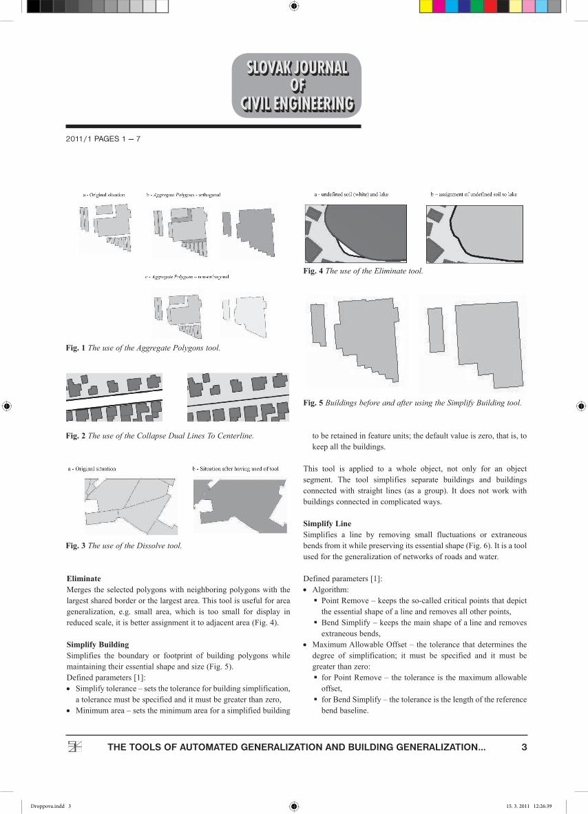
Aggregate PolygonsAggregatePolygonscombinepolygonswithinaspecifieddistanceofeachotherintonewpolygons.
Itisnecessarytodefinethe[1]:• AggregationDistance–thedistancebetweenpolygonboundariesforaggregationmustbegreaterthanzero,
• MinimumArea–theminimumareaforanaggregatedpolygonto be retained; the default value is zero, i.e., to keep all thepolygons,
• MinimumHoleSize–theminimumsizeofapolygonholetoberetained;thedefaultvalueiszero,i.e.,tokeepallthepolygonholes.
Depend on the characteristic shape of the input features, it ispossible to aggregate orthogonal (buildings, blocks) or non-orthgonal polygons (natural features, such asvegetation or soilpolygons,Fig.1).
Collapse Dual Lines To CenterlineDerives centerlines from dual-line (or double-line) features, suchasroads,basedonspecifiedwidthtolerances(Fig.2).Itisatoolforaroadnetworkgeneralization,butitonlysolvessimplecrossing.
DissolveAggregates features based on specified attributes (Fig. 3), itcan be statistically data of object, area, perimeter. It is tool forgeneralizationofarealobjects(e.g.forestarea,groundcover).
Droppova.indd 2 15. 3. 2011 12:26:38
2011/1 PAGES 1 — 7
3THE TOOLS OF AUTOMATED GENERALIZATION AND BUILDING GENERALIZATION...
EliminateMerges theselectedpolygonswithneighboringpolygonswith thelargestsharedborderorthelargestarea.Thistoolisusefulforareageneralization, e.g. small area, which is too small for display inreducedscale,itisbetterassignmentittoadjacentarea(Fig.4).
Simplify BuildingSimplifies the boundary or footprint of building polygons whilemaintainingtheiressentialshapeandsize(Fig.5).Definedparameters[1]:• Simplifytolerance–setsthetoleranceforbuildingsimplification,atolerancemustbespecifiedanditmustbegreaterthanzero,
• Minimumarea–setstheminimumareaforasimplifiedbuilding
toberetainedinfeatureunits;thedefaultvalueiszero,thatis,tokeepallthebuildings.
This tool is applied to a whole object, not only for an objectsegment. The tool simplifies separate buildings and buildingsconnectedwith straight lines (as a group). It does notworkwithbuildingsconnectedincomplicatedways.
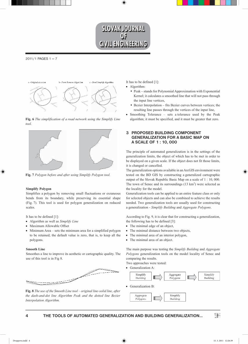
Simplify LineSimplifies a line by removing small fluctuations or extraneousbendsfromitwhilepreservingitsessentialshape(Fig.6).Itisatoolusedforthegeneralizationofnetworksofroadsandwater.
Definedparameters[1]:• Algorithm: PointRemove–keepstheso-calledcriticalpointsthatdepicttheessentialshapeofalineandremovesallotherpoints,
BendSimplify–keepsthemainshapeofalineandremovesextraneousbends,
• MaximumAllowableOffset– the tolerance thatdetermines thedegree of simplification; it must be specified and it must begreaterthanzero: forPointRemove– the tolerance is themaximumallowableoffset,
forBendSimplify–thetoleranceisthelengthofthereferencebendbaseline.
Fig. 1 The use of the Aggregate Polygons tool.
Fig. 4 The use of the Eliminate tool.
Fig. 2 The use of the Collapse Dual Lines To Centerline.
Fig. 5 Buildings before and after using the Simplify Building tool.
Fig. 3 The use of the Dissolve tool.
Droppova.indd 3 15. 3. 2011 12:26:39
4 THE TOOLS OF AUTOMATED GENERALIZATION AND BUILDING GENERALIZATION...
2011/1 PAGES 1 — 7
Simplify PolygonSimplifiesapolygonby removing small fluctuationsor exraneousbends from its boundary, while preserving its essential shape(Fig.7). This tool is used for polygon generalization on reducedscales.
Ithastobedefined[1]:• AlgorithmaswellasSimplify Line• MaximumAllowableOffset• MinimumArea–setstheminimumareaforasimplifiedpolygontobe retained; thedefault value is zero, that is, tokeepall thepolygons.
Smooth LineSmoothesalinetoimproveitsaestheticorcartographicquality.TheuseofthistoolisinFig8.
Ithastobedefined[1]:• Algorithm: Peak–standsforPolynomialApproximationwithExponentialKernel;itcalculatesasmoothedlinethatwillnotpassthroughtheinputlinevertices,
BezierInterpolation–fitsBeziercurvesbetweenvertices;theresultinglinepassesthroughtheverticesoftheinputline,
• Smoothing Tolerance – sets atolerance used by the Peakalgorithm;itmustbespecified,anditmustbegreaterthatzero.
3 PROPOSED BUILDING cOMPONENT GENERALIZATION FOR A BASIc MAP ON A ScALE OF 1 : 10, 000
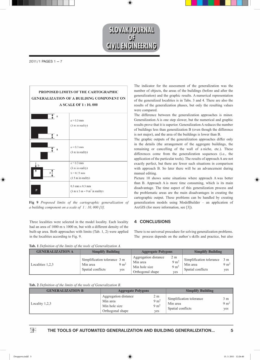
Theprincipleofautomatedgeneralization is in thesettingsof thegeneralizationlimits,theobjectofwhichhastobemetinordertobedisplayedonagivenscale.Iftheobjectdoesnotfitthoselimits,itischangedorcancelled.ThegeneralizationoptionsavailableinanArcGISenvironmentweretested on the BDGIS by constructing ageneralized cartographicoutputoftheSlovakRepublicBasicMaponascaleof1:10,000.ThetownofSenecanditssurroundings(13km2)wereselectedasthelocalityforthemodel.Generalizationtoolscanbeappliedtoanentirefeatureclassoronlyforselectedobjectsandcanalsobecombinedtoachievetheresultsneeded.Twogeneralizationtoolsareusuallyusedforconstructingageneralization-Simplify BuildingandAggregate Polygons.
AccordingtoFig.9,itisclearthatforconstructingageneralization,thefollowinghastobedefined[3]:• Theminimaledgeofanobject,• Theminimaldistancebetweentwoobjects,• Theminimalareaofaninteriorpolygon,• Theminimalareaofanobject.
ThemainpurposewastestingtheSimplify BuildingandAggregate Polygons generalization toolson themodel localityofSenecandcomparingtheresults.Twoapproachesweretested:• GeneralizationA:
• GeneralizationB:
Fig. 6 The simplification of a road network using the Simplify Line tool.
Fig. 7 Polygon before and after using Simplify Polygon tool.
Fig. 8 The use of the Smooth Line tool – original line-solid line, after the dash-and-dot line Algorithm Peak and the dotted line Bezier Interpolation Algorithm.
Droppova.indd 4 15. 3. 2011 12:26:39
2011/1 PAGES 1 — 7
5THE TOOLS OF AUTOMATED GENERALIZATION AND BUILDING GENERALIZATION...
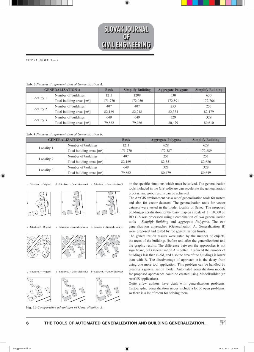
Three localitieswere selected in themodel locality.Each localityhadanareaof1000mx1000m,butwithadifferentdensityofthebuilt-uparea.Bothapproacheswithlimits(Tab.1,2)wereappliedinthelocalitiesaccordingtoFig.9.
The indicator for the assessment of the generalization was thenumberofobjects, theareasof thebuildings(beforeandafter thegeneralization)and thegraphicresults.Anumerical representationofthegeneralizedlocalitiesisinTabs.3and4.Therearealsotheresults of the generalization phases, but only the resulting valueswerecompared.The difference between the generalization approaches is minor.GeneralizationAisonestepslower,butthenumericalandgraphicresultsprovethatitissuperior.GeneralizationAreducesthenumberofbuildingslessthangeneralizationB(eventhoughthedifferenceisnotmajor),andtheareaofthebuildingsislowerthanB.The graphic outputs of the generalization approaches differ onlyin the details (the arrangement of the aggregate buildings, theremaining or cancelling of the wall of aniche, etc.). Thesedifferences come from the generalization sequences (i.e., theapplicationoftheparticulartools).TheresultsofapproachAarenotexactlyperfect,but thereare fewer such situations incomparisonwith approach B. So later there will be an advancement duringmanualediting.Picture 10 shows some situations where approach Awas betterthan B.ApproachAis more time consuming, which is its maindisadvantage. The time aspect of this generalization process andthe problematic areas are the main disadvantages in creating thecartographic output. These problems can be handled by creatinggeneralization models using ModelBuilder – an application ofArcGIS(formoreinformation,see[3]).
4 cONcLUSIONS
Thereisnouniversalprocedureforsolvinggeneralizationproblems.The processdependson the author´sskills andpractice, but also
Tab. 1 Definition of the limits of the tools of Generalization A. GENERALIZATION A Simplify Building Aggregate Polygons Simplify Building
Localities1,2,3Simplificationtolerance3mMinarea9m2
Spatialconflictsyes
Aggregationdistance2mMinarea9m2
Minholesize9m2
Orthogonalshapeyes
Simplificationtolerance3mMinarea9m2
Spatialconflictsyes
Tab. 2 Definition of the limits of the tools of Generalization B.GENERALIZATION B Aggregate Polygons Simplify Building
Locality1,2,3
Aggregationdistance2mMinarea9m2
Minholesize9m2
Orthogonalshapeyes
Simplificationtolerance3mMinarea9m2
Spatialconflictsyes
Fig 9 Proposed limits of the cartographic generalization of a building component on a scale of 1 : 10, 000 [3].
Droppova.indd 5 15. 3. 2011 12:26:40
6 THE TOOLS OF AUTOMATED GENERALIZATION AND BUILDING GENERALIZATION...
2011/1 PAGES 1 — 7
onthespecificsituationswhichmustbesolved.ThegeneralizationtoolsincludedintheGISsoftwarecanacceleratethegeneralizationprocess,andgoodresultscanbeachieved.TheArcGISenvironmenthasasetofgeneralizationtoolsforrastersand also for vector datasets. The generalization tools for vectordatasetswere tested in themodel localityofSenec.Theproposedbuildinggeneralizationforthebasicmaponascaleof1:10,000onBDGISwasprocessedusingacombinationof twogeneralizationtools - Simplify Building and Aggregate Polygons. The twogeneralization approaches (Generalization A, Generalization B)wereproposedandtestedbythegeneralizationlimits.The generalization results were rated by the number of objects,theareasofthebuildings(beforeandafterthegeneralization)andthe graphic results.The difference between the approaches is notsignificant,butGeneralizationAisbetter.ItreducedthenumberofbuildingslessthanBdid,andalsotheareaofthebuildingsislowerthan with B. The disadvantage of approachAis the delay fromusingonemore tool application.Thisproblemcanbehandledbycreating ageneralizationmodel.AutomatedgeneralizationmodelsforproposedapproachescouldbecreatedusingModelBuilder(anArcGISapplication).Quite afew authors have dealt with generalization problems.Cartographicgeneralizationissues includealotofopenproblems,sothereisalotofroomforsolvingthem.
Tab. 3 Numerical representation of Generalization A.GENERALIZATION A Basis Simplify Building Aggregate Polygons Simplify Building
Locality1Numberofbuildings 1211 1209 630 630Totalbuildingareas[m2] 171,770 172,050 172,591 172,766
Locality2Numberofbuildings 407 407 253 253Totalbuildingareas[m2] 82,169 82,218 82,334 82,479
Locality3Numberofbuildings 649 649 329 329Totalbuildingareas[m2] 79,862 79,966 80,479 80,610
Tab. 4 Numerical representation of Generalization B.GENERALIZATION B Basis Aggregate Polygons Simplify Building
Locality1Numberofbuildings 1211 629 629Totalbuildingareas[m2] 171,770 172,387 172,889
Locality2Numberofbuildings 407 251 251Totalbuildingareas[m2] 82,169 82,351 82,626
Locality3Numberofbuildings 649 328 328Totalbuildingareas[m2] 79,862 80,479 80,649
Fig. 10 Comparative advantages of Generalization A.
Droppova.indd 6 15. 3. 2011 12:26:40
2011/1 PAGES 1 — 7
7THE TOOLS OF AUTOMATED GENERALIZATION AND BUILDING GENERALIZATION...
REFERENCES
[1] ArcGIS 9.2 ESRI, Desktop Help, Desktop Help Onlineh t tp : / /webhe lp .es r i . com/arcg i sdesk top /9 .2 / index .cfm?TopicName=welcome.
[2] ESRI(2000):MapGeneralizationinGIS:PracticalSolutionswithWorkstationArcInfo Software, 20pp. http://downloads.esri.com/support/whitepapers/ao_/?ap_Generalization.pdf,(2007-02-10).
[3] DROPPOVÁ, V(2010): Kartografické modelovanievprostredí GIS (Cartographic Modelling in aGISEnvironment). Dissertation Thesis, Slovak University ofTechnology in Bratislava, Faculty of Civil Engineering;DepartmentofMappingandLandConsolidation,165pp,(inSlovak).
[4] DROPPOVÁ, V., FENCÍK, R. (2007): Možnosti nástrojovautomatizovanej generalizácie vprostredí ArcGIS(Possibilities of Automatized Generalization Tools in anArcGISEnvironment).In:GeodeticandCartographicReview,Prague:Vesmír, spol. sr.o.,vol.53/95,No.7 -8,pp.156-161,ISSN0016-7096,(inSlovak).
[5] PRAVDA, J., KUSENDOVÁ, D (2004): Počítačová tvorbatematických máp (Computer Creation of Thematic Maps).Comenius University in Bratislava, 264pp., ISBN 80-223-2011-0(inSlovak).
Droppova.indd 7 15. 3. 2011 12:26:40