Embed Size (px)
Citation preview
I
627.409 944 2ILIMvoL.2
Department of Public Works
TUMBI UMBI CREEK VALLEY
Flood Plain Management Study
1983
jj VOLUME 2 : Management Strategies
..1j.
.
;, U
11
vo
TIJ1B UMBREood P9ain Ma.
VALLEY
gement Study
agement Strategies
1983
Cameroa rtNamara
oorz l92./2. puuiic WORKS LIBRARY
6a74o9 9442 A023517
Department of Pufflic Works
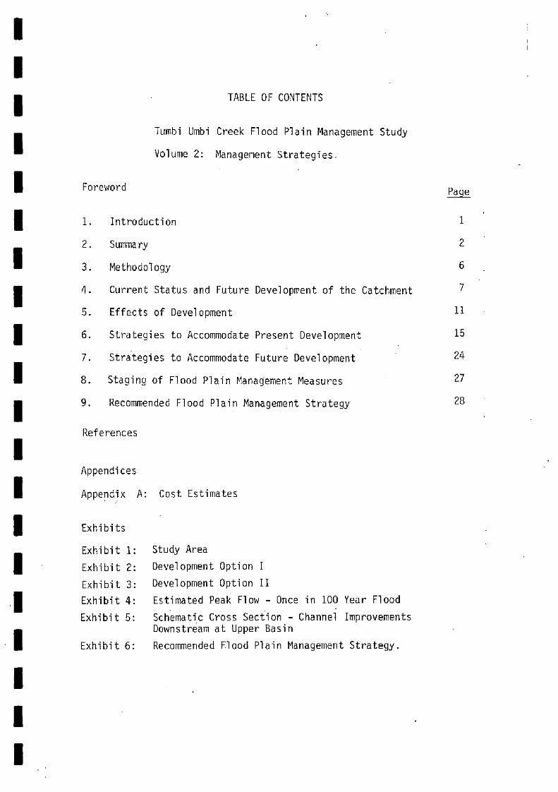
Exhibit 1:
Exhibit 2:
Exhibit 3:
Exhibit 4:
Exhibit 5:
Exhibit 6:
TABLE OF CONTENTS
Tumbi Umbi Creek Flood Plain Management Study
Volume 2: Management Strategies.
Foreword Paqe
Introduction 1
Summary 2
Methodology 6
Current Status and Future Development of the Catchnient 7
Effects of Development 11
Strategies to Accommodate Present Development 15
Strategies to Accommodate Future Development 24
Staging of Flood Plain Management Measures 27
Recommended Flood Plain Management Strategy 28
References
Appendices
Appendix A: Cost Estimates
Exhibits
Study Area
Development Option I
Development Option II
Estimated Peak Flow - Once in 100 Year Flood
Schematic Cross Section - Channel ImprovementsDownstream at Upper Basin
Recommended Flood Plain Management Strategy.
1. INTRODUCTION
The Tunibi Umbi Creek flood plain management study is one of aseries being undertaken along the coast of NSW in catchmentsidentified as:
having significant existing flooding problems, and/orlikely to undergo urbanisation in the foreseeabletuture that will influence or be influenced by flooding.
The studies were formulated on the initiative of the Department ofPublic Works, P15W with the assistance of the local governmentauthorities whose areas are affected. Funding for the studies wasprovided by the Department and for Tumbi Umbi Creek Valley, by theWyong Shire Council.
Broadly the objectives of these studies can be summarized as theformulation of strategies that will:
alleviate the flood risk to existing developmentensure future development is carried out in amanner compatible with the nature of flooding inthe valley.
The work carried out in this study is presented in two volumes:
Volume 1: Technical InvestigationsVolume 2: Management Strategies
1
- - S- - S
S S
S - - - a - - a S
S a
2. SUMMARY
Methodology
The current state of development in the catchment was establishedby examination of available maps and photographs and by extensivefield investigation. Future development options were then formulatedwith the assistance of t'Jyong Shire Council. The effects of thesedevelopment options were determined by hydrologic and hydraulicanalysis using the numerical models described in Volume 1 and a rangeof possible strategies was proposed to accommodate both existing andfuture development. These strategies were then assembled into acomplete flood plain management strategy for the valley andsuggestions put forward as to the most appropriate authority toimplement the works and measures proposed. Reconimèndation as tostaging of the works were also evolved.
Current Status and Future Development of the Catchment
The northern tributary catchrnent is close to fully urbanised in itsupper and lower reaches with:the existing open: space in the mid reaches.The main tributary catchment is only urbanised in the reach downstreamof The Entrance Road and around the headwaters together representingaround 11 per cent of catchment area. The valley floor is thicklytimbered and classified by previous researchers as environmentallyvaluable.
No major trunk drathage works exist on the main tributary but twodetention basins, termed upper and lower, together with associatedoutlet works have been constructed by Wyong Shire Council on thenorthern tributary. These basins assist in controlling the spreadof floodwaters but the heavy rainfall experienced in February 1981caused overtopping of both structures and revealed the inadequacyof the upper basin in particular.
Existing flood prone urban areas are concentrated on both tributariesbetween The Entrance Road and Tuggerah Lake. These properties sufferdirect flooding from the lake itself as well as from overflow fromthe creeks. Additional potentially flood prone development is sitedaround Playford Road. downstream of the upper basin.
Two future development options were identified for the catchments.Option 1 proposes rural residential uses on the south side of themain tributary catchment and medium density residential along thenorth side. The northern tributary is assumed fully urbanised withthe exception of the mid reaches. Option II varies from Option I in
that the rural residential goes over to medium density and thisrepresents an 'ultimate" development state. Within each option theconsultants formulated three suboptions for the flood plain rangingfrom no encroachment through flood fringe filling to total fillingand channelisation of the creeks.
2
Effects of Development
The hydrologic and hydraulic effects of the development optionsoutlined above were assessed using the numerical models. They canbe summarised as:
Main Tributary
With the natural flood plains retained in full Option I had almostno effect on flood flows with the exception of the upper reacheswhere local increases up to 40 per cent were noted. Option IIyielded increases averaging 28 per cent in the lower catchment,negligible increases in the mid catchment and a similar figure toOption I of 40 per cent in the upper reaches. Affluxes rangedfrom 0.05 metres at Tumbi Road to a maximum of 0.20 metres downstreamof The Entrance Road.
Filling of the flood fringes results in flow increases of around 30to 40 per cent in the lower reaches and up to 60 or 70 per cent higherin the catchnent with affluxes of up to 0.33 metres.
Complete filling of the flood plain gave significantly greater flowsat all locations with the increase being 52 per cent under. Option IIdownstream of The Entrance Road.
Northern Tributary
Full development of the northern tributary catchment would result inflood discharges increasing by around 25 per cent upstream of theupper basins 50 per cent upstream of the lower basin and 25 per cent.at the Adelaide Street culvert.
Strategies to Accommodate Present Development
Flood prone developments that require works and measures to alleviatecurrent problems are:
Main tributary - downstream of The Entrance Road- Moss Properties area.
Northern tributary - lower basin and areas downstreamupper basin and areas downstream.
Appropriate strategies wer&determined on the basis of engineeringfeasibility, cost, planning and environmental considerations. Theresulting strategies are:
A detention basin on the main tributary upstream ofThe Entrance Road with a capacity of 1.25 million cubicmetres.
Cost $190,000
Total diversion of runoff in the Moss Properties area.This involves a channel beside The Entrance Road toconvey flood flows from the west into Tumbi Umbi Creekand channel improvements in the creek channel to copewith the additional flow.
Cost $670,000.
a a a a a a a - a a a a a a a a a a a a
r-
-'S
-4
Ratsing of the upper basin wall on the northerntributary by 1.5 metres, provision of an emergencyspillway and improvements to the channel and roadcrossing downstream of the basin.
Cost $191,000.
Raising of the lower basin wall by one metre, andchannel improvenents downstream of the basin andreplacement of the Adelaide Street culvert.
Cost $125,000.
Strategies to Accommodate Future Development
The opportunity exists in the Tunbi Umbi Valley to institutestrategies that will allow development to proceed in a mannercompatible with the flood prone nature of some of the land. Dueto the advanced state of development in the northern tributarycatchnent there is not as much scope for implementation as in themain tributary catchment. The strategies are:
Data Collection - the current paucity of data could beovercome by installation of peak flood level indicatorsand stream gaugings during floods. This would contributegreatly to future flood plain planning.
Public Education - the installation of flood markers showingthe extent of past events and distribution of flood.information sheets would assist in promoting public awarenessof flood problems.
Land Use Controls . flood prone areas should be zoned aseither urban (flood liable) or rural (flood liable) andcorresponding land use restrictins introduced.
Building Controls - within flood liable urban areas buildingcodes should specify standards for floor level, building /7materials, types and alignments. An appropriate freeboardabove the 100 year flood level is 0.75 metres.
Landscape/Environment - the environmentally valuable standsof vegetation and associated wetlands should be preserved inany future development proposals.
Flood Plain Mapping - precise definition of the extent offlooding must be carried out prior to detailed land usecontrols being implemented. The mapping should cover thewhole catchment.
Detention Basins - the basin proposed, on the main 'tributaryupstream of The Entrance Road will assist in compensatingfor future upstream development as well as alleviatingexisting problems.
Flood Plain Filling - filling of the flood fringes wherewater depths are less than 0.5 metres can be considered toprovide flood free land for development. Other factorssuch as planning proposals and the environmental characterof the area must also be considered 'however in any fillingproject.
Staging of Flood Plain Management Measures.
The large detention basin on the main tributary1 can be delayeduntil, and if, development exceeds that envisatqed underdevelopment Option I. The works in the Moss Properties areashould precede future development of the industrial land northof The Entrance Road. Remedial measures associated with theexisting detention basins should proceed as soon as practicablewith the upper basin takinq priority.
Recommended Flood Plain Management Strategy
The strategies developed in Chapters 5 and 7 were assembled intoa valley wide flood plain management strategy.
Five measures were identified for existing areas at a total costof $1,176,000 in late 1982 dollars.
Eight measures were identified for future development with nodirect capital costs beyond the components of the main tributarydetention basin and the diversion of flow at the Moss Propertiesattributable to future works.
a a a a a a a a a a a a a a a - a a a a
//1
IIIIIIIIII1
IIIIIIII
6
3. METHODOLOGY
Current and Future Development
The current status of the catchment was established by referenceto available mapping, aerial photography and by extensive inspectionof the valley. Data was collected on type and extent of urbandevelopment, nature of new urban development, proposals forconservation of natural features, and the existing drainage andflood plain management works and measures.
Plans for future development largely came from discussions withofficers of Wyong Shire Council.
Effects of Development
The development proposals formulated above were examined hydrologicallyand hydraulically by suitable manipulation of the numerical modelsdescribed in Volume 1. Resulting data included the magnitude offlood flows at selected locations in the catchnient that would resultfrom implementation of the various land use proposals together withan indication ofthe effect on flood profiles, velocities and extents.
Possible Strategies
A broad range of possible floodplain management strategies wasexamined for relevance to the Tumbi Umbi Valley. These embraced thehard engineering or 'structural" as well as the soft, planning type"non-structural' approaches. Those that were found to have somemerit in this instance were developed to the stage where theirengineering feasibility could be assessed and 'order of" costsassigned where appropriate.
The strategies were divided into those that would primarily benefitexisting development and those that would focus on future development.
Staging
Extensive flood plain works for a catchment the size of Tumbi UmbiValley require substantial capi.tal input by the standards of localauthority budgets. The options available for staging the works inphase with the development of the catchment were explored.
Recommended Flood Plain Management Strategy
The strategies evolved in the study were drawn together into a
comprehensive schedule of works and meaures that constitute a floodplain management strategy. The agency or agencies responsible forimplementing the components of the strategy were also indicated.
a a a a - a a a a a a a a - - a -U
7
4. CURRENT STATUS AND FUTURE DEVELOPMENT OF THE CATCHMENT
4.1 Current Status -
General
The bulk of the existing development in the study catchments islocated in the northern tributary of Tunibi Urnbi Creek.Historically development has been along the foreshores ofTuggerah Lake, between the lake and The Entrance Road. Recentdevelopment has seen a progression from the foreshore areastoward the catchrnent headwaters at Killarney Vale.
Existing development in the main tributary is principally:residential subdivision in the headwaters near theGosf6rd road comprising seven per cent of the totalcatchment.residential/light industrial subdivisiOn in the lakeforeshore area comprising four per cent of the catchment.
The remainder of the main tributary catchnient is either undevelopedor rural-residential subdivisions.
Existing land uses of the Tunibi Umbi catchment thus can beclassified as:
residentiallight industrialrural-residentialrural enterprises (e.g. grazing, vegetable growing,poultry farming)virgin bushland.
Trunk Drainage
There are no major trunk drainage works on the main tributary.Existing development is foreshore style with drainage to theTumbi Umbi Creek channel or to Tuggerah Lake directly.
The gradial urban development of the northern tributary, however,has required the construction of trunk drainage systems throughparts of the catchment. Two detention basins, termed upper andlower basins in this report and shown on Exhibit 1., were constructedin early 1979. The upper basin is located between Eastern Roadand Playford Road, Killarney Vale and encompasses playing fields(Killarney Vale Hockey Fields). The lower basin is locatedimmediately upstream of The Entrance Road and is used as openspace. The upper basin commands a catchment of 0.57 squarekilometres while the lower basin commands 1.45 square kilornetres.
:They were constructed by Wyong Shire Council to alleviate frequentflooding in the lower reaches and to reduce the impact ofurbanisat-lon of the upper part of the catchment. Details of thesebasins are given in Table 4.1 below and are based on site inspectionby Ilie consul tarn and survey data suppilec by Wyong Shire Uouncil
-8
TABLE 4.1
Details of Existing Detention Basins
The upper basin has inadequate outlet and storage capacity andhas no emergency spillway arrangements. The basin was overtoppedduring the severe storm in February 1981. Calculations using thedeveloped rainfall-runoff models showed that the chance of overtoppingof the basin wall, in any one year, was greater than five per cent(corresponding to a storm with long term average recurrence of oncein 20 years). Similarly the basin would have overtopped during theJanuary 1978 storm had it been constructed. Regular overtopping ofthe wall could lead to erosion and possible failure of the embankmentwhich would have serious consequences for dwellings located immediatelydownstream.
The outlet from the upper basin discharges into a twin 900 millimetrepipe system below Playford Road then into an excavated open draindownstream of Playford Road with a bankfull capacity of approximately6 m3/s. This unlined drain is also unsatisfactory with inadequatecapacity to cater for once in 100 year flows. Moreover it is locatedon private property and, without lining, appears to be eroding thuscreating safety problems. The inadequacies of the upper basin andthe drainage channel immediately downstream render the developmentsalong Playford Road adjacent to the basin 'at risk".
In te consultant's view action should be taken as a matter of somepriority to rectify the situation at the upper basin.
The lower basin operated satisfactorily during the February 1981 stormthough some overtopping occurred.
Max. Storage 15 000 n3 95 000 m3
Bypass Pipe Diameter 3.75 mm Not used
Outlet pipe system
IT E UPPER BASIN LOWER BASIN
pipe diameter Single 500 mm Twin 1050 mmpipe lenqth 80 m 12 ru
pipe invert EL 9.2 m AHD EL 1.2 m AND
Estimated Crest level EL 11.85 m AND EL 3.7 iii AND
Outlet Capacity atmax. storage 0.85 m3/s 7.2 m3/s
Max. Tailwater EL 9.0 m AND EL 2.3 m AHD
- - a - - - - a - - - - - - - - - - - -
0-
9
The outlets from the lower basin pass below The Entrance Road andinto n unlined channel with a capacity of approximately 10 rn3Jsec.This is sufficient to handle 100 year runoff from its immediatelocal catchment only and the channel would surcharge any concurrentdischarge from the lower basin. In the lower sections of thetributary the unlined drain passes below Adelaide Street via a fourcell reinforced concrete box culvert (waterway area 3.7 square metres).Hydraulic calculations show that this structure would cause an affluxof 0.5 metres upstream if the drain was flowing at full capacity(10 m3/s). This behaviour is also reported from field inspectionsby Wyong Shire Council.
Flood Prone Areas
The approximate extents of flood.liable lard for a once in 100 yearflood are shown on Exhibit 1. Flooding in the study area has twosources which are:
inundation caused by lOcal rainfall creating flooddischarges in the study creeksinundation by extremely high lake levels in TuggerahLake caused by widespread rainfall in the region.
The two flooding sources are loosely related and either type offlood could occur separately or concurrently. The cause, frequencyand nature of lake flooding has not been extensively researched inthis study, but has been investigated in a previous study for theCities Commission (Ref.1) and by an Interdepartmental Committee.
It appears high lake levels are caused by substantial rainfall inthe region, the runoff from which cannot be adequately dischargedthrough the Tuggerah Lake outlet at The Entrance. Water levelsof up to 2.3 metres MW have been recorded in Tuggerah Lake whileonce in 100 year water levels are estimated at 2.4 metres MID.
The lower reaches of both the main and northern tributaries ofTumbi Umbi Creek would be subject to flooding from Tuggerah Lake.The areas inundated are more extensive than those inundated bylocal creek flows. Works and measures designed to cater for creekflows in these areas are particularly sensitive to downstream lakelevels and if high lake levels occur, such works andmeasures wouldprobably be drowned out.
Whilst the flooded area is extensive along the main tributary ofJumbi Umbi Creek, there is aLso little existing development in thearea upstream of The Entrance Road which can be considered at risk.Downstream of The Entrance Road, the channel capacity of the maintributary is about equal to the existing once in 100 year flows,given a downstream lake level of about 1.0 metre AHD. Any flowsgreater than this value (created by urban development upstream orby rare flood events) rn' higher lake levels will cause inundationof the areas beside the channel
The area west of Hansen's Road and south of The Entrance Roadcurrently drains via a culvert below the road and a small formedchannel to a confluence with Tumbi Unibi Creek, some 400 metresupstream of Tuggerah Lake. This area, tormed Moss Properties forthe purpose of this report, has very low rel ief and runoff wouldbe in the form of overland 'sheet" flow.
a a a a a a a - - - -
- a a a a a - -
- 10 -
Whilst .drainage of the Moss area is not a major problem at present,disposal of storimyater will become difficult as development proceedsand Vie capacity of the present drainage system is exceeded. Specificarrangements for this eventuality are outlined in Section 6.
The situation along the northern tributary is more critical withregard to inadequacies of the drainage system and the developmentof the area. Works and measures undertaken by Wyong Shire Councilover the past few years have improved the situation, but in theconsultant's view additional work is required to creete an acceptablesituation.
Landscapinq/Envi ronmént
The vegetation along the principal streams within the catchmentcarries a high conservation status. A recent investigation andstudy by the Department of Environment and Planning (D.O.E.P.) andspecialist biology consultants has shown that the wetland vegetationcommunities and alluvial flats forests are environmentally valuable.Over a dozen different vegetation types have been classified in thecatchment along the central drainage lines with a large and diversevariety of species represented. A number of these vegetation typeshave very restricted occurrences regionally and consequently shouldreceive a high conservation priority. The D.O.E.P. study stronglyadvises their preservation in the catchment area.
4.2 Future Development Options
Two broad options for development of the Turnbi Umbi Creek wereestablished based on advice by Wyong Shire Council on preliminaryplanning for the area, by limited site inspection and by examinationof available topographic data.
Option I
This option is illustrated on Exhibit 2 and involves medium densityresidential development along the northern bahk of Tumbi Umbi Creekfrom the creek itself to the catchment boundary. Other areas to besimilarly developed are the north western side of the catchment nearThe Entrance Road and the creek headwaters near the Gosford Road.The southern/western parts of lumbi timbi Creek catchment will bedeveloped as rural residential where ground slopes permit whilst theremaining areas will be used for open space recreation and conservationuse.
All devel opment in the northern tributary is currently proceeding underexisting zonings. Full development, as shown on Exhibit 2, would seempossible within the near future.
Option II
This option, illustrated on Exhibit 3 is consthered the ultimatepossible development of the catchment. It is similar to Option Iexcept that the rural residential uses of the southern bank arereplaced by medium density residential. The conversion from ruralresidential to medium density residential, although not presentlyplanned, is foreseen as a possible response to pressure for futureadditional land releases. The northern tributary is developed asabove.
a a a - a - - a a a a a a a a a a a a a
a a a a a a a a a a a a a a a a a a - a
5. EFFECTS OF DEVELOPMENT
General
The effects of development Options I and II as described in Chapter 4were assessed using the rainfall -runoff models set up for this study.
Within each of the development options three possible treatments ofthe main tributary flood plain were examined:
maintenance of the natural flood plainspartial filling of the flood plainscomplete development of the flood plainsresulting in a channelised stream.
These three suboptions embrace all the possibilities for futureusage of flood prone areas and provide a useful appreciation of theresponse of the drainage system to such proposals.
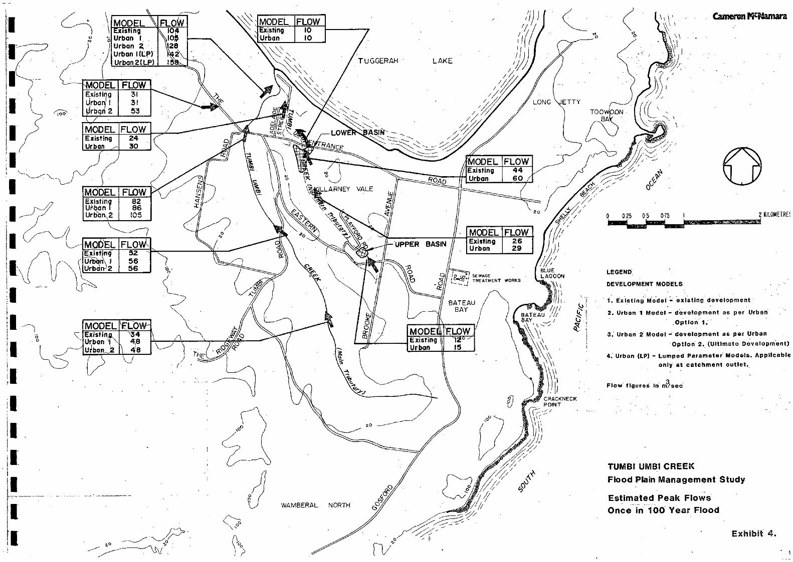
The effects of development are discussed below in terms of thesesuboptions and are summarised in Tables 5.1 and 5.2 and shown onExhibit 4.Discussion
Maintenance of natural flood plains.
Urban Development Option I creates little or no increase inestimated peak flows along the main tributary, principally because:
the western parts of the catchment are used asrural residential zones which have little impacton catchnient hydrology in major events providingnatural creeks and storages are not destroyed bydevelopmentmedium density residential development is sitedin a strip along the eastern catchment boundaryand is concentrated in the upper catchment whereextensive natural flood storage damps out anyincreased flows.
Urban Development Option II creates flow increases up to 28 percent on the main tributary by conversion of extensive areas of thecatchment to medium density residential uses. The extensive floodstorage available in the upper catchnient helps to reduce the impactof development in that area. Similar increases occur if therecorded January 1978 and February 1981 storms are applied over thewhole catchnient.
The predicted flood level rises are generally small. The largestincrease is 0.2 metres on the Tunibi Umbi main tributary downstreamof The Entrance Road. Flood level increases are generally less than0.15 metres upstream of Tumbi Road duet to the wide nature of theflood plain. While the level increases are minor in practical terms,they will probably be unacceptable in the downstream areas.
The effects of development on the northern tributary are more markedhowever, particularly in the middle part of the catchment where flowincreases of 26 per cent could be expected. The existing lower basinwill have a significant effect in reducing the estimated increases inthe lower reaches while the upper basin will not greatly mitigate theflow increases.
.7
I 5,
D-"> Io
IIIIIIIIIIIIIIIIIIII
- 12 -
Partial Flood Plain Filling
Filling of flood liable areas is a possible development option toprovide additional flood free land, although careful considerationmust always be given to such issues as town planning, landscapingand environmental impacts. Filling has been considered in thisstudy primarily from an engineering viewpoint and the conclusionsreached should not be construed as recommendations for widespreadfilling of the flood fringe.
Encroachment onto the flood plain has been reviewed for two floodplain filling alternatives. These are:
filling the flood plain periphery where flooddepths are 0.5 metres or lessfilling the flood plain periphery where flooddepths are 0.75 metres or less.
Option I, as an initial development stage, has not been reviewed inconjunction with flood plain filling.
Generally partial filling increases flows through loss of storageand, additionally, may create affluxes through loss of waterway areaFlows are increase&by up 33 per cent and 40 per cent and floodlevels by up to 0.03 and 0.3 metres for encroachment to the 0.5 and0.75 metre floo epths respectively. These increases would occurapproximately halfway between The Entrance and Tumbi Roads.
Flood level increases of 0.57 and 0.82 metres respectively would occurif the recorded January 1978 or February 1981 storms are applied tothe whole catchment. These increases again apply beteen The Entranceand Jumbi Roads whilst upstream of Tumbi Road smaller increases (0.30and 0.53 metres respectively) would occur.
Complete development of Flood Plain
The impact of development discussed above relates to maintenance ofthe majority of existing flood plain storage. Large areas of the floodplain could alternatively be developed if a substantial channeliseddrainage system is installed to cater for floods. This approach willproduce an upper limit for flood discharges given a particular urbandevelopment pattern and has been termed "lumped parameter model" inthis report. The "lumped parameter" approach gives estimated once in100 year peak flows at the main tributary outlet of:
&u142 m3/s for Option I (an increase of 37 per cent aboverural flows)
0158 m3/s for Option II (52 per cent increase).
Flood levels have not been assessed as the analysis presupposes acompletely new drainage system where flows are fully contained withinbuilt-up channels, /
TUMBI UMBI CREEK
IIMAIN
TRIBUTARY-atoutlet- at Entrance Road- atTufbj Road.52- at Extension of
Brook Ave.
10482
34
I
ISummaryThe results of the hydrologic and hydraulic nodelling of possiblefuture development can be summarised as:
there are two broad development options availablewhich differ by the ultimate development of thesouth-western bank of Tuinbi Umbi Creek (developedas either rural residential land, Option I, ormedium density, residential land, Option II)
I
TABLE 5.2
Estimated Once in 100 Year Flows -
Tumbi Umbi Creek, Northern Tributary
- 13 -
TABLE 5.1
Estimated Onde in 100 Year Flows -
Tumbi Umbi Creek, Main Tributary
(ms/s) (ms/s)Upstream, Upper Basin 12 15Upstream,.. Lower.. Basin 40 60Adelaide Street 24 30
105 128 - 133 - 140 -
85 105 0.15 109 0.18 119 0.2856 56 0.05 63 0.15 67 0.2148 48 0.11 56 0.17 59 0.23
URBAN OPTION I URBAN OPTION II URBAN OPTION II URBAN OPTION IINatural : Natural Flood plain Flood Plain
LOCATION RURAL iioodjj.ains Tiood:plains. filling 0.5m filling 0.7Srn
Flow Increase Flow Increase Flow Increasein flood in flood in flood
level level level
I (ms/s) (me/s) (mJs). (n) (ms/s) (m) (ms/s) (m)
Location Existing FullyDevel opment Developed
IIIII
IIII
IIIII
- 14 -
Flood El ows
increases in the estimated once in 100 year flowsof up to 28 per cent are anticipated if developmentproceeds as indicated by Option II but withmaintenance of existing flood storage areas
the presence of substantial flood storage in theupper parts of Tumbi Umbi Creek and the lower basinon the northern tributary is inportant in reducingthe impact of urbanisation
the increased flood flows following full devel opmentof the northern tributary will exacerbate existingprobl C1115.
Flood Levels
the increased flood flows will increase flood levelsby up to 0.2 metres along Tumbi Umbi Creek maintributary for Option II. This is generally not consideredsignificant except downstream of The Entrance Road.
filling parts of the flood plain where flood depths areless than 0.5 metres does not produce substantiallyincreased flows. ffluxes created by this action arenot significantly greater than those produced by urbandevelopment whilst maintaining flood plain storage.
a a a a a a a - a a - a a a a a a a a a
a a - - a a a a a a a a a a - a a a a a

6. STRATEGIES TO ACCOMMODATE PRESENT DEVELOPMENT
6.1 Main Tributary
Downstream of The Entrance Road
Works and measures will be required in this area because of theexisting urban development and the existing channel capacity(about the rural once in 100 year discharge). Future upstreamdevelopment could increase flood levels by up to 0.2 metres whichis considered unacceptable by Wyoñg Shire Council . Works toreduce this increase could be:
construction of detention basins upstream of TheEntrance Road to reduce future peak flows to orbelow their existing values.increasing the channel capacity downstream of TheEntrance Road.
The situation is also affected by development west of HansensRoad (Moss Properties) where various options for diversion offlow to the main Turnbi Umbi Creek channel , upstream of The EntranceRoad are possible. These options are outlined and reviewed later.
Construction of astngle basin immediately upstream of The EntranceRoad is the preferred alternative on the basis of cost and minimumchange to catchment behaviour (if compared to widely distributedupper catchuient storages).
The series of basins proposed in an earlier report (Ref..2) wereexamined with the rainfall-runoff model which. showed that:
they reduce peak flows at The Entrance Road, in theultimate development case, by about 10 per centthey do not reduce peak flows in the ultimatedevelopment situation to existing levelsthey would be overtopped in the once in 100 year,recorded 1978 and 198L storms and hence do notconform to the design standards outlined earlier.
The proposed single basin will achieve the desired objectives butat the expense of creating some additional flood liable landbetween The Entrance and Tumbi Roads. It is also less expensivethan channel works on Tumbi Umbi Creek.
Details of a suitable basin are given in Table 6.1 below while itslocation appears on Exhibit 6. The details in Table 6.1 relate toa situation where no additional flood attenuation is required tocater for diversion of water from the Moss Properties to the mainchannel . Some field survey was undertaken along the proposed basinwall to ensure the basin is practical. Further survey of the exactbasin extents is required.
K
- - - - - - - - - - - - a a - a a a a a
- 16 -
TABLE 6.1
Possible Detention Basin -
Main Tributary Upstream of The Entrance Road
Item Value
Crest Level EL 9.Sm AWl
Outlet System- Pipe diameter 1. 500 mm
- Pipe invert level EL 3.00 ni AHD
- No. of pipes 8
Max. storage 1.25 x 10 m3
Outlet capacity at max. 90 m3/s
storageMax. water levels, ultimate
devel opment- 1:100 year flood EL 7.5 m AHD- 1981 flood equivalent EL 9.5 m AHD
- 1978 flood equivalent EL 9.0 m AHD
Earthwcrks Volume 15 500 n
The estimated construction cost of this basin is $190 000 (asdetailed in Appendix A - Cost Estfmates).
Moss Property Area vecr 504K.The Moss Property area lies orth of the main tributary and wes(of The Entrance Road. The area has low relief and is currentlydrained to Tumbi Umbi Creek via a culvert below The Entrance Road.leading to a small formed earth channel and via a table draindirectly to the creek beside The Entrance Road. The presentdrainage to the creek will be inadequate when development of thearea occurs andflooding of the industrial areasnorth of theroad can be expected when the channel overtops. Four clear optionsexist to rectify the situation and are:
channel improvement works for the existing drainstotal diversion of the runoff to Tumbi Umbi viaa new channel beside The Entrance Roadcombination of channel improvement and diversionalternatives above to permit partial diversiondetention basin construction.
Complete freedom of choice between these options is not available,however, as planning for the industrial area has already reached anadvance stage. This planning has proceeded on the assumption oftotal diversion of runoff and consequently provision for substantialeasements has not been made.
- 17 -
Channel Iniprovements - Existinq Drainage System
The estimated peak flows from the Moss area vary between 31and 53 cubic metres per second for the present (rural) andultimate (fully developed) situation. The existing draincapacity through the industrial areas is about 10 cubicmetres per second and will require enlargement if all flowsare to be passed along it. A trapezoidal lined channel issuitable with parameters of:
base width: 6.0 metrestop width : 12.0 metresdepth : 1.8 metresflow depth: 1.5 metresaverage flow velocity: approximately 2.8 metres
per second at the edges with 4.8metreS per second at the channelcentre
lining concrete filled revetment material
Two new cul verts would be required, one on The Entrance Roadand the other on the access road to the industrial area.
The estimated cost of this option is $440 000 includina surve5'and design costs and a contingency allowance of.10 and 15 percent respectively.
Other channel systems were examined but discarded on the basisof performance (flaw velocities were too high) and cost.
Total Diversion
The capacity of Tumbi Umbi Greek, downstream of The Entrance Roadis about 85 cubic metres per second and approximates the once in100 year peak discharge from its catchment (under rural conditions).The channel length between The Entrance Road and Tuggerah Lake (thecreek outfall) is 1000 metres. Channel capacity in the lower 500metres is affected by backwater from Tuggerah Lake while Lhe capacityof ftc upper part is not affected at high flow levels. The channelis cut through apparently very erodible material and has very steepbanks (slopes one to one or steeper) over most of its length. Thereis extensive residential development along the eastern bank whilethe western bank has been subdivided and development is progressing.There are extensive stands of trees on the creek bank in this area.The creek bank vegetation is recognised as important in arenvironmental and biological sense and, in a landscaping context actsas a buffer between the residential and the industrial areas.
The total diversion strategy would involve increasing the capacityof the creek channel from 85 cubic metres per second to 135 cubicmetres per second (allowing for 85 and 50 cubic metres per secondfrom the main catchment and Moss Properties respectively). Thisrequired capacity allows .fo coincident. flood peaks from the.two catchments. Although the catchment response of the Moss areais significantly shorter coincidence is a likely possibility withstorms moving south to north over the study area. The best approachto achieve increased channel capacity and one which minimisesdisturbance to the existing river bank vegetation, would be channelwidening with lining using 'Gabions'.
IIIIIII
U
I
- 18 -
Thfs system, which permits near vertical channel walls, allowsminimum channel widths (hence minimum vegetation disturbance)while maintaining moderate channel velocit.ies. The channel bedwould not be protected and some scour may occur, thoughmattresses are envisaged to protect the 'gabion' walls againstundermining. The alternative to the system proposed would bean earth channel whose side slopes, battered at one to threevertical to'horizontal would require an additional 20 metres ofland for the channel, involving loss of vegetation and wouldcause distudjance to the existing developments on the easternbank. -
As part of the total diversion strategy, a channel would berequired beside The Entrance Road to collect and transfer flowto Jun51 Umbi. Creek. This channel would probably need to belined to prevent scouring and subsequent undermining of TheEntrance Road. The estimated cost of the total diversionstrategy is $670 000, made up by:
Turubi Umbi Improvement $380 000Diversion channel beside
The Entrance Road $290 000
The above figures include survey plus design costs and contingencyallowances of 10 and 15 per cent of construction cost respectively.
Partial Divers ion
The partial diversion strategy involves:
modifications to the detention basin proposedupstream of The Entrance Road, to reduce theonce in 100 year peak discharge to about 60cubic metres per seconddiversion of flow from Moss Properties, equalto the difference between- reduced once in 100year discharge, and existing creek capacity.In this case, approximately 25 cubic metresper second can be divertedchannel construction through the industrialareas adequate for the peak flow from MossProperties (in a fully developed condition)less the flow diverted.
The estimated cost of this strategy is $506 000 made up as follows;
The cost estimates for partial diversion strategy allow for:
lining of channels with mattresses (or revetmentliners)to prevent scour. Beside The Entrance Roadthe channel may be grassed, but this system wculdincur penalties of extra land requirements and thenecessity for drop structures to reduce flow velocities
diversion channel beside The Entrance Road $240 000channel through industrial land $320 000modifications to proposed basin $ 45 000
I
- 19 -
(otwo new culverts \across the channel running throughthe industrial 1aT culverts are sited at TheEntrance Road and the access roadan incremental cost for raising the basin proposedupstream of The Entrance Road. The primary cost ofthe basin, incorporated in the main tributary strategyhas not been included heresurvey and design costs and contingency allowance of10 and 15 per cent of estimated construction costrespectively.
The basin proposed upstream of The Entrance Road is a particularlylarge basin flooding an extensive area. This option, which involvesincreasing the basin's size is viewed as creating an unrealisticallylarge storage area and should not be adopted unless it is substantiallycheaper than the other alternatives.
Detention Basin Construction
The detention basin construction strategy involves siting of basinsin the upper catchment to achieve maximum reduction of estimatedflows and hence permit di versi on of flow from the Moss Propertiesarea and/or to reduce the size and cost of drainage works. Suitablebasins may be located, as follows:
on the main tributary near the extension of Brooke Avenueon three minor tributaries, west 'of Hansens Road andnorth of Tumbi Roadupstream of the Moss Properties area.
The above sites are those investigated by an earlier study (Ref.13) though differing spillway configurations were adopted for thisstudy. Basin wall heights envisaged are generally 3.2 metres thoughthe basin upstream of the Moss Properties would have a height of 3.5metres The once in 100 year flows are contained within the basins,with water depths reaching about 2.5 metres. The basins envisagedwould also contain the 1981 and 1978 storcñ runoff without overtopping.
The main tributary basins, together with the basin proposed earlierimmediately upstream of The Entrance Road, limit once in 100 yearflows (for the ultimate development case) to 69 cubic metres persecond, and thus enable 16 cubic metres per second (the differencebetween estimated flows and existing capacity) to be diverted fromMoss Properties without the need for works on the Turnbi Creek channelThe basin upstream of Moss Properties reduces the estimated once in100 year flow (for the ultimate development case) to 27 cubic ntresper second.
Total and/or partial diversion of flows from Moss Properties is stillrequired, following adoption of the above multi-basin concept, thoughthe total capacity required is less than those alternatives examinedearlier.
The estimated cost of the multi basin concept together with partialdiversion of flow to Tumbi Creek is $1 000 000 made up as follows:
basin contruction $610 000channel construction - industrial area : $195 000channel construction - beside The Entrance Road: $195 000
- - - - - - - - - - - - - - - _ - - - -
000
000000
A variation in the possible strategy, leading from the multiplebasin cOncept involves:
single basin construction on the main tributaryas outlined earlier for that creek section,ignoring Moss Propertiessingle basin construction upstream of Moss Propertiesfull diversion of flows to Tumbi Greek.
This strategy is aimed at reducing flows from the Moss Propertiesarea and niinimising the extra capacity equired along Tumbi UmbiGreek. The estimated cost of thislioy is $702 000 developedfrom:
basin construction upstream of Moss Properties: $ 135 000diversion channel beside The Entrance Road $ 232 000channel improQement works -Tumbi Urnbi Creek : $ 335 000
Overview
In summary the costs for the various strategy options for the MossProperties area are
channel improvement, existing drainage netvlorks:$ 440 000- tOtal diversion of flow :$ 670 000partial diversion of flow :$ 605 000
- multiple basin construction, partial diversionof flow
: $1 000 000multiple basin construction, total diversionof flow
: $1 130 000single basin, upstream of Moss Properties,total flow diversion
: $ 702 000
The multiple basin concepts above can be deleted from the comparisonof various options on cost grounds.
Both the channel improvement and partial diversion options aboverequire land acquisition through the industrial land and suchacquisition costs are not included in the above estimates.
The full diversion strategy must be 'adopted, despite its higherestimated cost on the basis of the advanced stage of industrialland development and planning. Apparent cost differentials willbe offset to degree by savings in acquisition costs of easementsand -in disruption tothe progress of a worthwhile and employmentgenerating communitydevelopment. The cost for channel improvementworks should be spread as an overall catchment users' contribution,though in the short term, public funding (viz. State and FederalGovernment) may be necessary to enable the works to be constructed.The channel improvement works on Tumbi Urnbi Creek will be requiredas soon as diversion of flows from Moss Properties area occurs, asthe existing channel : as noted, has inadequate capacity for thetotal fl byes even under present catchment devol opment.
The cost estimates above are based on minimal survey informationbut represent an upper bound on costs. More detailed estimatescan be prepared after appropriate survey and preliminary designis completed.
- 20 -
The estimated cost of total diversion of Moss Properties flows,together with multiple basin construction is $1 130 000, derivedas:
basin construction $ 610channel construction beside The Entrance Road : $ 244improvement works - Tumbi Umbi Creek : $ 276
- - - - - - - - - a a a a a - a - - a a
- 21 -
6.2 Northern Tributary
Upper Basin
Several measures are available to iftiprove the situation at thislocation. However, it should be noted that even with measuresoutlined below there is still a residual risk to the propertiesdownstream of the basin wall. The measures will reduce, but noteliminate, the risk due to possible wall failure and only serveto improve a most unsatisfactory arrangement.
Based on available ground survey of the basin area, it appearspossible to raise the basin wall to provide additional storage.
The works required are:raise dam wall by 1.5 metres to give a crest levelof EL 13.4 metres AHDprovide an emergency spillway probably a concreteshute with a width of 6 metres and dverflow levelat EL 11.86 metres to discharge into the existingchannel
The estimated maximum water level in the basin for a 1981 storm,given the improvements above would be EL 12.9 metres AHD. Theproposed crest thus provides freeboard of 0.5 metres.
The channel between the new spillway and Playford Road anddownstream of Playford Road, as noted earlier, has inadequatecapacity and appears to be eroding. Three alternative channellining methods were reviewed to rectify these problems:
lining with formed concretelining with a revetrnent systemlining with rock filled "gabions" and mattresses.
Lining the channel with concrete would provide adequate capacitybu..jtlw velocities would be about 4.5 metres per second, whichi dd?i'rable in the urban environment.
Revetment lining systems (developed from woven plastic "pillows"into which concrete is pumped) provide lower flow velocities butwere discarded as inadequate land space is available.
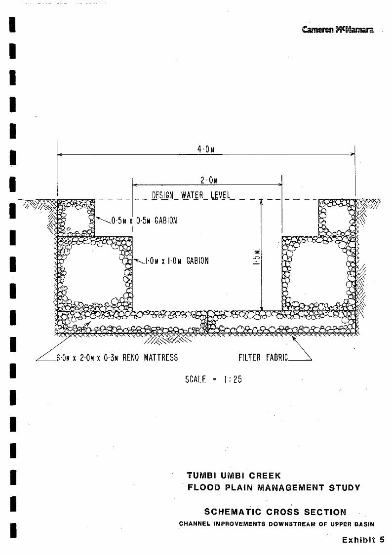
the third alternative, the "gabion" and mattress system, is therecommended approach and is illustrated on Exhibit 5. Theexisting channel will not require widening but its bed will needto be lowered by about 0.6 metres to conform with the proposedcross section. Anticipated flow velocities are about 2.6 metresper second (flow is sub-critical). Moreover, the proposed systemwill have the smallest visual impact of the alternative liningsystems examined.
A new 3.0 x 2.0 metre box culvert crossing of Playford Roadacross the channel would be required.
Due to the limitations on space the spillway, downstream channeland road crossing would not incorporate adequate safety featuressuch as shallow side batters. Consideration should therefore begiven to safety fencing in this urban environment.
- 22 -
-
A less desirable alternative to raising the basin wall would beto install larger outlets (a twin 1050 millimetre diameter pipesystem). This would prevent overtopping in the design once in100 year event but would not prevent overtopping in a 1981 or1978 equivalent storm. An emergency spillway arrangement wouldstill be required.
Lower Basin
The Tower basin operated satisfactorily during the 1981 floodalthough it was overtopped. In general overtopping of basinwalls is not desirable. Raising of the wall of the lower basinby one metre would provide freeboard of 0.6 metre and one metreto the 1981 flood and once in 100 year floods respectively; Theraising would also limit peak flows below the basin to 8 m3/s forfloods equal to or smaller than the 1981 flood.
Ground survey shows that the wall raising can be achieved withoutflooding existing properties west of the basin. It appears thatflooding of the school playground east of the basin may occur,but this would only happen in storms similar to the February 1981event.
The cost of raising the wall is estimated at S62 000.
Downstream of The Entrance Road and Adelaide Street Culvert
The existing drain below The Entrance Road has inadequate capacityeven for a once in 20 year flood given existing catchment conditions.The peak flows in the drain are created by:
flow from the lower basinflow from the local catchment.
It is proposed that the capacity pf the drain be increasedto 25 m3/s. The capacity would be adequate for once in 20year flows given the existing detention basin confiurationand ultimate catchment development. This capacity would beadequate for a once in 100 year or 1981 equivalent flood,following changes to the upper and lower basins, outlinedearl ier.
Capacity increases could be achieved by:lining with concrete
- deepening and maintenance as an unlined system.
Channel deepening by 0.5 metre will achieve the requiredcaiacity and is the cheaper alternative. Once again safetyrequirements should be borne in mind when accepting a relativelysteep sided drainage channel in an urban environment.
The Adelaide Street culvert should be replacedto reduce affluxescreated when the unlined drain flows at full capacity (25 ms/s).A twin 3.0 metre x 2.0 metre box culvert will be required.
The estimated cost of the. channel excavation and cul vertreplacement works is $63 000.
The estimated cost of the above works (as detailed in Appendix ACost Estimates) is $191 000, made up as follows:
Basin improvements $55 000Channel lining $100 000Playford Road crossing $26 000
Total $191 000
- 23 -
All of these works rely on Tuggerah Lake levels being at or belownormal levels (about one metre AHD). As the ambient lake levelincreases (through regional rainfall), the capacity of the channelwill decrease until it is finally drowned out. The only measurewhich would prevent this is construction of a foreshore levee withgate structures and pumping stations for local drainage.
- a - a. a - a a a a
a a a a a - a a
a a
a a a a a a a a a a a a a a - a
- 24 -
7. STRATEGIES TO ACCOMMODATE FUTURE DEVELOPMENT
The strategies outlined below are, with the exception of detentionbasins and flood plain filiing,"non-structural" in character andapply equally to both tributart'ds. They represent measures which,ifapplied to future development in existing or new release areas,will contribute to soundflood plain use in accordance with StateGovernment policy. (Refs. 3,4,5).
Data Collection
The data base used for this study is not comprehensive. Additional
data should be collected to permit confirmation of the conclusionsof this study and/or to permit revision of the adopted flood plainmanagement policy if required.
Worthwhile additional data in the study area would be:peak water level information by installation andmaintenance of peak level indicators. Suitablesites on the main tributary are at Tuggerah Lake,The Entrance Road, Tumbi Road. and an additionalindicator in the upper catchment,while on thenorthern tributary installations are required atAdelaide Street and the upper and lower basins
stream gauging during floods to obtain an estimateof flood flows for comparison with rainfall-runoffmodels results. It is recognised that the fastresponse of the catchment to rainfall makes thistask extremely difficult. However, the informationis vital for adequate calibration of the rainfall-runoff model. Wyong Shire Council may be able toprovide staff who, after a suitable training programme,will be able to undertake this task when a flood arises.
Public Education
Public education. to promote a wider awareness of the area's floodingpatterns and liability is a valuable strategy. The aim of sucheducation is to maintain a preparedness for flooding, make newcomersaware of flooding problems and promote a wider understanding offlood plain management aims and objectives.
Within the study area, public education is chiefly applicable tothose areas affected by lake flooding rather than creek flooding.Appropriate action would be installation of markers showing thehighest recorded flood levels at various locations and distributionof flood information sheets with council rate notices.
Land Use Controls
Land use controls go hand in glove with other flood plain managementmeasures and are aimed at restricting future unwise development ofthe flood plain. They are also vital in preventing the loss offlood plain storage areas following development.
The bulk of the land within the main tributary. catchment is underrural use and not sub-divided for urban purposes. There is anopportunity, at this stage, to control future land use by zoningfor flood compatible uses within the flood plain area such as:
IIIIIIIIIIIII
N
IIIIIII
- 25 -
rural but limited rural-residentialrecreationopen space/conservation.
Downstream of The Entrance Road and along the northern tributary,where widespread urban development has already occurred, theopportunity for zoning for flood compatible uses has largely beenlost. This area should be zoned as urban (flood liable) wherebuilding controls are applied.
Building Controls
Building controls are required within the flood liable urban areasand the flood fringe areas. These controls should encompass:
minimum floor levelsbuilding materialsbuilding types (e.g. two storey with the lowerstorey not for habitation)structure alignment.
Freeboard above estimated flood levels is generally provided insuch building controls to account for uncertainty in hydrologic andhydraulic analysis, wave action, debris pile-up and otherindeterminate factors. Uncertainty in hydrologic analysis appliesto the study area because of the relative weakness of the data base.An appropriate freeboard allowance within the catchment area is 0.75metres above the once in 100 year flood level (for ultimate urbandevelopment).
Landscape/Environment
Recent studies of the Tumbi lJmbi catchnient have shown the presenceof valuable stands and species of vegetation. All of the flood plainmanagement measures proposed in this report should be considered inconjunction with the objective of preserving this vegetation to thegreatest extent possible. In particular professional landscapeadvice should be sought before implementing any of the drainage orother structural measures proposed.
Flood Plain Mapping
The extent of flooded areas shown on Exhibit 1 are preliminaryestimates only based on the 1:4 000 orthophoto map series with twometre contours. Accurate flood plain mapping is essential for futuredevelopment plans to provide delineation of flood liable, flood fringeand flood free land and to permit adequate zoning of such land priorto development.
It is corsidered that the existing ground level information is notsufficiently accurate (because of the vegetation cover) for floodmapping purposes. Additional ground survey is required to provideflood plain information for hydraulic calculation and delineation offlood plain extents.
II
- - - - - - - - - - - - - - - a a a a a
- 26 -
Detention Basins
This study has reviewed.two development options representingpartial and ultimate development states. Moderate increasesin peak flows can be expected i ovid c. floodplain storage is 20generally maintained but significantly greater flow increasescan be expected if flood plain storage is not maintained.Generally, the widespread use of detention basins has not beenfavoured due in part to the experience of the 1981 storm, whichshowed basins need to be very large to prevent overtopping.Maintenance of the natural flood plains is seen as a 'softer'and cheaper solution. Any increased flood levels followingdevelopment with flood plain storage maintained are generallyacceptable as the opportunity exists to apply land use controlswhich take account of such increases.
The exception however is the area on the main tributary downstreamof The Entrance Road. This area will be adversely influenced byfuture development in the upper catchinent and the basin, discussedat length in Chapter 6, will be required to compensate for this aswell as to alleviate existing problems.
Flood Plain Filling
Filling of flood liable land to an appropriate freeboard heightprovides additional flood free land for development. However adisbenefit is that such filling reduces flood plain storage andconveyance capacity creating higher peak flows and flood levels.
In this study flood plain filling on those areas where flood depthsare less than 0.5 metres and 0.75 metres respectively has beenreviewed. Comparison of :t results shows that flood plain fillingto 0.5 metre flood depths would be acceptable upstream of TheEntrance Road as minimal flood level increases are created abovethose caused by general urban development. The increases do notdisadvantage surrounding areas as landuse controls, qhich accountfor such increases, can be applied before the land is released.
It is emphasised that the foregoing comments relate to flood plainfilling in a strict engineering sense. Other factors such asplanning, environment and scenic value of the area to be filledmust be considered before filling is permitted.
a -
a -
--
-- a
a a - a
L I C(yiV e (
- 27 -
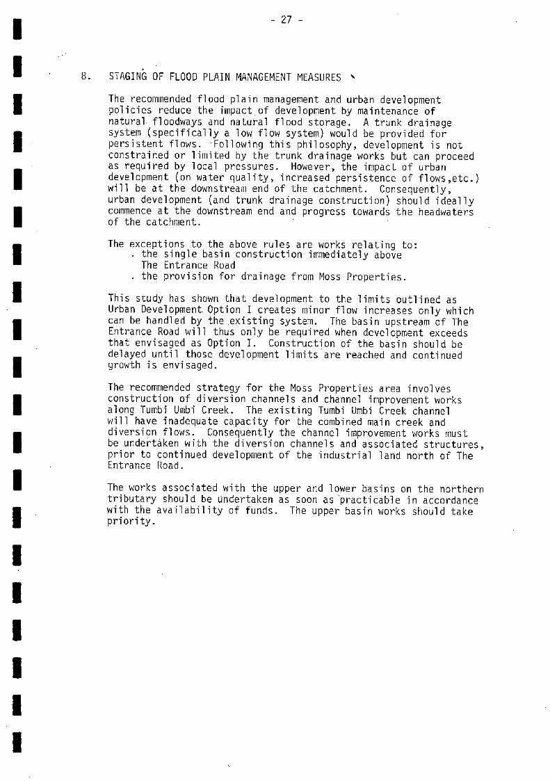
8. STAGING OF FLOOD PLAIN MANAGEMENT MEASURES '
The recommended flood plain management and urban developmentpolicies reduce the impact of development by maintenance ofnatural. floodways and natural flood storage. A trunk drainagesystem (specifically a low flow system) would be provided forpersistent flows. Following this philosophy, development is notconstrained or limited by the trunk drainage works but can proceedas required by local pressures. However, the impact of urbandevelopment (on water quality, increased persistence of flows,etc.)will be at the downstream end of the catchment. Consequently,urban development (and trunk drainage construction) should ideallycommence at the downstream end and progress towards the headwatersof the catchment.
The exceptions to the above rules are works relating to:the single basin construction immediately aboveThe Entrance Roadthe provision for drainage from Moss Properties.
This study has shown that development to the limits outlined asUrban Development. Option I creates minor flow increases only whichcan be handled by the existing system. The basin upstream of TheEntrance Road will thus only be required when development exceedsthat envisaged as Option I. Construction of the basin should bedelayed until those development limits are reached and continuedgrowth is envisaged.
The recommended strategy for the Moss Properties area involvesconstruction of diversion channels and channel improvement worksalong Tumbi Umbi Creek. The existing Turnbi Umbi Creek channelwill have inadequate capacity for the combined main creek and.diversion flows. Consequently the channel improvement works mustbe undertaken with the diversion channels and associated structures,prior to continued development of the industrial land north of TheEntrance Road.
The works associated with the upper and lower basins on the northerntributary should be Undertaken as soon as practicable in accordancewith the availability of funds. The upper basin works should takepriority.
a - a a a a - a a a a a a - a a a - a a
- 28 -
9. RECOMMENDED FLOOD PLAIN MANAGEMENT STRATEGY
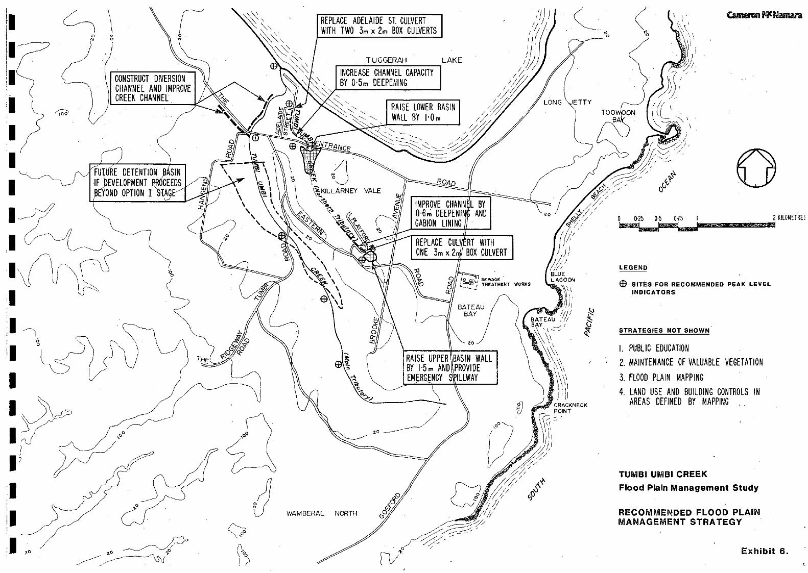
The strategies developed in Chapters.6 and / are summarised belowin a cohesive valley strategy and illustrated in Exhibit 6. Themost appropriate agency to implement each component of the strategyis indicated.
Measures for Existinq Development
Moss Properties Area
It is recommended that full diversion of flows from Moss Propertiesarea to the main tributary upstream of The Entrance Road bepermitted. Channel improvement works, downstream of The EntranceRoad, will be necessary to increase the existing channel capacity.
The estimated costs are:diversion works : $290 000channel improvement, Tumbi Umbi Creek: $380 000
Agency: Wyong Shire Council
Detention Basin on Tumbi Umbi Creek
Ultimate development will inevitably lead to increased flows. It
is therefore recommended that development should retain naturalflood plain storage as far as practicable to minimise such increases.
A 0.2 metre increase in flood levels could occur downstream of TheEntrance Road due to ultimate development. The most cost effectivemethod of eliminating this increase is a detention basin upstreamof The Entrance Road at an estimated cost Of $190 000.
Agency: Wyong Shire Council.
Downstream of The Entrance Road, Northern Tributary.
It is recommended that the improvement works to the Adelaide Streetdrain and replacement of the Adelaide Street culvert be undertaken.
Estimated Cost $ 63 000
Agency: Wyong Shire Council.
Lower Basin on Northern Tributary
It is recommended that the lower basin wall be raised. Since thiswork is aimed at increasing the freeboard available above the highestrecorded flood it should be undertaken as Council funds permit.
Etimated Cost $ 62 000
Agency: Wyong Shire Council
Upper Basin on Northern Tributary
it is recommended that the remedial works at the upper basin beundertaken as soon as possible to recitfy an existing 'area ofrisk".
Estimated Cost : $191 000
Agency: Wyong Shire Council
- a - - - a - a - a - - - a - - - a - -
Measures for Future Development
Data Collection
The data base for this study is not strong. It is recommendedadditional data be collected to rectify deficiencies in flood waterlevel and discharge information.
Agencies: PWD and Wyong Shire Council.
Public Education
It is recommended that a public education programme on flooding inthe study area be commenced involving:
installation of flood markersdistribution of information sheets
This action should be directed towards the areas which are liableto lake flooding.
Agencies: PWD and Wyong Shire Council
Landscape! Envi ronment
The findings of a recent study of landscape and environmental issuesin the catchment should be borne in mind before any structuralmeasures are implemented.
Agencies: Department of Environment and Planning andWyong Shire Council.
Flood Plain Mapping
It is recommended that flood plain mapping be undertaken throughoutthe catchment. This information would provide future inputs to landuse planning and development by defining the flood extents.
Agencies:
Land Use Control
It is recommended land use control be introduced to reflect the floodliability of affected lands. Zonings envisaged are rural (flood liable)and urban (flood liable) zones. Urban (flood liable) zones would beused only where the existing development is located onflood liable land,for example, north of The Entrance Road.
Agency: Wyong Council.
Building Controls
It is recommended that building controls be instituted for allfuture developments in flood prone land. The controls shouldencompass floor levels, building materials, types and alignments.
Agency: Wyong Shire Council.
- 29 -
and Wyong Shire Council

- - - - - a - - a - - a a - -.. a - - - -
References
"Gosford/Wyong Drainage & Flooding Study", Cities Commission 1974.
"Tumbi Umbi Creek,Stormwater DRainage Study", July 1979.
"Development of Flood Prone Lands.", Circular 15, Planning andEnvtronment Commission, August 1977.
"Implementation of Circular No.15", Circular 22, Planning andEnvironment Commission, April 1978.
5. Circular 31, Department of Environment and Planning, February 1981.

en
a a - - S - - - a - - a a - a - - -. - -
a a a - a a a a a a a - a a a a a a a a
Appendix A - Cost Estimates
Item Quantity Unit Rate Cost
NORTHERN TRIBUTARY- CHANNEL LINING, D.S.
PLAYFORD ROAD
(a) Cost per Pletre run
1. Excavation 4.7 in3 5.00 23.502. Gabions. urn x in 2 m3 39.60 79.20
0.Sm x 0.Sni 0.5 in3 27.80 13.903. Mattress Enix2nixQ.3m 4 m2 16.00 48.004. Filter Fabric 7 P12 2.00 14.00
Sub Total 178.605. Survey, Design 10% 17.866. Contingencies 15% 29.47
TOTAL 5225.93
(b) Project cost 440 in 225.93 $99 410
say $100 000
NORTHERN TRIBUTARY- IMPROVEMENTS TOUPPER BASIN
1. Earthworks - cut, place,
$ $
compact wall 3 500 m3 6.00 21 DUO- strip topsoil,prepare 235 ni3 5.00 1 175- topsoil and grass 3640
slopes m2 4.30 15 652
2. Spiliway - Supply, placeetc. cOncrete 27 m3 400.00 10 800
Sub Total $43 627
3. Design @ 10% Survey @ 5% 7 294
4. Contingencies @ 15% 8 388
$64 309TOTAL say $65 000
Appendix A - Cost Estimates
NORTHERN TRIBUTARY- PLAYFORD ROAD CROSSING
NORTHERN TRIBUTARY- LOWER BASIN RAISING
1. Earthworks - Cut, place,
NORTHERN TRIBUTARY
compact wall 4 560 m 5.00 22 800- strip topsoil 428 m3 5.00 2 140- topsoil & grass slopes 4 384 m2 4.30 18 851
2. Outlet Changes- 1 050 RCP 15 m 169.00 2 535- Headwall [5 2 000.00 2 000
sub Total $48 325
3. Survey & Design 0 10% 4 832
4. Contingency @ 15% _/ 974
TOTAL £61 132
say 62 000
- ADELAIDE STREET DRAIN ETC.
1. Channel excavation 3 000 n13 5.00 Sib 000
2. Adelaide St. Box Culvert- Supply box culverts 2.6 ii 658.20 17 373- Place box culverts [S 16 690
sub Total $49 063
3. Survey & Design @ 10% 4 906
4. Contingency @ 15% 8 095
TOTAL $62 064
say $63 000
1.
2.
3.
4.
Supply box culverts
Place box culverts
15 568.20
LS
10
10
023
400
Sub Total
Survey & Design @ 10%
Contingency 0 15%
20
2
3
423
042
370
TOTAL
say
$25
26
835
000
Item Quantity Unit Rate Cost
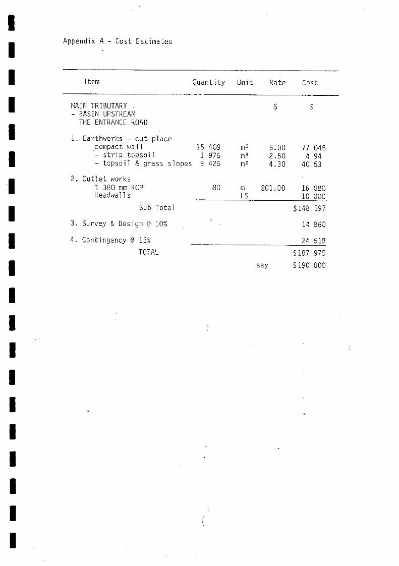
Appendix A - Cost Estimates
Item Quantity Unit Rate Cost
N1AIN TRIBUTARY $ S
- BASIN UPSTREAMTHE ENTRANCE ROAD
1. Earthworks - cut placecompact wall 15 409 rn3 5.00 77 045- strip topsoil 1 976 2.50 4 94- topsoil & grass slopes 9 426 rn2 4.30 40 53
2. Outlet works1 380 mm RCP 80 ni 201.00 16 080Headwalls LS 10 300
Sub Total $148 597
3. Survey & Design 10% - 14 860
4. Contingency @ 15 24 518
TOTAL 5187 975
say $190 000
S S
S - - - S
- S a a -
- a a a a a a
1
II1
lao ---
\N NTUGGERAH LAKE
4
/
- / - -a a,'
,'/r 7/'
W.AMBERAL NORTHy./
(2UPPER BASIN
/
(7/'
/,/,/,
BLUELAGOON
I/I,BATEAU ,L'BAY _-;\ 'c -
'\
CRACKNECKPOINT
U
50
0
0 025 05 015
AREA FLOODED BY LAKE FLOODING(Additlonar to creik flooding)
APPROXIMATE FLOOD PLAIN EXTENTS.
ONCE IN 100 YEAR I FLOOD DEPTH> O.5m
- FLOOD DEPTH(O.5m L_ .1
TUMBI UMBI gREEKFlood Plain Management Study
STUDY AREA
Carnemi WNaman
2 KILOMETRES
Exhibit 1.
0a
to
C
K
'N
'N
% \'N
0
C)
S
WAMBERAL NORTH
TUGGERAH
I
LAKE-
/4?/0
//
/
BATEAU /i'/BAY
/ 1,
BLUEL AG CON
/
E IT V
CRACKNECKPOINT
OPEN SPACE
TOO -------
3 025 05 015 I
Camain Wt4amara
LAND USE
MEDIUM DENSITY RESIDENTIAL
RURAL RESIDENTiAL
DEVELOPMENT OPTION I
Remainder of study catchment areasclassified as conservation -
TUMBI UMBI CREEK
Flood Plain Management Study
2 KIL0M[iRE
It'
Exhibit 2.
BATEAU /BAY I )
E.GG:. I//I LAND USE/ I BATEAU//I -.
/ (/Bç7.:_/ MEEUM DENSITY RESIDENTIAL
OPek SPACE
...,
CRACKNECKPOINT
I7I
e o9
WAMBERAL NORTH
TUGGERAH LAKE
/
/ LONG ETTY
TOO-- BA
SEWAGETREATMC1T WOCES
2
7
7
1/ /7///BLUELAGOON
/
/ ,0
Cama Cmara
/*S
Renialnder of study catchment areasclassified ai conservation
DEVELOPMENT OPTION II.
TUMBI UMBI CREEKI Flood Plain Management Study
Exhibit 3..
0 025 05 015 2 KILOMEIRES
MODELExistingUrban
-MODEL FLOWxistIrg 3!
UrbarI 31Ørbgii 2 53
BATEAUBAY
MODEA\ 'FLOWExisting \i iz° -"Urban i 15
V.ODEL FLOWExisting 44Urban 60
MODEL FLOWExisting 26Urban 29
SEWAGETREATMENT WORKS
LONG ETTYTOO 'ON-BA
'I;
I00
\ so
\N N
N'
WAMBERAL NORTH
TUGGERAH LAKE
I
/
//BLUELAGOON
/
PCRACKNECKPOINT
/7 0
I
0 025 05 0Th I 2 KIL0METRE
LEGEND
DEVELOPMENT MODELS
Existing Modol exlsting development
Urban 1 Model- dove!opment as per Urban- Option 1.
Q..Urban 2 Model -. development as per Urban
OptIon 2. (UltImata Dovalopmont)
Urban (LP) - Lumped Parametei Models. ApplIcableonly atãatchment outlet.
Flow flgurei In miseà
TUMBI UMBI CREEK
Flood Plain Management Study
Estimated Peak FlowsOnce in 100 Year Flood
Camenn Pfllamara
Exhibit 4.
MODEL FLOWExistingUrban
1010
MODEL \ a.o?wExisting 100Urban I. \I0Urban Z \28Urban IULP) )*2'\Urban2(LP) i5t.
MODEL FLOWExisting 82IJ?'ban I 86Urb'bn2 105
MQâEL FLO#.Existjnø> 52ui6bn\ I 56UrbcItv2 56
MODEL FLO.Existin 34Utban 48Urban,2 418
/
i aoee ejs'-w.' a(iitt 3
i-.JOM x kOM GABION fit_aa S
9.1
;t;ctr t,at \\\\
4ON
DESIGN WATER LEVEL
CAB ION T
///4'CON x 2OM x 03M RENO MATTRESS FILTER FABRIC
SCALE = 1:25
TUMBI UMBI CREEKFLOOD PLAIN MANAGEMENT STUDY
SCHEMATIC CROSS SECTIONCHANNEL IMPROVEMENTS DOWNSTREAM OF UPPER BASIN
Cameron PThamara
/
Exhibit 5
I
IMPROVE CHANN
06m DEEPENICABION LINING
REPLACE CUL
ONE 3mx2.
L BYAND
e s._&Tp4N
CONSTRUCT DIVERSION
CHANNEL AND IMPROVE /CREEK CHANNEL
/\FUT, RE DETENTION frSIN
IF DEVELOPMENT PROCEEDS
WYOND OPTION IS9
REPLACE ADELAIDE ST. CULVERT
WITH TWO 3m x 2 BOX CULVERTS
INCREASE CHANNEL CAPACITY
T UGGERAH
RAISE LOWER BASIN
WALL BY IOm//,
RI WITH
BOX CULVERT
BATEAUBAY
RAISE UPPER BASIN WALL
BY k5m AND PROVIDEEMRG{NCY ILLWAY
-Th
00
/
/
WAMBERAL NORTH
LAKE
/
/
/1!' jill
/BLUELAGOON
IiiBATEAU /1/8A\\ 'c,.- -,
V.' \
C RAC K N ECKPOINT
1
V
ETTY
TOOBA
LEGEND
/
0
/
0 025 05 015 I
® SITES FOR RECOMMENDED PEAK LEVELINDICATORS.
STRATEGIES NOT SHOWN
I. PUBLIC EDUCATION
MAINTENANCE OF VALUABLE VEGETATION
FLOOD PLAIN MAPPING
LAND USE AND BUILDING CONTROLS IN
AREAS DEFINED BY MAPPING
TUMBI UMBI CREEK
Flood Plain Management Study
RECOMMENDED FLOOD PLAINMANAGEMENT STRATEGY
Camenn MNamara
Exhibit 6.
2 ILOMETRE