Embed Size (px)
Citation preview
DEPARTMENT OF PLANNING, INDUSTRY & ENVIRONMENT
Surveying threatened plants and their habitats NSW survey guide for the Biodiversity Assessment Method
environment.nsw.gov.au
© 2020 State of NSW and Department of Planning, Industry and Environment
With the exception of photographs, the State of NSW and Department of Planning, Industry and Environment are pleased to allow this material to be reproduced in whole or in part for educational and non-commercial use, provided the meaning is unchanged and its source, publisher and authorship are acknowledged. Specific permission is required for the reproduction of photographs.
The Department of Planning, Industry and Environment (DPIE) has compiled this report in good faith, exercising all due care and attention. No representation is made about the accuracy, completeness or suitability of the information in this publication for any particular purpose. DPIE shall not be liable for any damage which may occur to any person or organisation taking action or not on the basis of this publication. Readers should seek appropriate advice when applying the information to their specific needs.
All content in this publication is owned by DPIE and is protected by Crown Copyright, unless credited otherwise. It is licensed under the Creative Commons Attribution 4.0 International (CC BY 4.0), subject to the exemptions contained in the licence. The legal code for the licence is available at Creative Commons.
DPIE asserts the right to be attributed as author of the original material in the following manner: © State of New South Wales and Department of Planning, Industry and Environment 2020.
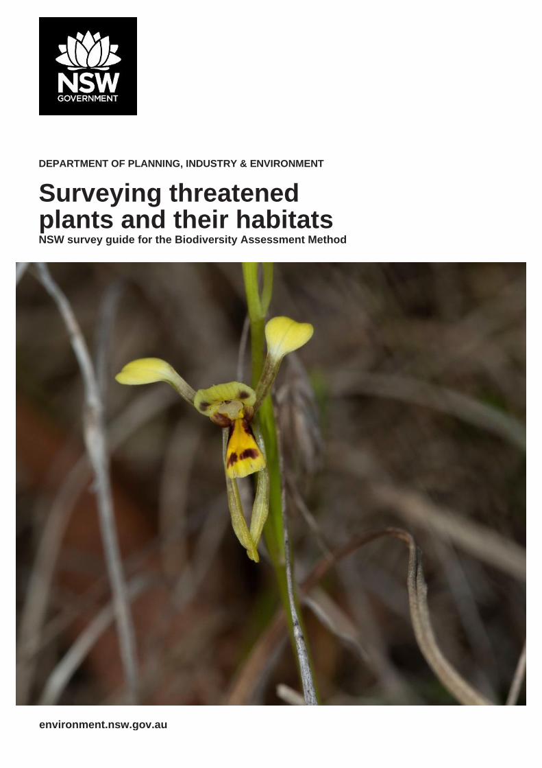
Cover photo: Willawarrin doubletail (Diuris disposita), Rollands Plains. Paul Sheringham/DPIE
Published by:
Environment, Energy and Science Department of Planning, Industry and Environment 4 Parramatta Square, 12 Darcy Street, Parramatta NSW 2150 Phone: +61 2 9995 5000 (switchboard) Phone: 1300 361 967 (Environment, Energy and Science enquiries) TTY users: phone 133 677, then ask for 1300 361 967 Speak and listen users: phone 1300 555 727, then ask for 1300 361 967 Email: [email protected] Website: www.environment.nsw.gov.au
Report pollution and environmental incidents Environment Line: 131 555 (NSW only) or [email protected] See also www.environment.nsw.gov.au
ISBN 978-1-922318-72-5 EES 2020/0146 April 2020
Find out more about your environment at:
www.environment.nsw.gov.au
iii
Contents
List of tables iv
List of figures iv
Shortened forms iv
1. Introduction 1
1.1 Purpose of this guide 1
1.2 Background 1
1.3 Objective of targeted threatened plant survey 2
1.4 Survey data and biodiversity credit calculations 2
2. Overall approach to targeted threatened plant survey 3
2.1 Systematic approach 3
2.2 Identify the skills of the threatened plant surveyor 3
3. Field survey design 4
3.1 Create a candidate species list 4
3.2 Optimise the time of year for the survey 4
3.3 Identify areas of suitable habitat on the subject land 6
3.4 Prepare the field survey plan 9
4. Field survey technique 10
4.1 Parallel field traverses 10
4.2 Width, length and area of field traverses 11
4.3 Survey effort 12
4.4 Survey design for large areas of suitable habitat 13
5. Field survey implementation 16
5.1 Undertaking the field traverses 16
5.2 Collect field survey data about individuals 18
5.3 Specimens for identification 20
5.4 Emerging survey methods 21
6. Documenting survey results 22
7. References 24
Appendix A: Determining the level of survey effort 26
Appendix B: Example of the two-phase grid-based systematic approach for areas greater than 50 hectares 27
iv
List of tables
Table 1 Maximum distance between parallel field traverses per life form and vegetation density 11
Table 2 Estimate of potential total lengths of field traverses 12
Table 3 Estimates of survey effort 12
Table 4 Grid spacing and survey area diameters for the finer-scale grid surveys per life form and vegetation density 14
List of figures
Figure 1 Results of 100-metre systematic surveys with two growth forms – shrub and terrestrial orchid 15
Shortened forms
BAM Biodiversity Assessment Method
BAM-C Biodiversity Assessment Method Calculator
BAR Biodiversity Assessment Report; includes Biodiversity Development Assessment Reports (BDARs), Biodiversity Certification Assessment Reports (BCARs) and Biodiversity Stewardship Site Assessment Reports (BSSARs)
BC Act Biodiversity Conservation Act 2016 (NSW)
BCAR Biodiversity Certification Assessment Report
BDAR Biodiversity Development Assessment Report
BOS Biodiversity Offsets Scheme
BSSAR Biodiversity Stewardship Site Assessment Report
the Department Department of Planning, Industry and Environment NSW
DPT distance between parallel traverses
EP&A Act Environmental Planning and Assessment Act 1979 (NSW)
EPBC Act Environment Protection and Biodiversity Conservation Act 1999 (C’th)
FTL field traverse length
GIS geographic information system
GPS global positioning system
PCT plant community type
SH suitable habitat
STE survey time estimate
TBDC Threatened Biodiversity Data Collection
TEC threatened ecological community
BVC BioNet Vegetation Classification
Surveying threatened plants and their habitats – NSW survey guide for the Biodiversity Assessment Method
1
1. Introduction
1.1 Purpose of this guide
The Biodiversity Assessment Method (BAM) (OEH 2017) was established by the NSW Department of Planning, Industry and Environment (the Department) for the purposes of assessing the impacts on biodiversity from development and clearing or improvements in biodiversity from management at a biodiversity stewardship site.
The purpose of this guide is to aid accredited persons (assessors) when they apply the Biodiversity Assessment Method (BAM) to survey for threatened plant species or their habitat. Under the BAM threatened plants are treated as species credits (i.e. they cannot be predicted by surrogates) and require appropriately timed on-ground surveys to determine their likelihood of occurrence at a proposed development, biodiversity certification or biodiversity stewardship site. The guide has been prepared using a variety of expert sources and must be read in conjunction with the BAM.
In applying the BAM, a species survey must be done in accordance with threatened species survey guides published by the Environment Agency Head (BAM Paragraph 6.5.1.3). Therefore, the survey requirements outlined in this guide must be applied, as a minimum, when conducting surveys for threatened plants.
The guide is not intended for the identification of plant community types (PCTs, see the plant community type identification tool in the BioNet Vegetation Classification database).
The guide will be reviewed and updated periodically to incorporate new information on threatened plants – for example, survey techniques – or to reflect any legislative or policy changes. This is Version 2 of the guide.
1.2 Background
In New South Wales, the Biodiversity Conservation Act 2016 (BC Act), together with the Biodiversity Conservation Regulation 2017, outlines the framework for the Biodiversity Offsets Scheme (BOS). The BOS is underpinned by the BAM (OEH 2017), which creates a transparent, consistent and scientifically based approach to biodiversity assessment and offsetting.
In the context of the BOS, threatened plant species include critically endangered, endangered or vulnerable species and populations as listed under Schedule 1 of the BC Act. The methods and techniques specified in this guide can provide guidance for other threatened species assessment processes such as the Assessment of Significance and Species Impact Statements required under section 7.3 and Division 5 (respectively) of the BC Act. For plant species listed under the Commonwealth Environment Protection and Biodiversity Conservation Act 1999 (EPBC Act) as critically endangered, endangered or vulnerable, the Commonwealth may require a targeted threatened plant survey using other methods/techniques than those specified in this guide.
The guide refers to land being assessed for threatened flora as the subject land. The subject land is where Stage 1 of the BAM is applied to assess the biodiversity values of the land. It includes land that may be a development site, clearing site, land proposed for biodiversity certification, or land proposed for a biodiversity stewardship agreement. All direct, prescribed and indirect impacts on biodiversity values arising from proposed development, clearing or biodiversity certification must be assessed and described in the Biodiversity Development Assessment Report (BDAR) or Biodiversity Certification Assessment Report (BCAR) (BAM sections 9.1.2, 9.1.4 and 9.2).
Surveying threatened plants and their habitats – NSW survey guide for the Biodiversity Assessment Method
2
1.3 Objective of targeted threatened plant survey
The objectives of a targeted threatened plant survey in the BAM is to;
1) establish, with a high level of confidence, the presence of a threatened plant species on the subject land and,
2) where threatened plant species are present, to collect data to determine the number of individuals or area of habitat, which is used to calculate species credits (refer to Section 5.2 of this guide).
The targeted threatened plant survey aims to minimise ‘false-negatives’ (i.e. the species is reported as absent from a site when it is present). A high level of confidence in the survey results is assumed if undertaken by an appropriately skilled person (refer to Section 2.2 of this guide), at the appropriate time (e.g. season, month), and in accordance with this guide.
1.4 Survey data and biodiversity credit calculations
Under the BAM all threatened entities are allocated to one of two biodiversity credit classes: ‘ecosystem’ or ‘species’ credits. Biodiversity credit classes are used to quantify the loss in biodiversity values from the impact of a proposed development or biodiversity certification, or the gain in biodiversity values from the effect of management actions on a stewardship site.
Ecosystem credits apply to threatened entities where the likelihood of occurrence of the entity or elements of a species’ habitat can be predicted by vegetation surrogates and landscape features, or for which targeted survey has a low probability of detection. Ecosystem credits measure, in credits, the threatened ecological communities (TECs) and/or threatened species habitat for a species that can be reliably predicted to occur with a plant community type (PCT) and other PCTs generally.
Species credits apply to species where the likelihood of occurrence of the species or elements of suitable habitat for that species cannot be confidently predicted by vegetation surrogates and/or landscape features but can be reliably detected by survey. Species credits measure, in credits, the predicted increase/improvements in, or the loss of, individuals of threatened species or their habitat.
Under the BAM, threatened plant species are species credit species. The BAM requires either a targeted species survey or an expert report to determine the presence of a species credit species on the subject land.
The information gathered from the targeted species survey is entered into the Biodiversity Assessment Method Calculator (BAM-C). The BAM-C operationalises the BAM by generating the number and type of credits on the subject land, that are generated or are required as an offset.
The BAM-C requires field survey data as well as the information contained in datasets such as the Threatened Biodiversity Data Collection (TBDC),and the BioNet Vegetation Classification database (includes a plant community type identification tool and associated vegetation condition benchmarks).

Surveying threatened plants and their habitats – NSW survey guide for the Biodiversity Assessment Method
3
2. Overall approach to targeted threatened
plant survey
2.1 Systematic approach
This guide describes a systematic approach to targeted threatened plant survey.
The survey approach must be considered in the planning phases of the assessment and incorporates two elements:
1. survey design to maximise the likelihood of detection of the target threatened plant species (including a consideration of seasonal and temporal constraints – detailed in Section 3), and
2. field survey techniques that aim to search a large proportion of an area of suitable habitat1 at an appropriate intensity (detailed in Sections 4 and 5).
2.2 Identify the skills of the threatened plant surveyor
Targeted threatened plant survey must be carried out by person/s with botanical skills and expertise in threatened plant identification and survey. An appropriate threatened plant surveyor is someone who can demonstrate their relevant experience and qualifications in field survey and plant identification, such as:
• a history of experience in survey method and identification, for one or more of the threatened plants in New South Wales2, and/or
• a resume detailing the list of projects specific to threatened plant survey in the relevant region over the previous 10 years including employers’ names and periods of employment (where relevant).
The experience and qualifications (including licence numbers) of the surveyor must be documented in the BAR (see Section 6 of this guide). The threatened plant surveyor does not need to be an assessor. However, the BAR must be submitted by an assessor.
It is important to note that the threatened plant surveyor is not equivalent to an ‘expert’ as defined in Subsection 6.5.2 of the BAM. To be considered an ‘expert,’ a person must demonstrate specialised knowledge in relation to particular biodiversity values (such as specific threatened plant species), as the opinion of an expert replaces the need to survey. Expert status is determined and approved by the Environment Agency Head and listed against approved species on the Department’s website.
1 Suitable habitat is defined as area(s) of the subject land that support PCT(s) where the species is expected to occur or periodically use. To be classified as suitable at least one habitat constraint, where these are listed for the species in the TBDC, is present and constraint(s) or any particular microhabitats are not significantly degraded.
2 It is assumed surveyors lacking familiarity with a particular target species will research resources/herbarium specimens, etc. to prepare for survey and this must be documented in the BAR.
Surveying threatened plants and their habitats – NSW survey guide for the Biodiversity Assessment Method
4
3. Field survey design
3.1 Create a candidate species list
Section 6.4 of the BAM details the series of filters applied to generate the list of threatened species likely to occupy or use the subject land. Filters include the species biodiversity credit class (i.e. is a ‘species credit’ species), distribution, geographic limitations and association with PCTs identified on the subject land.
Based on these filters and site-based information the BAM-C generates a list of threatened species that require targeted survey. The assessor can manually apply any relevant geographic limitations, which are based on information from the Threatened Species Profile website. Additionally, if there are past records of a threatened species on the subject land it must be included in the candidate species list.
In accordance with Section 6.4 of the BAM the list may be further refined where:
• habitat constraints listed for the species in the TBDC are absent from the subject land (or particular vegetation zones), or
• habitat constraints or microhabitats on which the species depends are sufficiently degraded such that the species is unlikely to use the subject land, or
• the species is vagrant in the IBRA subregion, or
• an expert report4 is prepared (in accordance with Subsection 6.5.2 of the BAM) stating that the species is unlikely to be present on the subject land.
The justification, including any relevant sources of information, for removing a threatened plant species from the candidate list (i.e. assuming it is not present on the subject land) must be documented in the BAR. All remaining candidate threatened plants must be assessed further in accordance with this guide5. Additional species are also be added to the list if, for example, the species and/or population:
• has recently been listed under the BC Act (and not yet added to the TBDC), or
• has been recorded or incidentally observed on or near the subject land but is not predicted by the BAM-C, or
• in the professional opinion of the surveyor, is likely to be present on the subject land, or affected by the proposal.
If the threatened plant surveyor is uncertain about the presence of a species on the subject land, it should be included in the candidate species list as a precautionary measure. The justification, including any relevant sources of information, for adding a threatened plant to the candidate list must also be documented in the BAR.
3.2 Optimise the time of year for the survey
The TBDC provides guidance on the appropriate time to survey for species credit species. The information is also displayed in the survey matrix section of the BAM-C; however, the TBDC must always be referred to as the most up-to-date source of information. Additional advice on surveying for particular species is also shown on the information page of the BAM-C via the ‘Species with specific survey requirements’ spreadsheet.
4 Note that an expert, for the purposes of preparing an expert report, needs to demonstrate skills and experience additional to those of the threatened plant surveyor, see Subsection 6.5.2 of the BAM. The expert report must be authored by the expert and attached to the BAR.
5 Assessment of the presence of these species must be undertaken at a development site but is optional at a stewardship site (if not undertaken, species credits will not be generated).
Surveying threatened plants and their habitats – NSW survey guide for the Biodiversity Assessment Method
5
The threatened plant surveyor may use key biological or regionally specific information (including the use of reference sites, known localities previously supporting the subject species, noting whether all local populations are likely to flower synchronously, climatic data etc.) to further refine survey times to optimise detectability. The survey timing may be adjusted if, for example:
• the species is currently present and identifiable above ground (e.g. geophytic orchids may be below ground as corms for a large proportion of the year, or an annual plant may germinate only at a certain time of the year)
• the species is flowering/fruiting out of season and these features are required for detection and/or identification
• natural disturbances or climatic events have occurred (e.g. drought, recent fire, flood or rainfall)
• ground disturbances have occurred (e.g. for species frequently found in disturbed road verges, fire obligates).
Some threatened species respond favourably to natural or human-induced disturbances, and thus an assessor would need to consider these events when determining suitable timing for survey. For example, some fire obligates, such as Commersonia spp., may re-emerge within weeks following a bushfire (Shelly & Lewer 2002; Bell & Holzinger 2015). Similarly, some species of Diuris and Microtis favour grassy verges where the canopy/understorey cover has been reduced, producing more favourable light conditions (e.g. Flanagan et al. 2006, Tierney et al. 2017).
Where survey times are altered from those identified by the TBDC or the BAM-C, the assessor must provide justification in the BAR using appropriate published/peer-reviewed references and/or data.
If a species survey has been undertaken on the subject land within five years of the current proposal lodgement date, and the survey meets the requirements of the BAM and this survey guide, these results can be used in place of further on-site survey (see Box 1). The use of a past survey must be documented in the BAR (including the original report), with the assessor demonstrating that no significant environmental disturbance has occurred on the subject land over the intervening period. The previous species survey must be an appropriate assessment
for the entire area. Supplementary survey, in addition to the results of the past survey, may be necessary in some instances to obtain more contemporary data.
Surveys undertaken more than five years prior to the proposal lodgement date may be used to inform the assessment process but cannot be used in place of a targeted species survey. This is to ensure results are current with respect to site condition, structural attributes and species’ presence. If there are existing records of a species on the subject land, and the current survey does not detect the species (or the population has changed permanently), then evidence to explain the change must be provided in the BAR (e.g. justification via appropriate published or peer-reviewed references and/or data).
In some situations, surveying at the optimum time under suitable conditions to detect threatened plants may not be possible or feasible. For example, where project timeframes are constrained, or detectability of a species is dependent on natural disturbance or a climatic event and the time since these events exceeds the life span of the species, or where sub-optimal conditions such as prolonged drought or an extreme stochastic event (e.g. bushfire) significantly impact the site. In such circumstances, the Department may provide specific advice on surveying for threatened species. In the absence of this advice, an expert report (in accordance with Subsection 6.5.2 of the BAM) can be used to assess the species’ presence on the subject land. Alternatively, the species can be assumed to be present at development and biodiversity certification subject lands only. A species credit species cannot be assumed to be present at a biodiversity stewardship site (see Paragraph 6.4.1.22 of the BAM).
Surveying threatened plants and their habitats – NSW survey guide for the Biodiversity Assessment Method
6
3.3 Identify areas of suitable habitat on the subject land
Only the suitable habitat of the target species within the subject land needs to be surveyed. To identify suitable habitat, the threatened plant surveyor will need to consider the subject land in relation to its range of known plant habitats. The TBDC and the Threatened Species Profile website, along with appropriate published or peer-reviewed references and/or data, must be used to determine suitable habitat.
Suitable habitat for a species can include areas on the subject land supporting any listed habitat constraints and PCTs associated with that species in the TBDC. Suitable habitat may encompass entire PCTs or be restricted to specific niches (e.g. listed as habitat constraints) such as rocky outcrops, riparian zones or areas of the tree canopy. Land use history, disturbance and climatic factors will also require consideration. For example, disturbance events may favour the presence and detection of some species (Miles & Cameron 2007; Binns 2013), while in other situations habitat for a species may diminish due to grazing, logging or drought (Fraser et al. 2004).
Available resources including mapping or imagery showing land use history, vegetation, soils, geology, altitude and topography can be used to derive relevant site characteristics.
Although the BAM requires fieldwork to determine general biodiversity values on the subject land, further survey is needed by the threatened plant surveyor to confirm site characteristics because:
• mapping and digital data may not accurately represent or include all PCTs, or adequately represent soil and topography details, and/or
• the history of the site and disturbance is not reliably evaluated from imagery, and/or
• small habitat features that provide specific niches for some species can be difficult to detect.
When an expert report is used as an alternative to survey, the expert report must address how the above features have been evaluated.
Surveying threatened plants and their habitats – NSW survey guide for the Biodiversity Assessment Method
7
Box 1: Questions and answers about field survey design
What do I do if the target threatened plant species has been recorded at the site previously but only occurs in the first five years after fire, and the site has not been burnt for 15 years?
Any targeted survey for this species is unreliable, unless it is done within five years of a known burn on suitable habitat. An expert report can be used to determine presence on the subject land, or the species can be assumed to be present (development or biodiversity certification only). Note that if a past survey occurred within the previous five years, and within five years of a fire, and meets the standards outlined in the BAM and this guide, the results of that survey can be used (see relevant question below). An alternative for species that persist as a soil seed bank is to sample soil and/or conduct seed viability analysis to verify their presence.
What if the target threatened plant species can only be identified when in flower or fruit, and its flowering/fruiting time is different to the other species being targeted for survey?
The survey must be carried out at the relevant flowering/fruiting time for each species (i.e. optimal survey time), as survey outside that time is unreliable. Additional survey time or a separate targeted survey during the appropriate survey season will be required, even if it is the same area of suitable habitat.
Alternatively, an expert report can be prepared, or the species’ presence can be assumed (development and biodiversity certification only).
What if flowers are needed for identification of the target threatened plant species, and they only last two weeks? How can I predict when the right time will be to survey?
The TBDC provides guidance on the appropriate time to survey for individual threatened species and may include additional notes on likely flowering times. Similarly, some species-specific survey information is available in the Flora Species with Specific Survey Requirements. A reference site/s for a known population/s, which is geographically or biophysically similar to your survey area, can also be used as a guide to indicate when the species may be flowering. The Biodiversity and Conservation Division of the Department may be able to provide advice on suitable reference sites. Alternatively, where reference sites are unknown, repeatedly visiting the site during potential flowering periods (e.g. at 10-day intervals) will increase the chances of detection.
What if flowers are not needed for identification or detection – do I have to survey during flowering time?
No; however, for some species fruits are a primary distinguishing feature (e.g. species in the genera Galium, Solanum or Lepidium), and as such, sampling during the fruiting period is required. Refer to the TBDC for additional notes regarding sampling and the optimum fruiting period.
Additionally, it is important to note that flowers, whilst not required for identification of a species, often assist in detection. Colourful flowers draw the eye during surveys. Flowers are not required to distinguish Tetratheca juncea from others in the genus but surveying when the species is not in flower is difficult and results are likely to under-represent the population extent.
Surveying threatened plants and their habitats – NSW survey guide for the Biodiversity Assessment Method
8
What if there has been a recent survey undertaken on the subject land – do I have to re-survey?
A past threatened plant survey can be used only where: a) it has been undertaken on the subject land within the last five years; b) it meets the requirements of the BAM and this guide (e.g. was undertaken by a qualified person, specifically targeted the species in question, seasonality, survey technique, etc.); and c) an appropriate assessment for the entire area is available. This information must be included in the BAR.
What if the target threatened plant species will only establish/flower in response to adequate/favourable rainfall and the region is currently experiencing severe drought? How do I determine presence/absence of the target species?
The survey will need to be undertaken during favourable conditions to optimise the chance of detection. Any survey outside of these conditions will be unreliable.
As an alternative, an expert report can be prepared, or the species’ presence can be assumed (development and biodiversity certification only).
If an expert report is used, it must address how the following characteristics have been evaluated: a) mapping and digital data; b) the history of the site and its disturbance; and c) habitat features that provide specific niches for some species.
If assumed to be present, the species polygon should be mapped to include all suitable habitat on the subject land, such as:
• the vegetation zone/s within which the target threatened plant species is predicted to occur, or
• around any habitat constraints, in accordance with the TBDC (not all species have habitat constraints).
Clear justification for the area mapped as the species polygon must be provided in the BAR.
Where the species is assumed to be present and the unit of measure is ‘counts of individuals’, the number of individuals likely to be present on the subject land will need to be estimated (e.g. based on reference sites). The approach to generate population estimates must be evidence-based and clearly documented in the BAR.
What if a threatened plant has been located on site but is likely to have been transplanted to the area (e.g. as an ornamental plant) – should I include it in the survey?
If the threatened plant occurs within its natural distribution and has been planted or regenerated from a population managed as part of a threatened species recovery project, conservation program or similar, it should be assessed under the BAM. Where the individual/s is clearly a garden planting or escapee and is not part of a self-sustaining population, please contact the Department (Biodiversity and Conservation) at [email protected] for advice.
Note that range extensions for species regularly occur. Where individuals are located beyond a species’ natural distribution, an assessment should be made to determine if the individuals are planted or part of a relatively natural/stable ecosystem. In the latter scenario, the population may be a range extension and must be appropriately offset. A sample should be collected and sent to the National Herbarium of NSW for verification.
Surveying threatened plants and their habitats – NSW survey guide for the Biodiversity Assessment Method
9
3.4 Prepare the field survey plan
A field survey plan is to be prepared based on the list of threatened plant species that require survey (Section 3.1 of this guide), habitat characteristics on the subject land (Section 3.3 of this guide) and in accordance with Section 6.4 of the BAM.
The following steps outline a generalised method for deriving a survey plan.
1. Identify areas of the subject land considered suitable habitat for the target species.
Only those parts of the subject land that are considered suitable habitat for a target threatened plant species require survey.
2. Determine survey methods and effort for each target threatened plant species.
Tables 1 to 3 provide guidance for minimum survey effort based on plant habit/growth form and likely detectability. Threatened plant surveyors are also expected to draw upon their experience and expertise in determining the most appropriate level of survey effort.
3. Group species based on survey effort, survey timing and suitable habitat.
Within each of the suitable habitats, group the target threatened plant species according to optimal survey time, survey effort and habit/growth form. This provides a plan of target species to be searched for within each of the suitable habitat areas and the appropriate time of year.
4. Select survey sites based on steps 1 and 2. Select dates based on step 3, allowing flexibility for unfavourable conditions.
Surveying threatened plants and their habitats – NSW survey guide for the Biodiversity Assessment Method
10
4. Field survey technique
Many threatened plant species have patchy distributions, low population sizes and cryptic habits (Rabinowitz 1981; Thompson 2004; Garrard et al. 2015). Therefore, survey effort must generally be high to ensure all areas of suitable habitat have been adequately surveyed and enable confidence in results (refer to Section 1.3 of this guide). Additionally, plants are sessile and for most species the probability of detection depends on the total time searched (in the appropriate season) rather than the number of site visits (Moore et al. 2011; Garrard et al. 2015).
Three commonly used methods to survey plant species are random meanders, parallel transects and random quadrats (Cropper 1993; Keith 2000). There can be a number of variations to each of these approaches, often tailored to a target species or habitat (e.g. McCaffrey et al. 2014; Mallee 2019).
The preferred approach recommended in this guide is the parallel field traverse (i.e. parallel transects sensu Cropper 1993).
Detectability of threatened plants is increased by using the parallel field traverse method because it systematically covers the entire area of suitable habitat within a site and it can be applied to a diverse range of species, habitats and sites. The use of survey plots/quadrats or a random meander within an area of suitable habitat is not considered adequate6 (in comparison to parallel field transects) to meet the objectives of this guide.
The parallel field traverse method may not be suitable for all species in all situations. In some circumstances, alternative techniques are acceptable where they are specified in a published, peer-reviewed survey guide developed for a specific taxonomic group. For example, the Commonwealth Government draft survey guidelines for Australia’s threatened orchids. An explanation for their use must be provided in the BAR (Paragraph 6.5.1.4 of the BAM).
4.1 Parallel field traverses
The parallel field traverse survey technique involves searching along a grid of parallel traverses a set distance apart (refer to Table 1), across areas of suitable habitat for each target threatened plant species. Traverses must be recorded on a global positioning system (GPS) and plotted on the Site Map in the BAR.
The separation distance of the parallel traverses is determined by the life form or habit of the target threatened plant species and by the habitat (e.g. open forest vs. closed grassland) (refer to Section 4.2 of this guide). Some general estimates of the expected length of time needed to survey an area are provided to assist in planning the field survey (refer to Section 4.3 of this guide). These are estimates only and do not include the time required to identify the species, record the location, or the collection of other data such as population counts/health or habitat details. Similarly, estimates do not account for moving through varied terrain or very dense vegetation at narrow separation widths.
6 Cropper (1993, p.32) recognises that ‘to cover the area completely and ensure that small or inconspicuous species are recorded, a more thorough technique such as parallel searching should be used’.
Surveying threatened plants and their habitats – NSW survey guide for the Biodiversity Assessment Method
11
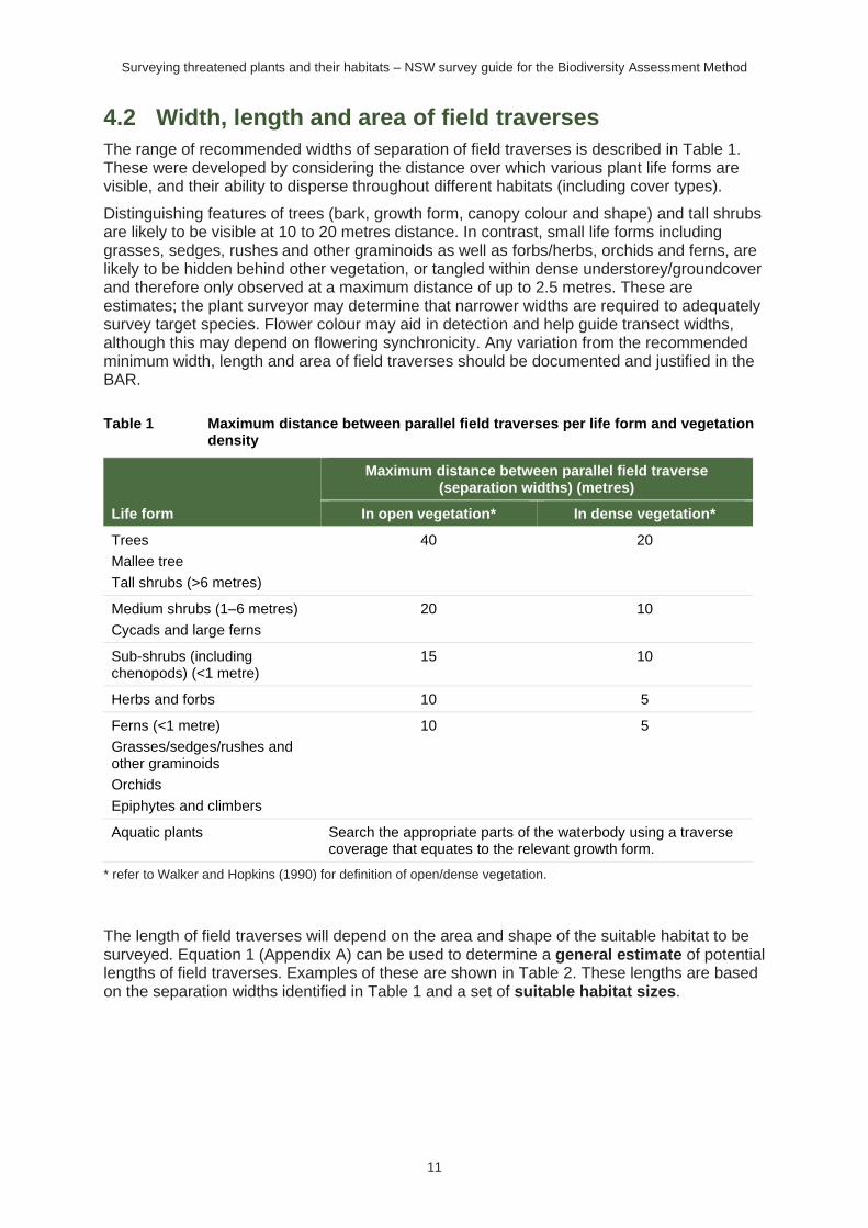
4.2 Width, length and area of field traverses
The range of recommended widths of separation of field traverses is described in Table 1. These were developed by considering the distance over which various plant life forms are visible, and their ability to disperse throughout different habitats (including cover types).
Distinguishing features of trees (bark, growth form, canopy colour and shape) and tall shrubs are likely to be visible at 10 to 20 metres distance. In contrast, small life forms including grasses, sedges, rushes and other graminoids as well as forbs/herbs, orchids and ferns, are likely to be hidden behind other vegetation, or tangled within dense understorey/groundcover and therefore only observed at a maximum distance of up to 2.5 metres. These are estimates; the plant surveyor may determine that narrower widths are required to adequately survey target species. Flower colour may aid in detection and help guide transect widths, although this may depend on flowering synchronicity. Any variation from the recommended minimum width, length and area of field traverses should be documented and justified in the BAR.
Table 1 Maximum distance between parallel field traverses per life form and vegetation density
Life form
Maximum distance between parallel field traverse (separation widths) (metres)
In open vegetation* In dense vegetation*
Trees
Mallee tree
Tall shrubs (>6 metres)
40 20
Medium shrubs (1–6 metres)
Cycads and large ferns
20 10
Sub-shrubs (including chenopods) (<1 metre)
15 10
Herbs and forbs 10 5
Ferns (<1 metre)
Grasses/sedges/rushes and other graminoids
Orchids
Epiphytes and climbers
10 5
Aquatic plants Search the appropriate parts of the waterbody using a traverse coverage that equates to the relevant growth form.
* refer to Walker and Hopkins (1990) for definition of open/dense vegetation.
The length of field traverses will depend on the area and shape of the suitable habitat to be surveyed. Equation 1 (Appendix A) can be used to determine a general estimate of potential lengths of field traverses. Examples of these are shown in Table 2. These lengths are based on the separation widths identified in Table 1 and a set of suitable habitat sizes.
Surveying threatened plants and their habitats – NSW survey guide for the Biodiversity Assessment Method
12
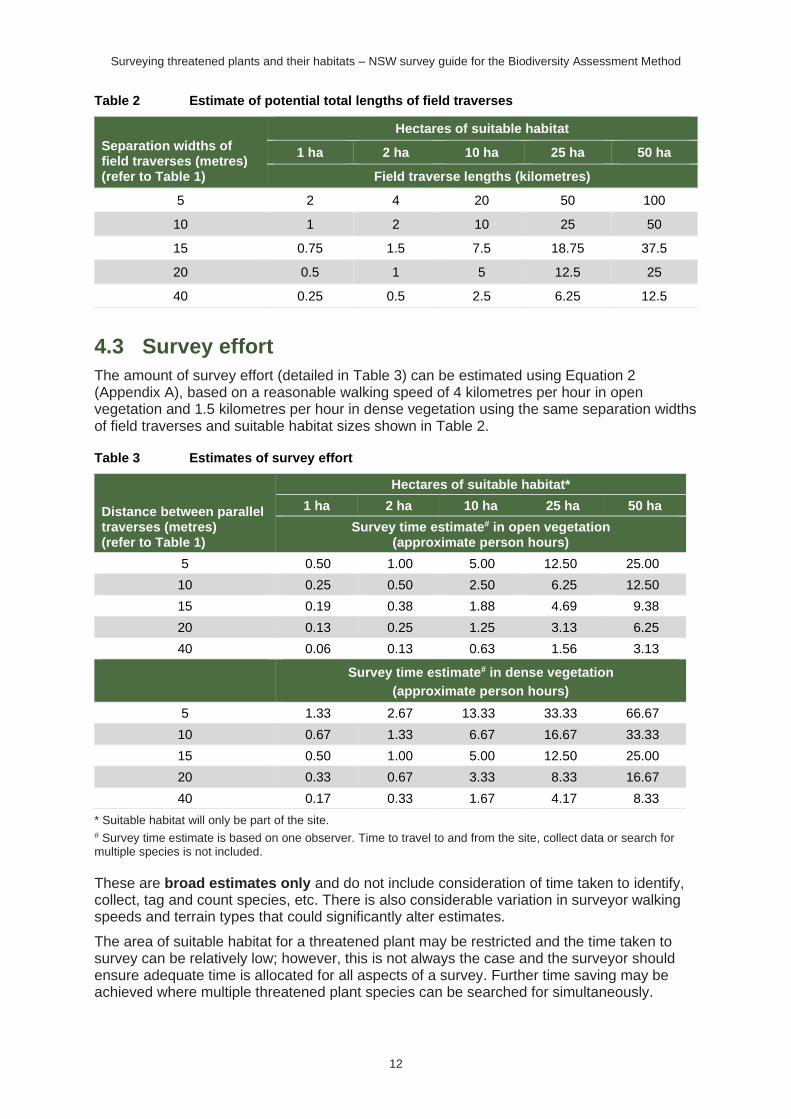
Table 2 Estimate of potential total lengths of field traverses
Separation widths of field traverses (metres) (refer to Table 1)
Hectares of suitable habitat
1 ha 2 ha 10 ha 25 ha 50 ha
Field traverse lengths (kilometres)
5 2 4 20 50 100
10 1 2 10 25 50
15 0.75 1.5 7.5 18.75 37.5
20 0.5 1 5 12.5 25
40 0.25 0.5 2.5 6.25 12.5
4.3 Survey effort
The amount of survey effort (detailed in Table 3) can be estimated using Equation 2 (Appendix A), based on a reasonable walking speed of 4 kilometres per hour in open vegetation and 1.5 kilometres per hour in dense vegetation using the same separation widths of field traverses and suitable habitat sizes shown in Table 2.
Table 3 Estimates of survey effort
Distance between parallel traverses (metres) (refer to Table 1)
Hectares of suitable habitat*
1 ha 2 ha 10 ha 25 ha 50 ha
Survey time estimate# in open vegetation (approximate person hours)
5 0.50 1.00 5.00 12.50 25.00
10 0.25 0.50 2.50 6.25 12.50
15 0.19 0.38 1.88 4.69 9.38
20 0.13 0.25 1.25 3.13 6.25
40 0.06 0.13 0.63 1.56 3.13
Survey time estimate# in dense vegetation
(approximate person hours)
5 1.33 2.67 13.33 33.33 66.67
10 0.67 1.33 6.67 16.67 33.33
15 0.50 1.00 5.00 12.50 25.00
20 0.33 0.67 3.33 8.33 16.67
40 0.17 0.33 1.67 4.17 8.33
* Suitable habitat will only be part of the site. # Survey time estimate is based on one observer. Time to travel to and from the site, collect data or search for multiple species is not included.
These are broad estimates only and do not include consideration of time taken to identify, collect, tag and count species, etc. There is also considerable variation in surveyor walking speeds and terrain types that could significantly alter estimates.
The area of suitable habitat for a threatened plant may be restricted and the time taken to survey can be relatively low; however, this is not always the case and the surveyor should ensure adequate time is allocated for all aspects of a survey. Further time saving may be achieved where multiple threatened plant species can be searched for simultaneously.
Surveying threatened plants and their habitats – NSW survey guide for the Biodiversity Assessment Method
13
4.4 Survey design for large areas of suitable habitat
The survey design described in this guide may be impractical for some large-scale projects (e.g. wind farms), where the time taken to search large areas of suitable habitat for small threatened species is high. Examples include grasslands, uninterrupted but narrow riparian habitat, semi-arid and arid shrublands, and woodlands or open woodland grading into disturbed or derived native grasslands.
Options to reduce survey effort in these circumstances may include dividing the proposed subject land into stages, refining areas considered suitable habitat through an initial site assessment, an expert report and/or reducing the survey area through the realignment of the boundaries/footprint of the proposed development, thereby reducing the area of impact.
Where these options have been considered but the area of suitable habitat to be surveyed for threatened plants remains large the survey technique outlined in Section 4.4.1 should be implemented. Large areas are taken to be areas of suitable habitat greater than 50 hectares. Alternatives to the two-phase grid-based systematic survey method may be proposed for the assessment of large areas of suitable habitat. It is recommended the assessor consult with the decision-maker and the Department (via [email protected]) early in the assessment process to ensure alternative methods are suitable. Justification including published or peer-reviewed references must be documented in the BAR.
4.4.1 Two-phase grid-based systematic survey approach for large areas
Large areas of suitable habitat can be assessed using a two-phase grid-based systematic survey approach. The approach provides a practical method for designating survey locations and ensures uniform, consistent coverage of the suitable habitat for a target species on the subject land (Krebs 1989; Fewster 2011). Survey locations are positioned on a grid intersect, facilitating planning and enabling rapid assessment across larger areas (McGarvey et al. 2016). The grid-based approach can be used for species assessed as counts of individuals or by area of suitable habitat.
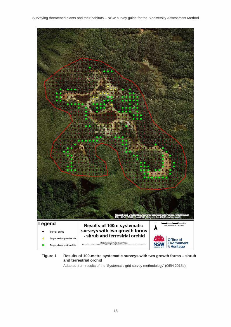
A grid spaced at 100 square metres is nested within a one-square-kilometre grid from a topographic map image and then overlayed onto the subject land using a geographic information system (GIS). Surveys are undertaken where the 100-square-metre gridlines intersect within suitable habitat for a target species. Survey for multiple target species can occur within the area covered by the 100-square-metre grid, providing they occur in similar habitat, are of the same life form/habit, and have the same optimal survey time as specified by the TBDC.
At each survey location (grid intersect), a 40-metre diameter area (1256-square-metre circular area) must be systematically surveyed for the target species. Survey locations must be pre-loaded onto a GPS, tablet or georeferenced map. An example of this first step is provided in Figure 1 and Figure 2 in Appendix B.
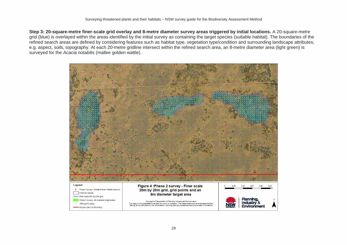
If a target species is located, finer-scale grid surveys (Table 4) are used to locate population extent, which will help define the species polygon. This subsequent phase ensures a greater intensity of survey effort in locations where the target species occurs (McGarvey et al. 2016). Directing survey effort to areas with a greater probability of hosting the species increases survey efficiency and reduces sampling costs (Guisan et al. 2006). The extent of the area covered by the finer-scale grid should be refined by considering the habitat type, vegetation type and condition and landscape attributes surrounding the locations where the target species was first detected. The information used to refine the boundaries of the finer-scale grid must be documented and justified in the BAR. An example of this step is provided in Figure 4 in Appendix B
Surveying threatened plants and their habitats – NSW survey guide for the Biodiversity Assessment Method
14
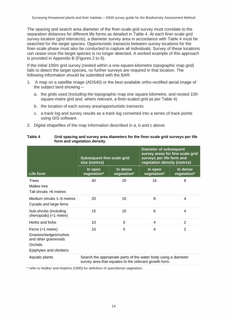
The spacing and search area diameter of the finer-scale grid survey must correlate to the separation distances for different life forms as detailed in Table 4. At each finer-scale grid survey location (grid intersects), a diameter survey area in accordance with Table 4 must be searched for the target species. Opportunistic transects between survey locations for the finer-scale phase must also be conducted to capture all individuals. Survey of these locations can cease once the target species is no longer detected. A worked example of this approach is provided in Appendix B (Figures 2 to 6).
If the initial 100m grid survey (nested within a one-square-kilometre topographic map grid) fails to detect the target species, no further surveys are required in that location. The following information should be submitted with the BAR:
1. A map on a satellite image (ADS40) or the best available ortho-rectified aerial image of the subject land showing –
a. the grids used (including the topographic map one square kilometre, and nested 100-square-metre grid and, where relevant, a finer-scaled grid as per Table 4)
b. the location of each survey area/opportunistic transects
c. a track log and survey results as a track log converted into a series of track points using GIS software.
2. Digital shapefiles of the map information described in a, b and c above.
Table 4 Grid spacing and survey area diameters for the finer-scale grid surveys per life form and vegetation density
Life form
Subsequent fine-scale grid size (metres)
Diameter of subsequent survey areas for fine-scale grid surveys per life form and vegetation density (metres)
In open vegetation*
In dense vegetation*
In open vegetation*
In dense vegetation*
Trees
Mallee tree
Tall shrubs >6 metres
40 20 16 8
Medium shrubs 1–6 metres
Cycads and large ferns
20 10 8 4
Sub-shrubs (including. chenopods) (<1 metre)
15 10 6 4
Herbs and forbs 10 5 4 2
Ferns (<1 metre)
Grasses/sedges/rushes and other graminoids
Orchids
Epiphytes and climbers
10 5 4 2
Aquatic plants Search the appropriate parts of the water body using a diameter survey area that equates to the relevant growth form.
* refer to Walker and Hopkins (1990) for definition of open/dense vegetation.
Surveying threatened plants and their habitats – NSW survey guide for the Biodiversity Assessment Method
15
Figure 1 Results of 100-metre systematic surveys with two growth forms – shrub and terrestrial orchid
Adapted from results of the ‘Systematic grid survey methodology’ (OEH 2018b).
Surveying threatened plants and their habitats – NSW survey guide for the Biodiversity Assessment Method
16
5. Field survey implementation
5.1 Undertaking the field traverses
To undertake a field traverse the threatened plant surveyor walks at a reasonable pace while making a visual sweep either side of, and along the traverse. This allows use of the different angles of light to detect flowers, fruit, leaf shape, leaf colour and habit of the threatened plant.
If a species is detected along a traverse, a GPS coordinate of the location must be recorded, then closer searching is required to count or estimate numbers of individuals and/or determine the area of occupancy (refer to Section 5.2 of this guide).
Several threatened plant species may be searched for during the same traverse. To ensure detectability is not compromised it is recommended that multi-species searches be restricted to a maximum of five species in the same stratum (i.e. search for five ground species, five mid-layer species or five canopy species) per traverse. Multi-species surveys could also be grouped further, by genus, similar growth form, or species with other similar characteristics where they are likely to occupy the same stratum.
Searching for threatened plant species is more reliable on clear days with little or no wind. Factors that may affect searching time include light levels, bad weather, wet grass, steep slopes and time of day (Moore et al. 2011). Very dense vegetation can significantly increase the time required for traverses. Details on the survey conditions, length of traverse, amount of time spent surveying for each species and GPS log of areas searched must be included in the BAR, as this may be important in evaluating survey results. As discussed previously, surveys for threatened plants (unless disturbance is required for determining presence), must not be undertaken during drought, following periods of disturbance (domestic grazing, burning, logging and slashing) or other adverse environmental conditions that affect species detectability (see Box 1).
A GPS track log (including the datum and Australian Map Grid zone) of the location of survey field traverses is the most effective way of demonstrating that the survey has been systematic and comprehensive – that is, the appropriate effort of searching has been completed within suitable habitat. The location of field traverses must be presented, by converting the track log into a series of track points using GIS software, on a satellite image (ADS40) or the best available ortho-rectified aerial image of the subject land, and supplied as part of the digital shapefiles submitted with the BAR.
Surveying threatened plants and their habitats – NSW survey guide for the Biodiversity Assessment Method
17
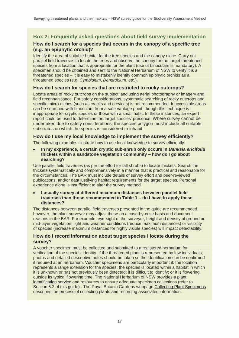
Box 2: Frequently asked questions about field survey implementation
How do I search for a species that occurs in the canopy of a specific tree (e.g. an epiphytic orchid)?
Identify the area of suitable habitat for the tree species and the canopy niche. Carry out parallel field traverses to locate the trees and observe the canopy for the target threatened species from a location that is appropriate for the plant (use of binoculars is mandatory). A specimen should be obtained and sent to the National Herbarium of NSW to verify it is a threatened species – it is easy to mistakenly identify common epiphytic orchids as a threatened species (e.g. Cymbidium, Dendrobium, etc.).
How do I search for species that are restricted to rocky outcrops?
Locate areas of rocky outcrops on the subject land using aerial photography or imagery and field reconnaissance. For safety considerations, systematic searching of rocky outcrops and specific micro-niches (such as cracks and crevices) is not recommended. Inaccessible areas can be searched with binoculars from a safe vantage point, though this technique is inappropriate for cryptic species or those with a small habit. In these instances, an expert
report could be used to determine the target species’ presence. Where survey cannot be undertaken due to safety considerations, the species polygon must include all suitable substrates on which the species is considered to inhabit.
How do I use my local knowledge to implement the survey efficiently?
The following examples illustrate how to use local knowledge to survey efficiently.
• In my experience, a certain cryptic sub-shrub only occurs in Banksia ericifolia thickets within a sandstone vegetation community – how do I go about searching?
Use parallel field traverses (as per the effort for tall shrubs) to locate thickets. Search the thickets systematically and comprehensively in a manner that is practical and reasonable for the circumstances. The BAR must include details of survey effort and peer-reviewed publications, and/or data justifying habitat requirements for the target species. Personal experience alone is insufficient to alter the survey method.
• I usually survey at different maximum distances between parallel field traverses than those recommended in Table 1 – do I have to apply these distances?
The distances between parallel field traverses presented in the guide are recommended; however, the plant surveyor may adjust these on a case-by-case basis and document reasons in the BAR. For example, eye-sight of the surveyor, height and density of ground or mid-layer vegetation, light and weather conditions (reduce maximum distances) or visibility of species (increase maximum distances for highly visible species) will impact detectability.
How do I record information about target species I locate during the survey?
A voucher specimen must be collected and submitted to a registered herbarium for verification of the species’ identity. If the threatened plant is represented by few individuals, photos and detailed descriptive notes should be taken so the identification can be confirmed if required at an herbarium. Voucher specimens are particularly important if: the location represents a range extension for the species; the species is located within a habitat in which it is unknown or has not previously been detected; it is difficult to identify; or it is flowering outside its typical flowering time. The National Herbarium of NSW provides a plant identification service and resources to ensure adequate specimen collections (refer to Section 5.2 of this guide).. The Royal Botanic Gardens webpage Collecting Plant Specimens describes the process of collecting plants and recording associated information.
Surveying threatened plants and their habitats – NSW survey guide for the Biodiversity Assessment Method
18
5.2 Collect field survey data about individuals
5.2.1 Location
Field data collection is needed to document the number of individuals and/or the area of habitat for each target threatened species located during the survey. This information is used to prepare species polygons.
Initially, the location of individuals (or groups of individuals) of target threatened plant species can be recorded during the field traverses. Once field traversing is complete, it is necessary to undertake a thorough search around individuals to establish an area of known occupancy. It is recommended that a defined area (e.g. based on the maximum dispersal distance, if known) be used to focus searching.
For threatened plant species where the unit of measure is area (according to the TBDC), the species polygon is used to measure the area of the suitable habitat (Paragraph 6.4.1.28 of the BAM).
For species where the unit of measure is a count of individuals, the targeted survey is used to determine their location and provide a count, or an estimation, of the number of individual plants on the subject land (BAM Paragraph 6.4.1.29). This information is used to prepare the species polygon, which shows the number and location of individuals (or the location of a group of individuals) on the subject land (BAM Paragraphs 6.4.1.28 – 6.4.1.30). The species polygon indicates the location of the population on the subject land and this is not used in credit calculations. Where individuals are identified by point locations, each must be buffered by a 30-metre radius (BAM Paragraph 6.4.1.29). If individuals are spaced less than 30 metres apart, overlapping areas of buffer can be combined to form the boundary of the species polygon (Appendix B). The species polygon should be constrained to within the subject land.
Generally, species assessed via direct counts are long-lived plants that persist above ground, where the population size can be readily assessed. Conversely, species assessed by area are generally cryptic, clonal, logistically difficult to survey (e.g. dangerous for the surveyor) or cannot be reliably counted because abundance above ground fluctuates by an order of magnitude in response to environmental conditions and/or disturbance regimes.
The boundary of the species polygon must be finalised on completion of the species survey and must (BAM Paragraphs 6.4.1.32 and 6.4.1.33):
a. use the unit of measurement identified for that species
b. include the locations of, or area/s of suitable habitat for, the species
c. contain any specific habitat constraint associated with that threatened species on the subject land including appropriate buffers and associated justifications (e.g. published literature)
d. use GPS to confirm the location of individual threatened plants and polygon on the best available ortho-rectified aerial image of the subject land. Remember to record both datums used (e.g. GDA 94) and zone (e.g. 54, 55 & 56).
5.2.2 Counts of individuals
Where the unit of measure is a count of individuals, the number of individuals can be directly counted with a reasonable level of confidence. Individuals on the subject land may represent only part of a population, with other individuals located beyond the boundary of the subject land. Only those individuals rooted within the subject land should be counted.
Surveying threatened plants and their habitats – NSW survey guide for the Biodiversity Assessment Method
19
It is good practice to temporarily mark individuals with removable flags, biodegradable flagging tape, or some other unobtrusive method so that errors such as double-counting can be avoided.
Where relevant, the surveyor should record counts in the life stage of individuals (e.g. germinant, juvenile, immature, mature, senescent). This will provide a holistic measure of the population, giving an indication of population age structure. For a biodiversity stewardship site, it could also inform management requirements for the population.
Small groups of individuals (e.g. <50 plants) can be counted with reasonable confidence; however, for larger populations, extrapolating the mean density by sampling over the areas of occupancy may be required. Where sampling is conducted, the count of individuals from quadrats or transects can be used to estimate the population within occupied habitat.
Sampling points must be established to provide a representative assessment of the species density, accounting for the level of variation in the density of individuals across the site. The number of sampling points must be adequate to determine, with confidence, the size of the population. Confidence can be assessed by recording the variance, standard deviation and standard error of the population estimate. The sampling method, raw data and approach taken to estimate the total population of the species must be clearly described and justified in the BAR.
Alternatively, an expert report can also be used to estimate the number and location of individuals likely to be present on the subject land and map the species polygon. The method used to make estimations must be documented in the expert report as part of the BAR and must include justification of the approach used (e.g. based on scientific literature, reference populations in the local area).
5.2.3 Area of suitable habitat
If the unit of measure is area of suitable habitat, the threatened plant surveyor must consider information on the following when defining the species polygon:
• the land-use history and disturbance on the subject land, including fire history
• recent rainfall events, and how it compares to long-term averages
• previous surveys for the species at or near the subject land
• reference populations in the local area
• life history characteristics of the species, and
• habitat constraints, growth form, any other relevant ecological information (e.g. hydrology, aspect, soil type, underlying lithology and vegetation community).
The method and information used to define the area of suitable habitat must be documented in the BAR (e.g. with reference to the above points).
The species polygon must be mapped around the extent of suitable habitat for the species on the subject land (BAM Paragraph 6.4.1.33). If a vegetation zone has consistent habitat for the species; for example, scattered individuals occur throughout a relatively homogenous vegetation zone, the area of habitat can be taken as the area of that vegetation zone.
For species known to inhabit particular microhabitats (e.g. edges of peat swamps) or ecological niches (e.g. rock shelf, vertical cliffs, spray zone of waterfalls) the polygon must encompass all suitable areas on the site (including any relevant buffers), even if individuals are not currently observed.
Similarly, for species occurring in areas that are dangerous to assess or where habitat is fragile and likely to be damaged by survey, the polygon must include all suitable substrates on which the species is considered to inhabit (see Box 2).
Surveying threatened plants and their habitats – NSW survey guide for the Biodiversity Assessment Method
20
Finally, where a species is clonal, and therefore assessed by area of habitat, the polygon must encompass the entire plant within a suitable buffer.
The BAM-C determines the habitat condition of the species polygon using the vegetation integrity score (Paragraph 6.4.1.35 of the BAM). Where multiple vegetation zones occur within the species polygon, the BAM-C will generate a habitat condition score using the vegetation integrity scores for these zones (Paragraph 6.4.1.36 of the BAM).
Where the presence of a species is assumed on a proposed development or biodiversity certification site, the surveyor can map the entire vegetation zone/s or vegetation zones/areas supporting habitat constraints relevant to the species as the species polygon.
Assuming species presence or the use of an expert report is recommended for some species, such as disturbance specialists, where site history indicates a long time since the required disturbance events. For example, Prostanthera junonis (Somersby mintbush) was rediscovered after 67 years on the Central Coast of New South Wales following soil disturbance associated with land clearing (Tierney & Gross 2001). This species is now known to occur as a post-fire coloniser that eventually disappears from the above ground biomass as associated vegetation thickens and shades it out. Similarly, surveys may not reliably detect annual or ephemeral plants due to their small size and reliance on specific climatic conditions to germinate. For example, the critically endangered Gentiana wingecarribiensis (Wingecarribee Gentian) a small, short-lived annual that opens its flowers only in bright sunlight. Its entire life cycle is completed in less than three months and only under favourable climatic conditions (Kodela et al. 1994).
5.3 Specimens for identification
If a plant cannot be identified during field survey and is suspected of being a threatened species, a voucher specimen must be collected and preserved for later identification with the assistance of resources such as field guides and keys. If the individual is a young plant the surveyor may consider leaving the plant in situ and returning to the site when it has produced the features necessary to enable identification. A threatened plant specimen must be identified to species level and submitted to a registered herbarium such as the National Herbarium of NSW, for inspection and formal identification. The National Herbarium of NSW outlines the procedures for specimen collection and vouchering, as well as providing a plant identification service(see Box 2 for more information on vouchering specimens).
5.3.1 Hybrids or intergrades
Where a plant is considered to be a hybrid or an intergrade, confirmation must be sought from a specialist botanist or relevant curator at the NSW Herbarium. Any correspondence must be included in the BAR.
Hybrids or intergrades are not considered to be the listed threatened species under the BC Act, unless hybridisation or intergrades are specifically described in the NSW Threatened Species Scientific Committee final determination for that species. Where the NSW herbarium advice is not definitive and the specimen is only assessed as ‘possibly/displays some affinity to or similar’, a precautionary approach is recommended (e.g. for a development proposal assume it is the threatened species).
Surveying threatened plants and their habitats – NSW survey guide for the Biodiversity Assessment Method
21
5.4 Emerging survey methods
The use of emerging survey methods, such as detection dogs, can potentially provide useful data, subject to the application of appropriate and reproducible survey design.
For example, trained detection dogs have proven to be effective and efficient in searching for the cryptic underground orchid (Rhizanthella). Detection dogs may provide a suitable option for locating threatened plants that are inconspicuous or have unpredicted growth or flowering habits. Prescriptive guidance for the use of detection dogs as well as any other emerging techniques in surveying for threatened plants will be provided in future versions of this guide.
Surveying threatened plants and their habitats – NSW survey guide for the Biodiversity Assessment Method
22
6. Documenting survey results
The BAR must be prepared in accordance with the BAM and requires documentation of targeted survey for species credit species including timing, design, method, effort and results (see Appendices 10, 11 and 12 of the BAM).
The BAR must contain results of the survey (refer to Paragraph 6.5.1.5 of the BAM and page 33 of the BAM Operational Manual Stage 1 (OEH 2018a)), an accurate representation of the survey process including the information compiled and analysed in the field survey design (refer to Section 3 of this guide), the field survey technique and effort (refer to Section 4 of this guide), and field survey implementation (refer to Section 5 of this guide).
The field survey component of the BAR is required to demonstrate that adequate survey has been carried out and the results are reliable.
In relation to threatened plant surveys, the BAR must include information on:
1. the subject land and areas of suitable habitat that are linked to the identified vegetation zones for the development, biodiversity certification or stewardship site. Smaller scale plant habitats superimposed on a geo-referenced map, aerial photograph, or similar must also be included
2. the candidate species list (scientific and common names) and any alterations, including justifications, to the list derived from the BAM-C. Any additional species must also be added to the list if they have been recently listed under the BC Act and/or recorded on or near the subject land in the TBDC. Assessors (or plant surveyors) may also include a species if they are of the professional opinion that it is likely to occur on the subject land or be affected by the proposed development. If the assessor is uncertain about the likelihood of the presence of a species on the subject land, they must include that species as a precautionary measure
3. the optimal survey timing including documentation and justification of information used if it differs from that identified by the BAM-C
4. the survey design indicating the species proposed for survey within each of the areas of suitable habitat, their optimal survey timing and survey effort
5. site description and history, such as previous fire disturbance or drought, which may influence distribution and abundance of the target species
6. weather conditions of each survey day (including prevailing conditions/rainfall over the preceding three months, e.g. drought, dates that the survey was undertaken and any groupings of multi-species searches). Weather conditions can be collected from meteorological records or recorded using a portable meteorological station
7. the location of field traverses within the suitable habitat area for each species (as recorded using a GPS) in shapefiles and shown on a geo-referenced map or aerial photograph
8. the results of the survey including each species’ presence or absence; where present, the location and number of individuals of species or area of habitat; information on age class, whether flowering or fruiting, condition of individuals, other population/demographic data; species polygons; area of occupancy including the methods used to determine numbers present (direct counting vs. estimation; individuals of species vs. area of suitable habitat); and any survey limitations (including reasoning). The results must be mapped using digital airborne data (ADS40) or best available ortho-rectified aerial imagery with the unit of measurement identified for that species (abundance or area of habitat) and GPS to confirm location (Paragraph 6.4.1.33 of the BAM)
Surveying threatened plants and their habitats – NSW survey guide for the Biodiversity Assessment Method
23
9. reference to any expert reports prepared for species for which survey was considered unreliable based on disturbance history or climatic events, or if prepared in lieu of a targeted threatened species survey (Subsection 6.5.2 of the BAM). This must also include copies of determinations/correspondence for any threatened species identified on the subject land from the National Herbarium of NSW or another registered herbarium. Copies of the expert reports must be included with the BAR
10. survey data, voucher specimen documentation and a full report of survey, research or other biodiversity assessment works must be uploaded to BioNet in accordance with Scientific Licence Conditions using the most recent version of the Atlas datasheet (EXCEL 2.7MB)
11. experience level, qualifications and justification of the suitability of the threatened plant surveyor (refer to Section 2.2 of this guide).
Surveying threatened plants and their habitats – NSW survey guide for the Biodiversity Assessment Method
24
7. References
Bell S and Holzinger B 2015, Wildfire reveals new populations of the endangered Commersonia rosea and Monotaxis macrophylla in northern Wollemi National Park, NSW, Australasian Plant Conservation, vol.23, no.4, pp.2–4.
Binns D 2013, Euphrasia arguta: management of a species previously presumed extinct, Australasian Plant Conservation, vol.21, no.3, pp.10–11.
Cropper SC 1993, Management of Endangered Plants, CSIRO Publications Victoria.
Fewster RM 2011, Variance estimation for systematic designs in spatial surveys, Biometrics, vol.67, no.4, pp.1518–1531.
Flanagan NS, Peakall R, Clements MA and Otero JT 2006, Conservation of taxonomically difficult species: the case of the Australian orchid, Microtis angusii, Conservation Genetics, vol.7, pp.847–859.
Fraser M, Simmons D and Adams R 2004, Population decline and potential for local extinction in a population of Pultenaea glabra (Fabaceae) in Victoria, Cunninghamia, vol.8, no.4, pp.431–438.
Guisan A, Broennimann O, Engler R, Vust M, Yoccoz N G, Lehmann A and Zimmermann NE 2006, Using niche-based models to improve the sampling of rare species, Conservation biology, vol.20, no.2, pp.501–511.
Garrard GE, Bekessy SA, McCarthy MA and Wintle BA 2015, Incorporating detectability of threatened species into environmental impact assessment, Conservation Biology, vol.29, pp.216–225.
Keith DA 1998, An Evaluation and Modification of World Conservation Union Red List Criteria for Classification of Extinction Risk in Vascular Plants, Conservation Biology, vol.12, no.5, pp.1076–1090.
Keith D. 2000, Sampling designs, field techniques and analytical methods for systematic plant population surveys, Ecological Management and Restoration, vol.1, pp.125–139.
Kodela PG, James TA and Hind PD 1994, Observations on the ecology and conservation status of the rare herb Gentiana wingecarribiensis, Cunninghamia, vol.3, pp.535–541.
Krebs CJ 1989, Ecological methodology, Harper & Row, New York, USA.
Mallee J 2019, On the ropes for rare herbs – 2019 rope-access surveys in Limpinwood Nature Reserve, Australasian Plant Conservation, vol.28, no.2, pp.3–5.
McCaffrey NB, Blick RAJ, Glenn VC, Fletcher AT, Erskine PD and van Osta J 2014, Novel stratified-meander technique improves survey effort of the rare Pagoda Rock Daisy growing remotely on rocky cliff edges, Ecological Management and Restoration, vol.15, no.1, pp.94–97.
McGarvey R, Burch P and Matthews JM 2016, Precision of systematic and random sampling in clustered populations: habitat patches and aggregating organisms, Ecological applications, vol.26, no.1, pp.233–248.
Miles J and Cameron S 2007, Observations on the ecology and conservation status of Haloragis exalata subsp. exalata (Haloragaceae) in southern New South Wales, Cunninghamia, vol.10, no.2, pp.263–272.
Moore JL, Hauser CE, Bear JL, Williams SG and McCarthy MA 2011, Estimating detection – effort curves for plants using search experiments, Ecological Applications, vol.21, no.2, pp.601–607.
Surveying threatened plants and their habitats – NSW survey guide for the Biodiversity Assessment Method
25
OEH 2017, Biodiversity Assessment Method, NSW Office of Environment and Heritage, Sydney.
OEH 2018a, Biodiversity Assessment Method Operational Manual – Stage 1, NSW Office of Environment and Heritage, Sydney.
OEH 2018b, ‘Systematic grid survey methodology: Barrington Tops’, internal report, Office of Environment and Heritage for the NSW Government, Sydney.
Rabinowitz D 1981, ‘Seven forms of rarity’, pp.205–217 in H Synge (ed.), The Biological Aspects of Rare Plant Conservation, John Wiley, New York, USA.
Royal Botanic Gardens 2020, Collecting Plant Specimens, Royal Botanic Gardens, Sydney, www.rbgsyd.nsw.gov.au/science/plants/plant-information/collecting-plant-specimens.
Shelly D and Lewer S 2002, Rulingia procumbens survey in Central-west New South Wales – Preliminary results, Danthonia, vol.11, no.3, pp.8–9.
Sivertsen D 2009, Native Vegetation Interim Type Standard, Department of Environment, Climate Change and Water NSW, Sydney, www.environment.nsw.gov.au/-/media/OEH/Corporate-Site/Documents/Research/Maps-and-data/native-vegetation-interim-type-standard-100060.pdf (PDF 1.1MB)
Thompson WL (ed.) 2004, Sampling Rare or Elusive Species: Concepts, designs, and techniques for estimating population parameters, Island Press, Washington, USA.
Tierney DA and Gross CL 2001, Prostanthera junonis Conn (LAMIACEA): is recovery possible? Pacific Conservation Biology, vol.7, no.2, pp.118–123.
Tierney DA, Sommerville KD, Tierney KE, Fatemi M and Gross CL 2017, Trading populations—can biodiversity offsets effectively compensate for population losses? Biodiversity Conservation, vol.26, pp.2115–2131.
Walker J and Hopkins MS 1990, ‘Vegetation’, in RC McDonald, RF Isbell, JR Speight, J Walker and MS Hopkins (eds), Australian soil and land survey – field handbook, 2nd edition, pp.58–77, Inkata Press, Melbourne and Sydney.

Surveying threatened plants and their habitats – NSW survey guide for the Biodiversity Assessment Method
26
Appendix A: Determining the level of survey effort
Equation 1: Determine the estimate of potential lengths of field traverses
𝐹𝑇𝐿 = (𝑆𝐻 /𝐷𝑃𝑇)
where:
FTL = total field traverse length
SH = hectares of suitable habitat (in square metres)
DPT = distances between parallel traverses (in metres)
Equation 2: Determine estimates of potential survey time based on vegetation density
Open vegetation Dense vegetation
𝑆𝑇𝐸 = (𝑆𝐻 ÷ 𝐷𝑃𝑇)/4000𝑚
where:
STE = survey time estimate# (approximate hours)
SH = hectares of suitable habitat* (in square metres)
DPT = distance between parallel traverses (in metres)
𝑆𝑇𝐸 = (𝑆𝐻 ÷ 𝐷𝑃𝑇)/1500𝑚
where:
STE = survey time estimate# (approximate hours)
SH = hectares of suitable habitat* (in square metres)
DPT = distance between parallel traverses (in metres)
Note: 4000 metres and 1500 metres derived from estimates of walking speed (Section 4.3 of this guide). # Travel to and from the site is not included. Include additional time for recording of data and when looking for multiple species.
* Suitable habitat may only be part of the site. One hectare is equivalent to 10,000 square metres.
Surveying threatened plants and their habitats – NSW survey guide for the Biodiversity Assessment Method
27
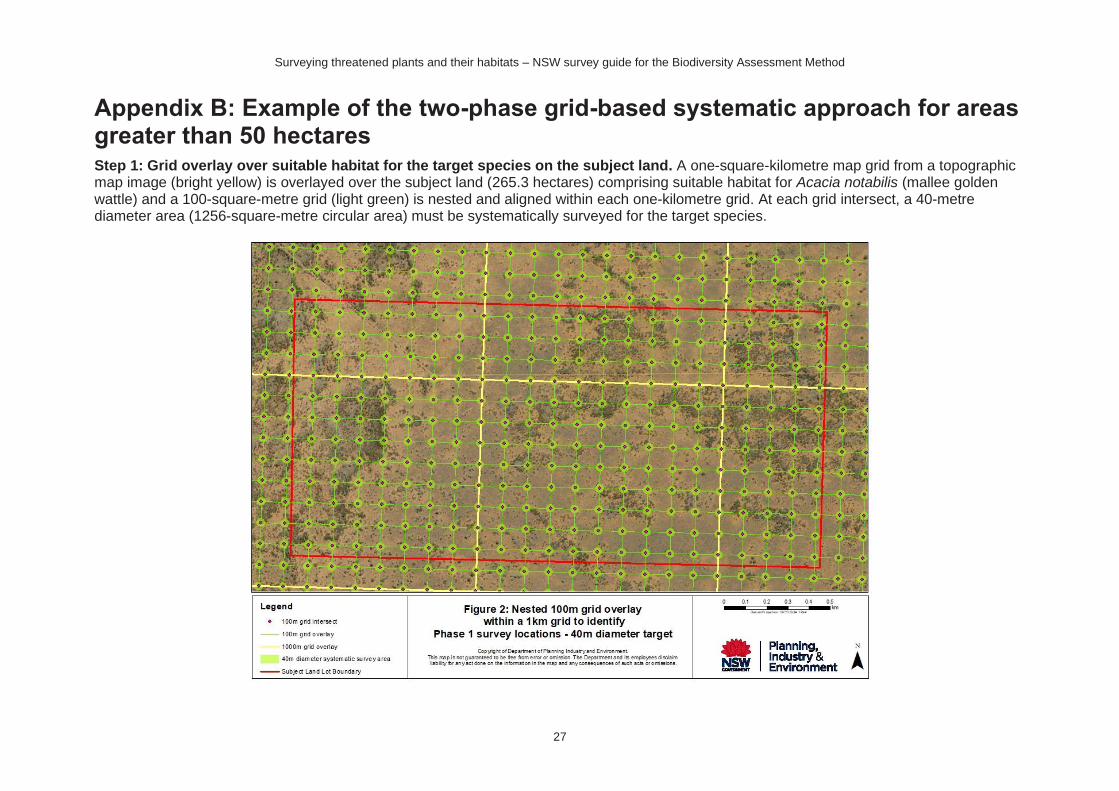
Appendix B: Example of the two-phase grid-based systematic approach for areas greater than 50 hectares Step 1: Grid overlay over suitable habitat for the target species on the subject land. A one-square-kilometre map grid from a topographic map image (bright yellow) is overlayed over the subject land (265.3 hectares) comprising suitable habitat for Acacia notabilis (mallee golden wattle) and a 100-square-metre grid (light green) is nested and aligned within each one-kilometre grid. At each grid intersect, a 40-metre diameter area (1256-square-metre circular area) must be systematically surveyed for the target species.
Surveying threatened plants and their habitats – NSW survey guide for the Biodiversity Assessment Method
28
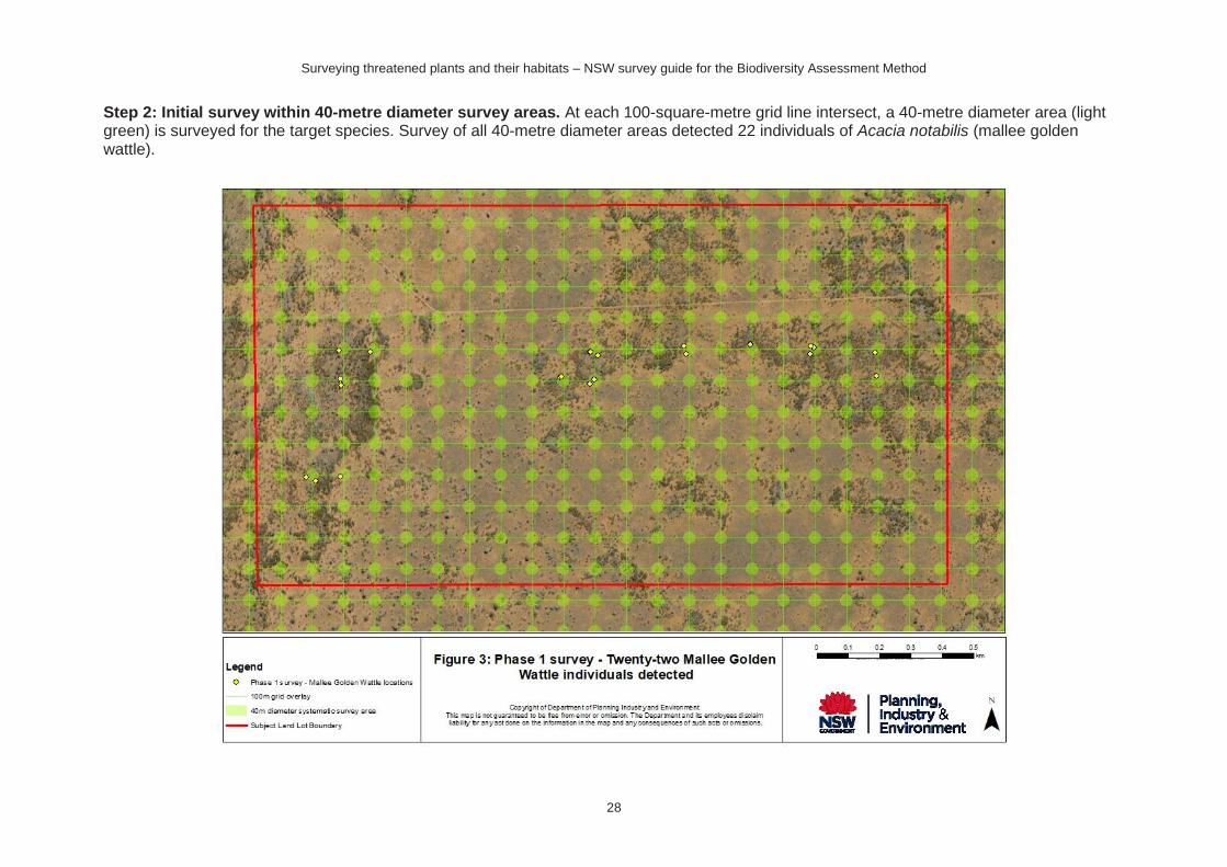
Step 2: Initial survey within 40-metre diameter survey areas. At each 100-square-metre grid line intersect, a 40-metre diameter area (light green) is surveyed for the target species. Survey of all 40-metre diameter areas detected 22 individuals of Acacia notabilis (mallee golden wattle).
Surveying threatened plants and their habitats – NSW survey guide for the Biodiversity Assessment Method
29
Step 3: 20-square-metre finer-scale grid overlay and 8-metre diameter survey areas triggered by initial locations. A 20-square-metre grid (blue) is overlayed within the areas identified by the initial survey as containing the target species (suitable habitat). The boundaries of the refined search areas are defined by considering features such as habitat type, vegetation type/condition and surrounding landscape attributes, e.g. aspect, soils, topography. At each 20-metre gridline intersect within the refined search area, an 8-metre diameter area (light green) is surveyed for the Acacia notabilis (mallee golden wattle).
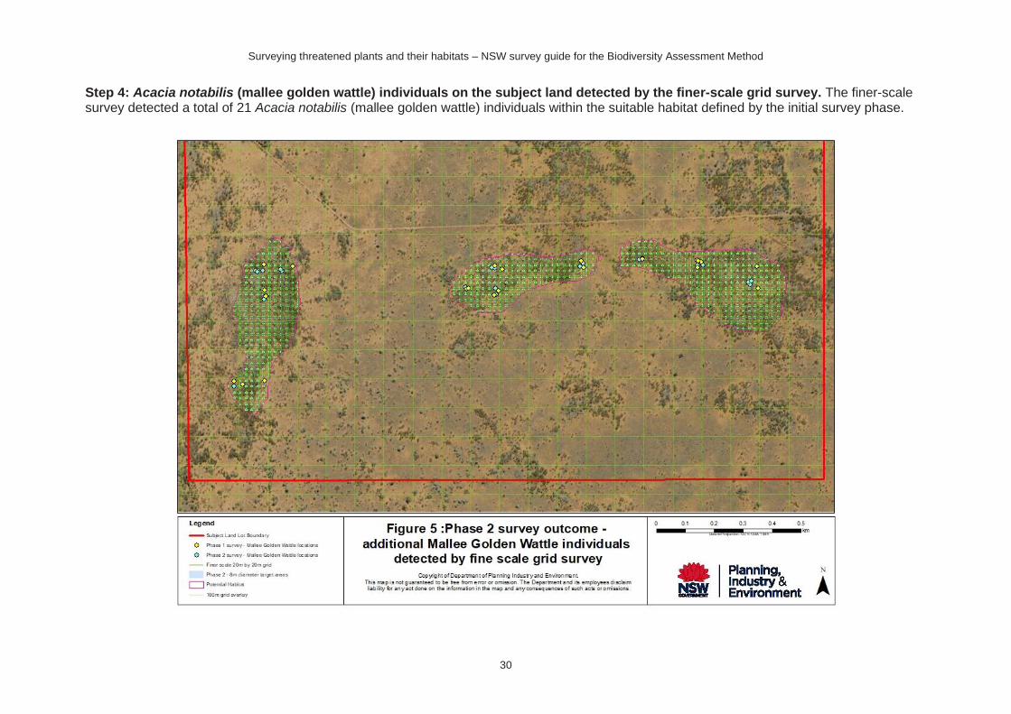
Surveying threatened plants and their habitats – NSW survey guide for the Biodiversity Assessment Method
30
Step 4: Acacia notabilis (mallee golden wattle) individuals on the subject land detected by the finer-scale grid survey. The finer-scale survey detected a total of 21 Acacia notabilis (mallee golden wattle) individuals within the suitable habitat defined by the initial survey phase.
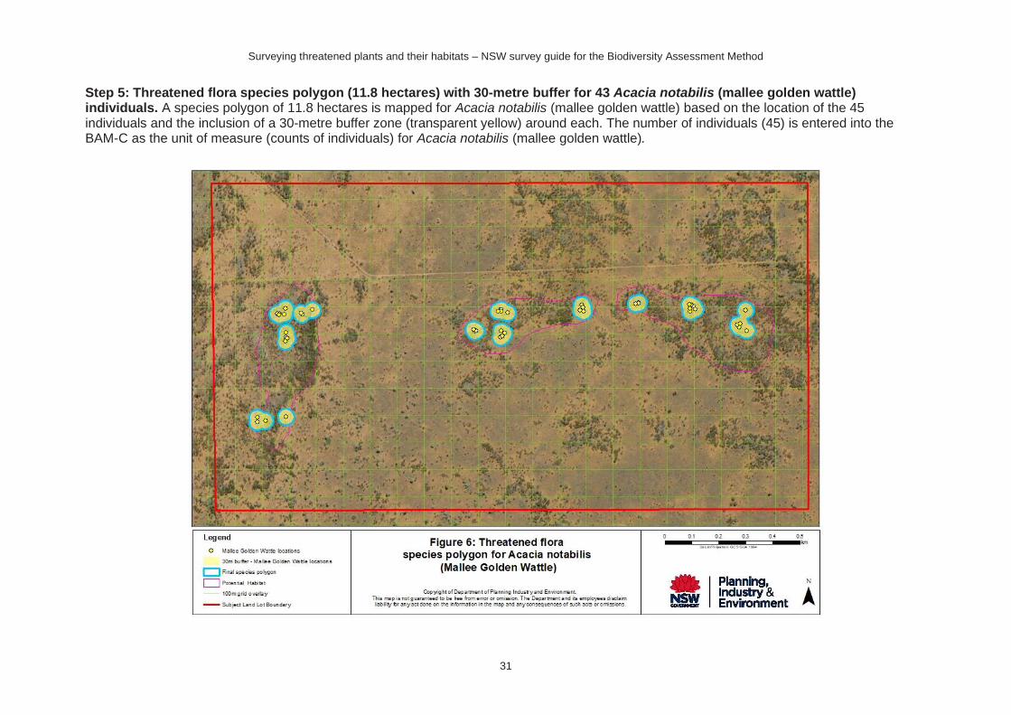
Surveying threatened plants and their habitats – NSW survey guide for the Biodiversity Assessment Method
31
Step 5: Threatened flora species polygon (11.8 hectares) with 30-metre buffer for 43 Acacia notabilis (mallee golden wattle) individuals. A species polygon of 11.8 hectares is mapped for Acacia notabilis (mallee golden wattle) based on the location of the 45 individuals and the inclusion of a 30-metre buffer zone (transparent yellow) around each. The number of individuals (45) is entered into the BAM-C as the unit of measure (counts of individuals) for Acacia notabilis (mallee golden wattle).