Embed Size (px)
Citation preview


Department of Planning and Zoning To: Community and Economic Development Committee From: Jeff Harvey
Director of Planning and Zoning Date: September 1, 2015 SUBJECT: Airport Land Use Compatibility Plan The proposal to amend the Comprehensive Plan to incorporate the Airport Land Use Compatibility Guidelines (attached) into the Plan was not approved by the Board. Reasons cited for not approving the amendment included that the document was confusing and too involved. For discussion purposes, staff is providing the following options for how the Airport Land Use Compatibility Plan may be better incorporated into the Comprehensive Plan.
- Link the Airport Compatibility recommendations more directly with the underlying land use recommendations in the Land Use Plan to avoid multiple and conflicting land use recommendations on any one property.
o Call out uses, otherwise supported in a specific land use district, that would not be permitted or would be permitted under special circumstances due to their proximity to the airport.
- Provide more specific land use recommendations in sub areas of a larger land use district around the airport.
o For example, in the Business and Industry Area, the sub-area to the east of the airport along US Route 1, which is generally in the approach area to the airport, could include more specific recommendations beyond the basic countywide land use recommendations.
o Represent these more specific recommendations with inset maps in the Chapter 3 Land Use Plan.
o Reevaluate the original document to consider paring down or simplifying the recommendations.
MEMORANDUM

o Maintain the more detailed document, in the format originally proposed, as an appendix of the Comp Plan to serve as background document and basis for the more specific recommendations.
Attachment

CHAPTER 3.8 STAFFORD REGIONAL AIRPORT PLANNING AREA
A. Introduction
The Stafford Regional Airport is located in an area of the County that is anticipated to experience growth
in the future. The area surrounding the Stafford Regional Airport was primarily agricultural and rural
residential with very low density housing when it was initially sited in 1987. The growth pattern in the
area has changed since that time with the construction of the Centerport Parkway in 2006 and
amendments to the Future Land Use Plan in 2010 which allows for the potential of higher density
development. The Airport Master Plan anticipates the extension of the existing runway and an increase
in operations.
The Comprehensive Plan recognizes the need to plan for growth that is compatible with the airport in
the following ways:
Chapter 2 (page 2-26) includes a recommendation for the development of land use compatibility
standards:
Objective 4.9. Minimize the noise impacts and potential safety hazards generated by general
aviation at public and private airfields in the County.
Policy 4.9.1. The County should develop land use compatibility standards for new development to
conform to within the aircraft approach patterns of airports and landing strips.
Chapter 6 (page 6-10) includes the recognition of the current zoning overlay district:
Overlay Districts In addition to the base zoning districts, the Stafford County Zoning Ordinance contains eight overlay districts. The purposes of the districts vary from protecting historical and environmental resources, reducing conflicts between established facilities, and mitigating potential hazards. Overlay districts add a variety of standards to the underlying districts. These standards could include use restrictions, preservation requirements, or stricter density regulations. The following is a list of the overlay districts used in Stafford County: AD Airport Impact - Provides an overlay zone in areas subject to intense and/or frequent
emissions of noise and vibration from airports and prevents obstructions of airport zones which
may result in an air navigation hazard.
An Airport Planning Area is established in order to further define and address the specific planning
considerations related to land use compatibility including potential impacts related to exposure to
aircraft noise, land use safety with respect both to people on the ground and the occupants of aircraft;
the protection of airport airspace; and general concerns related to aircraft overflights. The Airport
Planning Area consists of Airport Impact Zones that are defined in section C of this chapter.
Draft - April 22, 2015 REVISION 8
Attachment 1 Page 1 of 32

B. Background of the Stafford Regional Airport
The Stafford Regional Airport is located in the center of Stafford County and is situated approximately 40
miles southwest of Washington D.C., 50 miles north of Richmond, Virginia and approximately 5 miles
north of Fredericksburg, Virginia.
The need for a new public general aviation airport in Stafford County was determined in 1972 as part of
the National Airport System Plan. In 1977 Stafford County conducted a feasibility study which detailed
a need for a transport category airport in the region. A series of environmental studies were
conducted between 1977 and 1992 and resulted in the final selection of an airport site in the central
Stafford County area, adjacent to Interstate 95. Construction of the Airport began in 1997 and the
airport opened in December 2001. The Airport was completed for just over $41M dollars, $5M
under its allocated budget. This included an investment of $820k from the Stafford Regional Airport
Authority, almost $39M from the Federal Aviation Administration (FAA) and approximately $1.25M in
Commonwealth of Virginia funding. The Airport Improvement Program Handbook states, with
regard to any airport sponsor, “It (the airport sponsor) will take the appropriate action, to the
extent reasonable, including the adoption of zoning laws, to restrict the use of land adjacent to or in
the immediate vicinity of the airport to activities and purposes compatible with normal airport
operations, including landing and takeoff of aircraft.”
Significant airport development of more than $14M has occurred since the Airport was originally
constructed with the bulk coming from the FAA. This construction includes the addition of
T- Hangars, two corporate hangars, apron areas, auto parking, fuel farm, security fencing, an
instrument landing system (ILS), an approach lighting system and a new terminal building that opened
in January 2014. The FAA and DOAV provide nearly all of the funding for future airport
improvements and it is imperative that Stafford County establish and maintain high quality
development compatibility standards to insure that future expenditures are used to improve the
airport instead of noise abatement measures due to poor development planning.
The Airport is governed by a seven member Airport Authority (Stafford Regional Airport Authority or
SRAA). These appointed members serve four year terms and represent Stafford County (four
members), Prince William County (two members), and the City of Fredericksburg, Virginia (one
member). A fulltime airport manager is located at the Stafford Regional Airport and handles the daily
operation of the facility.
The Stafford Regional Airport service area includes Stafford County and portions of eight
surrounding counties plus the City of Alexandria and Washington D.C. as determined by the Virginia
Department of Aviation (DOAV) 2003 Virginia Air Transportation System Plan (VATSP) and airport
records.
The Stafford Regional Airport is served by a single 5,000’ x 100’ grooved runway (15-33) as shown
on the Airport Layout Plan in Exhibit 1. This runway is oriented 150 and 330 degrees and has a full-
length parallel taxiway. Runway 15-33 utilizes High Intensity Runway Lights (HIRL) which can be
operated by pilots using the Airport’s Unicom frequency (122.725). Medium Intensity Taxiway
Draft - April 22, 2015 REVISION 8
Attachment 1 Page 2 of 32

Lighting (MITL) is also available to pilots to assist in night operations, giving the facility 24-hour
operational capability.
Exhibit 1: Airport Layout Plan
The Stafford Regional Airport currently has three instrument approach procedures consisting of an ILS
approach, VOR approach, and a GPS approach. The ILS is an Instrument Landing System which
uses radio waves broadcast from the Airport to align aircraft with the approach path to the runway.
Runway 33 at the Airport has a Category 1 ILS System which enables aircraft with IFR (Instrument
Flight Rules) equipment to land at RMN in inclement weather. Non-Precision instrument approaches
(GPS or RNAV) for runway 15 have been developed and reviewed by the FAA but not implemented at
this time.
Aircraft operating at the Stafford Regional Airport use existing traffic patterns based on the type and
speed of the aircraft. The Airport currently operates with a standard left-hand traffic pattern for
runway 33 and a nonstandard right-hand pattern for runway 15 as shown in Exhibit 2. This
nonstandard pattern was temporarily implemented due to the proximity of a landfill which can serve as
a bird attractant. Airport layout plans call for reinstituting the standard left-hand traffic pattern
on Runway 15 once the closest landfill cell to the Airport is closed as shown in Exhibit 3.
An operation is defined as either a takeoff or a landing at the airport. Existing airport activity
exceeds 23,000 operations per year and a modest growth rate of approximately 1,000 operations per
year for the next several years is projected. This figure is supported by the FAA and DOAV as indicated
in the approved Airport Master Plan update that was completed in April 2013.
According to the 2011 Virginia Statewide Economic Impact Study, the Stafford Regional Airport provided
105 direct and indirect jobs and contributed $18.2M in economic activity to the region in 2010. This
impact demonstrates the value that the Stafford Regional Airport adds to the region as an economic
engine.
(Source: Stafford Regional Airport Compatible Land Use Study, May 2014, Talbert and Bright, Inc.)
Draft - April 22, 2015 REVISION 8
Attachment 1 Page 3 of 32
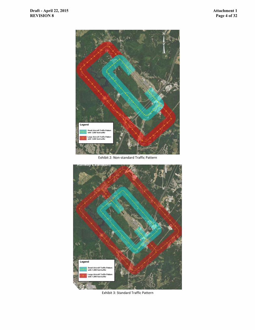
Exhibit 2: Non-standard Traffic Pattern
Exhibit 3: Standard Traffic Pattern
Draft - April 22, 2015 REVISION 8
Attachment 1 Page 4 of 32

C. Airport Impact Zones
The Airport Impact Zones that make up the Airport Planning Area define and address the specific
planning considerations related to land use compatibility in the area identified in the Airport Impact
Overlay District and the Stafford Regional Airport Master Plan. The specific planning considerations
include potential impacts related to exposure to aircraft noise, land use safety with respect both to
people on the ground and the occupants of aircraft; the management of airport airspace; and general
concerns related to aircraft overflights. This Plan designates Airport Impact Zones that closely
correspond with the existing Airport Impact Zoning Overlay District. The zones are utilized in establishing
the corresponding land use compatibility standards.
Approach zones reflect the approach and departure areas for the runway and are divided into several
sub areas.
Approach –Final, Runway Protection Zone (AP-1). The closest area at the end of each runway,
beginning 200-feet from the end of each runway, extending approximately two thousand five
hundred (2,500) feet to the east and one thousand seven hundred (1,700) feet to the west.
Approach – Mid (AP-2). The area that fans out from the Runway Protection Zone, extending
fourteen thousand (14,000) feet to the east and ten thousand (10,000) feet to the west.
Approach – Outer (AP-3). The area that fans out to the east of the runway that extends from
fourteen thousand (14,000) feet to fifty thousand (50,000) feet from the runway.
Approach – Transitional (AP-T). A 5,000 foot wide area extending along each side of the Outer
Approach, beyond the Conical zone.
Transitional (T). The area that fans away perpendicular to any airport runway centerline and approach
surfaces
Horizontal zones include the area that is established by swinging arcs of ten thousand (10,000) feet radii
from the center of the end of the primary surface of an airport runway and connecting adjacent arcs by
drawing lines tangent to those areas. The horizontal zone excludes the approach and transitional zones.
The area is divided into two sub-areas for the purpose of land use compatibility.
Horizontal – Inside Flight Pattern (H-1). The inner portion of the Horizontal zone that encompasses
the majority of the existing and future aircraft traffic patterns.
Horizontal – Outside Flight Pattern (H-2). The outer portion of the Horizontal Zone that
encompasses the outer edge of the Jet/Turboprop (large) aircraft traffic patterns.
Horizontal – Turning Areas (H-3). The area of the Horizontal zone that encompasses the portion of
the traffic pattern area where turning movements occur, where aircraft generate louder noise and
there is increased accident probability.
Conical (C). The area that surrounds and commences at the periphery of the horizontal zone (10,000
feet from the Runway Clear Zone) and extends outward from there for a distance of four thousand
(4,000) feet.
Draft - April 22, 2015 REVISION 8
Attachment 1 Page 5 of 32

Draft - April 22, 2015 REVISION 8
Attachment 1 Page 6 of 32

D. Analysis of the Planning Area
The following analysis shows the area of existing zoning classifications within each zone and the future
land use designations, which identify the types of potential development that may occur. When
comparing current zoning to future land use, the greatest potential for incompatible development to
occur is within the Horizontal Zone. The majority of the area is zoned A-1, Agricultural, with the
potential of being rezoned as the land is planned for Business and Industry, Suburban and Urban
Development Area (UDA) future land use designations. The land use designations within the Horizontal
Zone are described below:
Business and Industry – 1,533 acres - Uses include retail, wholesale, corporate and professional offices,
research and development, entertainment, manufacturing, distribution and transportation; possible
heavy industrial uses; new and used vehicle sales, including automobiles and boats.
Suburban – 725 acres - Uses include single family detached dwelling units, typically on ¼ to ½ acre lots,
maximum density of 3 du/ac; neighborhood and community oriented activity centers, places of worship,
parks and play areas, and retail and business activities with a maximum floor area ratio (FAR) of 0.4.;
industrial uses include warehousing, wholesaling, manufacturing, processing operations, mixed-use
commercial/industrial development, and flex office space.
Urban Development Areas – mix of uses including approximately 8,829 dwelling units and 13,900,800
square feet of commercial retail and office space in an area totaling approximately 3,196 acres, 2,300
acres of which are within the Horizontal Zone.
Draft - April 22, 2015 REVISION 8
Attachment 1 Page 7 of 32

Draft - April 22, 2015 REVISION 8
Attachment 1 Page 8 of 32

Draft - April 22, 2015 REVISION 8
Attachment 1 Page 9 of 32

Existing Future Land Uses and Zoning District Classifications by Airport Impact Zone
1. Final Approach Compatibility Zone (AP-1)
0
20
40
60
80
100
120
140
Business and Industry Resource Protection Area
Acr
eag
e (
Ac)
Future Land Use Type
Future Land Use Acreage within AP-1
0
20
40
60
80
100
120
A1 M1 ROW
Acr
eag
e (
Ac)
Zoning Type
Zoning Acreage within AP-1
Future Land Use Acres
Business and Industry 130.42
Resource Protection Area 0.21
Zoning Acres
A1 2.12
M1 103.05
ROW 25.46
Draft - April 22, 2015 REVISION 8
Attachment 1 Page 10 of 32

2. Middle Approach Compatibility Zone (AP-2)
0100200300400500600700800900
1000
Tota
l Acr
eag
e (
Ac)
Future Land Use Type
Future Land Use Acreage within AP-2
0
200
400
600
800
1000
1200
1400
A1 B1 B2 M1 ROW
Tota
l Acr
eag
e (
Ac)
Zoning Type
Zoning Acreage within AP-2
Future Land Use Acres
Agricultural/Rural 885.18
Business and Industry 278.98
Park 36.74
Resource Protection Area 251.23
Suburban 57.30
Urban Development Areas 0.33
Zoning Acres
A1 1303.13
B1 1.74
B2 12.48
M1 169.78
ROW 22.62
Draft - April 22, 2015 REVISION 8
Attachment 1 Page 11 of 32

3. Outer Approach Compatibility Zone (AP-3)
0
1000
2000
3000
4000
5000
6000
7000
8000
Agricultural/Rural Resource ProtectionArea
Suburban
Tota
l Acr
eag
e (
Ac)
Future Land Use Type
Future Land Use Acreage within AP-3
0
1000
2000
3000
4000
5000
6000
7000
8000
A1 A2 M2 ROW
Tota
l Acr
eag
e (
Ac)
Zoning Type
Zoning Acreage within AP-3
Future Land Use Acres
Agricultural/Rural 7183.19
Resource Protection Area 962.46
Suburban 0.95
Zoning Acres
A1 7430.01
A2 490.70
M2 31.96
ROW 184.95
Draft - April 22, 2015 REVISION 8
Attachment 1 Page 12 of 32

4. Transitional Approach Compatibility Zone (AP-T)
01000200030004000500060007000
Tota
l Acr
eag
e (
Ac)
Future Land Use Type
Future Land Use Acreage within AP-T
0
1000
2000
3000
4000
5000
6000
A1 A2 B1 M1 M2 PD1 R1 RC ROW
Tota
l Acr
eag
e (
Ac)
Zoning Type
Zoning Acreage within AP-T
Future Land Use Acres
Agricultural/Rural 5733.86
Park 273.53
Resource Protection Area 1232.03
Suburban 513.13
Urban Development Areas 63.26
Zoning Acres
A1 5689.74
A2 1404.22
B1 3.62
M1 109.61
M2 20.69
PD1 24.81
R1 232.76
RC 3.80
ROW 260.43
Draft - April 22, 2015 REVISION 8
Attachment 1 Page 13 of 32

5. Transitional Compatibility Zone (T)
0100200300400500600700
Tota
l Acr
eag
e (
Ac)
Future Land Use Type
Future Land Use Acreage within T
0
100
200
300
400
500
A1 A2 B1 B2 M1 M2 ROW
Tota
l Acr
eag
e (
Ac)
Zoning Type
Zoning Acreage within T
Future Land Use Acres
Agricultural/Rural 19.69
Business and Industry 601.24
Park 17.16
Resource Protection Area 66.32
Urban Development Areas 16.74
Zoning Acres
A1 231.17
A2 27.46
B1 7.21
B2 2.11
M1 406.01
M2 1.33
ROW 51.36
Draft - April 22, 2015 REVISION 8
Attachment 1 Page 14 of 32

6. Inner Horizontal Compatibility Zone (H-1)
0
200
400
600
800
1000
1200
Tota
l Acr
eag
e (
Ac)
Future Land Use Type
Future Land Use Acreage within H-1
0
200
400
600
800
1000
1200
1400
1600
A1 A2 B1 B2 B3 M1 M2 R2 R3 ROW
Tota
l Acr
eag
e (
Ac)
Zoning Type
Zoning Acreage within H-1
Future Land Use Acres
Agricultural/Rural 367.09
Business and Industry 862.89
Resource Protection Area 513.69
Suburban 121.38
Urban Development Areas 1024.09
Zoning Acres
A1 1431.06
A2 311.37
B1 0.40
B2 89.20
B3 36.59
M1 711.89
M2 15.96
R2 46.85
R3 12.34
ROW 233.49
Draft - April 22, 2015 REVISION 8
Attachment 1 Page 15 of 32

7. Outer Horizontal Compatibility Zone (H-2)
0100200300400500600700800900
Tota
l Acr
eag
e (
Ac)
Future Land Use Type
Future Land Use Acreage within H-2
0
200
400
600
800
1000
1200
A1 A2 B1 B2 B3 M1 R1 R2 R3 ROW
Tota
l Acr
eag
e (
Ac)
Zoning Type
Zoning Acreage within H-2
Future Land Use Acres
Agricultural/Rural 144.72
Business and Industry 307.29
Resource Protection Area 296.36
Suburban 345.19
Urban Development Areas 770.89
Zoning Acres
A1 989.03
A2 210.99
B1 7.31
B2 129.36
B3 114.76
M1 16.78
R1 51.32
R2 110.35
R3 58.94
ROW 175.86
Draft - April 22, 2015 REVISION 8
Attachment 1 Page 16 of 32
8. Horizontal Turning Zone (H-3)
0200400600800
1000120014001600
Tota
l Acr
eag
e (
Ac)
Future Land Use Type
Future Land Use Acreage within H-3
0
1000
2000
3000
A1 A2 B1 B2 B3 M1 M2 R3 ROW
Tota
l Acr
eag
e (
Ac)
Zoning Type
Zoning Acreage within H-3
Future Land Use Acres
Agricultural/Rural 1421.77
Business and Industry 363.01
Park 172.44
Resource Protection Area 546.92
Suburban 258.66
Urban Development Areas 505.66
Zoning Acres
A1 2488.64
A2 1.78
B1 19.31
B2 182.38
B3 5.23
M1 265.50
M2 41.38
R3 111.65
ROW 152.64
Draft - April 22, 2015 REVISION 8
Attachment 1 Page 17 of 32

9. Conical Compatibility Zone (C)
0500
1000150020002500300035004000
Tota
l Acr
eag
e (
Ac)
Future Land Use Type
Future Land Use Acreage within C
0
1000
2000
3000
4000
5000
6000
Tota
l Acr
eag
e (
Ac)
Zoning Type
Zoning Acreage within C
Future Land Use Acres
Agricultural/Rural 3413.87
Business and Industry 334.81
Resource Protection Area 617.88
Suburban 1802.59
Urban Development Areas 1000.08
Zoning Acres
A1 5325.93
A2 125.04
B1 10.37
B2 262.13
B3 232.20
M1 39.43
M2 22.36
PD1 13.65
PD2 185.72
PTND 11.00
R1 412.15
R2 27.65
R3 119.17
R4 30.45
ROW 344.38
UD 11.68
Draft - April 22, 2015 REVISION 8
Attachment 1 Page 18 of 32

E. Land Use Compatibility Guidelines
The following guidelines are proposed in order to better address the potential for incompatible land
uses and development within the Airport Planning Area:
GOAL: Stafford County shall promote the appropriate use of land in the Airport Planning Area to
maintain and support the viability of the Stafford Regional Airport and protect and promote the general
health, safety, welfare of the citizens, and overall economy in the airport area.
OBJECTIVE 1: Identify the compatibility of various land uses and establish development standards in
relation to airport operations to minimize potential impacts related to exposure to aircraft noise, land
use, and safety with respect both to people on the ground and the occupants of aircraft and ensure the
protection of airport airspace.
Policy 1.1 General concerns related to aircraft overflights shall be identified and mitigated during the
development review process for all applications for uses within the Airport Planning Area.
Policy 1.2: All development within the Airport Planning Area shall be consistent with the Land Use
Compatibility Matrix (Table 1) that identifies whether uses are Compatible, require Additional Review or
are Incompatible within each Airport Impact Zone.
Policy 1.3: The compatibility guidelines shall be applied in conjunction with the requirements of the
Future Land Use Plan recommendations.
Policy 1.4: The impacts of the following factors shall be considered for any development application
within the Airport Planning Area:
1. Height of all structures and vegetation per the FAR Part 77 requirements;
2. Management of earth disturbances and the creation of open dirt areas during activities such as
farming and construction to minimize dust emissions;
3. Reflective surfaces which cause glare, including storm water retention ponds, solar panels
and/or light-colored or mirrored building materials;
4. Light emissions shining upward into the flight path, flashing lights or lights arranged in a linear
pattern;
5. Uses that generate smoke, steam or fog;
6. Potential to attract wildlife and create habitat, such as open space and agricultural uses;
7. Number of people per unit of area per proposed use;
8. Existence of above ground storage of large quantities of materials that are hazardous, such as
flammable, explosive, corrosive, or toxic materials;
9. Location of proposed uses where mobility of users is limited, such as schools, hospitals and
nursing homes;
10. Location of critical community infrastructure, such as power plants, electrical substations, and
public communications facilities, away from areas where damage or destruction could occur
Draft - April 22, 2015 REVISION 8
Attachment 1 Page 19 of 32

and cause significant adverse effects to public health and welfare beyond the immediate
vicinity of the facility;
11. Proposed percentage of open space, including usable open space, in relation to the
development area. For the purposes of this document, usable open space should be open areas
that are long, level and free of obstacles that could serve as an emergency landing site to
promote public safety. The ideal site would be at least 300 feet by 75 feet and be clear of
obstacles;
12. Compatibility of all proposed uses with the Compatibility Matrix in Table 1.
Policy 1.5: The following standards shall apply to all development within the Airport Planning Area:
1. Final subdivision plats, site specific development plans, or any other document filed as part of
any approval process with Stafford County shall contain the following disclosure statement:
All or a portion of this property lies within the Airport Overlay District. Persons
on the premises may be exposed to noise and other effects as may be inherent in
airport operations;
2. Avigation easements shall be dedicated to Stafford Regional Airport for all new residential,
commercial, industrial, institutional or recreational buildings or structures intended for
habitation or occupancy by humans or animals to allow unobstructed passage for aircraft
related to the height requirements per FAR Part 77;
3. Applicable use restrictions shall apply only to the area of development within the respective
compatibility zone;
4. Height restrictions are effective at all times;
5. Underground utilities are encouraged for all development located within approach zones (AP-1
& AP-2) and traffic pattern areas (H-1, H-2, & H-3);
6. Minimize the occurrence of sunlight glare and wildlife attractants from stormwater
management ponds affecting pilots by limiting the size of ponds to under ½ acre in size and
encouraging dry ponds;
7. All development within the Airport Planning Area must, at a minimum, be consistent with
Federal Aviation Regulation Part 77 and Advisory Circular 150/5300-13A and any subsequent
revisions.
Policy 1.6: Uses identified in Table 1 as requiring “Additional Review” shall follow the specific
development standards identified in Table 2. The factors to consider during “Additional Review” shall
include, but may not be limited to: size, scope and scale of a development, such as the area, building
height, and number and square footage of structures; proposed use(s); location of the development in
relation to the airport; location of uses on an individual site; proposed mitigation measures; population
concentrations; and project externalities, defined as impacts related to the development of the project
that may extend beyond the limits of the project both horizontally and vertically.
Policy 1.7: The following additional standards shall apply to Non-Residential Uses that require Additional
Review in Table 1:
Draft - April 22, 2015 REVISION 8
Attachment 1 Page 20 of 32

1. Activities and structures associated with the use shall not exceed the maximum building
envelope ratio and/or site population limitation;
2. Incorporate shielding, such as the use of full cut-off lighting, lower intensity or other techniques
to avoid the occurrence of light emissions shining upward into the flight path; flashing lights; or
lights arranged in a linear pattern;
3. Waste disposal facilities shall not be located within 10,000 feet of the runway protection zone;
4. Provision of new private airfields or runways shall not be permitted within the planning area;
5. Additional open space requirements, height limitations and square footage limitations will apply
to uses with concentrations of people.
Policy 1.8: The following additional standards shall apply to Residential Uses that require Additional
Review in Table 1:
1. Development proposals shall not exceed the maximum density limitations established and
further described in the Table 2 Additional Review Standards;
2. Development within the airport operations area shall be constructed to include sound insulation
methods to achieve maximum internal noise levels of 45 dBc Ldn (average daily noise level);
3. Disclosure notification for all future purchasers of the property will be required for all residential
development within an airport compatibility zone;
4. Provide contiguous open space in conjunction with clustering of residential development areas.
Policy 1.9: Specific projects which are Not Compatible, as identified in Table 1 may be appropriate if it
can be demonstrated that the specific project would not negatively impact airport operations or safety
of the general public upon additional review, consistent with the guidelines.
Policy 1.10: If a proposed use is not listed in Table 1, the use determined to be most similar would apply
and would be evaluated against the related Additional Review criteria and any other standards deemed
appropriate.
Policy 1.11: The County shall support efforts of the Airport Authority or other entity to acquire land
and/or purchase development rights by coordinating receiving areas outside of the planning area in
order to encourage compatible land uses within the planning area.
IMPLEMENTATION POLICIES
Policy 1.12: For projects in the Airport Planning Area, the County shall coordinate review of all proposed
development applications, including, but not limited to, zoning reclassifications, conditional use permits,
site plans, and preliminary plans, with the Airport Authority for compatibility with airport operations and
plans for the purpose of receiving advisory comments and encouraging participation at County
development review meetings.
Policy 1.13: The Zoning Ordinance shall be revised to implement the Compatibility Guidelines
recommendations, including use restrictions, and development and building standards, and make
commensurate adjustments to the Airport Overlay District.
Draft - April 22, 2015 REVISION 8
Attachment 1 Page 21 of 32

Policy 1.14: Comprehensive Plan amendments and Ordinance amendments applicable to land within the
Airport Planning Area shall be reviewed for compatibility with the Regional Airport Master Plan,
Compatibility Matrix (Table 1) and related criteria and standards.
Draft - April 22, 2015 REVISION 8
Attachment 1 Page 22 of 32

TABLE 1: CONSOLIDATED LAND USE COMPATIBILITY MATRIX
1 Residential uses within zones H-1 and H-2 are discouraged. Individual projects may be considered appropriate if it is
determined that it satisfactorily addresses the Additional Review factors highlighted in Table 2.
ZONE CODE AP-1 AP-2 AP-3 AP-T T H-1 H-2 H-3 C
ZONE DESCRIPTION
_______________ USES
AP
PR
OA
CH
- F
INA
L R
UN
WA
Y P
RO
TEC
TIO
N
ZON
E
AP
PR
OA
CH
– M
ID
-14
,00
0’ E
AST
-10
,00
0’ W
EST
AP
PR
OA
CH
– O
UTE
R
(EA
ST)
AP
PR
OA
CH
-
TRA
NSI
TIO
NA
L
TRA
NSI
TIO
NA
L ZO
NE
HO
RIZ
ON
TAL
ZON
E -
INSI
DE
FLIG
HT
PA
TTER
N
HO
RIZ
ON
TAL
ZON
E -
OU
TSID
E FL
IGH
T
PA
TTER
N
HO
RIZ
ON
TAL
–
TUR
NIN
G Z
ON
E
CO
NIC
AL
ZON
E
INSTITUTIONAL Assembly (schools, place of worship, daycare)
NC NC AR C NC AR AR NC C
Hospitals NC NC AR C NC AR AR NC C
Community (Police, fire and rescue, neighborhood centers)
NC AR AR C AR AR C AR C
Vertical Infrastructure (Electric Transmission, Water Towers, Telecommunication Towers)
NC NC AR AR NC AR AR AR AR
RESIDENTIAL
Single-Family - Rural (Maintain 3 acre density with min. lot size of 1 acre outside the USA, while inside the USA, lot sizes can be smaller than 1 acre if significant areas are retained for open space and the lowest density recommendations of the land use plan are not exceeded)
NC AR AR C NC AR AR AR C
Single-family - Small Lot (<1 acre) & Townhomes
NC NC AR C NC AR1 AR
1 NC C
Multi-Family (Three or more units per building)
NC NC AR C NC AR1 AR
1 NC C
Group Living (Nursing homes, group homes)
NC NC AR C NC AR AR NC C
Transient Lodging NC AR C C NC AR AR AR C
COMMERCIAL (RETAIL/OFFICE)
General Retail & Service (shopping centers & stores, restaurants, convenience, vehicle fueling)
NC AR C C AR AR C AR C
Automobile related (sales lot, repair, storage)
NC C C C AR C C C C
Low-rise Office (1-3 stories) NC AR C C AR AR C AR C
Mid/High-rise Office (4+ stories) NC NC AR C NC AR AR NC C
INDUSTRIAL
Light (Light Manufacturing, Storage, Warehouse)
NC AR C C AR AR C C C
Heavy (Landfill, Heavy Manufacturing, bulk fuel storage, mining, uses that emit smoke or create sun glare)
NC NC NC AR NC AR AR AR AR
RECREATION AND OPEN SPACE
Passive (trails & natural areas) NC AR C C NC AR C AR C
Active (community sports fields, golf, indoor facilities)
NC AR AR C NC AR C AR C
Amusement (Stadiums, amusement parks, fairgrounds)
NC NC AR C NC AR AR NC C
Draft - April 22, 2015 REVISION 8
Attachment 1 Page 23 of 32

Key: C = Compatible AR = Additional Review – uses or activities that may be compatible with airport operations depending on their location and specifics of each project. Refer to design standards. NC = Not Compatible – uses or activities that should not be permitted
ZONE CODE AP-1 AP-2 AP-3 AP-T T H-1 H-2 H-3 C
ZONE DESCRIPTION
_______________ USES
AP
PR
OA
CH
- F
INA
L
RU
NW
AY
PR
OTE
CTI
ON
ZON
E
AP
PR
OA
CH
– M
ID
-14
,00
0’ E
AST
-10
,00
0’ W
EST
AP
PR
OA
CH
– O
UTE
R
(EA
ST)
AP
PR
OA
CH
-
TRA
NSI
TIO
NA
L
TRA
NSI
TIO
NA
L ZO
NE
HO
RIZ
ON
TAL
ZON
E -
INSI
DE
FLIG
HT
PA
TTER
N
HO
RIZ
ON
TAL
ZON
E -
OU
TSID
E FL
IGH
T
PA
TTER
N
HO
RIZ
ON
TAL
–
TUR
NIN
G Z
ON
E
CO
NIC
AL
ZON
E
AGRICULTURAL
Grazing, Crops AR AR C C AR AR C AR C
Processing (Lumber mill, grain elevators and silos)
NC NC C C NC AR AR AR AR
OTHER
Aboveground storage tanks of fuel and flammable materials (except residential uses)
NC NC NC C NC NC C NC C
Draft - April 22, 2015 REVISION 8
Attachment 1 Page 24 of 32

ADDITIONAL REVIEW STANDARDS
Overview
Uses identified in Table 1 requiring “Additional Review” shall follow the specific development
standards identified in Tables 2 and 3. The factors to consider during “Additional Review” shall
include, but may not be limited to: size, scope and scale of a development, such as the area, building
height, and number and square footage of structures; proposed use(s); location of the development
in relation to the airport; location of uses on an individual site; proposed mitigation measures;
population concentrations; and project externalities, defined as impacts related to the development
of the project that may extend beyond the limits of the project both horizontally and vertically.
Residential proposals (Single-family - small lot & Multi-family) within the H-1 and H-2 zones
In consideration of a new residential rezoning request from the A-1 or A-2 zoning district, where all
of the Additional Review criteria is satisfied, projects not exceeding a density increase of 50% over
the current density may be considered Compatible. Rezoning from any commercial or other
residential zoning district that adds or increases the permitted residential density is considered Not
Compatible.
Uses in the AP-3, Approach Outer zone requiring Additional Review
Given the size and extent of the AP-3 zone, which extends east to King George County, uses may be
deemed more compatible the farther away they are from the airport. Application of the additional
review standards will be based on the location on a case by case basis and dependent on the site
conditions and specific development proposal.
TABLE 2: ADDITIONAL REVIEW STANDARDS
USE ZONE(S) REQUIRING ADDITIONAL REVIEW
STANDARD
INSTITUTIONAL
Assembly (schools, place of worship, daycare)
H-1; H-2 Limit population concentration thresholds within the low to mid- level range;
Limited to independently mobile populations;
Public and private grade schools and stand-alone daycare are not permitted;
Provide usable open space.
Assembly (schools, place of worship, daycare)
AP-3 Uses considered generally compatible; siting located laterally offset of the extended centerline of the runway is preferred.
Draft - April 22, 2015 REVISION 8
Attachment 1 Page 25 of 32
USE ZONE(S) REQUIRING ADDITIONAL REVIEW
STANDARD
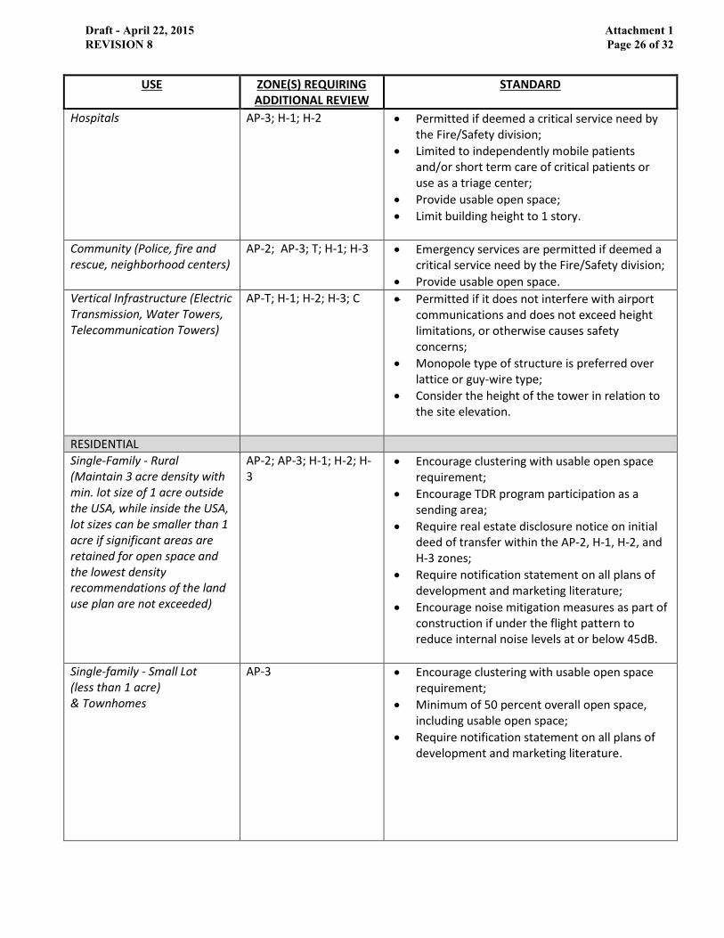
Hospitals AP-3; H-1; H-2 Permitted if deemed a critical service need by the Fire/Safety division;
Limited to independently mobile patients and/or short term care of critical patients or use as a triage center;
Provide usable open space;
Limit building height to 1 story.
Community (Police, fire and rescue, neighborhood centers)
AP-2; AP-3; T; H-1; H-3 Emergency services are permitted if deemed a critical service need by the Fire/Safety division;
Provide usable open space.
Vertical Infrastructure (Electric Transmission, Water Towers, Telecommunication Towers)
AP-T; H-1; H-2; H-3; C Permitted if it does not interfere with airport communications and does not exceed height limitations, or otherwise causes safety concerns;
Monopole type of structure is preferred over lattice or guy-wire type;
Consider the height of the tower in relation to the site elevation.
RESIDENTIAL
Single-Family - Rural (Maintain 3 acre density with min. lot size of 1 acre outside the USA, while inside the USA, lot sizes can be smaller than 1 acre if significant areas are retained for open space and the lowest density recommendations of the land use plan are not exceeded)
AP-2; AP-3; H-1; H-2; H-3
Encourage clustering with usable open space requirement;
Encourage TDR program participation as a sending area;
Require real estate disclosure notice on initial deed of transfer within the AP-2, H-1, H-2, and H-3 zones;
Require notification statement on all plans of development and marketing literature;
Encourage noise mitigation measures as part of construction if under the flight pattern to reduce internal noise levels at or below 45dB.
Single-family - Small Lot (less than 1 acre) & Townhomes
AP-3 Encourage clustering with usable open space requirement;
Minimum of 50 percent overall open space, including usable open space;
Require notification statement on all plans of development and marketing literature.
Draft - April 22, 2015 REVISION 8
Attachment 1 Page 26 of 32

USE ZONE(S) REQUIRING ADDITIONAL REVIEW
STANDARD
Single-family - Small Lot (less than 1 acre) & Townhomes
H-1, H-2 Use prohibited within 3000 feet of the centerline of the runway;
Areas of a proposal located within routine overflight zone should meet the usable and site open space requirements;
Development should be clustered outside of the overflight zone area;
Require real estate disclosure notice on initial deed of transfer;
Require notification statement on all plans of development and marketing literature;
Encourage noise mitigation measures as part of construction if under the flight pattern.
Multi-Family (Three or more units per building)
AP-3; H-1; H-2 Use prohibited within 3000 feet of the centerline of the runway;
Areas of a proposal located within routine overflight zone traffic pattern should be utilized to meet the usable and site open space requirements within a residential development; Cluster residential density outside of the overflight area if feasible;
Limit number of units per building;
Limit height to three stories;
Require real estate disclosure notice on initial deed of transfer within the H-1 and H-2 zones;
Require notification statement on all plans of development and marketing literature;
Encourage noise mitigation measures as part of construction if under the flight pattern.
Group Living (Nursing homes, group homes)
AP-3; H-1; H-2 Population concentration thresholds within low to mid-level range shall not be exceeded;
Limited to independently mobile patients;
Require notification statement on all plans of development and marketing literature.
Transient Lodging AP-2; H-3 Use should not exceed a height of 3 stories;
Population concentration thresholds within low to mid-level range shall not be exceeded;
Encourage noise mitigation measures as part of construction if under the flight pattern;
Parking lot lighting shall not be linear in design to avoid confusion with runway lighting.
Draft - April 22, 2015 REVISION 8
Attachment 1 Page 27 of 32

USE ZONE(S) REQUIRING ADDITIONAL REVIEW
STANDARD
Transient Lodging H-1; H-2 Use should not exceed a height of 3 stories;
Population concentration limits for site and single-acre shall not be exceeded;
Encourage noise mitigation measures as part of construction if under the flight pattern;
Parking lot lighting shall not be linear in design to avoid confusion with runway lighting.
COMMERCIAL (RETAIL/OFFICE)
General Retail & Service (shopping centers & stores, restaurants, convenience, vehicle fueling)
AP-2; T; H-1; H-3 Population concentration limits for site and single-acre shall not be exceeded;
Larger shopping centers should provide usable open space;
Parking lot lighting shall not be linear in design to avoid confusion with runway lighting.
Automobile related (sales lot, repair, storage)
T Limited to vehicle storage or open space;
Parking lot lighting shall not be linear in design to avoid confusion with runway lighting.
Low-rise Office (1-3 stories) AP-2;AP-3; T; H-1; H-3 Provide usable open space requirements;
Maximum population thresholds shall not be exceeded;
Parking lot lighting shall not be linear in design to avoid confusion with runway lighting.
Mid/High-rise Office (4+ stories)
AP-3; H-1; H-2 Population concentration limits for site and single-acre shall not be exceeded;
Consider limitations to building height based on the elevation of the site and proximity to the airport and flight patterns;
Parking lot lighting shall not be linear in design to avoid confusion with runway lighting.
INDUSTRIAL
Light (light manufacturing, storage, warehouse)
AP-2; T; H-1 Low level of population concentration limits shall not be exceeded;
Compatible without externalities;
Provide usable open space;
Parking lot lighting shall not be linear in design to avoid confusion with runway lighting.
Draft - April 22, 2015 REVISION 8
Attachment 1 Page 28 of 32

USE ZONE(S) REQUIRING ADDITIONAL REVIEW
STANDARD
Heavy (landfill, heavy manufacturing, mining, uses that emit smoke or create sun glare)
AP-T; H-1; H-2; C; H-3 Compatible without externalities;
Provide usable open space;
Utilities that affect public health, safety and welfare not permitted within 4,000 feet of the runway;
Consider limitations to structure height based on the elevation of the site and proximity to the airport and flight patterns;
Parking lot lighting shall not be linear in design to avoid confusion with runway lighting.
RECREATION AND OPEN SPACE
Passive (trails & natural areas) AP-2; H-3 Avoid the incorporation of elements, vegetation and/or materials that attract birds,
Limit water retention areas to no greater than .5-acres;
Limit height and types of new and existing vegetation in accordance with the FAR Part 77 requirements.
Active (community sports fields, golf, indoor facilities)
AP-2; AP-3; H-1; H-3 Population concentration limits for site and single-acre shall not be exceeded;
Limit water retention areas to no greater than .5-acres;
Avoid new features, vegetation and/or materials that attract birds.
Amusement (Stadiums, amusement parks, fairgrounds)
AP-3; H-1; H-2 Compatible with increased open space;
Within population concentration limits for site and per acre;
High intensity uses, such as stadiums, are not permitted;
Parking lot lighting shall not be linear in design to avoid confusion with runway lighting.
Draft - April 22, 2015 REVISION 8
Attachment 1 Page 29 of 32

POPULATION CONCENTRATION THRESHOLDS
The population concentration threshold ranges referenced in Table 2 are further defined below. These
serve as a measurement tool to determine whether the population density for a given use may be too
intense for a particular zone.
TABLE 3: POPULATION CONCENTRATION THRESHOLDS
ZONE(S)
SITEWIDE AVERAGE INTENSITY*
SINGLE-ACRE INTENSITY**
AP-1 Sitewide Intensity: Exceptions can be permitted for agricultural activities, roads, and automobile parking provided that FAA criteria are satisfied
AP-2 Sitewide Intensity: Low to Mid: 40 - 50 people per acre Mid to High: 51 - 60 people per acre
Single-Acre Intensity: Low to Mid: 80 -100 people per acre Mid to High: 101 -120 people per acre
T Sitewide Intensity: Low to Mid: 70 - 85 people per acre Mid to High: 86 -100 people per acre
Single-Acre Intensity: Low to Mid: 210 - 255 people per acre Mid to High: 256 - 300 people per acre
H-1; H-2 Sitewide Intensity: Low to Mid: 200 - 250 people per acre Mid to High: 251 - 300 people per acre
Single-Acre Intensity: Low to Mid: 800 - 1000 people per acre Mid to High: 1001 - 1200 people per acre
H-3 Sitewide Intensity: Low to Mid: 70 - 85 people per acre Mid to High: 86 - 100 people per acre
Single-Acre Intensity: Low to Mid: 210 - 255 people per acre Mid to High: 256 - 300 people per acre
Source: California Airport Land Use Planning Handbook (Handbook) released October 2011 by the
California Department of Transportation, Division of Aeronautics.
*Sitewide Average Intensity: calculated by determining the total number of people expected to be on
the site at any given time under normal conditions and dividing by the total number of acres of the
project site.
** Single-Acre Intensity: calculated by determining the total number of people expected to be within
any one-acre portion of the site at one time.
Draft - April 22, 2015 REVISION 8
Attachment 1 Page 30 of 32

STAFFORD REGIONAL AIRPORT SAMPLE REAL ESTATE DISCLOSURE STATEMENT
The following is a sample disclosure statement that is recommended to be incorporated into the initial
sale of new homes located within the Airport Impact Areas:
STAFFORD REGIONAL AIRPORT DISCLOSURE
The purchaser(s) of property at the following address: , on Assessor’s
Parcel , located in Stafford County Virginia, hereafter referred to as “property”,
acknowledges that the property lies in proximity to Stafford Regional Airport, and that the property is
subject to aircraft operations and aircraft overflight, with related noise and safety concerns.
While air traffic may be generalized into tracks, it is, by nature, dispersed. Aircraft may approach and
depart the airport from any number of directions. Flight paths vary depending on a variety of factors
including origin/destination, wind conditions and other aircraft in the traffic pattern. As a result, any
property in the vicinity of an airport is likely to be subject to aircraft overflight and its impacts to some
degree. Stafford County’s Comprehensive Plan has an exhibit that depicts the aircraft traffic patterns
associated with the airport.
Flight patterns may shift or change over time. Changes in operations may occur due to weather, changes
in users, changes in aircraft type, military missions, weather conditions, etc. The airport is relatively new
and still growing. Runway expansion and expansion of ground facilities are planned that will likely
increase the number of flights in and out of the airport. The Stafford Regional Airport has a Master Plan
that identifies plans for future expansion and development needs.
The undersigned purchaser(s) of said tract of land certify(ies) that he/she (they) has (have) read the
above disclosure statement and acknowledge(s) the pre-existence of the Stafford Regional Airport and
the noise exposure due to the airport.
Dated this day of , 20 .
Purchaser’s Signature
Purchaser’s Signature
Purchaser’s Signature
Draft - April 22, 2015 REVISION 8
Attachment 1 Page 31 of 32
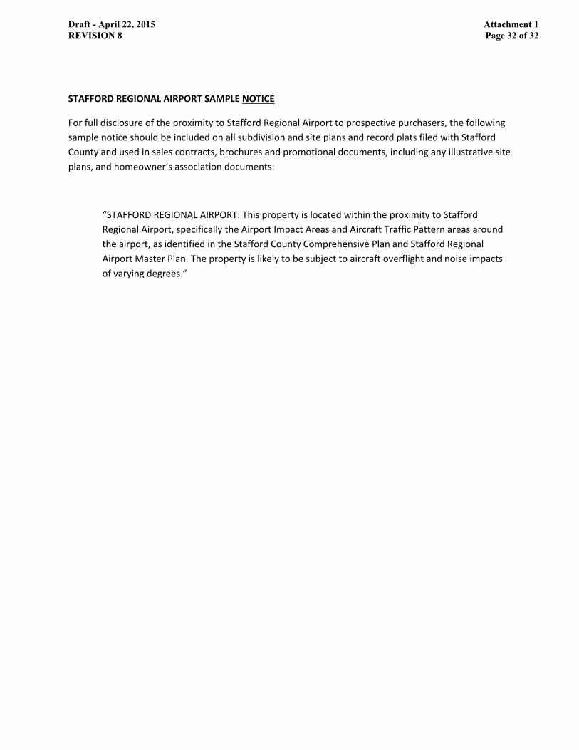
STAFFORD REGIONAL AIRPORT SAMPLE NOTICE
For full disclosure of the proximity to Stafford Regional Airport to prospective purchasers, the following
sample notice should be included on all subdivision and site plans and record plats filed with Stafford
County and used in sales contracts, brochures and promotional documents, including any illustrative site
plans, and homeowner’s association documents:
“STAFFORD REGIONAL AIRPORT: This property is located within the proximity to Stafford
Regional Airport, specifically the Airport Impact Areas and Aircraft Traffic Pattern areas around
the airport, as identified in the Stafford County Comprehensive Plan and Stafford Regional
Airport Master Plan. The property is likely to be subject to aircraft overflight and noise impacts
of varying degrees.”
Draft - April 22, 2015 REVISION 8
Attachment 1 Page 32 of 32


Department of Planning and Zoning MEMORANDUM TO: Community and Economic Development Committee FROM: Jeffrey A. Harvey Director of Planning and Zoning DATE: September 1, 2015 SUBJECT: Outdoor Music Festivals
The County Code allows for music festivals to be conducted within the county with the approval of a permit approved by the Board of Supervisors. The approval process for such a permit can become an issue when the submittal of the application and the meeting schedule of the Board do not mesh. Staff suggests drafting a proposed text amendment to allow the County Administrator to approve such permits after appropriate staff has reviewed and insured compliance with the regulations of the County Code. The following bullet points outline the current process and proposed process.
• Current regulations
o Section 4 of County Code
o Submittal of application
o Review by appropriate departments
o Approval by Board of Supervisors
• Proposed Process and Regulations
o Section 4 of County Code will still be the regulating section of the Code
o Zoning Department will be the coordinating agency
o Submit application to Zoning Department
o Application circulated to appropriate agencies
o If all agencies approve application
MEMORANDUM

o County Administrator will sign and permit will be issued
• Item that may change:
o Time frame for submitting application - change to 60 days from 21 days - allow all agencies to ensure their portion of application is in compliance
o Approval by County Administrator instead of Board of Supervisors
JAH:SWB Attachment

Page 1
ARTICLE II. - OUTDOOR MUSICAL OR ENTERTAINMENT FESTIVALS
DIVISION 1. - GENERALLY
Sec. 4-21. - Authority for and purpose of article.
This article is enacted pursuant to Code of Virginia, § 15.2-1200 for the purpose of providing necessary regulation for musical or entertainment festivals in the interest of the public health, safety and welfare of the citizens and inhabitants of the county.
(Code 1979, § 7-1; Ord. No. 097-68, 11-18-97)
Sec. 4-22. - Construction of article.
The provisions of this article shall be liberally construed in order to effectively carry out its purpose in the interest of the public health, welfare and safety of the citizens and residents of the county.
(Code 1979, § 7-10)
Sec. 4-23. - Violations of article.
Any person who violates any provision of this article shall be guilty of a class 1 misdemeanor. Each violation shall constitute a separate offense. The board of supervisors may bring suit in the circuit court of the county to restrain, enjoin or otherwise prevent violation of this article.
(Code 1979, § 7-8)
Cross reference— Penalty for class 1 misdemeanor, § 1-11.
Sec. 4-24. - Definition.
As used in this article, the term "musical or entertainment festival" or "festival" shall mean any gathering of groups or individuals in excess of twenty-five (25) persons for the purpose of listening to or participating in entertainment which consists primarily of musical renditions conducted in open spaces on private property and not within an enclosed structure or other structure designed to accommodate groups of persons.
(Code 1979, § 7-2)
Sec. 4-25. - Length of performances.
Music shall not be rendered nor entertainment provided at a festival for more than eight (8) hours in any twenty-four (24) hour period, such twenty-four (24) hour period to be measured from the beginning of the first performance at the festival.
(Code 1979, § 7-5)
Sec. 4-26. - Admission of minors.

Page 2
No person under the age of eighteen (18) years shall be admitted to any festival, unless accompanied by a parent or guardian, the parent or guardian to remain with such person at all times.
(Code 1979, § 7-6)
Secs. 4-27—4-35. - Reserved.
DIVISION 2. - PERMIT
Sec. 4-36. - Required.
No person shall stage, promote or conduct any musical or entertainment festival in the unincorporated areas of the county, without first obtaining a permit so to do issued pursuant to this division.
(Code 1979, § 7-3)
Sec. 4-37. - Application generally.
Application for a permit require by this division shall be in writing on forms provided for the purpose and filed in duplicate with the clerk of the board of supervisors at least twenty-one (21) days before the date of the proposed festival. Such application shall have attached thereto and made a part thereof the plans, statements, approvals and other documents required by this division.
(Code 1979, § 7-3)
Sec. 4-38. - Statements, plans, etc., to accompany application.
(a) A permit required by this division shall not be issued unless the following conditions are met and the following plans, statements, approvals and other items are submitted with the application:
(1) A copy of the ticket or badge of admission to the festival, containing the date or dates and time or times of the festival, together with a statement by the applicant of the total number of tickets to be offered for sale and the best reasonable estimate by the applicant of the number of persons expected to be in attendance.
(2) A statement of the names an addressed of the promoters of the festival, the financial backing of the festival and the names of all persons or groups who will perform at the festival.
(3) A statement of the nature and location of the proposed festival, the name and address of the owner of the property on which the festival is to be held and the interest of the applicant therein.
(4) A plan for adequate sanitation facilities and garbage, trash and sewage disposal for persons at the festival. This plan shall meet the requirements of all state and local statutes, ordinances and regulations and shall be approved by the health officer. [2]
(5) A plan for providing food, water and lodging for the persons at the festival. This plan shall meet the requirements of all state and local statutes, ordinances and regulations and shall be approved by the health officer.
(6) A plan for adequate medical facilities for persons at the festival, approved by the health officer.
(7) A plan for adequate parking facilities and traffic control in and around the festival area. [3]

Page 3
(8) A plan for adequate fire protection. This plan shall meet the requirements of all state and local statutes, ordinances and regulations and shall be approved by the fire marshal. [4]
(9) A statement specifying whether any outdoor lights are to be utilized, and if so, a plan showing the location of such lights and shielding devices or other equipment to prevent unreasonable glow beyond the property on which the festival is located.
(10) A statement that no music shall be played, either by mechanical device or live performance, in such a manner that the sound emanating therefrom shall violate any provision of chapter 16 of the County Code. [5]
(b) It shall be unlawful for any person obtaining a permit under this division to fail or refuse to comply with any of the plans, statements or other documents submitted pursuant to this section.
(Code 1979, § 7-4; Ord. No. O10-44, 10-5-10)
Footnotes:
--- (2) ---
Cross reference— Solid waste, Ch. 21; sewage disposal, Ch. 25.
--- (3) ---
State Law reference— Motor vehicles and traffic, Ch. 15.
--- (4) ---
Cross reference— Fire prevention and protection, Ch. 12.
--- (5) ---
Cross reference— Noise, Ch. 16.
Sec. 4-39. - Copy of application to be sent to board members.
On the day an application for a permit is filed under this division, the clerk of the board of supervisors shall send a copy of the application, by certified mail, to each member of the board.
(Code 1979, § 7-3)
Sec. 4-40. - Applicant to furnish permission for entering property.
No permit shall be issued under this division, unless the applicant shall furnish to the board of supervisors written permission for the board, its lawful agents and duly constituted law-enforcement officers to go upon the property at any time for the purpose of determining compliance with the provisions of this article.
(Code 1979, § 7-7)
Page 4
Sec. 4-41. - Grant or denial.
The board of supervisors shall act on an application for a permit under this division within ten (10) days from the filing of the same. If granted, the permit shall be issued in writing on a form provided for the purpose and mailed by the clerk of the board to the applicant at the address indicated. If denied, the refusal shall be in writing, with the reasons for such denial stated therein, and mailed by the clerk to the applicant at the address indicated.
(Code 1979, § 7-3)
Sec. 4-42. - Revocation.
The board of supervisors shall have the right to revoke any permit issued under this division upon noncompliance with any of its provisions and conditions.
(Code 1979, § 7-7)
Secs. 4-43—4-65. - Reserved.

#________
BOARD OF SUPERVISORS Agenda Item
Meeting Date:
September 1, 2015
Title:
Authorize the County Administrator to Execute a Contract for Computer Software Services for Electronic Plan Review
Department:
Planning and Zoning
Staff Contact:
Jeffrey Harvey, Director
Board Committee/ Other BACC:
N/A
Staff Recommendation:
Approval
Budget Impact:
See Background Report
Time Sensitivity:
See Background Report
ATTACHMENTS:
1. Background Report 2. Proposed Resolution R15-288
REVIEW:
X Consent Agenda Other Business Unfinished Business Discussion Presentation Work Session New Business Public Hearing Add-On
X County Administrator
X County Attorney
X Finance and Budget
X Information Technology
DISTRICT: N/A

Attachment 1 R15-288
BACKGROUND REPORT The FY2016 budget identifies on-line permitting (electronic plan review) as a desired capital asset in the Capital Improvement Program (CIP). The Departments of Fire and Rescue, Planning and Zoning, Public Works, and Utilities, review plans and permits for new developments and building renovations in the County. As a means to add convenience and efficiency for the County’s customers in the process of submission and County agencies in the process of review and approval of plans and permits, these departments desire that applications be submitted and reviewed electronically. On-line permitting is a growing trend across the nation. It allows customers to file applications at any time. It saves customers substantial time and costs, and allows customers to avoid making a trip to the Government Center to file or pick-up approved applications. Customers will no longer have to pay substantial copying costs for plan submittals, some of which cost several hundred dollars to print. The review process often requires the submittal of multiple plan sets and revisions prior to approval. Staff believes that the County will save money on storage costs and will also demonstrate increased efficiencies. The proposed contract is with SHI International Corporation (SHI) under state contract (VITA Contract # VA-140401-SHI). SHI is an authorized reseller for the purchase, installation, training, and maintenance of Avolve Software Corporation. Under the proposed contract with SHI, there would be no need for the County to purchase equipment to implement or maintain the software. The software interfaces with the HANSEN 8 software currently used by County agencies for processing permits and plan applications, inspections, asset management, and work orders. It is proposed as a five-year contract for software services including “software as a service hosting.” The proposed cost of the five-year contract for software services, including hosting, will be $150,211 per year, with a total cost of $751,055. Funding for the first year of the project is included in the FY2016 cash capital budget. Future years’ funding will be addressed in the full context of the budget. Technology fees, adopted for a five-year period, will pay the costs of the recent HANSEN upgrade, with FY2016 being the third year. It is expected that the full costs of the HANSEN upgrade with be reimbursed with fees collected through FY2016. The Board may wish to consider extending technology fees to cover the costs of this system enhancement, providing a higher level of service without increasing fees. Staff recommends approval of proposed Resolution R15-288, which authorizes the County Administrator to execute the proposed five-year contract with Avolve Software Corp. for an annual cost of $150,211.

R15-288
PROPOSED
BOARD OF SUPERVISORS COUNTY OF STAFFORD STAFFORD, VIRGINIA
RESOLUTION
At a regular meeting of the Stafford County Board of Supervisors (the Board) held in the Board Chambers, George L. Gordon, Jr., Government Center, Stafford, Virginia, on the 1st day of September, 2015: ---------------------------------------------------------------------------------------------------------- MEMBERS: VOTE: Gary F. Snellings, Chairman Laura A. Sellers, Vice Chairman Meg Bohmke Jack R. Cavalier Paul V. Milde III Cord A. Sterling Robert “Bob” Thomas, Jr. ---------------------------------------------------------------------------------------------------------- On motion of , seconded by , which carried by a vote of , the following was adopted:
A RESOLUTION AUTHORIZING THE COUNTY ADMINISTRATOR TO EXECUTE A CONTRACT WITH AVOLVE SOFTWARE CORP. FOR COMPUTER SOFTWARE SERVICES FOR ELECTRONIC PLAN REVEW
WHEREAS, the FY2016 Capital Improvement Program (CIP) identified on-line permitting (electronic plan review) as a desired capital asset, with funding available in the County’s General Fund; and WHEREAS, SHI International Corporation (SHI) provides electronic “software as a service” for electronic plan and permit review that is complementary to and compatible with existing computer software programs used by the County to enable on-line permitting; and WHEREAS, SHI is a named vendor under state contract to provide these services; and WHEREAS, SHI submitted a proposal to provide on-line permitting services to the County and the proposal is reasonable for the scope of work to be performed; and WHEREAS, the Board desires to provide efficient and effective services to the County’s customers; and WHEREAS, the Board believes that on-line permitting will benefit the County, in addition to its customers, in the review and approval process for plans and permits;

R15-288 Page 2 NOW, THEREFORE, BE IT RESOLVED by the Stafford County Board of Supervisors on this the 1st day of September, 2015, that the Board be and it hereby does authorize the County Administrator, or his designee, to execute a five-year contract for services with SHI International Corporation with the first year payment of One Hundred Fifty Thousand Two Hundred Eleven Dollars ($150,211), unless amended by a duly-executed contract amendment. AJR:JAH:sd

Department of Planning and Zoning MEMORANDUM TO: Community and Economic Development Committee FROM: Jeffrey A. Harvey Director of Planning and Zoning DATE: September 1, 2015 SUBJECT: Lighting Ordinance issues
The lighting regulations were adopted on September 3, 2013 with Ordinance O13-34.
Purpose of lighting regulations: is to establish outdoor lighting standards that will minimize glare, light trespass, over lighting and sky glow, which improving the safety and security, and conserving energy for businesses and residents of Stafford County.
Staff has received the following complaints concerning the regulations and has offered potential solutions to these complaints. Below are talking points based on comments received and observed plan review situations since adoption of the current standards.
Lighting Ordinance issues
o Complaint - Foot candle minimums are too high and require too many light poles for commercial development The uniform minimum light level is to prevent dark spots on a site and is a safety
issue Possible solution - Can look at adjusting the light levels to allow for more
flexibility but still provide for a safe environment (average versus minimum) Plans with high numbers of light poles appear to be using non- LED lights LED lights generally cost more up front but have long term cost savings
(construction cost trade-off more poles and fixtures versus more costly bulbs)
o Conflict with VDOT road lighting levels on commercial sites Sidewalk is required to be lit to 3.0 foot candles. VDOT standard is 0.3 foot candles on the face (vertical back) of curb for lighting
not considered roadway lighting
MEMORANDUM

Sidewalk is too close to pavement and light spills into roadway exceeding VDOT light levels
Possible solution is to adjust light levels on sidewalk when fixtures are 4 feet from pavement
Do not provide for trail lighting at recreation facilities
o Conflict with VDOT road lighting levels on residential sites County Code requires 0.5 foot candles on sidewalk located in right of way and is
too far away to qualify as roadway lighting. All sidewalks are located in right of way County is required to maintain lights in the right of way. If move light poles back to keep light from spilling onto roadway pavement, the
required 0.5 level is not met on the sidewalk Subdivision Ordinance requires lights in each yard, allows for homeowners to
turn lights off and therefore no lit sidewalks One possible solution is to require easement adjacent to sidewalk, HOA installs
and controls lights Do we want street lights or sidewalk lights?
o Commercial Lighting security levels are not realistic
programing lights must be done individually, very cumbersome and costly


Department of Planning and Zoning MEMORANDUM TO: Community and Economic Development Committee FROM: Jeffrey A. Harvey Director of Planning and Zoning DATE: September 1, 2015 SUBJECT: Readiness and Environmental Protection Integration (REPI) Program Progress Report and Overall Land Conservation Efforts
Background At the February 3, 2015 Community and Economic Development Committee meeting, staff presented an update regarding the REPI program to the Committee. Representatives from the Northern Virginia Conservation Trust (NVCT) attended the meeting, as well as a representative from Marine Corp Base Quantico (MCBQ). Ryan Stewart, Land Conservation Specialist for NVCT, presented an assessment of MCBQ's Encroachment Partnership priority parcels against various environmental data NVCT uses to assess the feasibility of its own projects. The correlation between the two sets of priorities, as well as interest expressed from landowners, has provided a starting point for outreach to landowners. Steve Hundley, Community Plans & Liaison Officer with MCBQ, indicated an application round for new REPI funds will be announced later this spring. March 3, 2015 Update Staff continued its cooperative effort with NVCT and the Base. Staff reviewed the existing list of potential parcels and removed some parcels from the list that have either been developed, or have been placed in a conservation easement. In addition, NVCT completed the following:
• Verified ownership of the highest priority partnering/REPI candidates • Updated records to account for properties no longer under consideration • Begun the process of creating outreach materials for landowners • Conducted a site visit and met with a property owner on Poplar Road who recently
contacted the County and expressed interest in the program April 14, 2015 Update Staff contacted the Base to determine if an application date has been set, but there has been no announcement to date. NVCT continues its outreach efforts to property owners, and has met with two owners that have expressed interest. Staff will be scheduling a joint meeting with NVCT and MCBQ in late April to further review potential properties.
MEMORANDUM

MEMO TO: Community and Economic Development Committee September 1, 2015 Page 2 May 5, 2015 Update The Base has announced the next application deadline of July 15th. Staff will continue to work with NVCT and the Base to identify any potential property(ies) that may be submitted. Staff will continue to provide monthly progress reports to the Committee. June 2, 2015 Update Staff and NVCT have identified two potential properties from the existing list that are both considered priority properties. Discussions have been held with the property owners, and further meetings are anticipated prior to submission of the applications to the Base. The properties are: Jenkins
• Assessor’s Parcel 19-47 • 8 acres • Forested parcel • Adjacent to MCBQ and Aquia Creek, west of Tech Parkway
Sterne
• Assessor’s Parcels 17-23A and 25 • 220 acres • Agricultural and forested parcels • West of the intersection with Mountain View Road and Poplar Road
Staff will complete the applications and submit to the Base, subject to owner authorization, by the July 15th deadline. At that time, the Base will review all applications submitted from the three adjacent localities and choose one property to be considered for funding. July 7, 2015 Update Staff has completed draft applications to submit to the Base. A meeting with Jenkins family is scheduled for June 23rd to review and finalize their application, and a meeting with the Sterne family is scheduled for June 30th to review and finalize their application. September 1, 2015 Update County staff submitted the Jenkins Property and Sterne Property applications to MCBQ staff on July 2nd. MCBQ staff submitted both applications to Marine Corps Installations Command on July 31st. The following is a summary of next steps:
• Marine Corps Installations Command will review and prioritize all the Marine Corps proposals
• Proposals will be forwarded to Department of Navy to be prioritized along with Navy installations REPI proposals

MEMO TO: Community and Economic Development Committee September 1, 2015 Page 3
• REPI proposals from all military branches of service will be submitted to Office of Secretary of Defense (OSD) by September 30th
• OSD will review all proposals and prioritize by late November • Preliminary funding will be allocated in December. • Applicants will be notified of project selection by early January
If the County is successful in receiving funds, information will be forwarded to the Board for authorization to proceed. JAH:KCB:kb

Department of Planning and Zoning MEMORANDUM TO: Community and Economic Development Committee FROM: Jeffrey A. Harvey Director of Planning and Zoning DATE: September 1, 2015 SUBJECT: PD-2 Lot Width for Single Family Homes
The PD-2, Planned Development – 2 Zoning District is intended to provide areas of the County of not less than 500, nor more than 850 acres which are suitable for planned, neo traditional mixed use development with a variety of housing types and commercial uses intended to serve the immediate community. Since the establishment of the PD-2 district, the Embrey Mill development has been the only property rezoned to PD-2 in the County. The Embrey Mill development is a mix of residential and commercial uses, and is currently under construction. The residential uses consist of townhouses and a variety of single-family detached housing types. The developer wishes to expand the offering of single-family housing types and requested that the zoning ordinance be amended to permit a smaller lot size to accommodate a smaller dwelling, without any increase in overall density. The proposed amendments would reduce the minimum lot width from 50 feet to 40 feet, while the area of the lot and the setbacks would not be affected by this proposed amendment (Attachment 1). The proposed amendment, Ordinance O15-33 (Attachment 3), would allow for such a change and promote the goals and objectives of the Comprehensive Plan to provide a variety of housing types and sizes within the County. The Board discussed this matter at the August 18, 2015 meeting and referred it back to the CEDC. Board members requested additional background information from the developer regarding this request to include the proposed size of the homes to be built on the lots, proposed price of homes compared to homes on the wider lots as currently allowed and fiscal impacts if any to the County for the smaller sized lots. The representative for the Embrey Mill development has included additional information to support the request (Attachment 2) JAH: Attachments (3)
MEMORANDUM

Attachment 2 Page 1 of 2

Attachment 2 Page 2 of 2


Attachment 3 Page 1 of 2
O15-33
PROPOSED
BOARD OF SUPERVISORS COUNTY OF STAFFORD STAFFORD, VIRGINIA
ORDINANCE
At a regular meeting of the Stafford County Board of Supervisors (the Board) held in the Board Chambers, George L. Gordon, Jr., Government Center, Stafford, Virginia, on the _____ day of __________, 2015: ---------------------------------------------------------------------------------------------------------- MEMBERS: VOTE: Gary F. Snellings, Chairman Laura A. Sellers, Vice Chairman Meg Bohmke Jack R. Cavalier Paul V. Milde, III Cord A. Sterling Robert “Bob” Thomas, Jr. ---------------------------------------------------------------------------------------------------------- On motion of , seconded by , which carried by a vote of , the following was adopted:
AN ORDINANCE TO AMEND AND REORDAIN STAFFORD COUNTY CODE SEC. 28-55 “PLANNED DEVELOPMENT-2 DISTRICT (PD-2) REGULATIONS”
WHEREAS, the Planned Development - 2 District (PD-2) promotes a large mixed-use development with a variety of housing types and commercial uses; and WHEREAS, the development community has demonstrated the need to accommodate additional housing types with smaller lot widths; and WHEREAS, the Board desires to promote the goals and objectives of the Comprehensive Plan to provide a variety of housing types and lot sizes within the mixed-use developments; and WHEREAS, the Board desires to amend the Zoning Ordinance to modify the PD-2 Zoning District lot width to accommodate these housing types; and WHEREAS, the Board carefully considered the recommendations of the Planning Commission and staff, and the public testimony, if any, received at the public hearing; and

Attachment 3 Page 2 of 2
O15-33 Page 2 WHEREAS, the Board finds that the proposed amendments promote the health, safety, and welfare of the County and its citizens; NOW, THEREFORE, BE IT RESOLVED by the Stafford County Board of Supervisors on this the ____ day of ______ , 2015, that proposed amendments to Stafford County Code Sec. 28-55 “Planned Development-2 District Regulations” pursuant to proposed Ordinance O15-33, be and they hereby are amended and reordained as follows with all other portions remaining unchanged: Sec. 28-55. - Planned Development - 2 District (PD-2) regulations. (d) Single-family /duplex residences. Single-family detached and duplex residential units shall conform to the following requirements. (3) Minimum lot width per unit shall be fifty forty (50 40 ) feet. AJR:SWB:sd

Department of Planning and Zoning
TO: Community and Economic Development Committee
FROM: Jeffrey A. Harvey Director of Planning and Zoning DATE: September 1, 2015
SUBJECT: Minor Amendment Application Fees
The County has received a request for revised application review fees associated with Minor Conditional Use Permit (CUP) Amendment and Minor Proffer Amendment applications. The Department of Planning and Zoning has separate applications, with separate fees, for both. In order to qualify for a minor amendment, applications must not have 1) more than two proffered conditions to be changed at the time of request; 2) changes that materially affect site layout; or 3) changes that affect intensity, use, or functionality of the site. These applications have lower fees than standard CUP and Proffer Amendment applications, as they typically require less staff services to process.
Minor CUP Amendment and Proffer Amendment applications may be submitted simultaneously for a property. In some cases, the CUP conditions and the proffers mirror each other, so the amendments to each application are virtually the same. Based on the reduced staff services needed to review both amendments simultaneously, the need for two application fees may be unnecessary.
The current fees for Minor CUP Amendment and Minor Proffer Amendment applications are $6,190 each, plus incidental costs for adjacent property notification and a technology fee. An applicant would pay approximately $12,380 for two applications. Staff is proposing that each application fee be reduced by half in the instance where both applications are submitted simultaneously, and the same amendments to each application are proposed. This would result in a total fee of approximately $6,190 for the two applications.
A public hearing would be required to consider Ordinance O15-34 (attached), which proposes new fees for simultaneous applications for Minor CUP Amendments and Minor Proffer Amendments, where the same amendments to each application are proposed. JAH:kb Attachment
MEMORANDUM

O15-34
PROPOSED
BOARD OF SUPERVISORS COUNTY OF STAFFORD STAFFORD, VIRGINIA
ORDINANCE
At a regular meeting of the Stafford County Board of Supervisors (the Board) held in the Board Chambers, George L. Gordon, Jr., Government Center, Stafford, Virginia, on the day of , 2015: ---------------------------------------------------------------------------------------------------------- MEMBERS: VOTE: Gary F. Snellings, Chairman Laura A. Sellers, Vice Chairman Meg Bohmke Jack R. Cavalier Paul V. Milde, III Cord A. Sterling Robert “Bob” Thomas, Jr. ---------------------------------------------------------------------------------------------------------- On motion of , seconded by , which carried by a vote of , the following was adopted:
AN ORDINANCE TO AMEND AND REORDAIN FEES FOR LAND DEVELOPMENT APPLICATION REVIEW SERVICES WHEREAS, Virginia Code §§ 15.2-2240 and 15.2-2286 authorize the Board to
set reasonable fees for land development application review services provided by the County’s Department of Planning and Zoning; and
WHEREAS, the Board desires to amend the Stafford County Schedule of Fees to add a review fee specifically for Minor Conditional Use Permit Amendment and Minor Proffer Amendment applications when submitted simultaneously for the same amendments; and
WHEREAS, the proposed review fee for each application would be half the
amount of the standard review fee; and WHEREAS, the Board last amended the County’s land development application
service fees on June 18, 2015, with the adoption of Ordinance O15-26; and
WHEREAS, the Board desires and is required to keep fees current with the actual costs of providing this review service; and WHEREAS, the Board carefully considered the recommendations of staff, and the public testimony, if any, at the public hearing; and

O15-34 Page 2
WHEREAS, the Board finds that public necessity, convenience, general welfare, and good planning and zoning practices require the adoption of this Ordinance;
NOW, THEREFORE BE IT ORDAINED by the Stafford County Board of
Supervisors on this the day of , 2015, that the schedule of fees for land development application review services provided by the Department of Planning and Zoning, be and it hereby is amended and reordained as follows, all other portions remaining unchanged: Service
Current Fee Proposed Fee Percent Change
Minor Proffer Amendment (when submitted simultaneously with Minor Conditional Use Permit Condition Amendment*) - General Fee
$0 $3,095 +2.75% technology
fee
100%
Minor Proffer Amendment (when submitted simultaneously with Minor Conditional Use Permit Condition Amendment*) - Adjacent Property Notification
$0
$6.48/adjacent
property notification
100%
Minor Conditional Use Permit Condition Amendment (when submitted simultaneously with Minor Proffer Amendment*) - General Fee
$0
$3,095
+2.75% technology fee
100%
Minor Conditional Use Permit Condition Amendment (when submitted simultaneously with Minor Proffer Amendment*) - Adjacent Property Notification
$0 $6.48/adjacent property notification
100%

O15-34 Page 3
*Only applies to applications that are amending comparable proffers and conditions in accordance with County Code Sec. 28-162(f) regarding minor amendments to approved Proffers, and County Code Sec. 28-185(5) regarding minor amendments to approved Conditional Use Permit conditions.
BE IT FURTHER ORDAINED that this Ordinance shall become effective on the __________ day of ________, 2015.
AJR:JAH:kb

CEDC - Quarterly Update
Site E-Newsletter Website Social media
Visits Walk-ins Outreach Views interactions
1st Qtr 54 248 5,098 13,258 145,502
2nd Qtr 56 279 8,419 16,954 114,643
Year Period Delta % Growth Delta % Growth Delta % Growth
2009 4th Qtr 2,259 35,064 $882
2013 4th Qtr 2,327 1 year 67 2.88% 39,753 1 year 308 0.77% $886 1 Year 34 3.84%
2014 4th Qtr 2,394 5 year 135 5.98% 40,061 5 year 4,997 14.25% $920 5 Year 38 4.31%
Period
Unemployment
Rate (%)* 2Q15 ** 1 yr trend 5 yr trend
Jun-10 6.6 Office 16.50%
Jun-14 5.4 Industrial 11.00%
Jun-15 5.1 Retail 5.40%
** Source: CoStar
NOTE: Updated March, June, September, and December with calendar year investment and square footage data included in every March report.
INPUTS2015 Economic Development Activity Report
*Source: LAUS Unit and Bureau of Labor Statistics
Source: VEC/Labor Market Statistics, Covered Employment and Wages Program (lags 2 Qrts behind)
OUTPUTSQuarterly Census of Establishments / Employment / Wages for Stafford County
Average Establishments Average Employment Average Weekly Wage
Commercial Vacancy Rates - 2Q15Monthly Unemployment