Embed Size (px)
Citation preview
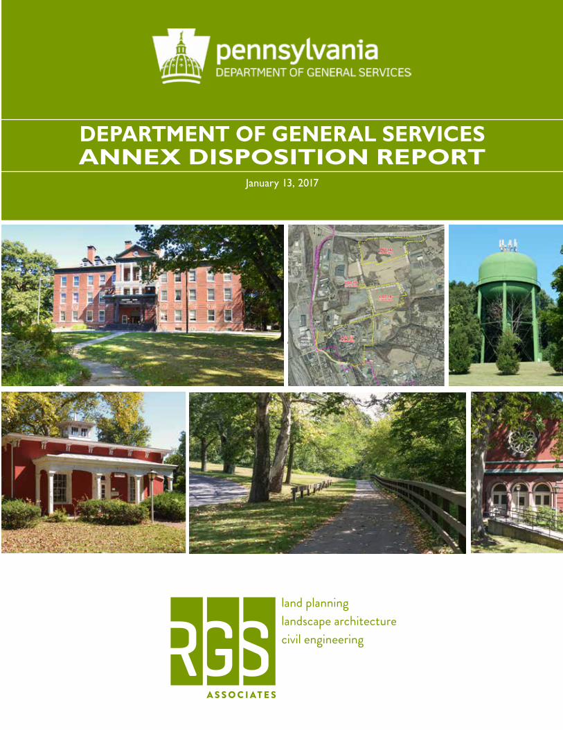
DEPARTMENT OF GENERAL SERVICESANNEX DISPOSITION REPORT
January 13, 2017
p. 2
ACKNOWLEDGMENTS
COMMONWEALTH OF PENNSYLVANIAGovernor Tom Wolf
PENNSYLVANIA DEPARTMENT OF GENERAL SERVICESCurt Topper, SecretaryJulien Gaudion, Deputy Secretary for Property & Asset ManagementElizabeth Woods, Director, Bureau of Real Estate
STAKEHOLDERS
STATE LEGISLATURESue Helm, Pennsylvania House of Representatives Patty Kim, Pennsylvania House of RepresentativesKimberly Morewood, Pennsylvania House of RepresentativesRob Teplitz, Pennsylvania State Senate
LOCAL / COUNTY GOVERNMENTMayor Eric Papenfuse, City of HarrisburgCarl Dickson, Dauphin County Parks and RecreationLeah Eppinger, Tri-County Planning CommissionJeff Haste, Dauphin County CommissionersDavid Kratzer, Susquehanna TownshipFrank Lynch, Susquehanna Township Board of CommissionersJackie Parker, City of HarrisburgTimothy Reardon, Tri-County Planning Commission
STATE AGENCIESSharon Altland, Pennsylvania Farm Show Complex and Expo CenterMary Bender, Pennsylvania Department of AgricultureJan Blosser, Pennsylvania Department of Human ServicesScott Dunkelberger, Pennsylvania Department of Community and Economic DevelopmentLauren Imgrund, Pennsylvania Department of Conservation and Natural ResourcesDiane Kripas, Pennsylvania Department of Conservation and Natural ResourcesAndrea MacDonald, Pennsylvania Historical and Museum CommissionDave Maher, Pennsylvania Historical and Museum CommissionDoug McLearen, Pennsylvania Historical and Museum CommissionSarah Miller, Pennsylvania Department of Community and Economic DevelopmentCheryl Nagel, Pennsylvania Historical and Museum Commission

p. 3
ACKNOWLEDGMENTS
Martyn Nevil, Pennsylvania Emergency Management AgencyRandy Padfield, Pennsylvania Emergency Management AgencyRussell Redding, Pennsylvania Department of AgricultureRita Rellick, Pennsylvania Emergency Management AgencyMichael Smith, Pennsylvania Department of Agriculture Heidi Svonavec, Pennsylvania Farm Show Complex and Expo CenterBryan Vansweden, Pennsylvania Historical and Museum CommissionJames Vaughan, Pennsylvania Historical and Museum CommissionNeil Weaver, Pennsylvania Department of Community and Economic DevelopmentDouglas Wolfgang, Pennsylvania Department of Agriculture
COMMUNITY AND ECONOMIC DEVELOPMENT GROUPS
David Black, Harrisburg Regional Chamber and CREDCGeorge Connor, Dauphin County Community and Economic DevelopmentShaun Donovan, Harrisburg Regional Chamber and CREDC
CIVIC / COMMUNITY GROUPSAlan Brunner, Pennsylvania State Employees Credit UnionMike Casciotta, Harrisburg Flying SocietyJohn DiLeonardo, GaudenziaMark Dunmire, Dauphin County Community GardensAndy Enders, Harrisburg Young ProfessionalsMichael Harle, GaudenziaMatthew Kenny, Historic Harrisburg AssociationDiane Kripas, Capital Area Greenbelt AssociationPatricia Landis, Capital Area Greenbelt AssociationDavid Morrison, Historic Harrisburg AssociationRichard Norford, Capital Area Greenbelt AssociationPaula Ruane, Gaudenzia Mark Sarneso, GaudenziaPete Spicher, Pennsylvania State Employees Credit UnionDerek Whitesel, Harrisburg Young Professionals
MEDIA GROUPSDavid Schankweiler, Journal Multimedia
EDUCATIONAL GROUPSJohn Sygielski, Harrisburg Area Community College
p. 4
ACKNOWLEDGMENTS
PROJECT TEAM
LEAD CONSULTANT
RGS Associates, Inc.Mark Hackenburg, RLAMitchell Kemp, PEAnne Marek, PE, LEED GANicole Seuffert
SUBCONSULTANTS
Vernon Land UseTracey Vernon, PP, AICP
ARM GroupStephen B. Fulton, PE, PGBradley Gehman
4ward PlanningTodd J. PooleErin Camarena
Delta Development GroupBonnie Mark
Walters AppraisalJeffrey L. Walters, MAI
Landmark Commercial RealtyDavid Remmel, PE, SIORBarbara MurdoccaDaniel Dutcavich
p. 5
TABLE OF CONTENTS
1.0 Introduction 9
5.0 Economic Impact & Residual Land Use Analyses 101
6.0 Highest & Best Use Analysis 115
3.0 Executive Summaries 21
2.0 Why Sell 17
4.0 Public Meeting 67
Project Team...................................................................................................................................... 10Approach .............................................................................................................................................11Process ................................................................................................................................................ 12Phase 1 ................................................................................................................................................ 12Phase 2 ................................................................................................................................................ 13Phase 3 ................................................................................................................................................ 13Phase 4 ................................................................................................................................................ 14Summary ............................................................................................................................................. 14
Economic Impact Analysis ............................................................................................................ 101Residual Land Value Analysis ....................................................................................................... 107
Lot 13 - Hypothetical Redevelopment / Adaptive Reuse Scenario .....................................116Lot 14 - Hypothetical Redevelopment .......................................................................................119Lot 15 - Hypothetical Redevelopment ...................................................................................... 121Lot 16 - Hypothetical Redevelopment ...................................................................................... 121Outside Market Influences ........................................................................................................... 123Conclusion ....................................................................................................................................... 123
Stakeholder Engagement ................................................................................................................ 21Phase 1 Environmental Site Assessments .................................................................................. 25Asbestos Inspection Report .......................................................................................................... 32Zoning & Site Analysis ..................................................................................................................... 33Ecological Assessment Report ...................................................................................................... 40Real Estate Market Research ......................................................................................................... 42Agency / Municipal Meeting Feedback ........................................................................................ 43Utility Separation Analysis ............................................................................................................. 47Historic Resource Assessment ..................................................................................................... 52Lot 13 Demolition Cost Analysis ................................................................................................. 54Community Benefit / Public Use .................................................................................................. 57Public Recreation / Open Space ................................................................................................... 61Pennsylvania Farm Show Complex .............................................................................................. 63
7.0 Appraisal Report 127
8.0 Marketing Recommendations 133
9.0 Findings & Conclusions 138
10.0 Draft Legislation 155
11.0 Appendices 159
Lot 13 ................................................................................................................................................. 128Lot 14 ................................................................................................................................................. 128Lot 15 ................................................................................................................................................. 128Lot 16 ................................................................................................................................................. 128Lots 13, 14, 15 & 16 Together as one parcel ........................................................................... 129Lots 14, 15 & 16 Together as one parcel .................................................................................. 129
Lot 13 ................................................................................................................................................. 133Lot 14 ................................................................................................................................................. 134Lot 15 ................................................................................................................................................. 134Lot 16 ................................................................................................................................................. 134Timing ................................................................................................................................................ 134
Lot 13 – Former Harrisburg Hospital Property ..................................................................... 138Lot 14 – Elemerton Ave. / Sycamore Dr. / State Farm Dr. Property ................................144Lot 15 – Elemerton Ave. / Bamberger Road Property ......................................................... 147Lot 16 – Interstate 81 / Bamberger Rd. / Kohn Rd. Property ............................................ 149DGS Annex Properties - Final Disposition Timeline ............................................................ 152
TABLE OF CONTENTS

Introduction 1.0

p. 9
INTRODUCTION1.0
OVERVIEW
In July 2015, the Pennsylvania Department of General Services (DGS) issued a Statement of Work (Solicitation Number: 6100034895) to secure the services of a qualified land planner to assist DGS in preparing a final plan of disposition for predetermined tracts of land located at the DGS Annex property. The plan of disposition is to be submitted to the General Assembly to meet the requirements of Act 100 of 2014. Act 100 authorized DGS to, among other matters, 1) survey land in the City of Harrisburg and Susquehanna Township that comprise the grounds of the former Harrisburg State Hospital (also referred to as the DGS Annex complex) and several nearby tracts (hereinafter the “property”); 2) consult with those entities that have jurisdiction and control over portions of the property to ensure that an adequate amount of property is retained for current and future operations of the Commonwealth; 3) prepare a plan of conveyance that includes a recommended division of the property; 4) establish the fair market value of each parcel; and 5) present such plan to both Houses of the General Assembly for authorization to convey the subject properties.
The final plan of disposition is intended to take into account various options for sale of the properties. Any option(s) for sale of the property provided in the final plan of disposition must be shown to be economically viable.
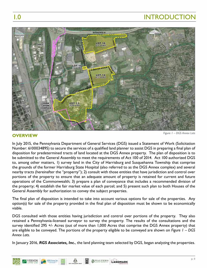
DGS consulted with those entities having jurisdiction and control over portions of the property. They also retained a Pennsylvania-licensed surveyor to survey the property. The results of the consultations and the survey identified 295 +/- Acres (out of more than 1,000 Acres that comprise the DGS Annex property) that are eligible to be conveyed. The portions of the property eligible to be conveyed are shown on Figure 1 – DGS Annex Lots.
In January 2016, RGS Associates, Inc., the land planning team selected by DGS, began analyzing the properties.
DGS Annex Parcel
Figure 1 – DGS Annex Lots
p. 10
The primary purpose of this engagement was for RGS Associates and its team of consults to evaluate the properties eligible for conveyance through an open, informed public information gathering process. Various due diligence studies were undertaken, stakeholder input was gathered and professional real estate assessments were analyzed to determine whether there is sufficient support for the intention to convey the noted real estate at its fair market value based on the highest and best use of each identified parcel.
PROJECT TEAM
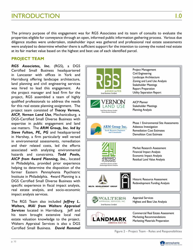
RGS Associates, Inc. (RGS), a DGS Certified Small Business headquartered in Lancaster with offices in York and Harrisburg offering landscape architecture, land planning and civil engineering services was hired to lead this engagement. As the project manager and lead firm for the project, RGS assembled a team of highly qualified professionals to address the needs for this real estate planning assignment. The project team consisted of Tracey Vernon, AICP, Vernon Land Use, Mechanicsburg, a DGS-Certified Small Diverse Business with expertise in public engagement and land use matters. The ARM Group, Inc. led by Steve Fulton, PE, PG and headquartered in Hershey, a firm particularly well versed in environmental assessments, remediation and their related costs, led the efforts associated with analyzing environmental hazards and constraints. Todd Poole, AICP from 4ward Planning, Inc., located in Philadelphia, provided prior experience helping to determine the disposition of the former Eastern Pennsylvania Psychiatric Institute in Philadelphia. 4ward Planning is a DGS Certified Small Diverse Business with specific experience in fiscal impact analysis, real estate analysis, and socio-economic impact analysis services.
The RGS Team also included Jeffrey L. Walters, MAI from Walters Appraisal Services located in Harrisburg. Jeff and his team brought extensive local real estate valuation knowledge to the project. Walters Appraisal Services is also a DGS Certified Small Business. David Remmel
INTRODUCTION 1.0
Figure 2 – Project Team - Roles and Responsibilities
p. 11
from Landmark Commercial Realty provided real estate consulting services for the project. David has been involved in other state-owned property disposition evaluations. Historic Resource Assessment services regarding the extensive historic building stock that comprises the former Harrisburg State Hospital was led by Bonnie Mark, Delta Development Group, Inc., from Mechanicsburg. Delta Development Group, in conjunction with the voluntary efforts of the Historic Harrisburg Association and the Committee for the Future of the Harrisburg State Hospital, was instrumental in analyzing the impacts of the existing National Register of Historic Places historic district that encompasses the majority of the site.
This talented group of professionals worked diligently with DGS staff for nearly one year to prepare this analysis and disposition recommendation for consideration by the General Assembly. The individual roles and responsibilities of the project team can be found in Figure 2 – Project Team - Roles and Responsibilities.
APPROACH
The project approach was largely set forth by DGS’ original Statement of Work. Since prior discussions about the potential sale of the Harrisburg State Hospital had a history of contention, DGS sought a unique approach to determining the disposition of the DGS Annex properties. Their traditional process would have simply resulted in DGS securing an appraisal for the properties and offering the land for sale. Since this property has many unique challenges, it was determined that achieving an appropriate outcome required a different approach. It was this realization that prompted DGS to consider engaging an outside consulting team to assess the real estate and provide an independent evaluation and recommendation on its long-term disposition. This is the first property evaluation of this type undertaken by DGS and, if successful, may lay the ground work for a similar analysis of key state-owned properties in the future.
The former Harrisburg State Hospital (HSH) site is clearly unique. The HSH site was home to the first publically owned mental institution in Pennsylvania; originally known as the Pennsylvania State Lunatic Hospital and Union Asylum. Pennsylvania was at the forefront of the treatment of mental illness in the United States. From 1851 – 2006, the HSH evolved as an institutional campus model that would eventually be replicated across Pennsylvania and in surrounding states. The site contains roughly 45 buildings, many still in active use, though in the process of being vacated. Different than other similar hospital sites across the state, the HSH is already afforded a layer of historic protection and preservation by a National Register of Historic Places historic district that encompasses much of the HSH site. The property also experiences a significant amount of public use on campus open spaces and the Capital Area Greenbelt recreation trail that traverses the site. Property upkeep and maintenance have clearly become a growing financial burden to the Commonwealth of Pennsylvania costing taxpayers over $5 million dollars per year to simply maintain and operate. These annual maintenance costs continue even as the former office uses are being relocated and many of the office buildings are vacated.
With so many parameters influencing the HSH site, including a public sentiment that achieving a balanced outcome between preservation and economic development was a community expectation, it became clear to DGS that a more thoughtful approach was required. The approach is summarized below:
• Phase 1 – Stakeholder Engagement and Site Due Diligence Research• Phase 2 – Municipal Government Engagement, Reporting on Phase 1 Findings, Utility Separation
Analysis and Public Meeting input.• Phase 3 – Valuation Analysis, Marketing Recommendations and Development of Final Disposition
Recommendations• Phase 4 – Active Marketing Support and Property Tours
INTRODUCTION1.0
p. 12
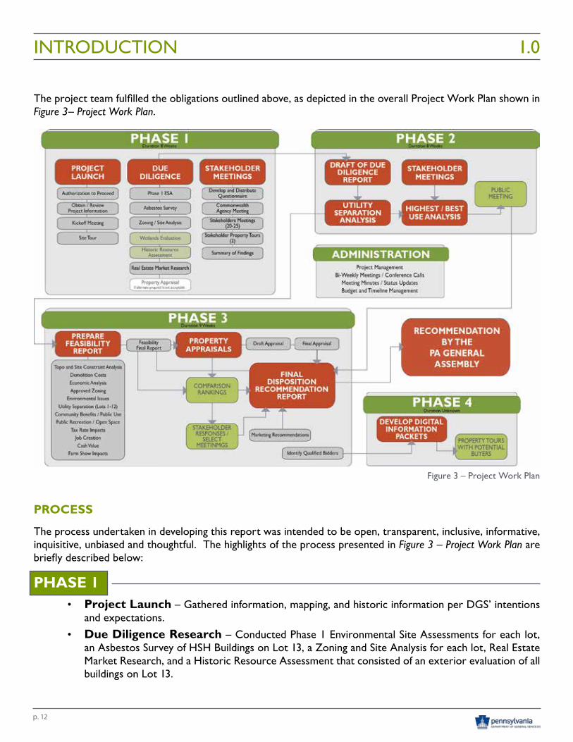
The project team fulfilled the obligations outlined above, as depicted in the overall Project Work Plan shown in Figure 3– Project Work Plan.
PROCESS
The process undertaken in developing this report was intended to be open, transparent, inclusive, informative, inquisitive, unbiased and thoughtful. The highlights of the process presented in Figure 3 – Project Work Plan are briefly described below:
PHASE 1• Project Launch – Gathered information, mapping, and historic information per DGS’ intentions
and expectations.• Due Diligence Research – Conducted Phase 1 Environmental Site Assessments for each lot,
an Asbestos Survey of HSH Buildings on Lot 13, a Zoning and Site Analysis for each lot, Real Estate Market Research, and a Historic Resource Assessment that consisted of an exterior evaluation of all buildings on Lot 13.
INTRODUCTION 1.0
Figure 3 – Project Work Plan
p. 13
• Stakeholder Engagement – Developed a 16-question qualitative and quantitative online questionnaire to measure stakeholder sentiment, conducted face to face interviews with 26 identified stakeholders and documented their sentiments, and conducted a meeting with representatives from seven state agencies to share findings and obtain their feedback and input.
PHASE 2
• Due Diligence Reports – Refined Phase 1 Due Diligence report content based on stakeholder input and updated overall project mapping based on client and stakeholder feedback.
• Utility Separation Analysis – Determined how to best separate the utilities serving the HSH Campus (Lot 13) from surrounding state owned properties and systems so the HSH site can stand on its own; separated from adjoining services. This included developing estimated costs associated with separating all utility interdependencies.
• Municipal Engagement – Developed PowerPoint presentations summarizing Phase 1 research; met with officials from Dauphin County, City of Harrisburg, and Susquehanna Township to review Phase 1 outcomes, share details of the evaluation process and obtain additional feedback.
• Highest and Best Use Analysis – Developed an assessment of the land uses permitted on the properties based on potential development opportunities and constraints associated with each. Developed hypothetical development capacities for each site to evaluate the socio-economic benefits that could occur under a scenario of redevelopment and adaptive re-use.
• Public Meeting – Prepared a PowerPoint presentation summarizing Phase 1 research; compiled eight (8) graphic information boards summarizing findings and conducted an approximately two-hour long public meeting to seek additional public comment, guidance and general input. 113 individuals attended the public meeting with media outlet coverage by PennLive, Central Penn Business Journal, WHP-TV21, FOX TV43 and WGAL-TV8.
PHASE 3
• Feasibility Report – Determined the best value and appropriate approach to the disposition of the real estate for consideration by the Commonwealth based on stakeholder feedback, public input, and background research; compiled findings and delivered as part of the final disposition report.
• Property Appraisals – Determined the real estate values at the “Highest and Best Use” based on current zoning and prepared appraisals for the lands and buildings to be offered for sale with appraisals presented in the following formats:
o Appraised Lots 13, 14, 15 and 16 separately o Appraised Lots 13, 14, 15 and 16 together as one parcel o Appraised Lots 14, 15 and 16 together as one parcel
• Stakeholder Responses / Select Meetings – Prepared for and engaged various key stakeholders in follow-up meetings and responses to specific concerns related to the final disposition recommendations.
• Marketing Recommendations – Presented recommendations on how the properties should be marketed (marketing time, advertising options) and options for conveyance of the real estate.
INTRODUCTION1.0
p. 14
• Final Disposition Recommendation / Report – Prepared a comprehensive report consisting of executive summaries from due diligence research, stakeholder input, historic resource assessment, public meeting feedback, appraisals and financial impact assessments conducted for the project; developed several disposition options for consideration by the General Assembly and presented the report to DGS for conveyance to the General Assembly for consideration.
• Identify Qualified Bidders – Proactively identified potential parties who may have interest in the real estate and provided the same to DGS for future consideration.
PHASE 4• Digital Information Marketing Packets – Developed digital information packets that include
property aerials, land and building information, demographics, and summaries of environmental reports for electronic distribution by DGS to potential buyers.
• Property Tours with Potential Bidders – Organized and conducted property tours throughout the disposition bidding period for potential buyers to view the property.
SUMMARY
This report is a comprehensive summary of the discussions, stakeholder feedback, analyses, research, and exercises that led to the Final Disposition Report’s recommendations. The chapters that follow closely mirror the planning and information gathering process undertaken as part of this engagement. The Appendices contain the detailed documentation and reports that support the executive summaries, stakeholder feedback, public meeting feedback, appraisals and financial impact analysis that comprise the report. Due to the volume of information represented in the report and contained in the appendices, an indexed CD is included inside the back cover of the report for reference.
INTRODUCTION 1.0
DGS Annex Parcel
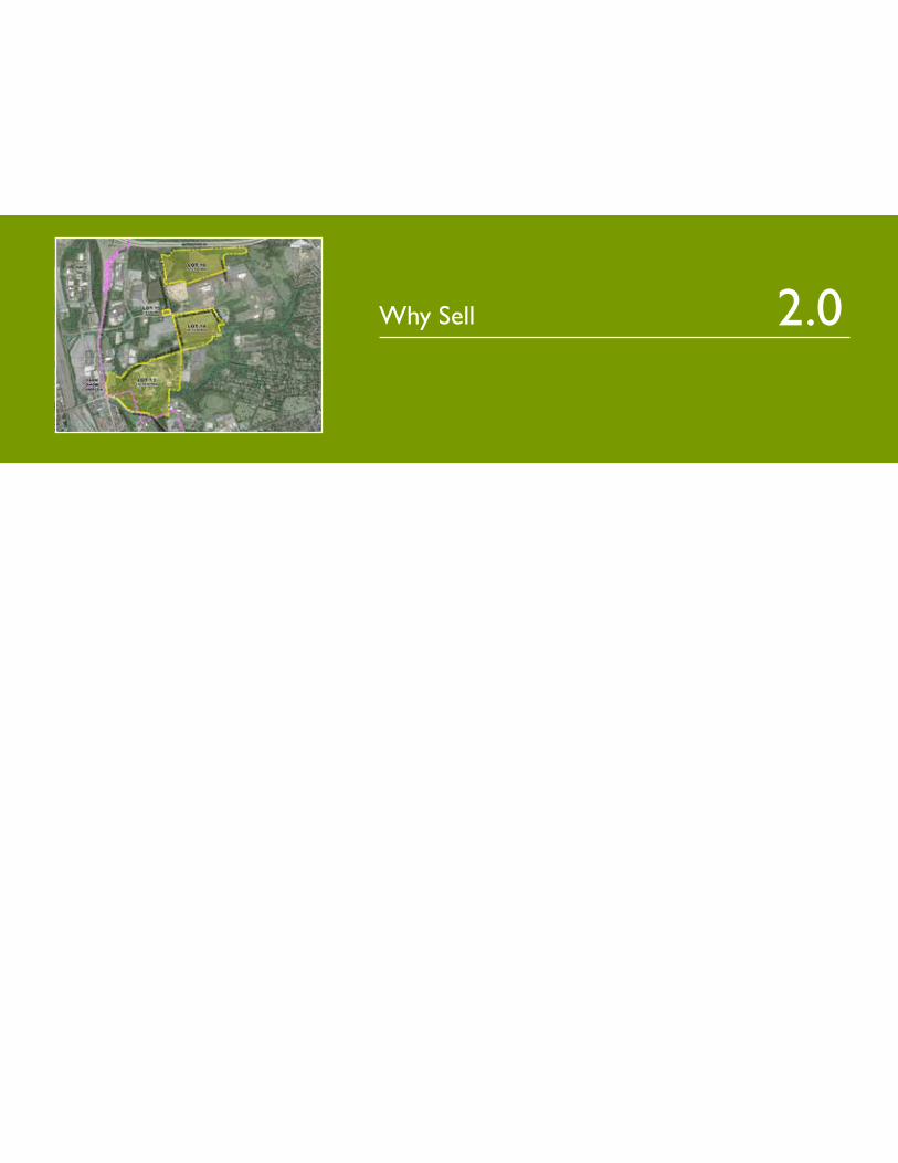
Why Sell 2.0

p. 17
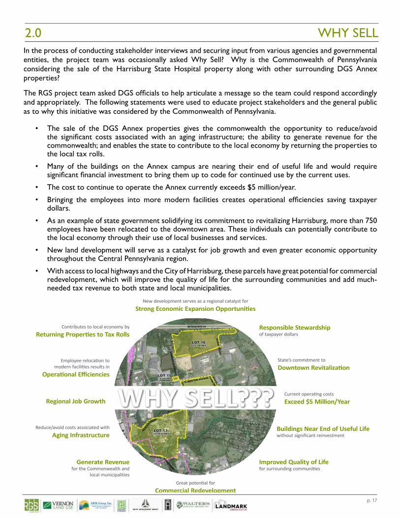
WHY SELL2.0In the process of conducting stakeholder interviews and securing input from various agencies and governmental entities, the project team was occasionally asked Why Sell? Why is the Commonwealth of Pennsylvania considering the sale of the Harrisburg State Hospital property along with other surrounding DGS Annex properties?
The RGS project team asked DGS officials to help articulate a message so the team could respond accordingly and appropriately. The following statements were used to educate project stakeholders and the general public as to why this initiative was considered by the Commonwealth of Pennsylvania.
• The sale of the DGS Annex properties gives the commonwealth the opportunity to reduce/avoid the significant costs associated with an aging infrastructure; the ability to generate revenue for the commonwealth; and enables the state to contribute to the local economy by returning the properties to the local tax rolls.
• Many of the buildings on the Annex campus are nearing their end of useful life and would require significant financial investment to bring them up to code for continued use by the current uses.
• The cost to continue to operate the Annex currently exceeds $5 million/year.
• Bringing the employees into more modern facilities creates operational efficiencies saving taxpayer dollars.
• As an example of state government solidifying its commitment to revitalizing Harrisburg, more than 750 employees have been relocated to the downtown area. These individuals can potentially contribute to the local economy through their use of local businesses and services.
• New land development will serve as a catalyst for job growth and even greater economic opportunity throughout the Central Pennsylvania region.
• With access to local highways and the City of Harrisburg, these parcels have great potential for commercial redevelopment, which will improve the quality of life for the surrounding communities and add much-needed tax revenue to both state and local municipalities.DGS Annex Properties
WHY SELL???Reduce/avoid costs associated with
Aging Infrastructure
Generate Revenuefor the Commonwealth and
local municipalities
Contributes to local economy by
Returning Properties to Tax RollsResponsible Stewardshipof taxpayer dollars
Great potential for
Commercial Redevelopment
New development serves as a regional catalyst for
Strong Economic Expansion Opportunities
State’s commitment to
Downtown Revitalization
Regional Job Growth
Employee relocation tomodern facilities results in
Operational Efficiencies
Improved Quality of Lifefor surrounding communities
Buildings Near End of Useful Lifewithout significant reinvestment
Current operating costs
Exceed $5 Million/Year


Executive Summaries 3.0

p. 21
This section of the Final Disposition Report contains Executive Summaries of various studies, analyses and engagement opportunities conducted throughout the process of evaluating the DGS Annex Properties. These summaries provide a high level overview of detailed findings with full and complete documents, studies, mapping, meeting summaries, and related background information found within the Appendices of this report. The content of this section includes:
Stakeholder EngagementPhase 1 Environmental Site Assessments Lot 13 Lot 14 Lot 15 Lot 16Lot 13 Asbestos Inspection ReportZoning & Site AnalysisEcological Assessment Report (Lot 13)Real Estate Market Research
Throughout the process of conducting these analyses and compiling the noted reports, information continued to be gathered and refined regarding parcel areas, lot sizes and the exact number of buildings on the subject properties. Despite an attempt to reconcile all reports and data, some discrepancies may exist between various reports, particularly those conducted early in the process (Phase 1 Environmental Assessments). Actual acreages of each parcel remains subject to change and will only be defined by a final survey and subdivision plans.
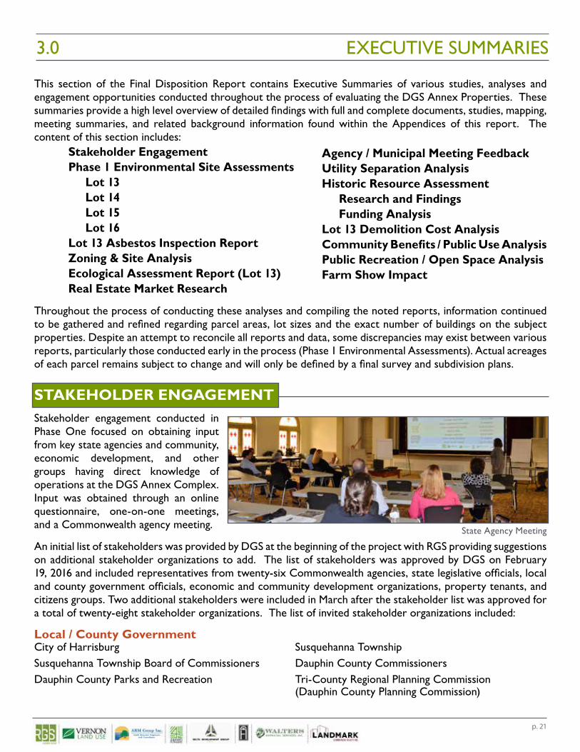
STAKEHOLDER ENGAGEMENTStakeholder engagement conducted in Phase One focused on obtaining input from key state agencies and community, economic development, and other groups having direct knowledge of operations at the DGS Annex Complex. Input was obtained through an online questionnaire, one-on-one meetings, and a Commonwealth agency meeting.
An initial list of stakeholders was provided by DGS at the beginning of the project with RGS providing suggestions on additional stakeholder organizations to add. The list of stakeholders was approved by DGS on February 19, 2016 and included representatives from twenty-six Commonwealth agencies, state legislative officials, local and county government officials, economic and community development organizations, property tenants, and citizens groups. Two additional stakeholders were included in March after the stakeholder list was approved for a total of twenty-eight stakeholder organizations. The list of invited stakeholder organizations included:
Local / County GovernmentCity of Harrisburg Susquehanna TownshipSusquehanna Township Board of Commissioners Dauphin County CommissionersDauphin County Parks and Recreation Tri-County Regional Planning Commission (Dauphin County Planning Commission)
Agency / Municipal Meeting FeedbackUtility Separation AnalysisHistoric Resource Assessment Research and Findings Funding AnalysisLot 13 Demolition Cost AnalysisCommunity Benefits / Public Use AnalysisPublic Recreation / Open Space AnalysisFarm Show Impact
EXECUTIVE SUMMARIES3.0
State Agency Meeting
p. 22
State LegislaturePennsylvania House of Representatives (103rd District) Pennsylvania House of Representatives(104th District)Pennsylvania State Senate (15th District)
State AgenciesPennsylvania Department of Agriculture Pennsylvania Department of General ServicesPennsylvania Department of Human Services Pennsylvania Emergency Management AgencyPennsylvania Farm Show Complex and Expo Center Pennsylvania Historical and Museum CommissionPennsylvania Department of Community Pennsylvania Department of Conservationand Economic Development and Natural Resources
Community and Economic DevelopmentHarrisburg Regional Chamber/ CREDC Dauphin County Community & Economic Development
Civic / Community Groups / OtherCapital Area Greenbelt Association Central Penn Business JournalDauphin County Community Gardens Gaudenzia, Inc.Harrisburg Area Community College Harrisburg Flying SocietyHarrisburg Young Professionals Historic Harrisburg AssociationPA Media Group Pennsylvania State Employees Credit Union
To begin stakeholder outreach, RGS sent e-mails to each stakeholder describing the purpose of their involvement and outlining next steps in the study. A copy of the introductory e-mail is included in Appendices.
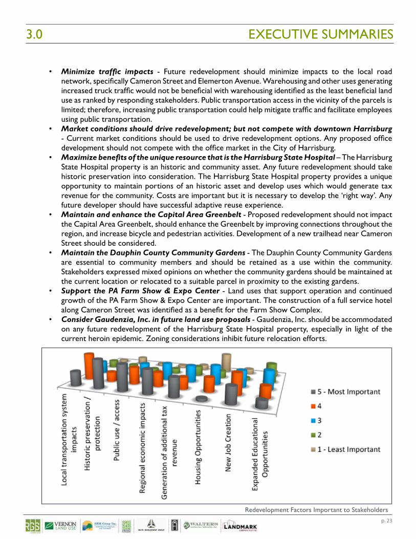
Key themes from both questionnaires and meetings as well as suggested land uses for each parcel are summarized as follows. Detailed information on the stakeholder questionnaire, stakeholder meetings, and Commonwealth agency meeting is included in the remainder of this section.
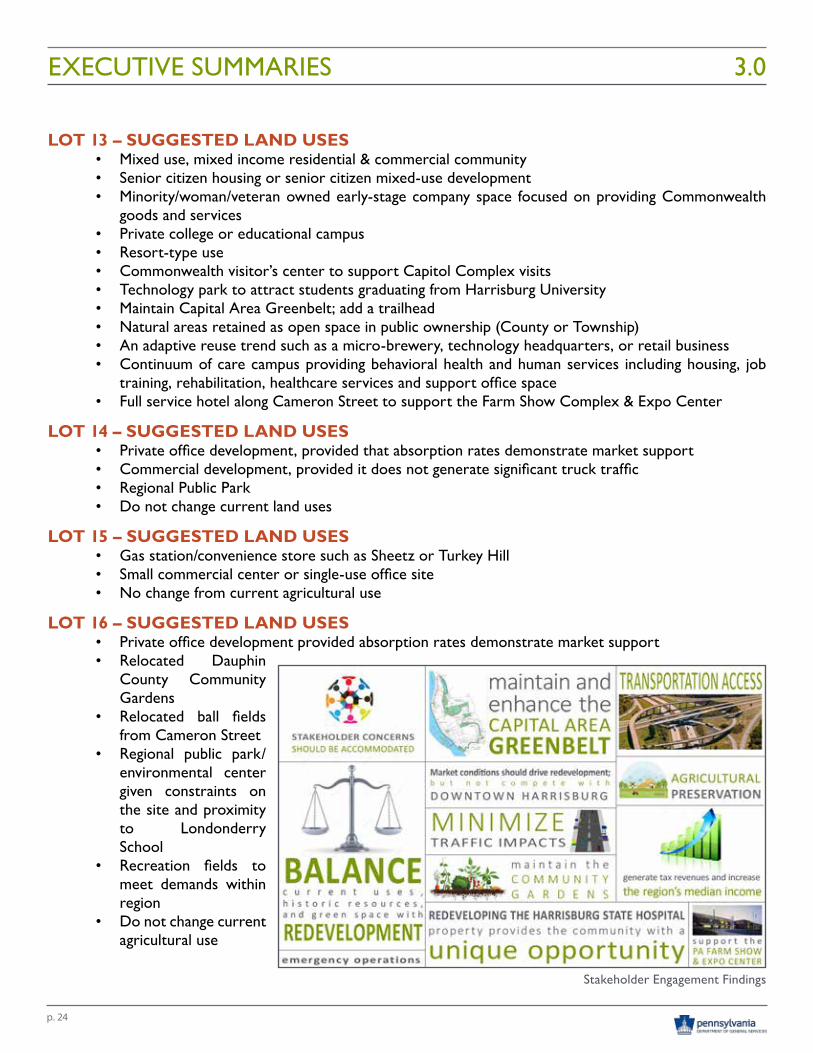
KEY THEMES • Stakeholder concerns should be accommodated in any future redevelopment proposal -
Redevelopment solutions should ensure that all concerns, especially concerns of citizens and members of the public, are accommodated and addressed.
• Seek a balanced approach between preservation of existing resources and economic development – Nearly 50% of stakeholder questionnaire respondents suggested a balance between preservation/protection and economic development. Many interviewees identified that any future land use proposal should include a balance between existing land use and redevelopment to create new jobs and increase tax revenues.
• Generate tax revenues and increase the region’s median income - Future redevelopment should consider generation of increased tax revenue for Susquehanna Township as well as the City of Harrisburg and the Commonwealth. Targeting industry clusters that provide higher paying jobs and increase the region’s median income should be a priority. Consider partnering with higher educational institutions such as Harrisburg University to determine if a connection between graduating students and area businesses could be made.
• Encourage mixed use development – Consider developing sustainable, mixed use, mixed income development, interconnected by open space and trails to the Capital Area Greenbelt. This would attract young professionals and retirees.
EXECUTIVE SUMMARIES 3.0
p. 23
• Minimize traffic impacts - Future redevelopment should minimize impacts to the local road network, specifically Cameron Street and Elemerton Avenue. Warehousing and other uses generating increased truck traffic would not be beneficial with warehousing identified as the least beneficial land use as ranked by responding stakeholders. Public transportation access in the vicinity of the parcels is limited; therefore, increasing public transportation could help mitigate traffic and facilitate employees using public transportation.
• Market conditions should drive redevelopment; but not compete with downtown Harrisburg - Current market conditions should be used to drive redevelopment options. Any proposed office development should not compete with the office market in the City of Harrisburg.
• Maximize benefits of the unique resource that is the Harrisburg State Hospital – The Harrisburg State Hospital property is an historic and community asset. Any future redevelopment should take historic preservation into consideration. The Harrisburg State Hospital property provides a unique opportunity to maintain portions of an historic asset and develop uses which would generate tax revenue for the community. Costs are important but it is necessary to develop the ‘right way’. Any future developer should have successful adaptive reuse experience.
• Maintain and enhance the Capital Area Greenbelt - Proposed redevelopment should not impact the Capital Area Greenbelt, should enhance the Greenbelt by improving connections throughout the region, and increase bicycle and pedestrian activities. Development of a new trailhead near Cameron Street should be considered.
• Maintain the Dauphin County Community Gardens - The Dauphin County Community Gardens are essential to community members and should be retained as a use within the community. Stakeholders expressed mixed opinions on whether the community gardens should be maintained at the current location or relocated to a suitable parcel in proximity to the existing gardens.
• Support the PA Farm Show & Expo Center - Land uses that support operation and continued growth of the PA Farm Show & Expo Center are important. The construction of a full service hotel along Cameron Street was identified as a benefit for the Farm Show Complex.
• Consider Gaudenzia, Inc. in future land use proposals - Gaudenzia, Inc. should be accommodated on any future redevelopment of the Harrisburg State Hospital property, especially in light of the current heroin epidemic. Zoning considerations inhibit future relocation efforts.
EXECUTIVE SUMMARIES3.0
Redevelopment Factors Important to Stakeholders
p. 24
LOT 13 – SUGGESTED LAND USES• Mixed use, mixed income residential & commercial community• Senior citizen housing or senior citizen mixed-use development• Minority/woman/veteran owned early-stage company space focused on providing Commonwealth
goods and services• Private college or educational campus• Resort-type use• Commonwealth visitor’s center to support Capitol Complex visits• Technology park to attract students graduating from Harrisburg University• Maintain Capital Area Greenbelt; add a trailhead• Natural areas retained as open space in public ownership (County or Township)• An adaptive reuse trend such as a micro-brewery, technology headquarters, or retail business• Continuum of care campus providing behavioral health and human services including housing, job
training, rehabilitation, healthcare services and support office space• Full service hotel along Cameron Street to support the Farm Show Complex & Expo Center
LOT 14 – SUGGESTED LAND USES• Private office development, provided that absorption rates demonstrate market support• Commercial development, provided it does not generate significant truck traffic• Regional Public Park• Do not change current land uses
LOT 15 – SUGGESTED LAND USES• Gas station/convenience store such as Sheetz or Turkey Hill• Small commercial center or single-use office site• No change from current agricultural use
LOT 16 – SUGGESTED LAND USES• Private office development provided absorption rates demonstrate market support• Relocated Dauphin
County Community Gardens
• Relocated ball fields from Cameron Street
• Regional public park/environmental center given constraints on the site and proximity to Londonderry School
• Recreation fields to meet demands within region
• Do not change current agricultural use
EXECUTIVE SUMMARIES 3.0
Stakeholder Engagement Findings
p. 25
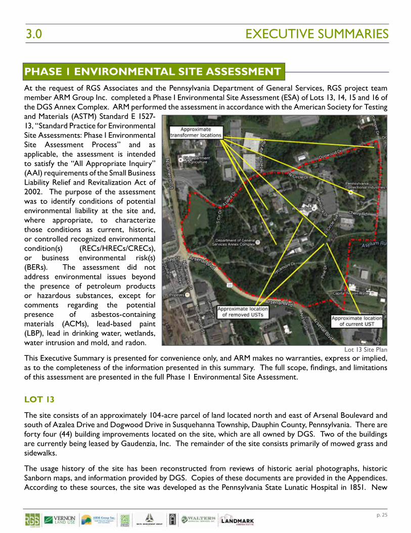
PHASE 1 ENVIRONMENTAL SITE ASSESSMENTAt the request of RGS Associates and the Pennsylvania Department of General Services, RGS project team member ARM Group Inc. completed a Phase I Environmental Site Assessment (ESA) of Lots 13, 14, 15 and 16 of the DGS Annex Complex. ARM performed the assessment in accordance with the American Society for Testing and Materials (ASTM) Standard E 1527-13, “Standard Practice for Environmental Site Assessments: Phase I Environmental Site Assessment Process” and as applicable, the assessment is intended to satisfy the “All Appropriate Inquiry” (AAI) requirements of the Small Business Liability Relief and Revitalization Act of 2002. The purpose of the assessment was to identify conditions of potential environmental liability at the site and, where appropriate, to characterize those conditions as current, historic, or controlled recognized environmental condition(s) (RECs/HRECs/CRECs), or business environmental risk(s) (BERs). The assessment did not address environmental issues beyond the presence of petroleum products or hazardous substances, except for comments regarding the potential presence of asbestos-containing materials (ACMs), lead-based paint (LBP), lead in drinking water, wetlands, water intrusion and mold, and radon.
This Executive Summary is presented for convenience only, and ARM makes no warranties, express or implied, as to the completeness of the information presented in this summary. The full scope, findings, and limitations of this assessment are presented in the full Phase 1 Environmental Site Assessment.
LOT 13
The site consists of an approximately 104-acre parcel of land located north and east of Arsenal Boulevard and south of Azalea Drive and Dogwood Drive in Susquehanna Township, Dauphin County, Pennsylvania. There are forty four (44) building improvements located on the site, which are all owned by DGS. Two of the buildings are currently being leased by Gaudenzia, Inc. The remainder of the site consists primarily of mowed grass and sidewalks.
The usage history of the site has been reconstructed from reviews of historic aerial photographs, historic Sanborn maps, and information provided by DGS. Copies of these documents are provided in the Appendices. According to these sources, the site was developed as the Pennsylvania State Lunatic Hospital in 1851. New
EXECUTIVE SUMMARIES3.0
Lot 13 Site Plan
p. 26
buildings were constructed on the site over the years. The hospital was subsequently named the Harrisburg State Hospital, and was closed in 2006. Several of the buildings are now utilized by DGS and some tenants for office space.
Based on the information obtained during this investigation, this assessment has revealed the following suspect environmental conditions (i.e., conditions representing potential environmentally related liability) in connection with the site:
• Two paint shops and a maintenance buildings that were in operation from as early as the late 1800s;• Several onsite buildings contain consumer-end petroleum products; • A 5,000-gallon petroleum fuel underground storage tank (UST) with four noted violations;• Two, 2,000-gallon petroleum fuel above ground storage tanks (ASTs); and• Located in an area of high radon propensity (i.e., potential radon concentrations of greater than 4
pCi/L).
Based on the information obtained during this investigation, and present scientific judgment, professional opinions regarding the environmental conditions addressed by this study are as follows:
• The historical use of two onsite buildings as paint shops and a few maintenance buildings from as early as the late 1800s is not considered to represent a REC or BER based on the site assessment results and ARM’s experience with similar facilities that operated during like time periods. In particular, there were no indications of any notable chemical spills or releases at the site, the types of equipment and operations associated with this kind of site commonly do not result in significant soil or groundwater contamination that would present a notable cleanup liability, and the types of equipment and materials reported to have been managed at this site generally did not include significant quantities of petroleum fuels, solvents, and other liquids that can result in soil and groundwater contamination.
• The presence of various containers of consumer-end chemicals observed on the site at the time of the site inspection is not considered to be a REC because there were no indications of a release from any of these containers observed at the time of the site inspection. The presence of these items is not considered to be a BER because of the relatively small volumes and risks associated these chemicals, although these chemicals should be disposed of in accordance with all applicable state and local regulations once they are no longer in use.
• The 5,000-gallon UST with four noted violations is not considered to be a REC because all four violations were corrected or abated to the satisfaction of the PADEP, and there were no indications of an existing release, a past release, or the material threat of a release from the tank observed at the time of the site inspection. The UST is considered to be a BER because of the costs required to continue to manage it in accordance with all applicable regulations, and/or the costs required to properly decommission and remove the tank when it is no longer in service.
• The diesel and gasoline ASTs located at the site are not considered to be RECs because there were no indications of an existing release, a past release, or the material threat of a release from any of the tanks observed at the time of the site inspection. The gasoline and diesel ASTs are registered with the Pennsylvania Department of Environmental Protection (PADEP) as required. These ASTs are considered to be a BER because of the costs required to continue to maintain them in accordance with all applicable regulations, and/or the costs required to properly decommission and remove the tanks when they are no longer in service.
• The location of the site in an area of high radon potential (i.e., potential radon concentrations greater than 4 pCi/L) is not considered to be a REC, as radon is considered to be an out of scope item under ASTM 1527-13. The location of the site in an area of high radon potential is considered to be a BER because radon can pose a concern in subsurface, poorly ventilated spaces (e.g., basements) and many
EXECUTIVE SUMMARIES 3.0
p. 27
of the on-site buildings contain basements. It should be noted that no radon tests were conducted as part of this ESA, and radon concentrations at the site could be less than 4 pCi/L.
ARM completed this Phase I ESA of the DGS Annex Lot 13 property, which is located north and east of Arsenal Boulevard and south of Azalea Drive and Dogwood Drive in Susquehanna Township, Dauphin County, Pennsylvania, in conformance with the scope and limitations of ASTM Standard E-1527-13. This assessment has revealed no evidence of RECs, HRECs or CRECs in connection with the property. However, the following BERs were identified because of the potential costs to address these issues and potential environmental issues if they are not managed properly:
• A 5,000-gallon petroleum UST;• Two, 2,000-gallon petroleum ASTs; and• Located in an area of high radon propensity (i.e., potential radon concentrations of greater than 4
pCi/L).
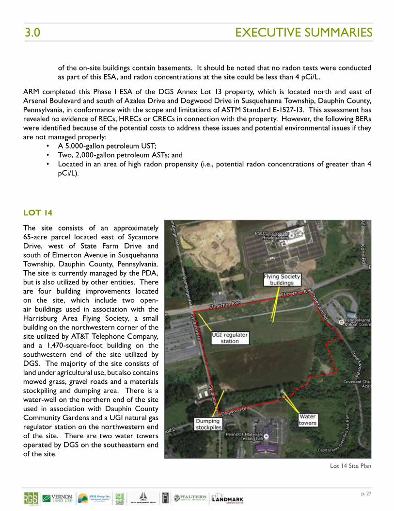
LOT 14
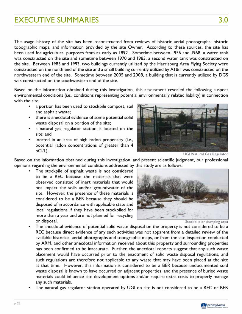
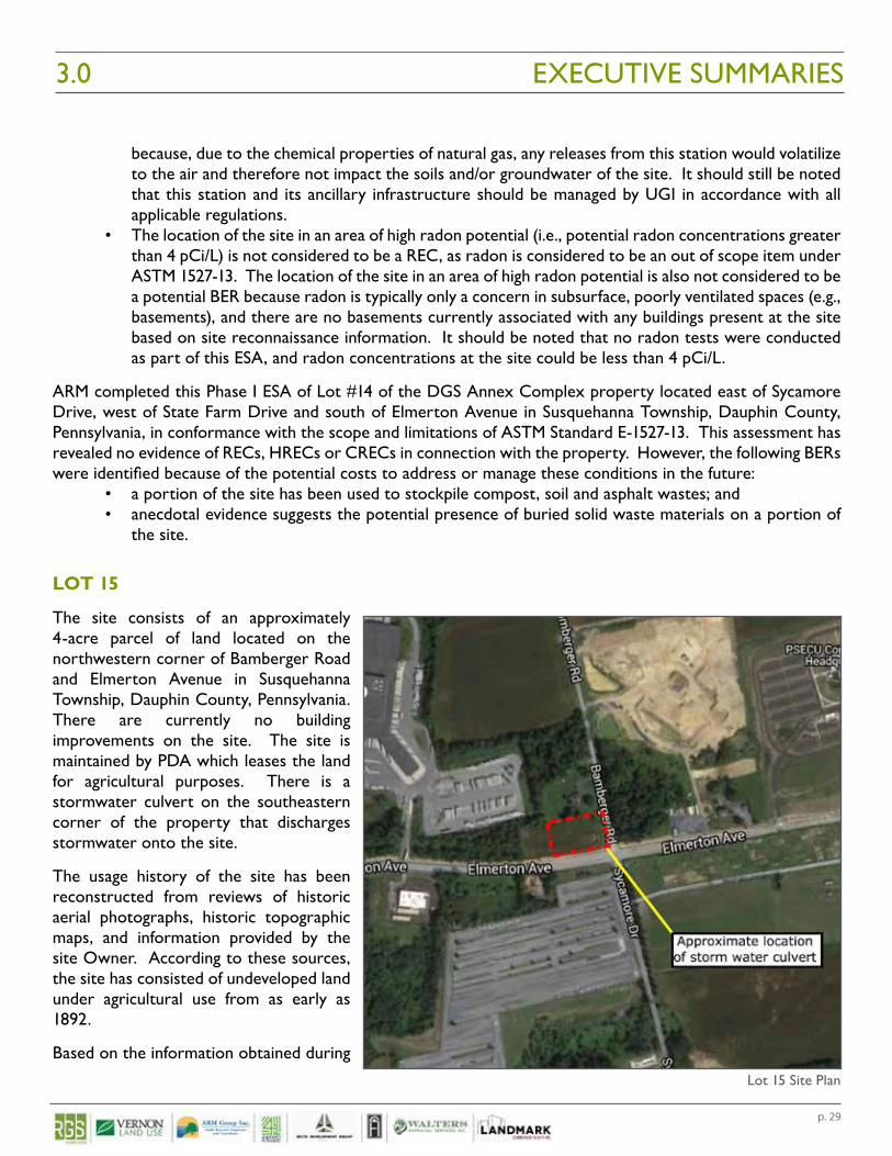
The site consists of an approximately 65-acre parcel located east of Sycamore Drive, west of State Farm Drive and south of Elmerton Avenue in Susquehanna Township, Dauphin County, Pennsylvania. The site is currently managed by the PDA, but is also utilized by other entities. There are four building improvements located on the site, which include two open-air buildings used in association with the Harrisburg Area Flying Society, a small building on the northwestern corner of the site utilized by AT&T Telephone Company, and a 1,470-square-foot building on the southwestern end of the site utilized by DGS. The majority of the site consists of land under agricultural use, but also contains mowed grass, gravel roads and a materials stockpiling and dumping area. There is a water-well on the northern end of the site used in association with Dauphin County Community Gardens and a UGI natural gas regulator station on the northwestern end of the site. There are two water towers operated by DGS on the southeastern end of the site.
EXECUTIVE SUMMARIES3.0
Lot 14 Site Plan
p. 28
The usage history of the site has been reconstructed from reviews of historic aerial photographs, historic topographic maps, and information provided by the site Owner. According to these sources, the site has been used for agricultural purposes from as early as 1892. Sometime between 1956 and 1968, a water tank was constructed on the site and sometime between 1970 and 1983, a second water tank was constructed on the site. Between 1983 and 1993, two buildings currently utilized by the Harrisburg Area Flying Society were constructed on the north end of the site and a small building currently utilized by AT&T was constructed on the northwestern end of the site. Sometime between 2005 and 2008, a building that is currently utilized by DGS was constructed on the southwestern end of the site.
Based on the information obtained during this investigation, this assessment revealed the following suspect environmental conditions (i.e., conditions representing potential environmentally related liability) in connection with the site:
• a portion has been used to stockpile compost, soil and asphalt waste;
• there is anecdotal evidence of some potential solid waste disposal on a portion of the site;
• a natural gas regulator station is located on the site; and
• located in an area of high radon propensity (i.e., potential radon concentrations of greater than 4 pCi/L).
Based on the information obtained during this investigation, and present scientific judgment, our professional opinions regarding the environmental conditions addressed by this study are as follows:
• The stockpile of asphalt waste is not considered to be a REC because the materials that were observed consisted of inert materials that would not impact the soils and/or groundwater of the site. However, the presence of these materials is considered to be a BER because they should be disposed of in accordance with applicable state and local regulations if they have been stockpiled for more than a year and are not planned for recycling or disposal.
• The anecdotal evidence of potential solid waste disposal on the property is not considered to be a REC because direct evidence of any such activities was not apparent from a detailed review of the available historical aerial photographs and topographic maps, or from the site inspection conducted by ARM, and other anecdotal information received about this property and surrounding properties has been confirmed to be inaccurate. Further, the anecdotal reports suggest that any such waste placement would have occurred prior to the enactment of solid waste disposal regulations, and such regulations are therefore not applicable to any waste that may have been placed at the site at that time. However, this information is considered to be a BER because undocumented sold waste disposal is known to have occurred on adjacent properties, and the presence of buried waste materials could influence site development options and/or require extra costs to properly manage any such materials.
• The natural gas regulator station operated by UGI on site is not considered to be a REC or BER
EXECUTIVE SUMMARIES 3.0
UGI Natural Gas Regulator
Stockpile or dumping area
p. 29
because, due to the chemical properties of natural gas, any releases from this station would volatilize to the air and therefore not impact the soils and/or groundwater of the site. It should still be noted that this station and its ancillary infrastructure should be managed by UGI in accordance with all applicable regulations.
• The location of the site in an area of high radon potential (i.e., potential radon concentrations greater than 4 pCi/L) is not considered to be a REC, as radon is considered to be an out of scope item under ASTM 1527-13. The location of the site in an area of high radon potential is also not considered to be a potential BER because radon is typically only a concern in subsurface, poorly ventilated spaces (e.g., basements), and there are no basements currently associated with any buildings present at the site based on site reconnaissance information. It should be noted that no radon tests were conducted as part of this ESA, and radon concentrations at the site could be less than 4 pCi/L.
ARM completed this Phase I ESA of Lot #14 of the DGS Annex Complex property located east of Sycamore Drive, west of State Farm Drive and south of Elmerton Avenue in Susquehanna Township, Dauphin County, Pennsylvania, in conformance with the scope and limitations of ASTM Standard E-1527-13. This assessment has revealed no evidence of RECs, HRECs or CRECs in connection with the property. However, the following BERs were identified because of the potential costs to address or manage these conditions in the future:
• a portion of the site has been used to stockpile compost, soil and asphalt wastes; and• anecdotal evidence suggests the potential presence of buried solid waste materials on a portion of
the site.
LOT 15
The site consists of an approximately 4-acre parcel of land located on the northwestern corner of Bamberger Road and Elmerton Avenue in Susquehanna Township, Dauphin County, Pennsylvania. There are currently no building improvements on the site. The site is maintained by PDA which leases the land for agricultural purposes. There is a stormwater culvert on the southeastern corner of the property that discharges stormwater onto the site.
The usage history of the site has been reconstructed from reviews of historic aerial photographs, historic topographic maps, and information provided by the site Owner. According to these sources, the site has consisted of undeveloped land under agricultural use from as early as 1892.
Based on the information obtained during
EXECUTIVE SUMMARIES3.0
Lot 15 Site Plan
p. 30
this investigation, this assessment revealed the following suspect environmental conditions (i.e., conditions representing potential environmentally related liability) in connection with the site:
• located in an area of high radon propensity (i.e., potential radon concentrations of greater than 4 pCi/L).
Based on the information obtained during this investigation, and present scientific judgment, our professional opinions regarding the environmental conditions addressed by this study are as follows:
• location in an area of high radon potential (i.e., potential radon concentrations greater than 4 pCi/L) is not considered to be a REC, as radon is considered to be an out of scope item under ASTM 1527-13. The location in an area of high radon potential is also not considered to be a potential BER because radon is typically only a concern in subsurface, poorly ventilated spaces (e.g., basements), and there are no basements currently associated with any buildings present at the site based on site reconnaissance information. It should be noted that no radon tests were conducted as part of this ESA, and radon concentrations at the site could be less than 4 pCi/L.
ARM completed this Phase I ESA of Lot 15 of the DGS Annex Complex property located on the northwestern corner of Bamberger Road and Elmerton Avenue in Susquehanna Township, Dauphin County, Pennsylvania, in conformance with the scope and limitations of ASTM Standard E-1527-13. This assessment has revealed no evidence of RECs, HRECs, CRECs or BERs in connection with the property.
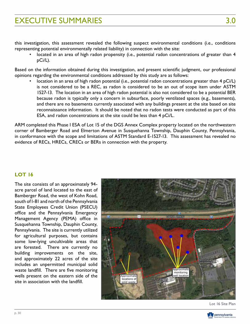
LOT 16
The site consists of an approximately 94-acre parcel of land located to the east of Bamberger Road, the west of Kohn Road, south of I-81 and north of the Pennsylvania State Employees Credit Union (PSECU) office and the Pennsylvania Emergency Management Agency (PEMA) office in Susquehanna Township, Dauphin County, Pennsylvania. The site is currently utilized for agricultural purposes, but contains some low-lying uncultivable areas that are forested. There are currently no building improvements on the site, and approximately 22 acres of the site includes an unpermitted municipal solid waste landfill. There are five monitoring wells present on the eastern side of the site in association with the landfill.
EXECUTIVE SUMMARIES 3.0
Lot 16 Site Plan
p. 31
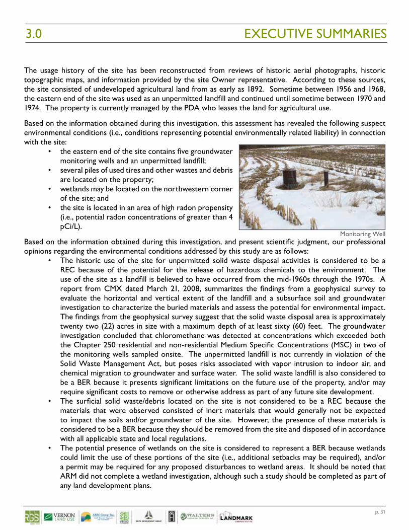
The usage history of the site has been reconstructed from reviews of historic aerial photographs, historic topographic maps, and information provided by the site Owner representative. According to these sources, the site consisted of undeveloped agricultural land from as early as 1892. Sometime between 1956 and 1968, the eastern end of the site was used as an unpermitted landfill and continued until sometime between 1970 and 1974. The property is currently managed by the PDA who leases the land for agricultural use.
Based on the information obtained during this investigation, this assessment has revealed the following suspect environmental conditions (i.e., conditions representing potential environmentally related liability) in connection with the site:
• the eastern end of the site contains five groundwater monitoring wells and an unpermitted landfill;
• several piles of used tires and other wastes and debris are located on the property;
• wetlands may be located on the northwestern corner of the site; and
• the site is located in an area of high radon propensity (i.e., potential radon concentrations of greater than 4 pCi/L).
Based on the information obtained during this investigation, and present scientific judgment, our professional opinions regarding the environmental conditions addressed by this study are as follows:
• The historic use of the site for unpermitted solid waste disposal activities is considered to be a REC because of the potential for the release of hazardous chemicals to the environment. The use of the site as a landfill is believed to have occurred from the mid-1960s through the 1970s. A report from CMX dated March 21, 2008, summarizes the findings from a geophysical survey to evaluate the horizontal and vertical extent of the landfill and a subsurface soil and groundwater investigation to characterize the buried materials and assess the potential for environmental impact. The findings from the geophysical survey suggest that the solid waste disposal area is approximately twenty two (22) acres in size with a maximum depth of at least sixty (60) feet. The groundwater investigation concluded that chloromethane was detected at concentrations which exceeded both the Chapter 250 residential and non-residential Medium Specific Concentrations (MSC) in two of the monitoring wells sampled onsite. The unpermitted landfill is not currently in violation of the Solid Waste Management Act, but poses risks associated with vapor intrusion to indoor air, and chemical migration to groundwater and surface water. The solid waste landfill is also considered to be a BER because it presents significant limitations on the future use of the property, and/or may require significant costs to remove or otherwise address as part of any future site development.
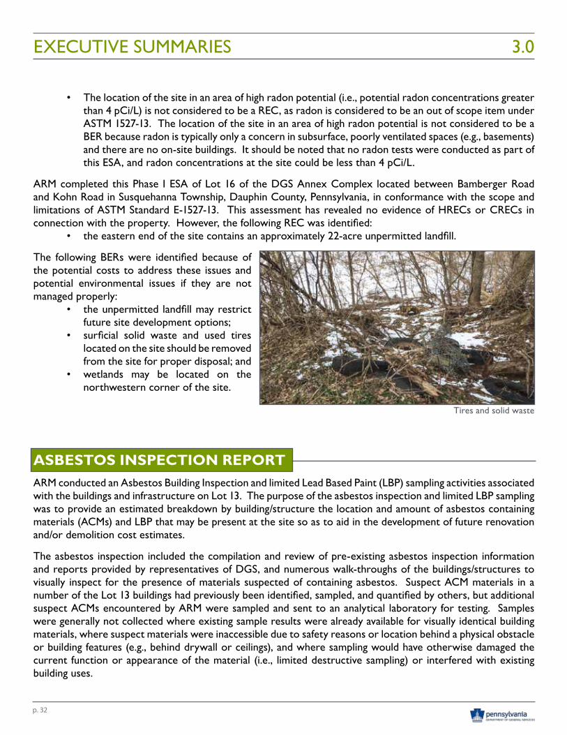
• The surficial solid waste/debris located on the site is not considered to be a REC because the materials that were observed consisted of inert materials that would generally not be expected to impact the soils and/or groundwater of the site. However, the presence of these materials is considered to be a BER because they should be removed from the site and disposed of in accordance with all applicable state and local regulations.
• The potential presence of wetlands on the site is considered to represent a BER because wetlands could limit the use of these portions of the site (i.e., additional setbacks may be required), and/or a permit may be required for any proposed disturbances to wetland areas. It should be noted that ARM did not complete a wetland investigation, although such a study should be completed as part of any land development plans.
EXECUTIVE SUMMARIES3.0
Monitoring Well
p. 32
• The location of the site in an area of high radon potential (i.e., potential radon concentrations greater than 4 pCi/L) is not considered to be a REC, as radon is considered to be an out of scope item under ASTM 1527-13. The location of the site in an area of high radon potential is not considered to be a BER because radon is typically only a concern in subsurface, poorly ventilated spaces (e.g., basements) and there are no on-site buildings. It should be noted that no radon tests were conducted as part of this ESA, and radon concentrations at the site could be less than 4 pCi/L.
ARM completed this Phase I ESA of Lot 16 of the DGS Annex Complex located between Bamberger Road and Kohn Road in Susquehanna Township, Dauphin County, Pennsylvania, in conformance with the scope and limitations of ASTM Standard E-1527-13. This assessment has revealed no evidence of HRECs or CRECs in connection with the property. However, the following REC was identified:
• the eastern end of the site contains an approximately 22-acre unpermitted landfill.
The following BERs were identified because of the potential costs to address these issues and potential environmental issues if they are not managed properly:
• the unpermitted landfill may restrict future site development options;
• surficial solid waste and used tires located on the site should be removed from the site for proper disposal; and
• wetlands may be located on the northwestern corner of the site.
ASBESTOS INSPECTION REPORTARM conducted an Asbestos Building Inspection and limited Lead Based Paint (LBP) sampling activities associated with the buildings and infrastructure on Lot 13. The purpose of the asbestos inspection and limited LBP sampling was to provide an estimated breakdown by building/structure the location and amount of asbestos containing materials (ACMs) and LBP that may be present at the site so as to aid in the development of future renovation and/or demolition cost estimates.
The asbestos inspection included the compilation and review of pre-existing asbestos inspection information and reports provided by representatives of DGS, and numerous walk-throughs of the buildings/structures to visually inspect for the presence of materials suspected of containing asbestos. Suspect ACM materials in a number of the Lot 13 buildings had previously been identified, sampled, and quantified by others, but additional suspect ACMs encountered by ARM were sampled and sent to an analytical laboratory for testing. Samples were generally not collected where existing sample results were already available for visually identical building materials, where suspect materials were inaccessible due to safety reasons or location behind a physical obstacle or building features (e.g., behind drywall or ceilings), and where sampling would have otherwise damaged the current function or appearance of the material (i.e., limited destructive sampling) or interfered with existing building uses.
EXECUTIVE SUMMARIES 3.0
Tires and solid waste
p. 33
A total of 140 suspect ACM samples were taken and submitted to EMSL Analytical, Inc. (EMSL) in Plymouth Meeting, PA for laboratory analysis for percent asbestos content. Friability of sampled suspect material was assessed by the Asbestos Inspector at the time of the inspection. Friable materials are those that, when dry, can be crumbled, pulverized, or reduced to powder by hand pressure. Non-friable materials are those that, when dry, cannot be crumbled, pulverized, or reduced to powder by hand pressure. Twenty one (21) of the 140 samples submitted tested positive for asbestos (i.e., greater than 1% asbestos content), and all ACM positive material tested was considered non-friable at the time of the assessment.
ARM also conducted periodic random sampling of the site buildings to determine the potential presence of LBP. Twenty six (26) of the 28 samples collected from 19 buildings/structures tested positive for LBP.
ZONING AND SITE ANALYSIS RGS was engaged as the lead consultant to assist the DGS in determining the long term disposition of the DGS Annex Complex. Prior to this engagement, DGS analyzed over 1,000 acres of their real estate land holdings in accordance with Act 100 of 2014 and determined that there are four parcels of ground totaling +/- 295 acres that are not valuable to either current or future operations of the Commonwealth. The properties being evaluated by analysis are part of the original land holdings of the Harrisburg State Hospital property.
The four (4) parcels (totaling +/- 295 acres) being analyzed are identified on the DGS Annex Parcel Exhibit as Lots 13, 14, 15 and 16. The lots are best identified and referenced as follows:
• Lot 13 – Harrisburg State Hospital Property (132.68 Ac.)• Lot 14 – Elmerton Avenue / Sycamore Drive / State Farm Drive Property (68.53 Ac.)• Lot 15 – Elmerton Avenue / Bamberger Road Property (1.47 Ac.)• Lot 16 – Interstate 81 / Bamberger Road / Kohn Road Property (92.61 Ac.)
The primary goal of this analysis is to reveal compelling factors to guide and shape specific conclusions each lot.
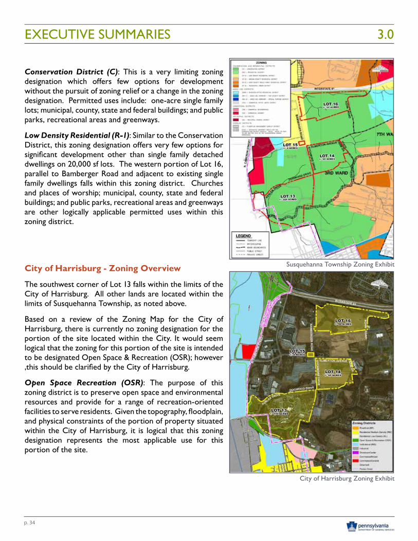
ZONING ANALYSIS
Susquehanna Township - Zoning Overview
The four (4) tracts of land relevant to this analysis fall predominantly within the limits of Susquehanna Township. Only a small portion of Lot 13 (±5 acres) is located within the City of Harrisburg.
Within Susquehanna Township, the zoning for three (3) of the properties within the scope of this analysis (Lots 13 and 14) are entirely situated within the “Conservation” Zoning District. Lot 15 is located entirely within the Low Density Residential Zoning District. The fourth parcel, Lot 16, is predominantly zoned “Conservation” except for approximately 6 acres which are zoned Low Density Residential (R-1).
Based on a review of the Zoning Map for Susquehanna Township, there is currently no zoning designation for a portion of the Harrisburg State Hospital site along its Cameron Street frontage. It would seem logical that the zoning for this portion of the site is intended to be designated Conservation (C); however, this should be clarified by Susquehanna Township.
EXECUTIVE SUMMARIES3.0
p. 34
Conservation District (C): This is a very limiting zoning designation which offers few options for development without the pursuit of zoning relief or a change in the zoning designation. Permitted uses include: one-acre single family lots; municipal, county, state and federal buildings; and public parks, recreational areas and greenways.
Low Density Residential (R-1): Similar to the Conservation District, this zoning designation offers very few options for significant development other than single family detached dwellings on 20,000 sf lots. The western portion of Lot 16, parallel to Bamberger Road and adjacent to existing single family dwellings falls within this zoning district. Churches and places of worship; municipal, county, state and federal buildings; and public parks, recreational areas and greenways are other logically applicable permitted uses within this zoning district.
City of Harrisburg - Zoning Overview
The southwest corner of Lot 13 falls within the limits of the City of Harrisburg. All other lands are located within the limits of Susquehanna Township, as noted above.
Based on a review of the Zoning Map for the City of Harrisburg, there is currently no zoning designation for the portion of the site located within the City. It would seem logical that the zoning for this portion of the site is intended to be designated Open Space & Recreation (OSR); however ,this should be clarified by the City of Harrisburg.
Open Space Recreation (OSR): The purpose of this zoning district is to preserve open space and environmental resources and provide for a range of recreation-oriented facilities to serve residents. Given the topography, floodplain, and physical constraints of the portion of property situated within the City of Harrisburg, it is logical that this zoning designation represents the most applicable use for this portion of the site.
EXECUTIVE SUMMARIES 3.0
Susquehanna Township Zoning Exhibit
City of Harrisburg Zoning Exhibit
p. 35
SITE ANALYSIS
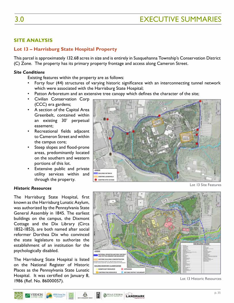
Lot 13 – Harrisburg State Hospital Property
This parcel is approximately 132.68 acres in size and is entirely in Susquehanna Township’s Conservation District (C) Zone. The property has its primary property frontage and access along Cameron Street.
Site ConditionsExisting features within the property are as follows:• Forty four (44) structures of varying historic significance with an interconnecting tunnel network
which were associated with the Harrisburg State Hospital;• Patton Arboretum and an extensive tree canopy which defines the character of the site;• Civilian Conservation Corp
(CCC) era gardens;• A section of the Capital Area
Greenbelt, contained within an existing 30’ perpetual easement;
• Recreational fields adjacent to Cameron Street and within the campus core;
• Steep slopes and flood-prone areas, predominantly located on the southern and western portions of this lot.
• Extensive public and private utility services within and through the property.
Historic Resources
The Harrisburg State Hospital, first known as the Harrisburg Lunatic Asylum, was authorized by the Pennsylvania State General Assembly in 1845. The earliest buildings on the campus, the Dixmont Cottage and the Dix Library (Circa 1852-1853), are both named after social reformer Dorthea Dix who convinced the state legislature to authorize the establishment of an institution for the psychologically disabled.
The Harrisburg State Hospital is listed on the National Register of Historic Places as the Pennsylvania State Lunatic Hospital. It was certified on January 8, 1986 (Ref. No. 86000057).
EXECUTIVE SUMMARIES3.0
Lot 13 Historic Resources
Lot 13 Site Features
p. 36
Soils and Hydrology
Approximately 50% of the site is concentrated urban land consisting of shale materials and of little agricultural importance or value. The remaining area is designated as prime farmland of agricultural value, which largely consists of floodplain valleys disrupted by bands of eroded shaly silt land throughout.
Asylum Run, a tributary to Paxton Creek, is located along the southern portion of the site. There are also two unnamed tributaries to Asylum Run present on the site. An existing 100-year floodplain associated with Asylum Run has been identified as a mapped GIS feature; however, there is no known detailed hydraulic study of this feature.
Transportation Network
Lot 13 is bounded by Azalea and Dogwood Drives to the north, Sycamore Drive to the east, Arsenal Boulevard to the south and Cameron Street to the west. Azalea, Dogwood and Sycamore Drives are all private drives owned and maintained by DGS. Arsenal Boulevard (SR 0022) and Cameron Street (SR 0230/0022) are both State Highways under the ownership and maintenance of the PA Department of Transportation (PennDOT).
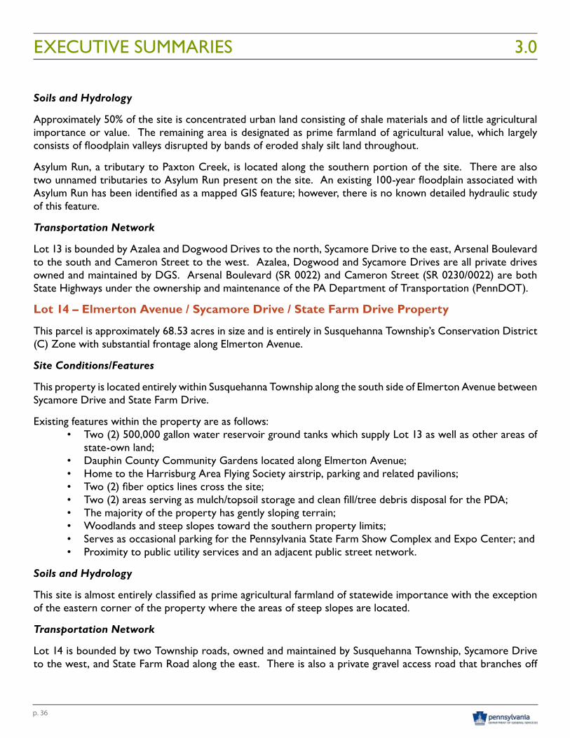
Lot 14 – Elmerton Avenue / Sycamore Drive / State Farm Drive Property
This parcel is approximately 68.53 acres in size and is entirely in Susquehanna Township’s Conservation District (C) Zone with substantial frontage along Elmerton Avenue.
Site Conditions/Features
This property is located entirely within Susquehanna Township along the south side of Elmerton Avenue between Sycamore Drive and State Farm Drive.
Existing features within the property are as follows:• Two (2) 500,000 gallon water reservoir ground tanks which supply Lot 13 as well as other areas of
state-own land;• Dauphin County Community Gardens located along Elmerton Avenue;• Home to the Harrisburg Area Flying Society airstrip, parking and related pavilions;• Two (2) fiber optics lines cross the site;• Two (2) areas serving as mulch/topsoil storage and clean fill/tree debris disposal for the PDA;• The majority of the property has gently sloping terrain;• Woodlands and steep slopes toward the southern property limits;• Serves as occasional parking for the Pennsylvania State Farm Show Complex and Expo Center; and• Proximity to public utility services and an adjacent public street network.
Soils and Hydrology
This site is almost entirely classified as prime agricultural farmland of statewide importance with the exception of the eastern corner of the property where the areas of steep slopes are located.
Transportation Network
Lot 14 is bounded by two Township roads, owned and maintained by Susquehanna Township, Sycamore Drive to the west, and State Farm Road along the east. There is also a private gravel access road that branches off
EXECUTIVE SUMMARIES 3.0
p. 37
Dogwood Drive on the southern side, to provide access to the existing water tanks and maintenance areas on the property. There is roughly 0.33 miles (1,762 ft.) of frontage along Elmerton Avenue with signalized intersections at the eastern and western limits of said frontage.
Lot 15 – Elmerton Avenue / Bamberger Road Property
This parcel is approximately 1.47 acres in size and is located entirely in Susquehanna Township’s Low Density Residential (R-1) Zone.
Site Conditions
This property is located at the northwest quadrant of the signalized intersection of Elmerton Avenue and Bamberger Road.
Existing features within the property are as follows:
• The entire property has gently sloping terrain;
• Current land use is agricultural;
• Free of environmental constraints; and
• Proximate to public utility services.
Soils and Hydrology
This site is comprised entirely of agricultural farmland of statewide importance.
Transportation Network
This property is bounded by one Township road, Bamberger Road to the east, and one State road, Elmerton Avenue (SR 3026) to the south. The site does have the benefit of being situated at an existing signalized intersection.
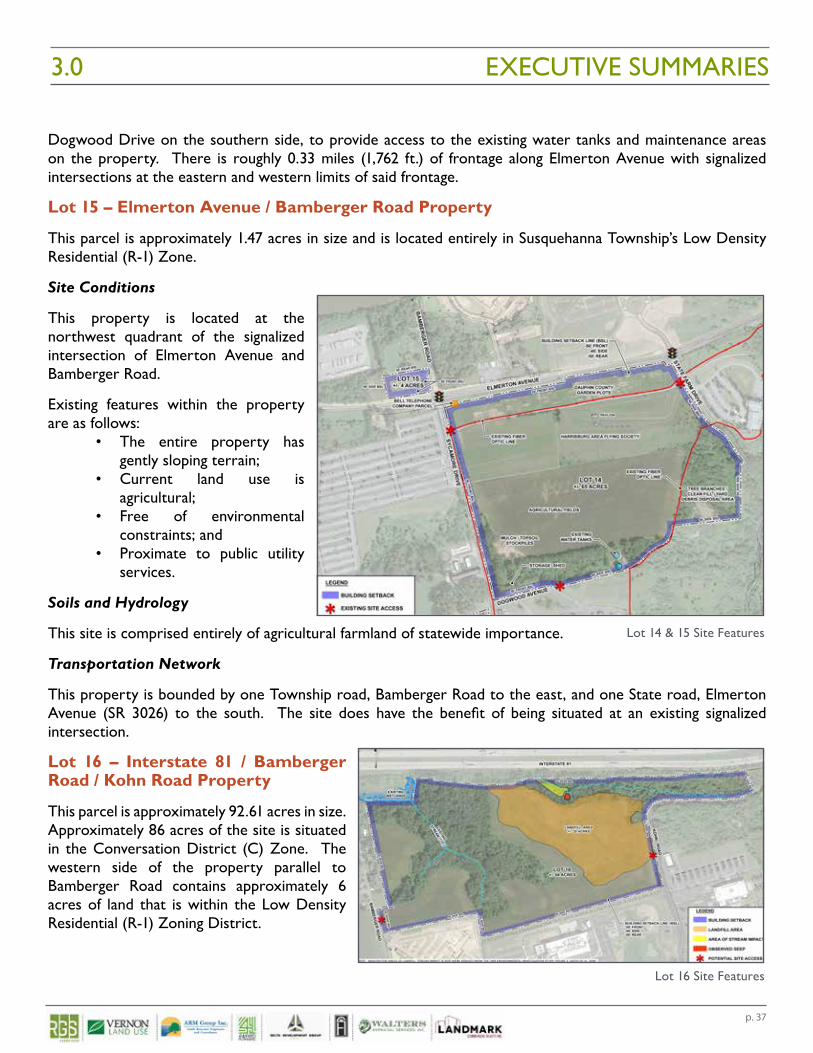
Lot 16 – Interstate 81 / Bamberger Road / Kohn Road Property
This parcel is approximately 92.61 acres in size. Approximately 86 acres of the site is situated in the Conversation District (C) Zone. The western side of the property parallel to Bamberger Road contains approximately 6 acres of land that is within the Low Density Residential (R-1) Zoning District.
EXECUTIVE SUMMARIES3.0
Lot 14 & 15 Site Features
Lot 16 Site Features
p. 38
Site Conditions
Existing features within the property are as follows:• The property is currently undeveloped and used for agricultural purposes;• Nearly half of the site is comprised of environmental constraints (woodlands and steep slopes);• A 22 acre portion of the site was utilized as a landfill in the 1960’s through the 1970’s; and• Proximate to public utility services.
Soils and Hydrology
This site contains soils with no prime farmland classification as well as some areas with prime soils supporting agricultural farmland of statewide importance. The landfill area is situated in the center of the site and eroded shaly silt cuts across the site detracting from significant agricultural value as a whole. However, portions of the site are suitable for agricultural uses.
There are two unnamed watercourses on the site to which all drainage flows.
Transportation Network
Lot 16 is bounded by a limited access State Highway Interstate 81 to the north and two Susquehanna Township roads, Kohn Road to the east and Bamberger Road to the west. There are no existing driveways on this property.
There are limited points of available access to this site with the exception of a small section of Bamberger Road, prior to the adjacent residential properties to the site. The other access option is along Kohn Road.
DEVELOPABLE AREA
Each lot was analyzed to assess its respective developable area. These conclusions are drawn from the detailed Zoning and Site Analysis Studies wholly contained within the Appendices of this report. This information was compiled to assist with understanding the potential development opportunities and constraints associated with each parcel. Once understood, the development capacity of each tract of land was determined to inform the Highest and Best Use Analysis and Property Appraisal valuations.
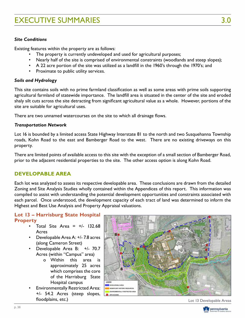
Lot 13 – Harrisburg State Hospital Property
• Total Site Area = +/- 132.68 Acres
• Developable Area A: +/- 7.8 acres (along Cameron Street)
• Developable Area B: +/- 70.7 Acres (within “Campus” area)
o Within this area is approximately 25 acres which comprises the core of the Harrisburg State Hospital campus
• Environmentally Restricted Area: +/- 54.2 Acres (steep slopes, floodplains, etc.)
EXECUTIVE SUMMARIES 3.0
Lot 13 Developable Areas
p. 39
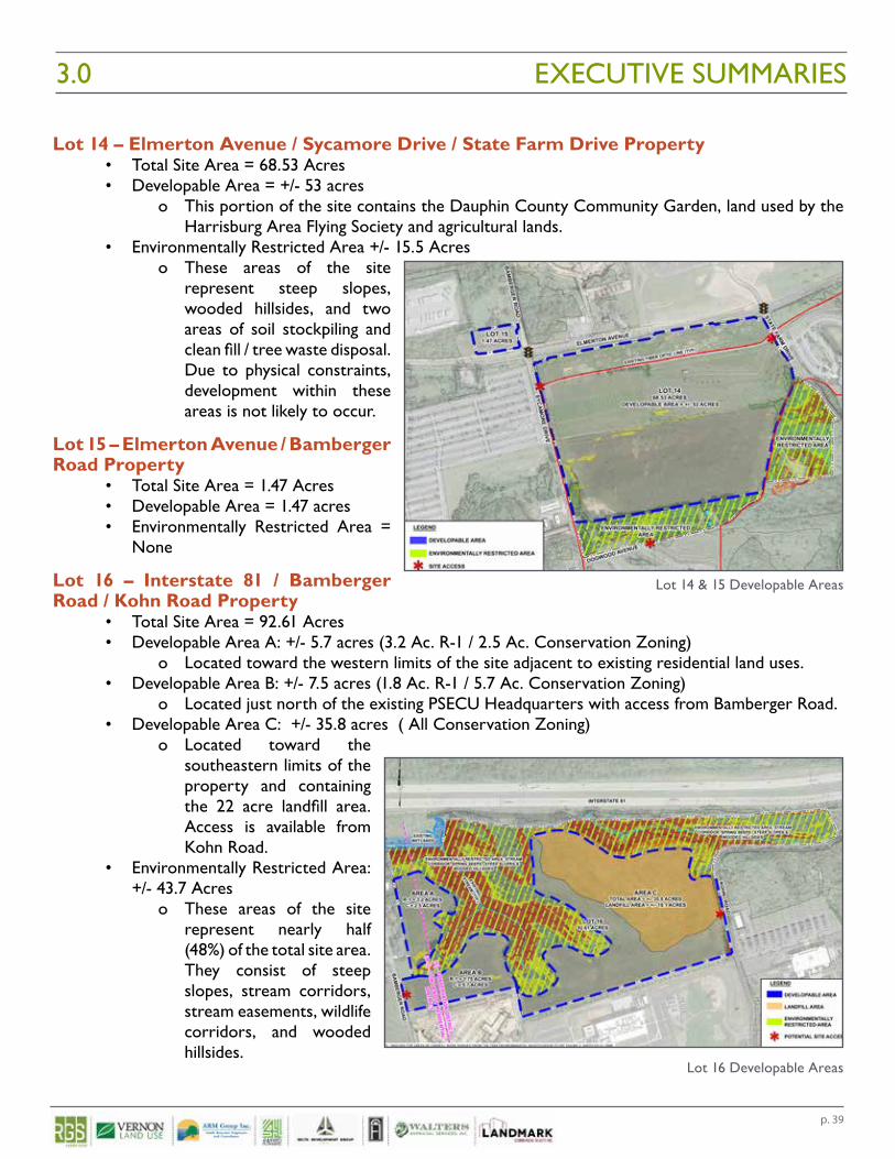
Lot 14 – Elmerton Avenue / Sycamore Drive / State Farm Drive Property• Total Site Area = 68.53 Acres• Developable Area = +/- 53 acres
o This portion of the site contains the Dauphin County Community Garden, land used by the Harrisburg Area Flying Society and agricultural lands.
• Environmentally Restricted Area +/- 15.5 Acreso These areas of the site
represent steep slopes, wooded hillsides, and two areas of soil stockpiling and clean fill / tree waste disposal. Due to physical constraints, development within these areas is not likely to occur.
Lot 15 – Elmerton Avenue / Bamberger Road Property
• Total Site Area = 1.47 Acres• Developable Area = 1.47 acres• Environmentally Restricted Area =
None
Lot 16 – Interstate 81 / Bamberger Road / Kohn Road Property
• Total Site Area = 92.61 Acres• Developable Area A: +/- 5.7 acres (3.2 Ac. R-1 / 2.5 Ac. Conservation Zoning)
o Located toward the western limits of the site adjacent to existing residential land uses. • Developable Area B: +/- 7.5 acres (1.8 Ac. R-1 / 5.7 Ac. Conservation Zoning)
o Located just north of the existing PSECU Headquarters with access from Bamberger Road.• Developable Area C: +/- 35.8 acres ( All Conservation Zoning)
o Located toward the southeastern limits of the property and containing the 22 acre landfill area. Access is available from Kohn Road.
• Environmentally Restricted Area: +/- 43.7 Acres
o These areas of the site represent nearly half (48%) of the total site area. They consist of steep slopes, stream corridors, stream easements, wildlife corridors, and wooded hillsides.
EXECUTIVE SUMMARIES3.0
Lot 16 Developable Areas
Lot 14 & 15 Developable Areas
p. 40
EXECUTIVE SUMMARIES 3.0
ECOLOGICAL ASSESSMENT REPORT
LOT 13
On August 28, 2015, the Department of Conservation and Natural Resources (DCNR) Bureau of Forestry (BOF) staff visited the former Harrisburg State Hospital (Lot 13) site to conduct an assessment of the ecological importance of this property, in particular the Asylum Run Corridor. On November 7, 2016 BOF and Bureau of State Parks (BOSP) staff updated their original assessment. The BOF and BOSP conducted a desktop GIS data review of rare, threatened or endangered species and other ecological attributes of the site.
FINDINGS
The primary features of the site are Asylum Run (a tributary to Paxton Creek), a portion of the Capital Area Greenbelt and a large forested block and riparian buffer area in the southwestern quadrant of the property.
Forest Type• The forest type present on the site mostly resembles a Tulip-Beech-Maple Forest; • Diverse tree species exist (black walnut, sycamore, red oak, hickory, black birch, hornbeam, dogwood,
tulip tree, American beech, red maple spicebush and Kentucky coffee-tree, a rare native species); and • Several species of herbaceous plants were observed, including jewel-weed, a wetland indicator
species.
Rare Species• A desktop review revealed no records of plants or animals of concern (rare, threatened, endangered
or species of concern) are known to the site; • There is an Important Bird Habitat Area (IBA) in Harrisburg made up of island habitats within the
Susquehanna River including a rookery on Wade Island made up of the state’s larges egret colonies. The forest block and creek found on the site may provide cover and habitat to migrating bird species such as great blue herons, great egrets and osprey known to roost in these nearby areas; and
• Several species of interior forest birds were observed on the site which indicates the importance of this area to bird species within the highly developed City of Harrisburg.
Asylum Run• Chapter 93 Designated Use is a Warm Water Fishery (which has establised water quality criteria); • Able to maintain populations of fish and aquatic life indigenous to warm water habitat; • PADEP’s Section 305.B (Clean Water Act monitoring) was reviewed which indicated problems
associated with urban runoff and agricultural siltation as the primary impacts to aquatic life; • Mentioned in the EPA Nutrient and Sedimentation Total Maximum Daily Load report for Paxton
Creek as having some level of impairment; • Existing riparian buffers and wooded conditions along the run likely result in less impairment than
would otherwise occur without this cover; and• This portion of tributary is perceived to be very important to the aquatic life and health of the
Paxton Creek.
Soils• Philo Silt Loam is considered a floodplain landform type of soil with a low runoff class, depth to water
table is 18-24” and flooding frequency is occasional;
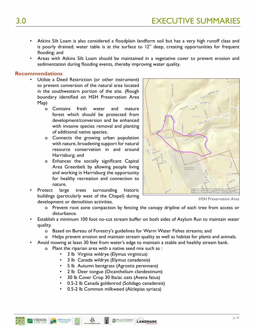
p. 41
EXECUTIVE SUMMARIES3.0
• Atkins Silt Loam is also considered a floodplain landform soil but has a very high runoff class and is poorly drained; water table is at the surface to 12” deep, creating opportunities for frequent flooding; and
• Areas with Atkins Silt Loam should be maintained in a vegetative cover to prevent erosion and sedimentation during flooding events, thereby improving water quality.
Recommendations• Utilize a Deed Restriction (or other instrument)
to prevent conversion of the natural area located in the southwestern portion of the site. (Rough boundary identified on HSH Preservation Area Map)
o Contains fresh water and mature forest which should be protected from development/conversion and be enhanced with invasive species removal and planting of additional native species;
o Connects the growing urban population with nature, broadening support for natural resource conservation in and around Harrisburg; and
o Enhances the socially significant Capital Area Greenbelt by allowing people living and working in Harrisburg the opportunity for healthy recreation and connection to nature.
• Protect large trees surrounding historic buildings (particularly west of the Chapel) during development or demolition activities.
o Prevent root zone compaction by fencing the canopy dripline of each tree from access or disturbance.
• Establish a minimum 100 foot no-cut stream buffer on both sides of Asylum Run to maintain water quality.
o Based on Bureau of Forestry’s guidelines for Warm Water Fishes streams; and o Helps prevent erosion and maintain stream quality as well as habitat for plants and animals.
• Avoid mowing at least 30 feet from water’s edge to maintain a stable and healthy stream bank.o Plant the riparian area with a native seed mix such as :
• 3 lb Virginia wildrye (Elymus virginicus)• 3 lb Canada wildrye (Elymus canadensis)• 5 lb Autumn bentgrass (Agrostis perennans)• 2 lb Deer tongue (Dicanthelium clandestinum)• 30 lb Cover Crop 30 lbs/ac oats (Avena fatua) • 0.5-2 lb Canada goldenrod (Solidago canadensis) • 0.5-2 lb Common milkweed (Alclepias syriaca)
Susquehanna
Harrisburg
Dauphin
Sources: Esri, HERE, DeLorme, USGS, Intermap, increment P Corp.,NRCAN, Esri Japan, METI, Esri China (Hong Kong), Esri (Thailand),MapmyIndia, © OpenStreetMap contributors, and the GIS User Community
FLegendState Hospital PreservationArea
PA Municipalities
Harrisburg State Hospital Preservation Area
Map view showing road names.HSH Preservation Area
p. 42
REAL ESTATE MARKET RESEARCHRGS project team member 4ward Planning, identified the highest and best use(s) for the DGS Annex Complex. The Real Estate Market analysis looked at three distinct study areas:
• Harrisburg-Susquehanna (includes harrisburg City and Susquehanna Township)• 15 minute drive time from the DGS Annex complex• The Greater Harrisburg MSA
The key findings of the detailed market analysis, highlighting salient commonalities and differences among all three study areas within the Harrisburg MSA, should be considered when repurposing the DGS Annex Complex properties. The following are significant local and regional socio-economic, labor and industry, and real estate strengths, challenges, and opportunities associated with the adaptive reuse and/or redevelopment of the DGS Annex Complex.
An Aging Population
All three study areas are seeing an aging population. Over one in six Harrisburg MSA residents are over 65, making them an increasingly dominant market force in the region, and the likelihood that many of these persons will look to downsize within the area represents a significant redevelopment factor.
Lower- and Upper-Income Needs
Considering relatively lower household incomes in the nearby communities of Harrisburg and Susquehanna Township (for younger and older households, alike), as well as the types of occupations projected to grow in the PMA over the next five to 10 years (e.g., lower- and semi-skilled jobs), a land-use strategy that is sensitive to these lower incomes - while still affording opportunity to capture a potion of upper-income households in the region (whether through housing, commercial establishments, or both) - should be of particular interest in a market-receptive redevelopment of the DGS Annex Complex.
EXECUTIVE SUMMARIES 3.0
Market Research Findings
p. 43
Medical Office Needs
The decline in the number and types of occupations which are traditionally associated with office use (e.g., public service administrative occupations and financial and real estate services jobs) in the region will likely mean a drop in demand for traditional office space in the PMA. However, as healthcare-related positions continue to expand, there will be a likely demand for medical-related office space – projected at an additional 285,000 square feet - which may not be satisfied by the region’s existing underutilized office space (much of which may be both physically and/or economically obsolescent and need of substantial rehabilitation investment).
Demand for Multi-Family Housing
According to the real estate supply/demand analysis performed, the DGS Annex Complex has the opportunity to support development of between 420 and 850 new multi-family units by 2030 (the larger housing unit number assumes that demand would continue to be unmet through 2030 and; therefore, result in a cumulative larger share of unmet housing demand).
Demand for Dining & Lodging Facilities
Finally, through a combination of real estate quantitative analysis and interviews conducted with active real estate professionals (e.g., local brokers, developers and property managers), the area could accommodate more in the way of sit-down dining establishments and lodging facilities, leveraging off the 937,500 participants attending major events held annually at the Pennsylvania Farm Show Complex & Expo Center immediately across the road from the DGS Annex Complex, and other annual events held near the DGS site. These same types of land-uses would also be patronized by regional visitors and family members of those seeking local area healthcare services.
AGENCY/MUNICIPAL MEETING FEEDBACKRepresentatives from DGS and the RGS Project Team conducted follow-up stakeholder meetings with various State Agencies, Dauphin County, City of Harrisburg, and Susquehanna Township Officials at the conclusion of the Phase 1 research. These meetings were intended to inform the groups of the knowledge gained from the initial research as well as to continue to gain additional input and feedback. The following meetings were conducted:
• State Agency Representatives - April 22, 2016 1:30 - 3:00 PM• Dauphin County Officials – July 14, 2016 9:00 - 10:30 AM• City of Harrisburg – June 22, 2016 3:15 - 4:15 PM• Susquehanna Township – June 13, 2016 6:00 - 8:00 PM
Meeting minutes as well as listings of the representatives in attendance at each discussion are contained in the Appendices.
Each meeting included a PowerPoint presentation summarizing Phase 1 research and findings. All meetings involved open dialogue and feedback. The following summaries represent the major themes conveyed at each meeting.
EXECUTIVE SUMMARIES3.0
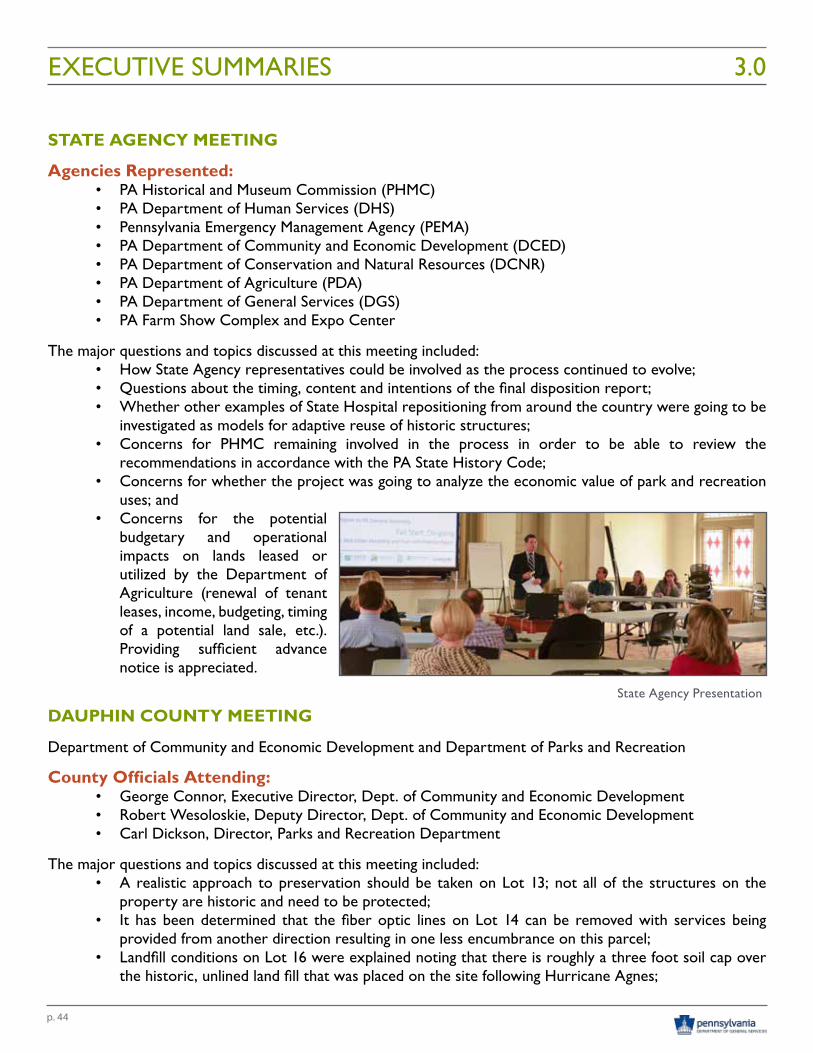
p. 44
STATE AGENCY MEETING
Agencies Represented:• PA Historical and Museum Commission (PHMC)• PA Department of Human Services (DHS)• Pennsylvania Emergency Management Agency (PEMA)• PA Department of Community and Economic Development (DCED)• PA Department of Conservation and Natural Resources (DCNR)• PA Department of Agriculture (PDA)• PA Department of General Services (DGS)• PA Farm Show Complex and Expo Center
The major questions and topics discussed at this meeting included: • How State Agency representatives could be involved as the process continued to evolve;• Questions about the timing, content and intentions of the final disposition report;• Whether other examples of State Hospital repositioning from around the country were going to be
investigated as models for adaptive reuse of historic structures; • Concerns for PHMC remaining involved in the process in order to be able to review the
recommendations in accordance with the PA State History Code; • Concerns for whether the project was going to analyze the economic value of park and recreation
uses; and • Concerns for the potential
budgetary and operational impacts on lands leased or utilized by the Department of Agriculture (renewal of tenant leases, income, budgeting, timing of a potential land sale, etc.). Providing sufficient advance notice is appreciated.
DAUPHIN COUNTY MEETING
Department of Community and Economic Development and Department of Parks and Recreation
County Officials Attending:• George Connor, Executive Director, Dept. of Community and Economic Development• Robert Wesoloskie, Deputy Director, Dept. of Community and Economic Development• Carl Dickson, Director, Parks and Recreation Department
The major questions and topics discussed at this meeting included: • A realistic approach to preservation should be taken on Lot 13; not all of the structures on the
property are historic and need to be protected; • It has been determined that the fiber optic lines on Lot 14 can be removed with services being
provided from another direction resulting in one less encumbrance on this parcel; • Landfill conditions on Lot 16 were explained noting that there is roughly a three foot soil cap over
the historic, unlined land fill that was placed on the site following Hurricane Agnes;
EXECUTIVE SUMMARIES 3.0
State Agency Presentation
p. 45
• Relocating the Dauphin County Community Gardens to Lot 16 would come with the stigma of gardens being planted atop the landfill. Soil types on the site are the same as those in the area of the current gardens and there is sufficient land area upslope from the land fill to accommodate the gardens;
• It was noted that Susquehanna Township has expressed interest in Lot 16 as a potential site for a community park;
• Questions about how the real estate would be offered for sale were posed, including whether the land could be conveyed to a redevelopment or industrial development authority;
• Concerns for whether the recommendations were going to include any mention or thoughts of the types of incentives that could be offered to secure a developer’s interest in the sites;
• Potential timing for complete vacancy of the buildings on Lot 13 was questioned to determine realistic timeframes for action (700-800 employees still on-site; two to three more years to vacate the site; likely three to five years until a property transaction could be completed.)
• It was noted that incentives and partnerships would be key to getting the sites redeveloped; and • Dauphin County recently received an EPA Community-Wide Brownfield Assessment Grant
($400,000) which could be used for both Phase 1 and Phase 2 environmental sites assessments in the County; some of the assessment funds could potentially be used for Lot 13 as part of a developer’s incentive package.
CITY OF HARRISBURG MEETING
City Officials Attending:• Jackie Parker, City of Harrisburg, Director of Community and Economic Development• Timothy Collins, Chief of Staff, Office of Senator Rob Teplitz
The major questions and topics discussed at this meeting included: • Suggested Lot 16 as a park / recreation area / public use property owned by the County or Township; • Suggestion made to consider street connections to the residential areas along Maclay Street with a
Sycamore Drive extension to improve traffic connectivity and remove some peak hour volume from the Cameron Street Corridor (suggesting consistency with the City Comprehensive Plan) ;
• Preference for Lot 13 to develop as a mixed use project while preserving and/or adaptively reusing the most historic buildings on the campus;
• Emphasized the importance of identifying transportation availability, needs, and connectivity issues in the area of Lot 13 area;
• Expressed concern for businesses and uses that would compete with downtown Harrisburg; and • Suggested that the project team needs to do a better job of explaining “why” it is important for DGS
to consider recommending the sale of the subject properties to the General Assembly.
SUSQUEHANNA TOWNSHIP MEETING
Township Officials (Staff, Planning Commission and Supervisors) attending:• Dave Kratzer; Johnathan Bowser; Frank Chlebniknow; Kerry Wilson; Mona Johnson; Jody Rebarchak;
Tom Pyne; Frank Lynch; Bob Grubic; James McGraw; Bruce Foreman; Frank C.; John Taylor; and Justin Fleming
EXECUTIVE SUMMARIES3.0
p. 46
The major questions and topics discussed at this meeting included: • Numerous questions focused on the recommendations being made to the General Assembly, how
they would be formulated, and how the real estate might be offered for sale; • It was noted that the land could not be transferred directly to an industrial development authority,
only a redevelopment authority; • Inclusion of the Susquehanna Township School District in future stakeholder meetings is recommended,
not including them was a gross oversight; • Leaseholds within Lot 13 expire in 2017, they also require a 365 day notice of termination; • Concerns were expressed regarding the current zoning of the property:
o would DGS be seeking a change in zoning prior to any potential sale? (no, not what DGS would typically do);
o who would likely seek such a change? (someone other than DGS); and o might the General Assembly place restrictions on the land? (they certainly can);
• Questions were asked about the disposition report being prepared for the General Assembly such as the timeframe for completion, the intent to provide options on how the real estate should be sold, and when might any transfers in real estate occur.
• There was an interest in understanding the disposition of the existing buildings on Lot 13: o have structural evaluations of the buildings been undertaken (no); o are the costs of potential demolition and clearing of the site understood (not at the time of
this meeting, but they have since been evaluated); and o has it been determined which ones must stay due to their historic value (not at the time of
this meeting, but they have since been evaluated); • DGS was questioned on why there was the need to sell the properties (annual upkeep and maintenance
costs of between $5-6M is significant and clearly not an efficient use of taxpayer dollars; DGS is simply interested in trying to “stop the bleeding” and be responsible stewards of taxpayer dollars and assets);
• Questions were asked around whether the project would be undertaking any type of Master Plan to develop a vision for the reuse of the site or whether any type of reuse analysis was being done?
o Master planning is not a typical element of work for DGS since they are generally not in the business of developing real estate; they would leave this to the private sector to figure out; and
o A reuse analysis was stated as something that would likely not be provided, however the final disposition report did ultimately include a hypothetical redevelopment capacity analysis to determine what land uses could potentially be developed on the subject parcels of land;
• There were suggestions made by meeting attendees that they needed to start communicating with local legislators about the future of the land and with DCED about leveraging potential redevelopment opportunities that could positively impact the Township;
• A discussion of potential land uses occurred: o the Township is not interested in substantial residential development; o focus on tax revenue generation from private businesses; the discussion also stated the need
for additional recreation land in the Township; and o Lot 16 might be of interest to the Township to serve the needs of residents, not necessarily
to simply relocate all of the uses potentially being displaced; • Concerns were expressed over recent statements about annexation by the City of Harrisburg:
o Susquehanna Township had not been approached about the matter;
EXECUTIVE SUMMARIES 3.0
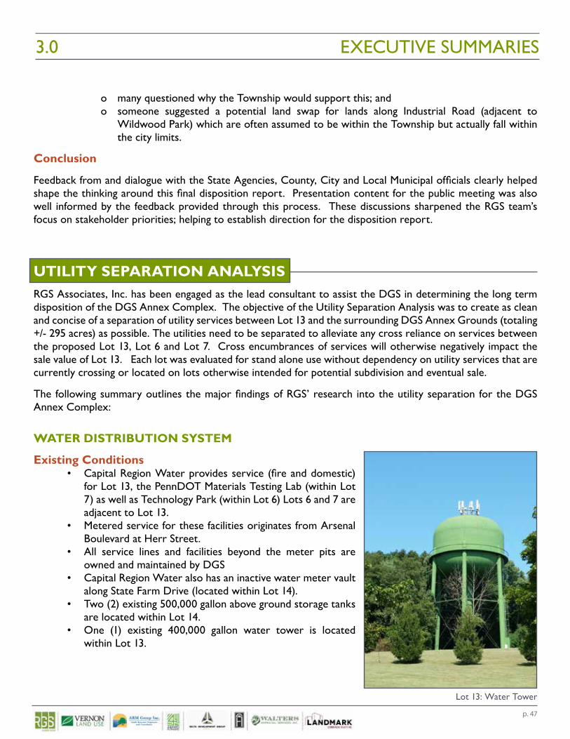
p. 47
o many questioned why the Township would support this; and o someone suggested a potential land swap for lands along Industrial Road (adjacent to
Wildwood Park) which are often assumed to be within the Township but actually fall within the city limits.
Conclusion
Feedback from and dialogue with the State Agencies, County, City and Local Municipal officials clearly helped shape the thinking around this final disposition report. Presentation content for the public meeting was also well informed by the feedback provided through this process. These discussions sharpened the RGS team’s focus on stakeholder priorities; helping to establish direction for the disposition report.
UTILITY SEPARATION ANALYSISRGS Associates, Inc. has been engaged as the lead consultant to assist the DGS in determining the long term disposition of the DGS Annex Complex. The objective of the Utility Separation Analysis was to create as clean and concise of a separation of utility services between Lot 13 and the surrounding DGS Annex Grounds (totaling +/- 295 acres) as possible. The utilities need to be separated to alleviate any cross reliance on services between the proposed Lot 13, Lot 6 and Lot 7. Cross encumbrances of services will otherwise negatively impact the sale value of Lot 13. Each lot was evaluated for stand alone use without dependency on utility services that are currently crossing or located on lots otherwise intended for potential subdivision and eventual sale.
The following summary outlines the major findings of RGS’ research into the utility separation for the DGS Annex Complex:
WATER DISTRIBUTION SYSTEM
Existing Conditions• Capital Region Water provides service (fire and domestic)
for Lot 13, the PennDOT Materials Testing Lab (within Lot 7) as well as Technology Park (within Lot 6) Lots 6 and 7 are adjacent to Lot 13.
• Metered service for these facilities originates from Arsenal Boulevard at Herr Street.
• All service lines and facilities beyond the meter pits are owned and maintained by DGS
• Capital Region Water also has an inactive water meter vault along State Farm Drive (located within Lot 14).
• Two (2) existing 500,000 gallon above ground storage tanks are located within Lot 14.
• One (1) existing 400,000 gallon water tower is located within Lot 13.
EXECUTIVE SUMMARIES3.0
Lot 13: Water Tower
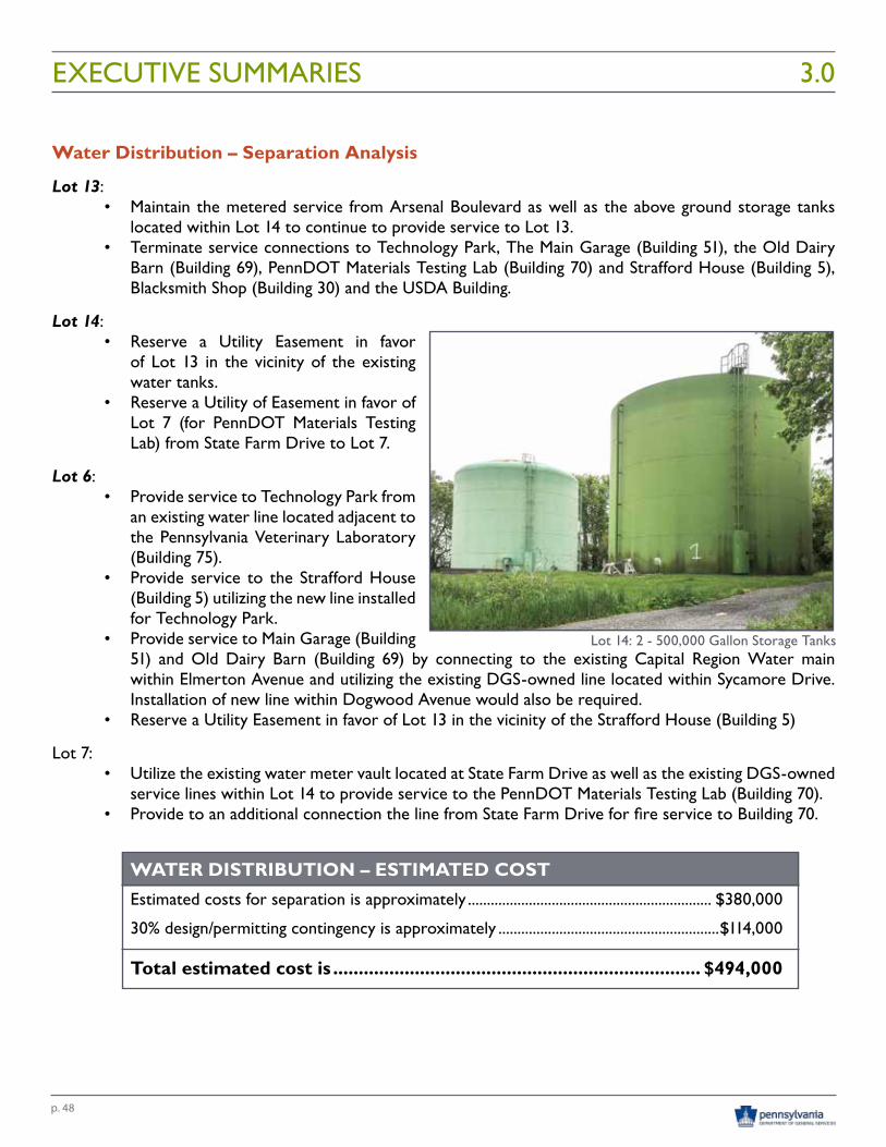
p. 48
Water Distribution – Separation Analysis
Lot 13:• Maintain the metered service from Arsenal Boulevard as well as the above ground storage tanks
located within Lot 14 to continue to provide service to Lot 13.• Terminate service connections to Technology Park, The Main Garage (Building 51), the Old Dairy
Barn (Building 69), PennDOT Materials Testing Lab (Building 70) and Strafford House (Building 5), Blacksmith Shop (Building 30) and the USDA Building.
Lot 14:• Reserve a Utility Easement in favor
of Lot 13 in the vicinity of the existing water tanks.
• Reserve a Utility of Easement in favor of Lot 7 (for PennDOT Materials Testing Lab) from State Farm Drive to Lot 7.
Lot 6:• Provide service to Technology Park from
an existing water line located adjacent to the Pennsylvania Veterinary Laboratory (Building 75).
• Provide service to the Strafford House (Building 5) utilizing the new line installed for Technology Park.
• Provide service to Main Garage (Building 51) and Old Dairy Barn (Building 69) by connecting to the existing Capital Region Water main within Elmerton Avenue and utilizing the existing DGS-owned line located within Sycamore Drive. Installation of new line within Dogwood Avenue would also be required.
• Reserve a Utility Easement in favor of Lot 13 in the vicinity of the Strafford House (Building 5)
Lot 7:• Utilize the existing water meter vault located at State Farm Drive as well as the existing DGS-owned
service lines within Lot 14 to provide service to the PennDOT Materials Testing Lab (Building 70).• Provide to an additional connection the line from State Farm Drive for fire service to Building 70.
WATER DISTRIBUTION – ESTIMATED COST Estimated costs for separation is approximately ................................................................ $380,000
30% design/permitting contingency is approximately ..........................................................$114,000
Total estimated cost is ........................................................................ $494,000
EXECUTIVE SUMMARIES 3.0
Lot 14: 2 - 500,000 Gallon Storage Tanks
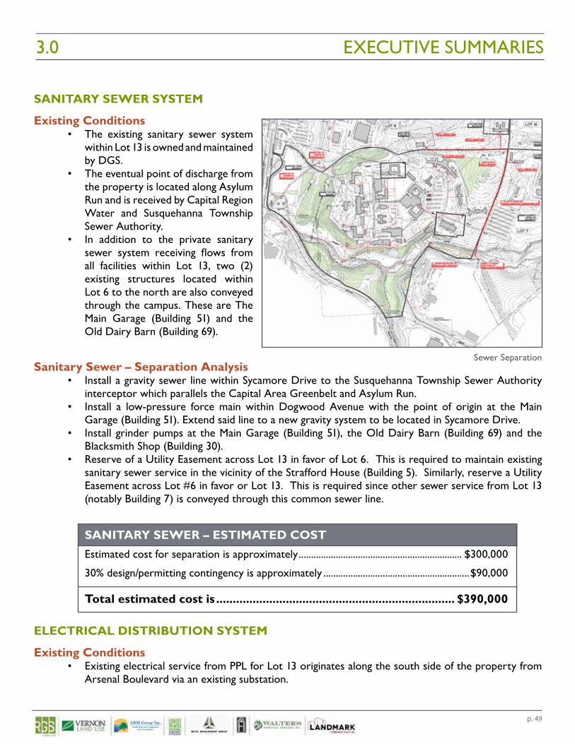
p. 49
SANITARY SEWER SYSTEM
Existing Conditions• The existing sanitary sewer system
within Lot 13 is owned and maintained by DGS.
• The eventual point of discharge from the property is located along Asylum Run and is received by Capital Region Water and Susquehanna Township Sewer Authority.
• In addition to the private sanitary sewer system receiving flows from all facilities within Lot 13, two (2) existing structures located within Lot 6 to the north are also conveyed through the campus. These are The Main Garage (Building 51) and the Old Dairy Barn (Building 69).
Sanitary Sewer – Separation Analysis• Install a gravity sewer line within Sycamore Drive to the Susquehanna Township Sewer Authority
interceptor which parallels the Capital Area Greenbelt and Asylum Run.• Install a low-pressure force main within Dogwood Avenue with the point of origin at the Main
Garage (Building 51). Extend said line to a new gravity system to be located in Sycamore Drive.• Install grinder pumps at the Main Garage (Building 51), the Old Dairy Barn (Building 69) and the
Blacksmith Shop (Building 30).• Reserve of a Utility Easement across Lot 13 in favor of Lot 6. This is required to maintain existing
sanitary sewer service in the vicinity of the Strafford House (Building 5). Similarly, reserve a Utility Easement across Lot #6 in favor or Lot 13. This is required since other sewer service from Lot 13 (notably Building 7) is conveyed through this common sewer line.
SANITARY SEWER – ESTIMATED COST Estimated cost for separation is approximately .................................................................. $300,000
30% design/permitting contingency is approximately ...........................................................$90,000
Total estimated cost is ........................................................................ $390,000
ELECTRICAL DISTRIBUTION SYSTEM
Existing Conditions• Existing electrical service from PPL for Lot 13 originates along the south side of the property from
Arsenal Boulevard via an existing substation.
EXECUTIVE SUMMARIES3.0
Sewer Separation
p. 50
• All electric lines within Lot #13 (including the Power Plant – Building 44) are owned and maintained by DGS.
• Electrical service to the Main Garage (Building 51) within Lot 6 is provided from the Power Plant (Building 44).
Electrical Distribution – Separation Analysis• Existing electrical service to the Main Garage (Building 51), Implement Shed (Building 28) and the
Blacksmith Shop (Building 30) should be terminated.• Install a proposed service to the Main Garage. Said service would originate at the intersection of
Sycamore Drive and Dogwood Avenue.
ELECTRICAL DISTRIBUTION – ESTIMATED COST Estimated cost for separation is approximately ..................................................................... $70,000
30% design/permitting contingency is approximately ........................................................... $21,000
Total estimated cost is ...........................................................................$91,000
FIBER OPTIC SYSTEM
Existing Conditions• Currently, 48-strand fiber optic lines serve as an interconnection between the numerous state
departments located within the City of Harrisburg and Susquehanna Township. Said lines pass through Lot 13, Lot 6, Lot 7 and Lot 14.
• Fiber optic lines enters Lot 13 at a point along Arsenal Boulevard along the southern limits of the property.
• The primary control point for the fiber optic for Lot 13 (and surrounding properties) is in the Administration building (Building 11).
• Fiber optic lines are located throughout the Harrisburg State Hospital Campus within the existing tunnel network.
• Two (2) lines that pass through Lot 14 which serve other Commonwealth agencies.
Fiber Optic – Separation Analysis• Fiber optic lines located within the State Hospital tunnel network could remain in place.• An underground bypass line would begin with splicing into the existing fiber optic line at the southern
limits of the property where service enters from Arsenal Boulevard and extend to the PennDOT Materials Testing Lab (Building 70). A reservation of Utility Easement within Lot 13 in favor of the Department of General Services is required.
• A second underground fiber optic bypass line would entail splicing into the line at Azalea Drive in front of Technology Park. A new underground conduit would extend along the northern side of Dogwood Avenue to the PennDOT Materials Testing Lab where it would need to reconnect to the Commonwealth’s fiber optic loop.
• The existing fiber optic line which extends from the PennDOT Materials Testing Lab and along the southeastern perimeter of Lot 14 will remain in-place. A reservation Utility Easement within Lot 14 in favor of DGS is required.
EXECUTIVE SUMMARIES 3.0
p. 51
• The existing fiber optic line within Lot 14, which is immediately south of the Dauphin County Community Gardens would be decommissioned once the Hillcrest building (Building 53) located within Lot 13 is vacated.
FIBER OPTIC – ESTIMATED COST Budgetary pricing for construction of the above described fiber optic bypass lines has been obtained from CORL Communications, Inc.
Estimated cost for separation is approximately ...................................................................$330,000 *This fee covers all design and installation.
Total estimated cost ............................................................................ $400,000 *An additional 20% has been added for any rock drilling that may be necessary.
STEAM HEATING SYSTEM
Existing Conditions• The majority of the existing buildings within the Harrisburg State Hospital Campus are heated with
steam which originates at the existing Power Plant (Building 44).• The Main Garage (Building 51) receives steam heat and is located within Lot 6.
Steam Heating – Separation Analysis• Disconnection of the existing steam lines serving the Main Garage (Building 51) would be necessary.• An alternate source of heating would need to be installed within the Main Garage. Hanging gas
heaters accompanied by a 1,000 gallon propane tank would be required.
STEAM HEATING – ESTIMATED COST
Estimated cost for separation is approximately .....................................................................$28,000
30% design/permitting contingency is approximately ............................................................. $8,000
Total estimated cost is .......................................................................... $36,000
GAS DISTRIBUTION SYSTEM• For Lot 13, existing gas service is provided by UGI. • The primary service extends from the north and is located within Sycamore Drive. This service
connects directly to the Power Plant (Building 44).• Gas service within the campus area is no longer active and all lines were abandoned in place.• For this utility service, no separation would be necessary. All other surrounding land uses have
independent, standalone services that are not reliant on lines serving Lot 13.
EXECUTIVE SUMMARIES3.0
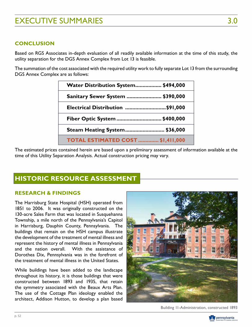
p. 52
CONCLUSION
Based on RGS Associates in-depth evaluation of all readily available information at the time of this study, the utility separation for the DGS Annex Complex from Lot 13 is feasible.
The summation of the cost associated with the required utility work to fully separate Lot 13 from the surrounding DGS Annex Complex are as follows:
Water Distribution System .................. $494,000
Sanitary Sewer System ........................ $390,000
Electrical Distribution ............................$91,000
Fiber Optic System ............................... $400,000
Steam Heating System ........................... $36,000
TOTAL ESTIMATED COST .............. $1,411,000
The estimated prices contained herein are based upon a preliminary assessment of information available at the time of this Utility Separation Analysis. Actual construction pricing may vary.
HISTORIC RESOURCE ASSESSMENT
RESEARCH & FINDINGS
The Harrisburg State Hospital (HSH) operated from 1851 to 2006. It was originally constructed on the 130-acre Sales Farm that was located in Susquehanna Township, a mile north of the Pennsylvania’s Capitol in Harrisburg, Dauphin County, Pennsylvania. The buildings that remain on the HSH campus illustrate the development of the treatment of mental illness and represent the history of mental illness in Pennsylvania and the nation overall. With the assistance of Dorothea Dix, Pennsylvania was in the forefront of the treatment of mental illness in the United States.
While buildings have been added to the landscape throughout its history, it is those buildings that were constructed between 1893 and 1935, that retain the symmetry associated with the Beaux Arts Plan. The use of the Cottage Plan ideology enabled the architect, Addison Hutton, to develop a plan based
EXECUTIVE SUMMARIES 3.0
Building 11-Administration, constructed 1893
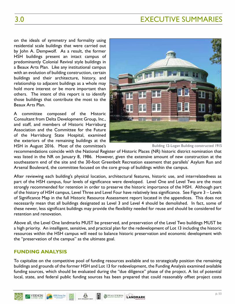
p. 53
on the ideals of symmetry and formality using residential scale buildings that were carried out by John A. Dempwolf. As a result, the former HSH buildings present an intact campus of predominantly Colonial Revival style buildings in a Beaux Arts Plan. Like any institutional campus with an evolution of building construction, certain buildings and their architecture, history, and relationship to adjacent buildings as a whole may hold more interest or be more important than others. The intent of this report is to identify those buildings that contribute the most to the Beaux Arts Plan.
A committee composed of the Historic Consultant from Delta Development Group, Inc., and staff, and members of Historic Harrisburg Association and the Committee for the Future of the Harrisburg State Hospital, examined the exteriors of the remaining buildings at the HSH in August 2016. Most of the committee’s recommendations coincide with the National Register of Historic Places (NR) historic district nomination that was listed in the NR on January 8, 1986. However, given the extensive amount of new construction at the southeastern end of the site and the 30-foot Greenbelt Recreation easement that parallels’ Asylum Run and Arsenal Boulevard, the committee focused on the core group of buildings within the campus.
After reviewing each building’s physical location, architectural features, historic use, and interrelatedness as part of the HSH campus, four levels of significance were developed. Level One and Level Two are the most strongly recommended for retention in order to preserve the historic importance of the HSH. Although part of the history of HSH campus, Level Three and Level Four have relatively less significance. See Figure 3 – Levels of Significance Map in the full Historic Resource Assessment report located in the appendices. This does not necessarily mean that all buildings designated as Level 3 and Level 4 should be demolished. In fact, some of these newer, less significant buildings may provide the flexibility needed for reuse and should be considered for retention and renovation.
Above all, the Level One landmarks MUST be preserved, and preservation of the Level Two buildings MUST be a high priority. An intelligent, sensitive, and practical plan for the redevelopment of Lot 13 including the historic resources within the HSH campus will need to balance historic preservation and economic development with the “preservation of the campus” as the ultimate goal.
FUNDING ANALYSIS
To capitalize on the competitive pool of funding resources available and to strategically position the remaining buildings and grounds of the former HSH and Lot 13 for redevelopment, the Funding Analysis examined available funding sources, which should be evaluated during the “due diligence” phase of the project. A list of potential local, state, and federal public funding sources has been prepared that could reasonably offset project costs
EXECUTIVE SUMMARIES3.0
Building 12-Logan Building constructed 1915
p. 54
depending on the ownership structure of the building and the funding source. In some cases, the ownership structure may need to be modified to take advantage of specific funding sources. Included at the end of the DGS Annex Surplus Grounds Funding Analysis in Figure 1, located in the Appendices is an overall matrix of potential funding programs.
The second part of the Funding Analysis is a Site Analysis that addresses future development plans for the reuse of the HSH site. Three possible options for retention of historic buildings were explored: Option 1 – Optimal (Figure 1), Option 2 – Desirable (Figure 2), and Option 3 – Undesirable (Figure 3). In order to retain the historic buildings and utilize both federal and state historic tax credits as a funding source for equity, a critical mass of buildings must be retained or the district could be delisted and the tax credits would be unavailable as a funding source, thus Option 1- Optimal should be the selected plan. This would not preclude new construction from occurring on the site. Contemporary-but-compatible new construction could be a potential option for the former location of the Branch Buildings as part of future development within the historic core (See Figures 4, 5, and 6 located in the DGS Annex Surplus Grounds Funding Analysis found in the Appendices).
Lastly, three case studies were prepared to examine how similar sites with historic buildings have been developed in Buffalo, New York; Philadelphia, Pennsylvania; and San Francisco, California. While the case studies are diverse in their size and regionally located, all three sites were subject to disposition from either state or federal government and all three sites have historic buildings, some of which are National Historic Landmarks, requiring additional analysis for reuse. While the federal government dispositions were for larger sites in excess of 1,000 acres, one particular site addressed the need for new construction on the site to create an urban mixed-use facility. All three sites stressed the importance of developing a master plan for the site.
The funding options prepared will provide a financial structure for the development of the overall site and the retention, reuse, and/or rehabilitation of the Level One and Level Two buildings at the Harrisburg State Hospital site. Option 1 – Optimal presents the best possible case for utilization of historic tax credits as part of equity for redevelopment and also provides the potential for new construction on the site. The case studies discuss the issues that were encountered for similar sites, whether is it compatible new construction or the need for self-sufficiency. At the HSH, funding and reuse strategies must be determined early-on so that the project can move forward to update the infrastructure, improve the roadway, and reuse the former treatment buildings that comprise the Beaux Arts Plan.
LOT 13 DEMOLITION COST ANALYSISARM prepared engineering cost estimates to remove hazardous material and demolish buildings on Lot 13 of the DGS Annex Complex. The purpose of this work was to support planning for the disposition and/or future reuse or redevelopment of Lot 13. The results and assumptions associated with this work are provided below.
OVERALL SUMMARY AND DISCUSSION
Estimated costs were developed for the abatement of hazardous materials (primarily asbestos containing materials, or ACMs) from all of the buildings on Lot 13 that were investigated as part of this study, and for the demolition of buildings that are located inside and outside of the Historic Resource Area of Lot 13. These areas were evaluated separately to support the evaluation of different site redevelopment/reuse options). The estimated costs were developed based on measured and estimated quantities, published cost data, previous
EXECUTIVE SUMMARIES 3.0
p. 55
EXECUTIVE SUMMARIES3.0
experience and engineering judgement; however, the actual costs could vary depending on a variety of factors such as the timing and sequence of the work, economies of scale, site reuse plans, and other factors. Because of the significant variability in the potential approaches to asbestos abatement, building renovation or demolition, and site redevelopment, estimated cost ranges were developed for the purposes of this study, and are summarized below.
DEMOLITION AND ABATEMENT COST ESTIMATE
Est. Low-End Cost Est. High-End Cost
Asbestos Abatement for all Buildings $3.2 million $4.5 million
Demolition of Buildings Outside of Historic Resource Area $2.7 million $3.8 million
Demolition of Buildings Inside of Historic Resource Area $3.4 million $4.8 million
Potential Total Costs $9.3 million $13.1 million
Cost Estimate Basis and Assumptions
The cost estimate ranges summarized in the preceding table were derived from the detailed cost estimate tables and values presented in the full Abatement and Demolition Cost Report, with the high-end cost estimates essentially reflecting 40% higher unit costs than considered for the baseline or low-end cost estimates. A 40% value was developed based on engineering judgment, previous cost estimates for similar projects, a typical range of unit cost variability for the items considered, and an additional contingency for unknown factors and site conditions. These cost estimates are based on the following general assumptions and considerations, and should not be used or provided without these supporting assumptions and notes:
• The cost estimates presented are engineering estimates of potential costs that have been developed to provide general order-of-magnitude estimates for planning purposes. Actual costs could vary depending on factors that include, but are not limited to: the results of future site planning and redevelopment studies; contractor bidding and selection processes; prevailing wage requirements; sequence, organization, and timing of the work; differing site conditions; discretionary decisions regarding the approach to materials abatement, building demolition, material reuse, off-site disposal, and site redevelopment; and others.
• Material quantity estimates, cost estimating approach, designation of buildings selected for demolition (i.e., those outside of the Historic Resource Area), and other considerations for the cost estimates provided were based on a number of other reports developed for Lot 13 listed below. The major findings and assumptions and considerations from those reports have not been repeated herein.
o Asbestos Inspection Report - DGS Annex Lot 13 (ARM Group Inc., dated August 18, 2016);o Phase I Environmental Site Assessment – DGS Annex Lot 13 (ARM Group Inc., dated August
18, 2016);o DGS Annex Surplus Grounds Funding Analysis for Lot 13 - Harrisburg State Hospital (Delta
Development Group, Inc., dated October 1, 2016);o DGS Annex Surplus Grounds Historic Resource Analysis for Lot 13 - Harrisburg State
Hospital (Delta Development Group, Inc., dated October 1, 2016); ando Highest and Best Use Analysis (RGS Associates).
• Unless otherwise specified, quantities have been estimated from previous inspection reports, site maps, and engineering judgment.
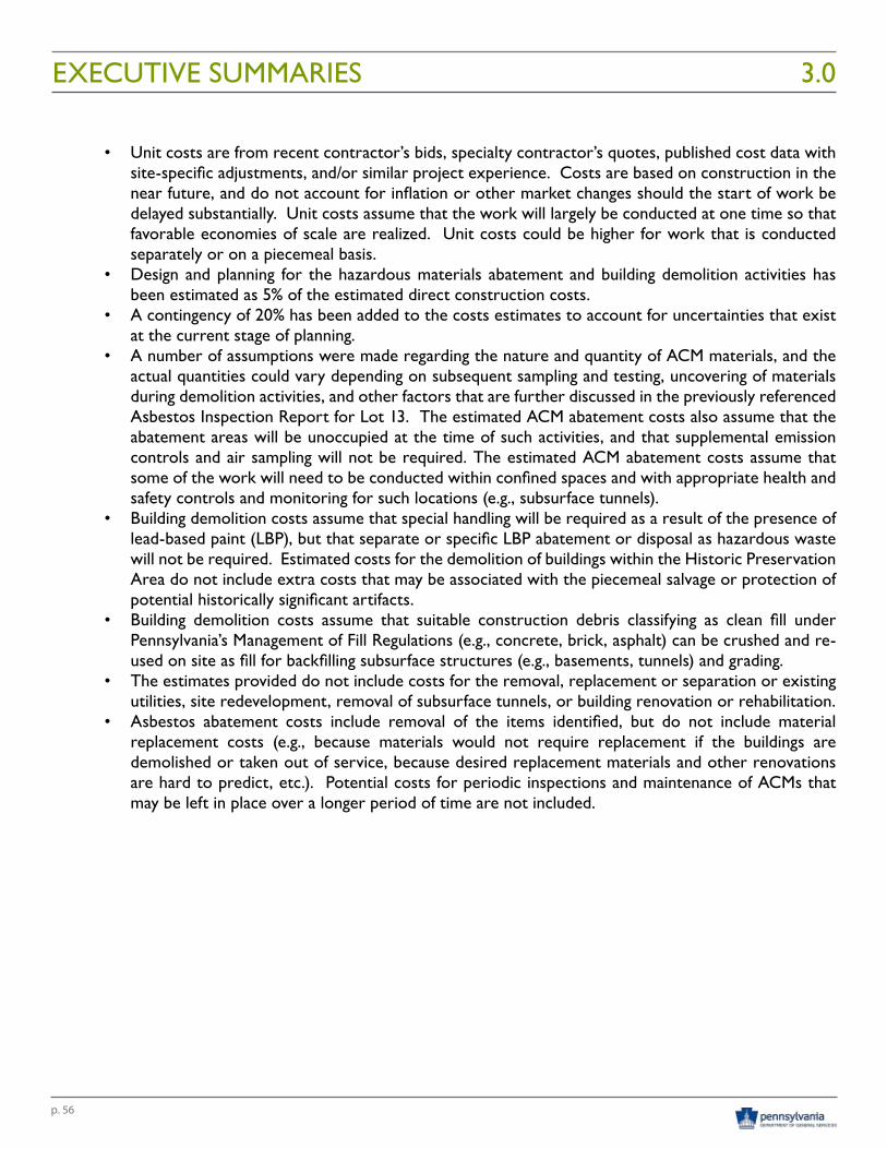
p. 56
• Unit costs are from recent contractor’s bids, specialty contractor’s quotes, published cost data with site-specific adjustments, and/or similar project experience. Costs are based on construction in the near future, and do not account for inflation or other market changes should the start of work be delayed substantially. Unit costs assume that the work will largely be conducted at one time so that favorable economies of scale are realized. Unit costs could be higher for work that is conducted separately or on a piecemeal basis.
• Design and planning for the hazardous materials abatement and building demolition activities has been estimated as 5% of the estimated direct construction costs.
• A contingency of 20% has been added to the costs estimates to account for uncertainties that exist at the current stage of planning.
• A number of assumptions were made regarding the nature and quantity of ACM materials, and the actual quantities could vary depending on subsequent sampling and testing, uncovering of materials during demolition activities, and other factors that are further discussed in the previously referenced Asbestos Inspection Report for Lot 13. The estimated ACM abatement costs also assume that the abatement areas will be unoccupied at the time of such activities, and that supplemental emission controls and air sampling will not be required. The estimated ACM abatement costs assume that some of the work will need to be conducted within confined spaces and with appropriate health and safety controls and monitoring for such locations (e.g., subsurface tunnels).
• Building demolition costs assume that special handling will be required as a result of the presence of lead-based paint (LBP), but that separate or specific LBP abatement or disposal as hazardous waste will not be required. Estimated costs for the demolition of buildings within the Historic Preservation Area do not include extra costs that may be associated with the piecemeal salvage or protection of potential historically significant artifacts.
• Building demolition costs assume that suitable construction debris classifying as clean fill under Pennsylvania’s Management of Fill Regulations (e.g., concrete, brick, asphalt) can be crushed and re-used on site as fill for backfilling subsurface structures (e.g., basements, tunnels) and grading.
• The estimates provided do not include costs for the removal, replacement or separation or existing utilities, site redevelopment, removal of subsurface tunnels, or building renovation or rehabilitation.
• Asbestos abatement costs include removal of the items identified, but do not include material replacement costs (e.g., because materials would not require replacement if the buildings are demolished or taken out of service, because desired replacement materials and other renovations are hard to predict, etc.). Potential costs for periodic inspections and maintenance of ACMs that may be left in place over a longer period of time are not included.
EXECUTIVE SUMMARIES 3.0
p. 57
COMMUNITY BENEFIT/PUBLIC USE
HARRISBURG STATE HOSPITAL HISTORIC RESOURCES (LOT 13)
Asset Description
The Harrisburg State Hospital campus signifies the history of mental illness and treatment in Pennsylvania and throughout the country. Listed on the National Register of Historic Places in 1986, the campus includes predominantly Colonial Revival style buildings in a Beaux Arts Plan.
As noted in the Historic Resource Assessment section, a Historic Resource Analysis was conducted for the project by a team including Delta Development Group, Historic Harrisburg Association, and the Committee for the Future of the Harrisburg State Hospital, assessed all buildings on site.
The study team identified specific buildings that are imperative to preserve, those that are highly encouraged to preserve, those with adaptive reuse potential, and those that are less significant from an historic resource perspective. In addition to the campus date stone, the buildings most imperative to preserve include the Dixmont Cottage and Dix Library. The complete Historic Resource Analysis is included in the appendices.
Citizens, the Pennsylvania Historic and Museum Commission (PHMC), Historic Harrisburg Association, and the Committee for the Future of the Harrisburg State Hospital stressed the need to find a balanced approach between preservation of the campus buildings and economic development.
Asset Impact
Should redevelopment impact the Harrisburg State Hospital campus, a detailed Master Plan should be prepared that strives to achieve a balanced approach between preservation and economic development. The approach should consider adaptive reuse of the existing buildings, as feasible.
STATE GOVERNMENT OPERATIONS (LOT 13)
Asset Description
Several buildings on the Harrisburg State Hospital campus provide office space for remaining DHS, formerly Department of Public Welfare, operations. As of March 2016, 750 existing DHS employees and contractors were housed in Harrisburg State Hospital property buildings. IT operations housed in Willow Oak are driven by special IT needs as specific funding sources dictate data security. These needs may impact relocation destination and costs.
In addition, the Pennsylvania State Police (PSP) currently conducts public safety training exercises in some of the vacant buildings on Lot 13. PSP is aware that these locations would not be available for future training exercises if the Harrisburg State Hospital campus is redeveloped.
EXECUTIVE SUMMARIES3.0
Historical Photo of Building 11
p. 58
Asset Impact
Relocation of additional DHS employees from the Harrisburg State Hospital campus should carefully consider space needs in light of potential security requirements imposed by state and federal funding sources. In addition, future state employee office needs, beyond DHS, should be evaluated to determine if portions of the campus, or other DGS Annex Surplus Grounds lots, should be reserved for future state office use.
Future redevelopment on Lot 13 would require the Pennsylvania State Police to find an alternate location to conduct public safety training exercises.
STATE GOVERNMENT OPERATIONS - INTERNAL ROAD NETWORK
Asset Description
The internal road network through and surrounding the Harrisburg State Hospital campus provides access, primarily via Azalea Drive, from the PDA headquarters building and the Pennsylvania Veterinary Laboratory to Harrisburg State Farm property. It also provides access between the Pennsylvania Farm Show Complex and Expo Center (Farm Show Complex) to satellite visitor parking lots along Sycamore Drive.
Sycamore Drive provides road access to PennDOTs Materials Testing Lab as well as access between PEMA’s new headquarters building on Elmerton Avenue and the Special Operations Center (SOC) near Capital Region Water.
The PDA, Farm Show Complex, and PEMA expressed interest in maintaining this internal road access as part of any future development plans on the DGS Annex Complex.
Asset Impact
Potential reconfiguration of the internal road network would impact transportation circulation for PEMA, PennDOT, PDA, and the Farm Show Complex. State agency transportation circulation would need to be addressed should the internal road network be impacted by future development on Lots 13 and 14.
Some segments of the internal road network may be appropriate to become incorporated into the public road network should redevelopment of the campus occur. This would likely require street system upgrades to public street standards in order to maintain or provide public access to the various uses that could occupy the site in the future. Dedicating the streets to Susquehanna Township would assure access to the various State Government entities that rely on Azalea Drive as a means of providing access to their operations.
STATE GOVERNMENT OPERATIONS - HARRISBURG STATE FARM
Asset Description
The Harrisburg State Farm was originally 130 acres in size with the Harrisburg State Hospital one of the first non-agricultural uses constructed on site. Recently, lands were subdivided from the Harrisburg State Farm to construct headquarters facilities for PEMA and PSECU.
PDA maintains the remaining Harrisburg State Farm property including: a dairy facility not included as part of the DGS Annex Surplus Grounds, Lot 14, Lot 15, and Lot 16. PDA derives income from leases on Lots 14, 15, and 16. Lot 14 is leased to the Dauphin County Community Gardens and the Harrisburg Area Flying Society and Lots 15 and 16 are leased to a local farmer.
EXECUTIVE SUMMARIES 3.0
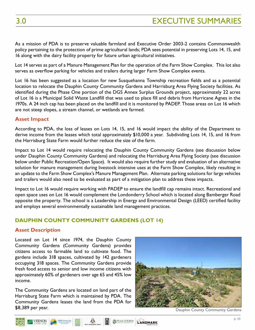
p. 59
As a mission of PDA is to preserve valuable farmland and Executive Order 2003-2 contains Commonwealth policy pertaining to the protection of prime agricultural lands; PDA sees potential in preserving Lots 14, 15, and 16 along with the dairy facility property for future urban agricultural initiatives.
Lot 14 serves as part of a Manure Management Plan for the operation of the Farm Show Complex. This lot also serves as overflow parking for vehicles and trailers during larger Farm Show Complex events.
Lot 16 has been suggested as a location for new Susquehanna Township recreation fields and as a potential location to relocate the Dauphin County Community Gardens and Harrisburg Area Flying Society facilities. As identified during the Phase One portion of the DGS Annex Surplus Grounds project, approximately 22 acres of Lot 16 is a Municipal Solid Waste Landfill that was used to place fill and debris from Hurricane Agnes in the 1970s. A 24 inch cap has been placed on the landfill and it is monitored by PADEP. Those areas on Lot 16 which are not steep slopes, a stream channel, or wetlands are farmed.
Asset Impact
According to PDA, the loss of leases on Lots 14, 15, and 16 would impact the ability of the Department to derive income from the leases which total approximately $10,000 a year. Subdividing Lots 14, 15, and 16 from the Harrisburg State Farm would further reduce the size of the farm.
Impact to Lot 14 would require relocating the Dauphin County Community Gardens (see discussion below under Dauphin County Community Gardens) and relocating the Harrisburg Area Flying Society (see discussion below under Public Recreation/Open Space). It would also require further study and evaluation of an alternative solution for manure management during livestock intensive uses at the Farm Show Complex, likely resulting in an update to the Farm Show Complex’s Manure Management Plan. Alternate parking solutions for large vehicles and trailers would also need to be evaluated as part of a mitigation plan to address these impacts.
Impact to Lot 16 would require working with PADEP to ensure the landfill cap remains intact. Recreational and open space uses on Lot 16 would complement the Londonderry School which is located along Bamberger Road opposite the property. The school is a Leadership in Energy and Environmental Design (LEED) certified facility and employs several environmentally sustainable land management practices.
DAUPHIN COUNTY COMMUNITY GARDENS (LOT 14)
Asset Description
Located on Lot 14 since 1974, the Dauphin County Community Gardens (Community Gardens) provides citizens access to farmable land to cultivate food. The gardens include 318 spaces, cultivated by 142 gardeners occupying 318 spaces. The Community Gardens provide fresh food access to senior and low income citizens with approximately 60% of gardeners over age 65 and 45% low income.
The Community Gardens are located on land part of the Harrisburg State Farm which is maintained by PDA. The Community Gardens leases the land from the PDA for $8,389 per year.
EXECUTIVE SUMMARIES3.0
Dauphin County Community Gardens
p. 60
Representatives of the Dauphin County Community Gardens, citizens, and many stakeholders expressed that the Community Gardens should remain untouched and not impacted by any potential future development. Several stakeholders suggested finding a suitable location to relocate the gardens should Lot 14 be recommended for development.
Asset Impact
A mitigation plan for relocating the Dauphin County Community Gardens should be prepared if Lot 14 is considered for development other than its current use. The mitigation plan should address: preparing a new parcel for cultivation, relocating existing top soil, relocating existing utilities, developing a multi-lingual public outreach strategy to inform citizens, and developing a relocation plan to help relocate gardeners from the existing location to a new location.
ADDICTION TREATMENT SERVICES (LOT 13)
Asset Description
While a full campus devoted to the treatment of mental illness is no longer the focus on the Harrisburg State Hospital campus, several buildings provide a location to treat members of the public afflicted by substance abuse. Gaudenzia, Inc. provides drug and alcohol treatment services at Building 21 and Building 22; employing 60 health care professionals at these facilities.
With the current opioid epidemic in Pennsylvania and across the country, the need for treatment locations is increasing. However, siting addiction treatment facilities is often difficult due to local zoning regulations. The treatment services housed on the campus are not currently impacted by local regulations as they are consistent with the original public service mission of the Harrisburg State Hospital. Gaudenzia has assessed locations outside of the Harrisburg metropolitan area to potentially relocate their services; however, local zoning regulations combined with the lack of public transportation for both clients and employees have rendered this option unobtainable.
Gaudenzia has expressed interest in potentially using additional buildings on the Harrisburg State Hospital campus to expand their operations to serve the growing number of citizens seeking addiction treatment services. Other stakeholders also expressed the need to maintain Gaudenzia’s presence on the campus.
Asset Impact
Removing Gaudenzia’s operations from the Harrisburg State Hospital campus would reduce the amount of space to administer critical treatment services to proactively address Pennsylvania’s ongoing opioid epidemic. Should future development plans on Lot 13 include relocating Gaudenzia’s operations, a mitigation strategy should be developed to find a comparable location in the Harrisburg area.
Future redevelopment plans should also consider the potential for Gaudenzia to remain on Lot 13 and facilitate their expansion, potentially as part of a more far reaching Health and Human Services Campus.
EXECUTIVE SUMMARIES 3.0
p. 61
PUBLIC RECREATION/OPEN SPACE
CAPITAL AREA GREENBELT AND ASYLUM RUN
Asset Description
The Capital Area Greenbelt (Greenbelt Trail) is a 20 mile loop trail through and around Harrisburg that is preserved and promoted by the Capital Area Greenbelt Association. The Greenbelt Trail runs through Lot 13 along Asylum Run which is not only a recreational resource, but a valued environmental resource. The Greenbelt Trail is used for active recreation by bicyclists and runners, and for open space and passive recreational use by local pedestrians and state agency employees. The floodplain areas along Asylum Run serve an important function as a natural flood control feature that should be protected and enhanced.
Further, the Greenbelt Trail and adjacent Harrisburg State Hospital campus provide passive recreational use for area birdwatchers as well as a broader wildlife habitat. According to a 2015 ecological assessment of the Harrisburg State Hospital campus and surrounding areas conducted by the Pennsylvania Department of Conservation and Natural Resources (DCNR) Bureau of Forestry for DGS, Asylum Run and adjacent lands, currently serve as a refuge for avian species impacted by the surrounding urbanization. Protecting forest cover and habitat on land surrounding Asylum Run would help preserve habitat for these and other wildlife species.
Stakeholders universally and unanimously expressed the need to protect and enhance the resources of the Capital Area Greenbelt. Future development on the Harrisburg State Hospital campus or any portion of Lot 13, should not impact the Capital Area Greenbelt or Asylum Run. Stakeholders suggested that development should enhance the Greenbelt Trail by improving connections throughout the region, particularly for bicycle and pedestrian use. Development of a new trailhead near Cameron Street was identified as a need and the plan to connect Susquehanna Township’s Veteran’s Park through state property to the Capital Area Greenbelt was identified as a priority.
Asset Impact
Identified as Susquehanna Township’s chief recreational asset, any uses which would detract from the Capital Area Greenbelt or negatively impact trees or landscaping along the Greenbelt Trail and Asylum Run would be viewed unfavorably. Future development should not impact, but enhance the Capital Area Greenbelt and Asylum Run. Future planning should also give consideration to potential floodplain improvements that could positively provide additional onsite flood storage capacity to reduce flooding impacts within the downstream Paxton Creek watershed.
HARRISBURG STATE HOSPITAL CAMPUS AESTHETICS (LOT 13)
Asset Description
The general public and employees of the Harrisburg State Hospital campus enjoy the tranquil setting it provides. The Patton Arboretum includes a mature tree canopy that combined with the architectural features of the existing structures on the campus, creates a unique setting that is not easily duplicated within a busy suburban environment. Refer to the Historic Resources Analysis Report for detailed information. It also provides a unique setting and passive recreational use opportunities for photographers and birdwatchers.
EXECUTIVE SUMMARIES3.0
p. 62
Similar to preservation of historic assets, stakeholders identified the need to find a balanced approach between preservation of the site’s unique natural characteristics and economic development.
Asset Impact
Redevelopment which damages or detracts from the current aesthetics of the Harrisburg State Hospital campus would negatively impact this asset and be a detriment to future public use and enjoyment. Should any impacts occur on the campus, enhancement of the Capital Area Greenbelt and Asylum Run should be considered. The aesthetics of the campus are what makes the resource unique. Ensuring continuity of the uniqueness of the resource should be paramount in any future planning efforts.
ATHLETIC FIELDS (LOT 13)
Asset Description
Lot 13 includes two athletic fields, the lower field along Cameron Street and the upper field by Building 23. Both fields are owned and maintained by DGS and used by local athletic leagues including a state employee league, a church league, and the Pennsylvania United Cricket Association (PAUCA).
Both of these fields provided valued recreational space for patients and residents who lived at the former Harrisburg State Hospital. They were viewed as vital elements of patient care by providing recreational opportunities as part of the Hospital’s treatment and care regimen.
During stakeholder interviews it was suggested that the athletic fields be retained as much as practical recognizing their value as open space and open play areas. If the fields need to be impacted to accommodate potential development to complement the Farm Show Complex, it was recommended that accommodations be made to relocate the fields since recreational space around the City and Susquehanna Township is at a premium. Lot 16 was suggested as a location by stakeholders and Susquehanna Township expressed potential interest in Lot 16 as a location for additional Township recreation and athletic fields.
Asset Impact
Development which impacts the existing athletic fields should consider relocation of the fields to a suitable location and include the existing athletic leagues in discussions. As noted above, Susquehanna Township has suggested the potential use of Lot 16 to site athletic and recreation fields.
HARRISBURG AREA FLYING SOCIETY (LOT 14)
Asset Description
The Harrisburg Area Flying Society (Flying Society) is a volunteer club organized in 1979 for the purpose of flying recreational model aircraft in a safe and controlled manner. The Flying Society has operated on Lot 14 since its inception 37 years ago. The flying field includes a 650 foot long grass runway. Members of the Flying Society must also be a member of the Academy of Model Aeronautics (AMA) for insurance and other purposes.
The Flying Society operates on land part of the Harrisburg State Farm which is maintained by PDA. The Flying Society leases the land from the PDA for $943 per year.
According to a comment provided at the Public Meeting conducted for the project in July 2016, the Flying Society hopes to have continued access to a flying site in the future and desires continued dialog with DGS representatives as plans continue to evolve.
EXECUTIVE SUMMARIES 3.0
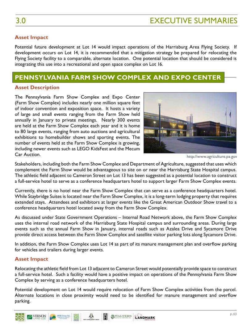
p. 63
Asset Impact
Potential future development at Lot 14 would impact operations of the Harrisburg Area Flying Society. If development occurs on Lot 14, it is recommended that a mitigation strategy be prepared for relocating the Flying Society facility to a comparable, alternate location. One potential location that should be considered is integrating this use into a recreational and open space complex on Lot 16.
PENNSYLVANIA FARM SHOW COMPLEX AND EXPO CENTERAsset Description
The Pennsylvania Farm Show Complex and Expo Center (Farm Show Complex) includes nearly one million square feet of indoor convention and exposition space. It hosts a variety of large and small events ranging from the Farm Show held annually in January to private meetings. Nearly 300 events are held at the Farm Show Complex each year and it is home to 80 large events, ranging from auto auctions and agricultural exhibitions to homebuilder shows and sporting events. The number of events held at the Farm Show Complex is growing, including newer events such as LEGO KidsFest and the Mecum Car Auction.
Stakeholders, including both the Farm Show Complex and Department of Agriculture, suggested that uses which complement the Farm Show would be advantageous to site on or near the Harrisburg State Hospital campus. The athletic field adjacent to Cameron Street on Lot 13 has been suggested as a potential location to construct a full-service hotel to serve as a conference headquarters hotel to support larger Farm Show Complex events.
Currently, there is no hotel near the Farm Show Complex that can serve as a conference headquarters hotel. While Staybridge Suites is located near the Farm Show Complex, it is a long-term lodging property that requires extended stays. Attendees and exhibitors at larger events like the Great American Outdoor Show travel to a conference headquarters hotel located away from the Farm Show Complex.
As discussed under State Government Operations – Internal Road Network above, the Farm Show Complex uses the internal road network of the Harrisburg State Hospital campus and surrounding areas. During large events such as the annual Farm Show in January, internal roads such as Azalea Drive and Sycamore Drive provide direct access between the Farm Show Complex and satellite visitor parking lots along Sycamore Drive.
In addition, the Farm Show Complex uses Lot 14 as part of its manure management plan and overflow parking for vehicles and trailers during larger events.
Asset Impact
Relocating the athletic field from Lot 13 adjacent to Cameron Street would potentially provide space to construct a full-service hotel. Such a facility would have a positive impact on operations of the Pennsylvania Farm Show Complex by serving as a conference headquarters hotel.
Potential development on Lot 14 would require relocation of Farm Show Complex activities from the parcel. Alternate locations in close proximity would need to be identified for manure management and overflow parking.
EXECUTIVE SUMMARIES3.0
http://www.agriculture.pa.gov

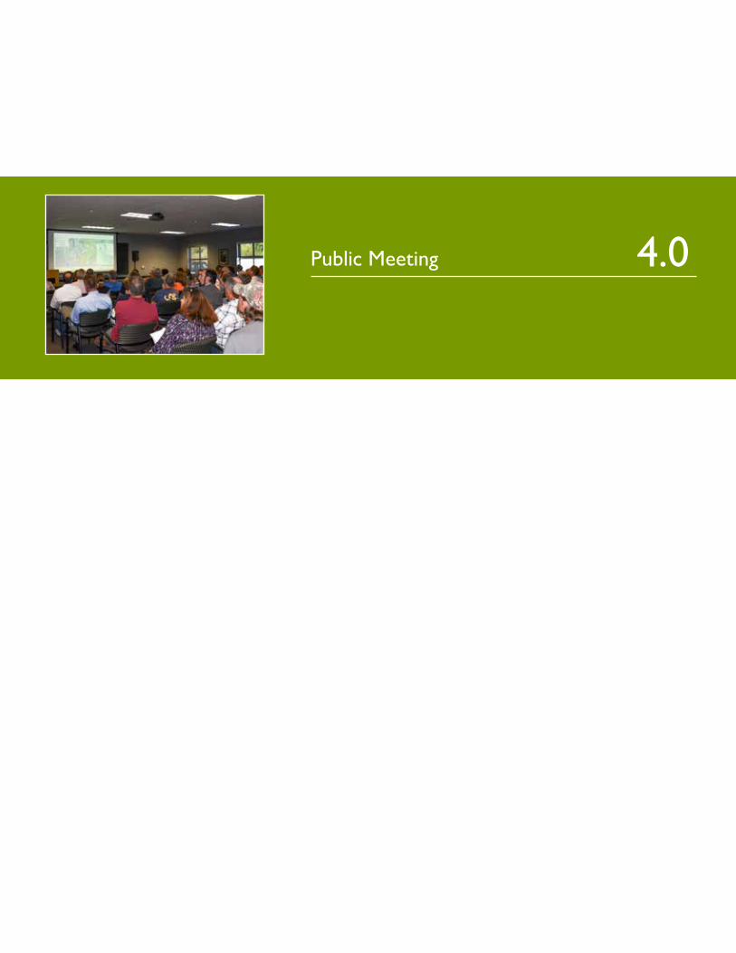
Public Meeting 4.0

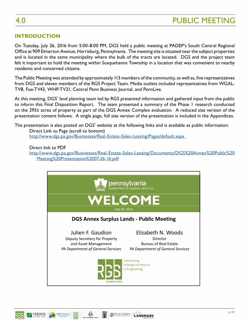
p. 67
INTRODUCTION
On Tuesday, July 26, 2016 from 5:00-8:00 PM, DGS held a public meeting at PADEP’s South Central Regional Office at 909 Elmerton Avenue, Harrisburg, Pennsylvania. The meeting site is situated near the subject properties and is located in the same municipality where the bulk of the tracts are located. DGS and the project team felt it important to hold the meeting within Susquehanna Township in a location that was convenient to nearby residents and concerned citizens.
The Public Meeting was attended by approximately 113 members of the community, as well as, five representatives from DGS and eleven members of the RGS Project Team. Media outlets included representatives from WGAL-TV8, Fox-TV43, WHP-TV21, Central Penn Business Journal, and PennLive.
At this meeting, DGS’ land planning team led by RGS presented information and gathered input from the public to inform this Final Disposition Report. The team presented a summary of the Phase 1 research conducted on the 295± acres of property as part of the DGS Annex Complex evaluation. A reduced size version of the presentation content follows. A single page, full size version of the presentation is included in the Appendices.
The presentation is also posted on DGS’ website at the following links and is available as public information:Direct Link to Page (scroll to bottom)http://www.dgs.pa.gov/Businesses/Real-Estate-Sales-Leasing/Pages/default.aspx
Direct link to PDFhttp://www.dgs.pa.gov/Businesses/Real-Estate-Sales-Leasing/Documents/DGS%20Annex%20Public%20
Meeting%20Presentation%2007-26-16.pdf
PUBLIC MEETING4.0
10/21/2016
1
Elizabeth N. WoodsDirector
Bureau of Real EstatePA Department of General Services
Julien F. GaudionDeputy Secretary for Property
and Asset ManagementPA Department of General Services
July 26, 2016
DGS Annex Surplus Lands ‐ Public Meeting
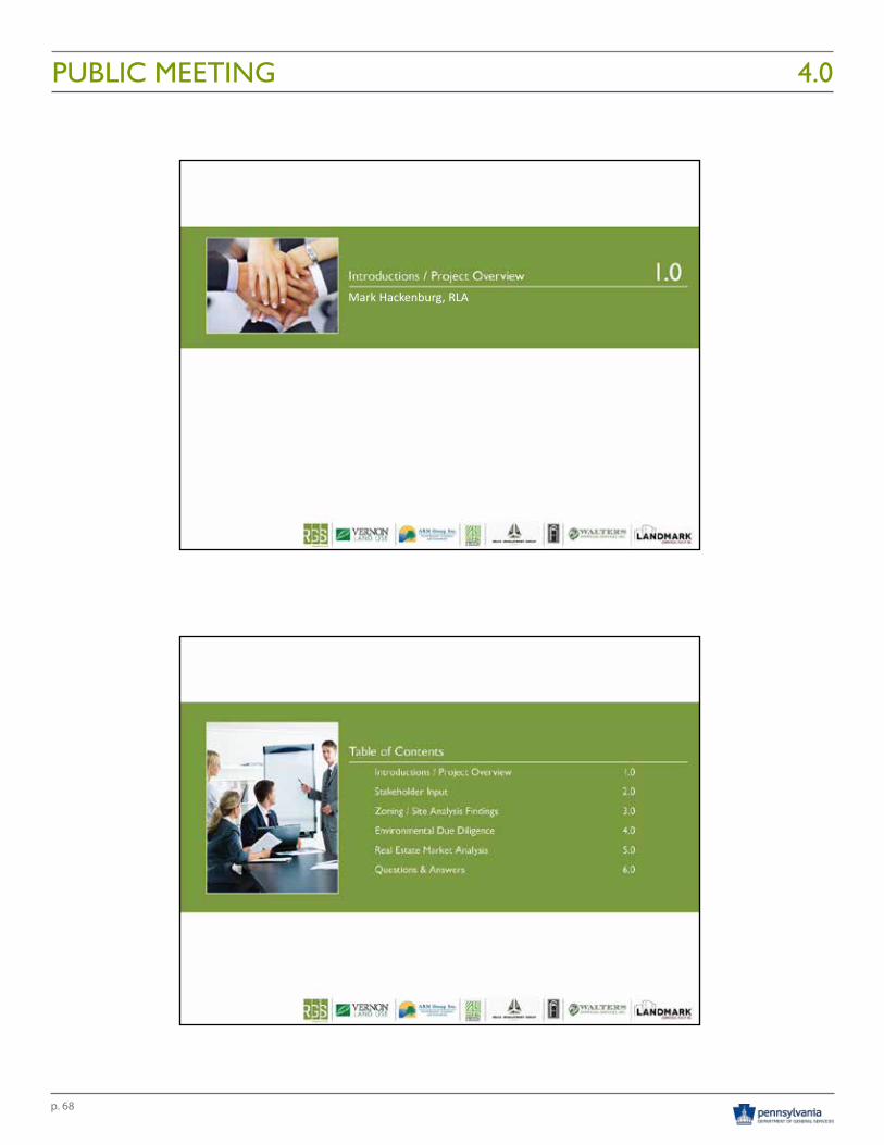
p. 68
PUBLIC MEETING 4.010/21/2016
1
Mark Hackenburg, RLA
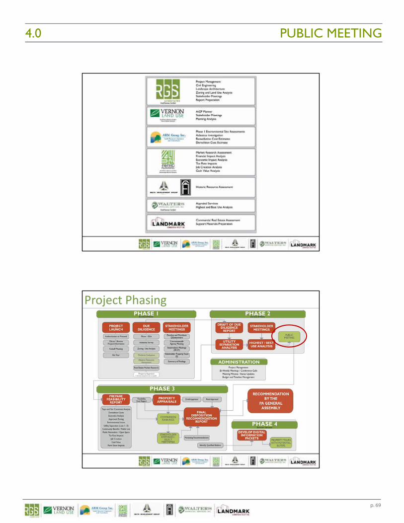
p. 69
PUBLIC MEETING4.0 10/21/2016
2
Project Phasing
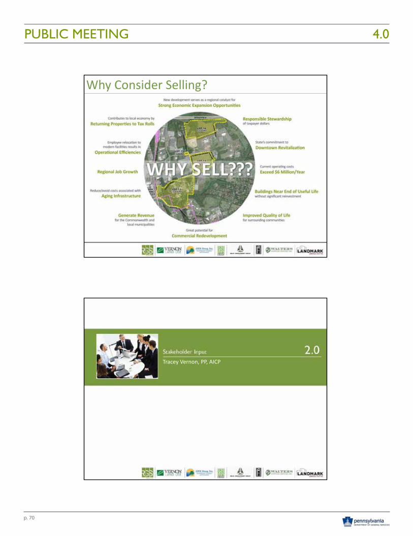
p. 70
PUBLIC MEETING 4.010/21/2016
3
Why Consider Selling?
Tracey Vernon, PP, AICP
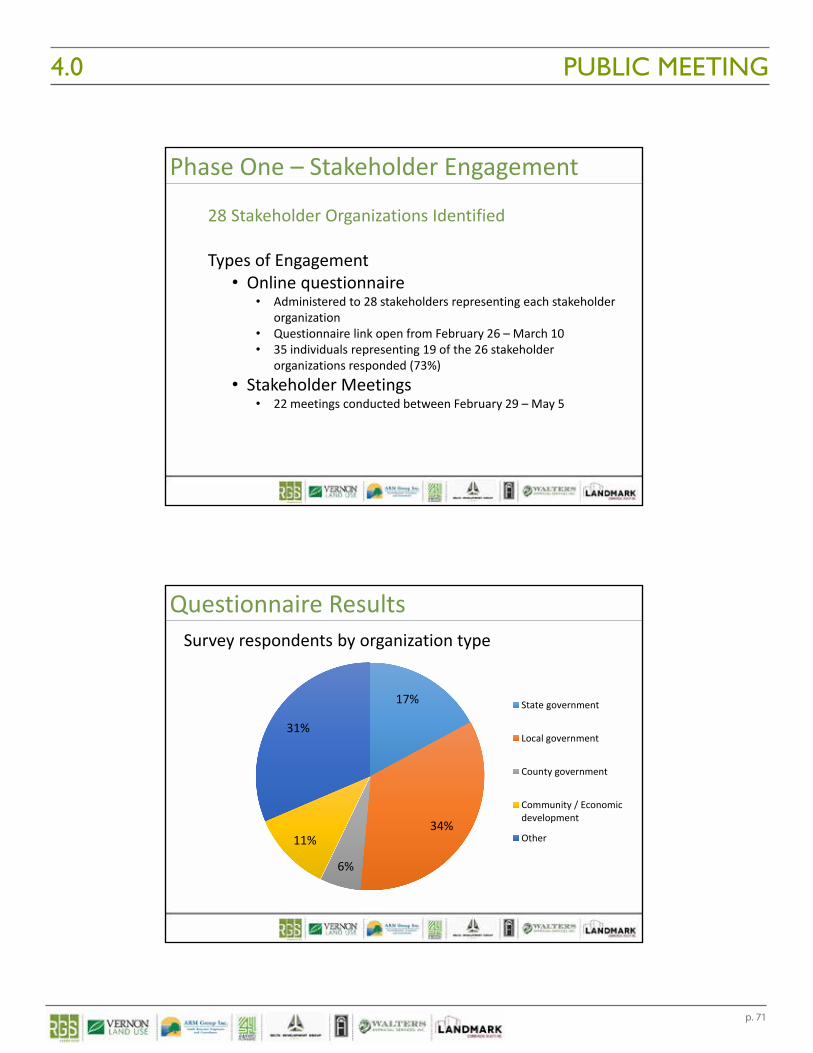
p. 71
PUBLIC MEETING4.0 10/21/2016
4
Phase One – Stakeholder Engagement
28 Stakeholder Organizations Identified
Types of Engagement• Online questionnaire
• Administered to 28 stakeholders representing each stakeholder organization
• Questionnaire link open from February 26 – March 10• 35 individuals representing 19 of the 26 stakeholder
organizations responded (73%)• Stakeholder Meetings
• 22 meetings conducted between February 29 – May 5
Survey respondents by organization type
Questionnaire Results
17%
34%
6%
11%
31%
State government
Local government
County government
Community / Economicdevelopment
Other
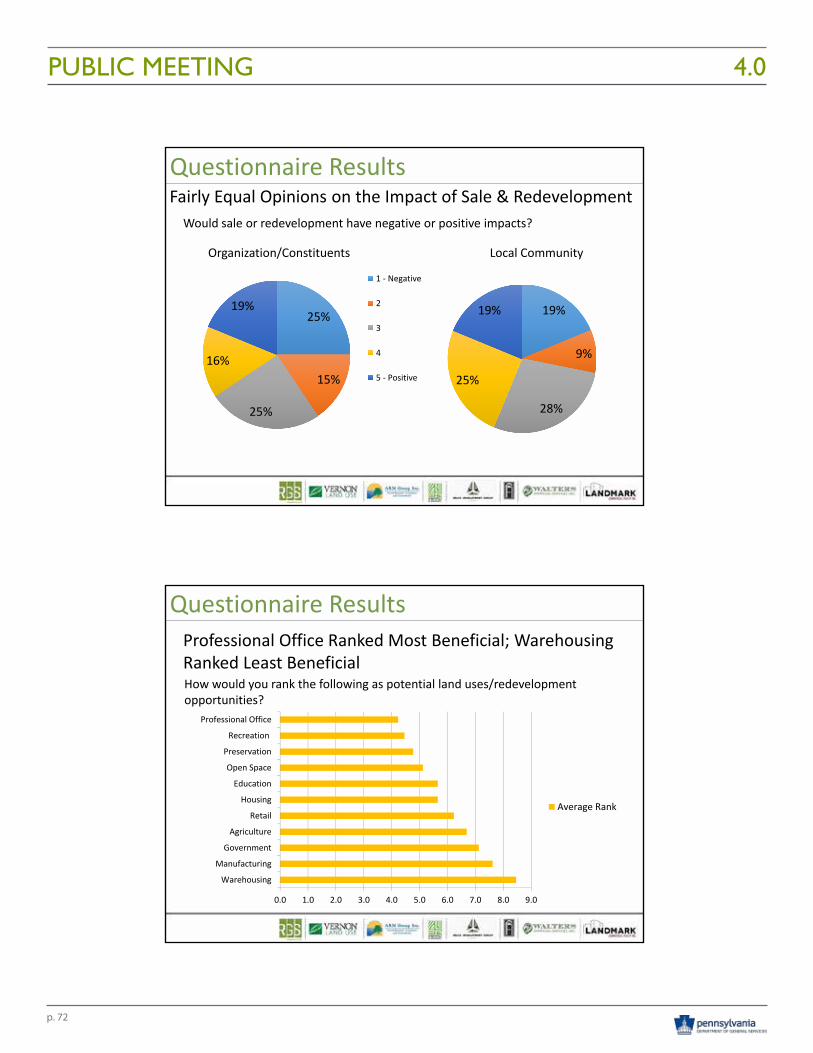
p. 72
PUBLIC MEETING 4.010/21/2016
5
Would sale or redevelopment have negative or positive impacts?
Questionnaire ResultsFairly Equal Opinions on the Impact of Sale & Redevelopment
25%
15%
25%
16%
19%
1 ‐ Negative
2
3
4
5 ‐ Positive
19%
9%
28%
25%
19%
Local CommunityOrganization/Constituents
How would you rank the following as potential land uses/redevelopment opportunities?
Questionnaire ResultsProfessional Office Ranked Most Beneficial; Warehousing Ranked Least Beneficial
0.0 1.0 2.0 3.0 4.0 5.0 6.0 7.0 8.0 9.0
Warehousing
Manufacturing
Government
Agriculture
Retail
Housing
Education
Open Space
Preservation
Recreation
Professional Office
Average Rank
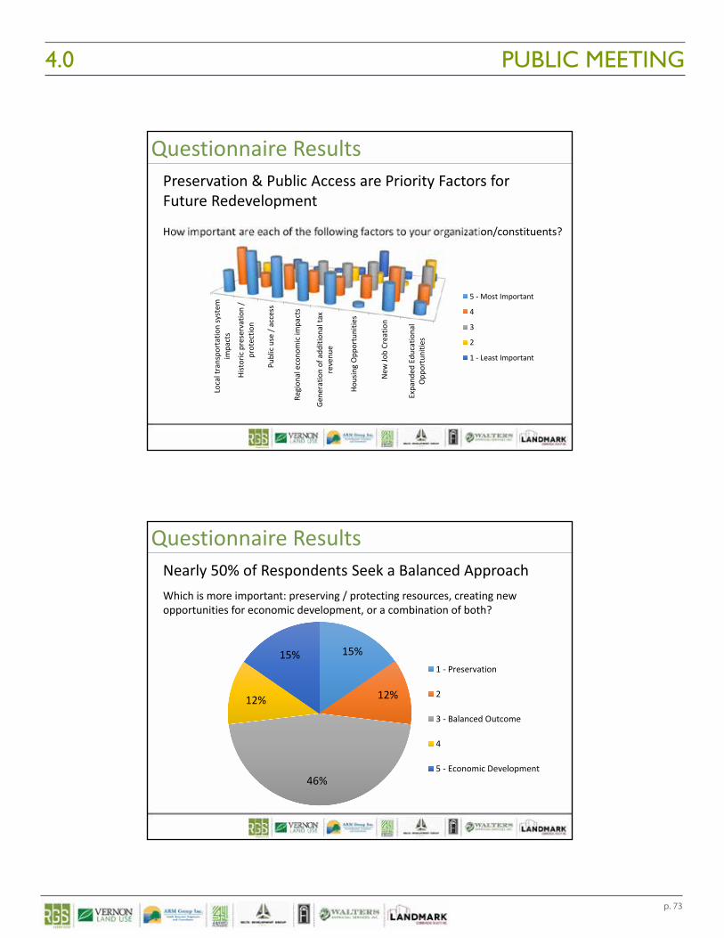
p. 73
PUBLIC MEETING4.0 10/21/2016
6
How important are each of the following factors to your organization/constituents?
Questionnaire ResultsPreservation & Public Access are Priority Factors for Future Redevelopment
Local transpo
rtation system
impacts
Historic preservation /
protectio
n
Public use / access
Region
al econo
mic im
pacts
Gene
ratio
n of add
ition
al ta
xrevenu
e
Housing Opp
ortunitie
s
New
Job Creatio
n
Expand
ed Edu
catio
nal
Opp
ortunitie
s
5 ‐ Most Important
4
3
2
1 ‐ Least Important
Which is more important: preserving / protecting resources, creating new opportunities for economic development, or a combination of both?
Questionnaire ResultsNearly 50% of Respondents Seek a Balanced Approach
15%
12%
46%
12%
15%1 ‐ Preservation
2
3 ‐ Balanced Outcome
4
5 ‐ Economic Development
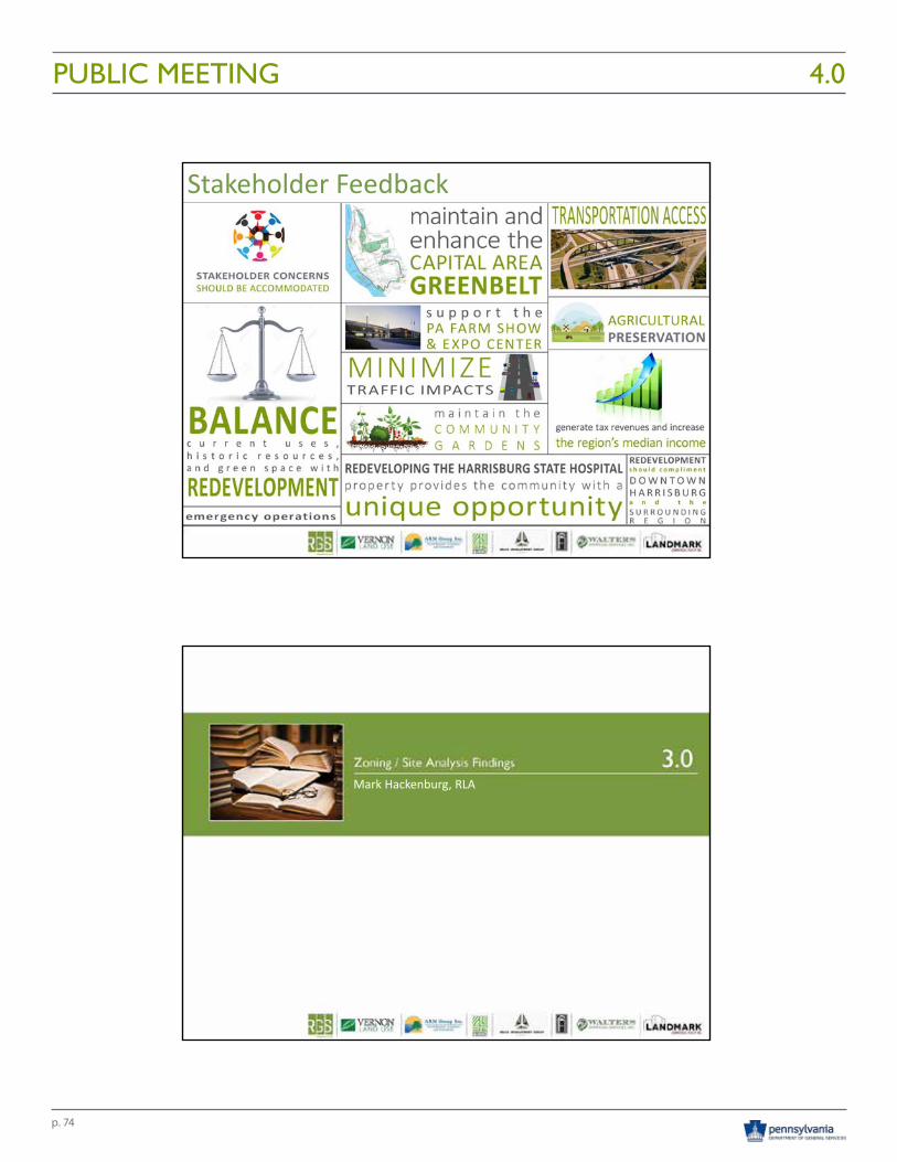
p. 74
PUBLIC MEETING 4.010/21/2016
7
Stakeholder Feedback
Mark Hackenburg, RLA
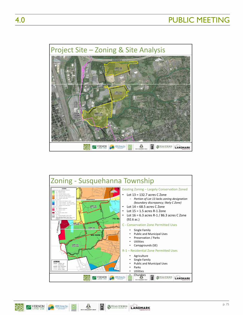
p. 75
PUBLIC MEETING4.0 10/21/2016
8
Project Site – Zoning & Site Analysis
Zoning ‐ Susquehanna TownshipExisting Zoning – Largely Conservation Zoned• Lot 13 = 132.7 acres C Zone
- Portion of Lot 13 lacks zoning designation (boundary discrepancy; likely C Zone)
• Lot 14 = 68.5 acres C Zone• Lot 15 = 1.5 acres R‐1 Zone• Lot 16 = 6.3 acres R‐1 / 86.3 acres C Zone
(92.6 ac.)
C ‐ Conservation Zone Permitted Uses• Single Family• Public and Municipal Uses• Preservation / Parks• Utilities• Campgrounds (SE)
R‐1 – Residential Zone Permitted Uses• Agriculture• Single Family• Public and Municipal Uses• Parks• Utilities• Churches
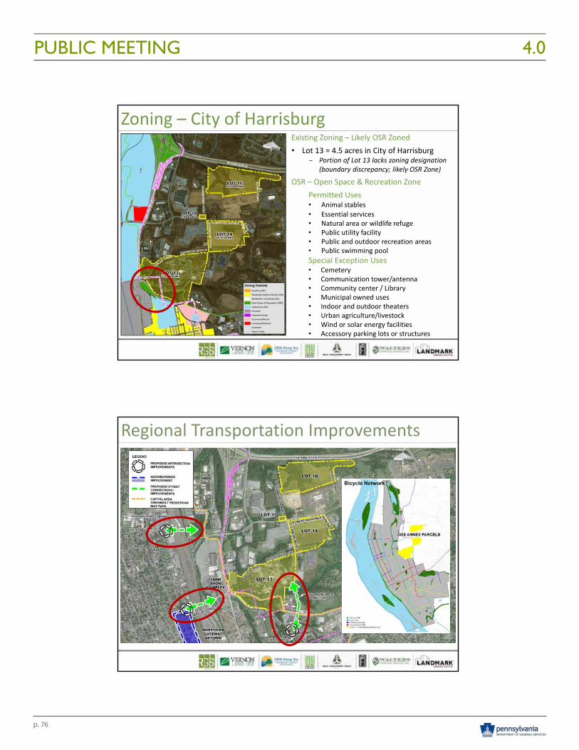
p. 76
PUBLIC MEETING 4.010/21/2016
9
Zoning – City of HarrisburgExisting Zoning – Likely OSR Zoned• Lot 13 = 4.5 acres in City of Harrisburg
- Portion of Lot 13 lacks zoning designation (boundary discrepancy; likely OSR Zone)
OSR – Open Space & Recreation Zone Permitted Uses• Animal stables• Essential services• Natural area or wildlife refuge• Public utility facility• Public and outdoor recreation areas• Public swimming poolSpecial Exception Uses• Cemetery• Communication tower/antenna• Community center / Library• Municipal owned uses• Indoor and outdoor theaters• Urban agriculture/livestock• Wind or solar energy facilities• Accessory parking lots or structures
Regional Transportation Improvements
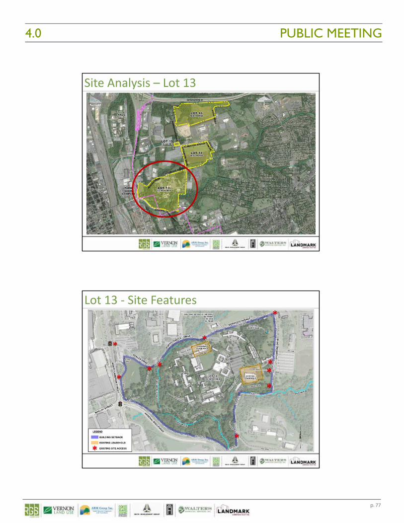
p. 77
PUBLIC MEETING4.0 10/21/2016
10
Site Analysis – Lot 13
Lot 13 ‐ Site Features
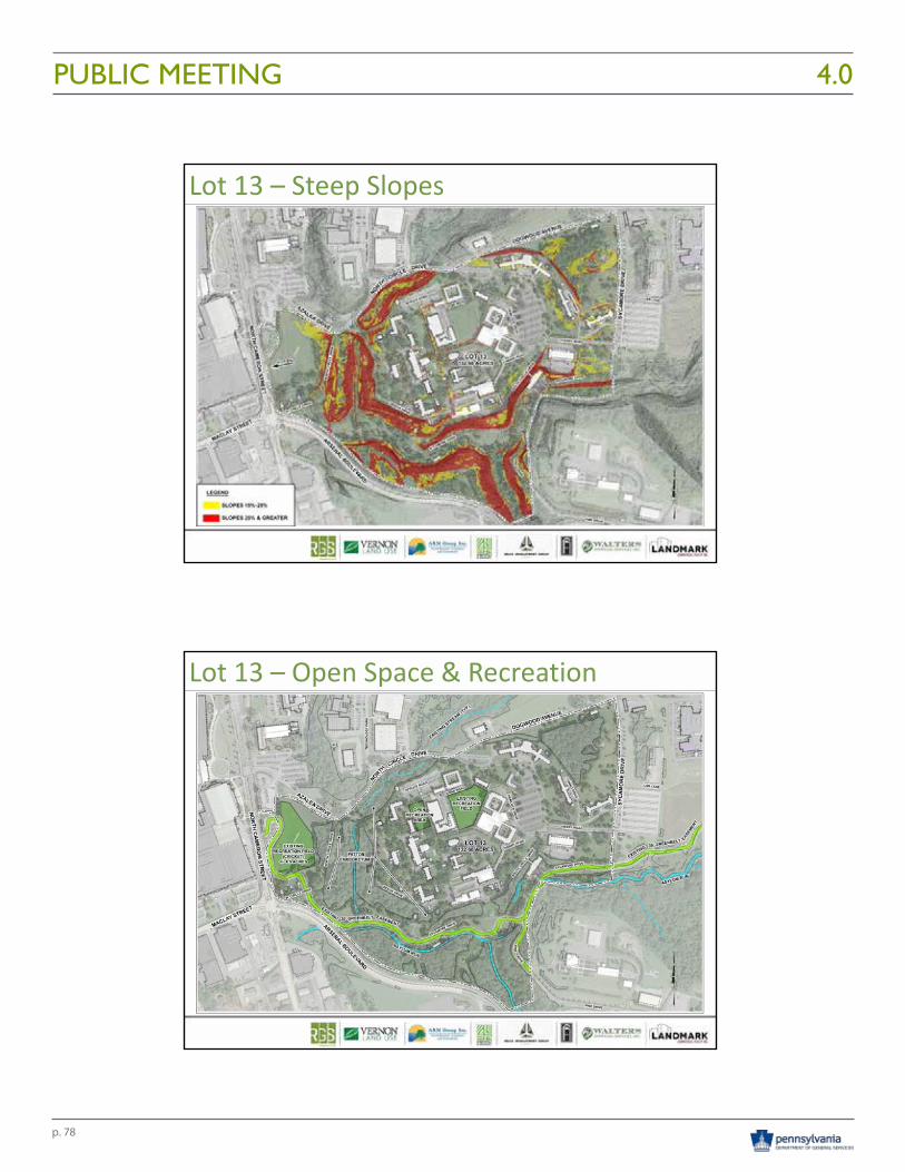
p. 78
PUBLIC MEETING 4.010/21/2016
11
Lot 13 – Steep Slopes
Lot 13 – Open Space & Recreation
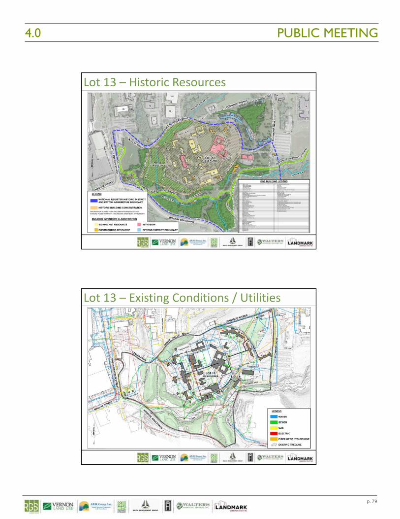
p. 79
PUBLIC MEETING4.0 10/21/2016
12
Lot 13 – Historic Resources
Lot 13 – Existing Conditions / Utilities
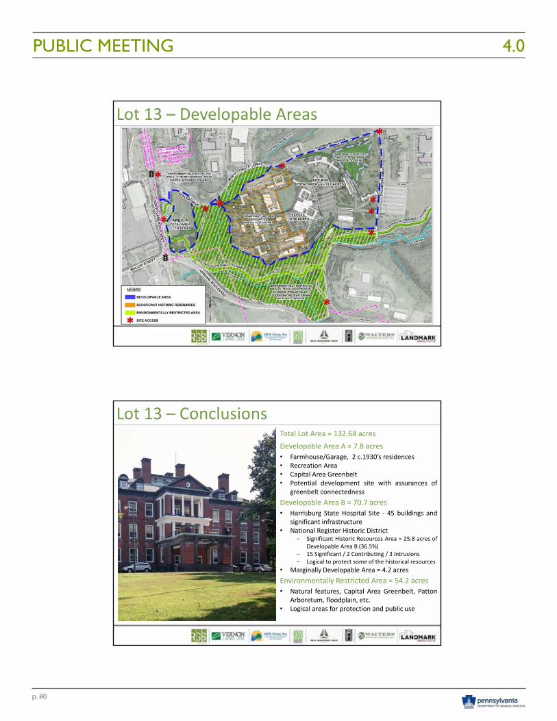
p. 80
PUBLIC MEETING 4.010/21/2016
13
Lot 13 – Developable Areas
Lot 13 – ConclusionsTotal Lot Area = 132.68 acresDevelopable Area A = 7.8 acres• Farmhouse/Garage, 2 c.1930’s residences• Recreation Area• Capital Area Greenbelt• Potential development site with assurances of
greenbelt connectednessDevelopable Area B = 70.7 acres• Harrisburg State Hospital Site ‐ 45 buildings and
significant infrastructure• National Register Historic District
- Significant Historic Resources Area = 25.8 acres ofDevelopable Area B (36.5%)
- 15 Significant / 2 Contributing / 3 Intrusions- Logical to protect some of the historical resources
• Marginally Developable Area = 4.2 acresEnvironmentally Restricted Area = 54.2 acres• Natural features, Capital Area Greenbelt, Patton
Arboretum, floodplain, etc.• Logical areas for protection and public use
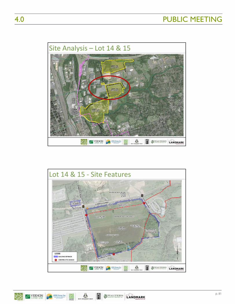
p. 81
PUBLIC MEETING4.0 10/21/2016
14
Site Analysis – Lot 14 & 15
Lot 14 & 15 ‐ Site Features
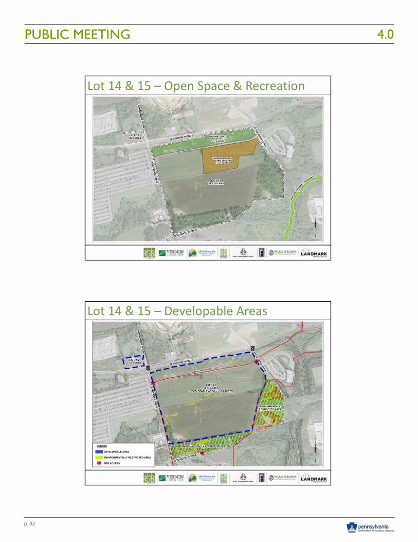
p. 82
PUBLIC MEETING 4.010/21/2016
15
Lot 14 & 15 – Open Space & Recreation
Lot 14 & 15 – Developable Areas
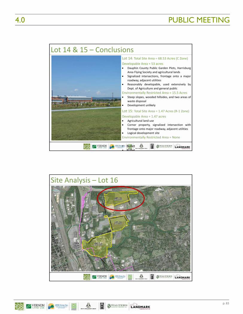
p. 83
PUBLIC MEETING4.0 10/21/2016
16
Lot 14 & 15 – ConclusionsLot 14: Total Site Area = 68.53 Acres (C Zone)Developable Area = 53 acres Dauphin County Public Garden Plots, Harrisburg
Area Flying Society and agricultural lands Signalized intersections, frontage onto a major
roadway, adjacent utilities Reasonably developable, used extensively by
Dept. of Agriculture and general publicEnvironmentally Restricted Area = 15.5 Acres Steep slopes, wooded hillsides, and two areas of
waste disposal Development unlikely
Lot 15: Total Site Area = 1.47 Acres (R‐1 Zone)Developable Area = 1.47 acres Agricultural land use Corner property, signalized intersection with
frontage onto major roadway, adjacent utilities Logical development siteEnvironmentally Restricted Area = None
• Bullet• Bullet
Site Analysis – Lot 16
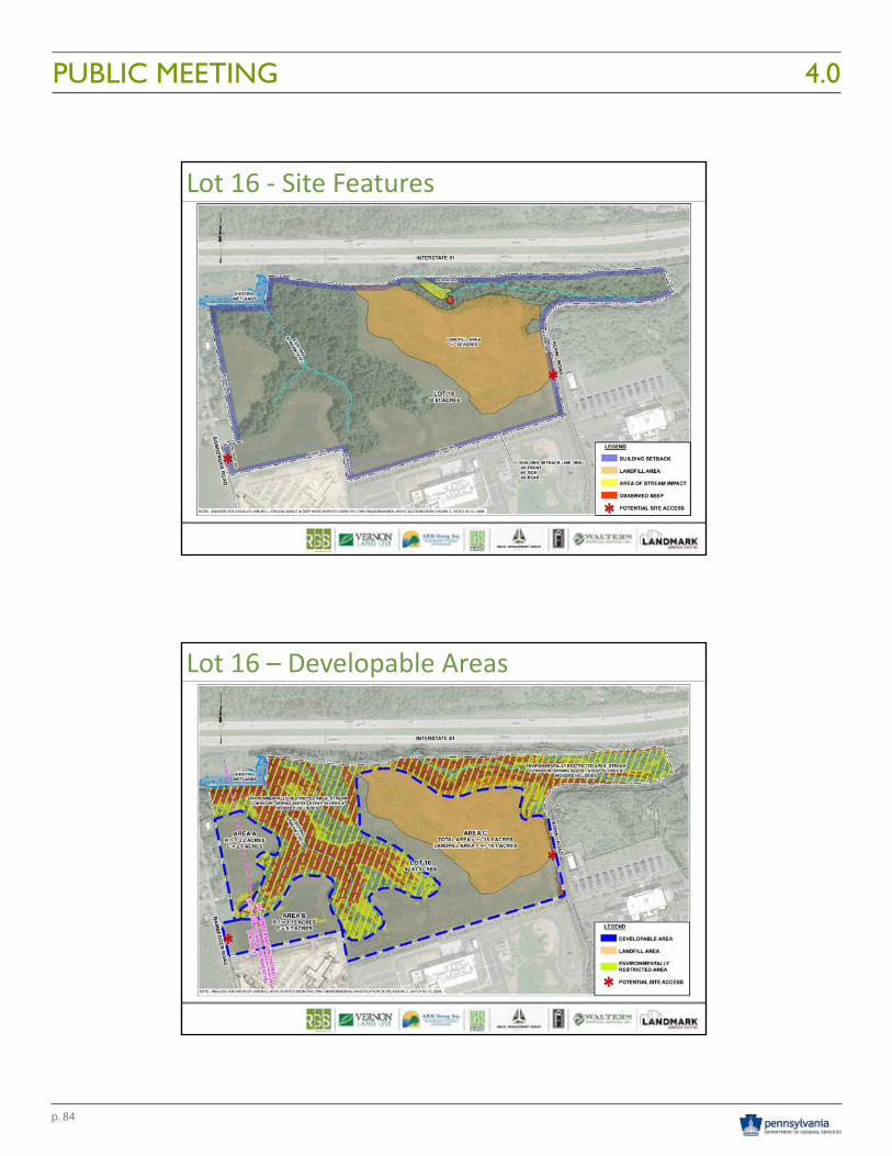
p. 84
PUBLIC MEETING 4.010/21/2016
17
Lot 16 ‐ Site Features
Lot 16 – Developable Areas
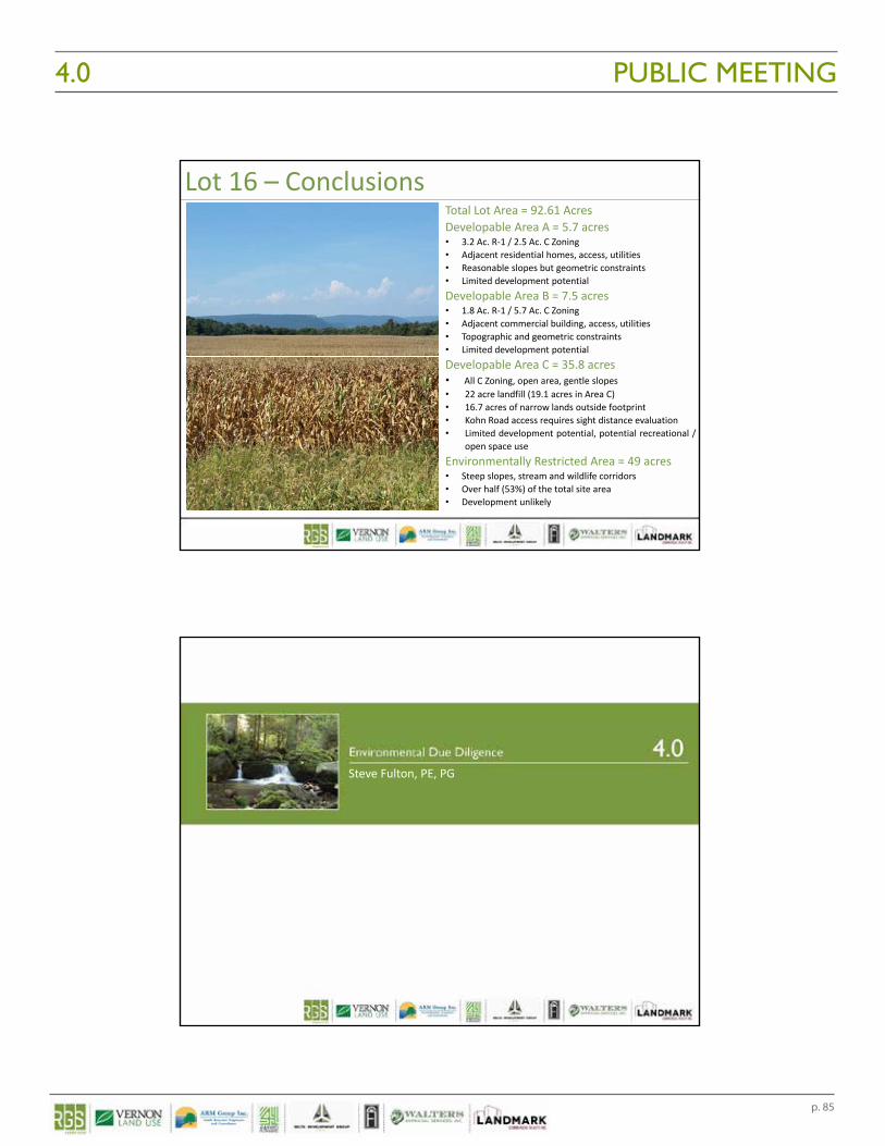
p. 85
PUBLIC MEETING4.0 10/21/2016
18
Lot 16 – ConclusionsTotal Lot Area = 92.61 AcresDevelopable Area A = 5.7 acres• 3.2 Ac. R‐1 / 2.5 Ac. C Zoning• Adjacent residential homes, access, utilities• Reasonable slopes but geometric constraints• Limited development potentialDevelopable Area B = 7.5 acres• 1.8 Ac. R‐1 / 5.7 Ac. C Zoning• Adjacent commercial building, access, utilities• Topographic and geometric constraints• Limited development potentialDevelopable Area C = 35.8 acres• All C Zoning, open area, gentle slopes• 22 acre landfill (19.1 acres in Area C)• 16.7 acres of narrow lands outside footprint• Kohn Road access requires sight distance evaluation• Limited development potential, potential recreational /
open space useEnvironmentally Restricted Area = 49 acres• Steep slopes, stream and wildlife corridors• Over half (53%) of the total site area• Development unlikely
Steve Fulton, PE, PG
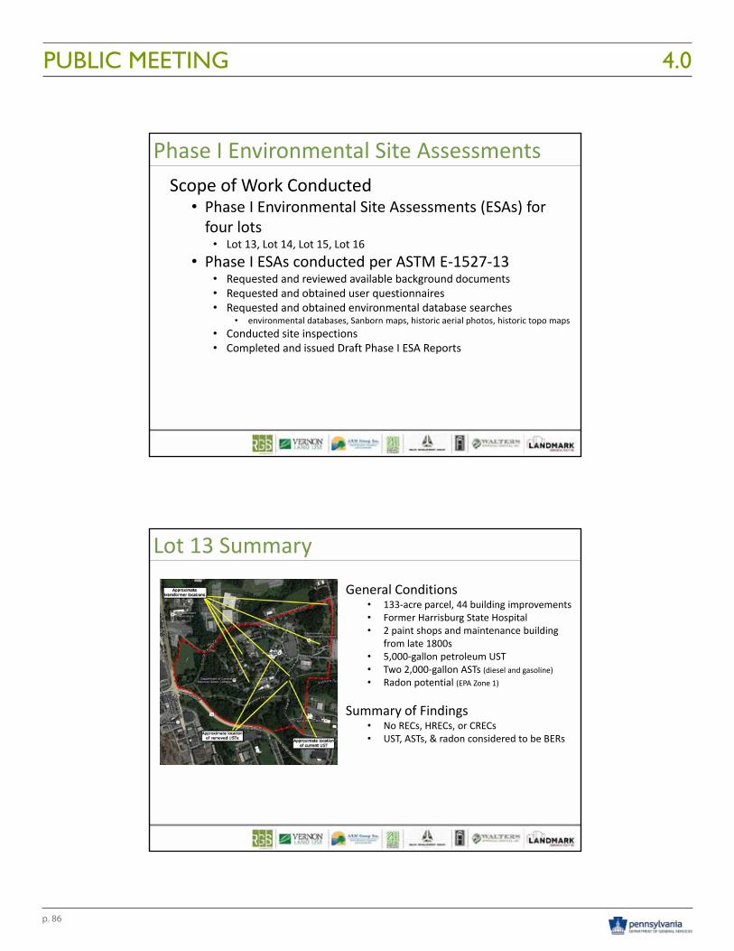
p. 86
PUBLIC MEETING 4.010/21/2016
19
Phase I Environmental Site AssessmentsScope of Work Conducted
• Phase I Environmental Site Assessments (ESAs) for four lots
• Lot 13, Lot 14, Lot 15, Lot 16• Phase I ESAs conducted per ASTM E‐1527‐13
• Requested and reviewed available background documents• Requested and obtained user questionnaires• Requested and obtained environmental database searches
• environmental databases, Sanborn maps, historic aerial photos, historic topo maps• Conducted site inspections• Completed and issued Draft Phase I ESA Reports
Lot 13 Summary
General Conditions• 133‐acre parcel, 44 building improvements• Former Harrisburg State Hospital• 2 paint shops and maintenance building
from late 1800s• 5,000‐gallon petroleum UST• Two 2,000‐gallon ASTs (diesel and gasoline)• Radon potential (EPA Zone 1)
Summary of Findings• No RECs, HRECs, or CRECs• UST, ASTs, & radon considered to be BERs
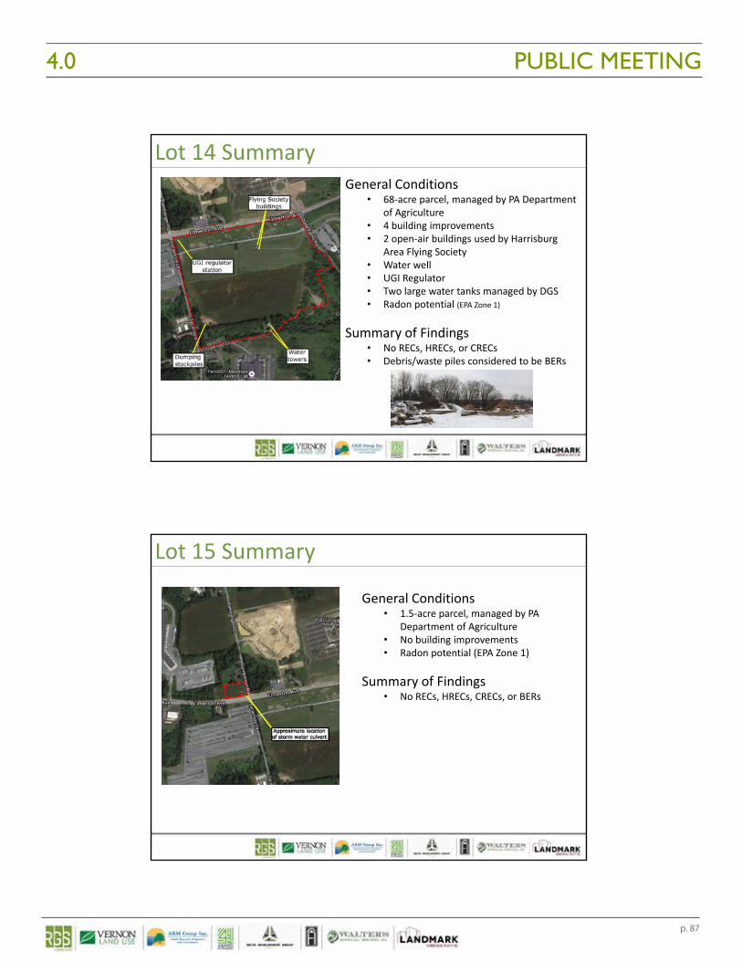
p. 87
PUBLIC MEETING4.0 10/21/2016
20
Lot 14 SummaryGeneral Conditions
• 68‐acre parcel, managed by PA Department of Agriculture
• 4 building improvements• 2 open‐air buildings used by Harrisburg
Area Flying Society• Water well• UGI Regulator• Two large water tanks managed by DGS• Radon potential (EPA Zone 1)
Summary of Findings• No RECs, HRECs, or CRECs• Debris/waste piles considered to be BERs
Lot 15 Summary
General Conditions• 1.5‐acre parcel, managed by PA
Department of Agriculture • No building improvements• Radon potential (EPA Zone 1)
Summary of Findings• No RECs, HRECs, CRECs, or BERs

p. 88
PUBLIC MEETING 4.010/21/2016
21
Lot 16 SummaryGeneral Conditions
• 93‐acre parcel, no improvements• 22‐Acre Unpermitted Municipal Solid
Waste Landfill• operated between ~1960 to 1972• investigated in 2008• waste up to 60 feet deep• some contaminants in groundwater and
seeps• Tires and surface debris piles• Possible on‐site wetlands• Radon potential (EPA Zone 1)
Summary of Findings• No HRECs, or CRECs• 22‐acre solid waste landfill is a REC• Surface debris, wetlands, and radon
considered to be BERs
Scope of Work Conducted
Asbestos Survey for Lot 13 Buildings/Structures• Also completed Limited Lead‐Based Paint (LBP) Survey
Compilation and Review of Existing Information• Discussions with site personnel• Detailed file review of maps and documents• Obtained copies of relevant reports:• 1990 Asbestos Inspection and Planning Reports (LRK)• 2005 Biennial Building Survey Report• Asbestos abatement reports
Asbestos Survey
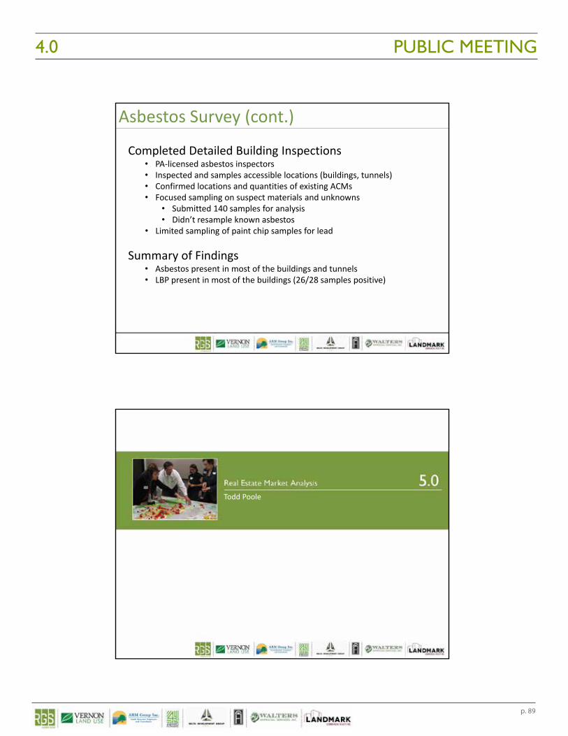
p. 89
PUBLIC MEETING4.0 10/21/2016
22
Asbestos Survey (cont.)
Completed Detailed Building Inspections • PA‐licensed asbestos inspectors• Inspected and samples accessible locations (buildings, tunnels)• Confirmed locations and quantities of existing ACMs• Focused sampling on suspect materials and unknowns
• Submitted 140 samples for analysis• Didn’t resample known asbestos
• Limited sampling of paint chip samples for lead
Summary of Findings• Asbestos present in most of the buildings and tunnels• LBP present in most of the buildings (26/28 samples positive)
Todd Poole
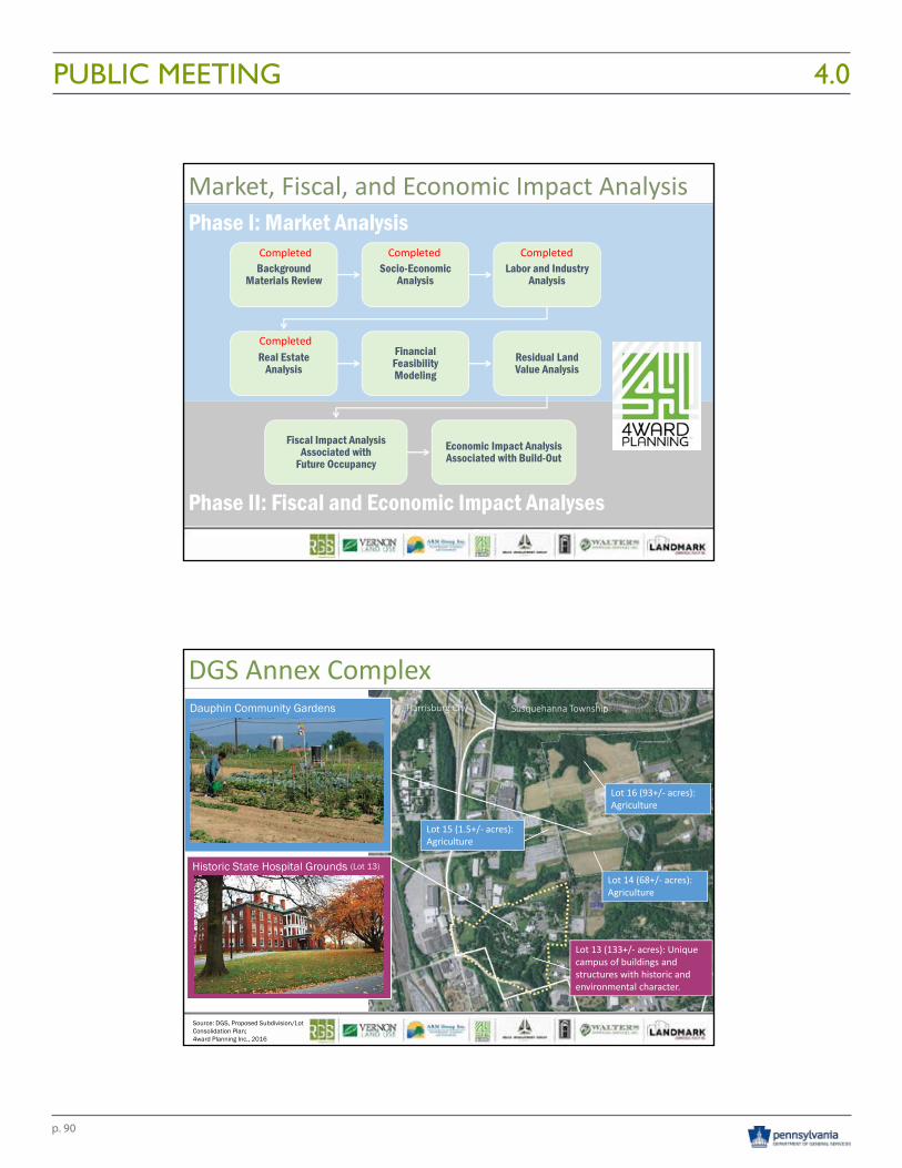
p. 90
PUBLIC MEETING 4.010/21/2016
23
Phase II: Fiscal and Economic Impact Analyses
Phase I: Market Analysis
Background Materials Review
Socio-Economic Analysis
Labor and Industry Analysis
Real Estate Analysis
Financial Feasibility Modeling
Residual Land Value Analysis
Fiscal Impact Analysis Associated with
Future OccupancyEconomic Impact Analysis Associated with Build-Out
Market, Fiscal, and Economic Impact Analysis
Completed
CompletedCompletedCompleted
DGS Annex Complex
Source: DGS, Proposed Subdivision/Lot Consolidation Plan; 4ward Planning Inc., 2016
Harrisburg City Susquehanna Township
Lot 13 (133+/‐ acres): Unique campus of buildings and structures with historic and environmental character.
Historic State Hospital Grounds (Lot 13)Lot 14 (68+/‐ acres): Agriculture
Lot 15 (1.5+/‐ acres): Agriculture
Lot 16 (93+/‐ acres): Agriculture
Dauphin Community Gardens
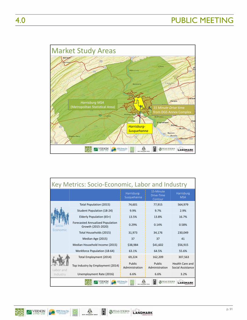
p. 91
PUBLIC MEETING4.0 10/21/2016
24
Harrisburg‐Susquehanna
Harrisburg MSA (Metropolitan Statistical Area)
Market Study Areas
15 Minute Drive time from DGS Annex Complex
Harrisburg‐Susquehanna
15‐Minute Drive‐Time Contour
Harrisburg MSA
Socio‐Economic
Total Population (2015) 74,601 77,915 564,979
Student Population (18‐24) 9.9% 9.7% 2.9%
Elderly Population (65+) 13.5% 13.8% 16.7%
Forecasted Annualized Population Growth (2015‐2020) 0.29% 0.14% 0.58%
Total Households (2015) 31,973 34,176 230,049
Median Age (2015) 37 37 41
Median Household Income (2015) $38,984 $41,602 $56,915
Workforce Population (18‐64) 63.1% 64.5% 55.6%
Labor and Industry
Total Employment (2014) 69,224 162,209 307,563
Top Industry by Employment (2014) Public Administration
Public Administration
Health Care and Social Assistance
Unemployment Rate (2016) 6.6% 6.6% 3.2%
Key Metrics: Socio‐Economic, Labor and Industry
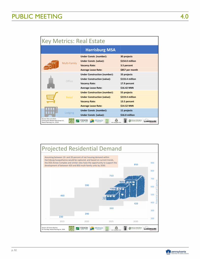
p. 92
PUBLIC MEETING 4.010/21/2016
25
Source: Reis, Q1 2015,Construction Market Data Group LLC,4ward Planning, Inc., 2016
Harrisburg MSA
Multi‐Family
Under Constr. (number): 30 projects
Under Constr. (value): $154.0 million
Vacancy Rate: 3.5 percent
Average Lease Rate: $857 per month
Office
Under Construction (number): 33 projects
Under Construction (value): $133.4 million
Vacancy Rate: 17.9 percent
Average Lease Rate: $16.42 NNN
Retail
Under Construction (number): 55 projects
Under Construction (value): $219.4 million
Vacancy Rate: 13.5 percent
Average Lease Rate: $14.52 NNN
LodgingUnder Constr. (number): 11 projects
Under Constr. (value): $16.0 million
Key Metrics: Real Estate
460
590
710
850
230 290
360
420
200
300
400
500
600
700
800
900
‐2015 2020 2025 2030
Potential Local Capture
Source: US Census Bureau;On The Map; 4ward Planning Inc. 2016
Assuming between 10‐ and 20‐percent of net housing demand within Harrisburg‐Susquehanna would be captured, and based on current trends, the DGS Annex Complex and similar sites have the opportunity to support the development of between 420 and 850 multi‐family units by 2030.
Assuming between 10‐ and 20‐percent of net housing demand within Harrisburg‐Susquehanna would be captured, and based on current trends, the DGS Annex Complex and similar sites have the opportunity to support the development of between 420 and 850 multi‐family units by 2030.
Projected Residential Demand
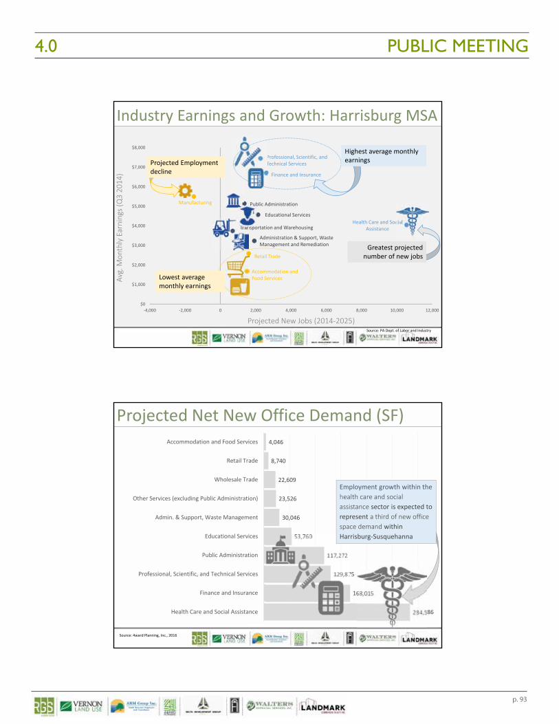
p. 93
PUBLIC MEETING4.0 10/21/2016
26
Health Care and Social Assistance
Finance and Insurance
Public Administration
Retail Trade
Manufacturing
Transportation and Warehousing
Accommodation and Food Services
Administration & Support, Waste Management and Remediation
Educational Services
Professional, Scientific, and Technical Services
$0
$1,000
$2,000
$3,000
$4,000
$5,000
$6,000
$7,000
$8,000
‐4,000 ‐2,000 0 2,000 4,000 6,000 8,000 10,000 12,000
Avg. M
onthly Earnings (Q3 20
14)
Projected New Jobs (2014‐2025)Source: PA Dept. of Labor and Industry
Greatest projected number of new jobsGreatest projected
number of new jobs
Lowest average monthly earnings Lowest average monthly earnings
Highest average monthly earningsHighest average monthly earningsProjected Employment
declineProjected Employment decline
Industry Earnings and Growth: Harrisburg MSA
284,586
168,015
129,875
117,272
53,760
30,046
23,526
22,609
8,740
4,046
Health Care and Social Assistance
Finance and Insurance
Professional, Scientific, and Technical Services
Public Administration
Educational Services
Admin. & Support, Waste Management
Other Services (excluding Public Administration)
Wholesale Trade
Retail Trade
Accommodation and Food Services
Source: 4ward Planning, Inc., 2016
Projected Net New Office Demand (SF)
Employment growth within the health care and social assistance sector is expected to represent a third of new office space demand within Harrisburg‐Susquehanna
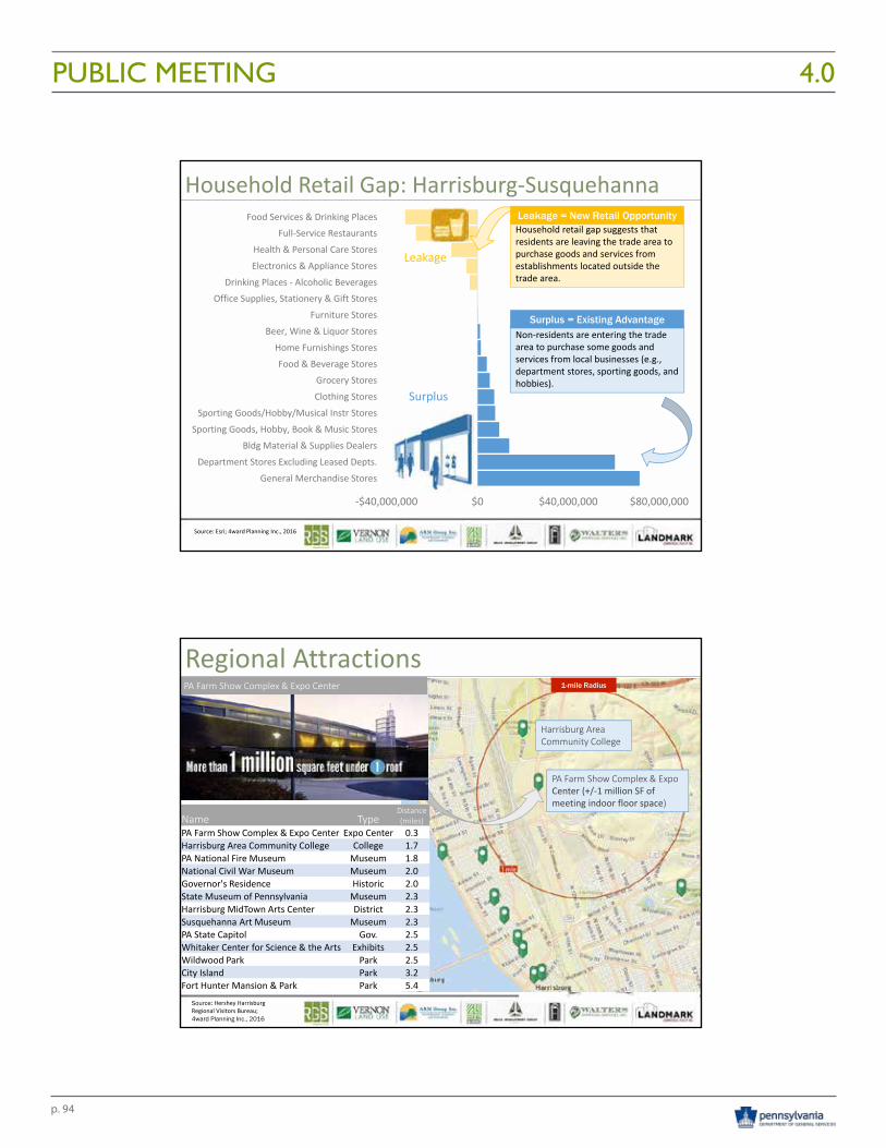
p. 94
PUBLIC MEETING 4.010/21/2016
27
‐$40,000,000 $0 $40,000,000 $80,000,000
General Merchandise Stores
Department Stores Excluding Leased Depts.
Bldg Material & Supplies Dealers
Sporting Goods, Hobby, Book & Music Stores
Sporting Goods/Hobby/Musical Instr Stores
Clothing Stores
Grocery Stores
Food & Beverage Stores
Home Furnishings Stores
Beer, Wine & Liquor Stores
Furniture Stores
Office Supplies, Stationery & Gift Stores
Drinking Places ‐ Alcoholic Beverages
Electronics & Appliance Stores
Health & Personal Care Stores
Full‐Service Restaurants
Food Services & Drinking Places
Source: Esri; 4ward Planning Inc., 2016
Leakage
Surplus
Household Retail Gap: Harrisburg‐Susquehanna
Household retail gap suggests that residents are leaving the trade area to purchase goods and services from establishments located outside the trade area.
Leakage = New Retail Opportunity
Non‐residents are entering the trade area to purchase some goods and services from local businesses (e.g., department stores, sporting goods, and hobbies).
Surplus = Existing Advantage
Name TypeDistance (miles)
PA Farm Show Complex & Expo Center Expo Center 0.3Harrisburg Area Community College College 1.7PA National Fire Museum Museum 1.8National Civil War Museum Museum 2.0Governor's Residence Historic 2.0State Museum of Pennsylvania Museum 2.3Harrisburg MidTown Arts Center District 2.3Susquehanna Art Museum Museum 2.3PA State Capitol Gov. 2.5Whitaker Center for Science & the Arts Exhibits 2.5Wildwood Park Park 2.5City Island Park 3.2Fort Hunter Mansion & Park Park 5.4
1-mile Radius
PA Farm Show Complex & Expo Center (+/‐1 million SF of meeting indoor floor space)
Harrisburg Area Community College
Regional Attractions
Source: Hershey HarrisburgRegional Visitors Bureau;4ward Planning Inc., 2016
PA Farm Show Complex & Expo Center
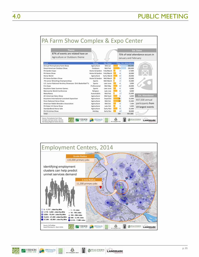
p. 95
PUBLIC MEETING4.0 10/21/2016
28
Event Theme Est. Dates Days Est. AttendanceAnnual Pennsylvania Farm Show Agriculture Mid Jan 7 500,000Great American Outdoor Show Outdoors Mid Feb 9 200,000PA Garden Expo Home & Garden Feb/March 3 17,000PA Home Show Home & Garden Feb/March 4 10,000Horse World Agriculture Early March 6 20,000PA Home Builders Show Home & Garden Mid March 3 20,000 PA Junior Wrestling Championships Sports Mid March 2 15,000U.S. Junior National Hershey Showcase: Girls Basketball To Sports Late June 4 3,000Fire Expo Professional Mid May 6 20,000Keystone State Summer Games Sports Late June 4 6,000Mennonite World Conference Religion Late July 6 8,000MotorRama Automobile Mid Feb 2 25,000All‐American Dairy Show Agriculture Mid Sept 6 6,000Keystone International Livestock Exposition Agriculture Sept/Oct 10 15,000Penn National Horse Show Agriculture Mid Oct 11 15,000American Rabbit Breeders Association Agriculture Mid Oct 4 7,500PA State 4‐H Horse Show Agriculture Late Oct 3 5,000Standardbred Horse Sale Agriculture Early Nov 6 15,000PA Christmas Show Holiday Early Dec 4 30,000Total 100 937,500
Source: Pennsylvania Farm ShowComplex and Expo Center; HersheyHarrisburg Regional Visitors Bureau
PA Farm Show Complex & Expo Center
75% of total attendance occurs in January and February
Est. Dates87% of events are related have an Agriculture or Outdoors theme
Theme
937,500 annual participants from 19 largest events
Est. Attendance
Source: OnTheMap,4ward Planning Inc., March 2016.
Employment Centers, 2014
1-mile Radius
11,200 primary jobs
133,000 primary jobs 5-mile Radius
Identifying employment clusters can help predict unmet services demand
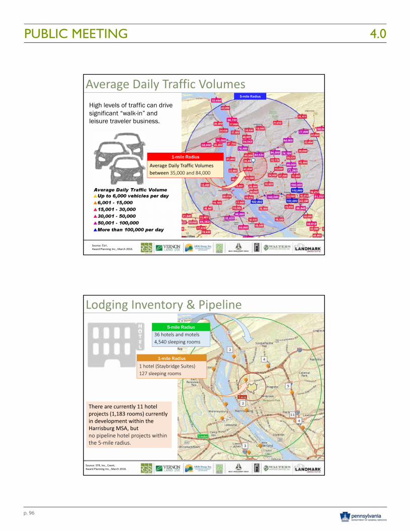
p. 96
PUBLIC MEETING 4.010/21/2016
29
Source: Esri, 4ward Planning Inc., March 2016.
5-mile Radius
Average Daily Traffic Volumes
1-mile Radius
Average Daily Traffic Volumes between 35,000 and 84,000
High levels of traffic can drivesignificant “walk-in” and leisure traveler business.
Source: STR, Inc., Cvent, 4ward Planning Inc., March 2016.
Lodging Inventory & Pipeline
1-mile Radius
1 hotel (Staybridge Suites)127 sleeping rooms
36 hotels and motels 4,540 sleeping rooms
5-mile Radius
There are currently 11 hotel projects (1,183 rooms) currently in development within the Harrisburg MSA, butno pipeline hotel projects within the 5‐mile radius.
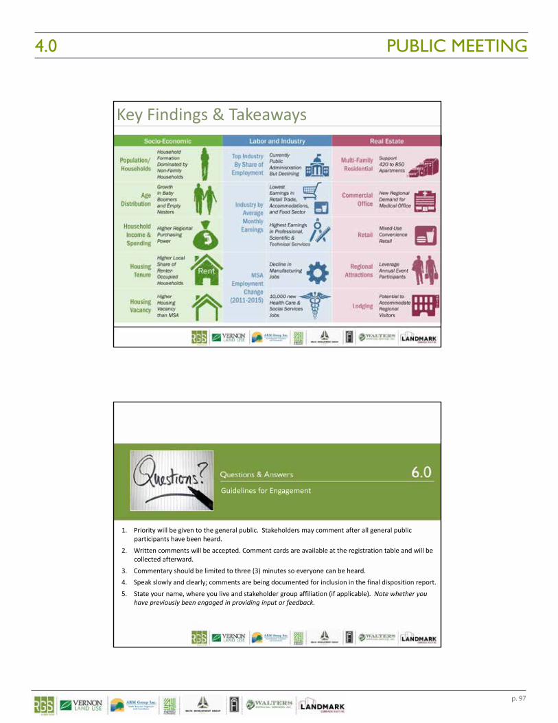
p. 97
PUBLIC MEETING4.0 10/21/2016
30
Key Findings & Takeaways
1. Priority will be given to the general public. Stakeholders may comment after all general public participants have been heard.
2. Written comments will be accepted. Comment cards are available at the registration table and will be collected afterward.
3. Commentary should be limited to three (3) minutes so everyone can be heard.4. Speak slowly and clearly; comments are being documented for inclusion in the final disposition report.5. State your name, where you live and stakeholder group affiliation (if applicable). Note whether you
have previously been engaged in providing input or feedback.
Guidelines for Engagement
p. 98
PUBLIC MEETING 4.0
Closing
Following the presentation, the project team welcomed comments and fielded questions about the project. The Public Meeting resulted in receipt of both written and verbal comments. The following documents derived from the Public Meeting are included within the Appendices of this report.
• Press Release announcing the date, time and location of the Public Meeting;• Sign In Sheets with names and contact information of approximately 113 individual attendees; • Public Meeting PowerPoint Presentation;• Public Meeting Summary that documents the questions posed by 29 citizens or group
representatives and the recorded responses to their inquiries;• Copies of all handwritten Comment Cards filled out and submitted at the Public Meeting; • Transcribed summary of all written comments provided; • Copies of all documents provided by representatives or organizations in attendance at the
meeting who shared specific reports or letters; and • Letters, emails and documents received as a result of the Press Release announcing the Public
Meeting.
Due to the volume of information received and diversity of topics addressed, it is difficult to succinctly characterize the content of the meeting. Depending on an individual’s point of view, they were either 1) supportive of the fact that the meeting occurred and that the information was being shared openly and transparently, 2) they were averse to anything changing, 3) they were concerned about how our society is now addressing (or not addressing) the needs of those with mental challenges or 4) they were supportive of the need to strike a balance between preservation of a resource, yet allowing changes in use to occur that offer a greater community benefit. Overall, the audience was attentive, respectful and engaged in asking appropriate questions and providing constructive dialog and feedback. There were multiple statements of appreciation for the work that DGS has put into evaluating the circumstances and listening to the community concerns for what may eventually become of the DGS Annex Complex.
Meeting attendance and media coverage clearly indicated that the local community is interested in the long-term impacts of the General Assembly’s ultimate decision. Three television outlets covered the meeting as well as two local print and on-line media sources. Most concerns expressed at the meeting (both written and verbal) were related to the following topics:
• Concern for any changes in land use that would negatively impact local transportation systems;• Concern for protecting the historic context and buildings that comprise the former Harrisburg
State Hospital property; • Concern for environmental impacts that exist on the properties (landfill, lead paint, asbestos); • Concern for the potential loss or relocation of the Dauphin County Community Gardens; • Concern for any impacts on the Capital Area Greenbelt; • Concern for impacts to natural systems, wildlife habitat, water quality and adverse impacts
caused by flooding; • Concern over the lack of engagement with and impact on the Harrisburg Area Flying Society
facilities;• Concern over the societal impacts of having closed the state hospital and how the needs of those
with mental challenges is being addressed now and in the future; and • The impact of a growing drug epidemic and how the HSH site may afford an appropriate solution
for housing folks needing treatment.
These concerns have been evaluated and considered in arriving at the Conclusions & Recommendations contained in the Final Disposition Report.
Economic Impact &
Residual Land Value Analyses5.0

p. 101
ECONOMIC IMPACT ANALYSIS5.0
ECONOMIC IMPACT ANALYSIS & RESIDUAL LAND VALUE ANALYSES
A potential change in land use can have a positive impact on the local community by contributing new jobs, sales opportunities for local vendors and increased local and state tax revenue as noted in the Economic Impact Analysis conducted as part of this engagement. Economic impacts, whether for employment or output, are typically referenced as direct, indirect or induced impacts which collectively equate to the total effects of a change in economic activity - that is, for every dollar in new investment, additional economic investment of equal or greater proportion results. The Economic Impact Analysis that follows evaluated a build-out scenario for the DGS Annex Complex based largely on the Hypothetical Highest and Best Use Analysis developed and included herein. The purpose of this assessment is to evaluate the potential impact a change in land use could have on the local economy and taxing bodies.
A Residual Land Value Analysis is also included which identifies the value of the underlying real estate by evauating the costs of development and the required returns. The purpose of this analysis is to determine whether any potential private development money allocated to the future purchase of land is available given the difference between the values of any completed new development minus the anticipated cost of development. The goal is to determine whether a likely development proposal is financially viable.
The research and findings associated with each analysis can be found below.
METHODOLOGYGeneral Input-Output Impact Modeling
Economic impact analysis involves applying a final demand change to a predictive economic input-output model, and then analyzing the resulting changes in the economy under study.
More concisely, an impact analysis is an assessment of change in overall economic activity as a result of change in one or several specific economic activities.
Economic impacts, whether for employment or output, are typically referenced as direct, indirect, and induced. 4ward Planning has expressed the estimated direct, indirect, and induced impacts for each year in this analysis.
In collaboration with RGS Associates, Inc., 4ward Planning developed a buildout scenario for the DGS Annex Complex, including a combination of new construction and adaptive reuse projects, as well as construction costs, employment and visitor spending model assumptions. Model assumptions are provided in more detail at the end of the Economic Impact Analysis Section of this report.
DGS Annex Complex
4WARD PLANNING LLC
November 10, 2016
Page 34WARD PLANNING INC
November 10, 2016
Page 3
Methodology: General Input-Output Impact Modeling
Economic impact analysis involves applying a final demand change to a predictive economic input-output model, and then analyzing the resulting changes in the economy under study.
More concisely, an impact analysis is an assessment of change in overall economic activity as a result of change in one or several specific economic activities.
Economic impacts, whether for employment or output, are typically referenced as direct, indirect, and induced. 4ward Planning has expressed the estimated direct, indirect, and induced impacts for each year in this analysis.
Direct Indirect Induced Total Effects
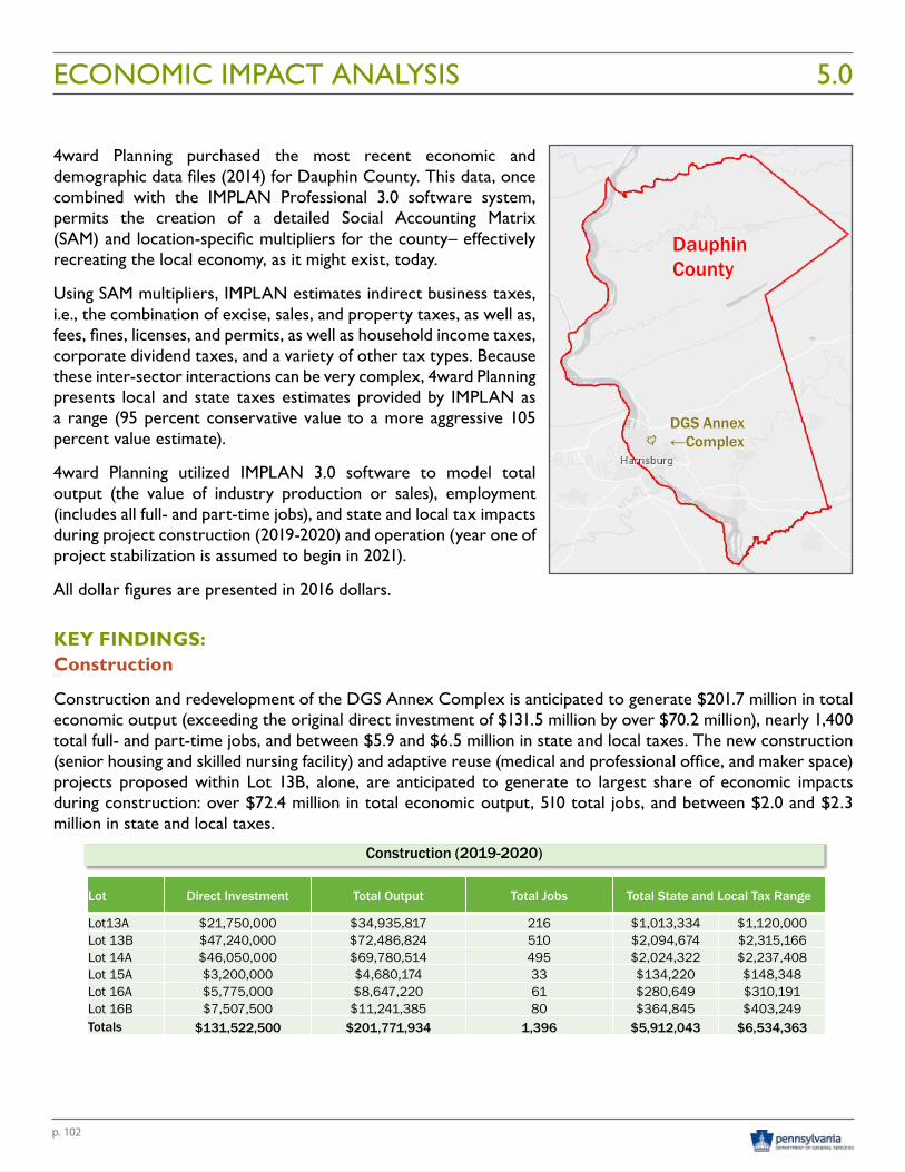
p. 102
ECONOMIC IMPACT ANALYSIS 5.0
4ward Planning purchased the most recent economic and demographic data files (2014) for Dauphin County. This data, once combined with the IMPLAN Professional 3.0 software system, permits the creation of a detailed Social Accounting Matrix (SAM) and location-specific multipliers for the county– effectively recreating the local economy, as it might exist, today.
Using SAM multipliers, IMPLAN estimates indirect business taxes, i.e., the combination of excise, sales, and property taxes, as well as, fees, fines, licenses, and permits, as well as household income taxes, corporate dividend taxes, and a variety of other tax types. Because these inter-sector interactions can be very complex, 4ward Planning presents local and state taxes estimates provided by IMPLAN as a range (95 percent conservative value to a more aggressive 105 percent value estimate).
4ward Planning utilized IMPLAN 3.0 software to model total output (the value of industry production or sales), employment (includes all full- and part-time jobs), and state and local tax impacts during project construction (2019-2020) and operation (year one of project stabilization is assumed to begin in 2021).
All dollar figures are presented in 2016 dollars.
KEY FINDINGS:Construction
Construction and redevelopment of the DGS Annex Complex is anticipated to generate $201.7 million in total economic output (exceeding the original direct investment of $131.5 million by over $70.2 million), nearly 1,400 total full- and part-time jobs, and between $5.9 and $6.5 million in state and local taxes. The new construction (senior housing and skilled nursing facility) and adaptive reuse (medical and professional office, and maker space) projects proposed within Lot 13B, alone, are anticipated to generate to largest share of economic impacts during construction: over $72.4 million in total economic output, 510 total jobs, and between $2.0 and $2.3 million in state and local taxes.
DGS Annex Complex
4WARD PLANNING LLC
November 10, 2016
Page 54WARD PLANNING INC
November 10, 2016
Page 5
Key Findings: Construction
Lot Direct Investment Total Output Total Jobs Total State and Local Tax Range
Lot13A $21,750,000 $34,935,817 216 $1,013,334 $1,120,000Lot 13B $47,240,000 $72,486,824 510 $2,094,674 $2,315,166Lot 14A $46,050,000 $69,780,514 495 $2,024,322 $2,237,408Lot 15A $3,200,000 $4,680,174 33 $134,220 $148,348Lot 16A $5,775,000 $8,647,220 61 $280,649 $310,191Lot 16B $7,507,500 $11,241,385 80 $364,845 $403,249Totals $131,522,500 $201,771,934 1,396 $5,912,043 $6,534,363
Construction (2019-2020)
Construction and redevelopment of the DGS Annex Complex is anticipated to generate $201.7 million in total economic output (exceeding the original direct investment of $131.5 million by over $70.2 million), nearly 1,400 total full- and part-time jobs, and between $5.9 and $6.5 million in state and local taxes. The new construction (senior housing and skilled nursing facility) and adaptive reuse (medical and professional office, and maker space) projects proposed within Lot 13B, alone, are anticipated to generate to largest share of economic impacts during construction: over $72.4 million in total economic output, 510 total jobs, and between $2.0 and $2.3 million in state and local taxes.
DGS Annex Complex
4WARD PLANNING LLC
November 10, 2016
Page 44WARD PLANNING INC
November 10, 2016
Page 4
Methodology: Economic Impact AnalysisIn collaboration with RGS Associates, Inc., 4ward Planning developed a buildout scenario for the DGS Annex Complex, including a combination of new construction and adaptive reuse projects, as well as construction costs, employment and visitor spending model assumptions. Model assumptions are provided in more detail in the Appendix.
4ward Planning purchased the most recent economic and demographic data files (2014) for Dauphin County. This data, once combined with the IMPLAN Professional 3.0 software system, permits the creation of a detailed Social Accounting Matrix (SAM) and location-specific multipliers for the county– effectively recreating the local economy, as it might exist, today.
Using SAM multipliers, IMPLAN estimates indirect business taxes, i.e., the combination of excise, sales, and property taxes, as well as, fees, fines, licenses, and permits, as well as household income taxes, corporate dividend taxes, and a variety of other tax types. Because these inter-sector interactions can be very complex, 4ward Planning presents local and state taxes estimates provided by IMPLAN as a range (95 percent conservative value to a more aggressive 105 percent value estimate).
DGS Annex←Complex
DauphinCounty
4ward Planning utilized IMPLAN 3.0 software to model total output (the value of industry production or sales), employment (includes all full- and part-time jobs), and state and local tax impacts during project construction (2019-2020) and operation (year one of project stabilization is assumed to begin in 2021).
All dollar figures are presented in 2016 dollars.
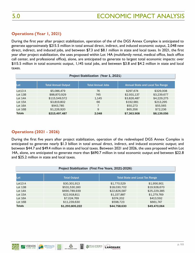
p. 103
ECONOMIC IMPACT ANALYSIS5.0
Operations (Year 1, 2021)
During the first year after project stabilization, operation of the of the DGS Annex Complex is anticipated to generate approximately $215.5 million in total annual direct, indirect, and induced economic output, 2,048 new direct, indirect, and induced jobs, and between $7.3 and $8.1 million in state and local taxes. In 2021, the first year after project stabilization, the uses proposed within Lot 14A (multifamily rental, medical office, back office call center, and professional office), alone, are anticipated to generate to largest total economic impacts: over $115.5 million in total economic output, 1,145 total jobs, and between $3.8 and $4.2 million in state and local taxes.
Operations (2021 - 2026)
During the first five years after project stabilization, operation of the redeveloped DGS Annex Complex is anticipated to generate nearly $1.3 billion in total annual direct, indirect, and induced economic output; and between $44.7 and $49.4 million in state and local taxes. Between 2021 and 2026, the uses proposed within Lot 14A, alone, are anticipated to generate more than $690.7 million in total economic output and between $22.8 and $25.2 million in state and local taxes.
DGS Annex Complex
4WARD PLANNING LLC
November 10, 2016
Page 64WARD PLANNING INC
November 10, 2016
Page 6
Lot Total Annual Output Total Annual Jobs Annual State and Local Tax Range
Lot13 A $5,086,479 76 $297,674 $329,008Lot 13B $88,870,929 745 $2,931,137 $3,239,677Lot 14A $115,549,572 1,145 $3,826,487 $4,229,275Lot 15A $3,819,802 66 $192,981 $213,295Lot 16A $943,785 7 $50,273 $55,565Lot 16B $1,226,920 9 $65,356 $72,236Totals $215,497,487 2,048 $7,363,908 $8,139,056
Project Stabilization (Year 1, 2021)
Key Findings: Operations (Year 1, 2021)
During the first year after project stabilization, operation of the of the DGS Annex Complex is anticipated to generate approximately $215.5 million in total annual direct, indirect, and induced economic output, 2,048 new direct, indirect, and induced jobs, and between $7.3 and $8.1 million in state and local taxes. In 2021, the first year after project stabilization, the uses proposed within Lot 14A (multifamily rental, medical office, back office call center, and professional office), alone, are anticipated to generate to largest total economic impacts: over $115.5 million in total economic output, 1,145 total jobs, and between $3.8 and $4.2 million in state and local taxes.
DGS Annex Complex
4WARD PLANNING LLC
November 10, 2016
Page 74WARD PLANNING INC
November 10, 2016
Page 7
Lot Total Output Total State and Local Tax Range
Lot13 A $30,301,913 $1,770,529 $1,956,901Lot 13B $531,530,160 $18,030,702 $19,928,670Lot 14A $690,789,939 $22,826,587 $25,229,385Lot 15A $22,918,811 $1,157,887 $1,279,769Lot 16A $7,024,769 $374,202 $413,592Lot 16B $11,239,630 $598,723 $661,747Totals $1,293,805,222 $44,758,630 $49,470,064
Project Stabilization (First Five Years, 2021-2026)
Key Findings: Operations (2021 - 2026)
During the first five years after project stabilization, operation of the redeveloped DGS Annex Complex is anticipated to generate nearly $1.3 billion in total annual direct, indirect, and induced economic output; and between $44.7 and $49.4 million in state and local taxes. Between 2021 and 2026, the uses proposed within Lot 14A, alone, are anticipated to generate more than $690.7 million in total economic output and between $22.8 and $25.2 million in state and local taxes.
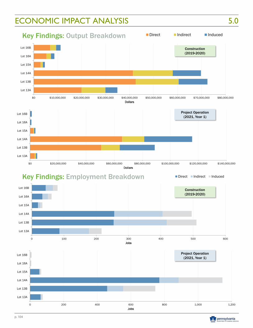
p. 104
ECONOMIC IMPACT ANALYSIS 5.0DGS Annex Complex
4WARD PLANNING LLC
November 10, 2016
Page 84WARD PLANNING INC
November 10, 2016
Page 8
Key Findings: Output Breakdown
$0 $20,000,000 $40,000,000 $60,000,000 $80,000,000 $100,000,000 $120,000,000 $140,000,000
Lot 13A
Lot 13B
Lot 14A
Lot 15A
Lot 16A
Lot 16B
Dollars
$0 $10,000,000 $20,000,000 $30,000,000 $40,000,000 $50,000,000 $60,000,000 $70,000,000 $80,000,000
Lot 13A
Lot 13B
Lot 14A
Lot 15A
Lot 16A
Lot 16B
Dollars
Direct Indirect Induced
Construction (2019-2020)
Project Operation (2021, Year 1)
DGS Annex Complex
4WARD PLANNING LLC
November 10, 2016
Page 94WARD PLANNING INC
November 10, 2016
Page 9
0 200 400 600 800 1,000 1,200
Lot 13A
Lot 13B
Lot 14A
Lot 15A
Lot 16A
Lot 16B
Jobs
0 100 200 300 400 500 600
Lot 13A
Lot 13B
Lot 14A
Lot 15A
Lot 16A
Lot 16B
Jobs
Direct Indirect InducedKey Findings: Employment Breakdown
Construction (2019-2020)
Project Operation (2021, Year 1)
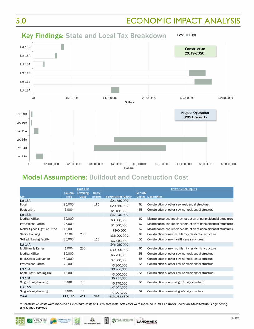
p. 105
ECONOMIC IMPACT ANALYSIS5.0DGS Annex Complex
4WARD PLANNING LLC
November 10, 2016
Page 104WARD PLANNING INC
November 10, 2016
Page 10
$0 $1,000,000 $2,000,000 $3,000,000 $4,000,000 $5,000,000 $6,000,000 $7,000,000 $8,000,000 $9,000,000
Lot 13A
Lot 13B
Lot 14A
Lot 15A
Lot 16A
Lot 16B
Dollars
$0 $500,000 $1,000,000 $1,500,000 $2,000,000 $2,500,000
Lot 13A
Lot 13B
Lot 14A
Lot 15A
Lot 16A
Lot 16B
Dollars
Low HighKey Findings: State and Local Tax Breakdown
Construction (2019-2020)
Project Operation (2021, Year 1)
DGS Annex Complex
4WARD PLANNING LLC
November 10, 2016
Page 124WARD PLANNING INC
November 10, 2016
Page 12
Model Assumptions: Buildout and Construction Cost
Lot
Built Out Construction InputsSquare Feet
Dwelling Units
Beds/ Rooms Construction Costs*
IMPLAN Sector Description
Lot 13A $21,750,000Hotel 85,000 185 $20,350,000 61 Construction of other new residential structure
Restaurant 7,000 $1,400,000 58 Construction of other new nonresidential structure
Lot 13B $47,240,000Medical Office 50,000 $3,000,000 62 Maintenance and repair construction of nonresidential structures
Professional Office 25,000 $1,500,000 62 Maintenance and repair construction of nonresidential structures
Maker Space-Light Industrial 15,000 $300,000 62 Maintenance and repair construction of nonresidential structures
Senior Housing 1,100 200 $36,000,000 60 Construction of new multifamily residential structure
Skilled Nursing Facility 30,000 120 $6,440,000 52 Construction of new health care structures
Lot 14A $46,050,000Multi-family Rental 1,000 200 $30,000,000 60 Construction of new multifamily residential structure
Medical Office 30,000 $5,250,000 58 Construction of other new nonresidential structure
Back Office Call Center 50,000 $7,500,000 58 Construction of other new nonresidential structure
Professional Office 20,000 $3,300,000 58 Construction of other new nonresidential structure
Lot 15A $3,200,000Restaurant-Catering Hall 16,000 $3,200,000 58 Construction of other new nonresidential structure
Lot 16A $5,775,000Single-family housing 3,500 10 $5,775,000 59 Construction of new single-family structure
Lot 16B $7,507,500Single-family housing 3,500 13 $7,507,500 59 Construction of new single-family structure
Total 337,100 423 305 $131,522,500
* Construction costs were modeled as 72% hard costs and 38% soft costs. Soft costs were modeled in IMPLAN under Sector 449:Architectural, engineering, and related services
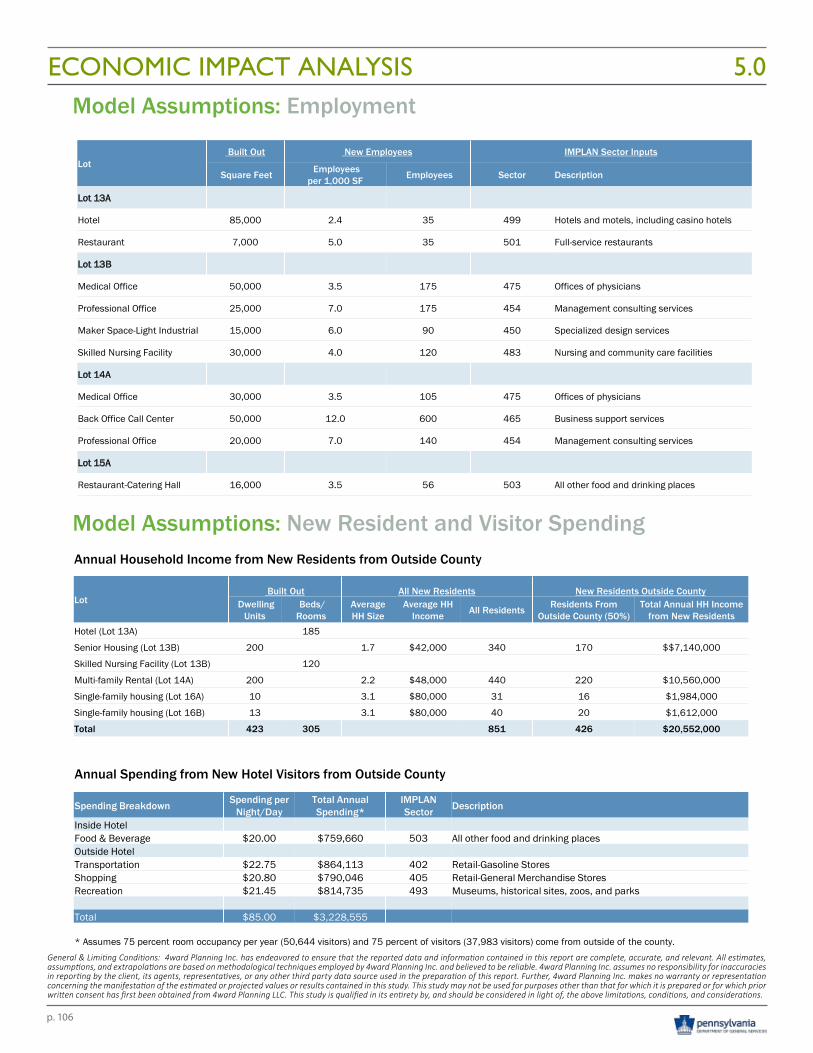
p. 106
DGS Annex Complex
4WARD PLANNING LLC
November 10, 2016
Page 144WARD PLANNING INC
November 10, 2016
Page 14
Model Assumptions: New Resident and Visitor SpendingAnnual Household Income from New Residents from Outside County
LotBuilt Out All New Residents New Residents Outside County
Dwelling Units
Beds/ Rooms
Average HH Size
Average HH Income All Residents Residents From
Outside County (50%)Total Annual HH Income
from New ResidentsHotel (Lot 13A) 185
Senior Housing (Lot 13B) 200 1.7 $42,000 340 170 $$7,140,000
Skilled Nursing Facility (Lot 13B) 120
Multi-family Rental (Lot 14A) 200 2.2 $48,000 440 220 $10,560,000
Single-family housing (Lot 16A) 10 3.1 $80,000 31 16 $1,984,000
Single-family housing (Lot 16B) 13 3.1 $80,000 40 20 $1,612,000
Total 423 305 851 426 $20,552,000
Annual Spending from New Hotel Visitors from Outside County
Spending Breakdown Spending per Night/Day
Total Annual Spending*
IMPLAN Sector Description
Inside HotelFood & Beverage $20.00 $759,660 503 All other food and drinking placesOutside HotelTransportation $22.75 $864,113 402 Retail-Gasoline StoresShopping $20.80 $790,046 405 Retail-General Merchandise StoresRecreation $21.45 $814,735 493 Museums, historical sites, zoos, and parks
Total $85.00 $3,228,555
* Assumes 75 percent room occupancy per year (50,644 visitors) and 75 percent of visitors (37,983 visitors) come from outside of the county.
DGS Annex Complex
4WARD PLANNING LLC
November 10, 2016
Page 134WARD PLANNING INC
November 10, 2016
Page 13
Model Assumptions: Employment
LotBuilt Out New Employees IMPLAN Sector Inputs
Square Feet Employees per 1,000 SF Employees Sector Description
Lot 13A
Hotel 85,000 2.4 35 499 Hotels and motels, including casino hotels
Restaurant 7,000 5.0 35 501 Full-service restaurants
Lot 13B
Medical Office 50,000 3.5 175 475 Offices of physicians
Professional Office 25,000 7.0 175 454 Management consulting services
Maker Space-Light Industrial 15,000 6.0 90 450 Specialized design services
Skilled Nursing Facility 30,000 4.0 120 483 Nursing and community care facilities
Lot 14A
Medical Office 30,000 3.5 105 475 Offices of physicians
Back Office Call Center 50,000 12.0 600 465 Business support services
Professional Office 20,000 7.0 140 454 Management consulting services
Lot 15A
Restaurant-Catering Hall 16,000 3.5 56 503 All other food and drinking places
ECONOMIC IMPACT ANALYSIS 5.0
General & Limiting Conditions: 4ward Planning Inc. has endeavored to ensure that the reported data and information contained in this report are complete, accurate, and relevant. All estimates, assumptions, and extrapolations are based on methodological techniques employed by 4ward Planning Inc. and believed to be reliable. 4ward Planning Inc. assumes no responsibility for inaccuracies in reporting by the client, its agents, representatives, or any other third party data source used in the preparation of this report. Further, 4ward Planning Inc. makes no warranty or representation concerning the manifestation of the estimated or projected values or results contained in this study. This study may not be used for purposes other than that for which it is prepared or for which prior written consent has first been obtained from 4ward Planning LLC. This study is qualified in its entirety by, and should be considered in light of, the above limitations, conditions, and considerations.
p. 107
RESIDUAL LAND VALUE ANALYSIS5.0
RESIDUAL LAND VALUE ANALYSIS
DGS Build-Out Scenarios
Residual land valuation is the process of developing land having development potential.
The money allocated to the purchase of land represents the difference between the value of the completed new development minus the cost of development (inclusive of a developer profit).
4ward Planning, working in collaboration with the DGS consulting team, performed a residual land value analysis for all of the lot parcels where development/redevelopment could, prospectively, occur, based on earlier identified market supportable land uses.
The build-out scenarios for each of the lot areas modeled within the DGS Annex site area (Lots 13A, 13B, 14A, 15A, 16A and 16B) are based on earlier identified land uses, as well as buildings identified as remaining for adaptive reuse, once the project site is sold.
However, it should be noted that the scale of the earlier identified land uses (specifically, the total commercial square footage identified) was based on what the subject land parcels could accommodate under a maximum build-out scenario (FAR, set backs, etc.), and not, necessarily, on what the market area could support over the near- to mid-term (see the 4ward Planning market study report). Consequently, 4ward Planning relied on its earlier market analysis findings in order to model what could likely be supported over the next five- to ten-years (with commercial square footage representing a much smaller share than that identified under a hypothetical full build-out scheme).
In this way, the residual analysis findings may be considered realistic.
It should also be understood that development metrics and market area lease rates, rents and sales prices all influence whether or not there will be a positive residual value for land – that is, whether there’s a value greater than zero which can be offered for the land in question – as well as the magnitude of the value.
The following pages exhibit the residual land values for each of lot area build-out scenarios modeled, along with assumptions and term definitions:
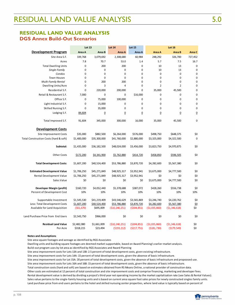
p. 108
Lot 14 Lot 15Development Program Area A Area B Area A Area A Area A Area B Area C
Site Area S.F. 339,768 3,079,692 2,308,680 60,984 248,292 326,700 727,452Acres 7.8 70.7 53.0 1.4 5.7 7.5 16.7
Total Dwelling Units 0 200 200 0 10 13 0Single-Family 0 0 0 0 10 13 0
Condos 0 0 0 0 0 0 0Town Houses 0 0 0 0 0 0 0
Multi-Family Rental 0 200 200 0 0 0 0Dwelling Units/Acre 0 3 4 0 2 2 0
Residential S.F. 0 220,000 200,000 0 35,000 45,500 0Retail & Restaurant S.F. 7,000 0 0 $16,000 0 0 0
Office S.F. 0 75,000 100,000 0 0 0 0Light Industrial S.F. 0 15,000 0 0 0 0 0Skilled Nursing S.F. 0 35,000 0 0 0 0 0
Lodging S.F. 84,604 0 0 0 0 0 0
Total Improved S.F. 91,604 345,000 300,000 16,000 35,000 45,500 0
Development CostsSite Improvement Costs $35,000 $882,500 $6,264,000 $576,000 $498,750 $648,375 $0
Total Construction Costs (hard & soft) $1,400,000 $35,300,000 $41,760,000 $2,880,000 $3,325,000 $4,322,500 0
Subtotal: $1,435,000 $36,182,500 $48,024,000 $3,456,000 $3,823,750 $4,970,875 $0
Other Costs $172,200 $4,341,900 $5,762,880 $414,720 $458,850 $596,505 $0
Total Development Costs: $1,607,200 $40,524,400 $53,786,880 $3,870,720 $4,282,600 $5,567,380 $0
Estimated Development Value $1,706,250 $45,271,849 $48,925,317 $3,952,941 $3,675,000 $4,777,500 $0Rental Development Value $1,706,250 $45,271,849 $48,925,317 $3,952,941 $0 $0 $0
Sales Value $0 $0 $0 $0 $3,675,000 $4,777,500 $0
Developer Margin (profit) $160,720 $4,052,440 $5,378,688 $387,072 $428,260 $556,738 $0Percent of Development Cost 10% 10% 10% 10% 10% 10% 10%
Supportable Investment $1,545,530 $41,219,409 $43,546,629 $3,565,869 $3,246,740 $4,220,762 $0Less: Total Development Costs $1,607,200 $40,524,400 $53,786,880 $3,870,720 $4,282,600 $5,567,380 $0Available for Land Acquisition ($61,670) $695,009 ($10,240,251) ($304,851) ($1,035,860) ($1,346,618) $0
Land Purchase Price from End Users $2,543,750 $966,000 $0 $0 $0 $0 $0
Residual Land Value $2,482,080 $1,661,009 ($10,240,251) ($304,851) ($1,035,860) ($1,346,618) $0Per Acre $318,215 $23,494 ($193,212) ($217,751) ($181,730) ($179,549) $0
Notes and Assumptions
Total construction costs (hard and soft) are based on estimates obtained from RS Means Online, a national provider of construction data.Other costs are estimated at 12 percent of total construction and site improvement costs and comprise financing, marketing and developer fees.Rental development value is derived by dividing a project's third year net operating income by the market capitalization rate (see Sales & Rental Values).Sales value pertains to the single-family housing units and is based on current area square foot sales prices for newly constructed singles family units.Land purchase price from end users pertains to the hotel and skilled nursuing center properties, where land value is typically based on percent of
Site area improvement costs for Lots 13A and 13B: 2.5 percent of total development costs, given existing infrastructure.Site area improvement costs for Lots 14A: 15 percent of total development costs, given the absence of basic infrastructure.Site area improvement costs for Lot 15A: 20 percent of total development costs, given the absence of basic infrastructure and propoosed use.Site area improvement costs for Lots 16A and 16B: 15 percent of total development costs, given the absence of basic infrastructure.
Lot 13 Lot 16
Site area square footages and acreage as identified by RGS AssociatesDwelling units and building square footages are deemed market supportable, based on 4ward Planning's earlier market analysis.Build-out program uses by lot area as identified by RGS Associates and 4ward Planning
Residual Land Analysis
DGS Annex Build-Out Scenarios
RESIDUAL LAND VALUE ANALYSIS 5.0
RESIDUAL LAND VALUE ANALYSISDGS Annex Build-Out Scenarios
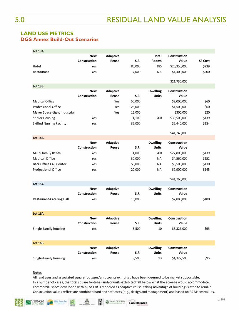
p. 109
Lot 13ANew Adaptive Hotel Construction
Construction Reuse S.F. Rooms Value SF CostHotel Yes 85,000 185 $20,350,000 $239Restaurant Yes 7,000 NA $1,400,000 $200
$21,750,000Lot 13B
New Adaptive Dwelling ConstructionConstruction Reuse S.F. Units Value
Medical Office Yes 50,000 $3,000,000 $60Professional Office Yes 25,000 $1,500,000 $60Maker Space-Light Industrial Yes 15,000 $300,000 $20Senior Housing Yes 1,100 200 $30,500,000 $139Skilled Nursing Facility Yes 35,000 $6,440,000 $184
$41,740,000Lot 14A
New Adaptive Dwelling ConstructionConstruction Reuse S.F. Units Value
Multi-family Rental Yes 1,000 200 $27,800,000 $139Medical Office Yes 30,000 NA $4,560,000 $152Back Office Call Center Yes 50,000 NA $6,500,000 $130Professional Office Yes 20,000 NA $2,900,000 $145
$41,760,000Lot 15A
New Adaptive Dwelling ConstructionConstruction Reuse S.F. Units Value
Restaurant-Catering Hall Yes 16,000 $2,880,000 $180
Lot 16ANew Adaptive Dwelling Construction
Construction Reuse S.F. Units ValueSingle-family housing Yes 3,500 10 $3,325,000 $95
Lot 16BNew Adaptive Dwelling Construction
Construction Reuse S.F. Units ValueSingle-family housing Yes 3,500 13 $4,322,500 $95
NotesAll land uses and associated square footages/unit counts exhibited have been deemed to be market supportable.In a number of cases, the total square footages and/or units exhibited fall below what the acreage would accommodate.Commercial space developed within Lot 13B is modeled as adaptive reuse, taking advantage of buildings slated to remain.Construction values reflect are combined hard and soft costs (e.g., design and management) and based on RS Means values.
Land Use Metrics
DGS Annex Build-Out Scenarios RESIDUAL LAND VALUE ANALYSIS5.0
LAND USE METRICSDGS Annex Build-Out Scenarios
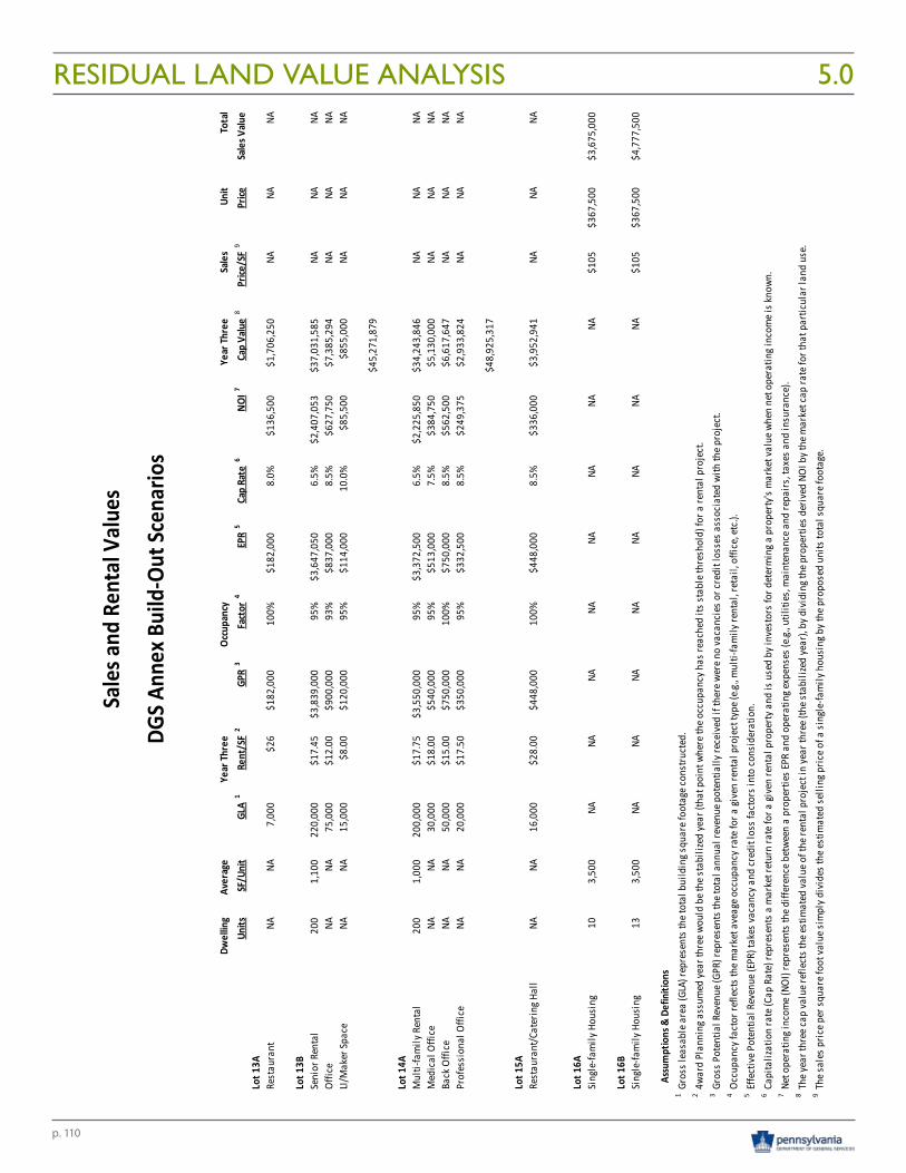
p. 110
Dwel
ling
Aver
age
Year
Thre
eOc
cupa
ncy
Year
Thre
eSa
les
Unit
Tota
lUn
itsSF
/Uni
tGL
A1
Rent
/SF
2GP
R3
Fact
or4
EPR
5Ca
p Ra
te6
NOI7
Cap
Valu
e8
Price
/SF
9Pr
iceSa
les V
alue
Lot 1
3ARe
stau
rant
NANA
7,00
0$2
6$1
82,0
0010
0%$1
82,0
008.
0%$1
36,5
00$1
,706
,250
NANA
NA
Lot 1
3BSe
nior
Ren
tal
200
1,10
022
0,00
0$1
7.45
$3,8
39,0
0095
%$3
,647
,050
6.5%
$2,4
07,0
53$3
7,03
1,58
5NA
NANA
Offic
eNA
NA75
,000
$12.
00$9
00,0
0093
%$8
37,0
008.
5%$6
27,7
50$7
,385
,294
NANA
NALI/
Mak
er Sp
ace
NANA
15,0
00$8
.00
$120
,000
95%
$114
,000
10.0
%$8
5,50
0$8
55,0
00NA
NANA
$45,
271,
879
Lot 1
4AM
ulti-
fam
ily R
enta
l20
01,
000
200,
000
$17.
75$3
,550
,000
95%
$3,3
72,5
006.
5%$2
,225
,850
$34,
243,
846
NANA
NAM
edic
al O
ffice
NANA
30,0
00$1
8.00
$540
,000
95%
$513
,000
7.5%
$384
,750
$5,1
30,0
00NA
NANA
Back
Offi
ceNA
NA50
,000
$15.
00$7
50,0
0010
0%$7
50,0
008.
5%$5
62,5
00$6
,617
,647
NANA
NAPr
ofes
sion
al O
ffice
NANA
20,0
00$1
7.50
$350
,000
95%
$332
,500
8.5%
$249
,375
$2,9
33,8
24NA
NANA
$48,
925,
317
Lot 1
5ARe
stau
rant
/Cat
erin
g Hal
lNA
NA16
,000
$28.
00$4
48,0
0010
0%$4
48,0
008.
5%$3
36,0
00$3
,952
,941
NANA
NA
Lot 1
6ASi
ngle
-fam
ily H
ousi
ng10
3,50
0NA
NANA
NANA
NANA
NA$1
05$3
67,5
00$3
,675
,000
Lot 1
6BSi
ngle
-fam
ily H
ousi
ng13
3,50
0NA
NANA
NANA
NANA
NA$1
05$3
67,5
00$4
,777
,500
Assu
mpt
ions
& D
efin
ition
s1 2 3 4
Occu
panc
y fac
tor r
efle
cts t
he m
arke
t ave
age o
ccup
ancy
rate
for a
give
n re
ntal
pro
ject
type
(e.g.
, mul
ti-fa
mily
rent
al, r
etai
l, of
fice,
etc.)
.5
Effe
ctiv
e Pot
entia
l Rev
enue
(EPR
) tak
es va
canc
y and
cred
it lo
ss fa
ctor
s int
o co
nsid
erat
ion.
6Ca
pita
lizat
ion
rate
(Cap
Rat
e) re
pres
ents
a m
arke
t ret
urn
rate
for a
give
n re
ntal
pro
perty
and
is u
sed
by in
vest
ors f
or d
eter
min
g a p
rope
rty's
mar
ket v
alue
whe
n ne
t ope
ratin
g inc
ome i
s kno
wn.
7Ne
t ope
ratin
g inc
ome (
NOI)
repr
esen
ts th
e diff
eren
ce b
etwe
en a
pro
perti
es EP
R an
d op
erat
ing e
xpen
ses (
e.g., u
tiliti
es, m
aint
enan
ce a
nd re
pairs
, tax
es a
nd in
sura
nce)
. 8
The y
ear t
hree
cap
valu
e ref
lect
s the
estim
ated
valu
e of t
he re
ntal
pro
ject
in ye
ar th
ree (
the s
tabi
lized
year
), by
div
idin
g the
pro
perti
es d
eriv
ed N
OI b
y the
mar
ket c
ap ra
te fo
r tha
t par
ticul
ar la
nd u
se.
9Th
e sal
es p
rice p
er sq
uare
foot
valu
e sim
ply d
ivid
es th
e est
imat
ed se
lling
pric
e of a
sing
le-fa
mily
hou
sing
by t
he p
ropo
sed
units
tota
l squ
are f
oota
ge.
Gros
s lea
sabl
e are
a (G
LA) r
epre
sent
s the
tota
l bui
ldin
g squ
are f
oota
ge co
nstru
cted
.4w
ard
Plan
ning
ass
umed
year
thre
e wou
ld b
e the
stab
ilize
d ye
ar (t
hat p
oint
whe
re th
e occ
upan
cy h
as re
ache
d its
stab
le th
resh
old)
for a
rent
al p
roje
ct.
Gros
s Pot
entia
l Rev
enue
(GPR
) rep
rese
nts t
he to
tal a
nnua
l rev
enue
pot
entia
lly re
ceiv
ed if
ther
e wer
e no
vaca
ncie
s or c
redi
t los
ses a
ssoc
iate
d wi
th th
e pro
ject
.
Sales
and R
enta
l Valu
es
DGS A
nnex
Bui
ld-O
ut Sc
enar
ios
RESIDUAL LAND VALUE ANALYSIS 5.0
p. 111
RESIDUAL LAND VALUE ANALYSIS5.0
RESIDUAL LAND VALUE ANALYSIS
DGS Build-Out Scenarios
Below is a summary of the residual land value findings for each of the lot area build-out scenarios:
Lot 13 A: This build-out scenario exhibits the largest potential land price value ($2.5 million), as well as largest per acre land price value ($318,215), given the uses modeled (185 room moderate service hotel and adjacent restaurant).
Lot 13B: This build-out scenario exhibits a $1.6 million potential land price value and a per acre land value of $23,494, based on a mix of residential and commercial uses. It should be stated the build-out program modeled would not need the entire 70.7 acres factored into this analysis and, thus, the per acre residual land value would rise in accordance with a reduction of the total acreage in this scenario. Further, the relatively low area market rents for office space, as well as for the 15,000 square feet of light industrial use-maker space (both as adaptive reuses), serve to limit what could otherwise be paid for land.
Lot 14A: This build-out scenario, featuring 100,000 square feet of medical office and back office/call center space and 200 market rate rental units exhibits the largest negative residual land value among all build-out scenarios modeled (-$10.2 million). This negative and relatively large residual value also suggests the development would not move forward, given the underpinning economics (e.g., the total cost of development substantially exceeds the capitalized value of the finished development, given market area rents and construction cost variables.
Lot 15 A: This build-out scenario features a large catering hall and restaurant on the relatively small 1.4 acre lot. The identified residual land value is negative (-$304,851), though not nearly as large as the negative value identified for the Lot 14A build-out scenario. It is conceivable that through a combination of achieving a lower development costs (e.g., reduced hard and soft costs, lower site improvement costs, etc.), as well as a slightly higher rental rate, the project could yield a positive (albeit small) residual land value.
Lot 16A: This build-out features a total of 10, relatively large single-family housing units on two-acre lots. The economics associated with developing new housing in the Susquehanna Township area, as well as current area sale prices for large single-family housing units all but precludes such as project from paying anything for the property (that is, given that pricing for such houses is relatively low (and notwithstanding relatively low construction costs), the economics of developing such units favors those developers who have controlled large land parcels for some period of time – effectively minimizing the land’s cost value to zero. Accordingly, the identified negative residual value (-$1,035,860 in this scenario) would likely prevent this project from moving ahead.
Lot 16B: This build-out features a total of 13, relatively large single-family housing units on two-acre lots. Like the Lot 16A scenario, the economics of developing such units favors those developers who have controlled large land parcels for some period of time. Accordingly, the identified negative residual value (-$1,346,618 in this scenario) would likely prevent this project from moving ahead.

Highest & Best Use Analysis 6.0

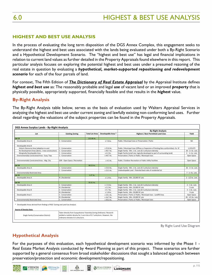
p. 115
HIGHEST AND BEST USE ANALYSIS
In the process of evaluating the long term disposition of the DGS Annex Complex, this engagement seeks to understand the highest and best uses associated with the lands being evaluated under both a By-Right Scenario and a Hypothetical Development Scenario. The “highest and best use” has legal and financial implications in relation to current land values as further detailed in the Property Appraisals found elsewhere in this report. This particular analysis focuses on exploring the potential highest and best uses under a presumed rezoning of the real estate in question by evaluating a hypothetical, market-supported repositioning and redevelopment scenario for each of the four parcels of land.
For context, The Fifth Edition of The Dictionary of Real Estate Appraisal by the Appraisal Institute defines highest and best use as: The reasonably probable and legal use of vacant land or an improved property that is physically possible, appropriately supported, financially feasible and that results in the highest value.
By-Right Analysis
The By-Right Analysis table below, serves as the basis of evaluation used by Walters Appraisal Services in analyzing the highest and best use under current zoning and lawfully existing non-conforming land uses. Further detail regarding the valuations of the subject properties can be found in the Property Appraisals.
Hypothetical Analysis
For the purposes of this evaluation, each hypothetical development scenario was informed by the Phase 1 - Real Estate Market Analysis conducted by 4ward Planning as part of this project. These scenarios are further supported by a general consensus from broad stakeholder discussions that sought a balanced approach between preservation/protection and economic development/repositioning.
HIGHEST & BEST USE ANALYSIS
Lot Existing Zoning Total Lot Area Developable Area * Highest / Best Permitted Land Uses Yield
Lot 13 132.68 Ac.Developable Area A C - Conservation ± 7.8 Ac. Public / Municipal Uses or Preservation / Parks NA
Developable Area BHistoric Resource Area (adaptive re-use) C - Conservation ± 25.8 Ac. Public / Municipal Uses (Offices or Expansion of Existing Non-conformities)- Ex. SF 1,223,675Re-Development Area (demo. / new construction) C - Conservation ± 40.7 Ac. Single Family - Min. 1 Ac. Lots (0.5 units/acre density) 20 - 1+ Ac. LotsMarginally Developable Area C - Conservation ± 4.2 Ac. Single Family (small size; logically developed as part of surrounding land) 2 - 1+ Ac. Lots
Environmentally Constrained Area - Susq. Twp. C - Conservation ± 49.7 Ac. Preservation / Parks or Public / Municipal Uses Open Space
Environmentally Constrained Area - Hbg. City OSR - Open Space / Recreation ± 4.5 Ac. Public / Outdoor Recreation or Public Utility Facilities Open Space
Lot 14 68.53 Ac.Developable Area A C - Conservation ± 53.0 Ac. Single Family - Min. 1 Ac. Lots (0.5 units/acre density) 26 - 1+ Ac. Lots
C - Conservation ± 15.5 Ac. Undevelopable Land - Potential back-side of residential lotEnvironmentally Restricted Area 7 - 1+ Ac. Lots
Lot 15 1.47 Ac.Developable Area A R-1 Residential ± 1.4 Ac. Single Family - Min. 20,000 SF Lots 2 - 1/2 Ac. Lots
Lot 16 92.61 Ac.Developable Area A C - Conservation ± 2.5 Ac. Single Family - Min. 1 Ac. Lots (0.5 units/acre density) 2 - 1 Ac. Lots
R-1 Residential ± 3.2 Ac. Single Family - Min. 20,000 SF Lots 5 LotsDevelopable Area B C - Conservation ± 5.7 Ac. Single Family - Min. 1 Ac. Lots (0.5 units/acre density) 3 - 1 Ac. Lots
R-1 Residential ± 1.8 Ac. Single Family - Min. 20,000 SF Lots 3 LotsDevelopable Area C C - Conservation ± 19.1 Ac. Preservation / Parks or Public / Municipal Uses - Landfill Area Open Space
R-1 Residential ± 16.7 Ac. Single Family - Min. 20,000 SF Lots 28 - 1/2 Ac. LotsEnvironmentally Restricted Area C - Conservation ± 49.0 Ac. Preservation / Parks or Public / Municipal Uses Open Space
* Developable Areas derived from findings of RGS' Zoning and Land Use Analysis
Source of Density Data:
Single Family (Conservation District)
DGS Annex Surplus Lands - By-Right AnalysisBy-Right Analysis
Taken directly from Susquehanna Township Zoning Ordinance. Research yielded a realistic density for 1 acre lots of 0.7 units/acre. However, the ordinance dictates 0.5 units/acre.
By Right Land Use Diagram
6.0
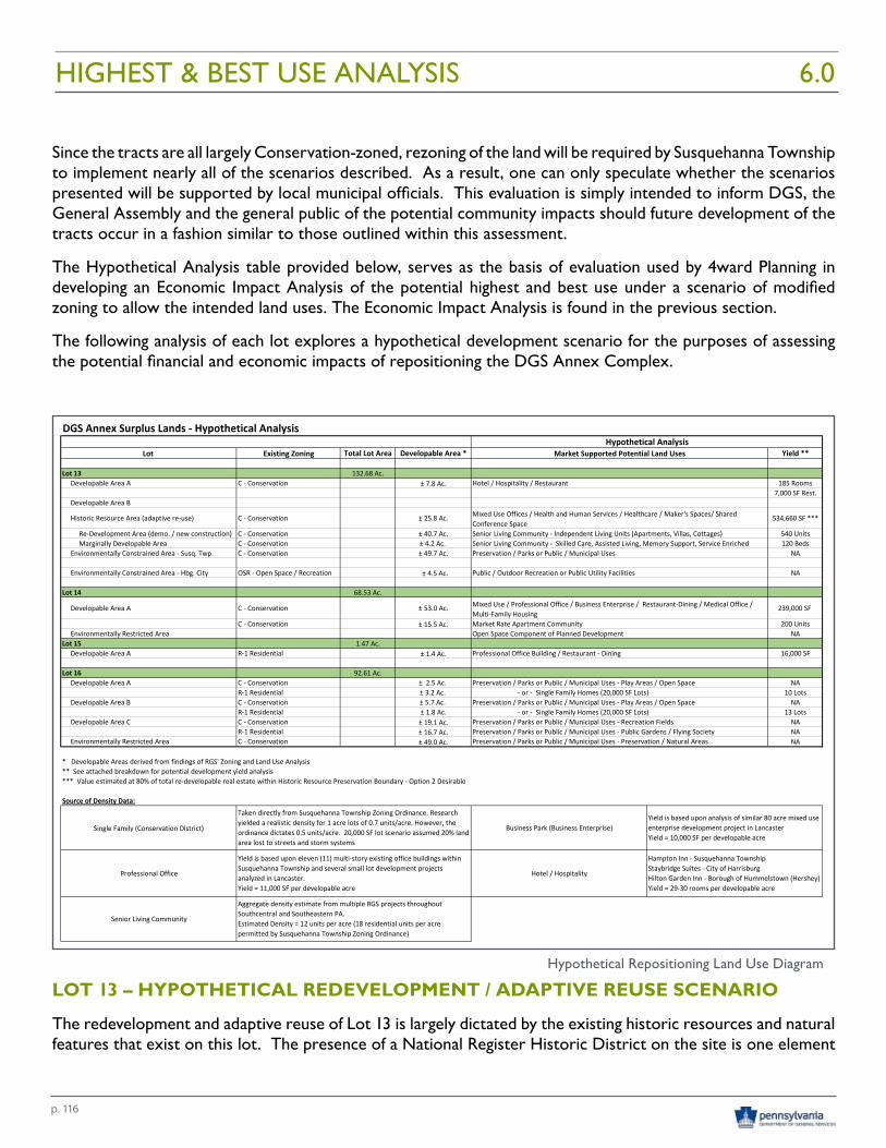
p. 116
Since the tracts are all largely Conservation-zoned, rezoning of the land will be required by Susquehanna Township to implement nearly all of the scenarios described. As a result, one can only speculate whether the scenarios presented will be supported by local municipal officials. This evaluation is simply intended to inform DGS, the General Assembly and the general public of the potential community impacts should future development of the tracts occur in a fashion similar to those outlined within this assessment.
The Hypothetical Analysis table provided below, serves as the basis of evaluation used by 4ward Planning in developing an Economic Impact Analysis of the potential highest and best use under a scenario of modified zoning to allow the intended land uses. The Economic Impact Analysis is found in the previous section.
The following analysis of each lot explores a hypothetical development scenario for the purposes of assessing the potential financial and economic impacts of repositioning the DGS Annex Complex.
LOT 13 – HYPOTHETICAL REDEVELOPMENT / ADAPTIVE REUSE SCENARIO
The redevelopment and adaptive reuse of Lot 13 is largely dictated by the existing historic resources and natural features that exist on this lot. The presence of a National Register Historic District on the site is one element
HIGHEST & BEST USE ANALYSIS
Lot Existing Zoning Total Lot Area Developable Area * Yield **
Lot 13 132.68 Ac.Developable Area A C - Conservation ± 7.8 Ac. Hotel / Hospitality / Restaurant 185 Rooms
7,000 SF Rest.Developable Area B
Historic Resource Area (adaptive re-use) C - Conservation ± 25.8 Ac. 534,660 SF ***
Re-Development Area (demo. / new construction) C - Conservation ± 40.7 Ac. Senior Living Community - Independent Living Units (Apartments, Villas, Cottages) 540 UnitsMarginally Developable Area C - Conservation ± 4.2 Ac. Senior Living Community - Skilled Care, Assisted Living, Memory Support, Service Enriched 120 Beds
Environmentally Constrained Area - Susq. Twp. C - Conservation ± 49.7 Ac. Preservation / Parks or Public / Municipal Uses NA
Environmentally Constrained Area - Hbg. City OSR - Open Space / Recreation ± 4.5 Ac. Public / Outdoor Recreation or Public Utility Facilities NA
Lot 14 68.53 Ac.
Developable Area A C - Conservation ± 53.0 Ac. 239,000 SF
C - Conservation ± 15.5 Ac. Market Rate Apartment Community 200 UnitsEnvironmentally Restricted Area Open Space Component of Planned Development NA
Lot 15 1.47 Ac.Developable Area A R-1 Residential ± 1.4 Ac. Professional Office Building / Restaurant - Dining 16,000 SF
Lot 16 92.61 Ac.Developable Area A C - Conservation ± 2.5 Ac. Preservation / Parks or Public / Municipal Uses - Play Areas / Open Space NA
R-1 Residential ± 3.2 Ac. - or - Single Family Homes (20,000 SF Lots) 10 LotsDevelopable Area B C - Conservation ± 5.7 Ac. Preservation / Parks or Public / Municipal Uses - Play Areas / Open Space NA
R-1 Residential ± 1.8 Ac. - or - Single Family Homes (20,000 SF Lots) 13 LotsDevelopable Area C C - Conservation ± 19.1 Ac. Preservation / Parks or Public / Municipal Uses - Recreation Fields NA
R-1 Residential ± 16.7 Ac. Preservation / Parks or Public / Municipal Uses - Public Gardens / Flying Society NAEnvironmentally Restricted Area C - Conservation ± 49.0 Ac. Preservation / Parks or Public / Municipal Uses - Preservation / Natural Areas NA
* Developable Areas derived from findings of RGS' Zoning and Land Use Analysis ** See attached breakdown for potential development yield analysis*** Value estimated at 80% of total re-developable real estate within Historic Resource Preservation Boundary - Option 2 Desirable
Source of Density Data:
Single Family (Conservation District) Business Park (Business Enterprise)
Professional Office Hotel / Hospitality
Senior Living Community
Aggregate density estimate from multiple RGS projects throughout Southcentral and Southeastern PA.Estimated Density = 12 units per acre (18 residential units per acre permitted by Susquehanna Township Zoning Ordinance)
Hampton Inn - Susquehanna Township Staybridge Suites - City of Harrisburg Hilton Garden Inn - Borough of Hummelstown (Hershey)Yield = 29-30 rooms per developable acre
DGS Annex Surplus Lands - Hypothetical Analysis
Mixed Use Offices / Health and Human Services / Healthcare / Maker's Spaces/ Shared Conference Space
Mixed Use / Professional Office / Business Enterprise / Restaurant-Dining / Medical Office / Multi-Family Housing
Yield is based upon analysis of similar 80 acre mixed use enterprise development project in LancasterYield = 10,000 SF per developable acre
Hypothetical AnalysisMarket Supported Potential Land Uses
Taken directly from Susquehanna Township Zoning Ordinance. Research yielded a realistic density for 1 acre lots of 0.7 units/acre. However, the ordinance dictates 0.5 units/acre. 20,000 SF lot scenario assumed 20% land area lost to streets and storm systems
Yield is based upon eleven (11) multi-story existing office buildings within Susquehanna Township and several small lot development projects analyzed in Lancaster.Yield = 11,000 SF per developable acre
6.0
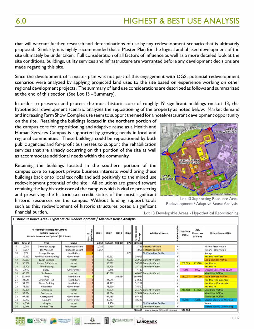
p. 117
Historic Resource Area - Hypothetical Redevelopment / Adaptive Reuse Analysis
Leve
l of
Sign
ifica
nce
LOS 1 LOS 2 LOS 3 LOS 4
Re-U
se S
quar
e Fo
otag
e Additional Notes
Rede
velo
pabl
e
Sub-Total Use SF
20% Reduction SF Value
Redevelopment Use
BLDG Total SF Type Status 2,852 567,535 103,084 879 669,3157 1,785 Dixmont Cottage Residence-Vacant 1 1,785 1,785 Historic Structure N Historic Preservation9 1,067 Dix Museum Residence-Vacant 1 1,067 1,067 Historic Structure N Historic Preservation
10 879 Storage Garage Health Care 4 879 Not Suited for Re-Use N Storage11 39,912 Administration Building Government 2 39,912 39,912 Y Healthcare Offices 12 26,953 Logan Building vacant 2 26,953 26,953 Currently Vacant Y Social Services / Office13 56,582 Kitchen & Cafeteria vacant 2 56,582 56,582 Currently Vacant Y 266,525 213220 Healthcare14 15,709 Pifer Building vacant 2 15,709 15,709 Currently Vacant Y Healthcare15 7,446 Chapel Government 2 7,446 7,446 Y 7,446 5957 Chapel / Conference Space16 40,660 Slothower vacant 2 40,660 40,660 Currently Vacant Y Mixed Use / Office17 103,084 Petry Health Care 3 103,084 103,084 Y 130,037 104030 Social Services / Office21 24,545 Anderson Hall Health Care 2 24,545 24,545 Y Healthcare (Gaudenzia)22 51,267 Green Building Health Care 2 51,267 51,267 Y Healthcare (Gaudenzia)23 78,510 Cedarcrest Government 2 78,510 78,510 Y Healthcare31 25,379 Shamrock vacant 2 25,379 25,379 Currently Vacant Y 216,408 173126 Mixed Use / Office32 52,884 Beechmont vacant 2 52,884 52,884 Currently Vacant Y Mixed Use / Office 33 97,485 Cherrywood Government 2 97,485 97,485 Y Mixed Use / Office 34 40,287 Laundry Government 2 40,287 40,287 Y 46,047 36,838 Makers Space / Co-Working35 4,156 Morgue vacant 2 4,156 Not Suited for Re-Use N Vacant36 5,760 Clothes Tree vacant 2 5,760 5,760 Currently Vacant Y Makers Space / Co-Working
666,463 534,660
Harrisburg State Hospital CampusBuilding Inventory
Historic Preservation Option 2 (23.2 Acres)
Assume Approx. 80% usable / leasable
that will warrant further research and determinations of use by any redevelopment scenario that is ultimately proposed. Similarly, it is highly recommended that a Master Plan for the logical and phased development of the site ultimately be undertaken. Full consideration of all factors of influence as well as a more detailed look at the site conditions, buildings, utility services and infrastructure are warranted before any development decisions are made regarding this site.
Since the development of a master plan was not part of this engagement with DGS, potential redevelopment scenarios were analyzed by applying projected land uses to the site based on experience working on other regional development projects. The summary of land use considerations are described as follows and summarized at the end of this section (See Lot 13 - Summary).
In order to preserve and protect the most historic core of roughly 19 significant buildings on Lot 13, this hypothetical development scenario analyzes the repositioning of the property as noted below. Market demand and increasing Farm Show Complex use seem to support the need for a hotel/restaurant development opportunity on the site. Retaining the buildings located in the northern portion of the campus core for repositioning and adaptive reuse as a Health and Human Services Campus is supported by growing needs in local and regional communities. These buildings could be repositioned by both public agencies and for-profit businesses to support the rehabilitation services that are already occurring on this portion of the site as well as accommodate additional needs within the community.
Retaining the buildings located in the southern portion of the campus core to support private business interests would bring these buildings back onto local tax rolls and add positively to the mixed use redevelopment potential of the site. All solutions are geared toward retaining the key historic core of the campus which is vital to protecting and preserving the historic tax credit status of the most significant historic resources on the campus. Without funding support tools such as this, redevelopment of historic structures poses a significant financial burden.
HIGHEST & BEST USE ANALYSIS
Lot 13 Developable Areas - Hypothetical Repositioning
6.0
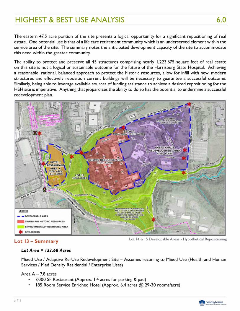
p. 118
The eastern 47.5 acre portion of the site presents a logical opportunity for a significant repositioning of real estate. One potential use is that of a life care retirement community which is an underserved element within the service area of the site. The summary notes the anticipated development capacity of the site to accommodate this need within the greater community.
The ability to protect and preserve all 45 structures comprising nearly 1,223,675 square feet of real estate on this site is not a logical or sustainable outcome for the future of the Harrisburg State Hospital. Achieving a reasonable, rational, balanced approach to protect the historic resources, allow for infill with new, modern structures and effectively reposition current buildings will be necessary to guarantee a successful outcome. Similarly, being able to leverage available sources of funding assistance to achieve a desired repositioning for the HSH site is imperative. Anything that jeopardizes the ability to do so has the potential to undermine a successful redevelopment plan.
Lot 13 – Summary
Lot Area = 132.68 Acres
Mixed Use / Adaptive Re-Use Redevelopment Site – Assumes rezoning to Mixed Use (Health and Human Services / Med Density Residential / Enterprise Uses)
Area A – 7.8 acres• 7,000 SF Restaurant (Approx. 1.4 acres for parking & pad)• 185 Room Service Enriched Hotel (Approx. 6.4 acres @ 29-30 rooms/acre)
Lot 14 & 15 Developable Areas - Hypothetical Repositioning
HIGHEST & BEST USE ANALYSIS 6.0
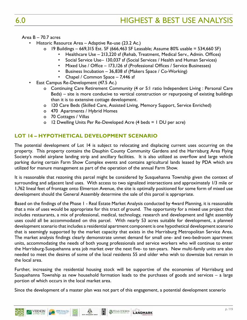
p. 119
Area B – 70.7 acres • Historic Resource Area – Adaptive Re-use (23.2 Ac.)
o 19 Buildings – 669,315 Est. SF (666,463 SF Leasable; Assume 80% usable = 534,660 SF)• Healthcare Use – 213,220 sf (Rehab, Treatment, Medical Serv., Admin. Offices)• Social Service Use– 130,037 sf (Social Services / Health and Human Services)• Mixed Use / Office – 173,126 sf (Professional Offices / Service Businesses)• Business Incubation – 36,838 sf (Makers Space / Co-Working) • Chapel / Common Space – 7,446 sf
• East Campus Re-Development (47.5 Ac.)o Continuing Care Retirement Community (4 or 5:1 ratio Independent Living : Personal Care
Beds) – site is more conducive to vertical construction or repurposing of existing buildings than it is to extensive cottage development.
o 120 Care Beds (Skilled Care, Assisted Living, Memory Support, Service Enriched)o 470 Apartments / Hybrid Homeso 70 Cottages / Villaso 12 Dwelling Units Per Re-Developed Acre (4 beds = 1 DU per acre)
LOT 14 – HYPOTHETICAL DEVELOPMENT SCENARIO
The potential development of Lot 14 is subject to relocating and displacing current uses occurring on the property. This property contains the Dauphin County Community Gardens and the Harrisburg Area Flying Society’s model airplane landing strip and ancillary facilities. It is also utilized as overflow and large vehicle parking during certain Farm Show Complex events and contains agricultural lands leased by PDA which are utilized for manure management as part of the operation of the annual Farm Show.
It is reasonable that rezoning this parcel might be considered by Susquehanna Township given the context of surrounding and adjacent land uses. With access to two signalized intersections and approximately 1/3 mile or 1,762 lineal feet of frontage onto Elmerton Avenue, the site is optimally positioned for some form of mixed use development should the General Assembly determine the sale of this parcel is appropriate.
Based on the findings of the Phase 1 - Real Estate Market Analysis conducted by 4ward Planning, it is reasonable that a mix of uses would be appropriate for this tract of ground. The opportunity for a mixed use project that includes restaurants, a mix of professional, medical, technology, research and development and light assembly uses could all be accommodated on this parcel. With nearly 53 acres suitable for development, a planned development scenario that includes a residential apartment component is one hypothetical development scenario that is seemingly supported by the market capacity that exists in the Harrisburg Metropolitan Service Area. The market analysis findings clearly demonstrate unmet demand for small one- and two-bedroom apartment units, accommodating the needs of both young professionals and service workers who will continue to enter the Harrisburg-Susquehanna area job market over the next five- to ten-years. New multi-family units are also needed to meet the desires of some of the local residents 55 and older who wish to downsize but remain in the local area.
Further, increasing the residential housing stock will be supportive of the economies of Harrisburg and Susquehanna Township as new household formation leads to the purchases of goods and services – a large portion of which occurs in the local market area.
Since the development of a master plan was not part of this engagement, a potential development scenerio
HIGHEST & BEST USE ANALYSIS6.0
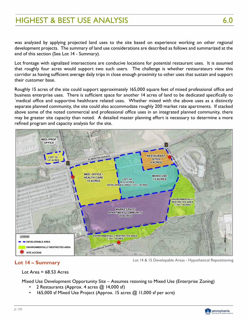
p. 120
was analyzed by applying projected land uses to the site based on experience working on other regional development projects. The summary of land use considerations are described as follows and summarized at the end of this section (See Lot 14 - Summary).
Lot frontage with signalized intersections are conducive locations for potential restaurant uses. It is assumed that roughly four acres would support two such users. The challenge is whether restaurateurs view this corridor as having sufficient average daily trips in close enough proximity to other uses that sustain and support their customer base.
Roughly 15 acres of the site could support approximately 165,000 square feet of mixed professional office and business enterprise uses. There is sufficient space for another 14 acres of land to be dedicated specifically to `medical office and supportive healthcare related uses. Whether mixed with the above uses as a distinctly separate planned community, the site could also accommodate roughly 200 market rate apartments. If stacked above some of the noted commercial and professional office uses in an integrated planned community, there may be greater site capacity than noted. A detailed master planning effort is necessary to determine a more refined program and capacity analysis for the site.
Lot 14 – Summary
Lot Area = 68.53 Acres
Mixed Use Development Opportunity Site – Assumes rezoning to Mixed Use (Enterprise Zoning)• 2 Restaurants (Approx. 4 acres @ 14,000 sf)• 165,000 sf Mixed Use Project (Approx. 15 acres @ 11,000 sf per acre)
Lot 14 & 15 Developable Areas - Hypothetical Repositioning
HIGHEST & BEST USE ANALYSIS 6.0
p. 121
o Professional Services / Office / Research & Development / Technology / Light Assembly • 60,000 sf Medical Offices (Approx. 14 acres @ 4,285 sf per acre) • 200 Unit Multi-family Apartment Complex (Approx. 20 acres at 10 Units per acre)
LOT 15 – HYPOTHETICAL DEVELOPMENT SCENARIO
The potential development of Lot 15 is also subject to rezoning which would need to be considered and approved by Susquehanna Township. Given the site’s adjacency to a signalized intersection, location on Elmerton Avenue and surrounding land uses, it would be reasonable for this parcel to be considered for a business oriented use.
The site is largely unencumbered by any physical constraints and could be considered to be fully developable. Based on the findings of the Phase 1 - Real Estate Market Analysis conducted by 4ward Planning, it is logical that this 1.47 acre site could be utilized to serve the medical, healthcare or small professional office demand that exists in the marketplace. The site would seem to accommodate roughly 16,000 square feet of space based on similar development projects for these types of uses. Future development considerations should explore the development of a program specific sketch plan to determine the actual capacity of this site should the General Assembly determine the sale of this parcel is appropriate. (Refer to the Hypothetical Repositioning Land Use Diagram for Lots 14 and 15 on the previous page.)
Lot 15 – Summary
Lot Area = 1.47 Acres
Assumes Rezoning to Business / Office Use• 16,000 SF Medical / Professional Services Office (Approx. 1.47 acres @ 11,000 sf per acre)
LOT 16 – HYPOTHETICAL DEVELOPMENT SCENARIO
The potential development and/or conservation of Lot 16 is subject to a number of factors. Since this parcel is underlain by a 22 acre landfill, it’s logical that a significant portion of this site may be suitable for several of the uses that could end up being displaced from other DGS Annex Complex properties, depending on whether the General Assembly determines the sale of those parcels is appropriate.
The eastern portion of Lot 16 could be converted to multiple active and passive recreation uses. This portion of the property could seemingly accommodate the relocation of the Dauphin County Community Gardens as well as the Harrisburg Area Flying Society’s model airplane landing strip and ancillary facilities currently located on Lot 14. It is also conceivable that sufficient space would be available to develop several recreation fields to fulfill an identified community need. These fields could also accommodate sports teams currently using fields that may be displaced by the redevelopment of Lot 13.
No detailed planning of these uses has been undertaken as part of this engagement. Should public ownership and use of this parcel be considered, it is recommended that a master plan be prepared. A master plan should assess the capacity of the site as well as the compatibility of the proposed uses. Orientation, tree cover, slopes and other physical constraints presented by the existing landfill could dictate very specific design solutions that may need to be addressed to accommodate the needs of a variety of uses, the physical space needs of each use and the overall safety of the general public.
HIGHEST & BEST USE ANALYSIS60
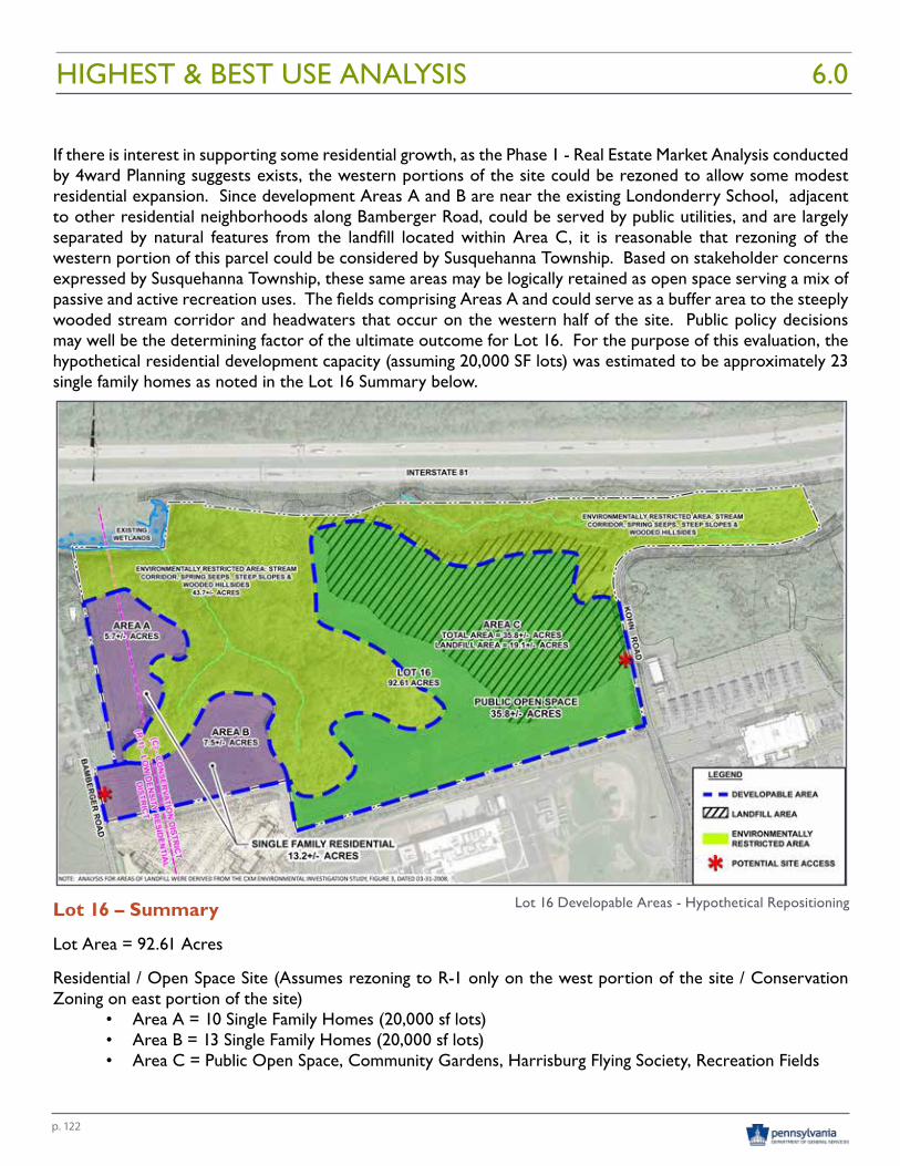
p. 122
If there is interest in supporting some residential growth, as the Phase 1 - Real Estate Market Analysis conducted by 4ward Planning suggests exists, the western portions of the site could be rezoned to allow some modest residential expansion. Since development Areas A and B are near the existing Londonderry School, adjacent to other residential neighborhoods along Bamberger Road, could be served by public utilities, and are largely separated by natural features from the landfill located within Area C, it is reasonable that rezoning of the western portion of this parcel could be considered by Susquehanna Township. Based on stakeholder concerns expressed by Susquehanna Township, these same areas may be logically retained as open space serving a mix of passive and active recreation uses. The fields comprising Areas A and could serve as a buffer area to the steeply wooded stream corridor and headwaters that occur on the western half of the site. Public policy decisions may well be the determining factor of the ultimate outcome for Lot 16. For the purpose of this evaluation, the hypothetical residential development capacity (assuming 20,000 SF lots) was estimated to be approximately 23 single family homes as noted in the Lot 16 Summary below.
Lot 16 – Summary
Lot Area = 92.61 Acres
Residential / Open Space Site (Assumes rezoning to R-1 only on the west portion of the site / Conservation Zoning on east portion of the site)
• Area A = 10 Single Family Homes (20,000 sf lots)• Area B = 13 Single Family Homes (20,000 sf lots)• Area C = Public Open Space, Community Gardens, Harrisburg Flying Society, Recreation Fields
Lot 16 Developable Areas - Hypothetical Repositioning
HIGHEST & BEST USE ANALYSIS 6.0
p. 123
OUTSIDE MARKET INFLUENCES
Worthy of note are outside market influences that can and will impact the hypothetical assumptions made herein. One example is the Vartan Group’s 2615 Linglestown Road project planned at the intersection of Progress Avenue and Linglestown Road. This mixed use residential and commercial real estate development project would clearly influence the absorption capacity in the Harrisburg Metropolitan Service Area as identified within the Phase 1 – Real Estate Market Analysis. Other projects that may be announced or come on line could also impact the development capacity and absorption rates for any development proposals that may be set forth for the DGS Annex properties. This assessment does not consider the potential influences of other development proposals in the region. Rather, it is intended to simply respond to the market opportunities that are understood to exist at the time this report was written.
CONCLUSION
The hypothetical development scenarios presented are intended to set forth potential development capacities for each lot based on the market opportunities understood to exist within the Harrisburg-Susquehanna service area. No warrants are made that these sites can or will be developed with the specific uses identified or at the densities/yields projected. Project timing, market influences and municipal land use/zoning decisions beyond the control of anyone involved with this evaluation and analysis will ultimately determine the mix of uses that may be located on each site.
HIGHEST & BEST USE ANALYSIS6.0


Appraisal Report 7.0

p. 127
We have inspected and appraised the above referenced property at your request by letter of engagement dated November 23, 2015. The report format is an “Appraisal Report.” We have estimated the market value of the Fee Simple interest of the subject property. The subject property consists of four (4) lots known collectively as DGS Annex Complex.
Our most recent property inspection of the subject property was on October 4, 2016, the effective date of value. During the course of completing the appraisal, we met with members of RGS Associates, Bradley Swartz of Department of General Services, Andrew Lick of Department of General Services, and various members of the Disposition Team associated with the DGS Annex Complex Harrisburg State Hospital analysis. Numerous inspections were made with and without assistance during the past four (4) months.
Extraordinary assumption: We relied on the various reports collectively organized by RGS Associates, Inc. Reports considered, and completed in concert with RGS Land Planning Landscape Architecture Civil Engineering, DGS Harrisburg State Hospital Disposition Report
ARM Group, Inc.• Asbestos Inspection Report – DGS Annex – Lot 13• Phase I Environmental Site Assessment – Lot 13 DGS Annex Complex• Phase I Environmental Site Assessment – Lot 14 DGS Annex Complex• Phase I Environmental Site Assessment – Lot 15 DGS Annex Complex• Phase I Environmental Site Assessment – Lot 16 DGS Annex Complex• Environmental Abatement and Remediation Cost Assessment
Delta Development Group, Inc.:• DGS Annex Surplus Grounds Funding Analysis for Lot 13 - Harrisburg State Hospital• DGS Annex Surplus Grounds Historic Resource Analysis for Lot 13 - Harrisburg State Hospital
4Ward Planning, Inc.:• DGS Annex Complex – Phase 1 Market Analysis• DGS Annex Complex – Economic Impact Analysis
RGS Associates:• Utility Separation Analysis for Department of General Services, Annex Land Planning• Zoning and Site Analysis Studies for Department of General Services, Annex Land Planning• Highest and Best Use Analysis
Vernon Land Use:DGS Annex Grounds – Phase One Stakeholder Engagement
As indicated in the Statement of Work, the appraisal contract shall include:i. Appraise Lots 13, 14, 15 and 16 separately taking into account a 180 day competitive sealed quoting
period.ii. Appraise Lots 13, 14, 15 and 16 together as one parcel taking into account a 180 day competitive
sealed quoting period.iii. Appraise Lots 14, 15 and 16 together as one parcel taking into account a 180 day competitive sealed
quoting period.
We have considered location, condition, size, zoning, marketing time, functional utility, sales of comparable properties, the uses for which the property is and could be employed, operating costs, and other pertinent data. Market data is used to develop the sales comparison approach to value.
APPRAISAL REPORT7.0
p. 128
APPRAISAL REPORT 7.0
LOT 13
We have determined the market value of Lot 13 as vacant at $2,650,000. After making cost adjustment for utility separation, asbestos abatement, and applying the minimum demolition cost, Lot 13 yields a negative value of ($8,050,000) as vacant. The analysis concludes the utility separation and demolition cost exceed the value as vacant. Therefore, the most likely path is to adapt and reuse the existing structures.
Additionally, we developed a market value as improved based on comparable sales. After consideration to comparable improved sales we determined the market value at $3,650,000. After adjustment for Utility Separation ($1,400,000) and Asbestos Abatement ($3,200,000), the value conclusion yields a negative value of ($950,000). The negative value as improved is less negative than the value as vacant.
It is our opinion, and we certify, that the market value of the Fee Simple interest in the subject property, as of October 4, 2016, is:
NEGATIVE – NINE HUNDRED FIFTY THOUSAND (-$950,000) DOLLARS
LOT 14
After making adjustments and considering both the unit rate per acre and possible building lots concludes an “as is” market value at $1,300,000. It is our opinion, and we certify, that the market value of the Fee Simple interest in the subject property, as of October 4, 2016, is:
ONE MILLION THREE HUNDRED THOUSAND ($1,300,000) DOLLARS
LOT 15
After making adjustments and considering both the unit rate per acre and possible building lots concludes an “as is” market value at $80,000. It is our opinion, and we certify, that the market value of the Fee Simple interest in the subject property, as of October 4, 2016, is:
EIGHTY THOUSAND ($80,000) DOLLARS
LOT 16
After making adjustments and considering both the unit rate per acre and possible building lots concludes an “as is” market value at $1,600,000. It is our opinion, and we certify, that the market value of the Fee Simple interest in the subject property, as of October 4, 2016, is:
ONE MILLION SIX HUNDRED THOUSAND ($1,600,000) DOLLARS
p. 129
LOTS 13, 14, 15 & 16 TOGETHER AS ONE PARCEL
It is our opinion, and we certify, that the market value of the Fee Simple interest in the subject property, as of October 4, 2016, is:
TWO MILLION ($2,000,000) DOLLARS
LOTS 14, 15 & 16 TOGETHER AS ONE PARCEL
It is our opinion, and we certify, that the market value of the Fee Simple interest in the subject property, as of October 4, 2016, is:
THREE MILLION ($3,000,000) DOLLARS
We have estimated a reasonable marketing time for the subject property to be approximately 3 - 5 years. The scope of work defines a 180 day competitive sealed quoting period.
This letter does not make up a complete appraisal report. The accompanying report, which comprises 89 pages plus addenda is included in the appendices. Please note the assumptions and limiting conditions on pages 24 to 25. We have personally prepared the analysis and formed the opinions presented in this report without significant professional assistance from any other person.
This appraisal is written in conformity with the Codes of Ethics and Standards of Professional Practice of the Appraisal Institute and the Uniform Standards of Professional Practice of the Appraisal Practice (USPAP). We have taken steps to comply with the competency provision of USPAP by identifying the appraisal problem and deciding that we have the knowledge and experience to complete the assignment competently. Jeffrey L. Walters is currently state-certified as a “General Appraiser” by the Commonwealth of Pennsylvania, and professional qualifications follow this report.
We have inspected the subject property, the subject property neighborhood, and comparable market data. As part of our inspection, it is not possible to observe conditions beneath the soil. Further, structural components and mechanical components within the walls and under the floors of the improvements are difficult to see. Unless specifically identified to the contrary in the body of the report, all mechanical components are assumed to be in operating condition and commensurate with the conditions of the balance of the improvements.
The Americans with Disabilities Act (“ADA”) became effective January 26, 1992. The appraiser has not made a specific compliance survey and analysis of this property to determine whether or not it is in conformity with the various detailed requirements of the ADA. It is possible that the compliance survey of the property, together with a detailed analysis of the requirements of the ADA, could reveal that the property is not in compliance with one or more of the requirements of the Act. If so, this fact could have a negative effect on the value of the property. Since the appraiser has no direct evidence relating to this issue, he did not consider possible non-compliance with the requirements of ADA in estimating the value of the property.
The authentic copies of this report are either a WALTERS APPRAISAL SERVICES, INC. generated PDF file or bound in covers bearing the WALTERS APPRAISAL SERVICES, lNC. firm name, and contain original signatures and photographs. Any copy of the report that does not ha\’e our standard binding and/or original signatures and
APPRAISAL REPORT7.0
p. 130
APPRAISAL REPORT 7.0
photographs is unauthorized, may have been altered, and is considered invalid.
It should be clearly understood, the acceptance of this assignment is not conditioned upon our repo1iing a specific (dictated) value; nor was the acceptance of the assignment conditioned on our concluding a requested minimum value or maximum value; nor was the acceptance of the assignment predicated in any way upon the approval, extension, or modification of an existing or pending loan for which the subject real estate is or may be pledged as collateral.

Marketing Recommendations 8.0

p. 133
Landmark Commercial Realty, Inc. has been engaged to assist DGS in determining the best marketing approach toward the ultimate disposition of the 295.3 Acre annex complex. It is anticipated that the Commonwealth will be completely vacated from the property in July of 2019. We’ve reviewed the various studies and reports that have recently been completed/compiled by RGS and its consultants for this property as well as the current real estate market conditions. We have been asked to provide our marketing recommendations for the method(s) of disposal for the individual tracts as well as for the combined package by considering the following options:
• Retain in State ownership/control• Direct conveyance (Redevelopment Authority)• Competitive Bid: Individually, and• Competitive Bid: Offered in combination
The following are our recommendations and rationale.
LOT 13132 Acre Former State Hospital Site
Due to the complexity of issues surrounding this site which currently has 44 buildings and includes the existence of various historic resources, structural, architectural and environmental concerns as well as conservation areas, our initial recommendation is that this tract be offered both separately as well as in combination with the other largely unimproved tracts.
The Real Estate Market Analysis for the region indicates that there is market capacity that would likely support a variety of land uses. Similarly, the hypothetical highest and best use analysis conducted for this site indicates that there is sufficient site capacity to support a combination of adaptive reuse and redevelopment that could include the following uses*:
• Hotels/Hospitality/Restaurant• Mixed use offices, Health and Human Services, Health care, Maker’s spaces, shared conference space• Senior Living Community – independent living units• Senior Living Community – skilled care, assisted living, memory support, service enriched• Preservation, parks or public/municipal uses• Public outdoor recreation facilities
*Assumption that Susquehanna Township will support these uses with appropriate zoning.
Prospective buyers, developers or tenants of this historically significant property will need to have knowledge and experience with adaptive reuse projects, and will need to work within the various rezoning and permitting constraints that have been identified.
Our initial recommendation would be to solicit competitive bids for both Parcel #13 individually and in combination with the entire 295 Acres allowing for a 180 day competitive quoting period. We would not entertain offers on Lots 14, 15 and 16 individually unless/until we have obtained a solid commitment from a qualified bidder on Lot #13. At the solicitation start date the real estate would be advertised via the Pennsylvania Bulletin, the PA e-market place and other internet sites, as well as direct mail or electronic mail to a list of likely bidders to be provided by Landmark.
During this 180 day bidding period qualified bidders and targeted prospects would be provided with access to the various links to the “due diligence” investigations materials that have been procured by our team and approved by DGS. Landmark representatives will be available to coordinate property tours during this period.
MARKETING RECOMMENDATIONS8.0
p. 134
MARKETING RECOMMENDATIONS 8.0
Our rational is that, even if this doesn’t bring us the final qualified buyer at an acceptable price, it will bring interested “anchor users” such as hotels, hospitals, health care and human services groups, mixed use offices, senior housing developers as well as the redevelopment authorities to the table.
If an acceptable bid has not been received during the quoting period, then DGS may pursue negotiation of a direct conveyance to a redevelopment authority, presumably with several anchor users or tenants on board. At this point we would recommend that the development authority pursue development of a master plan, pursue the asbestos remediation, and selected demolition followed by the production of and promotion of a leasing plan or a condominium document in order to lease or sell separate (to be delineated) areas of the tract.
LOT 1468.53 Acres – SEC Elmerton Avenue and Sycamore Drive
Our initial recommendation is that Lot #14 be offered only in combination with the other parcels for competitive bids. The solicitation for bids for the total 4 lot, 295 Acre package should include a 180 day bid quoting period.
This 68+ acre site has excellent frontage and visibility on Elmerton Avenue and Sycamore Drive. It is surrounded by large modern office buildings and would have the support of Susquehanna Township for office development. In our opinion it will be the easiest to develop of the parcels and thereby adds a strong net positive value to the package. As an enticement for developers, Lot #14 should be kept in the package until the final disposition of Lot #13 is determined.
If DGS is successful in disposing of Lot #13 individually, then, at that time we would recommend offering Lot #14 individually for competitive bid with a 90 day bidding term.
LOT 151.47 Acres – NWC Elmerton Avenue and Bamberger Drive
This parcel is situated on a hard corner of the signalized intersection of Elmerton Avenue and Bamberger Drive. It has the potential for, and would likely receive Township support for, future retail development, commercial or professional business office development. However, using the same logic as with Lot #14, it should initially be offered as part of the total package only.
If DGS is successful in the disposition of Lot #13 individually, then, at that time we would recommend offering Lot #15 individually for competitive bid with a 90 day bidding term.
LOT 1692.61 Acres with I-81 Frontage and Limited Access to Bamberger Road and Kohn Road
This tract should initially be offered only as a part of the total package. If at the conclusion of the 180 day bidding period DGS is able to consummate the sale of Lot #13 individually, then we would recommend a direct conveyance of Lot 16 to Susquehanna Township or Dauphin County for public uses, some of which are currently using Lot #14.
p. 135
TIMING:
In summary, we recommend that Lot #13 (132 Acre main campus) should be offered for competitive bid individually as well as the full (4 lot – 295 Acre) combined package. The two (2) solicitation start dates should occur simultaneously in early 2018 to provide sufficient lead time to facilitate property transfer(s) in 2019. Bid quoting periods of 180 days are recommended.
At the conclusion of this term, if a bid has been accepted for Lot #13, then Lots #14 and #15 should be offered individually with 90 day quoting periods and Lot #16 should be offered for direct conveyance to the County or Township for public use.
MARKETING RECOMMENDATIONS8.0


Findings & Conclusions 9.0

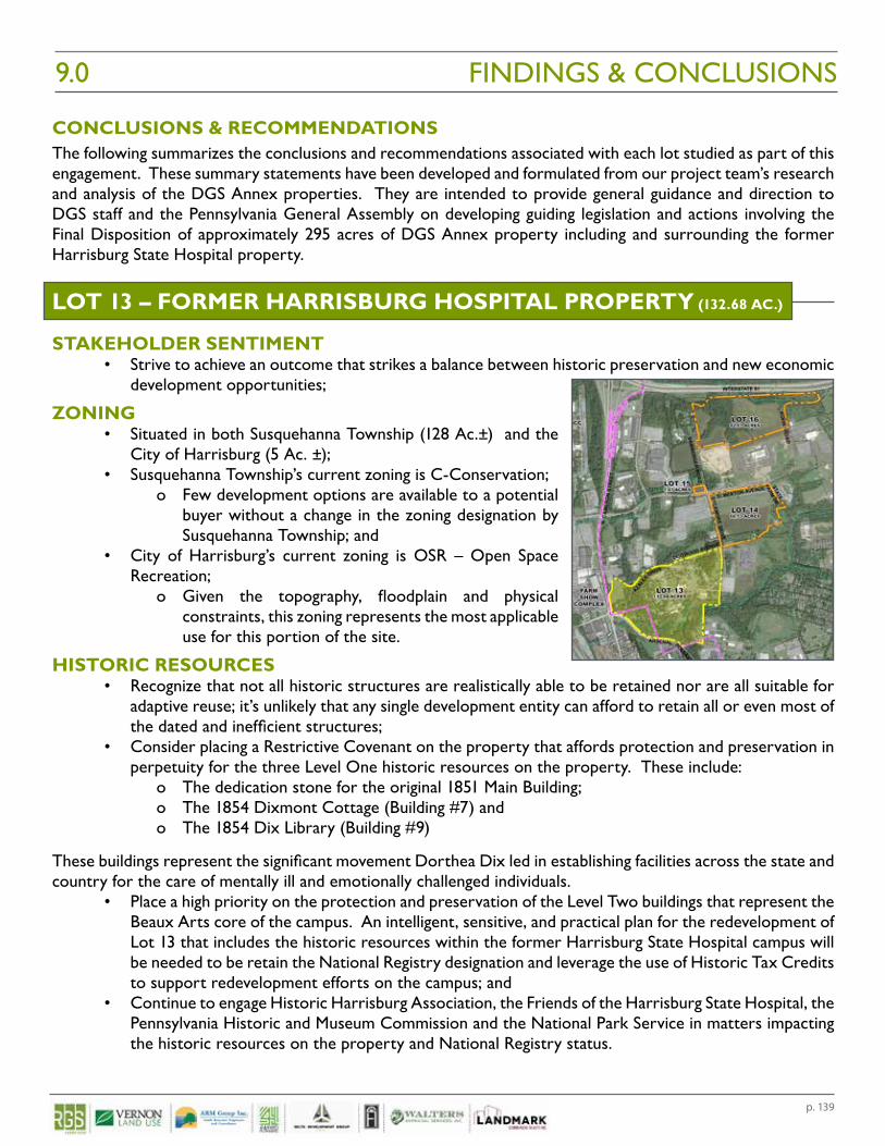
p. 139
CONCLUSIONS & RECOMMENDATIONSThe following summarizes the conclusions and recommendations associated with each lot studied as part of this engagement. These summary statements have been developed and formulated from our project team’s research and analysis of the DGS Annex properties. They are intended to provide general guidance and direction to DGS staff and the Pennsylvania General Assembly on developing guiding legislation and actions involving the Final Disposition of approximately 295 acres of DGS Annex property including and surrounding the former Harrisburg State Hospital property.
LOT 13 – FORMER HARRISBURG HOSPITAL PROPERTY (132.68 AC.)
STAKEHOLDER SENTIMENT• Strive to achieve an outcome that strikes a balance between historic preservation and new economic
development opportunities;
ZONING• Situated in both Susquehanna Township (128 Ac.±) and the
City of Harrisburg (5 Ac. ±);• Susquehanna Township’s current zoning is C-Conservation;
o Few development options are available to a potential buyer without a change in the zoning designation by Susquehanna Township; and
• City of Harrisburg’s current zoning is OSR – Open Space Recreation;
o Given the topography, floodplain and physical constraints, this zoning represents the most applicable use for this portion of the site.
HISTORIC RESOURCES• Recognize that not all historic structures are realistically able to be retained nor are all suitable for
adaptive reuse; it’s unlikely that any single development entity can afford to retain all or even most of the dated and inefficient structures;
• Consider placing a Restrictive Covenant on the property that affords protection and preservation in perpetuity for the three Level One historic resources on the property. These include:
o The dedication stone for the original 1851 Main Building; o The 1854 Dixmont Cottage (Building #7) and o The 1854 Dix Library (Building #9)
These buildings represent the significant movement Dorthea Dix led in establishing facilities across the state and country for the care of mentally ill and emotionally challenged individuals.
• Place a high priority on the protection and preservation of the Level Two buildings that represent the Beaux Arts core of the campus. An intelligent, sensitive, and practical plan for the redevelopment of Lot 13 that includes the historic resources within the former Harrisburg State Hospital campus will be needed to be retain the National Registry designation and leverage the use of Historic Tax Credits to support redevelopment efforts on the campus; and
• Continue to engage Historic Harrisburg Association, the Friends of the Harrisburg State Hospital, the Pennsylvania Historic and Museum Commission and the National Park Service in matters impacting the historic resources on the property and National Registry status.
FINDINGS & CONCLUSIONS9.0
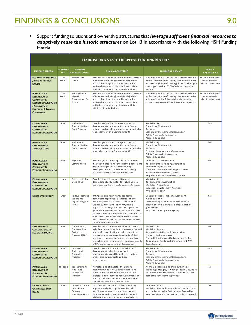
p. 140
FINDINGS & CONCLUSIONS 9.0
• Support funding solutions and ownership structures that leverage sufficient financial resources to adaptively reuse the historic structures on Lot 13 in accordance with the following HSH Funding Matrix.
DGS ANNEX SURPLUS GROUNDS – HARRISBURG STATE HOSPITAL SUSQUEHANNA TOWNSHIP DAUPHIN COUNTY, PENNSYLVANIA
27 | P A G E
MATRIX
FUNDING STREAMFUNDING
TYPEFUNDING
ANNOUNCEMENT FUNDING OBJECTIVE ELIGIBLE APPLICANTMATCH
REQUIREMENT
NATIONAL PARK SERVICE /INTERNAL REVENUE SERVICE
TaxCredi t
His toric Tax Credi t
Provides tax credi ts to promote rehabi l i tation of income-producing (depreciable), older his toric bui ldings that are l i s ted on the National Regis ter of His toric Places , ei ther individual ly or as a contributing bui lding
i thi hi t i di t i t
For-profi t enti ty in the rea l es tate development profess ion; non-profi t enti ty that partners with an investor (for- profi t enti ty) i f the tota l project cost i s greater than $5,000,000 and long-term lessees .
No, but must meet the substantia l
rehabi l i tation test.
PENNSYLVANIA DEPARTMENT OF COMMUNITY & ECONOMIC DEVELOPMENT / PENNSYLVANIA HISTORICAL & MUSEUM COMMISSION
TaxCredi t
Pennsylvania His toric Preservation Tax Credi t
Provides tax credi ts to promote rehabi l i tation of income-producing (depreciable), older his toric bui ldings that are l i s ted on the National Regis ter of His toric Places , ei ther individual ly or as a contributing bui lding within a his toric dis trict.
For-profi t enti ty in the rea l es tate development profess ion; non-profi t enti ty that partners with a for profi t enti ty i f the tota l project cost i s greater than $5,000,000 and long-term lessees .
No, but must meet the substantia l
rehabi l i tation test.
PENNSYLVANIA DEPARTMENT OF COMMUNITY & ECONOMIC DEVELOPMENT
Grant Multimodal Transportation Fund Program
Provides grants to encourage economic development and ensure that a safe and rel iable system of transportation i s ava i lable to res idents of this Commonwealth.
Municipa l i tyCounci l s of GovernmentBus inessEconomic Development OrganizationPubl ic Transportation AgencyPorts -Ra i l /Freight
Yes
PENNSYLVANIA DEPARTMENT OF TRANSPORTATION
Grant Multimodal Transportation Fund Program
Provides grants to encourage economic development and ensure that a safe and rel iable system of transportation i s ava i lable to res idents of this Commonwealth.
Municipa l i tyCounci l s of GovernmentBus inessEconomic Development OrganizationPubl ic Transportation AgencyPorts -Ra i l /Freight
Yes
PENNSYLVANIA DEPARTMENT OF COMMUNITY & ECONOMIC DEVELOPMENT
Grant Keystone Communities
Provides grants and targeted ass is tance to dis tressed areas and low income populations with a s trategic focus on community participation and col laborations among res idents , nonprofi ts , and bus inesses .
Units of Loca l GovernmentRedevelopment/Hous ing Authori tiesNonprofi t OrganizationsCommunity Development OrganizationsBus iness Improvement Dis trictsNeighborhood Improvement Dis tricts
Yes
PENNSYLVANIA DEPARTMENT OF COMMUNITY & ECONOMIC DEVELOPMENT
Loan Bus iness in Our Si tes (BIOS)
Provides loans for acquis i tion and development of key s i tes for future use by bus inesses , private developers , and others .
Municipa l i tiesRedevelopment Authori tiesMunicipa l Authori tiesIndustria l Development AgenciesPrivate Developers
No
OFFICE OF THE BUDGET Grant Redevelopment Ass is tance Capita l Program (RACP)
RACP projects are primari ly economic development projects , authorized in the Redevelopment Ass is tance section of a Capi ta l Budget Itemization Act, have a regional or multi -juri sdictional impact, and generate a substantia l increase or mainta in current levels of employment, tax revenues or other measures of economic activi ty. Projects with cul tura l , his torica l , recreational or civic s igni ficance are included.
Genera l purpose uni ts of governmentPubl ic authori tyLoca l development dis tricts that have an agreement with a genera l purpose uni t of governmentIndustria l development agency
Yes
DEPARTMENT OF CONSERVATION AND NATURAL RESOURCES
Grant Community Conservation Partnerships Program (C2P2)
Provides grants and technica l ass is tance to help PA communities , land conservancies and non-profi t organizations seek to meet the recreation and conservation needs of thei r res idents ; increase their access to outdoor recreation and natura l areas , enhance qual i ty of l i fe and preserve cri tica l landscapes .
Municipa l i tyMunicipa l AgencyAppropriate/Authorized organizationPre-qual i fied land trustsFor-profi t bus inesses (Only el igible for PA Recreational Tra i l s and Snowmobi le & ATV Grant funding)
Yes
PENNSYLVANIA DEPARTMENT OF COMMUNITY & ECONOMIC DEVELOPMENT
Grant Greenways , Tra i l s , and Recreation Program
Provides grants for projects which involve development, rehabi l i tation and improvements to publ ic parks , recreation areas , greenways , tra i l s and river conservation.
Municipa l i tiesCounci l s of GovernmentsBus inessEconomic Development OrganizationsPubl ic Transportation AgenciesPorts -Ra i l /Freight
Yes
PENNSYLVANIA DEPARTMENT OF COMMUNITY & ECONOMIC DEVELOPMENT
TIF Bond Tax Increment Financing Guarantee Program
Promotes and s timulates the genera l economic wel fare of various regions and communities in the Commonwealth and ass is ts in development, redevelopment, and revi ta l i zation of Brownfield and Greenfield s i tes in accordance with the TIF Act.
Al l municipa l i ties , and their authori ties , including boroughs , townships , towns , counties and home rules that i s sue TIF bonds to loca l economic development projects .
No
DAUPHIN COUNTY GAMING ADVISORY BOARD
Grant Dauphin County Loca l Share Gaming Municipa l Grant
Des igned for the purpose of dis tributing approximately 4% of gross terminal s lot machine revenues to support enhanced community and economic wel l -being and mitigate the impact of gaming and related activi ties
Dauphin CountyMunicipa l i ties within Dauphin County that are not contiguous with East Hanover TownshipNon-municipa l enti ties (with el igible sponsor)
No
HARRISBURG STATE HOSPITAL FUNDING MATRIX
APPENDIX 1 - Funding Matrix
p. 141
ASBESTOS AND LEAD BASED PAINTS• Though most buildings on the site and utility tunnels contain asbestos and lead based paint, recognize
that many of the buildings have had these elements encapsulated or stabilized as a result of prior improvements and not all of these environmental hazards require removal when treated appropriately for adaptive reuse;
• Recognize that the environmental constraints that do exist are limiting factors that will impact resale values, adaptive reuse and renovation or demolition costs associated with the existing structures; and
• Commonwealth of PA should be prepared to undertake appropriate remediation measures to effectively market and convey the real estate to a prospective buyer. Costs will vary widely depending upon the level of remediation required and buildings retained ($3.2-4.5 million for abatement to $9.3-13.1 million inclusive of building demolition).
ENVIRONMENTAL FEATURES• Consistent with the recommendation made by the PADEP’s Bureau of Forestry, consideration
should be given to the long term value of the steeply sloped wooded hillsides and the Asylum Run stream and floodplain corridor being held in public or quasi-public ownership by Dauphin County, Susquehanna Township or a Land Conservancy. Establishment of a deed restriction, permanent conservation easement or long-term fee simple ownership on this corridor will:
o Afford added protection and preservation of the aesthetics, wildlife habitat and physical surroundings along the existing 30’ wide perpetual Capital Area Greenbelt easement;
o Afford public control over potential stream improvement projects that could positively reduce Paxton Creek flooding concerns downstream of the site; and
o Contribute positively to Susquehanna Township’s ability to comply with their MS-4 requirements by reducing their Total Maximum Daily Load (TMDL) for sediment and nutrients contributing to water quality concerns within the Chesapeake Bay Watershed.
o Connects the growing urban population with nature, broadening support for natural resource conservation in and around Harrisburg.
• Consider requiring the protection of historic specimen trees located within the historic core of the campus during any demolition or construction operations (restrictive fencing placed beyond the canopy dripline of each tree).
• Consider establishing a minimum 100 foot no-cut stream buffer on both sides of Asylum Run to maintain water quality. This buffer, recommended by the Bureau of Forestry should:
o Be based on Bureau of Forestry’s guidelines for Warm Water Fishes streams; and o Helps prevent erosion and maintain stream quality as well as habitat for plants and animals.
• Consider establishing at least a 30 foot no-mow zone from water’s edge to maintain a stable and healthy stream bank. This riparian buffer area recommended by the Bureau of Forestry should:
o Be planted with a native seed mix such as : • 3 lb Virginia wildrye (Elymus virginicus)• 3 lb Canada wildrye (Elymus canadensis)• 5 lb Autumn bentgrass (Agrostis perennans)• 2 lb Deer tongue (Dicanthelium clandestinum)• 30 lb Cover Crop 30 lbs/ac oats (Avena fatua) • 0.5-2 lb Canada goldenrod (Solidago canadensis) • 0.5-2 lb Common milkweed (Alclepias syriaca)
FINDINGS & CONCLUSIONS9.0
p. 142
FINDINGS & CONCLUSIONS 9.0
PROPERTY SALE • The Commonwealth of PA should commence with separating utility services from surrounding
properties in accordance with the findings and recommendations of the Utility Separation Analysis prepared as part of this engagement;
• The Commonwealth of PA should commence with subdividing the Lots identified by the K&W Engineering Study to create the salable parcels identified in this report, including establishing the appropriate reservation of easements identified in the Utility Separation Analysis; and
• The Commonwealth of PA should offer the property for sale or direct conveyance in accordance with the Marketing Recommendations prepared as part of this engagement and noted herein.
DEVELOPMENT OPPORTUNITIES• Recognize the once-in-a-lifetime opportunity this site offers to leverage the uniqueness of the
property and its relative proximity to the State Capital, the City of Harrisburg, the Farm Show Complex, the regional commerce network and surrounding transportation systems;
• A future development entity should consider developing a strategic direction for the property that is guided by a clear master plan which sets forth a vision for the change in use;
• Upon transfer of the real estate to an entity other than the Commonwealth of PA, Susquehanna Township should consider working closely with a development entity to appropriately rezone the property to accommodate a balanced redevelopment of the former Harrisburg State Hospital property; and
• A future development entity should consider retaining some of the existing tenants on the campus. Users such as Gaudenzia have expressed interest in expanding their addiction treatment programs and facility needs on the campus. Their use could anchor a potential Health and Human Services Campus that could contribute to a renaissance of reuse for some of the structures on the former HSH property; and
• A future development entity should consider conducting a Urban Land Institute (ULI)-sponsored Technical Assistance Panel (TAP) as a means of further evaluating the redevelopment opportunities of this site and engaging stakeholder sentiment.
FINANCIAL ASSISTANCE• Susquehanna Township should consider the pros and cons of implementing a Local Economic
Revitalization Tax Assistance (LERTA) Program to allow local taxing authorities to exempt improvements to a business property if such property is located in a defined redevelopment area to encourage the adaptive reuse of some of the historic structures and repositioning of the campus; and
• Susquehanna Township should consider implementing a Tax Increment Financing District as a public financing tool to fund public works or improvements for private residential, commercial or industrial development or revitalization through the allocation and dedication of all or a portion of the additional taxes resulting from increases in property values or from the increase in commercial activity as a result of a development or revitalization project.
APPRAISAL VALUES
Value as Vacant• The market value of Lot 13 as vacant has been established at $2,650,000.• After making cost adjustment for Utility Separation ($1,400,000) and Asbestos Abatement
($3,200,000) and applying the minimum demolition cost ($6,100,000), Lot 13 yields a negative value
p. 143
of ($8,050,000) as vacant. • The analysis concludes the utility separation and demolition costs exceed the value as vacant. • Therefore, the most likely path is to adapt and reuse the existing structures.
Value as Improved• The market value of Lot 13 as improved based on comparable sales was established at $3,650,000.• After adjustment for Utility Separation ($1,400,000) and Asbestos Abatement ($3,200,000), the
value conclusion yields a negative value of ($950,000). • The negative value as improved is less negative than the value as vacant.
It is the appraiser’s certified opinion that the market value of the Fee Simple interest in Lot 13, as of October 4, 2016, is:
NEGATIVE – NINE HUNDRED FIFTY THOUSAND (-$950,000) DOLLARS
MARKETING RECOMMENDATIONS• Initial Offering: Lot 13 in combination with the other largely unimproved tracts (due to the complexity
of issues surrounding this site);• Bidding Period: Allow for a 180 day competitive quoting period;• Form of Solicitation: Competitive Bids (Lot 13 in combination with Lots 14, 15 and 16);
o It is not recommended offers be entertained on Lots 14, 15 and 16 individually unless/until a solid commitment has been obtained from a qualified bidder on Lot 13;
o If a qualified bidder does not materialize, it is recommended that DGS pursue negotiations for direct conveyance to a redevelopment authority;
• Advertising Recommendation: Upon determination of a solicitation start date, advertise the real estate via the Pennsylvania Bulletin, the PA e-market place and other internet real estate sites. Also distribute marketing packets via direct mail or electronic mail to a list of potential bidders to be provided by Landmark and approved by the Department of General Services;
o During the Bidding Period, provide qualified bidders and targeted prospects with access to the various links to the “due diligence” investigations materials that have been procured by our team and approved by DGS;
o Project Team and DGS representatives should be available to coordinate property tours;• Rationale: Even if an initial solicitation doesn’t bring forth a final qualified buyer at an acceptable
price, it will bring interested “anchor users” such as hotels, hospitals, health care and human services groups, mixed use offices, senior housing developers as well as local redevelopment authorities to the table;
• Subsequent Offering: If an acceptable bid has not been received during the initial quoting period, then it is recommended DGS pursue negotiation on a direct conveyance of Lot 13 to a redevelopment authority, presumably with several anchor users or tenants showing interest or committed to the site. At this point, it is recommended that any redevelopment authority engaged pursue development of a master plan, pursue any necessary asbestos remediation, and conduct selected demolition followed by the production of and promotion of a leasing plan or a condominium document in order to lease or sell separate (to be delineated) areas of the tract; and
• Timing: Lot 13 (132 Acres - former Harrisburg State Hospital Campus) should be offered for competitive bid as part of a full, combined four-lot package (Lots 13, 14, 15 and 16 – 295 Acres). The solicitation start date should occur in early 2018 to provide sufficient lead time to facilitate property transfer(s) in 2019. (Refer to Final Disposition Timeline)
FINDINGS & CONCLUSIONS9.0
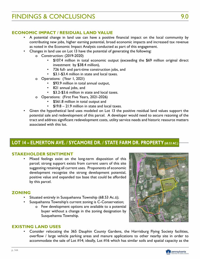
p. 144
FINDINGS & CONCLUSIONS 9.0
ECONOMIC IMPACT / RESIDUAL LAND VALUE• A potential change in land use can have a positive financial impact on the local community by
contributing new jobs, higher earning potential, broad economic impacts and increased tax revenue as noted in the Economic Impact Analysis conducted as part of this engagement.
• Changes in land use on Lot 13 have the potential of generating the following:o Construction: (2019-2020)
• $107.4 million in total economic output (exceeding the $69 million original direct investment by $38.4 million),
• 726 full- and part-time construction jobs, and • $3.1-$3.4 million in state and local taxes.
o Operations: (Year 1, 2021) • $93.9 million in total annual output, • 821 annual jobs, and • $3.2-$3.6 million in state and local taxes.
o Operations: (First Five Years, 2021-2026) • $561.8 million in total output and • $19.8 – 21.9 million in state and local taxes.
• Given the hypothetical land uses modeled on Lot 13 the positive residual land values support the potential sale and redevelopment of this parcel. A developer would need to secure rezoning of the tract and address significant redevelopment costs, utility service needs and historic resource matters associated with this lot.
LOT 14 – ELMERTON AVE. / SYCAMORE DR. / STATE FARM DR. PROPERTY (68.53 AC.)
STAKEHOLDER SENTIMENT• Mixed feelings exist on the long-term disposition of this
parcel; strong support exists from current users of this site suggesting retaining all current uses. Proponents of economic development recognize the strong development potential, positive value and expanded tax base that could be afforded by this parcel.
ZONING• Situated entirely in Susquehanna Township (68.53 Ac.±); • Susquehanna Township‘s current zoning is C-Conservation;
o Few development options are available to a potential buyer without a change in the zoning designation by Susquehanna Township.
EXISTING LAND USES• Consider relocating the 365 Dauphin County Gardens, the Harrisburg Flying Society facilities,
overflow / large vehicle parking areas and manure applications to other nearby site in order to accommodate the sale of Lot #14; ideally, Lot #16 which has similar soils and spatial capacity as the
p. 145
site being vacated;• Continue to engage and inform the gardeners, Flying Society members, PA Farm Show and PA
Department of Agriculture regarding the timing of potential impacts and relocation needs.
PROPERTY SALE • The Commonwealth of PA should commence with separating utility services from surrounding
properties in accordance with the findings and recommendation of the Utility Separation Analysis prepared as part of this engagement;
• The Commonwealth of PA should commence with subdividing the Lots identified by the K&W Engineering Study to create the salable parcels identified in this report, including establishing the appropriate reservation of easements identified in the Utility Separation Analysis;
• The Commonwealth of PA should offer the property for sale in accordance with the Marketing Recommendations prepared as part of this engagement and noted herein;
DEVELOPMENT OPPORTUNITIES• A future development entity should consider developing a strategic direction for the property that
is guided by a clear master plan which sets forth a vision for the change in use; and • Upon transfer of the real estate to an entity other than the Commonwealth of PA, Susquehanna
Township should consider working closely with a development entity to appropriately rezone the property to accommodate a balanced redevelopment of the former Harrisburg State Hospital property.
FINANCIAL ASSISTANCE• Susquehanna Township should consider the pros and cons of implementing a Local Economic
Revitalization Tax Assistance (LERTA) Program to allow local taxing authorities to exempt improvements to a business property if such property is located in a defined redevelopment area; and
• Susquehanna Township should consider implementing a Tax Increment Financing District as a public financing tool to fund public works or improvements for private residential, commercial or industrial development or revitalization through the allocation and dedication of all or a portion of the additional taxes resulting from increases in property values or from the increase in commercial activity as a result of a development or revitalization project.
ECONOMIC IMPACT / RESIDUAL LAND VALUE• A potential change in land use can have a positive financial impact on the local community by
contributing new jobs, higher earning potential, broad economic impacts and increased tax revenue as noted in the Economic Impact Analysis conducted as part of this engagement.
• Changes in land use on Lot 14 have the potential of generating the following:o Construction: (2019-2020)
• $69.8 million in total economic output (exceeding the $46 million original direct investment by $23.8 million),
• 495 full- and part-time construction jobs, and • $2.0 - 2.2 million in state and local taxes.
o Operations: (Year 1, 2021)
FINDINGS & CONCLUSIONS9.0
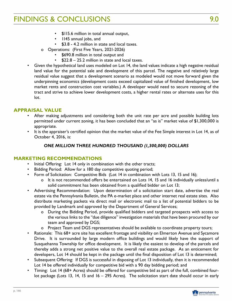
p. 146
FINDINGS & CONCLUSIONS 9.0
• $115.6 million in total annual output, • 1145 annual jobs, and • $3.8 - 4.2 million in state and local taxes.
o Operations: (First Five Years, 2021-2026) • $690.8 million in total output and • $22.8 – 25.2 million in state and local taxes.
• Given the hypothetical land uses modeled on Lot 14, the land values indicate a high negative residual land value for the potential sale and development of this parcel. The negative and relatively large residual value suggest that a development scenario as modeled would not move forward given the underpinning economics (development costs exceed capitalized value of finished development, low market rents and construction cost variables.) A developer would need to secure rezoning of the tract and strive to achieve lower development costs, a higher rental rates or alternate uses for this lot.
APPRAISAL VALUE• After making adjustments and considering both the unit rate per acre and possible building lots
permitted under current zoning, it has been concluded that an “as is” market value of $1,300,000 is appropriate.
• It is the appraiser’s certified opinion that the market value of the Fee Simple interest in Lot 14, as of October 4, 2016, is:
ONE MILLION THREE HUNDRED THOUSAND (1,300,000) DOLLARS
MARKETING RECOMMENDATIONS• Initial Offering: Lot 14 only in combination with the other tracts;• Bidding Period: Allow for a 180 day competitive quoting period;• Form of Solicitation: Competitive Bids (Lot 14 in combination with Lots 13, 15 and 16);
o It is not recommended offers be entertained on Lots 14, 15 and 16 individually unless/until a solid commitment has been obtained from a qualified bidder on Lot 13;
• Advertising Recommendation: Upon determination of a solicitation start date, advertise the real estate via the Pennsylvania Bulletin, the PA e-market place and other internet real estate sites. Also distribute marketing packets via direct mail or electronic mail to a list of potential bidders to be provided by Landmark and approved by the Department of General Services;
o During the Bidding Period, provide qualified bidders and targeted prospects with access to the various links to the “due diligence” investigation materials that have been procured by our team and approved by DGS;
o Project Team and DGS representatives should be available to coordinate property tours;• Rationale: This 68+ acre site has excellent frontage and visibility on Elmerton Avenue and Sycamore
Drive. It is surrounded by large modern office buildings and would likely have the support of Susquehanna Township for office development. It is likely the easiest to develop of the parcels and thereby adds a strong net positive value to the overall real estate package. As an enticement for developers, Lot 14 should be kept in the package until the final disposition of Lot 13 is determined;
• Subsequent Offering: If DGS is successful in disposing of Lot 13 individually, then it is recommended Lot 14 be offered individually for competitive bid with a 90 day bidding period; and
• Timing: Lot 14 (68+ Acres) should be offered for competitive bid as part of the full, combined four-lot package (Lots 13, 14, 15 and 16 – 295 Acres). The solicitation start date should occur in early
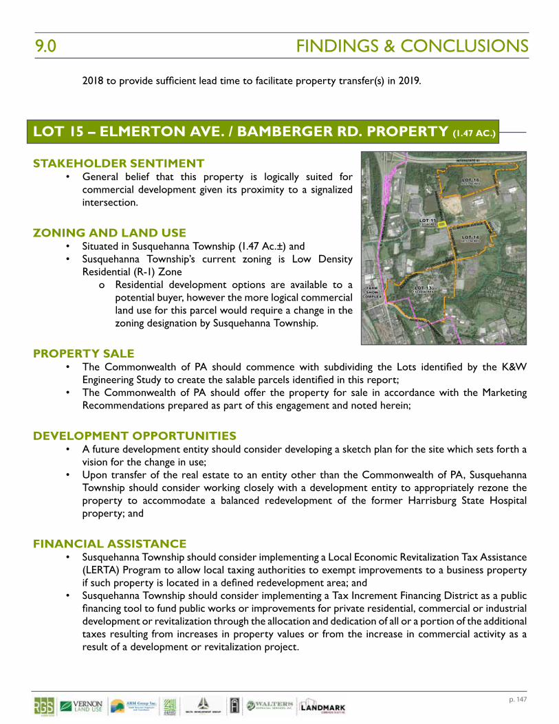
p. 147
2018 to provide sufficient lead time to facilitate property transfer(s) in 2019.
LOT 15 – ELMERTON AVE. / BAMBERGER RD. PROPERTY (1.47 AC.)
STAKEHOLDER SENTIMENT• General belief that this property is logically suited for
commercial development given its proximity to a signalized intersection.
ZONING AND LAND USE• Situated in Susquehanna Township (1.47 Ac.±) and • Susquehanna Township’s current zoning is Low Density
Residential (R-1) Zone o Residential development options are available to a
potential buyer, however the more logical commercial land use for this parcel would require a change in the zoning designation by Susquehanna Township.
PROPERTY SALE • The Commonwealth of PA should commence with subdividing the Lots identified by the K&W
Engineering Study to create the salable parcels identified in this report; • The Commonwealth of PA should offer the property for sale in accordance with the Marketing
Recommendations prepared as part of this engagement and noted herein;
DEVELOPMENT OPPORTUNITIES• A future development entity should consider developing a sketch plan for the site which sets forth a
vision for the change in use;• Upon transfer of the real estate to an entity other than the Commonwealth of PA, Susquehanna
Township should consider working closely with a development entity to appropriately rezone the property to accommodate a balanced redevelopment of the former Harrisburg State Hospital property; and
FINANCIAL ASSISTANCE• Susquehanna Township should consider implementing a Local Economic Revitalization Tax Assistance
(LERTA) Program to allow local taxing authorities to exempt improvements to a business property if such property is located in a defined redevelopment area; and
• Susquehanna Township should consider implementing a Tax Increment Financing District as a public financing tool to fund public works or improvements for private residential, commercial or industrial development or revitalization through the allocation and dedication of all or a portion of the additional taxes resulting from increases in property values or from the increase in commercial activity as a result of a development or revitalization project.
FINDINGS & CONCLUSIONS9.0
p. 148
FINDINGS & CONCLUSIONS 9.0
ECONOMIC IMPACT / RESIDUAL LAND VALUE• A potential change in land use can have a positive financial impact on the local community by
contributing new jobs, higher earning potential, broad economic impacts and increased tax revenue as noted in the Economic Impact Analysis conducted as part of this engagement.
• Changes in land use on Lot 15 have the potential of generating the following:o Construction: (2019-2020)
• $4.7 million in total economic output (exceeding the $3.2 million original direct investment by $1.5 million),
• 33 full- and part-time construction jobs, and • $134,000 – 148,000 in state and local taxes.
o Operations: (Year 1, 2021) • $3.8 million in total annual output, • 66 annual jobs, and • $193,000- 213,000 in state and local taxes.
o Operations: (First Five Years, 2021-2026) • $22.9 million in total output and • $1.2 – 1.3 million in state and local taxes.
• Given the hypothetical land uses modeled on Lot 15 the land values indicate a slightly negative residual land value for the potential sale and development of this parcel. A developer would need to secure rezoning of the tract and strive to achieve lower development costs, a slightly higher rental rate or alternate use for this lot.
APPRAISAL VALUE• After making adjustments and considering both the unit rate per acre and possible building lots
permitted under current zoning, it has been concluded that an “as is” market value of $80,000 is appropriate.
• It is the appraiser’s certified opinion that the market value of the Fee Simple interest Lot 15, as of October 4, 2016, is:
EIGHTY THOUSAND ($80,000) DOLLARS
MARKETING RECOMMENDATIONS • Initial Offering: Lot 15 only in combination with the other tracts;• Bidding Period: Allow for a 180 day competitive quoting period;• Form of Solicitation: Competitive Bids (Lot 15 in combination with Lots 13, 14 and 16);
o It is not recommended offers be entertained on Lots 14, 15 and 16 individually unless/until a solid commitment has been obtained from a qualified bidder on Lot 13;
• Advertising Recommendation: Upon determination of a solicitation start date, advertise the real estate via the Pennsylvania Bulletin, the PA e-market place and other internet real estate sites. Also distribute marketing packets via direct mail or electronic mail to a list of potential bidders to be provided by Landmark and approved by the Department of General Services;
o During the Bidding Period, provide qualified bidders and targeted prospects with access to the various links to the “due diligence” investigation materials that have been procured by our team and approved by DGS;
o Project Team and DGS representatives should be available to coordinate property tours;• Rationale: This 1.47 acre parcel is situated on a hard corner of the signalized intersection of Elmerton
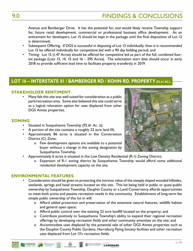
p. 149
Avenue and Bamberger Drive. It has the potential for, and would likely receive Township support for, future retail development, commercial or professional business office development. As an enticement for developers, Lot 15 should be kept in the package until the final disposition of Lot 13 is determined;
• Subsequent Offering: If DGS is successful in disposing of Lot 13 individually, then it is recommended Lot 15 be offered individually for competitive bid with a 90 day bidding period; and
• Timing: Lot 15 (1.47 Acres) should be offered for competitive bid as part of the full, combined four-lot package (Lots 13, 14, 15 and 16 – 295 Acres). The solicitation start date should occur in early 2018 to provide sufficient lead time to facilitate property transfer(s) in 2019.
LOT 16 – INTERSTATE 81 / BAMBERGER RD / KOHN RD. PROPERTY (92.61 AC.)
STAKEHOLDER SENTIMENT• Many felt this site was well suited for consideration as a public
park/recreation area. Some also believed this site could serve as a logical relocation option for uses displaced from other DGS Annex properties.
ZONING• Situated in Susquehanna Township (92.61 Ac. ±); • A portion of the site contains a roughly 22 acre land fill; • Approximately 86 acres is situated in the Conversation
District (C) Zone; o Few development options are available to a potential
buyer without a change in the zoning designation by Susquehanna Township.
• Approximately 6 acres is situated in the Low Density Residential (R-1) Zoning District;o Expansion of R-1 zoning district by Susquehanna Township would afford some additional
residential development capacity on the site.
ENVIRONMENTAL FEATURES• Consideration should be given to protecting the intrinsic value of the steeply sloped wooded hillsides,
wetlands, springs and head streams located on this site. This lot being held in public or quasi-public ownership by Susquehanna Township, Dauphin County or a Land Conservancy affords opportunities to meet both active and passive recreation needs in the community. Establishment of long-term fee simple public ownership of this lot in will:
o Afford added protection and preservation of the extensive natural features, wildlife habitat and general open space;
o Afford public control over the existing 22 acre landfill located on the property; and o Contribute positively to Susquehanna Township’s ability to expand their regional recreation
offerings by developing recreation fields and other community amenities on the site; and o Accommodate uses displaced by the potential sale of other DGS Annex properties such as
the Dauphin County Public Gardens, Harrisburg Flying Society facilities and other recreation uses displaced from Lot 13’s recreation fields.
FINDINGS & CONCLUSIONS9.0
p. 150
FINDINGS & CONCLUSIONS 9.0
PROPERTY SALE • The Commonwealth of PA should commence with subdividing the Lots identified by the K&W
Engineering Study to create the salable parcels identified in this report; • The Commonwealth of PA should offer the property for sale or direct conveyance in accordance
with the Marketing Recommendations prepared as part of this engagement and noted herein;
DEVELOPMENT OPPORTUNITIES• A future developer or public entity should consider developing a strategic direction for the property
that is guided by a clear master plan which sets forth a vision for the change in use;• Upon transfer of the real estate to an entity other than the Commonwealth of PA, Susquehanna
Township should consider working closely with a developer or public entity to consider the appropriate zoning for the property to accommodate reasonable and publically acceptable uses of the property;
ECONOMIC IMPACT / RESIDUAL LAND VALUE• A potential change in land use can have a positive financial impact on the local community by
contributing new jobs, higher earning potential, broad economic impacts and increased tax revenue as noted in the Economic Impact Analysis conducted as part of this engagement.
• Changes in land use on Lot 16 have the potential of generating the following:o Construction: (2019-2020)
• $19.9 million in total economic output (exceeding the $13.3 million original direct investment by $6.6 million),
• 141 full- and part-time construction jobs, and • $645,000 – 713,000 in state and local taxes.
o Operations: (Year 1, 2021) • $2.2 million in total annual output, • 16 annual jobs, and • $116,000 – 128,000 in state and local taxes.
o Operations: (First Five Years, 2021-2026) • $18.3 million in total output and • $973,000 – 1.1 million in state and local taxes.
• Given the hypothetical land uses modeled on Lot 16 the land values indicate a negative residual land value for the potential sale and development of portions of this parcel for residential housing. A developer would need to secure rezoning of a portion of the tract and have a larger development opportunity for a project of this nature to move forward making a sale for this use unlikely.
APPRAISAL VALUE• After making adjustments and considering both the unit rate per acre and possible building lots
permitted under current zoning, it has been concluded that an “as is” market value of $1,600,000 is appropriate.
• It is the appraiser’s certified opinion that the market value of the Fee Simple interest in Lot 16, as of October 4, 2016, is:
ONE MILLION SIX HUNDRED THOUSAND ($1,600,000) DOLLARS
p. 151
MARKETING RECOMMENDATIONS • Initial Offering: Lot 16 only in combination with the other tracts;• Bidding Period: Allow for a 180 day competitive quoting period;• Form of Solicitation: Competitive Bids (Lot 16 in combination with Lots 13, 14 and 15);
o It is not recommended offers be entertained on Lots 14, 15 and 16 individually unless/until a solid commitment has been obtained from a qualified bidder on Lot 13;
• Advertising Recommendation: Upon determination of a solicitation start date, advertise the real estate via the Pennsylvania Bulletin, the PA e-market place and other internet real estate sites. Also distribute marketing packets via direct mail or electronic mail to a list of potential bidders to be provided by Landmark and approved by the Department of General Services;
o During the Bidding Period, provide qualified bidders and targeted prospects with access to the various links to the “due diligence” investigation materials that have been procured by our team and approved by DGS;
o Project Team and DGS representatives should be available to coordinate property tours;• Rationale: This 92.6 acre parcel is situated along a limited access highway with limited accessibility
and frontage onto secondary township roads. Although the property has significant visibility from a major highway, nearly half of the site is burdened by steep slopes, environmentally sensitive areas and a significant land fill impacting its development potential;
• Subsequent Offering: If DGS is successful in disposing of Lot 13 individually, then it is recommended Lot 16 be conveyed directly to a public or quasi-public entity such as Susquehanna Township, Dauphin County or a Land Conservancy for public use, including accommodating some or all of the uses currently occurring on Lot 14; and
• Timing: Lot 16 (92.6 Acres) should be offered for competitive bid as part of the full, combined four-lot package (Lots 13, 14, 15 and 16 – 295 Acres). The solicitation start date should occur in early 2018 to provide sufficient lead time to facilitate property transfer(s) in 2019.
FINDINGS & CONCLUSIONS9.0
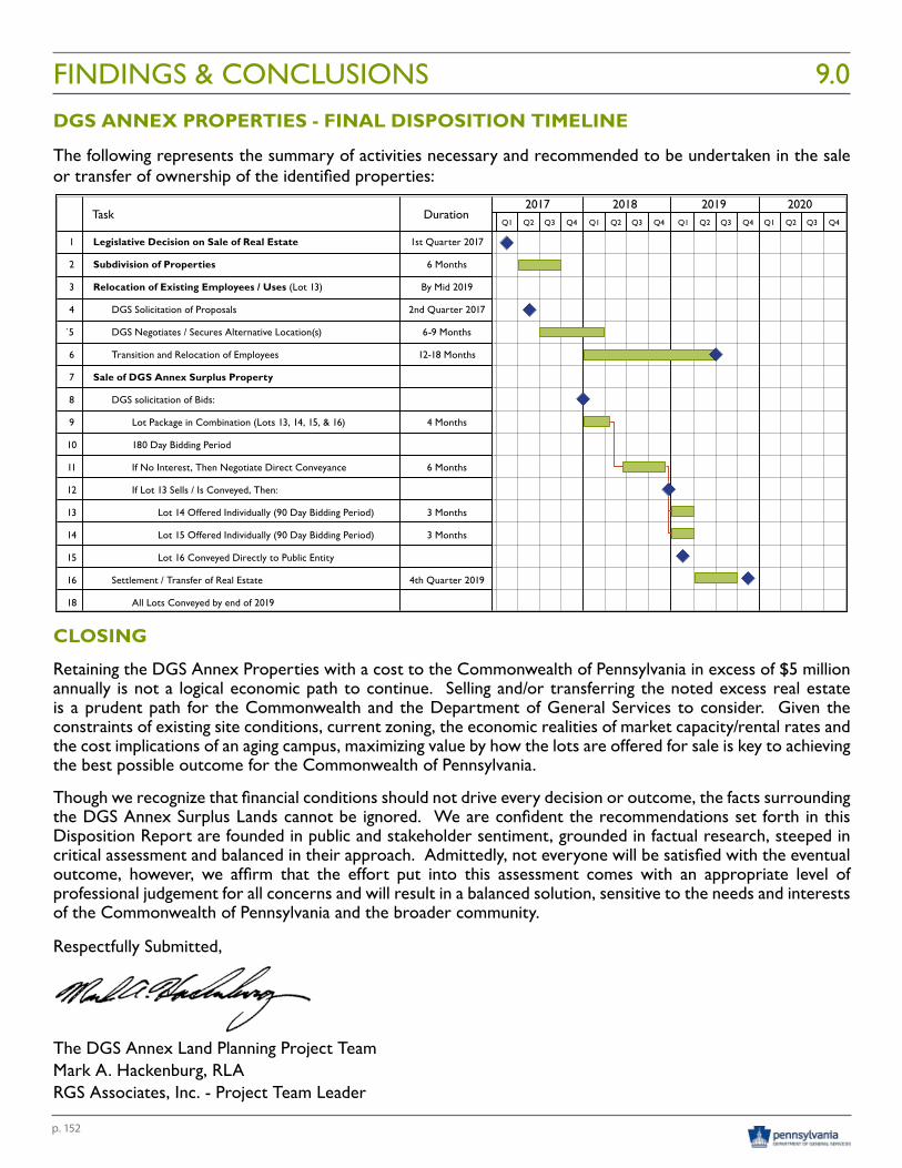
p. 152
FINDINGS & CONCLUSIONS 9.0DGS ANNEX PROPERTIES - FINAL DISPOSITION TIMELINE
The following represents the summary of activities necessary and recommended to be undertaken in the sale or transfer of ownership of the identified properties:
CLOSING
Retaining the DGS Annex Properties with a cost to the Commonwealth of Pennsylvania in excess of $5 million annually is not a logical economic path to continue. Selling and/or transferring the noted excess real estate is a prudent path for the Commonwealth and the Department of General Services to consider. Given the constraints of existing site conditions, current zoning, the economic realities of market capacity/rental rates and the cost implications of an aging campus, maximizing value by how the lots are offered for sale is key to achieving the best possible outcome for the Commonwealth of Pennsylvania.
Though we recognize that financial conditions should not drive every decision or outcome, the facts surrounding the DGS Annex Surplus Lands cannot be ignored. We are confident the recommendations set forth in this Disposition Report are founded in public and stakeholder sentiment, grounded in factual research, steeped in critical assessment and balanced in their approach. Admittedly, not everyone will be satisfied with the eventual outcome, however, we affirm that the effort put into this assessment comes with an appropriate level of professional judgement for all concerns and will result in a balanced solution, sensitive to the needs and interests of the Commonwealth of Pennsylvania and the broader community.
Respectfully Submitted,
The DGS Annex Land Planning Project TeamMark A. Hackenburg, RLARGS Associates, Inc. - Project Team Leader
1 Legislative Decision on Sale of Real Estate 1st Quarter 2017
2 Subdivision of Properties 6 Months
3 Relocation of Existing Employees / Uses (Lot 13) By Mid 2019
4 DGS Solicitation of Proposals 2nd Quarter 2017
`5 DGS Negotiates / Secures Alternative Location(s) 6-9 Months
6 Transition and Relocation of Employees 12-18 Months
7 Sale of DGS Annex Surplus Property
8 DGS solicitation of Bids:
9 Lot Package in Combination (Lots 13, 14, 15, & 16) 4 Months
10 180 Day Bidding Period
11 If No Interest, Then Negotiate Direct Conveyance 6 Months
12 If Lot 13 Sells / Is Conveyed, Then:
13 Lot 14 Offered Individually (90 Day Bidding Period) 3 Months
14 Lot 15 Offered Individually (90 Day Bidding Period) 3 Months
15 Lot 16 Conveyed Directly to Public Entity
16 Settlement / Transfer of Real Estate 4th Quarter 2019
18 All Lots Conveyed by end of 2019
2017 2018 2019 2020Q1 Q1 Q1 Q1Q2 Q2 Q2 Q2Q3 Q3 Q3 Q3Q4 Q4 Q4 Q4
DurationTask
DGS ANNEX PROPERTIES - FINAL DISPOSITION TIMELINE
Draft Legislation 10.0

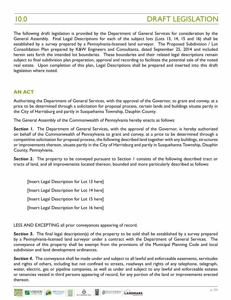
p. 155
The following draft legislation is provided by the Department of General Services for consideration by the General Assembly. Final Legal Descriptions for each of the subject lots (Lots 13, 14, 15 and 16) shall be established by a survey prepared by a Pennsylvania-licensed land surveyor. The Proposed Subdivision / Lot Consolidation Plan prepared by K&W Engineers and Consultants, dated September 25, 2014 and included herein sets forth the intended lot boundaries. These boundaries and their related legal descriptions remain subject to final subdivision plan preparation, approval and recording to facilitate the potential sale of the noted real estate. Upon completion of this plan, Legal Descriptions shall be prepared and inserted into this draft legislation where noted.
AN ACT
Authorizing the Department of General Services, with the approval of the Governor, to grant and convey, at a price to be determined through a solicitation for proposal process, certain lands and buildings situate partly in the City of Harrisburg and partly in Susquehanna Township, Dauphin County.
The General Assembly of the Commonwealth of Pennsylvania hereby enacts as follows:
Section 1. The Department of General Services, with the approval of the Governor, is hereby authorized on behalf of the Commonwealth of Pennsylvania to grant and convey, at a price to be determined through a competitive solicitation for proposal process, the following described land together with any buildings, structures or improvements thereon, situate partly in the City of Harrisburg and partly in Susquehanna Township, Dauphin County, Pennsylvania.
Section 2. The property to be conveyed pursuant to Section 1 consists of the following described tract or tracts of land, and all improvements located thereon, bounded and more particularly described as follows:
[Insert Legal Description for Lot 13 here]
[Insert Legal Description for Lot 14 here]
[Insert Legal Description for Lot 15 here]
[Insert Legal Description for Lot 16 here]
LESS AND EXCEPTING all prior conveyances appearing of record.
Section 3. The final legal description(s) of the property to be sold shall be established by a survey prepared by a Pennsylvania-licensed land surveyor under a contract with the Department of General Services. The conveyance of this property shall be exempt from the provisions of the Municipal Planning Code and local subdivision and land development ordinances.
Section 4. The conveyance shall be made under and subject to all lawful and enforceable easements, servitudes and rights of others, including but not confined to streets, roadways and rights of any telephone, telegraph, water, electric, gas or pipeline companies, as well as under and subject to any lawful and enforceable estates or tenancies vested in third persons appearing of record, for any portion of the land or improvements erected thereon.
DRAFT LEGISLATION10.0
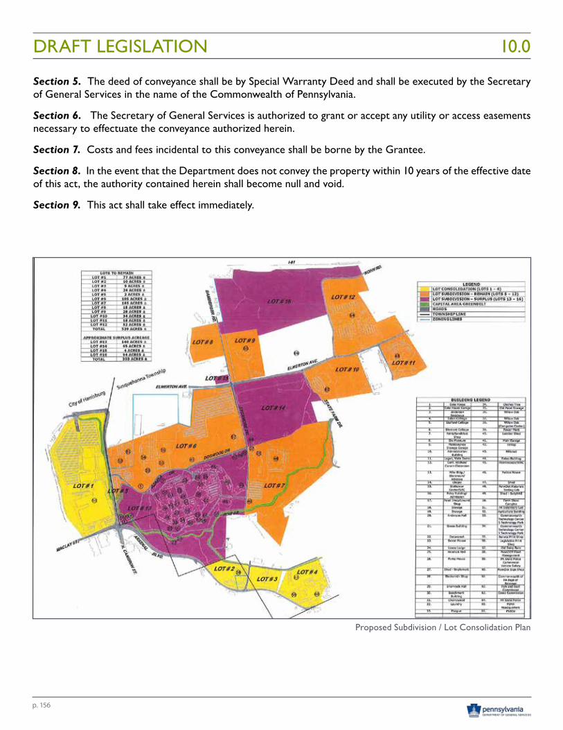
p. 156
DRAFT LEGISLATION 10.0
Section 5. The deed of conveyance shall be by Special Warranty Deed and shall be executed by the Secretary of General Services in the name of the Commonwealth of Pennsylvania.
Section 6. The Secretary of General Services is authorized to grant or accept any utility or access easements necessary to effectuate the conveyance authorized herein.
Section 7. Costs and fees incidental to this conveyance shall be borne by the Grantee.
Section 8. In the event that the Department does not convey the property within 10 years of the effective date of this act, the authority contained herein shall become null and void.
Section 9. This act shall take effect immediately.
Proposed Subdivision / Lot Consolidation Plan

Appendices 11.0

p. 159
VOLUME 1
Stakeholder Engagement Summary
Stakeholder Survey ResultsDGS Annex Project Stakeholder QuestionnaireDGS Annex Surplus Grounds Questionnaire Results
Stakeholder Interview NotesDGS Annex Land Planner – Stakeholder ListCity of Harrisburg Meeting SummarySusquehanna Township Board of Commissioners Meeting SummaryDauphin County Commissioners Meeting SummaryDauphin County Parks and Recreation Meeting SummaryTri-County Regional Planning Commission (Dauphin County Planning Commission) Meeting SummaryPA House of Representatives (Sue Helm) Meeting SummaryPA State Senate (Rob Teplitz) Meeting SummaryPA House of Representatives (Patty Kim) Meeting SummaryPA Historical and Museum Commission (PHMC) Meeting SummaryPA Department of Human Resources Meeting SummaryPA Emergency Management Agency (PEMA) Meeting SummaryPA Department of Community and Economic Development (DCED) Meeting SummaryPA Department of Agriculture & PA Farm Show Complex Expo Center Meeting SummaryPA Department of General Services Meeting SummaryPA Department of Conservation & Natural Resources Meeting SummaryHarrisburg Regional Chamber/CREDC Meeting SummaryDauphin County Community and Economic Department Meeting SummaryDauphin County Community Gardens Meeting SummaryHistoric Harrisburg Association Meeting SummaryGaudenzia Meeting SummaryPA State Employees Credit Union Meeting SummaryCapital Area Greenbelt Association Meeting SummaryHarrisburg Area Flying SocietyHarrisburg Young Professionals Meeting SummaryJournal Multimedia Meeting SummaryHarrisburg Area Community College Meeting Summary
Phase 1 Environmental Site Assessment Lot 13
Phase 1 Environmental Site Assessment Lot 15
Phase 1 Environmental Site Assessment Lot 14
Phase 1 Environmental Site Assessment Lot 16
Asbestos Survey
APPENDICES 11.0
p. 160
APPENDICES11.0VOLUME 2
Zoning/Site Analysis
Bureau of Forestry Ecological Assessment
Utility Separation Analysis
Real Estate Market Research
Historic Resource AssessmentHistoric Resource AnalysisHistoric Resource Survey Forms
Agency/Municipal MeetingsState Agency Stakeholder Review Meeting Phase 1 Findings Commonwealth Agency Stakeholder Meeting Sign in Sheet Susquehanna Township Meeting Minutes Dauphin County Meeting Minutes City of Harrisburg Meeting Minutes
Public Meeting Public Meeting Flyer DGS Annex Project Public Meeting Press Release Public Meeting Sign in Sheet (Typed)Public Meeting Sign in Sheet (Hand Written)Public Meeting PowerPoint Presentation Public Meeting Presentation BoardsMeeting Minutes July 26Public Meeting Comments July 26 (Typed)Public Meeting Comments July 26 (Hand Written)Public Meeting Correspondence and Submittals:
- Letter – Borough of Penbrook (Sanitary sewers) - Email / Letter – Rep. Mark Keller to DGS Sec. Curt Topper (Ag / Farm Show / Gardens)- Letter – Sec. Curt Topper response to Rep. Mark Keller- Email – Christina Sullivan (Historic structures / adaptive reuse)- Email – CREDC Dave Black (Review and comment)- Email / Exec. Summary – Gaudenzia John DiLeonardo; Cost Benefit Analysis: Gaudenzia’s Concept 90 Therapeutic Community Model- Submittal – Heather Dock (Community gardens)- Submittal – Susquehanna Twp Commissioner Jody Reberchak (Four points to consider)- Submittal – Dana Olsen; PA History Coalition Honoring People w/ Disability, Western PA Report- Submittal – Peggy Bell (Community gardens)
Historic Funding Analysis
Lot 13 Abatement/Demo Cost Analysis
DGS Annex-Building Identification Cross Reference Guide
p. 161
APPENDICES 11.0VOLUME 2
Public Meeting (continued)
Public Meeting Correspondence and Submittals: (continued)- Submittal – Sussay Russell (Community gardens)- Submittal – Capital Area Greenbelt; Preliminary Feasibility Study: Riverfront Trail Extension North to Linglestown Road- Email – Harrisburg / Hershey Visitor Bureau Inquiry (Future plans
Appraisal Report
Marketing Recommendations