Embed Size (px)
Citation preview

DEPARTMENT OF Date of Hearing: March 12, 2014 BUILDING AND DEVELOPMENT STAFF REPORT
# 14
BOARD OF SUPERVISORS PUBLIC HEARING
SUBJECT: DOAM-2013-0002, FSM Amendments, and Chapter 1096 Codified Ordinance Amendments
ELECTION DISTRICT: Countywide CRITICAL ACTION DATE: At the Pleasure of the Board STAFF CONTACTS: Jimmy Edmonds, Dept. of Building and Development
Mike Seigfried, Acting Director, Dept. of Building and Development
Randy Williford, Dept. of General Services Richard Pezzullo, Director, Dept. of General Services
PURPOSE: The purpose of this Item is to amend portions of Chapters 1 and 5 of the Loudoun County Facilities Standards Manual (FSM) (DOAM-2013-0002) and Chapter 1096 of the Loudoun County Codified Ordinances (“Chapter 1096 Amendments”), as directed by a Resolution of Intent to Amend adopted by the Board of Supervisors on October 2, 2013.
RECOMMENDATIONS: On February 4, 2014, the Planning Commission voted 6-1-1-1 (Scheel opposed; Dunn abstained; Ruedisueli absent) to forward DOAM-2013-0002 and the Chapter 1096 Amendments to the Board of Supervisors with a recommendation of approval. Staff and the Facilities Standards Manual Public Review Committee (“PRC”) recommend approval of DOAM-2013-0002 and the Chapter 1096 Amendments, as specified in Attachments 6 through 8.
CONTENTS OF THIS STAFF REPORT
Section Page Section Page
Motions 2 Applicability 7
Executive Summary 2-3 Summary Agency Referrals 7
Background 3-4 Draft Text 7
Summary of Changes 4-5 Fiscal Impacts 7-9
Issues 5-7 Attachments Attachment page # 1-91

Item 14 DOAM-2013-0002 and Chapter 1096 Amendments Board of Supervisors Public Hearing
March 12, 2014 Page 2
SUGGESTED MOTIONS: 1. I move that the Board of Supervisors forward DOAM-2013-0002, FSM Amendments,
and the amendments to Chapter 1096 of the Codified Ordinances to the April 2, 2014, Board of Supervisors Business Meeting for action.
OR
2a. I move that the Board of Supervisors suspend the rules. AND 2b. I move that the Board of Supervisors approve DOAM-2013-0002, FSM Amendments,
and the amendments to Chapter 1096 of the Codified Ordinances, as provided as Attachments 6 through 8 to the Staff Report for the March 12, 2014, Board of Supervisors Public Hearing, with an effective date of July 1, 2014.
AND
I further move that the Board approve the draft VSMP Permit Fee Schedule provided as Attachment 9 to the Staff Report for the March 12, 2014, Board of Supervisors Public Hearing, and direct Staff to complete a VSMP fee study comparing the revenue generated from the approved VSMP Permit Fee Schedule with the actual Staff hours required to implement the VSMP for one (1) year following the July 1, 2014, effective date to ensure that the fees are commensurate with the services rendered and report such findings to the Board.
OR 3. I move an alternate motion.
I. EXECUTIVE SUMMARY On October 2, 2013, the Board of Supervisors (“Board”) adopted a Resolution of Intent to Amend (Attachment #1) the Facilities Standards Manual (“FSM”) and Codified Ordinances, as necessary, to fully establish a Virginia Stormwater Management Program (“VSMP”) as required by the Virginia Stormwater Management Act, the Virginia Stormwater Management Program Permit Regulations, and Guidance provided by the Virginia Department of Conservation and Recreation and Virginia Department of Environmental Quality (“VSMP Regulations”). To bring the FSM and Chapter 1096 into conformance with the VSMP Regulations by May 15, 2014, as mandated by the State, major amendments to Chapter 5 (Water Resource Management) of the FSM, minor amendments to Chapter 1 (Authority) of the FSM, and major amendments to Chapter 1096 (Stormwater Management) of the Codified
Item 14 DOAM-2013-0002 and Chapter 1096 Amendments Board of Supervisors Public Hearing
March 12, 2014 Page 3
Ordinances are required and have been completed in draft form (“Draft Amendments”). Such Draft Amendments include, without limitation, the following:
Amendments to Chapter 1096 to establish that the County shall administer the VSMP Permit process for all land development projects that will disturb one (1) acre or more of land.
Amendments to Chapter 5 of the FSM and Chapter 1096 to provide more complex and more stringent State-mandated requirements for control of the quality and quantity of stormwater runoff from development sites (“Technical Criteria”).
Amendments to Chapter 1096 to establish that the County shall perform site inspections to verify the owner’s compliance with a Pollution Prevention Plan, which addresses construction site housekeeping (trash and debris, chemical storage, fueling operations, etc.).
Amendments to Chapter 1096 to establish that the County shall inspect Stormwater Management (“SWM”) facilities during construction to insure their proper construction and performance.
Amendments to Chapter 1 of the FSM in order to clarify the VSMP Regulations’ requirements in regard to the “grandfathering” of projects approved prior to the implementation of the new Technical Criteria.
Amendments to Chapter 1096 to establish that the County will have the responsibility for implementing the VSMP for all incorporated towns that are not subject to Municipal Separate Storm Sewer System (MS-4) provisions (Purcellville, Lovettsville, Middleburg, Hamilton, Hillsboro, and Round Hill). Memorandums of Understanding (MOUs) will need to be executed with these Towns to establish the extent of program administration, project inspection, stormwater infrastructure maintenance, and enforcement that will be the responsibility of County staff. Since Leesburg is designated as an MS-4 jurisdiction, it will be responsible for implementing all aspects of its own VSMP.
A timetable for adoption of the Draft Amendments is provided as Attachment #2. II. BACKGROUND
On February 1, 2012, the Board of Supervisors adopted a Resolution of Intent to Amend the FSM in its entirety. The comprehensive, chapter-by-chapter review of the FSM was split into three phases. The Board adopted the Phase 1 amendments (DOAM-2012-0001) on October 3, 2012, and the Phase 2 amendments (DOAM-2012-0002) on May 8, 2013. The PRC is currently working on Phase 3 (DOAM-2012-0003), which proposes amendments to Chapters 5, 7, and 8 of the FSM.

Item 14 DOAM-2013-0002 and Chapter 1096 Amendments Board of Supervisors Public Hearing
March 12, 2014 Page 4
The PRC and Staff worked together in eight (8) meetings from February 2013 to September 2013 to draft the amendments to Chapter 5 of the FSM that would be necessary to implement the VSMP. These amendments to Chapter 5 were originally included in Phase 3 (DOAM-2012-0003), but the PRC elected to consolidate all of the amendments to Chapter 5 into a separate FSM amendment (DOAM-2013-0002) in order to avoid having to make multiple updates to Chapter 5.
Staff revised DOAM-2013-0002 and prepared draft amendments to Chapter 1096 of the Codified Ordinances to bring them into conformance to the VSMP Regulations and provided a copy of the Draft Amendments in conjunction with the Item for the October 2, 2013, Resolution of Intent to Amend. The PRC and Staff worked together in nine (9) meetings from October 2013 to December 2013 to finalize the Draft Amendments, and have revised DOAM-2013-0002 to also include certain amendments to Chapter 1 of the FSM in regard to grandfathering. The PRC also provided an opportunity for public comment at the beginning of each meeting. The Virginia Department of Environmental Quality (DEQ) completed a cursory review of the Draft Amendments for conformance with the VSMP Regulations in January 2014 that prompted additional revisions to the draft text of Chapter 1 of the FSM and Chapter 1096. Staff presented these additional revisions to the PRC on January 15, 2014. The PRC was in agreement with these additional revisions and proposed further revisions to the grandfathering provisions of Chapter 1. Based on the guidance and feedback received from DEQ to date, Staff is in agreement with the PRC on these revisions to the Draft Amendments. A Planning Commission Public Hearing on the Draft Amendments was held on January 23, 2014. There were no members of the public who spoke at the Public Hearing. Following the Public Hearing, the Planning Commission voted to forward the Draft Amendments to a Work Session for further discussion. At the request of the Planning Commission, Staff made a presentation at the February 4, 2014, Work Session on the specific State-mandated amendments to the current technical criteria found in Chapter 5 of the FSM. The Chairman of the PRC also attended the Planning Commission’s Work Session. During the discussion, several members of the Planning Commission noted the burden that the new requirements would place on landowners. Following the Work Session, the Planning Commission voted 6-1-1-1 (Scheel opposed; Dunn abstained; Ruedisueli absent) to forward the Draft Amendments to the Board of Supervisors with a recommendation of approval. The Planning Commission also voted 8-0-2 (Ruedisueli and Ryan, absent) to forward a separate letter to the Board regarding their concerns about the VSMP Regulations. III. SUMMARY OF CHANGES: The draft text of DOAM-2013-0002 and the Chapter 1096 Amendments is provided in Attachments 6-8. Strikethrough language (to be deleted) is in red, while new text is blue. A summary of the specific amendments to Chapters 1 and 5 of the FSM, which are State-
Item 14 DOAM-2013-0002 and Chapter 1096 Amendments Board of Supervisors Public Hearing
March 12, 2014 Page 5
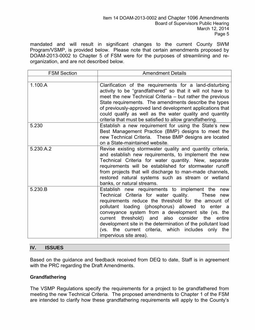
mandated and will result in significant changes to the current County SWM Program/VSMP, is provided below. Please note that certain amendments proposed by DOAM-2013-0002 to Chapter 5 of FSM were for the purposes of streamlining and re-organization, and are not described below.
FSM Section Amendment Details 1.100.A Clarification of the requirements for a land-disturbing
activity to be “grandfathered” so that it will not have to meet the new Technical Criteria – but rather the previous State requirements. The amendments describe the types of previously-approved land development applications that could qualify as well as the water quality and quantity criteria that must be satisfied to allow grandfathering.
5.230 Establish a new requirement for using the State’s new Best Management Practice (BMP) designs to meet the new Technical Criteria. These BMP designs are located on a State-maintained website.
5.230.A.2 Revise existing stormwater quality and quantity criteria, and establish new requirements, to implement the new Technical Criteria for water quantity. New, separate requirements will be established for stormwater runoff from projects that will discharge to man-made channels, restored natural systems such as stream or wetland banks, or natural streams.
5.230.B Establish new requirements to implement the new Technical Criteria for water quality. These new requirements reduce the threshold for the amount of pollutant loading (phosphorus) allowed to enter a conveyance system from a development site (vs. the current threshold) and also consider the entire development site in the determination of the pollutant load (vs. the current criteria, which includes only the impervious site area).
IV. ISSUES
Based on the guidance and feedback received from DEQ to date, Staff is in agreement with the PRC regarding the Draft Amendments. Grandfathering The VSMP Regulations specify the requirements for a project to be grandfathered from meeting the new Technical Criteria. The proposed amendments to Chapter 1 of the FSM are intended to clarify how these grandfathering requirements will apply to the County’s

Item 14 DOAM-2013-0002 and Chapter 1096 Amendments Board of Supervisors Public Hearing
March 12, 2014 Page 6
land development application process. The State’s liaison to Loudoun County from DEQ recently indicated that additional Guidance in regard to grandfathering may be provided to localities in the near future. Storm Drainage and Stormwater Management Easements - Plats and Deeds Based upon recent Guidance from DEQ, and after seeking advice from County Departments, including the Office of the County Attorney, the VSMP Regulations may require future amendments to Chapter 8 of the FSM related to the processing of deeds and plats for Storm Drainage and Stormwater Management Easements. The VSMP Regulations require that such deeds and plats be submitted (not recorded) to the County prior to approval of the Stormwater Management Plan. Currently, such deeds and plats are not required to be submitted prior to approval of the Stormwater Management Plan. The PRC is currently reviewing Chapter 8 with Phase 3, and any amendments to Chapter 8 determined to be necessary to implement the VSMP will be included separately with DOAM-2012-0003. Legislation There is currently legislation proposed in the Virginia General Assembly that could amend the following areas of the VSMP Regulations. Such legislation would probably go into effect July 1, 2014.
Land Development Application requirements and fees for the construction of certain single-family homes.
VSMP requirements for incorporated Towns (except Leesburg).
Appeals
Staff will inform the Board of Supervisors if this legislation is adopted and additional amendments to the FSM and/or Chapter 1096 become necessary. Fees The VSMP Regulations include a “Statewide Fee Schedule”, which is a basic schedule of fees for VSMP Permits that would require Applicants to pay a “sliding scale” fee based upon the amount of land disturbance on their particular site. The County will keep 72% of the fees and the State will receive 28% for their oversight role. The draft VSMP Permit Fee Schedule, included as Attachment 9, is based on the Statewide Fee Schedule included in the VSMP Regulations. Additional information on the draft VSMP Permit Fee Schedule is included in the Fiscal Impact discussion below.

Item 14 DOAM-2013-0002 and Chapter 1096 Amendments Board of Supervisors Public Hearing
March 12, 2014 Page 7
Preliminary Draft Review DEQ is currently reviewing the version of the Draft Amendments that was submitted by Staff on January 15, 2014, and should provide Staff with its comments within the next two (2) weeks. Staff will inform the Board of Supervisors if review comments or Guidance received from DEQ will require any additional amendments. V. APPLICABILITY
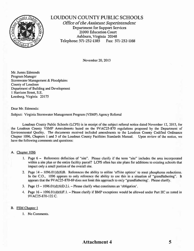
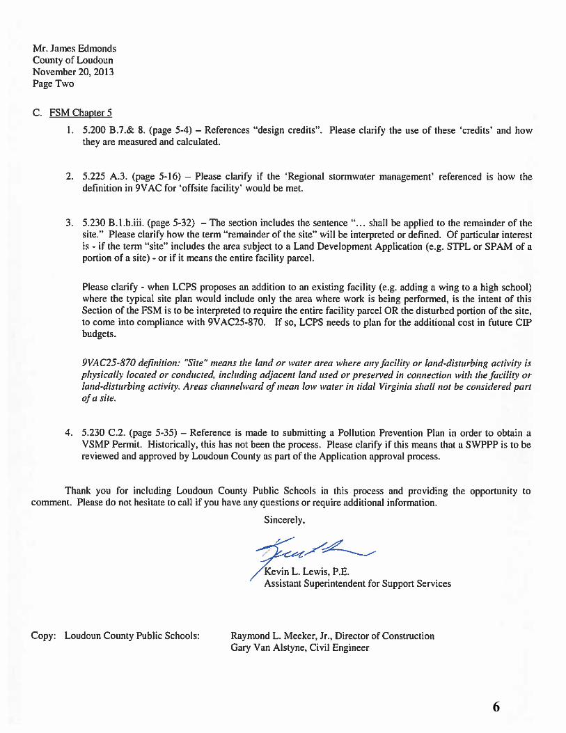
DOAM-2013-0002 and the Chapter 1096 Amendments will be applicable Countywide to land development applications submitted in accordance with the Loudoun County Zoning Ordinance, the Land Subdivision and Development Ordinance, and the Codified Ordinances of Loudoun County. VI. AGENCY REFERRALS The Draft Amendments were distributed for agency referral on November 12, 2013, with a due date of November 19, 2013, for comments. Staff has received responses from the Department of Parks, Recreation, and Community Services (PRCS) (no comments), the Department of Transportation and Capital Infrastructure (TCI) (no comments), the Engineering Division of the Department of Building and Development (B&D) (Attachment #3), Loudoun County Public Schools (LCPS) (Attachment #4), the Department of Fire, Rescue, and Emergency Management (no comments), and the Department of Planning (Attachment #5). On November 20, 2013, the PRC addressed the Engineering Division’s comments and the comments from LCPS. The comments from the Department of Planning were addressed at the PRC meeting on December 18, 2013, as the PRC finalized the Draft Amendments. VIII. DRAFT TEXT The draft text for DOAM-2013-0002 and the Chapter 1096 Amendments is provided, by Chapter, as Attachments 6 through 8. The Draft Amendments were finalized by the PRC during the January 15, 2014, PRC meeting. IX. FISCAL IMPACT
Additional Staff time, resources, and attainment of professional certifications will be necessary to administer the new VSMP. The particular State-mandated tasks that will necessitate these Staff resources and demands include:
The County, versus the State, will have to administer the VSMP Permit process.

Item 14 DOAM-2013-0002 and Chapter 1096 Amendments Board of Supervisors Public Hearing
March 12, 2014 Page 8
Increased complexity of Stormwater Management Plan reviews due to the more stringent technical criteria for water quality and quantity controls, leading to additional review time per plan.
Completeness reviews of Stormwater Plans will have to be carried out within 15 days, creating an extra phase in the review process.
Stormwater Pollution Prevention Plan inspections will be required during the
construction of a project (in addition to the Erosion and Sediment Control Inspections which are currently performed).
Inspections of Stormwater Management Best Management Practices (BMPs)
must be performed during construction.
The County must administer the VSMP for all incorporated towns (with the exception of Leesburg).
Staff Resource Implications Since the Draft Amendments go into effect July 1, 2014, Staff does not have a history of how the VSMP Regulations will impact County resources. As a result, Staff proposes that the Board approve the draft VSMP Permit Fee Schedule (Attachment #9), which is based on the Statewide Fee Schedule included in the VSMP Regulations, implement the actions proposed herein, and direct Staff to complete a VSMP fee study comparing the revenue generated from the approved VSMP Permit Fee Schedule with the actual Staff hours required to implement the VSMP for one (1) year following the July 1, 2014, effective date to ensure that the fees are commensurate with the services rendered and report the findings to the Board. As part of this monitoring effort, and if workload indicators substantiate a sustained need, staff will bring forward a request to unfreeze two existing Erosion and Sediment Control Field positions for Board consideration. Staff will also monitor efforts necessary to carry out the newly required inspections of the owner’s implementation of the Stormwater Pollution Prevention Plan (SWPPP). Additional time and reporting will be required, as well as newly created professional certification. As part of that effort staff will also examine the need for potential reclassification of existing positions in order to successfully implement the program. Overall, after deducting the State’s portion of the fees for local program oversight, it is estimated that sufficient revenue would exist to cover the costs of the two currently frozen positions.

Item 14 DOAM-2013-0002 and Chapter 1096 Amendments Board of Supervisors Public Hearing
March 12, 2014 Page 9
IX. ATTACHMENTS
Attachment Attach page #
1 October 2, 2013 Intent to Amend 1-2 2 Stormwater Management Program Update Timetable 3 3 Division of Engineering [B&D] Response 4 4 LCPS Response 5-6 5 Planning Department Response 7-8 6 FSM Chapter 1 (Draft) 9-14 7 FSM Chapter 5 (Draft) 15-62 8 Chapter 1096 of the Codified Ordinance (Draft) 63-90 9 Draft VSMP Permit Fee Schedule 91
*This Staff Report with attachments (file name 03-12-14 BOS STF RPT.PDF) can be viewed online on the Loudoun Online Land Applications System (LOLA) at www.loudoun.gov. Paper copies are also available in the Department of Planning and in the Department of Building and Development, Government Center, 1 Harrison Street, S.E., 2nd Floor, Leesburg, Virginia.

Attachment 1 1

2

Stormwater Management Program Update Timetable – Tentative Schedule
August 1 – October 2: Staff preparing draft FSM amendments to begin
dialogue with FSM Public Review Committee (PRC) October 2 – December 18: PRC review of draft FSM amendments (to include
overview of mandatory changes to Codified Ordinance)
October 2: Board Business Meeting – Intent to Amend FSM and Codified Ordinance
November 1: Preliminary draft FSM and Codified Ordinance amendments to
DEQ (submitting early allows time for feedback from DEQ prior to the Planning Commission Public Hearing)
January 23: Planning Commission Public Hearing February 4: Planning Commission Work Session March 12: Board Public Hearing April 2: Board Business Meeting – Discuss/Adopt
April 16: Board Business Meeting – Final adoption date
Key DEQ Timelines January 15, 2014: Preliminary draft amendments due to DEQ for review May 15, 2014: Final adopted amendments due to DEQ for review June 2014: DEQ approves local SWM programs July 1, 2014: Effective date for new SWM programs
Attachment 2 3

COUNTY OF LOUDOUN
DEPARTMENT OF BUILDING AND DEVELOPMENT
MEMORANDUM DATE:11/18/13 TO: Jimmy Edmonds FROM: Jim Brown SUBJECT: FSM Chapter 1 & 5, Codified Ordinance 1096 Comments Jimmy: Below please find a few comments that were generated from my review on 11/15/13: COD ORD 1096
1. Page 9- #8 Editorial Only- a lot of extra spaces 2. Page 15- #1 ii- Should VPDES actually be VSMP. 3. Page 22- a. Notice of Violations- the text mentions the use of “verbal warnings”. The
E&S Cod. Ord. references the E&S Protocol that discourages the use of verbal warnings.
4. Page 24- B2 Issuance of Summons- I could not find a mechanism that addresses how the administrator does this.
FSM CHAPT 1
1. Page 1-6- Necessary Reference Material- Add: Third Edition 1992 to Virginia Erosion and Sediment Control Handbook. This is a minor clarification and if already discussed and accepted otherwise please disregard.
FSM CHAPT 5
1. Page 5-24- Editorial Only- a lot of extra spaces between words. 2. Page 5-30- D. Ingress/ Egress- One Access Point has been deleted. This citation was
very useful to E&S in the past to limit the number of construction entrances into a site, thus cutting down transfer of mud and dirt to multiple road points. I do not believe that this limitation exists elsewhere in the VESCH, VESCL or 1220.
If you have any questions, please don’t hesitate to call, email, or see me in person. Regards, Jim Brown
Attachment 3 4
Attachment 4 5
6

County of Loudoun
Department of Planning
MEMORANDUM
DATE: December 6, 2013 TO: Jimmy Edmonds Building and Development FROM: Richard Klusek, AICP, Senior Planner
Community Planning SUBJECT: Virginia Stormwater Management Program (VSMP) Amendments The above referenced amendments to the Facilities Standards Manual (FSM) have been reviewed to determine consistency with the Revised General Plan (Plan). It is our understanding that the amendments are necessary to establish a Virginia Stormwater Management Program (VSMP) in Loudoun County consistent with the Virginia Stormwater Management Act and VMSP regulations. Community Planning Staff has reviewed the proposed amendments and finds that they are generally consistent with the Plan. However we recommend clarification of FSM text in two specific areas of Chapter 5. Section 5.200 (B) introduces the concept of Environmental Site Design (ESD) techniques as referred to in the Virginia Stormwater Management Handbook. What follows is a listing of these ESD techniques that replaces text relating to Low Impact Development (LID). It is our understanding that ESD is way of achieving LID. However, since the Revised General Plan makes reference to LID, we recommend that some additional clarifying text be added to the FSM to avoid confusion. For example, Section 5.200 (B) can begin with the following text:
“The Loudoun County Revised General Plan includes policies pertaining to the use of Low Impact Development (LID). The Virginia Stormwater Management Handbook contains Environmental Site Design (ESD) techniques which meet the intent of LID techniques. ESD techniques are may be incorporated into drainage designs…”
Section 5.210 discusses Hydrologic Design. The proposed amendments remove the requirement that hydrologic parameters be based on the planned land use depicted in the Revised General Plan. Staff understands that it is not practical to require developers
Attachment 5 7

Virginia Stormwater Management Amendments Community Planning, December 6, 2013
Page 2 of 2
to accommodate stormwater infrastructure for off-site development. However, we recommend that the text be modified such that consideration is given to any known future conditions where property owners and developers can gain efficiency by extending hydrologic analyses beyond an individual subject project. RECOMMENDATION Staff supports the proposed FSM amendments but recommends that additional consideration be given to LID references and to the parameters for hydrologic analyses as discussed above. cc: Julie Pastor, AICP, Planning Director
Cynthia Keegan, AICP, Program Manager (via email)
8
Planning Commission Draft 2/4/14
1-1 Adoption Date: 7/1/2002
CHAPTER 1.000
AUTHORITY 1.100 GENERAL
This document, entitled the Loudoun County Facilities Standards Manual, has been developed and designed to assist the public and the development community in determining the policies, which apply to land development in the County. It contains information primarily concerned with the design and construction standards and guidelines for improvements related to subdivisions and site plans.
The majority of the information contained herein is a compilation of existing requirements already in place. This document will serve as a central reference for these items. Except as specified below, Eeach land development application shall be subject to the version of the Facilities Standards Manual in effect at the time of initial acceptance. Land Development Applications for Record Plats, Dedication Plats, or Easement Plats shall be subject to the version of the Facilities Standards Manual in effect at the time of the initial submission and acceptance of the Construction Plans and Profiles or Site Plans upon such plat is based.
[language based on revisions to 9VAC25-870-48 approved by the State Water Control
Board on December 17, 2013, and amendments discussed during the January 15, 2014,
Facilities Standards Manual Public Review Committee Meeting, subject to change
until adoption by the Board of Supervisors] A. Each land development application shall conform to the current stormwater
management technical criteria in Chapter 5 of this manual, unless subject to 9VAC25-870-47 or grandfathered in accordance with the Virginia Stormwater Management Program (VSMP) grandfathering provisions of Chapter 1096 of the Codified Ordinances (and 9VAC25-870-48). Land development applications that are grandfathered shall meet the technical criteria of Part II.C (9VAC25-870-93 through 9VAC25-870-99), as well as the following requirements:
1. The land development application shall have been approved prior to July
1, 2012.
2. The land development application shall be a proffered plan of development, Special Exception, Preliminary Plat of Subdivision, Record Plat, Construction Plans and Profiles, or Site Plan. In addition, the following land development applications have been determined by Loudoun County as being the equivalent thereto: Rezoning, Rural Economy Site Plan, Dedication Plat, Boundary Line Adjustment, Preliminary/Record Subdivision, Family Subdivision, Subdivision
Attachment 6 9
Planning Commission Draft 2/4/14
1-2 Adoption Date: 7/1/2002
Waiver/Low Density Waiver, Easement and Vacation Plat, Dedication Plat, Plat and Plan Revision, Site Plan Amendment, or any other application as approved by the Director.
3. The land development application referenced in Subsection 1 and Subsection 2 above shall have included a Layout. "Layout" means a conceptual drawing sufficient to provide for the specified stormwater management facilities required at the time of approval, as defined in 9VAC-25-870-10.
4. The land development application has not been subsequently modified or
amended in a manner resulting in an increase in the amount of phosphorus leaving each point of discharge, and such that there is no increase in the volume or rate of runoff. In order to verify this condition, a comparison of the layouts between the original land development application and the modified version may be utilized. If the comparison of layouts is not conclusive, a comparison of performance-based calculations found in the technical criteria of Part II.C (9VAC25-870-10) as well as water quantity engineering calculations shall be required.
5. Land development applications on parcels or lots which are part of a
residential, commercial, or industrial subdivision served by an approved stormwater management facility designed to treat the said parcel or lot shall be deemed grandfathered.
B, In the event any land development application is made for a development which is
served by or subject to a previously approved roadway or stormwater management facility, such previously approved roadway or stormwater management facility would not have to be upgraded to meet current standards.
C. Any land development application proposing:
1. a site redevelopment involving major reconstruction or major demolition, or
2. a revision or construction modification to alter stormwater management
facilities which (a) is in conjunction with a change to the land use on-site that would result in an increase in runoff over that for which the facility was originally designed or (b) benefits additional land areas not previously utilizing the improvements included that results in an increase in runoff over which the facility was originally designed, except when such changes are minimal in nature with negligible impact.
shall be subject to the current version of this manual.
10
Planning Commission Draft 2/4/14
1-3 Adoption Date: 7/1/2002
1.200 INTERPRETATION AND REVISION A. Interpretation These standards and guidelines are designed to supplement the provisions of existing
Federal and State regulations and County codes and ordinances. Nothing herein shall be deemed to waive or modify other requirements of existing codes. Except as expressly provided otherwise in this document, the Director of Building and Development is the designated official charged with the administration of the standards and requirements contained in this manual and, in administering them, shall treat them as guidelines. The Director may allow for variations of given standards where the effect of such variation is in keeping with established engineering practices and procedures and shall make the final decision on all questions regarding interpretation of this manual, after reviewing recommendations from the designated departments, authorities, boards, and committees.
B. Revision As new basic information on design criteria becomes available and is accepted, and as
Federal, State, and County laws, regulations, and standards are changed, they will be reflected in this publication after at least an annual review. Any record plats, final site plans or construction plans and profiles submitted prior to the approval of any revisions will comply with the standards in effect at the time of the officially accepted submission for such record plats, final site plans, and/or construction plans and profiles.
C. Facilities Standards Manual Review Committee This committee shall consist of at least seven representatives appointed by the Board of
Supervisors of Loudoun County. The candidates for appointment may be any persons whom the Board of Supervisors deem qualified. In addition to public notification and request for citizen participation on the Review Committee, nominations shall be requested from, but not limited to the following organizations:
National Association of Industrial & Office Parks Loudoun Chamber of Commerce Virginia Society of Professional Engineers Virginia Association of Surveyors Heavy Construction Contractors Association Associated Building Contractors Northern Virginia Building Industry Association Piedmont Environmental Council Washington Area Council of Engineering Laboratories Consulting Engineers Council Association of Soil & Foundation Engineers Association of Engineering Geologists Virginia Association of Professional Soil Scientists Virginia Association of Geologists
11

Planning Commission Draft 2/4/14
1-4 Adoption Date: 7/1/2002
Loudoun County Board of Realtors Engineers & Surveyors Institute The majority of members shall be actively involved in the Loudoun County Community
and shall represent professionals registered to practice engineering, surveying, geology, landscape, architecture, or soil science in Virginia.
Committee members shall elect a chairman. The Director of Building and Development
or his designee shall serve as secretary to the committee. County staff members may serve as advisory staff to the committee but shall not be appointed to sit on committee.
Members shall be appointed for a term of not less than one year and no more than four
years and shall serve until replaced. If a member resigns, the Board of Supervisors will appoint a replacement.
The committee shall meet at least once a year to review the Facilities Standards Manual and shall advise the Director of Building and Development of their findings and recommendations. Whenever a change in the Facilities Standards Manual is proposed, the Director of Building and Development shall request the advice of the committee prior to requesting a public hearing for consideration of changes to the FSM.
D. Appeals Any applicant who is aggrieved by an interpretation or decision made by the Director in
the administration of the standards and requirements contained in this manual may, within five (5) working days of receiving written notice of such decision or interpretation, deliver a written notice to the Director requesting the Chairman of the Facilities Standards Manual Review Committee (the Committee), to appoint a subcommittee to review the matter. Such subcommittee shall consist of at least three members of the Committee. Such subcommittee shall hear the matter at the Department of Building and Development at a time convenient to the applicant and the Director, but in no event more than thirty (30) days after the notice and request is delivered to the Director, and shall make a written recommendation to the Director, stating the basis for such recommendation.
12

Planning Commission Draft 2/4/14
1-5 Adoption Date: 7/1/2002
Upon receiving such recommendation from the subcommittee, the Director shall render a final decision within five (5) working days thereafter. If the applicant is aggrieved by such final decision, the applicant may take such action as is otherwise provided by law with respect to the subject land use application at the appropriate time.
Any applicant who files an appeal under this subsection of the Facilities Standards
Manual shall waive, during the period of pendency of the appeal, any right to require the County to take any action to approve or disapprove the application pursuant to any statutory or other legally imposed timeline requirement. Any applicant giving notice of such appeal shall execute and deliver to the said Director such written waiver along with such notification in substantially the following language:
"I/we hereby waive any right I/we may have to require the County to take any
action to approve or disapprove the subject application during the pendency of the appeal, such that the time which elapses from the date of delivery of this notification to the Director until the date of the final decision on this appeal by the Director shall not be counted in determining the date as of which County action on the application is legally required."
The thirty (30) day period for action on this appeal shall not commence until such written
waiver has been delivered to the Director. E. Disclaimer of Liability The purpose of this manual is to establish reasonable land development standards and
guidelines for the protection and promotion of the general health, safety, and welfare of the County's residents. Approval of plans and plats by the County or its agencies pursuant to the ordinance and this manual, is not intended and shall not be deemed as a guarantee or warranty for any individual, landowner, or developer that any improvements will be designed, planned, constructed, or operated in any particular manner or be free from defects. Such approval shall create no duty or result in any liability on the part of the County, its officials, or employees for any claim, demand, suit, or damages alleged to have resulted from the development, construction, existence, or operation of improvements constructed pursuant to such approved plans or plats. Further, no such approval shall operate as or be deemed as a waiver of any provision or requirement of the ordinance, or this manual, unless such waiver has been specifically granted in writing by the Director as a variation allowed under Section 1.200.A hereof. In the event that any aspect of any such approved plan or plat fails to comply with any provision or requirement of this ordinance, or this manual, in effect at the time of such approval, such provision or requirement of the ordinance, or this manual, shall take precedence over the approved plans, and development shall be in accordance with the ordinance and this manual.
13

Planning Commission Draft 2/4/14
1-6 Adoption Date: 7/1/2002
1.300 NECESSARY REFERENCE MATERIAL
In order to properly utilize this manual, the designer or user in general should have certain publications readily available, as they are referenced throughout this document. A listing of the most commonly utilized publications is as follows:
"The Sewage Handling and Disposal Regulations," Board of Health, Commonwealth of Virginia.
"Virginia Water Works Regulations," State Health Department, Division of Water
Engineering. "Virginia Erosion and Sediment Control Handbook." The Loudoun County Sanitation Authority's Design and Construction Standards for
Sanitary Sewers and Water Supply System . The Building Official's Code Administrators, "The BOCA Basic Building Code," latest
edition. "Interpretive Guide to the Use of Soils Maps, Loudoun County, Virginia," latest edition. Controlling Urban Runoff: A Practical Manual for Planning and Designing Urban
BMPs. Federal Manual for Identifying and Delineating Jurisdictional Wetlands.
Additional reference materials specific to each subject area is listed at the end of each chapter.
14

Planning Commission Draft 2/4/14
Adoption Date: 5/8/2013 5-1
CHAPTER 5.000
WATER RESOURCE MANAGEMENT
5.100 PURPOSE/OBJECTIVES A. The purpose of this chapter is to establish minimum acceptable design criteria necessary
to promote adequate drainage and limit adverse impacts upon the health, safety, and welfare of the general public and the County’s water resources that may result from unregulated stormwater runoff and to set forth design criteria. An additional purpose is to iensure compliance with relevant state and federal laws and regulations related to water resource management which address pollution control and prevention, runoff volume reduction, stormwater treatment, stream channel protection, and flood protection. assure compliance with relevant state and federal regulations. Adequate drainage must have the hydraulic characteristics necessary to convey stormwater runoff from the contributing watershed, or portion thereof, for a specified rainfall event. To meet these objectives, it is necessary to performfor a detailed assessment of a given drainage area, stream geometry, and health and the natural drainage shed hydrology prior to the development of a stormwater management plan required as part of a land development application. The use of Environmental Site Design (ESD), described in Section 5.200.B, is a recommended technique for addressing these water resource management issues associated with development.
B. The design of an adequate drainage system must (a) account for both off-site and on-site
stormwater runoff; (b) honor natural drainage divides; and (c) adequately convey stormwater runoff in compliance with this chapter. and discharge into an adequate channel. An adequate channel shall be defined as a natural or man-made channel or pipe which can convey the stormwater runoff without overtopping its banks, surcharging the system, or creating erosive velocities. (Reference Virginia Erosion and Sediment Control Handbook - Minimum Standard MS-19.) Adequate drainage must also include provisions for overland relief to accommodate stormwater runoff in excess of the design storms without damaging or endangering adjacent structures or properties.
C. Proposed drainage systems which are designed to convey concentrated off-site
stormwater runoff across the project site shall be located within a drainage easement dedicated to the County of Loudoun. Regulatory floodplain limits as defined by the Zoning Ordinance shall be contained within an easement dedicated to the County of Loudoun.
DC. Stormwater management facilities shall be provided in conjunction with proposed
development, where an adequate outfall channel does not exist, in accordance with the criteria contained in this chapter. Stormwater management facilities serving single or multiple properties, sites or drainage areas may be incorporated within proposed developments. Regional stormwater management provisions shall be followed in accordance with any County approved drainage districts.
ED. AnThe objective of the County of Loudoun is to promote water quality provisions within
Attachment 7 15

Planning Commission Draft 2/4/14
Adoption Date: 5/8/2013 5-2
the drainage system design of all proposed developments as contained in this chapter. by implementing Best Management Practices (BMP) measures that address the water quality impacts of developmenturbanization on the surface and groundwater resources of theLoudoun County without the necessity for extensive water quality monitoring and/or inspections.
FE. The floodplain management criteria specified within the Loudoun County Zoning
Ordinance Zoning Ordinance are based on a formal determination of the regulatory flood elevations. Detailed floodplain studies shall be prepared in accordance with the criteria contained within this chapter.
G. Any development activity that is commenced or is conducted contrary to this chapter or
the approved plans and permit, may be subject to the enforcement actions outlined in the Virginia Stormwater Management Handbook and the Loudoun County Codified Ordinance.
5.200 DESIGN STANDARDS A. Except where specifically supplemented herein, the design provisions of the most current
adopted VDOT Drainage Manual, Virginia Erosion and Sediment Control Handbook, Virginia Stormwater Management Handbook, and all other reference documents referred to herein, at the time of application acceptance shall apply in all cases.
Table 1 – Preferred Design Reference – to be utilized when more than one approved reference may address the same design item
Design Item Reference
Storm Sewer & Culvert Outlet Protection - Dimensions Std. & Spec. 3.18 in the Virginia Erosion and Sediment Control Handbook (VESCH)
Riprap Channel Design – Side Slopes ≤ 3:1 Std. & Spec.’s 3.17 & 3.19 in the VESCH
Riprap Channel Design – Side Slopes > 3:1 (Tractive Force Analysis)
Appendix 3.19-a in Std. & Spec. 3.19 in the VESCH
Required Depth of Stone in Riprap Channel Design Std. & Spec. 3.19 in the VESCH
“Applicable Area” Boundary for Performance-Based Water Quality Calculations
Section 2-3.3 in Chapter 2 of the Virginia Stormwater Management Handbook
Runoff Coefficient, “c,” for Rational Method Calculations
Appendix 6E-1 in Chapter 6 of the VDOT Drainage Manual
16

Planning Commission Draft 2/4/14
Adoption Date: 5/8/2013 5-3
Design Item Reference
Curve Number, “CN,” for NRCS Calculation Methods Table 5-5 in Chapter 5 of the VESCH
Roughness Coefficient for Various Man-made and Natural Channels, and Floodplains
Appendix 7D-1 in Chapter 7 of the VDOT Drainage Manual
Maximum Allowable Velocity for Natural Channels – Based on Soil Types & Rockiness
Appendices 7D-2 & 7D-6 in Chapter 7 of the VDOT Drainage Manual
Correction Factor for Maximum Permissible Velocities for Sinuous Natural Channels
Table 5-23 in Chapter 5 of the VESCH
Floodplain Modeling with HEC-RAS – Cross Section Establishment (location, order, orientation, etc.)
Chapter 3 & 5 in the HEC-RAS User’s Manual
Low-impact design practices may be incorporated into drainage designs. Low Impact
development is a design approach that seeks to minimize the impact of development on watershed characteristics by reducing impervious areas and creating opportunities for ground water recharge, evaporation, and vegetation absorption in an effort to mimic the predevelopment hydrologic conditions. This can be accomplished by minimizing the concentration of runoff, utilizing vegetative filtration practices, conservation of natural features, and utilizing practices such as small scale controls, directing run-off to natural areas, customized site design and maintenance, pollution prevention, and education. “Low-Impact Development Design Strategies: An Integrated Design Approach”, dated July, 1999 and prepared by Prince George’s County, Maryland Department of Environmental Resources is the recommended reference for this design alternative or other design standards as approved by the Director. The low-impact drainage design within residential developments shall also meet the open channel specifications, as set forth in this chapter. The Director shall publish additional guidelines regarding low impact design practices.
B. Environmental Site Design (ESD) techniques as referred to in the Virginia Stormwater
Management Handbook may be incorporated into drainage designs in order to meet local and State goals for stormwater management. ESD integrates small-scale stormwater management practices, Low-Impact Development (LID) techniques, non-structural techniques, and better site planning to mimic natural hydrologic runoff characteristics and minimize the impact of land development on water resources. This includes:
1. Optimizing conservation of natural features (e.g., drainage patterns, soils,
vegetation, etc.); 2. Minimizing impervious surfaces;
17
Planning Commission Draft 2/4/14
Adoption Date: 5/8/2013 5-4
3. Utilizing BMPs located close the pollutant source that reduce stormwater runoff volume such as bioretention facilities, infiltration basins, wet and dry swales, etc.;
3. Slowing down runoff to maintain pre-development stormwater discharge timing
and to increase infiltration and evapotranspiration on the development site; 4. Using other non-structural practices or innovative technologies approved by the
Director; and, 5. Concurrently planning for stormwater management, density, parking, fire and
rescue, tree conservation, and other local requirements. When designed, constructed, and maintained effectively, ESD achieves numerous stormwater management goals as well as other complimentary ecological, social, and economic benefits, which include the following: 6. Reducing or eliminating stormwater runoff from a site to adjacent impervious
surfaces or conveyance systems benefits the watershed as a whole by reducing pollutant loading and erosion from uncontrolled runoff into waterways;
7. The use of infiltration-type BMPs may be used to satisfy both quality and quantity
control requirements. 8. ESD practices that preserve existing trees and other vegetation protect and
provide habitat and may be used to satisfy both quality and quantity control requirements, as well as Zoning Ordinance requirements.
9. Replacing impervious surfaces with trees and other vegetation can also reduce
urban heat island effects, in turn saving energy and improving human comfort. 10. The aesthetic appeal of adding vegetated areas to an urban environment has been
shown in multiple studies to benefit human health and well-being as well as increase property values and attractiveness to business patrons.
5.201 EASEMENTS Floodplain, storm drainage/stormwater conveyance systems, and stormwater management facilities shall be located within an easement dedicated to Loudoun County in accordance with the following table:
Table 2 - Easements
Easement Type
Applicability Length Width
Floodplain All major or minor floodplain on the subject property.
Defined by 100-year floodplain limit.
Defined by 100-year floodplain limit.
18
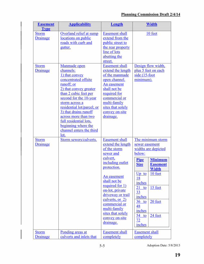
Planning Commission Draft 2/4/14
Adoption Date: 5/8/2013 5-5
Easement Type
Applicability Length Width
Storm Drainage
Overland relief at sump locations on public roads with curb and gutter.
Easement shall extend from the public street to the rear property line of lots abutting the street.
10 feet
Storm Drainage
Manmade open channels: 1) that convey concentrated offsite runoff; or 2) that convey greater than 2 cubic feet per second for the 10-year storm across a residential lot/parcel; or 3) that drains runoff across more than two full residential lots, beginning where the channel enters the third lot.
Easement shall extend the length of the manmade open channel. An easement shall not be required for commercial or multi-family sites that solely convey on-site drainage.
Design flow width, plus 5 feet on each side (15-foot minimum).
Storm Drainage
Storm sewers/culverts.
Easement shall extend the length of the storm sewer and culvert, including outlet protection. An easement shall not be required for 1) on-lot, private driveway or trail culverts, or 2) commercial or multi-family sites that solely convey on-site drainage.
The minimum storm sewer easement widths are depicted below:
Pipe Size
Minimum Easement Width
Up to 18 inches
10 feet
21 to 33 inches
15 feet
36 to 48 inches
20 feet
54 to 72 inches
24 feet
Storm Drainage
Ponding areas at culverts and inlets that
Easement shall completely
Easement shall completely
19

Planning Commission Draft 2/4/14
Adoption Date: 5/8/2013 5-6
Easement Type
Applicability Length Width
are located within or adjacent to a storm drainage easement.
encompass the 10-year ponding area.
encompass the 10-year ponding area.
Storm Drainage
Ponding areas at existing culverts and inlets on property not owned or controlled by the applicant.
N/A No easement required.
Storm Drainage
On-site preserved (natural) open channels that convey greater than 2 cubic feet per second.
Easement shall extend on-site to the floodplain, property line, or the point the conveyance system becomes jurisdictional (intermittent stream, perennial stream, or wetland).
Design flow width, plus 5 feet on each side (15-foot minimum).
Storm Drainage
Stormwater management facilities: above ground structures, including ponds, bioretention areas, etc.
N/A 10 feet beyond embankment toe and the 100-year water surface elevation.
Storm Drainage
Stormwater management facilities: vegetative filter strip used as water quality BMP below a level spreader.
To the end of the filter strip.
Width of level spreader rigid lip.
Storm Drainage
Stormwater management facilities: underground stormwater management structures (e.g., Stormfilter, Filterra, oil/water separators).
N/A 10 feet beyond periphery of the structure.
Storm Drainage
Access roadways for stormwater management facilities.
Length of the access road.
1 foot on each side of the roadway.
20
Planning Commission Draft 2/4/14
Adoption Date: 5/8/2013 5-7
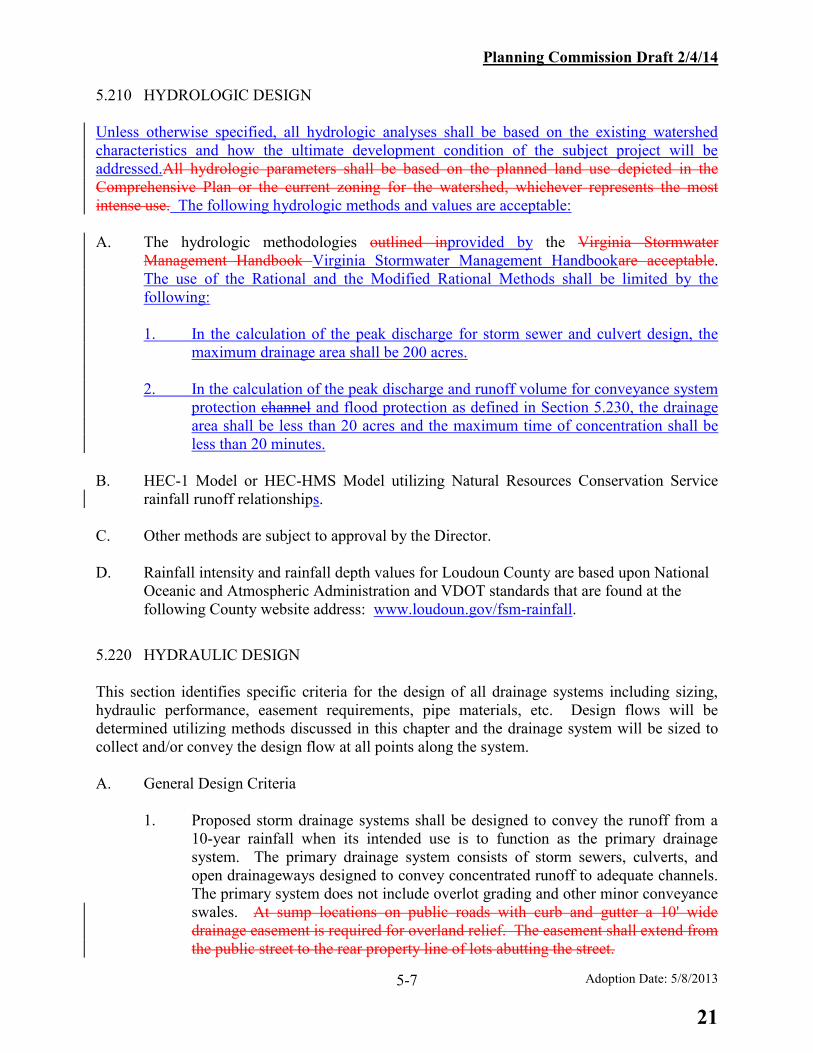
5.210 HYDROLOGIC DESIGN Unless otherwise specified, all hydrologic analyses shall be based on the existing watershed characteristics and how the ultimate development condition of the subject project will be addressed.All hydrologic parameters shall be based on the planned land use depicted in the Comprehensive Plan or the current zoning for the watershed, whichever represents the most intense use. The following hydrologic methods and values are acceptable: A. The hydrologic methodologies outlined inprovided by the Virginia Stormwater
Management Handbook Virginia Stormwater Management Handbookare acceptable. The use of the Rational and the Modified Rational Methods shall be limited by the following: 1. In the calculation of the peak discharge for storm sewer and culvert design, the
maximum drainage area shall be 200 acres. 2. In the calculation of the peak discharge and runoff volume for conveyance system
protection channel and flood protection as defined in Section 5.230, the drainage area shall be less than 20 acres and the maximum time of concentration shall be less than 20 minutes.
B. HEC-1 Model or HEC-HMS Model utilizing Natural Resources Conservation Service
rainfall runoff relationships. C. Other methods are subject to approval by the Director. D. Rainfall intensity and rainfall depth values for Loudoun County are based upon National
Oceanic and Atmospheric Administration and VDOT standards that are found at the following County website address: www.loudoun.gov/fsm-rainfall.
5.220 HYDRAULIC DESIGN This section identifies specific criteria for the design of all drainage systems including sizing, hydraulic performance, easement requirements, pipe materials, etc. Design flows will be determined utilizing methods discussed in this chapter and the drainage system will be sized to collect and/or convey the design flow at all points along the system. A. General Design Criteria 1. Proposed storm drainage systems shall be designed to convey the runoff from a
10-year rainfall when its intended use is to function as the primary drainage system. The primary drainage system consists of storm sewers, culverts, and open drainageways designed to convey concentrated runoff to adequate channels. The primary system does not include overlot grading and other minor conveyance swales. At sump locations on public roads with curb and gutter a 10' wide drainage easement is required for overland relief. The easement shall extend from the public street to the rear property line of lots abutting the street.
21
Planning Commission Draft 2/4/14
Adoption Date: 5/8/2013 5-8
2. Drainage systems shall not be terminated at the project boundary unless an
adequate channel exists at that point, as defined in this chapter. 3. Drainage systems shall be designed to provide, as a minimum, overland relief for
the 100-year rainfall without increasing the flood potential for nearby buildings. Calculations shall be provided to show appropriate overland relief when the primary drainage system is adjacent to the buildings. In lieu of calculations, the plans must indicate at least a minimum of 1 foot of overland relief being provided between the relief point and the lowest entry point of any building.
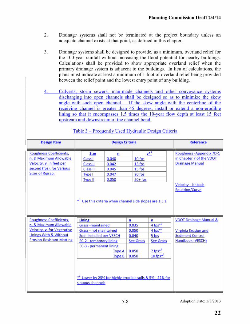
4. Culverts, storm sewers, man-made channels and other conveyance systems
discharging into open channels shall be designed so as to minimize the skew angle with such open channel. If the skew angle with the centerline of the receiving channel is greater than 45 degrees, install or extend a non-erodible lining so that it encompasses 1.5 times the 10-year flow depth at least 15 feet upstream and downstream of the channel bend.
Table 3 – Frequently Used Hydraulic Design Criteria
Design Item Design Criteria Reference
Roughness Coefficients, n, & Maximum Allowable Velocity, v, in feet per second (fps), for Various Sizes of Riprap.
Size n v*1
Class I 0.040 10 fps
Class II 0.042 13 fps
Class III 0.045 15 fps
Type I 0.047 20 fps
Type II 0.050 20+ fps
*1
Use this criteria when channel side slopes are ≤ 3:1
Roughness -Appendix 7D-1 in Chapter 7 of the VDOT Drainage Manual
Velocity - Ishbash Equation/Curve
Roughness Coefficients, n, & Maximum Allowable Velocity, v, for Vegetative Linings With & Without Erosion-Resistant Matting
Lining n v
Grass -maintained 0.035 4 fps*2
Grass - not maintained 0.050 4 fps*2
Sod -installed per VESCH 0.040 5 fps
EC-2 - temporary lining See Grass See Grass
EC-3 - permanent lining Type A Type B
0.050 0.050
7 fps*
3
10 fps*3
*2
Lower by 25% for highly erodible soils & 5% - 22% for sinuous channels
VDOT Drainage Manual &
Virginia Erosion and Sediment Control Handbook (VESCH)
22
Planning Commission Draft 2/4/14
Adoption Date: 5/8/2013 5-9
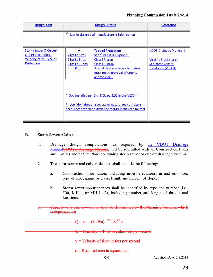
Design Item Design Criteria Reference
*3 Use in absence of manufacturer’s information
Storm Sewer & Culvert Outlet Protection – Velocity, v, vs. Type of Protection
v Type of Protection
2 fps to 5 fps Sod*4 or Class I Riprap*
5
5 fps to 8 fps Class I Riprap
8 fps to 18 fps Class II Riprap
v > 18 fps Special design energy dissipaters, must meet approval of County and/or VDOT
*4 Sod installed per Std. & Spec. 3.33 in the VESCH
*5
Use “dry” riprap; also, use of natural rock on-site is encouraged when equivalency requirements can be met
VDOT Drainage Manual &
Virginia Erosion and Sediment Control Handbook (VESCH)
B. Storm Sewers/Culverts 1. Drainage design computations, as required by the VDOT Drainage
ManualVDOT's Drainage Manual, will be submitted with all Construction Plans and Profiles and/or Site Plans containing storm sewer or culvert drainage systems.
2. The storm sewer and culvert designs shall include the following: a. Construction information, including invert elevations, in and out; size;
type of pipe; gauge or class; length and percent of slope. b. Storm sewer appurtenances shall be identified by type and number (i.e.,
#00, MH-1, or MH-1 #2), including number and length of throats and locations.
3. Capacity of storm sewer pipe shall be determined by the Manning formula, which
is expressed as: Q = va = (1.49/n) r 2/3 S 1/2 a Q = Quantity of flow in cubic feet per second v = Velocity of flow in feet per second a = Required area in square feet
23
Planning Commission Draft 2/4/14
Adoption Date: 5/8/2013 5-10
n = Coefficient of roughness (0.013 for concrete pipe) r = Hydraulic radius in feet = cross sectional area of flow ÷ wetted perimeter S = slope of pipe in feet per foot 43. Culvert pipe sizes shall be determined in accordance with Hydraulic Design
Series No. 5, Federal Highway Administration, Department of Transportation, or other VDOT-approved method.
54. Minimum size of concrete pipe to be used outside of the public right-of-way will
be 12 inches in diameter, where the distance between access openings is less than 50 feet. The minimum size of pipe permitted within the public right-of-way is 15 inches, unless otherwise specified in the VDOT Drainage ManualVDOT Drainage Manual.
65. There may be no reduction in pipe size greater than one standard increment along
the direction of flow within a storm sewer system. 76. The minimum cover for all drainage pipes within public or private Category A
and B roadways (street) rights-of-way shall be 2 feet, or one-half the diameter of the pipe, whichever is larger. When the storm sewer pipe is laid outside the street right-of-way or within Category C roadways, a minimum of 2 feet of cover shall be required. For Low Impact Design in non-load bearing conditions, a minimum of 1 foot of cover may be provided. If the minimum cover requirements as set forth in this section cannot be met, then stronger pipe classifications may be submitted for approval. Minimum cover for single residential lot driveways shall conform to VDOT standards.
87. Storm sewers shall be designed to provide a minimum velocity when running full
of no less than 2 1/23 feet per second for the design flow. Pipe velocities shall not exceed 20 10 feet per second to avoid abrasion. Pipe velocities within the public right-of-way shall comply with the VDOT Drainage Manual.
98. Except where noted otherwise, the maximum length between access openings
shall be 300 feet for pipes less than 36 inches in diameter or 500 feet for pipes 36 inches in diameter or greater. An access opening may be an inlet, manhole, junction box, or other approved appurtenance.
109. The minimum slope of each segment of the storm sewer lines shall be
0.5%percent. 101. The need for concrete anchors must be investigated on storm sewer lines with
slopes of 20 16 percent or greater. If anchors are required, the design engineer will show a detail on the plans with spacing requirements.
24

Planning Commission Draft 2/4/14
Adoption Date: 5/8/2013 5-11
112. Storm sewer pipes larger than 15 inches in size shall not outfall in the front yard of a single family detached lot less than or equal to 20,000 square. feet., but should be extended at least to the rear property line. Storm sewer outfalls located in single family attached developments shall extend at least to the rear lot line. If the storm sewer outfalls on a lot, or adjacent to a lot, on which an existing building will remain, sufficient topographic information shall be provided to verify overland relief.
123. The ends, entry or exit, of any storm sewer system and/or culvert shall be
provided with a standard end wall, head wall, curb inlet, yard inlet, flared end section, or other appurtenance or structure suitable for the intended use of the facility.
14. Erosion protection shall be provided at the outlets of storm sewers and culverts
based on outlet velocity in accordance with the following:
a. 2 fps to 5 fps Velocity
Sod protection (Kentucky Blue Grass or equally erosion resistant sod or other material) or VDOT, Class I Dry rip-rap or current equivalent*.
b. 5 fps to 8 fps Velocity
VDOT Class I dry rip-rap or current equivalent*. Length of rip-rap to be determined in accordance with the Virginia Erosion and Sediment Control Handbook.
c. 8 fps to 18 fps Velocity
VDOT Class II dry rip-rap or current equivalent*. Length of rip-rap to be determined in accordance with the Virginia Erosion and Sediment Control Handbook.
d. Velocities in Excess of 18 fps
Special design energy dissipaters or impact basins shall be required. The design of these structures must meet the approval of the County and/or VDOT.
*The use of natural rock located on the subject development site is encouraged when the equivalency requirements can be met.
13. In addition to providing a water quality benefit, level spreaders may be used to
promote sheet flow across vegetated areas in lieu of channelization. Level spreaders may also be utilized to diffuse flow before it enters a riparian buffer or wetland. The following design criteria shall be followed when utilizing level spreaders for these water quantity control purposes:
25

Planning Commission Draft 2/4/14
Adoption Date: 5/8/2013 5-12
a. The criteria found at the Virginia Stormwater BMP Clearinghouse, shall be used for design of level spreaders. The maximum allowable design flow to a level spreader shall be 10 cubic feet per second calculated using the Rational Method with a pre-determined rainfall intensity of 1inch per hour.
b. When a level spreader is located within 50 feet of riparian buffers,
jurisdictional wetlands, and/or floodplains, additional energy dissipation shall be provided by the addition of a stilling basin. Please see Figure 1 for minimum design parameters for a level spreader with a stilling basin.
c. The rigid lip of a level spreader may be constructed of timber for
discharges up to 5 cubic feet per second and shall be constructed of concrete for discharges over 5 cubic feet per second.
d. Alternate designs which can be shown to promote non-erosive sheet flow
shall be subject to approval by the Director. e. In order to apply stormwater pollutant removal credit to the vegetated area
below the level spreader, such area must meet the requirements for “Sheet Flow to a Vegetated Filter Strip or Conserved Open Space” found at the Virginia Stormwater Management BMP Clearinghouse.
15. Level spreaders may be used to promote sheet flow across vegetated areas in lieu of channelization. The following design criteria shall be followed when utilizing level spreaders for this purpose:
a. The schematics depicted in Figures 1 and 2 shall be utilized. Other
equivalent design configurations may be used subject to approval by the Director.
b. The maximum stormwater discharge to level spreaders for the 10-year
design storm must be limited to the following:
1. Simple Level Spreader – 15 cfs
2. Level Spreader with Plunge Pool – 35 cfs
cf. The maximum distance that discharge from a level spreader may be considered to remain in sheet flow before reaching a stable outlet is 150 feet. To inhibit the re-concentration of flows, the average slope over the entire length of the sheet flow shall be no greater than 8% percent.
dg. Level Spreaders adjacent to storm sewer pipe outfalls shall not be located
any closer to the invert out of the pipe than the length of required outlet protection.
26

Planning Commission Draft 2/4/14
Adoption Date: 5/8/2013 5-13
eh. A level spreader that receives discharge from storm sewer within the VDOT right-of-way is subject to these additional constraints:
1. An effort shall be made to provide a minimum 1- foot vertical
clearance between the invert out of the storm sewer and the top of the level spreader.
2. If a 1- foot vertical clearance between the invert out of the storm
sewer and the top of the level spreader cannot be achieved due to topographic or other site constraints, evidence of positive relief for the 10-year storm without restriction to the hydraulic function of the storm sewer shall be provided.
f. In order to apply stormwater pollutant removal credit to the vegetated area
below the level spreader, the area must meet the requirements for a “vegetated filter strip” as defined in the Virginia Stormwater Management Handbook. In such an application, the entire vegetated filter strip, defined by the length of the level spreader lip and extending to a stable outlet, shall be located within an easement that ensures the protection of the water quality BMP.
14. No storm sewer shall be located within 5 feet of the loading plane of a building
foundation as depicted in Figure 2.
C. Open Channel Flow 1. An Oopen channel is defined as a natural or manmade open drainageway. All
open channels shall comply with the following table:
Design Parameter On lLots ≤20,000 sq. ft. On lLots > 20,000 sq. ft. On nNon-rResidential and cCommon aAreas
Max. allowable flow* 2 cubic feet per second No max., but if > 2 cubic feet per second, open channel should be 50 feet from rear of house and 10 feet from side of house.
No Requirement (NR)
Max. velocity* 4 feet per second 4 feet per second if without armor is not provided.
4 feet per second ifwithout armor is not provided.
Min. average slope* 2 percent% 2 percent% 1 percent% Max. width of flow* 10 feet NR NR Max. depth of flow* 12 inches NR NR Preserved natural open channel > 2 cubic feet per second.
Allowed within easement
Allowed within easement Allowed within easement
27

Planning Commission Draft 2/4/14
Adoption Date: 5/8/2013 5-14
Design Parameter On lLots ≤20,000 sq. ft. On lLots > 20,000 sq. ft. On nNon-rResidential and cCommon aAreas
* in manmade open channels only. Modifications may be approved by the Director to achieve low impact development designESD. 2. Open channels located inside the public right-of-way shall be designed and
constructed in accordance with the VDOT Drainage Manual. The computations and the ditch cross-section shall be submitted with the plan and profile sheets.
3. Open channels conveying over 2 cubic feet per second should be designed for
stable, subcritical flow. Local depressions or flat slopes may be allowed along the flow path as part of ESDlow impact development design as long as they are designed to dissipate within 48 hours, unless designed for water retention.
D. Grading Criteria
Overall grading on residential lots less than one acre in size shall meet the following criteria:
1. In addition to the Individual Lot Grading Plan requirements of Chapter 8, overall
grading shall illustrate how the proposed house and lot grading will be integrated into the overall drainage system proposed for a particular section of development and shall honor drainage divides used for the storm drainage design.
2. A building footprint shall be illustrated on the individual lots specifying the
proposed finished floor elevations for a given lot. The footprint should accommodate the various potential home models without significant alteration of the proposed drainage design and patterns.
3. Miscellaneous grading criteria:
Design Issue Criteria Yard slopes ≤ 3:1 Stabilize with grass Yard slopes > 3:1 Use ground cover that does not require regular
mowing Surface drainage over curbs Yard overlot surface drainage in excess of 2
cubic feet per second (10- year design) should not be directed to overtop the curb and gutter of public or Category A private roads.
Yard grading To insure positive drainage away from the foundation, provide 6 inches of fall for the first 10 feet and a minimum 2 percent% * average
28
Planning Commission Draft 2/4/14
Adoption Date: 5/8/2013 5-15
Design Issue Criteria grade thereafter. Local depressions or flat slopes may be allowed along the flow path as part of a low impact development measure as long as they are designed to dissipate within 48 hours, unless designed for water retention.
* The minimum grade may be reduced to decrease disturbed area and to promote tree conservation if positive drainage can otherwise be achieved on the lot.
E. Easements shall be required in accordance with Section 5.100.C and as further specified
in this chapter.
Standard minimum easement width shall be determined as follows with minimum easement width to be based on the width of the trench necessary to unearth the pipe. The trench width shall be based on a 1:1 slope from the edge of the trench. Where multiple pipes or pipe sizes larger than 72 inches are installed, the edge of easement shall be a minimum of 5 feet clear of the outside edge of the outermost pipe. Criteria resulting in the greatest width shall be used.
Pipe Size Minimum Easement Width Up to 18 inches 10 feet 21-33 inches 15 feet 36-48 inches 20 feet 54-72 inches 24 feet
2. Easements shall be extended to the property line and to an adequate channel. Easements shall be extended beyond the property line to provide for off-site drainage improvements. If flows leaving the property have increased then an off-site drainage easement shall be provided, unless such increased flows have negligible impacts.
3. For open channels, easement width shall generally be based on the width required
to carry the design flow plus 5 feet on each side. Open channels will be in a minimum drainage easement of 15 feet.
4. Drainage easements shall be provided where drainage in an open channel exceeds
2 cfs. For an open channel draining runoff across more than two full residential lots, a drainage easement shall be provided where the open channel enters the third lot.
5. Easements are required to completely encompass the 10-year ponding area at all
culverts and inlets, except that, where existing drainage structures are being improved, off-site easements on property not owned or controlled by the applicant shall not be required. Where the storm drainage easement for such culvert or inlet
29

Planning Commission Draft 2/4/14
Adoption Date: 5/8/2013 5-16
is a temporary easement, the ponding area easement may also be temporary. FE. Pipe Materials 1. All pipe used for the construction of drainage systems and/or stormwater
management facilities shall be concrete or High Density Polyethylene (HDPE), as specified below. HDPE pipe is permitted in any particular application if VDOT approves its use, design and specifications during their review of the CPAP or Site Plan. Alternate materials can be utilized where specifically permitted below or in accordance with waivers granted by the Director of Building and Development.
a. All concrete pipe shall be a minimum Class III. All HDPE pipe shall meet
the most recently published VDOT specifications. Alternate materials, where permitted, shall meet the current VDOT requirements.
b. Metal and/or other plastic pipe may be designated for use on-site where
the facility is not located within an easement. All construction and use of these materials must be accomplished in accordance with manufacturer's recommendations.
c. Corrugated Metal Pipe used for Category C private roadway culverts shall
meet current VDOT specifications. cd. HDPE pipe shall not be permitted in pond embankments
5.225 STORMWATER MANAGEMENT - GENERAL CRITERIA A. General Criteria 1. Stormwater management facilities may consist of either above grade or
underground facilities; however, underground facilities are permitted only within non-residential areas or high-density residential zones. Above grade stormwater management facilities may be designed as either wet or dry facilities.
2. Stormwater management facilities serving single or multiple properties, sites, or
drainage areas may be incorporated within proposed developments. 3. Regional stormwater management is defined as facilities and/or design criteria
identified in a County approved drainage district study to control increases in runoff from developed sites within the established district. Stormwater management requirements identified with these studies must be met in conjunction with any applicable land development activity.
4. All stormwater management facilities shallmust be located within an easement
dedicated to Loudoun County (i.e., 10 feet from the toe of slope and/or periphery). Such facilities shall be maintained by the landowner, an owners or
30

Planning Commission Draft 2/4/14
Adoption Date: 5/8/2013 5-17
homeowners association, or other legal entity approved by the Board of Supervisors, to the extent not maintained by the County pursuant to Chapter 1096 of the Codified Ordinances of Loudoun County Codified Ordinances of Loudoun County (LCCOC.O.). Maintenance responsibilities shall be established in the required Deed of Dedication, in a form acceptable to the County Attorney.
5. Low-impact development designESD techniques may be incorporated into
stormwater management designs. 6. Regular maintenance is vital to the proper functioning of stormwater management
facilities. Designs shall consider and address the future operation and maintenance requirements of stormwater management facilities.
a. All required access-ways and easements shall be designated on plans and
cleared, graded, or constructed with the facility construction.
b. Proximity of facilities to the public right-of-way shall be considered in order to minimize the length of the access-way.
c. Multiple access paths to major facilities should be provided.
d. Specifically delineated access easements may be required where
stormwater management facilities are surrounded by residential lots. 7. All stormwater management retention ponds (wet ponds) that are not subject to a
separate negotiated stormwater maintenance agreement with the County pursuant to Chapter 1096 of the LCCOC.O. must be periodically maintained and inspected by the property owner or HOA in accordance with the Virginia Stormwater Management HandbookVirginia Stormwater Management Handbook. Such maintenance may include removal of silt, litter and other debris from all catch basins, inlets and drainage pipes, grass cutting and vegetation removal, and necessary replacement of landscape vegetation and any repair or replacement of structural features. The legal documents recorded to grant the easement for the stormwater management facilities must provide for an annual inspection and report in accordance with Chapter 1096 of the LCCOC.O.
8. When outfalls from stormwater management facilities are discharged to a
receiving channel, energy dissipators shall be placed at the outfall as necessary to provide a stabilized transition from the facility to the receiving channel.
B. Facility Design Standards
1. Where required by previous approvals, Preliminary Stormwater Management
Plans prepared in conjunction with proposed development shall include the following information:
a. General location of proposed centralized stormwater management facilities shown on available topographic mapping.
31

Planning Commission Draft 2/4/14
Adoption Date: 5/8/2013 5-18
b. Drainage area delineation and computations for each facility. c. Preliminary calculations to identify sizing criteria.
ed. Proposed phasing of facility construction in conjunction with development phasing.
2. Computations submitted with detailed designs for proposed stormwater management facilities shall include the following information:
A narrative shall be provided with all stormwater management designs which includes the following information: a. A description of pre- and post-development site conditions. b. An explanation of the stormwater management strategies used to meet
both the water quantity and water quality technical requirements of this Chapter.
c. A description of the stormwater management facilities employed which
includes: i. Type of facility.
ii. Location of facility, to include geographic coordinates. This information may be shown on the plans in lieu of the narrative.
iii. Acres treated. iv. Description of the discharge point. d. The mechanism thorough which the facilities will be operated and
maintained after construction is complete.
3. Computations submitted with detailed designs for proposed stormwater management facilities to demonstrate the attenuation of stormwater runoff (e.g., wet ponds, extended-detention ponds, oversized stormwater pipes or vaults, etc.) shall include the following information:
a. Stage - storage relationship for the facility.
b. Stage - discharge relationship for the proposed outfall structure(s)
including computations. c. Routing program utilized (may not be applicable in conjunction with
facilities designed using previously approved graphical and/or short cut methodologies).
32

Planning Commission Draft 2/4/14
Adoption Date: 5/8/2013 5-19
d. Hydrologic computations as provided outlined in this chapter.
4. The minimum low flow orifice diameter to be used for facilities which provide extended detention is 2.5 inches with open grill trash protection. If the “stack” filtering system (see Figure 3) is utilized for trash protection, the orifice diameter may be reduced to 1.75 inches.
35. All dry stormwater management facilities shall incorporate appropriate provisions
for low flow conveyance without using concrete trickle ditches.
46. Underground Stormwater Management Facilities – Design of Underground Stormwater Management Facilities including water quality inlets shallwill include the following information:
a. For structures that rely on soil suitability, a geotechnical report shall be
provided which addresses the soil suitability, compatibility with materials to be used, and pH and corrosiveness of the soil and water runoff from the drainage area.
b. Demonstrate that the facility will meet all stormwater management
regulations of this chapter.
c. Detailed description and specifications of the facility, how the facility will be constructed or installed, and the manufacturer’s and/or designer’s recommendations for maintenance and maintenance schedule shall be provided.
7. Stormwater Management Facilities with Infiltration – Design of measures that
rely on infiltration (through either engineered media, stone, or in situ soils) shall include the following:
a. Verification that the Seasonal High Water Table (SHWT), to include the
“perched” condition, is at least 2 feet below the bottom of the facility shall be accomplished by one of the following methods:
i. Observation of ground water monitoring wells over a 12-month
period. Testing duration may be reduced if testing is only performed from November 1 through May 31. Months June through October shall not be included unless the value of the Palmer Drought Severity Index (PDSI) is equal to or greater than 2.0 (i.e. wet).
ii. Site-specific evaluation of the redoximorphic features within the
soil profile by a Virginia Licensed Soil Scientist (C.P.S.S), Certified Professional Geologist (C.P.G.), Professional Wetland Delineator (PWD), or Licensed Professional Engineer (P.E.) who has completed a soil morphology training class offered through Northern Virginia Soil and Water Conservation District
33

Planning Commission Draft 2/4/14
Adoption Date: 5/8/2013 5-20
(NVSWCD) or equivalent as determined by the Director.
a. The evaluation shall include a soil description that includes all soil horizons and are described per ASTM D-2488 (Description and Identification of Soils Visual-Manual Procedure) or National Cooperative Soil Survey standards as set forth in the National Soil Survey Handbook. Colors shall be identified using the Munsell System of Color Notation.
b. Fieldwork shall be documented as being performed by the
professional who meets the certification requirements in subsection ii above.
c. All fieldwork shall be subject to review and confirmation
by the County.
iii. Use of data from the USDA Soil Data Mart.
iv. However, if the 2-foot separation between the bottom of the facility and the SHWT cannot be achieved, the incorporation of an underdrain system and an impermeable clay (Ksat 1x10⁻⁶ cm/s) or geotextile liner is acceptable.
85. The following information shall be included with designs for dam embankments
related to stormwater management or recreational water impoundments.
a. A geotechnical report shall be provided which addresses the soil seepage through the embankment and body of the pond, contains an embankment design, and addresses the soil and water pH and erosiveness related to the principle spillway pipe materials.
b. No landscape plantings other than grass or groundcover shall be proposed
on the dam embankment.
c. The pond outfall shall be far enough from the property line to achieve an adequate transition in accordance with the Virginia Stormwater Management Handbook Virginia Stormwater Management Handbook and the Virginia Erosion and Sediment Control HandbookVirginia Erosion and Sediment Control Handbook.
d. Low-level drains shall be provided for wet ponds to facilitate maintenance
and sediment removal where a gravity outfall is available.
e. Pond structures shall be engineered to assure structural integrity during the 100-year storm event.
34
Planning Commission Draft 2/4/14
Adoption Date: 5/8/2013 5-21
69. The State Water ControlVirginia Soil and Water Conservation Board regulates certain impounding structures defined therein (see Virginia Dam Safety Act, (Section 10.1-604 et seq.) Title 10.1, Chapter 6, Article 2 of the Virginia Code and Dam Safety Regulations of the Virginia Water Conservation Board – (the Act)). The design criteria presented below apply to impounding structures (wet ponds) which have a height greater than or equal to 6 feet and are governed by the Virginia Dam Safety Act. These impounding structures shall also conform to all design criteria listed in the State Impounding Structure Regulations (4VAC50-20-10 et seq.). In addition, the design criteria presented below apply to all impounding structures which have a height greater than or equal to 15 feet. These impounding structures will conform to all design criteria listed in Chapter 5 of "Impounding Structure Regulations", Regulation No. 9, State Water Control Board, Commonwealth of Virginia.
a. The height of the dam (Hd) shall be defined as the vertical distance from
the natural bed of the stream or watercourse measured at the downstream toe of the impounding structure to the top of the impounding structureis defined as the vertical distance from the foundation to the water surface elevation plus freeboard allowance for wind setup, waves, and frost action.
b. A slope stability analysis shallwill be performed to address seepage
through the structure, pore water pressure within the structure, slope pressure, and slope protection.
c. Emergency spillways shallwill be designed to pass at minimum a 100-
year storm with the primary spillway assumed to be 100 percent% clogged without endangering the integrity of the impounding structure.
d. A maintenance program shallwill be provided to the Department of
Building and Development and implemented in conformance to "Safety Evaluation of Small Earth Dams", 2nd Ed., Natural Resources Conservation Service, Virginia Department of Conservation and Historic Resources.
e. An Emergency Action Plan, as defined in the Act, shallwill be submitted
and maintained by the owner of the dam. The owner shallwill be responsible for notifying the 24 Hour Dispatch Center at "911".
5.230 STORMWATER MANAGEMENT - WATER QUANTITY TECHNICAL CRITERIA Adherence to the technical criteria in the Virginia Stormwater Management Handbook Program Permit Regulations (9VAC25-870-10 et seq.), the Stormwater BMP Clearinghouse Website (www.vwrrc.vt.edu/swc), and in this Chapter and the Virginia Erosion and Sediment Control Handbook shall be required. Exceptions shall meet the intent and spirit of the aforementioned handbooks.may be granted by the Director provided that: (i) the exception shall be the minimum necessary to afford relief, (ii) reasonable and appropriate conditions shall be imposed as necessary upon any exception granted so that the intent of Chapter 1096 of the C.O. and this
35

Planning Commission Draft 2/4/14
Adoption Date: 5/8/2013 5-22
chapter are preserved, (iii) granting the exception shall not confer any special privileges that are denied in other similar circumstances, and (iv) exception requests shall not be based upon conditions or circumstances that are self-imposed or self-created. A. Water Quantity Criteria
1. General Requirements
a. Concentrated stormwater runoff from development sites shall be discharged directly into a conveyance system, such as a well-defined natural or constructed receiving channel, pipe, or pipe system. A receiving channel shall have a defined bed and bank, verified by either of the following:
i. The cross section of the receiving channel has a maximum bottom
width to flow depth ratio of 35:1; or,
ii. For a receiving channel with a bottom width to flow depth ratio greater than 35:1, photos of the cross-section and overbank areas, along with any pertinent calculations shall be provided to show that channel meandering and erosion will not occur and that flow moving into overbank sections will not adversely impact the adjacent property.
b. Conveyance system protection and flood protection analyses shall be
provided at every discharge point of concentrated flow originating from site improvements.
c. Increased volumes of sheet flow originating from site improvements that
may cause erosion or flooding on down-gradient property shall be identified and diverted to a stable outlet or stormwater management facility that provides the required conveyance system protection and flood protection.
d. Offsite stormwater management facilities may be utilized to meet the
requirements of this section where (1) it can be shown that the stormwater management facility was designed to accommodate the subject area, and (2) an approved maintenance agreement with the owner of the stormwater management facility is executed in accordance with Chapter 1096 of the C.O.
2. Conveyance System Protection
Conveyance systems shall meet the following criteria:
a. When stormwater from a development is discharged to a Manmade
Conveyance Systems – Constructed or improved open channels, culverts, and storm sewer.
36

Planning Commission Draft 2/4/14
Adoption Date: 5/8/2013 5-23
i. The manmade conveyance system shall convey the post-
development peak flow rate from the 2-year 24-hour storm event without causing erosion of the system; or,
ii. The Energy Balance Methodology described in Section
5.230.A.2.c. shall be met.
b. When stormwater from a development is discharged to a Restored Conveyance Systems – Streams restored using natural channel design techniques which include an analysis of geomorphic processes to create, rehabilitate, restore or stabilize the channel so that it conveys its bankfull storm event within its banks and allows larger flows to access its floodplain.
i. The development, in combination with other stormwater runoff to
the stream, shall be consistent with the design parameters of the restored conveyance system that is functioning in accordance with the design objectives; or,
ii. The Energy Balance Methodology described in Section
5.230.A.2.c. shall be met.
c. When stormwater from a development is discharged to a Natural Conveyance Systems – Natural perennial or intermittent streams, unimproved ephemeral channels, or swales.
The maximum peak flow rate from the post-development 1-year 24-hour storm shall be calculated in accordance with the Energy Balance Methodology below or another methodology that is approved by the Director and the Water Control Board.
Energy Balance Methodology
Under no circumstances shall QDeveloped be greater than QPre-Developed nor shall QDeveloped be required to be less than that calculated in the equation (QForest x RVForest) / RVDeveloped; where, QDeveloped = The allowable peak flow rate of runoff from the developed site.
I.F. (Improvement Factor) = 0.8 for sites greater than one acre, or 0.9 for sites less than or equal to one acre. RVDeveloped = The volume of runoff from the site in the developed
QDeveloped ≤ I. F. x (QPre-Developed x RVPre-Developed) / RVDeveloped
Formatted: Font: CG Times
37
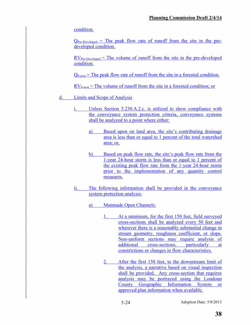
Planning Commission Draft 2/4/14
Adoption Date: 5/8/2013 5-24
condition.
QPre-Developed = The peak flow rate of runoff from the site in the pre-developed condition.
RVPre-Developed = The volume of runoff from the site in the pre-developed condition.
QForest = The peak flow rate of runoff from the site in a forested condition.
RVForest = The volume of runoff from the site in a forested condition; or
d. Limits and Scope of Analysis
i. Unless Section 5.230.A.2.c. is utilized to show compliance with the conveyance system protection criteria, conveyance systems shall be analyzed to a point where either:
a) Based upon on land area, the site’s contributing drainage
area is less than or equal to 1 percent of the total watershed area; or,
b) Based on peak flow rate, the site’s peak flow rate from the
1-year 24-hour storm is less than or equal to 1 percent of the existing peak flow rate from the 1-year 24-hour storm prior to the implementation of any quantity control measures.
ii. The following information shall be provided in the conveyance
system protection analysis:
a) Manmade Open Channels:
1. At a minimum, for the first 150 feet, field surveyed cross-sections shall be analyzed every 50 feet and wherever there is a reasonably substantial change in stream geometry, roughness coefficient, or slope. Non-uniform sections may require analysis of additional cross-sections, particularly at constrictions or changes in flow characteristics.
2. After the first 150 feet, to the downstream limit of
the analysis, a narrative based on visual inspection shall be provided. Any cross-section that requires analysis may be portrayed using the Loudoun County Geographic Information System or approved plan information when available.
38

Planning Commission Draft 2/4/14
Adoption Date: 5/8/2013 5-25
b) Pipe Systems and Pipes: For pipe systems (i.e., storm sewer), segments shall be analyzed and if the potential exists for surcharge of the system, a hydraulic grade line shall be provided. For individual pipes (e.g., culverts), a controlling headwater must be determined from the energy grade line (as depicted in VDOT design form LD-269) or through a stormwater routing calculation (as depicted in U.S. Department of Transportation’s HY-8).
3. Flood Protection
a. Conveyance systems shall meet the following criteria:
i. Stormwater discharges to conveyance systems that currently do not
experience localized flooding during the 10-year 24-hour storm:
a) The post-development flow from a 10-year 24-hour storm shall be confined in the conveyance system to avoid the localized flooding.
b) Detention of stormwater or downstream improvements may
be utilized to meet this criterion.
ii. Stormwater discharges to conveyance systems that currently experience localized flooding during the 10-year 24-hour storm:
a) The post-development flow from the 10-year 24-hour storm
shall be confined in the conveyance system to avoid the localized flooding; or
b) The post-development peak flow rate for the 10-year 24-
hour storm shall be released at the pre-development peak flow rate for the 10-year 24-hour storm.
c) Detention of stormwater or downstream improvements may
be utilized to meet these criteria.
b. Limits of Analysis Conveyance systems shall be analyzed to a point where:
i. Based upon land area, the site’s contributing drainage area is less
than or equal to 1 percent of the total watershed area draining to a point of analysis in the downstream conveyance system; or,
ii. Based on peak flow rate, the site’s peak flow rate from the 10-
year 24-hour storm is less than or equal to 1 percent of the existing peak flow rate from the 10-year 24-hour storm prior to
39

Planning Commission Draft 2/4/14
Adoption Date: 5/8/2013 5-26
the implementation of any quantity control measures; or
iii. The stormwater conveyance system enters the floodplain.
A. General Requirements
1. Stormwater management facilities shall be provided in conjunction with land development activities, which require the submission of Construction Plans and Profiles or a Site Plan, where an adequate receiving channel for site runoff does not exist or cannot be provided. Stormwater management designs shall attenuate the post-development peak runoff rate from the one-year storm, the two-year storm, and the ten-year storm, considered individually, so as not to exceed the respective pre-development runoff rate. Additional peak flow attenuation of the design storm may be required if the receiving channel, culvert, or storm sewer within the public right-of-way does not meet the design criteria as defined in the VDOT Drainage Manual.
Concentrated stormwater runoff leaving a development site shall be discharged directly into a well-defined natural or constructed off-site receiving channel or pipe. A receiving channel must have a defined bed and bank. An easement shall be provided where concentrated stormwater runoff is discharged from a development site onto an adjacent site in an area that experienced only sheet flow runoff prior to the development of the subject site. This standard applies whether or not there has been an increase in the peak flow rate.
Offsite stormwater management facilities may be used to meet the requirements of this section where (1) it can be demonstrated that the facility was designed to accommodate the subject area, and (2) an approved maintenance and easement agreement with the facility owner is signed and recorded that comports with the provisions of Chapter 1096 of the LCCO
Adequate channel must be demonstrated for every discharge point where there is an increase in velocity or peak runoff rate. A receiving channel or pipe is considered adequate if any of the following conditions can be met through an analysis of representative channel sections and/or pipe analysis. a. The bankfull capacity of the natural receiving channel is sufficient to pass an
increased post development peak flow from the 2-year frequency storm and the channel velocity (2-year frequency storm) does not exceed the permissible (non-erodible) velocity of the channel lining. In addition, overbank flow for the 10-year storm must be conveyed within a recorded drainage easement.
b. The bankfull capacity of the manmade receiving channel is sufficient to pass
the post development peak flow from the 10-year frequency storm and the
40

Planning Commission Draft 2/4/14
Adoption Date: 5/8/2013 5-27
channel velocity (2-year frequency storm) does not exceed the permissible (non-erodible velocity of the channel lining.)
c. The 10-year frequency storm is contained within the receiving culvert and/or
storm sewer system. d. The contributing drainage area of the development site is less than 1% of the
total drainage area to the point of consideration in the channel or pipe. e. There is no increase in the velocity or peak runoff rate for the 2-year
frequency storm (for natural receiving channels) or the 10-year frequency storm (for manmade receiving channels) at the point of discharge after development.
f. The receiving channel is the main channel within a major floodplain as shown
on the Floodplain Map of Loudoun County, that being a channel receiving runoff from an upstream area exceeding 640 acres.
g. The amount of increase in runoff, calculated as the difference between
pre-developed and post-developed peak discharge, leaving the subject site represents less than one percent (1%) of the total design-storm discharge for the receiving channel or storm drainage system. For purposes of analysis, the total discharge in the downstream channel should be determined using existing conditions for watershed areas other than the subject site, which contribute to the total flow in the downstream channel.
2. Determination of flooding and channel erosion impacts to receiving streams due
to land development projects shall be measured at each point of discharge from the development project and such determination shall include any runoff from the balance of the watershed which also contributes to that point of discharge.
34. The specific design storms shall be defined as either a 24-hour storm using the
rainfall distribution recommended by the Natural Resources Conservation Service when using these methods or as the storm of critical duration that produces the greatest required storage volume at the site when using a design method such as the Modified Rational Method. Pre-development and post-development runoff rates characteristics shall be verified by site inspections, topographic mapping or surveys, available soil mapping or studies, and calculations that are consistent with good engineering practices.
45. For purposes of computing runoff, all pervious lands in the site shall be assumed
prior to development to be in good condition (if the lands are pastures, lawns or parks), with good cover (if the lands are woods), or with conservation treatment (if the lands are cultivated), regardless of conditions existing at the time of computation, unless an engineered on-site analysis indicates different conditions and is included with the plan submission.
5. Stormwater runoff shall be considered to be in a sheet flow condition where the
maximum contributing length of flow is 150 feet for pervious surfaces and 75 feet
41
Planning Commission Draft 2/4/14
Adoption Date: 5/8/2013 5-28
for impervious surfaces. 6. The adequate outfall analysis, as required in this chapter, must be carried
downstream for a sufficient distance to demonstrate that the receiving channel and/or pipe system has adequate capacity. Applicants are encouraged to provide photographs of portraying the outfall channel existing conditions of natural and manmade stormwater conveyance systems to support the adequate outfallconveyance system protection and flood protection analysisanalyses.In order to confirm an adequate outfall the following narrative analysis shall be provided and shall contain the following information:
a. The maximum allowable velocity in each stream segment must be
determined based on the soil type and channel sinuosity in accordance with Chapter 5 of the Virginia Erosion and Sediment Control Handbook. The soil type, sinuosity, and maximum allowable velocity for each stream segment must be clearly described in the adequate outfall analysis.
b. From the site discharge point to the channel of the minor floodplain:
From the site discharge point to the stream channel of the minor floodplain, detailed adequate channel calculations with field surveyed channel, pipe and/or culvert sections shall be provided. The plan should include enough representative cross sections to evaluate the capacity of a receiving channel along its entire lengthAt a minimum, cross-sections shall be provided every 50 feet within the first 150 feet and wherever there is a reasonably substantial change in stream geometry, roughness coefficient or slope. Non-uniform channels may require analysis of several cross-sections, particularly at constrictions or at changes in the flow characteristics. For piped systems, all pipe segments must be analyzed and if the potential exists for surcharge of the system, a hydraulic grade line must be provided for the piped system.
7. Engineering information from previously approved plans or record drawings (if
available) may be used where it can be demonstrated that the assumptions and flow parameters used to design or analyze the downstream system are still valid.
8. The Department of Environmental Quality’s Runoff Reduction Method
Development Compliance Spreadsheet and accompanying Virginia Runoff Reduction Method Users Guide found at the Stormwater BMP Clearinghouse Website (www.vwrrc.vt.edu/swc) may be utilized to demonstrate overall compliance with Conveyance System Protection and Flood Protection requirements as follows: a. Bioretention, permeable pavement, or similar BMPs which infiltrate and
delay the release of runoff may receive credit for volume reduction through a Curve Number (CN) reduction.
42
Planning Commission Draft 2/4/14
Adoption Date: 5/8/2013 5-29
b. Actual peak flow reductions by infiltration-type BMPs based upon detailed storage and flow routing calculations may also be utilized to demonstrate compliance.
c. CN reduction shall not be accepted for the design of downstream
conveyance structures, such as roadway culverts, bridges, etc. c. From the stream channel of the minor floodplain to the stream channel of the
major floodplain:
An adequate outfall narrative and schematic shall be provided from the receiving channel of the minor floodplain to the receiving channel of the major floodplain. The schematic shall be taken from the Loudoun County Geographic Information System and shall include at a minimum parcels, buildings, drainageways, road crossings, and floodplain limits and will be supplemented with more current construction information as necessary. A visual inspection of the receiving channel conditions shall be performed and documented in the adequate outfall narrative and schematic. The visual inspection narrative shall include an evaluation of the existing stream channel conditions, storm drainage system, culverts, structures, and critical areas. Critical areas which could potentially impact offsite properties or structures shall be addressed. Adequate outfall calculations shall be provided using Loudoun County topographic information or, aerial or field topography where available, and approved plan information (where available) if the potential exists for a negative offsite impact. Onsite stormwater management or adequate channel shall be provided if adequate channel cannot be demonstrated from the above exercise.
7. Stormwater management facilities shall not be required where adequate channel can
be provided through on-site and/or off-site improvements. The drainage improvements (i.e. open channel, storm sewer, culverts, etc.) must be extended to an existing adequate channel.
8. Stormwater management requirements may be met through a combination of channel
improvements, stormwater detention or other measures adequate to protect against downstream erosion.
5.300 STORMWATER MANAGEMENT - WATER QUALITY CRITERIA
5.310 WATER QUALITY DESIGN GUIDELINES For any land development or redevelopment requiring construction plans and profiles or a site plan, stormwater runoff shall be controlled in accordance with the requirements of the Virginia Stormwater Management Handbook by the use of best management practices (BMP) that achieve the following general goals: A. To promote and preserve water quality, land disturbance shall be limited to the building
footprint area and that area necessary to provide for the proposed use or development.
43
Planning Commission Draft 2/4/14
Adoption Date: 5/8/2013 5-30
B. Prior to initiating grading or other on-site activities on any portion of a lot or parcel, all associated permits required by federal, state, and local laws and regulations shall be obtained and evidence of such submitted to the County.
C. Discharge of stormwater pollutants to wetlands shall be minimized, except where constructed wetlands are used as a BMP and are designed in accordance with County standards.
D. Ingress and egress during construction shall be limited to one access point, unless otherwise approved by the County.
E. Indigenous vegetation and tree cover shall be preserved to the maximum extent possible consistent with the use and permitted development and in accordance with the Virginia Erosion and Sediment Control Handbook and Chapter 7 of the FSMF. Development shall maximize the use of sheet flow through vegetated areas and shall maximize the flow length through vegetated areas. Areas of concentrated development shall be located in upland areas and away, to the maximum extent practicable, from surface waters and drainageways.
G. Compliance with the water quality criteria may be achieved by applying the performance based criteria or the technology based criteria as found in the Virginia Stormwater Management Handbook.
H. Infiltration practices such as bio-retention, infiltration trenches, and rain gardens shall be allowed only where it can be demonstrated that soil conditions are favorable, or if an adequate under-drain is included in the design.
5.230 WATER QUALITY DESIGN STANDARDS A. Best Management Practices (BMP) measures shall be incorporated into the design of all
Construction Plans and Profiles or Site Plan submissions, except as noted in this section, to achieve the following: 1. For development, the post-development nonpoint source pollutant load shall not
exceed the pre-development load. For the purpose of calculating the pre-development pollutant load, an average land cover condition of 16 percent impervious cover shall be used.
2. For redevelopment sites, the nonpoint source pollutant load shall not exceed the greater of (a) the pollutant load, based on existing conditions, minus 10 percent; or (b) the pollutant load based on an average land cover condition of 16 percent impervious cover.
3. The County may waive or modify this requirement for redevelopment sites that originally incorporated BMPs for stormwater runoff quality control, provided the following provisions are satisfied: a. In no case may the post-development non-point source pollution runoff
load exceed the pre-development load; b. Runoff pollution loads must have been calculated and the BMPs selected
for the expressed purpose of controlling nonpoint source pollution; c. If BMPs are structural, evidence shall be provided that facilities are
currently in good working order and performing at the design levels of service. A review of both the original structural design and maintenance plans may be required to verify this provision. A new maintenance agreement may be required to ensure compliance with this ordinance.
d. For redevelopment, both the pre- and post-development loadings shall be calculated by the same procedures. However, where the design data is
44

Planning Commission Draft 2/4/14
Adoption Date: 5/8/2013 5-31
available, the original post-development nonpoint source pollution loadings can be substituted for the existing development loadings.
B. Exclusions 1. Land development projects that disturb less than one acre of land. 2. Linear development projects (e.g. construction of power, communication, or other
utility lines; and highway construction projects), provided that (a) less than one acre of land will be disturbed per outfall or watershed,(b) there will be insignificant increases in peak flow rates, and (c) there are no existing or anticipated flooding or erosion problems downstream of the discharge point.
C. Reference Documents The Virginia Stormwater Management Handbook shall be utilized for purposes of determining the applicability, pollutant removal efficiency and design guidelines, not specifically contained within this manual, for various BMP measures. Alternative design methods shall require approval by the Director. The Director shall maintain a list of acceptable structural BMP devices and their pollutant removal efficiency.
D. Design Criteria 1. The method used to determine Water Quality Volume (WQV) shall be based on
the proposed land uses contributing runoff to the BMP facility, in accordance with the Virginia Stormwater Management Handbook.
2. Water quality inlets are acceptable as the primary control only where there are constraints which prohibit use of other structural BMP devices.
3. BMP measures that incorporate extended detention shall be designed to release the WQV over a minimum time of 30-hours.
4. The County encourages the use of nonstructural BMP measures alone or in combination with structural BMPs in order to meet water quality goals. Such measures help reduce the effects of new impervious cover, thereby reducing the need for structural BMPs. Acceptable measures are identified in the Virginia Stormwater Management Handbook.
5. In order to apply stormwater pollutant removal credit to sheet flow directed to a vegetated area, the area must meet the requirements for a “vegetated filter strip” as defined in the Virginia Stormwater Management Handbook.In such an application, the entire vegetated filter strip shall be located within an easement that ensures the protection of the water quality BMP.
6. Non-Structural BMPsNon-structural measures may be used in conjunction with or in place of structural measures in order to satisfy the requirements of this section, as provided herein: a. The County encourages alternative non-structural measures to satisfy,
partially or in whole, the requirements of this section, if such measures are identified in accepted technical literature, are acceptable to the County based on its exercise of sound professional judgment, and the County determines that the measures achieve equivalent benefit for water quantity and/or quality protection in accordance with the Virginia Stormwater Management Handbook’s technology and performance based standards.
b. Non-structural measures include, but are not limited to, minimization of impervious surfaces, preservation of existing stream buffers, stream buffer reforestation, providing additional stream buffer areas, wetland restoration, and development design that reduces the rate and volume of runoff.
45

Planning Commission Draft 2/4/14
Adoption Date: 5/8/2013 5-32
B. Water Quality Criteria
These criteria are based upon the State’s runoff reduction methodology, which includes treatment of the whole development site as well as allotting pollutant removal credit for volume reduction and particulate settling and filtering.
For all regulated land-disturbing activities, the following minimum water quality criteria shall be met.
1. Performance Criteria
a. New Development: The total phosphorus load from new development shall not exceed 0.41 pounds / acre / year.
b. Development on Prior Developed Lands:
i. For land-disturbing activities disturbing greater than or equal to one acre resulting in no-net increase in impervious cover from the pre-development condition, the total phosphorus load shall be reduced at least 20 percent below the pre-development total phosphorus load.
ii. For land-disturbing activities disturbing less than one acre resulting in no-net increase in impervious cover from the pre-development condition, the total phosphorus load shall be reduced at least 10 percent below the pre-development total phosphorus load.
iii. For land-disturbing activities that result in a net increase in impervious cover from the pre-development condition, the performance criteria for new development shall be applied to the increased impervious area, and subsections i or ii shall be applied to the remainder of the site.
iv. In lieu of subsection iii, the total phosphorus load of a linear development project occurring on prior developed lands shall be reduced by 20 percent below the pre-development total phosphorus load.
v. In no case shall the total phosphorus load be required to be reduced to below the performance criteria for new development.
2. Calculation Procedures to Demonstrate Compliance
a. The Department of Environmental Quality’s Runoff Reduction Method Development Compliance Spreadsheet and accompanying Virginia Runoff Reduction Method Users Guide found on the Stormwater BMP Clearinghouse Website (www.vwrrc.vt.edu/swc) shall be utilized to demonstrate compliance with the performance criteria in Section 5.230.B.1.
b. In utilizing the Spreadsheet identified in subsection a, compliance with the
pollutant load limits in the performance criteria shall be achieved for the entire site. However, if the site has multiple discharge points, the analyses
46

Planning Commission Draft 2/4/14
Adoption Date: 5/8/2013 5-33
may be completed for individual drainage areas and the sum of the treatment achieved in the individual areas shall meet the required pollutant load reduction for the entire site.
c. Drainage areas within different Hydrologic Unit Codes, as defined in the
most recent version of Virginia's 6th Order National Watershed Boundary Dataset, shall be evaluated individually in the Spreadsheet.
3. Stormwater Management BMP Design
a. Only BMPs included on the Stormwater BMP Clearinghouse Website
shall be utilized for pollutant removal credit, unless otherwise approved by the Director and the State Water Control Board.
b. BMP designs shall be consistent with those found on the Stormwater BMP
Clearinghouse Website. The Director may approve minor modifications to the BMP Clearinghouse design, as long as the intended performance of the BMP remains intact.
c. If available, stormwater offsite compliance options may be utilized to
meet phosphorus reductions as set forth in Virginia Stormwater Management Program (VSMP) Regulations (9VAC25-870-69).
74. Reservoir Protection Requirements
a. All development shall provide a minimum 300-foot separation from the existing or planned shoreline of the impoundment area of any public drinking water reservoir to any land disturbing activity with the exception of the following uses:, provided that this paragraph shall not apply to improvements to the reservoir facilities.
i. Placement of natural trail material such as leaf litter, mulch, etc.
for the creation of pedestrian access without the removal of trees which requires excavation.
ii. Planting of native vegetation.
iii. Infrastructure related to the operation and maintenance of the
reservoir.
iv. Waivers may be considered by the Director for other land disturbing activities with appropriate mitigation measures.
b. All development within the Goose Creek Reservoir Protection Area, as
defined as an area within a five (5) mile radius upstream of the dam must adhere to the following standards: i. At the time of submission of the first preliminary plat for a project
47

Planning Commission Draft 2/4/14
Adoption Date: 5/8/2013 5-34
to be developed in multiple phases or sections, a conceptual stormwater management plan shall be submitted outlining proposed water quantity and water quality facilities. The purpose of the plan is to ensure a comprehensive approach to managing runoff from the property is achieved.
ii. The post-development nonpoint source pollutant load shall not
exceed the pre-development pollutant load based upon an average land cover condition of 10 percent impervious cover.
iii. In no event shall less than 75% native plant materials be used for
vegetated water quantity and water quality facilities.
iv. All storm drainage inlet structures shall be marked to indicate that they drain to the drinking water supply and that no dumping into such inlet structures is permitted.
v. All erosion and sediment control practices must adhere to Chapter
1220 of the Codified Ordinances of Loudoun CountyCodified Ordinances of Loudoun County, Chapter 7 of this manual, and the latest edition of the Virginia Erosion and Sediment Control HandbookVirginia Erosion and Sediment Control Handbook. In addition, the following more protective measures apply:
a) Super silt fence will be substituted for silt fence in all
perimeter locations. b) Sediment traps and basins will provide double the minimum
required volume (286 cubic yards per acre), except that this volume may be reduced to avoid impacts to sensitive environmental features (e.g., streams, wetlands, forest cover, steep slopes).
c) The use of stabilization matting will be expanded to aid in
establishment of vegetation.
d) Development phasing should be utilized to avoid extensive areas of disturbance for extended periods of time.
EC. Particular Uses
1. HOTSPOTS. A stormwater hotspot is defined as a land use or activity that generates higher concentrations of hydrocarbons, trace metals or toxicants than are found in typical stormwater runoff. A greater level of stormwater treatment may be needed at hotspot sites to prevent pollutant wash off after construction. This may involve preparing and implementing stormwater pollution prevention measures that reduce the generation of pollutants by preventing contact with rainfall.
48

Planning Commission Draft 2/4/14
Adoption Date: 5/8/2013 5-35
The following land uses and activities are examples of such hotspots:
a. vehicle salvage yards and vehicle recycling facilities
b. vehicle service and vehicle maintenance facilities
c. vehicle and equipment cleaning facilities (car washes, detailing centers, etc.)
d. fleet storage areas (bus, truck, etc.)
e. industrial sites
f. marinas (service and maintenance)
g. outdoor liquid container storage
h. outdoor loading/unloading facilities
i. public works storage areas
j. facilities that generate or store hazardous materials
k. commercial container nursery
l. golf courses
m. storing and dispensing of petroleum products
n. chemical storage
o. sale or transfer of contaminants
p. dry cleaning operations
q. chemically treated pools, fountains, and other water features
2. A stormwater pollution prevention plan implementation is required for these land uses or activities under the EPA National Pollutant Discharge Elimination System (NPDES) stormwater program.Hotspot locations shall be identified in the Pollution Prevention Plan that is submitted in order to obtain a Virginia Stormwater Management Program (VSMP) Permit.
3. Golf Courses.
Notwithstanding the requirements for a site plan as contained in the Zoning Ordinance Zoning Ordinance and Land Subdivision and Development Ordinance Land Subdivision and Development Ordinance, where no structures are proposed, construction plans and profiles may serve as a site plan. In addition to other BMP measure requirements provided in this section, golf courses shall meet the following performance standards:
a. Managed turf shall be reduced by including areas of rough devoted to native plants, natural environments and wildlife habitat enhancement;
b. An Integrated Pest Management and nutrient management plan shall be submitted for review and approval;
49
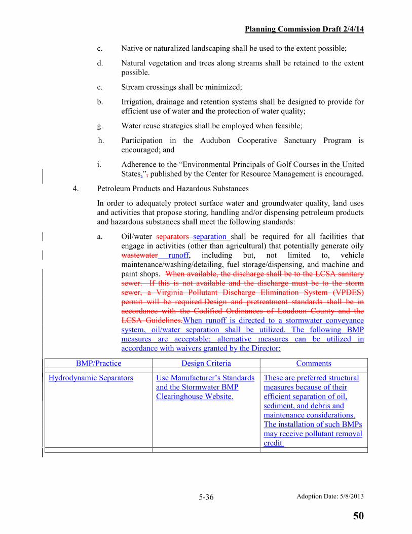
Planning Commission Draft 2/4/14
Adoption Date: 5/8/2013 5-36
c. Native or naturalized landscaping shall be used to the extent possible;
d. Natural vegetation and trees along streams shall be retained to the extent possible.
e. Stream crossings shall be minimized;
b. Irrigation, drainage and retention systems shall be designed to provide for efficient use of water and the protection of water quality;
g. Water reuse strategies shall be employed when feasible;
h. Participation in the Audubon Cooperative Sanctuary Program is encouraged; and
i. Adherence to the “Environmental Principals of Golf Courses in the United States,”, published by the Center for Resource Management is encouraged.
4. Petroleum Products and Hazardous Substances
In order to adequately protect surface water and groundwater quality, land uses and activities that propose storing, handling and/or dispensing petroleum products and hazardous substances shall meet the following standards:
a. Oil/water separators separation shall be required for all facilities that engage in activities (other than agricultural) that potentially generate oily wastewater runoff, including but, not limited to, vehicle maintenance/washing/detailing, fuel storage/dispensing, and machine and paint shops. When available, the discharge shall be to the LCSA sanitary sewer. If this is not available and the discharge must be to the storm sewer, a Virginia Pollutant Discharge Elimination System (VPDES) permit will be required.Design and pretreatment standards shall be in accordance with the Codified Ordinances of Loudoun County and the LCSA Guidelines.When runoff is directed to a stormwater conveyance system, oil/water separation shall be utilized. The following BMP measures are acceptable; alternative measures can be utilized in accordance with waivers granted by the Director:
BMP/Practice Design Criteria Comments Hydrodynamic Separators Use Manufacturer’s Standards
and the Stormwater BMP Clearinghouse Website.
These are preferred structural measures because of their efficient separation of oil, sediment, and debris and maintenance considerations. The installation of such BMPs may receive pollutant removal credit.
50

Planning Commission Draft 2/4/14
Adoption Date: 5/8/2013 5-37
BMP/Practice Design Criteria Comments Traditional 3-Chamber Gravity Separators
Provide a total minimum wet storage volume of 400 cubic feet per acre. Stokes Law shall be used to design the oil separation chamber. Maximum 1-acre drainage area.
Maintenance intensive. No pollutant removal credit shall be received as literature shows poor performance with pollutants other than oil waste.
Coalescing Plate Separators Design shall be based upon efficiency of the plate or plate system and Stokes Law.
Same as Traditional 3-Chamber Gravity Separator.
Water Quality (dry) Swale or Bioretention Filter (both with Underdrains)
Reference the Stormwater BMP Clearinghouse. Provide impermeable fabric on the bottom of facility to prevent groundwater contamination.
Use only with less intense hotspot uses such as vehicle storage (without maintenance facility or fueling operations). The installation of such BMPs may receive pollutant removal credit. Maintenance requirements are low to moderate.
b. Secondary containment shall be required for activities that propose storing, handling and/or dispensing of petroleum products (except for liquefied petroleum gas) and hazardous substances. The secondary containment shall be designed to provide a means of detecting material loss from the primary container; sufficient/compatible containment of the loss; retrieving the loss; and correcting the deficiency. For groups of tanks/containers, the secondary containment must be able to hold the contents of the largest container plus precipitation (if there is no roof). Temporary secondary containment shall be provided for construction sites that use petroleum products or hazardous substances.
c. For fuel tanks that contain petroleum products, a “double-walled” fuel tank with a fuel loss sensor is an acceptable method to provide secondary containment.
d. Dispensing of fuel and fuel storage related to emergency generators may be treated without the installation of a structural measure for oil/water separation. Due to the limited number of times per year that fuel
51

Planning Commission Draft 2/4/14
Adoption Date: 5/8/2013 5-38
dispensing will occur and the reduced chance for oil-laden runoff from the operation to reach stormwater conveyance systems, the following items are acceptable alternatives:
i. Use of a double-walled fuel tank with loss sensor or traditional secondary containment described above in Section 5.230.C.4.b.; and,
ii. Placement of a hydrocarbon-type spill kit adjacent to the fuel tank and generator installation; and,
iii. Inclusion of an inspection and maintenance narrative in the site notes as part of the water quality narrative in the associated development plan. The narrative shall portray a regular schedule of inspections and clean-up of oil slicks and/or oily sludge that could build up over time.
ce. The applicant shall provide evidence that an approved Emergency Response Plan has been filed with and approved by the Loudoun County Department of Fire and Rescue Services.
5. Discharge from Chemically Treated Pools, Fountains, and Similar Water Features
a. Prior to discharge to storm sewer or other manmade or natural stormwater conveyance systems, chemically treated water from pool draining and filtering operations shall be subject to the following:
i. Chlorine or bromine from draining operations or from backwash
filters shall be removed (e.g., dechorinated).
ii. Metallic-based algaecides shall be removed or neutralized.
b. Solids from filtering operations shall be removed from the discharge and stabilized so that they cannot enter the stormwater conveyance system.
c. Discharge from deck drains surrounding the pool or other water feature is not subject to subsections 5.a and 5.b above. However, it is recommended that deck drain discharge be allowed to flow across a vegetated area prior to entering a stormwater conveyance system.
5.400 FLOODPLAINS
A. Definitions:
1. Base Flood: The flood having a one (1) percent chance of being equaled or exceeded in any given year. Also known as the 100-year flood.
52
Planning Commission Draft 2/4/14
Adoption Date: 5/8/2013 5-39
2. Floodplain: Any land area susceptible to being inundated by water from the base flood and having a drainage area greater than one hundred (100) acres. For the purposes of this chapter, a distinction is made between floodplains in watersheds of greater than 640 acres (major floodplain), and those in watersheds of 640 acres or less (minor floodplain). In areas where a major floodplain overlaps a minor floodplain, the regulatory floodplain limits (major and minor) shall be established as the maximum computed or published floodwater elevation for any given point along the channel. The boundary line between the major and the minor floodplain may be defined as either: the intersection of the County approved backwater profile of the base stream and the County approved headwater profile for the tributary stream, or, where a detailed study of the tributary has not been performed, the boundary as shown on the Floodplain Map of Loudoun County.
3. Alteration: A development action which will change the cross section of the
floodplain and will increase either the erosive velocity or height of floodwaters either on-site or off-site. Alterations include, but are not limited to, land disturbing activities such as clearing, grading, excavating, transportation improvements and filling of land.
4. Cross section: Shape and dimensions of a channel and valley of the floodplain
perpendicular to the line of flow. B. The following types of floodplain applications are used within the land development
process and should be submitted to the Director. Refer to Chapter 8 of this manual for the specific requirements of each application type.
1. Floodplain Study Waiver shall be submitted prior to or concurrent with
submission of construction plans and profiles or site plan application. 2. Detailed Floodplain Study shall be submitted prior to or concurrent with
submission of construction plans and profiles or site plan application. 3. Floodplain Alteration, Type I shall be submitted and approved prior to issuance of
a Zoning Permit. 4. Floodplain Alteration, Type II shall require review and approval prior to the
approval of an associated construction plans and profiles or site plan application. C. Floodplain Mapping 1. The County floodplain maps shall be updated upon the presentation of appropriate
topographic information. This information shall be in a form acceptable to the County to facilitate a map update.
2. Loudoun County is a participating community in the Federal Emergency
Management Agency's (FEMA) National Flood Insurance Program (NFIP). As such, the County is required to coordinate the submission of more detailed technical information to FEMA for periodic updates of the Flood Insurance Rate
53

Planning Commission Draft 2/4/14
Adoption Date: 5/8/2013 5-40
Maps. A FEMA revision shall be required in accordance with the current Federal Emergency Management Agency "National Flood Insurance Program and Related Regulations". A FEMA map revision will be required when a Floodplain Study or Alteration affects the FEMA-defined Special Flood Hazard Area (SFHA).
3. The submission of such information to FEMA shall be required prior to approval
of the floodplain study or alteration, when appropriate. FEMA must approve the Letter of Map Revision (LOMR) prior to bond release for the related construction plans and profiles or site plan application.
5.410 FLOODPLAIN STUDY WAIVER A Floodplain Study Waiver request may be filed with the Director primarily for subdivisions of land zoned AR-1, AR-2, A-3, A-10, JLMA-20, and TR-10 provided road crossings or other encroachments of floodplains are not proposed. Waivers may also be granted in other Zoning Districts for projects which do not propose crossings or encroachments in the floodplain and where existing floodplain information reflects ultimate development conditions. 5.420 DETAILED FLOODPLAIN STUDIES Detailed floodplain studies performed to meet the requirements of the floodplain overlay district within the Loudoun County Zoning Ordinance Zoning Ordinance shall be required for review and approval concurrent with the associated construction plans and profiles or site plan application and shall include information required in Chapter 8 of this manual. The study shall be prepared in accordance with the following requirements: A. General 1. Detailed floodplain studies shall be based on the runoff from a 24-hour 100-year
rainfall depth. Flows will be determined utilizing methods discussed in this chapter.
2. If the floodplain study is located within the FEMA-defined SFHA, it must be
based on either the runoff from a 100-year rainfall depth as described in this chapter or the regulatory FEMA flow rate, whichever is larger.
3. Water-surface elevations should be determined by the standard step method.
HEC-2 and HEC-RAS models are acceptable. Alternative methodologies must include a description of the method assumptions, limitations, and a program users manual. Alternative methodologies must be approved by the Director prior to use.
4. Model input parameters will be determined based on physical properties of the
watershed and stream valley using good engineering judgment and are subject to the Director's approval. Input parameters shall include the starting water-surface elevation determined by either the normal depth (slope area method), a known water-surface elevation, or by other approximation methods acceptable to the
54

Planning Commission Draft 2/4/14
Adoption Date: 5/8/2013 5-41
Director and roughness coefficients to reflect channel and overbank conditions. 5. If a FEMA Flood Insurance Rate Map revision is required, then the model must
be acceptable to FEMA. B. Cross-Section Selection and Location 1. Location of cross-sections shall be selected based on two (2) foot contour interval
topography and any existing and/or proposed channel improvements and road crossings. Cross-sections are needed at floodplain contractions, expansions, sharp changes in invert slope, and where abrupt changes in channel roughness occur.
2. Cross-sections should be as nearly perpendicular to floodplain flow as possible
and should be identified using a topographic survey. The base line should be located as closely as possible to the center of the major conveyance area. Distances along the base line between sections should not exceed 300 feet. Location of cross-sections is subject to Director's approval.
C. If the floodplain study is being prepared for a particular site or property, the detailed
floodplain study shall extend a minimum of 300 feet upstream and downstream from the particular site or property. The floodplain study prepared shall be shown to be compatible with other floodplain studies within 1000 feet along the affected stream of the study area.
5.430 DETAILED FLOODPLAIN STUDIES CONDUCTED WITHIN THE BROAD RUN
WATERSHED The flow values and water surface elevation from "The Floodplain Study of the Broad Run Watershed" shall be used as the regulatory floodplain from the main stem of Broad Run. The main stem starts at the Potomac River and runs to the confluence with the North and South Fork of Broad Run. Floodplain studies for the tributaries to Broad Run shall use ultimate development conditions and include standard requirements for detailed floodplain studies. The following additional requirements also apply so that the study may be compared to "The Floodplain Study of the Broad Run Watershed". A. Hydrology 1. The 100-year flow values used to define the regulatory floodplain along the main
channel of Broad Run shall be taken from "The Floodplain Study of the Broad Run Watershed".
2. The 100-year flow values to be used for the tributaries to Broad Run shall be
generated from a detailed hydrologic analysis subject to the following requirements:
a. The land use assumptions and hydrologic parameters shall be based on the
planned land use depicted in the Comprehensive Plan or the current
55

Planning Commission Draft 2/4/14
Adoption Date: 5/8/2013 5-42
zoning for the watershed, whichever represents the most intense use. b. The flow shall be calculated utilizing either the Natural Resources
Conservation Service TR-20 model or the Corps of Engineers HEC-HMS or HEC-1 model. TR-55 will be considered with prior approval from the Director.
c. The hydrologic cross section locations and subbasin delineations shall be
derived from the Broad Run watershed maps. Additional routing sections, reservoir routings, or subbasin delineation may be included as necessary. HEC-1 models shall utilize modified subbasin delineations which have times of concentration values in compliance with T < 0.29 lag time criteria.
d. The hydrologic analysis shall begin with an original subbasin outfall and
shall be numbered in accordance with the numbering system used in "The Floodplain Study of the Broad Run Watershed".
B. Hydraulics 1. Land Development applications which contain floodplain associated with the
main stem of Broad Run and which have a hydraulic cross section located within the construction limits of the project shall include the following information. This information will replace the floodplain study requirement outlined in this Section. This information will be required concurrent with a Construction Plan and Profile application or a final site plan application.
a. Hydraulic cross sections used in "The Floodplain Study of the Broad Run
Watershed" shall be verified with updated 2-foot contour interval topography or field surveyed information. The methods of verification shall be provided. Additional cross sections may be required by the Director as determined by site specific channel characteristics.
b. The Mannings "n" values as used in the HEC-2 study shall be verified.
Methods of verification shall be included in the report. c. The land development application shall include cross sections which
would show both the regulatory floodplain elevation, the flood protection elevation, and the ground elevation.
d. The land development application shall include a plan view of the area
with cross sections denoting the flood protection elevations. 2. Floodplain Studies for the tributaries to Broad Run shall use the fundamental
hydraulic requirements outlined in this chapter and incorporate the following requirements:
a. The hydraulic cross section locations will correspond to the cross section
56

Planning Commission Draft 2/4/14
Adoption Date: 5/8/2013 5-43
locations used in "The Floodplain Study of the Broad Run Watershed". Additional cross sections shall be provided every 300 feet or as necessary to accurately reflect conveyance conditions in the channel and overbank areas. All cross sections shall be derived from 2-foot contour interval topography or field surveyed information.
b. The starting water-surface elevations will be the "ultimate scenario"
elevations at the confluence of the tributary with the main stem if the area of study is within 1000 feet of the main stem. If the study is over 1000 feet from the confluence, the water surface elevation at an existing Broad Run cross-section will be used. If the study is over 1,000 feet from the nearest existing Broad Run cross-section, an approved elevation from another study or a method accepted by the Corps of Engineers may be used.
c. Hydraulic studies shall begin and end with cross section locations shown
in "The Floodplain Study of the Broad Run Watershed". d. The hydraulic study shall extend 300 feet off-site or tie into a previously
approved study or alteration within 1000 feet. 5.440 CONSTRUCTION ACTIVITY IN FLOODPLAINS Any proposed construction activity in either a major or minor floodplain shall require approval of a Declaration of No Significant Impact to Floodplain, Floodplain Alteration Waiver, or Floodplain Alteration. 5.441 DECLARATION OF NO SIGNIFICANT IMPACT TO FLOODPLAIN For the specific construction activities listed below that do not involve offsite construction nor impacts to flooding on offsite property, a “Declaration of No Impact to Floodplain” narrative may be submitted in lieu of obtaining a Floodplain Alteration or Floodplain Alteration wWaiver. Such a narrative shall be included in the general notes of the companion Site plan or Construction Plans and Profiles and describe the work within the floodplain. Further, the narrative will provide certification that the construction activity within the floodplain will not impact offsite property and will have at most a negligible impact on floodplain limits, channel configuration, and water-surface elevations.
A. Installation of underground utilities that will return the ground to its existing (i.e.,
predevelopment) grade. B. Storm drainage outfall channels. C. Clearing activities that do not involve changes to the existing grade. D. Excavation activities where the excavated material is removed in its entirety from the
floodplain.
57

Planning Commission Draft 2/4/14
Adoption Date: 5/8/2013 5-44
5.442 FLOODPLAIN ALTERATION WAIVER A floodplain alteration waiver request may be filed with the Director for minor encroachments and alterations of major and minor floodplains, which shall include minor alterations to previously approved Floodplain Alteration applications. Such a request shall include a statement of the proposed development project, justification of the waiver requested, and treatment of the floodplain area. The waiver request shall be accompanied with a 1:2400 (1"=200') scale concept plan of the proposed site development and alteration. The applicant must show that the proposed alteration will have a negligible impact on the floodplain limits, channel configuration, and water surface elevation. Clearing and grading within the floodplain shall be kept to a minimum and shall not be proposed within the main channel of the stream. 5.443 FLOODPLAIN ALTERATIONS Floodplain alteration applications shall contain information sufficient to demonstrate conformance with the Loudoun County Zoning OrdinanceZoning Ordinance. Floodplain alteration analysis requirements are divided into Type I and Type II depending on land use and complexity of the proposed alteration. The analysis will extend upstream and downstream to the point where the floodplain limits are restored to the original conditions. A. Type I Alterations A Type I floodplain alteration may be submitted separately or as a part of a construction
plan and profile application for private driveways serving one residential lot and private access easements as provided for by the Land Subdivision and Development Ordinance Land Subdivision and Development Ordinance. Type I floodplain alteration applications must propose floodplain crossings that conform to the following design standards and must contain the following information:
1. Option 1:
This option shall be used for single lot driveways or private access easements
serving up to 2 lots and shall be shown on a sketch plan submitted prior to or concurrent with the zoning permit application. The sketch plan shall illustrate the proposed crossing, the dimensions of the proposed culvert or bridge structure and the proposed location. This sketch plan shall be reviewed, revised by the applicant if required and approved by the Director prior to the issuance of the zoning permit to ensure that there will be no off-site degradation as a result of the floodplain encroachment. The sketch plan shall clearly indicate that the alteration will not impact off-site properties. If the sketch plan indicates the alteration may impact off-site properties, the County will require additional information prior to approval.
2. Option 2:
58
Planning Commission Draft 2/4/14
Adoption Date: 5/8/2013 5-45
This option may be used for private access easements which serve 3 to 7
individual lots. Sufficient documentation shall be submitted as part of or concurrent with the construction plan application to ensure that the crossing conveys channel flow and provides overland relief for the 100-year storm along the approaches to the crossing.
a. The design shall be configured to convey the 2-year storm or bank full
conditions without overtopping the access road. b. The profile of the crossing must be such that there is overland relief for the
100-year storm with minimal obstruction. No rise in flood elevations because of the crossing will be allowed beyond the limits of the applicant's property.
c. All culverts used will conform to this chapter. A minimum of 2 feet of
cover is required over all culverts. d. Culvert designs and computations shall be in accordance with the VDOT
Drainage Manual. e. Where it is evident that there are no alternative driveway locations for a
particular lot, the construction plans shall include the proposed and engineered driveway location and corresponding culvert computations.
Proposed designs for crossings shall be evaluated by the Director to determine if more detailed engineering is necessary to ensure that there is no potential damage to neighboring property in any direction due to backwater or increased channel velocity. If more engineering detail is necessary, a Type II alteration shall be required.
The Director may consider alternatives to the above requirements (i.e., low-flow
crossings) if desired by the applicant. In such cases, however, the record plat shall provide a note disclosing the flooding potential of the access easement.
B. Type II Alterations Type II floodplain alteration applications must be submitted for any alteration which has
a significant impact on channel configuration, water surface elevations, and/or floodplain limits and all other cases not included in A above.
The Type II floodplain alteration will conform with the requirements in Detailed Floodplain Studies, and will be based on an approved detailed floodplain study. Refer to Chapter 8 of this manual for detailed requirements associated with the Type II floodplain alteration studies.
59

Planning Commission Draft 2/4/14
Adoption Date: 5/8/2013 5-46
60

Planning Commission Draft 2/4/14
Adoption Date: 5/8/2013 5-47
61

Planning Commission Draft 2/4/14
Adoption Date: 5/8/2013 5-48
62

Planning Commission Draft 2/4/14
1
CHAPTER 1096 Stormwater Management 1096.01 Stormwater Management Program. 1096.02 Maintenance of the Stormwater Management System. 1096.03 Discharges to the Stormwater Management System. 1096.04 Enforcement.Violations. 1096.05 Hearings and Appeals 1096.06 Fees. 1096.07 Conflicts. CROSS REFERENCES
Use of sewers; building sewers and connections - see S.U. & P.S. Ch. 1064
1096.01 STORMWATER MANAGEMENT PROGRAM. (a) Purpose and Findings.
(1) The health, safety, and welfare of Loudoun County residents requires the design, development, improvement, operation, maintenance, and oversight of a system of man-made and natural components of stormwater management infrastructure to both limit and manage the volume of stormwater to control flood events and to prevent degradation of the County's waterways and erosion of the County's lands.
(1) The purpose of this Ordinance is to ensure the general health, safety, and welfare of the citizens of Loudoun County and protect the quality and quantity of state waters from the potential harm of unmanaged stormwater, including protection from a land disturbing activity causing unreasonable degradation of properties, water quality, stream channels, and other natural resources, and to establish procedures whereby stormwater requirements related to water quality and quantity shall be administered and enforced.
(2) Loudoun County is subject to Phase II of the Federal Clean Water Act's National Pollutant Discharge Elimination System (NPDES) permit program for stormwater discharges, administered by the Virginia Department of Environmental Quality through a General Virginia Pollutant Discharge Elimination System (VPDES) Permit Regulation for Discharges of Storm Water from Small Municipal Separate Storm Sewer Systems in the Commonwealth of Virginia (9VAC25-890-1 et seq.). In order to comply with VPDESVirginia Stormwater Management Program (VSMP) requirements, the County must develop a stormwater management program to reduce pollution from the stormwater drainage system to the maximum extent practicable.
(3) Properly functioning stormwater management infrastructure provides benefit to all properties within the County by directly protecting properties through control of flooding and standing water, and by reducing the impact of stormwater flows on the County's natural environment.
(4) The Loudoun County Board of Supervisors is authorized by state law to adopt a program for local stormwater management (Code of Virginia Sections 10.1-603.1 et seq.).
Attachment 8 63

Planning Commission Draft 2/4/14
2
(4) This ordinance is adopted pursuant to Section 62.1-44.15:24 et seq. of the Code of Virginia.
(b) Establishment of Stormwater Management Program.
(1) The stormwater management program of Loudoun County is hereby established. The program shall include the design, development, improvement, operation, inspection, maintenance, and oversight of the stormwater management system.
(2) For the purposes of this chapter, stormwater management system (also referred to as stormwater infrastructure) is defined in Section 1096.01(c).
(3) The stormwater management system shall be designed, developed, improved, operated, maintained and overseen in accordance with all applicable Federal, State, and local laws, statutes, ordinances, regulations and policies. Applicable local ordinances, regulations and policies include, but are not limited to, the County Zoning Ordinance, Land Subdivision and Development Ordinance, the Facilities Standards Manual, The Virginia Erosion and Sediment Control Handbook, the drainage maintenance policies and programs of the County government, and all effective stormwater maintenance agreements.
(4) Administrative Authority. The Director shall be responsible for the administration and enforcement of this chapter.
(5) Right of Entry. The Director may, with proper identification enter, at reasonable times, upon public or private property for the purposes of inspecting and investigating conditions relating to the enforcement of this chapter, but only after obtaining consent of the owner or occupant of the private property to be inspected, which owner or occupant has the authority, under law, to authorize such entry and inspection.
(6) Inspection Warrant. A. If such consent is not obtained, for any reason, including the inability to
contact or locate the person with the authority to authorize such inspection, the Director shall obtain, from a County magistrate or judge, a warrant authorizing such entry, inspection or investigation upon such private property upon a showing of probable cause, supported by an affidavit, particularly describing the place, thing or person to be inspected or investigated, and the purpose for which the inspection or investigation is to be made. Probable cause shall be deemed to exist either if reasonable administrative standards for conducting such inspection or investigation are satisfied, with respect to the particular place, thing or person, or if there exists probable cause to believe that there is a condition, object, activity or circumstance which legally justifies such inspection or investigation. The supporting affidavit shall contain either a statement that consent to inspect or investigate has been sought and refused or not received or a description of the circumstances reasonably justifying the failure to seek such consent in order to effectively enforce this chapter.
B. An inspection warrant shall be effective for the time specified therein, not to exceed ten days, unless extended or renewed by the judicial officer who signed and issued the original warrant, upon a showing that such extension or renewal is in the public interest. Such warrant shall be executed and returned to the judicial officer by whom it was issued within the time
64
Planning Commission Draft 2/4/14
3
specified in the warrant or within the extended or renewed time. After the expiration of such time, the warrant, unless executed, shall be void. An inspection pursuant to such warrant may not be made in the absence of the owner, custodian or possessor of the particular place, thing or person unless specifically authorized by the judicial officer upon a showing that such authority is reasonably necessary to effectuate the purpose of this chapter. An inspection pursuant to this warrant shall not be made by means of forcible entry except that the judicial officer may expressly authorize a forcible entry where facts are shown sufficient to create a reasonable suspicion of a violation of any of the provisions of this chapter which, if such violation existed, would be an immediate threat to health or safety, or where facts are shown establishing that reasonable attempts to serve a previous warrant have been unsuccessful. In the case of inspection of a dwelling, prior consent must be sought and refused unless the issuing judicial officer finds that failure to seek consent is justified and that there is a reasonable suspicion of an immediate threat to public health or safety.
C. Compliance with inspection warrants. No person shall willfully refuse to permit an inspection lawfully authorized by a warrant issued pursuant to this chapter.
(b) Administration
(1) Administrator Defined. “Administrator” means the VSMP Authority responsible
for administering the VSMP on behalf of Loudoun County.
A. For the purposes of the administration of this Ordinance, the Director of the Department of Building and Development, or their designee, shall be considered to be the Administrator of Section 1096.01(d) et seq., and any enforcement thereof or any hearings or appeals taken pursuant thereto.
B. For the purposes of the administration of this Ordinance, the Director of the
Department of General Services, or their designee, shall be considered to be the Administrator of Section 1096.02 et seq. and 1096.03 et seq., and any enforcement thereof or any hearings or appeals taken pursuant thereto.
(2) Towns. Any town lying within Loudoun County which does not operate
Municipal Separate Storm Sewer System Program (MS-4) may adopt its own stormwater management program or shall become subject to the County program.
(3) Amendments. Any amendments to this Ordinance shall require the concurrence
of both the Director of the Department of Building and Development and the Director of General Services, or their respective designees.
(c) Definitions. As used in this chapter: In addition to the definitions set forth in
9VAC25-870-10 of the Virginia Stormwater Management (VSMP) Regulations, as amended, which are expressly adopted and incorporated herein by reference, the
65

Planning Commission Draft 2/4/14
4
following words and terms used in this Ordinance have the following meanings unless otherwise specified herein.
"Applicant" means any person submitting an application for a permit or requesting issuance of a permit under this Ordinance. “Best management practice" or "BMP" means schedules of activities, prohibitions of practices, including both structural and nonstructural practices, maintenance procedures, and other management practices to prevent or reduce the pollution of surface waters and groundwater systems from the impacts of land-disturbing activities. “Common plan of development or sale” means a contiguous area where separate and distinct construction activities may be taking place at different times on difference schedules. "Control measure" means any best management practice or stormwater facility, or other method used to minimize the discharge of pollutants to state waters.
"Clean Water Act” or “CWA" means the federal Clean Water Act (33 U.S.C §1251 et seq.), formerly referred to as the Federal Water Pollution Control Act or Federal Water Pollution Control Act Amendments of 1972, Public Law 92-500, as amended by Public Law 95-217, Public Law 95-576, Public Law 96-483, and Public Law 97-117, or any subsequent revisions thereto. "Department" means the Department of Environmental Quality. "Development" means land disturbance and the resulting landform associated with the construction of residential, commercial, industrial, institutional, recreation, transportation or utility facilities or structures or the clearing of land for non-agricultural or non-silvicultural purposes. (1) “Director” means the Director of the Department of General Services or his
designee. (2) "Discharge," when used without qualification, means the discharge of a pollutant.“Discharge” means to dispose, deposit, spill, pour, inject, dump, leak or place by any means, or that which is disposed, deposited, spilled, poured, injected, dumped, leaked or placed by any means. (3) “Dulles Greenway” means the private toll road and rights-of-way comprising a 14-mile extension of the Dulles Toll Road, connecting Washington Dulles International Airport with Leesburg, Virginia. (4) “Facilities Standards Manual”, or FSM, means the Loudoun County Facilities Standards Manual, as amended. "General Permit" means the state permit found in 9VAC25-880-70, General Permit
66

Planning Commission Draft 2/4/14
5
for Discharges of Stormwater from Construction Activities, authorizing a category of discharges under the CWA and the Act within a geographical area of the Commonwealth of Virginia. (5) "Illicit discharge" means any discharge to a municipal separate storm sewer that is not composed entirely of stormwater, except discharges pursuant to a separate VPDES or state permit (other than the state permit for discharges from the municipal separate storm sewer), discharges resulting from fire fighting activities, and discharges identified by and in compliance with 9VAC25-870-400 D.2.c.(3). “Illicit discharge” means any discharge to the stormwater management system that is not composed entirely of stormwater, except discharges pursuant to either a VPDES permit or discharges resulting from fire fighting activities. This definition shall not include the discharges listed in Section 1096.03(a)(2) unless the County identifies such discharges as sources of pollutants to waters of the Commonwealth of Virginia. (6) “Industrial discharge” means discharges from any conveyance that is used for collecting and conveying stormwater and which are directly related to industrial uses as defined by the General Virginia Pollutant Discharge Elimination System Permit for Discharges of Storm Water Associated with Industrial Activity (9 VAC 25-151-10 et seq.). "Land disturbance" or "land-disturbing activity" means a man-made change to the land surface that potentially changes its runoff characteristics including clearing, grading, or excavation except that the term shall not include those exemptions specified in Section 1096.01(d)(2)B of this Ordinance. “Layout” means a conceptual drawing sufficient to provide for the specified stormwater management facilities required at the time of approval. "Minor modification" means an amendment to an existing general permit before its expiration not requiring extensive review and evaluation including, but not limited to, changes in EPA promulgated test protocols, increasing monitoring frequency requirements, changes in sampling locations, and changes to compliance dates within the overall compliance schedules. A minor general permit modification or amendment does not substantially alter general permit conditions, substantially increase or decrease the amount of surface water impacts, increase the size of the operation, or reduce the capacity of the facility to protect human health or the environment. "Operator" means the owner or operator of any facility or activity subject to regulation under this Ordinance. “Part II C technical criteria” means the technical criteria in 9VAC25-870-93 through 9VAC25-870-99. "Permit" or "VSMP Authority Permit" means an approval to conduct a land-disturbing activity issued by the Administrator for the initiation of a land-disturbing activity, in accordance with this Ordinance, and which may only be issued after evidence of
67

Planning Commission Draft 2/4/14
6
general permit coverage has been provided by the Department. "Permittee" means the person to whom the VSMP Authority Permit is issued. (7) “Person” means any individual, firm, corporation, partnership, association,
organization or other entity, including governmental entities, or any combination thereof.
"Person" means any individual, corporation, partnership, association, state, municipality, commission, or political subdivision of a state, governmental body, including federal, state, or local entity as applicable, any interstate body or any other legal entity. "Regulations" means the Virginia Stormwater Management Program (VSMP) Regulations (9VAC25-870-10 et seq.), as amended. "Site" means the land or water area where any facility or land-disturbing activity is physically located or conducted, including adjacent land used or preserved in connection with the facility or land-disturbing activity. "State" means the Commonwealth of Virginia. "State Board" means the State Water Control Board. "State permit" means an approval to conduct a land-disturbing activity issued by the State Board in the form of a state stormwater individual permit or coverage issued under a state general permit or an approval issued by the State Board for stormwater discharges from an MS4. Under these state permits, the Commonwealth imposes and enforces requirements pursuant to the federal CWA and regulations, the Virginia Stormwater Management Act, and the Regulations. "State Water Control Law" means Chapter 3.1 (§62.1-44.2 et seq.) of Title 62.1 of the Code of Virginia. "State waters" means all water, on the surface and under the ground, wholly or partially within or bordering the Commonwealth or within its jurisdiction, including wetlands.
(8) “Stormwater” means runoff from rain, snow or other forms of precipitation and
surface runoff and drainage. "Stormwater" means precipitation that is discharged across the land surface or through conveyances to one or more waterways and that may include stormwater runoff, snow melt runoff, and surface runoff and drainage. “Stormwater hotspot” or “hotspot” means an area where the land use or activities (e.g., gas station, chemical storage facility, industrial facility, etc.) are considered to generate runoff with concentrations of pollutants in excess of those typically found in normal stormwater or have a higher risk of spills, leaks, or illicit dischargers. Specific
68
Planning Commission Draft 2/4/14
7
stormwater hotspots, and their associated treatment options, are provided in the Facilities Standards Manual. (9) “Stormwater maintenance agreement” means an agreement between a private property owner and the County that establishes mutual responsibilities for maintenance of the stormwater management infrastructure where such infrastructure has uses in addition to stormwater management. "Stormwater management plan" means a document(s) containing material describing methods for complying with the requirements of Section 1096.01(d)(4) of this Ordinance. (10) “Stormwater management system” means, for purposes of this chapterOrdinance, the series of structural and non-structural stormwater infrastructure established to manage stormwater runoff and drainage. The stormwater management system includes, but is not limited to the following facilities and equipment, storm drains, storm sewers, catch-basins, drop inlets, pipes, open channels and ditches, dry detention facilities, wet detention facilities, and bioretentionbio-retention facilities. (11) “Stormwater Pollution Prevention Plan” means a plan consisting of steps and
activities designed to identify potential sources of stormwater pollution or contamination; and, establishing practices that will prevent or reduce pollutants in stormwater runoff.
"Stormwater Pollution Prevention Plan" or "SWPPP" means a document that is prepared in accordance with good engineering practices and that identifies potential sources of pollutants that may reasonably be expected to affect the quality of stormwater discharges from the construction site, and otherwise meets the requirements of this Ordinance. A SWPPP required under a VSMP for construction activities shall identify and require the implementation of control measures, and shall include, but not be limited to the inclusion of, or the incorporation by reference of an approved erosion and sediment control plan, an approved stormwater management plan, and a pollution prevention plan. "Subdivision" means the same as defined in Section 1240.05 of the Loudoun County Land Subdivision and Development Ordinance. "Total maximum daily load" or "TMDL" means the sum of the individual wasteload allocations for point sources, load allocations for nonpoint sources, natural background loading and a margin of safety. TMDLs can be expressed in terms of either mass per time, toxicity, or other appropriate measure. The TMDL process provides for point versus nonpoint source trade-offs. (12) “Virginia Erosion and Sediment Control Handbook” means the technical guide published by the Virginia Department of Conservation and Recreation, Division of Soil and Water Conservation to meet the requirements of the Virginia Erosion and Sediment Law (Code of Virginia Sections 62.1-44.15:51 10.1-560 et seq.).
69

Planning Commission Draft 2/4/14
8
"Virginia Stormwater Management Act" or "Act" means Section 62.1-44.15:24 et seq. of the Code of Virginia. “Virginia Stormwater BMP Clearinghouse website” means a website that contains detailed design standards and specifications for control measures that may be used in Virginia to comply with the requirements of the Virginia Stormwater Management Act and associated regulations. “Virginia Stormwater Management Program” or “VSMP” means a program approved by the State Board after September 13, 2011, that has been established by a locality to manage the quality and quantity of runoff resulting from land-disturbing activities and shall include such items as local ordinances, rules, permit requirements, annual standards and specifications, policies and guidelines, technical materials, and requirements for plan review, inspection, enforcement, where authorized in this article, and evaluation consistent with the requirements of this article and associated regulations. "Virginia Stormwater Management Program Authority" or "VSMP Authority" means an authority approved by the State Board after September 13, 2011, to operate a Virginia Stormwater Management Program.
(d) Virginia Stormwater Management Program (VSMP) Established
(1) Pursuant to Section 62.1-44.15:24 et seq. of the Code of Virginia, Loudoun County hereby establishes a Virginia Stormwater Management Program for land-disturbing activities and adopts the applicable Regulations that specify standards and specifications for VSMPs promulgated by the State Board for the purposes set out in Section 1096.01(a) of this Ordinance.
(2) Virginia Stormwater Management Program (VSMP) Authority Permit
A. Except as provided herein, no person may engage in any land-disturbing activity, and no grading, building or other local permit shall be issued for a property, unless and until a VSMP Authority Permit has been issued by the Administrator in accordance with the provisions of this Ordinance.
B. Exemptions
Notwithstanding any other provisions of this Ordinance, the following activities are exempt from VSMP Authority Permit requirements, unless otherwise required by federal law:
1. Permitted surface or deep mining operations and projects, or oil and
gas operations and projects conducted under the provisions of Title 45.1 of the Code of Virginia;
2. Clearing of lands specifically for agricultural purposes and the
70

Planning Commission Draft 2/4/14
9
management, tilling, planting, or harvesting of agricultural, horticultural, or forest crops, livestock feedlot operations, or as additionally set forth by the State Board in regulations, including engineering operations as follows: construction of terraces, terrace outlets, check dams, desilting basins, dikes, ponds, ditches, strip cropping, lister furrowing, contour cultivating, contour furrowing, land drainage, and land irrigation; however, this exception shall not apply to harvesting of forest crops unless the area on which harvesting occurs is reforested artificially or naturally in accordance with the provisions of Chapter 11 (§ 10.1-1100 et seq.) of Title 10.1 of the Code of Virginia or is converted to bona fide agricultural or improved pasture use as described in Subsection B of § 10.1-1163 of Article 9 of Chapter 11 of Title 10.1 of the Code of Virginia;
3. Single-family residences separately built and disturbing less than one
acre and not part of a larger common plan of development or sale, including additions or modifications to existing single-family detached residential structures;
4. Land disturbing activities that disturb less than one acre of land area
except for activities that are part of a larger common plan of development or sale that is one acre or greater of disturbance;
5. Discharges to a sanitary sewer;
6. Activities under a State or federal reclamation program to return an
abandoned property to an agricultural or open land use;
7. Routine maintenance that is performed to maintain the original line and grade, hydraulic capacity, or original construction of the project. The paving of an existing road with a compacted or impervious surface and reestablishment of existing associated ditches and shoulders shall be deemed routine maintenance if performed in accordance with this Subsection; and
8. Conducting land-disturbing activities in response to a public
emergency where the related work requires immediate authorization to avoid imminent endangerment to human health or the environment. In such situations, the Administrator shall be advised of the disturbance within seven days of commencing the land-disturbing activity and compliance with the administrative requirements of 1096.01(d)(2)A is required within 30 days of commencing the land-disturbing activity.
C. Virginia Stormwater Management Program (VSMP) General Permit
Requirements:
71

Planning Commission Draft 2/4/14
10
1. Prior to the submission of a VSMP General Permit registration statement, a Stormwater Pollution Prevention Plan (SWPPP) shall be prepared.
D. Virginia Stormwater Management Program (VSMP) Authority Permit
Requirements:
1. No VSMP Authority Permit shall be issued by the Administrator, unless and/or until:
(i) A VSMP Authority Permit application, that includes a VSMP
General Permit registration statement, has been submitted to and approved by the Administrator;
(ii) An erosion and sediment control plan prepared in accordance with
Chapter 1220 of the Codified Ordinances of Loudoun County has been submitted to and approved by the Administrator;
(iii) A stormwater management plan that meets the requirements of
Section 1096.01(d)(4)A of this Ordinance has been submitted to and approved by the Administrator, except for land disturbing activities previously covered under the General Permit for Discharges of Stormwater from Construction Activities issued July 1, 2009;
(iv) Evidence of VSMP General Permit coverage has been obtained; (v) All fees required pursuant to Section 1096.06 have been received,
the financial guarantee required by Chapter 1220 of the Codified Ordinances of Loudoun County has been approved, and the performance bond required pursuant to Chapter 8 of the FSM has been executed and filed; and
(vi) The VSMP Authority Permit application and attendant materials
and supporting documentation demonstrate that all land clearing, construction, disturbance, land development and drainage will be conducted in accordance with this Chapter.
(3) Stormwater Pollution Prevention Plan; Contents of Plans.
A. The SWPPP shall comply with the requirements and general information
set forth in Section 9VAC25-870-54 and Section 9VAC25-880-70, and shall include an approved Stormwater Management Plan, an approved Erosion and Sediment Plan, and a Pollution Prevention Plan. In accordance with the FSM, the SWPPP must identify all “hotspot” uses and the BMP’s and strategies used to mitigate hotspot pollutants.
72

Planning Commission Draft 2/4/14
11
B. The SWPPP shall be amended by the operator whenever there is a change
in design, construction, operation, or maintenance that has a significant effect on the discharge of pollutants to state waters which is not addressed by the existing SWPPP.
C. The SWPPP must be maintained by the operator at a central location onsite.
If an onsite location is unavailable, notice of the SWPPP's location must be posted near the main entrance at the construction site. Operators shall make the SWPPP available for public review in accordance with Section II of the VSMP General Permit, either electronically or in hard copy.
(4) Stormwater Management Plan; Contents of Plan; Review of Plan.
A. The Stormwater Management Plan, required in Section 1096.01(d)(2)D.1.(iii) of this Ordinance, shall apply the stormwater management technical criteria set forth in Section 1096.01(d)(6)A of this Ordinance to the entire land-disturbing activity. Individual lots in new residential, commercial, or industrial developments shall not be considered separate land-disturbing activities. The Stormwater Management Plan shall also, consider all sources of surface runoff and all sources of subsurface and groundwater flows converted to subsurface runoff. The Stormwater Management Plan shall include the following information:
1. Information on the type and location of stormwater discharges;
information on the features to which stormwater is being discharged including surface waters or karst features, if present, and the pre-development and post-development drainage areas;
2. Contact information including the name, address, and telephone
number of the owner and the tax reference number and parcel number of the property or properties affected;
3. A narrative that includes a description of current site conditions and
final site conditions;
4. A general description of the proposed stormwater management facilities and the mechanism through which the facilities will be operated and maintained after construction is complete;
5. Information on the proposed stormwater management facilities,
including:
(i) The type of facilities; (ii) Location, including geographic coordinates; (iii) Acres treated; and
73

Planning Commission Draft 2/4/14
12
(iv) The surface waters or karst features, if present, into which the facility will discharge.
6. Hydrologic and hydraulic computations, including runoff
characteristics;
7. Documentation and calculations verifying compliance with the water quality and quantity requirements of Section 1096.01(d)(6)A of this Ordinance and the FSM.
8. A map or maps of the site that depicts the topography of the site and
includes:
(i) Delineation of all contributing drainage areas with drainage divides and a label denoting the surface area;
(ii) Existing streams, ponds, culverts, ditches, wetlands, other water bodies, and floodplains;
(iii) Soil types, geologic formations if karst features are present in the area, forest cover, and other vegetative areas;
(iv) Current land use including existing structures, roads, and locations of known utilities and easements;
(v) Sufficient information on adjoining parcels to assess the impacts of stormwater from the site on these parcels;
(vi) The limits of clearing and grading, and the proposed drainage patterns on the site;
(vii) Proposed buildings, roads, parking areas, utilities, and stormwater management facilities;
(viii)Proposed land use with tabulation of the percentage of surface area to be adapted to various uses, including but not limited to planned locations of utilities, roads, open space, and easements;
(ix) Percentage of site pervious and impervious area; and (x) Total disturbed acreage for the site.
B. If an operator intends to meet the water quality and/or quantity
requirements set forth in Section 1096.01(d)(6)A of this Ordinance through the use of off-site compliance options, where applicable, then a letter of availability from the off-site provider must be included. Approved off-site options must achieve the necessary nutrient reductions prior to the commencement of the applicant's land-disturbing activity except as otherwise allowed by § 62.1-44.15:35 of the Code of Virginia.
C. Elements of the stormwater management plans that include activities
regulated under Chapter 4 (§54.1-400 et seq.) of Title 54.1 of the Code of Virginia shall be appropriately sealed and signed by a professional registered in the Commonwealth of Virginia pursuant to Article 1 (§ 54.1-400 et seq.) of Chapter 4 of Title 54.1 of the Code of Virginia.
74
Planning Commission Draft 2/4/14
13
D. The Administrator shall review stormwater management plans and shall
approve or disapprove a stormwater management plan according to the following:
1. The Administrator shall determine the completeness of a plan in
accordance with Section 1096.01(d)(4) of this Ordinance, and shall notify the applicant, in writing, of such determination, within 15 calendar days of receipt. If the plan is deemed to be incomplete, the above written notification shall contain the reasons the plan is deemed incomplete.
2. The Administrator shall have an additional 60 calendar days from the
date of the communication of completeness to review the plan, except that if a determination of completeness is not made within the time prescribed in subdivision 1., then plan shall be deemed complete and the Administrator shall have 60 calendar days from the date of submission to review the plan.
3. The Administrator shall review any plan that has been previously
disapproved, within 45 calendar days of the date of resubmission.
4. During the review period, the plan shall be approved or disapproved and the decision communicated in writing to the person responsible for the land-disturbing activity or his designated agent. If the plan is not approved, the reasons for not approving the plan shall be provided in writing. Approval or denial shall be based on the plan's compliance with the requirements of this Ordinance.
5. If a plan meeting all requirements of this Ordinance is submitted and
no action is taken within the time provided above in subdivision (2) for review, the plan shall be deemed approved.
E. Approved stormwater plans may be modified as follows:
1. Modifications to an approved stormwater management plan shall be
allowed only after review and written approval by the Administrator. The Administrator shall have 60 calendar days to respond in writing either approving or disapproving such request.
2. The Administrator may require that an approved stormwater
management plan be amended, within a time prescribed by the Administrator, to address any deficiencies noted during inspection.
F. A construction record drawing or “as-built” for permanent stormwater
management facilities shall be submitted to the Administrator. The
75
Planning Commission Draft 2/4/14
14
construction record drawing shall be appropriately sealed and signed by a professional registered in the Commonwealth of Virginia, certifying that the stormwater management facilities have been constructed in accordance with the approved plan.
(5) Pollution Prevention Plan; Contents of Plans.
A. A Pollution Prevention Plan, required by 9VAC25-870-56, shall be developed, implemented, and updated as necessary and must detail the design, installation, implementation, and maintenance of effective pollution prevention measures to minimize the discharge of pollutants. At a minimum, such measures must be designed, installed, implemented, and maintained to:
1. Minimize the discharge of pollutants from equipment and vehicle
washing, wheel wash water, and other wash waters. Wash waters must be treated in a sediment basin or alternative control that provides equivalent or better treatment prior to discharge;
2. Minimize the exposure of building materials, building products,
construction wastes, trash, landscape materials, fertilizers, pesticides, herbicides, detergents, sanitary waste, and other materials present on the site to precipitation and to stormwater; and
3. Minimize the discharge of pollutants from spills and leaks and
implement chemical spill and leak prevention and response procedures.
B. The pollution prevention plan shall include effective best management
practices to prohibit the following discharges:
1. Wastewater from washout of concrete, unless managed by an appropriate control;
2. Wastewater from washout and cleanout of stucco, paint, form release
oils, curing compounds, and other construction materials; 3. Fuels, oils, or other pollutants used in vehicle and equipment operation
and maintenance; and 4. Soaps or solvents used in vehicle and equipment washing.
C. Discharges from dewatering activities, including discharges from
dewatering of trenches and excavations, are prohibited unless managed by appropriate controls.
(6) Technical Criteria for Regulated Land Disturbing Activities; Grandfathering;
76

Planning Commission Draft 2/4/14
15
Exceptions.
A. To protect the quality and quantity of state water from the potential harm of unmanaged stormwater runoff resulting from land-disturbing activities, Loudoun County adopts the technical criteria for regulated land-disturbing activities set forth in the Facilities Standards Manual. All land-disturbing activities regulated pursuant to this Ordinance that obtain a VSMP General Permit on or after July 1, 2014, shall be conducted in accordance with the Facilities Standards Manual, except as provided for in Subsection D. of this Section. These criteria shall address the minimum technical requirements of the Regulations (Part II B, 9VAC25-870-10 et seq.) by reference or inclusion and may include the following:
1. Additional supporting information, methodologies and guidance
related to the technical criteria; and
2. More stringent technical criteria enabled by this Ordinance.
B. The Administrator may allow the operator to use offsite options to meet phosphorus nutrient reductions as set forth in 9VAC25-870-69.A.
C. Notwithstanding subsection B., an operator shall be allowed to utilize
offsite options to meet phosphorus reductions as set forth in 9VAC25-870-69.B.
D. Technical Criteria – Grandfathering. [language based on revisions to
9VAC25-870-48 approved by the State Water Control Board on
December 17, 2013, and amendments discussed during the January 15,
2014, Facilities Standards Manual Public Review Committee Meeting,
subject to change until adoption by the Board of Supervisors]
1. Any land-disturbing activity shall be considered grandfathered by the Administrator and shall be subject to the Part II C technical criteria of this Ordinance provided:
(i) A proffered plan of development, Special Exception,
preliminary plat of subdivision, record plat, construction plans and profiles, site plan, or any document determined by the locality to be the equivalent thereto (i) was approved prior to July 1, 2012 (ii) provided a layout as defined in 9VAC25-870-10, (iii) will comply with the Part IIC technical criteria of this Ordinance, and (iv) has not been subsequently modified or amended in a manner resulting in an increase in the amount of phosphorus leaving each point of discharge, and such that there is no increase in the volume or rate of runoff;
(ii) A VSMP General Permit has not been issued prior to July 1,
77
Planning Commission Draft 2/4/14
16
2014; and (iii) Land disturbance did not commence prior to July 1, 2014.
2. Local, state, and federal projects shall be considered grandfathered by
the Administrator and shall be subject to the Part II C technical criteria of this Ordinance provided:
(i) There has been an obligation of local, state, or federal funding,
in whole or in part, prior to July 1, 2012, or (ii) The Department has approved a stormwater management plan
prior to July 1, 2012,
(iii) A VSMP General Permit has not been issued prior to July 1, 2014; and
(iv) Land disturbance did not commence prior to July 1, 2014
3. Land disturbing activities grandfathered under subsections 1 and 2,
shall remain subject to the Part II C technical criteria for one additional state permit cycle. After such time, portions of the project not under construction shall become subject to any new technical criteria adopted by the State Water Control Board.
4. In cases where governmental bonding or public debt financing has
been issued for a project prior to July 1, 2012, such project shall be subject to the technical requirements of the Part II C technical criteria.
5. Land disturbing activities that obtain a VSMP General Permit or
commence land disturbance prior to July 1, 2014 shall be conducted in accordance with the Part II C technical criteria. Such projects shall remain subject to the Part II C technical criteria for two additional state permit cycles. After such time, portions of the project not under construction shall become subject to any new technical criteria adopted by the State Water Control Board.
E. Technical Criteria – Exceptions.
1. The Administrator may grant exceptions to the technical requirements
of Section 1096.01(d)(6)A of this Ordinance or the Part II C technical criteria, provided that (i) the exception is the minimum necessary to afford relief, (ii) reasonable and appropriate conditions are imposed so that the intent of the Act, the Regulations, and this Ordinance are preserved, (iii) granting the exception will not confer any special privileges that are denied in other similar circumstances, and (iv) the
78
Planning Commission Draft 2/4/14
17
exception request is not based upon conditions or circumstances that are self-imposed or self-created. Economic hardship alone is not sufficient reason to grant an exception from the requirements of this Ordinance.
2. Exceptions to the requirement that the land-disturbing activity obtain
required VSMP Authority Permit shall not be granted by the Administrator.
3. Exceptions to requirements for phosphorus reductions shall not be
allowed unless offsite options otherwise permitted pursuant to 9VAC25-870-69 and Section 1096.01(d)(6) of this Ordinance have been considered and found not available.
F. BMPs
1. The Administrator shall not approve the use of a BMP that is not listed on the Virginia Stormwater BMP Clearinghouse Website.
2. The Administrator may preclude the onsite use of the of a BMP listed
on the Virginia Stormwater BMP Clearinghouse website, or require more stringent conditions upon its use, for a specific land-disturbing project based on a review of the stormwater management plan and project site conditions. Such limitations shall be based on site-specific concerns. (i) Any project or site-specific determination purportedly authorized
pursuant to this subsection may be appealed to the Department and the Department shall issue a written determination regarding compliance with this section to the requesting party within 90 days of submission. Any such determination, or a failure by the Department to make any such determination within the 90-day period, may be appealed to the State Board.
3. The Administrator may uniformly preclude jurisdiction-wide or
otherwise limit geographically the use of a BMP listed on the Virginia Stormwater BMP Clearinghouse website, or apply more stringent conditions to the use of such BMP in accordance with Section 62.1-44.15:33 of the Code of Virginia.
G. Nothing in this Section shall preclude an operator from constructing to a more stringent standard at their discretion.
(7) Monitoring and Inspections During Construction
A. The Administrator or any duly authorized agent of the Administrator shall inspect the land-disturbing activity during construction for:
79

Planning Commission Draft 2/4/14
18
1. Compliance with the approved erosion and sediment control plan; 2. Compliance with the approved stormwater management plan; 3. Development, updating, and implementation of a pollution prevention
plan; and 4. Development and implementation of any additional control measures
necessary to address a TMDL.
B. The Administrator or any duly authorized agent of the Administrator may, at reasonable times and under reasonable circumstances, enter any establishment or upon any property, public or private, for the purpose of obtaining information or conducting surveys or investigations necessary in the enforcement of the provisions of this Section.
C. In accordance with a performance bond with surety, cash escrow, letter of
credit, any combination thereof, or such other legal arrangement or instrument, the Administrator may also enter any establishment or upon any property, public or private, for the purpose of initiating or maintaining appropriate actions which are required by the permit conditions associated with a land-disturbing activity when a permittee, after proper notice, has failed to take acceptable action within the time specified.
D. Pursuant to § 62.1-44.15:40 of the Code of Virginia, the Administrator may
require every VSMP Authority Permit applicant or permittee, or any such person subject to VSMP Authority Permit requirements under this Ordinance, to furnish when requested such application materials, plans, specifications, and other pertinent information as may be necessary to determine the effect of his discharge on the quality of state waters, or such other information as may be necessary to accomplish the purposes of this Ordinance.
(e) Compliance with County Design Standards: In addition to the technical criteria for
regulated land disturbing activities in Section 1096.01(d)(6)A, all new development and redevelopment, which includes stormwater infrastructure, shall comply with the Facilities Standards Manual.
(Ord. 03-15. Passed 10-20-03; Ord. 09-07. Passed 2-9-09.)
1096.02 MAINTENANCE OF THE STORMWATER MANAGEMENT SYSTEM. It is the intent of this section to provide for the maintenance and repair of the County's
stormwater management system to its original design capability. (a)Compliance with County Design Standards. All new development and redevelopment,
which includes stormwater infrastructure for water quality and quantity management, shall comply with the water quality and quantity standards of the latest edition of the
80

Planning Commission Draft 2/4/14
19
Facilities Standards Manual. (a) Easements.
(1) All stormwater infrastructure hereafter created shall be located within an
appropriate easement in accordance with the Facilities Standards Manual. The deed for such easement shall set forth the long-term responsibility for and maintenance of permanent stormwater management facilities and shall be recorded in the local land records prior to VSMP General Permit termination or earlier as required by the Administrator and shall at a minimum: A. Be submitted to the Administrator for review and approval prior to the
approval of the stormwater management plan; B. Be stated to run with the land; C. Provide for all necessary access to the property for purposes of maintenance
and regulatory inspections; D. Provide for inspections and maintenance and the submission of inspection
and maintenance reports to the Administrator; and E. Be enforceable by all appropriate governmental parties.
(2) At the discretion of the Administrator, such an easement need not be required for
stormwater management facilities designed to treat stormwater runoff primarily from an individual residential lot on which they are located, provided it is demonstrated to the satisfaction of the Administrator that future maintenance of such facilities will be addressed through an enforceable mechanism at the discretion of the Administrator.
(b) Post-Construction Inspection and Maintenance of the Stormwater Management
System.
(1) Except as stated in this subparagraph, stormwater infrastructure heretofore or hereafter constructed within appropriately dedicated stormwater easements outside of Virginia Department of Transportation maintained rights-of-way, Dulles International Airport property and rights-of-way, Dulles Greenway property and rights-of-way, and the County's incorporated towns, shall be inspected and maintained by the County to its original design capability. The Administrator shall inspect such stormwater infrastructure at least once every five (5) years.
A. Notwithstanding, responsibility for the inspection, maintenance, repair, and
replacement of stormwater facilities and infrastructure heretofore or hereafter constructed and associated with wet ponds/lakes that have uses in addition to stormwater management, as determined by the Administrator,
81

Planning Commission Draft 2/4/14
20
shall remain with the property owner unless, on a case-by-case basis, the County, at its sole discretion, assumes certain inspection and maintenance responsibilities detailed in a stormwater maintenance agreement between the property owner and the County.
B. Notwithstanding, responsibility for maintenance, repair, and replacement of
stormwater facilities and infrastructure
1. Associated with manufactured filtration devices and systems or other structural or non-structural stormwater infrastructure not specifically listed in the definition of “Stormwater management system” in Section 1096.01(c)(10), and
2. Constructed pursuant to construction plans, site plans, or preliminary
subdivision plats depicting the proposed stormwater facilities and infrastructure and approved hereafter,
shall remain with the property owner, and such owner responsibility shall be guaranteed by a Facilities Maintenance Performance Agreement executed by the property owner. The responsibility for the inspection of such facilities and infrastructure shall also remain with the property owner, unless the County has assumed inspection responsibilities under the Facilities Maintenance Performance Agreement. To secure the performance of such Facilities Maintenance Performance Agreement, the property owner shall furnish to the governing body a financial guarantee in the form of a cash escrow, corporate surety bond, or a bank or savings institution's irrevocable letter of credit, which complies with the criteria for acceptable forms of surety or security as specified in the bonding policy set forth in Chapter 8 of the Facilities Standards Manual, with surety satisfactory to the Administrator as to the surety, the amount and the form, in an amount sufficient for and conditioned upon the construction, repair and maintenance of such stormwater facilities and infrastructure in accordance with this Chapter 1096Ordinance. On a case-by-case basis, the County, at its sole discretion, may assume certain maintenance responsibilities detailed in a stormwater maintenance agreement between the property owner and the County.
C. Notwithstanding, for stormwater management facilities designed to treat stormwater runoff primarily from an individual residential lot on which they are located for which the Administrator has determined that no easement is required pursuant to Section 1096.02(a)(2) above, responsibility for the inspection, maintenance, repair, and replacement of such stormwater facilities shall remain with the property owner.
CD. Where the responsibility for the inspection and maintenance of the
stormwater infrastructure in (b)(1)A., B., and/or C. above remains with the property owner, such infrastructure shall be maintained to its original design
82

Planning Commission Draft 2/4/14
21
capability, and the property owner shall provide a maintenance plan acceptable to the County and proof of compliance by submitting to the County an annual inspection report at least once every five (5) years, prepared by an engineer registered in the Commonwealth of Virginiaa person who is licensed as a professional engineer, architect, landscape architect, or land surveyor pursuant to Article 1 (§ 54.1-400 et seq.) of Chapter 4 of Title 54.1; a person who works under the direction and oversight of the licensed professional engineer, architect, landscape architect, or land surveyor; or a person who holds an appropriate certificate of competence from the State Board, detailing the condition of the infrastructure and certifying its ability to meet its original design capability or allow the County to inspect the stormwater infrastructure. If any deficiencies are reported in the engineering inspection report, or are found in the course of a County inspection, the property owner shall be deemed to be in violation of this chapterOrdinance and shall be subject to the provisions of Section 1096.04 in addition to the obligations of the owner and the enforcement rights of the County provided in the Facilities Maintenance Performance Agreement and financial guarantee referenced in subparagraph B. hereof.
DE. Nothing herein shall relieve any property owner or developer from the
obligations of valid proffers requiring the maintenance of storm drainage or stormwater management facilities except to the extent that the County assumes maintenance thereof pursuant to this chapterOrdinance.
(2) Existing stormwater infrastructure constructed without a stormwater easement
dedicated to Loudoun County mustshall be maintained to its original design capability by the property owner. The property owner shall provide proof of compliance by submitting to the County an annual inspection report at least once every five (5) years, prepared by an engineer registered in the Commonwealth of Virginiaa person who is licensed as a professional engineer, architect, landscape architect, or land surveyor pursuant to Article 1 (§ 54.1-400 et seq.) of Chapter 4 of Title 54.1; a person who works under the direction and oversight of the licensed professional engineer, architect, landscape architect, or land surveyor; or a person who holds an appropriate certificate of competence from the State Board, detailing the condition of the infrastructure and certifying its ability to meet its original design capability or allow the County to inspect the stormwater infrastructure. If any deficiencies are detailed in the engineeringinspection report, or are found in the course of a County inspection, the property owner shall be deemed to be in violation of this chapterOrdinance, subject to the provisions of Section 1096.04.
(3) The County at its sole discretion may, following a request from the property
owner, assume inspection and maintenance responsibility on a case-by-case basis for properties containing existing stormwater infrastructure constructed without a stormwater easement dedicated to Loudoun County, subject to the dedication of an easement for inspection and maintenance purposes acceptable to the County.
83

Planning Commission Draft 2/4/14
22
(c) Failure to Inspect or Maintain Private Stormwater Management Facilities. Any
property owner whose property includes stormwater infrastructure for which the County has not assumed inspection or maintenance responsibilities that fails to submit evidence of proper inspection or maintenance of said facility as outlinedrequired above, or denies the County access to inspect said facility, shall be considered in violation of this chapterOrdinance, subject to the provisions of Section 1096.04.
(Ord. 03-15. Passed 10-20-03; Ord. 09-07. Passed 2-9-09.)
1096.03 DISCHARGES TO THE STORMWATER MANAGEMENT SYSTEM. It is the intent of this section to prohibit the entry into public storm drainage facilities of any
substance, whether solid or liquid, other than stormwater. (a) Discharges to the Stormwater Management System.
(1) It shall be unlawful to:
A. Cause or allow illicit discharges to the county's stormwater management system;
B. Discharge materials other than stormwater to the stormwater management system by spills, dumping or disposal without a VPDES permit;
C. Cause or allow industrial discharges into the stormwater management system without a VPDES permit; or
D. Violate any condition or provision of this chapterOrdinance or any permit granted for stormwater discharges.
(2) Subject to the provisions of Section 1096.03(a)(3) of this section, the following
activities shall not be unlawful as illicit discharges under this chapterOrdinance: A. Water line flushing; B. Landscape irrigation; C. Diverting stream flows or raising groundwater; D. Infiltration of uncontaminated groundwater; E. Pumping of uncontaminated groundwater from potable water sources,
foundation drains, irrigation waters, springs or water from crawl spaces or footing drains;
F. Flows from riparian habitats and wetlands; G. Air conditioning condensate; H. Lawn watering; I. Individual car washing on residential properties; J. Dechlorinated swimming pool discharges; K. Street washing; and L. Discharges or flows from fire fighting activities.
(3) If any of the activities listed in Section 1096.03(a)(2) of this section are found by the County to be sources of pollutants to waters of the Commonwealth of Virginia, the Director shall so notify the person performing such activities and shall order that such activities be stopped or conducted in such manner as to
84

Planning Commission Draft 2/4/14
23
avoid the discharge of pollutants into such waters. The failure to comply with any such order shall constitute a violation of this chapterOrdinance.
(b) Inspections and Sampling.
(1) The Administrator shall have authority to enter onto public and private property to carry out all inspection, surveillance and sampling procedures necessary to determine compliance and noncompliance with the conditions of the County's VPDES permit, and this chapterOrdinance, including the prohibition of illicit discharges to the stormwater management system. The Administrator may sample stormwater outfalls or other components of the stormwater management system as may be appropriate in the administration and enforcement of this chapterOrdinance.
(2) If an illicit discharge as defined herein is detected, it shall be a violation of this
chapterOrdinance and shall be subject to the provisions of Section 1096.04. (3) If deemed necessary to prevent future occurrences of illicit discharge, the
Administrator shall have the authority to require a stormwater pollution prevention plan from any person whose discharges cause, or may cause, a violation of this chapterOrdinance.
(Ord. 03-15. Passed 10-20-03; Ord. 09-07. Passed 2-9-09.)
1096.04 VIOLATIONSENFORCEMENT.
(a) Right of entry.
(1) The Administrator or any duly authorized agent of the Administrator may, at reasonable times and under reasonable circumstances, enter any establishment or upon any property, public or private, for the purpose of obtaining information or conducting surveys or investigations necessary in the enforcement of the enforcement of this Ordinance.
(2) In accordance with a performance bond, the Administrator or any duly
authorized agent of the Administrator may also enter any establishment or upon any property, public or private, for the purpose of initiating or maintaining appropriate actions that are required by the VSMP Authority Permit conditions associated with a land-disturbing activity when a permittee, after proper notice, has failed to take acceptable action within the time specified.
(ab) Notice of Violations. If the County determines that there is an illicit discharge, a
failure to maintain a private stormwater management facility in conformance with this chapter, or any other violation of this chapter, notice shall be served upon the property owner of record by registered or certified mail to the address of the property owner of record. The notice shall specify the measures, as appropriate, needed to come into full compliance with this chapter and shall specify the time within which such measures
85

Planning Commission Draft 2/4/14
24
shall be completed. Failure to comply within the time specified shall be deemed to be a violation of this chapter subject to the penalties outlined herein.If the Administrator determines that there is an illicit discharge or a failure to maintain a private stormwater management facility in conformance with this Ordinance, or determines that there is a failure to comply with the VSMP Authority Permit conditions, an unauthorized discharge, or any other violation of this Ordinance, notice shall be served upon the permittee or person responsible for carrying out the VSMP Authority Permit conditions by any of the following: verbal warnings and inspection reports, notices of corrective action, consent special orders, and notices to comply. Written notices shall be served by registered or certified mail to the address specified in the VSMP Authority Permit application or by delivery at the site of the development activities to the agent or employee supervising such activities.
(1) The notice shall specify the measures needed to comply with the VSMP
Authority Permit conditions and shall specify the time within which such measures shall be completed. Upon failure to comply within the time specified, a stop work order may be issued in accordance with Subsection (2) or the VSMP Authority Permit may be revoked by the Administrator.
(2) If a permittee fails to comply with a notice issued in accordance with this Section
within the time specified, the Administrator, may issue an order requiring the owner, permittee, person responsible for carrying out an approved plan, or the person conducting the land-disturbing activities without an approved plan or required VSMP Authority Permit to cease all land-disturbing activities until the violation of the VSMP Authority Permit has ceased, or an approved plan and required VSMP Authority Permits are obtained, and specified corrective measures have been completed.
(3) Such orders shall become effective upon service on the person by certified mail,
return receipt requested, sent to the last known address of the person as shown on the County’s current real estate tax assessment records, or by personal delivery by an agent of the Administrator. However, if the Administrator finds that any such violation is grossly affecting or presents an imminent and substantial danger of causing harmful erosion of lands or sediment deposition in waters within the watersheds of the Commonwealth or otherwise substantially impacting water quality, it may issue, without advance notice or hearing, an emergency order directing such person to cease immediately all land-disturbing activities on the site and shall provide an opportunity for a hearing, after reasonable notice as to the time and place thereof, to such person, to affirm, modify, amend, or cancel such emergency order. If a person who has been issued an order is not complying with the terms thereof, the Administrator may institute a proceeding for an injunction, mandamus, or other appropriate remedy in accordance with Section 1096.04(b).
(bc) Enforcement of ChapterOrdinance; Penalty.
(1) Criminal penalty. Violation of the provisions of this chapter shall constitute a
86

Planning Commission Draft 2/4/14
25
misdemeanor. Each day that a continuing violation of this chapter is maintained or permitted to remain shall constitute a separate offense. Violators shall be subject to a fine not exceeding one thousand dollars ($1,000.00) or up to 30 days imprisonment for each violation, or both.Notwithstanding any other civil or equitable remedy provided by this Section or by law, any person who willfully or negligently violates any provision of this Ordinance, any order of the Administrator, any condition of a VSMP Authority Permit, or any order of a court shall, be guilty of a misdemeanor punishable by confinement in jail for not more than 12 months or a fine of not less than $2,500 nor more than $32,500, or both.
(2) Civil penalty.
A. Any person who, intentionally or otherwise, commits any of the acts prohibited by Section 1096.03(a), fails to maintain a private stormwater management facility in conformance with this chapterOrdinance, or is otherwise in violation of this chapterOrdinance, shall be liable to the County for all costs of maintenance of such facility, and shall also be liable to the County for all costs of testing, containment, cleanup, abatement, removal and disposal of any substance unlawfully discharged into the stormwater management system.
B. Without limiting the remedies that may be obtained under this section, the
County may bring a civil action against any person for violation of this chapter. The action may seek the imposition of a civil penalty of not more than two thousand dollars ($2,000.00) against the person for each violation. Any person who violates any provision of this Ordinance or who fails, neglects, or refuses to comply with any order of the Administrator, shall be subject to a civil penalty not to exceed $32,500 for each violation within the discretion of the court. Each day of violation of each requirement shall constitute a separate offense.
1. Violations for which a penalty may be imposed under this Subsection
shall include but not be limited to the following: (i) No VSMP General Permit registration; (ii) No SWPPP; (iii) Incomplete SWPPP; (iv) SWPPP not available for review; (v) No approved erosion and sediment control plan; (vi) Failure to install stormwater BMPs or erosion and sediment
controls; (vii) Stormwater BMPs or erosion and sediment controls improperly
installed or maintained; (viii)Operational deficiencies; (ix) Failure to conduct required inspections; (x) Incomplete, improper, or missed inspections; and (xi) Discharges not in compliance with the requirements of Section
9VAC25-880-70 of the VSMP General Permit.
87

Planning Commission Draft 2/4/14
26
2. The Administrator may issue a summons for collection of the civil
penalty and the action may be prosecuted in the appropriate court.
3. In imposing a civil penalty pursuant to this Subsection, the court may consider the degree of harm caused by the violation and also the economic benefit to the violator from noncompliance.
4. Any civil penalties assessed by a court as a result of a summons issued
by the Administrator shall be paid into the treasury of Loudoun County to be used for the purpose of minimizing, preventing, managing, or mitigating pollution of the waters of Loudoun County and abating environmental pollution therein in such manner as the court may, by order, direct.
C. The County may petition the Circuit Court to enjoin a violation or a
threatened violation of this chapterOrdinance without the necessity of showing that an adequate remedy at law does not exist.
D. In lieu of Section 1096.04(b)(2)B., above, with the consent of any person
who has violated or failed, neglected or refused to obey the provisions of this chapterOrdinance, the County may provide, in an order issued by the Administrator against such person, for the payment of civil charges for violations, in specific sums, not to exceed the limit specified in Section 1096.04(b)(2)B., above. Such civil charges shall be in lieu of any appropriate civil penalty, which could be imposed under Section 1096.04 (b)(2)B.
E. Remedies cumulative. The remedies set forth in this section shall be
cumulative, not exclusive, and it shall not be a defense to any action that one or more of the remedies set forth in this section has been sought or granted. (Ord. 2-21. Passed 6-17-02; Ord. 09-07. Passed 2-9-09.)
1096.05 HEARING AND APPEALS. (a) Right to Hearing.
(1) Any permit applicant, permittee, or person subject to the requirements of this Ordinance aggrieved by any action of the Administrator taken without formal hearing, or by inaction of the Administrator, in the administration or enforcement of Section 1096.01 or Section 1096.02, of this Ordinance may demand in writing a formal hearing by the [Board of Supervisors-designated appeals body], provided a petition requesting such hearing is filed with the Administrator within thirty (30) days after notice of such action is given by the Administrator.
88
Planning Commission Draft 2/4/14
27
A. Exception. Any permit applicant, permittee, or person subject to the requirements of this Ordinance aggrieved by an interpretation or decision made by the Administrator in the administration of the Technical Criteria promulgated pursuant Section 1096.01(d)(6) of this Ordinance may appeal such interpretation or decision in accordance with Section 1.200.D. of the FSM.
(2) The hearing held under this Section shall be conducted by a [Board of
Supervisors-designated appeals body] that shall consist of at least three (3) members. Such an appeals body shall hear the matter within thirty (30) days after the petition requesting a hearing is filed with the Administrator.
(3) A verbatim record of the proceedings of such hearings shall be taken and filed
with the Administrator. Depositions may be taken and read as in actions at law.
(4) The [Board-designated appeals body] shall have power to issue subpoenas and subpoenas duces tecum, and at the request of any party shall issue such subpoenas. The failure of a witness without legal excuse to appear or to testify or to produce documents shall be acted upon by the local governing body, or its designated member, whose action may include the procurement of an order of enforcement from the Circuit Court. Witnesses who are subpoenaed shall receive the same fees and reimbursement for mileage as in civil actions.
(b) Appeal to Circuit Court.
(1) Any permit applicant, permittee, or person subject to the requirements of this Ordinance aggrieved by the decision of the [Board-designated appeals body], any person subject to the requirements of this Ordinance aggrieved by the decision of the Administrator in an appeal taken pursuant to Section 1096.05(a)(1)A., or any person subject to the requirements of this Ordinance aggrieved by any action of the Administrator in the administration or enforcement of Section 1096.03 of this Ordinance, may within thirty (30) days of such decision or action, as applicable, appeal the decision to the Circuit Court.
1096.06 FEES. (a) Fees to cover costs associated with implementation of a VSMP related to land
disturbing activities and issuance of VSMP General Permit coverage and VSMP Authority Permits shall be established by the Board of Supervisors.
1096.07 CONFLICTS.
(a) Whenever any provision of this Ordinance imposes a greater requirement or a higher
standard than is required in any State or Federal statute or other County ordinance or regulation, the provision of this Ordinance shall govern. Whenever any provision of any State or Federal statute or other County ordinance or regulation imposes a greater requirement or a higher standard than is required by this Ordinance, the provision of
89

Planning Commission Draft 2/4/14
28
such State or Federal statute or other County ordinance or regulation shall govern.
90

VSMP Permit Fee Schedule (2/24/14 Draft)
Fee Type Total Fee
Notes
VSMP Permit: General/Stormwater Management
-50% due upon initial submission. The balance must be collected prior to issuance of the VSMP Permit. -Includes both Co. and State portions
Disturbed area:
less than 1 acre. $290
≥1 acre, < 5 acres $2700
≥5 acres, <10 acres $3400
≥10 acres, <50 acres $4500
≥50 acres, <100 acres $6100
≥100 acres $9600
VSMP Permit Modification or Transfer: General/Stormwater Management
-Does not apply to permit modifications that do not necessitate additional SWM plan review. -In addition to the state permit modification fee, modifications resulting in an increase in total disturbed area shall pay the difference in the initial state permit fee paid and the state permit fee that would have applied for the total disturbed area.
Disturbed area:
less than 1 acre. $20
≥1 acre, < 5 acres $200
≥5 acres, <10 acres $250
≥10 acres, <50 acres $300
≥50 acres, <100 acres $450
≥100 acres $700
VSMP Permit: Annual Permit Maintenance General/Stormwater Management
-Due by October 1 of each year.
Disturbed area:
less than 1 acre. $50
≥1 acre, < 5 acres $400
≥5 acres, <10 acres $500
≥10 acres, <50 acres $650
≥50 acres, <100 acres $900
≥100 acres $1400
Attachment 9 91