Embed Size (px)
Citation preview
Demonstration of Unmanned Aircraft Systems
Use for Traffic Incident Management (UAS-TIM)
Final Report
PRC 17-69 F
2
Demonstration of Unmanned Aircraft Systems
Use for Traffic Incident Management (UAS-TIM)
Texas A&M Transportation Institute
PRC 17-69 F
December 2017
Authors
Charles R. Stevens, Jr., P.E., PTOE
Tiffany Blackstock, J.D. Candidate
Copies of this publication have been deposited with the Texas State Library in compliance with the
State Depository Law, Texas Government Code § 441.101-106.
3
Demonstration of Unmanned Aircraft Systems for Traffic
Incident Management
Previous investigations into technologies that can improve incident response, monitoring, and
clearance resulted in the potential application of Unmanned Aerial System (UAS) for use in
Traffic Incident Management (TIM). An initial investigation of UAS-TIM, summarized in the
March 2017 report titled “Concept of Operations for Unmanned Aircraft Systems Use for Traffic
Incident Management (UAS-TIM),” determined the need to observe and understand the real-time
capabilities and functions of UAS-TIM, and suggested that researchers observe UAS-TIM
capabilities and functions by executing a live demonstration. This document reports on the
observed capabilities and functions of a UAS-TIM demonstration in Houston, Texas in May
2017 and provides conclusions and recommendations regarding the potential of UAS-TIM to be
a successful tool.
Texas A&M Transportation Institute (TTI) researchers conducted the demonstration over
two days in May 2017 and included missions to monitor traffic, detect incidents, respond
to incidents, provide situational awareness, and investigate crash scene mapping
capabilities.
Researchers determined that UAS-TIM was capable of Real-time enhanced video and
photography, non-video sensor data, and payload mobility; and, communication of data
to a traffic incident command center, guided mobile data collection, and safe flight
operation near or over live traffic.
Researchers also verified the ability of UAS-TIM to provide real-time confirmation and
monitoring of a traffic incident, as well as monitoring of alternate routes, incident
queuing, and secondary crashes.
Apart from multiple successful aspects of the demonstration, researchers noted
shortcomings and concerns with UAS-TIM capabilities for crash scene mapping.
Although image quality from UAS did not far exceed currently used camera technology,
the UAS did offer comparable quality with the added advantage of a mobile platform.
UAS-TIM cameras have an advantage over permanently-mounted cameras in that the
former can be repaired within minutes while the latter may require days of effort by
agency staff and/or contractors.
The ease of UAS deployment depends greatly on the readiness of the service provider
and its coordination with the Federal Aviation Administration.

4
UAS-TIM falls into a new approach to incident management and it will take time to see if
agencies will actually deploy and further develop the concept.
Future research should address response time, remote launching, UAS for special events
and public facilities, and UAS use over people, vehicles, and property.
5
Table of Contents
Demonstration of Unmanned Aircraft Systems for Traffic Incident Management ............... 3
List of Figures ................................................................................................................................ 7
Executive Summary ...................................................................................................................... 9
Concept of Operations ................................................................................................................. 9
Demonstration ............................................................................................................................. 9
Policy ........................................................................................................................................... 9
Findings ..................................................................................................................................... 10
Chapter 1: Introduction ............................................................................................................. 11
The Need for UAS-TIM ............................................................................................................. 11
Statement of Problem ................................................................................................................ 11
Purpose and Organization of Document ................................................................................... 11
Chapter 2: Legal and Regulatory Review ................................................................................ 13
Introduction ............................................................................................................................... 13
Background ............................................................................................................................... 13
Issue ........................................................................................................................................... 14
Summary of Findings ................................................................................................................ 14
Facts .......................................................................................................................................... 15
Discussion of Rules: Statutes .................................................................................................... 16
14 CFR 107—Federal Regulation ...................................................................................................................... 16 Texas Privacy Act ............................................................................................................................................... 22 Proposed Senate Bills 85th Texas Legislature (2017) ......................................................................................... 25 Proposed House Bills .......................................................................................................................................... 27
Can UAS be Flown for the Demonstration Project? ................................................................. 29
Conclusion/Recommendation for UAS-TIM Policy ................................................................. 29
Demonstration Planning ............................................................................................................. 30
Expected Capabilities and Functions ........................................................................................ 30
UAS-TIM Capabilities ........................................................................................................................................ 30 UAS-TIM Functions ........................................................................................................................................... 31 Expanded UAS-TIM Functionality ..................................................................................................................... 32
Public Agency Participation ...................................................................................................... 32
Houston METRO ................................................................................................................................................ 32 Houston TranStar ................................................................................................................................................ 33 Overview of Planned Demonstration .................................................................................................................. 33
UAS Operation Considerations ................................................................................................. 33
UAS-TIM Equipment and Service Provider Selection ............................................................. 33
Colorado Department of Transportation (CDOT) Demonstration ...................................................................... 34 Could a Tethered UAS Work for UAS-TIM? ..................................................................................................... 34 Service Provider Contracting .............................................................................................................................. 34
Equipment ................................................................................................................................. 35
Planned Missions ....................................................................................................................... 36
Mission #1—Houston METRO Park and Ride along US 290 ............................................................................ 36 Mission #2—Houston TranStar Traffic Management Center ............................................................................. 37
6
Planned Observations ................................................................................................................ 38
Day 1: West Little York Park & Ride (WLYPR) .................................................................... 39
Demonstration Timeline (May 10, 2017) .................................................................................. 39
Equipment Setup ....................................................................................................................... 40
Day 1: Summary of Activities ................................................................................................... 44
Traffic Monitoring .............................................................................................................................................. 44 Traffic Incidents.................................................................................................................................................. 46 Parking Lot Monitoring Exercise........................................................................................................................ 50 Crash Mapping Exercise ..................................................................................................................................... 52
Day 2: Houston TranStar and TTI Offices............................................................................... 54
Demonstration Timeline (May 11, 2017) .................................................................................. 54
Equipment Setup ....................................................................................................................... 55
Day 2: Summary of Activities ................................................................................................... 57
Houston TranStar Cameras Comparison to UAS EO Camera Payload .............................................................. 57 Incidents .............................................................................................................................................................. 60 Comparison with TxDOT PTZ Cameras ............................................................................................................ 65
Findings and Next Steps ............................................................................................................. 67
Assessing UAS-TIM Capabilities ............................................................................................. 67
Capability #1: Real-Time Enhanced Video and Photography (Achieved) ......................................................... 67 Capability #2: Real-Time Non-video Sensor Data (Achieved) .......................................................................... 67 Capability #3: Real-Time Payload (Cameras and Sensors) Mobility (Achieved) .............................................. 67 Capability #4: Communication of Data to a Traffic Incident Command Center (Achieved) ............................. 67 Capability #5: Guided Mobile Data Collection (Achieved)................................................................................ 68 Capability #6: Photogrammetry and Mapping (Undetermined) ......................................................................... 68 Capability #7: Safe Flight Operation near or over Live Traffic (Achieved) ....................................................... 68
Assessing UAS-TIM Functions ................................................................................................ 68
Function #1: Real-Time Confirmation of a Traffic Incident (Achieved) ............................................................ 68 Function #2: Real-Time Monitoring of a Traffic Incident (Achieved) ............................................................... 68 Function #3: Real-Time Monitoring of Alternate Routes (Achieved) ................................................................ 68 Function #4: Real-Time Monitoring of Traffic Incident Queuing (Achieved) ................................................... 68 Function #5: Real-Time Monitoring of Secondary Crashes (Not Applicable) ................................................... 68 Function #6: Fatal Crash Scene Mapping (Undetermined) ................................................................................. 69
Additional Observations ............................................................................................................ 69
Image Comparison .............................................................................................................................................. 69 Procedural Comparisons ..................................................................................................................................... 69 Agency Feedback ................................................................................................................................................ 69 Other Opinions and Conclusions ........................................................................................................................ 69
Policy Implications .................................................................................................................... 71
Next Steps ................................................................................................................................. 71
Acknowledgements ..................................................................................................................... 72
References .................................................................................................................................... 73
7
List of Figures
Figure 1. DJI Inspire 2 UAS Platform .......................................................................................... 35
Figure 2. CyPhy Works Persistent Aerial Reconnaissance and Communications (PARC) ......... 36
Figure 3. Demonstration Location for Day 1 ................................................................................ 39
Figure 4. Tethered UAS Awaiting Launch ................................................................................... 41
Figure 5. Tethered UAS Setup with Generator, Power Regulator, and Spooler .......................... 41
Figure 6. Power Regulator (reverse) ............................................................................................. 42
Figure 7. Tethered Flight Control Software with Incorporated Video ......................................... 42
Figure 8. DJI Inspire 2 Setup for 3D Mapping ............................................................................. 43
Figure 9. DJI Inspire Controller and Tablet .................................................................................. 43
Figure 10. Real-Time UAS Video Feed in the Houston TranStar Briefing Room ....................... 44
Figure 11. Ramp Congestion from Beltway 8 to US 290 (~½ mile) ............................................ 45
Figure 12. Interchange of Beltway 8 and West Little York Road (~3/4 mile) ............................. 45
Figure 13. Intersection of Hempstead Hwy. and West Little York (Adjacent to Park & Ride) ... 46
Figure 14. Vehicles Positioned for Simulated Stall in US 290 HOV Lane .................................. 47
Figure 15. Harris County Traffic Incident Management Response Van ...................................... 48
Figure 16. Simulated Stalled Vehicle on the Tow Truck (~2.33 miles) ....................................... 49
Figure 17. Following the Tow along US 290 HOV Lane ............................................................. 49
Figure 18. Example of Line of Site Obstruction from Bridges at US 290 and Beltway 8 ........... 50
Figure 19. Simulated Tow Entering the West Little York Park & Ride ....................................... 50
Figure 20. Vehicle Located in the West Little York Park & Ride Lot ......................................... 51
Figure 21. Auto Focus of Tether with 30X Zoom Payload .......................................................... 51
Figure 22. 360 Omni Camera Payload for Tethered UAS ............................................................ 52
Figure 23. 3D Map of Simulated Crash Scene ............................................................................. 53
Figure 24. Day 2 Launch Locations .............................................................................................. 54
Figure 25. Tethered UAS Setup on Houston TranStar Lawn ....................................................... 55
Figure 26. Initial Launch from Houston TranStar Lawn .............................................................. 56
Figure 27. Tethered Setup at TTI Offices ..................................................................................... 56
Figure 28. Congestion on IH 610 near US 290 Direct Connector ................................................ 57
Figure 29. Images from UAS of TxDOT-Houston District Building at Maximum Zoom ........... 58
Figure 30. Images from Houston TranStar Tower Camera of TxDOT-Houston District
Building at Maximum Zoom ................................................................................................. 58
Figure 31. Images from UAS of TTI-Houston Office Building at Maximum Zoom ................... 59
Figure 32. Images from Houston TranStar Tower Camera of TTI-Houston Office Building at
Maximum Zoom .................................................................................................................... 60
Figure 33. Stopped/Stalled Vehicle on T.C. Jester Overpass of IH 10 ......................................... 61
Figure 34. Group of Stopped Vehicles on IH 610 ........................................................................ 62
Figure 35. Stall/Stopped Vehicle on IH 10 ................................................................................... 63
Figure 36. Passenger of Stalled/Stopped Vehicle Walking Against Traffic ................................. 63
Figure 37. Minor Accident on IH 610 (Driver out of Vehicle) .................................................... 64

8
Figure 38. Incident Monitoring on IH 610 with Untethered UAS ................................................ 65
Figure 39. TxDOT PTZ Image of Minor Accident....................................................................... 66
9
Executive Summary
Texas freeways experience considerable traffic congestion—sometimes from high traffic
volumes and others from minor or major traffic incidents. Whether from minor (e.g., crashes,
stalls, and road debris) or major (e.g., vehicle rollovers, chemical spills, flooding, and hurricane
evacuations) incidents, freeway systems can come to a complete standstill, which results in
significant economic impacts for Texas drivers and businesses. Quick response and clearance of
traffic incidents through traffic incident management (TIM) practices is a proven method of
restoring roadway capacity and increasing mobility on urban freeways.
Transportation agencies and emergency responders are continually seeking new technologies and
systems (especially for major incidents) that can improve response times, monitoring, and
clearance. One such system/technology under consideration is unmanned aircraft systems (UAS).
Commonly referred to as drones in military applications, public and civil UAS could prove to be
a flexible and useful tool for transportation agencies and emergency responders.
Concept of Operations
To better understand the policy implications, the Texas A&M Transportation Institute developed
a concept of operations (ConOps), with a focus on using UAS as an intelligent transportation
systems tool to enhance TIM and provide quick and accurate information from the scene of a
traffic incident: UAS-TIM. The ConOps provides a set of capabilities and functions required to
guide the implementation of UAS-TIM.
Demonstration
In order to determine if UAS could be deployed and meet many or all of the required capabilities
and functions of the established ConOps, the Texas A&M Transportation Institute’s Policy
Research Center funded a demonstration project. The demonstration project included planning a
set of UAS-TIM missions or flights, so that researchers could observe and develop a better
understanding of capabilities and functions.
Texas A&M Transportation Institute (TTI) and its selected service provider conducted the
demonstration over two days in May 2017 and included missions to monitor traffic, detect
incidents, respond to incidents, provide situational awareness, and investigate crash scene
mapping capabilities.
Policy
UAS-TIM also comes with a number of policy questions. The federal government has recently
issued extensive regulations (whose implications are currently beyond the scope of this research
effort). Texas state law addresses drones in several areas, including limitations on use of the
UAS and use of the information gathered from the UAS.
10
Texas state law is not clear on whether agencies can use UAS-TIM or what limitations the
Federal Aviation Administration (FAA) might place on UAS-TIM. For this reason, TTI worked
with the Texas A&M Law school to develop a review of these regulations and Texas laws.
Findings
Researchers found that the demonstration provided a valuable resource in determining the
capabilities and functions of UAS-TIM. UAS-TIM was capable of the following:
Real-Time Enhanced Video and Photography.
Real-Time Non-video Sensor Data.
Real-Time Payload (Cameras and Sensors) Mobility.
Communication of Data to a Traffic Incident Command Center.
Guided Mobile Data Collection.
Safe Flight Operation near or over Live Traffic.
Researchers were also able to verify UAS-TIM functionality, including:
Real-Time Confirmation of a Traffic Incident.
Real-Time Monitoring of a Traffic Incident.
Real-Time Monitoring of Alternate Routes.
Real-Time Monitoring of Traffic Incident Queuing.
Real-Time Monitoring of Secondary Crashes.
Despite the successful effort to demonstrate the capabilities and functions above, crash scene
mapping capabilities identified concerns. Most notably—what level of accuracy does the legal
system need for court proceedings, and can a UAS platform deliver the required quality?
Overall, the demonstration was a success and produced the type of questions and concerns
needed to move the concept forward and closer to deployment.
11
Chapter 1: Introduction
The Need for UAS-TIM
Transportation agencies have begun to consider the potential application of UAS for traffic
incident management. However, several questions remain including the capabilities and
functions of a UAS as a technology, policy and legal considerations for operating UAS over
property and people, and the integration of UAS-TIM into real-time response procedures and
functions.
Previous investigations into technologies that can improve incident response, monitoring, and
clearance resulted in the potential application of Unmanned Aerial System (UAS) for use during
Traffic Incident Management (TIM). An initial investigation of UAS-TIM, summarized in the
March 2017 report titled Concept of Operations for Unmanned Aircraft Systems Use for Traffic
Incident Management (UAS-TIM), determined the need for observing and understanding the real-
time capabilities and functions of UAS-TIM. Report recommendations suggested that
researchers observe UAS-TIM capabilities and functions by executing a live demonstration.
During the March 2107 Concept of Operations effort, researchers identified three needs for
UAS-TIM in the previous report: incident monitoring, situational awareness, and quick clearance
and recovery.
Statement of Problem
Unlike the previous investigation, which developed a high-level concept of operations, this
demonstration project sought to observe achievement in the capabilities and functions of the
UAS-TIM concept (as listed in the ConOps document) necessary to meet the three primary needs
of traffic incident management. In addition to observing these capabilities, researchers sought to
discover any policy or regulatory barriers to implementation.
Purpose and Organization of Document
The purpose of this document is to provide a report of the observed capabilities and functions of
a UAS-TIM demonstration that took place on May 10 and 11, 2017. TTI recorded the observed
capabilities and functions and provided conclusions and recommendations regarding the
potential of UAS-TIM to be a successful tool for meeting the three primary needs, including real-
time incident monitoring, situational awareness, and quick clearance (including crash scene
mapping).
For this UAS-TIM demonstration, researchers were successful in finding agency partners with
Metropolitan Transit Authority of Harris County (Houston METRO) and Houston TranStar. In
the initial planning stages of the demonstration, the Texas A&M Transportation Institute (TTI)
worked with the Texas A&M Law School to better understand current and proposed policy and
regulatory considerations. This report is organized in the following manner:
12
Legal and Regulatory Review. This section of the report discusses the current legal and
FAA regulatory environment to be considered for UAS-TIM deployment—both for the
demonstration and in a non-research capacity.
Demonstration Planning. This section discusses the planning and development of the
ideal UAS-TIM demonstration, including coordination with partner agencies Houston
METRO and Houston TranStar. This section presents the considerations for selecting a
UAS service provider for the demonstration and their equipment.
UAS-TIM Demonstration Day 1. This section of the report summarizes the first day of
the demonstration that took place at the Houston METRO West Little York Park and
Ride in northwest Houston on May 10, 2017.
UAS-TIM Demonstration Day 2. This section of the report summarizes the second day
of the demonstration that took place on the lawn of Houston TranStar and at the TTI
Houston Offices on May 11, 2017.
Findings and Next Steps. Researchers summarize observations from the two-day
demonstration and provide recommendations for further research and potential
deployment.
13
Chapter 2: Legal and Regulatory Review
Introduction
With the assistance of the Texas A&M Law School and the direct effort of J.D. Candidate
Tiffany Blackstock, a memorandum on regulations affecting the implementation of UAS-TIM
was developed. This section seeks to better answer two questions:
Can UAS be flown legally for the purpose of the demonstration (research) project?
Could UAS-TIM be legally deployed by agencies if successfully demonstrated?
Background
Recently UAS have become widely used for both commercial and consumer activities. This new
widespread use, however, raises many privacy issues related to the use of UAS over private
property and individuals. To combat these potential issues, the Federal Aviation Administration
(FAA) and the State of Texas have enacted legislation regulating the use of UAS.
In 2012, Congress instructed the FAA to determine whether UAS could be safely operated in
U.S. airspace and, if it was determined that they could, to establish requirements for operation in
the national airspace system.1 After debate about whether UAS are aircraft and therefore subject
to regulation by the FAA, it was determined that UAS are aircraft and defined as “any device
used for flight in the air.” Thus, the FAA moved forward with regulation.2 On August 29, 2016,
the FAA issued regulations governing the non-recreational use of small UAS for the purpose of
minimizing the risks associated with the use of UAS.3 Small unmanned aircraft are defined as
“unmanned aircraft weighing less than 55 pounds on takeoff, including everything that is on
board or otherwise attached to the aircraft.”4
Attempting to stay ahead of the curve, in 2013, the State of Texas enacted legislation known as
the Texas Privacy Act governing the use of UAS.5 Unlike the FAA regulation, the Texas Privacy
Act is focused on ensuring that personal privacy rights are not violated by use of UAS. The
Texas Privacy Act identifies multiple categories that are exempt from liability and provides
details on what constitutes an offense, including the possession, disclosure, display, distribution,
or use of an image taken by a UAS, as well as the operation of unmanned aircrafts over a critical
infrastructure facility.
1 FAA Modernization and Reform Act of 2012 (PL No. 112-95) § 333. 2 Huerta v. Pirker, 2014 WL 8095629 (2014). 3 14 CFR 107. 4 14 CFR 107 § 107.3. 5 Tex. Gov’t Code § 423.
14
Issue
How do Federal and State regulations affect public and private service providers when operating
or launching UAS over public highways and private property for the purpose of traffic incident
management?
Summary of Findings
Current regulations provide uncertainty for the operation of UAS to provide UAS-TIM. Federal
rules do not allow for the operation of UAS over moving vehicles or individuals not located
under a covered structure (such as construction workers) unless a waiver is in place.6
Furthermore, federal rules strictly limit the operational abilities of UAS by setting speed,
altitude, visibility, and distance requirements while also prohibiting night-time operation, In
addition, visual line of sight (VLOS) must be maintained without the assistance of any device,
such as binoculars.7
Although waivers are available for many of these requirements, it is unclear what the general
requirements are for approval, to whom waivers may be issued, and how long it may take for the
waivers to be approved.8 Finally, the federal rules prohibit a UAS from being launched from a
moving vehicle or boat, but do not address launching from a public roadway or private property.9
Texas State Laws (“State Law”) regulating UAS have focused on privacy. The State Law
exempts multiple entities from the prohibition of capturing images in certain situations, as well
as the prohibition placed on flying over critical infrastructure facilities. Depending, however, on
whether a service provider is public or private, and specifically which service provider10 within
those two categories is operating the UAS, the provided exemptions may not apply.
State Law criminalizes the capturing of images taken from a UAS if the operator has the intent to
conduct surveillance.11 However, the Act regulating UAS does not define surveillance. Although
TIM likely does not fall within the Penal Code’s definition of surveillance, the lack of clarity
may discourage service providers from participating in this vital mission.
Based on the nature of TIM, UAS may need to be operated over critical infrastructure facilities at
an altitude less than 400 feet above ground level, which is a violation of State Law.12 Again,
depending on the service provider, the exemptions to this prohibition may not apply.
Finally, State Law does not address the following:
6 14 CFR § 107. 39. 7 14 CFR § 107.31. 8 See 14 CFR § 107.200 9 14 CFR § 107.25 10 Some service providers may be under contract with an entity that qualifies for an exemption, and the exemption
may thereby be extended to the service provider. 11 Government Code § 423.002. 12 Government Code § 423.0045.
15
The altitude at which UAS must fly over private property, other than critical
infrastructure facilities.13
Whether a UAS may be flown over private property located on public real property.
Whether UAS may be launched from public roadways or private property.
Facts
Texas freeways experience considerable traffic congestion, some from high traffic volumes and
some from minor traffic incidents such as crashes, stalls, and road debris and major incidents
such as vehicle rollovers, chemical spills, flooding and hurricane evacuations. Incidents can
literally bring freeway systems to a complete standstill, which results in a significant economic
impact for Texas drivers and businesses. Quick response and clearance of traffic incidents
through TIM practices is a proven method of restoring roadway capacity and increasing mobility
on urban freeways.
Transportation agencies and emergency responders are continually seeking to implement new
technologies and systems (especially for major incidents) that can improve incident response,
monitoring, and clearance; one such system/technology under consideration is Unmanned
Aircraft Systems (UAS). Commonly referred to as “drones” in military applications, public and
civil UAS could potentially prove to be a flexible and useful tool for transportation agencies and
emergency responders.
TTI has developed a concept of operations (ConOps), an early step in the systems engineering
process, with a focus on using UAS as an Intelligent Transportation Systems (ITS) tool to
enhance TIM and provide quick and accurate information from the scene of a traffic incident:
UAS-TIM.
The use of UAS in this fashion comes with a number of policy implications. The federal
government has recently issued extensive regulations. Texas State Law also addresses the use of
drones, including limitations on usage of the device and usage of the information gathered from
the device.
Texas State Law is not clear on whether agencies can use UAS for this purpose, or what
limitations the FAA might place on UAS used for TIM. For example, exemptions exist for work
on behalf of a law enforcement authority, including investigating the scene of a human fatality or
motor vehicle accident on a state highway. However, for the purposes of traffic management, the
existing language presupposes UAS operation only by law enforcement authorities versus ideally
being operated by public transportation agencies (state DOT, city, county, etc.). Further, as
researchers expect that agencies will contract with UAS service providers, the law’s application
to service providers should be clarified. For example, researchers recall confusion in the UAS
service provider community regarding the ability to fly over public right-of-way owned by the
13 Government Code § 423.0045(b)(1).
16
Texas Department of Transportation (TxDOT) in a 2015 research project. In regard to the
validation phase of UAS-TIM, service providers have concerns about permissions required to
park a trailer and have the drone take off from private property adjacent to highway right-of-way,
as well as the collection/retention of private images taken on or adjacent to the right-of-way
incidental to the cause of the incident. These issues are important to UAS service providers
because the FAA has the authority to revoke their commercial exemptions for UAS operations if
found in violation of state laws.
Discussion of Rules: Statutes
Statutes applicable to the operation of UAS for the purpose of TIM include federal regulations
and state law. 14 CFR 107 identifies limitations on the use of small UAS in general, while the
Texas Privacy Act takes a narrower focus and addresses issues relating to the use of UAS and
privacy.
14 CFR 107—Federal Regulation
FAA regulation 14 CFR 107 governs civil small UAS, which is defined as a “small unmanned
aircraft (under 55 pounds on takeoff) and its associated elements (including communication links
and the components that control the small unmanned aircraft) that are required for the safe and
efficient operation of the small unmanned aircraft in the national airspace system.” Therefore,
14 CFR 107 applies to all UAS under 55 pounds that are operated for civil purposes, including
monitoring traffic conditions. Civil purposes include commercial use and use related to business
operations (1).
Operating Rules: Operation over Human Beings
§ 107. 39 says that “no person may operate a small unmanned aircraft over a human being unless
that human being is: (a) directly participating in the operation of small unmanned aircraft, or (b)
located under a covered structure or inside a stationary vehicle that can provide reasonable
protection from a falling small unmanned aircraft.” Stationary is defined as “not moving or not
intended to be moved” (2). Therefore, a civil small UAS may not be operated over moving traffic
or individuals outside of a vehicle who are not directly participating in the use of the UAS.
Absent a waiver, this requirement will cause serious implications for UAS-TIM. Generally,
vehicles are not stationary on the highway. High-congestion areas can often be attributed to
construction zones, where construction workers are actively working in uncovered spaces. The
current requirement would prevent service providers from operating over most highways,
assuming that the traffic is moving at any rate of speed or construction workers are present.
Operating Rules: Limits on Operating Location
§ 107.25 limits the location from which a civil small UAS may be operated. § 107.25(b) says that
“no person may operate a small unmanned aircraft system from a moving land or water-borne
vehicle unless the small unmanned aircraft is flown over a sparsely populated area and is not
transporting another person’s property for compensation or hire.” The requirement limits the
17
pilot’s ability to comply with the visual line of sight requirements14 by requiring that, if the civil
small UAS is operated from a vehicle in a densely populated area, such as Houston, then that
vehicle from which the UAS is operated must be stationary. Therefore, the operator or anyone
assisting the operator cannot move the vehicle while the UAS is in operation, whether the
purpose of moving is to maintain visual sight of the UAS or any other reason.
Operating Rules: Remote Pilot Certificate
§ 107.12 requires that any person manipulating the flight controls of a civil small UAS have a
remote pilot certificate and meet specific aeronautical knowledge requirements. Furthermore, the
operator must be under the direct supervision of a remote pilot in command who can
immediately take direct control of the UAS.15
To obtain a remote pilot certificate, an individual must complete an application and submit
evidence of aeronautical knowledge by passing an aeronautical knowledge test or, if the
individual already holds a pilot certificate, he must meet specified flight review requirements and
complete an initial training course.16 Eligibility to apply for the remote pilot certificate requires
the individual be at least 16 years of age, able to read, speak, write, and understand the English
language, not know or have reason to know of a physical or mental condition that would
interfere with the safe operation of a civil small UAS, and demonstrate aeronautical knowledge
as previously discussed.17
A conviction for violation of any Federal or State Law relating to drugs is grounds for the denial
of an application for a period of up to one year after the date of the final conviction.18
Additionally, refusal of a blood alcohol content test when requested by law enforcement, or
refusal to furnish or authorize the release of such test when requested, is grounds for denial of an
application for a period of up to one year after the date of the refusal.19
This requirement should have no negative impact on UAS-TIM.
Operating Rules: Daylight Operation
§ 107.29 prohibits operations during night or periods of civil twilight. A small UAS may be
operated during civil twilight, however, if it is lighted with anti-collision lighting visible for at
least three statute miles.20 One statute mile is equivalent to 5,280 feet (3). Civil twilight means
the period of time that begins 30 minutes before official sunrise and the period of time that ends
30 minutes after official sunset.21 Therefore, if official sunrise is at 7:00 AM, civil twilight
14 See 14 CFR § 107.31. 15 See 14 CFR § 107.19 (remote pilot in command requirements). 16 See 14 CFR § 107.63. 17 See 14 CFR § 107.61. 18 See 14 CFR § 107.57. 19 See 14 CFR § 107.59. 20 14 CFR § 107.29(a)-(b). 21 14 CFR § 107.29(c)(1)-(2).
18
begins at 6:30 AM and ends at 7:00 AM. Likewise, if official sunset is at 7:00 PM, civil twilight
begins at 7:00 PM and ends at 7:30 PM.
This requirement would significantly limit the operational abilities of UAS-TIM. Construction is
often conducted during night-time hours, and vehicle accidents frequently occur between sunset
and sunrise. Absent an exemption or waiver for TIM operations, this requirement would prohibit
the use of a small civil UAS for a significant period of time every day, thereby limiting the
operation’s usefulness. § 107.200, however, allows the FAA to issue a certificate of waiver if it
is found that a proposed small UAS operation can be safely conducted under the terms of the
waiver. Although a waiver may allow TIM operations to be conducted during the prohibited
times, it is unknown what the terms of the waiver may be and how they may impact UAS-TIM.
Operating Rules: Visual Line of Sight
The visual line of sight requirement for the operation of a civil small UAS is slightly ambiguous
and could be interpreted differently by a court. § 107.31(a) requires that the remote pilot in
command, the visual observer, and the person controlling the flight control of the small UAS be
able to see the aircraft throughout the entire flight for the purpose of knowing the unmanned
aircraft’s location, determining the aircraft’s attitude and direction of flight, observing the
airspace for other air traffic or hazards, and determining that the unmanned aircraft does not
endanger the life or property of another. Furthermore, visual line of sight must be made without
any device other than corrective lenses. In summary, this section requires that all three persons
involved in the operation of the small UAS—the remote pilot in command, the visual observer,
and the person controlling the UAS—have the ability to see the aircraft throughout the entire
flight without devices, such as binoculars.
§ 107.31(b), however, says that the line of sight requirements discussed in § 107.31(a) be
exercised by either the remote pilot in command or a visual observer. In differentiating between
the two requirements of these provisions, it would be argued that § 107.31(a) cannot mean that
all three individuals involved in the operation of the unmanned aircraft be required to maintain
visual line of sight throughout the entire flight but, as the section says, they must have the ability
to visually see the aircraft at all times. One individual, however, is required to exercise that
visual line of sight at all times—either the remote pilot in command or the visual observer.
Additionally, it should be understood that a visual observer is not required during the operation
of a civil small UAS.22
Operating Rules: Visual Observer—if applicable
If a visual observer is to assist with the operation of a civil small UAS, certain requirements must
be met.23 At all times, effective communication must be maintained between the remote pilot in
command, the person controlling the small UAS, and the visual observer. The remote pilot in
command is responsible for ensuring that the visual observer complies with § 107.31, as
22 See 14 CFR § 107.31(a). “…the visual observer (if one is used)….” 23 See 14 CFR § 107.33.
19
discussed above, and is able to see the unmanned aircraft. It is the joint responsibility of the
remote pilot in command, the visual observer, and the person controlling the UAS to coordinate
and ensure one of the three are scanning the airspace where the aircraft is operating for any
potential collision hazards, and maintaining awareness of the position of the aircraft through
direct visual observation.
If multiple civil small UAS are in operation at the same time, one person may not act as the
operator, the remote pilot in command, or the visual observer for more than one unmanned
aircraft at the same time.24 This requirement further supports the visual line of sight
requirements.25
Operating Rules: Limits on Operational Areas
14 CFR 107 contains many restrictions on where an unmanned aircraft may operate:
§ 107.37. “Each small unmanned aircraft must yield the right of way to all aircraft,
airborne vehicles, and launch and reentry vehicles. Yielding the right of way means that
the small unmanned aircraft must give way to the aircraft or vehicle and may not pass
over, under or ahead of it unless well clear. No person may operate a small unmanned
aircraft so close to another aircraft as to create a collision hazard.”
§ 107.41. “No person may operate a small unmanned aircraft in Class B, Class C, or
Class D airspace or within the lateral boundaries of the surface area of Class E airspace
designated for an airport unless that person has prior authorization from Air Traffic
Control.”
§ 107.43. “No person may operate a small unmanned aircraft in a manner that interferes
with operations and traffic patterns at any airport, heliport, or seaplane base.”
§ 107.45. “No person may operate a small unmanned aircraft in prohibited or restricted
areas unless that person has permission from the using or controlling agency, as
appropriate.”
§ 107.47. “A person acting as remote pilot in command must comply with the provisions
of §§ 91.137 through 91.145 and 99.7…” dealing with flight restrictions in the proximity
of certain areas designated by notice to airmen.
These restrictions will likely impact UAS-TIM operations, especially when operating near an
airport. Houston, for example, has three major airports. Operation in these areas may be
significantly restricted or prohibited. UAS-TIM operators would need to be trained and aware of
the space in which they may operate and ensure that they do not enter prohibited airspace.
24 See 14 CFR § 107.35. 25 See 14 CFR § 107.31.
20
Operating Rules: Preflight Requirements
Prior to beginning the flight of an unmanned aircraft, the remote pilot in command is required to
conduct a preflight familiarization and inspection of the aircraft and to take certain actions for
aircraft operation.26 These requirements include the following:
1. “Access the operating environment, considering risks to persons and property in the
immediate vicinity both on the surface and in the air. This assessment must include:
o Local weather conditions.
o Local airspace and any flight restrictions.
o Location of persons and property in the surface.
o Other ground hazards.
2. Ensure that all persons directly participating in the small unmanned aircraft operation are
informed about the operating conditions, emergency procedures, contingency
procedures, roles and responsibilities, and potential hazards.
3. Ensure that all control links between ground control station and the small unmanned
aircraft are working properly.
4. If the small unmanned aircraft is powered, ensure that there is enough available power
for the small unmanned aircraft system to operate for the intended operational time.
5. Ensure that any object attached or carried by the small unmanned aircraft is secure and
does not adversely affect the flight characteristics or controllability of the aircraft.”
Although these safety precautions are extremely important, it is unclear whether an operator
must take action following the results of the assessment, or simply be aware of the results of the
assessment. Based on this ambiguity, operators should consider avoiding flight if conditions may
cause risk to persons or property in the immediate vicinity.
Operating Rules: Other Operating Limits
The statute lists other operational restrictions under § 107.51. These include speed, altitude,
visibility, and distance requirements. The requirements apply to both the remote pilot in
command and the operator of the UAS.
The first requirement of this section limits the groundspeed of the small unmanned aircraft to 87
knots, which is equal to 100 miles per hour. Groundspeed is defined as “how fast the aircraft is
moving over the ground” (4). For example, if the unmanned aircraft is moving in the same
direction as the wind at a speed of 50 mph, and the wind is blowing at 50 mph, the ground speed
26 See 14 CFR § 107.49.
21
is 100 mph. However, if the unmanned aircraft is flying into the wind, both of which are going at
a rate of 50 mph, then the groundspeed is 0 mph.
The altitude of a small unmanned aircraft is limited to 400 feet above ground level, with one
exception. If the aircraft is flown within a 400-foot radius of a structure, and does not fly more
than 400 feet above the structure’s immediate uppermost limit, then the aircraft may exceed the
400-foot ground level limit. This exception allows an operator to comply with the restrictions on
flying over critical infrastructure facilities in the Texas Privacy Act, which requires a UAS to
maintain an altitude greater than 400 feet above ground level when flying over a Critical
Infrastructure Facility.27
The remote pilot in command and the operator of the UAS must maintain a minimum flight
visibility of three statute miles, as observed from the location of the control station. Flight
visibility is defined by the statute as “the average slant distance from the control station at which
prominent unlighted objects may be seen and identified by day and prominent lighted objects
may be seen and identified at night.”
The statute also requires the aircraft to maintain a minimum distance from clouds. The minimum
distance requirements are:
1. No less than 500 feet below the cloud.
2. No less than 2,000 feet horizontally from the cloud.
Waivers
§ 107.200 allows the FAA to issue a certificate of waiver, if it is found that a proposed small
UAS operation can be safely conducted under the terms of the waiver. The following are
requirements of 14 CFR 107 that may be waived:
“Operation from a moving vehicle or aircraft. However, no waiver of this provision will
be issued to allow the carriage of property of another by aircraft for compensation or
hire.
Daylight operation.
Visual line of sight aircraft operation. However, no waiver of this provision will be
issued to allow the carriage of property of another by aircraft for compensation or hire.
Visual observer.
Operation of multiple small unmanned aircraft systems.
Yielding the right of way
Operation over people.
27 See Tex. Gov’t Code § 423.0045(b)(1).
22
Operation over certain airspace.
Operating limitations for small unmanned aircraft.”
The FAA frequently approves daylight operation waivers (5). Other waivers, however, are less
frequent. It is unclear whether this variance is caused by lack of applications or denial of
applications.
In August 2016, the FAA approved a waiver for BNSF Railway Company for the following
operations: (1) daylight operation, (2) visual line of sight aircraft operation, (3) visual observer,
and (4) operation in reduced visibility and with reduced distance from clouds (6). The provisions
of the waiver stated that “the administrator [found] that the proposed UAS operation [could] be
conducted safely under the provisions of [the] Certificate of Waiver (Waiver) as listed, because
adequate mitigations for risks involved with operating [the] UAS in the manner describe[d] [had]
been established.”28 Based on the reasoning for the BNSF waiver authorization, if TTI (or
deploying public agency) can prove that, based on research conducted and test flights completed,
adequate mitigations for risks have been established, a waiver may be granted for various
provisions of 14 CFR 107.
Texas Privacy Act
The Texas Privacy Act addresses the use of UAS in relation to capturing images and flying over
critical infrastructure facilities. The Act provides multiple exemptions to applicability,
specifically for governmental entities. Therefore, the Act will affect private and public service
providers differently.
How the Act may affect certain service providers is ambiguous. Depending on who is operating
the UAS, some provisions may apply, some may not, and, in many circumstances, the
applicability of a provision is unclear. This analysis discusses each section of the Act and
attempts to interpret when and to whom the provision may apply, and how the Act could be
clarified to allow for the operation of UAS-TIM.
Prohibitions: Illegal Use of Unmanned Aircraft to Capture Image - § 423.003 (Offense)
§ 423.003 states that “ A person commits an offense if that person uses an unmanned aircraft to
capture an image of an individual or privately owned real property in this state with the intent to
conduct surveillance on the individual or property captured in the image.”29 Penal Code § 6.03(a)
states that “a person acts intentionally, or with intent, with respect to the nature of his conduct or
to a result of his conduct when it is his conscious objective or desire to engage in the conduct or
cause the result.”30 The code does not define surveillance; however, Black’s Law Dictionary
defines it as “close observation or listening of a person or place in the hope of gathering
28 Id. 29 Tex. Gov’t Code § 423.003(a). 30 Tex. Penal Code § 6.03(a).
23
evidence.”31 Furthermore, evidence is defined as “something that tends to prove or disprove the
existence of an alleged fact.”32
The use of a UAS for the purpose of monitoring traffic is not an illegal use of an unmanned
aircraft, so long as the conduct is not surveillance, meaning the purpose of capturing the image is
not to collect evidence to prove or disprove a fact. If the purpose of traffic monitoring is limited
to information gathering used to clear traffic, this section of the Code is not violated.
In the event the image is captured with the intent to conduct surveillance, a person or entity may
defend himself from prosecution by destroying the image as soon as the person or entity has
knowledge that the image was captured in violation of this section, so long as the image has not
been disclosed, displayed, or distributed to a third party.33 For example, if a UAS is conducting
normal operations, and the operator sees something suspicious, whether it be a person acting
strangely or property in the wrong location, he may not monitor the situation. In the event that
the operator does begin monitoring the situation via the UAS, thereby intentionally conducting
surveillance, the person or entity conducting the operations must destroy the images as soon as
they learn of the surveillance, thereby providing a defense to prosecution.
If images have been disclosed, displayed, or distributed to a third party, the defense may not be
asserted. For example, if a UAS is conducting normal traffic monitoring operations for the
purpose of keeping the roads clear and a high-speed chase ensues, and the operator of the UAS
begins following the vehicle and transmitting the images to a local news station, he is conducting
surveillance on property and violating this section of the Code, and may not assert the defense of
destruction of the images.34
If the purpose of conducting surveillance in this situation were to transmit the information to the
police, the Code would arguably be inapplicable because the image is being captured on behalf
of a law enforcement authority for the purpose of immediate pursuit based on reasonable
suspicion or probable cause that a crime has been committed
Prohibitions: Possession, Disclosure, Display, Distribution, or Use of Image - § 423.004
(Offense)
The possession, disclosure, display, distribution, or use of an image is a violation of the Code
only if it is captured in violation of § 423.003, as previously discussed. So long as an image is
not captured for the purpose of surveillance to prove or disprove an alleged fact, the possession,
disclosure, display, distribution, or use of an image is not a violation. For example, if an image is
captured strictly for the purpose of monitoring or clearing traffic, with no intent to conduct
surveillance on any one or thing, then the possession, disclosure, display, distribution, or use of
that image is lawful.
31 Surveillance, BLACK’S LAW DICTIONARY (4th Pocket ed. 2011). 32 Evidence, BLACK’S LAW DICTIONARY (4th Pocket ed. 2011). 33 See Tex. Gov’t Code § 423.003(c). 34. See Tex. Gov’t Code § 423.002(8).
24
In the event that the image captured by the UAS is for the purpose of surveillance, a person or
entity may defend himself by discontinuing the disclosure, displaying, distribution, or other use
of the image as soon as the person or entity has knowledge that the image was captured in
violation of § 423.003. However, the person or entity will still be held liable for capturing the
image in violation of § 423.003.
Prohibitions: Operation of Unmanned Aircraft Over Critical Infrastructure Facility - §
423.0045 (Offense)
Intentionally or knowingly operating a UAS less than 400 feet over a critical infrastructure
facility is a violation of § 423.0045(b).35 Additionally, making contact with the critical
infrastructure facility or coming within a distance that interferes with the critical infrastructure
facility is a violation.
Although multiple types of facilities are mentioned in the Code, it is only a violation to fly over,
make contact, or interfere with those facilities if it is either: (1) completely enclosed by a fence
or other physical barrier that is obviously designed to exclude intruders, or (2) clearly marked
with a sign or signs that are posted on the property, are reasonably likely to come to the attention
of intruders, and indicate that entry is forbidden.36
Multiple facilities are listed within the Act as critical infrastructure facilities, thereby potentially
causing operational issues for UAS-TIM. For example, in a large city, such as Houston, many
critical infrastructure facilities will be located throughout the city, limiting the area in which
UAS-TIM may operate. Examples of critical infrastructure facilities include, among many
others, petroleum or alumina refineries, electrical power generating facilities, chemical, polymer
or rubber manufacturing facilities, water treatment facilities, railroad switching yards, and gas
processing plants.
UAS-TIM, however, may fall within multiple categories that are not subject to this section of the
Act. If the service provider conducting the operation is the federal government, the state, or a
governmental entity, the critical infrastructure restrictions do not apply to the operation.
Additionally, if the service provider conducting the operations is under contract with or
otherwise acting under the direction or on behalf of the federal government, state, or a
governmental entity, this section does not apply. Finally, if the UAS is being used for a
commercial purpose, and the operator is authorized by the FAA to conduct operations within the
airspace surrounding the critical infrastructure facility, the restrictions do not apply.
Nonapplicability
Certain purposes and entities are exempt from Sections 423.003 and 423.004, and therefore
images may be lawfully captured using an unmanned aircraft.37 Keep in mind, however, that
35 See Tex. Gov’t Code §423.0045(b)(1). 36 Tex. Gov’t Code § 423.0045(1)(A). 37 Tex. Gov’t Code § 423.002.

25
nonapplicability does not apply to the restriction of flying over critical infrastructure facilities,
which has exemptions of its own within Section 423.0045.
Although Section 423.002(1) currently exempts a person acting on behalf of an institution of
higher education for the purpose of professional or scholarly research and development or for
another academic purpose, as well as those under contract with or otherwise acting under the
direction or on behalf of the institution, these exemptions will most likely no longer be
applicable following full implementation of UAS-TIM.
Section 423.002 also states that an image of public real property or a person on that property may
be lawfully captured, such as Texas highways. The exemption, however, does not address
whether images of private property located on public real property, such as private vehicles, may
be lawfully captured. Therefore, this exception to Sections 423.003 and 423.004 may not be
beneficial to UAS-TIM.
Proposed Amendments to the Texas Privacy Act
Both the Texas Senate and House of Representatives have proposed various amendments to the
current requirements and restrictions of the Texas Privacy Act regarding the use of unmanned
aircraft. Although some proposed amendments may have no impact on UAS-TIM, many will
change how UAS-TIM may operate.
Senate Bills 85th Texas Legislature (2017)
S.B. 395
Senate Bill 395 adds to § 423.0045 a prohibition on operating an unmanned aircraft over a
Correctional Facility in addition to the current prohibition on flying over a critical infrastructure
facility. The bill defines a “correctional facility” as “a confinement facility operated by or under
contract with any division of the Texas Department of Criminal Justice; a municipal or county
jail; or, a secure correctional facility or secure detention facility, as defined by Section 51.02 of
the Family Code.”38
The bill also changes to whom § 423.0045 applies. If the bill were passed, it would become
unlawful to operate an unmanned aircraft over a Correctional Facility or Critical Infrastructure
Facility in certain situations.39 However, if the conduct involves a Critical Infrastructure Facility,
38 H.B. 395 § 423.0045. 39 See H.B. 395 § 423.0045(b). “A person commits an offense if the person intentionally or knowingly: (1) operates
an unmanned aircraft over a correctional facility or critical infrastructure facility and the unmanned aircraft is not
higher than 400 feet above ground level; allows an unmanned aircraft to make contact with a correctional facility or
critical infrastructure facility, including any person or object on the premises of or within the facility; or (3) allows
an unmanned aircraft to come within a distance of a correctional facility or critical infrastructure facility that is close
enough to interfere with the operations of or cause a disturbance to the facility.”

26
nine groups are exempt from the prohibition.40 If the conduct involves a Correctional Facility,
only five groups are exempt from the prohibition.41
S.B. 523
Senate Bill 523 also adds correctional facility to the area over which the use of an unmanned
aircraft is prohibited. This bill, however, defines correctional facility as “a confinement facility
operated by or under contract with any division of the Texas Department of Criminal Justice; or,
a municipal or county jail.” Furthermore, the bill changes to whom the prohibitions apply in the
same manner as Senate Bill 395.42
S.B. 838
Senate Bill 838 adds categories for whom it is lawful to capture an image using an unmanned
aircraft, while removing other categories for whom it is currently lawful to capture an image
using an unmanned aircraft. The passage of S.B. 838 would likely be the most beneficial to the
operation of traffic monitoring.
The change proposed by the Bill would make it lawful to capture an image by UAS if the image
is captured “for a commercial purpose; and in compliance with Federal Aviation Administration
regulations or exemptions; and reasonably related to the commercial purpose, including images
captured for purposes of navigation or public safety.”
As previously mentioned, this Bill would also remove current operations from the list of non-
applicable operations. However, none of these changes would have an impact on the operation of
traffic monitoring, and most, if not all, would still be covered under the added provision for
commercial purposes.43
40 See H.B. 395 § 423.0045(c). “This section does not apply to: (1) conduct described by Subsection (b) that
involves a correctional facility or critical infrastructure facility and is committed by: (A) the federal government, the
state, or a governmental entity; (B) a person under contract with or otherwise acting under the direction or on behalf
of the federal government, the state, or a governmental entity; (C) a law enforcement agency; (D) a person under
contract with or otherwise acting under the direction or on behalf of a law enforcement agency; or (E) an operator of
an unmanned aircraft that is being used for a commercial purpose, if the operator is authorized by the Federal
Aviation Administration to conduct operations over that airspace; or (2) conduct described by Subsection (b) that
involves a critical infrastructure facility and is committed by: (A) an owner or operator of the critical infrastructure
facility; (B) a person under contract with or otherwise acting under the direction or on behalf of an owner or
operator of the critical infrastructure facility; (C) a person who has the prior written consent of the owner or operator
of the critical infrastructure facility; or (D) the owner or occupant of the property on which the critical infrastructure
facility is located or a person who has the prior written consent of the owner or occupant of that property.” 41 Id. 42 See Infra text accompanying notes 46-47. 43 See H.B. 838 § 423.002(a). Passage of the Bill would remove certain operations that currently may lawfully
capture an image using an unmanned aircraft, including: “if the image is: captured by or for an electric or natural gas
utility: (5)(A) for operations and maintenance of utility facilities for the purpose of maintaining utility system
reliability and integrity; (B) for inspecting utility facilities to determine repair, maintenance, or replacement needs
during and after construction of such facilities; (C) for assessing vegetation growth for the purpose of maintaining
clearances on utility easements; and (D) for utility facility routing and siting for the purpose of providing utility
service; (13) if the image is captured by a Texas licensed real estate broker in connection with the marketing, sale, or
27
S.B. 839
Senate Bill 839 adds journalism to the list for whom it is lawful to capture an image using an
unmanned aircraft. In the event this project extends to news networks that conduct traffic
monitoring, the passage of this Bill may be beneficial to the project.
This Bill states that “[i]t is lawful to capture an image using an unmanned aircraft in this state: if
the image is captured by a journalist for the purpose of reporting on a matter that: (A) is of
substantial public interest, (B) potentially affects public safety, including an inclement weather
event; and (c) occurs under circumstances in which individuals whose images are captured do
not have a reasonable expectation of privacy, including a mass gathering.” Therefore, because
traffic conditions are of substantial public interest and affect public safety, and individuals do not
have a reasonable expectation of privacy when in public places,44 journalists would be allowed to
use drones to capture images of traffic.
S.B. 840
In the same manner as House Bill 106,45 Senate Bill 840 removes § 423.002(a)(14) from the list
of operations that may lawfully capture images using an unmanned aircraft, which currently
allows images to be taken of real property or a person on real property that is within 25 miles of
the U.S. border.
S.B. 901
In the exact same manner as Senate Bill 523, Senate Bill 901 adds Correctional Facility to the
areas over which the use of an unmanned aircraft is prohibited. Furthermore, the Bill includes the
nine exemptions for use over a critical infrastructure facility and five exemptions for use over a
Correctional Facility.
House Bills
H.B. 106
House Bill 106 removes § 423.002(a)(14) from the Texas Privacy Act which currently exempts
anyone from liability if they are flying over real property or a person on real property that is
within 25 miles of the U.S. border.46 If passed, this bill would mean that if a UAS captured
financing of real property, provided that no individual is identifiable in the image; (17) if the image is captured by
the owner or operator of an oil, gas, water, or other pipeline for the purpose of inspecting, maintaining, or repairing
pipelines or other related facilities, and is captured without the intent to conduct surveillance on an individual or real
property located in this state; (20) if the image is captured by a registered professional land surveyor in connection
with the practice of professional surveying, as those terms are defined by Section 1071.002, Occupations Code,
provided that no individual is identifiable in the image; or (21) if the image is captured by a professional engineer
licensed under Subchapter G, Chapter 1001, Occupations Code, in connection with the practice of engineering, as
defined by Section 1001.003, Occupations Code, provided that no individual is identifiable in the image.” 44 Katz v. U.S., 389 U.S. 347, 360 (1967) (Harlan, J., concurring). 45 See infra note 52. 46 See Tex. Gov’t Code § 423.002(a)(14).
28
images of an individual or privately owned real property with the intent to conduct surveillance
within 25 miles of the U.S. border, the operator could be held liable under § 423.003.
H.B. 638
House Bill 638 makes the exact same changes to § 423.0045 as S.B. 395 by adding a prohibition
on flying over a Correctional Facility.47
H.B. 1424
House Bill 1424 adds both Correctional Facility and Detention Facility to the list of prohibited
areas over which an unmanned aircraft may not be flown. “Detention Facility” is defined as “a
facility operated by or under contract with United States Immigration and Customs Enforcement
for the purpose of detaining aliens and placing them in removal proceedings.”
As in S.B. 395 and 901, the Bill includes the same nine exemptions for which the offense does
not apply when flying over a “critical infrastructure facility,” and only five exemptions when
flying over a Detention Facility or Correctional Facility.48
The Bill adds a new offense for operations of an unmanned aircraft over a sports venue. The Bill
defines a “sports venue” as an arena, automobile racetrack, coliseum, stadium, or other type of
area or facility that: (1) has seating capacity of 30,000 or more people; and (2) is primarily used
for one or more professional or amateur sports or athletics events.” The Bill states that an offense
is committed when an aircraft is flown over the sports venue at an altitude not higher than 400
feet above ground level. Additionally, the Bill lists eight categories that are not subject to the
section.49
H.B. 1643
House Bill 1643 adds to the list of critical infrastructure facilities that may not be flown over “a
concentrated animal feeding operation, as defined by Section 26.048, Water Code.” Water Code
§ 26.048 defines a concentrated animal feeding operation as “a concentrated, confined livestock
or poultry facility that is operated for meat, milk, or egg production or for growing, stabling, or
housing livestock or poultry in pens or houses, in which livestock or poultry are fed at the place
of confinement and crop or forage growth or feed is not produced in the confinement area.”
Although this section does not apply to the federal government, the state, or a governmental
47 See supra text accompanying notes 44-47. 48 See Infra text accompanying notes 46-47. 49 See H.B. 1424, § 423.0046(c). “This section does not apply to conduct described by Subsection (b) that is
committed by: (1) the federal government, the state, or a governmental entity; (2) a person under contract with or
otherwise acting under the direction or on behalf of the federal government, the state, or a governmental entity; (3) a
law enforcement agency; (4) a person under contract with or otherwise acting under the direction or on behalf of a
law enforcement agency; (5) an operator of an unmanned aircraft that is being used for a commercial purpose, if the
operator is authorized by the Federal Aviation Administration to conduct operations over the airspace; (6) an owner
or operator of the sports venue; (7) a person under contract with or otherwise acting under the direction or on behalf
of an owner or operator of the sports venue; or (8) a person who has the prior written consent of the owner or
operator of the sports venue.”
29
entity, as well as a person under contract with or otherwise acting under the direction of or on
behalf of the federal government, the state, or a governmental entity, it is unclear whether a
third-party private service provider would be subject to this exception. Absent clarification,
private service providers may be reluctant to operate over this area.
Can UAS be Flown for the Demonstration Project?
Based on the review of policies and state laws, conducting UAS research such as the
demonstration project itself does not appear to be in conflict with current federal regulations and
state laws. TTI is completing the demonstration on behalf of the State of Texas and for
educational purposes. However, for the full deployment of UAS-TIM, it is necessary to clarify
several laws to ensure agencies or employed service providers comply with the expectations of
State of Texas.
Conclusion/Recommendation for UAS-TIM Policy
The Texas Legislature may wish to consider proposing a specific exemption for UAS-TIM
operations, whether operated by a public or private service provider. Also, clarify in the
exemption from where the UAS may be launched.
When discussing the proposed exemption, focus on the privacy aspect and the 4th amendment,
and why it is reasonable (government interests v. individual interests) to allow the service
provider to launch from private property and record images of private property. Also, it would be
best to include in the provision that the images may not be distributed beyond the scope of the
TIM mission to prevent any 4th amendment violations.
30
Demonstration Planning
In order to establish the capabilities and function of UAS-TIM, researchers established the need
to create a data collection and coordination plan to share with both the UAS service provider and
the public agencies that agreed to participate in the demonstration. In addition to this plan, the
team developed performance measure concepts in order to compare existing TIM capabilities
with UAS-TIM capabilities. Lastly, the planning component of the project worked off the
following unanswered questions:
1. What capabilities and functions do we want to demonstrate?
2. Who or what agency cooperation will be needed?
3. Who will fly the UAS?
4. What type of UAS (equipment) will we use?
5. When and where will we launch and land the UAS?
6. How will we determine success?
Expected Capabilities and Functions
In developing an itinerary for the UAS-TIM demonstration, researchers found it necessary to
revisit the list of expected capabilities and functions of UAS-TIM from the previous ConOps
document. Knowing the expected capabilities is important for understanding UAS-TIM
demonstration successes and limitations. The expected capabilities and functions of UAS-TIM
are as follows.
UAS-TIM Capabilities
Agencies can customize and deploy UAS-TIM to support a wide variety of incident management
functions. At a minimum, UAS-TIM must have the following capabilities:
Capability #1: Real-Time Enhanced Video and Photography
The UAS should be able to capture and deliver high definition (HD) video and photography
from within the airspace and elevations as allowed by FAA regulations and approximately
400 feet above the grade of the lowest agency-owned facility near a traffic incident. The
UAS should be able to effectively communicate with a central command center as needed.
Capability #2: Real-Time Non-video Sensor Data
The UAS should be able to capture sensor data (e.g., infrared for heat signature, motion, and
electronic signals) from within the airspace and elevations as approved by FAA regulations.
The UAS should be able to effectively communicate with a central command center and
deliver sensor data as needed.
31
Capability #3: Real-Time Payload (Cameras and Sensors) Mobility
The UAS should be mobile and have the ability to collect video, photography, and sensor
data while moving within the airspace and elevations as approved by FAA regulations. The
UAS should be able to effectively communicate with a central command center and deliver
video, photography, and sensor data as needed.
Capability #4: Communication of Data to a Traffic Incident Command Center
The UAS should be able to effectively communicate with a central command center and
deliver video, photography, and sensor data as needed. The UAS should use secure
information channels, and researchers expect it to first communicate with a ground station
and then effectively communicate in real time from the ground station to a central command.
Capability #5: Guided Mobile Data Collection
The UAS should be able to be guided by a pre-programmed flight plan (for global
positioning system and elevation waypoints) and collect video, photography, and sensor data
while moving within the airspace and elevations as approved by FAA regulations.
Capability #6: Photogrammetry and Mapping
The UAS should be able to provide accurate navigational data and photography as required
to meet the agency minimum requirements needed for legal proceedings resulting from a
fatal crash.
Capability #7: Safe Flight Operation near or over Live Traffic
The UAS should be able to operate safely near and over live traffic within the airspace and
elevations as approved by FAA regulations.
UAS-TIM Functions
Agencies can customize and deploy UAS-TIM to support a wide variety of incident management
functions. At a minimum, UAS-TIM must support the following functionality.
Function #1: Real-Time Confirmation of a Traffic Incident
UAS-TIM should provide the information necessary to confirm the severity and extent of a
traffic incident.
Function #2: Real-Time Monitoring of a Traffic Incident
UAS-TIM should provide enhanced real-time video, photography, and sensor data
monitoring functionality (to existing static cameras).
Function #3: Real-Time Monitoring of Alternate Routes
UAS-TIM should provide real-time video, photography, and sensor data of alternate routes
that agencies could use for traffic diversion decision making.
32
Function #4: Real-Time Monitoring of Traffic Incident Queuing
UAS-TIM should provide real-time video, photography, and sensor data of traffic queuing
as a result of the traffic incident.
Function #5: Real-Time Monitoring of Secondary Crashes
UAS-TIM should provide real-time video, photography, and sensor data of secondary
crashes and incidents to aid in response.
Function #6: Fatal Crash Scene Mapping
UAS-TIM should quickly provide sensor data (e.g., photogrammetry and LIDAR) that
exceeds the capabilities of manual crash scene mapping, with the aim to reduce the
clearance time of the incident.
Expanded UAS-TIM Functionality
During a meeting with potential implementers, researchers discovered that UAS-TIM could also
serve in an expanded capacity. UAS-TIM could provide video that agencies can use for incident
management training purposes.
Researchers believe that service providers can attach sensor technologies as a payload to the
UAS to provide three-dimensional imaging and—in combination with HD photogrammetry—
provide a record of the crash scene.
Public Agency Participation
The research team concluded that partnering with one or multiple public agencies would help
facilitate a successful demonstration of UAS-TIM capabilities and functions. TTI researchers
regularly attend the Houston-Galveston Area Council Operation Task Force meetings where
nearly all public agencies including TxDOT, Houston METRO, City of Houston, Harris County
and others attend on a quarterly basis. At this meeting, researchers announced the need for local
partners for the demonstration project. Two agencies, Houston METRO (a transit agency) and
Houston TranStar indicated interest in participating in the project.
Houston METRO
Houston METRO opened for business in January 1979, and its mission is to provide safe, clean,
reliable and friendly public transportation services to the Houston region. Through collaborative
relations and innovative approaches, Houston METRO is an industry leader in delivering timely
and efficient transit services. Houston METRO has more than 1,200 actives buses, 22 miles of
light-rail, paratransit services, and park-and-ride lots, and it operates the High Occupancy
Vehicle (HOV) and High Occupancy Toll (HOT) lanes in the region (7).
33
Houston TranStar
Houston TranStar is a Traffic Management Center established in 1993 that manages the Houston
region’s transportation system through a partnership of representatives from the City of Houston,
Harris County, Houston METRO and TxDOT. These agencies share resources and exchange
information to keep motorists informed, roadways clear, and lives safe. The Houston TranStar
building houses this partnership, which serves as the primary coordination site for state, county,
and local agencies when responding to incidents and emergencies such as hurricanes (8).
In order to move forward with the demonstration, researchers were required to develop a
demonstration plan and communicate with both Houston METRO and Houston TranStar the
specific details and timeline of the expected demonstration. Houston METRO, for example,
requested that TTI develop a formal no-cost task order under an existing master agreement
outlining the expected demonstration details, TTI responsibilities, and Houston METRO
responsibilities. This no-cost work order also served to facilitate Houston TranStar participation
as Houston METRO is a member of the Houston TranStar partnership, along with TxDOT,
Harris County, and the City of Houston.
Overview of Planned Demonstration
After working with both Houston METRO and Houston TranStar, TTI researchers developed a
two-day demonstration plan that included AM and PM peak period traffic monitoring, incident
detection and response opportunities, planned opportunities for communication and real-time
video feeds to Houston TranStar and cellular devices, a planned simulated incident (as backup if
no real-time incidents were observed), and a simulated crash scene mapping exercise.
UAS Operation Considerations
Researchers carefully considered the available options of flying a TTI-owned UAS or
contracting with a UAS service provider. TTI currently owns multiple untethered UAS units
located in both College Station and San Antonio. TTI does not own any tethered UAS. TTI also
does not have any current UAS certified pilots under Part 107 regulations. However, the
organization does have staff possessing a private manned aircraft license. Due to the expected
environment of operating the UAS near an active freeway and most likely over private citizens,
TTI chose to find an established UAS provider that had similar experience.
UAS-TIM Equipment and Service Provider Selection
TTI researchers set out to secure one or multiple UAS service providers to conduct the planned
two-day demonstration. Researchers were unsure of the type of vehicle and needed payload to
accomplish the demonstration. Determining the standards and specifications of UAS and payload
is a massive undertaking on its own. In understanding that developing specifications for UAS-
TIM was beyond the scope of the project, researchers sought to find similar examples of
transportation agencies using UAS for monitoring purposes.
34
Colorado Department of Transportation (CDOT) Demonstration
TTI researchers attended a webinar on October 6, 2016 addressing CDOT’s recent field test of a
commercial tethered UAS for traffic control and emergency management. The National
Operations Center of Excellence hosted the webinar and provided information in the form of a
case study, lessons learned, and potential additional UAS applications.
The case study focused on evaluating the use of a tethered UAS and advanced optical payload to
provide continuous monitoring of traffic conditions of a nearby highway and intersection. CDOT
expected that the UAS would help improve how traffic was managed for a high traffic concert
event at Falcon Stadium. The tethered UAS provided real-time communications, including video
for CDOT staff, operations center managers, and emergency responders. The UAS was safely
operated near people and live traffic.
Advantages of a tethered UAS include continuous power and data by using the tether cable. The
tether was no longer than 400 feet with only about 20 feet of drift in any one direction at the 400-
foot elevation.
Could a Tethered UAS Work for UAS-TIM?
TTI researchers quickly reached out to the service provider to better understand what was
completed during the Colorado demonstration. At the time, TTI staff only understood that the
service provider operated a tethered UAS. However, researchers quickly learned that the service
provider flew both tethered and untethered UAS. An untethered UAS was not flown at the same
time as the tethered UAS in the Colorado study. After much discussion, the service provider was
interested in participating in our study and using the tethered UAS as a monitoring vehicle, as
well as deploying an untethered UAS as a response unit. This unique setup, using two UAS,
would be the first time it had ever been tried for traffic incident management. TTI researchers
were convinced that the service provider would be able to meet the requirements of the
demonstration.
Service Provider Contracting
In order to meet contracting requirements, TTI contacted four service providers regarding the
availability of both a tethered and untethered vehicle. Only one service provider had both a
tethered and untethered vehicle available—Point Conception, LLC. Point Conception, LLC is the
service provider that provided the CDOT demonstration. Researchers requested a formal
proposal from Point Conception, LLC, and once finalized processed a purchase order through the
Texas A&M University business office. Point Conception, LLC provided services on May 10th
and 11th (2017) in Houston according to the statement of work and proposed itinerary.

35
Equipment
The selected service provider was contracted to deploy two UAS platforms:
A DJI Inspire 2 (untethered) UAS (see Figure 1) with DJI ZENMUSE X5S gimbal and
camera system.
A CyPhy Works Persistent Aerial Reconnaissance and Communications (PARC)
tethered UAS with + Long-Range Zoom Electro-Optical/Infrared (EO/IR) (see Figure 2).
Appendix A provides the specifications for each UAS platform.
Figure 1. DJI Inspire 2 UAS Platform
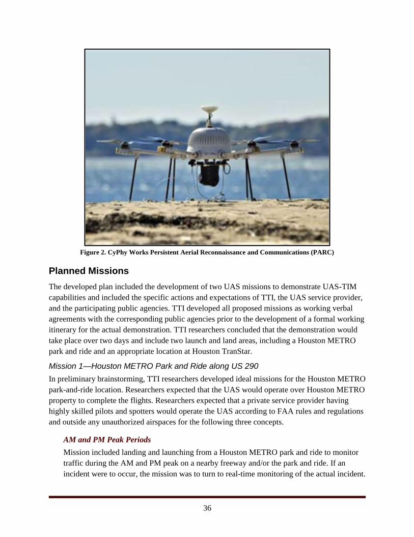
36
Figure 2. CyPhy Works Persistent Aerial Reconnaissance and Communications (PARC)
Planned Missions
The developed plan included the development of two UAS missions to demonstrate UAS-TIM
capabilities and included the specific actions and expectations of TTI, the UAS service provider,
and the participating public agencies. TTI developed all proposed missions as working verbal
agreements with the corresponding public agencies prior to the development of a formal working
itinerary for the actual demonstration. TTI researchers concluded that the demonstration would
take place over two days and include two launch and land areas, including a Houston METRO
park and ride and an appropriate location at Houston TranStar.
Mission 1—Houston METRO Park and Ride along US 290
In preliminary brainstorming, TTI researchers developed ideal missions for the Houston METRO
park-and-ride location. Researchers expected that the UAS would operate over Houston METRO
property to complete the flights. Researchers expected that a private service provider having
highly skilled pilots and spotters would operate the UAS according to FAA rules and regulations
and outside any unauthorized airspaces for the following three concepts.
AM and PM Peak Periods
Mission included landing and launching from a Houston METRO park and ride to monitor
traffic during the AM and PM peak on a nearby freeway and/or the park and ride. If an
incident were to occur, the mission was to turn to real-time monitoring of the actual incident.
37
Off Peak Incident Simulation
As a backup to the observation of real-time incidents, researchers requested that Houston
METRO assist in simulating an incident in the access controlled Houston METRO
HOV/HOT lane. TTI researchers suggested having Houston METRO simulate a stalled
vehicle and initiate a response by having a tow truck respond and clear the stall. The
Houston METRO HOV/HOT lanes are reversible along US 290 and are closed from 11:00
AM to 2:00 PM. If technically possible, service providers were to feed live video back to
Houston TranStar for observations by TTI and Houston METRO staff.
Crash Scene Mapping Exercise
TTI researchers also planned a crash scene mapping of a simulated crash in the park-and-
ride lot.
Mission 2—Houston TranStar Traffic Management Center
TTI planned to complete up to two UAS flights originating from Houston TranStar and had
preliminary approval to launch from a sidewalk near the future helipad. Launching from Houston
TranStar allowed for the demonstration of UAS technology to monitor freeways from a central
location. Houston TranStar is centrally located and near IH 10, IH 610, US 290, and Hempstead
Highway. Houston TranStar can easily monitor Houston METRO’s Northwest Transit Center.
Researchers expected that the UAS would operate over Houston TranStar property to complete
the missions.
Real-Time Traffic Monitoring
TTI planned to utilize the selected service provider to launch their UAS for the purposes of
responding to and monitoring traffic from Houston TranStar.
AM and PM Peak
Missions on one or both days were planned to include landing and launching from Houston
TranStar to monitor traffic during the AM and PM peak on a nearby freeway and/or the
Northwest Transit Center. If an accident were to occur, the mission would then turn to real-
time monitoring of the actual incident.
If technically possible, the service provider would feed live video back to Houston TranStar
for observations by anyone on the Houston TranStar floor. The service provider would also
launch and land a UAS from the surface of the Houston TranStar sidewalk near the
proposed helipad.
38
Planned Observations
Researchers planned to observe and record the events of the demonstration necessary to
determine whether UAS achieves the capability and functions that were presented in the concept
of operations document. Researchers planned to also get feedback from the participants in the
demonstration, as well as present the concept to the Houston TranStar Incident Management
Task Force. Upon the conclusion of the demonstration, researchers recorded general
observations and opinions about the potential for deployment in the future.
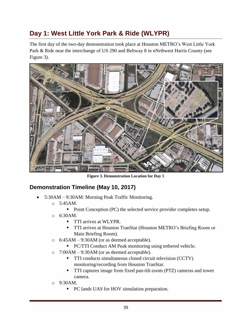
39
Day 1: West Little York Park & Ride (WLYPR)
The first day of the two-day demonstration took place at Houston METRO’s West Little York
Park & Ride near the interchange of US 290 and Beltway 8 in nNrthwest Harris County (see
Figure 3).
Figure 3. Demonstration Location for Day 1
Demonstration Timeline (May 10, 2017)
5:30AM – 9:30AM: Morning Peak Traffic Monitoring.
o 5:45AM.
Point Conception (PC) the selected service provider completes setup.
o 6:30AM.
TTI arrives at WLYPR.
TTI arrives at Houston TranStar (Houston METRO’s Briefing Room or
Main Briefing Room).
o 6:45AM – 9:30AM (or as deemed acceptable).
PC/TTI Conduct AM Peak monitoring using tethered vehicle.
o 7:00AM – 9:30AM (or as deemed acceptable).
TTI conducts simultaneous closed circuit television (CCTV)
monitoring/recording from Houston TranStar.
TTI captures image from fixed pan-tilt-zoom (PTZ) cameras and tower
camera.
o 9:30AM.
PC lands UAS for HOV simulation preparation.
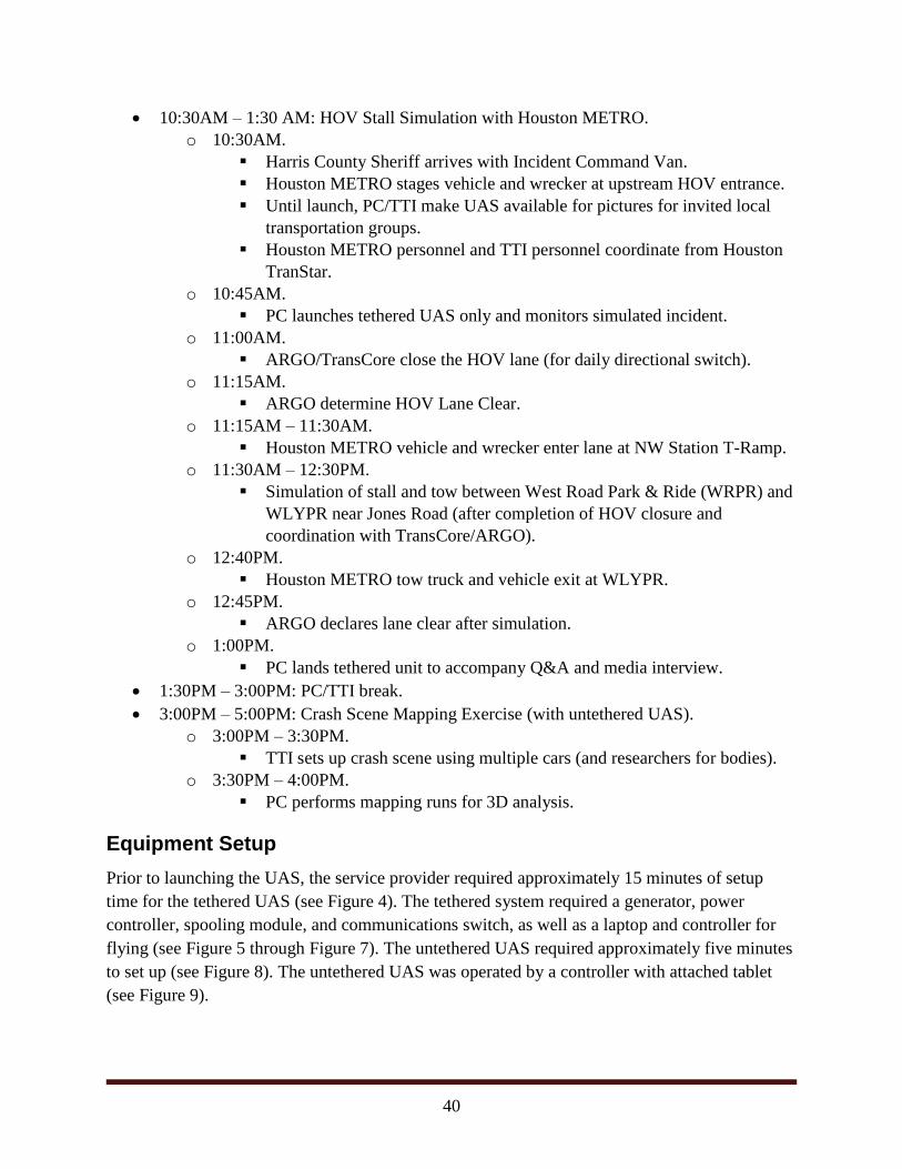
40
10:30AM – 1:30 AM: HOV Stall Simulation with Houston METRO.
o 10:30AM.
Harris County Sheriff arrives with Incident Command Van.
Houston METRO stages vehicle and wrecker at upstream HOV entrance.
Until launch, PC/TTI make UAS available for pictures for invited local
transportation groups.
Houston METRO personnel and TTI personnel coordinate from Houston
TranStar.
o 10:45AM.
PC launches tethered UAS only and monitors simulated incident.
o 11:00AM.
ARGO/TransCore close the HOV lane (for daily directional switch).
o 11:15AM.
ARGO determine HOV Lane Clear.
o 11:15AM – 11:30AM.
Houston METRO vehicle and wrecker enter lane at NW Station T-Ramp.
o 11:30AM – 12:30PM.
Simulation of stall and tow between West Road Park & Ride (WRPR) and
WLYPR near Jones Road (after completion of HOV closure and
coordination with TransCore/ARGO).
o 12:40PM.
Houston METRO tow truck and vehicle exit at WLYPR.
o 12:45PM.
ARGO declares lane clear after simulation.
o 1:00PM.
PC lands tethered unit to accompany Q&A and media interview.
1:30PM – 3:00PM: PC/TTI break.
3:00PM – 5:00PM: Crash Scene Mapping Exercise (with untethered UAS).
o 3:00PM – 3:30PM.
TTI sets up crash scene using multiple cars (and researchers for bodies).
o 3:30PM – 4:00PM.
PC performs mapping runs for 3D analysis.
Equipment Setup
Prior to launching the UAS, the service provider required approximately 15 minutes of setup
time for the tethered UAS (see Figure 4). The tethered system required a generator, power
controller, spooling module, and communications switch, as well as a laptop and controller for
flying (see Figure 5 through Figure 7). The untethered UAS required approximately five minutes
to set up (see Figure 8). The untethered UAS was operated by a controller with attached tablet
(see Figure 9).
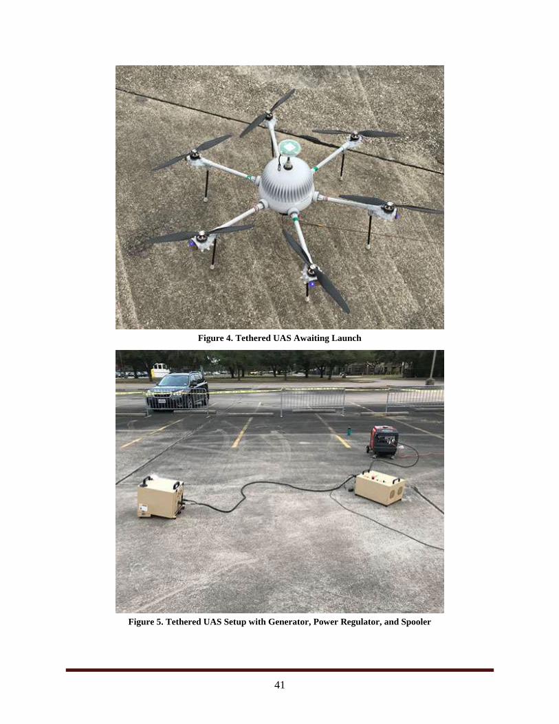
41
Figure 4. Tethered UAS Awaiting Launch
Figure 5. Tethered UAS Setup with Generator, Power Regulator, and Spooler
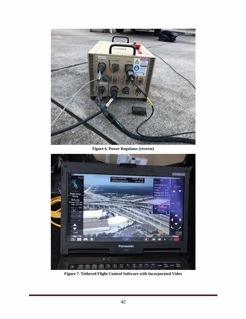
42
Figure 6. Power Regulator (reverse)
Figure 7. Tethered Flight Control Software with Incorporated Video
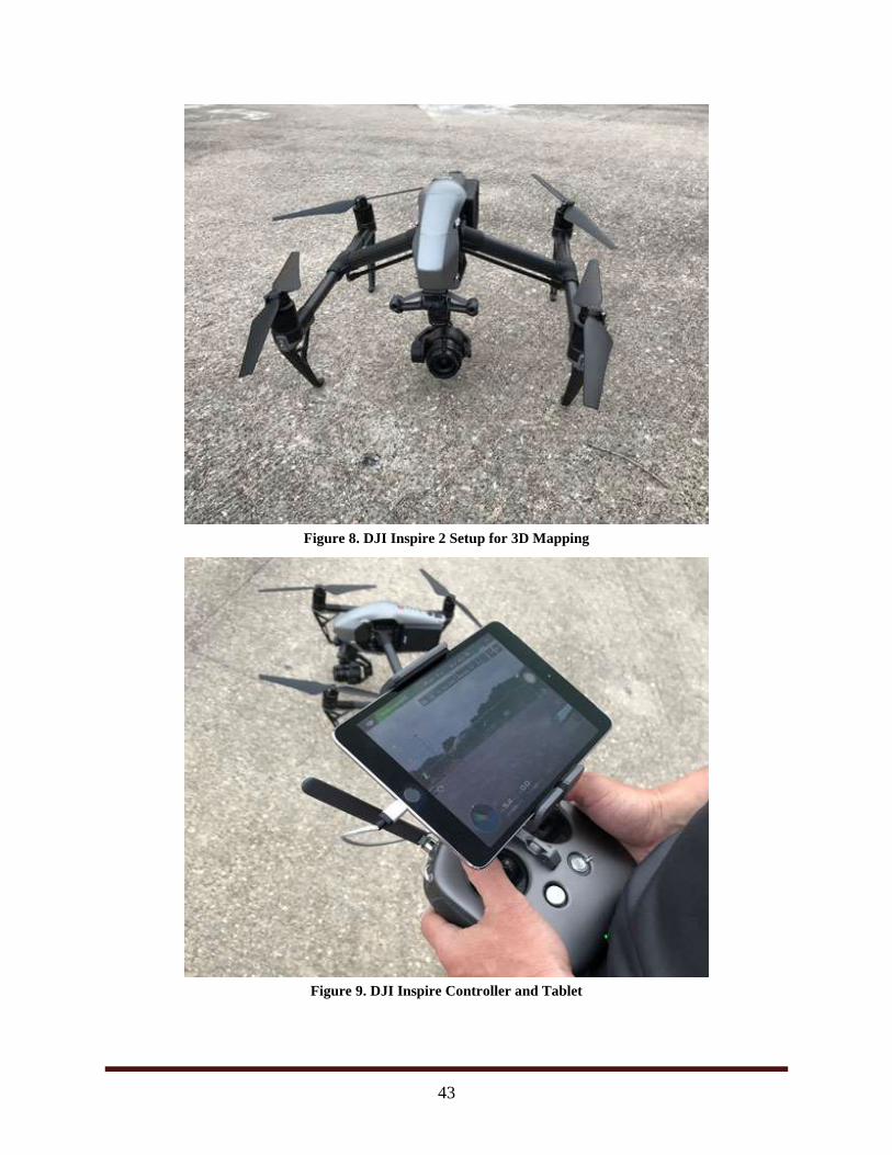
43
Figure 8. DJI Inspire 2 Setup for 3D Mapping
Figure 9. DJI Inspire Controller and Tablet
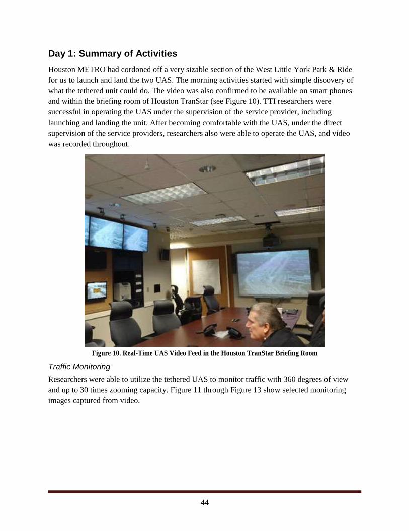
44
Day 1: Summary of Activities
Houston METRO had cordoned off a very sizable section of the West Little York Park & Ride
for us to launch and land the two UAS. The morning activities started with simple discovery of
what the tethered unit could do. The video was also confirmed to be available on smart phones
and within the briefing room of Houston TranStar (see Figure 10). TTI researchers were
successful in operating the UAS under the supervision of the service provider, including
launching and landing the unit. After becoming comfortable with the UAS, under the direct
supervision of the service providers, researchers also were able to operate the UAS, and video
was recorded throughout.
Figure 10. Real-Time UAS Video Feed in the Houston TranStar Briefing Room
Traffic Monitoring
Researchers were able to utilize the tethered UAS to monitor traffic with 360 degrees of view
and up to 30 times zooming capacity. Figure 11 through Figure 13 show selected monitoring
images captured from video.

45
Figure 11. Ramp Congestion from Beltway 8 to US 290 (~½ mile)
Figure 12. Interchange of Beltway 8 and West Little York Road (~3/4 mile)
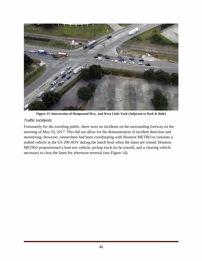
46
Figure 13. Intersection of Hempstead Hwy. and West Little York (Adjacent to Park & Ride)
Traffic Incidents
Fortunately for the traveling public, there were no incidents on the surrounding freeway on the
morning of May 10, 2017. This did not allow for the demonstration of incident detection and
monitoring. However, researchers had been coordinating with Houston METRO to simulate a
stalled vehicle in the US 290 HOV during the lunch hour when the lanes are closed. Houston
METRO propositioned a lead tow vehicle, pickup truck (to be towed), and a clearing vehicle
necessary to clear the lanes for afternoon reversal (see Figure 14).
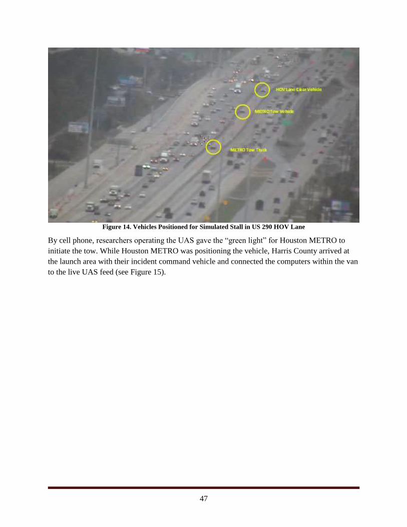
47
Figure 14. Vehicles Positioned for Simulated Stall in US 290 HOV Lane
By cell phone, researchers operating the UAS gave the “green light” for Houston METRO to
initiate the tow. While Houston METRO was positioning the vehicle, Harris County arrived at
the launch area with their incident command vehicle and connected the computers within the van
to the live UAS feed (see Figure 15).
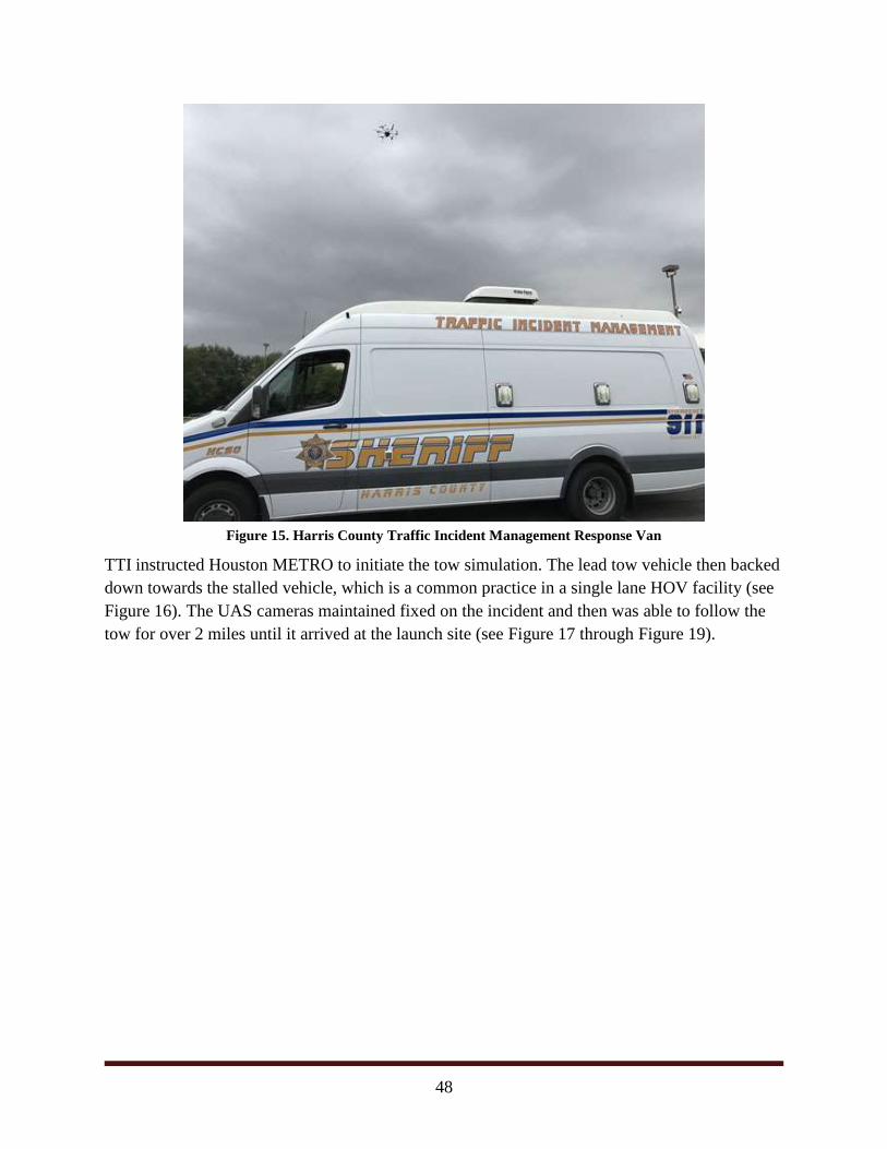
48
Figure 15. Harris County Traffic Incident Management Response Van
TTI instructed Houston METRO to initiate the tow simulation. The lead tow vehicle then backed
down towards the stalled vehicle, which is a common practice in a single lane HOV facility (see
Figure 16). The UAS cameras maintained fixed on the incident and then was able to follow the
tow for over 2 miles until it arrived at the launch site (see Figure 17 through Figure 19).
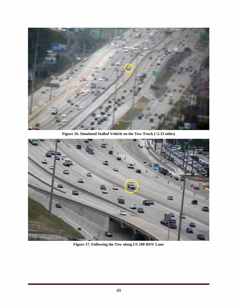
49
Figure 16. Simulated Stalled Vehicle on the Tow Truck (~2.33 miles)
Figure 17. Following the Tow along US 290 HOV Lane
v
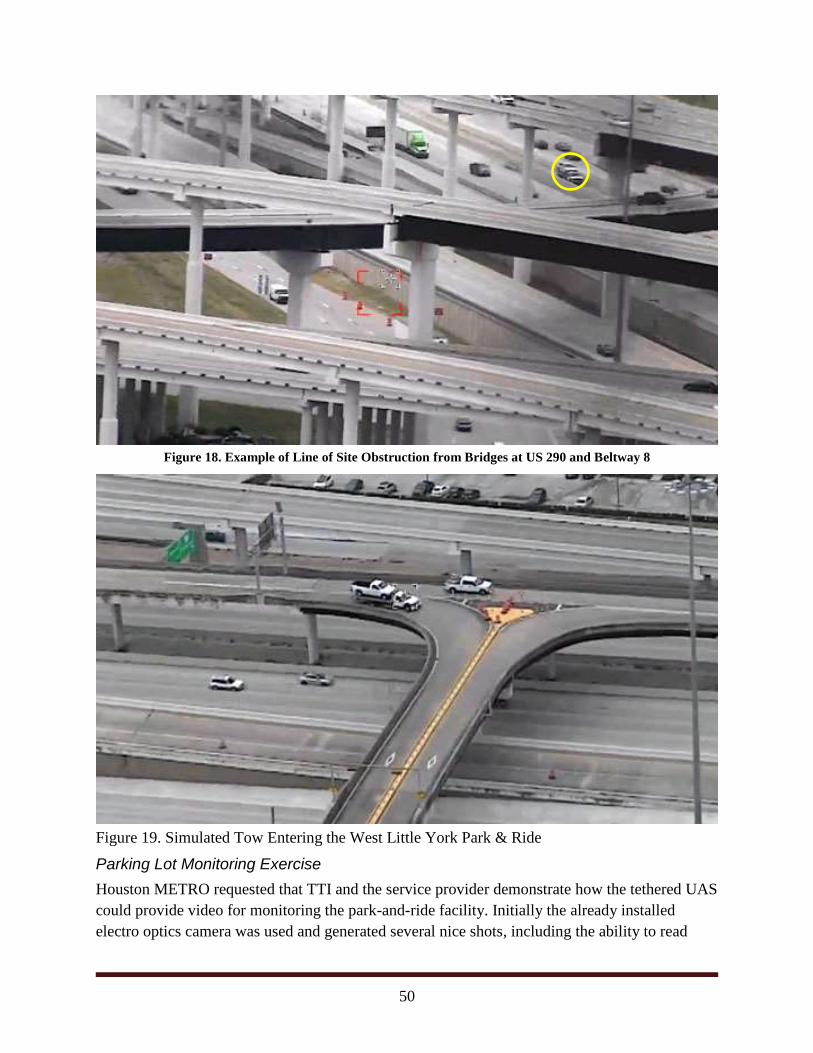
50
Figure 18. Example of Line of Site Obstruction from Bridges at US 290 and Beltway 8
Figure 19. Simulated Tow Entering the West Little York Park & Ride
Parking Lot Monitoring Exercise
Houston METRO requested that TTI and the service provider demonstrate how the tethered UAS
could provide video for monitoring the park-and-ride facility. Initially the already installed
electro optics camera was used and generated several nice shots, including the ability to read
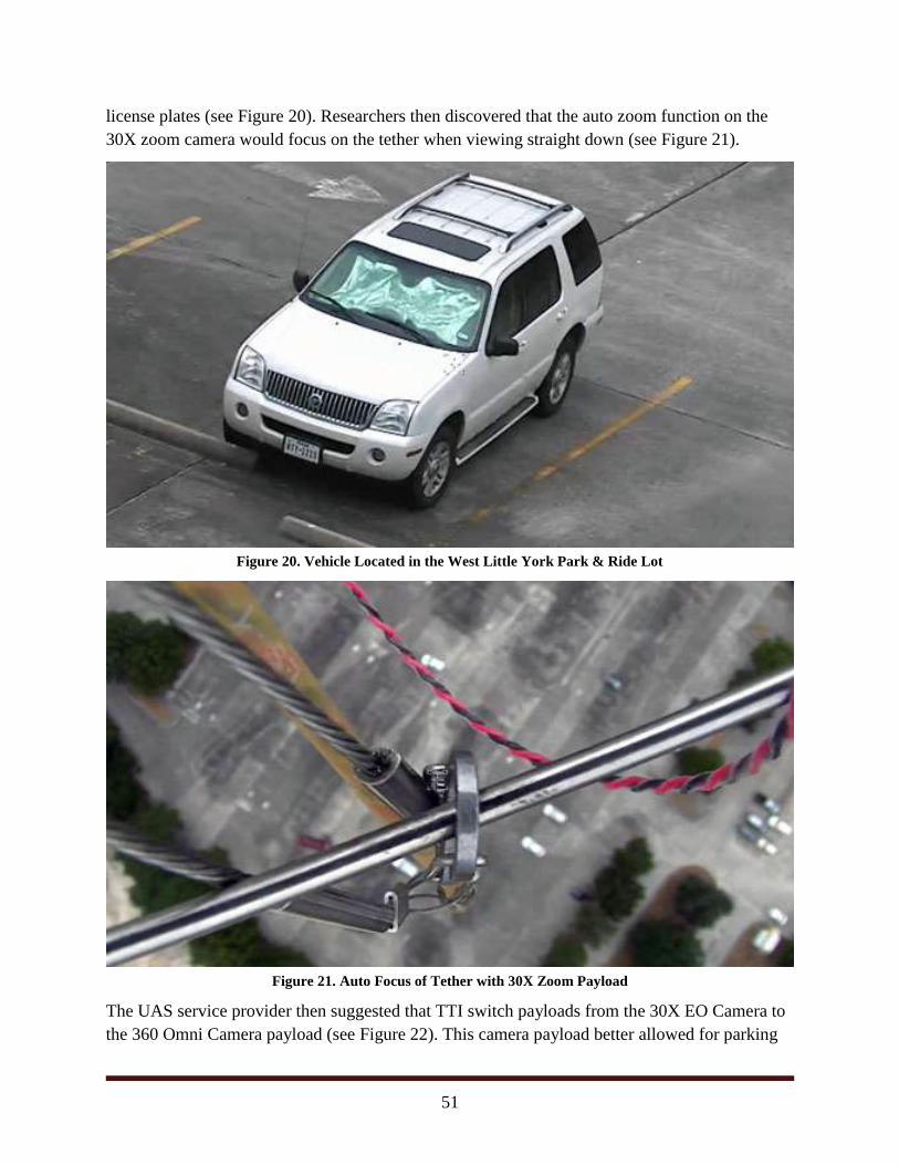
51
license plates (see Figure 20). Researchers then discovered that the auto zoom function on the
30X zoom camera would focus on the tether when viewing straight down (see Figure 21).
Figure 20. Vehicle Located in the West Little York Park & Ride Lot
Figure 21. Auto Focus of Tether with 30X Zoom Payload
The UAS service provider then suggested that TTI switch payloads from the 30X EO Camera to
the 360 Omni Camera payload (see Figure 22). This camera payload better allowed for parking
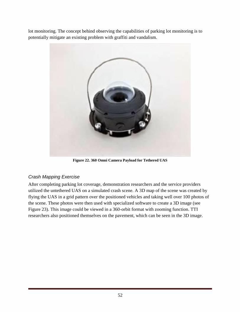
52
lot monitoring. The concept behind observing the capabilities of parking lot monitoring is to
potentially mitigate an existing problem with graffiti and vandalism.
Figure 22. 360 Omni Camera Payload for Tethered UAS
Crash Mapping Exercise
After completing parking lot coverage, demonstration researchers and the service providers
utilized the untethered UAS on a simulated crash scene. A 3D map of the scene was created by
flying the UAS in a grid pattern over the positioned vehicles and taking well over 100 photos of
the scene. These photos were then used with specialized software to create a 3D image (see
Figure 23). This image could be viewed in a 360-orbit format with zooming function. TTI
researchers also positioned themselves on the pavement, which can be seen in the 3D image.
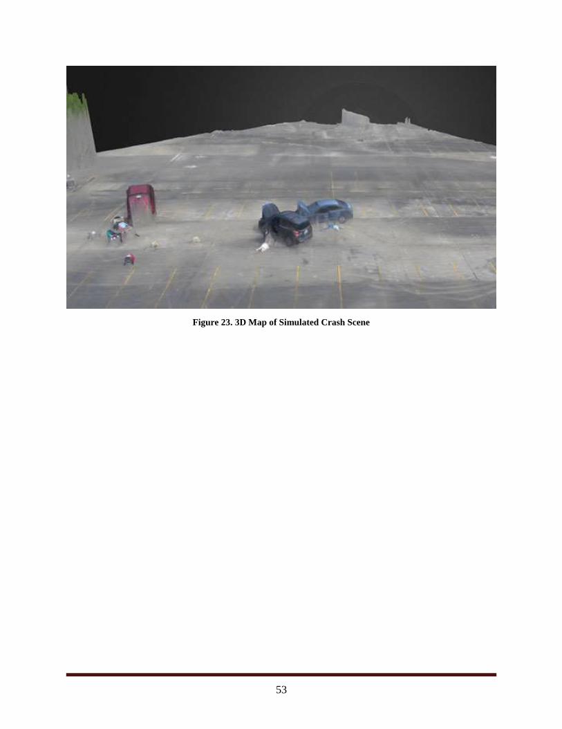
53
Figure 23. 3D Map of Simulated Crash Scene
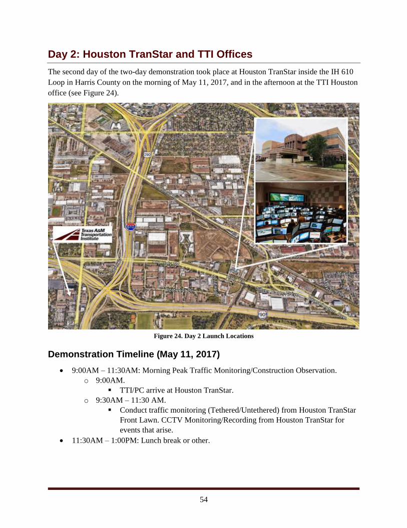
54
Day 2: Houston TranStar and TTI Offices
The second day of the two-day demonstration took place at Houston TranStar inside the IH 610
Loop in Harris County on the morning of May 11, 2017, and in the afternoon at the TTI Houston
office (see Figure 24).
Figure 24. Day 2 Launch Locations
Demonstration Timeline (May 11, 2017)
9:00AM – 11:30AM: Morning Peak Traffic Monitoring/Construction Observation.
o 9:00AM.
TTI/PC arrive at Houston TranStar.
o 9:30AM – 11:30 AM.
Conduct traffic monitoring (Tethered/Untethered) from Houston TranStar
Front Lawn. CCTV Monitoring/Recording from Houston TranStar for
events that arise.
11:30AM – 1:00PM: Lunch break or other.
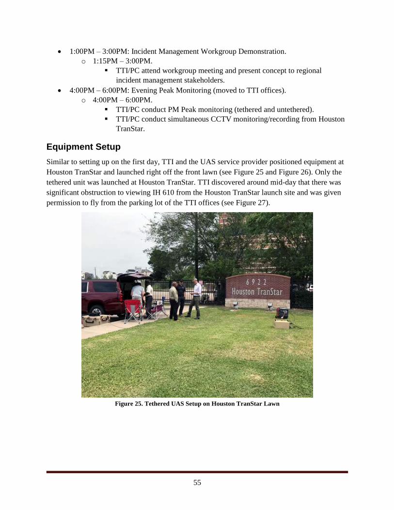
55
1:00PM – 3:00PM: Incident Management Workgroup Demonstration.
o 1:15PM – 3:00PM.
TTI/PC attend workgroup meeting and present concept to regional
incident management stakeholders.
4:00PM – 6:00PM: Evening Peak Monitoring (moved to TTI offices).
o 4:00PM – 6:00PM.
TTI/PC conduct PM Peak monitoring (tethered and untethered).
TTI/PC conduct simultaneous CCTV monitoring/recording from Houston
TranStar.
Equipment Setup
Similar to setting up on the first day, TTI and the UAS service provider positioned equipment at
Houston TranStar and launched right off the front lawn (see Figure 25 and Figure 26). Only the
tethered unit was launched at Houston TranStar. TTI discovered around mid-day that there was
significant obstruction to viewing IH 610 from the Houston TranStar launch site and was given
permission to fly from the parking lot of the TTI offices (see Figure 27).
Figure 25. Tethered UAS Setup on Houston TranStar Lawn
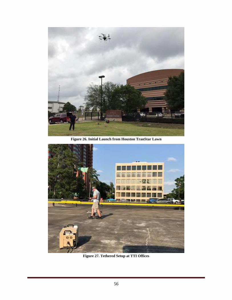
56
Figure 26. Initial Launch from Houston TranStar Lawn
Figure 27. Tethered Setup at TTI Offices
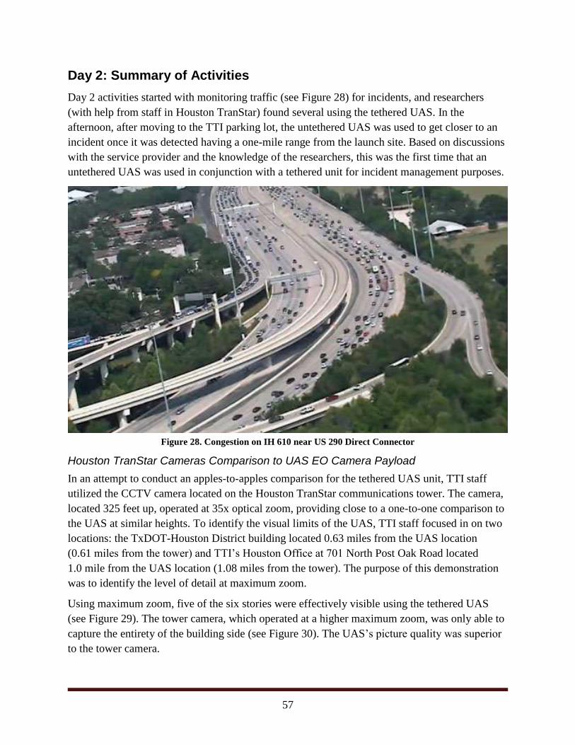
57
Day 2: Summary of Activities
Day 2 activities started with monitoring traffic (see Figure 28) for incidents, and researchers
(with help from staff in Houston TranStar) found several using the tethered UAS. In the
afternoon, after moving to the TTI parking lot, the untethered UAS was used to get closer to an
incident once it was detected having a one-mile range from the launch site. Based on discussions
with the service provider and the knowledge of the researchers, this was the first time that an
untethered UAS was used in conjunction with a tethered unit for incident management purposes.
Figure 28. Congestion on IH 610 near US 290 Direct Connector
Houston TranStar Cameras Comparison to UAS EO Camera Payload
In an attempt to conduct an apples-to-apples comparison for the tethered UAS unit, TTI staff
utilized the CCTV camera located on the Houston TranStar communications tower. The camera,
located 325 feet up, operated at 35x optical zoom, providing close to a one-to-one comparison to
the UAS at similar heights. To identify the visual limits of the UAS, TTI staff focused in on two
locations: the TxDOT-Houston District building located 0.63 miles from the UAS location
(0.61 miles from the tower) and TTI’s Houston Office at 701 North Post Oak Road located
1.0 mile from the UAS location (1.08 miles from the tower). The purpose of this demonstration
was to identify the level of detail at maximum zoom.
Using maximum zoom, five of the six stories were effectively visible using the tethered UAS
(see Figure 29). The tower camera, which operated at a higher maximum zoom, was only able to
capture the entirety of the building side (see Figure 30). The UAS’s picture quality was superior
to the tower camera.
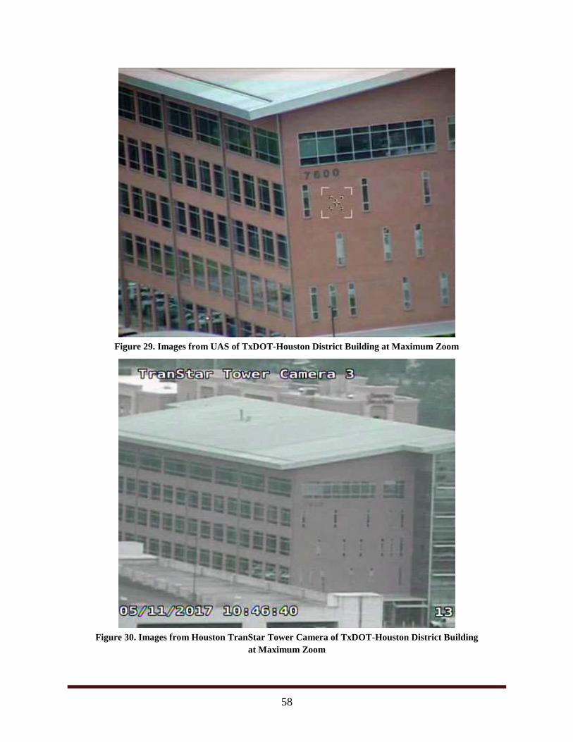
58
Figure 29. Images from UAS of TxDOT-Houston District Building at Maximum Zoom
Figure 30. Images from Houston TranStar Tower Camera of TxDOT-Houston District Building
at Maximum Zoom
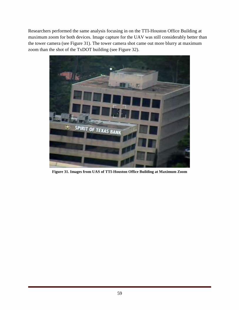
59
Researchers performed the same analysis focusing in on the TTI-Houston Office Building at
maximum zoom for both devices. Image capture for the UAV was still considerably better than
the tower camera (see Figure 31). The tower camera shot came out more blurry at maximum
zoom than the shot of the TxDOT building (see Figure 32).
Figure 31. Images from UAS of TTI-Houston Office Building at Maximum Zoom
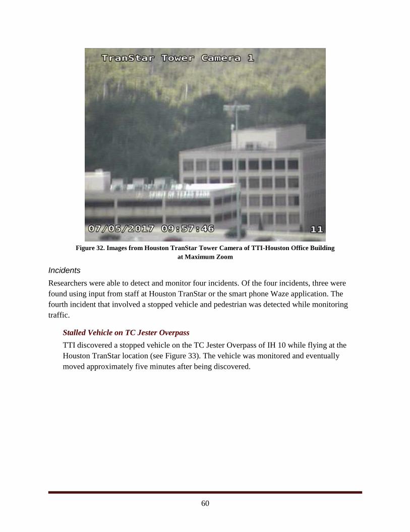
60
Figure 32. Images from Houston TranStar Tower Camera of TTI-Houston Office Building
at Maximum Zoom
Incidents
Researchers were able to detect and monitor four incidents. Of the four incidents, three were
found using input from staff at Houston TranStar or the smart phone Waze application. The
fourth incident that involved a stopped vehicle and pedestrian was detected while monitoring
traffic.
Stalled Vehicle on TC Jester Overpass
TTI discovered a stopped vehicle on the TC Jester Overpass of IH 10 while flying at the
Houston TranStar location (see Figure 33). The vehicle was monitored and eventually
moved approximately five minutes after being discovered.
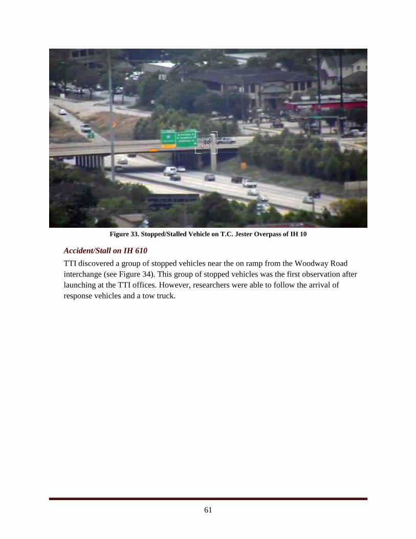
61
Figure 33. Stopped/Stalled Vehicle on T.C. Jester Overpass of IH 10
Accident/Stall on IH 610
TTI discovered a group of stopped vehicles near the on ramp from the Woodway Road
interchange (see Figure 34). This group of stopped vehicles was the first observation after
launching at the TTI offices. However, researchers were able to follow the arrival of
response vehicles and a tow truck.
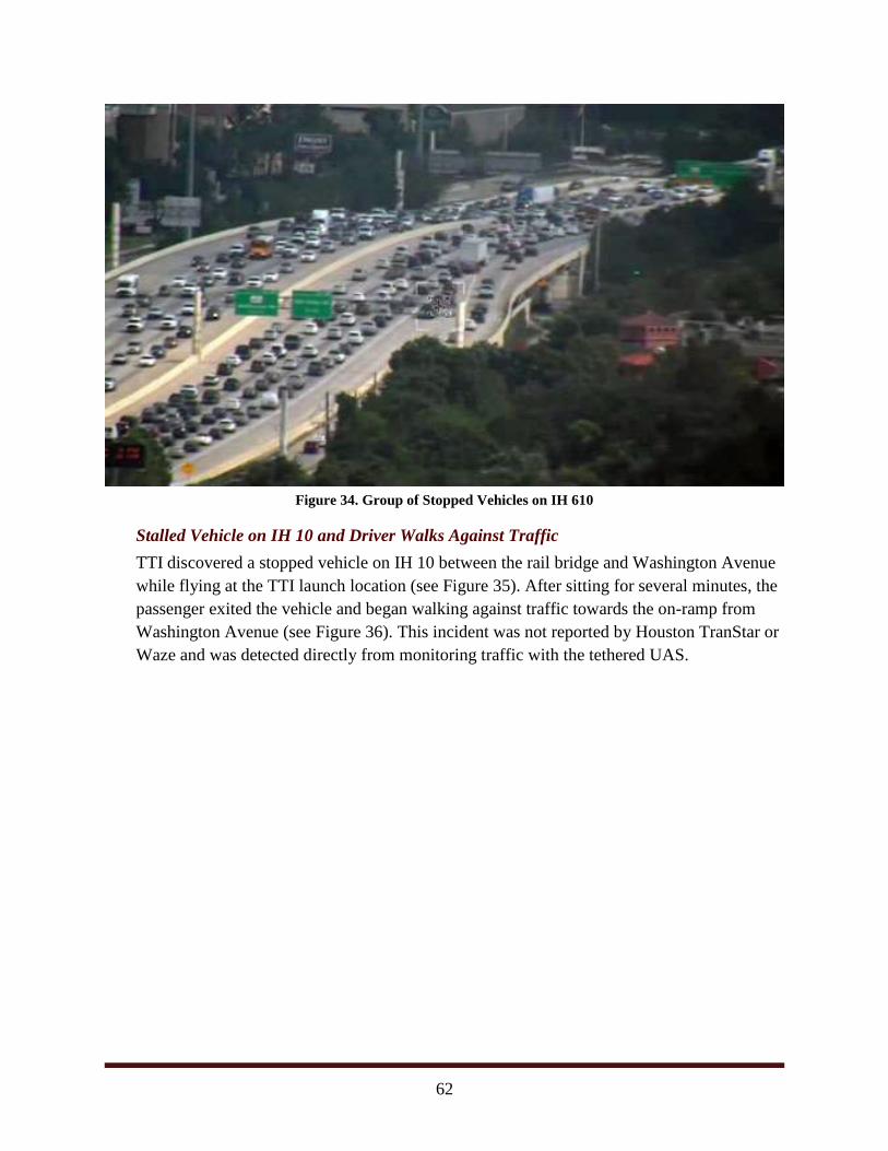
62
Figure 34. Group of Stopped Vehicles on IH 610
Stalled Vehicle on IH 10 and Driver Walks Against Traffic
TTI discovered a stopped vehicle on IH 10 between the rail bridge and Washington Avenue
while flying at the TTI launch location (see Figure 35). After sitting for several minutes, the
passenger exited the vehicle and began walking against traffic towards the on-ramp from
Washington Avenue (see Figure 36). This incident was not reported by Houston TranStar or
Waze and was detected directly from monitoring traffic with the tethered UAS.
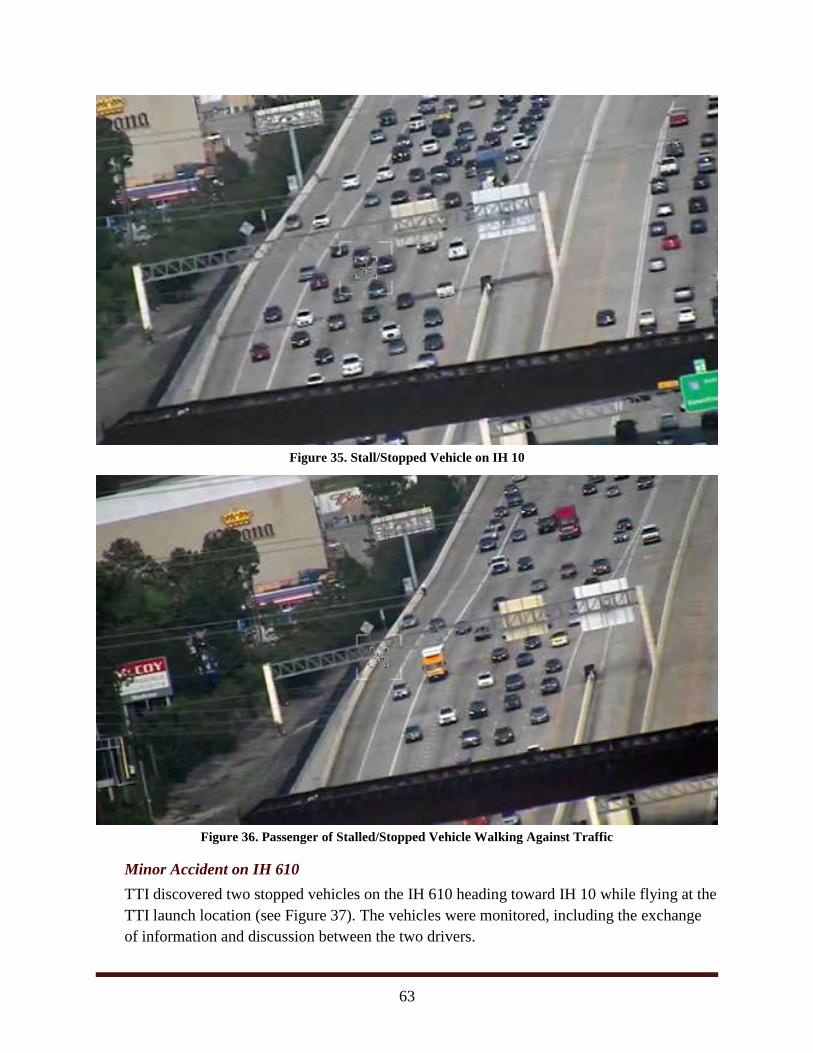
63
Figure 35. Stall/Stopped Vehicle on IH 10
Figure 36. Passenger of Stalled/Stopped Vehicle Walking Against Traffic
Minor Accident on IH 610
TTI discovered two stopped vehicles on the IH 610 heading toward IH 10 while flying at the
TTI launch location (see Figure 37). The vehicles were monitored, including the exchange
of information and discussion between the two drivers.
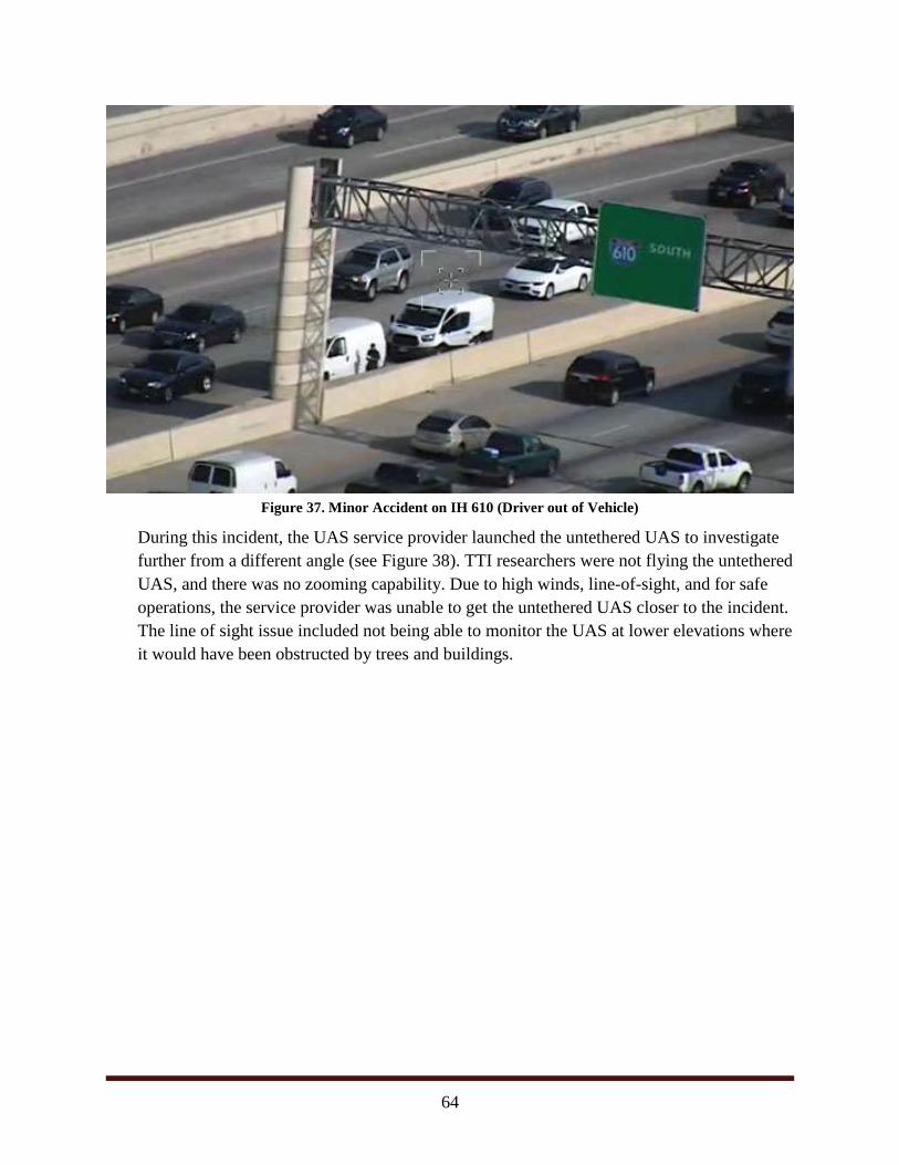
64
Figure 37. Minor Accident on IH 610 (Driver out of Vehicle)
During this incident, the UAS service provider launched the untethered UAS to investigate
further from a different angle (see Figure 38). TTI researchers were not flying the untethered
UAS, and there was no zooming capability. Due to high winds, line-of-sight, and for safe
operations, the service provider was unable to get the untethered UAS closer to the incident.
The line of sight issue included not being able to monitor the UAS at lower elevations where
it would have been obstructed by trees and buildings.
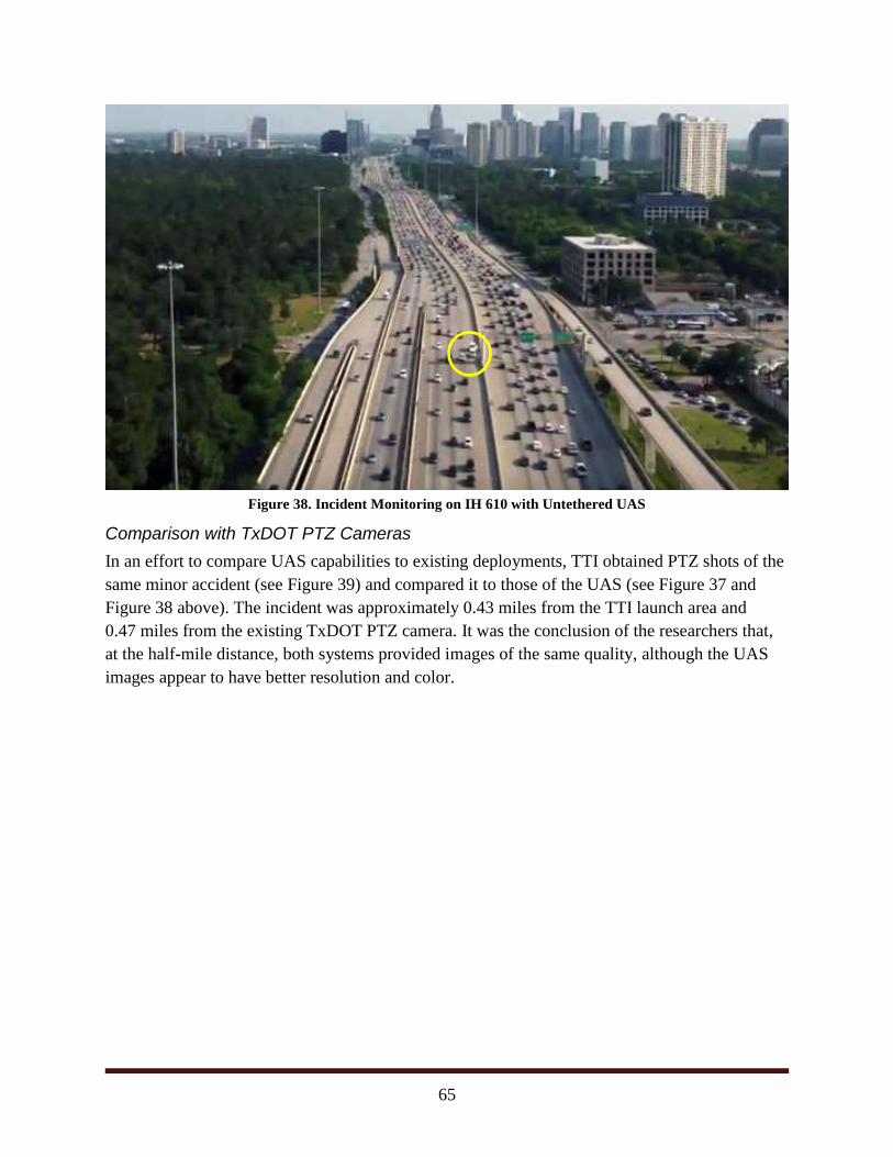
65
Figure 38. Incident Monitoring on IH 610 with Untethered UAS
Comparison with TxDOT PTZ Cameras
In an effort to compare UAS capabilities to existing deployments, TTI obtained PTZ shots of the
same minor accident (see Figure 39) and compared it to those of the UAS (see Figure 37 and
Figure 38 above). The incident was approximately 0.43 miles from the TTI launch area and
0.47 miles from the existing TxDOT PTZ camera. It was the conclusion of the researchers that,
at the half-mile distance, both systems provided images of the same quality, although the UAS
images appear to have better resolution and color.
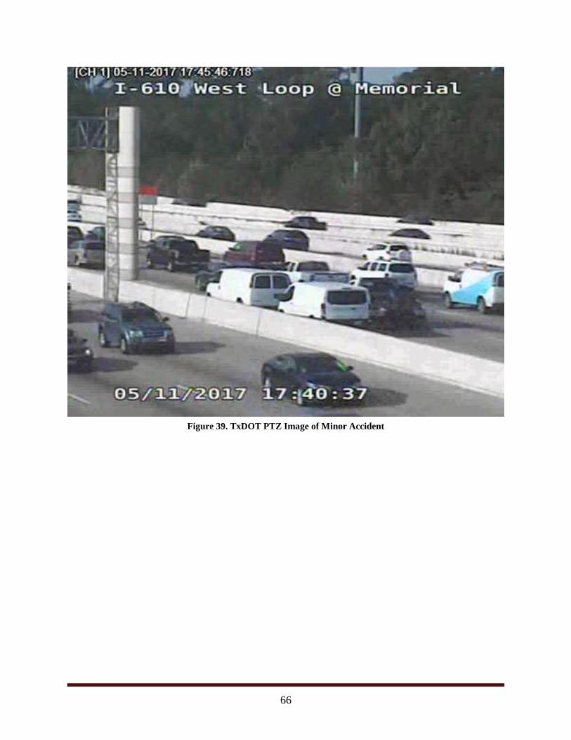
66
Figure 39. TxDOT PTZ Image of Minor Accident
67
Findings and Next Steps
It is difficult to evaluate the findings of the UAS-TIM demonstration. There were many positive
observations made that could potentially improve current incident management capabilities and
functions. However, it is the duty of the research to overcome the “neat” factor and attempt to
determine whether this technology could meet the underlying goal of the demonstration.
Can UAS-TIM meet or exceed existing traffic incident management tools and technology to the
benefit of the traveling public and transportation agencies?
To evaluate the outcome of the demonstration in a structured manner, researchers have looked
back at the required capabilities and functions outlined in the initial concept of operations
document for UAS-TIM.
Assessing UAS-TIM Capabilities
Using the required capabilities outlined in the original concept of operations document,
researchers reviewed observations from the demonstration and compared them.
Capability #1: Real-Time Enhanced Video and Photography (Achieved)
Both the tethered and untethered UAS were able to capture and deliver HD video and
photography from within the airspace and elevations as allowed by FAA regulations and
approximately 400 feet above the grade of the lowest agency-owned facility near a traffic
incident. Both UAS were able to effectively communicate with a central command center,
Houston TranStar, as needed. The tethered UAS was able to also communicate to personal cell
phones through a downloadable app. The untethered UAS was able to provide a live feed using
an online application.
Capability #2: Real-Time Non-video Sensor Data (Achieved)
The tethered UAS was able to capture infrared sensor data from within the airspace and
elevations as approved by FAA regulations. The tethered system was able to effectively
communicate the infrared image to Houston TranStar and personal cell phones as needed.
Capability #3: Real-Time Payload (Cameras and Sensors) Mobility (Achieved)
Both the tethered and untethered UAS were mobile (the tethered less so than the untethered) and
collected video, photography, and sensor data while moving within the airspace and elevations as
approved by FAA regulations. Both systems were able to effectively communicate with a central
command center (Houston TranStar) and deliver video, photography, and sensor data as needed.
Capability #4: Communication of Data to a Traffic Incident Command Center (Achieved)
Both the tethered and untethered UAS were able to effectively communicate with a central
command center (Houston TranStar) and deliver video, photography, and sensor data as needed.
The video feeds were provided by web address and could be protected by user name and
password.
68
Capability #5: Guided Mobile Data Collection (Achieved)
The untethered unit was able to follow a pre-programmed flight plan (for global positioning
system and elevation waypoints) and collect video, photography, and sensor data while moving
within the airspace and elevations as approved by FAA regulations.
Capability #6: Photogrammetry and Mapping (Undetermined)
The untethered UAS was able to establish a 3D crash reconstruction model. The model
developed during the demonstration was of high enough quality to make out vehicles and body
positions. It is unclear whether the model developed during the demonstration would be
admissible in a legal proceeding. It is unclear if there are any specific statutes providing legal
guidance on the quality level needed for legal proceedings and if any UAS 3D mapping
technology could achieve those minimum standards.
Capability #7: Safe Flight Operation near or over Live Traffic (Achieved)
Both the tethered and untethered UAS were able to operate safely near and over live traffic
within the airspace and elevations as approved by FAA regulations.
Assessing UAS-TIM Functions
Using the required functions outlined in the original concept of operations document, researchers
reviewed observations from the demonstration and compared them.
Function #1: Real-Time Confirmation of a Traffic Incident (Achieved)
UAS-TIM was able to provide the information necessary to confirm the severity and extent of a
traffic incident.
Function #2: Real-Time Monitoring of a Traffic Incident (Achieved)
UAS-TIM was able to provide enhanced real-time video, photography, and sensor data
monitoring functionality (to existing static cameras).
Function #3: Real-Time Monitoring of Alternate Routes (Achieved)
UAS-TIM was able to provide real-time video, photography, and sensor data of alternate routes
that agencies can use for traffic diversion decision making.
Function #4: Real-Time Monitoring of Traffic Incident Queuing (Achieved)
UAS-TIM was able to provide real-time video, photography, and sensor data of traffic queuing
as a result of the traffic incident.
Function #5: Real-Time Monitoring of Secondary Crashes (Not Applicable)
UAS-TIM did not have an opportunity to provide real-time video, photography, and sensor data
of secondary crashes and incidents to aid in response. However, the UAS systems flown would
have been capable of providing this function.
69
Function #6: Fatal Crash Scene Mapping (Undetermined)
UAS-TIM was able to quickly provide sensor data but it is not clear whether UAS obtained
mapping would exceed the capabilities of manual crash scene mapping or other existing
technologies. However, researchers do believe that service providers can attach high enough
quality sensor technologies as a payload to the UAS to provide three-dimensional imaging and—
in combination with HD photogrammetry necessary—to provide a record of the crash scene.
Additional Observations
Image Comparison
TTI researchers were able to use existing Houston TranStar camera technology to compare with
that of the UAS-TIM imagery. It was evident that, although the UAS-TIM optics did not advance
imagery far beyond that of what is already available, it did so using a mobile platform. The
UAS-TIM demonstration showed that images could be captured at an equal or higher quality
level without permanent installation. UAS-TIM can be a very powerful mobile tool for high
quality, real-time video and sensor information.
Procedural Comparisons
The demonstration was able to show the ability of UAS-TIM to provide real-time video to a
central location and further beyond to any device that was connected to the internet. No hard line
communications were required, and there are payloads available to create a dedicated network if
needed. However, researchers were not able to coordinate an actual response using UAS-TIM.
They were able to simulate a response to a planned incident with the help of Houston METRO.
Agency Feedback
It is unclear to the researchers who set the expectations of the demonstration, but there was very
little agency response to UAS-TIM, either positive or negative. It is typical in transportation
systems management and operations to only deploy proven technologies and take a “wait and
see” approach to new ideas and approaches. UAS-TIM falls into a new approach to incident
management, and it will take time to see if agencies will actually deploy and further develop the
concept.
Other Opinions and Conclusions
UAS-TIM was very easy to deploy including both the untethered and tethered UAS.
This was primarily due to the efficient effort of the contracted service provider and
coordination with local transportation agencies. It is the opinion of the author that this
technology would be easy to deploy.
However, this ease of deployment depends greatly on the readiness of the service
provider and their coordination with the FAA. One way agencies could address this
concern is to have preapproved service providers that have FAA authority to fly within
the agency’s jurisdiction.
70
UAS is a very effective tool that could monitor many freeways from one single location.
The combination of a tethered UAS and untethered UAS provided an incident detection
and response system.
UAS-TIM has an advantage in comparison a permanent PTZ camera system. During the
first day of the demonstration, researchers attempted to get comparison images from the
existing PTZ camera system, and both the upstream and downstream permanent PTZ
cameras were inoperable. The camera system used by the UAS during the demonstration
was a payload-based system. Repairing a PTZ camera requires coordination with
maintenance staff or third party contractors and can take days. If the UAS camera had
malfunctioned, it would take less than 15 minutes to attach a back-up camera and re-
launch.
The tethered UAS was very safe. The system had built in autonomous safety features
including high wind warning and high wind auto-land features that were directly
experienced during the second day of the demonstration. Safe operations technology
continues to improve for both tethered and untethered UAS. For example, the untethered
UAS deployed during the demonstration had collision avoidance technology.
Imaging technology is improving, including stability options. The tethered unit that was
flown only had a two-gimbal stability mount, while the untethered unit had a three-
gimbal mount. Images from the three-gimbal mount were of higher quality, and the
image was very stable.
There are numerous applications beyond incident management for which a UAS can be
deployed. It may be the assumption of agencies that the acquisition or contracting of
UAS service may be dedicated solely to incident management; however, a mobile real-
time video system can be deployed in many ways. Two concepts discussed during the
demonstration were special event monitoring and remote deployment for vandalism
mitigation.
Agencies did not appear to seriously consider UAS-TIM deployment as an incident
management tool at the time of or immediately after the demonstration. Researchers
presented the concept to the Houston TranStar Incident Management Task Force, but the
research team has not been contacted for any additional information. This lack of
excitement may be partly the fault of the researchers and the selected service provider. In
preliminary discussions, researchers were made to believe that the imaging payload
would be much more capable. For example, being able to make out details up to three
miles away. This expectation was conveyed to the participating agencies, and the
delivered imagery did not meet those preliminary expectations.
71
Policy Implications
It was clear that the selected service provider was not troubled by any federal regulations or State
of Texas laws at the time of the demonstration. However, the service providers were very
experienced and have flown UAS all over the world, including within controlled airspace.
Researchers are not certain that less experienced pilots would have been as confident regarding
regulations and laws.
With regard to specific policy for UAS-TIM, it might help advance the tool if policy existed to
further define the use of UAS over public roadways and facilities for the purposes of traffic
monitoring, incident response, and any purpose to improve congestion and public safety. Further
consideration should be given to policy that clarifies and allows service providers acting on
behalf of a public agency to launch from private property and record images of private property.
Interestingly, another surprising policy concern that rose from the demonstration was the level of
detail needed for crash mapping. Is it possible for a UAS to obtain a crash scene map that could
be used in legal proceedings? Unfortunately, this concern was discovered after the completion of
the policy review. Understanding these legal requirements and whether UAS-TIM can meet them
could be a future project to the benefit of the concept.
Next Steps
The UAS-TIM demonstration was successful. However, many more questions surfaced
regarding advancing technologies, regulations, and laws. If and when funding is available to
investigate these concerns, UAS technology and TIM could benefit from additional research
including:
Specifications for UAS-TIM (imaging requirements, response time, etc.).
Remote Launching Capabilities for Permanent UAS-TIM Deployment.
Remote Launching for Monitoring of Public Facilities (Park & Rides, Buildings,
Storage).
UAS for Special Events (Houston Rodeo, Super Bowl, etc.).
Crash Scene Mapping Requirements for Legal Proceedings.
UAS Operation over People, Vehicles, and Property.
72
Acknowledgments
The authors would like to acknowledge the help of TTI staff member Jeff Kaufman for his
involvement in coordinating with Houston TranStar. Additionally, Houston METRO staff
members Terrance Fontaine, Lauren Cochran, and Larry Wood were vital in coordinating efforts
at the West Little York Park & Ride as well as during the HOV stall simulation. Lastly, Jack
Whaley and his Houston TranStar staff assisted in communication testing prior to the day of the
demonstration.
73
References
1 Getting Started, Federal Aviation Administration (Feb. 10, 2017 at 3:23 PM),
https://www.faa.gov/uas/getting_started/.
2 Stationary, Google Translate, https://translate.google.com/#auto/en/stationary (last
visited Feb. 26, 2017).
3 Sarina Houston, Nautical Miles vs Statute Miles, the balance (Sep. 15, 2016),
https://www.thebalance.com/nautical-miles-vs-statute-miles-282937.
4 Charles Fletcher, What causes the difference between ground speed and air speed?,
Quora (June 23, 2015), https://www.quora.com/What-causes-the-difference-between-
ground-speed-and-air-speed.
5 Part 107 Waivers Granted, Federal Aviation Administration,
https://www.faa.gov/uas/request_waiver/waivers_granted/ (last visited Mar. 15, 2017).
6 U.S. Department of Transportation, Federal Aviation Administration, Certificate of
Waiver or Authorization, Waiver No.: 107W-2016-00003 (2016),
https://www.faa.gov/uas/request_waiver/waivers_granted/media/107W-2016-
00003_BNSF_CoW.pdf.
7 http://www.ridemetro.org/Pages/AboutMETROAboutHouston METRO.aspx Accessed
07/25/2017.
8 http://www.houstontranstar.org/about_transtar/ Accessed 07/25/2017.