Embed Size (px)
Citation preview
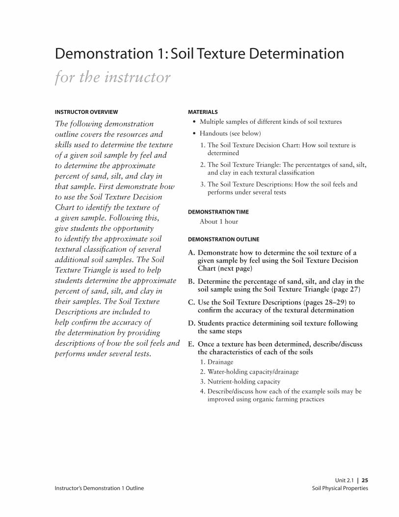
Soil Physical Properties Unit 2.1 | 25
Instructor’s Demonstration 1 Outline
Demonstration 1: Soil Texture Determination
for the instructor
Instructor overvIew
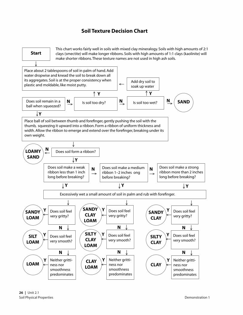
The following demonstration outline covers the resources and skills used to determine the texture of a given soil sample by feel and to determine the approximate percent of sand, silt, and clay in that sample. First demonstrate how to use the Soil Texture Decision Chart to identify the texture of a given sample. Following this, give students the opportunity to identify the approximate soil textural classification of several additional soil samples. The Soil Texture Triangle is used to help students determine the approximate percent of sand, silt, and clay in their samples. The Soil Texture Descriptions are included to help confirm the accuracy of the determination by providing descriptions of how the soil feels and performs under several tests.
MaterIals
• Multiplesamplesofdifferentkindsofsoiltextures
• Handouts(seebelow)
1.TheSoilTextureDecisionChart:Howsoiltextureisdetermined
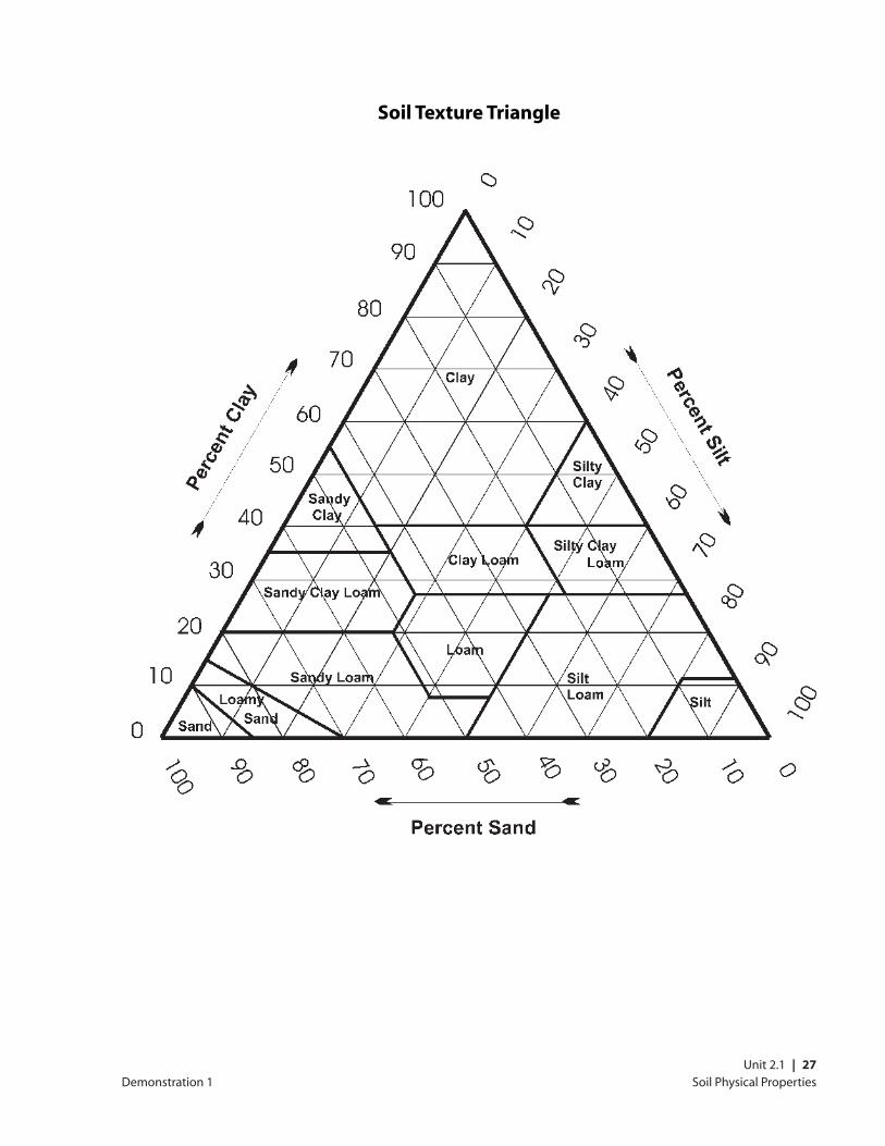
2.TheSoilTextureTriangle:Thepercentatgesofsand,silt,andclayineachtexturalclassification
3.TheSoilTextureDescriptions:Howthesoilfeelsandperformsunderseveraltests
DeMonstratIon tIMe
About1hour
DeMonstratIon outlIne
A. Demonstrate how to determine the soil texture of a given sample by feel using the Soil Texture Decision Chart (next page)
B. Determine the percentage of sand, silt, and clay in the soil sample using the Soil Texture Triangle (page 27)
C. Use the Soil Texture Descriptions (pages 28–29) to confirm the accuracy of the textural determination
D. Students practice determining soil texture following the same steps
E. Once a texture has been determined, describe/discuss the characteristics of each of the soils 1.Drainage
2.Water-holdingcapacity/drainage
3.Nutrient-holdingcapacity
4.Describe/discusshoweachoftheexamplesoilsmaybeimprovedusingorganicfarmingpractices
26 | Unit 2.1Soil Physical Properties
soil texture Decision chart
Demonstration 1
This chart works fairly well in soils with mixed clay mineralogy. Soils with high amounts of 2:1 clays (smectite) will make longer ribbons. Soils with high amounts of 1:1 clays (kaolinite) will make shorter ribbons. These texture names are not used in high ash soils.
start
Place about 2 tablespoons of soil in palm of hand. Add water dropwise and knead the soil to break down all its aggregates. Soil is at the proper consistency when plastic and moldable, like moist putty.
→
Add dry soil to soak up water
→
Does soil remain in a ball when squeezed?
Is soil too dry?→ Is soil too wet?→
→
n n
Y Y
→n sanD
Place ball of soil between thumb and forefinger, gently pushing the soil with the thumb, squeezing it upward into a ribbon. Form a ribbon of uniform thickness and width. Allow the ribbon to emerge and extend over the forefinger, breaking under its own weight.
→
Y
→
Does soil form a ribbon?nloaMY
sanD→
→
Y
Does soil make a weak ribbon less than 1 inch long before breaking?
Does soil make a medium ribbon 1–2 inches ong before breaking?
n Does soil make a strong ribbon more than 2 inches long before breaking?
n
Y
→
Excessively wet a small amount of soil in palm and rub with forefinger.
→
Y
→
Y→
Does soil feel very gritty?
sanDY loaM
→
Does soil feel very smooth?
→
Neither gritti- ness nor smoothness predominates
sIlt loaM
loaM
Y
Y
Y
n
n
→
Does soil feel very gritty?
sanDY claY loaM →
Does soil feel very smooth?
→
sIltY claY loaM
claY loaM
Y
Y
Y
n
n
→
Does soil feel very gritty?
sanDY claY
→
Does soil feel very smooth?
→
sIltY claY
claY
Y
Y
Y
n
n
Neither gritti- ness nor smoothness predominates
Neither gritti- ness nor smoothness predominates
→ →
→→→
→
→
→
→
→
→
→
Soil Physical Properties Unit 2.1 | 27
soil texture triangle
Demonstration 1
Soil Physical Properties28 | Unit 2.1
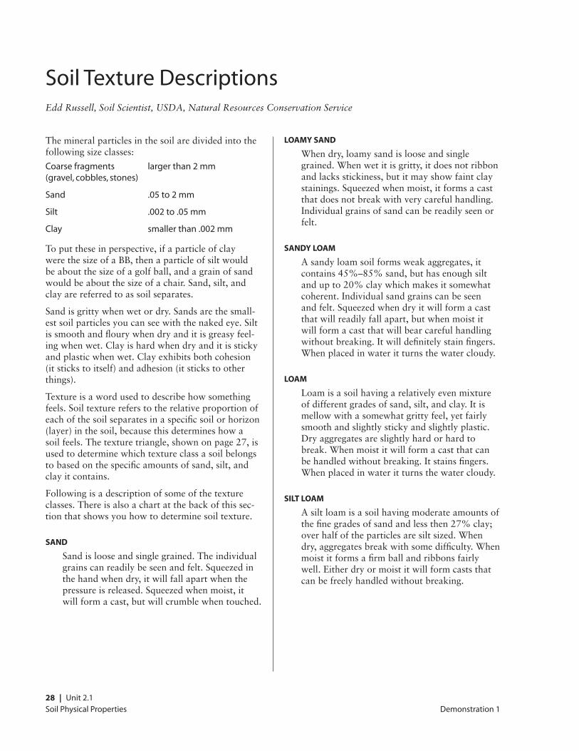
Soil Texture DescriptionsEdd Russell, Soil Scientist, USDA, Natural Resources Conservation Service
Themineralparticlesinthesoilaredividedintothefollowingsizeclasses:
Coarse fragments larger than 2 mm (gravel, cobbles, stones)
Sand .05 to 2 mm
Silt .002 to .05 mm
Clay smaller than .002 mm
Toputtheseinperspective,ifaparticleofclaywerethesizeofaBB,thenaparticleofsiltwouldbeaboutthesizeofagolfball,andagrainofsandwouldbeaboutthesizeofachair.Sand,silt,andclayarereferredtoassoilseparates.
Sandisgrittywhenwetordry.Sandsarethesmall-estsoilparticlesyoucanseewiththenakedeye.Siltissmoothandflourywhendryanditisgreasyfeel-ingwhenwet.Clayishardwhendryanditisstickyandplasticwhenwet.Clayexhibitsbothcohesion(itstickstoitself)andadhesion(itstickstootherthings).
Textureisawordusedtodescribehowsomethingfeels.Soiltexturereferstotherelativeproportionofeachofthesoilseparatesinaspecificsoilorhorizon(layer)inthesoil,becausethisdetermineshowasoilfeels.Thetexturetriangle,shownonpage27,isusedtodeterminewhichtextureclassasoilbelongstobasedonthespecificamountsofsand,silt,andclayitcontains.
Followingisadescriptionofsomeofthetextureclasses.Thereisalsoachartatthebackofthissec-tionthatshowsyouhowtodeterminesoiltexture.
sanD
Sandislooseandsinglegrained.Theindividualgrainscanreadilybeseenandfelt.Squeezedinthehandwhendry,itwillfallapartwhenthepressureisreleased.Squeezedwhenmoist,itwillformacast,butwillcrumblewhentouched.
loaMY sanD
Whendry,loamysandislooseandsinglegrained.Whenwetitisgritty,itdoesnotribbonandlacksstickiness,butitmayshowfaintclaystainings.Squeezedwhenmoist,itformsacastthatdoesnotbreakwithverycarefulhandling.Individualgrainsofsandcanbereadilyseenorfelt.
sanDY loaM
Asandyloamsoilformsweakaggregates,itcontains45%–85%sand,buthasenoughsiltandupto20%claywhichmakesitsomewhatcoherent.Individualsandgrainscanbeseenandfelt.Squeezedwhendryitwillformacastthatwillreadilyfallapart,butwhenmoistitwillformacastthatwillbearcarefulhandlingwithoutbreaking.Itwilldefinitelystainfingers.Whenplacedinwateritturnsthewatercloudy.
loaM
Loamisasoilhavingarelativelyevenmixtureofdifferentgradesofsand,silt,andclay.Itismellowwithasomewhatgrittyfeel,yetfairlysmoothandslightlystickyandslightlyplastic.Dryaggregatesareslightlyhardorhardtobreak.Whenmoistitwillformacastthatcanbehandledwithoutbreaking.Itstainsfingers.Whenplacedinwateritturnsthewatercloudy.
sIlt loaM
Asiltloamisasoilhavingmoderateamountsofthefinegradesofsandandlessthen27%clay;overhalfoftheparticlesaresiltsized.Whendry,aggregatesbreakwithsomedifficulty.Whenmoistitformsafirmballandribbonsfairlywell.Eitherdryormoistitwillformcaststhatcanbefreelyhandledwithoutbreaking.
Demonstration 1
Soil Physical Properties Unit 2.1 | 29
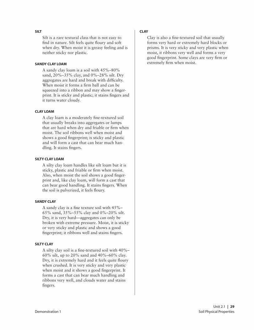
sIlt
Siltisararetexturalclassthatisnoteasytofindinnature.Siltfeelsquiteflouryandsoftwhendry.Whenmoistitisgreasyfeelingandisneitherstickynorplastic.
sanDY claY loaM
Asandyclayloamisasoilwith45%–80%sand,20%–35%clay,and0%–28%silt.Dryaggregatesarehardandbreakwithdifficulty.Whenmoistitformsafirmballandcanbesqueezedintoaribbonandmayshowafinger-print.Itisstickyandplastic;itstainsfingersanditturnswatercloudy.
claY loaM
Aclayloamisamoderatelyfine-texturedsoilthatusuallybreaksintoaggregatesorlumpsthatarehardwhendryandfriableorfirmwhenmoist.Thesoilribbonswellwhenmoistandshowsagoodfingerprint;isstickyandplasticandwillformacastthatcanbearmuchhan-dling.Itstainsfingers.
sIltY claY loaM
Asiltyclayloamhandleslikesiltloambutitissticky,plasticandfriableorfirmwhenmoist.Also,whenmoistthesoilshowsagoodfinger-printand,likeclayloam,willformacastthatcanbeargoodhandling.Itstainsfingers.Whenthesoilispulverized,itfeelsfloury.
sanDY claY
Asandyclayisafinetexturesoilwith45%–65%sand,35%–55%clayand0%–20%silt.Dry,itisveryhard—aggregatescanonlybebrokenwithextremepressure.Moist,itisstickyorverystickyandplasticandshowsagoodfingerprint;itribbonswellandstainsfingers.
sIltY claY
Asiltyclaysoilisafine-texturedsoilwith40%–60%silt,upto20%sandand40%–60%clay.Dry,itisextremelyhardanditfeelsquiteflourywhencrushed.Itisverystickyandveryplasticwhenmoistanditshowsagoodfingerprint.Itformsacastthatcanbearmuchhandlingandribbonsverywell,andcloudswaterandstainsfingers.
claY
Clayisalsoafine-texturedsoilthatusuallyformsveryhardorextremelyhardblocksorprisms.Itisverystickyandveryplasticwhenmoist,itribbonsverywellandformsaverygoodfingerprint.Someclaysareveryfirmorextremelyfirmwhenmoist.
Demonstration 1

30 | Unit 2.1Soil Physical Properties
Soil Physical Properties Unit 2.1 | 31
Instructor’s Demonstration 2 Outline
Demonstration 2: Soil Pit Examination
for the instructor
DeMonstratIon outlIne
A. Determine Approximate Textural Classification of Soil by Feel
B. Identify Distinct Soil Horizons 1.AHorizonandwhatdefinesit
2.BHorizonandwhatdefinesit
3.CHorizonandwhatdefinesit
4.Identifyindicatorsofsoildisturbance(e.g.,tillage)
C. Describe/Define the Type(s) of Soil Structure Observed 1.Describegeneralsoilstructureandhowitiscreated
2.Identifyandprovideexamplesofsoilaggregatesandhowtheyform
Instructor overvIew
In this demonstration students examine the soil profile and various soil properties exposed in a shallow soil excavation. Discuss the soil profile and how the soil properties observed affect the use of the soil for farming, gardening, and other purposes.
MaterIals
• ShovelandPicmattock(todigpit)
• Munsellsoilcolorbook
• Waterbottleformoisteningsoil
• pHkit
sIte PreParatIon
Severalhoursbeforethedemonstra-tiondigapitapproximately2–4feetdeep(oruntildistinctsoilhorizonsareobserved).Forease,thepitmaybetriangularinshapeandstepped.Plantohavethesoilprofileinfullsunatthetimeofthedemonstration.
PreParatIon tIMe
Approximately1hour
DeMonstratIon tIMe
1hour

Soil Physical Properties32 | Unit 2.1
Soil Physical Properties Unit 2.1 | 33
Supplemental Demonstrations
Supplemental Demonstrations and Examples
for the instructor
Instructor overvIew
These demonstrations and examples use analogy and models to illustrate various soil physical properties. Note the references to sections of the detailed lecture outline for specific topics.
soIl exaMPles
LectureOutlineReference:Throughout
PUrPOSE
Toshowexamplesofcertainsoilphysicalprop-erties
MATErIAlS: ExAMPlES OF SOIl TO ShOw
• Color(dark=highorganicmatter,bright=welldrained,redoximorphicfeatures=wetness)
• Structure
• Texture(sand,silt,clay,loam,etc.)
• Hardpans
Baklava DeMonstratIon
DetailedLectureOutlineReference:C1a)iii
PUrPOSE
Toshowlayeringakintowhatisfoundinphyl-losilicate(layer-lattice)clays
MATErIAlS
• Baklava,preferablyenoughsothateachstudentcanhaveapiece
METhODS
Pointoutthatmanyclaymineralsarelayeredatthemicroscopiclevelmuchthewaythatbaklavaisandthatcationsareadsorbedtothesidesofclayparticlesmuchthesameasthenutsarestucktothesidesofthebaklava.
MoDels DeMonstratIon
DetailedLectureOutlineReference:C1a)iii
PUrPOSE
Toshowthearrangementofmoleculesinsilicatetrahedraandaluminadioctehedra
MATErIAlS
• Molecularmodelsormodelsmadefromcardboardandtapeshowingtheshapeofatetrahedronandoctrahedron
METhODS
Ifshortontime,skipthis.ThisismorethanmanycancomprehendbutIuseittoillustratethecomplexityoftheclayminerals.
Soil Physical Properties34 | Unit 2.1
target DeMonstratIon
DetailedLectureOutlineReference:C1a)iii
PUrPOSE
Toshowthatclayissticky(adhesion)
MATErIAlS
• Moistclay,moistenedenoughsothatitadherestomostsurfaces
• Aflipchartorblackboardwithatargetdrawnonit
• Moistsandyloam(optional,forcontrast)
METhODS
Formtheclayintoaball,andthrowitatthetarget(testthesurfacefirsttomakesurethattheclaywillactuallysticktoit).Optionally,youcanrepeattheprocesswithsandyloamorsimilartoshowthatitisnotassticky.
rIBBon DeMonstratIon
DetailedLectureOutlineReference:C1a)iii
PUrPOSE
Toshowthatclayisplastic(cohesion)
MATErIAlS
• Moistclay
• Moistsandyloam(optional,forcontrast)
METhODS
Squeezetheclaythroughyourthumbandfore-fingertocreatearibbon.Optionally,repeattheprocesswithsandyloamtoshowthatitdoesnotribbonaswell.
slInkY DeMonstratIon
DetailedLectureOutlineReference:C1a)iii
PUrPOSE
Toshowhowclaysshrinkandswellbylayersbecomingseparated
MATErIAlS
• Slinky
METhODS
Stretch and compress a slinky in your hand while explaining that some clays can shrink and swell as layers get separated when water gets between them
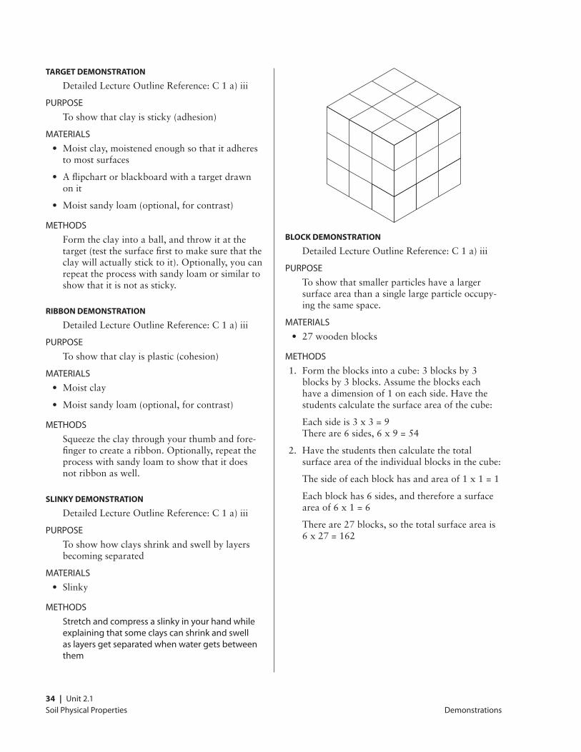
Block DeMonstratIon
DetailedLectureOutlineReference:C1a)iii
PUrPOSE
Toshowthatsmallerparticleshavealargersurfaceareathanasinglelargeparticleoccupy-ingthesamespace.
MATErIAlS
• 27woodenblocks
METhODS
1. Formtheblocksintoacube:3blocksby3blocksby3blocks.Assumetheblockseachhaveadimensionof1oneachside.Havethestudentscalculatethesurfaceareaofthecube:
Eachsideis3x3=9 Thereare6sides,6x9=54
2. Havethestudentsthencalculatethetotalsurfaceareaoftheindividualblocksinthecube:
Thesideofeachblockhasandareaof1x1=1
Eachblockhas6sides,andthereforeasurfaceareaof6x1=6
Thereare27blocks,sothetotalsurfaceareais6x27=162
Demonstrations
Soil Physical Properties Unit 2.1 | 35
color Book exaMPle
DetailedLectureOutlineReference:C6a)
PUrPOSE
Toshowhowsoilcolorisdescribed
MATErIAlS
MunsellorEarthColorssoilcolorcharts
METhODS
ShowhowthecolorchartsandMunsellcolornotationareused.
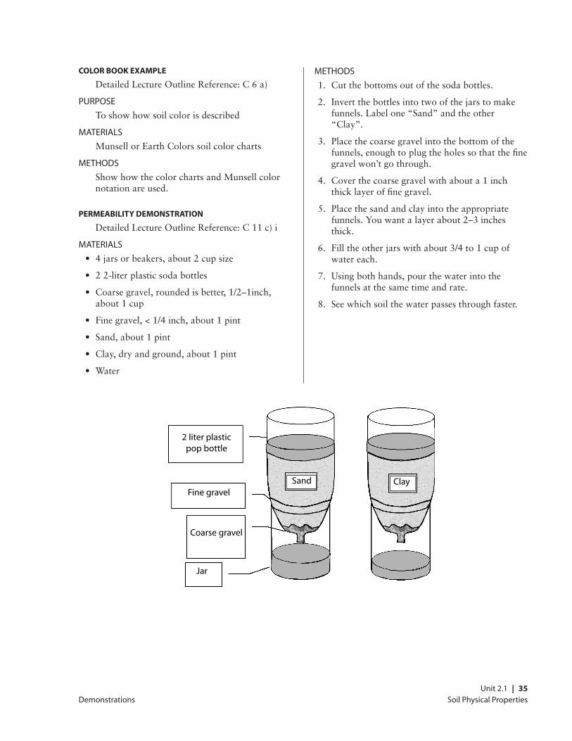
PerMeaBIlItY DeMonstratIon
DetailedLectureOutlineReference:C11c)i
MATErIAlS
• 4jarsorbeakers,about2cupsize
• 22-literplasticsodabottles
• Coarsegravel,roundedisbetter,1/2–1inch,about1cup
• Finegravel,<1/4inch,about1pint
• Sand,about1pint
• Clay,dryandground,about1pint
• Water
METhODS
1. Cutthebottomsoutofthesodabottles.
2. Invertthebottlesintotwoofthejarstomakefunnels.Labelone“Sand”andtheother“Clay”.
3. Placethecoarsegravelintothebottomofthefunnels,enoughtoplugtheholessothatthefinegravelwon’tgothrough.
4. Coverthecoarsegravelwithabouta1inchthicklayeroffinegravel.
5. Placethesandandclayintotheappropriatefunnels.Youwantalayerabout2–3inchesthick.
6. Filltheotherjarswithabout3/4to1cupofwatereach.
7. Usingbothhands,pourthewaterintothefunnelsatthesametimeandrate.
8. Seewhichsoilthewaterpassesthroughfaster.
Demonstrations
Sand Clay
2 liter plastic pop bottle
Fine gravel
Coarse gravel
Jar
Soil Physical Properties36 | Unit 2.1
Demonstrations
Peat Moss DeMonstratIon
DetailedLectureOutlineReference:C11d)i.
PUrPOSE
Toshowhowdryorganicmatterrepelswater
MATErIAlS
• Drypeatmoss(ahandful)
• Water
METhODS
Holdupahandfulofdrypeatmossandpourthewateroverit,showinghowthewaterrunsoffratherthansoakingin.
sPonge DeMonstratIon
DetailedLectureOutlineReference:C12
PUrPOSE
Toprovideaconceptualmodelofavailablewatercapacityandfieldcapacity
MATErIAlS
• Sponge
• Waterinabowlorpan
METhODS
1. Soakthespongeinwateruntilitissaturated.
2. Holdupthespongeuntilmostofthewaterstopsdripping.Explainthatthespongeisanalagoustosoil.Whenthewaterhasfinisheddrainingfromthesoil24hoursaftersaturation,thesoilissaidtobeatfieldcapacity.
3. Squeezethespongetoremoveasmuchwaterasyoucan.Mentionthatthiswaterwouldbeanalagoustowhatcanberemovedbyplantsandiscalledavailablewater.Thereisstillsomemoistureinthespongeandthatisanalagoustothewaterthatisheldsotightlyinthesoilthatplantscannotremoveit.
Soil Physical Properties Unit 2.1 | 37
Assessment Questions
Assessment Questions
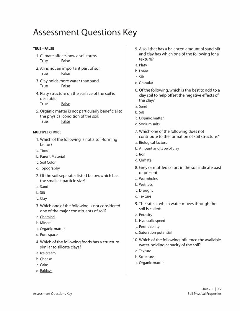
true or false
1. Climate affects how a soil forms. True False
2. Air is not an important part of soil. True False
3. Clay holds more water than sand. True False
4. Platy structure on the surface of the soil is desirable. True False
5. Organic matter is not particularly beneficial to the physical condition of the soil. True False
MultIPle choIce
1. which of the following is not a soil-forming factor?
a. Time
b. Parent material
c. Soil color
d. Topography
2. Of the soil separates listed below, which has the smallest particle size?
a. Sand
b. Silt
c. Clay
3. which one of the following is not considered one of the major constituents of soil?
a. Chemical
b. Mineral
c. Organic matter
d. Pore space
4. which of the following foods has a structure similar to silicate clays?
a. Ice cream
b. Cheese
c. Cake
d. Baklava
5. A soil that has a balanced amount of sand, silt and clay has which one of the following for a texture?
a. Platy
b. loam
c. Silt
d. Granular
6. Of the following, which is the best to add to a clay soil to help offset the negative effects of the clay?
a. Sand
b. Silt
c. Organic matter
d. Sodium salts
7. which one of the following does not contribute to the formation of soil structure?
a. Biological factors
b. Amount and type of clay
c. Iron
d. Climate
8. Gray or mottled colors in the soil indicate past or present:
a. wormholes
b. wetness
c. Drought
d. Texture
9. The rate at which water moves through the soil is called:
a. Porosity
b. hydraulic speed
c. Permeability
d. Saturation potential
Soil Physical Properties38 | Unit 2.1
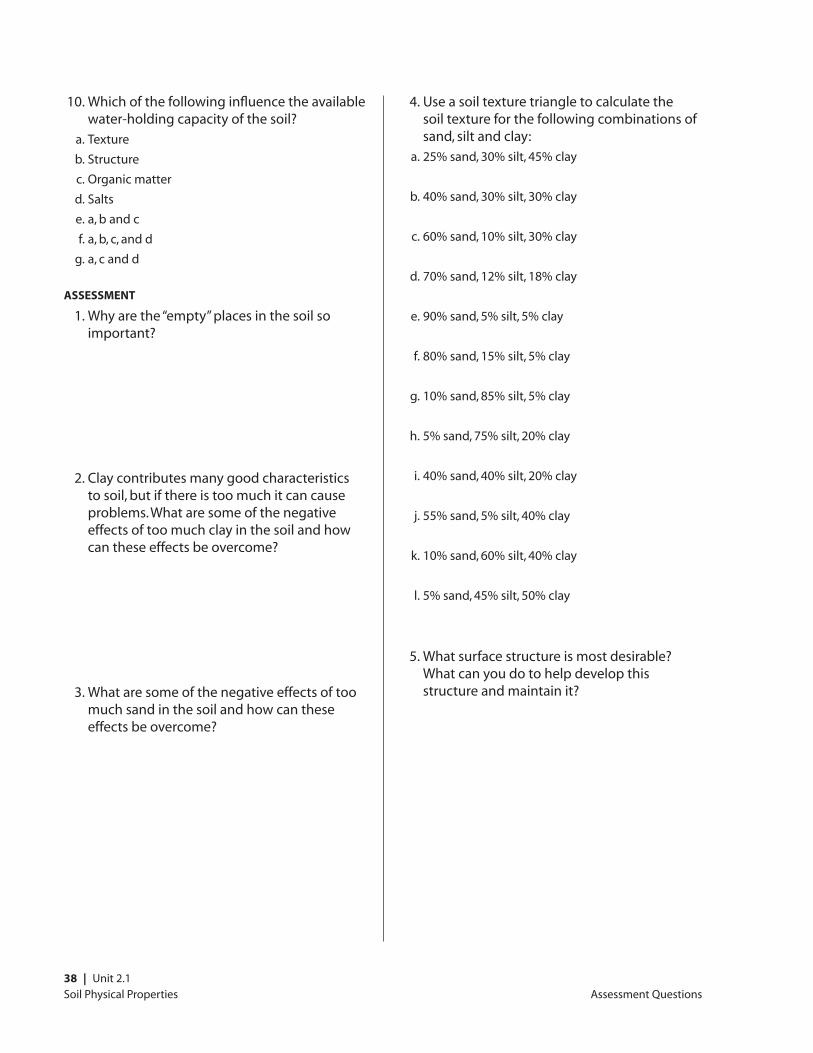
10. which of the following influence the available water-holding capacity of the soil?
a. Texture
b. Structure
c. Organic matter
d. Salts
e. a, b and c
f. a, b, c, and d
g. a, c and d
assessMent
1. why are the “empty” places in the soil so important?
2. Clay contributes many good characteristics to soil, but if there is too much it can cause problems. what are some of the negative effects of too much clay in the soil and how can these effects be overcome?
3. what are some of the negative effects of too much sand in the soil and how can these effects be overcome?
4. Use a soil texture triangle to calculate the soil texture for the following combinations of sand, silt and clay:
a. 25% sand, 30% silt, 45% clay
b. 40% sand, 30% silt, 30% clay
c. 60% sand, 10% silt, 30% clay
d. 70% sand, 12% silt, 18% clay
e. 90% sand, 5% silt, 5% clay
f. 80% sand, 15% silt, 5% clay
g. 10% sand, 85% silt, 5% clay
h. 5% sand, 75% silt, 20% clay
i. 40% sand, 40% silt, 20% clay
j. 55% sand, 5% silt, 40% clay
k. 10% sand, 60% silt, 40% clay
l. 5% sand, 45% silt, 50% clay
5. what surface structure is most desirable? what can you do to help develop this structure and maintain it?
Assessment Questions
Soil Physical Properties Unit 2.1 | 39
Assessment Questions Key
true – false
1. Climate affects how a soil forms. True False
2. Air is not an important part of soil. True False
3. Clay holds more water than sand. True False
4. Platy structure on the surface of the soil is desirable. True False
5. Organic matter is not particularly beneficial to the physical condition of the soil. True False
MultIPle choIce
1. which of the following is not a soil-forming factor?
a. Time
b. Parent Material
c. Soil Color
d. Topography
2. Of the soil separates listed below, which has the smallest particle size?
a. Sand
b. Silt
c. Clay
3. which one of the following is not considered one of the major constituents of soil?
a. Chemical
b. Mineral
c. Organic matter
d. Pore space
4. which of the following foods has a structure similar to silicate clays?
a. Ice cream
b. Cheese
c. Cake
d. Baklava
5. A soil that has a balanced amount of sand, silt and clay has which one of the following for a texture?
a. Platy
b. loam
c. Silt
d. Granular
6. Of the following, which is the best to add to a clay soil to help offset the negative effects of the clay?
a. Sand
b. Silt
c. Organic matter
d. Sodium salts
7. which one of the following does not contribute to the formation of soil structure?
a. Biological factors
b. Amount and type of clay
c. Iron
d. Climate
8. Grey or mottled colors in the soil indicate past or present:
a. wormholes
b. wetness
c. Drought
d. Texture
9. The rate at which water moves through the soil is called:
a. Porosity
b. hydraulic speed
c. Permeability
d. Saturation potential
10. which of the following influence the available water-holding capacity of the soil?
a. Texture
b. Structure
c. Organic matter
Assessment Questions Key
Soil Physical Properties40 | Unit 2.1
d. Salts
e. a, b and c
f. a, b, c, and d
g. a, c, and d
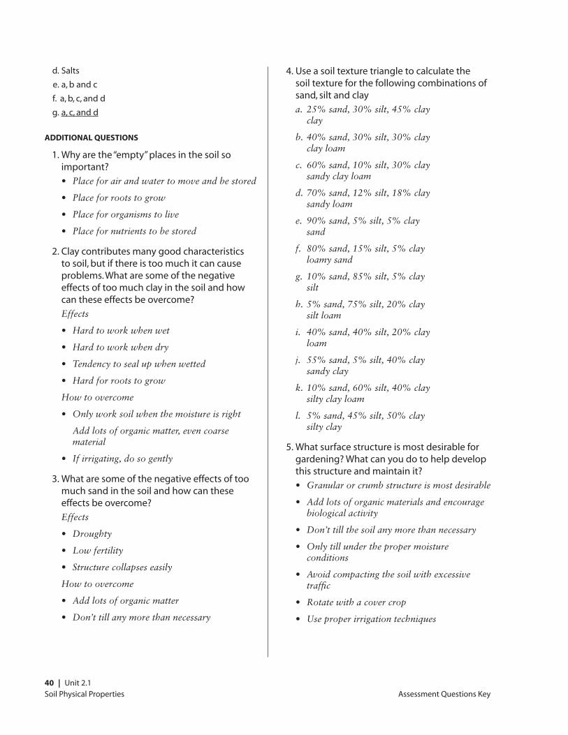
aDDItIonal QuestIons
1. why are the “empty” places in the soil so important?
• Placeforairandwatertomoveandbestored
• Placeforrootstogrow
• Placefororganismstolive
• Placefornutrientstobestored
2. Clay contributes many good characteristics to soil, but if there is too much it can cause problems. what are some of the negative effects of too much clay in the soil and how can these effects be overcome?
Effects
• Hardtoworkwhenwet
• Hardtoworkwhendry
• Tendencytosealupwhenwetted
• Hardforrootstogrow
Howtoovercome
• Onlyworksoilwhenthemoistureisright
Add lots of organic matter, even coarse material
• Ifirrigating,dosogently
3. what are some of the negative effects of too much sand in the soil and how can these effects be overcome?
Effects
• Droughty
• Lowfertility
• Structurecollapseseasily
Howtoovercome
• Addlotsoforganicmatter
• Don’ttillanymorethannecessary
4. Use a soil texture triangle to calculate the soil texture for the following combinations of sand, silt and clay
a. 25% sand, 30% silt, 45% clay clay
b. 40% sand, 30% silt, 30% clay clay loam
c. 60% sand, 10% silt, 30% clay sandy clay loam
d. 70% sand, 12% silt, 18% clay sandy loam
e. 90% sand, 5% silt, 5% clay sand
f. 80% sand, 15% silt, 5% clay loamy sand
g. 10% sand, 85% silt, 5% clay silt
h. 5% sand, 75% silt, 20% clay silt loam
i. 40% sand, 40% silt, 20% clay loam
j. 55% sand, 5% silt, 40% clay sandy clay
k. 10% sand, 60% silt, 40% clay silty clay loam
l. 5% sand, 45% silt, 50% clay silty clay
5. what surface structure is most desirable for gardening? what can you do to help develop this structure and maintain it?
• Granularorcrumbstructureismostdesirable
• Addlotsoforganicmaterialsandencouragebiological activity
• Don’ttillthesoilanymorethannecessary
• Onlytillunderthepropermoistureconditions
• Avoidcompactingthesoilwithexcessivetraffic
• Rotatewithacovercrop
• Useproperirrigationtechniques
Assessment Questions Key
Soil Physical Properties Unit 2.1 | 41
resources
resources
PrInt resources
BOOKS
Brady,N.C.,andWeil,R.R.1999.The Nature and PropertyofSoils,12thedition.UpperSaddleRiver,NJ:Prentice-Hall,Inc.
A good general soils text, used for introductory soils classes at universities. Might be too technical for some.
Buol,S.W.,F.D.Hole,R.J.McCracken,andR.J.andSouthard.1997.SoilGenesisandClassification,Fourth Edition.Ames,IA:IowaStateUniversityPress.
College textbook used to teach soil classification.
Dixon,J.B.,andS.B.Weed,eds.1989.Minerals in Soil Environments.Madison,WI:SoilScienceSocietyofAmerica.
Verytechnicalreferenceonsoilminerals.Onlythe most hardy go here.
Dubbin,William.2001.Soils.TheNaturalHistoryMuseum,London.AvailablefromIowaStateUni-versityPress,Ames,Iowa.
Short overview of soil science. Easy to read and understand, lots of color photos.
Gershuny,Grace.1993.Start with the Soil.Em-maus,PA:RodalePress.
A general book on soils and soil management geared toward organic gardeners. Easy to read and understand.
Gershuny,Grace.2000.The Soul of Soil: A Soil-BuildingGuideforMasterGardenersandFarmers,Fourth edition.WhiteRiverJunction,VT:ChelseaGreenPublishing.
Providesessentialinformationonsoilecosystemmanagement for organic growers. Topics include organic matter management, building and maintaining humus, on-site composting, green manures and crop rotations, cultivation and weed control, nutrient balances and soil testing, and using mineral fertilizers.
Magdoff,FredandHaroldVanEs.2000.Building Soils for Better Crops, Second Edition.SustainableAgricultureNetwork,HandbookSeriesBook4.Beltsville,MD:NationalAgriculturalLibrary.
An introductory overview of organic management of soil fertility covering the basics of soil organic matter, physical and chemical properties of soil, ecological soil and cropmanagement.Practicalandaccessibleinformation. Available from www.sare.org
Stell,ElizabethP.,1998.SecretstoGreatSoil.Pow-nal,VT:StoreyCommunications,Inc.
An easy-to-read primer on soils, composting and basicgardeningtechniques.Lotsofdiagrams.
SOIl SUrvEyS
ThesecanbeobtainedfromNaturalResourceCon-servationServicesoffices.Theyarealsoavailableinmanylibraries.
SoilSurveyStaff,NaturalResourcesConservationService.1999.NationalSoilSurveyHandbook,title430-VI.UnitedStatesDepartmentofAgriculture,Washington,D.C.,U.S.GovernmentPrintingOffice.
Contains all the technical details about making soil surveys and entering soil properties into the National Soils Information System (NASIS). Available online at:
www.statlab.iastate.edu/soils/nssh/.
SoilSurveyDivisionStaff.1993.Soil Survey Manu-al.UnitedStatesDepartmentofAgriculture,Wash-ingtonDC.,U.S.GovernmentPrintingOffice.
This is the manual that soil scientists use to carry out soil survey work. The most definitive guide on how to describe the physical properties of soil. Available online at:
www.statlab.iastate.edu/soils/ssm/gen_cont.html
SoilSurveyStaff,NaturalResourcesConservationService.1999.Soil Taxonomy.UnitedStatesDepart-mentofAgriculture.Washington,D.C.:U.S.Gov-ernmentPrintingOffice.
Thereferenceusedtoclassifysoils.Highlytechnical, used mainly by soil scientists. Available online at:
www.statlab.iastate.edu/soils/nsdaf/
Soil Physical Properties42 | Unit 2.1
weB resources
CaliforniaAgricultureTeachersAssociation(CATA)SustainableAgricultureCurriculumandPowerPointResources
www.ccagcans.com/cansdefault.html (see “Course Curriculum”)
The CATA Sustainable Agriculture Curriculum andPowerPointsitecontains5courses(including course descriptions, outlines, and resourcelistings)andover40PowerPointtitles. Developed by leading agricultural professionals, these resources address various aspects of sustainable food systems and organic agricultural production practices.
CaliforniaNRCShomepage
www.ca.nrcs.usda.gov
CanadianSoilInformationSystem
res.agr.ca/CANSIS
ExploringSustainabilityinAgriculture:AnOnlineSustainableAgricultureInstructionalResource,Cen-terforAgroecologyandSustainableFoodSystems(CASFS)
zzyx.ucsc.edu/casfs/instruction/esa/index.html
This sustainable agriculture education resource from the Center for Agroecology and Sustainable Food Systems includes a catalogue description and outline for a comprehensive course on sustainable agriculture, appropriate for the community college, state college, or university level. The outline and annotated resources address topics in social and environmental sciences; plant, soil, crop, and animal sciences; pest management; natural resource management; the adoption of sustainable agriculture; and the growth and development of sustainable agriculture and the organic food industry.
GlossaryofSoilScienceTerms
www.soils.org/sssagloss
NationalSustainbleAgricultureInformationService
www.attraorg/soils.html
Science of Soilsonlinejournal
link.springer.de/link/service/journals/10112/index.htm
SoilsofCanada
quarles.unbc.edu/nres/soc/soc.htm
USDASoilData
soildatamart.nrcs.usda.gov
USDASoilInformation
soils.usda.gov
eDucatIon lInks
soilsassociation.org/links/educational.htm
InstItutIons
CooperativeExtensionServiceorFarmAdvisorsoffice
Staff from these offices will be aware of crop nutrient needs and problems in your area. They can assist you with nutrient deficiency symptoms and known plant nutrition problems in your area.
USDepartmentofAgriculture–NaturalResourcesConservationService(USDA–NRCS)fieldoffices
Information about soils in your area can be obtained from NRCS field offices. They are usuallylistedintheU.S.Governmentpagesof the phone book under US Department of Agriculture. They may also be listed as USDA Service Center. Some areas do not have NRCS offices but do have Resource Conservation District offices that can provide the same information.
resources
Soil Physical Properties Unit 2.1 | 43
Glossary
Glossary
AbsorptionUptake of matter or energy by a substance3
AdsorptionThe process by which atoms, molecules, or ions are taken up from the soil solution or soil atmosphere and retained on the surfaces of solids by chemical or physical binding.3
Acidity Refers to the condition of the soil when the exchange complex is dominated by hydrogen and aluminum ions
Acidity, salt-replaceableThe aluminum and hydrogen that can be replaced from an acid soil by an unbuffered salt solution such as KCl or NaCl 3
Acidity, totalThe total acidity including residual and exchangeableacidity.Oftenitiscalculatedby subtraction of exchangeable bases from the cation exchange capacity determined byammoniumexchangeatpH7.0.ItcanbedetermineddirectlyusingpHbuffer-saltmixtures (e.g., BaCl2plustriethanolamine,pH8.0 or 8.2) and titrating the basicity neutralized after reaction with a soil.3
Aeration, soilThe exchange of air in soil with air from the atmosphere. The air in a well-aerated soil is similar to that in the atmosphere; the air in a poorly aerated soil is considerably higher in carbon dioxide and lower in oxygen.1
Aggregate, soilMany fine particles held in a single mass or cluster. Natural soil aggregates, such as granules, blocks, or prisms, are called peds. Clods are aggregates produced by tillage or logging.1
Alkali soil(i)AsoilwithapHof8.5orhigherorwithaexchangeable sodium ratio greater than 0.15. (ii) A soil that contains sufficient sodium to interfere with the growth of most crop plants.3
AnionA negatively charged ion (has surplus electrons)3
Anion exchange capacityThe sum of exchangeable anions that a soil can adsorb. Usually expressed as centimoles, or millimoles, of charge per kilogram of soil (or of other adsorbing material such as clay).3
AspectThe direction in which a slope faces1
AtomThe smallest particle of an element that can exist either alone or in combination4
Available water capacity (available moisture capacity) (AwC)
The volume of water that should be available to plants if the soil, inclusive of fragments, were at field capacity. It is commonly estimated as the amount of water held between field capacity and wilting point, with corrections for salinity, fragments, and rooting depth. It is commonly expressed as inches of water per inch of soil.2 The following classes are used in California, based on the AWC of 60 inch depth (or depth to a limiting layer):
AWC Class AWC/60 inches or limiting layer
Very low 0 to 2.5
Low 2.5to5
Moderate 5 to 7.5
High 7.5to10
Very high more than 10
AwCSee available water capacity
references useD for terMs
1Fromthestandardglossaryusedinsoilsurveyreports
2NationalSoilSurveyHandbook.1998.Availableonlineat www.statlab.iastate.edu/soils/nssh/
3GlossaryofSoilScienceTerms.1996,SoilScienceSocietyofAmerica.Availableonlineatwww.soils.org/sssagloss/
4Merriam-WebsterOnline.www.m-w.com/
Soil Physical Properties44 | Unit 2.1
Base saturationThe degree to which material having cation-exchange properties is saturated with exchangeable bases (sum of Ca, Mg, Na, and K), expressed as a percentage of the total cation-exchange capacity1
Boulders. Rock fragments larger than 2 feet (60 centimeters) in diameter1
Bulk density A measurement of the oven-dried weight of the less than 2 mm soil material per unit volume of soil. Common measurements are taken at a water tension of 1/10 bar; 1/3 bar; or 15 bar. Bulk density influences plant growth and engineering applications. It is used to convert measurements from a weight basis to a volume basis. Within a family particle size class, bulk density is an indicator of how well plant roots are able to extend into the soil. Bulk density is used to calculate porosity.2
Calcareous soilA soil containing enough calcium carbonate (commonly combined with magnesium carbonate) to effervesce visibly when treated with cold, dilute hydrochloric acid1
Calcium carbonate equivalentThequantityofcarbonate(CO3) in the soil expressedasCaCO3 and as a weight percentage of the less than 2 mm size fraction2
Capillary waterWater held as a film around soil particles and in tiny spaces between particles. Surface tension is the adhesive force that holds capillary water in the soil.1
CationAn ion carries a positive charge of electricity. The common soil cations are calcium, potassium, magnesium, sodium, and hydrogen.1
Cation-exchange capacity (CEC)The total amount of exchangeable cations that can be held by the soil, expressed in terms ofmilliequivalentsper100gramsofsoilatneutrality(pH7.0)oratsomeotherstatedpHvalue.Theterm,asappliedtosoils,issynonymous with base-exchange capacity but is more precise in meaning.1
CECSee cation exchange capacity
ClayAs a soil separate, the minerals soil particles less than 0.002 millimeter in diameter. As a soil textural class, soil material that is 40 percent or more clay, less than 45 percent sand, and less than 40 percent silt.1
ClaypanA dense, compact, slowly permeable layer in the subsoil, with a much higher clay content than overlying materials from which is separated by a sharply defined boundary. A claypan is usually hard when dry, and plastic or sticky when wet.2
Coarse fragmentsSee Rock fragments
Coarse textured soilSand or loamy sand1
Cobble (or cobblestone)A rounded or partly rounded fragment of rock 3 to 10 inches (7.6 to 25 centimeters) in diameter1
ColloidA particle, which may be a molecular aggregate, with a diameter of 0.1 to 0.001 µm. Soil clays and soil organic matter are often called soil colloids because they have particle sizes that are within, or approach colloidal dimensions.3
CompactionThe process by which the soil grains are rearranged to decrease void space and bring them into closer contact with one another, thereby increasing the bulk density3
CompoundSomething formed by a union of elements or parts; especially: a distinct substance formed by chemical union of two or more ingredients in definite proportion by weight4
Consistence, soilRefers to the degree of cohesion and adhesion of soil material and its resistance to deformation when ruptured. Consistence includes resistance of soil material to rupture and to penetration; plasticity, toughness, and stickiness of puddled soil material; and the manner in which the soil material behaves when subject to compression. Terms describing consistence are defined in the Soil Survey Manual.1
Glossary
Soil Physical Properties Unit 2.1 | 45
Deep soilSee Depth
Depth, soilGenerally,thethicknessofthesoiloverbedrock.Very deep soils are more than 60 inches deep over bedrock; deep soils, 40 to 60 inches; moderately deep, 20 to 40 inches; shallow, 10 to 20 inches; and very shallow, less than 10 inches.1
Drainage class (natural)Referstothefrequencyanddurationofwetperiods under conditions similar to those under which the soil formed. Alterations of the water regime by human activities, either through drainage or irrigation, are not a consideration unless they have significantly changed the morphology of the soil. Seven classes of natural soil drainage are recognized: excessively drained, somewhat excessively drained, well drained, moderately well drained, somewhat poorly drained, poorly drained, and very poorly drained. These classes are defined in the Soil Survey Manual.1
DuripanA subsurface soil horizon that is cemented by illuvial silica, usually opal or microcrystalline forms of silica, to the degree that less than 50 percent of the volume of air-dry fragments will slakeinwaterorHCl3
ECSee electrical conductivity
EdaphologyThe science that deals with the influence of soils on living things; particularly plants, including human uses of land for plant growth3
Electrical conductivity (EC)The electrolytic conductivity of an extract from saturated soil paste2
ElementBasicunitofmatterthatcan’tbebrokendownby chemical means. They are the building blocks of nature. Any of more than 100 fundamental substances that consist of atoms of only one kind and that singly or in combination constitute all matter.4
EluviationThe movement of material in true solution or colloidal suspension from one place to another within the soil. Soil horizons that have lost material through eluviation are eluvial; those that have received material are illuvial.1
Exchangeable anionA negatively charged ion held on or near the surface of a solid particle by a positive surface charge and which may be easily replaced by other negatively charged ions (e.g., with a Cl- salt)3
Fertility, soilThequalitythatenablesasoiltoprovideplantnutrients,inadequateamountsandinproperbalance, for the growth of specified plants when light, moisture, temperature, tilth, and other growth factors are favorable1
Field moisture capacityThe moisture content of a soil, expressed as a percentage of the oven dry weight, after the gravitational, or free, water has drained away; the field moisture content 2 or 3 days after a soaking rain; also called normal field capacity, normal moisture capacity, or capillary capacity1
Fine textured soilSandy clay, silty clay, or clay1
FragmentsUnattached cemented pieces of bedrock, bedrock-like material, durinodes, concretions, and nodules 2 mm or larger in diameter; and woody material 20 mm or larger in organic soils2
Genesis, soilThe mode of origin of the soil. Refers especially to the processes or soil-forming factors responsible for the formation of the solum, or true soil, from the unconsolidated parent material.1
GravelRounded or angular fragments of rock as much as 3 inches (2 millimeters to 7.6 centimeters) in diameter. An individual piece is a pebble.1
Gravelly soil materialMaterial that is 15 to 35 percent, by volume, rounded or angular rock fragments, not prominently flattened, as much as 3 inches (7.6 centimeters) in diameter1
Glossary
Soil Physical Properties46 | Unit 2.1
Great groupA group of soils that is characterized by common characteristics usually developed under the influence of environmental factors (as vegetation and climate) active over a considerable geographic range and that comprises one or more families of soil—called also great soil group.4 See Soil Classification.
GypsumThe percent, by weight, of hydrated calcium sulfates in the <20 mm fraction of soil2
hardpanA hardened or cemented soil horizon, or layer. The soil material is sandy, loamy, or clayey and is cemented by iron oxide, silica, calcium carbonate, or other substance.1
horizon, soilA layer of soil, approximately parallel to the surface, having distinct characteristics produced by soil-forming processes. In the identification of soil horizons, an uppercase letter represents the major horizons. Numbers or lowercase letters that follow represent subdivisions of the major horizons. An explanation of the subdivisions is given in the Soil Survey Manual. The major horizons of mineral soil are as follows:1
Ohorizon=Anorganiclayeroffreshanddecaying plant residue.
Ahorizon=Themineralhorizonatornearthesurface in which an accumulation of humified organic matter is mixed with the mineral material. Also, a plowed surface horizon, most of which was originally part of a B horizon.
Ehorizon=Themineralhorizoninwhichthe main feature is loss of silicate clay, iron, aluminum, or some combination of these.
Bhorizon=ThemineralhorizonbelowanA horizon. The B horizon is in part a layer of transition from the overlying A to the underlying C horizon. The B horizon also has distinctive characteristics, such as (1) accumulationofclay,sesquioxides,humus,ora combination of these; (2) prismatic or blocky structure; (3) redder or browner colors than those in the A horizon; or (4) a combination of these.
Chorizon=Themineralhorizonorlayer,excluding indurated bedrock, that is little
affected by soil-forming processes and does not have the properties typical of the overlying soil material. The material of a C horizon may be either like or unlike that in which the solum formed. If the material is known to differ from that in the solum, an Arabic numeral, commonly a 2, precedes the letter C.
Crhorizon=Soft,consolidatedbedrockbeneaththe soil.
Rlayer=Consolidatedbedrockbeneaththesoil. The bedrock commonly underlies a C horizon, but it can be directly below an A or a B horizon.
humusThe well decomposed, more or less stable part of the organic matter in mineral soils1
Impervious soilA soil through which water, air, or roots penetrate slowly or not at all. No soil is absolutely impervious to air and water all the time.1
InfiltrationThe downward entry of water into the immediate surface of soil or other material, as contrasted with percolation, which is movement of water through soil layers or material1
Infiltration capacity The maximum rate at which water can infiltrate into a soil under a given set of conditions
Infiltration rateThe rate at which water penetrates the surface of the soil at any given instant, usually expressed in inches per hour. The rate can be limited by the infiltration capacity of the soil or the rate at which water is applied at the surface.1
Iron depletionsLow-chromazoneshavingalowcontentofiron and manganese oxide because of chemical reduction and removal, but having a clay content similar to that of the adjacent matrix. A type of redoximorphic depletion.1
leachingThe removal of soluble material from soil or other material by percolating water.1
Glossary
Soil Physical Properties Unit 2.1 | 47
loamSoil material that is 7 to 27 percent clay particles, 28 to 50 percent silt particles, and less than 52 percent sand particles1
loamyTexture group consisting of coarse sandy loam, sandy loam, fine sandy loam, very fine sandy loam, loam, silt loam, silt, clay loam, sandy clay loam, and silty clay loam soil textures3
Medium textured soilVery fine sandy loam, loam, silt loam, or silt1
Microrelief(i) Genericallyreferstolocal,slightirregularities in form and height of a land surface that are superimposed upon a larger landform, including such features as low mounds, swales, and shallow pits. See also gilgai, shrub-coppice dune, tree-tip mound, tree-tip pit.
(ii) Slight variations in the height of a land surface that are too small to delineate on a topographic or soils map at commonly used map scales (e.g., 1:24 000 and 1:15 840)3
Mineral soilSoil that is mainly mineral material and low in organic material. Its bulk density is more than that of organic soil.1
Moderately coarse textured soilCoarse sandy loam, sandy loam, or fine sandy loam1
Moderately deep soil See Depth
Moderately fine textured soilClay loam, sandy clay loam, or silty clay loam1
MoleculeThe smallest particle of a substance that retains all the properties of the substance and is composed of one or more atoms4
Morphology, soilThe physical makeup of the soil, including the texture, structure, porosity, consistence, color, and other physical, mineral, and biological properties of the various horizons, and the thickness and arrangement of those horizons in the soil profile1
Mottling, soilIrregular spots of different colors that vary in number and size. Descriptive terms are as follows: abundance: few, common, and many; size: fine, medium, and coarse; and contrast: faint, distinct, and prominent. The size measurements are of the diameter along the greatest dimension. Fine indicates less than 5 millimeters (about 0.2 inch); medium, from 5 to 15 millimeters (about 0.2 to 0.6 inch); and coarse, more than 15 millimeters (about 0.6 inch).1
MuckUnconsolidated soil material consisting primarily of highly decomposed organic material in which the original plant parts are not recognizable (i.e., “sapric” in Soil Taxonomy). It generally contains more mineral matter and is usually darker in color, than peat.2
Munsell notationA designation of color by degrees of three simple variables: hue, value, and chroma. For example, a notation of 10YR 6/4 is a color with hue of 10YR, value of 6, and chroma of 4.
Neutral soilAsoilhavingapHvalueof6.6to7.3(seeReaction, soil)1
Nutrient, plantAny element taken in by a plant that is essential toitsgrowth.Plantnutrientsaremainlynitrogen, phosphorus, potassium, calcium, magnesium, sulfur, iron, manganese, copper, boron, and zinc obtained from the soil and carbon, hydrogen, and oxygen obtained from the air and water.1
OMSeeOrganicmatter
OrderThe highest level (most general) of soil classification according to Soil Taxonomy. There are twelve orders: andisols, alfisols, aridisols, entisols, gelisols, histosols, inceptisols, mollisols, oxisols, spodosols, ultisols and vertisols.
Organic matter (OM)Plantandanimalresidueinthesoilinvariousstages of decomposition1
OxidationThe loss of one or more electrons by an ion or molecule3
Glossary
Soil Physical Properties48 | Unit 2.1
PanA compact, dense layer in a soil that impedes the movement of water and the growth of roots. For example, hardpan, fragipan, claypan, plowpan, and traffic pan.1
Parent materialThe unconsolidated and more or less chemically weathered mineral or organic matter from which the solum is developed by pedogenic processes2
PeatUnconsolidated soil material consisting largely of undecomposed, or slightly decomposed, organic matter (i.e., “fibric” in Soil Taxonomy) accumulated under conditions of excessive moisture2
PedAn individual natural soil aggregate, such as a granule, a prism, or a block
PedogenesisSeeGenesis,soil
PedologySoil science, especially the study of soils as a natural body
PedonThe smallest volume that can be called “a soil.” A pedon is three dimensional and large enough to permit study of all horizons. Its area ranges fromabout10to100squarefeet(1squaremeterto10squaremeters),dependingonthevariability of the soil.1
PercolationThe downward movement of water through the soil1
PermeabilityThequalityofthesoilthatenableswaterorairto move downward through the profile. The rate at which a saturated soil transmits water isacceptedasameasureofthisquality.Insoilphysics, the rate is referred to as “saturated hydraulic conductivity,” which is defined in the Soil Survey Manual. In line with conventional usage in the engineering profession and with traditional usage in published soil surveys, this rate of flow continues to be expressed as “permeability.” Terms describing permeability, measured in inches per hour, are as follows: 1
Permeabilityclass rateperhour
Extremely slow 0.0 to 0.01 inch
Very slow 0.01 to 0.06 inch
Slow 0.06 to 0.2 inch
Moderately slow 0.2 to 0.6 inch
Moderate 0.6 inch to 2.0 inches
Moderately rapid 2.0 to 6.0 inches
Rapid 6.0 to 20 inches
Very rapid more than 20 inches
ph valueA numerical designation of acidity and alkalinity in soil. (See Reaction, soil.)1
PlowpanA compacted layer formed in the soil directly below the plowed layer1
PondingStanding water on soils in closed depressions. Unless the soils are artificially drained, the water can be removed only by percolation or evapotranspiration.1
Potential rooting depth (effective rooting depth)Depth to which roots could penetrate if the contentofmoistureinthesoilwereadequate.The soil has no properties restricting the penetration of roots to this depth.1
Profile, soilA vertical section of the soil extending through all its horizons and into the parent material1
reaction, soilA measure of acidity or alkalinity of a soil, expressedinpHvalues.AsoilthatteststopH7.0 is described as precisely neutral in reaction because it is neither acid nor alkaline. The degreesofacidityoralkalinity,expressedaspHvalues, are: 1
Reactionclass pH
Ultra acid less than 3.5
Extremely acid 3.5 to 4.4
Very strongly acid 4.5 to 5.0
Strongly acid 5.1 to 5.5
Moderately acid 5.6 to 6.0
Slightly acid 6.1 to 6.5
Neutral 6.6 to 7.3
Glossary
Soil Physical Properties Unit 2.1 | 49
Slightly alkaline 7.4 to 7.8
Moderately alkaline 7.9 to 8.4
Strongly alkaline 8.5 to 9.0
Very strongly alkaline 9.1 and higher
redoximorphic concentrationsNodules, concretions, soft masses, pore linings, and other features resulting from the accumulation of iron or manganese oxide. An indication of chemical reduction and oxidation resulting from saturation.1
redoximorphic depletionsLow-chromazonesfromwhichironandmanganese oxide or a combination of iron and manganese oxide and clay has been removed. These zones are indications of the chemical reduction of iron resulting from saturation.1
redoximorphic featuresRedoximorphic concentrations, redoximorphic depletions, reduced matrices, a positive reaction to alpha, alpha-dipyridyl, and other features indicating the chemical reduction and oxidation of iron and manganese compounds resulting from saturation.
reductionThe gain of one or more electrons by an ion or molecule3
reliefThe relative difference in elevation between the upland summits and the lowlands or valleys of a given region3
rock fragmentsRock or mineral fragments having a diameter of 2 millimeters or more; for example, gravel, cobbles, stones, and boulders1
root zoneThe part of the soil that can be penetrated by plant roots1
runoffThe precipitation discharged into stream channels from an area. The water that flows off the surface of the land without sinking into the soil is called surface runoff. Water that enters the soil before reaching surface streams is called groundwater runoff or seepage flow from groundwater.1
Saline soilA nonsodic soil containing sufficient soluble salt to adversely affect the growth of most crop plants. The lower limit of saturation extract electrical conductivity of such soils is conventionally set at 4 dS/m (mmhos/cm) at 25˚C. Actually, sensitive plants are affected at half this salinity and highly tolerant ones at about twice this salinity.3
Saline-sodic soilA soil containing sufficient exchangeable sodium to interfere with the growth of most crop plants andcontainingappreciablequantitiesofsolublesalts. The exchangeable sodium ratio is greater than 0.15, the conductivity of the soil solution, at saturated water content, of greater than 4 dS m(at25ºC),andthepHisusually8.5orlessinthe saturated soil.3
SalinityA measure of the “saltiness” of the soil expressed as the electrical conductivity of a saturation extract in decisiemens per meter (dS/m=mmhos/cm)at25ºC.
The following salinity classes are recognized:2
Salinity class mhos/cm
Non-saline 0 - 2
Very slightly saline 2 - 4
Slightly saline 4 - 8
Moderately saline 8 - 16
Strongly saline > 16
SandAs a soil separate, individual rock or mineral fragments from 0.05 millimeter to 2.0 millimeters in diameter. Most sand grains consist ofquartz.Asasoiltexturalclass,asoilthatis85 percent or more sand and not more than 10 percent clay.1
SandyTexture group consisting of sand and loamy sand textures.3
SArSee sodium adsorption ratio
Glossary
Soil Physical Properties50 | Unit 2.1
SaturationWetness characterized by zero or positive pressure of the soil water. Under conditions of saturation, the water will flow from the soil matrix into an unlined auger hole.1
Series, soilA group of soils that have profiles that are almost alike, except for differences in texture of the surface layer. All the soils of a series have horizons that are similar in composition, thickness, and arrangement (see soil classification).1
Shallow soil See Depth
SilicaA combination of silicon and oxygen. The mineralformiscalledquartz.1
SiltAs a soil separate, individual mineral particles that range in diameter from the upper limit of clay (0.002 millimeter) to the lower limit of very fine sand (0.05 millimeter). As a soil textural class, soil that is 80 percent or more silt and less than 12 percent clay.1
Slick spotA small area of soil having a puddled, crusted, or smooth surface and an excess of exchangeable sodium. The soil generally is silty or clayey, is slippery when wet, and is low in productivity.1
SlopeThe inclination of the land surface from the horizontal.Percentageofslopeistheverticaldistance divided by horizontal distance, then multiplied by 100. Thus, a slope of 20 percent is a drop of 20 feet in 100 feet of horizontal distance.2
Slope aspectThe direction toward which the surface of the soil (or slope) faces2
Sodic (alkali) soilA soil having so high a degree of alkalinity (pH8.5orhigher)orsohighapercentageofexchangeable sodium (15 percent or more of the total exchangeable bases), or both, that plant growth is restricted1
SodicityThe degree to which a soil is affected by exchangeable sodium.1 See sodium adsorption ratio. The following categories are commonly used in California:
Sodicity SAR
Slight less than 13:1
Moderate 13-30:1
Strong more than 30:1
Sodium adsorption ratio (SAr)Sodium adsorption ratio (SAR) is a measure of the amount of sodium (Na) relative to calcium (Ca) and magnesium (Mg) in the water extract from saturated soil paste. It is the ratio of the Naconcentrationdividedbythesquarerootofone-half of the Ca + Mg concentration.2 SAR is calculatedfromtheequation:
SAR=Na/[(Ca+Mg)/2]0.5
SoilAnatural,three-dimensionalbodyattheearth’ssurface. It is capable of supporting plants and has properties resulting from the integrated effect of climate and living matter acting on earthy parent material, as conditioned by relief over periods of time.1
Soil classificationThe systematic grouping of soils based on their characteristics. The system used in the United States is called Soil Taxonomy. Soil Taxonomy uses the following levels grouping (from most general to most specific): order, suborder, great group, subgroup, family and series.
Soil separatesMineral particles less than 2 millimeters in equivalentdiameterandrangingbetweenspecified size limits. The names and sizes, in millimeters, of separates recognized in the United States are as follows:1
Name Size in mm
Very coarse sand 2.0 to 1.0
Coarse sand 1.0 to 0.5
Medium sand 0.5 to 0.25
Fine sand 0.25 to 0.10
Very fine sand 0.10 to 0.05
Silt 0.05 to 0.002
Clay less than 0.002
Glossary
Soil Physical Properties Unit 2.1 | 51
StonesRock fragments 10 to 24 inches (25 to 60 centimeters) in diameter if rounded or 15 to 24 inches (38 to 60 centimeters) in length if flat1
StonyRefers to a soil containing stones in numbers that interfere with or prevent tillage1
Structure, soilThe arrangement of primary soil particles into compound particles or aggregates. The principal forms of soil structure are: platy (laminated), prismatic (vertical axis of aggregates longer than horizontal), columnar (prisms with rounded tops), blocky (angular or subangular), and granular. Structureless soils are either single grained (each grain by itself, as in dune sand) or massive (the particles adhering without any regular cleavage, as in many hardpans).1
SubgroupSee Soil Classification
SuborderSee Soil Classification
SubsoilTechnically, the B horizon; roughly, the part of the solum below plow depth1
Surface layerThe soil ordinarily moved in tillage, or its equivalentinuncultivatedsoil,rangingindepthfrom 4 to 10 inches (10 to 25 centimeters). Frequentlydesignatedasthe“plowlayer,”orthe “Ap horizon.”1
Surface soilThe A, E, AB, and EB horizons, considered collectively. It includes all subdivisions of these horizons.1
Texture, soilThe relative proportions of sand, silt, and clay particles in a mass of soil. The basic textural classes, in order of increasing proportion of fine particles, are sand, loamy sand, sandy loam, loam, silt loam, silt, sandy clay loam, clay loam, silty clay loam, sandy clay, silty clay, and clay. The sand, loamy sand, and sandy loam classes may be further divided by specifying “coarse,” “fine,” or “very fine.”1
Tilth, soilThe physical condition of the soil as related to tillage, seedbed preparation, seedling emergence, and root penetration1
TopsoilThe upper part of the soil, which is the most favorable material for plant growth. It is ordinarily rich in organic matter and is used to topdress roadbanks, lawns, and land affected by mining.
very deep soilSee Depth
very shallow soilSee Depth
water tableThe upper surface of ground water or that level below which the soil is saturated by water. Also thetopofanaquifer.1
weatheringAll physical and chemical changes produced in rocksorotherdepositsatorneartheearth’ssurface by atmospheric agents. These changes result in disintegration and decomposition of the material.1
Glossary