Embed Size (px)
Citation preview
Rebecca Biggs
From:
Sent:
To: Cc:
Subject:
Attachments:
Dear Rebecca,
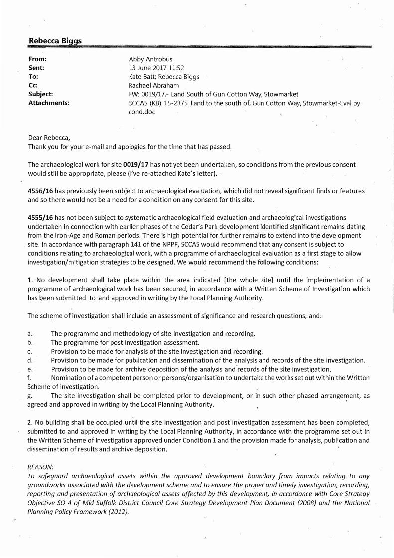
Abby Antrobus 13 June 2017 11:52 Kate Batt; Rebecca Biggs Rachael Abraham FW: 0019/17,- Land South of Gun Cotton Way, Stowmarket SCCAS (KBL15-2375_Land to the south of, Gun Cotton Way, Stowmarket-Eval by cond.doc
Thank you for your e-mail and apologies for the time that has passed.
The archaeological work for site 0019/17 has not yet been undertaken, so conditions from the previous consent would still be appropriate, please {I've re-attached Kate's letter).
4556/16 has previously been subject to archaeological evaluation, which did not reveal significant finds or features and so there would not be a need for a condition on any consent for this site.
4555/16 has not been subject to systematic archaeological field evaluation and archaeological investigations undertaken in connection with earlier phases of the Cedar's Park development identified significant remains dating from the Iron-Age and Roman periods. There is high potential for further remains to extend into the development
. site. In accordance with paragraph 141 of the NPPF, SCCAS would recommend that any consent is subject to conditions relating to archaeological work, with a programme of archaeological evaluation as a first stage to allow investigation/mitigation strategies to be designed. We would recommend the following conditions:
1. No development shall take place within the area indicated [the whole site] until the implementation of aprogramme of archaeological work has been secured, in accordance with a Written Scheme of Investigation whichhas been submitted to and approved in writing by the Local Planning Authority.
The scheme of investigation shall include an assessment of significance and research questions; and:·
a. The programme and methodology of site investigation and recording.b. The programme for post investigation assessment.c. Provision to be made for analysis of the site investigation and recording.d. Provision to be made for publication and dissemination of the analysis and records of the site investigation.e. Provision to be made for archive deposition of the analysis and records of the site investigation.f. Nomination of a competent person or persons/organisation to undertake the works set out within the WrittenScheme of Investigation.g. The site investigation shall be completed prior to development, or in such other phased arrangement, asagreed and approved in writing by the Local Planning Authority.
2. No building shall be occupied until the site investigation and post investigation assessment has been completed,submitted to and approved in writing by the Local Planning Authority, in accordance with the programme set out inthe Written Scheme of Investigation approved under Condition 1 and the provision made for analysis, publication anddissemination of results and archive deposition.
REASON:
To safeguard archaeological assets within the approved development boundary from impacts relating to any
groundworks associated with the development scheme and to ensure the proper and timely investigation, recording,
reporting and presentation of archaeological assets affected by this development, in accordance with Core Strategy
Objective SO 4 of Mid Suffolk District Council Core Strategy Development Plan Document /2008} and the National
Planning Policy Framework /2012).
INFORMATIVE:
The submitted scheme of archaeological investigation shall be in accordance with a brief procured beforehand by the
developer from Suffolk County Council Archaeological Service, Conservation Team.
I have copied in Kate Batt as case-officer for these sites if you would need more formal response in due course -do
get in touch if you would like to discuss anything further,
With best wishes, Abby
Dr Abby Antrobus
Senior Archaeological Officer
Suffolk County Council Archaeological Service
Bury Resource Centre, Hollow Road, Bury St Edmunds, Suffolk, IP32 7AY
Tel: 01284 741231 Mob: 07785950022
Website: https://www.suffolk.gov.uk/archaeology
Heritage Explorer: https://heritage.suffolk.gov.uk/
Ipswich Archive: http://archaeologydataservice.ac. uk/archives/view/ipswich parent 2015/index.cfm
Ipswich Urban Archaeological Database: https://heritage.suffolk.gov.uk/ipswich-uad
Rebecca Biggs
From: Sent:
To:
Subject:
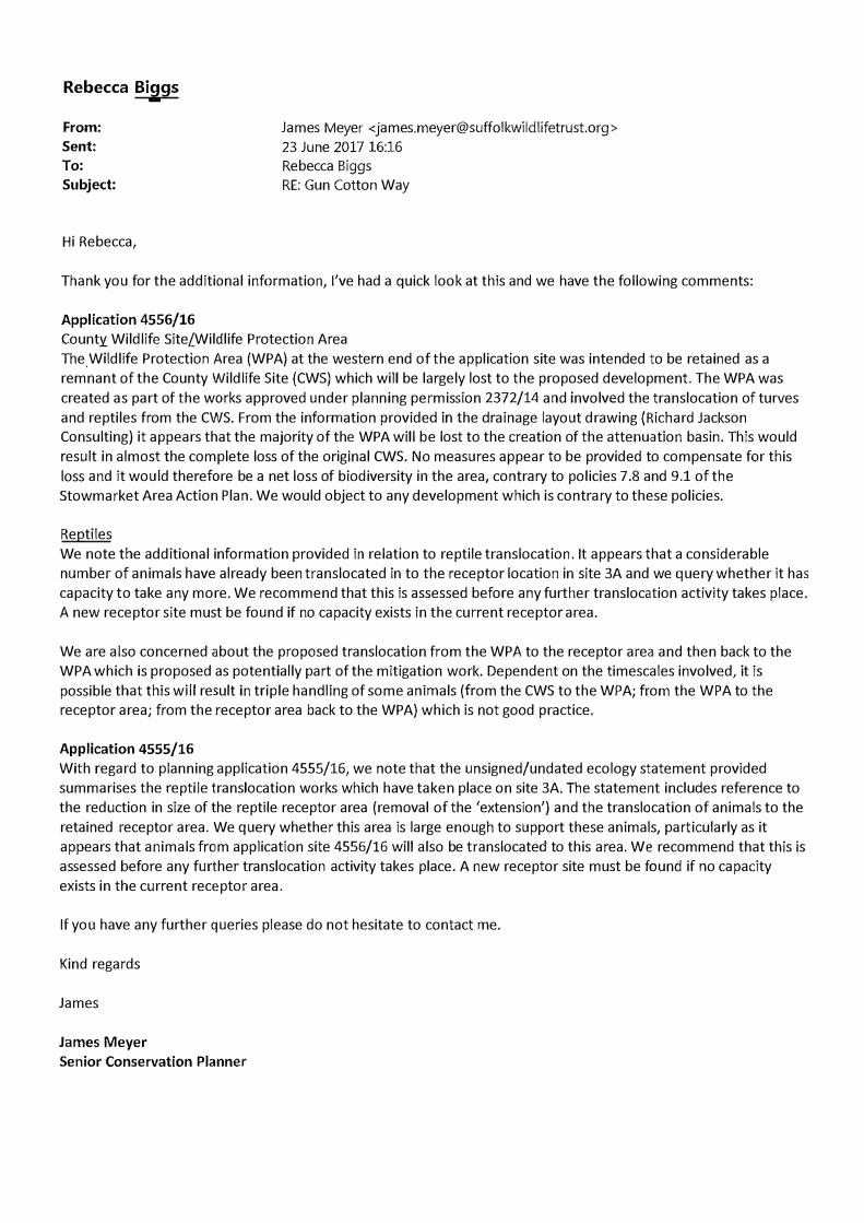
Hi Rebecca,
James Meyer <[email protected]> 23 June 2017 16:16 Rebecca Biggs RE: Gun Cotton Way
Thank you for the additional information, I've had a quick look at this and we have the following comments:
Application 4556/16
County Wildlife Site/Wildlife Protection Area The.Wildlife Protection Area (WPA) at the western end of the application site was intended to be retained as a remnant of the County Wildlife Site (CWS) which will be largely lost to the proposed development. The WPA was
created as part of the works approved under planning permission 2372/14 and involved the translocation of turves and reptiles from the CWS. From the information provided in the drainage layout drawing (Richard Jackson Consulting) it appears that the majority of the WPA will be lost to the creation of the attenuation basin. This would result in almost the complete loss of the original CWS. No measures appear to be provided to compensate for this
loss and it would therefore be a net loss of biodiversity in the area, contrary to policies 7 .8 and 9.1 of the Stowmarket Area Action Plan. We would object to any development which is contrary to these policies.
Reptiles We note the additional information provided in relation to reptile translocation. It appears that a considerable number of animals have already been translocated in to the receptor location in site 3A and we query whether it has capacity to take any more. We recommend that this is assessed before any further translocation activity takes place. A new receptor site must be found if no capacity exists in the current receptor area.
We are also concerned about the proposed translocation from the WPA to the receptor area and then back to the WPA which is proposed as potentially part of the mitigation work. Dependent on the timescales involved, it is
possible that this will result in triple handling of some animals (from the CWS to the WPA; from the WPA to the receptor area; from the receptor area back to the WPA) which is not good practice.
Application 4555/16
With regard to planning application 4555/16, we note that the unsigned/undated ecology statement provided summarises the reptile translocation works which have taken place on site 3A. The statement includes reference to the reduction in size of the reptile receptor area (removal of the 'extension') and the translocation of animals to the retained receptor area. We query whether this area is large enough to support these animals, particularly as it appears that animals from application site 4556/16 will also be translocated to this area. We recommend that this is assessed before any further translocation activity takes place. A new receptor site must be found if no capacity exists in the current receptor area.
If you have any further queries please do not hesitate to contact me.
Kind regards
James
James Meyer
Senior Conservation Planner
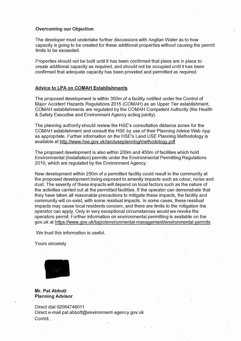
Overcoming our Objection
The developer must undertake further discussions with Anglian Water as to how capacity is going to be created for these additional properties without causing the permit limits to be exceeded.
Properties should not be built until it has been confirmed that plans are in place to create additional capacity as required, and should not be occupied until it has been confirmed that adequate capacity has been provided and permitted as required.
Advice to LPA on COMAH Establishments
The proposed development is within 300m of a facility notified under the Control of Major Accident Hazards Regulations 2015 (COMAH) as an Upper Tier establishment, CO MAH establishments are regulated by the CO MAH Competent Authority (the Health & Safety Executive and Environment Agency acting jointly).
The planning authority should review the HSE's consultation distance zones for the COMAH establishment and consult the HSE by use of their Planning Advice Web App as appropriate. Further information on the HSE's Land USE Planning Methodology is available at http://www.hse.qov.uk/landuseplanninq/methodology.pdf
The proposed development is also within 200m and 450m of facilities which hold Environmental (Installation) permits under the Environmental Permitting Regulations 2010, which are regulated by the Environment Agency.
New development within 250m of a permitted facility could result in the community at the proposed development being exposed to amenity impacts such as odour, noise and dust. The severity of these impacts will depend on local factors such as the nature of the activities carried out at the permitted facilities. If the operator can demonstrate that they have taken all reasonable precautions to mitigate these impacts, the facility and community will co-exist, with some residual impacts. In some cases, these residual impacts may cause local residents concern, and there are limits to the mitigation the operator can apply. Only in very exceptional circumstances would we revoke the operators permit. Further information or:i environmental permitting is available on the gov. uk at https://www.gov.uk/topic/environmental-management/environmental-permits
We trust this information is useful.
Yours sincerely
Mr; Pat Abbott Planning Advisor
Direct dial 020847 48011 Direct e-mail [email protected] Cont/d..
Rebecca Biggs
From:
Sent:
To:
Subject:
Martin Egan 22 June 2017 15:39 Rebecca Biggs 4556/16 Stowmarket
Attachments: MS/4555/16 & MS/4556/16 - Gun Cotton Way, Stowmarket Travel Plan; MS_ 4556_ 16.docx
Hi Rebecca,
I do not agree with the views of the agent, Mr McIntosh. However, the shortcomings in the application are sadly not sufficient to warrant a recommendation of refusal. Therefore, please find attached some suitable highway conditions. The Travel Plan comments/ 5106 request is attached as a separate email.
For information application 4555/16 is in the process of being assessed by Samantha Harvey and a response should be with you early next week.
Regards,
Martin Egan, Highways Development Management Engineer, Strategic Development, Resource Management, Suffolk County Council, Endeavour House, 8 Russell Road, Ipswich, IPi 2BX, [email protected] www.suffolk.gov.uk
From: Phillip McIntosh fmailto:[email protected]] Sent: 12 June 2017 11:04 To: Rebecca Biggs <[email protected]> Cc: 'info' <[email protected]> Subject: RE: 4556/16 and 4555/15- Gun Cotton Way (Email 1of2)
Hi Rebecca
Thank you for your email. We comment as follows;
1. Given the provision of visitor parking across the site (see para below) we do not consider there is a need toprovide specific visitor parking within the parking court for apartments 3-11. At 1.5 spaces per dwelling thisequates to a need for 13.5 spaces. The average number of cars per household for Stowmarket North (ward)is 1.37 and therefore, applying this figure to the apartment block results in a requirement for 12.3 spaces.We have proposed a communal parking court for the apartments, rather than allocated parking. Accordingto the parking standards where this is the case, there can be some flexibility applied to the standards (up to25%). The site is also sustainably located fn close proximity to local services and the town centre(walking/cycling or public transport). As such we consider that 12 residents only communal parking spaceswithin this parking court provides sufficient off street parking in line with the sec parking standards.
2. · There are 6 visitor spaces at either end of the development, providing a total of 12 spaces which meets theparking standards in terms of numbers. As per my previous comments (10 May), the site is not large and
therefore, the distance to walk to the properties which are centrally positioned within the site is only short (less than 100m). Plots 1, 2, 36, 37 and 47 benefit from visitors being able to park on the driveway and therefore, would be unlikely to place demand on the need for visitor parking. There would also be the potential for informal visitor parking between plots 38 and 48 on the road. As such we consider the site is well served in terms of provision for visitor parking.
3. We previously commented on this matter on 10 May however, to reiterate, access through this part of thesite should be kept to a minimum as it is an ecologically sensitive (wildlife protection) area. Therefore, weconsider provision of a 'cyclists dismount' sign at either end of the path can address concerns in relation tothis matter and can be secured by condition.
With regard to the conditions sought by Sue Hooton in relation to ecology, our only query is in relation to application 4555 which appears to relate to a different ecology report and consequently a different site. We consider they should be consistent with those conditions as set out in her comments on application 4556.
Are you on track to get the application to the 28 June committee?
Please give me a c�II if you wish to discuss any of these matters.
Kind regards
Phillip McIntosh BRTP {Hons) MRTPI
Senior Planning Director
For and on behalf of
Melville Dunbar Associates
. -·-_I-\ ,. .
MELVILLE DUNBAR ASSOCIATES
PLANNING URBAN DESIGN ARCHITECTURE
tho Mtll HQurio. Kfn{J; Attf:J, Cogg11tih!1ll 1 E11n�� COU 1NY T<•! O·IJ7-0 ���-i!-7.0 (tr1,111. m!oii'Jn<it\�.1:o<hrnt;ii11,1e,!';0;.�1.11Q•• >::-Om
r·,u: 01J7(; &�u,, Wti�_J if>WWtn<:;1!'{,fltid,vt1b.:it(l\i(io/;lJjt(l'> tO,,fil
., i--'.···
,,,, ,1 .. ''I•


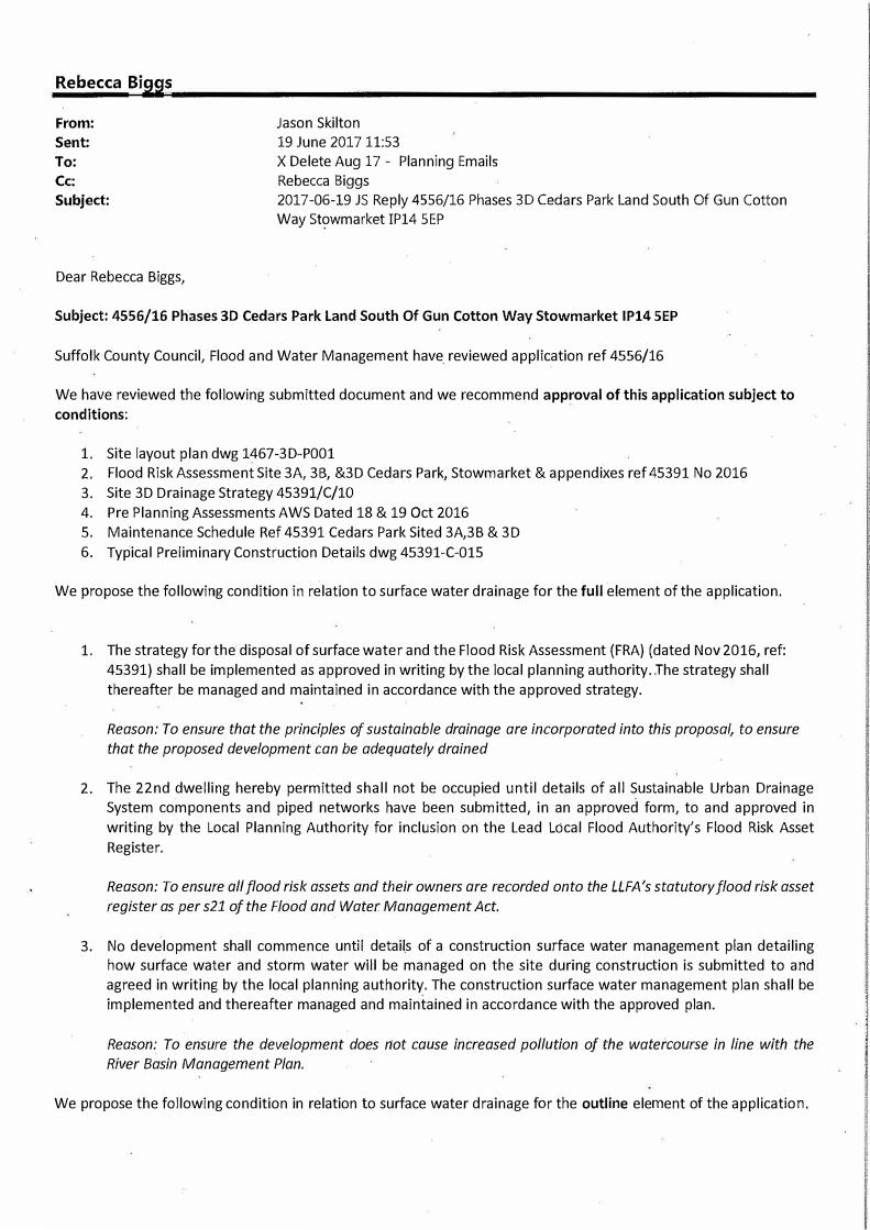
Rebecca Biggs
From: Jason Skilton Sent: 19 June 2017 11:53 To: Cc:
X Delete Aug 17 - Planning Emails Rebecca Biggs
Subject: 2017-06-19 JS Reply 4556/16 Phases 3D Cedars Park Land South Of Gun Cotton Way Stowmarket IP14 SEP
Dear Rebecca Biggs,
Subject: 4556/16 Phases 3D Cedars Park Land South Of Gun Cotton Way Stowmarket IP14 SEP
Suffolk County Council, Flood and Water Management have. reviewed application ref 4556/16
We have reviewed the following submitted document and we recommend approval of this application subject to
conditions:
1. Site layout plan dwg 1467-3D-P0012. Flood Risk Assessment Site 3A, 3B, &3D Cedars Park, Stowmarket & appendixes ref 45391 No 2016
3. Site 3D Drainage Strategy 45391/C/104. Pre Planning Assessments AWS Dated 18 & 19 Oct 20165. Maintenance Schedule Ref 45391 Cedars Park Sited 3A,3B & 3D6. Typical Preliminary Construction Details dwg 45391-C-015
We propose the following condition in relation to surface water drainage for the full element of the application.
1. The strategy for the disposal of surface water and the Flood Risk Assessment (FRA) (dated Nov 2016, ref:45391) shall be implemented as approved in writing by the local planning authority . .The strategy shallthereafter be managed and maintained in accordance with the approved strategy.
Reason: To ensure that the principles of sustainable drainage are incorporated into this proposal, to ensure
that the proposed development can be adequately drained
2. The 22nd dwelling hereby permitted shall not be occupied until details of all Sustainable Urban DrainageSystem components and piped networks have been submitted, in an approved form, to and approved inwriting by the Local Planning Authority for inclusion on the Lead Local Flood Authority's Flood Risk AssetRegister.
Reason: To ensure all flood risk assets and their owners are recorded onto the LLFA's statutory flood risk asset
register as per s21 of the Flood and Water Management Act.
3. No development shall commence until details of a construction surface water management plan detailinghow surface water and storm water will be managed on the site during construction is submitted to andagreed in writing by the local planning authority. The construction surface water management plan shall beimplemented and thereafter managed and maintained in accordance with the approved plan.
Reason: To ensure the development does not cause increased pollution of the watercourse in line with the
River Basin Management Plan.
We propose the following condition in relation to surface water drainage for the outline element of the application.
1. Concurrent with the first reserved matters application(s) a surface water drainage scheme shall besubmitted to, and approved in writing by, the local planning authority. The scheme shall be in accordancewith the approved FRA and include:
a. Dimensioned plans and drawings of the surface water drainage scheme;b. If the use of infiltration is not possible then modelling shall be submitted to demonstrate that the
surface water runoff will be restricted to Qbar or 21/s/ha for all events up to the critical 1 in 100 yearrainfall events including climate change as specified in the FRA;
c. Modelling of the surface water drainage scheme to show that the attenuation/infiltration featureswill contain the 1 in 100 year rainfall event including climate change;
d. Modelling of the surface water conveyance network in the 1 in 30 year rainfall event to show noabove ground flooding, and modelling of the volumes of any above ground flooding from the JJipenetwork in a 1 in 100 year climate change rainfall event, along with topographic plans showingwhere the water will flow and be stored to ensure no flooding of buildings or offsite flows;
e. Topographical plans depicting all exceedance flowpaths and demonstration that the flows would not· flood buildings or flow offsite, and if they are to be directed to the surface water drainage systemthen the potential additional rates and volumes of surface water must be included within themodelling of the surface water system;
2. The scheme shall be fully implemented as approved.
Reason: To prevent flooding by ensuring the satisfactory storage and disposal of surface water from the site
for the lifetime of the development.
3. Concurrent with the first reserved matters application(s) details of the implementation, maintenance andmanagement of the surface water drainage scheme shall be submitted to and approved in writing by the localplanning authority. The strategy shall be implemented and thereafter managed and maintained in accordancewith the approved details.
Reason: To ensure clear arrangements are in place for ongoing operation and maintenance of the disposal of
surface water drainage.
4. The development hereby permitted shall not be occupied until details of all Sustainable Urban DrainageSystem components and piped networks have been submitted, in an approved form, to and approved inwriting by the Local Planning Authority for inclusion on the Lead Local Flood Authority's Flood Risk AssetRegister.
Reason: To ensure all flood risk assets and their owners are recorded onto the LLFA's statutory flood risk asset
register as per s21 of the Flood and Water Management Act.
s. No development shall commence until details of a construction surface water management plan detailinghow surface water and storm water will be managed on the site during construction is submitted to andagreed in writing by the local planning authority. The construction surface water management plan shall beimplemented and thereafter managed and maintained in accordance with the approved plan.
Reason: To ensure the development does not cause increased pollution of the watercourse in line with the River
Basin Management Plan.
lnformatives
• Any works to a watercourse may require consent under section 23 of the Land Drainage Act 1991• Any discharge to a watercourse or groundwater needs to comply with the Water Environment (Water
Framework Directive) (England and Wales) Regulations 2003• Any discharge of surface water to a watercourse that drains into an Internal Drainage Board catchment may
be is subject to payment of a surface water developer contribution
Kind Regards


![[3] - National Democratic Institute | Home · PDF fileဥပမာအားျဖင္႔အရပ္ဖက္အဖဲြ ႔အစည္းမ်ားႏွင္](https://img.pdfslide.us/doc/110x75/5a77026c7f8b9aa3688da4cb/3-national-democratic-institute-home-.jpg)