Embed Size (px)
Citation preview

8/14/2019 Delta Subsidence in California -- The sinking heart of the State
http://slidepdf.com/reader/full/delta-subsidence-in-california-the-sinking-heart-of-the-state 1/4
US Department of the InteriorUS Geological Survey
FS-005-00April 2000
T he Delta, located at the con uenceof the Sacramento and San JoaquinRivers, is blanketed by peat and
peaty alluvium deposited where streams,originating in the Sierra Nevada, CoastRanges, and southern Cascade Range,enter the San Francisco Bay system. In thelate-1800s, large-scale agricultural devel-
opment in the Delta required levee-build-ing to prevent frequent ooding. Theleveed marshland tracts then had to bedrained, cleared of wetland vegetation,and tilled. Levees and drainage systemswere largely complete by 1930 and the Delta had takenon its current ap-
pearance, with mostof its 1,150-square-mile area reclaimed for agricultural use(Thompson, 1957).
Today the Deltaincludes about 57islands or tracts thatare imperfectly protected from flooding bymore than 1,100 miles of levees. Reclama-tion and agriculture have led to subsidenceof the land surface on the developed islandsin the central and western Delta at long-
The Sacramento-San Joaquin River Delta of California once was a greattidal freshwater marsh blanketed by peat and peaty alluvium. Beginning inthe late 1800s, levees were built along the stream channels, and the landthus protected from ooding was drained, cleared, and planted. Althoughthe Delta is now an exceptionally rich agricultural area (over a $500 millioncrop value in 1993), its unique value is as a source of freshwater forthe rest of the State. It is the heart of a massive north-to-south water-delivery system. Much of this water is pumped southward for use in theSan Joaquin Valley and elsewhere in central and southern California.The leveed tracts and islands help to protect water-export facilities inthe southern Delta from saltwater intrusion by displacing water andmaintaining favorable freshwater gradients. However, ongoing subsidencebehind the levees reduces levee stability and, thus, threatens to degradewater quality in the massive north-to-south water-transfer system.
term average rates of 1–3 inches per year (Rojstaczer and oth-ers, 1991; Rojstaczer and Deverel, 1993).Many of the islands in thecentral Delta are presently 10 tonearly 25 feet (ft) below sea level. As
subsidence progresses, the levees them-selves must be regularly maintained and periodically raised and strengthened tosupport the increasing stresses on their
banks. Currently, the levees are maintained to a standard cross section at a height
of 1 ft above theestimated 100-year-flood elevation.
An extensive net-work of drainageditches preventsislands from flood-ing internally and maintains ground-water levels deep
enough for agricultural crops to grow.The accumulated agricultural drainage is
pumped through or over the levees intostream channels. Without this drainage,the islands would become flooded.
The dominant cause of land subsidencein the Delta is decomposition of organiccarbon in the peat soils. Prior to agri-cultural development, the soil was water-logged and anaerobic (oxygen-poor).Organic carbon accumulated faster thanit could decompose. Drainage for agri-culture led to aerobic (oxygen-rich) con-ditions that favor rapid microbial oxida-tion of the carbon in the peat soil. Most
Rio Vista
Courtland
Stockton
Antioch
S a n
Jo a q u i n
R i v e r
S a c r
a m
e n t o
R i v e r
Levee
0 to10
10 to15
Greater than 15
Land subsidence,in feet below sea level
Clifton CourtForebay
ToSan
Francisco Bay Sherman
Island
ChippsIsland
Tyler I.
Grand I.
California Aqueduct(State operated)
Tracy Pumping Plant
South BayPumping Plant
Delta-Mendota Canal(Federal operated)
Contra Costa Canal
South BayAqueduct
0 5 Mi
0 5 Km
Harvey O. BanksDelta Pumping Plant
C o s u m n
e s R .
N
CALIFORNIA
Maparea
( C a l i f o r n i a D e p a r t m e n t o f W a t e r R e s o u r c e s )
Delta Subsidence in California
The sinking heart of the State

8/14/2019 Delta Subsidence in California -- The sinking heart of the State
http://slidepdf.com/reader/full/delta-subsidence-in-california-the-sinking-heart-of-the-state 2/4
The leveed tracts and islands helpto protect water-export facilities inthe southern Delta from saltwaterintrusion by displacing water andmaintaining the salinity balance.
Field studies (Deverel and Rojstaczer, 1996)determined that the increased flux of carbondioxide gas from the drained peat soils wassufficient to explain most of the carbon lossand measured subsidence. The dissolved
organic carbon pumped from the islands inagricultural drainage could account for onlyabout 1 percent of the carbon loss. The stud-ies also showed that rates of carbon-dioxideproduction increase with increasing tempera-ture and decrease with increasing soil mois-ture.
of the carbon loss is emitted as carbon-dioxide gas to the atmosphere (Deverel
and Rojstaczer, 1996).
The Delta’s unique value as asource of freshwater
The Delta receives runoff from about40 percent of the land area of Californiaand about 50 percent of California’stotal streamflow. It is the heart of a mas-sive north-to-south water-delivery systemwhose giant engineered arterials transportwater southward. State and Federal con-tracts provide for export of up to 7.5 mil-
lion acre-feet per year from two huge pumping stations in the southern Deltanear the Clifton Court Forebay (CaliforniaDepartment of Water Resources, 1993).About 83 percent of this water is used for agriculture and the remainder for variousurban uses in central and southern Califor-
nia. Two-thirds of California’s population(more than 20 million people) gets at least
part of its drinking water from the Delta(Delta Protection Commission, 1995).
The waterways of the Delta are subjectto tidal action. Ocean tides propagatinginto San Francisco Bay are observed 5–6hours later along theCosumnes River inthe eastern Delta.The position of theinterface betweenthe saline waters of the Bay and the
freshwaters of the Delta depends uponthe tidal cycle and the flow of freshwater through the Delta. Before major damswere built on rivers in the Delta water-shed, the salinity interface migrated asfar upstream as Courtland along theSacramento River (California Depart-
ment of Water Resources, 1993). Today,releases of freshwater from dams far upstream help reduce the maximum land-ward migration of the salinity interfaceduring the late summer. In the spring,however, reservoirs and Delta exportsconsistently act in concert to increase thelandward migration of the salinity inter-face over that expected under conditions
of unimpaired flows1
(Knowles, 2000).Land subsidence of Delta islands indi-rectly affects the north-to-south water-transfer system, which is predicated on theavailable water supply (annual inflows tothe Delta), the viability of aquatic species
populations, and acceptable water qualityin the southern Delta. The presence of the western Delta islands, in particular, is
believed to effectively inhibit the inland migration of the salinity interface betweenthe Bay and Delta. If these islands wereto become permanently inundated withsaline water, the water available to themassive pumping facilities near the Clif-ton Court Forebay might become toosaline to use. The timing of levee breaksand flooding is critical in this regard.
Fortunately, mostflooding occurs inwinter and spring,when major salt-water intrusion isless likely. How-ever, there are occa-
sional levee failures under low-flow con-ditions. These failures can cause major short-term water-quality problems, evenif the flooded areas are later reclaimed.During one such incident, an island wasflooded under low-flow conditions, and chloride levels reached 440 parts per mil-
1Unimpaired flows refer to the hypothetical flows that would occur in the estuary without water storagediversions and exports, upstream and in the Delta, but in the presence of the existing channels and levees.
In flooded conditions,decaying tules decom-pose slowly to releasecarbon dioxide (CO 2)and methane (CH 4).
Exposure to air acceleratesthe decay of tules and peat
soil. Organic material isconverted mainly to CO 2
and water.
ANAEROBIC CONDITIONS: Oxygen poor AEROBIC CONDITIONS: Oxygen rich
Oxygen (O 2)
Carbondioxide (CO 2)
Carbon
As peat soilsdecompose, theland “vaporizes”and subsides.
ChannelMain channel
Natural levees were formedby sediments depositedduring spring floodsand stabilized byvegetation.
“Tule” (bulrushand reed species) Water table
Peat soils were formedfrom decaying vegetationover thousands of years.
Riparian vegetation wascleared and levees werebuilt to create farmland. Semicontinuous pumps
remove agriculturaldrainage to maintaina low water table.
Levees must be periodicallyraised and reinforced tosupport increasing stressesfrom stream channels.
Saucer-shaped profile re-flects greatest thicknessand subsidence of peatsoils near the center ofthe islands.
Not to scale
PREDEVELOPMENT
POSTDEVELOPMENT
8/14/2019 Delta Subsidence in California -- The sinking heart of the State
http://slidepdf.com/reader/full/delta-subsidence-in-california-the-sinking-heart-of-the-state 3/4
The Sacramento-San Joaquin Delta: The heart of California’s water systems
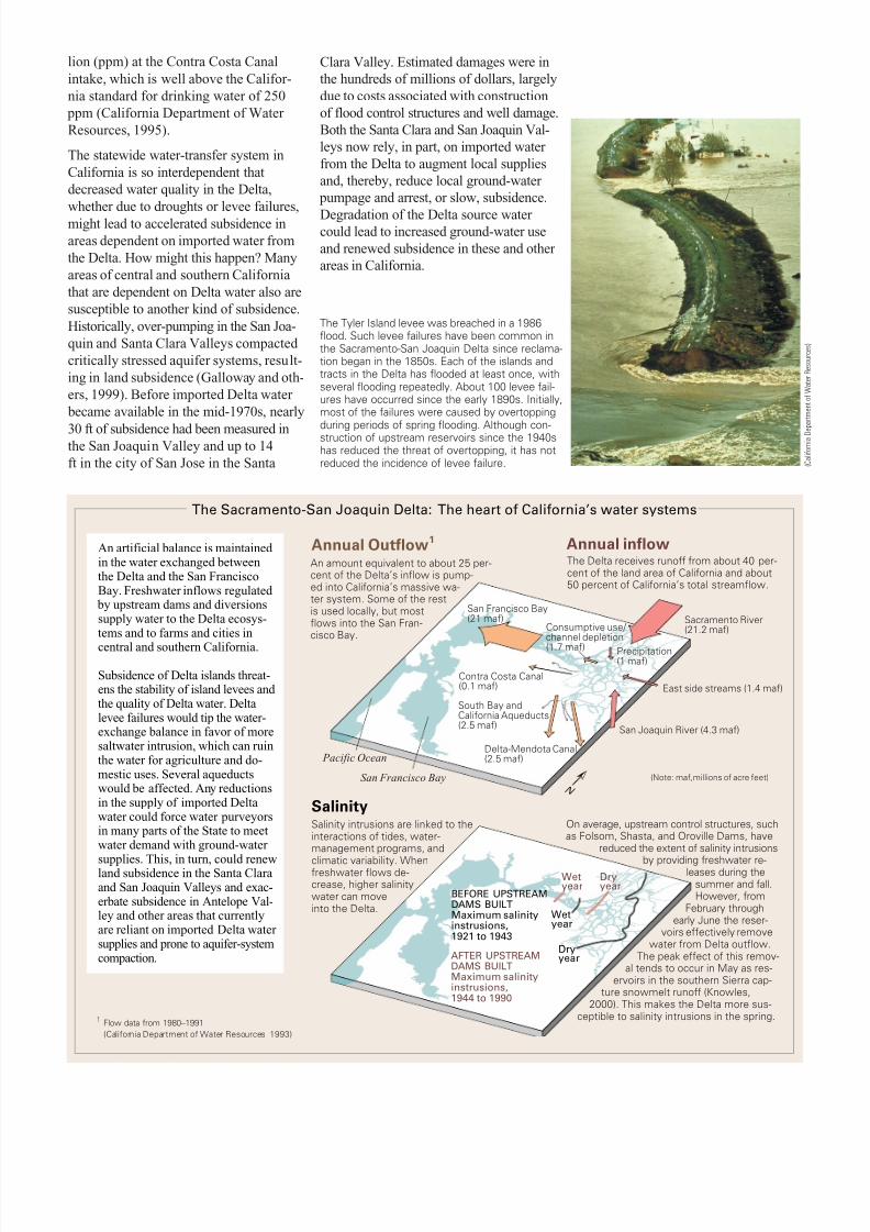
lion (ppm) at the Contra Costa Canalintake, which is well above the Califor-nia standard for drinking water of 250
ppm (California Department of Water Resources, 1995).
The statewide water-transfer system inCalifornia is so interdependent thatdecreased water quality in the Delta,whether due to droughts or levee failures,might lead to accelerated subsidence inareas dependent on imported water fromthe Delta. How might this happen? Manyareas of central and southern Californiathat are dependent on Delta water also aresusceptible to another kind of subsidence.Historically, over-pumping in the San Joa-quin and Santa Clara Valleys compacted critically stressed aquifer systems, result-ing in land subsidence (Galloway and oth-ers, 1999). Before imported Delta water
became available in the mid-1970s, nearly
30 ft of subsidence had been measured inthe San Joaquin Valley and up to 14ft in the city of San Jose in the Santa
Clara Valley. Estimated damages were inthe hundreds of millions of dollars, largelydue to costs associated with constructionof flood control structures and well damage.Both the Santa Clara and San Joaquin Val-leys now rely, in part, on imported water from the Delta to augment local suppliesand, thereby, reduce local ground-water
pumpage and arrest, or slow, subsidence.
Degradation of the Delta source water could lead to increased ground-water useand renewed subsidence in these and other areas in California.
Sacramento River(21.2 maf)
San Francisco Bay(21 maf)
Contra Costa Canal(0.1 maf)
Consumptive use/ channel depletion(1.7 maf)
South Bay andCalifornia Aqueducts(2.5 maf)
Delta-Mendota Canal(2.5 maf)
East side streams (1.4 maf)
Precipitation(1 maf)
San Joaquin River (4.3 maf)
San Francisco Bay
Pacific Ocean
BEFORE UPSTREAMDAMS BUILTMaximum salinityinstrusions,1921 to 1943
AFTER UPSTREAMDAMS BUILTMaximum salinityinstrusions,1944 to 1990
Wetyear
Dryyear
Wetyear
Dryyear
Annual inflowAnnual Outflow 1An artificial balance is maintained in the water exchanged betweenthe Delta and the San FranciscoBay. Freshwater inflows regulated
by upstream dams and diversionssupply water to the Delta ecosys-tems and to farms and cities in
central and southern California.
Subsidence of Delta islands threat-ens the stability of island levees and the quality of Delta water. Deltalevee failures would tip the water-exchange balance in favor of moresaltwater intrusion, which can ruinthe water for agriculture and do-mestic uses. Several aqueductswould be affected. Any reductionsin the supply of imported Deltawater could force water purveyorsin many parts of the State to meetwater demand with ground-water
supplies. This, in turn, could renewland subsidence in the Santa Claraand San Joaquin Valleys and exac-erbate subsidence in Antelope Val-ley and other areas that currentlyare reliant on imported Delta water supplies and prone to aquifer-systemcompaction.
An amount equivalent to about 25 per-cent of the Delta’s inflow is pump-ed into California’s massive wa-ter system. Some of the restis used locally, but mostflows into the San Fran-cisco Bay.
The Delta receives runoff from about 40 per-cent of the land area of California and about50 percent of California’s total streamflow.
SalinitySalinity intrusions are linked to theinteractions of tides, water-management programs, and
climatic variability. Whenfreshwater flows de-crease, higher salinitywater can moveinto the Delta.
On average, upstream control structures, suchas Folsom, Shasta, and Oroville Dams, have
reduced the extent of salinity intrusions
by providing freshwater re-leases during thesummer and fall.However, from
February throughearly June the reser-
voirs effectively removewater from Delta outflow.
The peak effect of this remov-al tends to occur in May as res-
ervoirs in the southern Sierra cap-ture snowmelt runoff (Knowles,
2000). This makes the Delta more sus-ceptible to salinity intrusions in the spring.1 Flow data from 1980–1991
(California Department of Water Resources 1993)
(Note: maf,millions of acre feet)N
( C a l i f o r n i a D e p a r t m e n t o f W a t e r R e s o u r c e s )
The Tyler Island levee was breached in a 1986flood. Such levee failures have been common inthe Sacramento-San Joaquin Delta since reclama-tion began in the 1850s. Each of the islands andtracts in the Delta has flooded at least once, withseveral flooding repeatedly. About 100 levee fail-ures have occurred since the early 1890s. Initially,most of the failures were caused by overtoppingduring periods of spring flooding. Although con-struction of upstream reservoirs since the 1940shas reduced the threat of overtopping, it has notreduced the incidence of levee failure.

8/14/2019 Delta Subsidence in California -- The sinking heart of the State
http://slidepdf.com/reader/full/delta-subsidence-in-california-the-sinking-heart-of-the-state 4/4
For additional information contact:
Kimberly Taylor U.S. Geological SurveyPlacer Hall, 6000 J StreetSacramento, CA 95819(916) [email protected]
Helpful internet sites:
http://sfbay.wr.usgs.govhttp://calfed.ca.gov
REFERENCES
California Department of Water Resources, 1993, Sac-
ramento-San Joaquin Delta atlas: California Depart-ment of Water Resources, 121 p.
———, 1995, Delta levees: California Department of Water Resources, 19 p.
Delta Protection Commission, 1995, Land use and resource management plan for the primary zone of theDelta: Delta Protection Commission, 60 p.
Deverel, S.J., and Rojstaczer, S.A., 1996, Subsidence of agricultural lands in the Sacramento-San Joaquin Delta,California. Role of aqueous and gaseous carbon uxes:Water Resources Research, v. 32, p. 2,359-2,367.
Galloway, D.C., Jones, D.R., and Ingebritsen, S.E.,1999, Land subsidence in the United States: U.S. Geo-logical Survey Circular 1182, 177 p.
Knowles, Noah, 2000, Natural and human in uenceson freshwater ows and salinity in the San Francisco
Bay-Delta estuary and watershed: Interagency Eco-
logical Program for the Sacramento-San JoaquinEstuary Newsletter, v. 13, no. 1, p. 5–23.
Rojstaczer, S.A., and Deverel, S.J., 1993, Time depen-dence of atmospheric carbon inputs from drainage of organic soils: Geophysical Research Letters, v. 20, p.1,383–1,386.
Rojstaczer, S.A., Hamon, R.E., Deverel, S.J., and Massey, C.A., 1991, Evaluation of selected data toassess the causes of subsidence in the Sacramento-San Joaquin Delta, California: U.S. Geological Sur-vey Open-File Report 91-193, 16 p.
Thompson, John, 1957, The settlement geographyof the Sacramento-San Joaquin Delta, California:Palo Alto, Calif., Stanford University, Ph.D. dis-sertation, 551 p.
—S.E. Ingebritsen, Marti E. Ikehara, Devin L. Galloway, and David R. Jones
The future of the Deltaposes many challenges
Delta-island subsidence caused by peatoxidation only can be controlled bymajor changes in land-use practices. Thecontinuation of agriculture in the Deltadepends on a sufficient peat thickness. Inmuch of the cultivated area of the Delta,substantial thicknesses of peat remain sothat there is great potential for further subsidence.
The Delta currently is the subject of amajor Federal-State-stakeholder effort(called CALFED) to develop a long-term
plan to restore ecological health and toimprove water management of the Bay-Delta system. This plan includes restor-ing wetland and riparian habitat alongthe outside of the levees and on severalof the smaller, less subsided islands.
Presently, there are no planned restorationactivities in the heavily subsided areaswithin the central Delta islands. Much of the extensively subsided area is impracti-cal to restore and will continue to requiresome monitoring and, perhaps, mainte-nance. As subsidence progresses, thelevee system will become increasinglyvulnerable to catastrophic failure duringfloods and earthquakes. The interrelated issues of Delta land subsidence, water quality, and wildlife habitat will continueto pose a major dilemma for California’swater managers.
FUTURE STRATEGIES
Possible long-term management strategies for various Delta islands include:
1. Shallow ooding to mitigate subsidence by slowing peat oxidationand allowing growth of wetland vegetation that contributes biomassaccumulation.
2. Shallow ooding combined with thin-layer mineral deposition (a pos-sibly bene cial reuse of dredge material).
3. Continued use of agricultural areas with shallow peat and (or) loworganic-matter content, under the assumption that the additional sub-sidence will not destabilize the levees.
4. Addition of thick layers of mineral soil, possibly using controlled leveebreaches or deposition of dredge material, to slow peat oxidation andraise land-surface elevation.
5. Deep ooding to create freshwater reservoirs.
These strategies may be implemented in a mosaic throughout the Deltathat creates a substantial diversity of wildlife habitat—uplands, openwater, shallow permanent wetlands, and seasonal wetlands.
Reclamation—drainingDelta islands
Ground-water pumpage increasesregional land subsidence
Subsidence of islands
Levee instability
Increased water salinity
Reduced water exports
Sacramento-San Joaquin Delta
San JoaquinValley
Santa ClaraValley
The statewide water-transfer system in Cali-fornia is so interdependent that subsidencein the Delta might lead to accelerated subsid-ence in areas dependent on imported waterfrom the Delta.